Agenda
Ordinary
(Planning) Meeting
Thursday, 4
November 2021
held at Council
Chambers, Station Street, Mullumbimby
commencing
at 9:00am
Public Access relating to items on this Agenda can be made between 9.00am and
9.30am on the day of the Meeting. Requests for public access should be
made to the General Manager or Mayor no later than 12.00 midday on the day
prior to the Meeting.

Mark Arnold
General Manager
What is a “Conflict of Interests” - A conflict of
interests can be of two types:
Pecuniary - an interest that a person has in a matter because of a reasonable
likelihood or expectation of appreciable financial gain or loss to the person
or another person with whom the person is associated.
Non-pecuniary – a private or personal interest that a Council
official has that does not amount to a pecuniary interest as defined in the
Code of Conduct for Councillors (eg. A friendship, membership of an
association, society or trade union or involvement or interest in an activity
and may include an interest of a financial nature).
Remoteness – a person does not have a pecuniary interest in a matter
if the interest is so remote or insignificant that it could not reasonably be
regarded as likely to influence any decision the person might make in relation
to a matter or if the interest is of a kind specified in the Code of Conduct
for Councillors.
Who has a Pecuniary Interest? - a person has a pecuniary interest in a
matter if the pecuniary interest is the interest of the person, or another
person with whom the person is associated (see below).
Relatives, Partners - a person is taken to have a pecuniary
interest in a matter if:
·
The
person’s spouse or de facto partner or a relative of the person has a
pecuniary interest in the matter, or
·
The
person, or a nominee, partners or employer of the person, is a member of a
company or other body that has a pecuniary interest in the matter.
N.B. “Relative”, in relation to a person means any of the
following:
(a) the parent,
grandparent, brother, sister, uncle, aunt, nephew, niece, lineal descends or
adopted child of the person or of the person’s spouse;
(b) the spouse
or de facto partners of the person or of a person referred to in paragraph (a)
No Interest in the Matter - however, a person is not taken to have a
pecuniary interest in a matter:
·
If
the person is unaware of the relevant pecuniary interest of the spouse, de
facto partner, relative or company or other body, or
·
Just
because the person is a member of, or is employed by, the Council.
·
Just
because the person is a member of, or a delegate of the Council to, a company
or other body that has a pecuniary interest in the matter provided that the
person has no beneficial interest in any shares of the company or body.
Disclosure and participation in meetings
·
A
Councillor or a member of a Council Committee who has a pecuniary interest in
any matter with which the Council is concerned and who is present at a meeting
of the Council or Committee at which the matter is being considered must
disclose the nature of the interest to the meeting as soon as practicable.
·
The
Councillor or member must not be present at, or in sight of, the meeting of the
Council or Committee:
(a) at
any time during which the matter is being considered or discussed by the
Council or Committee, or
(b) at
any time during which the Council or Committee is voting on any question in
relation to the matter.
No Knowledge - a person does not breach this Clause if the person did
not know and could not reasonably be expected to have known that the matter
under consideration at the meeting was a matter in which he or she had a
pecuniary interest.
Non-pecuniary Interests - Must be disclosed in meetings.
There are a broad range of options available for managing conflicts &
the option chosen will depend on an assessment of the circumstances of the
matter, the nature of the interest and the significance of the issue being
dealt with. Non-pecuniary conflicts of interests must be dealt with in at
least one of the following ways:
·
It
may be appropriate that no action be taken where the potential for conflict is
minimal. However, Councillors should consider providing an explanation of
why they consider a conflict does not exist.
·
Limit
involvement if practical (eg. Participate in discussion but not in decision
making or vice-versa). Care needs to be taken when exercising this
option.
·
Remove
the source of the conflict (eg. Relinquishing or divesting the personal
interest that creates the conflict)
·
Have
no involvement by absenting yourself from and not taking part in any debate or
voting on the issue as of the provisions in the Code of Conduct (particularly
if you have a significant non-pecuniary interest)
RECORDING OF VOTING ON PLANNING MATTERS
Clause 375A of the Local Government Act
1993 – Recording of voting on planning matters
(1) In this section, planning
decision means a decision made in the exercise of a function of a council
under the Environmental Planning and Assessment Act 1979:
(a) including a decision relating to
a development application, an environmental planning instrument, a development
control plan or a development contribution plan under that Act, but
(b) not including the making of an
order under that Act.
(2) The general manager is required
to keep a register containing, for each planning decision made at a meeting of
the council or a council committee, the names of the councillors who supported
the decision and the names of any councillors who opposed (or are taken to have
opposed) the decision.
(3) For the purpose of maintaining
the register, a division is required to be called whenever a motion for a
planning decision is put at a meeting of the council or a council committee.
(4) Each decision recorded in the
register is to be described in the register or identified in a manner that enables
the description to be obtained from another publicly available document, and is
to include the information required by the regulations.
(5) This section extends to a meeting
that is closed to the public.
BUSINESS OF Ordinary (Planning) Meeting
1. Public Access
2. Apologies
3. Requests
for Leave of Absence
4. Declarations
of Interest – Pecuniary and Non-Pecuniary
5. Tabling of Pecuniary
Interest Returns (Cl 4.9
Code of Conduct for Councillors)
6. Adoption
of Minutes from Previous Meetings
6.1 Ordinary
(Planning) Meeting held on 14 October 2021
7. Reservation
of Items for Debate and Order of Business
8. Mayoral Minute
9. Notices of Motion
Nil
10. Petitions
11. Submissions and Grants
12. Delegates' Reports
13. Staff Reports
Sustainable Environment and
Economy
13.1 PLANNING -
Report of the 7 October 2021 Planning Review Committee........... 7
13.2 PLANNING -
10.2021.16.1 - Change of Use to General Store and Restaurant at 10 Huonbrook
Road, Upper Wilsons Creek.................................................................. 10
13.3 PLANNING -
Development Application 10.2021.291.1 Mixed Use Development - Shops and
Serviced Apartments - 116-118 Jonson Street Byron Bay............... 37
13.4 24.2020.39.1
- Centennial Circuit One-way Traffic Trial - Outcomes of the trial and next
steps...................................................................................................................... 81
13.5 24.2020.27.1
- Bangalow Development Control Plan Changes Submissions Report........................................................................................................................................ 86
13.6 PLANNING -
26.2019.10.1 Submissions Report - North Beach Byron Rezoning Planning Proposal........................................................................................................ 91
13.7 Federal
Movement and Place Draft Concept Design.......................................... 109
13.8 Biodiversity
Projects and Operations Update....................................................... 114
13.9 Update
Resolution 20-203 Linneaus Estate.......................................................... 136
13.10 Update Resolution
21-273 Emergency Housing.................................................. 142
13.11 Resolution 21-221
Multiple Occupancies and Rural Workers Cottages & Resolution 21-275 MOs and
CTs - pathway for secondary dwellings and dual occupancies 149
13.12 Update Resolution
20-727 Proposed Off Leash Dog Park at Mullumbimby Recreation Grounds....................................................................................................................... 158
13.13 Update Resolution
21-180 (3) land use definitions as they apply to rural land 163
13.14 Byron Shire Local
Heritage Grants Program 2021-22......................................... 168
13.15 Update Resolution
21-244 Dogs in Public Spaces Strategy.............................. 174
13.16 PLANNING - 26.2020.7.1
- Planning Proposal Stage 3 E zone Implementattion Program Submissions report................................................................................... 179
Infrastructure Services
13.17 Tender 2021-1093 -
Byron STP Biosolids Shed Roof Replacement................ 197
14. Questions With Notice
Nil
Councillors are
encouraged to ask questions regarding any item on the business paper to the
appropriate Director prior to the meeting. Any suggested amendments to the
recommendations should be provided to Councillor Support prior to the meeting
to allow the changes to be typed and presented on the overhead projector at the
meeting.
Staff Reports - Sustainable Environment and Economy 13.1
Staff Reports - Sustainable Environment and
Economy
Report No. 13.1 PLANNING
- Report of the 7 October 2021 Planning Review Committee
Directorate: Sustainable
Environment and Economy
Report Author: Chris
Larkin, Manager Sustainable Development
Noreen Scott, EA Sustainable Environment and Economy
File No: I2021/1617
Summary:
This report provides the outcome of the Planning Review
Committee (PRC) held on 7 October 2021.
NOTE TO COUNCILLORS:
In accordance with the
provisions of S375A of the Local Government Act 1993, a Division is to be
called whenever a motion for a planning decision is put to the meeting, for the
purpose of recording voting on planning matters. Pursuant to clause 2(a)
under the heading Matters to be Included in Minutes of Council Meetings of Council's
adopted Code of Meeting Practice (as amended) a Division will be deemed to have
been called by the mover and seconder of all motions relating to this report.
RECOMMENDATION:
That Council endorses the outcomes of the Planning
Review Committee meeting held on 7 October 2021.
Report
The Planning Review Committee
meeting was held on 7 October 2021. The meeting commenced at 3:30pm and
concluded at 4:00pm.
Councillors: Cameron, Coorey,
Lyon, Ndiaye, Martin, Hunter
Apologies: Spooner, Hackett
Staff: Shannon Burt (Director
Sustainable Environment and Economy), Chris Larkin (Manager Sustainable
Development)
The following development
applications were reviewed with the outcome shown in the final column.
|
DA No.
|
Applicant
|
Property Address
|
Proposal
|
Exhibition /submissions
|
Reason/s
Outcome
|
|
10.2021.450.1
|
Newton
Denny Chapelle
|
45-71
Byron Street BANGALOW
|
Alterations
and Additions to Existing Primary School
|
Level 2
3/9/21-30/9/21
4
submissions
|
The
perceived public significance of the application
Council
|
|
10.2021.458.1
|
Archimages
Architecture Pty Ltd
|
99
Alcorn Street SUFFOLK PARK
|
Demolition
of Existing Dwelling House, Removal of Seven (7) Native Trees, Erection of a
New Dwelling House and Ancillary Infrastructure
|
|
No delegation
Council
|
Council determined the following original development
applications. The S.4.55 applications to modify those consents are
referred to the Planning Review Committee to decide if the modification
applications can be determined under delegated authority.
|
DA
No.
|
Applicant
|
Property Address
|
Proposal
|
Exhibition /submissions
|
Reason/s
Outcome
|
|
10.2014.743.4
|
Northpoint
Advisory
|
41
Matong Drive OCEAN SHORES
|
S4.55 to
Modify the Approved Staging and Modify Consent Conditions to reflect Modified
Staging for an Approved Subdivision and Multi Dwelling Housing Development
|
Level 2
30/3/21
to 19/4/21
Nil
submissions
|
Staff
Delegation
|
|
10.2014.743.5
|
Northpoint
Advisory
|
41
Matong Drive OCEAN SHORES
|
S4.55 to
update staging and add two (2) dwellings
|
Level 2
30/3/21
to 19/4/21
2
submissions
|
The
perceived public significance of the application
Council
|
Staff Reports - Sustainable Environment and Economy 13.2
Report
No. 13.2 PLANNING - 10.2021.16.1 -
Change of Use to General Store and Restaurant at 10 Huonbrook Road, Upper
Wilsons Creek
Directorate: Sustainable
Environment and Economy
Report Author: Ben
Grant, Planner
File No: I2021/1569
Proposal:
|
DA No:
|
10.2021.16.1
|
|
Proposal description:
|
Change of Use to General Store and Restaurant plus
Ancillary Car Parking
|
|
Property description:
|
LOT: 1 DP: 346087
|
|
10 Huonbrook Road UPPER WILSONS CREEK
|
|
Parcel No/s:
|
168960
|
|
Applicant:
|
Matt Walker Town Planning
|
|
Owner:
|
Mr T P & Mrs A T Fitton
|
|
Zoning:
|
DM Deferred Matter Byron LEP 1988
|
|
Date received:
|
8 January 2021
|
|
Integrated / Designated Development:
|
☐
Integrated
|
☐
Designated
|
☒
Not applicable
|
|
Concurrence required
|
No
|
|
Public notification or exhibition:
|
-
Level 2 advertising under DCP 2014 Part A14 – Public
Notification and Exhibition of Development Applications
-
Exhibition period: 25/1/21 to 8/2/21
-
Submissions received: 83
-
Submissions acknowledged: ☒ Yes ☐ No ☐ N/A
|
|
Planning Review Committee:
|
PRC meeting of 11-03-2021. Called in due to number of
submissions.
|
|
Variation request
|
Not applicable
|
|
Delegation to determine
|
Council
|
Summary:
This development application seeks
consent for a change of use from a general store to a combined general store
and restaurant plus ancillary car parking at 10 Huonbrook Road, Upper Wilsons
Creek.
The business, known as ‘Lilium’, has been
operating for some time and as such there are no physical works proposed to the
general store. The kitchen has already been fitted out and there is a toilet provided
that was completed several years ago. The restaurant’s proposed hours of
operation are Sunday to Thursday, 8am to 7:30pm, with Friday and Saturdays to
increase to 8am to 9:30pm.
The application was advertised and notified for a period of
14 days between 25 January and 5 February 2021. A total of 83 submissions were
received comprising 28 objections and 55 in support. Objections generally
focused on dangerous car parking and traffic generation while supporters noted
the positive aspects of the cafe as a meeting place and community hub.
The application is referred to Council for determination due
to the number of submissions received and the perceived public interest in the
proposed development.
A key issue for consideration is parking congestion around
the intersection of Huonbrook Road and Upper Wilsons Creek Road which is a
safety concern and has been the subject of numerous objections and complaints.
The proposal has been amended during the assessment and car
parking issues are to be addressed by expanding the existing car park to
provide an additional 9 spaces. In addition, consent conditions are recommended
which require road upgrades at the intersection of Huonbrook Road and Upper
Wilsons Creek Road including new intersection line marking.
In summary, the proposal is in keeping with the surrounding
natural and built environment that provides a social hub for the Wilson’s
Creek and Huonbrook communities. The development satisfies the relevant
planning controls applying to the land and, provided the consent conditions are
implemented, will not have a significant impact on the environment or on local
traffic conditions. Conditions of consent are recommended in relation to hours
of operation and to limit patron numbers to 30 at any one time noting the size
and scale of this small restaurant in the Byron Shire Hinterland.
The development is recommended for approval subject to the
conditions in Attachment 1.
NOTE TO COUNCILLORS:
In accordance with the
provisions of S375A of the Local Government Act 1993, a Division is to be
called whenever a motion for a planning decision is put to the meeting, for the
purpose of recording voting on planning matters. Pursuant to clause 2(a)
under the heading Matters to be Included in Minutes of Council Meetings of Council's
adopted Code of Meeting Practice (as amended) a Division will be deemed to have
been called by the mover and seconder of all motions relating to this report.
RECOMMENDATION:
That pursuant to
Section 4.16 of the Environmental Planning & Assessment Act 1979,
Development Application No. 10.2019.343.1 for change of use to general store and restaurant plus ancillary
carparking, be granted consent subject to the conditions of approval shown at
Attachment 1 (E2021/126746).
Attachments:
1 Attachment
1 - 10.2021.16.1 - Conditions, E2021/126746

2 Attachment
2 - 10.2021.16.1 - Plans, E2021/126627

3 Attachment
3 - 10.2021.16.1 - Amended car parking plans (marked up), E2021/127851 
4 Attachment
4 - Redacted submissions, E2021/37598
Report
1.
INTRODUCTION
1.1.
History/Background
Previous determinations
The following applications and development history are
relevant to the current proposal:
·
The subject allotment was subdivided in
1941. The 1941 survey plan identifies a “shop” on the site in the
current location of the general store.
·
DA 1994/382 – Development consent was granted on 23 December 1994 for use
of the premises as a general store. The conditions included details of an
effluent disposal system, provision of parking and access, and fitting out and
operation of food premises in accordance with the requirements of the Food
Act 1989. The hours of operation were limited to 8.00am to 5.00pm Monday to
Friday and 8.00am to noon on Saturday.
·
BA 97/2398 – Building approval was granted on 18 December 2002
for “shop renovations”.
·
DA 10.2005.212.1 – Development consent was granted on 31 August 2010 for a
change of use from general store to restaurant and extended trading hours. The
consent was conditioned to require upgraded car parking and on-site sewage
management system. However, there is no record of this consent ever being
lawfully or physically commenced and it is considered to have lapsed on 31
August 2010.
·
S96 Application 5.1994.382.2 – Granted approval to modify the operating hours of the
general store on 6 October 2006. Hours of operation were increased to 8.00am to
7.30pm every day.
Compliance Actions
Council officers inspected the site on 11 August 2020 in
response to allegations of the unauthorised use of the premises as a restaurant.
A notice of proposed order was issued on 18 September 2020, notifying the
landowners that Council intended to issue a stop use order and a restore works
order in relation to the use of the premises as a restaurant.
Further, during the site inspection the following works and
buildings were identified which appeared to have been constructed without
consent:
·
Corrugated iron fencing to a height of
approximately 2m near Huonbrook Road.
·
A shipping container located ~4m from
Huonbrook Road.
·
A concrete hardstand area near
Huonbrook Road with dimensions ~150m2.
The above buildings and works do not meet the relevant
standards for exempt development in the Codes SEPP and potentially conflict
with the new car parking area that forms part of the development proposal.
As discussed further in this report, conditions of consent
are recommended for the non-compliant works to be rectified prior to the issue
of a construction certificate. The matter has also been referred to
Council’s community enforcement team for further consideration.
Amendments
A request for further information was sent to the applicant
on 12 May 2021 asking for amended car parking plans, demonstrating at least 15
car parking spaces in accordance with DCP 2010.
Amended car parking plans were provided on 12 August 2021.
1.2.
Description of the proposed
development
This application seeks consent to change the use of an
existing general store to a combined restaurant/general store, along with
ancillary works to expand the existing car parking area.
The business, known as ‘Lilium’, has been
operating for some time and as such there are no physical works proposed to the
general store. The kitchen has already been fitted out and there is a toilet
provided that was completed several years ago.
There are six seats provided under the verandah plus an
outdoor dining area of approximately 100m2 behind the restaurant. An
existing car park with six car parking spaces is located on the southern side
of the building which is to be altered and expanded to accommodate 15 vehicles.
The proposed hours of operation are Sunday to Thursday, 8am
to 7:30pm, with Friday and Saturdays to increase to 8am to 9:30pm.
The Statement of Environmental Effects notes that the
general store is intended to remain active and will operate in accordance with
a recently acquired liquor licence to enable the retail sales of alcohol with
the restaurant to provide food and non-alcoholic beverages for purchase and
consumption on site.
Figure 1: Site plan showing proposed restaurant and
car parking area
Figure 2: Proposed floor plan.
1.3.
Description of the site
A site inspection was carried out on 12 February 2021.
|
Land is legally described
|
LOT: 1 DP: 346087
|
|
Property address
|
10 Huonbrook Road UPPER WILSONS CREEK
|
|
Land is zoned:
|
DM Deferred Matter Byron LEP 1988
|
|
Land area is:
|
3.72 hectares
|
|
Property is constrained by:
|
Bushfire prone land; Cattle Dip Buffer
|
|
Is a BDAR required due to the location of the proposed
development?
|
☐ Yes ☒ No
|
|
Are there any easements in favour of Council affecting the
site?
|
☐ Yes ☒ No
|
|
Is there a Vegetation Management Plan which might affect
the proposal?
|
☐ Yes ☒ No
|
|
Is there a Voluntary Planning Agreement which might affect
the proposal?
|
☐ Yes ☒ No
|
The subject site is located at 10 Huonbrook Road, Upper
Wilsons Creek and lies at the junction of Huonbrook Road, Wilsons Creek Road
and Upper Wilsons Creek Road. The Intersection is commonly known as
‘Three-ways at Malcolm’s Corner’.
The lot has an area of 4.15 hectares and is an irregular
shaped parcel of land which extends west up into the surrounding hills.
Existing development comprises a general store located in
the eastern corner of the lot and a dwelling house located approximately 40m to
the west, accessed off a separate driveway. The western portion of the site is
undeveloped and heavily vegetated.
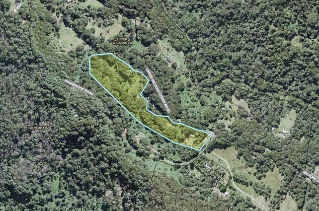
Figure 3: Aerial image of site and surrounds (yellow
highlight).
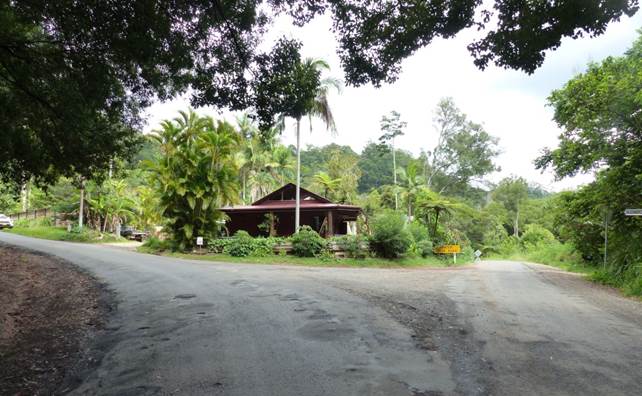
Figure 2: View towards Lillium Café from
Malcom’s Corner.
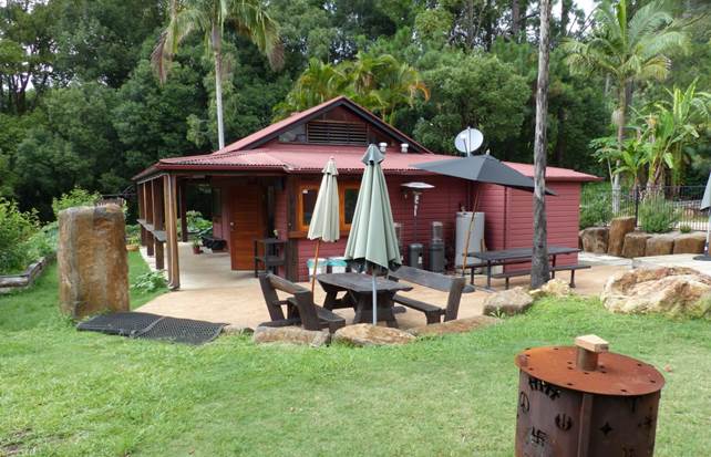
Figure 3: Outdoor dining area
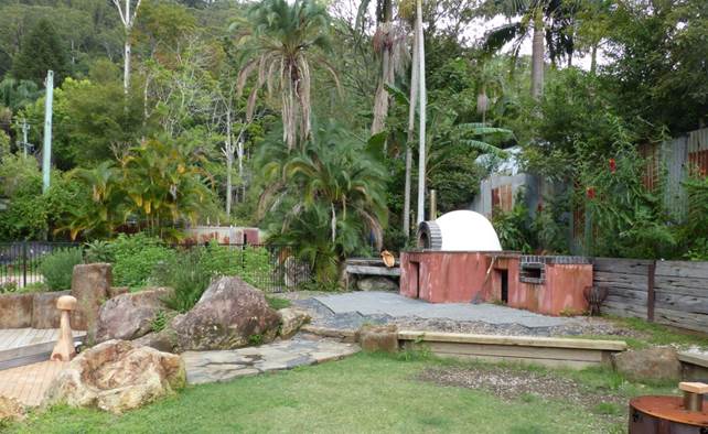
Figure 4: Pizza oven and outdoor seating area.
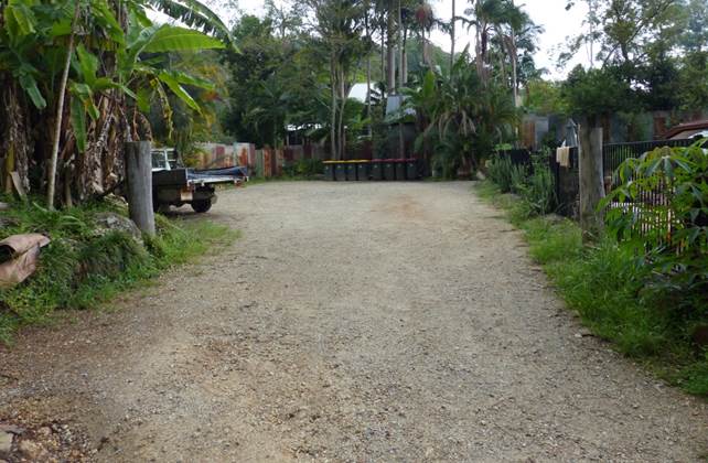
Figure 5: Existing gravel carpark with room for six
(6) vehicles.
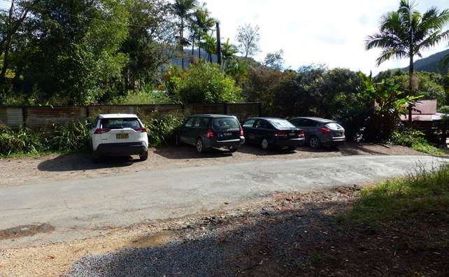
Figure 6: Vehicles parked near the Café on
Huonbrook Road.
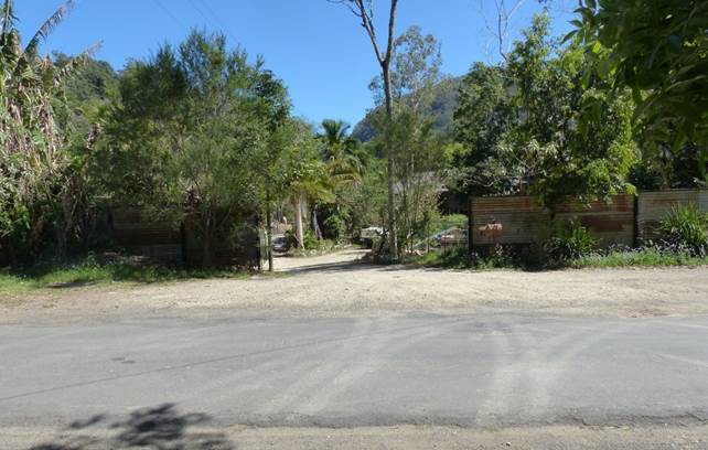
Figure 7: Second driveway entrance for expanded car
park
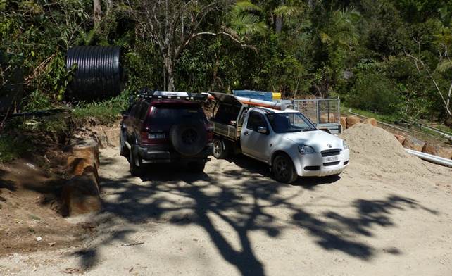
Figure 8: Part of proposed carparking at the southern
corner of the site.
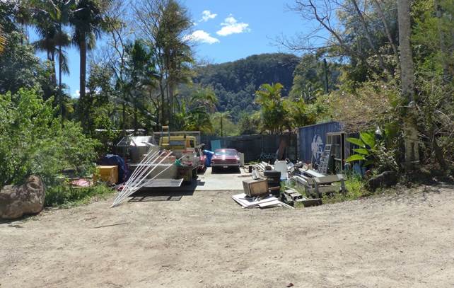
Figure 9: Recently constructed concrete slab, fencing
and shipping container.
2.
SUMMARY OF REFERRALS
|
Referral
|
Comment
|
|
Environmental Health Officer
|
Council’s Environmental Health Officer commented
that the existing on-site sewage management system (OSMS) does not appear to
have been installed with approval and has been substantially altered by the
unauthorised developments at the shop, including decking over the septic
tank. It is recommended that that the OSMS be upgraded to include a grease
trap and approval be obtained for the system under Section 68 of the Local
Government Act 1993.
In relation to noise, it was noted that an acoustic
report was not provided and therefore conditions are recommended which limit
the hours of operation to 8am to 730pm Sunday to Thursday and 8am to 9.30pm
Friday to Saturday.
In terms of potable water, rainwater tanks are to be
upgraded to include first-flush bypass devices and shall be maintained and
tested in accordance with NSW Health’s Private Water Supply Guidelines.
|
|
Development Engineer
|
A revised car parking plan was provided in the
applicant’s further information detailing 15 spaces as required by DCP
2010.
Council’s Development Engineer concluded that
the car parking plan did not strictly comply with the relevant engineering
standards for car parking dimensions and manoeuvring in AS2890.1, however,
there is enough room available on-site for a compliant parking plan to be
prepared for the construction certificate application.
In relation to traffic generation and road condition, it
is recommended that the road formation (sealed width) of Huonbrook Road and
Upper Wilsons Creek Road to be upgraded to achieve a carriageway of 6.2m for
the full frontage of the development site and intersection line marking.
|
|
Infrastructure Services
|
Council’s Director of Infrastructure Services
acknowledged that a small part of the premises (~3m2) is in the
road reserve. Planning staff were advised that no further action is required
at this stage.
A condition is recommended to clarify that minor parts
of the building extending outside the lot boundaries are not included in the
development consent.
|
3.
SECTION 4.14 – BUSH FIRE
PRONE LAND
Under section 4.14 of the
Act, Council must be satisfied prior to making a determination for development
on bush fire prone land, that the development complies with the document
‘Planning for Bush Fire Protection 2019’. The site is bush fire prone
land.
Planning for Bushfire Protection 2019 – Section 8:
Other Development
The proposed restaurant is accessible to fire fighting
vehicles and is capable of being defended in the event of a bushfire. Rainwater
tanks could potentially serve as additional firefighting water supply if
needed.
The proposed development is considered to satisfy the aims
and objectives of PBP 2019 and meets the objectives for ‘other
development’ under s. 8.3.1.
4.
SECTION 4.15C – MATTERS
FOR CONSIDERATION – DISCUSSION OF ISSUES
Having regard to the matters for consideration detailed in
Section 4.15(1) of the Environmental Planning & Assessment Act 1979
(EP&A Act), the following is a summary of the evaluation of the issues.
4.1
State Environmental Planning
Instruments
|
|
Satisfactory
|
Unsatisfactory
|
|
State
Environmental Planning Policy No 55—Remediation of Land
|
☒
|
☐
|
|
Council’s Environmental Health Officer noted that
the land is considered to be suitable for the proposed restaurant in its
current state and does not require remediation. The site is currently
approved for use as a general store and there is no increase in the
sensitivity of the land use resulting from the proposed development.
|
|
State Environmental Planning Policy (Koala Habitat
Protection) 2020
|
☒
|
☐
|
|
The subject site is not identified in Council’s
records as containing preferred or core koala habitat. The application
relates to change of building use on a cleared part of the site and does not
involve any development on forested parts of the land to the west of the
proposed restaurant. The proposed development is unlikely to significantly
affect koalas or their habitat.
|
4.2B Byron Local Environmental Plan 1988
(LEP 1988)
LEP 1988 is an applicable
matter for consideration in the assessment of the subject development
application in accordance with subsection 4.15(1) of the EP&A Act because
it applies to the subject land and the proposed development. The LEP 1988
clauses that are checked below are of relevance to the proposed development:
|
Part 1
|
☒1|
☒2| ☒2A| ☒3| ☒4| ☒5| ☒LEP 1988 Dictionary| ☒7
|
|
Part 2
|
☒8|
☒9
|
|
Part 3
|
☒40|
☒45| ☒64
|
In accordance with LEP 1988 clauses 5, 8 and 9:
(a) The
proposed development is defined in the LEP 1988 Dictionary as General Store
and Restaurant;
(b) The
land is within the LEP1988 7(c) (Water Catchment Zone) according to the map
under LEP 1988;
(c) The
proposed development is permitted with consent; and
(d) The
proposed development is consistent with the relevant objectives of the Zone for
the following reasons:
|
Zone Objective 7(c) Water Catchment Zone
|
Consideration
|
|
(a) to prevent development within the
catchment of existing or future water supply systems which would have a
significant detrimental effect on the quality or quantity of the water
supply,
|
The proposal can satisfy the zone objectives subject
to suitable conditions of consent. The existing on-site sewage management
system will need upgrading to Council’s standards and erosion and
sediment controls will need to be employed during any future works to upgrade
the car parking and/or driveway.
|
|
(b) to ensure that development maintains
the rural character of the locality and minimises disturbances to the
landscape through clearing, earthworks and access roads so as to avoid
erosion,
|
|
(c) to ensure that development does not create
unreasonable or uneconomic demands, or both, for provision or extension of
public amenities or services,
|
|
(d) to enable the carrying out of
appropriate uses on the land within the zone in a sound manner which
conserves or enhances the environmental amenity of the locality,
|
|
(e) to ensure land uses which use
pesticides and herbicides or other pollutants are kept to a minimum to
maintain the quality of run off water, and
|
|
(f) to enable the careful control of noxious
plants and weeds by means not likely to be significantly detrimental to the
native ecosystem.
|
The remaining checked clauses have been taken into
consideration in the assessment of the subject development application in
accordance with Section 4.15 of the EP&A Act. The proposed development
complies with all clauses of LEP 1988 (in some cases subject to conditions and/or
to the satisfaction of other assessing officers).
|
Division 4 General provisions
|
Compliance
|
Comment
|
|
Clause 40 Height
|
Yes
|
The existing building is single storey with a maximum
height of approximately 4m. No changes to the height of the building are proposed.
|
|
Clause 45 Provision of services
|
Yes, subject to conditions
|
Upgrades to the existing on-site sewage management
system and rainwater harvesting system are required.
Council’s Environmental Health Officer noted
that the existing OSMS will need to be upgraded and a grease trap installed
to deal with waste from the kitchen.
Rainwater tanks are required to have first flush
devices installed and managed in accordance with a potable water management
plan.
|
4.3
Any proposed Instrument that has
been the subject of public consultation and has been notified to the consent
authority
The site is identified for rezoning to Part RU2 Rural
Landscape zone and Part E2 Environmental Conservation in Stage 3 of
Council’s e-zones planning proposal. At this stage the LEP amendment has
not completed public exhibition and is neither imminent nor certain. In
relation to the likely future zoning of the site, the proposed restaurant is a
permissible use and is compatible with the zone objectives.
4.4B Byron Shire Development Control Plan 2010 (DCP 2010)
DCP 2010 is an applicable
matter for consideration in the assessment of the subject development
application in accordance with subsection 4.15(1) of the EP& A Act because
its purpose is to provide planning strategies and controls for various types of
development permissible in accordance with LEP 1988. The DCP 2010
Chapters/Parts that are checked below are of relevance to the proposed
development:
|
Chapter 1 Parts:
|
☒D|
☒F| ☒G| ☒H| ☒L| ☒ N
|
These checked Chapters/Parts have been taken into
consideration in the assessment of the subject development application in
accordance with Section 4.15 of the EP&A Act. The proposed development is
demonstrated to meet the relevant Objectives of DCP 2010 (in some cases subject
to conditions and/or to the satisfaction of other assessing officers).
|
DCP 2010 - Chapter 1 Part D
|
Complies
|
Comment
|
|
D2.1 Element - Location and Function
|
Yes
|
The site is not a commercial centre. However, the
location of the restaurant on the corner of Huonbrook and Wilson’s
Creek Roads is central to the localities of Wilson’s Creek, Wanganui
and Huonbrook and serves as a social hub for these communities.
|
|
D2.2 Element - Scale and Appearance
|
Yes
|
The proposed restaurant is not part of a business
centre, but is appropriate in size, scale and appearance for its locality.
|
|
D2.3 Element – Parking
|
Yes, subject to conditions
|
Refer to DCP Element G2.1.
|
|
D2.4 Element - Loading Docks
|
Yes
|
There is sufficient room for a small truck or van to park
temporarily in the carparking area to load and unload goods if required.
Council’s Development Engineer has also recommended a condition for a
loading bay to be provided in the amended car parking plan.
|
|
D2.5 Element - Setback from Street
|
Yes
|
The building is an old shop with a nil setback to the
road reserve. No changes to the existing setbacks are proposed as part of the
DA.
|
|
D2.6 Element – Signs
|
Yes
|
A small business identification sign has been attached
to the verandah of the shop. No additional signage is proposed.
|
|
D2.7 Element - Access and Facilities for People with
Disabilities
|
Yes
|
Disabled access was assessed as part of the BA 97/2398
and found to be adequate.
|
|
D2.9 Element - Outdoor Dining
|
Yes
|
The proposal includes outdoor dining on a veranda and
rear courtyard.
The layout of the outdoor eating area complies with
the Prescriptive Measures of D2.9 in relation to private arcades and
courtyards.
|
|
D2.11 Element Plumbing
|
Yes, subject to conditions
|
Council’s EHO recommended that a grease trap be
installed to deal with waste from the kitchen. Conditions are recommended.
|
|
D2.12 Element - Waste Management
|
Yes
|
Council garbage collection is available off Huonbrook
Road.
|
|
DCP 2010 - Chapter 1 Part F
|
Complies
|
Comment
|
|
F2.2 Site Waste Minimisation and Management Plans
|
Yes, subject to conditions
|
A condition is recommended that requires a waste
management plan to be prepared in accordance with DCP Chapter 1 Part F,
Element F4.3. The waste management plan is to be implemented and adhered to
at all times.
|
|
F4.3 Element – Commercial & Retail
Development
|
Yes, subject to conditions
|
See above.
|
|
DCP 2010 - Chapter 1 Part G
|
Complies
|
Comment
|
|
G2.1 Element – Parking Schedules
|
Yes, subject to conditions
|
Part G2.1 of the DCP requires car parking for
restaurants to be provided at a rate of 1 space per 7.5m2 of gross
floor area (GFA) or 1 space per 3 seats, whichever is the greater.
The building has a GFA of 109m2 which
generates demand for 15 car parking spaces.
The applicant provided amended car parking plans in
their further information detailing 15 car parking spaces as per the DCP (6
were originally proposed).
The amended plans satisfy the DCP requirement for
parking but will require revision to ensure the dimensions and manoeuvring
comply with AS2890.1 and Council’s design guidelines.
Nevertheless, sufficient room exists on site to
provide a carparking area which meets the relevant standards.
Council’s Development Engineer has proposed a
condition requiring expansion of the car parking area to provide 9 additional
car parking spaces. The proposal will satisfy the development control subject
to this condition.
|
|
G2.2. Element - Parking Layout
|
Yes, subject to conditions
|
As noted above, the applicant’s car parking plan
requires revision to ensure it meets the relevant technical standards in
AS2890.1.
Revised plans are to be submitted for approval with
the construction certificate.
|
|
G2.3 Element - Design, Access and Construction
|
Yes, subject to conditions
|
One disabled parking space shall be provided in
accordance with AS2890.1.
|
|
G2.4 Element - Service and Garbage Areas
|
Yes
|
Council waste collection is available off Huonbrook
Road. There is adequate room for bin collection in the road reserve.
|
|
G2.5 Element - Monetary Provision
|
N/A
|
A monetary contribution for car parking is not the
preferred outcome in this case given there is adequate room to provide
parking on-site.
|
4.5
Environmental Planning &
Assessment Regulation 2000 Considerations
|
Clause
|
This control is applicable to the proposal:
|
I have considered this control as it relates to the
proposal:
|
If this control is applicable, does the proposal comply?
|
|
92
|
Yes.
|
Yes.
|
Yes. Proposal must comply
with AS2601.
|
|
93
|
No
|
N/A
|
N/A
|
|
94
|
No
|
N/A
|
N/A
|
|
94A
|
No
|
N/A
|
N/A
|
4.6
The likely impacts of that
development, including environmental impacts on both the natural and built
environments, and social and economic impacts in the locality
|
Impact on:
|
Likely significant impact/s?
|
|
Natural environment
|
Vegetation
A minor amount of vegetation may need to be removed to
facilitate construction of the car parking area. Vegetation to be removed
comprises a mixture of palms, bananas and various native and non-native
shrubs and trees such as banksia and Lilli pili.
Much of the vegetation appears to have been planted
at some point in the past 10 years (based on aerial photos and Google Street
View images) and is not considered to have significant environmental value. Compensatory
plantings are to be provided at a rate of 5:1 and incorporated into a new
landscaping concept plan for the proposed car parking area.
Effluent and runoff
Effluent quality is to be addressed through conditions
requiring the OSMS to be upgraded along with the installation of a grease
trap to handle waste from the kitchen. The café is unlikely to have a
significant effect on the quality or quantity of water discharged from the
site subject to appropriate conditions of consent.
|
|
Built environment
|
Car parking
Parking congestion was observed around Malcom’s
corner during the site inspection which appears to be having an impact on the
safety of road users and pedestrians. The road reserve does not have adequate
space to safely accommodate the number of vehicles parking around the
café.
To address this issue Council’s Development
Engineer has recommended that the existing carparking is to be expanded to
provide an additional 9 spaces along with road upgrades along Huonbrook Road
and Upper Wilsons Creek Road.
Traffic generation
The Annual Average Traffic Daily (AADT) volumes on
Huonbrook Road and Wilsons Creek Road are currently estimated to be 278 and
169 vehicles per day respectively.
The proposed restaurant will likely increase traffic
volumes by an additional 66 AADT, which equates to a 24% increase for Huonbrook
Road, and a 39% increase for Upper Wilsons Creek Road.
Council’s Development Engineer has recommended
that the road formation (sealed width) of Huonbrook Road and part of Upper
Wilson’s Creek Road be upgraded to achieve a width of 6.2m. Further, line
marking must be provided at the intersection.
Nosie and amenity
The nearest dwelling is approximately 90m from the
proposed restaurant, however, the landscape is such that noise will likely
travel if it involves amplified music or is occurring late at night.
Council’s Environmental Health Officer
recommended that the restaurants hours of operation should be limited to the
hours specified in the application, being Sunday to Thursday, 8am to 7:30pm,
and Friday to Saturday from to 8am to 9:30pm. Further, no amplified or live
music is to occur.
If the operators wish to seek permission to extend
operating hours or host live music, the consent will need to be modified or
reviewed and an acoustic report provided demonstrating no adverse noise impacts
on the surrounding area.
Fencing
Corrugated iron fencing to a height of ~2m appears to
have been constructed along the Huonbrook Road frontage. The fencing fails to
comply with the requirements for exempt development in the Codes SEPP and
partially encroaches the road reserve.
A condition is recommended for the fencing to be
removed and replaced with a compliant post-and-rail fencing and/or
landscaping to rectify the encroachment and improve the appearance of the
site from the public domain.
Shipping container and concrete hardstand
In addition, a shipping container and a concrete
hardstand area of ~150m2 has been constructed near Huonbrook Road.
As with the fence, the structure fails to comply with the standards for
exempt development in the Codes SEPP and also conflicts with the proposed car
parking area.
A condition is recommended for the shipping container
is to be removed. Similarly, the concrete hardstand is to be demolished, or
else incorporated into the amended carparking design.
The matter has also been referred to Council’s
community enforcement team for further consideration.
|
|
Social Environment
|
Community meeting place
The presence of a café and general store at
Malcom’s corner is likely to have a positive social impact on the
communities of Huonbrook, Wilsons Creek and Wanganui. Numerous submissions of
support have been received from the public reflecting on the importance of
the cafe/store as a valued meeting place and community hub in the area.
Liquor licence
It is understood that the Office of Liquor and Gaming
recently granted approval for a packaged liquor licence in September 2020.
The licence allows for packaged alcohol to be sold from the general store for
consumption off-premises.
Any new liquor license application (if applied for)
will need to be reviewed and approved by the NSW Office of Liquor and
Gaming.
|
|
Economic impact
|
The proposal is likely to have a minor but positive
impact on the local economy. The restaurant supports local producers and
contributes to the tourism industry.
|
|
Construction Impacts
|
Conditions of consent are recommended controlling
hours of work, builders waste, construction noise, installation of
sedimentation and erosion control measures and the like to ameliorate such
impacts.
|
4.7
The suitability of the site for
the development
The site attributes are suitable for the ongoing use of the
site as a restaurant and general store. The main issue is a lack of car parking
which has resulted in traffic congestion and dangerous car parking occurring
around Malcolm’s corner. This is to be addressed by expanding the
existing car park to provide 15 spaces along with appropriate signage and road
upgrades.
4.8
Submissions made in accordance
with this Act or the regulations
The development application
was publicly exhibited for a period of 14 days in accordance with DCP 2010.
There were 83 submissions made on the development application:
-
For 55.
Against 28.
Supporters of the DA mainly focused on the positive aspects
of the café as a meeting place and community hub. Some people also
highlighted the need to support small businesses which hire local staff and
source ingredients from local farmers.
Objectors focused on the dangerous car parking and traffic
situation along with unauthorised camping and trespassing on private land. The
issue of unauthorised development was also raised.
Submissions of support
|
Issue
|
Comment
|
|
Positively contributes to local community.
Café is a meeting place and hub for the local
community.
|
The café provides social benefits as a meeting
place for the local community.
|
|
Council should support small business.
The business hires local staff and creatives and
sources ingredients from local enterprises and farmers.
Business is ethical an only uses organic produce.
|
Acknowledged. The proposal is likely to have a minor
positive impact on the local economy and community.
|
|
Council should widen/improve the road and provide
parking
|
Council will not be undertaking public works to
facilitate a private business.
|
|
Serves needs of local community - saves 20-minute
drive to Mullumbimby.
|
The proposal will enhance the current offerings of the
general store and improve service to the local community.
|
|
Contributes to tourism in the region.
|
The proposed cafe will make a minor but positive
contribution to tourism in the Shire.
|
Objections
|
Issues raised in objection
|
Comment
|
|
Café has been operating without approval
|
Agreed. The DA has been lodged following a compliance
investigation by Council.
|
|
Café has increased traffic on Wilsons Creek
Road
|
Agreed that the café has increased traffic on
Wilsons Creek Road. Conditions are recommended to increase car parking and
undertake road upgrades.
|
|
Lack of car parking resulting in dangerous illegal
parking on blind corner. Matter of time before a pedestrian or child is
injured
|
See above.
|
|
Safety issue due to drivers consuming alcohol
Liquor licence needs to be reviewed
|
The general store has a packaged liquor licence (i.e.,
takeaway licence) which does not permit consumption of alcohol on-premises.
The operators of the restaurant will need to apply for
a new liquor license to NSW liquor and Gaming if they wish to serve alcohol
on site.
Driving under the influence of alcohol is a matter for
NSW Police.
|
|
Business is a café and not a general store.
Do not offer essentials to avoid a trip to
Mullumbimby.
|
Agreed that the business is currently operating as a
café, although there is an existing approval in place to operate as a
general store.
|
|
Functions and café generate excessive noise
|
Conditions of consent have been recommended in
reaction to noise. The café is not approved to operate late at night
or be used as a function centre.
|
|
Increase in wild campers due to café
advertising wild camping locations to customers.
|
Unauthorised camping is not a matter directly related
to the proposed restaurant.
Should the land owners allow people to camp on the
property then this should be raised with Council to investigate and take
appropriate compliance action
|
|
Not following Covid safe guidelines
|
Compliance with Covid safe guidelines is a matter for
NSW police and State Government Public Health Council’s official to
investigate.
|
|
Current OSMS and infrastructure is inadequate for the
development. The store may have resulted in contaminants leaking downstream
into the environment.
|
Noted - The OSMS will need to be upgraded prior to
commencement of operations and installation of a trade waste device (grease
trap) Conditions are recommended.
|
|
More killed animals on the roads
|
There is insufficient evidence to demonstrate
increased animal deaths due to the café.
|
|
Increase in traffic on road resulting in road safety
issues.
|
Conditions are recommended for road upgrades at the
frontage of the site along Huonbrook Road and Upper Wilsons Creek Road.
|
|
Increases in tourism, resulting in camping, fires,
garbage, and excrement and noise.
|
The proposed café is not directly related to
unauthorised camping in the area.
|
|
Trespassing resulting from promotion of local
waterholes
|
See above. Allegations of trespassing are beyond the
scope of this assessment.
|
|
Events attract huge number of people and create
dangerous parking situation
|
Acknowledged. Additional parking is required for the
restaurant.
Restaurant is only small and to have only a limited
capacity of 30 patrons. Conditions to apply.
|
4.9 Public interest
The proposed development is unlikely to prejudice or
compromise the public interest or create an undesirable precedent. Public
safety is unlikely to be compromised subject to conditions for additional car
parking and road upgrades.
5. DEVELOPER CONTRIBUTIONS
5.1 Water & Sewer Levies
The site is not serviced by reticulated water or sewer. Section
64 levies are not applicable.
5.2 Developer Contributions
The proposal is for commercial
development with an estimated cost of less than $100 000. Section 7.12
developer contributions are not applicable.
6. DISCLOSURE OF POLITICAL DONATIONS AND GIFTS
|
Has a Disclosure Statement been received in relation
to this application
|
No
|
|
Have staff received a ‘gift’ from anyone
involved in this application that needs to be disclosed. Where the answer is
yes, the application is to be determined by the Director or Manager of the
Planning, Development and Environment Division.
|
No
|
Provide Disclosure Statement register details here: Not
applicable.
7. CONCLUSION
This development application seeks consent for a change of
use from a general store to a combined general store/restaurant plus ancillary
car parking works at 10 Huonbrook Road, Upper Wilsons Creek.
The proposal has been amended to address several issued
identified by Council officers during the assessment of the application. Safety
issues relating to car parking and traffic congestion are to be addressed by
expanding the carpark to provide an additional 9 spaces along with consent
conditions requiring road upgrades at the frontage of the site along Huonbrook
Road and Upper Wilsons Creek Road.
In summary, the proposal is in keeping with the surrounding
natural and built environment that provides a social hub for the Wilson’s
Creek and Huonbrook communities. The development satisfies the relevant
planning controls applying to the land and, provided the consent conditions are
implemented, will not have a detrimental impact on the environment or on local
traffic conditions. The development is recommended for approval subject to the
conditions of consent.
Staff Reports - Sustainable Environment and Economy 13.3
Report
No. 13.3 PLANNING - Development Application
10.2021.291.1 Mixed Use Development - Shops and Serviced Apartments - 116-118
Jonson Street Byron Bay
Directorate: Sustainable
Environment and Economy
Report Author: Shannon
Burt, Director Sustainable Environment and Economy
File No: I2021/1324
Proposal:
|
DA No:
|
10.2021.291.1
|
|
NSW PP
|
PAN-101826
|
|
Proposal description:
|
Demolition of existing backpackers’ hostel and
construction of a mixed-use development comprising retail premises and
serviced apartments
|
|
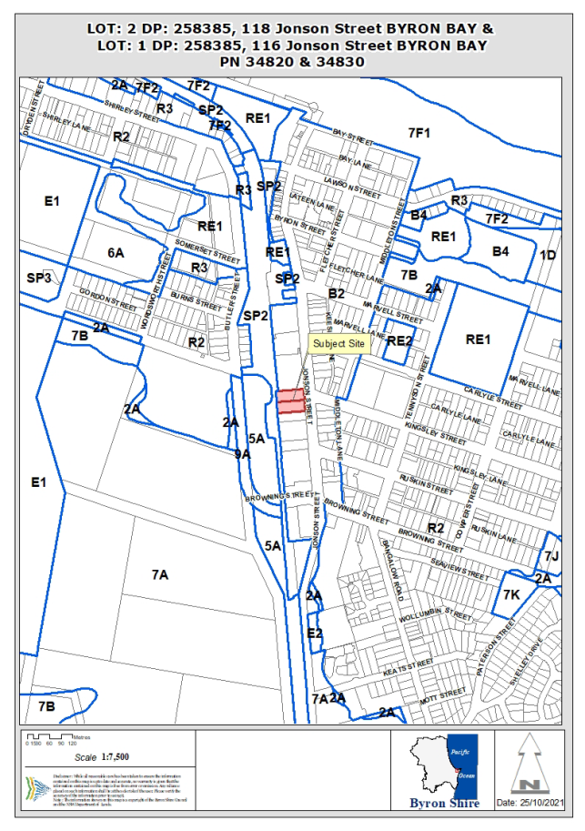
Property description:
|
LOT: 1 DP: 258385, LOT: 2 DP: 258385
|
|
116 Jonson Street BYRON BAY, 118 Jonson Street BYRON
BAY
|
|
Parcel No/s:
|
34830, 34820
|
|
Applicant:
|
Aidop No 5 Pty Ltd ATF Aidop No 5 Unit Trust and Aidop
No 6 Pty Ltd ATF Aidop N
|
|
Owner:
|
J E Moore & S J Walker & Mrs K H Wilson &
Others
|
|
Zoning:
|
B2 Local Centre
|
|
Date received:
|
27 May 2021
|
|
Integrated / Designated Development:
|
☒
Integrated
|
☐
Designated
|
☐
Not applicable
|
|
Concurrence required
|
Yes
|
|
Public notification or exhibition:
|
- Level
3 advertising under DCP 2014 Part A14 – Public Notification and
Exhibition of Development Applications
- Exhibition
period: 10/6/21 to 8/7/21
- Submissions
received 21 (19 Support: 1 Resolved: 1 Objection)
|
|
Development Standard Variation Request
|
Clause 4.6 – Building Height
|
|
Issues:
|
· Clause 4.6 Submission –
Building Height
· Design Excellence
· Sustainability
· Waste Collection and Parking,
Loading and Unloading Bays
· Stormwater management
|
Summary:
The proposal seeks consent for
Demolition of existing backpackers’ hostel and construction of a
mixed-use development comprising retail premises and serviced apartments.
Byron LEP 2014 was updated on 20 August 2021 by Amendment No
27 (Byron Bay Town Centre Planning Controls).
An independent design excellence expert was engaged to work
alongside the Council assessment team to ensure optimum compliance was achieved
by the proposal with the new Byron Bay Town Centre Planning controls.
Following a preliminary assessment of the submitted proposal
by the Council assessment team, and meetings on same, requests for additional
information and design amendments were sent to the applicant.
The applicant has worked proactively and collaboratively with
the Council assessment team and responded to these requests. A series of
plan iterations has been submitted that addressed key areas of concern with the
proposal. These areas were:
· Apartment
amenity
· Roof
terrace amenity and shade protection
· Circulation
and connectivity
· Bulk
mass and façade & street wall expression
· Natural
cross ventilation
· Sustainability
and
· Waste
collection, parking and loading bays.
The application includes a request to vary the height of
buildings development standard.
The request to vary the development standard is supported in
this instance given the site context, land use mix and location in the town
centre area.
The applicant however is required to provide further
stormwater easement details to verify matters relating to the nominated legal
points of discharge for stormwater from the site.
Given the above, the application is recommended for deferred
commencement consent subject to recommended conditions in Attachment 2.
NOTE TO COUNCILLORS:
In accordance with the
provisions of S375A of the Local Government Act 1993, a Division is to be
called whenever a motion for a planning decision is put to the meeting, for the
purpose of recording voting on planning matters. Pursuant to clause 2(a)
under the heading Matters to be Included in Minutes of Council Meetings of
Council's adopted Code of Meeting Practice (as amended) a Division will be
deemed to have been called by the mover and seconder of all motions relating to
this report.
RECOMMENDATION:
That Council:
1. Approves
the variation requested to clause 4.3 Height of Buildings in accordance with
clause 4.6 ‘Exceptions to Development Standards’ of the Byron Local
Environmental Plan 2014; and
2. Grants
Deferred Commencement Consent pursuant to Section 4.16 (3) of the Environmental
Planning and Assessment Act 1979, to Development Application
10.2021.291.1 Mixed Use Development - Shops and Serviced Apartments - 116-118
Jonson Street Byron Bay subject to the conditions in Attachment 2
(#E2021/131318) to the report.
Attachments:
1 Proposed
Plans 10.2021.291.1, E2021/129090

2 Proposed
Conditions 10.2021.291.1, E2021/131318
3 Redacted
submissions received 10.2021.291.1, E2021/128991
Report
1. INTRODUCTION
Site History
116 Jonson Street DA
83/099 Hostel and Manager’s Residence. Approved May 1993.
BA
86/0313 Hostel
118 Jonson Street DA
80/289 Residential flat building.
DA
81/002 Extensions to an existing residential flat building
DA
10.2015.262.1 Change of use to backpackers’ accommodation; approved Dec
2015
History Relevant to the Development
Application
The application was submitted on 27 May 2021.
Byron LEP 2014 was updated on 20 August 2021 by Amendment No
27 (Byron Bay Town Centre Planning Controls).
The amendments are an action from the Byron Town Centre
Masterplan and seek to improve the development outcomes for the town centre.
Key changes included:
· Introduction
of a Building Height Allowance clause for development located on flood prone
land and a new Building Height Allowance Map
· Design
Excellence controls in the LEP and a new Design Excellence Map
· Active
Street Frontage controls in the LEP and a new Active Street Frontages Map
· The
formation of a Design Excellence Panel
Currently there is no Design Excellence
Panel. Instead, an independent design excellence
expert was engaged to work alongside the Council assessment team to ensure
optimum compliance was achieved by the proposal with these new controls.
Following a preliminary assessment of the submitted proposal
by the Council assessment team, and meetings on same, requests for additional
information and design amendments were sent to the applicant on 5 August, 10
September, 21 September, 8 October, and 13 October 2021.
The applicant has worked proactively and collaboratively with
staff and responded to these requests and submitted the following information
and amendments as follows:
Round 1 – Solar Impact to 120 Jonson Street (Staff
– 5 August 2021)
Reduced building envelope, bulk, mass, and scale by increasing
the southern boundary setback by a further 3.3m to the east and west 4-bedroom
apartments to improve solar access, outlook, and amenity for the 120 Jonson
Street neighbours, as well as improved solar access to the internal circulation
corridors within the scheme.
This initiative was well received by the neighbours and
resulted in the only objection from 120 Jonson Street being retracted.
Round 2
– Urban Design Review (Simpson Wilson – 10 September 2021)
• New
voids provided to corridor adjacent to the two-bedroom units to allow natural
light to penetrate through the corridors on Level 3 and Level 2 to improve
solar access and amenity to the adjoining apartments on Level 1 and 2.
• Additional
landscaping and vertical gardens to new voids to improve microclimate and cross
ventilation.
• Increase
corridor widths adjacent 2 bed layouts to improve natural ventilation and solar
access.
• Reduced
size and reconfigured 4 x 2-bedroom layouts to accommodate voids.
• Reduced
internal area from master bedroom of Unit 1.12 & 1.15 on Level 1, &
2.12 on Level 2 facing Jonson St to increase depth of the recess by an
additional 1.2m.
• Primary
Entry - Reduced internal area from master bedroom of Unit 2.15 on Level 2
facing Jonson St to increase depth of the recess by an additional 3.6m.
• Setback
Level 3 rooftop balustrade so it’s concealed from street.
Round 3
– Urban Design Review (Council/Simpson Wilson – 21 September 2021)
• Void
spaces have been extended from Level 3 and Level 2 on the western corridor down
to Level 1 also, to improve natural light penetration down to the ground floor,
including units G.07, G.06 and G.05 specifically.
• High-level
glazing introduced to the western edge of the 151m2 retail tenancy (adjacent
units G.07, G.06 and G.05) to provide additional light spill into the ground
floor western corridor.
• Reduced
internal area from master bedroom of Unit 2.12 on Level 2 facing Jonson Street
to increase depth of recess by an additional 3.6m.
• Reprofiled
the horizontal roof balustrade by reducing the depth, height and width of the
slab edge and planter fronting Jonson Street to reduce bulk and mass.
• Reduced
trafficable area of private roof terraces by approximately 420m2 and replaced
with soft landscaping or other.
• Inclusion
of modest permanent shading structures to roof terraces and pool area to
improve habitability.
· increased
size of proposed street trees along Jonson Street to a mature size of 500L pot
size upon installation to create more immediate shading along the street at
completion of the project.
• Materiality
of Jonson Street balcony spandrel in the recessed areas amended to provide
brick expression detail to improve fine grain, visual interest, and depth to
the façade.
Round 4 – Urban Design Review, Waste and Traffic
(Council/Simpson Wilson – 8 October 2021 and 13 October 2021)
• Reduced
extent of trafficable area to private roof terraces by 796m2 and replaced with
soft landscaping or other.
• Deletion
of shade structures to private roof terraces and inclusion of modest permanent
shading structures to pool area to improve habitability and shade amenity.
• Extent
of Level 3 roof has reduced by 68m2 and been setback a further 500mm from the
original DA to ensure building footprint remains wholly within the property
boundary (i.e., no projection beyond the property boundary);
• Level
2 façade and balconies to Jonson Street have been setback a further
500mm from the property boundary;
• Level
1 façade and balconies to Jonson Street are now setback 1m from the
original DA and property boundary to provide more articulation and relief to
this elevation;
• Level
1 Unit 1.12 & Unit 1.15 have reduced in size and now become smaller
2-bedroom units Instead of 3 bedrooms;
• Level
2 Unit 2.12 & Unit 2.15 have reduced in size and now become smaller
2-bedroom units Instead of 3 bedrooms;
• An
overall reduction of 140m2 in Total Gross Floor Area;
• Level
3 roof landscape planters with trailing climbers are shown to provide additional
vertical articulation and visual interest to soften and break up the
façade; and
• Deletion
of kerbside loading zone for waste collection to ensure all waste collection is
carried out from within the site.
The above amendments are reflected in the revised plans
attached to the report for Council determination (Attachment 1).
Description of the proposed
development
This application seeks consent for the demolition of existing
buildings on two properties and the construction of a three-storey mixed use
development containing a total of 602m2 of retail and 41 serviced
apartments, including:
· basement
parking, containing 119 car parking spaces;
· ground
floor: retail / café spaces around and internal courtyard, and 7
serviced apartments at the rear;
· two
levels above, each with 17 serviced apartments; and
· guest
facilities on the roof, including a communal area with a swimming pool and
deck.
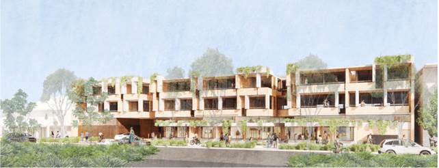
Fig 1. Jonson Street
perspective
· Development
Summary
|
Ground Floor
|
Upper Floors
|
|
Retail Spaces:
· retail/
café: 199m2
· retail: 252m2
· retail: 151m2
Serviced Apartments:
· 1 x 4 bedroom
· 6 x 3 bedroom (1
accessible)
Central Landscaped Courtyard 523m2
Apartments Lobby
Plant Rooms & Amenities
|
Each Level:
3 x 2 bedroom apartments
12 x 3 bedroom apartments
2 x 4 bedroom apartments
|
Floor Space:
· Retail 660m2
· Apartments: 4,651m2
· Common areas: 115m2
· Total: 5,246m2
A single level of basement carparking is proposed, accessed
off Jonson Street toward the southern boundary of the property. The basement
contains:
· 76 spaces for the serviced
apartment, including 7 accessible spaces.
· 7 bicycle parking spaces
for serviced apartments.
· 33 spaces for retail
component, including 1 accessible space.
· 7 bicycle spaces for
retail component.
· Lift and stair access to
upper floors.
· A loading/ garbage storage
area.
· Plant rooms and fire exit.
At ground level, two of the three retail tenancies are located
at the Jonson Street frontage, separated by a 3.6m wide walkway into the
central courtyard. The third retail tenancy is located internally, off
the south-west corner of the courtyard.
Vehicle access is via a ramp off Jonson Street located toward
the southern end of the property. The access is proposed as left-in/
left-out.
Plant rooms, toilets, showers and change rooms are along the
southern boundary.
Seven serviced apartments are proposed at the rear (western
end) of the ground floor, access via a lobby at the northern end. Each of
the serviced apartments include a western-facing paved balcony and a private
outdoor lawn space.
The upper two levels are identical, with serviced apartment
proposed around the central void. All apartments are accessed via
corridors open to the central void.
Eastern and western facing apartments have external balconies,
with the two-bedroom apartments to the south of the building having balconies
looking toward the central void.
The eastern and western facing apartments on the top floor
each have an internal stair access to the roof.
Lift access to the roof otherwise is at the northern boundary,
located against the adjoining Mercato shopping complex.
Additional roof-top plant and a staircase is located at this
northern edge. Hot water plant room on the southern edge.
While the height of the roof generally meets the 11.5m height
limit, there are roof top elements that exceed it to a varying extent.
A request to vary the development standard pursuant to Clause
4.6 of the Byron LEP 2014 has been submitted and is discussed in detail in the
report.
Description of the site
|
Land is legally described
|
Lots 1 & 2 DP 258385
|
|
Property address
|
116- 118 Jonson Street BYRON BAY
|
|
Land is zoned:
|
B2 Local Centre
|
|
Land area is:
|
4,282m2
|
|
Property is constrained by:
|
Acid Sulfate Soils Class
3
|
|
|
Bushfire Prone Land
|
|
|
Flood Prone Land
|
|
|
Mosquito Risk Zone
|
|
|
Is a BDAR required due to the location of the proposed
development?
|
☐ Yes ☒ No
|
|
|
Are there any easements in favour of Council affecting
the site?
A 3m wide drainage easement exists along the western
boundary of both lots.
|
☒ Yes ☐ No
|
|
|
Is there a Vegetation Management Plan which might
affect the proposal?
|
☐ Yes ☒ No
|
|
|
Is there a Voluntary Planning Agreement which might
affect the proposal?
|
☐ Yes ☒ No
|
The site is made up of two lots, each containing one and two
storey buildings used for holiday accommodation (backpackers).
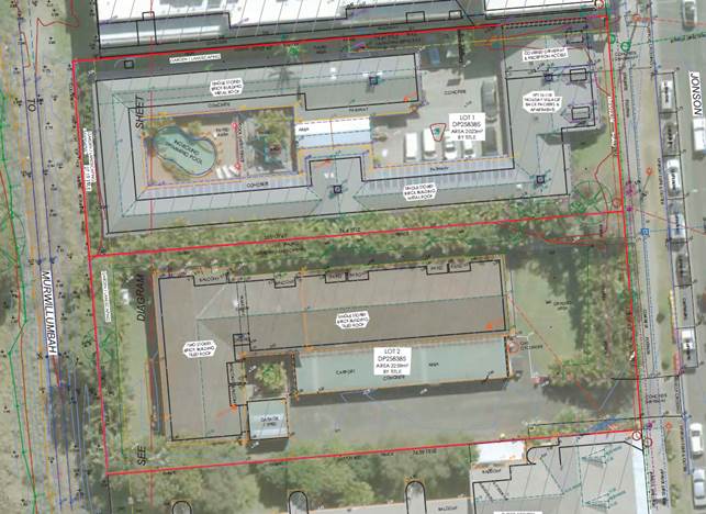
Fig 2. Existing development
The property has a total frontage of 57.56m to Jonson Street
on its eastern boundary, and the same to the North Coast Rail Line on its
western boundary. It has a depth of 74.4m.
It is generally flat, with a slight fall to the south-west,
with elevations ranging from approx. RL 3.2m AHD to RL 2.3m AHD.
Ground level across most of the site is at approx. RL 3.0m
AHD.
Mature vegetation is located along the Jonson Street frontage
of Lot 2 (the southern lot) and along the internal adjoining boundary.
The Mercato shopping complex adjoins to the north, with a
blank wall along the whole length of the adjoining boundary. A two-storey
development adjoins to the south, with shops at the Jonson Street frontage and
residential apartments behind, over a ground floor garage. That building
has varying setbacks from the adjoining boundary, with mature vegetation
planted on the boundary of the lot. Most of the apartments are holiday let.
Photo 1. Jonson Street frontage
– Mercato to right of photo
Photo 2. Jonson Street frontage
of Lot 2
Photo 3. Within Lot 2 showing relationship to apartments on
adjoining land
2. SUMMARY OF REFERRALS
|
External Referrals
|
Comment
|
|
Rural Fire Service (s.100B Rural Fires Act 1997)
|
Bush Fire Safety Authority issued 30 July 2021.
General Terms of Approval included in recommended consent.
|
|
Transport for NSW (cl 101& 104 SEPP Infrastructure
2007)
|
Support left in/left out access as proposed.
Recommend that any consent include requirement for Construction Management
Plan.
|
|
Transport for NSW (cl.86 SEPP Infrastructure 2007)
|
Concurrence granted subject to conditions; included in
recommended consent.
|
|
Water NSW (s.90 Water Management Act 2000)
|
General Terms of Approval issued; included in
recommended consent.
|
|
Internal Referrals
|
Comment
|
|
Environmental Health Officer
|
Conditions provided in the
referral are included in the recommendation of this Report
|
|
Development Engineer
|
Conditions provided in the referral are included in
the recommendation of this Report
|
|
Contributions Officer
|
Conditions provided in the referral are included in
the recommendation of this Report
|
|
Water & Sewer Engineer (Local Approvals Officer)
|
Conditions provided in the referral are included in
the recommendation of this Report
|
|
Building Surveyor
|
Conditions provided in the referral are included in
the Recommendation of this Report
|
3. SECTION 4.14 –
BUSH FIRE PRONE LAND
Under section 4.14 of the Act, Council must be satisfied prior
to making a determination for development on bush fire prone land, that the
development complies with the document ‘Planning for Bush Fire Protection
2006’.
The site is bush fire prone land.
Tourist and visitor accommodation is defined as a type of
“special fire protection purpose” and requires a Bush Fire Safety
Authority (BFSA) under s. 100B of the Rural Fires Act 1997.
The development application seeks approval for the BFSA
concurrently and is therefore classified as integrated development as per s.
4.46 of the Environmental Planning and Assessment Act 1979.
General Terms of Approval were issued by the RFS on 30 July
2021, requiring the whole property to be managed as an inner protection area
and construction to be BAL 29 for elevations other than that on Jonson Street,
which can be BAL 19.
4. SECTION 4.15C –
MATTERS FOR CONSIDERATION
The following is a summary of the assessment of the
application in accordance with Section 4.15(1) of the Environmental Planning
& Assessment Act 1979 (EP&A Act).
The application has been assessed against the relevant
environmental planning instruments below:
State Environmental Planning
Instruments (SEPP)
State
Environmental Planning Policy (Koala Habitat Protection) 2021
Council’s
Byron Coast Comprehensive Management Plan is an approved koala
management plan for the purposes of this SEPP. Clause 10 of the SEPP
therefore applies and requires that Council’s determination of the
development application must be consistent with the approved koala plan of
management that applies to the land.
In accordance with the approved
Plan, the subject site is within the South
Byron Coast Koala Management Area.
The site
is not located within any mapped Koala
Management Precinct. As such, there
are no provisions of the Plan that are directly relevant to the subject
application.
State
Environmental Planning Policy No 55 - Remediation of Land
A Preliminary Site Contamination
Report has been submitted in support of the application and is assessed as
acceptable.
State
Environmental Planning Policy No 65 - Design Quality of Residential Apartment
Development
SEPP 65 does not apply to service
apartments. The guidelines and development criteria are therefore not
applicable.
State
Environmental Planning Policy (Building Sustainability Index: BASIX) 2004
The proposed building is not a
BASIX affected building.
SEPP (Coastal Management) 2018
The property is located within an area mapped as land in
proximity to coastal wetlands. Under clause 11 of the SEPP, development
consent cannot be granted to the development unless Council is satisfied that
it will not significantly impact on:
(a) the
biophysical, hydrological or ecological integrity of the adjacent coastal
wetland or littoral rainforest,
(b) the
quantity and quality of surface and ground water flows to and from the adjacent
coastal wetland or littoral rainforest
The proposal is assessed as not having adverse impacts on the
adjoining area mapped as coastal wetland (See comments DCP 2014 Chapter
B.1.21).
SEPP
(Infrastructure) 2007
The following clauses apply:
86 Excavation above, below, or adjacent rail corridors:
Because the proposal involves excavation within 25m of the
rail corridor, the application was referred to Transport for NSW, the relevant
rail authority, who issued their concurrence, and associated conditions, on 14
July 2021. The conditions are included in the recommendations to this
report.
101 Development with frontage to a classified road:
The site has frontage to Jonson Street, a classified road.
Under clause 101(2), the consent authority must not grant consent to
development that has a frontage to a classified road unless it is satisfied
that the efficiency and operation of the classified road will not be adversely
affected by the development.
A detailed assessment of the traffic aspects of the
development is outlined in Section 4.8 of this report. The application was
referred to Transport for NSW, the relevant road authority, who issued who
issued their concurrence, and associated conditions, on 14 July 2021. The
conditions are included in the recommendations to this report.
104 Traffic generating development
Clause 104 requires that Roads and Maritime Services (RMS) is
given the opportunity to comment on development that is traffic generating
development specified under Schedule 3 of the SEPP. The proposed
development is traffic generating development based on the proposed number of
motor vehicle trips per hour. The RMS provided written comments in a
letter to Council dated 8 July 2021 to assist in making a determination.
The proposed development is satisfactory with regards to traffic generating
development, subject to conditions of consent.
Byron Local Environmental Plan 2014
(LEP 2014)
The application was assessed against the relevant clauses of
Byron LEP 2014:
In accordance with LEP 2014
clauses 1.4 and 2.1 – 2.3:
(a) The
proposed development is defined as mixed use development in the
LEP 2014 Dictionary, which means a
building or place comprising 2 or more different land uses.
The land uses within the proposed development are defined in the dictionary as:
· Commercial Premises,
including
- Retail Premises,
including:
- Food
and Drink Premises, being:
- Restaurant or café;
· Tourist and Visitor
Accommodation, being:
- Serviced Apartments ;
(b) The land is
within the B2 Local Centre according to the Land Zoning Map;
(c) The proposed
development is permissible with consent; and
(d) Regard is had
for the Zone Objectives as follows:
|
Zone Objective
|
Consideration
|
|
To provide a range of retail, business,
entertainment and community uses that serve the needs of people who live in,
work in and visit the local area.
|
Consistent. The development will provide retail
and café businesses in the centre of town.
|
|
To encourage employment opportunities in accessible
locations.
|
Consistent. The retail & café
businesses and serviced apartments will generate employment opportunities.
|
|
To maximise public transport patronage and
encourage walking and cycling.
|
Consistent. The property is easily accessed from
local bus stops, including the bus terminal in Butler Street.
Bicycle parking has been provided in the basement for
both retail and serviced apartment components, in accordance with the
requirements of DCP 2014.
|
|
To encourage vibrant centres by allowing
residential and tourist and visitor accommodation above commercial premises.
|
Consistent. Serviced apartments are proposed
behind and above retail premises.
|
Clause 2.7 – Demolition requires consent
Clause 2.7 requires that demolition
of a building may be carried out only with development consent, except where it
is demolition of development
specified as exempt development under State Environmental Planning Policy
(Exempt and Complying Development Codes) 2008. The proposal seeks
consent for the demolition of all existing structures. This type of
demolition is not exempt development. It is permissible with consent
under Clause 2.7.
Clause 4.3 – Height
of buildings
Clause 4.3 provides that the height of a building on any land
is not to exceed the maximum height shown for the land on the Height of
Buildings Map. The clause establishes that this height is measured from
existing ground level to the finished level of the roof or parapet.
The Height of Buildings Map shows a maximum allowable height
of 11.5m in this part of the town centre.
As discussed further below, some building components exceed
the 11.5m development standard.
The application includes a submission under clause 4.6 of
the LEP, arguing that compliance with the 11.5m building height standard is
unreasonable and unnecessary.
That submission is assessed below under Clause 4.6
Exceptions to Development Standards.
Clause 4.3A –
Measurement of height of buildings
The objective of this clause is to align
building height and flood planning provisions within Byron Bay town
centre. It specifies that, in flood prone parts of the Byron Town Centre,
the maximum height is measured from a nominated height, being the Flood
Planning Level (FPL), rather than from existing ground level.
Parts of the development site are flood prone. Most of
Lot 2 (the southern lot) is mapped with a FPL of RL 3.2, with a smaller area in
the western part of the lot mapped as RL 3.1. The eastern part of Lot 1
(the northern lot) is mapped with a FPL of RL 3.2.
The 11.5m maximum building height is therefore measured from
existing ground level (RL 3.0) for the part of the land not mapped as
flood prone, and RL 3.1 and RL 3.2 for the flood prone parts of the land.
For the purposes of this assessment, the maximum height is
discussed i.e. 11.5m above RL 3.0 – being RL 14.5.
The application includes a written request from the
applicant under Clause 4.6 of the LEP, arguing that strict compliance with the
11.5m building height standard is unreasonable and unnecessary.
That submission is assessed below under Clause 4.6
Exceptions to Development Standards.
Clause 4.4 – Floor space
ratio
The maximum floor space ratio (FSR) for a building on any land
is not to exceed the FSR shown for the land on the floor space ratio
map. The maximum permissible FSR
on the site is 1.3:1.
FSR is the ratio of
the total gross floor area of a building to the total area of the property.
The proposed development has a
total gross floor space of 5,426m2. The site area is 4,282m2,
resulting in a FSR of 1.3:1.
Clause 4.6 Exceptions to
Development Standards
Where a DA includes a variation to a development standard, an
application under Clause 4.6 Exceptions to Development Standards of the LEP is
required.
Clause 4.6 provides that development consent must not be
granted for development that contravenes a development standard unless the
consent authority has considered a written request from the applicant that
seeks to justify the contravention of the development standard, by
demonstrating that compliance with the development standard is unreasonable or
unnecessary in the circumstances of the case, and that there are sufficient
environmental planning grounds to justify contravening the development
standard.
As per the planning circular PS
18-003 - Variations to development standards, the Secretary’s
concurrence can be assumed in relation to variations. Where variations
are greater than 10%, the secretary’s concurrence can only be assumed by
a decision of the Council (i.e., not delegated to a Council officer).
Building Height:
1. Summary
of Height Exceedance
The site is subject to a maximum
height development standard of 11.5m. For the purposes of this assessment, the
maximum height is discussed i.e. 11.5m above RL 3.0 – being RL 14.5.
The height of the proposal is generally compliant with the
11.5m except for the swimming pool fencing, roof terrace walls, solar array,
pool awnings and lift overrun, staircase and plant room which have varying
non-compliances with the 11.5m of up to a maximum height of 14.10m.
See table below.
2. Clause 4.6
Exceptions to Development Standards
A written request has been submitted to Council, in
accordance with clause 4.6(3)(a) and (b) of the Byron LEP 2014 demonstrating:
a) That compliance with the development standard is unreasonable or
unnecessary in the circumstances of the case,
b) That there are sufficient environmental planning grounds to justify
contravening the development standard,
c) the proposed development will be in the public interest because it is
consistent with the objectives of the standard
d) the objectives for the development within the zone in which the
development is proposed to be carried out.
3. The
Development Standard to be varied
The 11.5m building height, prescribed by the Height of
Buildings Map applicable to the site under Clause 4.3 of LEP 2014.
4. Extent of
Variation to the Development Standard
|
Building Component
|
Proposed Height (m)
|
Height above 11.5m
|
% Height Variation
|
|
Swimming pool fencing & roof terrace walls
|
12.65
|
1.15
|
10.0%
|
|
Solar array
|
13.75
|
2.25
|
19.6%
|
|
Pool awnings
|
14.10
|
2.60
|
22.6%
|
|
Lift overrun, fire stairs and plant room
|
14.10
|
2.60
|
22.6%
|
5. Applicants
written request under Clause 4.6(3)(a) and (b)
The applicant seeks to justify the
contravention of the maximum height development standard on the following
basis:
a) Compliance
with the development standard is unreasonable and unnecessary in the circumstances
of the case:
· The proposed encroachments
are not visible from the surrounding area and will not visibly impact on the
streetscape.
· The proposed variation sought
does not add to the bulk or scale of the proposed building.
· Strict compliance with the
development standard would likely result in the removal of access to amenities
on the rooftop for guests but would not alter the overall design of the
building.
· The proposed variation will
not adversely impact on adjoining properties in terms of views, solar access or
privacy.
· The proposed development has
a maximum FSR of 1.3:1 complaint with Byron LEP 2014, demonstrating that the
proposed development is not excessive in terms of proposed intensity.
· The design of the proposed
building by locating amenities on the roof top provides for substantial ground
floor open space with the site which will be accessible to the general public
and guests of the hotel. This is considered to be a superior outcome to the
provision of private guest only facilities on the ground floor.
b) There
are sufficient environmental planning grounds to justify contravening the
standard:
The proposed variation
to the building height will not result in adverse impacts on adjoining
properties in terms of solar access or views. The proposed elements in relation
to which variations are sought are sited as such as to not disrupt views from
surrounding properties or the public street. The provision of rooftop amenities
for serviced apartment guests provides the opportunity to incorporate
significant open space on the ground floor and make it publicly accessible. The
area is some 650m2 and will provide an ‘oasis’ within the existing
town centre. It is submitted that given the lack of environmental impact and
arguable positive impact on the built environment there are sufficient planning
grounds to justify the proposed contravention.
c) The
proposed development will be consistent with the objectives of the zone as
follows:
· To
provide a range of retail, business, entertainment and community uses that
serve the needs of people who live in, work in and visit the local area.
· To
encourage employment opportunities in accessible locations.
· To
maximise public transport patronage and encourage walking and cycling.
To encourage vibrant centres by
allowing residential and tourist and visitor accommodation above commercial
premises.
The proposed mixed-use
development is consistent with the objectives of the B2 Local Centre, providing
a range of retail uses to serve the B2 Local zone needs of people who live and
visit the local area. The restaurant /café and retail premises on the
ground floor will have an outlook to the internal courtyard and this
substantial area of open space comprising 650m2.
The proposal provides
for employment opportunities in an accessible location in the Byron Bay Town
Centre.
The provision of
tourist accommodation on this site will contribute to the vibrancy of the town
centre.
d) The
proposed development will be consistent with the objectives of the standard as
follows—
(a) to achieve building design that does not exceed a
specified maximum height from its existing ground level to finished roof or
parapet,
(b) to ensure the height of buildings complements the
streetscape and character of the area in which the buildings are located,
(c) to minimise visual impact, disruption of views, loss
of privacy and loss of solar access to existing development.
The proposed height of the
building complements the streetscape and character of the area. The proposed
built form has been designed to present as three separate elements. The general
height of the building is consistent with existing and surrounding development
and the elements of non-compliance are set well back and not visible form the
surrounding streetscape.
The proposed variation will not result
in significant adverse visual impact with elements design to minimise their
visibility. There will be no disruption of views or loss of privacy resulting
from the proposed variation. The proposed variation does not increase the
impacts of overshadowing on existing surrounding developments.
6. Consideration
of Applicants Written Request under Clause 4.6(3)(a)(i) and (ii)
Development consent must not be granted unless the consent
authority is satisfied
that:
a) The
applicant’s written request has adequately addressed the matters required
to be demonstrated by subclause 3 of Clause 4.6 being that compliance with the
development standard is unreasonable or unnecessary in the circumstances of the
case, and that there are sufficient environmental planning grounds to justify
contravening the standard; and
b) The
proposed development will be in the public interest because it is consistent
with the objectives of the standard and the objectives for development within
the zone in which the development is proposed to be carried out.
Does the written request adequately address those issues
at Clause 4.6(3)(a)?
The height of the proposal is generally compliant with the
11.5m except for the swimming pool fencing, roof terrace walls, solar array,
pool awnings and lift overrun, staircase and plant room which have varying
non-compliances with the 11.5m of up to a maximum height of 14.10m.
A site plan with roof view and
building frontages is shown in Figure 3.The area of the elements on the roof
that exceed the building height limit are shown below and are marked up in red
in Figure 4 below.
Large pool Awning – 99 m2
Smaller Pool awning – 41.25 m2
Fire stairs – 15 m2
Hot water plant room 26.25 m2
Lift Overrun, staircase and plant room – 80 m2
Fig 3. Site plan with roof view and building frontages
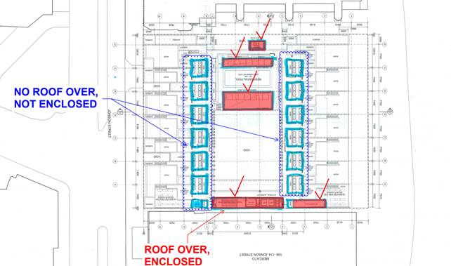
Fig 4. Elements that exceed height limit
These elements are for the main, ancillary to the proposal.
They otherwise provide a necessary building service function and or are
necessary for the safety and amenity of building users.
These elements due to roof top
location and positioning will not be readily visible from the public street,
will not impact on adjoining properties amenity or create additional use of the
roof top area.
Notably, the pool and roof terrace wall elements are those
that mostly exceed the height limit, and by only 10%.
As such the written request that
compliance with the development standard is unreasonable or unnecessary in the
circumstances of the case and that there are sufficient planning grounds to
justify contravening it is supported.
Does the written request adequately address those issues
at clause 4.6(3)(b)?
For the reasons stated above, the elements that exceed the
building height limit do not conflict with the objectives of the standard or
the zone.
These elements are for the main, ancillary to the proposal.
They otherwise provide a necessary building service function and or are
necessary for the safety amenity of building users.
Visual and or amenity impacts from these are negligible
given their roof top location and positioning, as compared to a compliant
building form.
As such the written request that compliance with the
development standard is unreasonable or unnecessary in the circumstances of the
case is supported.
Is the development in the public interest?
The development is in the public interest because it is
consistent with the objectives of the standard and the objectives of the zone
in which the development is proposed to be carried out.
Clause 5.21 – Flood
Planning
Most of the subject land is mapped as flood prone (see below).
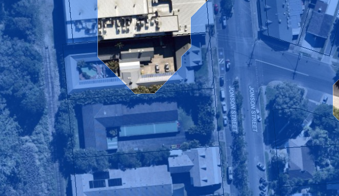
Fig 5. Flood Map
This clause requires that consent must not be granted unless
the consent authority is satisfied that the development:
(a) is
compatible with the flood function and behaviour on the land, and
(b) will
not adversely affect flood behaviour in a way that results in detrimental
increases in the potential flood affectation of other development or
properties, and
(c) will
not adversely affect the safe occupation and efficient evacuation of people or
exceed the capacity of existing evacuation routes for the surrounding area in
the event of a flood, and
(d) incorporates
appropriate measures to manage risk to life in the event of a flood, and
(e) will
not adversely affect the environment or cause avoidable erosion, siltation,
destruction of riparian vegetation or a reduction in the stability of river
banks or watercourses.
The clause also requires that the consent authority must
consider the following matters:
(a) the impact of
the development on projected changes to flood behaviour as a result of climate
change,
(b) the intended
design and scale of buildings resulting from the development,
(c) whether
the development incorporates measures to minimise the risk to life and ensure
the safe evacuation of people in the event of a flood,
(d) the potential
to modify, relocate or remove buildings resulting from development if the
surrounding area is impacted by flooding or coastal erosion.
A flood planning level of RL3.22AHD
applies to the site. A flood impact report has been prepared by PLANIT. This
report has been assessed by staff as adequate to address flood planning for the
proposal. Relevant conditions are included in the Recommendation to the Report.
Clause 6.1 – Acid
Sulfate Soils
This clause provides that, where applicable, development
consent must not be granted for the carrying out of works unless an acid
sulfate soils management plan (ASSMP) has been prepared in accordance with the
Acid Sulfate Soils Manual.
An ASSMP prepared by Tim Fitzroy
& Associates, dated May 2021, provides that Actual Acid Sulfate Soils and
Potential Acid Sulfate Soils can be adequately managed. Relevant
conditions are included in the Recommendation to the Report.
Clause 6.2 - Earthworks
Clause 6.2(3)
requires the consent authority to consider the effects of the proposed
development on the environment and surrounding area as a result of any proposed
earthworks.
The earthworks
associated with the proposed development are significant, for the excavation of
the proposed basement car park.
The proposal
comprises Integrated Development as approval is required under the Water
Management Act 2000. The development application was referred to WaterNSW
and General Terms of Approval (GTA’s) were issued on 30 June
2021.
A condition limits any excavations
or dewatering to be in accordance with the GTA’s. The impacts of the proposal can be
addressed through appropriate conditions of consent.
Clause 6.4 – Floodplain risk management
In relation to tourist and visitor accommodation, this clause
requires that the consent authority must be satisfied that the development will
not, in flood events exceed the flood planning level, affect the safe occupation
of, and evacuation from, the land.
A flood impact report has been prepared by PLANIT. This report
has been assessed by staff as adequate to address flood risk for the proposal.
Relevant conditions are included in the Recommendation to the Report.
Clause 6.6 – Essential services
Clause 6.6 requires
the consent authority to be satisfied that essential services are available for
the proposed development. Council officers are satisfied that the site is
fully serviced and meets the requirements of clause 6.6. Relevant conditions are included in the
Recommendation to the Report.
Clause 6.13 – Design
excellence – Byron Bay town centre
Development consent must not be granted
to a new building in the town centre unless Council is satisfied that it
exhibits design excellence.
To achieve design excellence the proposal inter alia must
incorporate sustainable design principles, have a high standard of
architectural design, materials, and detailing, respond well to the
environmental and built forms characteristics of the site and neighbouring
buildings, and improve the quality of the public domain.
The clause also states that development consent must not be
granted to a development unless the Byron Design Excellence Panel has endorsed
the development as exhibiting design excellence.
Currently there is no such Panel. Instead, an independent design excellence expert was engaged to work
alongside the Council assessment team for this development application to
ensure optimum compliance was achieved by the proposal with these new controls.
Following a preliminary assessment of the submitted proposal
by the Council assessment team, and meetings on same, requests for additional
information and design amendments were sent to the applicant on 5 August, 10
September, 21 September, 8 October, and 13 October 2021.
The applicant has worked proactively and collaboratively with
the Council assessment team and responded to these requests and submitted a
series of plan iterations to address key areas of concern with the proposal as
submitted:
· Apartment amenity
· Roof terrace amenity and shade
protection
· Circulation and connectivity
· Bulk mass and façade
& street wall expression
· Natural cross ventilation
· Sustainability and
· Waste collection, parking and
loading bays.
Most of the above areas have been addressed by the applicant
to the satisfaction of the design excellence expert and staff. Changes are
summarised in section ‘History Relevant to the Development
Application’ of this report, shown on the revised plans Attachment 1 and
or addressed by relevant conditions in the recommendation.
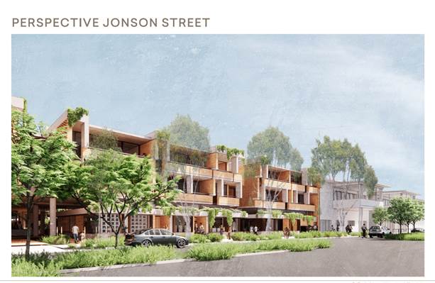
Fig 6. Jonson Street perspective
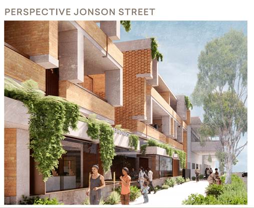
Fig 7. Jonson Street perspective
Fig 8. Internal courtyard perspective
In response to sustainability the following further
comment is provided on the applicant’s most recent submission.
The commitment to setting a baseline at “current best
practice’ is supported.
Being serviced apartments in single ownership provide a
range of opportunities that are not as easily achieved in strata titled
development by being in single ownership and having more control over the
on-going operation of the building.
Current best practice is Net Zero Carbon in operation, and
this has been achieved in a number of projects around Australia. This is
acknowledged in the “Sustainability Strategy”:
"Sustainability objectives for the 116-118 Jonson St
Project are:
· To
reduce GHG emissions with the goal of a building 100% powered by renewables.
· To
mitigate the consumption of potable water resources, seek more sustainable
infrastructure solutions and best practice water leaving the site’
While these objectives are supported it is noted that more
detailed modelling and definition is required to ensure the objectives are
achieved.
It is further noted that the objectives are consistent with
and anticipated by the ‘design excellence' provisions of the LEP’.
In
considering whether the development exhibits design excellence, the consent
authority must consider whether—
(a) the building incorporates sustainable design
principles, including in relation to the following—
(i) sunlight,
(ii) natural ventilation,
(iii) wind,
(iv) reflectivity,
(v) visual and acoustic privacy,
(vi) safety and security,
(vii) resource, energy and water efficiency,
durability and adaptability, and
With regard to the above, the Pathway to Net Zero Energy
approach outlined on page 9/13 of the Sustainability Strategy is supported;
noting that this will be achieved by: energy efficiency measures, fossil fuel
free (induction cooktops including commercial premises) on site renewables
(noting that the amount of PV on the roof could be significantly increased now
that the roof terraces are removed from the design) and commitment to purchase
of off-site renewables (noting that a ten year PPA is considered current best
practice). This approach should not require additional offsetting for
refrigerants.
Further, Council would support the use of BASIX and
associated thermal performance modelling software (NatHERS) to provide
preliminary assurance that the objectives can be met. This would not be onerous
and would allow the DA to progress without needing to commit to a more
comprehensive and expensive rating system at this stage.
Relevant conditions have been included in the recommendation
to the Report.
In response to waste collection, parking and loading bays
further comment is provided on the applicant’s most recent submission in
section DCP 2014 comments Chapters B4 and B8 to this report.
Clause 6.14 – Active Street frontages in Byron Bay
town centre
The clause applies to the subject site.
Development consent must not be granted to a new building in
the town centre unless Council is satisfied that it will have an active street
frontage.
For the purposes of this clause, a building has an active
street frontage if:
(a) all
premises on the ground floor of the building facing the street or a public
space are used for the purposes of business premises or retail premises
Two tenancies are located on the
ground floor facing the street. They are nominated for retail and
café use.
Basement car park access and an
electrical plant room are located facing the street at the southern edge of the
building. A fire exit and fire infrastructure are also located at the street
front at the northern boundary. Under the clause these elements are
‘excepted’ from that part of the building that promotes an active
street frontage.
(b) the
street frontage of the building enables direct visual and physical connection
between the street and the interior of the building
There will be a direct visual
connection for the majority of the two ground floor tenancies at the street
front. The 3.6m wide walkway located between these tenancies provide some
visual connection to the internal courtyard.
(c) all
premises on the ground floor are built to the boundary or are built to create a
continuous building edge with adjoining commercial premises
Ground floor is built to the
boundaries.
(d) the
street frontage of each premises on the ground floor of the building facing the
street is not greater than 20 metres
None of the ground floor
elements are greater than 20m in length.
(e) parking,
or loading and unloading, areas that are above ground level are not located at
the front of the site
All parking and loading is
within the basement car park.
Fig 9. Jonson Street perspective
Any proposed Instrument that has been the subject of public
consultation and has been notified to the consent authority
Not applicable.
Byron Shire Development Control Plan 2014 (DCP 2014)
DCP 2014 is an applicable matter
for consideration in the assessment of the subject development application in
accordance with subsection 4.15(1) of the EP& A Act because it applies to
the land to which LEP 2014 applies. The DCP 2014 Parts/Chapters that are of
relevance to the proposed development are addressed below:
|
Part A
|
Compliance
|
Comment
|
|
A13.4
|
Community Consultation Prior to Development
Application Lodgement
|
Yes
|
Pre-consultation was undertaken by the proponents in accordance
with the DCP requirements, and included a project web site, letterbox drops,
personal neighbour contact, site sign, emails to community stakeholders,
press advertisements, and a public community information session.
A report on the pre-consultation was submitted with
the application, outlining the process and the results.
|
|
|
|
|
|
Chapter B1 Biodiversity
|
Compliance
|
Comment
|
|
B1.1.5
|
Biodiversity Planning Principles
|
Yes
|
The proposal does not result
in any net loss of vegetation or affect habitat connectivity.
|
|
B1.2.1
|
Development Envelope Controls
|
No; but acceptable in this case
|
“Important wetlands” – i.e., wetland
mapped under SEPP Coastal Management; are located on the rail corridor land
immediately west of the development site.
Table 3 of the DCP suggests that a 50m buffer is
required.
In this case, there is less than 15m from the western
boundary of the site to the edge of the wetland vegetation.
It is noted that the vegetation is on a separate
publicly owned parcel and that the rail infrastructure is located between the
vegetation and the site.
While trains do not run on that infrastructure, there
are proposals being examined to use that part of the corridor as part of a
wider movement corridor, at least by way of a shared path cycleway, and
potentially by light rail options in the longer term.
In these circumstances, it is considered that a
requirement of 50m separate is unnecessary and that it would unreasonably
constrain the future development of the town centre.
|
|
B1.2.2
|
Development infrastructure and other controls
|
Yes
|
The infrastructure associated with this development
does not require any clearing of significant vegetation and will not
adversely impact biodiversity.
|
|
B1.2.3
|
Koala Habitat
|
Yes
|
The site is not considered to be a potential koala
habitat.
|
|
Chapter B3 Services
|
Compliance
|
Comment
|
|
B3.2.1
|
Provision of Services:
|
Yes
|
Water Supply
The site is serviced by a reticulated water supply.
Council’s Systems Planning Engineers advise that there is existing
capacity in the system to service the proposed development.
Sewage
The site is serviced by a sewage supply.
Council’s Systems Planning Engineers advise that there is existing
capacity in the system to service the proposed development.
Access
See Chapter B4 below.
Other
No issues are raised
regarding electricity of telecommunications infrastructure.
|
|
B3.2.3
|
Stormwater Management
|
Yes
|
A concept stormwater plan was submitted with the
application.
The applicant is required to provide further
stormwater easement details to verify matters relating to the nominated legal
points of discharge for stormwater from the site. Condition requiring deferred
commencement consent is included in the recommendation.
|
|
B3.2.4
|
Sedimentation and Erosion Control Measures
|
Yes
|
Standard conditions can adequately address issues.
|
|
Chapter B4 Traffic
Planning, Vehicle Parking, Circulation and Access
|
Compliance
|
Comment
|
The application is supported by a traffic and parking study by
McLaren Traffic Engineering and Road Safety Consultants.
There have been several requests for additional information
and clarification on the proposal from Council’s assessment team to date.
Of particular concern has been the arrangement proposed for waste collection,
parking and loading bays.
A revised supplementary traffic and parking report with plans
was submitted (rev Oct) to respond to the issues raised.
As it stands 119 car parks are provided in the basement,
inclusive of 8 accessible parking spaces for guests and visitors.
Notwithstanding the above, the parking supply requirement is
not met, by one (1) space.
The one (1) space car park deficiency on the main can be
justified on the grounds that the retail and serviced apartment uses will have
cross utilisation and complimentary timing for peak use.
Relevant conditions are otherwise included in the
recommendation to address accessible parking numbers, parking layout, and
service vehicle arrangements for loading and unloading and waste collection.
The proposal is now able to be supported by the assessment
team.
|
Chapter B5 Provisions for
Cycling
|
|
|
Cycleways are planned as part of the Byron Bypass and
Council’s adopted bike plan will build on existing cycleways in this
location such that dedicated cycle paths will pass the subject site, connecting
north and south.
Fourteen (14) bicycle parks are proposed as part of the
development. Within the basement, charging facilities will be available for
electric bikes.
Bike racks are also proposed at ground level.
|
Chapter B7 Mosquitoes and Biting Midges
|
Compliance
|
Comment
|
|
B7.2.1
|
Mosquito and Biting Midge Risk Zones
|
Yes
|
The site is located within or directly adjacent to a
mapped risk zone. The Applicant has addressed the requirement of this
chapter.
|
|
B7.2.2
|
Strategies and Guidelines for proposed development in
risk zones
|
No; but acceptable in this case
|
For applications involving tourist and visitor
accommodation with more than 5 units, the DCP requires a report from a
qualified entomologist addressing risk.
In this case, the rail corridor provides a cleared
grass buffer between the vegetated risk area and the rear of the site. In
that circumstance, the provision of screens to the rear facing units will be
sufficient to address the risk, and a detailed report is not considered to be
required.
|
|
Chapter B8 Waste
Minimisation and Management
|
Compliance
|
Comment
|
|
B8.3.1
|
Demolition of Buildings or Structures
|
Yes
|
A Site Waste Minimisation and Management Plan (SWMMP)
by Elephants Foot Recycling Solutions has been submitted in support of the
application, addressing the requirements of the DCP.
The SWMMP has been reviewed by Council’s
Resource Recovery Team and is acceptable, subject to recommended conditions
of consent to ensure that actions are implemented during demolition stage of
the project.
|
|
B8.3.2
|
Construction of Buildings or Structures
|
Yes
|
The construction stage SWMMP has been reviewed by
Council’s Resource Recovery Team and is acceptable, subject to
recommended conditions of consent to ensure that actions are implemented
during the construction stage of the project.
|
|
B8.3.3
|
Bin Sizes and Collection Measures
|
Yes
|
An Operation SWMMP provides recommendations that are
consistent with part of the DCP.
A site-specific collection contract will be used for
all collection.
|
|
|
Tourist Accommodation and Commercial and Retail
Development
|
Yes
|
The operation stage SWMMP has been reviewed by
Council’s Resource Recovery Team and is acceptable, subject to
recommended conditions of consent to ensure that actions are appropriately implemented.
|
|
Chapter B9 Landscaping
|
Compliance
|
Comment
|
|
B9.2.2
|
Landscape Plans for Development Applications
|
Yes
|
A detailed landscape plan has been submitted with the
application, to address the requirements of these parts of the DCP.
Relevant conditions of consent are included in the
recommendation.
|
|
B9.2.3
|
Further Requirements for more Complex Developments
|
Yes
|
As above.
|
|
B9.6.1
|
Landscaping of Tourist and Visitor Accommodation
|
Yes
|
A minimum of 10% of the site area must be dedicated to
landscaping.
At ground level, the development includes a total of
1,040m2 of landscaped area, including central landscaped courtyard and
private garden areas for serviced apartments.
This equates to approx. 24% of the site area.
Landscaped and communal open space areas have direct
and equitable access and amenity.
|
|
Chapter B11 Planning for
Crime Protection
|
Compliance
|
Comment
|
|
B11.2.1
|
Development that requires a formal crime risk
assessment
|
Yes
|
The development includes a basement car park, so a formal
crime risk assessment is required, and has been submitted to support the
application.
|
|
B11.2.3
|
CPTED design opportunities
|
Yes
|
The crime risk report provides an assessment of the
proposal in relation to the DCP performance criteria.
The proposal is for a mixed-use development with
service apartments. The design, layout and managed access to the site has
provided adequate passive surveillance and is able to meet CPTED principles.
|
|
Chapter B12 Social Impact
Assessment
|
Compliance
|
Comment
|
|
B12.1.3
|
Application of this Chapter
|
Yes
|
An SIA is required for tourist and visitor
accommodation for 50 or mor persons.
The proposal includes a total of 122 bedrooms,
therefore has a capacity well in excess of 50 people.
A SIA has been submitted with the application.
The SIA finds that the proposal will generate a number
of positive social impacts, including: • increasing the diversity and
availability of tourist accommodation in the town centre; • provision
of open green space for the use of the community; • employment in the
construction and fit out and operation of the proposed mixed use development
including the retail, restaurant and commercial spaces, and in the
maintenance of the communal spaces; • improvement of the visual
appearance of the site to the street; • provision of an active street
frontage to Jonson Street; • opportunities to support small local independent
retailers via micro retailing; and • the provision of a physical
showcase of the Shire’s urban history to identify and celebrate
identity.
The SIA demonstrates compliance with the requirements
of the DCP.
|
|
|
|
|
|
Chapter B13 Access and
Mobility
|
Compliance
|
Comment
|
|
B13.2.2
|
Shop top housing and serviced apartments
|
Yes
|
An Access Assessment Report has been submitted in
support of the application, demonstrating that the design complies with the
DCP and all relevant legislation and standards.
10% of units should be adaptable. There are 41
serviced apartments in total. 5 apartments are shown as
“accessible/ adaptable”, spread across the 3 levels.
|
|
|
|
|
|
Chapter C2 Areas Affected by
Flood
|
Compliance
|
Comment
|
|
C2.13
|
Planning objectives and development controls
|
Yes
|
The proposal meets the objectives of the B2 zone.
|
|
|
|
|
|
Chapter D3 Tourism
Development
|
Compliance
|
Comment
|
|
D3.2.4
|
Character and design in business and mixed-use zones
|
Yes
|
Design Excellence provisions applied.
The proposal is compatible with the character,
landscape and land uses of the zone.
|
|
D3.3.7
|
Serviced apartments
|
Yes
|
Design Excellence provisions applied.
The proposal is compatible with streetscape and
character of locality.
It meets the requirements of D1.6.
|
|
D1.6
|
Multi dwelling housing in urban zones:
|
Yes
|
A mix of serviced apartment sizes is provided in the
form of 2, 3 and 4 bedrooms. This choice optimises accommodation choices to
those visiting the Town Centre.
|
|
D1.6.1
|
Private open space courtyards
|
Yes
|
Ground floor apartments each have a ground level
courtyard of approx. 40m2, with dimensions of 5m x 5m.
|
|
D1.6.2
|
Open space balcony
|
Yes
|
Upper floor units all have compliant balconies, with
the second-floor apartments also having individual access to the roof top
pool area.
The western facing units are not ideally orientated,
only having access to afternoon sun.
|
|
D1.6.3
|
Landscaping
|
Yes
|
See assessment above.
|
|
D1.6.4
|
On-site car parking
|
Yes
|
See assessment above.
|
|
D1.6.5
|
Soundproofing
|
Yes
|
Apartments will be appropriately sound proofed.
|
|
D1.6.6
|
Clothes drying facilities
|
Yes
|
Apartments are all shown with laundry areas that can
incorporate clothes driers or spaces to provide clothes drying areas.
|
|
D1.6.7
|
Equity of access and mobility
|
Yes
|
An Access Assessment Report has been submitted in
support of the application, demonstrating that the design complies with the
DCP and all relevant legislation and standards.
|
|
D1.6.8
|
Pipes and vents
|
Yes
|
All plant can be appropriately screened.
|
|
D1.6.9
|
TV antennae
|
Yes
|
Common facilities will be provided.
|
|
D1.6.10
|
Character
|
Yes
|
Design Excellence provisions applied.
|
|
Chapter D4 Commercial and
Retail Development
|
Compliance
|
Comment
|
|
D4.2.1
|
Design and character of retail and business areas
|
Yes
|
See assessment above.
|
|
D4.2.2
|
Design detail and appearance
|
Yes
|
See assessment above.
|
|
D4.2.3
|
Vehicle access and parking
|
Yes
|
See assessment above.
|
|
D4.2.4
|
Loading docks
|
Yes
|
See assessment above.
|
|
D4.2.5
|
Street setbacks
|
Yes
|
Ground floor – no setback. Upper floors
are setback, with balconies utilised in setback.
|
|
D4.2.10
|
Restaurants, cafes, small bars etc
|
Yes
|
Noise is unlikely to be an issue at this
location. Hours of operation and other requirements can be conditioned.
|
|
Chapter D8 Public Art
|
Compliance
|
Comment
|
|
D8.2.1
|
Provision of public art
|
Yes
|
The applicants have submitted a draft Voluntary
Planning Agreement (VPA) proposing to provide a monetary contribution toward
public art. This VPA has been exhibited and endorsed by the Public Art Panel.
Relevant condition of consent included in the recommendation.
|
|
Chapter
E10 Byron Bay Town Centre
|
Compliance
|
Comment
|
|
E10.2.1
|
Uses
|
Yes
|
Retail and active uses dominate the ground
floor. Each proposed retail space has a depth to width ratio of between
1:1 and 3:1.
|
|
E10.2.2
|
Character
|
Yes
|
Development provides active street frontage,
articulated facades, is fine grained safe and legible connections through it.
|
|
E10.2.3
|
Built form
|
Yes
|
See assessment above.
|
|
|
Buildings must contain no more than 3 storeys
|
Yes
|
Complies.
|
|
|
Roof-top facilities not to contravene maximum
building height
|
No; but acceptable in this case
|
See discussion above regarding building height
variation.
|
|
|
Floor to ceiling heights
|
No (ground and first floor); but acceptable in this
case
|
Ground floor: required 4.0m; proposed: 3.9m
First floor: required 3.3m; proposed 3.1m
Second floor: required 2.7m; proposed 3.1m
The FTCH controls relate to the creation of
comfortable and high-quality internal environments for occupants and users.
The proposal is for mixed use development and not
permanent residential.
The proposal has otherwise satisfied amenity and build
excellence criteria for this type of development. The variation to FTCH is
acceptable.
|
|
|
Upper levels to be setback 3.0m (can be used for
balconies)
|
Yes
|
Upper floors each have 3.0m wide balconies at street
frontage.
|
|
|
Access to sunlight for adjoining properties
|
Yes
|
Adjoining buildings retain the required access to
daylight hours of sunlight.
|
|
10.2.4
|
Climate and context
|
Yes
|
See assessment above. Relevant conditions included in
the recommendation.
|
|
10.2.5
|
Acoustic and visual privacy
|
Yes
|
Achieved by design. Relevant conditions included in
the recommendation.
|
|
10.2.6
|
Car parking
|
Yes
|
See assessment above. Relevant conditions included in
the recommendation.
|
|
10.2.7
|
Waste and Recycling
|
Yes
|
See assessment above. Relevant conditions included in
the recommendation.
|
|
10.2.9
|
Roof form, access and use
|
Yes
|
Relevant conditions included in the recommendation.
|
|
10.2.10
|
Green infrastructure
|
Yes
|
The proposal includes vertical planting green walls
and landscaping throughout the site.
A condition is also recommended that the proposal
provide a shaded environment for pedestrians on the eastern façade of
the development at street level. This to take the form of a pergola or
arbour type structure across the frontage of the development to cover the
footpath in Jonson Street.
Relevant conditions included in the recommendation.
|
|
10.2.11
|
Design Excellence
|
Yes
|
See assessment above. Relevant conditions included in
the recommendation.
|
The likely impacts of that development, including environmental impacts
on both the natural and built environments, and social and economic impacts in
the locality
|
Impact on:
|
Likely significant impact/s?
|
|
Natural environment
|
No. The proposal will not have a significantly adverse
impact on the natural environment of the locality.
|
|
Built environment
|
No. The proposal will not have a significantly adverse
impact on the built environment of the locality.
|
|
Social Environment
|
No. The proposal will not have a significant social
impact on the locality.
|
|
Economic impact
|
No. The proposal will not have a significant economic
impact on the locality.
|
|
Construction Impacts
|
The development will generate minor impacts during its
construction. Conditions of consent recommended to control hours of work,
builders waste, construction noise, installation of sedimentation and erosion
control measures and the like to ameliorate such impacts.
|
The suitability of the site for the
development
It is considered that the proposal is suitable for the
site. It will not have any adverse amenity impacts on the adjoining
properties, and it meets the desired future character and built form controls
for the Byron Bay Town Centre.
Submissions made in accordance with this Act or the regulations
The development application was publicly exhibited
There were 21 submissions made on the development application:
- 19 For
- 1 Resolved
See comments under Round 1 – Solar Impact to 120 Jonson
Street (Staff – 5 August 2021)
- 1 Against
Issues raised in the submission against the proposal were
height and bulk of development. The development’s building height
exceedance and design excellence compliance have been addressed in detail in
the report.
Public interest
The proposal does not to prejudice or compromise the public
interest or create an undesirable precedent.
5. DEVELOPER CONTRIBUTIONS
Water & Sewer Levies
Section 64 levies will be payable.
Developer Contributions
Section 7.12 Contributions will be
payable.
6. DISCLOSURE OF POLITICAL
DONATIONS AND GIFTS
|
Disclosure details
|
Response
|
|
Has a Disclosure Statement been
received in relation to this application?
If Yes, Provide Disclosure
Statement register reference: 91.
|
Yes ☐ No ☒
|
|
Have staff received a
‘gift’ from anyone involved in this application that needs to be
disclosed.
|
Yes ☐ No ☒
|
7. CONCLUSION
The proposal seeks consent for
demolition of existing backpackers’ hostel and construction of a
mixed-use development comprising retail premises and serviced apartments.
The application includes a request to vary the height of
buildings development standard.
The request to vary the development standard is supported in
this instance given the site context, land use mix and location in the town
centre area.
The applicant however is required to provide further
stormwater easement details to verify matters relating to the nominated legal
points of discharge for stormwater from the site.
Given the above, the application is recommended for deferred
commencement consent subject to recommended conditions in Attachment 2.
Staff Reports - Sustainable Environment and Economy 13.4
Report
No. 13.4 24.2020.39.1 - Centennial
Circuit One-way Traffic Trial - Outcomes of the trial and next steps
Directorate: Sustainable
Environment and Economy
Report Author: Isabelle
Hawton, Planner
File No: I2021/1566
Summary:
The Centennial Circuit one-way traffic trial was a
‘quick-win’ project from the Byron Arts and Industry Estate
Precinct Plan and has been running since May 2021.
The trial has altered the flow of traffic in Centennial
Circuit, from two-ways to a one-way clockwise circulation between Brigantine
Street and Wollongbar Street. All other streets in the area have remained
two-way.
The trial has been a resounding success, with the vast
majority of feedback supportive of making the trial permanent.
It is recommended to extend the one-way traffic trial for
approximately 12 months to allow for design and implementation of a permanent
solution.
RECOMMENDATION:
That Council:
1. Extends
the one-way traffic trial for an additional 12 months, or until such time as a
permanent solution can be implemented.
2. Considers
a quarterly budget review of $17,900 to
commission the design for permanent one-way traffic circulation and to fund the
interim trial extension measures.
3.
Continues to consider other opportunities for improving traffic
circulation and flow within the Byron Arts and Industry Estate, including
further linemarking and the possibility of other one-way streets.
Attachments:
1 24.2020.39.1
- Yoursay feedback - Centennial Circuit one way traffic trial - During the
trial, E2021/123497 
Report
The Centennial Circuit one-way
traffic trial was a ‘quick-win’ project from the Byron
Arts and Industry Estate Precinct Plan, adopted
in 2019 (RES 19-452).
The aim of the trial was to test
whether a one-way solution to part of Centennial Circuit would remedy some of
the traffic flow and safety issues that were occurring in the estate. The trial
was intended to be a simple, low-cost and temporary.
The trial was implemented in May
2021 and scheduled to finish on 30 November 2021.
Image below shows the extent of
the one-way trial.
Council staff engaged with
business owners pre and during the trial through door-to-door discussions,
letterbox flyer drops, advertisements on BayFM and social media posts.
Feedback was gathered via
Council’s Your Say page and through Council’s facebook account.
The trial has been overwhelmingly
successful, with the vast majority of feedback supporting making the trial a
permanent fixture in the Arts and Industry Estate.
A recent facebook post on the
trial has over 120 responses, and overwhelmingly people wanted the Circuit to
remain one-way. Comments received through Your Say also reinforce this
level of support (refer Attachment 1).
Next steps
Staff recommend extending the
trial for 12 months to allow time to:
· design a permanent solution;
· carry out additional consultation on the permanent design;
and
· prepare for permanent construction.
This would extend the trial from
30 November 2021 to 30 November 2022.
The trial extension and design
will be managed by Council Infrastructure Services Directorate.
Budget to support extension
There will be approximately $7,000
remaining in the Centennial Circuit one-way trial fund at the end of November
2021. The budget required to extend the trial and undertake the design is
$24,900 (as detailed in the table below). As such, an additional $17,900
budget would be required in the next quarterly budget review. The 30
September 2021 Quarter Budget Review will be submitted to Council on 25
November 2021 and should Council approve the recommendation to this report,
this will be included amongst other priorities for consideration.
|
Budget item
|
Estimate
|
Note
|
|
Water filled
barriers
|
$1,500
|
It is proposed
to replace the hired barriers with recently acquired water filled barriers
from the Talking Street Trial parklets, which would incur a one-off cost of
approximately $1,500 (owned by Council). However, this would rule out
these barriers for use in the parklets for the interim.
|
|
Waste
collection
|
$8,400
|
Budget will
also be required to continue the changes to waste collection through this
time. Council is working to renegotiate the waste contract, but in the
interim funding in the vicinity of $700 per month will need to be secured.
$8,400 would be required over 12 months.
|
|
Design
estimate
|
$15,000
|
Budget will be
required to create a design that will improve safety and traffic flow at key
intersections and rectify any minor issues to do with the current design.
This work will be undertaken by Council’s Infrastructure Services
Directorate, with input from relevant place planning staff. A budget estimate
of $15,000 has been provided by Infrastructure Services for the design work.
|
|
Total
|
$24,900
|
|
Strategic Considerations
Community Strategic Plan
and Operational Plan
|
CSP Objective
|
CSP Strategy
|
DP Action
|
Code
|
OP Activity
|
|
Community Objective
4: We manage growth and change responsibly
|
4.1: Support the visions and
aspirations of local communities through place-based planning and management
|
4.1.1: Develop, implement
and update Place Plans that promote place-based forward planning strategies
and actions
|
4.1.1.5
|
Deliver one way traffic
trial for Centennial Circuit (Byron Arts and Industry Estate Precinct Plan
action)
|
Recent Resolutions
· 19-433
· 19-452
Legal/Statutory/Policy
Considerations
Any permanent design will need to be approved by the Local
Traffic Committee.
Financial Considerations
As outlined above.
Consultation and
Engagement
Significant community consultation has been undertaken to
date on this project.
The Byron Arts and Industry Estate Precinct Plan was adopted
after community consultation, including a formal exhibition period.
The Centennial circuit one-way trial underwent a period of
notification which included conversations with affected businesses, letterbox
drops, radio advertisements and social media.
Additional consultation will be undertaken with the
permanent design.
Staff Reports - Sustainable Environment and Economy 13.5
Report
No. 13.5 24.2020.27.1 - Bangalow
Development Control Plan Changes Submissions Report
Directorate: Sustainable
Environment and Economy
Report Author: Isabelle
Hawton, Planner
File No: I2021/1529
Summary:
Council staff have been working with the Bangalow community
to update the Byron Shire Development Control Plan 2014 (DCP) chapters that relate
to Bangalow. This is a priority action from the Bangalow Village Plan,
which was adopted in February 2019 (RES 19-006).
At the Council Meeting on 5 August 2021, Council endorsed
the recommendation to exhibit the proposed updates to the DCP Chapters E2
Bangalow and C1 Non-Indigenous Heritage for 28 days. This report presents
the exhibition outcomes.
The proposed updates to the DCP chapters were exhibited from
1 September to 28 September 2021 and 16 submissions were received. Many of
these submissions agreed with the majority of proposed changes but requested
some detailed updates. The submissions are provided in full in Attachment
5.
The report recommends that the DCP updates (as per
Attachments 1 and 2) be adopted with the updated changes reflective of the
feedback received during the exhibition period.
RECOMMENDATION:
That Council adopts the Development Control Plan
Chapters E2 Bangalow, Attachment 1 (E2021/125364) and C1 Non-indigenous
Heritage, Attachment 2 (E2021/125359) and alterations to Part A (Attachment 3 -
E2021/125362) and publishes the relevant chapters on its website and notifies
the public as required by the Environmental Planning and Assessment Act and
Regulation.
Attachments:
1 Byron
Shire DCP 2014 Chapter E2 Bangalow - amended post public exhibition, E2021/125364
2 Byron
DCP 2014 Chapter C1 Non-indigenous Heritage - Bangalow amended post exhibition,
E2021/125359
3 Additional
definitions to add to DCP Part A Dictionary, E2021/125362
4 Submissions
overview, E2021/124074
5 Submissions
received - redacted version, E2021/123655

6 Form
of Special Disclosure of Pecuniary Interest, E2012/2815
Report
Council staff have been working with the Bangalow community
to update the Byron Shire Development Control Plan 2014 (DCP) chapters that
relate to Bangalow. This is a priority action from the Bangalow Village
Plan, which was adopted in February 2019 (RES 19-006).
At the Council Meeting on 5 August 2021, Council endorsed
the recommendation to exhibit the proposed updates to the DCP Chapters E2
Bangalow and C1 Non-Indigenous Heritage for 28 days. This report presents
the exhibition outcomes.
The proposed updates to the DCP
make some significant changes to improve future development outcomes in
Bangalow. These include:
· Providing
a clearer structure for the E2 Chapter
· Removing
outdated or contradictory sections in C1 and E2
· Removing
double up between C1 and E2
· Moving
heritage architectural guidelines for buildings in Byron Street to Chapter C1
· Creating
new heritage architectural controls for Station Street precinct
· Adding
in an Active Street Frontages provision
· Adding
in provisions around connectivity and permeability
· Adding
Urban Design outcomes and specific controls for Station Street in lieu of a
separate ‘Structure Plan’
· Amending
and updating relevant maps and graphics
Community engagement during the public exhibition period
The proposed updates to the DCP chapters were exhibited from
1 September to 28 September 2021 and 16 submissions were received. Many of
these submissions agreed with the majority of proposed changes but requested
some detailed updates. The submissions are provided in full in Attachment
5.
During the public exhibition
period, Council staff reached out to various landowners, community groups, and
key stakeholders to encourage them to make submissions and engage with the
proposed chapters. These interactions happened via mail, email and over the
phone.
Even though the total number of
submissions is not large, it should be noted that the level of engagement with
and understanding of the proposed content for the DCPs was high and translated
to educated and informed constructive feedback to the proposed changes.
Key issues
Low rise heritage character of
the Bangalow town centre
Many submissions referred to the desire to
maintain and protect the low-rise heritage nature of the Bangalow village
centre and the Bangalow Heritage Conservation Area more broadly. Feedback
was generally positive – indicating that most submitters believed that
the proposed changes were effectively meeting this expectation.
Feedback focussed on the desire to
maintain the low-rise built form of Bangalow with many submissions expressing a
wish for single storey/two storey buildings only. The minimum floor to ceiling
heights introduced in the DCP chapters will reinforce this preference.
Glossary of terms
Several submissions suggested that the
language of the DCP can sometimes be confusing for a lay-person, and that a
glossary/dictionary explaining key terms would be helpful.
In response to this, some key
words and definitions are proposed to be added to the existing dictionary in
Part A of the DCP to provide further clarity on key terms. These definitions
are included in Attachment 3.
Pedestrian Permeability
There was strong support from several submissions for the measures to improve
pedestrian permeability in the village centre. Submissions applauded the
efforts to increase pedestrian access to and through sites, however some
suggested that the wording might be softened.
No changes are proposed to this
clause at this time.
Updates/Changes to the
Development Control Plan Chapters
A number of submissions suggested detailed changes to the proposed DCP
chapters. Some of these have resulted in amendments to provide further
clarity/improve the effectiveness of certain controls. These have been
responded to in further detail in Attachment 4.
Feedback outside the scope of
this DCP amendment
A number of submissions made comment on issues outside the scope of these
amendments. These included, but were not limited to, requests for
additional pedestrian crossings, ‘gateways to the village’ and more
general heritage concerns. Some of these requests might be better dealt
with through a review of Chapter C1 Non-indigenous Heritage, at a later date.
It is recommended that Council’s Strategic Planning Team add this request
to the DCP updates register for future consideration.
Next Steps
The report recommends that the DCP updates (as per
Attachment 1 and 2) be adopted with the updated changes reflective of the
feedback received during the exhibition period.
Strategic Considerations
Community Strategic Plan
and Operational Plan
|
CSP Objective
|
CSP Strategy
|
DP Action
|
Code
|
OP Activity
|
|
Community Objective
4: We manage growth and change responsibly
|
4.1: Support the visions and
aspirations of local communities through place-based planning and management
|
4.1.1: Develop, implement
and update Place Plans that promote place-based forward planning strategies
and actions
|
4.1.1.4
|
Review and update Bangalow
Development Control Plan (high priority action from the Bangalow Village
Plan)
|
Recent Resolutions
· 21-262
(Proceed to exhibition with proposed DCP amendments)
· 19-006
(Adoption of Bangalow Village Plan)
Legal/Statutory/Policy
Considerations
Discussed in body of the report.
Financial Considerations
Not applicable.
Consultation and
Engagement
Discussed in body of the report.
Staff Reports - Sustainable Environment and Economy 13.6
Report
No. 13.6 PLANNING - 26.2019.10.1
Submissions Report - North Beach Byron Rezoning Planning Proposal
Directorate: Sustainable
Environment and Economy
Report Author: Sharyn
French, Manager Environmental and Economic Planning
File No: I2021/1415
Summary:
This report presents the outcomes of the exhibition of a
Planning Proposal for the proposed rezoning of land at Bayshore Drive, Byron
Bay.
The planning proposal was initiated following a landowner
request to rezone land immediately to the north-west of the Elements of Byron
Resort to allow for a subdivision to create up to nine (9) large residential
lots.
The site includes several properties under one ownership,
including the resort and land to the north-west previously used as a private
golf course associated with a former tourist facility on the land. In more
recent times cleared vacant parts of the land has been used to accommodate the
Byron Writer’s Festival.
Part of the subject land is zoned SP3 Tourist under Byron
Local Environmental Plan 2014, with other parts of the land deferred, retaining
the zoning under Byron Local Environmental Plan 1988, including 2(t) Tourist
Area, 7(a) Wetlands, 7(b) Coastal Habitat and 7(f1) Coastal Lands.
The requested rezoning relates primarily to the cleared and
vacant part of the land, to implement a zoning of E4 Environmental Living. This
zoning has not previously been applied within LEP 2014, and this would be the
first property zoned as such.
The objectives of the E4
Environmental Living Zone are:
· To
provide for low-impact residential development in areas with special
ecological, scientific or aesthetic values.
· To
ensure that residential development does not have an adverse effect on those
values.
In this case, the significant values of the land relate to
its beachfront location and the ongoing implications of coastal processes.
The proponents commissioned a detailed Coastal Hazard
Assessment, which provides contemporary modelling to establish the predicted
location of the erosion escarpment in 50, 80 and 100 years.
The modelling approach, which includes allowance for
predicted sea-level rise, was agreed by staff of the Department of Planning,
Industry and Environment Coastal Division, and forms a sound basis for the
hazard assessment.
The modelling shows that the contemporary 100 year hazard
line (i.e. for the year 2120) is located approximately 135m seaward of the
previously mapped 100 year hazard line, which was used as the basis of the
7(f1) Coastal Land zoning and associated DCP Part J erosion precincts.
The contemporary modelling demonstrates that the area within
the site subject to coastal hazard is smaller than previously understood.
On this basis, the planning proposal seeks to implement the
E4 zoning for the cleared area between Bayshore Drive and the contemporary 100
year hazard line.
E2 Environmental Conservation is proposed seaward of
the hazard line, ensuring that there will not be development in that hazard
area.
The planning proposal also seeks to implement E2
Environmental Conservation and E3 Environmental Management zones across
vegetated parts of the property, as agreed with the landowners through
Council’s E Zone Review process.
In September 2020, Council resolved to seek Gateway for the
proposal (Res 20-470). A Gateway determination was issued
in March 2021.
The proposed rezoning was publicly exhibited between April
and May 2021. A total of 113 objections were received as well as 62
submissions of support.
NSW Rural Fire Service, NSW Biodiversity and Conservation
Division and Heritage NSW were also consulted, along with Tweed Byron Local
Aboriginal Land Council. Advice was received from NSW Rural Fire Service in
relation to matters that need consideration at the DA stage. Advice was also
received from the Biodiversity and Conservation Division (BCD) of the
Department of Planning, Industry and Environment. Some of the issues
raised by BCD have subsequently been addressed, resulting in two outstanding
matters of objection.
Key issues addressed in this report relate to coastal hazards
and flood risk.
The exhibited planning proposal proposed a 2ha minimum lot
size (MLS) and an additional permitted uses clause to limit future subdivision
of the E4 zone to 9 lots. Post exhibition an adjustment has been made to the
northern boundary of the E4 zone to accurately reflect the boundary of the
coastal wetland mapping. This adjustment has reduced the total area of the E4
zone. This together with a revised minimum lot size of 1ha will limit the total
number of lots to nine, thereby removing the need for the proposed additional
permitted uses clause.
The following changes are proposed to the planning proposal
post exhibition:
· Zoning
adjustment to reduce northern boundary of E4 zone and expand adjoining E2 zone
to accurately reflect the coastal wetland mapping
· Change
to minimum lot size from 2ha to 1ha for E4 Zone
· Removal
of proposed additional permitted uses clause to limit the E4 zone to a maximum
9 lots as the two changes above achieve the same outcome
· Amend
minimum lot size of E3 zone from 1ha to 40ha
· Amend
Height of Buildings map to apply maximum 9m building height across the entire
E4 and E2 zone
· Update
Acid Sulphate Soils map to apply to the site
· Amend
Land Application map to remove some of the Deferred Matter areas
· Amend
the Floor Space Ratio map to reflect the changes to the part of the site zoned
SP3 Tourist
These changes are not considered significant enough to
warrant re-exhibition.
It is recommended that Council adopt the amended Planning
Proposal in Attachment 1 and send to DPIE for finalisation.
NOTE TO COUNCILLORS:
In accordance with the
provisions of S375A of the Local Government Act 1993, a Division is to be
called whenever a motion for a planning decision is put to the meeting, for the
purpose of recording voting on planning matters. Pursuant to clause 2(a)
under the heading Matters to be Included in Minutes of Council Meetings of
Council's adopted Code of Meeting Practice (as amended) a Division will be
deemed to have been called by the mover and seconder of all motions relating to
this report.
RECOMMENDATION:
That Council forwards
the planning proposal, as contained in Attachment 1 (E2021/111179), along with
updated Local Environmental Plan maps as detailed in this report, to the
Department of Planning, Industry and Environment for finalisation.
Attachments:
1 Elements
Planning Proposal - Updated version for Council report following public
exhibition - 26.2019.10.1, E2021/111179
2 Coastal
Hazard Assessment - Planning Proposal Appendix B, E2021/53423
3 Updated
Flood Assessment - Planning Proposal Appendix C, E2021/125689
4 Bushfire
Assessment - Planning Proposal Appendix D, E2019/92528
5 Updated
Ecological Assessment - Planning Proposal Appendix E, E2021/125699
6 Cultural
Heritage Report - Planning Proposal Appendix F, E2020/5232
7 Preliminary
Contamination Report - Planning Proposal Appendix G, E2021/55944
8 Alteration
of Gateway determination - timeframe extended to 8 March 2022, E2021/125595
9 Objection
submissions, E2021/105676
10 Support
submissions, E2021/105674
11 NSW
Rural Fire Service RFS submission, E2021/125869
12 Biodiversity
& Conservation Division, Dept Planning, Industry & Environment
Submission, E2021/125860
13 Form
of Special Disclosure of Pecuniary Interest, E2012/2815
Report
Planning Proposal 26.2019.10.1 (Attachments
1 to 8) relates to land around the Elements of Byron Resort, at the northern
end of Bayshore Dr, Byron Bay.
The
Site
The planning proposal mainly
relates to the cleared parts of the site located north-west of the existing
resort, which is proposed to be zoned E4 Environmental Living. It also
proposes to implement the agreed environmental zones across the site as part of
Council’s E Zone Review process.
Part of the site is zoned SP3
Tourist under Byron Local Environmental Plan 2014, with much of the land
‘deferred’ and subject to the E Zone Review process. The
deferred parts of the site contain areas zoned 2(t) Tourist Area, 7(a)
Wetlands, 7(b) Coastal Habitat and 7(f1) Coastal Lands under Byron Local
Environmental Plan 1988.
|
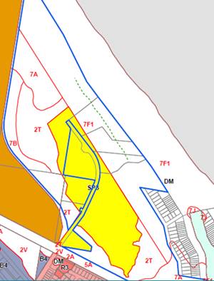
|
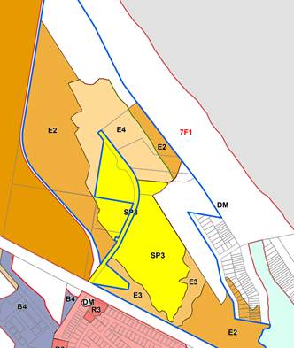
|
|
Existing Zoning
|
Proposed Exhibited Zoning
(Note. The
northern section of the E4 zone has been reduced post exhibition to
accurately reflect the boundary of the coastal wetland mapping– see
further discussion in this report)
|
Coastal Hazard
The location of the 7(f1) Coastal
Lands zone was originally based on The Byron Bay - Hastings Point coastal
hazard report, prepared in the late 1970s. The zone was intended to
identify land subject to the most immediate coastal risks and is a very
restrictive zone that does not permit permanent development.
To address coastal hazard on the site, the proponents
commissioned a detailed Coastal Hazard Assessment of the property, which
provides contemporary probabilistic modelling to establish the predicted
location of the erosion escarpment in years 2050, 2070, 2100 and 2120
(Attachment 2).
The modelling approach, which includes allowance for
sea-level rise and climate change, was agreed by staff of the Department of
Planning, Industry and Environment Coastal Division, and forms a sound basis
for the hazard assessment.
For the purposes of the planning proposal, the seaward
extent of the E4 Environmental Living zone is set at the year 100 (2120) 1%
exceedance line.
This is where the model predicts the coastal erosion
escarpment to be in 100 years’ time. The 1% exceedance means
there is 1% chance that the line could be further landward – i.e. there
is 99% certainty that the line will not be further landward in 100 years.
The location of this contemporary 100 year hazard line is shown
by the dashed green line on the existing zoning diagram above.
It is located approx. 135m seaward of the previously mapped
100 year hazard line, which was used as the basis of the 7(f1) Coastal Land
zoning and associated DCP Part J erosion precincts.
The contemporary modelling demonstrates that the area within
the site that is subject to coastal hazard is far smaller than previously
understood.
Council resolved (Res. 20-470,
Part 3) that the current 7(f1) Coastal Land zoning remain in place for
the part of the site located seaward of the contemporary 100 year hazard line,
pending completion of the Coastal Management Program, at which time it can be
reviewed.
Through further consultation with the applicant and agencies
an E2 zone has instead been applied. This was to ensure that this part of the
future lots to be created retained the integrity of the hazard line without
development being place on it.
The landowner has agreed to the
application of an E2 Environmental Conservation zone on the part of the property
seaward of the contemporary line, and E zones have been applied in accordance
with the state government’s ‘Northern Councils E Zone Review Final
Recommendations Report’.
The combination of the E4 and E2
zones will allow the subdivision of this cleared part of the property but
ensure that all future development within the lots is located outside of the
coastal hazard area. The application of a minimum lot size will restrict the
subdivision potential of the land to a maximum of 9 lots.
The coastal hazard modelling was
only applied to the cleared parts of the property. It was not extended
for the full length of the property, and therefore cannot be used to
‘fix’ a zoning line north-west of the cleared area.
As such, it is recommended that
the existing zoning of 7(f1) Coastal Lands remain outside of the area that was
subject of the probabilistic modelling.
A combination of E2 Environmental
Conservation and E3 Environmental Management is proposed over the remaining
undeveloped and vegetated parts of the site, outside of the coastal hazard
areas. The SP3 Tourist zone will remain over the existing resort.
The E3 Environmental Management
area fringes the existing resort, where asset protection zones are required to
be maintained in accordance with bush fire approvals.
Flood Risk
The flood advice provided
to support the planning proposal, dated 27 November 2019 (Attachment 3), was
prepared prior to recent state government changes to how flooding is considered
in land use planning.
These changes included the
introduction of two standard instrument local environmental plan clauses on
flood related development controls and a local planning direction under section
9.1 of the Environmental Planning and Assessment Act 1979.
Whilst these new flood planning
requirements do not apply where a Gateway has previously been issued as is the
case with this PP, further information was requested from the applicant to
ensure that the rezoning is appropriate and does not result in subsequent
development applications that are inconsistent with the new flooding
legislation.
Further additional flood
assessment was requested to address the following matters:
· The
updated flood model prepared by Royal HaskoningDHV, and relied on in their
flood assessment, should be calibrated to a known event, to demonstrate the
accuracy of predicted flood levels. All Tuflow model data files must be
submitted with the revised assessment.
· The
assessment should address cumulative impacts in relation to flood levels,
impact assessment and evacuation options.
· Council
will not support sheltering in place as the sole evacuation response. The
assessment should demonstrate the ability to provide for a safe and effective
evacuation option for future residents that does not rely on rescue by
boat. If the recommended option involves raising of a section of Bayshore
Drive, the flood impacts of such work need to be addressed and information
provided demonstrating how the commitment to the works can be guaranteed.
· The
flood assessment should specifically address Council’s adopted Belongil
Creek Floodplain Risk Management Study and Plan (BMT WBM, 2015). In
particular, Figure 9-1 of the adopted Plan specifies the site as “No
Development”. Further information should be provided addressing the
basis of that designation and providing justification for not following that
recommendation.
Attachment 3 contains the original
flood advice along with four additional reports that address the above matters.
The following table provides a brief summary of these reports and an assessment
of how they responded to the request for information.
Council’s Infrastructure
Planners have reviewed this additional work and are satisfied with the level of
assessment undertaken, the data used in the modelling and the resulting
outputs.
|
Additional Flood Reports
|
Comment
|
|
Review of state governments
changes to planning guidelines regarding flood planning levels and how
changes to Council’s adopted flood planning level could impact the
proposed development,19 July 2021
|
This report investigated how the
new state government flood planning controls affect the development potential
of the site.
It found that adopting a higher
flood planning level at the study site would not prevent the proposed
development of the site. Flood hazard and structural considerations were also
investigated against a higher design flood event and indicate that the
development is still considered feasible under these conditions.
|
|
Review of Hydraulic
Categorisation resulting in the site being considered ‘no
development’ area in the Belongil Creek Floodplain Risk Management
Study and Plan 2015 (FRMS&P), 3 September 2021
|
Further investigation was conducted into this site
being considered a “No Development” area, in the Belongil Creek
Flood Risk Management Study and Plan (FRMS&P).
This investigation remodelled the flood risk on the
subject site based on the FRMS&P model and using more accurate ground
elevation data and improved hydrological inputs. Based on this improved and
refined data the updated model does not consider the site as a floodway. It
also shows that the site is considered low hazard and under the FRMS&P
criteria it would be considered potentially suitable for development.
|
|
Verification of the hydraulic
model set used to investigate the study area, 16 September 2021
|
This report provides information
relating to the hydraulic model setup for the subject site. It details the
updated information used to remodel the existing FRMS&P model including:
refined model resolution from 10m to 5m, more accurate ground elevation data
(LiDAR), and improved hydrological inputs. It also provides a comparison of
the updated model results to the existing FRMS&P.
|
|
Assessment of Evacuation
Options, 6 October 2021
|
This report provides a suite of
evacuation options to minimise risk to life that don’t rely on
sheltering in place. It demonstrates that risk can be reduced and mitigated
at the development assessment stage.
|
Exhibition
of Planning Proposal
Council resolved to prepare the planning proposal and seek
Gateway approval at its Planning Meeting of 17 September 2020 (Res 20-470).
A Gateway determination was issued in March 2021, and a revised Gateway, to
extend the finalisation period, was received in September 2021 (Attachment 8).
The proposed rezoning was publicly exhibited between April
and May 2021. A total of 113 objections were received as well as 62
submissions of support (Attachments 9 & 10).
The issues raised in objection are
addressed below:
|
Issues raised in Submissions
|
Comment
|
|
Coastal erosion risks:
|
|
|
· sea level rise
ignored
|
The coastal hazard assessment report (Attachment 2)
modelling includes consideration of three different approaches to quantifying
future sea level rise:
· Council’s current
sea level rise policy, which is based on State Government modelling from
2009, adjusted to account for the estimated actual sea level rise over the
period 1990-2020
· peak sea levels as set
out by Intergovernmental Panel on Climate Change (IPCC) 2013 reporting,
increased by 10% to account for local variation
· projections set out in
a 2017 study of exposure to shoreline change in NSW (Kinsela et al)
The probabilistic modelling showed that the predicted
coastal hazard lines at 20 years, 50 years and 100 years are in a similar
position irrespective of which sea level rise approach is adopted.
The modelling approach was agreed by staff of the
Department of Planning, Industry and Environment Coastal Division, and forms
a sound basis for the hazard assessment.
|
|
· increased risks
with climate change
|
In addition to accounting for sea level rise, the
probabilistic modelling included consideration of more frequent storm events.
|
|
· drain on Council
resources and funds to protect future houses
|
This concern assumes that dwellings would be subject
to coastal erosion events in the future.
The E4 zoning is limited to the cleared parts of the
site that are demonstrated to be outside of the coastal hazard area.
|
|
· planned retreat
does not work in practice
|
Given that development would be limited to areas not
subject to coastal erosion, planned retreat is not necessary.
|
|
· rezoning should
not precede completion of the Coastal Management Program
|
Consideration of this rezoning proposal provides an
opportunity to test policy / zoning matters that will require Shire-wide
consideration as part of the CMP.
The probabilistic modelling, which forms the basis of
the zoning recommendations, is the same process that is required for the CMP,
and therefore forms an appropriate basis for this project.
|
|
Flooding risks:
|
|
|
· Belongil Creek
Flood Study (2009) indicates significantly deep flooding at this site,
influenced by both catchment flooding and elevated ocean levels
|
The FRMS&P model was rerun using new and updated
data. This found that the site is no longer considered a floodway.
|
|
· 2015 Management
Study and Plan shows a recommendation of ‘no development’ for
this site
|
Further information was requested and provided by the
applicant on this issue (Attachment 3).
Further investigation was conducted into this site
being considered a “No Development” area, in the Belongil Creek
Flood Risk Management Study and Plan (FRMS&P).
This investigation remodelled the flood risk on the
subject site based on the FRMS&P model and using more accurate ground
elevation data, improved hydrological inputs and a refined model resolution
(from 10m to 5m). Based on this improved and refined data it shows that the
site is considered low hazard and under the FRMS&P criteria it would be
considered potentially suitable for development.
The refinements to the model will inform the future
review of the FRMS&P.
|
|
Impact on sensitive wetlands and bird habitat
· Migratory birds
use the artificial wetland within the area proposed for subdivision (e.g.
Latham Snipe)
|
Further information was requested and provided by the
applicant on the Latham Snipes ecology (Attachment 5).
This was referred to the Biodiversity Conservation
Unit who advised that as a migratory bird it is listed on the schedules of
the Commonwealth Environment Protection and Biodiversity Conservation Act
1999 (EPBC Act). As such it is not triggered at the rezoning stage and will
require further consideration at the DA stage.
A Vegetation Management Plan is to be prepared for all
Environmental Zones on the site which will further consider habitat
requirements for the Latham’s Snipe.
|
|
Public access:
· beach access would
be limited to narrow fenced corridor
· significant impact
on current aesthetic values
|
Beach access currently exists via a formal
right-of-way across the site, located just north of the main Elements
building.
The proposed rezoning plan has the E4 zone immediately
north of the existing access, so that it remains within the Elements site.
Exact details would be subject to future application,
but a subdivision of the E4 land would change the visual character of the area,
with private residential lots north-west of the access.
|
|
Traffic impacts
|
The implementation of a 1ha minimum lot size would
restrict future development to a maximum of 9 residential lots. The
resultant traffic would not be significant.
|
|
Future development will be ‘enclave for the
rich’
|
This is not a relevant planning consideration.
|
|
Future lots will be used for holiday letting
|
It would be possible to condition any future
development applications to restrict holiday letting, although the site is
located in an existing tourist precinct and holiday letting of 9 dwellings
would still be significantly less intense than the existing resort use.
|
|
Secondary dwellings/ dual occupancies will
significantly increase density
|
The E4 Environmental Living Zone provides for Dwelling
Houses with consent. All other forms of Residential Accommodation including
secondary dwellings and dual occupancies are prohibited.
|
|
Increased demands on local infrastructure
|
The rezoning can enable up to 9 residential dwellings
with no substantial increase in demand for public infrastructure. Developer
contributions will be payable as part of any future development application.
The site is serviced by an existing sealed road with access to existing sewer
and water mains.
|
Consultation with public authorities and organisations
NSW Rural Fire Service, NSW Biodiversity and Conservation
Division and Heritage NSW were consulted, along with Tweed Byron Local
Aboriginal Land Council. The following agencies provided advice.
NSW Rural Fire Service
(Attachment 11):
Future development within the area
zoned E4 Environmental Living must comply with the requirements of Planning for
Bush Fire Protection 2019 and associated documents. These matters need
consideration at the DA stage.
Biodiversity & Conservation
Division, Dept Planning, Industry & Environment (Attachment 12):
The initial BCD response raised
several issues of objection to the proposed rezoning. Following further
discussion and the submission of further information, some of these
issues have been satisfactorily addressed, resulting in two outstanding matters
of objection and one other matter.
|
BCD issues raised
|
Comment
|
|
The PP is expanded to include the entirety of the
subject lot to the north of the area proposed for E4 zoning and this area to
the north currently zoned 7f1 is zoned E2 as part of this PP.
|
The
contemporary coastal hazard modelling that’s determined the new 100yr
hazard line was only applied to the cleared parts of the property. As
it was not applied to the full length of the property it cannot be used to
‘fix’ a zoning line north of the E4 zone.
Council is currently working on a Coastal Management
Program (CMP) for the Shire’s beach compartments. Amongst other
things, the CMP will identify land subject to coastal hazard, by way of
contemporary “probabilistic” modelling, similar to that
undertaken for the subject land.
Until the CMP determines the coastal hazard for these
areas and the policies for how that land will be managed, it is considered
premature to rezone land that is subject to identified coastal hazard.
This approach is supported by Council’s long
standing resolutions 16-576 (part 2) and 17-045 (Part 2c) which
request the DPIE to provide a separate coastal hazard zone as the Standard
Instrument LEP does not provide a suitable replacement for the 7(f1) Coastal
Land and 7(f2) Urban Coastal Land Zones.
|
|
The PP identifies the mechanism to be used to secure
the requirement to prepare a vegetation management plan for land zoned E2, E3
and E4 in the planning area and describes the intent of the VMP and how it
will be implemented.
|
Council’s Development Control Plan 2014, Chapter
B1 – Biodiversity provides for Vegetation Management Plans (VMP) and
Biodiversity Conservation Management Plans (BCMP).
A BCMP is required for any development that includes
the subdivision of land.
A BCMP contains similar information and management
actions as a Vegetation Management Plan. However, a BCMP generally has
increased management actions over a longer period of time and requires more
detailed information.
BCDs requirement for a VMP will be considered at the
DA stage.
|
BCD also requested that Council considers
waiting for relevant data from the Coastal Management Program (CMP) to inform
the PP so the areas south of the planning area of the proposed E4 zone is also
rezoned from its current 7f1 to an appropriate zone as part of this PP.
Council is currently working on a CMP for the Shire’s
northern and southern beach compartments. Amongst other things, the CMP will
identify land subject to coastal hazard, by way of contemporary
“probabilistic” modelling, similar to that undertaken for the land
subject to this rezoning request. The CMP will also develop policies for how
that land will be managed.
It is considered that, pending completion of the CMP, it is
premature to rezone land that is subject to identified coastal hazard.
Amendments to the planning
proposal
The exhibited planning proposal proposed a 2ha minimum lot
size (MLS) and an additional permitted uses clause to limit future subdivision
of the E4 zone to 9 lots. Post exhibition an adjustment has been made to the
northern boundary of the E4 zone to accurately reflect the boundary of the
coastal wetland mapping. This adjustment has reduced the total area of the E4
zone and increased the E2 zone. This together with a revised minimum lot size
of 1ha will limit the total number of lots to 9, thereby removing the need for
the proposed additional permitted uses clause.
The following changes are proposed to the planning proposal
post exhibition:
· Zoning
adjustment to reduce northern boundary of E4 zone and expand adjoining E2 zone
to accurately reflect the coastal wetland mapping
· Change
to minimum lot size from 2ha to 1ha for E4 Zone
· Removal
of proposed additional permitted uses clause to limit the E4 zone to a maximum
9 lots as the two changes above achieve the same outcome
· Amend
minimum lot size of E3 zone from 1ha to 40ha
· Amend
Height of Buildings map to apply maximum 9m building height across the entire
E4 and E2 zone
· Update
Acid Sulphate Soils map to apply to the site
· Amend
Land Application map to remove some of the Deferred Matter areas
· Amend the
Floor Space Ratio map to reflect the changes to the part of the site zoned SP3
Tourist
The amendments are not considered significant to warrant
re-exhibition of the PP.
|
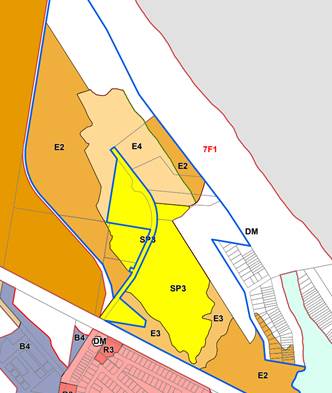
|
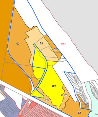
|
|
Exhibited Zones
|
Amended Zones
|
|
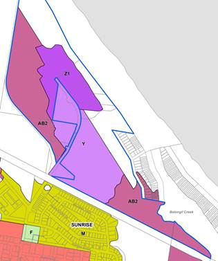
|
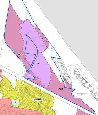
|
|
Exhibited minimum lot size (MLS)
|
Amended MLS
|
|
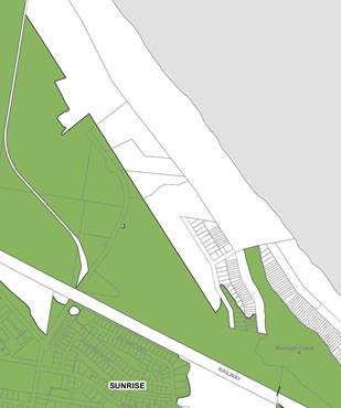
|
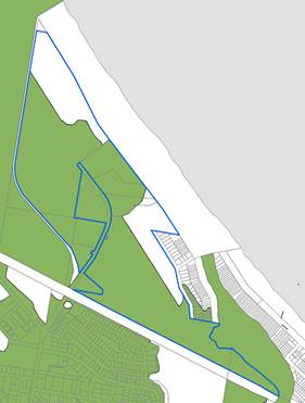
|
|
Exhibited Building Height
|
Amended Building Height
|
Next steps
Based on the assessment of the planning proposal and the
feedback received from public exhibition, it is recommended that the amendments
to Byron Local Environmental Plan 2014 proceed toward finalisation.
The draft will be sent to the
Department of Planning Industry and Environment to finalise the amendment.
Strategic Considerations
Community Strategic Plan and Operational Plan
|
CSP Objective
|
L2
|
CSP Strategy
|
L3
|
DP Action
|
L4
|
OP Activity
|
|
Community Objective 4: We manage growth and
change responsibly
|
4.1
|
Support the visions and aspirations of local communities
through place-based planning and management
|
4.1.3
|
Manage development through a transparent and efficient
assessment process
|
4.1.3.10
|
Prepare and assess Planning Proposals and Development Control
Plans, and amend Local Environmental Plan maps
|
|
|
|
|
|
|
|
|
|
Recent Resolutions
|
20-204
21/05/2020
|
Resolved that this matter be
deferred for discussion at a Strategic Planning Workshop and a report be
provided at the first available Ordinary Planning Meeting after the winter
recess.
|
|
20-470
17/09/2020
|
1. That
Council prepare a planning proposal to rezone a section of land at North
Beach Byron to E4 Environmental Living, and implement the agreed E2 and E3
environmental zones across the site (Attachment 1 E2020/67667), and forward
the proposal to the Department of Planning, Industry and Environment for
Gateway determination.
2. That
the planning proposal be placed on public exhibition in accordance with the
Gateway determination, and that Council receive a further report at the end
of the exhibition period detailing submissions made.
3. That
the current 7(f1) Coastal Land zoning remain in place for the part of the
site located seaward of the contemporary 100 year hazard line, pending
completion of the Coastal Management Program, at which time it can be reviewed
|
Legal/Statutory/Policy Considerations
The planning proposal will amend Byron Local Environmental
Plan 2014 as outlined in this report.
Financial Considerations
The planning proposal continues to be progress on a
cost-recovery basis paid for by the landowner.
Consultation and Engagement
The report above presents the outcomes of the latest
community engagement process.
Staff Reports - Sustainable Environment and Economy 13.7
Report
No. 13.7 Federal Movement and Place
Draft Concept Design
Directorate: Sustainable
Environment and Economy
Report Author: Andrew
FitzGibbon, Acting Place Activation Coordinator
Isabelle Hawton, Planner
File No: I2021/1424
Summary:
The purpose of this report is to
seek Council endorsement of the Federal Movement and Place Draft Concept Design
to go on public exhibition.
The public exhibition will be for
a minimum of 28 days and in accordance with the Byron Shire Council Community
Participation Plan.
It is an important project which
aims through design significant improvements to safety, accessibility and
placemaking for Federal Drive (refer to project scope and objectives in
Attachment 1).
The draft concept design is
provided at Attachment 2.
This draft has been developed with
input from Federal Village Masterplan Steering Group representatives, Council
engineering / placemaking staff and Transport NSW.
It is important to consult the
whole of Federal and surrounding villages about this as the design relates to a
significant ‘place’ at the heart of their community.
It is also important for this
exhibition to occur now while the design is in the concept stage and while
there is still meaningful opportunity for engagement to effect changes in the
design.
RECOMMENDATION:
That the Federal Movement and Place Draft Concept
Design (Attachment 2 – E2021/127271) be publicly exhibited for a period
of not less than 28 days and in accordance with the Byron Shire Council
Community Participation Plan.
Attachments:
1 Project
Scope and Objectives - Federal, E2021/123824
2 Draft
Concept Plan - Federal Drive - Oct 2021, E2021/127271

Report
The purpose of this report is to
seek Council endorsement for the Federal Movement and Place Draft Concept
Design to move to a stage of public exhibition.
The public exhibition will be for
a minimum of 28 days and in accordance with the Byron Shire Council Community
Participation Plan.
It is a key project which aims
through design significant improvements to safety, accessibility and
placemaking for Federal Drive (refer to project scope and objectives in
Attachment 1).
It is important to consult the
whole of Federal and surrounding villages about this as the design relates to a
significant ‘place’ at the heart of their community.
It is also important for this
exhibition to occur now while the design is in concept stage and while there is
still meaningful opportunity for engagement to effect changes in the design.
Background
The Movement and Place design for
Federal Drive is a detailed project that has been developed alongside the
community-led masterplanning process underway in Federal.
Council endorsed this design
project and associated funding on 24 June 2021 (refer resolution
21-243 point 2).
The design
work is being led by Better Cities Group alongside staff.
Draft Concept Design
The draft concept design is provided
at Attachment 2.
This draft has been developed with
input from Federal Village Masterplan Steering Group representatives, Council
engineering / placemaking staff, Transport NSW and Northern Rivers Bus Lines.
Note that for the public
exhibition a communication package will be developed to clearly explain the
various aspects of the plan and how the project objectives are addressed.
The communication package will
include explanatory text and illustrative graphics.
Project Program
The following table summarises the project program,
including consultation undertaken to date and the next steps.
|
#
|
Stage
|
Timing
|
|
1
|
Concept drafting which
included:
· multiple concept meetings with community
representatives, Council engineering / placemaking staff
· consultation with Transport NSW and Northern Rivers
Bus Lines
|
Completed in Aug / Sept
2021
|
|
2
|
Briefing to Council’s
Executive Team
|
Completed 30 Sept 2021
|
|
3
|
Briefing to the Place
Planning Collective
|
Scheduled for 26 Oct 2021
|
|
4
|
Report to Council for endorsement
to go to public exhibition
|
This report – 4 Nov
2021
|
|
5
|
Public exhibition of the
draft design concept
|
Nov/Dec 2021
|
|
6
|
Design refinement –
including further discussions with community representatives and Council
engineering / placemaking staff
|
Jan 2022
|
|
7
|
Reporting final concept
design to Executive Team and Council
|
Feb/Mar 2022
|
|
8
|
Detailed design to develop
construction ready drawings
|
Apr/May 2022
|
|
9
|
Apply for grants for
construction
|
Pending appropriate grant
|
Public Exhibition
The following key stakeholders
will be consulted during the public exhibition period:
· the whole community
· Federal Village Masterplan Steering Group
· Federal Village Movement and Access Sub-group
· Land owners directly adjoining the primary study area
· Byron Shire Councillors
· Transport NSW
· Northern Rivers Bus Lines
Key issues
Key issues to be explored during
the consultation will be:
· Preferred bus stop locations and bus turning options
· Intersection treatments
· Accessibility
· Placemaking elements
· Carparking provision
Strategic Considerations
Community Strategic Plan
and Operational Plan
|
CSP
Objective
|
CSP Strategy
|
DP Action
|
Code
|
OP Activity
|
|
Community
Objective 4: We manage growth and change responsibly
|
4.1:
Support the visions and aspirations of local communities through place-based
planning and management
|
4.1.1:
Develop, implement and update Place Plans that promote place-based forward
planning strategies and actions
|
4.1.1.6
|
Support
the Federal Community Village Masterplan Steering Group to undertake
community-led masterplanning for Federal
|
Recent Resolutions
· Council endorsed this design project and associated funding
on 24 June 2021 (refer resolution
21-243 point 2)
Legal/Statutory/Policy Considerations
Public exhibition to be undertaken in accordance with
Council’s Community Participation Plan.
Financial Considerations
Consultation costs have already been funded as part of the
project budget.
Consultation and
Engagement
As noted within the report.
Staff Reports - Sustainable Environment and Economy 13.8
Report
No. 13.8 Biodiversity Projects and
Operations Update
Directorate: Sustainable
Environment and Economy
Report Author: Lizabeth
Caddick, Biodiversity Officer
File No: I2021/1615
Summary:
This report provides the Council with an update on current
projects and programmes being undertaken by the Biodiversity team, including:
· 2021-22 FY
biodiversity conservation strategy projects
· Wildlife corridor
mapping
· Koala activity
surveys
· Wildlife road
strike mitigation
· Koala habitat
planting projects
· Leash-Up Pilot
Communication Project
· Sustainable
Agriculture Projects
· Flying-fox
Management Plan
· Pest Animal
Management Plan
· Bringing Back the
Bruns
· Feral Cat trapping
program – BSC and LLS partnership
· Keeping Cats
Safe at Home Project - RSPCA NSW
RECOMMENDATION:
That Council:
1. Notes that
a draft wildlife corridor map has been prepared and that expert stakeholder
consultation/peer review of this map will occur in late 2021, with formal
exhibition of the map to follow in early 2022, subject to a further report for
Council’s consideration.
2. Notes
that the "Bow Wow Leash me Now!" project is a finalist in the LGNSW's
Excellence in the Environment Awards in the Communication, Education and
Empowerment category with the online award ceremony being held on 16 November
2021.
Report
2021-22
Financial Year Biodiversity Conservation Strategy Projects
Council’s 2021-22 Operational Plan has provided funding
for the following new projects (Table 1), which are Biodiversity Conservation
Strategy Actions.
Table 1. 2020-2021 Biodiversity Conservation Strategy
Projects
|
Project
|
OP number
|
Biodiversity Strategy Action number
|
Project Progress
|
Budget
|
|
Develop a Strategic Action Plan for Wildlife Road Strike
Mitigation in Byron Shire.
|
3.1.1.15
|
4.25 - Work with RMS, local wildlife groups and Regional
Koala Communications Group to identify road strike hotspots in Byron Shire.,
4.26 - Seek funding for road strike mitigation trials at
priority road strike hotspots.
4.27 - Consider roadkill mitigation measures and
opportunities to improve wildlife connectivity into design work for new roads
and road asset upgrades.
|
Finalising contract & collating road strike data.
Due to start January 2022.
|
$11,500
|
|
Finalise shire-wide restoration map
|
3.1.1.17
|
1.20 Map areas that have been revegetated: a) using public
funds, and b) for conservation purposes
|
Contract awarded. Starting October 2021.
|
$8,850
|
|
Map potential habitat areas for Mitchell's Rainforest
Snail
|
3.1.1.18
|
1.25 Map potential habitat areas for Mitchell’s
Rainforest Snail.
|
Seeking quotes.
|
$8,000
|
|
Update 2017 vegetation and HEV mapping to reflect ground
truthing done as part of EZone review (approx 250 sites).
|
3.1.1.19
|
1.14 Update and maintain Council's vegetation and HEV
mapping with revised Plant Community Types (PCTs) and current aerial
photography.
|
Contract awarded. Starting October 2021.
|
$6,000
|
|
Update flora and fauna lists for the shire, including
status of threatened flora and fauna
|
3.1.1.20
|
1.11 Conduct a review of Byron Shire’s biodiversity
values as a baseline for ongoing biodiversity monitoring. Include: •
Updated Byron Shire flora and fauna lists, • Status of threatened flora
and fauna, • Status of weed species, • Extent of native
vegetation, • Extent of protected vegetation (public and private land)
• Fire frequency status
|
Seeking quotes.
|
$5,600
|
Wildlife Corridor Mapping
Landmark Ecological have developed draft wildlife corridor mapping
for Byron shire. The draft wildlife corridor map aims to protect core habitat
and dispersal opportunities for key threatened plants and animals in the shire
– i.e., those species that have core habitat in the shire, and that have
the most limited dispersal capability. The methodology is similar to that used
in development of Lismore Council’s wildlife corridor maps (Landmark
2012) and the regional wildlife corridor mapping developed by NSW National
Parks (Scotts 2003), but unlike previous wildlife corridor maps it includes
plants and ecological communities as well as animals. 62 conservation priority
fauna species, 65 flora species and 11 vegetation types based on a range of
geologies were used to derive the corridor system.
The methodology takes into consideration:
· Current
and historic species records and habitat,
· Threatened
ecological communities, Big Scrub remnants, Coastal SEPP, existing areas of
native vegetation regeneration.
· Existing
connections (e.g., highway underpasses and waterways),
· Existing
land use constraints (e.g., avoiding residential and industrial land, prime
agricultural land, and roads where possible),
· Location
of wildlife corridors in adjacent shires, plus OEH 2019 climate change
corridors and DEC Key Habitats and Corridors for Forest Fauna (Scotts 2003),
· Likely
impacts of climate change (through consideration of flood prone land, south
facing slopes, riparian habitats etc.).
The intent of the wildlife corridor mapping is to:
· Support
Council, environmental groups and landholders to strategically focus
restoration and habitat connectivity projects to where they can have the
greatest biodiversity benefit.
· To
support Council and environmental groups in seeking grant funding for key
strategic biodiversity conservation projects.
· To
support the implementation of Council’s Biodiversity DCP (Chapter B1)
during the development assessment process, by supporting planning decisions
that best protect and enhance our biodiversity, while continuing to facilitate
permitted land uses, e.g., on agricultural and residential zoned land.
· To
provide the community with a big picture perspective of how individual
properties fit into our natural environment, helping to foster connections with
the natural world and motivate residents, in both rural and suburban corridors,
to take steps to create and maintain wildlife connectivity in their backyards.
Next Steps
Staff are currently consulting with agricultural
stakeholders through the Agriculture Cluster Group, as well as other expert
stakeholders on the role and application of the corridor map in Byron Shire. We
intend to engage with the community more broadly and put the corridor map on
public exhibition in early 2022, subject to a further report to Council for
endorsement.
Some amendments will be required to the Biodiversity DCP to:
· Ensure
that the definition of a wildlife corridor in the DCP reflects the new mapping,
· Clearly
articulate different management intent for corridors in areas of native
vegetation compared with those in agricultural and high-density land use zones.
Coastal koala activity
monitoring program 2021
Council’s coastal koala activity monitoring program is
nearly complete, funded with a $20,000 grant from the NSW 2018-2021 Koala
Strategy. The field work has been delayed by wet weather, Covid-19 and
difficulties accessing some sites that are on private property. To date 49 out
of 58 sites have been surveyed. A small number of survey site locations have
been changed (within 250 metres) where we were unable to access private land.
This monitoring repeats surveys done in the coastal KPOM
area in 2011 and 2016 and uses the Spot Assessment Technique (SAT) to assess
changes in koala activity. The surveys involve repeat monitoring of 58 sites
(mostly on private land) for koala scats (droppings), which are used as an
indicator of koala presence/absence and activity.
As well as providing us with updated information on koala
activity in the shire, the project has been a great opportunity to talk with
landowners in the CKPOM areas about koala conservation on their land and what
they can do to help. Once all surveys are complete, full results will be
reported to Biodiversity Advisory Committee.
Wildlife
Road Strike
As per Table 1 above, Council
is developing a Strategic Action Plan for Wildlife Road Strike Mitigation. This
will use road strike data provided by wildlife carer groups and the NSW
Government to identify key wildlife road strike hotspots in the shire. Appropriate
and cost-effective mitigation measures will be identified at the highest
priority sites. This will enable Council to seek funding for wildlife road
strike mitigation at the most strategically important locations in the shire.
In 2020, Council has also been progressing installation of
wildlife signage along several roads in the shire, as part of road upgrade
projects, including:
· Skinners
Shoot Road upgrade (Figure 1). The speed limit along this road has also been
reduced from 80 to 50km/h.
· Bangalow
Road upgrade (Figure 2)
· Gray’s
Lane upgrade (in progress). The speed limit along this road has also been
reduced from 80 to 60 km/h.
· Tyagarah
Road (Figure 3).
· Myocum
Road upgrade – in progress.
Figure 1 – Skinners Shoot Rd koala sign
Figure 2 – Bangalow
Rd wildlife sign
Figure 3 – Tyagarah Rd koala sign
At the end of the 2020-21 financial year, Council received a
grant of $12,000 from the NSW Koala Strategy for installation of a koala zone
on Mafeking Rd, Goonengerry, either side of Byrangery Grass Reserve and in a
known breeding koala habitat area. The koala zone includes two 6m x 7m road markings, as well as signs picturing a
mother koala with a joey on her back (Figures 4 and 5).
Figure 4 – Mafeking Rd Koala Zone
Figure 5 – Mafeking Rd Koala Sign

Koala habitat planting
projects
Council is continuing to progress a number of projects
focussed on creating or restoring koala habitat on private land, including:
· North-East
Hinterland Koala Conservation Project - This DPIE-funded project is a
partnership between Tweed, Byron, Lismore and Ballina Councils and Friends of
the Koala. Byron Shire Council has a budget of $45,000 over three years for
koala habitat planting and restoration on private land. 15 sites, totalling
around 15 ha and over 2000 trees have been planted and maintenance work on
these sites is in progress.
· Koala
Food for the Future Project – the Saving our Species program has provided
$18,750 funding for koala habitat restoration on private land, with a similar
methodology to the North-East Hinterland project. To date 10 sites, totalling 7.5
ha have been identified and planting is in progress.
· Council
has been helping Mullumbimby High School students set up their Trees for Koalas
- Connecting Communities project. Students from the school’s Special
Education Learning Centre and their families joined in a second
planting at The Pocket on 4 May. More trees will be delivered to the school in
August for planting on private properties.
· Byron
Habitat Corridors Project - This Environment Trust funded project finished in
March 2021. The project has resulted in planting of 6.6 ha (3983 plants) and
restoration of 10.9 ha koala habitat at six private properties in Mullumbimby,
Bangalow, Brunswick Heads, Myocum and Skinners Shoot, in addition to 3
community workshops and 2 community planting days.
Leash-Up Pilot Communication Project
The Leash-Up project ran from June
2020 – June 2021, funded by a $84,890 grant under the NSW Koala
Strategy’s ‘Conservation through Community Action’ pillar.
The project developed a social behaviour change communications campaign and
findings were reported to regional partners via the Northern Rivers Regional
Koala Group.
The "Bow Wow Leash me
Now!" leash-up project has recently been nominated as a finalist in the
2021 Local Government NSW Excellence in the Environment Awards. The online
award ceremony is being held on 16 November 2021.
Leash-Up was a community engagement project aimed at
increasing dog-leashing compliance in public spaces, to reduce the risk of
dog-koala attacks. Rather than going straight to an education campaign, the
project adopted a social marketing approach, guided by the theory of behaviour
change, to engage with dog owners and understand their attitudes and social
norms. This understanding enabled development of a targeted and engaging
campaign, which was tested on the target audience before being deployed via
television, social media and signage (Figure 6).
Use of dog-leashing as a measure of behaviour change
enabled simple monitoring of the campaign at a pilot study site, and
digitisation of the campaign via Facebook, Google and a website enabled us to
measure the reach and influence of the campaign.
Figure 6 – Leash Up Graphics and Messaging.

Key findings were:
· An
incremental change in leashing of +11% hides more substantial behavioural
changes:
o Large dogs are now being leashed more frequently with a
leashing increase of +27%
o More dogs are being leashed on the street and at the
park with a leashing increase of +20%
· 35%
of dog owners associate dog leashing with koala protection messages
· 29%
of dog owners have seen the Bow Wow TV ad
· Disagreement
that most people walk dogs on-leash has risen by +23% suggesting dog owners may
be more attuned to non-leashing behaviour than prior to the campaign
· Owners
of large dog may be more amenable to making changes to dog management and land
management to benefit koalas and other wildlife.
Implementing behaviour change requires a long-term
approach. To ensure project benefits are ongoing, the engagement tools
developed (artwork, videos) can be reused in future by both Byron and other
councils, to reinforce messages and stimulate community conversation. Results
were communicated to other regional LGAs via the Northern Rivers Regional Koala
Communications Group. As a pilot study, the intention was to share learnings
and outputs with other councils working to conserve koalas. All artwork is
available to the other regional Councils and the TV ad campaign was deployed
regionally, with the support of other local Councils.
Local Councils have a regulatory
role over many issues (littering, parking, environmental health), and
Council’s frequently use awareness-raising campaigns to help manage
regulatory issues. The methodology used in this campaign, including social
marketing, behaviour change theory and testing of concepts on the target
audience are applicable to community engagement campaigns across a range of
issues.
Additionally, the project created
a significant database of local dog owners, their demographics, views and
attitudes, which provides a starting point for development of additional
communications materials relating to numerous dog-owner compliance issues.
Sustainable Agriculture
SmartFarms
The hand book for aspiring farmers - Starting Out!- An
introductory Guide to Farming in the Byron Shire has been reprinted to
allow for broader distribution. Promotion of the book is via the farmer network
as well as through the organisations and individuals contributing to the book
and Facebook. The book is distributed from real estate and stock and station
agents in the shire and distribution is also planned for rural stores.
SmartFarms workshops have commenced with over 110 people
attending 4 workshops.
Smart Farms workshops completed so far:
· You
and your land – planning what to do.
· Soils
as part of Soils our national capital with BVL and Casino Food Co Op.
· Organic
vegetable and flower Field Day hosted by Liz and Bob in Goonengerry which was
filmed for Social media.
· Rotational
grazing to reduce pasture weeds.
A Mentoring program has commenced and is
providing a variety of mentors for farmers in a variety of ways:
· The
establishment of the Myocum grazing group assists newer farmers to learn from
established farmers while they all learn from each other.
· Organic
growers were invited to an organic vegetable and flower farm in Goonengerry to
learn about organic growing. Networks were formed and the hosts make themselves
available to discuss issues regarding organics, growing and marketing.
· Field
day at a regenerative grazing farm in Myocum. The host is happy to talk cattle
and regenerative farming with newer farmers starting out in the area.
· Council
is partnering with the Farming Together program/Regenerative Agricultural Alliance
mentor program. A 3 month program connecting 10 farmers with farming experts.
There is also potential to have 12 farmers as part of the program, meeting with
or having contact with a regenerative farming mentor monthly over a 12 month
period.
Combating Pests and Weeds Grant
(Commonwealth) 2020 - Agricultural advice, weed and pest animal control in
Byron Shire
Tropical Soda Apple eradication in the Shire is complete.
Over 5ha of the weed in the Shire has been controlled by Rous County Council
which includes several follow-up controls over the last 12 months.
Five primary producing landholders are participating in the
control of 5.5ha of environmental weeds ($27k). The project is addressing a
variety of weeds including pasture and riparian weeds for the benefit of both
productivity and the environment.
A broad acre weed management project will
address weeds on 120ha of agricultural lands by a managed grazing incentive
project. As part of this project, 14 primary producers will be participating in
a Regenerative Agriculture based property planning workshop in late 2021. 453ha
of farmland in the Shire will be planned for managed/cell grazing. Regenerative
grazing of this type promotes pasture development and condition which competes
well with many pasture weeds, as well as providing many other soil, moisture
and nutrient retention benefits over the long term. Of these 12 participants, 6
farmers have been selected to receive grants up to $4,500 to assist them to
implement their plans, for purchases such as electric fences, posts, energisers
and water systems on their farms (over 140ha).
Additional agricultural extension activities
Update on achievements since Nov 2020:
· Byron
Shire Farmer Network database set up and running consisting of over 260
members. Members receive weekly information emails specific to their farming
type, incentive opportunities and notifications of field days and workshops.
· 14
on site Farm Visits.
· 11
Real estate agents/buyers sent details and pdf of the new “Starting
out” and “Farmers farm and cows DO moo” guides.
· 10
“Newsletter” emails gone out to the BFN for workshops, events, and
grant info.
· 200
email introductions of extension role and service to landholders with
properties over 30 acres.
· Agriculture
extension role and service with contact numbers put in the latest Rates notice
distributed to all rate payers in the Shire.
· Presenter/Speaker
at 6 events in the Shire
Flying-fox Management
A Flying-fox Project
Reference Group meets quarterly to discuss issues, upcoming projects and
community concerns. The group is a good sounding board, representing the local
neighbourhoods of the flying-fox camps in the Shire. They also work well as a
conduit for information to their local areas.
Flying-fox Camp Management Plan Implementation:
The Flying-fox
Camp Management Plan (2018-2023) has been implemented over the last 3 years
with funds from Council, LGNSW and a State grant.
The LGNSW funded a $40,000 project to
create a 10m vegetation buffer between houses in Colins St Bangalow and the
Paddys Ck flying-fox camp. This effectively moved flying-foxes away from the
neighbourhoods back yards, reducing the impacts on the households considerably
with regard to noise, smell, mess and the use of their own back yards.
The NSW Environmental Trust funded the
Flying-Improvements project to the value of $79,500 over 3years and the project
will be completed by December 2021.
Project outcomes include:
· Contribution
to Flying-fox management officer salary over 2 years
· 6ha
of Flying-fox camp rehabilitation by bush regeneration (3 camps)
· 1260
riparian and rainforest plants for camp rehabilitation
· 180m
of riparian rehabilitation
· 100m2
of riverbank stabilisation
· 4
media releases discussing the values of Flying-foxes to the environment.
Council has noted a reduction in complaints
from the community compared to before the projects were commenced.
Camp Monitoring
The CSIRO Flying-fox census is carried out quarterly each
year. The results of the National Census from 2016 are tabled below and in
Figure 7.
|
|
Beech Camp
Suffolk Park
|
Butler St
Camp Byron Bay
|
Middleton
Camp Byron Bay
|
Mullumbimby
Camp Bruns R.
|
Paddy's Ck
Camp Bangalow
|
|
2016
|
Feb
|
180
|
0
|
250
|
2010
|
1000
|
|
|
May
|
0
|
3200
|
1016
|
1300
|
0
|
|
|
Aug
|
0
|
0
|
660
|
0
|
0
|
|
|
Nov
|
84
|
0
|
478
|
1826
|
955
|
|
2017
|
Feb
|
57
|
0
|
562
|
3584
|
2088
|
|
|
May
|
0
|
285
|
3429
|
10359
|
0
|
|
|
Aug
|
0
|
0
|
767
|
2755
|
0
|
|
|
Nov
|
469
|
0
|
276
|
7072
|
1947
|
|
2018
|
Feb
|
596
|
0
|
835
|
5522
|
2805
|
|
|
May
|
0
|
0
|
3020
|
0
|
0
|
|
|
Aug
|
0
|
0
|
3214
|
0
|
0
|
|
|
Nov
|
187
|
0
|
521
|
2654
|
1776
|
|
2019
|
Feb
|
755
|
0
|
318
|
3132
|
2128
|
|
|
May
|
0
|
0
|
947
|
0
|
0
|
|
|
Aug
|
64
|
0
|
1002
|
0
|
0
|
|
|
Nov
|
411
|
0
|
317
|
1623
|
891
|
|
2020
|
Feb
|
214
|
0
|
388
|
1995
|
1919
|
|
|
May
|
80
|
0
|
914
|
1242
|
187
|
|
|
Aug
|
36
|
0
|
702
|
0
|
0
|
|
|
Nov
|
415
|
0
|
405
|
4190
|
65
|
|
2021
|
Feb
|
167
|
0
|
476
|
3980
|
0
|
|
|
May
|
0
|
0
|
1017
|
0
|
0
|
|
|
Aug
|
0
|
0
|
665
|
920
|
0
|
|
|
Nov
|
|
|
|
|
|
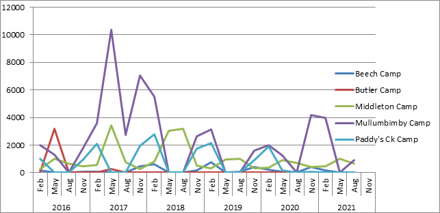
Figure 7. Total number of
Flying-foxes counted at the 5 managed camps in Byron Shire
Pest Animal
Management Plan
Wild Dogs, Cats and Foxes
Trapping is on-going on Council lands through our
contractor- JR Trapping. JR Trapping was also engaged by Council to trap on
private land in the Shire for 23 trapping weeks under the Australian Government
Drought Pest and Weeds project.
In the 2020-21 year, 1 dog and 1 fox were trapped on Council
land at the West Byron STP and the Waste Recovery Centre in Myocum.
In total, in the 2020-21-year, JR Trapping trapped 36 dogs,
27 foxes and 6 cats were trapped in the Shire for Council by JR Trapping.
A contract for a further 8 trapping weeks on private land
until the end of June 2021 will commence shortly, funded by Australian
Government Drought Pest and Weeds project.
Council participated in a feral cat trapping project funded
by NCLLS. Priority areas were identified following consultation with Council
staff, BVL and JR Trapping. 17 cats were trapped in this project by JR Trapping
as contractors.
Feral Deer
A young male Rusa deer was found in the north of the Shire
on Tuesday 3 August. This was the first record of a deer in the Shire. The deer
was dispatched that day by a local hunter.
A media report was sent to all
outlets and was picked up by newspapers and radio. The main messages for the
community included:
· to
report all sightings on Feralscan (www.feralscan.com.au).
A recording alerts the NCLLS, DPI and Council.
· landholders
have a biosecurity obligation to control all pest weeds and animals on their
land
No other sightings have been recorded in the Shire since.
Council is participating in an awareness campaign with
neighbouring Councils to make sure people know what to do if they do spot a
deer in the Shire. For more information about deer and the campaign in the
Northern Rivers go to www.feraldeeralert.com.au
Indian Myna
Myna trapping has been a success so far with great results
for the 20/21 year.
· 11
community members are involved in the Shire
· 7
members received 1:1 training and follow-up with dispatching of trapped birds
· 95
Indian Mynas trapped so far.
Council has received another 6 cage traps
and the trapping program has re-commenced this Spring.
Bringing
Back the Bruns
Fish Habitat Restoration
Program – Federal Grant
Contracting, sub-contracting
and design discussions have commenced with partners NCLLS and Soil Conservation
Service for the Bringing Back the Bruns project on the Brunswick River
in Mullumbimby.
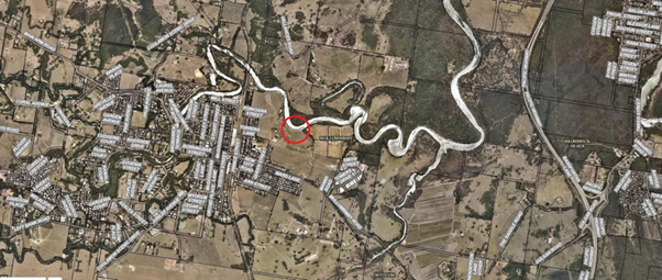
Figure 8. Fish Habitat Restoration
Program project site in red
A 190m bank of the upper Brunswick River
estuary has been identified in the Brunswick Coastal Zone Management Plan as a
strategic project site (CZMP B8), Figure 8. There is major bank
undercutting and erosion with a narrow and sparse riparian vegetation buffer
(Figure 9). The primary cause is channel meander migration, accelerated by the
lack of riparian vegetation and possibly wave action from the wind and boats. The eroding bank contributes towards poor water quality of the
Brunswick River estuary. This, with the lack of a functioning riparian zone
means that there is poor aquatic and minimal terrestrial habitat at the site.
The project is twofold - to stabilize and
rehabilitate the riverbank using designs and techniques that will also provide habitat
on the bed and bank. The landholder has committed to providing and maintaining
appropriate riparian vegetation to a minimum 12m from the top of the riverbank,
stock fencing and on-going maintenance to complete the project and ensure its
on-going estuarine and terrestrial habitat value. The project will incorporate
innovative bank stabilization designs which will provide diversity to the
aquatic habitat and promote colonization of stabilizing mangroves. In time the
structures will degrade and disappear, leaving mangroves and other local native
riparian vegetation to maintain the stability of the bank and provide native
habitat.
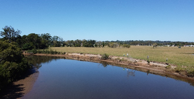
Figure 9. Fish
Habitat Restoration Program restoration site on Brunswick River
Project Objectives:
1. Reduce
ongoing sediment and poor water quality entering the Brunswick River, to
improve aquatic habitat.
2. Provide,
improve and secure aquatic and riparian habitat on strategic reaches of the
Brunswick River.
3. Stabilise
the riverbank using structures of natural materials that will encourage
colonization of mangroves and degrade overtime leaving local native vegetation
to stabilise the riverbank and provide aquatic and terrestrial habitat.
Planned on-ground
outcomes:
Significant aquatic and
riparian rehabilitation along a strategic reach on the Brunswick River estuary. It is anticipated the project will achieve:
· 190m
of stable riverbank,
· improved
aquatic habitat,
· 190m
of fenced riparian zone,
· 0.2ha
riparian rehabilitation,
· the
establishment of an extra 600 riparian plants ,
· Landholder
Management Agreement to maintain the outcomes of the project for at least three
years to assist the establishment and on-going maintenance of aquatic and
riparian habitat.
The project has been extended by 6 months
due to the delayed release of the funding agreement to NCLLS.
Fisheries Habitat Action
Grant (Federal) – Mullumbimby Riparian Riverbank Project
1.8km (Figure 10, orange
area) of bush regeneration has been completed by contractors. Councils Bush
Regeneration Team will be maintaining the site quarterly to encourage a dense
native riparian zone for the benefit of improved water quality, terrestrial and
aquatic habitat. Two community information days were held at the site to inform
the project and to promote good riverbank management by the local community.
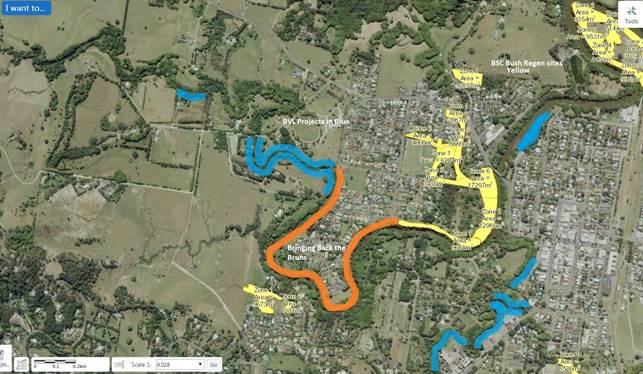
Figure 10. Habitat Action Grant project site in Orange.
Brunswick Valley Landcare sites in Blue. BSC Bush Regeneration sites in Yellow
Keeping
Cats Safe at
Home’ Project - RSPCA NSW
In October Council launched a new web page on responsible
cat ownership: Responsible
cat ownership - Byron Shire Council (nsw.gov.au). This website provides
regarding the impact of domestic cats on native wildlife and what people can do
to protect their cats and wildlife, including tips on building a
‘catio’ (enclosed outdoor space for cats) and walking your cat on a
lead.
This information will also support the RSPCA Keeping Cats
Safe At Home project, which Council is about to start participating in.
This is a 4-year behaviour change project run by the RSPCA and supported by the
NSW Environment Trust, which will encourage cat owners to keep their cats safe
at home through a range of project activities. The RSPCA will be developing
tailored behaviour change strategies for 10 successful Councils (of which Byron
Shire Council is one), which may include social marketing, school visits,
community engagement events, and GPS trackers to help owners understand the
impact of their cat and support with desexing and building cat enclosures.
The community consultation phase
of this project is currently in progress, with a ‘what do you think
about cats?’ online survey running until November 2021. Behaviour
change strategies will be developed and implemented from January 2022-Jan 2025.
Strategic Considerations
Community Strategic Plan
and Operational Plan
|
CSP Objective
|
CSP Strategy
|
DP Action
|
Code
|
OP Activity
|
|
Community Objective 2: We cultivate and celebrate our
diverse cultures, lifestyle and sense of community
|
Enhance community safety and amenity while respecting
our shared values
|
Enhance public safety, health and liveability through
the use of council's regulatory controls and services
|
2.4.3.6
|
Facilitate companion animals education
|
|
Community Objective 3: We protect and enhance our
natural environment
|
Partner to protect and enhance our biodiversity,
ecosystems and ecology
|
Protect and enhance our natural environment and
biodiversity
|
3.1.1.1
|
Implement the Biodiversity Conservation Strategy
|
|
3.1.1.2
|
Revise Wildlife Corridor Mapping (Biodiversity
Conservation Strategy action)
|
|
3.1.1.6
|
Investigate opportunities for Council to provide
incentives for landholders to conduct restoration works on their properties
that will assist with long term biodiversity conservation.(Biodiversity
Conservation Strategy action)
|
|
3.1.1.9
|
Implement the Flying Fox Camp Management Plan
|
|
3.1.1.10
|
Continue to undertake the Flying Fox National Census
|
|
3.1.1.11
|
Implement the Koala Plan of Management
|
|
3.1.1.12
|
Partner with key stakeholders on koala research and
management projects, including
- NE Hinterland Koala Conservation Project
- North Coast Koala Linkage and
- Maximising outcomes for koalas on private land project.
(Koala Plan of Management action)
|
|
3.1.1.13
|
Deliver and report on feral animal projects (Action in
Pest Animal Management Plan)
|
|
3.1.1.14
|
Deliver the pests and weeds grant funded project
|
|
Community Objective 3: We protect and enhance our
natural environment
|
Strive to become a sustainable community
|
Support community environmental and sustainability
projects
|
3.2.2.1
|
Provide coastal, environmental and sustainability
information and encourage and support community activities and groups
|
|
3.2.2.2
|
Participate in regional sustainability and environmental
working groups and initiatives.
|
|
3.2.2.4
|
Support Friends of the Koala, Bangalow Koalas and Wires
through the Regional Koala Communications Group.
|
|
3.2.2.5
|
Support Brunswick Valley Landcare to deliver the Land
for Wildlife Program and biodiversity enquiries
|
|
Community Objective 3: We protect and enhance our
natural environment
|
Partner to protect and enhance the health of the
Shire’s coastlines, estuaries, waterways and catchments
|
Implement Coastal Management Program
|
3.3.1.3
|
Continue Bringing Back the Brunswick River Project
|
|
Community Objective 3: We protect and enhance our
natural environment
|
Support and secure our farming future
|
Develop and implement strategies to support agriculture,
agri-business and farmers
|
3.4.1.1
|
Finalise and commence implementation of the Agriculture
Action Plan
|
|
3.4.1.2
|
Continue to deliver Smart Farms –Small Grants
project
|
|
3.4.1.3
|
Continue to convene Agricultural Cluster Group Meetings
|
Legal/Statutory/Policy
Considerations
Not applicable to the report.
Financial Considerations
Where relevant, budgets for specific projects noted above.
Consultation and
Engagement
Not applicable to the report.
Staff Reports - Sustainable Environment and Economy 13.9
Report
No. 13.9 Update Resolution 20-203
Linneaus Estate
Directorate: Sustainable
Environment and Economy
Report Author: Shannon
Burt, Director Sustainable Environment and Economy
Alex Caras, Land Use Plannning Coordinator
File No: I2021/1619
Summary:
Council considered Report No 13.3 - PLANNING - 26.2018.2.1
The Linnaeus Estate - Options for proceeding with Community Title Subdivision
at the Ordinary (Planning) Meeting of 21 May 2020 Agenda
of Ordinary (Planning) Meeting - 21 May 2020 (infocouncil.biz) and resolved
as follows:
Resolved 20-203:
1. That Council:
a) Note the report
PLANNING - 26.2018.2.1 The Linnaeus Estate - Options for proceeding with
Community Title Subdivision.
b) Support the preparation
of an amended planning proposal for Lot 1 DP 1031848, Broken Head Road, Broken
Head (The Linnaeus Estate) that rectifies the issues noted in this report.
c) Require the proponent
to provide a current coastal hazard study that informs the amended planning
proposal to Council’s satisfaction.
d) Receive a further
report that considers (i) proposed amendments to the planning proposal, (ii)
the outcomes of the coastal hazard study, and (iii) submissions that were
received during the public exhibition period.
2. That any planning
proposal and/or development application consultation and engagement period
reflects the Community Participation Plan namely that:
Before the lodgement of a planning proposal and/or
development application for community significant development, the applicant
must:
· carry
out a community meeting or workshop to be facilitated by Council;
· notify
adjoining and surrounding landowners and known community groups; and
· ensure
the community has adequate time to consider and comment on the proposal.
3. That
Council request the proponent to submit a current audit of buildings,
structures and works on site to enable Council staff to review against existing
consents and approvals to assess compliance. This audit is to be submitted
within three months.
This report provides an update on the status of each of the
points of the resolution.
RECOMMENDATION:
That Council:
1. Notes
the staff update on Resolution 20-203 The Linneaus Estate - Options for
proceeding with Community Title Subdivision.
2. In noting the site
inspection findings (section 5 of the audit), understands that staff will do
the follow up with the landowner (and do a site inspection if deemed necessary)
to clarify the nature of the minor inconsistencies identified between some of
the building forms on site as they appear in the various approval documentation
on file.
Attachments:
1 Attachment
1 - 26.2018.2.1 Site Audit - Planning Ingenuity Draft Report Version 2 - 951
Broken Head Road, E2021/127687 
Report
Update on Resolution 20-203
Resolution points are addressed below.
1. That Council:
a) Note the report
PLANNING - 26.2018.2.1 The Linnaeus Estate - Options for proceeding with
Community Title Subdivision.
This part of the resolution is
complete.
b) Support the
preparation of an amended planning proposal for Lot 1 DP 1031848, Broken Head
Road, Broken Head (The Linnaeus Estate) that rectifies the issues noted in this
report.
This part of the resolution as it
relates to the application of minimum lot sizes to strata
and community title schemes in
Environmental and Special purpose zones is complete
as per Planning Proposal (House
Keeping).
Housekeeping
amendments - Byron Shire Council (nsw.gov.au)
Any future changes to the zoning of
the subject land will need to be considered by a
separate Planning Proposal, which can
be Council and or landowner initiated.
c) Require the
proponent to provide a current coastal hazard study that informs the amended
planning proposal to Council’s satisfaction.
The subject land is part of the Coastal
Management Program Southern Coastline.
Coastal
Management Program Southern Coastline - Byron Shire Council (nsw.gov.au)
The Coastal Management Program for the
Southern Coastline is a long-term strategy
to guide the management of issues to
the:
· Coastal
areas from Broken Head in the south to Cape Byron in the north.
· Coastal
creeks and lakes including Belongil Creek estuary, Tallow Creek estuary, Ti
Tree (Taylor’s) Lake and their wider catchments.
A coastal hazard study currently
underway will include the subject land.
This study is a prerequisite to inform
any future planning proposal for the subject land.
d) Receive a further
report that considers (i) proposed amendments to the planning proposal, (ii)
the outcomes of the coastal hazard study, and (iii) submissions that were
received during the public exhibition period.
This report is dependent on b) and c)
above.
2. That any planning
proposal and/or development application consultation and engagement period
reflects the Community Participation Plan namely that:
Before the lodgement of a planning proposal and/or
development application for community significant development, the applicant
must:
· carry
out a community meeting or workshop to be facilitated by Council;
· notify
adjoining and surrounding landowners and known community groups; and
· ensure
the community has adequate time to consider and comment on the proposal.
This part of the resolution will be
met by the landowner/proponent as required.
3. That
Council request the proponent to submit a current audit of buildings,
structures and works on site to enable Council staff to review against existing
consents and approvals to assess compliance. This audit is to be submitted
within three months.
The above resolution followed a complaint submitted to
Council and issues raised in public access during the 21 May Council Meeting.
On 11 August 2020, the landowner
submitted an audit to Council seeking to address the above Council resolution.
Following this, Council staff
engaged an independent planning consultant to review the audit report to assess
compliance.
Staff acknowledge the significant
time delay since receipt of the audit report from the landowner until now. This
is explained by difficulties in engaging a consultant in a timely manner for
various reasons including COVID restrictions, to undertake the review.
The audit report in full is
Attachment 1. The conclusions of the audit report follow.
Given the above, it is recommended that Council note the
findings.
In noting the site inspection
findings (section 5 of the audit), understand that staff will do the follow up
with the landowner (and do a site inspection if deemed necessary) to clarify
the nature of the minor inconsistencies identified between some of the building
forms on site as they appear in the various approval documentation on file.
Strategic Considerations
Community Strategic Plan
and Operational Plan
|
CSP Objective
|
CSP Strategy
|
DP Action
|
Code
|
OP Activity
|
|
Community
Objective 4: We manage growth and change responsibly
|
4.1:
Support the visions and aspirations of local communities through place-based
planning and management
|
4.1.3:
Manage development through a transparent and efficient assessment process
|
4.1.3.5
|
Respond
to and investigate complaints against building standards
|
Recent Resolutions
· 20-203
Legal/Statutory/Policy
Considerations
As discussed in the report.
Financial Considerations
Not applicable to this report.
Consultation and
Engagement
As noted in reference to the Resolution 20-203.
Staff Reports - Sustainable Environment and Economy 13.10
Report
No. 13.10 Update Resolution 21-273 Emergency
Housing
Directorate: Sustainable
Environment and Economy
Report Author: Shannon
Burt, Director Sustainable Environment and Economy
File No: I2021/1620
Summary:
Council at
the Ordinary (Planning) Meeting of 5 August 2021 considered a Notice of
Motion 9.2 Emergency Housing Agenda
of Ordinary (Planning) Meeting - Thursday, 5 August 2021 (infocouncil.biz)
and resolved as follows:
21-273 Resolved that
Council:
1. Requests staff to prepare
a report to Council prior to submitting a development application and any
required supporting local approval applications for a “Transitional
Supported Accommodation” development made under existing definitions in
the Local Environmental Plan 2014, on that part of Lot 22 identified for
Affordable Housing in the “Plan of Management Community Land Mullumbimby
Sports Fields” that meets the following parameters:
“Transitional
Supported Accommodation” is temporary accommodation to bridge the gap
from those in insecure housing or at risk of homelessness to permanent housing
and is located as close as possible to existing residential facilities and
social support services.
“Temporary
accommodation” is a residential use or development for a period of not
more than 48 months from the date on which an occupation certificate is issued
under the Act.
2. Requests an update on the
progress of the emergency accommodation for women that was requested by the
Community Centre and advises the timeframe in which this may be delivered.
3. Requests a report
exploring the potential and highlighting the barriers for the Old Mullumbimby
Hospital Site to be used for temporary accommodation until the permanent use of
the site has been finalised.
4. Provides a report on any
Council land zoned RE1 and the barriers which would prevent it under the
current rules from providing emergency accommodation as per 1. above.
This report presents an update on
each of the items of the resolution.
RECOMMENDATION:
That Council:
1. Notes
the staff update on Resolution 21-273 Emergency Housing.
2. Not
proceed with the preparation of a development application for Transitional
Supported Accommodation on part of Lot 22, and instead continues to look for
more appropriate, less constrained sites for this type of development.
3. Continues
to work with the other member councils in the NRJO on potential housing
solutions for our region.
4. Continues
to work with relevant state government agencies, housing providers and local
housing groups to deliver (on ground) safe, secure and location appropriate
housing solutions for Byron Shire locals and key workers.
5. Continues
to advocate and agitate for housing policy change and financial support from
the state and commonwealth governments where opportunities arise.
Attachments:
1 FINAL
Transitional Supported Accommodation Lt 22 Stuart St Mullumbimby, E2021/127099 
2 Precinct
Structure Plan - Deicke Richards - Mullumbimby Former Hospital Site - Outcome
of Charette, E2021/127103
3 Mullumbimby
Hospital PRG - adopted recommendations November 2018, E2021/127118
Report
Update
on Resolution 21-273
Resolution
items are addressed below.
1. Requests staff to
prepare a report to Council prior to submitting a development application and
any required supporting local approval applications for a “Transitional
Supported Accommodation” development made under existing definitions in
the Local Environmental Plan 2014, on that part of Lot 22 identified for
Affordable Housing in the “Plan of Management Community Land Mullumbimby
Sports Fields” that meets the following parameters:
“Transitional
Supported Accommodation” is temporary accommodation to bridge the gap
from those in insecure housing or at risk of homelessness to permanent housing
and is located as close as possible to existing residential facilities and
social support services.
“Temporary
accommodation” is a residential use or development for a period of not
more than 48 months from the date on which an occupation certificate is issued
under the Act.
Council engaged an independent planning consultant to
prepare a report to outline the planning controls that apply to the subject
land and the constraints and opportunities that are relevant in the preparation
of a development application for Transitional Supported Accommodation (point
1). It also provides an assessment against the planning controls that may limit
the use of any land zoned RE1 for emergency accommodation point 4.
The report in full is Attachment
1.
In summary the report finds that
· An
application for Transitional Supported Accommodation could be prepared for the
subject land, but only in the form of a caravan park that includes permanent
sites.
· However,
the subject land is highly constrained and as little as 1 hectare of the 3.4-hectare
site is likely to be able to be used as a caravan park.
· By
comparison, the Glen Villa Resort in Byron Bay is located on a 5.5-hectare site
with approximately 2.5 hectares allocated to cabins.
· Moveable
dwelling sites are required to be a minimum of 80 m2. With fire separation
distances and the need for roads, landscaping and other infrastructure, the
actual yield is likely to be as low as 40 sites.
· The
cost of extending services to the sites as well as the cost of filling and
achieving a flood resilient access across the railway line and back to Stuart
Street are likely to be excessive and difficult to balance against the low
yield while still achieving low-cost accommodation.
· It
is not certain that access across the rail line would be provided by the NSW
government.
· A
development application for a caravan park to be used for Transitional
Supported Accommodation on part Lot 22 would take a long time to prepare and
would be expensive. It would have a low probability of success and be expensive
to construct and service if it were approved.
Given the above, it is recommended that Council not proceed
with the preparation of a development application for Transitional Supported
Accommodation on part of Lot 22, and instead continues to look for more
appropriate, less constrained sites for this type of development.
2. Requests an update on
the progress of the emergency accommodation for women that was requested by the
Community Centre and advises the timeframe in which this may be delivered.
A contract has been signed for a moveable dwelling to be
installed onsite at Suffolk Beachfront Holiday Park by 2 February 2022.
The moveable dwelling consists of a living space of 54 square metres, 2
bedrooms, 1 bathroom and all modern amenities. The original delivery
timeframe for the dwelling was 12 months due to COVID-19 supply implications,
however given the nature of the emergency accommodation the supplier was able
to expedite and agree to deliver within a 4-month window.
3. Requests a report
exploring the potential and highlighting the barriers for the Old Mullumbimby
Hospital Site to be used for temporary accommodation until the permanent use of
the site has been finalised.
There following factors prevent the site from being used for
temporary accommodation at this time.
Site contamination
Following the demolition and removal of the asbestos
contaminated hospital buildings, additional contamination was discovered on the
site. Council has engaged a registered auditor to progress remediation
under the provisions of the NSW Contaminated Land Management Act 1997.
Specialist consultants have completed the detailed site
investigation (DIS) which has been accepted by the auditor and will be the
basis for the development and implementation of a remediation action plan (RAP)
and associated works.
Following completion of the RAP works, the validation of the
RAP will comprise a site survey to confirm compliance with the technical
specifications of the capping containment structure. The outcomes of RAP
process will be addressed in an environmental management plan (EMP) for the
future management and use of the site.
The status of the site remediation and associated
requirements were the subject of Report No. 13.16 Remediation Mullumbimby
Hospital Site to the Agenda
of Ordinary Meeting - Thursday, 28 October 2021 (infocouncil.biz)
Land use zoning
The site is currently zoned SP2 Infrastructure (Health
Services Facility). Under this zoning only those land uses defined can be
permitted with approval/consent. Temporary accommodation, transition supported
accommodation and any other forms of residential accommodation are not
permitted land uses.
In keeping with the recommendations of the Mullumbimby
Hospital Site Project Reference Group (Attachments 2 and 3) it remains
Council’s aim that the property is developed to include a range of
community uses including housing and associated support services. Council’s
Place Planning team is continuing to work on this aspect of the project while
the remediation is being finalised. Further updates will be provided to Council
as their work progresses.
4. Provides a report on any
Council land zoned RE1 and the barriers which would prevent it under the
current rules from providing emergency accommodation as per 1. above.
The report referred to in point 1 also includes commentary
about point 4 as follows:
· It
has also been requested to identify the planning controls that may limit the
use of any land zoned RE1 for emergency accommodation wherever it may occur
(point 4).
· Emergency
accommodation is not a use defined in Byron LEP 2014 and is therefore a
prohibited use in the RE1 zone where all uses not specifically identified as permitted
are prohibited. The only potentially useful permitted use is caravan parks.
Although caravan parks are a permitted use in the zone, this does not mean that
all land zoned as RE1 is suitable for that use. Being a permitted use means
that you can prepare and lodge a development application, but it does not mean
it has to be approved.
· The
approval process is a merit assessment that is specific to each site. The
objectives of the RE1 zone indicate that it is not the intention of this zone
to provide emergency accommodation or residential accommodation. A caravan park
that is aimed at the tourist related market (at least in part) is more likely
to achieve the zone objectives than one dedicated to providing long-term
accommodation for singles and families to live in (long term is greater than
three months).
· Although
Byron LEP 2014 does not require a development to be consistent with all of the
zone objectives, there is an expectation that Council will still need to
justify the inconsistency with the objectives on the basis of the suitability
of the site and the merits of the caravan park development proposed.
· Any
application will also need to address the provisions of Byron Shire Development
Control Plan 2014 – Chapter D3 section D3.3.3. Subclause 3. a) to
i) provides a good summary of the issues and controls that are likely to limit
the use of any land zoned RE1 for a caravan park, including sites for long-term
occupation.
· The
relevant regulation for caravan parks in NSW is the Local Government
(Manufactured Home Estates, Caravan Parks, Camping Grounds and Moveable
Dwellings) Regulation 2005, which sets standards for:
· the
design, construction, maintenance and operation of caravan parks and camping
grounds;
· the
design, construction and installation of manufactured homes and other moveable
dwellings; and
· promotion
of the health, safety and amenity of the occupiers of those dwellings.
· A
caravan park would need to comply with this regulation.
· An
approval under section 68 of the Local Government Act 1993 is also required to
operate a caravan park or camping ground. This must be renewed every five
years.
Next steps
That Council continues to work
with the other member councils in the NRJO on potential housing solutions for
our region.
That Council continues to work
with relevant state government agencies, housing sector providers and local
housing groups to deliver on ground safe, secure and locationally appropriate
housing solutions for Byron Shire locals and key workers.
That Council continues to advocate and agitate for housing
policy change and financial support from the state and commonwealth governments
where opportunities arise.
Strategic Considerations
Community Strategic Plan
and Operational Plan
|
CSP Objective
|
CSP Strategy
|
DP Action
|
Code
|
OP Activity
|
|
|
Community Objective
4: We manage growth and change responsibly
|
4.2
|
Support housing diversity in
appropriate locations across the Shire
|
4.2.1
|
Establish planning mechanisms to
support housing that meets the needs of our community
|
|
Community Objective 2: We
cultivate and celebrate our diverse cultures, lifestyle and sense of
community
|
2.2
|
Support access to a wide range
of services and activities that contribute to the wellbeing of all members of
the Byron Shire community
|
2.2.1
|
Develop and maintain
collaborative relationships with government, sector and community
|
|
|
|
|
|
|
|
|
|
|
Recent Resolutions
· 21-112
· 21-062
· 21-066
· 21-122
· 21-123
· 21-253
· 21-273
Legal/Statutory/Policy
Considerations
As discussed in the report.
Financial Considerations
As discussion in the report.
Consultation and
Engagement
Not applicable to the report.
Staff Reports - Sustainable Environment and Economy 13.11
Report
No. 13.11 Resolution 21-221 Multiple Occupancies
and Rural Workers Cottages & Resolution 21-275 MOs and CTs - pathway for
secondary dwellings and dual occupancies
Directorate: Sustainable
Environment and Economy
Report Author: Shannon
Burt, Director Sustainable Environment and Economy
Alex Caras, Land Use Plannning Coordinator
Chris Larkin, Manager Sustainable Development
File No: I2021/1621
Summary:
Council at the Ordinary Meeting of 24 June 2021 considered a
Notice of Motion No. 9.2 Multiple Occupancies and Rural Workers Cottages Agenda
of Ordinary Meeting - Thursday, 24 June 2021 (infocouncil.biz) and resolved as follows:
21-221
Resolved that Council:
1. Prepares a report
exploring the possibilities, hurdles, and opportunities for continuing Multiple
Occupancies and Community Title as a pathway to providing more options for
accessible and affordable housing in the Byron Shire.
2. Prepares a report
on pathways to encourage the use of rural workers’ cottages to provide
accommodation for farmers wanting to live and work on the land.
3. Progress points 1
and 2 as part of the review of the RLUS to commence FY21/22. Noting this review
will enable a fresh dialogue with relevant state government agencies on the
current needs of our rural community five years on from the original RLUS
adoption.
Separate and subsequently, Council at the
Ordinary (Planning) meeting of 5 August 2021 considered Notice of Motion No.
9.5 MOs and CTs – pathway for secondary dwellings and dual occupancies Agenda
of Ordinary (Planning) Meeting - Thursday, 5 August 2021 (infocouncil.biz)
and resolved as follows:
21-275 Resolved that
Council investigates how to enable a workable pathway to facilitate secondary
dwellings on Multiple Occupancies and to facilitate secondary dwellings and/or
dual occupancies on Community Titles.
Multiple Occupancies (MO) and
rural Community Title (CT) developments have had various approval pathways in
the past.
Both resolutions have requested a
further report on the current pathways to enable new MO or CT development and to
facilitate secondary dwellings on existing MOs and to facilitate secondary
dwellings and/or dual occupancies on existing CTs.
This report addresses those parts
of the above resolutions in more detail.
RECOMMENDATION:
That Council:
1. Notes
the staff update on Resolution 21-221 Multiple Occupancies and Rural Workers
Cottages & Resolution 21-275 MOs and CTs - pathway for secondary dwellings
and dual occupancies.
2. Requests staff to prepare and submit a planning proposal to the
Department of Planning Industry and Environment for Gateway Determination to amend clauses 4.1B and 4.2B Byron Local Environmental Plan
2014 to:
i. remove the restriction of
one dwelling per neighbourhood lot and make any other necessary changes to
permit dual occupancy and secondary dwellings on existing Multiple Occupancy
and rural Community Title development; and
ii. update
where relevant the assessment criteria for Multiple Occupancy and rural Community
Title development.
Report
Update
on Resolution 21-221
Resolution
items are addressed below.
1. Prepares a report
exploring the possibilities, hurdles, and opportunities for continuing Multiple
Occupancies and Community Title as a pathway to providing more options for
accessible and affordable housing in the Byron Shire.
See discussion below.
2. Prepares a report on
pathways to encourage the use of rural workers’ cottages to provide
accommodation for farmers wanting to live and work on the land.
Rural workers dwellings across the Shire were originally
approved to help landowners manage the ongoing viability of their farm
holdings. But in many cases the size and viability of these farm holdings have
been reduced over the years due to a wide variety of reasons including aging of
farmers, loss of economic viability, declining farming skills in younger
generations and sales of portions of the original property.
Clause 16 of Byron LEP 1988 enables development consent to
be obtained for a rural worker’s dwelling provided that certain
conditions are met. The LEP 1988 applies to that land deferred from LEP 2014.
16 Rural
workers’ dwellings
(1) This clause applies to land within Zones Nos 1
(a), 1 (b1), 1 (b2), 1 (d), 7 (c) or 7 (d).
(2) The council shall not consent to the erection of
a rural workers’ dwelling on land to which this clause applies
unless—
(a) the erection of the additional dwelling will
not impair the suitability of the land for agriculture,
(b) the needs of existing agriculture genuinely
require that rural workers reside on the land,
(c) any other rural workers’ dwellings on
the land are being used by persons substantially engaged in agricultural
employment on that land, and
(d) the rural worker to occupy the dwelling is
to be employed by the owner of the land.
(3) A rural worker’s dwelling may, with the
consent of the council, be erected on a parcel of land to which this clause
applies on which a rural worker’s dwelling is already in existence if the
number of such dwellings does not exceed one for each 40 hectares of land
contained within the parcel.
A rural worker’s dwelling under Byron LEP 1988 is
defined as:
rural worker’s dwelling means a dwelling which is on land
upon which there is already erected a dwelling and which is occupied by persons
engaged in rural occupation on that land.
Clause 4.2C of Byron LEP 2014 also enables development
consent to be obtained for rural worker’s dwellings provided that certain
conditions are met.
4.2C Erection of rural
workers’ dwellings on land in Zones RU1 and RU2
(1) The
objective of this clause is to ensure the provision of adequate accommodation
for employees of existing agricultural or rural industries.
(2) This
clause applies to land in the following zones—
(a) Zone
RU1 Primary Production,
(b) Zone
RU2 Rural Landscape.
(3) Development
consent must not be granted for the erection of a rural worker’s dwelling
on land to which this clause applies, unless the consent authority is satisfied
that—
(a) the
development will be on the same lot as an existing lawfully erected dwelling
house, and
(b) the
development will not impair the use of the land for agricultural or rural
industries, and
(c) the
agriculture or rural industry being carried out on the land has a demonstrated
economic capacity to support the ongoing employment of rural workers, and
(d) the
development is necessary considering the nature of the agriculture or rural
industry land use lawfully occurring on the land or as a result of the remote
or isolated location of the land.
A rural worker’s dwelling under the Byron LEP 2014 is
defined as:
rural
worker’s dwelling means a building or place that is
additional to a dwelling house on the same lot and that is used predominantly
as a place of residence by persons employed, whether on a long-term or
short-term basis, for the purpose of agriculture or a rural industry on that
land.
The Department of Primary Industry provides advice to
councils to determine if rural workers dwellings should be provided for in
their LEP together with some relevant planning considerations.
Topics include:
· Are rural
workers dwellings needed?
· Recommended
approaches
· Developing
relevant criteria for rural workers dwellings
See Rural
Workers Dwellings (nsw.gov.au)
Under the RU1 and RU2 zones of Byron LEP 2014, detached dual
occupancy development and secondary dwellings are also permissible with
development consent. Both of which have had substantial development
applications made and approved in recent years.
It is highly likely that the take up of rural worker’s
dwellings as an accommodation option on rural land is currently not occurring
because of this. These types of development can be approved without
having to demonstrate that the ‘dwelling’ is required for a rural
worker on that land and is otherwise not constrained by the strict planning
provisions around a rural worker’s dwelling. This would also appear to be
the case given that so much of our rural land is no longer being farmed but
instead occupied for lifestyle purposes only. This observation is supported by
economic data which has shown a decline in primary industry output in the Shire
in recent years.
Notwithstanding the above, Council has a current commitment
to supporting our agricultural sector and the employment of an Agricultural
Extension Officer to do so. This may result in an increased demand for bonofide
rural worker’s dwellings due also to farming and agribusiness initiatives
and projects being rolled out by various business groups, organisations and
agencies across the northern rivers region.
Agriculture
- Byron Shire Council (nsw.gov.au)
1. Progress
points 1 and 2 as part of the review of the RLUS to commence in FY21/22. Noting
this review will enable a fresh dialogue with relevant state government
agencies on the current needs of our rural community five years on from the
original RLUS adoption.
Noted for
further action by staff FY21/22.
Update on
Resolution 21-275
That Council investigates how
to enable a workable pathway to facilitate secondary dwellings on Multiple
Occupancies and to facilitate secondary dwellings and/or dual occupancies on
Community Titles.
MOs and
rural CT developments have been granted additional dwelling density compared to
freehold rural lots. In this regard the parent parcel had one dwelling
entitlement before being developed for a MO or rural CT development, comprising
somewhere between three dwelling and fifteen dwellings.
The exact
number of additional dwelling sites would be determined from the assessment of
the development application for the MO or rural CT development in terms of a
site capability assessment or by a local environmental plan (LEP) amendment.
Under Byron
LEP 2014 Clause 4.2B limits the number of dwellings for MOs to 1 dwelling per 3
hectares up to a maximum of 15 dwellings on the lot, or the number shown for that lot on the Multiple Occupancy
and Community Title Map (where applicable).
Subsequent conversion of MOs to CT Development restricts the number of
residential lots created based on the number of dwelling sites approved under
the MO.
Under Byron
LEP 1988 the maximum number of dwellings is reflected in the Schedules below.
Byron
Local Environmental Plan 1988 - NSW Legislation – Schedule 8
Byron
Local Environmental Plan 1988 - NSW Legislation – Schedule 10
Byron
Local Environmental Plan 1988 - NSW Legislation – Schedule 13
Having
regard to the above, there are three planning pathways for additional dwellings
to be permitted subject to approval on MO or CT communities.
Pathway
1 to permit additional ‘dwellings’ on existing approved MO
or CT sites
(Note: a secondary dwelling or dual occupancy dwelling is
considered an additional dwelling)
Existing
Multiple Occupancies
A
development application under clause 4.2B of LEP 2014 can be lodged to amend an existing MO
development consent where the approved/constructed number of dwellings does not
exceed the assessed site capability of the land for that MO development,
provided that property is identified on the Multiple Occupancy and Community
Title Map under the clause.
This
pathway presents the possibility of one lot constructing additional dwellings
at the expense of other lots within that approved MO development. For example,
a property that has say an area of 40 hectares theoretically could have 13
dwellings on it. If ten dwellings already exist on it, the MO community would
need to determine amongst themselves who would benefit from receipt of the
additional yield of three more dwellings if approved.
In this
circumstance, it remains a matter for the MO community to determine prior to DA
lodgement which MO share/s, would receive the additional dwelling/s. This would
not be a matter for Council staff to arbitrate once a development application
is lodged.
Further,
the historical context of the existing approved MO community would need to be
considered by Council as part of the DA assessment in terms of merit, even
though the land may no longer fall under provisions of the Byron LEP
1988.
Applications
for additional development/dwellings often result in objections from the
community.
An example
of this is a MO approved in the late 1990’s in Goonengerry. The
applicant’s applied for 12 sites, Council approved 10 sites and following
a third-party appeal by a community group, the development consent was amended
back to 7 dwellings.
In this
circumstance, it would now seem somewhat perverse if Council were to permit an
additional 7 dwellings on this land in the form of dual occupancies or
secondary dwellings given the site history.
It should also be noted that many
older MOs approved under Byron LEP 1988 are not mapped under Byron LEP 2014,
and as such the pathway for additional dwelling sites would need to rely upon
existing use rights for expanding the approved MO. Any applications for extra
dwellings would again need to consider the historical context of the
development, the merits of the application and the site capability of the land
noting any maximum number of dwellings would be based on 1 dwelling per three
hectares and up to a maximum of 15.
Existing
Community title developments
As
discussed, the rural CT developments have been approved based on one dwelling
per lot (4.1B) Subdivisions that
have been approved under Byron LEP 2014 could have the number of dwellings
increased. It is noted some development consents have conditions of approval
that also reflect this limitation on the number of dwellings and or the
restriction is carried over into the Management Plan and Statement for the
subdivision. It is considered this is a development standard that could be
varied under Clause 4.6 of the LEP. Such an application will need to be
considered on merit, having regards to the historical context of the property
and the site capability of the land. Again, the ultimate number of dwellings
would be limited to one per three hectares and the community would need to
determine who benefits from the receipt of the additional dwellings.
Like older
MOs some of the older CT subdivisions approved under Byron LEP 1988 are not
mapped under Byron LEP 2014. The pathway for additional dwellings would also
rely upon existing use rights as discussed above.
Pathway
2 to permit additional ‘dwellings’ on existing mapped and or
vacant MO or CT sites
(Note: a
secondary dwelling or dual occupancy dwelling is considered an additional
dwelling)
As
discussed, currently in Byron LEP 2014 clause 4.2B controls housing density on these sites and 4.1B restricts sites to 1 dwelling.
Although
secondary dwellings and dual occupancies are permitted in the RU1 and RU2
zones, the above-mentioned clauses restrict dwelling numbers on MO or CT
communities.
The process
listed above under Pathway 1 has limited application and provides little
certainty of approval.
Council
could if of a mind, consider an amendment to clauses 4.2 B and 4.1B of LEP 2014
to permit additional dwellings on merit and to simplify the approval process
for same.
The
amendment would be two-fold – firstly remove the restriction of one
dwelling per neighbourhood lot and make any other
necessary changes to the LEP to permit dual occupancy and secondary dwellings
on existing MO and CT development. And update where relevant the assessment
criteria (previously imposed by State Environmental Planning Policy No 15 Rural
Land Sharing, and subsequently refined and adopted by Council for the former
Byron Rural Settlement Strategy and in LEP 1988 and LEP 2014) for this type of
development.
Pathway
3 to permit new MO or CT sites on vacant land not currently identified for
such development
MO and CT
development was already considered in the preparation Council’s Rural
Land Use Strategy (adopted 2017), where only a
handful of sites met the site suitability assessment criteria. An early
draft of the Rural Land Use Strategy (2016) identified substantial areas for MO
and/or CT development, but these were rejected by the State government mainly due
to their distance from nearest service centre/s and sub-standard road
infrastructure.
The current
State/regional policy framework (namely the North
Coast Regional Plan and s117 Ministerial
Direction 5.3 - Farmland of State and Regional Significance on the NSW Far
North Coast) severely restricts Council’s
ability to amend the Rural Land Use Strategy for the purpose of increasing MO
or CT rural settlement in the Shire.
The North
Coast Regional Plan is currently under review.
A review of the Rural Land Use Strategy is to follow the
North Coast Regional Plan update later in FY21/22. This review will enable a
fresh dialogue with relevant state government agencies on the current needs of
our rural community five years on from the original Rural Land Use Strategy
adoption.
Strategic Considerations
Community Strategic Plan
and Operational Plan
|
CSP Objective
|
CSP Strategy
|
DP Action
|
Code
|
OP Activity
|
|
Community
Objective 4: We manage growth and change responsibly
|
4.1:
Support the visions and aspirations of local communities through place-based
planning and management
|
4.1.3:
Manage development through a transparent and efficient assessment process
|
4.1.3.11
|
Prepare
and assess Planning Proposals and Development Control Plans, and amend Local
Environmental Plan maps
|
Recent Resolutions
· 21-221
· 21-275
Legal/Statutory/Policy
Considerations
The preparation of the planning proposal will need to
satisfy the requirements of the Environmental Planning and Assessment Act 1979
and guidance and information on the process for preparing planning proposals
from the DPIE.
It should be noted that Council
has developed the Rural Land Use Strategy and Residential Strategy to guide
future housing within the Shire. Additional housing in rural MO and CT
developments is not currently supported within these strategies, mainly due to
locational and road infrastructure constraints. This may be an issue
raised by the DPIE in considering whether to issue a Gateway Determination for
the planning proposal if it is to be progressed following any Council
resolution.
Financial Considerations
The planning proposal would be
considered Council initiated and will be funded from the existing land use
planning services budget.
Consultation and
Engagement
Not applicable to this report.
Staff Reports - Sustainable Environment and Economy 13.12
Report
No. 13.12 Update Resolution 20-727 Proposed Off
Leash Dog Park at Mullumbimby Recreation Grounds
Directorate: Sustainable
Environment and Economy
Report Author: Shannon
Burt, Director Sustainable Environment and Economy
File No: I2021/1639
Summary:
Council at
the Ordinary Meeting of 17 December 2020 considered a Notice of Motion
No. 9.4 Opportunity for activation and increased passive surveillance at the
Mullumbimby Skate Bowl Agenda
of Ordinary Meeting - Thursday, 17 December 2020 (infocouncil.biz)
and resolved as follows:
20-727 Resolved that
Council:
1. Supports the concept of activating the
sports field adjacent to the Mullumbimby skate bowl with a dog park with the
aim of creating increased passive surveillance and stopping people being able
to drive on the field and damage it.
2. Requests the Sustainable Environment and
Economy Directorate staff to arrange for the preparation of a detailed design
for a dog park for consultation with the community, and a report of the
outcomes of the consultation to Council for final design endorsement.
3. Requests the Sustainable Environment and
Economy Directorate staff to ensure that the dog park design is integrated with
the wider planning work, which is looking at the future use and development on
adjacent lands including Lot 22 vacant land community gardens, private lands,
sports fields and the skate bowl.
4. Approves a budget allocation of $20,000 from an appropriately
identified source to undertake the necessary design work on the dog park to
enable the community consultation process, and following, refinement of a final
design to enable project delivery.
This report presents an update on
the resolution.
RECOMMENDATION:
That Council:
1. Notes the staff
update on Resolution 20-727 Opportunity for activation and increased passive
surveillance at the Mullumbimby Skate Bowl.
2. Not
progress the concept plan prepared for activating the sports field adjacent to
the Mullumbimby Skate Bowl with an Off Leash Dog Park at this time.
3. Instead
look for an alternate site for an Off Leash Dog Park in Mullumbimby that is on
Council owned or other land.
Attachments:
1 Attachment
1 Mullumbimby Recreation Ground - Crown Land Map, E2021/129125 
2 Attachment
2 - Concept Plan Off Leash Dog Park, E2021/129123
Report
Update on Resolution 20-727
Resolution
items are addressed below.
1. Supports the concept of activating the
sports field adjacent to the Mullumbimby skate bowl with a dog park with the
aim of creating increased passive surveillance and stopping people being able
to drive on the field and damage it.
A SPW was held on the 7 October
2021 to discuss the Mullumbimby Recreation
Grounds considering community interest and projects put forward for the site
including:
The Mullum Chamber of Commerce -
Pump Track
The Mullum Bruns Cricket Club -
Cricket pitch upgrade
Mullum Netball Club –
Netball facilities upgrade
Council Off Leash Dog Park -
Concept Plan and Grant Application
Youth/Community Centre - Unsolicited
Proposal
The update from staff highlighted
several matters relevant to the consideration and ability for the above
projects progressing including land tenure, Native Title and Plan of Management
status.
The Mullumbimby Recreation Grounds
is Crown land where Native Title Rights and Interests continue and any
activities on the reserve need to comply with Native Title Act requirements.
(Attachment 1) Broadly speaking, that requires:
i. Council
to respect native title rights and interests and in the first instance
avoid/minimise impacts from Council projects on those rights as much as
possible (just like Council respects and avoids/minimises impacts from Council
projects on private property rights as much as possible).
ii. Council
to include compensation for impacts on Native Title rights in budgets for
projects if Council resolves to proceed with a project for new or upgraded
works on the reserve.
iii. Any
Projects for new or upgraded works on the reserve need to meet some very
specific definitions contained in the Native Title Act to be allowed to proceed
and projects that do not meet those definitions cannot go ahead unless an
Indigenous Land Use Agreement (ILUA) is negotiated that allows the project to
proceed.
Based on the above, it is recommended
that Council look for an alternative site for the proposed Dog Park.
(Please note resources have not been expended yet on reviewing whether it would
satisfy the third requirement above or not).
2. Requests the Sustainable and Economy
Directorate staff to arrange for the preparation of a detailed design for a dog
park for consultation with the community, and a report of the outcomes of the
consultation to Council for final design endorsement.
A concept plan for an Off Leash
Dog Park has been prepared (Attachment 2). But due to 1 above, it will need to
be revised in its size and layout to suit a new location.
3. Requests the Sustainable and Economy
Directorate staff to ensure that the dog park design is integrated with the
wider planning work, which is looking at the future use and development on
adjacent lands including Lot 22 vacant land community gardens, private lands,
sports fields and the skate bowl.
Should the alternate site
identified for the Off Leash Dog Park be part of or adjacent to Lot 22 Council
land or private land the new design will be integrated to suit the wider
development layout of the Saltwater Creek Precinct.
4. Approves a budget allocation of $20,000 from
an appropriately identified source to undertake the necessary design work on the
dog park to enable the community consultation process, and following,
refinement of a final design to enable project delivery.
A concept plan for an Off Leash
Dog Park has been prepared (Attachment 2). However, due to 1, wider community
consultation has been put on hold until a new site has been identified for its
location and development.
Strategic Considerations
Community Strategic Plan
and Operational Plan
|
CSP Objective
|
CSP Strategy
|
DP Action
|
Code
|
OP Activity
|
|
Community
Objective 1: We have infrastructure, transport and services which meet
our expectations
|
1.2:
Provide essential services and reliable infrastructure which meet an
acceptable community standard
|
1.2.4:
Provide active and passive recreational Community space that is accessible
and inclusive for all (SP)
|
1.2.4.5
|
Deliver
the grant funded car park works and provision of off-leash dog area project
at the Mullumbimby Recreation Grounds
|
Recent Resolutions
· 20-727
Legal/Statutory/Policy
Considerations
As discussed in the report.
Financial Considerations
As per resolution.
Consultation and
Engagement
Not applicable to this report.
Staff Reports - Sustainable Environment and Economy 13.13
Report
No. 13.13 Update Resolution 21-180 (3) land use
definitions as they apply to rural land
Directorate: Sustainable
Environment and Economy
Report Author: Shannon
Burt, Director Sustainable Environment and Economy
File No: I2021/1649
Summary:
Council at the Ordinary (Planning) Meeting of 10 June 2021
considered Report No 13.1 - PLANNING - Housekeeping planning proposal
exhibition outcomes 26.2020.6.1 Agenda
of Ordinary (Planning) Meeting - Thursday, 10 June 2021 (infocouncil.biz) and
resolved as follows:
21-180
Resolved that Council:
1. Forwards
the planning proposal to amend Byron LEP 2014, as revised in Attachment 1
(E2021/65655) to include the changes recommended in this report to NSW
Parliamentary Counsel’s Office (PCO) requesting that a draft LEP
instrument be prepared.
2. Pending
receipt of PCO opinion that the plan can be made, forward the plan to the NSW
Department of Planning, Industry and Environment for notification on the NSW
Government legislation website.
3. Holds a Strategic
Planning Workshop to consider and clarify issues around ambiguity in some of
the uses on rural properties including;
a) the definition of
small scale industry;
b) function centres;
c) artisan food and
drink premises;
d) roadside food
stalls in R5 (Large Lot Residential Zones); and
e) any others that
require clarification.
This report presents an update on each of the items of the
resolution.
RECOMMENDATION:
That Council notes the staff update on Resolution
21-180 part (3) land use definitions as they apply to rural land.
Report
Update
on Resolution 21-180
1. Forwards the planning proposal to
amend Byron LEP 2014, as revised in Attachment 1 (E2021/65655) to include the
changes recommended in this report to NSW Parliamentary Counsel’s Office
(PCO) requesting that a draft LEP instrument be prepared.
Planning proposal currently being finalised by DPIE.
2. Pending
receipt of PCO opinion that the plan can be made, forward the plan to the NSW
Department of Planning, Industry and Environment for notification on the NSW
Government legislation website.
Planning proposal currently being finalised by DPIE.
3. Holds a Strategic
Planning Workshop to consider and clarify issues around ambiguity in some of
the uses on rural properties including:
a) the definition
of small scale industry;
b) function
centres;
c) artisan food
and drink premises;
d) roadside food
stalls in R5 (Large Lot Residential Zones); and
e) any others that
require clarification.
Point 3 of the resolution sought a SPW on
issues and ambiguity of certain land use terms as they seem to apply to rural
land under the relevant Local Environmental Plan.
This followed discussion at the planning
meeting by councillors about aspects of the planning proposal and a submission
made to it. The planning proposal included changes to the LEP to permit small
scale roadside stalls as exempt development in RU1 and RU2 zones and permit
artisan food and drink industry with development consent in the
RU2 zone. Details of these are included
in the report and its attachments (link provided above).
Due to limited SPW days, it has not been
possible to schedule a SPW on this item this year. Instead, further explanation
of each land use is provided below.
|
Land use term LEP 2014
|
Land use definition / reference in LEP 2014
|
|
Small scale industry
|
There is no specific land use
definition or reference in LEP 2014 to ‘small scale industry’.
The term small scale however is defined
in clause 6.8
Rural and nature-based tourism development as:
small scale means a scale
that is small enough to be generally managed and operated by the principal
owner living on the property.
Clause 6.8 applies to land zoned RU1
and RU2 and seeks to ensure that tourism development in rural and natural
areas is small scale and does not adversely impact on the agricultural
production, scenic or environmental values of the land.
The only other mention of small scale
is in clause 6.11
Temporary Use of function centres in RU1 and RU2 zones
In this instance, it is a head of
consideration for a development application for a function centre use in zone
RU2 i.e., the development is small scale and low impact.
There are otherwise multiple other
definitions that apply to ‘industry’ and ‘industrial’
land use types in the standard LEP dictionary to LEP 2014.
For ease of understanding these, a land
use matrix for all land uses in LEP 2014 and their relationship to the land
uses zones can be viewed by the following link:
Revision-5-Byron-LEP-2014-Land-Use-Matrix-amended-August-2020-to-included-Function-Centre-in-RU2-LEP-Amd-20-Excel-previous-revision.pdf
|
|
Function centres
|
Defined as under LEP 2014:
function centre means a
building or place used for the
holding of events, functions,
conferences, and the like,
and includes convention centres,
exhibition centres and
reception centres, but does not
include an entertainment
facility.
Land use matrix link above shows which
land use zones function centres are permitted in.
Clause 6.11
Temporary Use of function centres in RU1 and RU2 zones provides
additional controls for temporary use of land for functions centres in zone
RU2.
Further chapter D9
Rural Function Centres in DCP 2014 addresses the suitability of potential
sites and establishes minimum standards for the management of events on those
sites.
|
|
Artisan food and drink premises
|
Defined as under LEP 2014:
artisan food and drink industry means
a building or place
the principal purpose of which is
the making or
manufacture of boutique, artisan or
craft food or drink
products only. It must also include
at least one of the
following—
· a
retail area for the sale of the products,
· a
restaurant or cafe,
· facilities
for holding tastings, tours or workshops.
Land use matrix link above shows which
land use zones function centres are permitted in.
Clause
5.4 Controls relating to miscellaneous permissible uses
provides for controls in industrial or rural zones relating to the retail
floor area of an artisan food and drink industry.
|
|
Roadside stalls in R5 (Large Lot
Residential Zones)
|
Defined as under LEP 2014:
roadside stall means a
place or temporary structure used
for the retail sale of agricultural
produce or hand-crafted
goods (or both) produced from the
property on which the
stall is situated or from an
adjacent property.
Land use matrix link above shows which
land use zones roadside stalls are permitted in.
Clause
5.4 Controls relating to miscellaneous permissible uses
provides for controls relating to the gross floor area of roadside stalls.
Roadside stalls are a permitted use in
zone R5.
|
|
Any other matters that require
clarification
|
As this matter is open ended no
specific staff comments have been able to be provided in the report.
|
Key issues
Staff undertake regular reviews of the LEP and DCP controls
to maintain currency with state government changes and directions, case law,
requests made by landowners and or by Council resolution (where lawful).
Regular reports are presented on Housekeeping Amendments to Council on same.
Strategic Considerations
Community Strategic Plan
and Operational Plan
|
CSP Objective
|
CSP Strategy
|
DP Action
|
Code
|
OP Activity
|
|
Community
Objective 4: We manage growth and change responsibly
|
4.1: Support
the visions and aspirations of local communities through place-based planning
and management
|
4.1.3:
Manage development through a transparent and efficient assessment process
|
4.1.3.11
|
Prepare
and assess Planning Proposals and Development Control Plans, and amend Local
Environmental Plan maps
|
Recent Resolutions
· 21-180
Legal/Statutory/Policy
Considerations
As discussed in the report.
Financial Considerations
Not applicable to this report.
Consultation and
Engagement
Not applicable to this report.
Staff Reports - Sustainable Environment and Economy 13.14
Report
No. 13.14 Byron Shire Local Heritage Grants Program
2021-22
Directorate: Sustainable
Environment and Economy
Report Author: Shannon
Burt, Director Sustainable Environment and Economy
File No: I2021/1650
Summary:
This report seeks Council
endorsement of the funding allocation for the Byron Shire Local Places Heritage
Grants Program 2021-22.
RECOMMENDATION:
1. That
Council endorses the recommended funding allocations of the Byron Shire Local
Places Heritage Grants Program 2020-21 being three (3) applications
(Attachments 1-3 (E2021/128086, E2021/128090, E2021/128091) which will each
receive a grant amount of $3,500 to complete building repairs, enhancements,
and maintenance to prominent local heritage items in main towns.
2. That
the grant applicants be notified of Council’s decision.
Attachments:
1 Confidential
- Attachment 1 - Local Heritage Places Fund Application 2021/22, E2021/128086
2 Confidential
- Attachment 2 - Local Heritage Places Fund Application 2021/22, E2021/128090
3 Confidential
- Atachment 3 - Local Heritage Places Fund Application 2021/22, E2021/128091
4 Confidential
- Attachment 4 - Grant Application Assessment, E2021/128868
Report
The Local Heritage Places Grants program
is jointly funded by Council and the NSW Heritage Division as part of its
commitment to heritage management and tourism within Byron Shire. The purpose
of the fund is to provide small grants to support owners of heritage items or
draft heritage items in maintaining their heritage property.
There is an amount of up to $12,000.00 in
the 2020-21 fund made up of a grant from the Heritage Division of the NSW
Office of Environment of up to $5,500.00 and $6,500.00 from Council.
Up to $3,000 is the maximum normally
available for each project from the total funding pool. The main conditions are
that property owners need to provide one dollar for every dollar contributed
jointly by Council and the Heritage Division and that the work must be
completed before or by March 2022.
Due to the impact COVID restrictions and
lockdowns has had on our community; it is believed that applications are down
on previous years. Only three (3) applications were received this year.
Each proposal was assessed by
Council’s Heritage Advisor against the required Heritage Division
criteria. Local
Heritage Places Funding - Byron Shire Council (nsw.gov.au)
The grant applications are confidential
Attachments 1 – 3. A summary of each is provided below.
|
APPLICATION
|
PROPOSAL
|
|
1. Inverary, 130 Main Road, Mullumbimby
The building is significant to the precinct. It is a
rare example of a late 19th century weatherboard house and is connected to a
pioneering family of the district, the Campbells.
The land on which the house Inverary was built was
selected by the Campbell family in 1881. The house was built at the end of
the Nineteenth Century, and it remains substantially as built.
SHI 12600915
|
Repainting of Exterior - Includes preparation and
repainting of walls, doors, windows, metal window canopies, some stripping
and treatment.
|
|
2. 58
Kingsley St, Byron Bay
This elegantly proportioned weatherboard house was built
in 1907 and has been well maintained throughout its history. The building is
situated in Kingsley St amongst others of its style. The building is a very
good period example of a timber bungalow. The house is part of the Kingsley
precinct.
SHI 1260023
 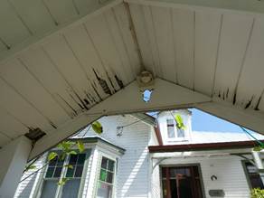

|
Repair and reconstruct deteriorated balustrade to verandah
and arbour entry structure. Wet rot to timber.
|
|
3. 26 Satinash Crescent, Bangalow.
(Formerly 3 Granuaille Crescent)
House is a heritage listed item I026
‘Finely proportioned timber residence with high
quality Federation style timber detailing located on an elevated site at the
north end of the village. The house displays local materials and
craftsmanship in carpentry of a very high standard’.
SHI 1260081
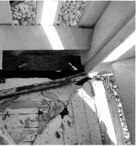

|
Repair of deteriorated verandah including corner support
post, bearers and decking in hardwood.
|
The focus for the 2021-2022 Local
Heritage Grants Program is conservation works that enhance individual places,
buildings and historic streetscapes including buildings in conservation areas
that will promote and foster community appreciation of the history of the
Shire.
After consideration by the
Council’s Heritage Adviser and the Director Sustainable Environment and
Economy, it was agreed the three (3) projects meet the criteria and are
recommended to Council for funding this year. Confidential Attachment 4.
In summary the three (3) applications
will each receive $3,500. This is an additional amount to that advertised but
given the limited number of applications and merit of each received is reasonable
and acceptable.
The funding of these projects will
support over $21,550 worth of work to be carried out in this financial year on
heritage property restoration.
Strategic Considerations
Community Strategic Plan
and Operational Plan
|
CSP Objective
|
CSP Strategy
|
DP Action
|
Code
|
OP Activity
|
|
Community
Objective 2: We cultivate and celebrate our diverse cultures, lifestyle and
sense of community
|
2.5:
Encourage community appreciation of cultural vitality and diversity
|
2.5.2:
Recognise and support the heritage of Byron Shire
|
2.5.2.2
|
Conduct
the Local Heritage Places Grant Program
|
Financial Considerations
Council will deliver the Local Heritage
Grants Program with the aid of a grant from the Heritage Division of the NSW
Office of Environment and Heritage with Council providing at least $6,500 to
qualify for up to $5,500 from the Heritage Division of the Office of
Environment and Heritage.
Consultation and
Engagement
The Local Heritage Grants program is a
key action task in the Byron Shire Heritage Strategy 2020-2024.
Staff Reports - Sustainable Environment and Economy 13.15
Report
No. 13.15 Update Resolution 21-244 Dogs in Public
Spaces Strategy
Directorate: Sustainable
Environment and Economy
Report Author: Shannon
Burt, Director Sustainable Environment and Economy
Sarah Nagel, Manager Public and Environmental Services
File No: I2021/1653
Summary:
Council considered Report No 13.14 - Dog and Cat Management Initiatives at
the Ordinary meeting 24 June 2021 Agenda
of Ordinary Meeting - Thursday, 24 June 2021 (infocouncil.biz) and resolved as
follows:
Resolved
21-244 that Council notes the staff update provided on Dog and Cat
Management initiatives being managed by Sustainable Environment & Economy
Directorate staff.
This report included an update on
the status of the Dogs in Public Spaces Strategy previously commenced.
This report provides a further
update, and in particular sets out the next stage of the project, the community
engagement program.
RECOMMENDATION:
That Council:
1. Notes
the staff update on Resolution 21-244 as it relates to the Dogs in Public
Spaces Strategy.
2. Endorses
the Community Engagement Plan activities which includes the formation of a
Community Working Group by Locale Consulting and a staff project control group
to help inform and guide the preparation of the Dogs in Public Spaces Strategy.
Report
As reported in June 2021, the
development of a Dogs in Public Spaces Strategy (DiPS) will contribute to
Council’s Companion Animal Management Plan and will seek to encourage
responsible pet ownership and compliance with relevant legislation.
The DiPS is being developed in
three stages:
1. Initial information
gathering and research.
2. Further information
gathered through community engagement; and
3. Strategy development and
implementation.
It is proposed that the DiPS will
replace the Byron Shire Council Policy 5.31 Companion Animal Exercise Areas
– which was last reviewed in 2011.
Since the report to Council in
June 2021, Locale Consulting has been engaged to work alongside staff to
complete the DiPS project.
Locale Consulting have prepared a
community engagement plan for the DiPs project, the principals, and activities
of which are summarised below.
· There are a range of key messages associated with the
project and early and consistent delivery of these messages in the engagement
process is important.
· Due to the ongoing Covid-19 pandemic, this Plan will be
implemented in a flexible and adaptable manner and having regard to any
restrictions in place at the time.
· To harness community engagement across the Shire a
Community Working Group (CWG) will be established through an Expression of
Interest (EOI) process. The CWG will consist of up to 15 members representing
the diverse interests in this issue (across localities and interest groups).
· To ensure maximum stakeholder reach, an online survey will
be available for completion as well as face to face drop-in sessions held
across the main localities within the Shire.
· Wherever possible, consultation activities would be
supported by Council's communications team – social media, Councillor
updates, Council’s Have Your Say page and website promotion.
· Council may also implement optional engagement activities
during the project using internal resources like dog day pop up events,
educational events.
Details of the CWG are summarised
below:
Purpose
The CWG is being established to help inform and guide the
preparation of the DiPS. This Strategy will set out the vision, themes, and
actions for the management of dogs in public spaces across the Shire.
Membership
The
CWG will seek to represent a wide span of community interests. This includes:
· dog owners and non-dog owners
· business people including tourism operators and food
outlets
· neighbourhood and residents’ groups
· vets and animal welfare groups
· environmental protection authorities and interest groups
· sporting groups and general users of parklands and exercise
spaces
· people with a disability and any special interest groups
· the elderly and young people
The CWG will consist of up to 15
community members made up of representatives from different localities across
the Shire and reflecting the diverse interests in the issue.
Members must live in the Shire.
Council staff will use an expression of interest process to appoint members to
the Group.
Role
The CWG will work closely with
Council staff and the project consultants, Locale Consulting, to provide
meaningful, representative input and feedback on key policy issues about the
management of dogs in public spaces.
This includes exploring:
· changes to the existing conditions for off-leash areas
· whether there is a need for new dog exclusion zones,
off-leash areas or enclosed
· dog parks
· the suitability of existing dog exercise areas and
associated infrastructure such as
· signage and bins
· how Council can encourage and promote responsible dog
ownership
The CWG will be advisory only and will not have a
decision-making role.
Format
The CWG will meet four times during the project duration as
follows:
1. Inception:
getting to know each other explaining the roles, responsibilities &
involvement in the Group in the project
2. Co-design:
work on elements of the face-to-face drop-in sessions for the project
3. Exploration
of topics: early input from the Group into the vision, themes, and actions into
the draft Strategy
4. Feedback:
on the emerging vision, themes and actions for the draft Strategy before the
formal exhibition
With regards to the CWG, staff
propose to progress an EOI process to establish the group and commence meetings
before the end of the year. Membership selection will be based on a set
of criteria scored/weighted by the consultants and a staff project control
group.
If the formation of the CWG is delayed beyond the end of the
year, this will push out the community engagement program and completion of the
DiPS into the next Financial Year.
Strategic Considerations
Community Strategic Plan
and Operational Plan
|
CSP
Objective
|
CSP
Strategy
|
DP
Action
|
Code
|
OP
Activity
|
|
Community Objective 2: We cultivate and celebrate our diverse
cultures, lifestyle and sense of community
|
2.4: Enhance community safety and amenity while respecting our
shared values
|
2.4.3: Enhance public safety, health and liveability through the
use of council's regulatory controls and services
|
2.4.3.5
|
Provide companion animal management services
|
|
Community Objective 2: We cultivate and celebrate our diverse
cultures, lifestyle and sense of community
|
2.4: Enhance community safety and amenity while respecting our
shared values
|
2.4.3: Enhance public safety, health and liveability through the
use of council's regulatory controls and services
|
2.4.3.6
|
Facilitate companion animals education
|
Recent Resolutions
· 18-362
· 21-244
Legal/Statutory/Policy
Considerations
The DiPS will assist Council meet its obligations under
companion animals legislation.
Financial Considerations
The DiPS is funded by the FY21/22 public and environmental
service program budget.
Consultation and
Engagement
As discussed in the report.
Staff Reports - Sustainable Environment and Economy 13.16
Report
No. 13.16 PLANNING - 26.2020.7.1 - Planning
Proposal Stage 3 E zone Implementattion Program Submissions report
Directorate: Sustainable
Environment and Economy
Report Author: Alex
Caras, Land Use Plannning Coordinator
File No: I2021/1662
Summary:
The implementation of
Environmental Zones commenced in 2018 and is being delivered in a number of
stages. To date Stages 1 and 2 are complete, Stage 3 is the subject of this
report and Stage 4, to commence in 2022, will finalise the application of
Environmental Zones.
To date Stages 1-3 have
collectively resulted in a net gain of 1,420ha of E2 Environmental
Conservation zones on private land, when compared to areas previously zoned
7a, 7b, 7k & 7j in Byron LEP 1988.
The Stage 3 Planning Proposal (PP)
applies environmental and non-environmental zones to over 2,200 private
properties in the Shire, which includes approximately 4,960 ha of E2
Environmental Conservation zones and 830 ha of E3 Environmental Management zones.
It also amends other LEP 2014 maps such as Minimum Lot Size, Height of
Building, Floor Space Ratio, Drinking Water Catchment, Acid Sulfate Soils and
Multiple Occupancy & Community Title Maps.
PP 3 was exhibited from 29 March
to 30 July 2021. The 335 public submissions received can be categorised as follows:
· Landowner
submissions — ‘Agreed’ E zone and non-E zone properties
· Landowner
submissions —'Not Agreed’ E zone properties
· Government
Agency submissions
· Submission
from Community Alliance for Byron Shire
· Submission
from Bundjalung of Byron Bay Aboriginal Corporation (Arakwal)
There are 205 properties where
agreement was reached on proposed E zones and non-E zones. Details of these
properties, including landowner feedback and proposed LEP map changes, are
contained in Attachment 1.
There are thirty-five (35)
properties where landowner agreement on proposed E zones could not be
reached. Thirteen (13) of these already have an existing environmental
zone under LEP 1988 (namely 7a Wetlands, 7b Coastal Habitat and or 7k Habitat).
Although proposed E zone areas on
many of these properties have already been reduced (based on feedback from
landowner), no agreement on the final amended zones could be reached. A
detailed analysis of these properties, including landowners’ reasons for
not agreeing and Council’s response to these, is contained in Attachment
2.
This report presents:
· a
summary of the submissions received during exhibition of the Stage 3 Planning
Proposal; and
· corresponding
property specific LEP2014 mapping amendments for adoption.
The report recommends that E
zone Stage 3 Planning Proposal be updated to
reflect the proposed LEP 2014 zones and other related mapping changes in
Attachments 1 and 2 of this report, and forwarded to the Department of Planning, Industry & Environment for finalisation.
It also notes that property owners whose land will be
subject to an E zone will be notified in writing of Council's decision and
advised that they have 28 days to notify the Department of Planning and
Environment to request a review of the proposed zoning of their property.
NOTE TO COUNCILLORS:
In accordance with the
provisions of S375A of the Local Government Act 1993, a Division is to be
called whenever a motion for a planning decision is put to the meeting, for the
purpose of recording voting on planning matters. Pursuant to clause 2(a)
under the heading Matters to be Included in Minutes of Council Meetings of
Council's adopted Code of Meeting Practice (as amended) a Division will be
deemed to have been called by the mover and seconder of all motions relating to
this report.
RECOMMENDATION:
1. That Council in relation to Stage 3 E Zones planning
proposal adopts:
a) the proposed LEP 2014 map
changes for properties identified in Attachment 1; and
b) the proposed LEP 2014 zones (environmental and non-environmental) and
consequential mapping for the ‘not
agreed’ properties contained in Attachment 2,
2. That
Council requests that the NSW Department of Planning, Industry
and Environment, as the plan-making authority in this instance, make the final
LEP for notification on the NSW Government legislation website.
3. That
Council notes,
post consideration of the submissions and endorsement of the final planning
proposal, landowners whose land will be subject to an E zone are to be notified
in writing of Council's decision and advised that they have 28 days to notify
the Department of Planning and Environment to request a review of the proposed
zoning of their property.
Attachments:
1 Summary
of proposed E Zone Mapping Changes arising from Stage 3 Exhibition (excluding
Not Agreed outcomes), E2021/60380

2 Summary
of Not Agreed Landowner submissions, E2021/78307

3 Government
Agency submissions - Biodiversity & Conservation Division (DPIE) and Local
Land Services, E2021/126714
4 Response
to and submissions from Community Alliance for Byron Shire (CABS), E2021/127168 
5 Bundjalung
Byron Bay Aboriginal Corporation (Arakwal) Submission re Lots 332 & 334
Riverside Crescent Brunswick Heads, E2021/126786
6 Form
of Special Disclosure of Pecuniary Interest, E2012/2815
Background
Council
at its 22 March 2018 Ordinary Meeting resolved (Res 18-188) to
implement the Department’s
‘Northern Councils E Zone Review Final Recommendations Report’ in several stages to deliver more timely
and effective outcomes for affected landowners. An overview of the latest
staged implementation program is shown in Figure 1 below.

Figure 1: Staging Program to
apply environmental and other zones
on certain land in Byron LEP 2014
Stage 1 Planning Proposal (PP1)
PP1
applied environmental and non-environmental
zones to 64 properties in the Shire based on agreed outcomes. This
included approximately 340 ha of E2 Environmental Conservation zones and
60 ha of E3 Environmental Management zones.
Status: completed and gazetted on 28 February
2020.
Stage 2 Planning Proposal (PP2)
PP2 applied environmental and
non-environmental zones to 619 properties in the Shire based on agreed
outcomes. Approximately 1,485 ha of E2 Environmental Conservation
zones and 400 ha of E3 Environmental Management zones are applied in
PP2. It also amends other LEP 2014 maps such as Minimum Lot Size, Height of
Building, Drinking Water Catchment and Acid Sulfate Soils Maps.
Status: completed and gazetted on 14 May 2021.
Stage 3 Planning Proposal (PP3) – subject of this report
PP3 applies
environmental and non-environmental zones to over 2,200 properties in the
Shire, which includes approximately 4,960 ha of E2
Environmental Conservation zones and 830 ha
of E3
Environmental Management zones.
In relation to the Stage 3 Planning Proposal, Council
at its 20 November 2020 Planning Meeting resolved [Resolution 20-614] the following:
1. Amend
the planning proposal contained in Attachment 1 (E2020/85949) to exclude the
following land in the 7D Scenic Escarpment Zone, representing
‘non-agreed’ environmental zoning outcomes that can be collectively
considered as part of a future strategic review of remaining 7D land in the
Shire:
a) Lot 5 DP
625004, 470 Main Arm Road, Main Arm
b) PT Lot 22
SP 549688, 139 Bangalow Road, Byron Bay
c) Lot 21 DP
859004, 83 Walkers Lane, The Pocket
d) Lot 1 DP
719570, 133 Middle Ridge Road, Upper Main Arm
e) Lot 5 DP
625004, 470 Main Arm Road, Main Arm
f) Lot
11 DP 816147, 689 Left Bank Road, Mullumbimby Creek
g) Lot 285 DP
1198641, 64 Corkwood Cres, Suffolk Park
h) Lot 4 DP
635176, 526 Broken Head Road, Broken Head
2. Submit
the amended planning proposal to the NSW Department of Planning, Industry and
Environment for Gateway determination;
3. Pending
Gateway determination, undertake public exhibition of the planning proposal and
consult with government agencies in accordance with the Gateway determination;
and
4. Receive
a report outlining the exhibition outcomes.
In accordance with item
‘1.’ in the above resolution, land in the 7D Scenic Escarpment zone
will only have an E Zone applied where agreed by the landowner.
Otherwise, all remaining land in the 7D zone will remain ‘deferred
‘and collectively considered as part of
a future strategic review of remaining 7D land in the Shire and or until a suitable replacement zone (LEP 2014) is supported
by the Department of Planning, Industry and Environment.
The remainder of this report
presents a summary of submissions (and other
feedback) received during the exhibition of PP3 along with recommended LEP
mapping amendments for adoption.
Report
PP3 was submitted to Department of
Planning & Environment for gateway determination in December 2020. A
positive gateway determination was received in February 2021 subject to the
following conditions:
· Consulting with
following government agencies (during exhibition):
- NSW Rural Fire Service;
- NSW Biodiversity and Conservation
Division;
- NSW Department of Primary
Industries;
- the Local Aboriginal Land Council;
and
- NSW Division of Resources and
Geoscience.
· Notifying all affected
landowners in writing of the planning proposal and the public exhibition
arrangements
· Amending the planning
proposal as follows prior to exhibition:
a) Appendix
1 be altered to note that Direction 4.3 Flood Prone Land does apply to the
planning proposal;
b) 44 Ti Tree Road, Byron Bay
(property ID: 94240) be altered to include an E2 zone over the area of the site
mapped as 'Coastal Wetland' under the Coastal Management SEPP;
c) Jones Road, Wooyung
(property ID 240048) be altered to be zoned E1 National Parks and Nature
Reserves; and
d) Amend Table 5.1 in the planning proposal as follows:
i. include
a new column to describe each property's complete zoning;
ii. update the primary land use of 228 Broken Head Road, Suffolk Park
to reflect an Env/Urban instead of Urban Res; include a new column to indicate
whether the property is identified as state and/or regionally significant
farmland.”
iii. include a new column to describe each property's
complete zoning.
· When Council has
considered the submissions received during public exhibition and has endorsed
the final planning proposal, landowners whose land will be subject to an E zone
are to be notified in writing of Council's decision and advised that they have
28 days to notify the Department of Planning and Environment to request a
review of the proposed zoning of their property.
Public Exhibition
E
Zones Stage 3 Planning Proposal (PP3) was exhibited from 29 March to 30 July 2021.
Landowner
notification was undertaken in stages due to the large number of properties
captured in PP3 (> 2,200) and the need to ensure staff could respond to
enquiries in a timely manner.
335
public submissions were received and are categorised as follows:
Ø Landowner
submissions — ‘Agreed’ E zone and non-E zone properties
Ø Landowner submissions —'Not Agreed’
E zone properties
Ø Government Agency submissions
Ø Submission from Community Alliance for Byron
Shire
Ø Submission from Bundjalung of Byron Bay
Aboriginal Corporation (Arakwal)
There are 215 landowners
that Council has not had any response from throughout the E zone engagement
process. These properties have been included in PP3 ‘as exhibited’.
Landowner submissions — ‘Agreed’ E zone and non-E
zone properties
There are 205 properties where
agreement was reached on proposed E zones and non-E zones. Details of these
properties, including landowner feedback and proposed LEP map changes, are
contained in Table 1(a) of Attachment 1.
Attachment 1 also contains the
following other proposed changes:
- Table 1(b) –
Land parcels to be removed from Planning Proposal 3 (e.g. contains no deferred
matter or proposed/exhibited Ezone)
- Table 1(c) –
Land parcels to be updated in LEP 2014 Multiple Occupancy and Community Title
Map (as no longer a deferred matter)
- Table 1(d) –
Proposed Changes to certain land parcels previously zoned in E zones PP2 (as a
result of submissions on adjoining PP3 land)
RECOMMENDATION:
That Council adopts the proposed LEP maps changes in Attachment 1.
Landowner submissions —'Not Agreed’ E zone properties
There are
thirty-five (35) properties where landowner agreement on proposed E zones could
not be reached. Thirteen (13) of these already have an existing environmental zone
under LEP 1988 (i.e., 7a Wetlands, 7b Coastal Habitat and or
7k Habitat).
The
proposed E zones largely relate to intact areas of high environmental value
vegetation having one or more of the following attributes: Key Threatened
Species Habitat; Endangered Ecological Communities; SEPP Coastal Wetlands;
Over-cleared vegetation communities and/or riparian and estuarine vegetation on
waterfront land.
Although
proposed E zone areas on many of these properties have already been reduced (based on feedback from landowner), no agreement on
the final amended zones could be reached. Inevitably there will be a
minority of landowners where there’s been (i) a change of mind about what
was originally agreed to on their land, (ii) a change in ownership since an
agreed outcome was reached.
A detailed analysis of these
properties, including landowners’
reasons for not agreeing and Council’s response to these, is contained in
Attachment 2. The analysis of each property considers primary use(s) of
the land together with historical aerial photography (mainly back to 1966),
current aerial photography (e.g., Nearmaps), feedback from landowners, recent
DA approvals, prior zoning, site inspections by Council Ecologist (including
photo points) and/or drone footage.
RECOMMENDATION: That Council adopts the proposed LEP
2014 zones (environmental and non-environmental) for each of the ‘not
agreed’ properties contained in Attachment 2 (noting that these landowners be notified in writing of
Council's decision and advised that they have 28 days to notify the Department
of Planning and Environment to request a review of the proposed zoning of their
property).
Government Agency Submissions
In
accordance with the Gateway Determination issued 8 February 2021, the following
public authorities were consulted under section 3.34(2)(d) of the Act and/or to comply with the requirements of relevant
section 9.1 Directions:
-
NSW Rural Fire Service
-
NSW Biodiversity and Conservation Division (of DPIE)
-
NSW Department of Primary Industries
-
Arakwal Aboriginal Corporation
-
Tweed Byron Aboriginal Land Council
-
NSW Division of Resources and Geoscience.
Two (2) government agency
responses were received (Attachment 3). A summary of key issues raised and
planning response to these is presented in Table 1 below.
Table 1 – Summary of government agency submissions
received and planning response
|
Agency Name
|
Issues
raised and Planning Response
|
|
1. NSW Biodiversity and Conservation Division (Department of Planning, Industry & Environment)
|
Considers Council’s review
and application of E zones across the Shire has generally been well
implemented, however recommends that prior to finalising the proposed Stage 3
amendments relating to ‘Deferred Matter’ lands not formerly zoned
7(a), 7(b), 7(j) or 7(k) under BLEP 1988 and Non – Deferred Matter
land zoned under BLEP 2014, the council must ensure that:
1. The PP has appropriately determined the primary use of
the land.
2. Justification is included
in the PP of the council’s determination
of the primary use of each
of the relevant parcels.
3. The PP has distinguished
between environmental conservation and environmental management land uses as
follows:
a. In areas of native
vegetation where ancillary uses are absent
or have not occurred in the last two years, the land use would align with Environmental Conservation.
b. In areas of native vegetation where ancillary
uses are present or which have occurred the last two years, such as grazing,
the land use would align with Environmental Management.
Planning Response
Council has determined
the primary use of individual land parcels using all relevant information
available. This includes the characteristics of the land, its prior
zoning, aerial photography, visual inspection, contact with landowners and
other property information held by Council (e.g., development approvals;
farmland rating status, Private Native Forestry or Property Vegetation Plan
approvals).
BCD’s request to
provide more detailed justification of the primary land use(s) identified for
each parcel of land would require a significant body of work and
resources that go beyond any North Coast council’s capacity to
implement the ‘Northern Councils E Zone Review
Final Recommendations Report’. Undertaking such a
detailed level of investigation on each land parcel is neither practical nor
justified, noting that all landowners were given the opportunity to provide
feedback on the primary use(s) identified for their land as part of the engagement
process since 2017 (i.e. in addition to confirming vegetation
accuracy). Where necessary, updates to ‘primary land use’
have been made because of landowner feedback received.
4. The E2 zone is applied
to land that meets the criteria
in Table 1 of the E Zone Review where the land use has been identified
as Environmental Conservation as per our recommendation
3.a. above.
5. The E3 zone is applied to land that meets the
criteria in Table 1 or Table 2 of the E zone Review where the land use has
been identified as Environmental Management as per our recommendation 3.b.
above.
Planning Response (4
& 5)
Noted.
There may be instances where agreed zoning outcomes do not align precisely
with the primary use(s) of the land but still deliver a better planning result
6. Where the primary use of the land is not
considered to be environmental conservation or environmental management and
the E2 or E3 zone criteria are verified as present on the land, then the land
should be zoned E2 or E3 if the landowner agrees to applying either of those
zones.
Planning Response
Noted. This is
substantially consistent with the approach taken throughout the E zone review
process.
7. Where the primary use of the land is not
considered to be environmental conservation or environmental management and
the E2 or E3 zone criteria are verified as present on the land, but the
landholder does not agree to an E2 or E3 zone, then mapped planning controls
should be applied to the land.
Planning Response
Noted. This is
substantially consistent with the approach taken throughout the E zone review
process.
8. Where mapped planning controls are required, these
should be developed and incorporated into the PP to ensure E2/E3 zone
criteria known to be present are appropriately considered as part of the
development application process.
Planning Response
Noted. Mapped
overlays/planning controls will be considered in the E zones Stage 4 planning
proposal.
9. Primary Use’ test — PP provides no justification
for how zone boundaries have been split.
Planning Response
Throughout the E zone review process staff have
endeavoured to reach agreed outcomes (wherever possible) when applying both
environmental and non-environmental zone on private land. The reality
is that many of the agreed zoning outcomes do not always align precisely with
the primary use(s) of the land. Indeed, there are many examples of E2 zone
landowners in Byron shire that have high value open forest with koala
habitat but use light grazing as a valuable and essential tool for
understorey weed control.
There are also examples where primary production
activities such as cattle grazing occur throughout an entire property, but
the landowner has still agreed to rezone areas containing high environmental
value vegetation to E2 Environmental Conservation, even though such
areas are not solely managed for this purpose.
In the case of split zones in PP3, the BCD submission
(p4) cites the example below where lots appear to have similar and contiguous
canopy, and which may therefore reflect a similar land use across the two
zone types.
|
|
|

In this instance the RU2 areas were negotiated with
the landowners after confirming that both properties had multiple dwellings
and RU2 was required for houses, bushfire APZs and access roads. At the same
time key areas of vegetation that met the E2 zone criteria were retained as
Ezone while connectivity of Ezone vegetation across the landscape was also a
key outcome.
Overall, most split zones in
PP3 were based on negotiated outcomes with owners, but also informed by the
following supporting information where applicable and available:
· vegetation
mapping 2017 (including canopy and condition attributes),
· historical
aerial photography (mainly back to 1966),
· current
aerial photography (including 2020 Nearmaps),
· site
inspections by Council’s Ecologist (including photo points),
· drone
footage
· topography
(very steep inaccessible terrain not suitable for farming),
· DA
information,
· connectivity
with neighbours (e.g., valleys largely cleared for dwellings and roads as per
neighbour),
· existing
infrastructure (houses, sheds, water tanks etc.),
· future
landowner intentions (e.g. restoration plans).
Conclusion
Staff have invested a
substantial amount of resources into individual parcels by contacting each
landowner wherever possible to confirm ‘primary land use/s’ and
vegetation accuracy. BCD’s request to provide more detailed
justification of the primary land use(s) identified for each parcel of
land is neither practical nor justified, noting that the greatest attention
in determining ‘primary land use’ has been focused on the
“Not Agreed” E zone properties. This was considered the
most practical and efficient approach given the substantially high number of
properties included in PP3 (> 2,200).
NO CHANGES RECOMMENDED
|
|
2.
NSW Local Land Services (on behalf of
Tweed Byron Local Aboriginal Land Council)
|
Discussions with Local Land
Services and Tweed Byron Local Aboriginal Land Council (TBALC)
representatives resulted in a request to defer all land owned or subject to
native title claim by TBALC from PP3.
Planning Response
Agreed. The deferment of these properties is
captured in Attachment 1 and is consistent with treatment of properties owned
by Jali LALC and Bundjalung of Byron Bay Aboriginal Corporation (Arakwal).
|
Note: The adjoining councils of Tweed and Ballina were
also given the opportunity to provide comments on the exhibition of PP3,
however no response was received.
Submission from Community Alliance for Byron Shire (CABS)
Council
received a submission from CABS identifying a number of concerns with PP3,
namely that:
· parts of the Cape Byron Marine
Park are not being zoned to W1 Natural Waterways, where applicable on certain
properties in this planning proposal;
· Council is upzoning wide swathes
of the Shire by applying new zones that allow a greater range of permissible
land uses compared to what the current LEP 1988 environmental zone/s allow.
In
relation to the first point above, properties
in PP3 that contain Cape Byron Marine Park have been updated to include the
gazetted W1 Natural Waterways zone, except where infrastructure overlaps
with the proposed W1 zone. These updates are captured in Table 1(a) of
Attachment 1.
In
relation to the second point above, CABS position is that any land currently
zoned 6(a), 6(b), 7(a), 7(b), 7(d), 7(f1), 7(f2), 7(j), 7(k), 8(a) in LEP 1988
should not be rezoned to anything other than E1 National Parks, E2
Environmental Conservation or W1 Natural Waterways.
Conversely, if the exhibited PP3 maps show land that is currently zoned as
listed above being re-zoned to RU1, RU2, RU5, R5, E3, R2, R3, RE1, RE2, SP1,
SP2, SP3 then that land (not the entire land parcel) is to be removed from the
Planning Proposal and the existing zoning under the Byron LEP 1988 should
remain in place.
Planning Response (in relation
to second point above)
CABS’ request to defer any
land currently zoned 6(a), 6(b), 7(a), 7(b), 7(d), 7(f1), 7(f2), 7(j), 7(k),
8(a) in LEP 1988 and that has not been rezoned to anything other than E1
National Parks, E2 Environmental Conservation or W1 Natural
Waterways is not supported for the following reasons:
· The E zone engagement process
to date has been robust, constructive, and well received by the majority of
those affected. This is demonstrated by nearly 1,200 agreed outcomes to
date and the fact that Stages 1-3 have collectively resulted in a net
gain of 1,420ha of E2 Environmental Conservation zones on private
land, when compared to areas previously zoned 7A, 7B, 7k & 7J in Byron LEP
1988.
· In the
absence of agreed outcomes, all Far North Coast councils must be consistent
with the Northern Councils E Zone Review Final Recommendations
report when applying E zones (i.e.. satisfy E zone criteria and
primary land use).
· 8(a)
National Parks and Nature Reserve Zones. This ‘deferred matter’
zone totals 2.7 Ha in Byron Shire and is made up of road reserves within
National Parks or small areas of Crown Land. They are not included in Planning
Proposal 3 as this applies primarily to private land. (Note: All land
administered by National Parks & Wildlife Service is zoned E1 National
Parks).
· 7(f1)
Coastal lands and 7(f2) Urban Coastal Lands will be “considered under
a separate process and remain as a Deferred Matter under the Byron Local LEP
2014 until appropriate planning controls are developed in consultation with the
State Government” (Fact Sheet 1 – EZones FAQs).
· The only
PP3 properties where 7(d) Scenic Escarpment land has been zoned E3 are small
areas over internal roads.
· Five (5)
parcels zoned 6(a) Open Space Zone and 6(b) Private Open Space Zone have been
included in Planning Proposal 3, as follows:
|
Property Number
|
Current LEP 1988 Zone (s)
|
Proposed LEP 2014 Zone(s)
|
Change in zoning summary
|
|
157230
|
6(a)
(Open Space Zone)
|
RE1 Public Recreation and
E2 Environmental Conservation
|
Eureka Public Recreation
Reserve. Increase of 2,395 sqm of land to be zoned E2.
|
|
211460
|
6(b)
(Private Open Space Zone)
|
RE2 Private Recreation
|
Mullumbimby Ex-services Club. No
change in permissible uses.
|
|
90190, 213940, 213500, 170560
|
6(b)
(Private Open Space Zone),
1(d)
(Investigation Zone)
|
RE2 Private Recreation and
E2 Environmental Conservation
|
Ocean Shores Country Club. 5,983
sqm now in E2.
Remaining RE2 is consistent with
the primary land use.
|
|
111970, 267456, 170950
|
6(b)
(Private Open Space Zone) and
7(b)
(Coastal Habitat Zone)
|
RE2 Private Recreation and
E2 Environmental Conservation
|
Byron Bay Golf Club. Increase of
29,924 sqm (3ha) of Environmentally protected area (E2).
|
A copy of the CABS submissions and
detailed response to the property-specific matters raised is contained in
Attachment 4.
Submission from Bundjalung of Byron Bay Aboriginal Corporation
(Arakwal)
The
submission refers to two privately owned lots that are accessed via Crown land
from Riverside Crescent in Brunswick Heads (Lots 332 & 334 in
DP755692). PP3 proposes to apply an E3 Environmental Conservation zone to
both lots which are currently zoned 7B Coastal Habitat and have a
collective area of 1,438 sqm. Neither parcel has
a dwelling entitlement, and both are mapped as “intermediate flood
hazard”.
The
submission recommends that an E2 Environmental Conservation Zone should
be applied for the reasons cited below:
· both
lots contain conservation vegetation and are within a surrounding wildlife corridor;
· both
lots do not contain a constructed road frontage;
· the land
is also flood and bushfire prone and contains
high wetland vegetation, cultural landscape, and coastal habitat areas.
A copy of the Arakwal submission
is contained in Attachment 5.
Planning
Response
The proposed zoning of both lots
was further considered in relation to matters raised in the Arakwal
submission. This included a site visit undertaken by Council’s
Ezone Ecologist, which identified mostly weeds and fruit trees on the land and
hence not meeting the criteria for E2 zoning. However, as both properties
are within 40m of the Brunswick River, Cape Byron Marine Park and flood
affected (‘intermediate’ flood hazard), they do meet the E3
criteria for ‘Riparian and estuarine vegetation and wetlands.
Therefore, no change is recommended to the proposed E3 zone on both lots.
Other consultation with Arakwal
Staff also met with Arakwal
representatives in June 2021 to discuss future zoning of the following
(Deferred Matter) properties in their ownership:
|
Property description
|
Current zoning in BLEP 1988
|
|
10 Ironbark Ave, Byron Bay
|
7b Coastal Habitat
|
|
Lot 438 DP 729107, Bangalow
Rd, Byron Bay
|
1d Investigation
|
Following this meeting it was
decided to defer these properties from Planning Proposal 3 to allow time for
further discussions with Arakwal representatives and internal staff. This
is consistent with treatment of properties owned by Jali LALC and Tweed Byron
LALC in the E zone review program.
Conclusion
This
report presents a summary of submissions (and
other feedback) received during the exhibition of PP3 along with recommended
LEP mapping amendments for adoption.
Collectively Stages 1-3 of
Council’s E zone implementation program
have resulted in a net gain of 1,420ha of E2 Environmental
Conservation zones on private land, when compared to areas previously zoned
7A, 7B, 7k & 7J in Byron LEP 1988. This figure is expected to
increase when the E zones Stage 4 planning proposal is prepared in 2022.
It’s worth noting that Council’s E zone implementation program was the NSW runner-up in the 2020 Planning Institute of
Australia Awards for ‘Public Engagement and Community Planning’.
It’s also worth noting that
to date Byron Shire Council is the only Far
North Coast council to have undertaken (and substantially completed) the
application of E zones on private land. This has been largely achieved
through our ‘up front’ engagement with landowners combined with a
robust, collaborative, and flexible approach to achieving “agreed
outcomes” wherever possible, as well as through the local
community’s strong support for the E zone planning process.
The Stage 3 Planning Proposal represents the most significant of the E zone review
stages for Council to adopt prior to finishing its term.
Recommendation
It is
recommended that E
zone Stage 3 Planning Proposal be updated to
reflect the proposed LEP 2014 zones and other related mapping changes in
Attachments 1 and 2 of this report, and forwarded to the Department of Planning, Industry & Environment for finalisation.
Strategic Considerations
Community Strategic Plan and Operational Plan
|
CSP Objective
|
CSP Strategy
|
DP Action
|
Code
|
OP Activity
|
|
Community
Objective 3: We protect and enhance our natural environment
|
3.1:
Partner to protect and enhance our biodiversity, ecosystems and ecology
|
3.1.1:
Protect and enhance our natural environment and biodiversity
|
3.1.1.5
|
Continue
the E zone review (Action No.9 from Rural Land Use Strategy)
|
Recent Resolutions
· 20-614
Legal/Statutory/Policy Considerations
The
process of applying E zones and mapped overlays in Byron LEP 2014 is being
undertaken in accordance with Section 117
Direction 2.5 – Application of E2 and E3 Zones and Environmental
Overlays in Far North Coast LEPs. This direction specifically
requires that a planning proposal that
introduces or alters an E2 Environmental Conservation or E3
Environmental Management Zone, or an overlay and associated clause must be
consistent with the Northern Councils E Zone Review Final Recommendations.
Financial Considerations
The
remaining 2021/22 budget for the E zone Implementation program will most likely
be exhausted before Stage 4 is completed in 2022. If so, a separate
report will be presented to Council detailing the additional 2021/221 budget
requirements to enable completion of a Stage 4 planning proposal. Stage 4 will
include Council, public authority, and Aboriginal owned lands as well as LEP
mapping overlays and will be the final stage of the E zone Implementation
program.
Consultation and Engagement
Consultation was undertaken as per the planning proposal
Gateway determination conditions.
Due to the large number of properties, landowner
notification was undertaken in stages requesting feedback by one or more of the
following options: calling a designated ‘hotline’ phone number;
emailing to our Ezones inbox, scheduling a phone back or face to face meeting
using our online booking calendar. This resulted in more than 400 contacts with
landowners and or consultants.
Staff Reports - Infrastructure Services 13.17
Staff Reports - Infrastructure Services
Report No. 13.17 Tender
2021-1093 - Byron STP Biosolids Shed Roof Replacement
Directorate: Infrastructure
Services
Report Author: Joshua
Winter, Capital Works Engineer
File No: I2021/1654
Summary:
On 10 September 2021, the General Manager, under delegated
authority, approved the use of the open tender method to call for tenders for
Contract 2021-1093 – Byron STP Biosolids Shed Roof Replacement.
The Request for Tender was advertised from 16 September to 8
October 2021. Tenders were received from two organisations.
Tenders have been assessed in accordance with the provisions
of the Local Government (General) Regulations 2005. This report
summarises the background and assessment of the tenders and provides a
recommendation to award the tender for Contract 2021-1093.
RECOMMENDATION:
1. That
Council award Tender 2021-1093 to the tenderer recommended in the Tender
Evaluation Report (Confidential Attachment 1).
2. That
the project budget be increased by $210,000 with funding provided from the
Sewer Capital Works Reserve.
3. That Council makes public its decision, including the name and
amount of the successful tenderer, in accordance with Clause 179(b) of the Local
Government (General) Regulation 2021.
Attachments:
1 Confidential
- 24.2021.32.1 - 2021-1093 - Byron STP Biosolids Roof Replacement - Evaluation
Report, E2021/128262
Report
On 10 September 2021, the General Manager, under delegated authority,
approved the use of the open tendering method to call for tenders for Contract
2021-1093 – Byron STP Biosolids Shed Roof Replacement.
A contract to undertake these works is required due to the
specialist nature of the works and the risk associated with undertaking the
works.
The Request for Tender sought responses from proponents for
the supply and construction of the Byron STP Biosolids Shed roof replacement
and structural rectification works, as well as the demolition of the current
chemical storage shed and construction of new footings for the future chemical
storage shed installation.
The Contract is expected to commence in November 2021 for a
period of approximately eight weeks.
The Contract will be managed by the Utilities Capital Works
Engineer.
Tenders were advertised as follows:
Vendorpanel & Council website: 16 September to 8 October
2021.
Site briefings were held at the West Byron Sewage Treatment
Plant. Three organisations attended.
An Evaluation Panel comprising of three members was formed.
Tenders closed on 8 October 2021 and tenders were received
from the following proponents:
· Advanced
Concrete Engineering
· Bishton
Group
Tenders were evaluated by the Evaluation Panel in accordance
with the following evaluation criteria:
Mandatory criteria:
a) Tenderer
must have a valid Australian Business Number.
b) Substantial
conformance to Conditions of Contract and Statement of Requirements.
c) Workers
compensation insurance for all employees.
d) Holds,
or is willing to obtain, the insurances as specified in the Statement of
Requirements.
e) Satisfactory
Work Health and Safety practices.
f) Satisfactory
environmental management practices.
g) Proponent
confirms no involvement from Australia’s offshore detention centres.
h) Proponent
confirms no involvement with the construction or operation of the Carmichael
mine or otherwise have ties to Bravus Mining & Resources.
Qualitative criteria:
(a) Demonstrated experience on
similar projects with respect to technical aspects and project costs: references
from previously completed projects; Disclosure of prior commitments during the
contract period - work at hand
(b) Nominated project team including
the organisational structure, qualification and relevant experience of key
personnel and subcontractors
(c) Demonstrated understanding of
the project and ability to carry out the work and manage the contract
The evaluation deemed both submissions as qualifying tenders
and scored the submissions in accordance with the attached Evaluation Report.
Financial Considerations
The price basis for the contract is a lump sum.
General Ledger Account 7649.036 has been established and
Council approved an original budget of $60,000 for this project upon adoption
of the original 2021/2022 budget estimates. A further $210,000 is
required to fund the project with funding available in the Sewerage Capital
Works Reserve.to finalise the works. Should Council approve the
additional funding recommended the budget for this project will be $270,000.
Statutory and Policy Compliance
Considerations
The tendering process has been undertaken in accordance with
Council’s Purchasing and Procurement Policy, and the provisions of the
Local Government (General) Regulation 2021.
The Local Government (General) Regulations 2021 define the
options available to Council. An extract is provided below.
Local Government (General) Regulation 2021 - Reg 178
Acceptance
of tenders
178 Acceptance
of tenders
(1) After considering the tenders submitted
for a proposed contract, the council must either—
(a) accept the tender that, having regard
to all the circumstances, appears to it to be the most advantageous, or
(b) decline to accept any of the tenders.
(1A) Without limiting subsection (1), in considering
the tenders submitted for a proposed contract for the performance of domestic
or other waste management services, the council must take into account whether
or not existing workers (within the meaning of section 170) will be offered
employment or engagement on terms and conditions comparable to those applicable
to the workers immediately before the tender was submitted.
(2) A council must ensure that every contract
it enters into as a result of a tender accepted by the council is with the
successful tenderer and in accordance with the tender (modified by any
variation under section 176). However, if the successful tender was made by the
council (as provided for in section 55(2A) of the Act), the council is not
required to enter into any contract in order to carry out the requirements of
the proposed contract.
(3) A council that decides not to accept any
of the tenders for a proposed contract or receives no tenders for the proposed
contract must, by resolution, do one of the following—
(a) postpone or cancel the proposal for
the contract,
(b) invite, in accordance with section
167, 168 or 169, fresh tenders based on the same or different details,
(c) invite, in accordance with
section 168, fresh applications from persons interested in tendering for the
proposed contract,
(d) invite, in accordance with section
169, fresh applications from persons interested in tendering for contracts of
the same kind as the proposed contract,
(e) enter into negotiations with any
person (whether or not the person was a tenderer) with a view to entering into a
contract in relation to the subject matter of the tender,
(f) carry out the
requirements of the proposed contract itself.
(4) If a council resolves to enter into
negotiations as referred to in subsection (3)(e), the resolution must state the
following—
(a) the council’s reasons for
declining to invite fresh tenders or applications as referred to in subsection
(3)(b)–(d),
(b) the council’s reasons for
determining to enter into negotiations with the person or persons referred to
in subsection (3)(e).
Council’s endorsement of the recommendation to award
the tender as recommended in the attached Evaluation Report is sought.