 Agenda
Ordinary (Planning) Meeting

Thursday, 7 December 2023
Agenda
Ordinary (Planning) Meeting
Thursday, 7 December 2023
Agenda Ordinary (Planning) Meeting
held at Council Chambers, Station Street, Mullumbimby
commencing at 11:00am
Public access relating to items on this agenda can be made between 11:00am and 11:30am on the day of the meeting. Requests for public access should be made to the General Manager or Mayor no later than 12:00 midday on the day prior to the meeting.

Mark Arnold
General Manager
CONFLICT OF INTERESTS
What is a “Conflict of Interests” - A conflict of interests can be of two types:
Pecuniary - an interest that a person has in a matter because of a reasonable likelihood or expectation of appreciable financial gain or loss to the person or another person with whom the person is associated.
Non-pecuniary – a private or personal interest that a Council official has that does not amount to a pecuniary interest as defined in the Code of Conduct for Councillors (eg. A friendship, membership of an association, society or trade union or involvement or interest in an activity and may include an interest of a financial nature).
Remoteness – a person does not have a pecuniary interest in a matter if the interest is so remote or insignificant that it could not reasonably be regarded as likely to influence any decision the person might make in relation to a matter or if the interest is of a kind specified in the Code of Conduct for Councillors.
Who has a Pecuniary Interest? - a person has a pecuniary interest in a matter if the pecuniary interest is the interest of the person, or another person with whom the person is associated (see below).
Relatives, Partners - a person is taken to have a pecuniary interest in a matter if:
· The person’s spouse or de facto partner or a relative of the person has a pecuniary interest in the matter, or
· The person, or a nominee, partners or employer of the person, is a member of a company or other body that has a pecuniary interest in the matter.
N.B. “Relative”, in relation to a person means any of the following:
(a) the parent, grandparent, brother, sister, uncle, aunt, nephew, niece, lineal descends or adopted child of the person or of the person’s spouse;
(b) the spouse or de facto partners of the person or of a person referred to in paragraph (a)
No Interest in the Matter - however, a person is not taken to have a pecuniary interest in a matter:
· If the person is unaware of the relevant pecuniary interest of the spouse, de facto partner, relative or company or other body, or
· Just because the person is a member of, or is employed by, the Council.
· Just because the person is a member of, or a delegate of the Council to, a company or other body that has a pecuniary interest in the matter provided that the person has no beneficial interest in any shares of the company or body.
Disclosure and participation in meetings
· A Councillor or a member of a Council Committee who has a pecuniary interest in any matter with which the Council is concerned and who is present at a meeting of the Council or Committee at which the matter is being considered must disclose the nature of the interest to the meeting as soon as practicable.
· The Councillor or member must not be present at, or in sight of, the meeting of the Council or Committee:
(a) at any time during which the matter is being considered or discussed by the Council or Committee, or
(b) at any time during which the Council or Committee is voting on any question in relation to the matter.
No Knowledge - a person does not breach this Clause if the person did not know and could not reasonably be expected to have known that the matter under consideration at the meeting was a matter in which he or she had a pecuniary interest.
Non-pecuniary Interests - Must be disclosed in meetings.
There are a broad range of options available for managing conflicts & the option chosen will depend on an assessment of the circumstances of the matter, the nature of the interest and the significance of the issue being dealt with. Non-pecuniary conflicts of interests must be dealt with in at least one of the following ways:
· It may be appropriate that no action be taken where the potential for conflict is minimal. However, Councillors should consider providing an explanation of why they consider a conflict does not exist.
· Limit involvement if practical (eg. Participate in discussion but not in decision making or vice-versa). Care needs to be taken when exercising this option.
· Remove the source of the conflict (eg. Relinquishing or divesting the personal interest that creates the conflict)
· Have no involvement by absenting yourself from and not taking part in any debate or voting on the issue as of the provisions in the Code of Conduct (particularly if you have a significant non-pecuniary interest)
RECORDING OF VOTING ON PLANNING MATTERS
Clause 375A of the Local Government Act 1993 – Recording of voting on planning matters
(1) In this section, planning decision means a decision made in the exercise of a function of a council under the Environmental Planning and Assessment Act 1979:
(a) including a decision relating to a development application, an environmental planning instrument, a development control plan or a development contribution plan under that Act, but
(b) not including the making of an order under that Act.
(2) The general manager is required to keep a register containing, for each planning decision made at a meeting of the council or a council committee, the names of the councillors who supported the decision and the names of any councillors who opposed (or are taken to have opposed) the decision.
(3) For the purpose of maintaining the register, a division is required to be called whenever a motion for a planning decision is put at a meeting of the council or a council committee.
(4) Each decision recorded in the register is to be described in the register or identified in a manner that enables the description to be obtained from another publicly available document, and is to include the information required by the regulations.
(5) This section extends to a meeting that is closed to the public.
OATH AND AFFIRMATION FOR COUNCILLORS
Councillors are reminded of the oath of office or affirmation of office made at or before their first meeting of the council in accordance with Clause 233A of the Local Government Act 1993. This includes undertaking the duties of the office of councillor in the best interests of the people of Byron Shire and the Byron Shire Council and faithfully and impartially carrying out the functions, powers, authorities and discretions vested under the Act or any other Act to the best of one’s ability and judgment.
BUSINESS OF Ordinary (Planning) Meeting
1. Public Access
3. Attendance by Audio-Visual Link
4. Requests for Leave of Absence
5. Declarations of Interest – Pecuniary and Non-Pecuniary
6. Tabling of Pecuniary Interest Returns (Cl 4.14 Code of Conduct for Councillors)
7. Adoption of Minutes from Previous Meetings
7.1 Ordinary (Planning) Meeting held on 9 November 2023
8. Reservation of Items for Debate and Order of Business
9. Notices of Motion
9.1 Independent advice on Wallum ecology, Bayside Brunswick................................. 8
9.2 Register of land to be acquired.................................................................................. 12
9.3 Emergency Accommodation in Byron Shire............................................................ 18
9.4 Access at 656 and 660a Bangalow Road................................................................ 22
10. Mayoral Minute
11. Petitions
12. Delegates' Reports
13. Staff Reports
General Manager
13.1 Policy Commercial Activities on Coastal and Riparian Crown Reserves........... 24
Corporate and Community Services
13.2 Bangalow Heritage House.......................................................................................... 27
Sustainable Environment and Economy
13.3 Byron Shire Wildlife Corridor System....................................................................... 34
13.4 Status report on Development Applications (DAs) with bodies like the Northern Regional Planning Panel (NRPP).............................................................................. 57
13.5 PLANNING - Report of the Planning Review Committee held 2 November 2023 63
13.6 PLANNING - 10.2023.244.1 Multi Dwelling Housing Comprising Twenty (20) Units, Basement Parking and Associated Works Including Demolition, Removal of Nineteen (19) Trees and Earthworks at 310 Ewingsdale Road, Byron Bay........................ 65
13.7 PLANNING - Review of Development Control Plan (DCP) 2014 planning controls for Biodiversity, Tree and Vegetation Management................................................... 108
13.8 26.2023.3.1 - Amendments to Byron Development Control Plan 2014 Chapter E5 to include the North Beach Byron site........................................................................ 119
13.9 Update Resolution 23-462 Waiver of contributions on secondary dwellings... 125
13.10 Bypassed Town Signage- Mullumbimby................................................................ 132
13.11 Submissions Report - Busking Policy..................................................................... 136
13.12 Review of Council's Onsite Sewage Management Strategy 2001 and Onsite Sewage Management Guidelines 2004................................................................................. 144
13.13 PLANNING - 10.2014.361.4 s4.55 modification Waves Motel at 35 Lawson Street Byron Bay.................................................................................................................... 148
Infrastructure Services
13.14 New Brighton Parking Improvements..................................................................... 168
13.15 Results of Beach Naming Survey........................................................................... 176
13.16 RFT2023-1860 Mullumbimby Recreation grounds Amenities Upgrade........... 183
13.17 Rifle Range Road Traffic Calming for Koala Safety............................................. 189
13.18 Social Enterprise Commercial Laundry - Beacon Laundry - s64 Sewer Developer Contributions............................................................................................................... 193
13.19 Part Road Reserve Closure and sale adjoining Lot 4 & 5 DP 246401, 154 & 156 Lighthouse Road, Byron Bay NSW......................................................................... 196
14. Questions With Notice
Nil
Questions with Notice: A response to Questions with Notice will be provided at the meeting if possible, that response will be included in the meeting minutes. If a response is unable to be provided the question will be taken on notice, with an answer to be provided to the person/organisation prior to the next Ordinary Meeting and placed on Councils website www.byron.nsw.gov.au/Council/Council-meetings/Questions-on-Notice
Councillors are encouraged to ask questions regarding any item on the business paper to the appropriate Director prior to the meeting. Any suggested amendments to the recommendations should be provided to Councillor Support prior to the meeting to allow the changes to be typed and presented on the overhead projector at the meeting.
BYRON SHIRE COUNCIL
Notices of Motion 9.1
Notice of Motion No. 9.1 Independent advice on Wallum ecology, Bayside Brunswick
File No: I2023/1845
I move that Council:
1. Urgently seeks advice from an independent ecologist with expertise in Wallum heathland ecology on whether:
a) any native vegetation has been cleared or removed by slashing since May 2023 on Clarence Property’s “Wallum Estate” at Bayside Brunswick;
b) threatened species are being or could be impacted by on-going slashing there;
c) the heath area of the property contains native vegetation (it is mapped as being of High Environmental Value).
2. Asks the expert ecologist to also consult with ecologists known to the Save Wallum group as they have information about flora on the site.
Signed: Cr Duncan Dey
Councillor’s supporting information:
Consent Condition 3 for the development approved on this property requires that “no native trees or vegetation may be cleared or removed until a Subdivision Certificate has been issued relevant to those trees and vegetation”.
No Certificate has been issued relevant to the area recently slashed. It appears Condition 3 has been breached. Protected native flora and fauna may have been unnecessarily destroyed. Witnesses say they have seen native vegetation hanging from the slasher’s equipment as well as native vegetation crushed and slashed by it in the subdivision area. Threatened species of fauna have also been impacted.
In response to Question with Notice 15.1 on the Agenda for Council’s meeting of 23 November, Council staff report that “slashing or low-cut mowing on the property is understood to have been limited to outside of the mapped retained Wallum Froglet Habitat as per the approved Wallum Froglet Management Plan. No native trees have been removed in these areas either”.
Qualified ecologists supporting Save Wallum believe this advice falls short in not recognising the damage done to native vegetation including threatened species by recent slashing.
Staff comments
by Shannon Burt, Director, Sustainable Environment and Economy:
Response to the points raised in the Notice follows:
1. Council to urgently seek advice from an independent ecologist with expertise in Wallum heathland ecology on:
a) whether any native vegetation has been cleared or removed by slashing since May 2023 on Clarence Property’s “Wallum Estate” at Bayside Brunswick;
b) whether threatened species are being or could be impacted by on-going slashing there;
c) whether the heath area of the property contains native vegetation (it is mapped as being of High Environmental Value).
Staff response
As per Resolution 23-454 Council has resolved inter alia that it:
5. Receives assessments of the Amended Management Plans submitted to Council for the development at Bayside Brunswick (DA10.2021.575.1) to ensure that those Plans comply with Consent Conditions set by the NRPP and with federal, state and local regulations, including separate assessments of Plans for:
a) Vegetation Management (Condition 6);
b) Wallum Froglet Management (Condition 7);
c) Construction Environmental Management (Condition 8);
d) Updated Surface and Groundwater Management (Condition 9);
e) Stormwater Maintenance Management (Condition 12);
f) Cultural Heritage Site Inspection (Condition 18).
Part 7 of the same resolution requires the assessments to be reported back to Council.
The work to cover 23-454 (5) is in train with an independent, expert ecologist engaged by Council already to review the reports and also respond to recent concerns/complaints.
There is little benefit in staff’s opinion of engaging another ecologist to do the same work.
Response given, and published in the Ordinary Meeting Agenda 23 November 2023 to the question about slashing and low-cut mowing on site:
Any slashing or low-cut mowing on the property is understood to have been limited to outside of the mapped retained Wallum Froglet Habitat as per the approved Wallum Froglet Management Plan. No native trees have been removed in these areas either.
Notwithstanding the above, condition 3 states in relation to areas ‘beyond those in the area identified as “extent of works” on the Vegetation Management Plan (VMP)’ that ‘No native trees or vegetation may be cleared or removed until a Subdivision Certificate has been issued relevant to those trees and vegetation’.
Given the concerns raised in this QoN, and recent responses from the landowner/proponent about these concerns, staff continue to review the matter in accordance with Byron Shire Enforcement Policy 2020 section 4.4.
Staff issued a Show Cause Notice on the landowner/proponent 14 November 2023 to respond to ‘concerns raised about ‘slashing, low-cut mowing and vegetation removal within mapped areas of Wallum froglet habitat’.
The landowner/proponent provided a response to Council on 23 November 2023, which at the time of writing this response was under assessment in accordance with Council’s adopted Enforcement Policy.
Staff will otherwise make use of experts as required to review and or determine necessary next steps re this matter should they be identified by either the landowner/proponent response to the Show Cause Notice or the expert review to the development consent conditions and concerns/complaints.
2. Council asks the expert ecologist to also consult with ecologists known to the Save Wallum group as they have information about flora on the site.
An expert is a person who has specialised knowledge based on their training, study or experience.
An expert, with such specialised knowledge may express an opinion on matters within his or her particular area of expertise.
An expert’s duty is not to the person retaining the expert (Council). An expert witness is not an advocate for any of the stakeholders (Council or Save Wallum).
The value of any expert opinion very much depends on the reliability and accuracy of the material which the expert used to reach his or her opinion. It also depends on the degree to which the expert analysed the material upon which the opinion was based and the skill and experience brought to bear in formulating the opinion given.
While it is open for the expert to consult with stakeholder experts (any consultation would be at the discretion of the appointed expert) the appointed expert is in no way bound by the opinion of those experts.
Financial/Resource/Legal Implications:
There are costs to Council to engage independent experts to undertake the review of the plans identified in Resolution 23-454.
Is the proposal consistent with any Delivery Program tasks?
|
CSP Objective |
CSP Strategy |
DP Action |
Code |
OP Activity |
|
4: Ethical Growth |
4.1: Manage responsible development through effective place and space planning |
4.1.1: Development assessment - Manage development through a transparent and efficient assessment process |
4.1.1.1 |
Assess and determine development assessments in accordance with the relevant legislation |
BYRON SHIRE COUNCIL
Notices of Motion 9.2
Notice of Motion No. 9.2 Register of land to be acquired
File No: I2023/1848
I move that Council receives a report on the pros & cons of:
1. Anticipating situations where the acquisition of part or all of an allotment would alleviate infrastructure bottlenecks such as those listed below, and
2. Maintaining a register of such locations so that, when opportunities arise such as owner willingness or property sale, Council has the background ready plus any other steps to acquire the land to facilitate that infrastructure.
Signed: Cr Dey
Councillor’s supporting information:
Council has experience of projects that could have improved road safety and utility, or eased road congestion but are not possible without adjacent land being acquired. Land acquisition is generally a protracted process and such projects then fall by the wayside, because of long delivery times. Many such projects are grant funded and that funding carries time limits.
Other Councils overcome this limitation by anticipating such situations and acquiring the land when that process is at its easiest. The project itself then happens later, without being scotched by the long timeframe to acquire land. State government uses the same process when building major infrastructure such as highways and dams.
Examples I know of in Byron Shire include:
1. A roundabout at the intersection of Clifford Street with Broken Head Road, Suffolk Park;
2. Heavy vehicle turn radii at the intersections of Tincogan Street and Fern Streets with Station Street, Mullumbimby;
3. Road realignment around causeway #2 on Main Arm Road, Upper Main Arm.
Council resolved at Resolution 23-141 to pursue this matter as part of updating our Land Acquisition and Disposal Policy but progress has stalled. This is reported in Attachment 1 to Report 13.7 in our Agenda for 23 November (see Page 163 of 773).
This Motion seeks to unlock the register from the stalled Policy and take steps to get started. It is a long-term project with the benefits appearing ‘well down the track’.
Staff comments
by James Flockton, Infrastructure Planning Coordinator, Infrastructure Planning:
Projects that involve land or easement acquisitions are always more difficult to deliver and have longer planning and design phases. Often projects are built prior to these dealings being finalised due to tight project funding deadlines which can lead to difficult close out scenarios where the landowner has the upper hand on Council.
Early land or easement acquisition is a staff preference and following recent difficulties, the Infrastructure Planning team have agreed that projects will not be committed to at a construction level until land or easement acquisitions processes are complete.
However, to ensure Council funds are being allocated to the correct land or easement acquisitions there requires a higher level of strategic planning than Council currently undertakes.
Council currently has a 10-year capital works program, but the program generally includes projects that are fundable under Council’s annual funding allocations. This is not sufficient for the bigger projects that typically require land or easement acquisitions. Large, often grant funded projects don’t tend to be included due to the desire to balance budgets (ie need to identify any matching funding source). Further grant projects are often tailored to a particular funding stream expectations.
In order to plan our capital road projects better and in turn plan early land or easement acquisitions we must first develop better ways of prioritising our future capital road projects. This prioritisation should also be based upon asset condition and road use data rather than political or key group desires.
Projects that may need land or easement acquisitions include; intersection upgrades, road realignments, bridge or culvert replacements, drainage upgrades, flood mitigation, footpath or shared paths.
Comments on the projects listed by Cr Dey
1. A roundabout at the intersection of Clifford Street with Broken Head Road, Suffolk Park; This intersection has been modelled recently and the modelling supported traffic lights over a roundabout. The 2023/24 budget has a line item to investigate this further and obtain a final decision on the intersection’s treatment. This will guide any land acquisitions requirements.
2. Heavy vehicle turn radii at the intersections of Tincogan Street and Fern Streets with Station Street, Mullumbimby; This intersection will need an upgrade in the future and that will involve likely extensive land acquisition. Where this lies in Council’s priorities is not known and needs to better understood first to ensure we are obtaining land for projects that are likely to commence soon.
3. Road realignment around causeway #2 on Main Arm Road, Upper Main Arm. This project allowed a 12-month planning and design period, which can be sufficient to obtain land. The budget allocation for the land acquisition was considered sufficient, however, negotiations with the land owner did not result in an affordable acquisition value therefore the only option to deliver the project in budget and to funding deadlines was to keep the existing road alignment.
On 14 December 2017 Council passed Resolution 17-685 - Traffic Signals in Byron Shire Council Area (I2017/1891) as follows:
1. That various traffic control solutions across the Shire be developed using a merit-based approach that considers the relevant constraints and context for each site.
2. That a range of technical and other guides be considered as possible guides for design of intersection and transport infrastructure in order that possible innovative solutions can be considered.
3. That an options report be presented to Council, where roundabout or traffic signals are being considered, which reviews all facets of the design process for each intersection traffic control measure, including the recommended solution for the intersection and the reasons why it should be used.
4. That the planned Ewingsdale Road/Bayshore Drive roundabout project proceed utilising the available grant funds.
5. That further investigation be undertaken for alternative solutions to a roundabout at Clifford Street/Broken Head Road, including traffic lights.
6. That the modelling for the updated MR545 study include options for traffic signals and other innovative solutions that may become apparent. (Cameron/Hackett)
Staff are supportive of the idea of early land or easement acquisition and welcome this discussion; however, Council first need to ensure suitable funding and resources are available to collect suitable data that can model intersections to advise which intersections are our priority intersections for improvement.
Further Council’s existing road condition data sets need to be used to guide and develop suitable forward plans to ensure we are upgrading our highest priority roads.
Resourcing
The Infrastructure Services, Works Infrastructure Planning team have three roles that cover this area: a Roads and Bridge Engineer, a Traffic and Transport engineer and a Flood and Drainage Engineer. Unfortunately, the realities of today’s world is that these roles receive so many; Customer Requests, Inwards Correspondence, Councillors Requests, Council Reports, Council Resolutions and projects to deliver that little time remains for the desired level of strategic project planning.
Additionally, Council’s asset team do not currently have the Asset Coordinator and Asset Management Systems Officer roles filled. These roles provide essential support to the Infrastructure Planning team developing forward plans.
In recent months the Infrastructure Planning team have been developing different ways of delivering projects via the use of contract project managers, this is a new direction with the aim of freeing staff time to spend more time developing strategic plans for assets under the Works team.
Further additional fully funded staff or changes in how we operate are required in order to resource the development and updating of these plans.
Data
Councils current annual budget allocation for traffic counts is $25,000 this collects our standard traffic counts and some special counts to support decisions around Customer Requests and Inwards Correspondence.
Additional budget is required to collect intersection counts on an annual or biannual basis to keep up to date with how intersection use changes. As well as budget to develop a set of intersection models and then model this data biannually in order to stay up to date with intersection use and change an Intersection priorities list as required.
Additional to this existing traffic data, crash data and asset condition data needs to be used to develop and then update annually a road network improvements plan.
Further the Works team are currently investigating systems to improve Customer Request and Inwards Correspondence processes and data collection to support strategic planning decision making. This system will also support programming and recording maintenance activities.
Key issues
Funding of data collection for improved strategic planning.
Funding or resourcing the development of robust strategic plans such an Intersection Priorities and Upgrade Plan, plus a Road Network Improvement Plan.
Next steps
Once these plans are in place, projects can be well developed, and future land or easement acquisitions can be planned and budgeted. Staff support the direction raised by Cr Dey, but at this time the organisations strategic direction is not considered mature enough to be making those decisions.
The following steps to this point are recommended:
1. Fill all vacant roles that support strategic asset planning
2. Fund additional data collection
3. Improve project delivery resource processes to free staff time for strategic planning
4. Improve Customer Request and Inwards Correspondence processes and data collection to support strategic planning decision making
5. Develop asset specific strategic plans that can guide budget development and allocations
6. Program projects and complete early land or easement acquisitions
Legal/Statutory/Policy Considerations
Council generally needs to own either the land or an easement over the land it is building its infrastructure within. There are processes available to complete works while a land or easement acquisition is finalised, however, they carry risks and should not be used unless absolutely necessary.
Councils have broad roles and responsibilities in their communities, including the provision of facilities and the supply of public services, for example, the widening of roads, increased community park areas, or the expansion of water and sewerage services. It is recognised that a Council will sometimes need to acquire land, or an interest in land such as an easement, to achieve its roles and responsibilities as its community’s needs change.
A council’s powers to acquire land or an interest in land for the purpose of exercising its functions are derived from section 177 of the Roads Act 1993 (for roads purposes) and from section 186 of the Local Government Act 1993 (for all other purposes). A council’s power to acquire land or in interest in land is non-delegable and the decision to undertake the acquisition must be made by a resolution of the council. Section 178 of the Roads Act 1993 and section 187 of the Local Government Act 1993 authorises a council to acquire such land or interest in land by agreement or by compulsory process in accordance with the Land Acquisition (Just Terms Compensation Act) 1991.
The acquisition process is governed by the Land Acquisition (Just Terms Compensation) Act 1991. Councils must also ensure they are in compliance with the Property Acquisition Standards, the Minimum Requirements – Minimum Negotiation Period for Acquisition of Land, and the Minimum Requirements – Owner-Initiated Acquisition in Cases of Hardship.
In accordance with section 178 of the Roads Act 1993 and section 187 of the Local Government Act 1993, a Council may not give a proposed acquisition notice under the Land Acquisition (Just Terms Compensation) Act 1991 without the approval of the Minister for Local Government.
Having regard to the above Council should not speculate on land acquisitions. The land acquisition process should be reserved for specifically identified projects and where it is supported by a resolution of Council.
Previous 10-year plans have been developed around balancing budgets within projected budget allocations. This process may need to be reviewed to locate future desirable grant funded projects that require early land or easement acquisitions.
Is the proposal consistent with any Delivery Program tasks?
Yes see below.
|
CSP Objective |
CSP Strategy |
DP Action |
Code |
OP Activity |
|
5: Connected
Infrastructure |
5.3: Invest in renewable energy and emerging technologies |
5.3.1: Future needs - Plan for the infrastructure needs of the current and future population |
5.3.1.1 |
Review and update 10 year Flood and Drainage Renewal and Upgrade program |
|
5: Connected Infrastructure |
5.3: Invest in renewable energy and emerging technologies |
5.3.1: Future needs - Plan for the infrastructure needs of the current and future population |
5.3.1.2 |
Review and update 10 year Stormwater Levy program |
|
5: Connected
Infrastructure |
5.3: Invest in renewable energy and emerging technologies |
5.3.1: Future needs - Plan for the infrastructure needs of the current and future population |
5.3.1.3 |
Review and update 10 year Roads and Bridge Renewal and Upgrade program |
|
5: Connected
Infrastructure |
5.3: Invest in renewable energy and emerging technologies |
5.3.1: Future needs - Plan for the infrastructure needs of the current and future population |
5.3.1.4 |
Review and update 10 year Active Transport Renewal and Upgrade program |
BYRON SHIRE COUNCIL
Notices of Motion 9.3
Notice of Motion No. 9.3 Emergency Accommodation in Byron Shire
File No: I2023/1851
1. Acknowledges that:
a) the most recent rough sleeping street count conducted by the NSW Department of Communities and Justice found 300 people sleeping rough in Byron Shire, the highest count of any local government area in NSW,
b) this outcome is likely a significant undercount of people sleeping rough and also does not count all homeless people in the Shire or those residents who have been forced to leave the Shire due to lack of housing options,
c) there is currently very limited access to short term Emergency Accommodation for those who need it in Byron Shire, such as those fleeing domestic violence, those sleeping rough and those suffering from drug or alcohol issues, with most people required to travel out of their community to Ballina, Lismore or Tweed to access accommodation and support.
2. Writes to the NSW Minister for Housing, Homelessness and the North Coast, the Hon. Rose Jackson MLC to:
a) thank the NSW Government for the recent announcements to provide a one-time funding contribution to Fletcher Street Cottage and for a one-year commitment to expand the Assertive Outreach program into Byron Shire,
b) formally request that the relevant department conduct a needs analysis, in consultation with stakeholders, on the most appropriate and urgent form of short term Emergency Accommodation needed in Byron Shire,
c) offer Council’s assistance in identifying and supporting the approval process for an appropriate permanent site for short term Emergency Accommodation within Byron Shire.
Signed: Cr Asren Pugh
Councillor’s supporting information:
The Housing crisis in Byron Shire continues, with the most recent rough sleeping street count giving Byron Shire the dubious honour of having the most rough sleepers of any local government area in NSW, greater even than the City of Sydney. The level of services available between the two LGAs could not be more stark. A fact acknowledged by the Minister herself. An assertive Outreach program is a great start, but without services and warm, safe accommodation to refer people to, its impact will not be maximised.
Identifying the right type of accommodation and support services required is important as, depending on the issues facing those that are being accommodated, different styles of housing will be needed.
We currently have a Minister who acknowledges the issues facing our community and wants to take action. Council can play a strong role in maximising this opportunity to ensure better support and outcomes for our community, long left ignored by previous governments.
Staff comments
by Esmeralda Davis , Director, Corporate and Community Services:
The Department of Communities and Justice (DCJ) provide a range of housing programs and accommodation types, with different configurations and different intended duration.
This includes, but is not limited to, for example:
a. Temporary accommodation
b. Emergency temporary accommodation
c. Supported and crisis accommodation
Further information is available within DCJ’s Housing Assistance Options Policy.
Temporary accommodation is not intended to be longer term by definition. However, in practice, temporary accommodation can go on for extended periods if DCJ are mandated to do so. For instance, during COVID-19 pandemic, DCJ received a Health mandate to ‘get people off of the streets’ and therefore offered longer duration of temporary accommodation. Otherwise, temporary accommodation can be cyclic where the tenant would be expected to “exit” after an established period. The exit may be a return to homelessness if another housing option is not available.
DCJ provides emergency temporary accommodation for up to three months for people who are not eligible for social housing, but who are experiencing a short-term housing crisis. This type of assistance is only available to people who are in extreme situations. The intention is to assist people in the general community who are facing hardship due to a crisis or emergency, which has made them temporarily homeless.
Supported and crisis accommodation: through a range of programs, some community housing organisations provide specialist, short-term and medium-term housing for people who are homeless, or who are at risk of becoming homeless and are in crisis.
Accommodation can be “supported”, often referred to as ‘transitional supported accommodation’. In this instance, the term transitional implies temporary housing with another housing solution available when temporary accommodation ends. Supported generally refers to casework support through a non-government organisation service provider.
Understanding the priority needs in the Byron Shire, through the proposed needs analysis, would enable identification of the most appropriate form of temporary accommodation required. Staff are supportive of requesting this process to occur.
NSW Government-funded programs
DCJ funds Mullumbimby & District Neighbourhood centre to deliver domestic and family violence (DFV) programs, however these programs do not include accommodation:
- Staying Home Leaving Violence (SHLV): “this specialised DFV program is designed to assist women and their children to stay safely in their own home or a home of their choice after leaving a violent relationship. The program is aimed at promoting victims’/survivors’ housing stability and preventing their homelessness.”
- Integrated Domestic and Family Violence (IDFV): “Coordinated services to clients through a multi-disciplinary team and is based on clear referral pathways between service agencies such as Police, Health, Family and Community Services and non-government support agencies.”
DCJ funds Momentum Collective to run women/children’s shelters (aka refuges) in Northern NSW. None of these are located in Byron Shire: “Women and their families who are at risk of homelessness due to domestic or family violence can find safe and confidential housing options through our Women and Children’s Refuges. Located across northern New South Wales, this accommodation is a secure space from which you can plan your transition to a violence-free future.”
In Northern NSW, a range of housing programs are delivered by DCJ Housing and Community Housing Providers.
NSW Health funds alcohol and other drugs (AOD) residential rehab, including services delivered by The Buttery in Byron Shire: “Residential rehabilitation is the psychological care and support for people in an AOD-free residential community setting. Residential rehabilitation programs may be medium to long-term in duration (4 weeks to 12 months) and provide a range of support services”
The level of assistance that can be provided by Council in identifying a site, and the approval process thereafter for a ‘permanent site for short term emergency accommodation’ is unknown at this time. It will vary in degree depending on the site chosen and the accommodation proposed. This will need to be further scoped and understood through the needs analysis process.
Financial/Resource/Legal Implications:
Preparing the correspondence to NSW Minister for Housing, Homelessness and the North Coast, the Hon. Rose Jackson MLC can be accommodated within established resources.
Is the proposal consistent with any Delivery Program tasks?
|
CSP Objective |
CSP Strategy |
DP Action |
Code |
OP Activity |
|
2: Inclusive Community |
2.5: Create social impact and initiatives that address disadvantage |
2.5.3: Rough sleepers - Work in partnership to reduce and end rough sleeping through community action |
2.5.3.1 |
Respond to people experiencing homelessness and rough sleepers through engagement and referrals to appropriate support and housing services. |
BYRON SHIRE COUNCIL
Notices of Motion 9.4
Notice of Motion No. 9.4 Access at 656 and 660a Bangalow Road
File No: I2023/1852
I move that Council:
1. Receives a report on the access issues at 656 and 660a Bangalow Road Talofa that includes:
a) whether the current road works are authorised or require a development application
b) whether the current works meet Council standards for road building and are appropriate to be used as a joint accessway for the properties
c) how Council can ensure that its own future needs and rights are preserved over the road reserve
d) options for Council to resolve the issue over the works in the road reserve.
Signed: Cr Asren Pugh
Councillor’s supporting information:
There has been ongoing disputes over the right of way through 660a Bangalow Road and appropriate access for the neighbouring property at 656 Bangalow Road. There has been a road built within the Council road reserve that is forming part of this dispute. While Council has a limited role in determining the dispute between the neighbours, we do have a responsibility to ensure that works done on Council land are safe, appropriate and authorised. We must also ensure that any accessway built on Council land preserves the needs of future Councils and residents for infrastructure.
Staff comments
by Ralph James Legal Counsel:
A report on the issues caught by the Motion can be prepared. It will require cross Directorate input. Compilation of the report will be coordinated by Legal Counsel.
As to the access issue, staff have for some time now been involved in ongoing issues between the respective owners/occupiers of the properties at the 660 A and 656 Bangalow Road Talofa.
The current view, which will be canvassed in the report, is that the works which have been undertaken in the road reserve relate to a private driveway with dual use.
There is an easement in place to allow and facilitate access to both properties.
Staff currently regard the access issue, including enforcement of the easement, as a matter to be ventilated, if at all, between the parties. It is not a matter in which Council will be involved. If this view changes it will be canvassed in the report.
The staff view is that that if either of the parties wishes to undertake further work in the road reserve to create an alternative access to either property those proposed works require an application for approval to Crown Land and Council.
Financial/Resource/Legal Implications:
Staff time only.
Any legal implications will be canvassed in the report.
BYRON SHIRE COUNCIL
Staff Reports - General Manager 13.1
Staff Reports - General Manager
Report No. 13.1 Policy Commercial Activities on Coastal and Riparian Crown Reserves
Directorate: General Manager
Report Author: Paula Telford, Leasing and Licensing Coordinator
File No: I2023/1769
Summary:
Council has completed a 28-day public exhibition of draft Policy Commercial Activities on Coastal and Riparian Crown Reserves.
This report recommends that the draft Policy is adopted by Council.
RECOMMENDATION:
That Council:
1. Notes one (joint) submission was received on the Draft Policy Commercial Activities on Coastal and Riparian Crown Reserves.
2. Adopts the Draft Policy Commercial Activities on Coastal and Riparian Crown Reserves as attached to this report (E2023/2345).
1 Attachment
1: Submission from Sea Kayak Sub-Licensees Policy Commercial Activities on
Coastal and Riparian Crown Reserves (November 2023), E2023/116958 ![]()
2 Draft
Policy Commercial Activities on Coastal & Riparian Crown Reserves, E2023/2345 ![]()
Report
Council resolved (23-407) at its 28 September 2023 meeting:
That Council adopts the draft Policy Commercial Activities on Coastal and Riparian Crown Reserves for the purpose of public exhibition for 28 days, and
1. Should no submissions be received, that the Policy is adopted, and
2. Should submissions be received, that all submissions are reported back to Council for further consideration.
In accordance with the resolution, Council advertised Draft Policy Commercial Activities on Coastal and Riparian Crown Reserves (draft Policy) for 28 days between from 11 October to 8 November 2023.
Council received one joint submission from Sea Kayak Sub-Licensees (attachment 1). It is summarised in the below table:
|
Submission |
Council response |
|
Items 1 to 6. |
Noted by Council. |
|
Items 7 to 9. |
Clause 1.1 Policy Objectives represent Councils desired goals for the management of public land by reference to social, environmental, economic and governance outcomes. The Policy objectives endorse multi-use of the public land by balancing the right for general public use with other low impact commercial and non-commercial land uses. |
|
Item 10. |
So far as staff could ascertain, point 10 in the original submission dated 29 May 2023, referred to the term of a sub-licence. Councillors endorsed the maximum term of a sub-licence to be limited to 6-years at the 1 June 2023 workshop. |
Council must duly consider the submission received in its decision to adopt the draft Policy.
The report recommends Council adopts the draft Policy unchanged from the version publicly advertised between 11 October and 8 November 2023.
Strategic Considerations
Community Strategic Plan and Operational Plan
|
CSP Objective |
CSP Strategy |
DP Action |
Code |
OP Activity |
|
5: Connected Infrastructure |
5.4: Provide accessible community facilities and open spaces |
5.4.2: Parks and open spaces - Provide and maintain active and passive recreational community space that is accessible and inclusive for all |
5.4.2.11 |
Progress Plan of Management for Crown Reserve 82000 - Byron Beach Reserve |
Recent Resolutions
· 21-429
· 23-349
· 23-407
Legal/Statutory/Policy Considerations
Nil.
Financial Considerations
Nil.
Consultation and Engagement
In accordance with resolution (23-407) Council publicly advertised the draft Policy for 28 days between11 October and 8 November 2023. Council received one submission.
BYRON SHIRE COUNCIL
Staff Reports - Corporate and Community Services 13.2
Staff Reports - Corporate and Community Services
Report No. 13.2 Bangalow Heritage House
Directorate: Corporate and Community Services
Report Author: Geeta Cheema, Manager Social & Cultural Planning
File No: I2023/1846
Summary:
The lease for the Premises known as Bangalow Heritage House expires 30 June 2024. The findings of an end of lease review were presented at a 7 September 2023 Councillor Workshop and options for future arrangements discussed.
Council has indicated interest in pursuing multi-purpose use of the Premises to optimise utilisation and meet community needs. Preliminary concepts include not-for-profit uses alongside a commercially operated café.
This report outlines next steps to further scope and pursue these multi-purpose uses. It recommends that Council endorse an Options Study to be reported back to Council to inform decisions about future lease or license arrangements, noting that a competitive process is generally required for granting a lease or licence.
This report was deferred from the 26 October 2023 meeting to enable further engagement with the current lessees, which occurred on 21 November 2023.
RECOMMENDATION:
That Council:
1. Endorses the allocation of $12,000 from the Community Buildings budget (GL 2320.051) for the preparation of an Options Study to inform scoping of potential multi-purpose uses of the Premises; and
2. Receives a further report with the outcome of the Options Study, to inform a decision regarding appropriate future lease or license arrangements.
Report
In 2019, Council resolved (19-162) to grant the Bangalow Historical Society Incorporated (Society) a five-year lease over the property known as Bangalow Heritage House (Premises), 4 Ashton Street Bangalow. Terms of the lease require that the Premises is used for a ‘not-for-profit museum and tea house’. The lease expires on 30 June 2024. With no renewal provisions in the current lease, Council must identify the desired lease or licence arrangements for the Premises from this date.
This report seeks endorsement for an Options Study to further scope possible future use of the Premises beyond the current leased term.
The Society wishes to remain at the Premises beyond the current leased term.
Land
The Premises is located on Folio 1/1249921 being Council-owned land classified as community land and categorised for general community use.
Plan of Management
The Plan of Management (POM) over the land:
· sets the predominant use of the Premises as a multi-purpose community facility, open for broad community access.
· expressly authorises leasing and licensing of the Premises subject to conditions for example:
- requirements to consult with community on proposed leases and licences; and
- mandatory tender processes for some leases
- limits on lengths of leases.
Any leases and licences must meet the objective of encouraging appropriate use and management of the facility, and the performance target to any agreement must encourage multi and shared use of facilities.
Provided it meets the objective and targets of the POM, commercial uses of the Premises are permitted by the POM.
Premises
The building known as the Bangalow Heritage House was built in Brunswick Heads in approximately 1920. Council purchased the building in 1993 and relocated it to its current site. Considerable building refurbishment ensued, with the Premises opened to the public as the Bangalow Heritage House museum in 1995. The building itself is not heritage listed, though the Lot is located within the Bangalow Heritage Conservation Area.
A Section 355 Committee of Council operated the facility from 2000 to 2019. Use of the Premises was expanded in 2008 to include a restaurant/tearoom.
A successful 2017 Stronger Country Communities grant resulted in a new reading room being added to the Premises, a commercial kitchen installed, and Wi-Fi access upgraded.
The Section 355 Committee was dissolved in 2019 and a lease was offered to the Bangalow Historical Society Inc. The Society is a not-for-profit community association (Incorporation Number Y1951904) and is a registered charity.
The Society closed the Premises to the public in May 2021. In March 2023 the Society re-opened the museum to the public during selected days/hours. The tearoom remains closed to the public.
Future use of the Premises was initially discussed at a Councillor workshop 1 September 2022. Outcomes of that workshop required staff to undertake a needs assessment to inform appropriate future use of the Premises. The needs assessment was accomplished through an end-of-lease review conducted June to August 2023.
End of lease review
The end of lease review was presented to Councillors at the 7 September 2023 Councillor workshop along with options for the future use of the Premises.
The end of lease review noted the key features of the site, considered lessee performance, identified related Council policies and plans, and shared the findings of preliminary community consultation. As the workshop outcome, Council expressed desire to scope not-for-profit community uses of the Premises alongside a commercial café.
Potential multi-purpose use of the Premises
Commercial café
The café is a desirable feature of the Premises which enables community members to gather and enjoy the surroundings and adjacent Parklands. To date, two approaches to café operations have been attempted without success: a) operation of the café by the lessee (who has acknowledged they are not able to sustain operations); and b) proposed operation of the café through another not-for-profit organisation as a social enterprise (concluding with no responses to Council’s 2021 Expression of Interest process).
A commercial café operation may possibly be viable at this location. Any commercial operation should utilise part of the Premises (including kitchen, lawns and potentially portions of the veranda) and should work in conjunction with non-commercial uses.
A competitive Request for Tender process is required to establish a lease with a commercial café provider.
Non-Commercial Uses
Not-for-profit community uses are favoured for the interior of the Premises (with exception of the kitchen). Non-commercial uses can respond to community demand for space and will promote utilisation of the Premises. More than one non-commercial tenant may potentially occupy the Premises at the same time depending on the proposed use and configuration of space.
An Expression of Interest process can be applied to solicit interested not-for-profit organisations and to establish license(s) for non-commercial uses in the Premises.
Planning Considerations
The land is zoned RE1 Public Recreation zone under the Byron Local Environmental Plan 2014. The objectives of the zone include to enable land to be used for recreational purposes and provide a range of recreational settings and activities and compatible land uses.
Permissible uses (with consent) include, as examples, centre-based childcare facilities, community facilities, emergency services facilities, entertainment facilities, function centres, information and education facilities, kiosks, markets, recreation areas and facilities, respite day care centres, restaurants or cafes etc.
Existing approvals and uses of the facility are for a museum and tearoom with the most recent consent issued under DA10.2017.598.1 on the 22 February 2018.
Planning approval pathways would need to be considered for other types of future uses and or additions and alterations to the building.
Any future development applications to Council will need to have regards to the constraints affecting the site being predominantly flooding, whilst also considering Councils various planning controls under Byron LEP 2014 and Byron DCP 2014.
In this regard the property is located within the Bangalow Heritage Conservation Area, so any further alterations and additions to the building should have regard to the heritage vernacular of Bangalow. Car parking for the site appears somewhat informal, reliant on parking in the public domain and in the adjacent park. Any proposal that is likely to increase demand on parking will need to address that issue and this could be accomplished by formalising the surrounding parking for the site in the adjacent park.
Next steps
The following stages are recommended to grant a new lease or license(s).
1. Condition Assessment Report, to establish the end-of-lease condition of the building and to identify costs for any required remediation.
2. Options Study, to potentially include:
· feasibility of redesign/space reconfiguration and useability for preferred use
· feasibility and cost of construction including any Building Code matters and kitchen fit out, as well as relevant upgrade,
· compliance with planning controls such as formalising car parking requirements, flooding,
· planning approval pathways and time and cost of obtaining additional approvals, for example potential costs of meeting additional car parking or developer contributions, and
· Developer Contributions/ Water and Sewer Headworks Charges.
3. Decision by Council on the process(es) by which to grant a new lease or license, for example Request for Tender (required for retail lease) and/or Expression of Interest (suited to not-for-profit uses).
It is proposed to report the outcome of the Options Study to Council, to enable a fully informed decision regarding the process (es) to establish occupancy of the premises post June 2024.
Discussions with the current lessee will continue to ensure clear communication about the end of lease review and next steps.
Strategic Considerations
Community Strategic Plan and Operational Plan
|
CSP Objective |
CSP Strategy |
DP Action |
Code |
OP Activity |
||
|
1: Effective Leadership |
1.5: Empower community leadership through collaboration, capacity building, and cultivating community driven initiatives |
1.5.2: Collaboration and capacity building - Collaborate with stakeholders to build community capacity |
1.5.2.4 |
Support asset management to enable effective and appropriate utilisation of community buildings |
||
Recent Resolutions
· 19-162
Legal/Statutory/Policy Considerations
Council may grant a lease and license by direct negotiation only if permitted by the Independent Commission Against Corruption (ICAC) Direct Negotiation Guidelines. The ICAC Guideline states that “Direct negotiations should generally be avoided” noting the desirability of a competitive process.
ICAC provides criteria for undertaking direct negotiations including: (i) exemption by statute or government policy (ii) uniqueness; (iii) monopoly (iv) intellectual property rights (v) real property rights (vi) interface with existing facility or product (vii) transactions that derive from an earlier competitive process (viii) to avoid damaging the public interest (ix) emergency circumstances (x) competitive process too expensive (xi) competitive process not successful (xii) maintaining a temporary source of supply (xiii) sponsorships and (xiv) other legal rights.
Council’s Leasing and Licensing Policy (2021) identifies the permissible selection process for a lease or license, noting this should occur by competitive process. The Policy identifies that an NGO or charity must demonstrate: “use of the facility will meet a community or Council need”, and “governance capacity and financial viability to hold a lease or license”.
The Local Government Act (1993) mandates public consultation on all lease or licenses proposed over community land under sections 46 and 47. Minimum consultation requires a) 28-day submission period and b) letter box drop to all immediate neighbours and other interested persons regarding the submission period and c) advertisement on the land detailing the submission period. Council must consider all submissions received before determining whether to grant the lease or licence.
Financial Considerations
Estimated cost of the Options Study is $10,000 - $12,000. The Community Buildings budget (Urgent unplanned works 2320.051) has adequate funds for this expense and is suggested as the appropriate funding source.
Consultation and Engagement
Preliminary community engagement occurred as part of an end-of-lease review. 17 community members were invited to an interview with Council staff, including from key organisations in Bangalow, members of Council’s Place Planning Collective who are residents of Bangalow, members of Section 355 Committees who manage community facilities in Bangalow, and individuals who had contacted Council in the prior 12 months seeking operating space in Bangalow. Of the 17 invitees, 11 individuals accepted and participated in an interview.
Interviewees were asked the following questions: (1) Tell me about your knowledge and experience of Bangalow Heritage House; (2) What value does the Bangalow Heritage House building and property have for the community; (3) In your view, how might the Bangalow Heritage House building and property be used to meet community needs; and (4) Is there any other information you want to share. The main findings of the preliminary community consultation were discussed at a Councillor Workshop.
The current lessee, Bangalow Historical Society (Society), participated in the preliminary community engagement and has a direct and ongoing relationship with Council’s asset sponsor for the building. The lessee has been informed about Council’s pending decisions towards the granting of any new lease.
A meeting occurred on 21 November 2023 between Council and the Society, attended by the asset sponsor (Manager Social & Cultural Planning), Director Community and Corporate Services, Cr Asren Pugh, BHS President and BHS Publicity Officer. The purpose of the meeting was to discuss items raised at the 26 October Council meeting.
The Local Government Act (1993) mandates public consultation on all lease or licenses proposed over community land under sections 46 and 47. Council must consider all submissions received before determining whether to grant the lease or licence.
BYRON SHIRE COUNCIL
Staff Reports - Sustainable Environment and Economy 13.3
Staff Reports - Sustainable Environment and Economy
Report No. 13.3 Byron Shire Wildlife Corridor System
Directorate: Sustainable Environment and Economy
Report Author: Lizabeth Caddick, Biodiversity Officer
File No: I2023/1723
Summary:
Landmark Ecological Services have developed a revised Wildlife Corridor System for Byron Shire, based on current species distribution, ecology and status data for Byron Shire. The map is a GIS-based model, that takes into consideration existing land use constraints and connections, likely impacts of climate change, and location of corridors in adjacent local government areas (Attachment 1).
The primary intention of the wildlife corridor system is to provide a decision planning tool to help Council and other conservation groups to plan and prioritise habitat restoration. For the broader community, the map will show people where they fit within the big picture of our natural landscape - to inspire residents to restore wildlife habitat, by showing them how important their backyard is for native plants and animals. We want the community to get behind the map, use it to learn what threatened species may be using their property, and use the associated planting lists to plant the right species to help support wildlife.
The Wildlife Corridor System was on public exhibition for six weeks, from 31 October to 12 December. Over this period 108 submissions were received. Most feedback on the wildlife corridor map related to the potential of the map to impact on land use planning, and 31 people requested specifically that their properties be wholly or partially removed from the corridor map. Some of these concerns are addressed through the recommended removal of the wildlife corridor across moderate to high density land use zones (R2, R3, IN1, B1, B2, B4 and B7), and amendments to Council’s DCP which are addressed in the report in this agenda titled ‘PLANNING - Review of Planning Controls for Biodiversity, Tree and Vegetation Management’. This report also provides clarification that the corridor map is non-statutory and explains why the corridor map does not impact on other perceived concerns raised by landholders, including requirements for a vegetation management plan for rural subdivision, requirement for a BDAR under the Biodiversity Conservation Act, and permitted land use activities on rural/agricultural land.
The community, including many people who are already restoring habitat on their properties, are not going to get behind this map if it is perceived as another planning restriction, that penalises landholders who have already created or protected wildlife habitat, and creates additional costs for landholders to carry out permitted land uses or compliant development.
For Council to be able to use the map to its best advantage, we recommend that it is treated as it was intended – as a guide to encourage habitat creation and restoration, rather than a land use planning tool. To achieve this, we recommend that wildlife corridors are not listed as a ‘red flag’ in DCP Chapters B1 and B2, and that these chapters are updated to provide flexible, performance-based options for landholders to protect wildlife habitat, rather than a prescriptive, one-size fits all approach. There are many opportunities for landholders to enhance wildlife corridors without changing land use, including restoring degraded vegetation, planting paddock trees, improving soil health, removing barbed wire etc., and Council has an opportunity to support these actions through delivery of its Biodiversity Conservation Strategy and Agriculture Action Plan.
The following report details the community concerns raised regarding planning scheme impacts, and recommends ways to address these concerns, including some amendments to Council’s DCP. The report also describes the mechanisms through which Council intends to facilitate restoration of wildlife corridors.
In reviewing DCP Chapters B1 and B2, staff identified a need for further amendments and housekeeping updates to these chapters to improve usability and application of biodiversity provisions within the Byron LGA. Plan-It Consulting were engaged to conduct a full review of DCP Chapters B1 and B2, the details of which are being reported to Council in parallel with this report (refer to report in this agenda titled ‘PLANNING - Review of Planning Controls for Biodiversity, Tree and Vegetation Management’). Amendments made are intended to create a more streamlined and simplified biodiversity and planning framework for the Byron LGA, with a stronger focus on biodiversity being integral to the site analysis process and genuinely prioritised, without being an exclusive constraint.
RECOMMENDATION:
That Council:
1. Endorses the Byron Shire Wildlife Corridor System as a conservation planning tool to support and encourage wildlife habitat restoration with the following changes and actions:
a. That Council writes to landholders who raised concerns, to clarify:
i) that the wildlife corridor map is not a statutory land use planning zone and that areas of high conservation value are currently protected in the LEP as C-Zones.
ii) that any further change to a land use zone requires public exhibition and notification to all affected landholders, as was done during the C-Zone review.
iii) that the wildlife corridor map does not impact on the requirement for a VMP for rural subdivisions.
b. That Council provides clear advice on the wildlife corridor web map that the wildlife corridor map:
i) is not a provision within the LEP and this map will not impact the ability of landholders to apply for land uses permitted under the LEP, including, those that relate to tourist cabins and secondary dwellings and those that relate to the ability of farmers to carry out permitted agricultural activities on rural land
ii) does not impact on the requirement for a VMP for rural subdivisions
iii) does not impact on the requirement for a BDAR under the Biodiversity Conservation Act.
iv) Include the following caveat (or similar) on the wildlife corridor map on Council’s website: A landholders right to carry out agricultural and development activities on their land under the Byron Shire LEP are not altered by their property being identified on this map.
c. Realigns corridor boundaries to exclude densely urbanised land use zones, including R2, R3, IN1, B1, B2, B4 and B7 in the following towns and villages: Ocean Shores, South Golden Beach, New Brighton, Brunswick Heads, Mullumbimby, Byron Bay, Bangalow and Suffolk Park.
d. Updates Council’s Guidelines for preparing Vegetation Management Plans or Biodiversity Conservation Management Plans (Guidelines-VMP-and-BCMP-for-website-Vegetation-Management-Plans-VMP-orBiodiversity-Conservation-Management-Plans (1).pdf), to ensure that wildlife corridors are identified on VMP and BCMP site maps and to recommend wildlife corridors be considered as priority areas for planned management and restoration activities (e.g. tree planting required for tourist cabins).
e. Continues to support local primary producers to maintain food security and adopt sustainable agricultural practices through the Agricultural Extension Program, Agriculture Cluster Group and providing ongoing support for the work done by Brunswick Valley Landcare.
f. Council recognises that local Aboriginal groups including Bundjalung of Byron Bay Arakwal Corporation and Local Aboriginal Land Councils have limited capacity to review the mapping, and allow an opportunity for these organisations to negotiate the wildlife corridor map on their land in future.
g. That all Council and Crown land be excised from the wildlife corridor map until such time that legislation pertaining to this land allows multiple land uses to occur on land mapped by Council as a wildlife corridor.
h. That rail corridor and state agency land continues to be included in the wildlife corridor map, with acknowledgement that, because the future status of this land is unknown, the wildlife corridor map may need to be revised in future (e.g. if rail corridor land is transferred to Council or Crown and is therefore included within the Local Government Act).
2. Develops a GIS map and data portal to give landholders user-friendly advice on corridor values in their local area and what species they can plant to enhance local wildlife corridors.
1 FINAL
REPORT v.2 - Byron Wildlife Corridor System - 15/08/2022, E2022/78713 ![]()
2 Confidential - Byron Wildlife Corridor Submissions - combined merged and part redacted for confidential attachment to Council report, E2023/11463
3 Meeting
Minutes - Expert Stakeholder Workshop on 23 Nov 2021 - Byron Shire Wildlife
Corridor Map, E2022/3595 ![]()
4 REPORTS
- Examples of Local Government Act Impacts on Public Land Use Within Wildlife
Corridors, E2023/114741 ![]()
5 Council
strategic actions to support and promote the Byron Shire wildlife corridor
system, E2023/120676 ![]()
6 Summary
of Stakeholder Engagement - Wildlife Corridor Map, E2021/137201 ![]()
Report
A wildlife corridor is a linear area that links wildlife habitat and maintains connectivity between plant and animal populations. Wildlife corridors maintain the ecological processes that help ecosystems to function, such: as migration, colonisation, pollination, breeding and resilience to environmental disruptions like fire, flood and disease. Updating Council’s wildlife corridor mapping is listed as a very high priority action in the 2020-2030 Byron Shire Biodiversity Conservation Strategy.
Landmark Ecological have developed a Wildlife Corridor System for Byron Shire (Attachment 1) using a methodology that ranks the dispersal capacity of threatened plants and animals. The system provides a network that primarily supports threatened species that have the most limited dispersal capability, and which also have core habitat in Byron Shire. In other words, rather than catering for every species in the shire, the wildlife corridor map defines those landscape linkages that best cater for highest priority at risk species and highest value habitats in Byron Shire. This methodology is similar to that used in development of Lismore Council’s Wildlife Corridor System (Milledge, 2012) and the regional wildlife corridor mapping developed by NSW National Parks (Scotts, 2003). Unlike these earlier models, the Byron Shire Wildlife Corridor System includes plants and ecological communities as well as animals. 62 conservation priority fauna species, 65 flora species and 11 vegetation types based on a range of geologies were used to derive the corridor system. The methodology takes into consideration:
· Current and historic species records and habitat,
· Threatened ecological communities, Big Scrub remnants, Coastal SEPP, existing areas of native vegetation regeneration.
· Existing connections (e.g., highway underpasses and waterways),
· Existing land use constraints (e.g., avoiding residential and industrial land, prime agricultural land, and roads where possible),
· Location of wildlife corridors in adjacent shires, plus OEH 2019 climate change corridors and DEC Key Habitats and Corridors for Forest Fauna (Scotts 2003),
· Likely impacts of climate change (through consideration of flood prone land, aspect, riparian habitats etc.).
The intent of the Wildlife Corridor System is to provide a decision-support tool for restoration planning – i.e. to help Council, environmental groups and landholders locate restoration sites in the most strategically important locations, where they can have the greatest biodiversity benefit. The map will be a useful strategic reference to support Council and environmental groups in seeking grant funding for biodiversity conservation projects.
Council also intends to use the corridor map to motivate the community, in both rural and suburban corridors, to take steps to create and maintain wildlife connectivity, through showing people a bigger picture view of the importance of their backyard habitat in the overall landscape.
Community Engagement
The Wildlife Corridor System was on public exhibition for six weeks, from 31 October to 12 December. Over this period 108 submissions were received (Attachment 2).
The web page had 1077 page views. For November, this was 20% of traffic to the Your Say section this month. The wildlife corridor system information sheet map had 210 document downloads, which indicates a significant level of interest, given that document download rates on your say pages are often low.
Key stakeholder agencies were also invited to comment on the wildlife corridor system during the public exhibition period. Letters were sent to agencies and organisations listed in Table 1. Comments were received from 3 community groups (Bangalow Progress Association, Skinners Shoot Residents Association, South Golden Beach Community Association), which are incorporated into the discussion below.
Table 1 Agencies and community groups contacted during public exhibition period
|
Agencies contacted |
Community Groups contacted |
|
Tweed Byron Local Aboriginal Land Council |
Bangalow Progress Association |
|
Crown Lands |
Belongil Residents |
|
School Infrastructure Division, Department of Education |
Brunswick Heads Chamber Of Commerce Inc |
|
Jali Local Aboriginal Land Council |
Brunswick Heads Progress Association |
|
Tweed Byron Region, National Parks & Wildlife Service |
Byron Bay Chamber of Commerce |
|
Reflections Holiday Parks |
Byron Residents Association |
|
Rous County Council |
Byron Community Centre |
|
Transport Asset Holding Entity of NSW |
Byron Environment Centre |
|
Transport for NSW |
Byron Residents Group |
|
Bundjalung of Byron Bay Aboriginal Corporation (Arakwal) |
Byron Youth Service |
|
Ngulingah Local Aboriginal Land Council |
Community Alliance for Byron Shire (CABS) |
|
Maritime Infrastructure Delivery Office |
Destination Byron |
|
NSW Aboriginal Land Council |
Ewingsdale Progress Assoc |
|
|
Federal Masterplan Group |
|
|
Main Arm Rural Residents Assoc |
|
|
Mullumbimby Chamber of Commerce |
|
|
Mullumbimby Residents Association |
|
|
North Byron Chamber of Commerce |
|
|
Ocean Shores Community Association |
|
|
Skinners Shoot Residents Association |
|
|
South Golden Beach Community Association |
|
|
Suffolk Park Progress Association |
|
|
The SHIFT project (housing) |
|
|
Wategos Beach Protection Association |
|
|
Resilient Byron |
While there was some positive support for the corridor system, the majority of the community feedback received raised concerns related to the potential of the map to impact on land use planning. 31 people requested specifically that their properties be wholly or partially removed from the corridor map. Box 1, below, provides a summary of the views of people that indicated support for the wildlife corridor system, and the following sections of the report discuss concerns raised, and provide recommendations to resolve these issues.
|
BOX 1: Examples of feedback supporting the Wildlife Corridor System · An amazing resource with important but accessible information for the general public, landowners, planners, developers and restoration practitioners. · For residents in corridors, it as an opportunity for the important ecological values of their properties to be protected and enhanced. · The map highlights why our region is so environmentally significant and why we need to be considerate custodians in Byron Shire. · The map gives greater public awareness of exceptional environmental value in the Byron LGA also demonstrates how we can individually contribute to native habitat improvement, a substantial added benefit to this initiative. · Supports the outcome of 2022 Great Eastern Ranges conference to encourage the Australian Government to embrace revitalisation of the former National Wildlife Corridors Plan as a framework for implementing nature-based approaches to address climate mitigation and adaptation, biodiversity loss and community health and wellbeing. · The wildlife corridor system proposed by Landmark Ecological Services is an emphatic example of their profound knowledge of key elements of Byron Shire biodiversity and wildlife conservation, based on several decades of focus and experience. · The thorough analysis supporting proposed corridor maps and recommended vegetation species provides ample evidence of a valid solution for the ongoing protection and enhancement of our wildlife corridors. |
Key Issues Raised by the Community
1. Fear about the future
Many landholders questioned what the wildlife corridor map might mean for children who inherit their farms in the future. Landholders are concerned that the map may be used by a future council or state government to place additional restrictions on land. The C-Zone (previously E-Zone) process is still fresh in people’s minds and, while it was made clear that wildlife corridors are not a land use zone, landholders are concerned that this might change in the future.
The wildlife corridor map is non-statutory and is not a land use planning zone. It is intended to encourage residents to restore wildlife habitat rather than force them to do so. Council’s Local Environment Plan (LEP) already protects high conservation value land in Byron Shire, as Conservation Zones (C-Zones), which have been identified through on-ground assessments and an extensive landholder consultation and engagement process. Any further changes to the LEP could not be done without notification and engagement with all affected landholders.
Furthermore, the wildlife corridor map is a GIS model, based on vegetation mapping, threatened species records, topography, climate, protected areas and land use constraints. A model is only as good as that data it is based on, and while we are fortunate in Byron Shire in having better vegetation and species data than many areas, further on-ground surveys have not been done to create this model. To implement a statutory wildlife corridor map would require ground truthing of every parcel within the corridor, and species-specific surveys to determine what areas are being used as a corridor.
|
Recommendations: |
a. i) & ii) That Council writes to landholders who raised concerns, to clarify that the wildlife corridor map is not a statutory land use planning zone and that areas of high conservation value are currently protected in the LEP as C-Zones. Any further change to a land use zone requires public exhibition and notification to all affected landholders, as was done during the C-Zone review. |
|
|
b. i) That Council provides clear advice on the wildlife corridor web map that the wildlife corridor map is not a provision within the LEP and this map will not impact the ability of landholders to apply for land uses permitted under the LEP, including: - those that relate to tourist cabins and secondary dwellings - those that relate to the ability of farmers to carry out permitted agricultural activities on rural land. |
2. Issues relating to Council’s Planning Controls
Note: In reviewing DCP Chapters B1 and B2, staff identified a need for further amendments and housekeeping updates to these chapters to improve usability and application of biodiversity provisions within the Byron LGA. Plan-It Consulting were engaged to conduct a full review of DCP Chapters B1 and B2, as well as to accommodate the changes recommended in this report, the details of which are being reported to Council in parallel with this report (refer to report in this agenda titled ‘PLANNING - Review of Planning Controls for Biodiversity, Tree and Vegetation Management’).). The amendments are intended to support the Chapter being increasingly streamlined and user-friendly and obtaining practical outcomes without negative biodiversity impacts.
Landholders and local town planners raised concerns relating to wildlife corridors being listed as a ‘red flag’ in DCP Chapter B1, Table 3, including:
i. This will place an extra financial burden on landholders who, for example, want to build a secondary dwelling or subdivide a rural property, because it forces proponents to pay for:
a. A Vegetation Management Plan (VMP) or Biodiversity Conservation Management Plan (BCMP).
b. A Biodiversity Development Assessment Report (BDAR).
ii. The 20m building setback from native vegetation is considered too large, especially on smaller rural allotments and where people have revegetated their lots close to infrastructure.
iii. A wildlife corridor over rural land might restrict a landholder’s ability to build a secondary dwelling for children, or to construct tourist cabins to supplement farm income.
2.1 Vegetation Management Plans and Subdivisions
The wildlife corridor map does not have any impact on the requirement for a VMP for rural subdivisions. DCP Chapter B1, Table 4 (p.29) already currently requires a VMP or BCMP for any rural subdivision, regardless of whether the site is in a wildlife corridor or not. In reality, rural subdivisions are rare as most rural lots are already too small to be subdivided when the minimum lot size is 40ha.
|
Recommendations: |
a. iii) That Council writes to landholders who raised concerns, to clarify that the wildlife corridor map does not impact on the requirement for a VMP for rural subdivisions. |
|
|
b. ii) That Council provides clear advice on the wildlife corridor web map that the wildlife corridor map does not impact on the requirement for a VMP for rural subdivisions. |
2.2 Biodiversity Assessment Reports (BDAR)
The Byron Shire wildlife corridor map does not have any impact on whether a BDAR is required, and there are no specific provisions relating to Byron Shire’s wildlife corridor map in the BC Act. The requirement to do a BDAR is controlled by the Biodiversity Conservation Act 2016. A BDAR is required where the Biodiversity Offsets Scheme applies, and applies to land on the Biodiversity Values Map, land where there is known threatened species habitat/threatened ecological communities, and clearing on any site that exceeds the BOS area threshold for that site. This legislation applies regardless of whether land is on Council’s wildlife corridor map or not.
(When does the Biodiversity Offsets Scheme apply? | NSW Environment and Heritage)
|
Recommendation: |
b. iii) That Council provides clear advice on the wildlife corridor web map that the wildlife corridor map does not impact on the requirement for a BDAR under the Biodiversity Conservation Act. |
2.3 Vegetation Management Plans and Development Approvals
DCP Chapter B1.2.5 Vegetation Management Plans & Biodiversity Conservation Management Plans, Prescriptive Measures (p.39) outlines when a VMP or BCMP is required, as per Box 2 below:
|
BOX 2: DCP Chapter B1.2.5 Vegetation Management Plans & Biodiversity Conservation Management Plans 1. A Vegetation Management Plan (VMP) is required for any proposal: a. That will impact High Environmental Value (HEV) vegetation and/or a red flagged area, or requires management of an environmental management buffer within an ecological setback (Table 3) 2. A Biodiversity Conservation Management Plan (BCMP) is required for any development that triggers the requirement of a VMP and also either: a. Impacts a threatened fauna species known to occur on site (e.g. koala habitat); and/or b. Includes the subdivision of land (determined on a case-by-case basis). Where the proposed development avoids impacting HEV or red flagged areas, an ecological assessment is not required. However, this will normally entail a site inspection ensuring that no threatened flora, or threatened fauna habitat are present within the development envelope.
|
Landholders and local town planners are concerned that listing wildlife corridors as a Red Flag in the DCP places an additional burden on landholders within those areas, compared with those who are not within wildlife corridors, and that this is unfair given that there are important areas of wildlife habitat throughout the Shire, outside of wildlife corridors. There is a real risk that using the corridors to restrict land use may discourage people from planting/restoring habitat, for fear of what restrictions this may create for them in future.
The DCP extracts below (Box 3) demonstrate that native vegetation, threatened species habitat, areas of high environmental value and areas that maintain habitat connectivity are already protected under DCP Chapter B1, whether it is within or outside of wildlife corridors. A VMP is also already required for all rural tourist accommodation development applications, regardless of whether the site is in a wildlife corridor or not (DCP Chapter D3.3.4, prescriptive measure 3).
DCP Chapter B1.2.2 also makes recommendations for other controls to protect/enhance wildlife connectivity, including management of roads, fencing, noise, lighting, pest animals and domestic animals, regardless of whether the site is in a wildlife corridor or not.
|
BOX 3: Development Control Plan Chapter B1 – current vegetation protection requirements that apply to land both within and outside of wildlife corridors. B1.2.1 Development Envelope Controls
1. Table 3 (p.20) Significant habitat including High Environmental Value (HEV) areas, pre-existing protected habitat, areas of known threatened species habitat, koala habitat, waterways and very large trees are all listed as ‘red flags’ and are protected by development setbacks,
2. (p.23) Unless adequate pre-existing biodiversity offset arrangements have been made under a Council-endorsed strategic planning process (e.g. a master plan) or a State or Federal government approval, clearing of native vegetation or other habitat not red flagged in Table 3 will generally not be supported unless all of the following apply: a. the area to be cleared is less than 5000m2; b. the clearing does not result in a significant decrease in habitat connectivity; c. there are no other suitable locations on the site; e. adequate provision is made to compensate for any clearing ensuring no net loss to biodiversity. 10. (p.25) Development setbacks required to manage potential bushfire risk shall not overlap with red flagged areas referred to in Table 3 or other retained native vegetation. 12. (p.26) Any clearing entitlement under the NSW Rural Fire Service 10/50 Vegetation Clearing Code of Practice for NSW (or similar subsequent provision) shall be regarded as a development setback.
|
|
NOTE: The following DCP amendments have been incorporated as part of a broader review of DCP Chapters B1 and B2. For further detail refer to refer to report in this agenda titled ‘PLANNING - Review of Planning Controls for Biodiversity, Tree and Vegetation Management’. |
|
· Given the existing levels of vegetation and habitat protection in the DCP, it is recommended that wildlife corridors are removed as a red flag from the DCP (Chapters B1 and B2). This helps to support the primary intention of the wildlife corridor map, which is to inspire and encourage landholders to restore habitat, rather than constrain permitted land uses. |
|
· Update Council’s Guidelines for preparing Vegetation Management Plans or Biodiversity Conservation Management Plans (Guidelines-VMP-and-BCMP-for-website-Vegetation-Management-Plans-VMP-orBiodiversity-Conservation-Management-Plans (1).pdf) to require that wildlife corridors are identified on VMP and BCMP site maps and to recommend wildlife corridors be considered as priority areas for planned management and restoration activities. |
|
· To avoid discouraging landholders from planting trees on their property, update B1.2.1 to add a prescriptive measure that allows more flexibility around removal of trees recently planted by existing landholders, so as not to discourage people from planting trees on their land. |
Small Lots with High Intensity Land Use
Urban landholders are concerned that the corridor map contains inconsistencies in the treatment of dense residential zones (R2 and R3). Some R2 and R3 zones next to vegetation are included within the corridor buffer, but others are not. There is little scope for these small blocks to function as wildlife corridors, as the majority have very limited space for native vegetation once housing and asset protection zones are accommodated. The presence of people, fences, dogs and cats further impacts wildlife.
While Council can encourage landholders neighbouring wildlife corridors to take action to protect wildlife, these urban lots are highly constrained and are not a high priority for habitat conservation, compared with the numerous more intact areas of vegetation outside of our residential zones. Exclusion of dense residential, business and industrial land use zones from wildlife corridors would better align with LEP objectives for these land zones, and would make implementation of the planning scheme clearer to proponents and assessors.
|
Recommendation: |
c. Realign corridor boundaries to exclude densely urbanised land use zones, including R2, R3, IN1, B1, B2, B4 and B7 in the following towns and villages: Ocean Shores, South Golden Beach, New Brighton, Brunswick Heads, Mullumbimby, Byron Bay, Bangalow and Suffolk Park. |
2.4 Ecological Setbacks
Over 30 respondents expressed concern that a 20m building setback to native vegetation within wildlife corridors is too large, particularly on smaller rural lots, or where the building is a simple structure like a shed, rather than a house.
The objective of ecological setbacks is to ensure that habitat to be retained is adequately protected and managed to guarantee long-term ecological viability. Guidance given in the DCP is intended to be considered in the context of each individual site, and it is common for proponents to negotiate minor variations to setbacks, particularly on smaller lots, if they can demonstrate they can meet the provisions of the DCP with a smaller setback. A 20m setback is not always required to protect ecological values, and there is a real risk that over-prescriptive setbacks could discourage landholders from planting habitat.
|
NOTE: The following DCP amendments have been incorporated as part of a broader review of DCP Chapters B1 and B2. For further detail refer to refer to report in this agenda titled ‘PLANNING - Review of Planning Controls for Biodiversity, Tree and Vegetation Management’. |
|
· As per Section 2.3 (Note) above, remove wildlife corridors as a red flag from the DCP. This removes the requirement for building setbacks, and the DCP contains adequate levels of protection for vegetation and habitat (Box 3). |
|
· Amend B1.2.1 of the DCP to introduce additional guidance notes regarding minor variations to red flagged areas, to enable flexibility but ensure no net loss to biodiversity when variations to ecological setbacks are sought, as per Box 4. |
|
BOX 4: Updates to DCP Chapter B1.2.1 to maintain connectivity and ecological functions when variations are sought to ecological setbacks.
Minor variations to the red flagged areas identified in Table 3 may be considered to achieve practical outcomes. Some examples include minor incursions into the ecological setbacks; ecological setbacks that necessarily overlap with access roads or other linear infrastructure (e.g. a narrow access road that does not require clearing with native vegetation on each side); isolated patches of native vegetation with an area of less than 1000m2; ecological setbacks arising from adjoining land not in the same ownership; threatened or other significant fauna that are considered vagrant, highly nomadic, or are not closely associated with the habitat on site; areas subject to a controlled activity approval under the Water Management Act 2000; threatened or other significant flora that occur as seedlings or saplings outside of their natural habitat. Any minor variation must not: a. trigger a subsequent red flag in another area defined within Table 3, or b. conflict with any statutory consideration that requires the retention of that area. Other acceptable solutions may be appropriate, however the application must demonstrate that the variation is consistent with all the relevant planning principles and objectives of this DCP Chapter and: a. there is no net loss to biodiversity; and b. a clearly equivalent or superior long-term outcome can be assured. It is strongly advised that any proposal that involves variations to the measures within this DCP Chapter, or any proposed offsetting are discussed through Council’s pre-lodgement consultation process prior to finalising your application for lodgement. |
2.5 Secondary Dwellings and Cabins on Rural Land
Many rural landholders expressed an interest in building a secondary dwelling on rural land in the future. For primary producers, a secondary dwelling can provide workers accommodation, enable succession planning by housing children and grandchildren, and provide an additional income stream, which is often necessary in this region given small farm sizes and high land value (for most of Byron Shires’ farmers, agriculture alone does not provide a sufficient income stream).
The wildlife corridor map isn’t a land use zone in the Byron Shire Local Environmental Plan (LEP) and there are no specific provisions relating to wildlife corridors in the LEP. If landholders are in a wildlife corridor, they can still carry out all permitted activities for their land use zone, with consent where applicable. In RU1 and RU2 land, this means landholders can still apply for a secondary dwelling or dual occupancy, provided they comply with the relevant requirements of the LEP.
To build tourist cabins, landholders must also meet relevant planning scheme controls in the DCP, regardless of whether they are in a wildlife corridor or not. As per DCP chapter D3.3.4, a Vegetation Management Plan is a requirement for all tourist cabins, regardless of whether they are in a wildlife corridor or not.
|
Recommendations: |
As per Recommendation b. i) above, i.e. That Council provides clear advice on the wildlife corridor web map that the wildlife corridor map is not a provision within the LEP and this map will not impact the ability of landholders to apply for land uses permitted under the LEP, including: - those that relate to tourist cabins and secondary dwellings - those that relate to the ability of farmers to carry out permitted agricultural activities on rural land. |
|
d. Update Council’s Guidelines for preparing Vegetation Management Plans or Biodiversity Conservation Management Plans (Guidelines-VMP-and-BCMP-for-website-Vegetation-Management-Plans-VMP-orBiodiversity-Conservation-Management-Plans (1).pdf), to ensure that wildlife corridors are identified on VMP and BCMP site maps and to recommend wildlife corridors be considered as priority areas for planned management and restoration activities (e.g. tree planting required for tourist cabins). |
3. Wildlife Corridors and Agriculture
Land managers expressed concern that wildlife corridors across their land would impact on their ability to farm. Because the wildlife corridor map is non-statutory and is not a land use zone in the Byron Shire Local Environmental Plan (LEP), there should be no impact on farming. There are no specific provisions relating to wildlife corridors in the LEP. For farmland within a wildlife corridor, landholders can still carry out all permitted activities for their land use zone. In RU1 and RU2 land, this means farming activities are permitted.
As well as protecting ecosystems, Byron Shire must maintain a local food supply, and Council needs to encourage farmers throughout the shire to keep up the vitally important job of growing local food. In implementing Council’s Agriculture Action Plan, Council’s Farm Liaison Officer works with local growers to help them adopt sustainable land use practices that improve productivity, flood and drought resilience as well as protecting wildlife. The wildlife corridor map, together with other land management information, will help Council prioritise sites for regenerative agriculture initiatives.
Comments were received questioning why the corridor map includes paddocks and other cleared rural areas. The wildlife corridor map shows the areas that are most likely to provide connectivity for some of our most vulnerable species, plus areas that, if restored, have the potential to provide connectivity. This is why some paddocks and cleared areas are included the corridor map. Because vegetation is fragmented, many animals do use open farmland to move between patches of habitat. For farmers with an interest in improving wildlife habitat on their farms, the corridor map can provide direction, e.g. on where to plant shade trees, where to replace barbed wire fencing, or where to install infrastructure such as nest boxes or owl perches.
|
Recommendations: |
As per Recommendation b. i) above, i.e. That Council provides clear advice on the wildlife corridor web map that the wildlife corridor map is not a provision within the LEP and this map will not impact the ability of landholders to apply for land uses permitted under the LEP, including: - those that relate to tourist cabins and secondary dwellings, - those that relate to the ability of farmers to carry out permitted agricultural activities on rural land. |
|
e. Continue to support local primary producers to maintain food security and adopt sustainable agricultural practices through the Agricultural Extension Program, Agriculture Cluster Group and providing ongoing support for the work done by Brunswick Valley Landcare. |
|
|
b. iv) Include the following caveat (or similar) on the wildlife corridor map on Council’s website: A landholders right to carry out agricultural and development activities on their land under the Byron Shire LEP are not altered by their property being identified on this map. |
4. Corridors and Local Aboriginal Land Council Land
Representatives from Arakwal participated in an expert stakeholder workshop on developing the wildlife corridor map, held on 26 November 2021 (Attachment 3). In October 2022, as part of the consultation on the draft map, Council reached out to Aboriginal Lands Councils and Arakwal for comment (Table 1). However, understandably, these organisations have resource constraints at the moment due to flood recovery work, with many of their members and assets impacted. It is recommended that the project proceed for now, without their feedback, but on the basis that Council acknowledges the importance of traditional owner input and it will review any requests Aboriginal Lands Councils or Native Title Corporations might make in future, once they’ve had an opportunity to consider the project and how it relates to lands they manage on behalf of the Aboriginal community.
|
Recommendation: |
f. Council recognises that local Aboriginal groups including Bundjalung of Byron Bay Arakwal Corporation and Local Aboriginal Land Councils have limited capacity to review the mapping, and allow an opportunity for these organisations to negotiate the wildlife corridor map on their land in future. |
5. Impact of the Local Government Act on Wildlife Corridor Map
During internal Council cross consultation, it was identified that public land needs to be excised from the wildlife corridor map. While, as discussed in 2.1 – 2.6 above, the current mapping will not restrict existing legislated uses for private land, due to interaction with other legislation, it will impact existing community uses on some public land which was not intended.
Public land needs to be treated differently because additional legislation applies to public land that does not apply to private land. For example, the Local Government, Crown Land Management and Native Title Acts for Council and Crown Land.
With the Wildlife Corridor Mapping, Council is trying to achieve a system that is future looking - focused not on what it the land is used for now (and preserving those existing uses) but instead seeking to guide future uses. However, the public land legislation such as the Local Government Act focuses on what is on the land is actually used for and imposes a prescribed system of management directly linked to those existing uses. The two approaches can sit side-by-side but cannot both apply at the same time to public land.
For rail corridor and state agency land, Council wrote to the relevant agencies on 31 October 2022 (Table 1) to ascertain if there could be any unintended impacts from the interaction between the Wildlife Corridor System and their service-specific legislation. No responses were received.
|
Recommendations: |
g. That all Council and Crown land be excised from the wildlife corridor map until such time that legislation pertaining to this land allows multiple land uses to occur on land mapped by Council as a wildlife corridor. |
|
h. That rail corridor and state agency land continue to be included in the wildlife corridor map, with acknowledgement that, because the future status of this land is unknown, the wildlife corridor map may need to be revised in future (e.g. if rail corridor land is transferred to Council or Crown and is therefore included within the Local Government Act). |
It is very important to note that public land being excised from the mapping will not change the operation or intended outcomes from the Wildlife Corridor System, quite to the contrary. Public land managers already focus on actions that support biodiversity, alongside community co-use, to achieve both social and environmental outcomes. Indeed, a lot of the high biodiversity value areas on public land exist now because of proactive work done by Council and community volunteers to create and improve them. Council is currently working on 369 hectares of public land across the shire, of which 114 hectares are at a maintenance level containing less than 1% non-native vegetation and that is in addition to supporting volunteer conservation activities at several public land sites.
This important work will continue, and actions to improve biodiversity outcomes will continue be embedded in Plans of Management for public land, regardless of the wildlife corridor mapping. Similarly, the goal of identifying priority areas for biodiversity investment will not be impacted because the mapping will remain a foundational tool to be used by public land managers to inform operational decisions and future Plans of Management.
Excision of Council and Crown Land from the wildlife corridor map removes a total of 772.26 acres (312.5 ha) from the wildlife corridor map.
Options – Strategies to Encourage Corridor Restoration
One of the key intentions of the wildlife corridor map is to inspire landholders to improve wildlife habitat. Improving wildlife habitat can be done at many scales, on large or small properties and with large or small investments of time and resources. Habitat restoration can also have follow on benefits for landholders, including passive cooling, better pollination of crops and veggie gardens, rodent control and improved soil water and carbon storage capacity.
Attachment 5 lists some of the ways in which Council intends to encourage restoration of wildlife corridors, through delivery of the Biodiversity Conservation Strategy and Agriculture Action Plan.
To help people connect with the wildlife corridors at a local scale, Council is looking to update the interactive wildlife corridor map that was produced for community consultation, to create a user-friendly and visually appealing map and data portal that landholders can use to explore what species use their land and how they can help protect them (see Next Steps section below).
Next steps
Council staff and community conservation groups, e.g., Brunswick Valley Landcare, are keen to start using the Wildlife Corridor System to help guide restoration planning and new plantings, to help encourage community interest in wildlife habitat restoration, and to support wildlife road strike mitigation measures (as per the strategic actions listed in Attachment 5).
· Council’s Restoring Wildlife Habitat web page (Restoring wildlife habitat - Byron Shire Council (nsw.gov.au))
· Byron Shire Native Species Planting Guide - Native Species Planting Guide | Byron Shire Council (nsw.gov.au),
· My Local Native Garden and Climate Resilient Landscapes Guides - Native plants | Brunswick Valley Landcare),
Council and Brunswick Valley Landcare are currently partnering to revise and update the Riparian Planting Guide for the Brunswick River Catchment, and the reprinting of this resource will present a significant opportunity to promote what people can do to restore wildlife corridors in their local area.
Strategic Considerations
Community Strategic Plan and Operational Plan
|
CSP Objective |
CSP Strategy |
DP Action |
Code |
OP Activity |
|
3: Nurtured Environment |
3.1: Partner to nurture and enhance biodiversity, ecosystems, and ecology |
3.1.1: Native species - Use best practice land management to improve ecological resilience and reduce threats to biodiversity |
3.1.1.9 |
Seek funding to implement the Biodiversity Conservation Strategy, Coastal Koala Plan of Management and Flying Fox Camp Management Plan |
|
3: Nurtured Environment |
3.1: Partner to nurture and enhance biodiversity, ecosystems, and ecology |
3.1.3: Habitat restoration - Restore degraded areas that provide high environmental or community value |
3.1.3.3 |
Restore koala habitat on private land in Byron Shire |
|
3: Nurtured Environment |
3.1: Partner to nurture and enhance biodiversity, ecosystems, and ecology |
3.1.1: Native species - Use best practice land management to improve ecological resilience and reduce threats to biodiversity |
3.1.1.3 |
Partner with Regional Koala Group to progress delivery of Byron Shire Koala Plan of Management and NSW Koala Strategy |
|
3: Nurtured Environment |
3.1: Partner to nurture and enhance biodiversity, ecosystems, and ecology |
3.1.3: Habitat restoration - Restore degraded areas that provide high environmental or community value |
3.1.3.5 |
Deliver Federal Fish Habitat Restoration Project |
|
3: Nurtured Environment |
3.1: Partner to nurture and enhance biodiversity, ecosystems, and ecology |
3.1.3: Habitat restoration - Restore degraded areas that provide high environmental or community value |
3.1.3.6 |
Undertake bush regeneration activities to maintain and expand restoration of HEV sites on Council owned or managed lands forming part of the Council bush regeneration program |
|
3: Nurtured Environment |
3.2: Deliver initiatives and education programs to encourage protection of the environment |
3.2.2: Environmental education and awareness - Coordinate and support environmental education to the community |
3.2.2.1 |
Support Brunswick Valley Landcare to deliver the Land for Wildlife Program and biodiversity enquiries |
|
3: Nurtured Environment |
3.2: Deliver initiatives and education programs to encourage protection of the environment |
3.2.2: Environmental education and awareness - Coordinate and support environmental education to the community |
3.2.2.2 |
Provide coastal and biodiversity information and encourage and support community activities and groups |
|
3: Nurtured Environment |
3.2: Deliver initiatives and education programs to encourage protection of the environment |
3.2.2: Environmental education and awareness - Coordinate and support environmental education to the community |
3.2.2.7 |
Partner with DPE to implement koala vehicle strike mitigation as part of the NSW Koala Strategy 2022-2026 |
Recent Resolutions
RESOLUTION NUMBER: 22-366
Resolved:
1. That Council endorses the Byron Shire Wildlife Corridor System for public exhibition, with proposed updates to Council’s Biodiversity DCP (as set out in this report) included as supporting information.
2. That following exhibition, Council receives a submissions report to consider key issues raised and formally adopt the new Wildlife Corridor System.
3. Following completion of ‘2’ above, that Council:
a) update DCP Chapter ‘B1 – Biodiversity’ to reflect the adopted Wildlife Corridor Map and any additional supporting amendments; and
b) exhibit the DCP chapter updates in accordance with relevant legislative requirements.
Legal/Statutory/Policy Considerations
As per Key Issues, Section 1 above, the Byron Shire Wildlife Corridor System is non-statutory and is not a land use planning zone. The corridor map is not referenced in Council’s Local Environment Plan (LEP). To implement a statutory wildlife corridor map would require ground truthing of every parcel within the corridor, and species-specific surveys to determine what areas are being used as a corridor. Any amendments to the LEP to incorporate a wildlife corridor map would need to be done notification and engagement with all affected landholders.
As per Key Issues, Section 5 above, identification of public land on the wildlife corridor map triggers a Natural Area categorisation under the public land provisions of the Local Government Act 1993 (Part 2 of Chapter 6 – Public Land). In order to retain community land for existing purposes (including sports fields, swimming pools, community halls and facilities) it is necessary to exclude all Council and Crown land be excised from the wildlife corridor map.
Financial Considerations
N/A – work proposed in Next Steps can be done in house, as resources allow.
Consultation and Engagement
The draft wildlife corridor map was discussed with Councillors at Strategic Planning Workshops on 7 November 2021, 6 October 2022 and 7 September 2023, with local expert stakeholders through an Expert Stakeholder Workshop on 26 November 2021 (Attachment 3), and with Council’s Agriculture Cluster Group on 9 November 2021. Attachment 6 provides a summary of these discussions.
Key points raised during stakeholder engagement include:
- General support for the Wildlife Corridor System, particularly to support grant applications for conservation and regenerative agriculture projects.
- Use of some kind of interactive map to engage the community was recommended.
- Promoting the Wildlife Corridor System in partnership with the community is recommended.
- Ensuring that the community have access to advice regarding incorporating fire breaks and buffers into plantings.
- More information on what to plant where should be provided alongside the corridor map.
- Use a positive (carrot, not stick) approach for developers who help to conserve and enhance wildlife corridors, e.g. through incentives. Local planning consultants can help disseminate this information if they are provided with a clear briefing.
The draft Wildlife Corridor System was also peer-reviewed by two local ecologists and their comments incorporated.
As described in the Report above, the Wildlife Corridor System was on public exhibition for six weeks, from 31 October to 12 December. Over this period 108 submissions were received, with over 1000 views of the website. Attachment 2 includes all submissions received.
Key stakeholder agencies were also invited to comment on the wildlife corridor system during the public exhibition period, as detailed in Table 1 above.
Documents used as references in the report
Milledge, D.R. 2012. Lismore Local Government Area - Key Habitats and Corridors System. Unpubl. rep. to Lismore City Council. Landmark Ecological Services, Suffolk Park, NSW.
Scotts, D. 2003. Key habitats and corridors for forest fauna. A landscape framework for conservation in north-east New South Wales. Occasional Paper 32. NSW National Parks and Wildlife Service, Sydney, NSW.
BYRON SHIRE COUNCIL
Staff Reports - Sustainable Environment and Economy 13.4
Report No. 13.4 Status report on Development Applications (DAs) with bodies like the Northern Regional Planning Panel (NRPP)
Directorate: Sustainable Environment and Economy
Report Author: Shannon Burt, Director Sustainable Environment and Economy
File No: I2023/1727
Summary:
At the Council (Planning) Meeting of 12 October 2023 it was resolved as part of 23-461
that Council: Receives status reports monthly to each Ordinary (Planning) Meeting on all
DA’s that are being processed by Council for determination by other bodies such as the
Northern Regional Planning Panel or the Independent Planning Commission.
Resolution 22-559 further requires: That Councillors receive, as a standard procedure, a copy of the Assessment Report prepared by Council staff for any DA that is to be determined by the Northern Regional Planning Panel on the next working day after it is lodged on the Planning Portal.
RECOMMENDATION:
That Council notes the status report on Development Applications (DAs) with bodies like the Northern Regional Planning Panel (NRPP).
Report
The following applications are matters for determination by the Northern Regional Planning Panel in accordance with the Sydney District & Regional Planning Panels Operational Procedures. There are no matters currently with the Independent Planning Commission.
|
Planning Authority |
Application Description and link |
Status |
|
Northern Regional Planning Panel |
Coastal Protection Works | Planning Portal - Department of Planning and Environment (nsw.gov.au)
Link to DA tracker for DA 2023.287.1 information and documents here: Byron Shire Council - Application Tracker
|
Under assessment |
|
Northern Regional Planning Panel |
Link to Council DA tracker for DA 2021.384.3 information and documents here: Byron Shire Council - Application Tracker
|
At the time of drafting this report the modification application is scheduled to be reported to the NRPP on 13 December 2023. |
Strategic Considerations
Community Strategic Plan and Operational Plan
|
CSP Objective |
CSP Strategy |
DP Action |
|
1: Effective Leadership |
1.1: Enhance trust and accountability through open and transparent leadership |
1.1.2: Governance - Ensure legislative compliance and support Councillors to carry out their civic duties |
Recent Resolutions
· 23-461
Legal/Statutory/Policy Considerations
The Planning Panels determine regionally significant development applications (DAs), certain other DAs and s4.55(2) and s4.56 modification applications including:
· Regionally significant development, as outlined in Schedule 6 of the State Environmental Planning Policy Planning Systems 2021
· Regionally significant development relating to Aboriginal land, as outlined in Chapter 3 of the State Environmental Planning Policy Planning Systems 2021
· Development with a capital investment value (CIV)* over $30 million.
· Development with a CIV* over $5 million which is:
o Council related
o lodged by or on behalf of the Crown (State of NSW)
o private infrastructure and community facilities
o eco-tourist facilities
o extractive industries, waste facilities and marinas that are designated development
o certain coastal subdivisions and
o certain coastal protection works.
*Capital investment value (CIV) is calculated at the time of lodgement of the DA for the purpose of determining whether an application should go to a Planning Panel - refer to Planning Circular PS 10-008.
Section 10 of the Sydney District & Regional Planning Panels Operational Procedures talks to Roles of councils and other panels.
10.1 states the elected Council and Council staff have different roles in the assessment of DAs. Under the Local Government Act 1993, the independence of Council staff is protected in the preparation of advice and recommendations. Staff members are not subject to direction by the Council or by a Councillor as to the content of any advice or recommendation made by the staff member. Equally, a Council or Councillor is not bound by the advice or recommendation made by a member of staff.
10.3 states historically, one of the roles of an elected Council has been to determine or make decisions on DAs in their capacity as a consent authority. There are occasions, however, where the determination role is performed by other people or bodies, either because the Council has delegated that function, or because it has been conferred upon another person or body. For example, where local planning panels have been introduced, elected Councils no longer determine DAs (see section 2.17 of the EP&A Act). The Panel for the area in which the development is to be carried out is the consent authority for regionally significant development (see section 4.5 of the EP&A Act).
10.4 states Council staff are responsible for post-determination functions including: · notifying Panel determinations on DAs (see sections 4.7(2)(e), 4.18 and 4.59 of the EP&A Act), · registering Panel development consents on the NSW Planning Portal (see sections 4.7(2)(e) and 4.20 of the EP&A Act), and · monitoring and enforcing compliance with conditions of the development consent.
The notice of determination should be issued once Council receives a copy of the endorsed and final determination from the Panel. The notice of determination must include all conditions imposed by the Panel, including any additional or amended conditions.
The Council has no power to amend conditions or include additional conditions following the Panel’s determination.
Council will advise any person who made a submission on the DA of the determination.
The Council continues to be responsible for the monitoring of, and enforcing compliance with, any conditions of the development consent.
Where an application has been approved subject to a ‘deferred commencement’ condition Council is responsible for determining whether the requirements of the condition have been met (see section 4.16(3) of the EP&A Act). Council advises the chair of the Panel in writing when the matter specified in the condition has been satisfied (see section 277(2) of the EP&A Regulation)
Microsoft Word - Att C - Amended RPP Operational Procedures.docx (amazonaws.com)
11.13 talks to Council representation to the Planning Panel.
An elected Council may make a submission on a DA within their LGA that is to be determined by a Panel up to seven days before the Panel meeting. After the assessment report is sent to the Secretariat, it may be given to the elected Council to assist in its decision as to whether it will be making a submission to the Panel. The elected Council’s submission should not be prepared by persons involved in the assessment of the application but could be prepared by another Council officer, or a consultant.
A Council submission should not be specifically referenced in the assessment report or recommendations prepared by the Council staff. If Council makes a submission, a staff representative or individual Councillors may register to address the Panel at the meeting to express the views of Council. Councillors who are also Panel members have an independent role because they have been nominated by their Council as its nominee to the Panel.
A Code of Conduct also applies to members of the Planning Panels.
Appeals from Planning Panel determinations
Section 8.15(4) of the EPA Act was introduced on 1 March 2018. It provides relevantly:
If the determination or decision appealed against under this Division was made by a Sydney district or regional planning panel or a local planning panel, the Council for the area concerned is to be the respondent to the appeal but is subject to the control and direction of the panel in connection with the conduct of the appeal. The Council is to give notice of the appeal to the panel.
In respect of the conduct and potential resolution of appeals, Councils are subject to the direction and control of planning panels in respect of decisions they make after 1 March 2018.
The Land and Environment Court has said that in circumstances where the panel and Council have conflicting views on a development, the appropriate approach would be for the panel to apply to be joined as a party to the appeal proceedings.
Financial Considerations
None relevant to this report.
Consultation and Engagement
Applications are exhibited as per the Council’s Community Participation Plan.
Otherwise, consultation, engagement and reporting must be in accordance with the Planning Panels Operations Procedure and Code of Conduct.
BYRON SHIRE COUNCIL
Staff Reports - Sustainable Environment and Economy 13.5
Report No. 13.5 PLANNING - Report of the Planning Review Committee held 2 November 2023
Directorate: Sustainable Environment and Economy
Report Author: Shannon Burt, Director Sustainable Environment and Economy
File No: I2023/1729
Summary:
This report provides the outcome of the Planning Review Committee (PRC) held on 2 November 2023.
NOTE TO COUNCILLORS:
In accordance with the provisions of S375A of the Local Government Act 1993, a Division is to be called whenever a motion for a planning decision is put to the meeting, for the purpose of recording voting on planning matters. Pursuant to clause 2(a) under the heading Matters to be Included in Minutes of Council Meetings of Council's adopted Code of Meeting Practice (as amended) a Division will be deemed to have been called by the mover and seconder of all motions relating to this report.
RECOMMENDATION:
That Council endorses the outcomes of the Planning Review Committee meeting held 2 November 2023.
Report
The PRC meeting was held on 2 November 2023. The meeting commenced at 1:25pm and concluded at around 1:35pm.
Councillors: Mayor M Lyon, Cr S Ndiaye, Cr A Pugh, Cr A Hunter, Cr P Westheimer.
Apologies: Cr Dey
Staff: Shannon Burt (Director of Sustainable Environment & Economy)
Conflict of Interest: None declared.
Council determined the following original development application.
The S.4.55 application to modify the consent was referred to the PRC to decide if the modification application can be determined under delegated authority with the outcome shown in the final column.
|
DA No. / Applicant |
Property Address / Proposal |
Consultation / Submissions |
Reason/s / Outcome |
|
10.2020.28.5 Ardill Payne & Partners |
17 Byron Creek Road Modification to Stage 2 Tourist and Visitor Accommodation comprising Six (6) Cabins and Associated Works |
Level 2 29/9/23 -13/10/23 |
Staff Delegation
|
BYRON SHIRE COUNCIL
Staff Reports - Sustainable Environment and Economy 13.6
Report No. 13.6 PLANNING - 10.2023.244.1 Multi Dwelling Housing Comprising Twenty (20) Units, Basement Parking and Associated Works Including Demolition, Removal of Nineteen (19) Trees and Earthworks at 310 Ewingsdale Road, Byron Bay
Directorate: Sustainable Environment and Economy
Report Author: Patricia Docherty, Planner
File No: I2023/1775
Proposal
|
DA No: |
10.2023.244.1 |
||
|
Planning Portal ref |
PAN-344063 |
||
|
Proposal description: |
Multi Dwelling Housing Comprising Twenty (20) Units, Basement Parking and Associated Works Including Demolition, Removal of Nineteen (19) Trees and Earthworks |
||
|
Property description: |
LOT: 3 DP: 551947 |
||
|
310 Ewingsdale Road BYRON BAY |
|||
|
Parcel No/s: |
21670 |
||
|
Applicant: |
Planning Ingenuity Pty Ltd |
||
|
Owner: |
310 Properties Pty Ltd |
||
|
Zoning: |
Zone R2 Low density residential Part 4 West Byron Bay Site Byron Local Environmental Plan (LEP) 1988 |
||
|
Date received: |
11 July 2023 |
||
|
Integrated / Designated Development: |
☒ Integrated |
☐ Designated |
☐ Not applicable |
|
Concurrence required |
Yes – NSW Planning Portal CNR No.57574 Department of Planning and Environment - Biodiversity & Conservation Division (DPIE BCD) Outcome: Not supported Water NSW and Department of Planning & Environment - Water (DPIE Water Outcome: Water NSW completed dewatering assessment, but final determination not received at time of report including hydrological impacts being considered by DPE Water Essential Energy. Clause 2.48 of Transport and Infrastructure SEPP 2021. Outcome: Plans show encroachments to overhead powerlines – acoustic berm, fencing and other ancillary structures. Safety concerns. Could potentially be resolved if DA was to be approved |
||
|
Public notification or exhibition: |
- Level 3 advertising under Council’s Community Participation Plan. - Exhibition period: From: 20 July 2023 To: 9 August 2023 - Submissions received: Ten - Submissions acknowledged: ☒ Yes |
||
|
Variation request to Development Standards under Byron LEP 1988 |
Clause 85 Exceptions to development standards Not supported
|
||
|
Estimated cost |
$14,700,000.00 |
||
|
Delegation to determine |
Council |
||
|
Issues |
· Biodiversity impacts · Acid sulfate soils · Groundwater potential impacts on adjacent wetland · Stormwater · Acoustic berm conflicts with cycle path, powerlines · Extensive excavation and dewatering for basement car parking · Building height, building height plane, bulk and overshadowing · Variation to building height not supported · Waste collection is not serviceable · Overdevelopment resulting in offsite impacts · Public submissions of objection (Confidential Attachment 1) |
||
Summary:
The DA proposes multi dwelling housing comprising twenty (20) units, basement parking and associated works including demolition, removal of nineteen (19) trees and earthworks.
The dwellings are arranged in five buildings with landscaped communal and private open spaces including ‘front’ and ‘rear’ private courtyards. The dwellings are a mix of two storeys and three storeys including habitable attics, with three of the five buildings exceeding the 9 metre height limit. An earth mound with a pedestrian entry gate to the site is provided along the Ewingsdale Road frontage.
Extensive excavation, earthworks and dewatering is required for a proposed basement car park with capacity for 44 vehicles including five spaces for visitor parking. The finished floor level of the proposed basement carpark is at least 3.5m below the natural ground level. The proposed multi dwelling development will have vehicular access and frontage to a new public road within the approved West Byron subdivision, known as the Harvest Estate.
The proposed development in its current form is not supported on the basis of excessive, height, bulk, scale, and associated impacts of overlooking, overshadowing, environmental impacts, and amenity impacts that detract from the lawful use of surrounding residential land and public open space.
In particular, the proposed development exceeds the 9 metre height limit and in the circumstances there are insufficient grounds to justify such a variation on this “greenfield site” at West Byron. To grant a height variation to the first major residential development in this estate, which has prominence and frontage to Ewingsdale Road being the main gateway to Byron Bay will look to set a precedent that Council does not value its development standards for this site, and prejudice Council’s planning controls for the area into the future.
The proposed waste collection is not serviceable and multiple encroachments into road reserves are not supported by Council staff. The proposed development will result in biodiversity impacts on habitat and vegetation loss that could be reasonably avoided. Council, being the consent authority cannot be satisfied that the application makes demonstrated and justified efforts to avoid and minimise impacts on biodiversity values in accordance with section 6.12 of the Biodiversity Conservation Act 2016 (BC Act).
Excavation work for the underground car park will have direct impacts on native trees nominated for retention including a rough-shelled bush nut (Macadamia tetraphylla) tree, which is listed as vulnerable under the BC Act. Pruning of vegetation required for bushfire protection will further impact on native trees. Issues relating to acid sulfate soils, stormwater management and earthworks have not been addressed satisfactorily, and there are other matters not addressed in terms of State Environmental Planning Policy (SEPP) Resilience and Hazards 2021, SEPP (Transport and Infrastructure 2021, Byron Local Environmental Plan 1988 Part 4 West Byron Site and Byron Development Control Plan 2014 – Chapter E8 – West Byron Urban Release Area and other relevant controls.
It is concluded the proposal is an overdevelopment of the site and would set a precedent that is not in the public interest and potentially will be seen by other further land owners that the controls for west Byron can be readily varied. It is recommended that the application be refused for the reasons outlined below.
NOTE TO COUNCILLORS:
In accordance with the provisions of S375A of the Local Government Act 1993, a Division is to be called whenever a motion for a planning decision is put to the meeting, for the purpose of recording voting on planning matters. Pursuant to clause 2(a) under the heading Matters to be Included in Minutes of Council Meetings of Council's adopted Code of Meeting Practice (as amended) a Division will be deemed to have been called by the mover and seconder of all motions relating to this report.
RECOMMENDATION:
Pursuant to Section 4.16 of the Environmental Planning & Assessment Act 1979, Development Application No. 10.2023.244.1 for Multi Dwelling Housing Comprising Twenty (20) Units, Basement Parking and Associated Works Including Demolition, Removal of Nineteen (19) Trees and Earthworks, be refused for the following reasons:
1. Pursuant to Section 6.12 of the Biodiversity Conservation Act 2016, Council, being the consent authority, cannot be satisfied that the application makes demonstrated and justified efforts to avoid and minimise impacts on biodiversity values.
2. Pursuant to section 4.15(1)(a)(i) of the Environmental Planning and Assessment Act 1979,the application does not provide sufficient information to demonstrate compliance with Chapter 2 Coastal Management and Chapter 4 Remediation of land of State Environmental Planning Policy (Resilience and Hazards) 2021.
3. Pursuant to section 4.15(1)(a)(i) of the Environmental Planning and Assessment Act 1979 the application does not provide sufficient information to demonstrate compliance with Chapter 2 Infrastructure of State Environmental Planning Policy (Transport and Infrastructure) 2021.
4. Pursuant to Section 4.15(a)(i) of the Environmental Planning and Assessment Act 1979 the application does not provide sufficient information to demonstrate compliance with Part 4 West Byron Bay Site of Byron Local Environmental Plan 1988 with regards to Clause 84 Height of buildings; Clause 85 Exceptions to development standards; Clause 97 Acid sulfate soils; Clause 98A Development for the purpose of stormwater management systems; and Clause 98B Earthworks.
5. Pursuant to Section 4.15(a)(iii) of the Environmental Planning and Assessment Act 1979, the application does not provide sufficient information to demonstrate compliance with Development Control Plan 2014 with regards to the applicable controls in Chapter E8 West Byron Urban Release Area and supplementary controls in Chapter B3 Services; Chapter B4 Traffic Planning, Vehicle Parking, Circulation and Access; Chapter B8 Waste Minimisation and Management’ Chapter B13 Access and Mobility; and Chapter D1 Residential Accommodation.
6. Pursuant to Section 4.15(1)(b) of the Environmental Planning and Assessment Act 1979, the application does not satisfactorily address the likely impacts of the proposed development, including environmental impacts on both the natural and built environments in the locality.
7. Pursuant to Section 4.15(1)(c) of the Environmental Planning and Assessment Act 1979, the application does not provide sufficient information to demonstrate that the site is suitable for the proposed development.
8. Pursuant to Section 4.15(1)(d) of the Environmental Planning and Assessment Act 1979, Council, being the consent authority, cannot be satisfied that application provides sufficient information to demonstrate that the proposed development is acceptable with consideration for relevant issues raised in public submissions.
9. Pursuant to Section 4.15(1)(e) of the Environmental Planning and Assessment Act 1979 the application does not provide sufficient information to demonstrate that the proposed development is in the public interest.
Attachments:
1 Confidential - 10.2023.2441. submissions received, E2023/119482
2 10.2023.244.1
- Architectural Plans, E2023/66858
![]()
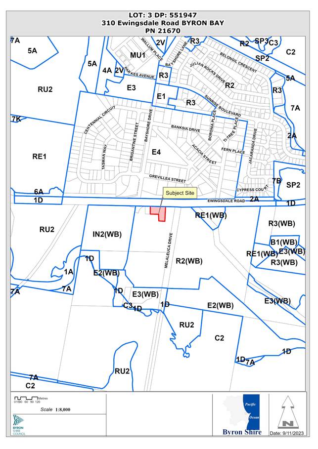 Assessment:
1. INTRODUCTION
History/Background
|
Consent No. |
Description |
Determination |
Date |
|
5.1993.66.1 |
Sign |
Refused Delegated |
05/04/1993 |
|
10.2015.510.1 |
Secondary dwelling |
Approved |
02/10/2015 |
|
10.2015.510.2 |
S96 for addition of verandah and raising of ceiling height |
Approved |
15/04/2016 |
|
10.2018.176.1 |
Subdivision: four (4) lots |
Application withdrawn |
23/07/2018 |
|
10.2023.206.1 |
Demolition of existing structures and construction of a multi dwelling housing development with basement parking and landscaping |
Application returned |
20/06/2023 |
Context of West Byron Consent LEC Appeal No. 2019/310612
DA 10.2017.201.1 was approved with amended plans on 8 December 2020 by the NSW Land and Environment Court. The Court approved subdivision of six (6) lots into one hundred and forty nine (149) lots consisting of one hundred and forty five (145) residential lots, four (4) large residential lots and dedication of residual land to council for public or drainage reserves (on boundary.
The site access will be via approved ‘Road 2’. The site is adjacent to approved Lots 2-4 and 901 open space lot in the ‘Harvest Estate’. Council’s approved street name for Road 2 is Autumn Court. This road is yet to be opened to the public and is pending application and approval of the subdivision certificate.
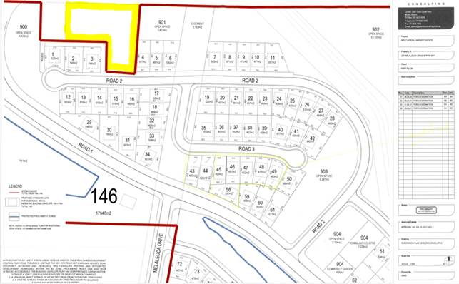
Figure 1: ‘West Byron’ Subdivision Approval (site in yellow)
Assessment and requests for additional information
The applicant uploaded the development application to the NSW Planning Portal on 26 June 2023.
Council undertook a preliminary review of the application documents and sent a request for additional information on the NSW Planning Portal on 29 June 2023.
The application was formally lodged (fees paid) on 11 July 2023 and the clock stopped on 13 July 2023 pending a response to the information request.
Council exhibited the application (Level 2) in accordance with Byron Community Consultation Plan for an extended three week period from 20 July 2023 to: 9 August 2023.
Essential Energy uploaded a request for addition information to the NSW Planning Portal on 28 July 2023.
Water NSW uploaded a request for additional information to the NSW Planning Portal on 17 August 2023.
Department of Planning and Environment - Biodiversity & Conservation Division (DPE BCD) uploaded a request for additional information to the NSW Planning Portal on 23 August 2023.
The applicant emailed Council to ask for copies of submissions made on the development application on 31 August 2023.
The applicant provided a response on 1 September to the preliminary information request.
Council advised the applicant of the Government Information Public Access (GIPA) Act procedures for making an open access request form online by reply email and they submitted the GIPA request to view public submissions on 6 September 2023.
Council sent a copy of redacted submissions to the applicant on 14 September 2023.
The applicant uploaded correspondence including consideration of the public submissions on 27 October 2023.
Council collated a detailed letter documenting extensive issues raised by Council and Agency officers that concluded the application in its current form cannot be supported. Council requested that in the circumstances the application be withdrawn. The letter was uploaded to the NSW Planning Portal on 3 November 2023.
The applicant responded in the NSW Planning Portal on 3 November 2023 to advise no further information will be provided for this application and the application will not be withdrawn. The applicant requested that Council complete the assessment and determination based on the information currently available.
Description of the proposed development
This application seeks approval for multi dwelling housing comprising 20 dwelling units, basement parking for 44 vehicles and associated works including demolition, removal of 19 trees and earthworks.
Extensive excavation, earthworks and dewatering is required for a proposed basement car park with capacity for 44 vehicles including four spaces for visitor parking. The finished floor level of the proposed basement carpark is at least 3.5m below the natural ground level. The proposed multi dwelling development will have vehicular access and frontage to a new public road within the approved West Byron subdivision, known as the Harvest Estate.
The dwellings are arranged in five buildings with landscaped communal and private open spaces including ‘front’ and ‘rear’ private courtyards. The dwellings are a mix of two storeys and three storeys including habitable attics. Two dwellings are nominated universal adaptable design.
An earth mound with a pedestrian entry gate to the site is provided along the Ewingsdale Road frontage.
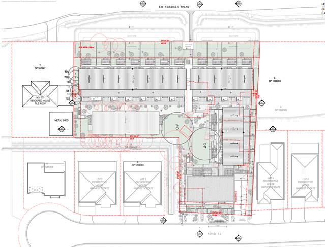
Figure 2: Proposed site plan
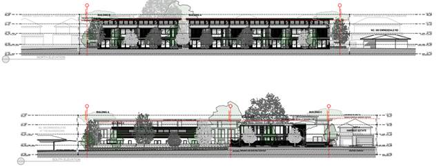
Figure 3: Proposed Street Elevations
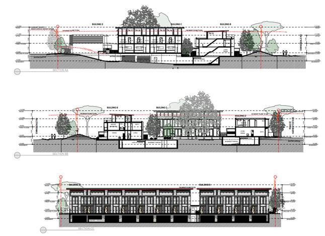
Figure 4: Sections
Description of the site
A site inspection was carried out on 29 August 2023 and 17 November 2023.
|
Land is legally described |
LOT: 3 DP: 551947 |
|
|
Property address |
310 Ewingsdale Road BYRON BAY |
|
|
Land is zoned: |
R2 Low density residential |
|
|
Land area is: |
4388 m2 |
|
|
Property is constrained by:
|
Bushfire prone land; Acid Sulfate Soils Class 3; High Environmental Value |
|
|
|
Is a BDAR required due to the location of the proposed development? |
☒ Yes ☐ No |
|
|
Are there any easements in favour of Council affecting the site? |
☐ Yes ☒ No |
|
|
Is there a Vegetation Management Plan which might affect the proposal? |
☐ Yes ☒ No |
|
|
Is there a Voluntary Planning Agreement which might affect the proposal? |
☐ Yes ☒ No |
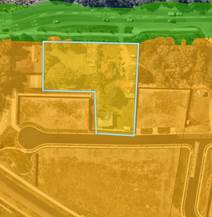
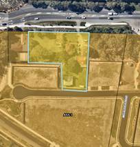
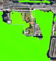
Figure 5: Bushfire mapping (L); Acid Sulfate Soils Class 3 (M); High Environmental Value
Note. West Byron Flood Planning Area - Whilst the site is mapped as being located within the West Byron Flood Planning Area, the site is not identified as being flood prone in Council’s adopted Belongil Creek Flood Study.
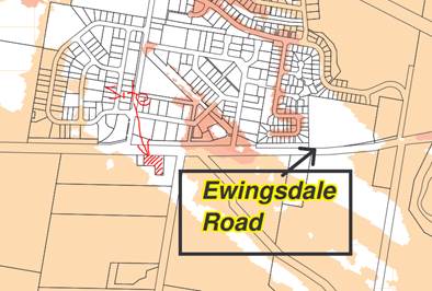
Figure 6: Extract Adopted Belongil Creek Flood Study
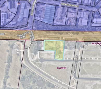
Figure 7: Zoning Byron LEP 1988 Part 4 West Byron R2 Low density residential
Figure 8: Site photos from Ewingsdale Road and inside Harvest Estate
2. SUMMARY OF REFERRALS
|
Referral |
Issue |
|
Environmental Health Officer |
Not supported |
|
Development Engineer |
Not supported |
|
S64 / Systems Planning Officer |
No objections subject to conditions |
|
S7.11 / Contributions Planner |
No objections subject to conditions |
|
Natural Resource Planner |
Not supported |
|
Department of Planning & Environment – Biodiversity and Conservation |
Not supported |
|
Water NSW and Department of Planning & Environment – Water |
Additional information response is being reviewed and assessment not completed at time of reporting |
|
Essential Energy |
Safety concerns to be resolved |
|
Tweed Byron Land Council |
No objections received |
Issues:
NSW Government & Agencies
Department of Planning & Environment – Biodiversity and Conservation reconsidered the applicant response to information requested and still raised deficiencies with the BDAR assessment methodologies and impacts on vegetation and issues about acid sulfate soils assessment. Biodiversity impacts on fauna habitat and vegetation loss could be reasonably avoided. Development will impact/remove all native vegetation at the site. Excavation work for the underground car park will have direct impacts on native trees nominated for retention including a rough-shelled bush nut (Macadamia tetraphylla) tree, which is listed as vulnerable under the BC Act.
Water NSW requested information and completed their part of the dewatering assessment but has referred the application to Department of Planning & Environment – Water to review the hydrological assessment (not yet resolved).
Essential Energy raised concerns about clearance distances to overhead power lines. The boundary fence and berm are within 3.7 and 4.42 metres meaning works within 5m of exposed overhead power lines. Could be resolved by conditions to underground, if necessary
Council
1. Ecological impacts
a. Clearing of vegetation will be the major direct impact associated with the development. Direct impact includes the loss of vegetation and fauna habitats as a result of clearing works in order to facilitate the proposal. The proposal would result in direct impacts on 0.087 ha of native vegetation comprising Plant Community Types (PCT) ‘PCT 1064 Paperbark swamp forest of the coastal lowlands of the NSW North Coast Bioregion and Sydney Basin Bioregion (Zone 1)’. Approximately 0.3553ha of ‘Modified and cleared areas’ will be directly impacted upon as a result of the proposal.
b. There is no allowance or discussion of tree compensation and how this might be achieved, especially with regard to bushfire requirements.
c. The arborists assessment notes a major encroachment into the Tree protection Zone (TPZ) of the two retained figs – this is significant and the long term health of the trees may be compromised. More detailed assessment is required and the BDAR may need to consider whether these trees are ‘lost’ as a result of incursions into the TPZ.
d. A tiny portion of the 100m proximity buffer to the SEPP coastal wetlands to the south crosses the SW corner of the site must be addressed with regard to potential impacts of the car park excavation and potential groundwater drawdown. The small patch of wetland is habitat for two species of threatened frogs. The Groundwater report (AWC) is not detailed with regard to any impact of the excavation works, noting (s 3.2): “Although there is not expected to be long term reduction of water table levels, monitoring will be done to ensure this assumption is correct”. Further discussion is needed here, along with some drawdown mapping/discussion.
e. Note comments from DPE with regard to vegetation allocation and whether the figs are indicative of subtropical rainforest.
f. PCT 1064 is characteristic of the TEC ’swamp sclerophyll forests’ as per recent documentation by DPE/BCD.
g. Consistent with BCD advice an updated Biodiversity Development Assessment Report (BDAR) must be prepared taking the above issues into account and referring any updated supporting studies (e.g., groundwater, stormwater bushfire, arborist report etc). The updated BDAR should also reconsider the principle of ‘avoid and minimise’ with regard to the layout and appropriate protection of the fig trees.
2. Berm inside Ewingsdale Road Reserve. The proposed acoustic berm encroaches into the cycle path. The proposed acoustic design measure does not comply with part E8.10.8.8 and Figure 8.11 in Chapter B8 of BDCP 2014. The proposed berm in Ewingsdale Rd must be provided with a 1m mowing strip between the existing cycle path and the toe of the berm. The proposed footpath connection in Ewingsdale Rd must be amended to connect onto the existing cycle path in Ewingsdale Rd. Amended Environmental Noise Impact Assessment Environmental Noise Impact Assessment is required to address these conflicts.
3. Retaining Walls and multiple footpath connections in Road 2 (Autumn Court) must be deleted.
4. Traffic Report by Planit Consulting indicated a total number of 45 parking spaces are provided however there are only 44 parking spaces shown in the drawing A3011 Issue A by MacKenzie Architects. Parking widths for parking spaces dwellings 01 & 03 closest to the wall must be widened to 2.7m in accordance with the blind aisle requirement of AS2890.1.
5. Clause 2.5.3(a)(ii) of AS2890.1 specifies the maximum ramp grades of 1:5 (20%) for driveway ramps up to 20m. The ramp is approximately 18m and the proposed ramp grade is 1:4 (25%). The proposal exceeded the maximum grade requirement allowable in AS2890.1.
6. Part B4.2.6(e) of Chapter B4 of DCP 2014. The maximum allowable area exposed to direct rainfall to be 60m2 only at driveway ramps. Assessment calculated/measured an area of approximately 90m2 is exposed to direct rainfall.
7. Stormwater Quantity
Predevelopment catchment 1 of 1018m2 currently draining directly in Ewingsdale Rd. This catchment is diverted into the drainage network in Harvest Estate in the post development condition in accordance with the post development catchment analysis. Due to the diversion of catchment 1, the sizing of the OSD must accommodate the additional flows of the full post development of catchment 1 (unmitigated). This is because this catchment currently discharges 0% into Harvest Estate in predevelopment condition and discharges 100% into Harvest Estate in the post development condition.
8. Stormwater Quality
Although the treatment train effectiveness in the proposal meets the target efficiencies in Council’s DCP, there is insufficient information to verify the following: -
a. Size and number of Ocean Protect Stormfilter cartridges and Ocean Guards used in the model to meet the treatment train effectiveness
b. The area required to accommodate the installation of the Ocean Protect Stormfilter and grade requirements to facilitate efficient drainage
c. The area required to facilitate any maintenance plant and equipment to regularly maintain the treatment devices
Provision of maintenance plan and an electronic copy of the MUSIC model to support the proposal was not provided.
9. Acid Sulfate Soils - Dewatering will disturb groundwater on the site and surrounding sites and extraction of groundwater will require specific management (treatment and disposal). The finished floor level of the proposed basement carpark is at least 3.5m below the natural ground level (bngl). The sampling depth should be at least one (1) metre beyond the depth of the proposed excavation or the estimated drop in water table height, or to a minimum two (2) metres below the land surface, whichever is the greatest, (s4.1 (b) ASSMAC, 1998). The acid sulfate soils assessment does not comply with ASSMAC, 1998. The applicant is required to obtain additional soil samples to comply with cl 97 of Byron LEP 1988.
10. Groundwater- The applicant did not provide sufficient information when requested.
a. Remedial Action Plan (Groundwater) - Groundwater Impact Assessment prepared by AWC Ref: 1221605-02 dated 04/04/2023 found that the site was ‘burdened by existing groundwater contamination from extremely high concentrations of phosphorus and nitrogen species. Water quality detected cannot be discharged directly to the surface water systems and requires remediation. A preliminary Remedial Action Plan (RAP) is required that demonstrates method to be employed to control and mitigate impacts to the receiving environment, to determine the likely success of any remedial action and the likely environmental impact to the receiving environment.
b. Cross section plans do not provide details of the proposed groundworks ‘to scale’ that demonstrate the vertical and lateral extent of groundworks (for basement / plant / infrastructure for services).
c. Cone of Depression Modelling states that unmitigated dewatering will result in drawdown in excess of the property boundaries extending 196m. Modelling did not include a required cone of depression modelling sheet to verify the extent of dewatering to assess the potential on and off-site impacts on adjacent groundwater dependent ecosystems (GDE) arising from lowering the groundwater and changing direction of flow.
d. Hydrogeological Model includes bore logs results that indicate the standing groundwater on the subject site is just below the natural ground surface. To allow council to assess the likely impacts to the adjacent wetlands the applicant was requested to provide a conceptual hydrogeological model in accordance with the Minimum Requirements for Building Site Groundwater Investigations and Reporting, (DPIE, 2022).
e. Shoring Method for Subterranean Constructions detail was also requested to allow council to determine the likely impact of dewatering activities particularly in respect to adjacent sensitive wetlands and groundwater dependant ecosystems.
11. Waste management - the application identified that units would share waste bins. This is an option that may be approved by Council for existing poorly designed developments that have exhausted all other options. The provision of shared bins would not be supported for a proposed development that has the ability to be designed and manage waste management from within a site.
· The proposed dwellings are 3 bedroom and the volume of waste if shared would be the same for a 6- bedroom dwelling, which 1 x waste 240L bin , 1 x 240L recycle and 1 x 240 organics would be insufficient. The proposed development of 20 units must consider individual waste collection services. The waste storage rooms are insufficient and configurations are to be provided, and the road frontage size is insufficient for the collections of waste bins as it is an 8m frontage which does not support even a reduced number of bins for the development.
3. SECTION 4.14 – BUSH FIRE PRONE LAND
Bushfire Planning Australia completed a Bushfire Assessment Report to support the proposed medium density infill development located at 310 Ewingsdale Road, Byron Bay. The development will result in the construction of 20 semi-detached and attached residential dwellings within 4 separate buildings and include the strata subdivision of each dwelling.
The BAR found that the site is currently exposed to a low bushfire threat located to the south-west corner over 100m from the most western point of the development footprint. The hazard is consistent with a forest vegetation, namely Coastal Swamp Forest, and is also confirmed as a private environmental area.
Any remaining or future vegetation within 100m of site was classified as a low threat being consistent with the RFS BFSA for the adjoining Harvest Estate. All vegetation to the east of the site is considered to be sufficiently contained in small isolated pockets and separated by areas of active open space and parkland to support the findings of the vegetation hazard assessment. The site is otherwise surrounded by low-threat vegetation, managed or cleared land and is therefore not required to be considered for the purposes of PBP 2019.
In summary, the following key recommendations have been designed to enable the proposed residential development to achieve the aims and objectives of PBP 2019:
1. All land within the site shall be managed as an Inner Protection Area (IPA) as outlined within Appendix 4 of PBP 2019 and the RFS document Standards for asset protection zones;
2. All driveways shall be constructed in accordance the layout contained in Appendix A and section 5.3.2 of PBP 2019;
3. All new dwellings are to be connected to a reliable water supply network and that suitable fire hydrants are located throughout the development site that are clearly marked and provided for the purposes of bushfire protection. Fire hydrant spacing, sizing and pressure shall comply with AS2419.1 2005 and section 5.3.3 of PBP 2019;
4. A BAL-LOW rating apply to all proposed dwellings as there is insufficient risk to warrant specific construction requirements;
5. Trees identified in Attachment 5 Ground Floor Plan contained in the Arboriculture Impact Assessment Report (Appendix F) prepared by Northern Tree Care numbered #8, # 9 and #23-29 shall be retained and suitably pruned to ensure no branches touch or overhang the building; and
6. Consideration should be given to landscaping and fuel loads on site to decrease potential fire hazards on site. his assessment has been made based on the bushfire hazards observed in and around the site at the time of inspection and production (March 2023) and demonstrates the development has satisfied the aims and objectives of Planning for Bushfire Protection 2019.
The report is based on the best available information and expert knowledge, but it is important to note that bushfire risk is dynamic and can change. Finally, should the above recommendations be implemented, the existing bushfire risk should be suitably mitigated to offer an acceptable level of protection to life and property for those persons and assets occupying the site, but they do not and cannot guarantee that the area will not be affected by bushfire at some time and that property and life damage/loss will not occur.
4. SECTION 4.15C – MATTERS FOR CONSIDERATION – DISCUSSION OF ISSUES
Having regard to the matters for consideration detailed in Section 4.15(1) of the Environmental Planning & Assessment Act 1979 (EP&A Act), the following is a summary of the evaluation of the issues.
4.1 State Environmental Planning Policies (SEPP)
|
Considerations |
Satisfactory |
Unsatisfactory |
|
Resilience and Hazards SEPP 2021 Consideration: Ground water has not been satisfactorily addressed in accordance with Chapter 2 Coastal Management or Chapter 4 Remediation of land.
|
☐ |
☒ |
|
Transport and Infrastructure SEPP 2021 Consideration: Section 2.48 Essential Energy raised concerns about clearance distances to overhead power lines. The boundary fence and berm are within 3.7 and 4.42 metres meaning works within 5m of exposed overhead power lines. safety concerns have not been satisfactorily addressed in the current design. This could be resolved via consent conditions with potential to underground power, if necessary S2.119 Development with frontage to classified road, Ewingsdale is a classified road. The acoustic berm location raises conflicts that are not supported by council and there is no resolved design to address objective (b) to prevent or reduce the potential impact of traffic noise and vehicle emission on development adjacent to classified roads. (2) The consent authority must not grant consent to development on land that has a frontage to a classified road unless it is satisfied that— ...(b) the safety, efficiency and ongoing operation of the classified road will not be adversely affected by the development as a result of—... (c) the development is of a type that is not sensitive to traffic noise or vehicle emissions, or is appropriately located and designed, or includes measures, to ameliorate potential traffic noise or vehicle emissions within the site of the development arising from the adjacent classified road.
|
☐ |
☒ |
|
SEPP (Building Sustainability Index: BASIX) 2004 Consideration: A valid BASIX Certificate was submitted with the application documents.
|
☒ |
☐ |
4.2 Byron Local Environmental Plan 1988 (LEP 1988)
In accordance with LEP 1988:
(a) The proposed development is defined in the LEP 1988 Dictionary as multi dwelling housing;
(b) The land is within the LEP1988 R2 Low density residential zone according to the map under LEP 1988;
(c) The proposed development is permissible with consent in the zone; and
(d) However, the proposed development is inconsistent with the relevant objectives of the Zone for the following reasons:
|
Zone Objective |
Consideration |
|
(a) to provide for the housing needs of the community within a low density residential environment, |
The proposed number of dwellings and scale of the buildings on the site will result in off-site impacts within the low density residential environment. |
|
(b) to enable other land uses that provide facilities or services to meet the day to day needs of residents. |
Clause 82 Minimum lot sizes for dual occupancies, multi dwelling housing and residential flat buildings
The LEP sets a minimum lot size of 1000 m2 for Multi dwelling housing and residential flat buildings. The property with an area of 4388 m2 complies with the clause.
84 Height of buildings
(1) The objective of this clause is to ensure that the height and scale of development is appropriate to its location, surrounding development and the environmental characteristics of the land.
(2) The height of a building on any land is not to exceed the maximum height shown for the land on the Height of Buildings Map.
Non-compliant : The proposed building height is 10.53 metres above existing ground level according to the submitted architectural plan. This is an exceedance of 17% above the 9 metre height development standard.
The applicant submitted a written variation request pursuant to Clause 85:
85 Exceptions to development standards
(1) The objectives of this clause are as follows—
(a) to provide an appropriate degree of flexibility in applying certain development standards to particular development,
(b) to achieve better outcomes for and from development by allowing flexibility in particular circumstances.
(2) Development consent may, subject to this clause, be granted for development even though the development would contravene a development standard imposed by this or any other environmental planning instrument. However, this clause does not apply to a development standard that is expressly excluded from the operation of this clause.
(3) Development consent must not be granted to development that contravenes a development standard unless the consent authority is satisfied the applicant for development consent has demonstrated that—
(a) compliance with the development standard is unreasonable or unnecessary in the circumstances, and
(b) there are sufficient environmental planning grounds to justify the contravention of the development standard.
Note—
The Environmental Planning and Assessment Regulation 2021 requires the development application to be accompanied by a document setting out the grounds on which the applicant seeks to demonstrate the matters in paragraphs (a) and (b).
(4) The consent authority must keep a record of its assessment carried out under subclause (3).
(5) (Repealed)
(6) Development consent must not be granted under this clause for a subdivision of land in Zone E2 Environmental Conservation or Zone E3 Environmental Management if—
(a) the subdivision will result in 2 or more lots of less than the minimum area specified for such lots by a development standard, or
(b) the subdivision will result in at least one lot that is less than 90% of the minimum area specified for such a lot by a development standard.
(7) (Repealed)
(8) This clause does not allow development consent to be granted for development that would contravene any of the following—
(a) a development standard for complying development,
(b) a development standard that arises, under the regulations under the Act, in connection with a commitment set out in a BASIX certificate for a building to which State Environmental Planning Policy (Building Sustainability Index: BASIX) 2004 applies or for the land on which such a building is situated,
(c) clause 87 (Controls relating to miscellaneous permissible uses),
(d) clause 99 or 100.
Note. Clause 85 subclauses 1-4 are applicable to the proposed development.
The remaining checked clauses have been taken into consideration in the assessment of the subject development application in accordance with Section 4.15 of the EP&A Act. The proposed development does not comply with all clauses of LEP 1988, including:
Clause 97 Acid sulfate soils
Clause 98A Development for the purpose of stormwater management systems
Clause 98B Earthworks
Clause 85 Exceptions to Development Standards
The applicant has sought a variation to the 9 metre height development standard by proposing a maximum of 10.53 metres above existing ground level according to the submitted architectural plans
The architectural plans indicate that the proposed development has a maximum height of 10.53m to the upper most point of the south west corner to the roof of Building C (Dwelling 17). The maximum breach is 1.53m which is a 17% variation to the development standard. The roof to Buildings A, B and C exceeds the height control to a lesser extent than the maximum point of non-compliance. The extent of the proposed height non-compliance is shown on illustrations in the Statement of Environmental Effects, Annexure B Request for Variation to Development Standard - Byron Local Environmental Plan 1988 Height of Buildings, including:
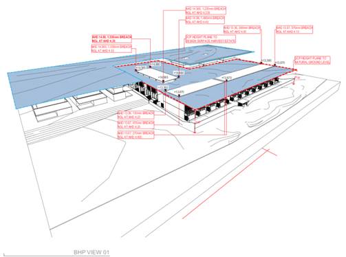
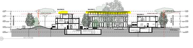
Figure 9: 3D of building height extent and cross section showing areas of building exceeding height limit (highlighted yellow). See attached plans to report for more detail.
The applicant has submitted a written request with regards to Clause 85 subclause 3 that strict compliance with the development standard is unreasonable or unnecessary and that there are sufficient environmental grounds to vary the controls as follows:
· The proposed development is a built form that is of a scale, density, number of storeys, landscaped setting and external appearance that is compatible with the future desired character for the West Byron Urban Release Area (URA) as prescribed in BLEP 1988 and Development Control Plan Chapter E8 West Byron Urban Release Area including the objectives for development in Zone R2 Low Density Residential and the objectives for controlling the height of buildings;
· There are no additional significant adverse impacts arising from the proposed non-compliance; and
· There are positive environmental outcomes from the proposed building form within the specific conditions of the site and its setting and compatibility with existing and future works on adjoining land.
· The height non-compliance is associated only with the uppermost sections of the roofs to Buildings A, B and C and the majority of built form is below the 9m height control.
· There are portions of the site where finished ground levels are required to be filled above natural ground level in order that stormwater management, vehicle access and frontage works are compatible with adjoining land (which has been filled).
· On the portions of the site most impacted by earthworks on neighbouring land, the proposed buildings are well below the height control. This demonstrates building scale is responsive to the setting and context within and beyond the site. It also demonstrates the bulk and scale will not be excessive or detrimental when considered and experienced within the context of surrounding development. The written request provides three examples as to how building height has been well considered within the context and setting.
· Three storey built form is anticipated in DCP Chapter E8.- Section E8.10.10.3 Residential Areas of DCP Chapter E8 includes the following objectives for all development: “1. Ensure development is at a bulk and scale that reflects the residential character of Byron Shire. 2. Provide housing with a suitable degree of amenity to cater for the needs of the residents. 3. To facilitate diverse housing outcomes in the R2 Zone and R3 Zone, 4. To encourage sustainable housing through energy and water efficient design measures.”
It is considered that strict compliance with the development standard is not unreasonable and unnecessary in the circumstances of the case and that there are not sufficient environmental grounds to vary the development standard for the following reasons:
Comment: The height exceedance facilitates a development that doesn’t satisfactorily meet the objectives of Clause 84 to ensure that the height and scale of development is appropriate to its location, surrounding development and the environmental characteristics of the land or clause 85, to achieve better outcomes for and from development by allowing flexibility in particular circumstances or the objectives of the R2 low density zone because the proposed number of dwellings and scale of the buildings on the site will result in off-site impacts within the low density residential environment, avoidable ecological impacts and dwellings that cannot be serviced effectively.
Compliance with the height is not unreasonable or unnecessary in the circumstances, nor does the written request satisfactorily demonstrate that there are sufficient environmental planning grounds to justify the contravention of the development standard, for instance site constraints to be overcome such as topography or requirements for flood planning level. The height breaches could be avoided if the buildings were scaled back to avoid impacts within the site and off-site.
The proposed additional 1.53m, which is a 17% exceedance of the 9 metre height development standard is not considered to achieve better outcomes for and from the development and there is not reasons to allow flexibility in any particular circumstances of this site, particularly when the proposal presents significant off site impacts including encroachment into the building height plane, excessive bulk and overshadowing in the low density environment and direct biodiversity impacts.
Further the proposal is not in the public interest having regards to the objectives of the development standard.
The concurrence of the Planning Secretary is not required.
It is recommended that the development standard cannot be varied in this instance.
The development is not satisfactory having regard to the requirements outlined in clause 85;
The development is not satisfactory having regard to applicable Department of Planning, Infrastructure and Environment Circulars;
The development is not satisfactory having regard to relevant caselaw;
The DA does not demonstrate that compliance is with the development standard is unreasonable and unnecessary;
The DA does not demonstrate that there are sufficient environmental planning grounds to justify contravening the standard;
The DA does not demonstrate that that the development in the public interest;
The DA does not demonstrate that the development is consistent with the objectives of the standard and the zone;
The DA does not demonstrate how the development produces a better planning outcome than one that strictly complied with the development standard; and
The DA does not demonstrate what it is about the grounds of the request that are particular to the proposed development on this site, and that there has to be something particular to the development on this site to justify the variation.
Whilst a 9 metre height limit can enable three stories with careful design, in essences it’s a height limit that is there to facilitate two storey development. As such there are no planning grounds to vary the height limit in this instance and being the first development for the West Byron Urban Release Area for residential development no precedent has been established that indicates the development standard has been abandoned or will be abandoned in the future. The application is recommended for refusal.
Clause 88 Development within the coastal zone
A small portion of the 100m proximity buffer to the SEPP coastal wetlands to the south crosses the SW corner of the site. The applicant has not addressed potential impacts of the car park excavation and potential groundwater drawdown.
Clause 90 Preservation of trees
Excavation work for the underground car park will have direct impacts on native trees nominated for retention including a rough-shelled bush nut (Macadamia tetraphylla) tree, which is listed as vulnerable under the BC Act. Clearing of vegetation will be the major direct impact associated with the development. Direct impact includes the loss of vegetation and fauna habitats because of clearing works to facilitate the proposal. The proposal would result in direct impacts on 0.087 ha of native vegetation comprising Plant Community Types (PCT) ‘PCT 1064 Paperbark swamp forest of the coastal lowlands of the NSW North Coast Bioregion and Sydney Basin Bioregion (Zone 1)’. Approximately 0.3553ha of ‘Modified and cleared areas’ will be directly impacted upon because of the proposal. There is no allowance or discussion of tree compensation and how this might be achieved, especially regarding bushfire requirements. The arborists assessment notes a major encroachment into the Tree protection Zone (TPZ) of the two retained figs – this is significant, and the long-term health of the trees may be compromised. More detailed assessment is required and the BDAR may need to consider whether these trees are ‘lost’ as a result of incursions into the TPZ.
Clause 97 Acid sulfate soils
Acid Sulfate Soils - Dewatering will disturb groundwater on the site and surrounding sites and extraction of groundwater will require specific management (treatment and disposal). The finished floor level of the proposed basement carpark is at least 3.5m below the natural ground level (bngl). The sampling depth should be at least one (1) metre beyond the depth of the proposed excavation or the estimated drop in water table height, or to a minimum two (2) metres below the land surface, whichever is the greatest, (s4.1 (b) ASSMAC, 1998). The acid sulfate soils assessment does not comply with ASSMAC, 1998. The applicant is required to obtain additional soil samples and analysis to comply with cl 97 of Byron LEP 1988.
Clause 98 Flooding
Whilst the site is mapped as being located within the West Byron Flood Planning Area, the site is not identified as being flood prone in Council’s adopted Belongil Creek Flood Study.
Should the application be approved conditions would apply to ensure basements are protected from stormwater infill.
Clause 98A Development for the purpose of stormwater management systems
The application does not provide sufficient information on Stormwater quantity and quality, provision of a maintenance plan and an electronic copy of the MUSIC model to support the proposal was not provided. Predevelopment catchment 1 of 1018m2 currently draining directly in Ewingsdale Rd. This catchment is diverted into the drainage network in Harvest Estate in the post development condition in accordance with the post development catchment analysis. Due to the diversion of catchment 1, the sizing of the OSD must accommodate the additional flows of the full post development of catchment 1 (unmitigated). This is because this catchment currently discharges 0% into Harvest Estate in predevelopment condition and discharges 100% into Harvest Estate in the post development condition.
Although the treatment train effectiveness in the proposal meets the target efficiencies in Council’s DCP, there is insufficient information to verify the following: -
a. Size and number of Ocean Protect Stormfilter cartridges and Ocean Guards used in the model to meet the treatment train effectiveness.
b. The area required to accommodate the installation of the Ocean Protect Stormfilter and grade requirements to facilitate efficient drainage.
c. The area required to facilitate any maintenance plant and equipment to regularly maintain the treatment devices.
The application is recommended for refusal.
Clause 98B Earthworks
The proposal does not provide sufficient information to ensure the earthworks will avoid, minimise or mitigate detrimental impacts on environmental functions and processes, including groundwater. The likely disruption of drainage patterns and the direct impacts on native vegetation with consideration for proximity of the basement to vegetation marked for retention and potential for adverse impacts on adjoining wetlands is not considered to be satisfactory, based on the information provided. The application is recommended for refusal.
4.3 Any proposed Instrument that has been the subject of public consultation and has been notified to the consent authority
No draft EPI’s affect the proposal
4.4 Byron Shire Development Control Plan 2014 (DCP 2014)
Byron DCP 2014 Chapter E8 and other applicable chapters and controls
The proposal is not consistent with the objectives of DCP 2014 Chapter E8, Section E8.10.10.3 Residential Areas to ensure development is at a bulk and scale that reflects the residential character of Byron Shire and with a suitable degree of amenity to cater for the needs of the residents.
The proposal fails to demonstrate compliance with various Performance Criteria and Prescriptive Measures in Table E8.3 and other applicable chapters in Byron DCP 2014 that do not contradict Chapter E8:
E8.10.5.2 Landscaping
E8.10.8 Hazards and Constraints
E8.10.8.2 Acid Sulfate Soils
E8.10.8.3 Groundwater
E8.10.10.3 Residential Areas
The following controls apply to various forms of residential development including dwelling houses, attached dwellings, dual occupancy, multi-dwelling housing and integrated housing development under 83 of Byron LEP 1988.
Objectives
1. Ensure development is at a bulk and scale that reflects the residential character of Byron Shire.
2. Provide housing with a suitable degree of amenity to cater for the needs of the residents.
Table E8.3:
5. Building Height
6. Upper level development
7. Upper wall length
8. Building design and material in relation to streetscape
9. Site coverage etc. and size of dwellings to lot size
11. Car Parking and Vehicle Access
12. Energy Conservation
14. Adaptable Housing
16. Waste Disposal
17. Stormwater Management and Water Consumption
Assessment Table E8.3 - Key Controls for Dwelling Houses, Dual Occupancy (attached and detached), multi-dwelling housing and integrated development permissible under Clause 83 of Byron LEP 1988 in the R2 (and R3 Zones)
|
Performance Criteria |
Prescriptive Measures – R2 Zone |
Compliance of DA 10.2023.244.1 |
|
|
1. Location of Development |
|||
|
To ensure residential land has been suitably designed and orientated to accommodate residential development comprising more than 1 dwelling. |
For Dual occupancy, multi dwelling housing, residential flat buildings and integrated housing, the land has been identified at the subdivision stage for this type of development. |
Proposal for 20 unit multi dwelling housing is on an existing L shaped lot with a limited frontage to an internal collector road approved by the Harvest Subdivision. As such, the lot is not specifically designed for this scale of multi dwelling housing. This lot contains a dwelling with secondary dwelling and is zoned R2. Low density residential. Multi dwelling housing is permissible with consent but does not meet the density requirements in prescriptive measure 9. Site coverage (includes garages, car ports, decks, balconies and verandas) and size of dwellings to lot size. (see below) |
|
|
2. Minimum Frontage |
|||
|
Properties are to be of a suitable width to ensure garages, car port and car parking do not dominate the front facade. Safe vehicle access and egress is provided to the development.
|
a. Garages, car ports and car parking areas consume no more than 40% of the main street frontage width. b. Where development is located on splayed and battleaxe handle arrangements the development to demonstrate that vehicles can enter and leave in a forward direction. Driveways to comply with AS 2890 and Chapter B3 of Byron DCP 2014. For three or more dwellings passing bays with two way access/ egress will be required at the street frontage. c. For development comprising three or more dwellings, corner lots with a shared access on the narrower secondary street frontage is preferable to individual access from the main frontage. |
Access to basement is 7.5 metres across the frontage of 31.285 metres. Complies b. cars can enter and exit in a forward direction however Clause 2.5.3(a)(ii) of AS2890.1 specifies the maximum ramp grades of 1:5 (20%) for driveway ramps up to 20m. The ramp is approximately 18m and the proposed ramp grade is 1:4 (25%). The proposal exceeded the maximum grade requirement allowable in AS2890.1. – Non compliance c. only one frontage available for vehicular access to and from internal road. Cannot use classified road. |
|
|
3. Setbacks - Streets - Corner Lots - Lanes |
|||
|
Residential development to be designed with suitable setbacks to the street: a. To delineate a clear transition between the public and private domain; b. as an extension to residents landscaped open space area; and c. to ensure safe vehicle access into and out of the property. |
a. Front setback to be 4.5 metres from front boundary to building. b. Garage line to be 5.5.metres from front boundary. c. Corner lots – 3 metres setback from secondary street boundary to building. d. Rear Lanes – 0.9 metres to the dwelling, 2.5 metres to any garage or car port
|
a. Complies b. n/a c. n/a d. n/a |
|
|
4. Side and rear setback |
|||
|
Side and rear setbacks: a. To provide spatial separation between dwellings in relation to privacy and amenity. b. To enable climate control devices over windows and doors to encroach into the setback. c. To allow zero line setbacks for certain types of residential development |
In addition to any setback requirements under the Building Code of Australia the following minimums will apply a. For single storey dwellings - 0.9 metres setback. b. For two storey buildings - 2.5 metres setback for the second storey or any part of the building higher than 4.5 metres. c. Eaves and gutters, canopies and other climate control devices over windows and doors permitted to encroach into the setback. d. Reduced setbacks down to zero line are permitted for attached dual occupancy, multi dwelling housing and integrated development for shared boundaries between the proposed dwellings.
|
a. n/a. b. complies c. Noted d. n/a no shared boundary between proposed dwellings on site.
|
|
|
5. Building height |
|||
|
To ensure development maintains the general low rise - two storey nature of residential development in Byron Shire |
a. 9 metres as per Byron LEP 1988 b. Shadow plans required for any two storey proposal for mid-winter at 9am, 12 midday and 3pm. Such plans to be provided in plan view as a minimum. c. Any third storey elements to be integrated into the roof/ attic space or as a mezzanine level. |
a. Non-compliance variation sought. b. Shadow plans show significant overshadowing of dwellings within the site and adjacent to the site (east) c. Non-compliance third storey with flat roof There is no building height plane (BHP) specified in this section of the DCP. Therefore there is no inconsistency with Chapter D2 of BDCP 2014 for building height planes. BHP is applicable under BDCP 2014 and there are multiple non compliances on the building which would result in significant overshadowing and overlooking.
|
|
|
6. Upper level development |
|||
|
Upper level development: a. To maintain neighbourhood privacy and amenity. b. To limit the potential for overlooking into neighbouring properties from upper levels through design. c. To minimize overshadowing of neighbouring properties private open space areas during the winter months
|
a. Upper level development to be primarily utilised for bedrooms, bathrooms and study areas. b. Main living and kitchen areas to be situated on the ground floor, except where orientated to overlook public open space/ land zoned environmental protection, or where required for solar access provided it can be demonstrated that there is no direct overlooking into adjacent properties with spatial separation of 6 metres or more between dwellings. c. Upper level windows to be sited so that there is no direct looking into upper level windows of adjoining dwellings. Where this can’t be achieved windows are sited a minimum 1.7 metres above the upper level floor. d. Any upper level deck/ to be orientated to ensure no direct overlooking of adjoining properties. e. Where required screening with lattice, battens, fixed louvres to be provided over upper level windows and decks/ balconies. The screening to have a maximum of 25% opening with dimension no greater than 50mm. f. No upper levels to overshadow the principle private open space of neighbouring dwellings for more than 3 hours between 9am and 3pm at the winter solstice (21 June). Note: In certain circumstances applicants may submit 3D or perspective shadow plans as well as in plan view to demonstrate the level of overshadowing on neighbouring dwellings |
a. complies b. complies all living and kitchen on ground floor. c. complies within the site but overlooking from building c . d.non-compliance of building c overlooking neighbouring properties to east. e.non compliance f. non-compliance could be conditioned |
|
|
7. Upper wall length |
|||
|
a. To ensure development is at a bulk and scale that is not overbearing for adjoining dwellings. b. To ensure buildings are not dominated by long straight elevations. |
a. Maximum allowable continuous upper storey wall length is 12 metres. b. For facades longer than 12 metres, the upper wall must be broken up with a step of 600mm deep for a length of at least 1.8m. The roof line and eaves must follow the line of the step. The stepped area must remain within the building envelope as defined by minimum setbacks.
|
a. and b. non-compliant |
|
|
8. Building design and material in relation to streetscape |
|||
|
a. To provide articulated building designs that present well to the street. b. To provide for casual surveillance of the street. c. To reflect the coastal environment of Byron Bay and traditional coastal architecture through the use of lightweight materials |
a. Front façades to be articulated with one or more of the following: i. an entry feature or portico; ii. a balcony, deck, patio, pergola, terrace or verandah; iii. an upper level overhang or cantilever; iv. a window box treatment; v. a bay window or similar feature; vi. an awning or other feature over a window; and vii. a sun shading feature. b. The articulated feature or element may intrude into the front setback by up to 1 metre (averaged) provided the feature does not exceed 25% of the articulation zone. (e.g. a property with a frontage width of 12 metres, can have an articulate feature 3 metres wide and intrude into the setback by 1 metre, or the intrusion can be averaged and intrude for example by 0.5 metres but for a width of 6 metres) c. Buildings to utilise a mix of materials and colours to provide interest and variation to the streetscape and to delineate a change in storeys, to embellish an architectural feature or to reflect different elements of the building. d. Dwellings to incorporate windows and doors within the frontage to enable casual surveillance of the public domain and the street. e. Building materials and designs which are heavily urbanised through the use of brick, concrete and tiles or attempt to replicate tuscan, tudor or federation styles will not be supported.
|
a. complies b. noted c. non-compliant heavily urbanised through the use of concrete render
|
|
|
9. Site coverage (includes garages, car ports, decks, balconies and verandas) and size of dwellings to lot size |
|||
|
a. To ensure site coverage for residential development is consistent with the residential character of the area. b. To ensure the size of residential dwellings are proportional to the size of the land. c. To provide for a diversity of dwelling sizes across West Byron. |
a. Ground Floor Level – maximum 60% b. Upper Level – maximum 35% c. The maximum number of bedrooms in a dwelling to be sized to the Site (or allotment) area as follows: |
a .Ground level is approx. 65% Non-compliant b Upper level noted. c noncompliance with maximum number of bedrooms. The site is 4388 m2. The 20 units are 3 bedroom dwellings The site allotment is 250 m2 per 3 bedroom dwellings. On this basis the site area required for 3 bedrooms, the site could accommodate 17 x 3 bedroom dwellings. |
|
|
Number of Bedrooms |
Site (or allotment) area required per dwelling |
||
|
1-2 Bedrooms |
>150m2 |
||
|
3 Bedrooms |
>250m2 |
||
|
4 Bedrooms |
> 300m2 |
||
|
10. Private open space (POS) and Landscaped area |
|||
|
a. To provide an even distribution of open space, landscaping and building footprint, to facilitate a balance of indoor and outdoor recreation within a garden setting. b. To provide an attractive landscaped area to facilitate the planting of trees, shrubs, lawn and vegetable gardens.
|
Landscape area to comprise: a. Minimum 30% of the area of an allotment to be landscaping. b. Minimum 50% of the landscaped area must consist of deep soil areas with minimum dimensions of 5 metres. Landscape Plan to be submitted with development application in accordance with E8.10.5.2. Private Open Space per dwelling to comprise a. Minimum 24 m2 at ground level with minimum dimension of 4 metres to be provided for Private Open Space b. Must be directly accessible from the living area. c. The principal open space area to receive at least 3 hours of sunlight between 9am and 3pm at the winter solstice (21 June). d. Where the private open space area due to orientation of a property is provided in the front of a property, dwellings to be setback a further metre from the street boundary to accommodate suitable landscaping (e.g. lilly pilly hedge) for privacy. e. For secondary dwellings a minimum of 15 m2 with minimum dimensions of 2.5 metres to be provided in a private courtyard setting. The secondary dwelling not to compromise the overall landscaping and private open space required for the principal dwelling. f. Private Open Space at ground level is a component of the overall landscaped area.
|
Landscape area to comprise: a. Site area: 4388m2 Landscape area is 35.39 % approx. Complies.
b. Deep soil is limited by basement.
Private Open Space - various units do not fully comply with minimum dimensions or sunlight requirements.
|
|
|
11. Car Parking and Vehicle Access |
|
||
|
Development to ensure that a. Vehicle access and parking is accommodated on site with an appropriate number of car parking spaces for the dwelling house and the normal activities of the household. b. Safe vehicle access and egress is provided. c. To provide incentives to reduce the dominance of the motor vehicle. |
Car parking for residential development to comprise the following: a. 1 – 2 bedroom dwellings - 1 Space b. 3 or more bedroom dwelling – 2 spaces c. Visitor Parking required for multi dwelling housing/ integrated housing comprising 4 or more dwellings at a rate of 1 space/ 4 dwellings d. As a minimum at least one vehicle space/ dwelling to be covered either in a garage or car port. e. Where two spaces are required these can be provided in a tandem arrangement provided the tandem space complies with the minimum setback provisions. f. Access, driveways, maneuvering and turning areas, and structures adjacent to driveways to comply with Chapter B3 and B4 of Byron DCP 2014. g. Driveways where crossing swales to be designed in accordance with Appendix E. h. Where 3 or more dwellings are proposed on a property, mews style development and or common/ central car parking areas are permissible to reduce the amount of land required for the motor vehicle. i. Secondary dwellings are not to be sited to so as to remove car parking servicing the principle dwelling. j. To encourage car pooling and to reduce car dependency for three or more dwellings, a reduction in car parking of 33% will be agreed to for residential development in a community title or strata title arrangement, if a vehicle is provided as part of the common or neighbourhood property and for the use of the residents. The following will be required: i. 3 - 8 dwellings – 1 community vehicle ii. 8 -12 dwellings – 2 community vehicles iii. More than 12 – 3 community vehicles Details to be provided with the application on the type of vehicle, where it will be garaged on the property under cover, and how it will be maintained, managed, shared and replaced by the residential community. The car(s) is to be no older than 5 years at the time of the issue of the occupation certificate and be able to seat four adults. |
a. n/a b. 44 spaces provided. 2x 20 spaces complies subject to design clearances of 2 spaces. see engineering comments.
c. Visitor 1 space per 4 dwellings say 5 spaces required 1 car space short. Non-compliance see engineering comments.
d. Complies all in basement. e. n/a f. Non-compliance see engineering comments. g. n/a h. complies. i. n/a j. Not proposed.
|
|
|
12. Energy Conservation |
|||
|
a. To reduce total energy use in residential buildings by reducing heat loss and energy consumption for heating and cooling. b. To utilise design features to passively control the climate within residential dwellings
|
a. A clothes drying area to be provided in an outdoor area that receives a minimum of 2 hours sunlight midwinter. The area to accommodate a minimum of 25 metres of line. b. Dwellings to be designed to facilitate cross ventilation of air to assist with cooling with operable windows on opposite sides of the house. c. Dwellings to be designed with a roof orientated between the north east to the north west to facilitate the installation of photovoltaic cells for electricity generation or solar hot water systems with a minimum area of 15m2. d. The western elevation of dwellings to incorporate a range of climate control features including canopy and shading devices over windows and doors, pergolas and verandahs, and eaves with a minimum width of 450mm for increased shading and weather protection. |
a. non compliance b. non-compliance upper level of units 1-17 c. non-compliance all roofs almost flat at 2 degrees slope south or east. d. complies |
|
|
13. Fencing |
|||
|
To enable fencing to be erected for privacy, territorial reinforcement between the public domain and private property and security |
Any fencing to comply with Chapter D1 of Byron DCP 2014. |
Can be conditioned |
|
|
14. Adaptable Housing |
|||
|
Development ensures that housing is able to be readily adapted to a resident's changing life-cycle needs. |
To comply with Chapter B13 of Byron DCP 2014. |
Insufficient detail about path of travel including long sections to scale required. The distance of nominated parking to adaptable units including path of travel does not consider the needs of affected residents. |
|
|
15. Subdivision |
|||
|
To facilitate separate ownership of dwellings in a co-ordinated manner |
Where land is to be further subdivided as part of the proposal details to be included with the application including: a. a plan of subdivision; b. type of titling proposed (e.g. Torrens, Strata or Community title) and c. Management/ Neighbourhood Plan (if required).
|
N/A no proposal for subdivision. |
|
|
16. Waste Disposal |
|
||
|
a. Waste to be adequately stored and separated on site prior to being collected by the waste contractor. b. Bin storage area is adequately screened from the public domain. c. Common or shared storage areas permissible for medium density housing forms |
In addition to the measures contained in Chapter B8 of DCP 2014 the following to apply: a. Sufficient storage area is available behind the front building line for the location of garbage, recycling and green bins (The three bin system), and the area is not to be visible from the street. b. For three or more dwellings within a strata or community title arrangement, shared waste disposal facilities can be provided on the common or neighbourhood property. c. Details to be provided as to how the three bin system can be accommodated onsite.
|
a. Noted. Not visible in basement. b. Shared storage space for bins provided in basement (common property). 3. No of bins, storage and collection is not satisfactory see resource recovery comments. |
|
|
17. Stormwater Management And Water Consumption |
|||
|
a. To minimise water consumption from potable water supplies b. To assist with the management of stormwater |
a. In addition to any water storage requirements for BASIX a further 3000 litres of storage capacity per dwelling to be provided for stormwater management. b. Rainwater tanks to be connected to the stormwater down pipes from the roof of the dwelling and be plumbed back into the house as a minimum for the flushing of toilet(s) and for external gardening purposes. c. Overflow from the water tank and house to be connected to the street stormwater system generally in accordance with the drawing shown at Appendix F - Typical Stormwater House Connection
|
See engineer comments about water quality and quantity. Not satisfactory.
|
|
Byron DCP 2014 controls in the following chapters that do not contradict Chapter E8 and are supplementary controls:
Chapter B4 Traffic Planning, Vehicle Parking, Circulation and Access Chapter
Part B4.2.6(e) of Chapter B4 of DCP 2014 requires that the maximum allowable area exposed to direct rainfall to be 60m2 only at driveway ramps. Assessment calculated/measured an area of approximately 90m2 is exposed to direct rainfall. This results in a shortfall of on-site parking of one space.
Clause 2.5.3(a)(ii) of AS2890.1 specifies the maximum ramp grades of 1:5 (20%) for driveway ramps up to 20m. The ramp is approximately 18m and the proposed ramp grade is 1:4 (25%). The proposal exceeded the maximum grade requirement allowable in AS2890.1. The Traffic Report by Planit Consulting indicated a total number of 45 parking spaces are provided however there are only 44 parking spaces shown in the drawing A3011 Issue A by MacKenzie Architects. Parking widths for parking spaces dwellings 01 & 03 closest to the wall must be widened to 2.7m in accordance with the blind aisle requirement of AS2890.1.
B8 Waste Minimisation and Management Chapter
The application identified that units would share waste bins. This is an option that may be approved by Council for existing poorly designed developments that have exhausted all other options. The provision of shared bins would not be supported for a proposed development that could be designed and manage waste management from within a site.
The proposed dwellings are 3 bedroom and the volume of waste if shared would be the same for a 6- bedroom dwelling, which 1 x waste 240L bin , 1 x 240L recycle and 1 x 240 organics would be insufficient. The proposed development of 20 units must consider individual waste collection services. The waste storage rooms are insufficient, and the road frontage size is insufficient for the collections of waste bins as it is an 8m frontage which does not support collection of 40 bins required to service the development.
B13 Access and Mobility
There is insufficient detail about path of travel including long sections to scale between universal design / accessible dwellings located in Building E and essential services. The distance of nominated parking to adaptable units including an excessive path of travel does not consider the needs of affected residents. This is further considered to be limited by the proximity of the only lift within the site being located between Buildings A and B for use by residents of all 20 units to access basement for parking, waste, and other storage reasons.
Chapter D1 Residential Accommodation
The proposed development breaches the building height plane on multiple elevations and shared boundaries to the east, west and south; raising issues in relation to bulk, scale and overshadowing and overlooking of approved residential land to the south and east and new public open space lot to the east.
4.5 Environmental Planning and Assessment Regulation 2021 considerations
|
|
Applicable to the proposal: |
Considered the control as it relates to the proposal: |
If this control is applicable, does the proposal comply? |
|
Section 61 - Additional matters that consent authority must consider |
☒ Yes* ☐ No |
☒ Yes ☐ No ☐ NA |
☒ Yes ☐ No ☐ NA |
|
Section 62 - Consideration of fire safety |
☐ Yes ☒ No |
☐ Yes ☐ No ☒ NA |
☐ Yes ☐ No ☒ NA |
|
Section 64 - Consent authority may require upgrade of buildings |
☐ Yes ☒ No |
☐ Yes ☐ No ☒ NA |
☐ Yes ☐ No ☒ NA |
|
Section 63 - Considerations for erection of temporary structures |
☐ Yes ☒ No |
☐ Yes ☐ No ☒ NA |
☐ Yes ☐ No ☒ NA |
* (1) In determining a development application for the demolition of a building, the consent authority must consider the Australian Standard AS 2601—2001: The Demolition of Structures.
4.6 The likely impacts of that development, including environmental impacts on both the natural and built environments, and social and economic impacts in the locality
|
Impact on: |
Likely significant impact/s? |
|
Natural environment |
Yes. The proposal will have a significantly adverse impact on the natural environment of the locality. |
|
Built environment |
Yes. The proposal will have a significantly adverse impact on the built environment of the locality. |
|
Social Environment |
No. The proposal would be unlikely to have a significant social impact on the locality. |
|
Economic impact |
No. The proposal will not have a significant economic impact on the locality. |
|
Construction Impacts |
Yes. The development will generate impacts during its construction. Conditions of consent would be recommended to control hours of work, builders waste, construction noise, installation of sedimentation and erosion control measures and the like to ameliorate such impacts if the proposal was to be approved. |
4.7 The suitability of the site for the development
The site although serviced is constrained property and is not suitable for the scale of the proposed development.
4.8 Submissions made in accordance with this Act or the Regs.
The development application was publicly exhibited. There were ten submissions made against the development application.
Relevant matters for consideration raised, include:
1. Overdevelopment, excessive scale and density, out of character
2. Height exceedance not supported and potentially sets a precedent
3. Tree removal not supported
4. Insufficient onsite parking
5. Setback from Ewingsdale Road for earth mound and new road and footpath works. Setbacks from Ewingsdale Road
6. Basement dewatering to have negative impact on Wallum Sedge Frog wetland and interrupt groundwater flow
7. Stormwater capacity
8. Insufficient kerbside space for bin collection
4.9 Public interest
The proposed development is likely to prejudice or compromise the public interest and create an undesirable precedent.
5. DEVELOPER CONTRIBUTIONS
5.1 Water & Sewer Levies
Section 64 levies would be required, if the development was approved.
5.2 Developer Contributions
Section 7.11 Contributions would be payable, if the development was approved.
6. DISCLOSURE OF POLITICAL DONATIONS AND GIFTS
|
Disclosure details |
Response |
|
Has a Disclosure Statement been received in relation to this application? If Yes, Provide Disclosure Statement register reference: 91. |
Yes ☐ No ☒ |
|
Have staff received a ‘gift’ from anyone involved in this application that needs to be disclosed. |
Yes ☐ No ☒ |
7. CONCLUSION
The DA proposes multi dwelling housing comprising twenty (20) units, basement parking and associated works including demolition, removal of nineteen (19) trees and earthworks.
The proposed development is not satisfactory having regard to the relevant environmental planning instruments and planning controls applicable to the site. The proposal raises significant issues in terms of environmental impacts that the application fails to demonstrate can be managed. The site is a serviced, constrained property and is not considered suitable for the proposed development.
It is recommended that pursuant to Section 4.16 of the Environmental Planning & Assessment Act 1979, Development Application No. 10.2023.244.1 for multi dwelling housing comprising twenty (20) units, basement parking and associated works including demolition, removal of nineteen (19) trees and earthworks, be refused for the reasons outlined in the recommendation of this report.
BYRON SHIRE COUNCIL
Staff Reports - Sustainable Environment and Economy 13.7
Report No. 13.7 PLANNING - Review of Development Control Plan (DCP) 2014 planning controls for Biodiversity, Tree and Vegetation Management
Directorate: Sustainable Environment and Economy
Report Author: Liz Caddick, Biodiversity Officer
Alex Caras, Land Use Plannning Coordinator
File No: I2023/1819
Summary:
This report was prepared by Planit Consulting for Council.
At the Planning Meeting of 11 August 2022, Council resolved to endorse the Byron Shire Wildlife Corridor System for public exhibition, and update DCP 2014 Chapter ‘B1 – Biodiversity’ to reflect the adopted Wildlife Corridor Map and any additional supporting amendments. The scope of this update was subsequently augmented to include Actions 1.1 and 1.2 of the Byron Shire Biodiversity Conservation Strategy 2020-2030.
A coordinated review of these provisions was pursued to ensure an efficient review process and holistic considerations. Specifically, the review focuses on the provisions detailed within Chapters B1 Biodiversity and B2 Tree and Vegetation Management of the Byron DCP 2014. To ensure an integrated framework, the current Guidelines for preparing Vegetation Management Plans (VMP) or Biodiversity Conservation Management Plans (BCMP) were also reviewed.
The 2 Chapters serve different, biodiversity-based functions, namely:
· Chapter B1 Biodiversity applies to Development Applications that involve the removal of high environmental value vegetation, or vegetation on land with sensitive attributes, such as waterways, ecological features, or cultural heritage.
· Chapter B2 Tree and Vegetation Management applies where vegetation removal is sought outside of a Development Application process.
Through subsequent consultation with Council staff, broader considerations were also identified, including but not limited to:
· Desired improvements to the clarity and application of the respective Chapters.
· Where possible, simplify and streamline provisions, particularly for smaller scale development types.
· Increase flexibility for infill urban development and where biodiversity improvements have been made proactively by landowners.
· Refine definitions to ensure adequate protection of biodiversity.
· General housekeeping improvements.
The DCP 2014 review process has involved multiple workshops with Council’s technical staff. In addressing the abovementioned matters and incorporating feedback from the workshops, a number of key amendments are proposed, including amendments to Part A, Preliminary. Copies of each recommended draft DCP 2014 Chapter are attached to this report. Key changes include:
· Removal of Wildlife Corridors as a red flag.
· Specific provisions for Infill Development in existing urban zones.
· Expansion of Offset Planting Requirements.
· Changes to the Document Structure.
The proposed DCP amendments are considered to improve the useability, and application of biodiversity provisions within the Byron LGA. It is important to now engage with the community and industry specialists to further interrogate the draft amendments sought, which will add rigor to the DCP framework. At the conclusion of this process, a further report will be brought back to Council detailing the feedback received and the next steps within the review.
NOTE TO COUNCILLORS:
In accordance with the provisions of S375A of the Local Government Act 1993, a Division is to be called whenever a motion for a planning decision is put to the meeting, for the purpose of recording voting on planning matters. Pursuant to clause 2(a) under the heading Matters to be Included in Minutes of Council Meetings of Council's adopted Code of Meeting Practice (as amended) a Division will be deemed to have been called by the mover and seconder of all motions relating to this report.
RECOMMENDATION:
That Council:
1. Authorises the public exhibition of Byron Development Control Plan 2014 Part A Preliminary, Chapter B1 Biodiversity and Chapter F1 Tree and Vegetation Management, as contained in Attachments 1 – 3 (E2023/119582, E2023/119583, E2023/119581) for a period of 28 days.
2. Receives a report outlining the public exhibition outcomes and any other matters that may arise during the exhibition period.
1 DCP
2014 Part A Preliminary showing draft amendments, E2023/119582 ![]()
2 DCP
2014 - Chapter F1 Tree and Vegetation Management showing draft amendments, E2023/119583 ![]()
3 DCP
2014 - Chapter B1 Biodiversity showing draft amendments, E2023/119581 ![]()
REPORT
This report was prepared for Council by Planit Consulting.
Purpose
The purpose of this report is to provide Councillors with an update as to the review of the planning controls for biodiversity, as expressed within the Byron Development Control Plan 2014, namely Chapters B1 Biodiversity, and Chapter B2 Tree and Vegetation Management.
Within this update, a summary of key amendments proposed is provided, supporting planning commentary, and copies of draft Chapters prepared (Attachments 1-3).
The report seeks resolution from Council to proceed to a public exhibition process, whereby the community and industry experts will be invited to review and comment on the amendments proposed.
Background
At the Planning Meeting of 11 August 2022, Council resolved to endorse the Byron Shire Wildlife Corridor System for public exhibition, and update DCP 2014 Chapter ‘B1 – Biodiversity’ to reflect the adopted Wildlife Corridor Map and any additional supporting amendments. The scope of this update was subsequently augmented to include Actions 1.1 and 1.2 of the Byron Shire Biodiversity Conservation Strategy 2020-2030, which prescribe as follows:
1.1 Update Council’s DCP 2014 to include a Biodiversity, Vegetation and Habitat Management Chapter that:
· Reflects current legislation;
· Aligns with the Byron Shire Rural Land Use Strategy 2017.
· Reflects updates to local and regional vegetation mapping;
· Provides standards and controls to ensure planning of new development maintains or improves ecological values & ecological function;
· Incorporates clear planning controls for protection of Koala Habitat, within the Byron Coastal Koala Management Area, and other rural koala habitat areas.
· Aligns with the Guiding Principles of this Biodiversity Conservation Strategy
1.2 Amend existing Council DCP chapters to reflect current NSW environmental legislation and Council's Biodiversity DCP chapter.
In accordance with previous Council resolutions and policy action plans, a review of Council’s current planning guidelines for Tree and Vegetation Management, as well as Biodiversity has been pursued. The review focussed on the provisions detailed within the DCP, namely Chapter B1 Biodiversity and Chapter B2 Tree and Vegetation Management. To ensure an integrated framework, the current Guidelines for preparing Vegetation Management Plans (VMP) or Biodiversity Conservation Management Plans (BCMP) were also reviewed.
The 2 Chapters serve different, biodiversity-based functions, namely:
· Chapter B1 Biodiversity applies to Development Applications that involve the removal of vegetation, and/or on land with sensitive attributes, such as waterways, ecological features, or cultural heritage. Chapter B1 implements an avoidance led approach, prescribing minimum setbacks of variable size, dependant on the sensitivity of the site constraint. Chapter B1 also provides guidance on other matters, including but not limited to the management of ecological buffers, the interface with development and provides additional guidance beyond the statutory provisions of the Biodiversity Conservation Act 2016. Chapter B1 has been operational since December 2020.
· Chapter B2 Tree and Vegetation Management applies where vegetation removal is sought outside of a Development Application process. As per State Environmental Planning Policy (Biodiversity and Conservation) 2021, Chapter B2 declares vegetation on non-rural land which requires a permit, granted by Council, to be removed. Permit applications made under Chapter B2 are assessed by Council’s arborist, and if approved, involve offset planting requirements to maintain biodiversity, social and amenity values. Chapter B2 has been effective since March 2021, however, has formed part of Council’s policy framework for an extended period, including previous reference as a Tree Protection Order.
Through subsequent consultation with Council staff, broader considerations were also identified, including but not limited to:
· Desired improvements to the clarity and application of the respective Chapters.
· Where possible, simplify and streamline provisions, particularly for smaller scale development types.
· Increase flexibility for infill urban development and where biodiversity improvements have been made proactively by landowners.
· Refine definitions to ensure adequate protection of biodiversity.
· General housekeeping improvements.
The DCP review process to-date has involved workshops with Council’s technical staff, as well as review of draft Chapters. In addressing the abovementioned matters and incorporating feedback from the workshops held, a number of key amendments are proposed, including amendment to Part A, Preliminary of DCP 2014, as the preliminary Chapter. Copies of each draft DCP Chapter can be found as Attachments 1-3 to this report, however Table 1, below, provides a summary of the amendments, as well as planning commentary as a rational and context of the amendments.
Table 1 - Summary of DCP Amendments Proposed
|
Summary of Amendments |
Planning Commentary |
|
|
Part A: Preliminary |
New Section A4 Biodiversity Planning Principles. This new section includes the current content of B1.1.5 Biodiversity Planning Principles. Consolidate definitions into 1 location and include new definitions for infill development, tree and wildlife corridor. |
See key amendment 2 and 4 commentary at the base of this Table. |
|
Chapter B1: Biodiversity |
Housekeeping amendments throughout section B1.1, predominately to remove outdated or unnecessary commentary and legislation references. Within section B1.2 Defining the development envelope: · Include performance criteria, · Provide specific exclusion of ecological setbacks for infill development, · Include compensatory planting provisions · Provide greater clarity of mapping accuracy and assessment process. · Remove wildlife corridor from Table 3 – Ecological setbacks · Include offset vegetation provisions Housekeeping amendments throughout section B1.3, predominately to remove unnecessary commentary, and shift relevant commentary into alternate sections within Part A and Chapter B1. |
Various housekeeping amendments are proposed to assist document usability, align with contemporary legislation references and guide proponents of the process/ methodology to be pursued. See key amendment 1, 2 and 3 commentary at the base of this Table. |
|
Chapter F1: Tree and Vegetation Management (previously Chapter B2)
To fall under a new Part F: Controls Applying Outside a Development Application |
Update all references from B2 to F1. Housekeeping amendments throughout. Remove ‘Land within a defined wildlife corridor’ and ‘first order stream’ from Appendix 1 – Red Flag types. |
Various housekeeping amendments are proposed to assist document usability, align with contemporary legislation references and further integrate the Chapter within the Byron Development Control Plan 2014. See key amendment 1 and 4 commentary at the base of this Table. |
Key Amendment 1: Removal of Wildlife Corridor as an ecological constraint
Wildlife corridor mapping is generally strategic in nature (i.e. does not purely represent current environment conditions) and typically prepared at a broad, ‘whole of LGA’ level. Accordingly, mapped corridors are often applicable to land free of native vegetation and generally range in width from 200m and above to in excess of 1km.
Chapter B1 currently prescribes that development should avoid mapped wildlife corridors and buffered by a 20m ecological setback.
If enforced rigidly, these provisions would sterilise significant areas of land within the LGA. As discussed within corresponding Council report (titled ‘PLANNING - Review of Development Control Plan (DCP) 2014 planning controls for Biodiversity, Tree and Vegetation Management’), staff recommend utilising the strategic wildlife corridor mapping to incentivise proactive and positive environmental outcomes, as opposed to mandating avoidance and buffering of proposed wildlife corridors, particularly where avoidance is not possible.
The amendment proposed is identified as appropriate by providing pragmatic outcomes within mapped strategic wildlife corridors. Supplementary amendments protect landowners who have voluntarily and proactively improved the biodiversity values of land (unless prescribed by a development consent or funded by Government Grant/s). Likewise, the DCP provisions retain an avoidance-led approach and ecological buffering where high environmental value vegetation or like constraint is located within a wildlife buffer.
Key Amendment 2: Specific provisions for Infill Development Types
A consistent feedback theme through the DCP review involved the interface between the ecological buffers within Chapter B1 and development proposals ‘filling in’ existing urban lots. Specifically, 2 primary issues were identified, being:
· The inability to physically achieve the prescribed buffers (which are typically 20 – 30m in size) on a typical urban lot, and
· The inability to provide offset plantings on-site and simultaneously achieve the requirements of Planning for Bushfire Protection 2019.
Addressing these matters within the current policy context is complex as the Biodiversity Offset Scheme provisions under the Biodiversity Conservation Act 2016 do not afford an ‘opt-in’ provision to financially offset the loss of vegetation. Similarly, an existing framework, along with candidate land parcels, is not established to physically offset vegetation within the LGA. To date, this has necessitated the provision of a Planning Agreement to secure the offset vegetation, which is a cumbersome process, and generally not preferred unless all other options are exhausted.
Accordingly, alternate development envelope provisions have been drafted to facilitate fit-for-purpose provisions for infill development types. Primary changes include:
1. The introduction of a definition for ‘infill development’, being: Infill development means development, other than subdivision, on land zoned other than RU1, RU2, C1 – C4, W1 and W2 where the lot size is less than 2,500m2.
The key drivers for the parameters of this definition include:
a) The ecological buffers within Chapters B1 are typically 20 – 30m in size. Whilst these are measured radially, lots are typically rectangular in shape. Accordingly, to incorporate the buffers prescribed, minimum site areas are 1,600m2 where a 20m buffer is required (i.e. a 40m x 40m lot), up to 3,600m2 where a 30m buffer is required.
b) The above minimum site areas do not accommodate any further setback that may be required from boundaries on planning grounds, or asset protection zone requirements for bushfire mitigation.
c) Post establishing these additional site area provisions, a development envelope itself is also required.
Whilst alternate lot size thresholds can be tested (particularly post public exhibition), it is anticipated that a reduction from 2,500m2 would regularly maintain the existing conflict where the prescribed ecological buffer provisions cannot be met based on existing site size.
2. Inclusion of additional performance criteria to reinforce the preferred methodology of prioritising avoiding and minimising development impacts, recognising the potential for competing planning policy influences, and facilitating alternate solutions to maintain and improve biodiversity where avoidance cannot be practically achieved.
3. Prescribing that the ecological setbacks of Chapter B1 are not applicable to infill development.
The proposed amendments are not to facilitate increased clearing within the LGAs existing communities, as avoidance remains the primary step.
However, the amendments seek to recalibrate the balance between biodiversity, character, growth, risk and resilience by facilitating a framework for pragmatic siting, design and decision-making. Noting the tensions experienced within the current policy framework, it is timely to engage with the community and industry practitioners to identify any further opportunities for improvement, road-test the draft amendments, and ensure suitable outcomes are supported.
Key Amendment 3: Expansion of Offset Planting Requirements
Within the current DCP framework, offset plantings requirements, based on low, medium or high environmental value, are only prescribed where tree and vegetation removal is sought outside of a DA process (i.e. exclusively through Chapter B2). Acknowledging that greater opportunity for impact is typically experienced through the DA process, as opposed to more isolated tree removal permits, broadly, the existing framework is counter intuitive. Accordingly, the amendments sought extend the offset planting provisions for permits, to also be applicable to DAs.
Notwithstanding the above, anecdotal evidence and case study examples have been cited which have highlighted opportunity for conflict between the provision of offset planting, achieving biodiversity improvements and retaining/achieving compliance with the provisions of Planning for Bushfire Protection, under the NSW Rural Fire Act 1997. The amendments drafted provide opportunity for applicants to promote site-specific outcomes that support biodiversity whilst ensuring appropriate protection from bushfire threat. Balancing these potentially competing outcomes is identified as critical to maintaining biodiversity values, character and delivering resilient growth without undue threat or hazard.
Key Amendment 4: Document Structure
Whilst the 3 amendments discussed above form the primary policy changes, the documentation of the biodiversity framework is notably different within the draft Chapters.
To streamline and further integrate the Chapters of the Byron DCP 2014, all relevant definitions have been consolidated within Part A Preliminary. In addition, the Biodiversity Planning Principles, which currently form part of Chapter B1, are proposed to be integrated within the Site Analysis provisions of Part A. This integration seeks to ensure that biodiversity forms a core component to site planning and is considered, along with other site opportunities and constraints, as a primary step in siting and designing development proposals.
Chapter B1 has also been refined and simplified by a combination of:
· Deleting duplication of legislation, process information and superseded background content
· Inclusion of additional Objectives and Performance Criteria
· Improving the relationship between Prescriptive Measures and Guidance Notes.
The abovementioned changes clarify and consolidate key biodiversity content, as distinct from provisions which otherwise ordinarily apply by virtue of other Acts, Regulations or processes. Likewise, the amendments support the Chapter being increasingly user-friendly and obtaining practical outcomes without negative biodiversity impacts. It is now considered timely to engage with the community and industry practitioners to identify any further opportunities for improvement, and ensure suitable outcomes are supported.
Chapter B2 is proposed to be reassigned to a new Chapter F1 - Tree and Vegetation Management, under a new Part F: Controls Applying Outside a Development Application. The repositioning and updating of this Chapter is intended to improve the clarity of its application, which is exclusively outside of a DA framework. In turn, it is anticipated that an improvement in quality of DAs received will arise, assisting their subsequent assessments.
Next Steps
This DCP review is considered to positively contribute towards a streamlined and simplified biodiversity and planning framework for the Byron LGA. Whilst a series of investigations with technical staff has been pursued to develop the amended guideline provisions, it is critical to now engage with the community and industry specialists to further interrogate the framework provisions. The additional ‘road-testing’ of the draft controls and opportunity for community feedback will add rigor to the DCP framework into the future.
The Byron LGA has long been identified as a biodiversity hotspot, as well as being subject to ongoing demand for urban development, primarily within a consolidated urban footprint. The DCP Chapters are identified as critical in rationalising these competing demands and achieving responsible and balanced outcomes, which uphold the Shire’s valued character. Accordingly, this report recommends Council resolve to progress to a formal public exhibition process, as per section 13 of the Environmental Planning and Assessment Regulations 2021 and Council’s Community Participation Plan 2019.
Strategic Considerations
Community Strategic Plan and Operational Plan
|
CSP Objective |
CSP Strategy |
DP Action |
Code |
OP Activity |
|
4: Ethical Growth |
4.1: Manage responsible development through effective place and space planning |
4.1.4: LEP & DCP - Review and update the Local Environmental Plan and Development Control Plans |
4.1.4.2 |
Review and update Local Environmental Plan and Development Control Plans to reflect strategic land use priorities and/or legislative reforms |
Recent Resolutions
· 22-366
Legal/Statutory/Policy Considerations
The review of the planning controls will be used to inform future strategic land use and biodiversity strategies to ensure a coordinated planning framework, balancing the LGAs significant biodiversity with investment and growth planning.
Financial Considerations
Not applicable to this report.
Consultation and Engagement
Consultation and engagement for the proposed DCP amendments will be undertaken in accordance with the Community Participation Plan and the Environmental Planning and Assessment Regulation 2021.
BYRON SHIRE COUNCIL
Staff Reports - Sustainable Environment and Economy 13.8
Report No. 13.8 26.2023.3.1 - Amendments to Byron Development Control Plan 2014 Chapter E5 to include the North Beach Byron site
Directorate: Sustainable Environment and Economy
Report Author: Lachlan Wall, Land Use Planner
File No: I2023/1830
Summary:
Council received a request to amend Chapter E5 Certain locations in Byron Bay and Ewingsdale, of the Byron Development Control Plan (BDCP) 2014, for the land immediately to the north-west of the Elements of Byron resort at Belongil known as the ‘North Beach Resort site. The site includes a number of properties under one ownership.
The subject land was previously rezoned (to C4 Environmental Living) to facilitate the future residential subdivision of the site to create nine (9) large residential lots, each with provision for a single dwelling. The current DCP Chapter E5 does not contain provisions to address residential development in this area and accordingly new controls are required for future dwellings on this land and to adequately respond to environmental constraints.
A ‘marked up’ copy of the draft table of amendments to the DCP chapter E5 showing the proposed changes is appended to this report as Attachment 1
The key proposed additions to chapter E5 include:
· Creation of a new control that would prohibit the keeping of cats within the area,
· Creation of design requirements for fenced areas for any dog kept on the property.
· Provisions to retain an access corridor for public pedestrian access to ensure that access to the beach front area is maintained.
· A range of controls for future dwellings on the site that will ensure that future development has consideration for; design, environmental constraints and sustainability. That will be provided for in addition to existing controls within other DCP chapters.
· A percentage based maximum site coverage control for each dwelling.
This report recommends that the draft DCP 2014 Chapter E5 amendments be exhibited for a period of 28 days.
NOTE TO COUNCILLORS:
In accordance with the provisions of S375A of the Local Government Act 1993, a Division is to be called whenever a motion for a planning decision is put to the meeting, for the purpose of recording voting on planning matters. Pursuant to clause 2(a) under the heading Matters to be Included in Minutes of Council Meetings of Council's adopted Code of Meeting Practice (as amended) a Division will be deemed to have been called by the mover and seconder of all motions relating to this report.
RECOMMENDATION:
2. That following exhibition, Council receives a further report detailing key submission issues and planning response to these.
3. Should there be no submissions as of the close of the exhibition period, that Council adopts the amended Chapter and give notice of its decision in accordance with the Environmental Planning and Assessment Regulation.
1 Draft
table of amendments to Chapter E5 Certain Locations in Byron Bay and
Ewingsdale, E2023/120263 ![]()
2 North
Byron Design Guide, E2023/120264 ![]()
Report
Council has received a request seeking to amend Chapter ‘E5 – Certain Locations in Byron Bay and Ewingsdale’ of Byron Development Control Plan 2014, This follows Council’s adoption of Planning Proposal 26.2019.10.1 in November 2021, to rezone the subject site to C4 Environmental Living (formerly E4) and C2 Environmental Conservation (formerly E2).
The purpose of the planning proposal is to enable residential subdivision of the land to create nine (9) larger lots, each with provision for a single dwelling. As part of Council’s adoption of this planning proposal, it also resolved (21-493) the following:
Amend Byron Development Control Plan 2014 Chapter E5 - Certain Locations in Byron Bay and Ewingsdale by inserting Section E5.7A North Beach Byron E4 Land and include provisions for the subdivision of the land addressing the following matters:
i. the submission of a Vegetation Management Plan with any application for subdivision; and
ii. the provision of public beach access comprising a width of 10 metres increasing to a width of 20 metres at the boundary with Crown land.
The proposed DCP amendments will further facilitate the future development of residential dwellings on the land in a sensitive manner.
Subject Site
The subject site contains the following land shown in figure
1. The current land use zoning is a mixture of C2 Environmental Conservation,
C4 Environmental Living and
SP3 Tourist.
The proposed amendments to chapter E5 of the Byron Development Control Plan 2014 relate only to the area known as the North Beach Byron site, and in this case specifically to the land that was historically used as a private golf course that has since ceased operation.
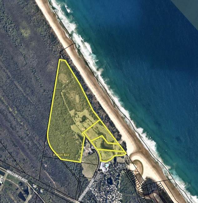
Figure 1: Subject site area
Summary of Proposed Changes
The changes proposed within the DCP provide for additional development and design controls to be applied to future residential development within this site. Details of the changes can be found in attachment 1, with the key changes summarised below.
· Prohibition of cats within the area, and requirements to provide for fenced areas for any dog kept on the property.
· Provision for a public pedestrian access corridor to ensure that access to the beach front area is maintained.
· A range of controls for future dwellings on the site that will ensure that future development has consideration for design, environmental constraints and sustainability. That will be provided for in addition to existing controls within other DCP chapters.
· A control to limit the maximum site coverage for each dwelling on any lot created.
Overall, the changes proposed will allow for greater clarity and control for future dwellings on this land and a better response to the environmental constraints. These constraints were considered during the rezoning of the land and will be further investigated as development applications for subdivision and associated dwellings are made on the land.
The proposed amendments to chapter E5 will work in concert with other existing DCP 2014 controls for residential development and do not seek to alter those controls.
North Byron Design Guide
In addition to the proposed amendments to chapter E5, the applicant has also prepared the “North Byron Design Guide” (attachment 2). This document is not proposed to be included Chapter E5 for assessment purposes, but instead provides an additional layer of architectural design considerations for future owners — noting that Council will not be responsible for managing or enforcing this document. This Guide will be managed by the developer of the land as a document to provide future landowners with greater guidance on the character and design of future dwellings and associated elements in the E4 Environmental Living Zone.
In accordance with the Environmental Planning and Assessment
Regulation 2021, it is recommended that the proposed amendments to chapter E5
should be exhibited for public comment.
Strategic Considerations
Community Strategic Plan and Operational Plan
|
CSP Objective |
L2 |
CSP Strategy |
L3 |
DP Action |
L4 |
OP Activity |
|
Community Objective 4: We manage growth and change responsibly |
4.1 |
Support the visions and aspirations of local communities through place-based planning and management |
4.1.3 |
Manage development through a transparent and efficient assessment process |
4.1.3.10 |
Prepare and assess Planning Proposals and Development Control Plans, and amend Local Environmental Plan maps |
Recent Resolutions
· 20-470 – to prepare a planning proposal to rezone a section of land at North Beach Byron to E4 Environmental Living and implement the agreed E2 and E3 environmental zones across the site.
· 21-493 – adoption of planning proposal and required amendments to DCP 2014 Chapter ‘E5 - Certain Locations in Byron Bay and Ewingsdale’.
Legal/Statutory/Policy Considerations
This proposal seeks to amend the DCP 2014. All relevant policy implications have been discussed above. The proposed amendment will be exhibited as per the statutory requirements.
Financial Considerations
This is an Applicant funded DCP amendment, all costs will be borne by the applicant.
Consultation and Engagement
It is recommended that the DCP will be exhibited for a minimum of 28 days as per legislative requirements.
BYRON SHIRE COUNCIL
Staff Reports - Sustainable Environment and Economy 13.9
Report No. 13.9 Update Resolution 23-462 Waiver of contributions on secondary dwellings
Directorate: Sustainable Environment and Economy
Report Author: Shannon Burt, Director Sustainable Environment and Economy
File No: I2023/1745
Summary:
Council considered a Notice of Motion No. 9.3 Waiver of contributions on secondary dwellings Agenda of Ordinary (Planning) Meeting - Thursday, 12 October 2023 (infocouncil.biz) and Resolved 23-462:
That Council receives a report by December outlining the mechanisms, if any, whereby we could constrain the future use of both dwellings for the purposes of providing affordable and/or permanent accommodation, in exchange for a full or partial waiver of contributions on the secondary dwelling.
This report talks to Resolution 23-462.
RECOMMENDATION:
That Council:
1. Notes the update provided on Resolution 23-462 Waiver of contributions on secondary dwellings and the suggested mechanisms that could be utilised to support such a proposal.
2. Supports an amendment to the Affordable Housing Contribution Policy 2020 or creation of a new policy to give effect to a framework and suite of mechanisms to constrain the future use of dwellings for the purposes of providing affordable and/or permanent accommodation, in exchange for an agreed level of funding or other support from Council.
3. Notes that a forward budget bid of $20,000 will be included in the FY 24/25 Operational Plan and Budget process for an expression of interest process to support 2.
Report
Background
Resolution 23-462 acknowledges the previous waiving of contributions that Council put in place for the period early 2011- 2018.
Council resolved at this time to waive the requirement to pay section 94 and section 64 charges for secondary dwellings.
The purpose of the waiver was to promote housing affordability. The waiver applied to secondary dwellings approved under the terms of the then State Environmental Planning Policy (Affordable Rental Housing) 2009 (SEPP). Various reports to council talk to this.
The waiver was discontinued in 2018 (Report No. 13.24 Contributions for Secondary Dwellings Agenda of Ordinary Meeting - 22 February 2018 (infocouncil.biz)) as it was found to not be achieving its intended affect due to matters such as short-term rental usage of the approved secondary dwellings instead of long-term rental usage. There was a significant cost to council ongoing the result of this waiver that has not been recouped.
Lessons learnt being that a better mechanism/s is needed to incentivise and then enforce the future use of dwellings for the purposes of providing affordable and/or permanent accommodation.
More recently, the Independent Planning Commission Advice Report on the Byron Shire Short Term Rental Accommodation Planning Proposal stated extract page iv:
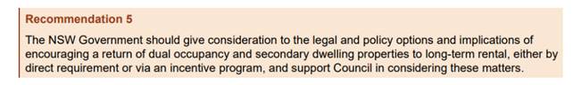
In the absence of a State Government approach, a local response is proposed below.
Permanent and Affordable Housing
An agreement on what is meant by permanent and affordable rental housing is necessary for this resolution, and in the context of Byron Shire.
Council’s Affordable Housing Contribution Policy states that Council:
favours affordable housing contributions that improve the supply of smaller dwellings (1- 2 bedroom) such as self-contained units in retirement villages, residential flat buildings and multi-dwelling housing suited to smaller households.
It is suggested that the following definitions could be used to define the type of tenure and occupancy for the purposes of the resolution. These definitions would need to be included in a policy.
Permanent Rental accommodation Byron Shire
Permanent / long term lease or rental is one that exceeds 12 months.
Affordable Rental Accommodation Byron Shire
Affordable Rental Accommodation in Byron Shire will target low to moderate-income households and is to be priced to be affordable to them. This would mean that housing costs (rental included) should not exceed 30 per cent of gross household income.
2021 Census stats: Median weekly household income $1,561: Median weekly rent $600
Mechanisms
Incentivise
Rebates/Fee waiver or deferral
Council may look to rate rebates and or defer/waive other fees and charges for ‘dwellings’ (as part of a dual occupancy development) or secondary dwelling nominated for permanent rental accommodation through an approved mechanism.
However, in doing so, this will result in a loss of income to council which would need to be offset by an alternate funding source and or be offered as a standalone subsidy or grant.
A broad application of a rate rebate or fee waiver or deferral is not supported without further work on financial impacts.
See Financial comments below.
Enforce
Partner with a Community Housing Provider
The landowner enters into a formal arrangement with a Community Housing Provider to lease their property on the private rental market. Council would include the property details on a register for the purposes of monitoring and compliance.
Planning Agreement
The landowner enters into a planning agreement either at a rezoning or development application stage in accordance with Council adopted policies to provide for permanent affordable rental housing on their land.
Restrictions on the Use of Land intended to be created pursuant to Section 88B Conveyancing Act 1919
The landowner agrees to execute any document necessary to create a restriction on the use of (part of) the land so as to prohibit (part of) the land being used for short term rental accommodation.
Conditions on Consent
Conditions are imposed on a Development Consent restricting future use of the development in part or full, for permanent affordable rental housing.
Continuing to use this mechanism should be selectively considered as it is complicated in law.
Options
Council has an adopted Affordable Housing Contribution Policy 2020. This policy sets how Council intends to operate the contribution framework in Byron Shire,
Objective 3.2 provide for the policy to encourage and adopt innovative and flexible approaches to the provision of affordable housing in a manner that is consistent with Byron Shire Council’s strategic and infrastructure plans and as so enabled under the Act.
A review of this policy is now needed with the Residential Strategy Refresh nearing completion.
A new policy statement is needed to give effect to the mechanisms above. Whether this policy is the appropriate place to address this resolution or a new policy is needed is yet to be determined.
Following development of a policy, a Pilot Program would be the most appropriate way to test interest in and the various mechanisms to deliver on a potential, return of housing stock to permanent affordable rental housing.
To this aim, Council could allocate funding ($20,000) for a pilot program.
An expression of interest could be called for property owners that meet the policy to receive a defined rate rebate or fee or charge subsidy for a nominated period i.e., the term of the use of the dwelling for permanent affordable rental housing.
Next steps
Staff to amend the Affordable Housing Contribution Policy 2020 or create a new policy.
A forward budget bid of $20,000 be included in the FY 24/25 Operational Plan and Budget process for an expression of interest process to support the policy.
Strategic Considerations
Community Strategic Plan and Operational Plan
|
CSP Objective |
CSP Strategy |
DP Action |
Code |
OP Activity |
|
4: Ethical Growth |
4.2: Enable housing diversity and support people experiencing housing insecurity |
4.2.3: Legislation changes - Establish planning mechanisms and advocate for changes to legislation to support housing that meets the needs of our community |
4.2.3.1 |
Prepare submission/s on draft changes to State government planning policy or legislative reforms |
Legal/Statutory/Policy Considerations
As discussed in the report.
Financial Considerations
It is understood that Council is looking for ways to facilitate permanent and affordable housing for via dual occupancy or secondary dwellings housing types.
Incentive Mechanism
If Council is looking at financial incentives to do this, it should not waive any:
· Development fees
· Developer Contribution fees
· Rezoning fees
· On going rates and service (water, sewer and waste) charges
Instead, it should create a budget as suggested in the report as a pilot to fund these fees plus any legal fees for registration of a covenant on the title if that option is taken up. There are specific reasons why it is suggested Council provides budget to fund any financial incentives mentioned above as follows:
1. Avoid any potential legal doubt as to whether Council actually has the ability to waive the rate/fees/charge (ie rates).
2. At the higher level, Council does not reduce the revenues it would normally get from rates and charges, development fees and rezoning fees.
3. With developer contributions, the intent of the developer contributions plan (either Section 7.11 or Section 64) is not diminished to provide infrastructure/facilities under those plans through reduced contributions.
By creating a budget, there is then the ability for Council to pay these fees related to any proposed property, it will also enable Council to identify the level of support being provided to and is a similar process used when payment of rates and charges is made for properties under Council’s Section 356 Donations – Rates and Charges Policy albeit in this case the payment would not be considered a donation.
Determination of incentive level/funding support
Council would need to establish the level of support it would be willing to contribute per applicant under any proposed arrangement. This could be either 100% or a lesser level. As an example, under Council’s S356 Rates and Charges Donations Policy, it provides payment of 100% of the ordinary rates and all fixed service charges but not usage charges ie water consumption.
Council in determining a level, would also need to understand how the current rates, fees and charges are implemented. As an example, the below illustrates how rates and charges are imposed:
For a property with a secondary dwelling, if it is not strata-titled, it is treated for the purposes of rating as one rateable assessment. The calculation of ordinary rates is also dependent upon the unimproved capital land value. That is a minimum rate of $1,000 is normally payable if unimproved land value is $926,000 or less. For the imposition of water, sewerage and waste charges it depends upon the water meter size connected to derive the applicable water and sewerage fixed charges. For waste charges, it depends upon the number/size of bins and frequency of service to determine the waste charge. None of these charges are currently raised based on the number of dwellings on a property if they are not strata-titled.
Essentially for Byron Shire Council, a property is charged for the majority of fixed service charges based on the size of the connected services. It is acknowledged, other Councils may use the approach of charging based on the number of ‘self-contained occupancies’ located on a property that is not strata titled.
It is suggested, whatever methodology Council may want to utilise, that it does not subsidise any property usage charges i.e. water consumption.
Surety over incentives/funding provided
Should Council determine a level of financial incentives for secondary dwellings or dual occupancies provided for affordable housing, it should ensure any incentives or funding is not lost for the intended purpose or any loss is minimised. It is suggested that a binding agreement needs to be established with the property owner and whether that agreement includes enforceable clauses to the extent that if the agreement is not maintained as struck, then Council has the right to claim back any financial incentives provided. Council would need to decide whether this is based on an annual scenario during the life of the agreement or for charges that are once off ie development, developer contributions etc payable up front are reclaimable and how that is done.
Council will need to be mindful of the debt recovery scenarios here as rates/charges are property debts and can be secured against a property whereas other forms of incentives may not. This would need to be covered off in any agreement.
Funding a Pilot Program/Expression of Interest
Recommendation 4 to the Report outlines provision of a budget bid in the 2024/25 Operational Plan and Budget process. Whilst this is a matter for Council, as an alternate if it wished to provide funding in the 2023/24 financial year, the Property Reserve has capacity to fund $20,000.
Consultation and Engagement
Not applicable to this report.
BYRON SHIRE COUNCIL
Staff Reports - Sustainable Environment and Economy 13.10
Report No. 13.10 Bypassed Town Signage- Mullumbimby
Directorate: Sustainable Environment and Economy
Report Author: Lisa Richards, Industry Engagement Lead
File No: I2023/1749
Summary:
Roads and Maritime Services (now Transport for NSW) identified Bangalow, Brunswick Heads and Mullumbimby as towns bypassed by the Pacific Highway that qualify for a new type of image-based road sign. The signs aim to promote bypassed towns in rural and regional NSW.
From 14 December 2020 to 31 January 2021, Council conducted online consultation for proposed bypassed town signage for Bangalow, Brunswick Heads and Mullumbimby. Approximately 180 community members provided feedback on whether the signs should be implemented, as well as proposed types of images and service symbols.
A separate report was prepared for Bangalow and Brunswick Heads bypassed town signage for endorsement at the 23 November 2023 Council meeting.
Proposed bypassed town signage for Mullumbimby is included in this report, based on above consultation. This report is to seek Council endorsement of the signage artwork provided by Transport for NSW. The artwork is in line with Attachment 2 Outcomes from Bypassed Town Signage Consultation January 2021 report and has been endorsed by Mullumbimby Chamber of Commerce.
Once endorsed by Council, Transport for NSW’s North Region Director’s approval is required, then they will then send to the local member for concurrence. Once the local member has endorsed, Transport for NSW will finalise the signs, manufacture and install. Transport for NSW will issue a media release when the signs are installed.
RECOMMENDATION:
That Council:
1. Notes the Bypassed Town Signage Consultation report, January 2021. (Attachment 1 E2021/27467).
2. Endorses the proposed Mullumbimby Bypassed Town Signage Image included in this report at Figure 1.
1 Outcomes
from Bypassed Town Signage Consultation January 2021, E2021/27467 ![]()
Report
The NSW Government has introduced an initiative for a new type of image-based road sign which aims to promote bypassed towns in rural and regional NSW.
These signs are positioned close to the exit of a motorway and use colour images to show key features of the bypassed towns to encourage visitation. Bypassed town signage also displays service symbols to highlight available services and facilities to assist travellers on their journeys and encourage rest breaks. The NSW Government have prepared a Bypassed Town Signage Fact Sheet.
Bangalow, Brunswick Heads and Mullumbimby were identified by the Roads and Maritime Services (now Transport for NSW) as towns bypassed by the Pacific Highway that qualify for these signs.
Council was responsible for engaging community on the photographic images and symbol selection deemed appropriate for use on the signs for their bypassed town/s.
At the 25 June 2020 Council meeting it was resolved that staff consult with key community stakeholders of Bangalow, Brunswick Heads and Mullumbimby to assist with the selection of proposed images and service symbols for each of the bypassed town signs in accordance with the guidelines from Roads and Maritime Service, and advise the Roads and Maritime Services of the outcome of the consultation (refer to resolution 20-303).
Approximately 180 community members provided feedback on whether the signs should be implemented, as well as proposed types of images and service symbols. A selection of proposed images for the online survey were identified in consultation with local Chambers of Commerce.
Consultation was promoted via Council’s social media platforms, a media release, email to key stakeholders and Council’s Business e-newsletter.
Local Chambers of Commerce expressed interest in identifying local photographers for taking the final imagery. This information was passed on to Roads and Maritime Services.
The outcomes report was provided to Roads and Maritime Services on Thursday 25 February 2021 and is attached (Attachment 1).
A separate report was prepared for Bangalow and Brunswick Heads bypassed town signage for endorsement at 23 November 2023 Council meeting.
Bypassed town signage artwork for Mullumbimby, provided by Transport for NSW (formerly Roads and Maritime Services) and in line with consultation in the attached Outcomes from Bypassed Town Signage Consultation January 2021 report is below for review and endorsement.
Mullumbimby Chamber of Commerce has reviewed and endorses this artwork based on consultation to date.

Figure 1: Mullumbimby bypassed town signage artwork for Council endorsement
Key issues
Council conducted online community consultation in December 2020/January 2021 and provided an outcomes report to Roads and Maritime Services (now Transport for NSW) and the local member on Thursday 25 February 2021.
Next steps
· Council endorsement is sought for the Mullumbimby bypassed town signage, which includes selected images and service symbols in line with Council’s consultation report.
· Council endorsement to be provided to Transport for NSW, with an outline of consultation carried out to determine images and service symbols.
· Approval from Transport for NSW’s North Region Director and sent to local member for concurrence.
· Once endorsed by local member, Transport for NSW will finalise the signs and send for manufacture and installation.
· Transport for NSW to issue a media release when signs are installed.
Strategic Considerations
Community Strategic Plan and Operational Plan
|
CSP Objective |
CSP Strategy |
DP Action |
Code |
OP Activity |
|
4: Ethical Growth |
4.4: Foster sustainable visitation and manage the impacts of tourism on the Shire |
4.4.3: Sustainable visitation - Investigate opportunities to mitigate peak tourist demands on local amenity and infrastructure |
4.4.3.1 |
Continue to liaise with our business and tourism industry |
Recent Resolutions
· Res 20-303
Legal/Statutory/Policy Considerations
N/A
Financial Considerations
N/A
Consultation and Engagement
From 14 December 2020 to 31 January 2021, Council conducted online consultation regarding proposed bypassed town signage for Bangalow, Brunswick Heads and Mullumbimby.
BYRON SHIRE COUNCIL
Staff Reports - Sustainable Environment and Economy 13.11
Report No. 13.11 Submissions Report - Busking Policy
Directorate: Sustainable Environment and Economy
Report Author: Dylan Johnstone, Development Investigations Lead
File No: I2023/1799
Summary:
Council considered Report 13.14 Busking Policy Review at Agenda of Ordinary Meeting - Thursday, 22 June 2023 (infocouncil.biz) and resolved to put the Policy on exhibition and receive a report detailing submissions made.
RECOMMENDATION:
That Council:
1. Acknowledges the submissions detailed in Attachment 1 (E2023/121754) in response to the public exhibition of the Draft Busking Policy.
2. Adopts the Draft Busking Policy detailed in Attachment 2 (E2023/122264) which has been amended where appropriate to reflect submissions received.
3. Agrees to obtain public liability insurance to cover busking permit holders and for the cost of insurance to Council be recovered by increasing busking permit fees.
4. Agrees that the proposed fee increase for busking permits to include public liability insurance be placed on public exhibition for a period of 28 days in accordance with Section 610F of the Local Government Act 1993. That if:
a) submissions objecting to the fees are received, they are reported to Council for consideration.
b) no objections to the fees are received, Council adopts the fees.
Attachments:
1 Confidential - Public Submissions - Draft Busking Policy, E2023/121754
2 Draft
Policy; Busking 2023 post exhibition version, E2023/122264
![]()
Report
Council considered Report 13.14 Busking Policy Review at its meeting 22 June 2023 and resolved to put the Policy on exhibition and receive a report detailing submissions made in accordance with Resolution 23-297.
23-297 Resolved that Council:
1. Places the Draft Busking Policy in Attachment 1 (E2023/56924) on public exhibition for a minimum period of 28 days.
2. Following exhibition, receives a further report detailing submissions made.
To recap, Council resolved via 22-727 that Council addresses issues with busking in the town centre of Byron Bay, specifically the use of large speaker systems and busking in non-designated areas, by revising the policy and providing better guidance for the benefit of all concerned.
It is also noted that Council resolved via 18-361 that Council’s Busking Policy be amended to include the Byron Visitors Centre leased site as a designated busking site.
Proposed amendments
Council’s Busking Policy was first adopted in 2001 and has been amended on several occasions with the most recent amendment occurring in 2013.
Proposed changes to the current Busking Policy included in the Draft presented to Council at its meeting 22 June 2023 included:
· Restriction of amplified busking so that it may only take place during specified hours and at designated sites in Byron Bay and during specified hours in all other areas of the shire.
· Clear conditions that busking must not be repetitive in nature and must not result in offensive noise
· Prohibition of the use of dangerous materials and implements which are defined as materials and implements that pose a risk, hazard or uncertain outcomes for people.
· Requirement for buskers to obtain public liability insurance of a minimum $20 million to indemnify Council against any liability arising from busking activities and to demonstrate this when making an application.
· Inclusion of the Byron Visitor Centre as a designated busking site.
· Removal of two sites currently identified as designated sites in Jonson Street as per Annexure 4 of the current Policy. These sites are proposed to be removed as staff are of the view that the percussion and circle busking acts currently permitted in these locations are more appropriate to be located in Apex Park, Railway Park and the Byron Visitor Centre.
· Inclusion of a condition for busking that encourages informal self-regulation by individual buskers and the busking community to ensure that compliance with the Policy is achieved at all times.
· Requirement for buskers to submit a passport-sized identification photograph when making application for a permit and to display the photograph while busking so that authorised officers are able to identify that the person busking is the holder of a permit.
· Requirement for a busking group to be limited to a maximum of four (4) performers.
Exhibition
The Draft Policy was on public exhibition from 3 July to 30 July 2023 and a total of fourteen (14) submissions were received which are included in Attachment 1 of this report.
A summary of issues raised within submissions on the Draft Policy and staff responses are outlined below:
1. Buskers should not be required to have public liability insurance, and this should be covered by Council or built into the licence fee
Staff response: Further discussion between staff and Council’s insurer has determined that Council may take out an insurance policy to cover public liability insurance for buskers at a cost of $11.00 per busker, with a minimum policy cost of $520 + charges and admin fee. It is noted that Council issues an average of 165 busking permits per year. Staff propose that the existing fees for busking permits be increased to cover the cost of insurance to Council.
In accordance with Council’s 2023/24 Revenue Policy, busking permit fees consist of:
Application fee (one off fee) $28.00
Yearly fee $17.00
Monthly fee $6.00
All busking permit holders are required to pay the one off fee of $28.00. Therefore staff considers it appropriate if the yearly fee is increased by $11.00 from $17.00 to $28.00 and the monthly fee is increased by $1.00 from $6.00 to $7.00 on a pro rata basis.
The Draft Busking Policy has been amended to clarify that buskers are not required to demonstrate their own public liability insurance as they will be covered by Council’s own insurance policy.
2. Support for limits on volume
Staff response: In order to address community concerns regarding noise impacts from amplified busking in the town centre of Byron Bay, the Draft Policy limited amplified busking to designated areas only. It is considered that attempting to place specific noise limits on buskers (i.e. maximum decibels, volume units etc.) would be impractical to enforce. The Draft policy already requires that amplified busking in the designated areas is carried out only with the use of battery operated amplifiers and the use of mains electricity or generators is prohibited.
3. Generally, too restrictive (the Policy)
Staff response: Submission is personal opinion.
4. There needs to be more designated sites for amplified / percussion busking which can be controlled by limiting amplified busking to between certain hours
Staff response: The sites designated for amplified / percussion busking identified in the Draft Policy were selected due to their location away from shopfronts and residences to address a common source of complaints to Council.
5. The maximum number of 4 members of a busking group is too restrictive and should be increased to 6
Staff response: The Draft Policy has been amended to increase the maximum permitted number of members of a busking group to six (6).
6. There should be no limit on the number of performers within a group
Staff response: A limit has been applied to ensure pedestrian access and the ability of other users of public spaces are not adversely impacted.
7. The requirement to have each and every registered member of a busking group present with no absences or substitutions is too prescriptive
Staff response: The Draft Policy has been amended to permit absences however substitutions should not be permitted due to the need to be able to easily identify approved permit holders.
8. The policy needs to include some level of quality and suitability control. At the moment there is none, we simply apply and are granted a licence
Staff response: Staff do not intend to restrict the type or quality of performances.
9. In recent years some buskers have been using amplifiers that are too powerful (i.e. 2500 Watt) when 25 Watt is more than adequate
Staff response: See comments in response to issue no. 2.
10. Amplification should be limited to a certain level i.e. VU (volume units) to be displayed on busker signage. A VU reading app on a smart phone can be used to regulate this
Staff response: See comments in response to issue no. 2.
11. Focus should be on limiting noise from amplified busking rather than pushing amplified busking into designated areas only
Staff response: See comments in response to issue no. 2.
12. Existing Busking Policy should be kept as is
Staff response: Current Policy is outdated and requires review.
13. There is no need for hourly limits as this can be negotiated amongst the buskers themselves competing for the same location
Staff response: Hourly limits are required to reduce impact on neighbouring businesses, residences and other uses of public spaces.
14. Other local government areas have addressed noise issues from amplified busking by either prohibiting amplification (Fremantle, WA) or limiting time allowed.
Staff response: Noted – see comments in response to issue no. 2.
15. Amplified busking should be banned
Staff response: This was an isolated response and not a general reflection of submissions received.
16. Please advise which sites in Jonson St are proposed to be closed
Staff response: The existing Busking Policy adopted in 2013 included two (2) designated percussion busking and circle act sites in Jonson Street. These sites are in front of 6 Jonson Street (on the western side of Jonson Street north of the Lawson Street roundabout) and in front of 35 Jonson Street (The Great Northern Hotel). For the reasons outlined in the staff response to issue no. 2, percussion and amplified busking are deemed to be inappropriate in the town centre and should only be permitted at the designated sites identified in the Draft Policy. The Draft Policy has also identified that circle busking acts are only permitted at these designated sites to ensure pedestrian access and the ability of other users of public spaces are not adversely impacted.
17. Definition of offensive noise is problematic as it refers to a person affected “outside the premises from which the noise is emitted” – busking usually occurs in the street / open areas, not inside premises. Definition should include people who are inside premises i.e. shop or residence being impacted by noise from outside.
Staff response: The definition used in the Draft Policy was adopted from the Protection of the Environment Operations Act 1997. Following submissions, the definition of offensive noise as per the Draft Policy has been amended to be more simple and enforceable by authorised officers.
18. Condition requiring buskers to obtain permission to busk in front of a shop / business should be extended to include residences (including shop top housing).
Staff response: The Draft Policy has been amended to specify that, if a complaint is received from a resident about a busker directly in front of residential accommodation not busking in accordance with the Policy, an authorised officer will request that the busker move from the location.
19. Confusion regarding amplified busking in designated sites. Section 2.4 designated sites states that amplified busking is only permitted in those areas identified in the site maps – does this mean that amplified busking is not permitted at any other location?
Staff response: As per the Draft Policy, amplified busking is only permitted at the designated sites in Byron Bay. The Draft Policy has been amended to clearly specify that, outside of Byron Bay, amplified busking will be considered on merit at any location upon application of a busking permit.
20. Section 10 states that in Byron Bay amplified busking is only permitted at designated sites but the next paragraph states that busking is permitted at any other location in Byron Bay?
Staff response: See comments in response to issue no. 19.
21. Are the designated sites reserved only for percussion / circle / amplified busking?
Staff response: Percussion / circle / amplified busking are only permitted at the designated sites. These sites do not prohibit any other form of busking from occurring there.
22. Amplified busking up to 10pm still has the potential to unduly impact residences.
Staff response: It is considered that limiting amplified busking to the designated sites within Byron Bay and limiting the power source of amplifiers to batteries will ensure that residences are not unduly impacted by noise during the permitted hours of amplified busking from 6.00pm to 10.00pm.
23. Amplified busking in Apex Park will conflict with live music at the Beach Hotel. The most appropriate busking area in Apex Park is located to the north east in the area bounded by the car park and foreshore as reflected by current busking activity.
Staff response: This comment is noted and staff have responded by relocating the designated site in Apex Park to the suggested area to minimise conflict with the Beach Hotel and to reflect existing busking activity.
24. The policy mentions conditions for busking to encourage self-regulation by buskers and the busking industry but there is no such thing as a busking industry.
Staff response: Reference to busking industry has been amended to busking community.
25. Buskers should be required to display a sign with a phone number for the public to direct any complaints.
Staff response: Busking permits issued by Council include Council’s contact details and it is a condition of the Draft Policy that buskers must display their permit in a prominent, highly visible position in the busking site at all times during their acts.
26. Variation of content - repetitiveness is open to interpretation and difficult to enforce and suggest a contact number if audiences find the content annoying.
Staff response: See comments in response to issue no. 25.
27. Railway park – no one ever busks here
Staff response: Noted. For the reasons outlined in the staff response to issue no. 2, percussion and amplified busking are deemed to be inappropriate in the town centre and therefore are only permitted at the designated sites identified in the Draft Policy. The Draft Policy has also identified that circle busking acts are only permitted at these designated sites to ensure pedestrian access and the ability of other users of public spaces are not adversely impacted.
28. Visitor centre – no one ever busks here
Staff response: Noted – see comments in response to issue no. 27.
29. Busking locations should be outside Woollies in Jonson St, outside Aldi, outside IGA, corner opposite the clock in Byron St, beachfront in Apex Park, west side of the lighthouse
Staff response: Noted – all of these sites are permitted for busking while amplified busking, percussion busking and circle acts are only permitted in Apex Park and the other designated sites.
30. In Europe and England buskers have QR codes with a fixed basic donation – is this considered to be soliciting?
Staff response: This is a question rather than a submission however staff are of the view that the use of QR codes with a fixed or flexible donation does not constitute soliciting of funds as defined by the Draft Policy.
Amendments to the Draft Policy as indicated above are shown highlighted in Attachment 2.
Strategic Considerations
Community Strategic Plan and Operational Plan
|
CSP Objective |
CSP Strategy |
DP Action |
Code |
OP Activity |
|
1: Effective Leadership |
1.1: Enhance trust and accountability through open and transparent leadership |
1.1.1: Leadership - Enhance leadership effectiveness, capacity, and ethical behaviour |
1.1.1.1 |
Coordinate Council's annual policy review program, update and publish adopted policies |
|
2: Inclusive Community |
2.2: Enhance safety and contribute to the physical, mental, and spiritual health and well being of our people. |
2.2.2: Public health – Protect, promote and control risks to public health |
2.2.2.4 |
Monitor, investigate and respond to public and environmental health matters through proactive inspections and surveillance programs. |
Recent Resolutions
· 18-361
· 22-727
· 23-297
Legal/Statutory/Policy Considerations
The relevant legal/statutory/policy considerations have been noted above.
Financial Considerations
Liability Insurance and Fees and Charges changes the result of the Policy review and submissions have been noted above.
Consultation and Engagement
Council must give public notice of a draft Policy after it is prepared under Local Government Act 1993 – Section 160 Public notice and exhibition of draft local policy.
Under the Local Government Act 1993 – Section 160 the period of public exhibition must be not less than 28 days.
The draft Busking Policy was placed on public exhibition for 28 days from 3 July to 30 July 2023.
All submissions are included in Attachment 1 of this report.
BYRON SHIRE COUNCIL
Staff Reports - Sustainable Environment and Economy 13.12
Report No. 13.12 Review of Council's Onsite Sewage Management Strategy 2001 and Onsite Sewage Management Guidelines 2004
Directorate: Sustainable Environment and Economy
Report Author: Tim Connors, Team Leader Environmental Health
File No: I2023/1805
Summary:
Council’s Environmental Health Team, together with Tim Fitzroy of Fitzroy & Associates, have reviewed the Onsite Sewage Management Strategy 2001 and Onsite Sewage Management Guidelines 2004.
A draft Onsite Sewage Management Strategy and Guidelines were placed on public exhibition for six weeks, during which nine submissions were received.
As a result of the submissions received, the draft Onsite Sewage Management Strategy and Guidelines has been amended to include several recommendations.
This report recommends that Council adopt the draft Onsite Sewage Management Strategy and Guidelines as amended.
That Council adopts the draft Onsite Sewage Management Strategy 2023 (E2023/74357) and draft Onsite Sewage Management Guidelines 2023 (E2023/95318) amended as a result submissions received during public exhibition.
1 Final
Updated Onsite Sewage Management Strategy 2023, E2023/74357 ![]()
2 Final
updated Onsite Sewage Management Guidelines 2023, E2022/95318 ![]()
3 Submissions
Report, E2023/121771 ![]()
Report
Background
Council’s Onsite Sewage Management Strategy and Onsite Sewage Management Guidelines have been in place since 2001 and 2004, respectively. Due to ongoing changes since that time, deficiencies in Council’s strategy and guidelines were identified by Council staff, designers, and installers.
To address the deficiencies, Council’s Environmental Health Team engaged Tim Fitzroy of Fitzroy and Associates to review and update Council’s documents.
Following benchmarking against best practice Onsite Sewage Management System policies throughout Australia, Council’s Environmental Health Team, together with Tim Fitzroy of Fitzroy and Associates, conducted several workshops. These workshops resulted in the revised draft Onsite Sewage Management Strategy and Onsite Sewage Management Guidelines.
On 20 October 2022, the draft strategy and draft guidelines were reported to the Water and Sewer Advisory Committee (see agenda here). The committee resolved that staff take onboard feedback and also consider further amendments to the documents (see minutes here).
The draft strategy and draft guidelines were amended as part of that resolution to incorporate recommended changes and were presented back to the Water and Sewer Advisory Committee on 30 March 2023 (see agenda here). The committee resolved to convene a further meeting between staff and available committee members prior to reporting the documents to Council (see minutes here).
On 23 August 2023, the draft strategy and draft guidelines were reported to Council. Council resolved via 23-112 to support the public exhibition of the draft Onsite Sewage Management Strategy 2023 and the draft Onsite Sewage Management Guidelines 2023 for a minimum six-week period to allow for community feedback and submissions Minutes of Ordinary Meeting - Thursday, 24 August 2023 (infocouncil.biz). During the public exhibition period Council received nine submissions which are contained in the attached submissions report (Attachment 3).
Response to submissions
Changes have been made to both the draft Strategy and draft Guidelines as follows:
- Wording of preferred viral die-off method amended and example provided in Appendix A has now been omitted
- Amendment made to include advanced secondary treatment systems
- Inconsistencies regarding requirement of suitably qualified persons amended
- Amendment made to operational maintenance requirements
- Amendment made to acid sulfate soil management requirements
- Amendment to the definition of habitable rooms
- Amendment made to the calculation of land application areas for community title, multiple occupancies and dual occupancies
Final updated documents are Attachments 1 and 2 to the report for adoption.
Strategic Considerations
Community Strategic Plan and Operational Plan
|
CSP Objective |
CSP Strategy |
DP Action |
Code |
OP Activity |
|
1: Effective
Leadership |
1.1: Enhance trust and accountability through open and transparent leadership |
1.1.1: Leadership - Enhance leadership effectiveness, capacity, and ethical behaviour |
1.1.1.1 |
Coordinate Council's annual policy review program, update and publish adopted policies |
|
1:
Effective Leadership |
1.2: Engage and involve community in decision making |
1.2.1: Community-led decision making - Engage with community to inform Council decision making |
1.2.1.1 |
Provide opportunities for the community to have input, comment and feedback to Council on projects and matters of interest. |
|
1: Effective
Leadership |
1.2: Engage and involve community in decision making |
1.2.1: Community-led decision making - Engage with community to inform Council decision making |
1.2.1.2 |
Support staff to consider communication and engagement as part of all project development and implementation. |
|
1:
Effective Leadership |
1.2: Engage and involve community in decision making |
1.2.4: Advisory Committees - Coordinate advisory committees to inform decision making on their areas of expertise |
1.2.4.1 |
Coordinate and support Advisory Committees to assist with effective Council decision making |
Recent Resolutions
· 23-1112
· 22-645
· 22-646
· 13–135
· 07-231
Legal/Statutory/Policy Considerations
· Protection of the Environment Operations Act 1997
· Local Government Act 1993
· Local Government (General) Regulation, 2005.
· Byron Shire Council (2018). Policy No. 14/009. On-Site Sewage management Systems in Reticulated Areas.
· Byron Shire Council (2001) On-site Sewage Management Strategy. November 2001.
· Byron Shire Council (2004) Design Guidelines for On-site Sewage Management for Single Households. 1 December 2004.
· Byron Shire Council Community Engagement Policy 2018.
Financial Considerations
Not applicable to this report.
Consultation and Engagement
As discussed in the report.
BYRON SHIRE COUNCIL
Staff Reports - Sustainable Environment and Economy 13.13
Report No. 13.13 PLANNING - 10.2014.361.4 s4.55 modification Waves Motel at 35 Lawson Street Byron Bay
Directorate: Sustainable Environment and Economy
Report Author: Rob Van Iersel, Contract Planner
File No: I2023/1844
Proposal:
|
Modification No |
10.2014.361.4 |
||
|
Planning Portal Ref |
PAN-272941 |
|
|
|
Proposed modification |
S4.55 to Relocate Part of a Food and Drink Component previously Approved within an Existing Motel Development from the Ground Floor to a Roof Terrace Area NOTE: subsequently amended to delete food and drink component; application now for roof-top recreation terrace for motel guests |
||
|
Original Development |
Alterations and additions to existing motel |
||
|
Type of modification sought |
4.55(2) Other modifications |
||
|
Property description |
LOT: 7 SEC: 8 DP: 758207 |
||
|
35 Lawson Street BYRON BAY |
|||
|
Parcel No/s |
116660 |
||
|
Applicant |
The Trustee for MP MANAGEMENT (AUST) HOLDINGS TRUST |
||
|
Owner |
MP Pacific Investments Pty Ltd |
||
|
Zoning |
E1 Local Centre |
||
|
Date received |
2 November 2022 |
||
|
Original DA determination date |
22 October 2014 |
||
|
Integrated Development |
No |
||
|
Public notification or exhibition |
- Level 2 advertising under the Byron Shire Council Community Participation Plan. - Exhibition period: 17/11/2022 to 30/11/2022 - Submissions received: 25 submitters (15 in support, 10 objections) - Amended plans re-notified 2 November to 15 November - Submissions received: 9 submitters (5 in support, 4 objections) |
||
|
Delegation to determination |
Council |
||
|
Issues |
· Building height · Potential noise and amenity impacts |
||
Summary:
The s4.55 modification application as originally submitted proposed the establishment of a roof-top restaurant with a seating capacity for 60 people. A pergola structure was proposed over the seating area, with a sail structure that could be closed to the weather. Bi-fold doors were proposed around the perimeter, which could be closed to manage noise.
The proposal included a kitchen/ back of house, a new lift and stair access from the second floor, patron amenities and roof garden including a water feature, and a raised planter box around the roof’s perimeter.
The application was reported to the Council (Planning) Meeting of 12 October 2023 with a staff recommendation for refusal. The primary issue of concern related to exceedance of the 9.0m maximum building height, as the proposed modifications increased the previously approved building height by approx. 2.7m.
Immediately prior to the Council meeting, the applicant submitted amended plans intended to address the reasons for refusal, deleting the commercial component of the roof-top proposal.
At the Meeting, Council resolved to defer consideration of the application to enable public exhibition and assessment of the amended plans. See the following links on previous report to Council on 12 October 2023. https://byron.infocouncil.biz/Open/2023/10/PLAN_12102023_AGN_1622.htm#PDF2_ReportName_11534
The amended plans now show a roof-top terrace, located roughly in the centre of the roof, proposed for recreational use by motel guests. The applicants indicate that the terrace would be used for passive recreation by motel guests and their visitors and for exercise such as yoga etc.
The existing Waves Motel Building was approved in 1993 and includes a roof-top terrace area located between two accommodation units at the roof level.
Development Consent 10.2014.361.1 approved refurbishments to the roof and to level 2 to provide 4 accommodation units with a flatter roof line.
The amended plans provided with the current application propose to reinstate the roof-top terrace, but located to the western edge of the building, away from the Middleton Street frontage, so that it is less visible.
A unisex universal access toilet is proposed on the roof, located on the western edge of the building, with new stair and lift access and a small solar array. Planter boxes are proposed around the perimeter of the roof.
The revised proposal significantly reduces the extent of roof-top elements that exceed the 9.0m height limit in comparison to the plans originally submitted. The deletion of the restaurant component also significantly reduces the potential for amenity impacts.
It is recommended that the application, as now amended, be approved.
NOTE TO COUNCILLORS:
In accordance with the provisions of S375A of the Local Government Act 1993, a Division is to be called whenever a motion for a planning decision is put to the meeting, for the purpose of recording voting on planning matters. Pursuant to clause 2(a) under the heading Matters to be Included in Minutes of Council Meetings of Council's adopted Code of Meeting Practice (as amended) a Division will be deemed to have been called by the mover and seconder of all motions relating to this report.
RECOMMENDATION:
That, pursuant to Section 4.55 of the Environmental Planning & Assessment Act 1979, Application No. 10.2014.361.4, for modifications to an existing motel development to provide a roof-top terrace, be approved by modifying Development consent number 10.2014.361.1 in accordance with Attachment 1 E2023/122362 Recommended Modifications.
Attachments:
1 DA10.2014.361.4
Recommended Amended Conditions of Consent, E2023/122362
![]()
2 DA10.2014.361.4
Updated Architect Plan Set, E2023/111174
![]()
3 Confidential - submissions received from exhibtion 2 Nov to 15 Nov 2023, E2023/122213
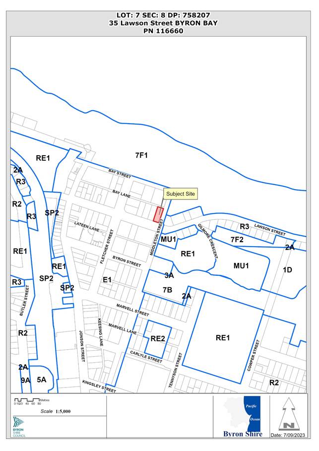 Assessment:
1. INTRODUCTION
1.1. History/Background
The existing Waves Motel was approved in October 1993 under Approval 1993/167. The top floor of the development approved an outdoor terrace, located between two accommodation units.
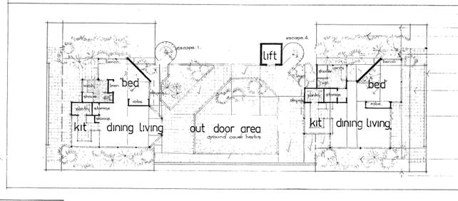
Figure 1: Originally Approved Roof Level
The approved plans indicate that the top of the building was at a height of approx. 9.6m, as shown below.
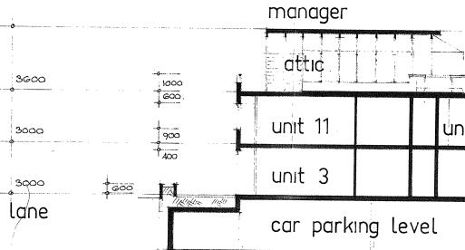
Figure 2: Originally Approved Building Height
Consent 10.2014.361.1 approved alterations to the existing Waves Motel, involving reconstruction of the top floor to provide four (4) penthouse units and a swimming pool. This involved a redesigned roof, removing the existing curved roof elements and roof-top terrace, which slightly lowered the overall building height.
The existing lift (and lift overrun) were maintained. Other minor changes included amendments to the basement to better facilitate the 27-car parking spaces and reorientating a stairwell on the first floor. No works were proposed on the ground floor.
The consent was modified under 10.2014.361.2 to stage the approved works. The Stage 1 works (modification to car park access ramp) were commenced and the consent therefore remains valid.
Modification application 10.2014.361.3 was lodged in later 2022, proposing similar rooftop modifications as the current application, but was subsequently withdrawn by the applicant.
Modification application 10.2014.361.4 (current application) was reported to the Council (Planning) Meeting of 12 October 2023, where Council resolved to defer consideration to allow public exhibition and assessment of revised plans.
1.2. Description of the proposed development
This application originally sought approval to modify the approved building to relocate a previously approved “coffee shop”, located within the ground floor lobby of the existing motel, from the ground floor to a new roof terrace area.
The relocation included upgrading the food and drink premises from a coffee shop to a café/ restaurant with a 60-seat capacity seating area. It also proposed an enclosed kitchen/ back of house, toilets, storeroom, lift and stairway access to the roof; an open roof garden including a water feature, and a raised planter box around the roof’s perimeter.
A pergola structure was proposed above the seating area, with retractable shade cover, and bi-fold doors and windows enclose the seating area.
Other proposed modifications included:
· Introduction of EV charging stations into the basement car park;
· Provision of a “dumbwaiter” to link kitchen on ground floor with rooftop café/ restaurant; and
· Amend access to rooftop terrace to provide stair access from level 2.
The modification application has subsequently been amended to remove the café/ restaurant component.
The application now proposes a roof-top terrace area to be used by motel guests and their visitors. The previously proposed kitchen / back of house has also been removed, with an amenities block remaining containing accessible unisex toilet facilities.
As shown in Figure 3, the roof terrace is located roughly in the centre of the roof, with the amenities located on the western edge of the building. The terrace will also contain a new stair and lift access and a small solar array. Planter boxes are proposed around the perimeter of the roof.
Access to the terrace is proposed by way of stairs from Level 2. An existing lift connects the ground floor to Level 2, and a new smaller lift is proposed to extend to the roof.
The level of the roof terrace is set at the same height as the roof of the building as approved under 10.2014.361.1, which is RL 13.09mAHD. Based on a ground level of RL 3.6mAHD, this is a height of approx. 9.5m.
The top of the amenities building is RL 15.64mAHD, which is a height of 12.04m, with the roof lift overrun at RL 15.74mAHD, at a height of 12.14m.
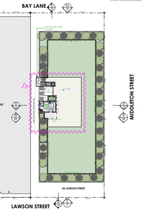
Figure 3: Current Proposed Roof Plan
Other proposed changes include:
· Provision of an internal ‘dumbwaiter’ adjacent to the existing lift, linking the kitchen on the ground floor to the approved pool/ recreation area on the second level (dumbwaiter also extends to basement).
· Addition of three (3) EV chargers into the basement car park.
· New stairs linking the second floor pool deck to the roof- terrace. To maintain accessibility, a separate lift will is also proposed to link the second floor to the rooftop.
· Solar panels are proposed, located on the roof of the roof-top amenities.
1.3. Description of the site
The site was inspected on 24 August 2023.
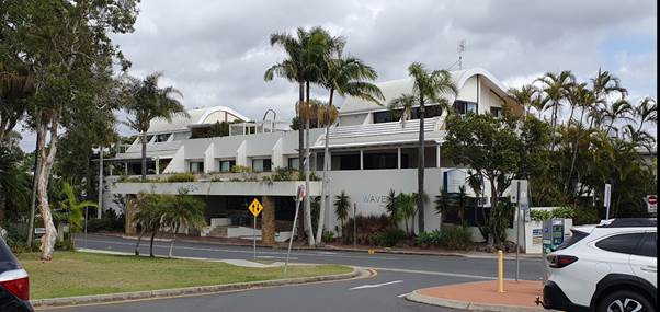
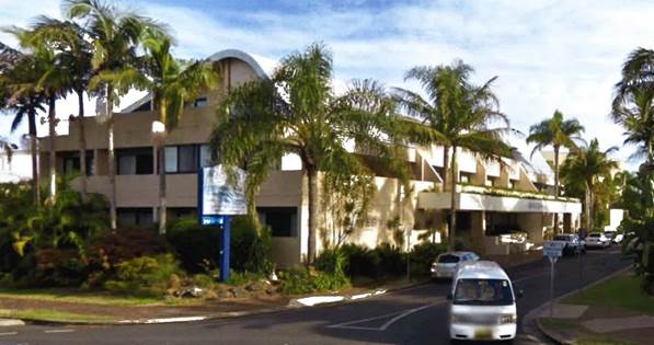
Figure 4: Existing Motel Building (viewed from Middleton Street)
|
Land is legally described |
LOT: 7 SEC: 8 DP: 758207 |
||
|
Property address |
35 Lawson Street BYRON BAY |
||
|
Land is zoned: |
E1 Local Centre |
||
|
Land area is: |
1,012m2 |
||
|
Constraints: |
Acid Sulfate Soils (Class 5) |
||
|
|
Bushfire Prone Land (Vegetation Buffer) |
||
|
|
Coastal Erosion (Precinct 2) |
||
|
|
Flood Prone Land (southern part of site) |
||
|
|
Is a BDAR required due to the location of the proposed development? |
☐ Yes ☒ No |
|
|
|
Are there any easements in favour of Council affecting the site? |
☐ Yes ☒ No |
|
|
|
Is there a Vegetation Management Plan which might affect the proposal? |
☐ Yes ☒ No |
|
|
|
Is there a Voluntary Planning Agreement which might affect the proposal? |
☐ Yes ☒ No |
|
The property contains the existing Waves Motel and is located in the Byron CBD, with easy pedestrian access to shops, restaurants and the beach. Surrounding development comprises a mixture of tourist accommodation and commercial/ retail businesses.
The motel contains 20 units, two of which are approved for residential use (top level), and a basement car park for 27 vehicles.
The existing motel includes a roof-top terrace used by motel guests (see below)
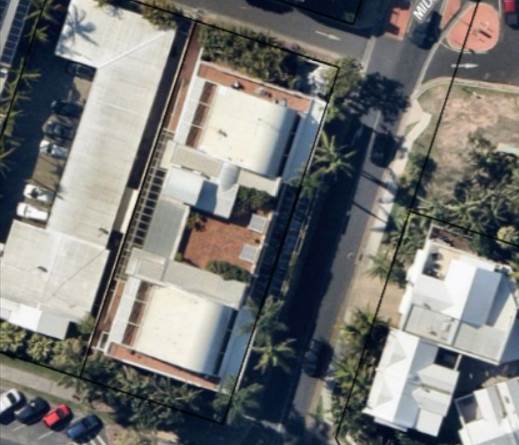
Figure 5: Existing Motel (roof-top terrace shown in the centre of the building)
Development consent 10.2014.361.1 provides for conversion of the top floor to create four (4) units. The first stage of that consent has been activated, and the consent remains valid, although the top floor renovations have not yet been undertaken.
2. SECTION 4.55(2)
|
Section 4.55(2) |
The Applicant is a person entitled to act on the consent. The applicable provisions of the Regulation are considered below. The development to which the consent as modified relates is substantially the same as the originally approved development. The proposed development remains for alterations and additions to an existing motel. The application retains the overall built form approved under DA 10.2014.361.1 (as modified), noting that the main modification is the provision of a roof-top recreation terrace to the roof level including landscaping, solar panels, water saving provisions and electric vehicle charging stations. Consultation was not required with the Minister, public authority or an integrated development approval body in relation to the original development application. Public notification of the application, including consideration of any submissions received if applicable, is discussed in this report below. |
|
Section 4.55(3) |
Section 4.15(1) matters are considered below. |
|
Section 4.55(4) |
The modification to the development consent is not the granting of a consent. The modified consent becomes the consent. |
|
Section 4.55(6) |
The deemed refusal provisions are noted. |
|
Section 4.55(8) |
The Court was not involved in the original development consent and is not involved in the current section 96 application. |
3. ENVIRONMENTAL PLANNING AND ASSESSMENT REGULATION 2021
|
Part 5, Division 1 |
Landowner’s consent has been provided with the application. The application has been made via the Planning Portal and is in the approved form and contains all the information and documents sufficient for it to be properly assessed. In accordance with the Regulation, motel accommodation is not BASIX development. |
|
Section 106 |
The original development application was not for designated development, State significant development, nominated integrated development, threatened species development, Class 1 aquaculture development or to development consent granted by the Court on appeal. |
|
Section 107 |
The application was advertised in accordance with Council’s Community Participation Plan, in the same way as the original application. |
|
Section 109 |
The were no concurrence authorities and approval bodies for the original development application. |
4. SUMMARY OF REFERRALS
|
Referral |
Issue |
|
Environmental Health Officer |
No objections subject to conditions, following receipt of updated acoustic assessment. Note – the comments below related mainly to the operation of the previously proposed roof-top restaurant. I accept the acoustic consultants’ modelling and findings, except for their suggestion to allow the use of the evening shoulder period background noise levels as the target noise criteria. The suggestion is that the background noise levels experienced during the evening period should continue to apply for the 10pm - 11pm period, when setting the Project Noise Trigger Levels. This argument is used to justify the operation of the business beyond 10pm. It is clear in the provided background noise level assessment, and background noise level assessments from assessments conducted at 33 Lawson St, that the ambient noise in the area drops rapidly after 10pm. Especially for those residents most affected by the development, which are screened by the Waves Motel from the town centre and the traffic on Lawson St. The proposed café/bar is supported however operations after 10pm are not supported, in order to minimise the risk of sleep disturbance to the surrounding residents. While the restaurant is no longer proposed, the commentary around no use after 10pm is considered to remain valid for the use of the roof-top terrace. A condition of consent is recommended. |
|
Development Engineer |
Car parking assessment - a total requirement for 34 spaces, the site contains 27 spaces, with no opportunity to provide the deficit of 7 spaces. The deficit in car parking related to the previously proposed roof-top restaurant. Now that this is no longer proposed, the roof-top terrace will be used by hotel guests and does not generate additional activities. It therefore does not generate parking requirements additional to those approved in the original application. |
|
ET Engineer |
No objections subject to conditions. |
5. SECTION 4.14 – BUSH FIRE PRONE LAND
Under section 4.14 of the Act, Council must be satisfied prior to making a determination for development on bush fire prone land, that the development complies with the document Planning for Bush Fire Protection 2019. The site was not bush fire prone land at the time of the original consent. However, it has since become bush fire prone land through updated bush fire prone land mapping.
The bush fire prone land map extract below shows that the site is within the 100m buffer to mapped bush fire hazard vegetation. However, the only mapped hazard vegetation within 100m of the site is the parkland area on the eastern side of Middleton Street between the Library and the Court House.
The part of the hazard that is within 100m of the site is considered to be a modified landscapes and the exclusions of AS 3959 are considered to apply, and is not required to be considered for the purposes of Planning for Bush Fire Protection 2019, because it is vegetation regarded as low threat due to factors such as flammability, moisture content or fuel load, being a maintained public reserve and parkland.
EFFECT OF 10/50 RULE ON SIGNIFICANT VEGETATION
There is no significant vegetation on the site which might be adversely affected by the 10/50 Rule requiring a protective condition.
6. SECTION 4.15 – MATTERS FOR CONSIDERATION – DISCUSSION OF ISSUES
Having regard to the matters for consideration detailed in Section 4.15(1) of the Environmental Planning & Assessment Act 1979 (EP&A Act), the following is a summary of the evaluation of the issues.
6.1. State Environmental Planning Instruments
|
Considerations |
Satisfactory |
Unsatisfactory |
|
Biodiversity and Conservation SEPP 2021 Consideration: There is no high environmental value vegetation or potential koala habitat mapped for this site. |
☒ |
☐ |
|
Resilience and Hazards SEPP 2021 Consideration: Council’s Environmental Health Officer raised no objection to the original DA in relation to potential contamination, noting that the proposal represents the continuation of the approved residential land use. Council’s EHO raised no objection to the proposed modification in this regard. Coastal Management The site is mapped as: · partly in Coastal Environment Area (northern part of property) · wholly within the Coastal Use Area · partly within proximity area to Coastal Wetland – wetland mapped to the south of library site. The proposed development does not raise any issues associated with coastal impact considerations within the SEPP. |
☒ |
☐ |
6.2. Byron Local Environmental Plan 2014 (LEP 2014)
In accordance with LEP 2014 clauses 1.4 and 2.1 – 2.3:
(a) The overall development is defined in the LEP 2014 Dictionary as hotel or motel accommodation, which is a type of tourist and visitor accommodation. The roof-top terrace, as amended, does not involve any additional uses.
(b) The land is within the E1 Local Centre zone according to the Land Zoning Map;
(c) The modified development remains permitted with consent; and
(d) The modified proposal remains satisfactory having regard to the Zone Objectives.
Clause 4.3 Height of buildings
The Height of Buildings Map specifies a maximum height of 9m for this site. The existing ground level is at approx. RL 3.6mAHD.
The existing building, as approved under 5.1993.167.1, has a maximum height of approx. 11m to the ridge of the curved roof elements.
The building modifications approved under DA 10.2014.361.1 provide for a maximum height of approx. 9.5m to roof level, which includes the existing roof-top terrace area, with a lift overrun at a maximum height of approx. 11.5m.
The building as proposed in this modification application (as amended) includes rooftop facilities at the following heights:
· balustrades – approx. 10.4m
· roof-top terrace – approx. 9.4m
· roof over amenities – approx. 12.0m
· top of roof lift – approx. 12.1m
Prior to the recent amendments, the application included a pergola structure over the restaurant seating area, at a height of approx. 11.5m, with the kitchen/ back of house at a height of approx.12.2m. These areas covered a combined area of 240m2.
As amended, the proposed modifications decrease the area of roof above previously approved maximum height to an area of approx. 27m2.
The current amendments substantially reduce the impact of the proposed roof-top facilities, in comparison to the application as submitted and reported to the October Planning meeting.
The existing motel contains a roof-top terrace for guest use, which is located at the Middleton Street edge of the roof (see Figure 3 above). The current proposal moves the terrace back toward the centre of the roof, with planter boxes/ balustrades along the roof edge, which will ensure that the terrace and gusts using it are not visible from adjoining land.
In the context of this site and the existing and approved development, both of which were approved above the 9.0m building height standard, the current modifications provide only a minor increase in building height.
The architects plans below provide a comparison of aerial view of approved versu currently proposed roof areas:
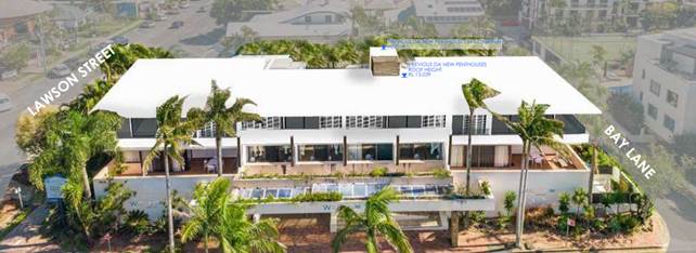
Approved
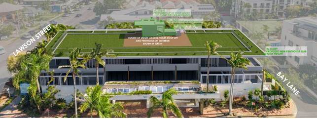
Proposed
Clause 4.4 Floor space ratio
The FSR map indicates a maximum FSR of 1.3:1 for this site.
The definition of gross floor area means the sum of the floor area of each floor of a building measured from the internal face of external walls. It excludes plant rooms, lift towers and stairs.
Based on this definition, the back of house facilities previously proposed generated additional floor space of approx. 40m2. The roof-top restaurant, while only ‘semi-enclosed’ generated approx. 200m2 of area that could be considered floor space.
As amended, the amenities have a floor area of approx. 27m2.
The application indicates that the approved building has an FSR of 1.38:1. The addition of 27m2 of floor space, increases the FSR to 1.4:1, increasing the exceedance of the standard from 6.1% to 7.6%.
The variation to the FSR can be supported as addition of the roof-top amenities in a location that is not visible from surrounding public areas does not add to the bulk and scale of the building, particularly in comparison to the two roof-top waves structures on the current building (see Figure 2 above).
Clause 6.13 Design Excellence – Byron Bay Town Centre
This clause was not in place when 10.2014.361.1 was assessed and determined.
The site is located at the eastern edge of the Town Centre, and this clause is a relevant consideration for the current proposal.
With the removal of the previously proposed roof-top restaurant, the modifications as currently proposed respond well to the environmental and built form characteristics of the locality. The recreation terrace is set back from the public road frontage of the building, with perimeter landscaping, which combine to ensure that users of the terrace will not be visible from the adjoining road. Removal of the commercial component also substantially reduces potential for noise impacts.
In terms of energy efficiency, the proposal includes a small number of solar panels. (3 only) Given the expanse of roof available, it is considered that additional solar panels should be included to optimise the energy efficiency of the building. Conditions to apply.
6.3. Any proposed Instrument that has been the subject of public consultation and has been notified to the consent authority
There are no proposed instruments of significant applicability to the proposal.
6.4. Byron Shire Development Control Plan 2014 (DCP 2014)
The following comments are provided on the relevant chapters of the DCP 2014 pertinent to this application.
B4 Traffic and Parking
The modification application as originally submitted proposed additional uses and additional floor space that would generate addition parking demands.
As outlined in the report to the Planning meeting of 12 October, Council’s Development Engineer assessed the proposal as having a significant deficit of parking spaces.
The modifications as now proposed do not generate uses of the building in addition to those approved. The modifications therefore do not generate additional car parking requirements.
E10 Byron Bay Town Centre
E10.2.3 Built form – Relevant Prescriptive Measures:
2. Where the Byron LEP 2014 Height of Buildings Map specifies a maximum height of 9m, buildings must not contain more than two storeys.
The subject development has been approved in a three storey built form and the existing building already exceeds the 9 m height limit. The additional facilities on the roof, as amended, do not substantially increase this height exceedance, as outlined above and do not constitute an additional storey.
3. Roof-top recreation or commercial facilities must not contravene the maximum building height standard.
As discussed above, while the proposed roof-top facilities contravene the maximum building height, they are consistent with the levels approved under 10.2014.361.1.
4. Buildings are to have minimum floor to ceiling heights of:
a. ground floor: 4.0m
b. first floor: 3.3m
c. second floor: 2.7m
The building does not comply but is subject of an existing approval.
E10.2.9 Roof form, access and use – Relevant Prescriptive Measure
5. Roof-top recreation spaces should be intended primarily for the occupants of that building, and should not be readily accessible to the general public
The rooftop café/ restaurant is proposed for use by motel guests.
The proposed development is generally consistent with the DCP provisions.
6.5. Environmental Planning & Assessment Regulation 2021 Considerations
|
Clause |
This control is applicable to the proposal: |
I have considered this control as it relates to the proposal: |
If this control is applicable, does the proposal comply? |
|
61 |
Yes |
Yes |
Yes |
|
62 |
No |
N/A |
N/A |
|
64 |
No |
N/A |
N/A |
6.6. The likely impacts of that development, including environmental impacts on both the natural and built environments, and social and economic impacts in the locality
|
Impact on: |
Likely significant impact/s? |
|
Natural environment |
No. The proposal will not have a significantly adverse impact on the natural environment of the locality. |
|
Built environment |
No. The proposal will not have a significantly adverse impact on the built environment of the locality in comparison to the approved building. |
|
Social Environment |
No. The proposal does not create potential for a significant social impact on the locality given that it provides for a continuation of the roof-top guest terrace that currently exists on the building. |
|
Economic impact |
No. The proposal will not have a significant economic impact on the locality. |
|
Construction Impacts |
No. The proposal will not generate impacts during construction. Existing conditions of consent to control hours of work, builders waste, construction noise, installation of sedimentation and erosion control measures and the like to ameliorate such impacts are not proposed to be modified. |
6.7. The suitability of the site for the development
The site is a serviced property with access to water, sewer, drainage, electricity and communication services. The site is suitable for tourist and visitor accommodation use.
The site is considered to be suitable for the proposed roof-top terrace as now proposed, without adversely impacting adjoining properties, given that it is essentially a continuation of the existing roof-top terrace on the building.
6.8. Submissions made in accordance with this Act or the regulations
The original modification application was publicly exhibited, generating 25 submissions, with 10 objecting and 15 in support.
The amended application was re-exhibited from 2 November to 15 November, attracting 9 submissions, 5 in support and 4 objections.
The table below addresses the submissions made in respect of the amended proposal (Note – 3 of the 4 objectors referred to the roof-top restaurant, which is no longer part of the proposal).
|
Issue |
Consideration |
|
Objection |
|
|
Amenity impacts associated with noise and lighting from use of the rooftop terrace.
|
The acoustic assessment submitted in support of the original application concluded that, subject to a number of recommendations, the proposed use of the roof-top restaurant would be within acceptable levels of the relevant noise criteria. Council’s Environmental Health Office reviewed that report and accepted its conclusion, other than recommending that the hours of operation be limited to 10.00pm rather than 11.00pm as proposed. As outlined in this report, the roof-top restaurant is no longer proposed and the terrace will therefore generate significantly less noise, as it is for recreational use of motel guests. The existing motel includes a similar roof-top terraces, which has not generated significant noise complaints. A condition of approval is recommended limiting use of the terrace to 10.00pm, and for guests and their visitors only. |
|
Development exceeds the height limit and existing approval provide an already considerable height concession. |
The issue of building height is discussed in detail above, noting that the proposed modifications, as now amended, do not result in a significant increase in height of the building as existing and as approved. |
|
Support |
|
|
Roof-top recreation space will be a valuable addition to the motel, and deletion of previously proposed commercial components will reduce impacts. |
See commentary above. |
6.9. Public interest
Development consent 10.2014.361.1 was approved with an exceedance of the 9.0m maximum building height, largely because the roof height was consistent with the existing curved roof elements of the motel building, which also exceed the 9.0m height standard.
The modification application as originally submitted sought approval for additional height and a proposed commercial use of the roof area, including an area which was partially a fourth storey, which was not envisaged in the original proposal.
The application has been modified to remove the commercial component and substantially reduce the extent of area that exceeds the height limit. The provision of a roof-top terrace provides for a continuation of the terrace that exists on the current building, but which was not approved under the refurbishment approval.
Subject to recommended conditions limiting the use for guests and their visitors and no use after 10.00pm, it is considered that the proposed modification does not prejudice the public interest.
7. DEVELOPER CONTRIBUTIONS
7.1. Water & Sewer Levies
No Section 64 levies will be required.
7.2. Section 7.11 Contributions
No Section 7.11 Contributions will be required.
8. CONCLUSION
The modification application has been amended to remove the previously proposed roof-top restaurant. It now proposes a roof-top terrace area for the recreational use of guests and their visitors. This will effectively provide for a continuation for the roof-top terrace that exists on the building at the moment, but which was not included in the development consent for refurbishment (10.2014.361.1).
BYRON SHIRE COUNCIL
Staff Reports - Infrastructure Services 13.14
Staff Reports - Infrastructure Services
Report No. 13.14 New Brighton Parking Improvements
Directorate: Infrastructure Services
Report Author: Isabella Avelino Gianelli, Project Engineer
File No: I2023/1408
Summary:
This report addresses the outcomes of parking investigations in the New Brighton area following resolution 23-217.
In line with our continuous commitment to meet community needs and address environmental concerns, the report highlights the importance of careful planning and adherence to Council policies.
Each aspect is explored with a focus on minimising environmental impact and promoting community welfare.
RECOMMENDATION:
That Council:
1. Takes no further action on The Esplanade North, Riversea Lane and Dolphin Lane regarding parking implementation.
2. Endorses the installation of the wayfinding signage plan as per attachment 3.
3. Supports detail design and planning for implementing the North Head Road carpark and the 6-spaces solution at The Esplanade as per attachment 4.
4. Notes that any further investigations will consider the eventual outcome of the dune continuing to move west onto the Esplanade.
Attachments:
1. North Head Road – Parking Draft Design (E2023/36775)
2. Planning Advice Assessment (E2023/35699)
3. Parking study and wayfinding New Brighton (E2023/108434)
4. Revised
Planning Advice New Brighton, The Esplanade 6-space option (E2023/119288)
Report
Council recently resolved 23-217 as follows:
1. That staff continue to develop designs to improve car parks in the area including North Head Carpark, The Esplanade North and provide way finding signage in the area to direct beach goers to the beach facility.
2. That Council investigates closing all but 6 car parking spaces in The Esplanade South and providing further parking in Esplanade North, North Head Rd, Riversea Lane, Dolphin Lane and New Brighton for foot traffic beach access.
3. That a further report is brought back to Council within 3 months of this date.
4. That Council considers the eventual outcome of the dune continuing to move west onto the Esplanade and this aspect be referred to the CMP. (Hunter/Lyon)
Following this Council resolution, staff have been progressing the parking investigations at New Brighton. The following describes actions and outcomes against items 1-4 above and provides reasoning for the recommendations provided.
1. Wayfinding
Signage Plan & North Head Road Carpark
It is recommended that Council endorse the installation of the wayfinding
signage plan contained within this report (attachment 3). Wayfinding
signage is a vital component to improve navigation and accessibility within the
area. This plan has been developed with the community's well-being and
convenience in mind, and its implementation will contribute positively to the
overall experience for residents and visitors.
It is recommended that Council staff initiate detail design and planning for implementing the North Head Road carpark design (attachment 1) with the current budget allocated and seek funding to proceed with construction in the future.
2. Closing all but 6 car parking spaces in The Esplanade South investigation.
Council staff have consulted with Principal Planner, Mike Svikis to assess the planning pathways on the 6-spaces solution (attachment 4) and as per the advice all the activities that make up the 6-space parking option can be undertaken in the road reserve as exempt development. For example:
· signage
· parking delineation
· line marking
· bollards
· pothole fixing; and
· sealing or resealing of existing road (not widening).
Note key point extracted from attachment 4:
“The 6-space parking option is a relatively minor scope of works that has minimal opportunity to have a significant environmental impact. Although the location is environmentally sensitive, an REF is not required.”
Based on the advice, it is recommended that Council staff initiate detail design and planning for implementing the 6-space solution with the current budget allocated and seek funding to proceed with construction in 2023/24.
3. The Esplanade North, Riversea Lane and Dolphin Lane.
It is recommended that no further action be undertaken on The Esplanade North, Riversea Lane and Dolphin Lane concerning parking implementation.
Based on the comprehensive Planning Advice Assessment (attachment 2), any proposed layout in these locations would require significant tree removal and road widening.
These activities are likely to have a significant impact of the environment as the subject land is identified by Council as an area of High Environmental Value (Figure 1) with a vegetation community described as Littoral Rainforest (Figure 2), it is also mapped as an immediate hazard area (Figure 3) and Bush regeneration and landcare area (Figure 4).
Note key points below taken from attachment 2:
“It is an area where Council policy (as contained in its 2010 DCP) states:
Element – Precinct 1 - from the Beach Escarpment to the Immediate Impact Line
Element Objective
To ensure the impact of coastal processes on potential development is minimised by limiting development and ensuring any development is only temporary.
Performance Criteria
New buildings or works are to be temporary and able to be readily removed in the event of coastal erosion.
Development that is of a community nature, which relates to the use of the beachfront, may be considered, provided that any building is easily removable and does not require a major extension to a service main.’
Works such as widening the road and removal of mature, native vegetation that has been planted to protect and stabilise the dune are not temporary or readily removed and it would go against Council policy.”
Figure 1: BSC
Area of High Environmental Value
Figure 2: BSC Vegetation Community mapping
Figure 3: Current Hazard lines
Figure 4: BSC bush regeneration and landcare areas
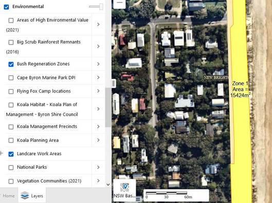
4. Dune Movement
Council staff will continue to monitor and will consider the eventual outcome
of the dune continuing to move west onto the Esplanade in
any further investigations.
Alternate Parking Options
Upon thorough investigation, staff has explored various alternate parking solutions within New Brighton. Regrettably, no viable alternative options have been identified, other than the options previously presented at Ocean Avenue & Park Street as the sole alternatives (attachment 3).
Considering the limitations of alternative options, there is merit in examining these two locations as part of a more comprehensive, multi-departmental project. Such an approach would allow for the integration of place planning, open space enhancements, and parking improvements within New Brighton as a comprehensive design process. This consolidated effort may provide a more effective solution for the community's needs.
Strategic Considerations
Community Strategic Plan and Operational Plan
|
CSP Objective |
CSP Strategy |
DP Action |
Code |
OP Activity |
|
5: Connected Infrastructure We have connected infrastructure, transport, and facilities that are safe, accessible, and reliable |
5.4: Provide accessible community facilities and open spaces |
5.4.1: Community buildings - Ongoing maintenance and capital upgrades of community buildings with a focus on increasing accessibility |
5.4.1.2 |
Deliver accessibility outcomes within Capital Works and infrastructure renewal programs |
Recent Resolutions
· Resolution number 23-217
Legal/Statutory/Policy Considerations
Council Development Control Plan –
Element – Precinct 1 - from the Beach Escarpment to the Immediate Impact Line
Element Objective
To ensure the impact of coastal processes on potential development is minimised by limiting development and ensuring any development is only temporary.
Performance Criteria
New buildings or works are to be temporary and able to be readily removed in the event of coastal erosion. Development that is of a community nature, which relates to the use of the beachfront, may be considered, provided that any building is easily removable and does not require a major extension to a service main.
BYRON SHIRE COUNCIL
Staff Reports - Infrastructure Services 13.15
Report No. 13.15 Results of Beach Naming Survey
Directorate: Infrastructure Services
Report Author: Andrew Erskine, Open Space Technical Services Officer
File No: I2023/475
Summary:
A long-term resident and former Councillor identified anomalies in the naming of beaches in the Byron Bay embayment. Council requested a report seeking to clearly delineate geographical boundaries and names for beaches within the Shire, and to undertake community engagement seeking consideration of official names.
The core issue raised related to delineation between Main Beach and Belongil. Outside the individual that raised the matter, community have not recognised the need for change. The original matter expanded to consideration of naming beaches across the Shire.
It is considered important to use consistent names for our beaches, this assists emergency responders to attend incidents without confusion and assists businesses and visitors to the region with clarity around sanctioned names for areas. Confirmation of names and at this stage will not preclude ability to modify or amend at some future date should the need be identified.
Strong community support for recognition of Bundjalung traditional names was recognised in the feedback. Engagement with Bundjalung of Byron Bay Aboriginal Corporation (Arakwal) and Tweed Byron Local Aboriginal Land Council (TBLALC) has not to date resulted in identification of any preferred naming for Shire beaches.
RECOMMENDATION:
That Council:
1. Recognises the widespread support within community for recognition of traditional custodian naming across the Shire, and extend an invitation to Tweed Byron ALC and Arakwal Board to continue to explore opportunities for renaming as these are identified.
2. Recognises that the process of delineating names and geographical boundaries for beaches is an important risk management exercise that assists emergency services response
3. Resolves to adopt the popular beach names as currently used and detailed in the maps accompanying this report, and that the names and coordinates of each named area in the attachment to this report be submitted to the Geographical Names Board for Gazettal. (noting that beaches within NPWS Estate are already adopted and gazetted).
1 Byron
Shire Beach Names, E2023/121037 ![]()
Background
Council resolved in 2017 (in part) to complete audit of all beach signage across the Shire, and to prepare a map which names all Shire beaches and designates usage and restrictions.
Audit of all existing signage relating to shire beaches and beach access pathways was completed by NSW Surf Life Saving as a component of an overall Coastal Public Safety Risk Assessment. Details on Shire beaches designating usage, restrictions and map location was prepared and included within Council’s website Parks and Reserves information.
The mapping exercise identified that few of the commonly used beach names shire-wide have been gazetted and that delineation of where beaches start, and finish is only vaguely defined. Where beaches have been gazetted by the Geographical Names Board (GNB) the coordinates were found to be inaccurate.
In response to the completion of above actions, Council further requested staff Council staff provide a future report to Council seeking to clearly delineate geographical boundaries and names for beaches within the Shire.
Report
Of the 23 beaches in the Byron Shire, 11 do not have official names. This needs to be resolved for the NSW Geographical Names Board. Official names for beaches and landmarks are important especially for emergency services when they are responding to a call for help.
Council in early 2023 asked the community to look at the map/s of the beaches and tell us to what degree you value renaming the beaches and make any suggestions for more appropriate new names.
Maps of coastal features were provided that showed beach names that are gazetted, beach names not gazetted and beach delineation, or where the named beach starts and stops.
At the close of the Exhibition period 142 responses were received.
Four core questions were asked;
1. Are you in favour of keeping the locally known and accepted names?
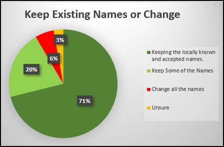
Eight submissions seeking all beach names be changed all suggested that First Nations names should be applied.
28 respondents suggested some beaches be renamed, with 13 of these favouring traditional indigenous names. These respondents also suggest a variety of additional names including;
§ The Wreck Beach
§ Jetty Beach
§ Brunswick Heads Beach
§ Fern Beach
§ Christmas Beach
§ Jar Jum’s Corner
§ Captain Cook Beach
§ North Byron Beach (north of South Golden Beach)
§ North Beach (Elements)
§ Locals Only Beach
§ Whalers Beach
§ Nudie Beach
§ Beachy McBeachface
§ Redgate Beach
Within these submissions it was also suggested that certain beach names be removed, including;
§ Seagulls
§ Fisherman’s Lookout
§ Thompson’s Rock
§ Cosy Corner
§ Suffolk Park Beach
§ Captain Cook
§ Harry’s Hill
2. Do you support an official name being given to the beach between Wooyung and South Golden Beach
Suggestions for this area included North Byron Beach and Fern Beach.
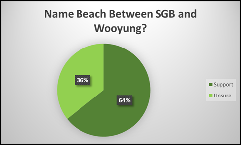
3. Are you in favour of changing the name Crabbes Creek Beach?
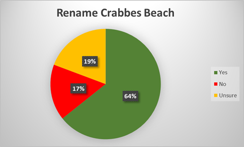
Again 15 respondents expressed need to engage with traditional owners around naming.
Key issues
Clearly delineating geographical boundaries and names for beaches is an important risk management exercise that assists emergency services response.
While the idea of co-naming the beaches with Bundjalung names was popular with community to date no formal input has been received from Arakwal Board or Tweed – Byron Local Aboriginal Land Council (“TBLALC”). The original report and all mapping were forwarded to Arakwal Board and TBLALC seeking their input. Council has been advised that Arakwal Board and members have been presented the information, but that consideration is ongoing.
Council and wider community may feel some urgency to implement change to allow recognition of traditional owners through naming, that urgency is not currently found within the indigenous communities. Rather than rush the process, it is best to allow change to be led by the relevant traditional owners. Confirming current names and delineation of beaches through the Geographical Naming Board does not preclude future amendments or alterations should the need arise.
Community consensus was to retain all commonly used beach names except for Crabbes Creek Beach, with preference for any changes to beach names to reflect traditional custodian preferences. The section of beach between South Golden Beach and Wooyung currently has no name. Options proposed (Fern Beach or North Byron Beach) do not have strong links to the area and are not seen as viable.
In lieu of any alternatives, it is recommended that at this time that the delineation of South Golden Beach and New Brighton Beach be amended to close off the gaps, clearly delineating the respective beach area, with the unknown “Crabbes Creek Beach” name to be removed.
There was no dispute received about the beach names or their geographic perimeters as mapped in the community consultation document. Recurrent issues around correct spelling of Wategos and Clarkes beaches were raised in response the survey, however without historical clarity the existing spellings that are already adopted by the geographical names board are recommended to be retained.
Next steps
Following Gazettal, the adopted mapping and names be advertised locally and distributed to local emergency responders and Chambers of Commerce.
Strategic Considerations
Community Strategic Plan and Operational Plan
|
CSP Objective |
CSP Strategy |
DP Action |
Code |
OP Activity |
|
1: Effective Leadership |
1.1: Enhance trust and accountability through open and transparent leadership |
1.1.3: Information Management - Provide timely, accessible, and accurate information to the community |
1.1.3.5 |
Ensure website has clear content governance and schedule to maintain timely, accurate and accessible information on the website |
|
1: Effective Leadership |
1.2: Engage and involve community in decision making |
1.2.1: Community-led decision making - Engage with community to inform Council decision making |
1.2.1.1 |
Provide opportunities for the community to have input, comment and feedback to Council on projects and matters of interest |
|
2: Inclusive Community |
2.3: Respect Aboriginal culture, value cultural knowledge, and acknowledge history |
2.3.1: Aboriginal community and First Nations People - Develop strong and productive relationships that empower the Aboriginal community |
2.3.1.1 |
Continue working with Traditional owners on land management matters |
Recent Resolutions
Resolution 22-321.
1. Council approves the proposed refinement of mapping on public exhibition for 28 days; and
2. Requests a further report on the resulting community feedback generated, for consideration of agreed naming.
Resolution 21-246.
Council staff to provide a future report to Council seeking to clearly delineate geographical boundaries and names for beaches within the Shire.
Resolution 17:081
1. That Council clarify the official name of the stretch of beach north of the Belongil estuary and on up to the clothes optional beach at Tyagarah Nature Reserve.
2. That Council prepare a map which names all Shire beaches and designates usage and restrictions.
Legal/Statutory/Policy Considerations
Names put forward to the Geographic Names Board NSW follow the conventions adopted in the Geographical Names Act 1966.
Financial Considerations
Application to GNB including correct coordinates can be readily prepared by staff.
Consultation and Engagement
Community consultation has been completed.
BYRON SHIRE COUNCIL
Staff Reports - Infrastructure Services 13.16
Report No. 13.16 RFT2023-1860 Mullumbimby Recreation grounds Amenities Upgrade
Directorate: Infrastructure Services
Report Author: Jamie Steel, Project Officer Open Space & Facilities
File No: I2023/1654
Mullumbimby Recreation Grounds public amenities block and adjacent “little athletics” cs building were inundated with floodwaters in the February 2022 event. These amenities are essential community recreation assets for both general public and users of the Mullumbimby Recreation Grounds, with the primary user group being the Brunswick Byron Netball Association.
Funds made available under the Sports Priority Needs Program will be utilised to re-establish the amenities block and athletics building to fit for purpose. Unisex accessible amenities block and adjacent sporting change room facilities will result.
On 7 August 2023, the General Manager, under delegated authority, approved the use of the open tender method to call for tenders for Contract 2023-1860 Mullumbimby Recreation Grounds Amenities Upgrade.
Tenders have been assessed in accordance with the provisions of the Local Government (General) Regulations 2021. This report summarises the background and assessment of the tenders and provides a recommendation to award the tender for Contract 2023-1860.
RECOMMENDATION:
That Council:
1. Awards Tender for the Mullumbimby Recreation Grounds Amenities Upgrade to the preferred supplier identified in the Tender Evaluation Report E2023/121708.
2. Makes public its decision, including the name and amount of the successful Tenderer, in accordance with Clause 179(b) of the Local Government (General) Regulation 2021.
Attachments:
1 Confidential - Signed Evaluation Report RFT 2023-1860 Mullum Rec Grounds Amenities Upgrade Project, E2023/121708
Report
On 7/8/2023 the General Manager, under delegated authority, approved the use of the open tendering method to call for tenders for Contract 2023-1860 Mullumbimby Recreation Grounds Amenities Upgrade Project
The current Amenities are not fit for purpose. The existing toilet block and Athletics buildings are in need of repair and Upgrades to bring the buildings to a fit for purpose facility for the use of local sporting clubs and community members. NSW Office of Sport has approved Grant Funds to help with this redevelopment to reconnect an important piece of community infrastructure for user groups.
Scope of works includes removal of the existing amenities block and replacement with a new fully accessible and CPTED (crime prevention through environmental design) compliant amenity block. The current \athletics building is to be completely refurbished to include 2 x Change rooms, up to 3 x Game day toilets and 2 x Storerooms.
Project works are anticipated to begin February 2024.
The Request for Tender sought responses from proponents to provide:
1.1. The objective is to provide the Community and Community sporting groups of Mullumbimby with Current Standard sporting Amenities and Facilities. The existing facilities are in a very dilapidated state and are need of renovation works.
1.2. CPTED (Crime prevention through Environmental design) design will from a part of new outlay of the proposed renovation works. Architect has delivered a ‘Concept’ design/layout that suits the use of local Netball Association Committee. Suppliers are to provide a design/layout with submission.
1.3. Successful submission will require Supplier to outline their history, in providing a quality service/s of similar nature, delivered on time and to budget. Project delivery timing is crucial to create the least possible disruption to normal Sporting Calendar Fixtures.
The Contract is expected to commence in February 2024 for a period of 15 weeks.
The Contract will be managed by Council’s Project Officer Open Spaces & Facilities.
Tenders were advertised as follows:
VendorPanel Online: 18/10/2023 – 16/11/2023
Council website: 18/10/2023
Two Site meetings were held over the Tender period on 26/10/2023 and 2/11/2023 at 10am respectively, and attended by the following suppliers:
· TYCORP Pty Ltd
· Quadracon Building Pty Ltd
· Bishton Group Pty Ltd
· CIRCL Group Pty Ltd
· TCDE – Demolition Company
· Barden Constructions Pty Ltd
· Bouman Pty Ltd
An Evaluation Panel comprising of three Council staff members was formed.
Tenders closed on 16 November 2023 and tenders were received from the following proponents:
· Barden Constructions Aust Pty Ltd
· Bishton Group Pty Ltd
· Bouman Pty Ltd
· CIRCL Group Pty Ltd
· Tycorp Constructions Pty Ltd
Tenders were evaluated by the Evaluation Panel in accordance with the following evaluation criteria:
Mandatory criteria:
a) Tenderer must have a valid Australian Business Number.
b) Substantial conformance to Conditions of Contract and Statement of Requirements.
c) Workers compensation insurance for all employees.
d) Holds, or is willing to obtain, the insurances as specified in the Statement of Requirements.
e) Satisfactory Work Health and Safety practices.
f) Commitment to ethical business practice principles.
Qualitative criteria:
|
Criteria |
Elements |
|
Profile and relevant experience |
Tenderer profile |
|
Previous relevant experience |
|
|
Environmental practices |
|
|
Opportunities for disadvantaged people |
|
|
Local employment opportunities |
|
|
Quality and availability of resources |
Proposed key personnel |
|
Proposed staff |
|
|
Use of subcontractors |
|
|
Vehicles, plant and equipment |
|
|
Delivery Plan |
Goods/services standards and methodology |
|
Implementation plan |
|
|
Product sustainability |
|
|
Supporting local business, social enterprise and Indigenous business |
|
|
Price |
Total contract price |
Following the evaluation, the Evaluation Panel conducted referee and financial checks on the preferred tenderer. The results of these checks were deemed by the Evaluation Panel to be satisfactory as detailed in the attached Evaluation Report.
Financial Considerations
There is sufficient funding for the proposed contract in the current budget.
Option 2:
The price basis for the contract is a lump sum.
Council has budgeted $448,700 for this project.
Grant Funding of $372,000 has been obtained for the residual budget (figures exclusive of GST).
There is sufficient funding for the proposed contract in the current budget.
Statutory and Policy Compliance Considerations
The tendering process has been undertaken in accordance with Council’s Purchasing and Procurement Policy, and the provisions of the Local Government (General) Regulation 2021.
The Local Government (General) Regulations 2021 define the options available to Council. An extract is provided below.
Local Government (General) Regulation 2021 - Reg 178
178 Acceptance of tenders
(1) After considering the tender submissions for a proposed contract, the council must either—
(a) accept the tender submission that, having regard to all the circumstances, appears to it to be the most advantageous, or
(b) decline to accept any of the tender submissions.
(1A) Without limiting subsection (1), in considering the tender submissions for a proposed contract for the performance of domestic or other waste management services, the council must take into account whether or not existing workers (within the meaning of section 170) will be offered employment or engagement on terms and conditions comparable to those applicable to the workers immediately before the tender submissions.
(2) A council must ensure that every contract it enters into as a result of a tender submission accepted by the council is with the successful tenderer and in accordance with the tender (modified by any variation under section 176). However, if the successful tender submission was made by the council (as provided for in section 55(2A) of the Act), the council is not required to enter into any contract in order to carry out the requirements of the proposed contract.
(3) A council that decides not to accept any of the tender submissions for a proposed contract or receives no tender submissions for the proposed contract must do one of the following—
(a) postpone or cancel the proposal for the contract,
(b) invite, in accordance with section 167, 168 or 169, fresh tender submissions based on the same or different details,
(c) invite, in accordance with section 168, fresh applications from persons interested in making a tender submission for the proposed contract,
(d) invite, in accordance with section 169, fresh applications from persons interested in making a tender submission for contracts of the same kind as the proposed contract,
(e) by resolution of the council, enter into negotiations with any person (whether or not the person was a tenderer) with a view to entering into a contract in relation to the subject matter of the tender,
(f) carry out the requirements of the proposed contract itself.
(4) If a council resolves to enter into negotiations as referred to in subsection (3)(e), the resolution must state the following—
(a) the council’s reasons for declining to invite fresh tender submissions or applications as referred to in subsection (3)(b)–(d),
(b) the council’s reasons for determining to enter into negotiations with the person or persons referred to in subsection (3)(e).
Council’s endorsement of the recommendation to award the tender as recommended in the attached Evaluation Report is sought.
BYRON SHIRE COUNCIL
Staff Reports - Infrastructure Services 13.17
Report No. 13.17 Rifle Range Road Traffic Calming for Koala Safety
Directorate: Infrastructure Services
Report Author: Judd Cornwall, Traffic & Transport Engineer
File No: I2023/1761
Summary:
The purpose of this report is to respond to part 3 of Council resolution number 22-438 which requested do the following:
3. Request that staff meet with residents from adjacent properties and prepares a report to Council on implementing and/or installing traffic calming options along the newly sealed section of Rifle Range Road in Bangalow north of Raftons Road.
RECOMMENDATION:
That Council considers the provision of funding in the amount $14,000, in the December quarterly budget review, for the installation of wildlife warning signage/pavement treatments within the subject section of Rifle Range Road to improve Koala awareness.
Attachments:
1 Rifle
Range Road_Local Area Traffic Management_Letter to community_8_11_2023, E2023/116778 ![]()
Report
Staff have reached out to the residents within the newly sealed section of Rifle Range Road, north of Raftons Road to provide any feedback regarding the implementation of speed management devices within this section of road (please refer to attachment 1).
Staff received three responses from the properties that would be directly impacted should traffic management devices be implemented. In summary, the responses indicated opposition to any form of physical speed intervention due to access concerns.
Staff have conducted a traffic survey to understand traffic movements within the subject section of road in terms of speed, volume, and vehicle class. A summary of this survey is shown below (table 1). The survey data indicates that the volumes and speeds along this section of road are very low and do not form a case for intrusive interventions like speed humps or other LATM devices. However, there may be opportunity to create greater awareness for the presence of koalas in the area with the implementation of high impact signage and pavement marking (refer to figure 2) should funding be made available.
Table 1: Traffic survey data – Rifle Range Road, 125m north of Raftons Rd
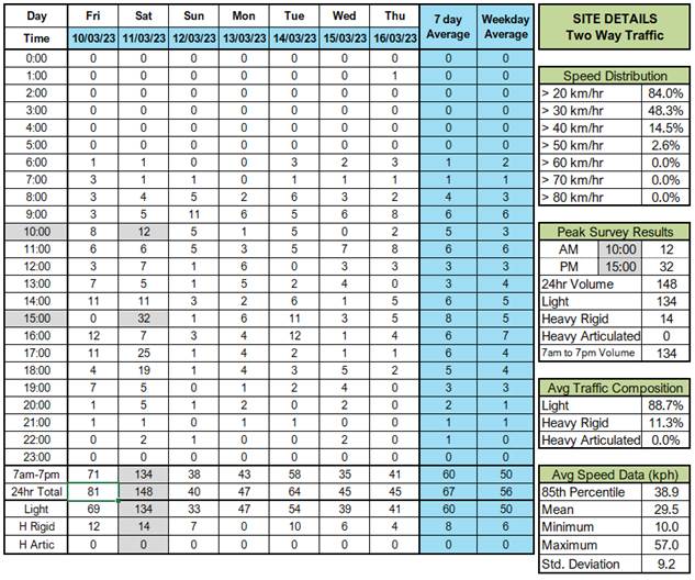
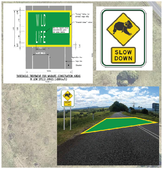
Figure 1: High impact signage with pavement marking example
Strategic Considerations
Community Strategic Plan and Operational Plan
|
CSP Objective |
CSP Strategy |
DP Action |
Code |
OP Activity |
|
5: Connected Infrastructure |
5.1: Provide a safe, reliable, and accessible transport network |
5.1.2: Road renewal and upgrades - Deliver road renewal and upgrade capital works program |
5.1.2.24 |
Delivery local area traffic management facilities |
Recent Resolutions
Resolution Number 22-438
Resolved that Council:
1. Notes the recent listing of the NSW Koala Population as endangered.
2. Notes the recent death of two breeding female Koalas and their Joeys in the Bangalow area
3. Request that staff meet with residents from adjacent properties and prepares a report to Council on implementing and/or installing traffic calming options along the newly sealed section of Rifle Range Road in Bangalow north of Raftons Road.
(Pugh/Balson)
Financial Considerations
Funding for the installation of pavement treatments and high impact signage would need to be identified if found to be appropriate. The pavement treatment has been quoted at $8,085 (including install costs). Signage costs are dependent upon post type (slip based etc.) an allowance of $2,000 should be adequate.
Consultation and Engagement
Engagement of a suitable contractor to mark the pavement treatment will be required.
BYRON SHIRE COUNCIL
Staff Reports - Infrastructure Services 13.18
Report No. 13.18 Social Enterprise Commercial Laundry - Beacon Laundry - s64 Sewer Developer Contributions
Directorate: Infrastructure Services
Report Author: Dean Baulch, Principal Engineer, Systems Planning
File No: I2023/1853
Summary:
Byron Shire Council received a letter from Beacon Laundry (dated 09 November 2023) requesting Council waive the s64 sewer contributions for their social enterprise laundry service which has an approved development 10.2023.363.1 at 2/6 Dudgeons Lane Bangalow.
As per letter dated 09 November 2023, Beacon Laundry is a not-for-profit social enterprise and a registered charity, providing lifechanging employment and career pathways for disadvantaged people in the community, such as people living with a disability, experiencing mental illness or homelessness, former refugees or First Nations people, or people who have spent time in the criminal justice system.
Byron Shire Council may waive developer contributions where the proponent demonstrates to Council’s satisfaction that it is a non-profit and charitable organisation, which by virtue of carrying out such development, is considered to be making a significant and positive contribution to the community and is unable to recover the charge from the end user.
RECOMMENDATION:
That Council provides Beacon Laundry service a waiver to sewer developer contributions limited to the approved development 10.2023.363.1 at 2/6 Dudgeons Lane Bangalow.
Attachments:
1 10.2023.363.1
Social Enterprise Commercial Laundry_Beacon Laundry_Letter of Application to
Waive s64 Sewer Contributions, E2023/122134
![]()
2 Byron
Shire Council Development Servicing Plan for Water Supply and Sewerage Revision
1 Adopted Plan 07 September 2016 PDF Version, E2023/122134
![]()
Report
Byron Shire Council received a letter from Beacon Laundry, a social enterprise commercial laundry service (Attachment 1), requesting Council waive the s64 sewer contributions for their social enterprise charitable organisation which has an approved development 10.2023.363.1 at 2/6 Dudgeons Lane Bangalow.
In accordance with NSW Water Directorate Guidelines and Council’s Equivalent Tenement Policy, the sewer contributions for this commercial laundry service (as of today’s date) were assessed as:
Sewer ET of proposed development:
|
Sewer |
86.13 |
ET @ |
$12,193.00 |
= |
$1,050,183.09 |
|
Total |
= |
$1,050,183.09 |
Section 2.7 of Byron Shire Council’s Development Servicing Plans for Water Supply and Sewerage (Attachment 2) states:
BSC may waive developer contributions where the proponent demonstrates to Council’s satisfaction that it is a non-profit and charitable organisation, which by virtue of carrying out such development, is considered to be making a significant and positive contribution to the community and is unable to recover the charge from the end user.
The water supply for this development is provided by Rous Water and not considered in this report.
Council did previously waive s64 contributions for another social enterprise and much smaller laundry operation known as Linen SHIFT via Resolution 19-401 on 23 August 2019. The total contribution waived for this laundry was for four washing machines [$31,074.92].
Options
· Council determines not to waive developer contributions.
· Council determines not to waive developer contributions but enters into an agreement to pay the contributions over four-year period. A deferred payment agreement for payment of s64 Contributions as per Councils Resolution 13-253
· Council determines to waive water and sewer contribution under s2.7 of Council’s Development Servicing Plans for Water Supply and Sewerage.
STRATEGIC CONSIDERATIONS
Community Strategic Plan and Operational Plan
Not applicable.
Legal/Statutory/Policy Considerations
In respect of the water supply Council has no jurisdiction to reduce or waive the charges applied by Rous Water. Section 610(E) of the Local Government Act 1993 provides the ability for Council to waive or reduce fees provided Council has adopted categories that allow for fees to be reduced or waived. Council as part of its policy has adopted a category that includes for public benefit ie charitable projects. In this instance and in accordance the Development Servicing Plan for Water and Sewerage, there is the flexibility for Council to approve the recommendations to this report should it determine to do so.
Financial Considerations
Should Council adopt the proposed recommendation to this report, it will forgo a total of $1,050,183.09 in developer contributions for sewerage.
Consultation and Engagement
Not applicable.
BYRON SHIRE COUNCIL
Staff Reports - Infrastructure Services 13.19
Report No. 13.19 Part Road Reserve Closure and sale adjoining Lot 4 & 5 DP 246401, 154 & 156 Lighthouse Road, Byron Bay NSW
Directorate: Infrastructure Services
Report Author: Tracy Armstrong, Roads & Property Officer
File No: I2023/1866
Summary:
This report is being presented to Council to endorse the closure of Council’s road reserve adjoining Lot 4 & 5 DP 246401.
As per Crown Land determination the road/land will vest in Council upon closure, and it is proposed to sell the land to the adjoining landowners of Lot 4 and Lot 5 DP 246401.
Land size is approximately 108m2 (Lot 4), 100 m2 (Lot 5)
RECOMMENDATION:
That:
1. Council endorses the closure of part road reserve adjoining Lot 4 & 5 DP 246401 as detailed in the report.
2. Council accepts the valuation as per Attachment 1 E2023/99644 and Attachment 2 E2023/99646, that has been agreed upon by the landowners.
3. The applicant pays all remaining costs associated with the part road closure and consolidation.
a) Council application fees
b) Council’s surveyor's fees and survey, valuation, and legal costs
c) All registration fees
d) Legal costs
4. The allotments created by the part road closure to be consolidated into existing Parcel No 44960 Lot 4 DP 246401 and Parcel No 44970 Lot 5 DP 246401.
5. Council authorises the General Manager to execute all documents necessary to affect the road closure, sale, transfer, and consolidation of the part closed road.
Attachments:
1 Confidential - Page Extraction Current Market Valuation Asset Advisory Valuers, Proposed Road Closure 156 Lighthouse Road Byron Bay Lot 5 DP 246401, E2023/99644
2 Confidential - Page Extraction Current Market Valuation Asset Advisory Valuers, Proposed Road Closure 154 Lighthouse Road Byron Bay Lot 4 DP 246401, E2023/99646
3 Plan
of Proposed Road Closure Adjoining 154 & 156 Lighthouse Road Byron Bay Lots
4 & 5 DP 246401, E2023/97556 ![]()
4 Authorities
Responses & Submissions for Proposed Road Closure Adjoining 156 Lighthouse
Road Byron Bay Lot 5 DP 246401, E2023/108003
![]()
Report
Council was approached by the owners of Lot 4 & 5 DP 246401 154 & 156 Lighthouse Road Byron Bay to discuss encroachment issues on Council’s road reserve. The survey plan (Attachment 3 E2023/97556) shows the existing formed road lying within adjoining part Lot 4 & 5 DP246401. This road closure is purely to rectify access encroachment issues.
A road closure of Council’s Road reserve was discussed to resolve the encroachment issues as per Image 1 below, and a valuation was carried out (Attachment 1 E2023/99644 and Attachment 2 E2023/99646) with the current owners. Image 2 Red arrow highlights fork to the left of No Name Road to access Lot 4 & 5 DP 246401
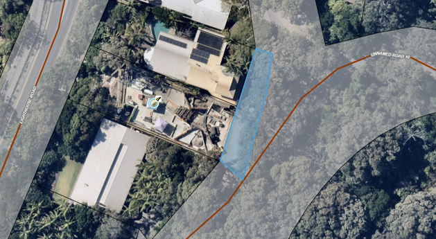
Blue indicates section of road proposed to be closed
Brown indicates actual road
Image 1 Highlights the location of the proposed road closure, alongside a marked line which shows the actual road.
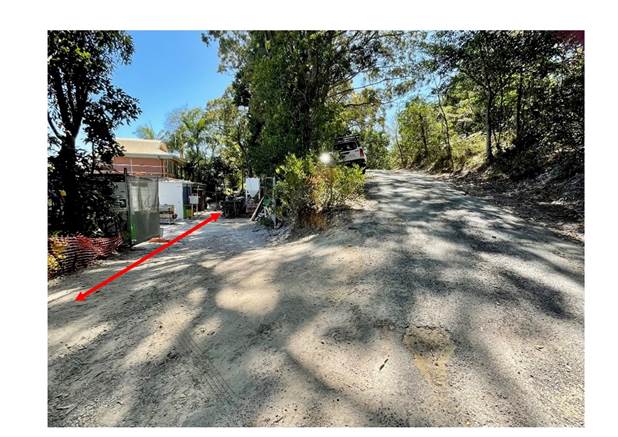
Image 2
Image 2 Red arrow highlights fork to the left of No Name Road
to access Lot 4 & 5 DP 246401.
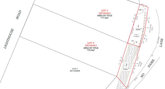
Image 3
Image 3 Shows section of road reserve that would be closed and sold to the adjoining landowners to resolve encroachment issues.
An easement will be created in favour of Lot 5 DP 246401 to formalise access to their property.
Table 1 below provides a summary of likely impacts from the closure of this section of Council road reserve.
Table 1
|
Likely Impacts |
|
|
Waste Collection |
None |
|
Road Assets (e.g. kerb, gutter, roadside barriers, etc) |
None |
|
Stormwater Drainage |
None |
|
Water Supply Assets |
None |
|
Sewer Assets |
None |
|
Public Transport (e.g. bus stops, pedestrian crossings, school buses, etc) |
None |
|
Community / Operational Land |
None |
|
Services (e.g. Rural Fire Service, power, water, Crown lands) |
None |
|
Future Infrastructure upgrades |
Unlikely |
|
Future Council needs in general |
Unlikely |
|
Non Council utilities |
None |
|
Emergency services |
None |
Council identified as per the Roads Act 1993 (Part 4 Division 3 Closing of council public roads by council 38A When council may close council public road), that this part road area would not be reasonably required as a road for public use. This part road area is not required to provide continuity for an existing road network, and the part road does not impede vehicular access to a particular land.
A Notice was placed in The Byron Echo on 13 September 2023 and could be viewed on Council website. Notifications went out to adjoining landowners and all authorities advising closure of the section of Lighthouse Road outlined in Image 1 highlighted blue as per Roads Act 1993 Part 4 Division 3 Closing of council public roads by council 38B Notification of proposal to close council public road.
There was a 28-day submission period with five submissions of objection by adjoining landowners and no submissions for objection by authorities. The points raised in the five submissions had no bearing on the partial road reserve closure. All submissions Attachment 4 E2023/108003.
A resolution of Council is required to finalise the road closure process. The final plans when completed, will be registered with Land Registry Services. A plan of consolidation will also need to be drawn up and registered with Land Registry Services.
Strategic Considerations
Community Strategic Plan and Operational Plan
|
CSP Objective |
CSP Strategy |
DP Action |
Code |
OP Activity |
|
1: Effective Leadership |
1.3: Ethical and efficient management of resources |
1.3.3: Asset Management - Maximise asset service delivery potential and take a proactive approach to lifetime asset maintenance |
1.3.3.8 |
Provide ongoing detailed road assessment and valuation for the purposes of purchase, closure and land sale as required |
Legal/Statutory/Policy Considerations
Roads Act 1993
Part 4 Closing of public roads
Division 3 Closing of council public roads by councils
38A When council may close council public road
A council may propose the closure of a council public road for which it is the roads authority if:
(a) the road is not reasonably required as a road for public use (whether for present or future needs), and
(b) the road is not required to provide continuity for an existing road network, and
(c) if the road provides a means of vehicular access to particular land, another public road provide lawful and reasonably practicable vehicular access to that land.
38B Notification of proposal to close council public road
(1) A council that is proposing to close a council public road must cause notice of the proposal:
(a) to be published in a local newspaper, and
(b) to be given to:
(i) all owners of land adjoining the road, and
(ii) all notifiable authorities, and
(iii) any other person (or class of person) prescribed by the regulations.
(2) The notice:
(a) must identify the road that is proposed to be closed, and
(b) must state that any person is entitled to make submissions to the council with respect to the closing of the road, and
(c) must indicate the manner in which, and the period (being at least 28 days) within which, any such submission should be made.
38C Public submissions and formal objections
(1) Any person may make submissions to the council with respect to the closing of the road in the manner and within the period specified in the notice published under section 38B.
(2) Without limiting subsection (1), a notifiable authority in relation to the road may include a
statement in the authority’s submission to the effect that the authority formally objects to the
closing of the road. The authority may withdraw the objection any time by written notice given
to the council.
Note.
If a formal objection is made, section 38D (2) provides that the road may not be closed until the
objection is withdrawn by the authority or set aside by the Land and Environment Court under this section.
(3) The council may appeal to the Land and Environment Court against a formal objection made by a notifiable authority against the closing of the road.
(4) On any such appeal, the Land and Environment Court may:
(a) affirm the objection, or
(b) set aside the objection.
(5) In deciding whether to affirm or set aside the objection, the Land and Environment Court must have regard to the public interest.
38D Decision of proposal
(1) After considering any submissions that have been duly made with respect to the proposal, the
council may, by notice published in the Gazette, close the public road concerned.
(2) However, a council public road may not be closed:
(a) in the case of a classified road—unless RMS consents to the closure of the road, or
(b) in the case where a notifiable authority has formally objected under section 38C to the
closing of the road—until the objection is withdrawn by the authority or set aside by the
Land and Environment Court under that section.
38E Effect of notice of closure
(1) On publication of the notice closing the council public road concerned:
(a) the road ceases to be a public road, and
(b) the rights of passage and access that previously existed in relation to the road are
extinguished.
(2) The land comprising a former road:
(a) in the case of a public road that was previously vested in a council (other than a public road in respect of which no construction has ever taken place)—remains vested in the council, and
(b) in any other case—becomes (or, if previously vested in the Crown, remains) vested in the Crown as Crown land.
38F Appeals to Land and Environment Court against closure decision
(1) A person referred to in section 38B (1) (b) may appeal to the Land and Environment Court against the closure of a council public road by a council.
(2) On any such appeal, the Land and Environment Court may:
(a) affirm the closure, or
(b) set aside the closure.
(3) Section 38E is taken never to have applied to a closure that is set aside.
(4) To avoid doubt, an appeal under section 38C does not prevent an appeal under this section.
Financial Considerations
The costs associated with this road closure be paid for by the adjoining landowners.
Consultation and Engagement
As per the Roads Act 1993 requirements, the necessary notices and submissions period was undertaken, and two objections were received.