 Agenda
Ordinary Meeting

Thursday, 18 April 2024
Agenda
Ordinary Meeting
Thursday, 18 April 2024
Agenda Ordinary Meeting
held at Council Chambers, Station Street, Mullumbimby
commencing at 9.00AM
Public access relating to items on this agenda can be made between 9:00 and 10:30 am on the day of the meeting. Requests for public access should be made to the General Manager or Mayor no later than 12:00 midday on the day prior to the meeting.

Mark Arnold
General Manager
CONFLICT OF INTERESTS
What is a “Conflict of Interests” - A conflict of interests can be of two types:
Pecuniary - an interest that a person has in a matter because of a reasonable likelihood or expectation of appreciable financial gain or loss to the person or another person with whom the person is associated.
Non-pecuniary – a private or personal interest that a Council official has that does not amount to a pecuniary interest as defined in the Code of Conduct for Councillors (eg. A friendship, membership of an association, society or trade union or involvement or interest in an activity and may include an interest of a financial nature).
Remoteness – a person does not have a pecuniary interest in a matter if the interest is so remote or insignificant that it could not reasonably be regarded as likely to influence any decision the person might make in relation to a matter or if the interest is of a kind specified in the Code of Conduct for Councillors.
Who has a Pecuniary Interest? - a person has a pecuniary interest in a matter if the pecuniary interest is the interest of the person, or another person with whom the person is associated (see below).
Relatives, Partners - a person is taken to have a pecuniary interest in a matter if:
· The person’s spouse or de facto partner or a relative of the person has a pecuniary interest in the matter, or
· The person, or a nominee, partners or employer of the person, is a member of a company or other body that has a pecuniary interest in the matter.
N.B. “Relative”, in relation to a person means any of the following:
(a) the parent, grandparent, brother, sister, uncle, aunt, nephew, niece, lineal descends or adopted child of the person or of the person’s spouse;
(b) the spouse or de facto partners of the person or of a person referred to in paragraph (a)
No Interest in the Matter - however, a person is not taken to have a pecuniary interest in a matter:
· If the person is unaware of the relevant pecuniary interest of the spouse, de facto partner, relative or company or other body, or
· Just because the person is a member of, or is employed by, the Council.
· Just because the person is a member of, or a delegate of the Council to, a company or other body that has a pecuniary interest in the matter provided that the person has no beneficial interest in any shares of the company or body.
Disclosure and participation in meetings
· A Councillor or a member of a Council Committee who has a pecuniary interest in any matter with which the Council is concerned and who is present at a meeting of the Council or Committee at which the matter is being considered must disclose the nature of the interest to the meeting as soon as practicable.
· The Councillor or member must not be present at, or in sight of, the meeting of the Council or Committee:
(a) at any time during which the matter is being considered or discussed by the Council or Committee, or
(b) at any time during which the Council or Committee is voting on any question in relation to the matter.
No Knowledge - a person does not breach this Clause if the person did not know and could not reasonably be expected to have known that the matter under consideration at the meeting was a matter in which he or she had a pecuniary interest.
Non-pecuniary Interests - Must be disclosed in meetings.
There are a broad range of options available for managing conflicts & the option chosen will depend on an assessment of the circumstances of the matter, the nature of the interest and the significance of the issue being dealt with. Non-pecuniary conflicts of interests must be dealt with in at least one of the following ways:
· It may be appropriate that no action be taken where the potential for conflict is minimal. However, Councillors should consider providing an explanation of why they consider a conflict does not exist.
· Limit involvement if practical (eg. Participate in discussion but not in decision making or vice-versa). Care needs to be taken when exercising this option.
· Remove the source of the conflict (eg. Relinquishing or divesting the personal interest that creates the conflict)
· Have no involvement by absenting yourself from and not taking part in any debate or voting on the issue as of the provisions in the Code of Conduct (particularly if you have a significant non-pecuniary interest)
RECORDING OF VOTING ON PLANNING MATTERS
Clause 375A of the Local Government Act 1993 – Recording of voting on planning matters
(1) In this section, planning decision means a decision made in the exercise of a function of a council under the Environmental Planning and Assessment Act 1979:
(a) including a decision relating to a development application, an environmental planning instrument, a development control plan or a development contribution plan under that Act, but
(b) not including the making of an order under that Act.
(2) The general manager is required to keep a register containing, for each planning decision made at a meeting of the council or a council committee, the names of the councillors who supported the decision and the names of any councillors who opposed (or are taken to have opposed) the decision.
(3) For the purpose of maintaining the register, a division is required to be called whenever a motion for a planning decision is put at a meeting of the council or a council committee.
(4) Each decision recorded in the register is to be described in the register or identified in a manner that enables the description to be obtained from another publicly available document, and is to include the information required by the regulations.
(5) This section extends to a meeting that is closed to the public.
OATH AND AFFIRMATION FOR COUNCILLORS
Councillors are reminded of the oath of office or affirmation of office made at or before their first meeting of the council in accordance with Clause 233A of the Local Government Act 1993. This includes undertaking the duties of the office of councillor in the best interests of the people of Byron Shire and the Byron Shire Council and faithfully and impartially carrying out the functions, powers, authorities and discretions vested under the Act or any other Act to the best of one’s ability and judgment.
BUSINESS OF Ordinary Meeting
1. Public Access
3. Attendance by Audio-Visual Link
4. Requests for Leave of Absence
5. Declarations of Interest – Pecuniary and Non-Pecuniary
6. Tabling of Pecuniary Interest Returns (Cl 4.14 Code of Conduct for Councillors)
7. Adoption of Minutes from Previous Meetings
7.1 Ordinary Meeting held on 28 March 2024
8. Reservation of Items for Debate and Order of Business
9. Notices of Motion
9.1 Diminish STRA precinct at Butler Street.................................................................... 8
9.2 Visibility of significant DAs.......................................................................................... 15
9.3 Loan to Byron Bay Football Club............................................................................... 20
10. Mayoral Minute
11. Petitions
12. Delegates' Reports
12.1 Far North Coast BFMC meeting on 2 April 2024.................................................... 23
13. Staff Reports
Corporate and Community Services
13.1 Grants March 2024...................................................................................................... 24
13.2 Council Investments - 1 March 2024 to 31 March 2024........................................ 28
13.3 Public Exhibition of draft 2024/25 Operational Plan, Budget, and Revenue Policy........................................................................................................................................ 36
13.4 Draft Submission - Standing Committee on State Development into the ability of local governments to fund infrastructure and services.................................................... 52
Sustainable Environment and Economy
13.5 Information regarding the use of non-trapping investigative methods and monitoring to monitor and trap dingoes, feral/roaming dogs, foxes and cats............................ 57
13.6 PLANNING - DA 10.2023.235.1 Demolition and construction of mixed-use development comprising basement parking, ground floor courtyard with commercial premises, food and drink premises, two levels of shop top housing (total of 21), rooftop terraces and pool and associated plant at 119-121 Jonson Street BYRON BAY 2481............................................................................................................................... 88
13.7 PLANNING - DA 10.2016.625.5 - 35-37 Burringbar Street Mullumbimby 2482 130
13.8 PLANNING - 26.2023.3.1 - Submissions report - changes to DCP 2014 Chapter E5 - Certain locations in Byron Bay and Ewingsdale................................................... 142
13.9 Wallum Subdivision DA10.2021.575.1 - Response to Council Resolution 23-454 - Stormwater and Cultural Heritage Site Inspection Plan...................................... 152
13.10 PLANNING - Report of the Planning Review Committee held 7 March 2024. 164
13.11 PLANNING - 26.2022.3.1 Planning Proposal - Stage 4 C zone Implementation Program....................................................................................................................... 167
13.12 PLANNING - DA 10.2023.73.1 Demolition and construction of mixed-use development comprising basement parking, ground floor cafe/restaurant and retail, two levels of shop top housing (total of eight), rooftop pool, decking and associated plant and strata subdivision at 9 Marvell Street BYRON BAY 2481.............................................. 173
13.13 PLANNING - Amendments to Byron Shire DCP 2014 Chapter C2: Areas Affected by Flood - Draft for Exhibition........................................................................................ 210
Infrastructure Services
13.14 Bangalow Street Trees Succession Plan............................................................... 217
13.15 Draft Litter and Illegal Dumping Prevention Strategy........................................... 226
13.16 Emergency access at Belongil Beach.................................................................... 233
14. Reports of Committees
Infrastructure Services
14.1 Report of the Floodplain Management Advisory Committee Meeting held on 13 February 2024............................................................................................................ 241
14.2 Report of the Water and Sewer Advisory Committee Meeting held on 21 March 2024...................................................................................................................................... 247
No table of contents entries found.
15. Questions With Notice
15.1 Residual land from Tallowood Estate..................................................................... 250
Questions with Notice: A response to Questions with Notice will be provided at the meeting if possible, that response will be included in the meeting minutes. If a response is unable to be provided the question will be taken on notice, with an answer to be provided to the person/organisation prior to the next Ordinary Meeting and placed on Councils website www.byron.nsw.gov.au/Council/Council-meetings/Questions-on-Notice
Councillors are encouraged to ask questions regarding any item on the business paper to the appropriate Director prior to the meeting. Any suggested amendments to the recommendations should be provided to Councillor Support prior to the meeting to allow the changes to be typed and presented on the screen at the meeting.
Notices of Motion 9.1
Notices of Motion
Notice of Motion No. 9.1 Diminish STRA precinct at Butler Street
File No: I2024/471
I move that Council:
1. Acknowledges the Petition of 61 residents with three urban blocks inside the Short Term Rental Accommodation (STRA) Precinct at Butler Street Byron Bay, in which those residents ask for their sub-area to be extracted from the Precinct.
2. Contacts property owners within the urban blocks as shown below (west of Butler Street and south of Somerset Street) informing them in April of the above request and asking them to respond within 28 days on whether they wish to be included or excluded from the STRA Precinct.
3. Informs the NSW Department of Planning that Council is investigating this minor change with a view to asking for the sub-area’s removal from the STRA Precinct.
4. Receives a report in June on the above consultation and asks for the change.
Signed: Cr Duncan Dey
Councillor’s supporting information:
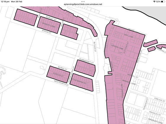
The relevant “sub-area” is the three pink urban blocks central in the picture above, ie west of Butler Street and south of Somerset Street.
Many residents there have expressed their collective view as in the Petition, that they were not aware they would be included and that they wish to be excluded. SIXMAPS shows 65 properties within the three urban blocks in question. If the resident survey represents the property owner’s views, then these should be listened to.
Staff comments
by Shannon Burt, Director Sustainable Environment and Economy:
As Council and the community is aware, the NSW State Government endorsed the change for non-hosted short term rental accommodation (STRA) to 60 days per year for most of the Shire. To offset this, two nominated and strategically mapped areas were identified for uncapped unhosted STRA. These being in the Byron Town Centre and Brunswick Village.
The Council report to the 15 December 2022 meeting addressed this specific issue and Council resolved (Res.22 -729) to include this precinct – see below.
Report:
https://byron.infocouncil.biz/Open/2022/12/OC_15122022_AGN_1481.htm#PDF2_ReportName_10454
Resolution:
https://byron.infocouncil.biz/Open/2022/12/OC_15122022_MIN_1481.htm#PDF2_ReportName_10454
Relevant report extracts:
To achieve this outcome for the community, a lengthy difficult and public planning proposal process occurred. Many reports over several years were presented to Council on same, including but not limited to an economic impact assessment for the planning proposal.
No other council in NSW has been granted this level of local control.
Short-term rental accommodation Planning Proposal - Byron Shire Council (nsw.gov.au)
Short-Term Rental Accommodation - Byron Shire Council (nsw.gov.au)
The planning proposal process also included a public hearing held by the Independent Planning Commission as required by the Minister for Planning.
At all-times during the planning proposal process, submissions received from stakeholders including residents and landowners were considered in the context of the NSW STRA management framework and what was being asked for and why.
The final decision made by the Minister for Planning to have some areas in Byron Bay and Brunswick Heads able to operate for 365 days per year as STRA, addressed the IPC recommendations, planning legislation and moreover aligned with the above resolved position of Council made in its submission to the Minister for Planning for local planning controls that included the same mapped precincts as uncapped STRA.
The Minister in his press release September 2023 stated:
In response to the Independent Planning Commission’s recommendation, the cap will be tightened on some STRA from 180 days to 60 days per 365-day period.
Some precincts in Byron Bay and Brunswick Heads with high tourism appeal, near beaches and services, were identified by Council to operate without a cap – allowing for year-round use.
Hosted short term rentals (where the host resides on the premises during the stay) are unaffected by this decision and can be undertaken 365 days per year.
There will be a 12-month transition period for the community and industry to prepare before the new rules to take effect on September 26, 2024, ahead of the 2024/25 summer…….
"I thank Council, the community, the IPC, industry, and stakeholders for such a collaborative effort to find the best outcome that strikes the right balance for locals and visitors.”
Taking the above into account, the Notice of Motion as drafted is not supported by staff.
It is contrary to the work that Council has done towards achieving, and about to implement for the management of STRA from September 2024 on.
It is also pre-emptive and premature to start a pick and choose process for precincts or changes to precincts without evidence, given the work involved and justification needed in making them in the first place.
Further, for any review of the STRA provisions for Byron Shire to occur, the new rules need to be in effect followed by a reasonable period of monitoring with data collection and collation to inform any review. Any decision also needs to be grounded in social and economic impact assessments.
To this end, the monitoring and review of the Byron Shire STRA rules post implementation has also been widely reported on in Council reports. A program for this as well as enforcement strategy for STRA is under development.
Further to the above, Council at the meeting of 14 March 2024 reiterated the above stated position in its recent submission to the ‘review of short-term rental accommodation regulations and the supply of long-term rental accommodation’ to the Department of Planning Housing and Industry by stating:
Planning Pathways and general requirements
From a Byron Shire Council perspective, at this time a change to the planning pathways for STRA locally is not considered necessary. In September 2024, new regulations will apply across most of the Byron Shire, with a 60-day cap on un-hosted STRA in all areas except parts of Byron Bay and Brunswick Heads, after which a period of monitoring and review will follow.
However, Housing SEPP STRA general requirements section 113 (c) needs to remove reference to certain secondary dwellings (see below).
Further, the provision in the Housing SEPP ‘to not count bookings over 21 consecutive days’ towards a day cap, also needs removal to prevent day cap creep / extension at the expense of the integrity of the day cap in place. Its intended use for mobile workforce and corporate accommodation is being misused. Further, the ability to monitor it is problematic as it is without restriction. Anecdotally, we have heard that some operators intend to utilise this exemption as a loophole to avoid the 60-day cap.
Recommendation
• Current planning pathways are acceptable.
• Byron Shire Council will implement its new regulations in September 2024 and monitor and review after.
• Certain secondary dwellings need to be removed from Housing SEPP general requirements section 113 (c) (see below).
• Bookings over 21 days enabled under the Housing SEPP need to count
Financial/Resource/Legal Implications:
N/A
Is the proposal consistent with any Delivery Program tasks?
|
CSP Objective |
CSP Strategy |
DP Action |
Code |
OP Activity |
|
4: Ethical Growth |
4.1: Manage responsible development through effective place and space planning |
4.1.4: LEP & DCP - Review and update the Local Environmental Plan and Development Control Plans |
4.1.4.7 |
Progress Short Term Rental Accommodation planning proposal
|
Notices of Motion 9.2
Notice of Motion No. 9.2 Visibility of significant DAs
File No: I2024/474
I move:
1. That Council prepares a report that considers improving the visibility of significant DAs and other events happening at Council and in Byron Shire, including more regular advertising in the local newspaper and on local radio.
2. That the report considers how to reach the greatest number of community members to advise them of:
a) non-complying DAs that are likely to have an impact beyond their immediate neighbours
b) public notices or similar from State and Federal agencies such as Planning Panels
c) items usually put on the ‘Your Say” page of Council’s website
d) other significant issues that affect Byron Shire residents and businesses
e) any other items of public significance.
Signed: Cr Cate Coorey
Councillor’s supporting information:
Whilst I realise that we have a Community Participation Plan, it feels, from personal feedback and commentary on Facebook in particular, that we are not reaching enough people about what goes on in the Shire.
The lack of community awareness around the Wallum Estate subdivision has pointed out gaps in public awareness. Whilst this is not the fault of Council, given that it was an NRPP decision, a better-informed public could, for example, have called for the NRPP to have held a community hearing on this DA and been able to raise concerns and challenge aspects and the outcome may have been different.
We are largely reliant on the BSC website and email newsletter for most communications and whilst I know that the website has a good level of use, I don’t believe that most people regularly check what is happening around them – either the Public Notices and the ‘Your Say’ on our front page, or the DA Tracker. The ‘What’s Happening Near Me’ button is so far down on the home page that most people would overlook it. Maybe more people need to know it is there.
It may not be that we need to advertise every significant DA in the Echo, for example, but if we don’t do that, then we need to do better at directing/reminding people to look – and look often -- at those things that may concern them.
It may well be community apathy is the problem, but we could consider some of the following:
A regular ad in the same place in the Echo every week that outlines key things happening in the Shire. Rather than listing every DA, we could simply put that there are new DAs on exhibition in [insert suburb] and direct people to the tracker for more info.
Additionally, I’m not aware that we advertise at all on Bay FM, which is widely listened to. We could have an ongoing revolving Community Service Announcement that reminds people to visit our website for updates on what’s happening and DAs in their area. Or, we could every week send to Bay FM a list of things that require community attention that could be read out in community news/what’s on etc. When Simon Richardson was a regular guest on a Friday morning, it was a good opportunity to mention what was going on in Council and was good for keeping people up to date on a lot of things.
These are just a few ideas that a report could consider, they are by no means all.
Staff comments
by Shannon Burt, Director, Sustainable Environment and Economy and Esmeralda Davis Director Corporate and Community Services:
Planning authorities, including councils and NSW agencies with key planning approval functions, must have a community participation plan (CPP). The Environmental Planning and Assessment Act 1979 (EP&A Act) requires this.
CPPs set out how the planning authority will engage the public in their decision-making. These principles set the standard.
CPPs must meet the minimum requirements for community participation set out in Schedule 1 of the EP&A Act, but planning authorities may choose to do more.
In our adopted CPP Community Participation Plan - Byron Shire Council (nsw.gov.au) , we have an additional category of development ‘community significant development’.
Community significant development is:
· a building with a gross floor area of 5,000m2 or more in an industrial, rural or commercial zone; or
· any development that will be referred under the Act to the Joint Regional Planning Panel; or
· any subdivision resulting in 50 lots or more; or residential accommodation resulting in 10 or more dwellings; or
· any development that proposes demolition of a heritage listed item; or
· pubs; or
· small bars (nightclubs) within the meaning of the Liquor Act 2007; or
· function centres; or
· restaurants in rural areas; or
· offensive industries; or
· telecommunications facility
For all developments considered to be community significant development, consultation with the community is required before lodgement of the development application. It is the applicant’s responsibility to carry out the pre-lodgement consultation. We are the only NSW Council to have this category of development in its Community Participation Plan.
The EP&A Act also requires planning decision-makers to publicise the reasons for their decisions on key matters and show how they considered community views.
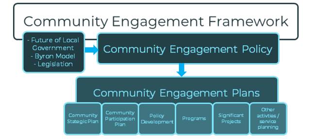
Councils may build their CPPs into the broader community engagement strategies they prepare under local government legislation. To this end, Council has an adopted Community Engagement Strategy Community Engagement Strategy - Byron Shire Council (nsw.gov.au).
These documents form part of a wider community engagement framework as show below:
The requirement for newspaper advertising was permanently removed from the Local Government (General) regulation in 2020 as a result of a COVID-19 related amendment. Coincidentally, Council’s current contract with the Byron Shire Echo also expired at the end of September 2020. Since this time, all information previously published in the Echo is available on Council’s website, including:
- Public Notices and Tenders
- Documents on Exhibition and Submissions
- DA notifications
Print advertising is still utilised on an ‘as needed’ basis for significant projects.
Information is regularly shared with community via Council’s e-newsletter, which although not print media, has a current reach of 15,000+ subscribers and an open rate of 50-54%+ (compared with the average rate of 45%). Council website views exceeded 120,000 and YourSay page views exceeded 5,400 in March 2024.
Council also has a planning e-newsletter which has subscribers sent regular updates and planning news throughout the year. This, and further enhancements to the Council’s DA Tracker/Authority to include a Development Exhibition Subscription Service, is also being explored at the moment in response to questions from the Community Roundtable members.
This Notice of Motion is seeking a further report on improving the visibility of significant DAs and other events happening at Council and in Byron Shire. In particular looking at advertising in the local newspaper and on local radio. If this report proceeds, further consideration will be given to understanding the reach and accessibility of current advertising and information distribution methods, and the value of increasing newspaper and/or radio advertising.
Financial/Resource/Legal Implications:
Budget will be required to support changes to or augmentation of community engagement approaches outside current adopted plans and strategies.
Is the proposal consistent with any Delivery Program tasks?
|
CSP Objective |
CSP Strategy |
DP Action |
Code |
OP Activity |
|
1: Effective Leadership |
1.2: Engage and involve community in decision making |
1.2.1: Community-led decision making - Engage with community to inform Council decision making |
1.2.1.1 |
Provide opportunities for the community to have input, comment and feedback to Council on projects and matters of interest |
|
1: Effective Leadership |
1.2: Engage and involve community in decision making |
1.2.1: Community-led decision making - Engage with community to inform Council decision making |
1.2.1.2 |
Support staff to consider communication and engagement as part of all project development and implementation
|
Notices of Motion 9.3
Notice of Motion No. 9.3 Loan to Byron Bay Football Club
File No: I2024/541
I move that Council lends the Byron Bay Football Club $200,000 over ten years at a low interest rate.
Signed: Cr Michael Lyon
Councillor’s supporting information:
Byron Bay Football Club are undertaking a build of a new clubhouse on the Byron Bay Memorial Recreation Grounds. They have raised significant amounts of money through fundraising, donations and government grants and are close to their target of $1.25 million, the total cost of the build. They are approximately $200k short and do not want to partially complete the project and have contractors leave the site, as this will ultimately end up costing them 30-40% on these components of work.
They have reached out for a loan from Council, given that this will ultimately be a Council-owned asset on Council-managed land. I have advised representatives of the Club that I would bring it to Council in the hope of getting support for them to finish the project. Whilst this notice of motion proposes a 10-year period for the loan, they anticipate being able to pay back the loan well before then, indeed this is their intention, as they do not wish there to be debt on the books of the club. They expect to be making $60k per annum conservatively with the new canteen, functions etc. that can be held in the new facility. I suggest we lend to them, at the rate we borrow at, which is currently 4.94% with NSW Treasury Corporation.
They are a large and successful club with a proud history, with over 650 members and 70 active teams and 710 players on the books and it would be great if we could get behind them so they can finish the project asap. I have full confidence in their ability to pay the money back. I also ask that we include a clause in the loan contract which allows for early repayment without penalty.
Staff comments
by James Brickley, Manager Finance, Corporate and Community Services:
The provision of a loan to a sporting club whilst not a regular occurrence is not uncommon in local government. These have been known as a ‘Sporting Club Advance.’
In the case of the Byron Bay Football Club, Council recognises the building subject of the loan request as an asset since it is located on Council Community Land. In this instance there are no issues about security over a potential loan as the funds will be spent on a building that Council is the ultimate owner of. The loan, if approved by Council, will enable the Byron Bay Football Club to effectively add value to a Council asset.
Currently Council could borrow at 4.94% per annum over ten years, based on a reference interest rate provided by NSW Treasury Corporation. If that interest rate were acceptable and Council loaned $200,000 to the Byron Bay Football Club, annual loan repayments would be $25,825.50 per annum, inclusive of loan interest and principal.
Council should take steps to understand the capacity of the Club to repay a loan prior to an offer of a loan to the Byron Bay Football Club. With this in mind, Council should undertake some due diligence by for example, reviewing two previous year’s financial statements and a year to date financial statement.
The Property Development Reserve could fund the loan, with that reserve being reimbursed as loan repayments are made. On a cashflow basis though, this reserve will initially be left with approximately $100,000 on current projections should the loan offer be made and accepted. In the short term, this may limit Council undertaking other projects that this reserve could be called upon to fund, but in the longer term it will be replenished through loan repayments. The loan would be established in Council’s accounts as a ‘deferred debtor.’
Council may consider also to delegate to the General Manager the authority to negotiate an appropriate loan agreement with the Byron Bay Football Club that secures Council’s interests, covers the situation if there is any payment default, plus any other relevant terms or conditions. Further, whilst the term of the loan is suggested at 10 years, Council should without penalty accept early repayment of the entire loan or even in part if the situation arises, which appears to be a desire of the Club from the information included in this NOM.
Financial/Resource/Legal Implications:
Included in the staff comments above.
Is the proposal consistent with any Delivery Program tasks?
Yes
Strategy 5.4 – Connected Infrastructure – Provide accessible community facilities and open spaces.
Deliver Plan Priority – 5.4.4 Sporting Facilities and Swimming Pools – Ensure ongoing maintenance and upgrade of inclusive sporting facilities and swimming pools.
|
CSP Objective |
CSP Strategy |
DP Action |
Code |
OP Activity |
|
||||
|
5: Connected Infrastructure |
5.4: Provide accessible community facilities and open spaces |
5.4.4: Sporting facilities and swimming pools - Ensure ongoing maintenance and upgrade of inclusive sporting facilities and swimming pools |
5.4.4.6 |
Work with sport and community groups to build relationships and help drive increased participation opportunities and event attraction
|
|||||
Delegates' Reports 12.1
Delegates' Reports
Delegate's Report No. 12.1 Far North Coast BFMC meeting on 2 April 2024
File No: I2024/478
The Bush Fire Management Committee’s (BFMC) area covers three Shires: Tweed, Byron, Ballina. I attended the Committee meeting in Murwillumbah. Matters relevant to Byron Shire included:
1. Council and Fire & Rescue NSW have corresponded about a proposal to connect Lilli Pilli Drive from its north end to Cemetery Road, for resident egress during bushfire. Parking in the cul-de-sac will have to be restricted, to keep the route open in emergencies and a gate installed to prevent daily usage. Keys will be shared across agencies but not with residents.
2. Crown Lands raised the issue of an Asset Protection Zone northwards off Bayside Way, behind the residential area that includes the Village Greens shop. The need was identified after the Bayshore Drive fire that almost reached Bayside Brunswick in October 2023.
3. North Rocks Road starts on Council administered land in Huonbrook and rises into the National Park. The route runs 1.3km in the valley then 2.6km in the Park. It was heavily damaged in the 2022 flood. BFMC has previously determined to abandon the route, ie to remove it from the Fire Access and Fire Trail (FAFT) Plan. This will be executed at the next BFMC meeting unless reasons arise not to. RFS has written to Council several times recently but has not yet received a response.
The next Committee meeting is scheduled for 11 June 2024.
Signed: Cr Duncan Dey
Staff Reports - Corporate and Community Services 13.1
Staff Reports - Corporate and Community Services
Report No. 13.1 Grants March 2024
Directorate: Corporate and Community Services
Report Author: Donna Johnston, Grants Coordinator
File No: I2023/1978
Summary:
Council is waiting on determination of 15 Grant applications which, if successful, would provide funding to enable the delivery of identified projects. This report provides an update on Grant applications.
RECOMMENDATION:
That Council notes the grant submissions report for the month of March 2024 (Attachment 1 #E2024/35071).
1 Grant
submission as at March 2024, E2024/35071
![]()
Report
Currently Council has 15 grant applications awaiting determination (refer to Grants Submissions as of 31 March 2024 - Attachment 1, E2024/35071.
Successful applications
No grants announced.
Unsuccessful applications
No notifications received.
Upcoming Grant opportunities
The Australian Government’s Housing Support Program (HSP) is one of a range of programs designed to help achieve National Housing Accord’s target of building 1.2 million new, well-located homes over 5 years from 1 July 2024. The HSP will support the delivery of increased housing supply by funding projects that seek to deliver enabling infrastructure, provide amenities to support new housing development or improve building planning capability.
This first Stream (HSP 1) will provide funding to state, territory and local governments for projects which will improve planning capability. A later stream will provide funding for enabling infrastructure projects. More specifically the program will support:
· Infrastructure projects that support new housing, such as connecting essential services like water, power, sewage and roads;
· Infrastructure projects that provide amenities to support new housing, including shared facilities like community centres and parks;
· Building planning capability, including resources to support increased delivery of new housing and master planning to support increasing housing in well-located areas.
The HSP is a competitive funding program open to all local, state and territory governments across Australia. Funding will be provided via two streams:
· Stream 1 is designed for projects that will improve planning capacity.
· Stream 2 will focus on infrastructure projects that support new housing of this program, by ensuring enabling infrastructure and amenities are in place.
The program will operate over 2023-24 and 2024-25, concluding on 30 June 2025.
Staff are currently preparing an application for the development of a Masterplan and Business Case to support delivery outcomes of the former Mullumbimby Hospital site.
Litter Prevention Grants Program: grants available (nsw.gov.au)
Up to $10 million in funding is available in three streams from 2022 to 2027.
The NSW Government has opened the Waste and Sustainable Materials Strategy 2041 (WASM) Litter Prevention Grants Program for councils, community groups and other key stakeholders to deliver litter prevention projects and develop strategic plans to address litter in their local environments.
Up to $10 million is available from 2022 to 2027. Funding is provided under three streams:
· Stream 1: Small-scale, on-ground projects, including a dedicated cigarette butt litter program
· Stream 2: Strategic development and capacity building
· Stream
3: Own It and Act strategic implementation
Following an Expression of Interest, Council has been invited to apply for funding under Stream 3 for funding to support implementation activities from the draft Illegal Dumping Prevention Strategy 2024 to 2029.
Community Strategic Plan and Operational Plan
|
CSP Objective |
CSP Strategy |
DP Action |
Code |
OP Activity |
|
1: Effective Leadership |
1.3: Ethical and efficient management of resources |
1.3.1: Financial Management - Ensure the financial integrity and sustainability of Council through effective financial management |
1.3.1.9 |
Coordinate grant applications to support the delivery of Council projects and services within management plans, masterplans, strategic plans, council resolutions and high priority actions from feasibility studies; and support the management of successful grants |
Legal/Statutory/Policy Considerations
Under section 409 3(c) of the Local Government Act 1993 Council is required to ensure that ‘money that has been received from the Government or from a public authority by way of a specific purpose advance or Grant, may not, except with the consent of the Government or public authority, be used otherwise than for that specific purpose’. This legislative requirement governs Council’s administration of Grants.
Financial Considerations
If Council is successful in obtaining the identified Grants, this would bring funding sought to approximately $27.8 million which would provide significant funding for Council projects. Some of the Grants require a contribution from Council (either cash or in-kind) and others do not. Council’s contribution is funded.
The potential funding is detailed below:
Funding applications submitted and
awaiting notification (total value) $27.8 million
Requested funds from funding bodies $15.3 million
Council contribution cash $12.5 million
Council co-contribution in-kind $4,500
Other contributions $0
Funding determined in March 2024:
Successful
applications $0 (total project value)
Unsuccessful/withdrawn applications $0 (total project value)
Consultation and Engagement
Cross-organisational consultation has occurred in relation to the submission of relevant grants, and the communication of proposed grant applications.
Staff Reports - Corporate and Community Services 13.2
Report No. 13.2 Council Investments - 1 March 2024 to 31 March 2024
Directorate: Corporate and Community Services
Report Author: James Brickley, Manager Finance
File No: I2024/467
Summary:
This Report includes a list of investments and identifies Council’s overall cash position for the period 1 March 2024 to 31 March 2024 for information.
This Report is prepared to comply with Section 212 of the Local Government (General) Regulation 2021.
RECOMMENDATION:
That Council notes the report
listing Council’s investments and overall cash position as of 31 March
2024.
Report
Council has continued to maintain a diversified portfolio of investments. As of 31 March 2024, the average 90-day bank bill rate (BBSW) for the month was 4.34%. Council’s performance for March 2024 was 4.68%.
The table below identifies the investments held by Council as at 31 March 2024.
Schedule of Investments held as at 31 March 2024
|
Purch Date |
Principal ($) |
Description |
CP* |
Rating |
Maturity Date |
Fossil Fuel |
Type |
Int. Rate |
Current Value ($) |
|
15/11/18 |
1,000,000.00 |
NSW Treasury Corp (Green Bond) |
N |
AAA |
15/11/28 |
N |
B |
3.00% |
963,140.00 |
|
28/03/19 |
1,000,000.00 |
National Housing Finance & Investment Corporation |
Y |
AAA |
28/03/29 |
N |
B |
2.38% |
930,300.00
|
|
21/11/19 |
1,000,000.00 |
NSW Treasury Corp (Sustainability Bond) |
N |
AAA |
20/03/25 |
N |
B |
1.25% |
975,930.00
|
|
27/11/19 |
500,000.00 |
National Housing Finance & Investment Corp |
Y |
AAA |
27/05/30 |
N |
B |
1.52% |
429,118.00
|
|
15/06/21 |
500,000.00 |
National Housing Finance & Investment Corp |
Y |
AAA |
01/07/31
|
N |
B |
1.99% |
504,076.29
|
|
06/09/21 |
1,000,000.00 |
Northern Territory TCorp |
N |
Aa3 |
15/12/26 |
N |
B |
1.40% |
1,000,000.00 |
|
16/09/21 |
1,000,000.00 |
QLD Treasury Corp (Green Bond) |
N |
AA+ |
02/03/32 |
N |
B |
1.83% |
801,190.00 |
|
30/10/23 |
850,000.00 |
Bank Australia Ltd |
P |
BBB+ |
30/10/26 |
N |
FRN |
5.84% |
852,994.45 |
|
21/02/24 |
500,000.00 |
Bank Australia Ltd |
N |
BBB+ |
21/02/28 |
N |
FRN |
6.04% |
502,301.30 |
|
27/11/23 |
1,000,000.00 |
Westpac Tailored |
P |
AA- |
27/11/24 |
N |
TD |
5.40% |
1,000,000.00 |
|
29/11/23 |
1,000,000.00 |
Bank of QLD |
P |
BBB+ |
02/04/24 |
N |
TD |
5.20% |
1,000,000.00 |
|
04/12/23 |
2,000,000.00 |
Bank of QLD |
N |
BBB+ |
04/04/24 |
N |
TD |
5.20% |
2,000,000.00 |
|
03/01/24 |
2,000,000.00 |
Judo Bank |
P |
BBB- |
02/04/24 |
N |
TD |
5.10% |
2,000,000.00 |
|
04/01/24 |
1,000,000.00 |
Judo Bank |
N |
BBB- |
04/04/24 |
N |
TD |
5.10% |
1,000,000.00 |
|
08/01/24 |
2,000,000.00 |
NAB |
P |
AA- |
08/04/24 |
Y |
TD |
5.05% |
2,000,000.00 |
|
10/01/24 |
2,000,000.00 |
Judo Bank |
N |
BBB- |
10/04/24 |
N |
TD |
5.10% |
2,000,000.00 |
|
11/12/24 |
2,000,000.00 |
Bank of QLD |
N |
BBB+ |
11/04/24 |
N |
TD |
5.20% |
2,000,000.00 |
|
12/01/24 |
5,000,000.00 |
Judo Bank |
N |
BBB- |
12/04/24 |
N |
TD |
5.10% |
5,000,000.00 |
|
12/01/24 |
5,000,000.00 |
Bank of QLD |
N |
BBB+ |
13/05/24 |
N |
TD |
5.05% |
5,000,000.00 |
|
12/01/24 |
5,000,000.00 |
NAB |
N |
AA- |
10/07/24 |
Y |
TD |
5.10% |
5,000,000.00 |
|
12/01/24 |
5,000,000.00 |
Heritage Bank |
P |
BBB |
11/07/24 |
N |
TD |
5.00% |
5,000,000.00 |
|
19/01/24 |
1,000,000.00 |
Judo Bank |
N |
BBB- |
19/04/24 |
N |
TD |
5.05% |
1,000,000.00 |
|
19/01/24 |
1,000,000.00 |
NAB |
N |
AA- |
18/04/24 |
Y |
TD |
5.05% |
1,000,000.00 |
|
19/01/24 |
1,000,000.00 |
Bank of QLD |
N |
BBB+ |
20/04/24 |
N |
TD |
5.05% |
1,000,000.00 |
|
22/01/24 |
1,000,000.00 |
Bank of QLD |
N |
BBB+ |
22/05/24 |
N |
TD |
5.05% |
1,000,000.00 |
|
25/01/24 |
2,000,000.00 |
Bank of QLD |
N |
BBB+ |
24/05/24 |
N |
TD |
5.05% |
2,000,000.00 |
|
30/01/24 |
1,000,000.00 |
NAB |
N |
AA- |
29/04/24 |
Y |
TD |
5.05% |
1,000,000.00 |
|
07/02/24 |
1,000,000.00 |
Auswide Bank |
P |
BBB- |
08/05/24 |
N |
TD |
5.05% |
1,000,000.00 |
|
07/02/24 |
1,000,000.00 |
Auswide Bank |
N |
BBB- |
07/08/24 |
N |
TD |
5.15% |
1,000,000.00 |
|
19/02/24 |
1,000,000.00 |
NAB |
N |
AA- |
20/05/24 |
Y |
TD |
5.05% |
1,000,000.00 |
|
29/02/24 |
1,000,000.00 |
MyState Bank |
P |
BBB |
29/05/24 |
N |
TD |
5.00% |
1,000,000.00 |
|
06/03/24 |
2,000,000.00 |
Beyond Bank |
P |
BBB |
05/06/24 |
N |
TD |
5.10% |
2,000,000.00 |
|
07/03/24 |
2,000,000.00 |
Judo Bank |
N |
BBB- |
05/09/24 |
N |
TD |
5.20% |
2,000,000.00 |
|
08/03/24 |
2,000,000.00 |
Beyond Bank Australia |
N |
BBB |
06/06/24 |
N |
TD |
5.05% |
2,000,000.00 |
|
14/03/24 |
1,000,000.00 |
Bank of QLD |
N |
BBB+ |
16/09/24 |
N |
TD |
5.17% |
1,000,000.00 |
|
18/03/24 |
2,000,000.00 |
NAB |
N |
AA- |
18/06/24 |
Y |
TD |
5.05% |
2,000,000.00 |
|
21/03/24 |
2,000,000.00 |
NAB |
N |
AA- |
21/06/24 |
Y |
TD |
5.05% |
2,000,000.00 |
|
27/03/24 |
1,000,000.00 |
Auswide Bank Ltd |
N |
BBB- |
27/06/24 |
N |
TD |
5.00% |
1,000,000.00 |
|
N/A |
20,311,785.72
|
CBA Business Saver |
P |
AA- |
N/A |
Y |
CALL |
4.35% |
20,311,785.72
|
|
N/A |
1,163,113.40
|
CBA Business Saver – Tourism Infrastructure Grant |
N |
AA- |
N/A |
Y |
CALL |
4.35% |
1,163,113.40
|
|
N/A |
10,104,137.05
|
Macquarie Accelerator Call |
N |
A |
N/A |
Y |
CALL |
4.20% |
10,104,137.05
|
|
Total |
94,929,036.17 |
|
|
|
|
|
AVG |
4.68% |
94,538,086.21 |
|
Note 1. |
CP = Capital protection on maturity |
|||
|
|
|
|||
|
|
N = No Capital Protection |
|||
|
|
Y = Fully covered by Government Guarantee |
|||
|
|
P = Partial Government Guarantee of $250,000 (Financial Claims Scheme) |
|||
|
|
|
|||
|
Note 2. |
Fossil Fuel ADI |
|||
|
|
N = No investment in Fossil Fuels |
|||
|
|
Y = Investment in Fossil Fuels |
|||
|
|
U = Unknown Status |
|||
|
|
|
|
|
|
|
|
|
|
|
|
|
Note 3. |
Type |
Description |
|
|
|
|
B |
Bonds |
Principal can vary based on valuation, interest payable via a fixed interest, payable usually each quarter. |
|
|
|
FRN |
Floating Rate Note |
Principal can vary based on valuation, interest payable via a floating interest rate that varies each quarter. |
|
|
|
TD |
Term Deposit |
Principal does not vary during investment term. Interest payable is fixed at the rate invested for the investment term. |
|
|
|
CALL |
Call Account |
Principal varies due to cash flow demands from deposits/withdrawals. Interest is payable on the daily balance. |
|
Environmental and Socially Responsible Investing (ESRI)
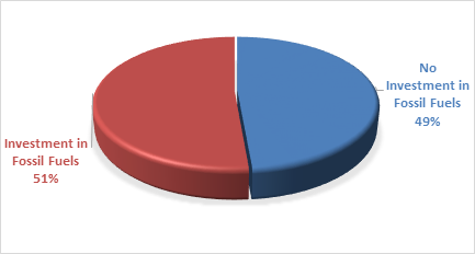
An additional column has been added to the schedule of Investments to identify if the financial institution holding the Council investment has been assessed as a ‘Fossil Fuel’ investing institution. This information has been sourced through www.marketforces.org.au and identifies financial institutions that either invest in fossil fuel related industries or do not. The graph below highlights the percentage of each classification across Council’s total investment portfolio in respect of fossil fuels only.
The notion of Environmental and Socially Responsible Investing is much broader than whether a financial institution as rated by ‘marketforces.org.au’ invests in fossil fuels or not. Council’s current Investment Policy defines Environmental and Socially Responsible Investing at Section 4.1 of the Policy which can be found on Council’s website.
Council may from time to time have an investment with a financial institution that invests in fossil fuels but is nevertheless aligned with the broader definition of Environmental and Socially Responsible investments. When this occurs, the investment will be marked as no fossil fuels given the investment purpose.
During the month of November 2023 as an example, Council undertook an investment with Westpac Bank as a tailored deposit. The investment proceeds are utilised for environmental purposes as this investment in Climate Bond Ceritifed.
With the lifting of the NSW Treasury Corporation loan borrowing covenant on Council’s investments, growth has recommenced in acquiring investments not aligned with fossil fuels. Council’s portfolio reached its lowest point in August 2023 at 15% but as at 31 March 2024, the portfolio has increased to 49%.
The below table identifies compliance with Council’s Investment Policy by the proportion of the investment portfolio invested with financial institutions, along with their associated credit ratings compared to parameters in the Investment Policy. The parameters are designed to support prudent short and long-term management of credit risk and ensure diversification of the investment portfolio. Note that the financial institutions currently offering investments in the ‘ethical’ area are still mainly those with lower credit ratings (being either BBB or not rated at all i.e., credit unions).
|
Investment policy compliance |
|
|
||
|
% should not exceed the following |
ACTUAL |
|
||
|
|
|
|
|
|
|
AAA to AA |
A1+ |
100% |
45% |
Meets policy |
|
A+ to A- |
A1 |
60% |
11% |
Meets policy |
|
BBB to NR |
A2,NR |
40% |
44% |
Does not meet policy |
The above table shows the BBB to NR category are outside policy at 31 March 2024, however at 2 April 2024 this has been corrected with two term deposits in the BBB category maturing and therefore bringing the term deposits back in line with policy. Further, Bank of Queensland has had a credit rating upgrade as of 3 April 2024 now rated A- long term.
The investment portfolio is outlined in the table below by investment type for the period 1 March 2024 to 31 March 2024:
Dissection of Council Investment Portfolio as at 31 March 2024
|
Investment Linked to: |
Current Market Value ($) |
Cumulative Unrealised Gain/(Loss) ($) |
|
|
56,000,000.00 |
Term Deposits |
56,000,000.00 |
0.00 |
|
20,311,785.72 |
CBA Business Saver |
20,311,785.72 |
0.00 |
|
1,163,113.40
|
CBA Business Saver – Tourism Infrastructure Grant |
1,163,113.40
|
0.00 |
|
10,104,137.05 |
Macquarie Accelerator |
10,104,137.05 |
0.00 |
|
7,350,000.00 |
Bonds/Floating Rate Notes |
6,959,050.04 |
(390,949.96) |
|
94,929,036.17 |
Total |
94,538,086.21 |
(390,949.96) |
Council’s overall ‘cash position’ is not only measured by funds invested but also by the funds retained in its consolidated fund or bank account for operational purposes. The table below identifies Council’s overall cash position for the month of March 2024 as follows:
Dissection of Council’s Cash Position as at 31 March 2024
|
Principal Value ($) |
Current Market Value ($) |
Cumulative Unrealised Gain/(Loss) ($) |
|
|
Investments Portfolio |
|||
|
Term Deposits |
56,000,000.00 |
56,000,000.00 |
0.00 |
|
CBA Business Saver |
20,311,785.72
|
20,311,785.72
|
0.00 |
|
CBA Business Saver – Tourism Infrastructure Grant |
1,163,113.40
|
1,163,113.40
|
0.00 |
|
Macquarie Accelerator |
10,104,137.05
|
10,104,137.05
|
0.00 |
|
Bonds |
7,350,000.00 |
6,959,050.04 |
(390,949.96) |
|
Total Investment Portfolio |
94,929,036.17 |
94,538,086.21 |
(390,949.96) |
|
Cash at Bank |
|||
|
Consolidated Fund |
1,794,089.10 |
1,794,089.10 |
0.00 |
|
Total Cash at Bank |
1,794,089.10 |
1,794,089.10 |
0.00 |
|
Total Cash Position |
96,723,125.27 |
96,332,175.31 |
(390,949.96) |
Strategic Considerations
Community Strategic Plan and Operational Plan
|
CSP Objective |
CSP Strategy |
DP Action |
Code |
OP Activity |
|
1: Effective Leadership |
1.3: Ethical and efficient management of resources |
1.3.1: Financial Management - Ensure the financial integrity and sustainability of Council through effective financial management |
1.3.1.6 |
Maintain Council's cash flow |
Legal/Statutory/Policy Considerations
In accordance with Section 212 of the Local Government (General) Regulation 2021, the Responsible Accounting Officer of Council must provide Council with a monthly report detailing all monies it has invested under section 625 of the Local Government Act 1993.
The Report must be presented at the next Ordinary Meeting of Council after the end of the month being reported. The current Council Meeting cycle does not always allow this to occur, especially as investment valuations required for the preparation of the report are often received after the deadline for the submission of reports. Endeavours are being made to achieve a better alignment and for some months this will require reporting for one or more months.
Council’s investments are made in accordance with section 625(2) of the Local Government Act 1993 and Council’s Investment Policy. The Local Government Act 1993 allows Council to invest money as per the Minister’s Order – Forms of Investment, last published in the Government Gazette on 11 March 2011.
Council’s Investment Policy includes the objective of maximising earnings from authorised investments and ensuring the security of Council Funds.
Financial Considerations
Council uses a diversified mix of investments to achieve short, medium, and long-term results.
Staff Reports - Corporate and Community Services 13.3
Report No. 13.3 Public Exhibition of draft 2024/25 Operational Plan, Budget, and Revenue Policy
Directorate: Corporate and Community Services
Report Author: Heather Sills, Manager Corporate Services
James Brickley, Manager Finance
Amber Evans Crane, Corporate Planning and Improvement Coordinator
File No: I2024/419
Summary:
The Community Strategic Plan, the Delivery Program and the Operational Plan form part of the Integrated Planning and Reporting Framework which is a requirement under the Local Government Act 1993 (Sections 402 to 406).
Council’s Operational Plan articulates the key activities to be delivered in a financial year based on the community objectives in the Byron Shire Community Strategic Plan 2023 and the priorities in the 4-year Delivery Program. 2024/25 is the third year of the Delivery Program 2022-26.
Council’s Statement of Revenue Policy includes Budget Estimates, Rates and Charges, Borrowings, and Fees and Charges.
This report recommends placing the Draft 2024/25 Operational Plan and Statement of Revenue Policy, subject to any amendments, on public exhibition for 28 days.
RECOMMENDATION:
That the Draft Operational Plan 2024/25 (Attachment 1 #E2024/31007) and associated Draft 2024/25 Budget Estimates (Attachment 2 #E2024/34913), Draft 2024/25 Statement of Revenue Policy including Fees and Charges and Option __ rating structure (Attachment 3 #E2024/34797) be placed on public exhibition for a period of 28 days.
1 DRAFT
Operational Plan 2024/25, E2024/31007
![]()
2 DRAFT
2024/25 Detailed Budget Estimates for Public Exhibition, E2024/34913 ![]()
3 DRAFT
2024/25 Statement of Revenue Policy including Fees and Charges for Public
Exhibition, E2024/34797 ![]()
4 DRAFT
2024/25 Fees and Charges increasing greater than CPI and proposed new fees, E2024/34975 ![]()
Report
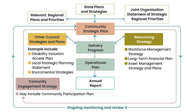
All Councils in NSW use the IP&R framework to guide their planning and reporting activities. The Community Strategic Plan, the Delivery Program and the Operational Plan form part of the Integrated Planning and Reporting Framework which is a requirement under the Local Government Act 1993.
Overview of Integrated Planning and Reporting
The Integrated Planning and Reporting (IPR) Framework includes:
· 10 year Community Strategic Plan reflecting the aspirations, needs, and priorities of the local community
· The Resourcing Strategy, addressing sustainable long term financial, asset management and workforce planning;
· A four year Delivery Program outlining Council's activities planned for Council term
· Annual Operational Plan consisting of actions identified to be undertaken each year to meet the Delivery Program commitments; together with the related budget, statement of revenue policy, and fees and charges.
The diagram below highlights the relationship and hierarchy of the strategies and plans.
Draft 2024/25 Operational Plan
The Delivery Program is supported by an annual Operational Plan which details the individual projects and activities that will be undertaken each year to achieve the commitments of the delivery program. The Operational Plan must include the Council’s annual budget, along with Council’s Statement of Revenue Policy, which sets the proposed rates, fees and charges for that financial year.
The draft Operational Plan 2024/25 is grouped under the five Community Strategic Plan community objectives, which are:
· Effective Leadership – we have effective decision making and community leadership that is open and informed
· Inclusive Community – we have an inclusive and active community where diversity is embraced and everyone is valued
· Nurtured Environment – we nurture and enhance the natural environment
· Ethical Growth – we manage growth and change responsibly
· Connected Infrastructure – we have connected infrastructure, transport, and facilities that are safe, accessible, and reliable
Within each theme the Operational Plan is structured according to the Delivery Plan priorities. Each Operational Plan activity is coded, and details included about the activity, competition statement, due date, and responsible unit. Links to relevant Council Resolutions and the Disability Inclusion Action Plan are also referenced.
The draft Operational Plan 2024/25 is included at Attachment 1.
Draft 2024/25 Budget Estimates (Statement of Revenue Policy)
The Draft 2024/25 Budget Estimates are based on the 31 December 2023 Quarterly Budget Review with various changes to reflect updated costs of service delivery developed from the input received from each Council Directorate. Results from the 31 March 2024 Quarterly Budget Review are yet to be finalised and considered by Council which will happen during May 2024 and any outcome from that review is yet to be incorporated into the Draft 2024/25 Budget Estimates.
The Draft 2024/25 Budget Result on a Consolidated (All Funds) basis forecasts a balanced budget result as outlined below at Table 1.
Table 1 – Forecast Budget Result 2024/25 Consolidated (All Funds)
|
Item |
Amount $ |
|
Operating Result |
|
|
Operating Revenue |
115,842,500 |
|
Less: Operating Expenditure |
97,403,800 |
|
Less: Depreciation |
20,657,300 |
|
Operating Result – Surplus/(Deficit) |
(2,218,600) |
|
|
|
|
Funding Result |
|
|
Operating Result – Surplus/(Deficit) |
(2,218,600) |
|
Add: Non cash expenses – Depreciation |
20,657,300 |
|
Add: Capital Grants and Contributions |
45,448,000 |
|
Add: Loan Funds Used |
4,194,000 |
|
Add: Asset Sales |
0 |
|
Less: Capital Works |
69,373,000 |
|
Less: Loan Principal Repayments |
4,561,300 |
|
Funding Result – Surplus/(Deficit) (Cash Movement) |
(5,853,600) |
|
Reserves Movement – Increase/(Decrease) |
(5,853,600) |
|
Overall Budget Result – Surplus/(Deficit) (Operating + Funding) |
(0) |
The detailed Draft 2024/25 Budget Estimates are included at Attachment 2. Table 1 indicates a forecasted balanced budget result, and this relates to the General Fund. The forecast General Fund Unrestricted Cash Balance position based on the draft budget included at Table 1 is outlined in Table 2 below:
Table 2 – Forecast General Fund Unrestricted Cash Balance
|
Item |
$ |
|
Forecast unrestricted cash balance to 30 June 2024 at 31 December 2023 Quarterly Budget Review |
(250,000) |
|
Add: Estimated Draft 2024/25 Budget result |
0 |
|
Forecast unrestricted cash balance at 30 June 2024 |
(250,000) |
In addition to Table 1 above, budgeted financial statements incorporating an Operating Statement and Cash Flow Statement have been produced. These financial statements, replicating the format of Council’s Annual Financial Statements, are included in Attachment 2 as part of the Operational Plan, along with a one-page summary of all Council budget program outcomes. Reserve balances are outlined in the detailed budget estimates provided at Attachment 2.
Council’s financial position
In producing the proposed draft budget outcome for 2024/25 Council has had to continue to take dividends from some of its reserves and other funds again, which is not sustainable. This, in addition to the continual use of the Plant Fund to fund operation of the Works Depot, have been underlying structural issues in Council’s budget for a number of years which have not been able to be addressed.
The difficulty of balancing the proposed 2024/25 budget position has been compounded by the following factors also on a consolidated all funds basis:
· Superannuation guarantee increasing from 11.0% to 11.5%
· Award salary increase of 3.5% budgeted plus a one off $1,000 payment to all full time staff and pro-rata to part-time staff.
· Insurance premiums of up to 7.5 to 10% estimated increase (excluding workers compensation insurance).
· Increased contribution to Richmond Tweed Regional Library.
· Increased workers compensation insurance, extra $293,500 funded but a further potential $210,000 required yet to be identified.
· Council addressing gaps left by other levels of government, despite insufficient resources
· Budget bids for funding much needed maintenance which are not affordable.
It is vital for Council to consider the financial impacts of future decisions, given its current financial position. Whilst the 2024/25 draft budget is projecting the Council as business as usual, it also encompasses ongoing recovery works from the 2022 February/March flood events that are expected to be grant funded – estimated $23.760million. This is outlined in the budget program titled ‘Infrastructure Recovery’ and the Capital Works Program.
It is becoming increasingly difficult for Council to fund its operations with the current revenue base. This is due to:
· Not able to allocate general revenue funding towards capital works aside from pay parking revenue and the 2017/2018 Special Rate Variation yield in part.
· Traditional levels of maintenance funding in the General Fund being unsustainable.
· Council not able to increase its expenditure budgets to keep pace with inflation. Indexation has generally been reduced to 3.8% compared to inflation currently at 4.1% but was as high as 5.4% at commencement of the budget process.
· Council’s revenue base being subject to variability in that revenue levels derived are dependent upon demand and use of the services, however the cost of those services is often fixed.
· The growing reliance on grant funding as a means to fund works or projects is a risk given that the significant levels of grant funding received or to be received in recent times cannot be assumed will be continued.
· The inability to incorporate any new budget bids or requests without funding.
· No capacity to increase any service level without corresponding additional revenue to fund or reduction in a service level elsewhere amongst Council services to compensate.
· Restrictions imposed by regulated fees and charges that Council must use that do not reflect the cost of services.
· For the first time Council has not budgeted for a full staff complement but is assuming continual salaried vacancies of at least 3.5 full time positions.
· Items yet to be determined such as the Emergency Services Levy (ESL).
Given the current situation, it is not surprising there are now three separate inquiries into the financial sustainability of local government as a sector, one by the Federal Government at the national level and at a state level one by New South Wales and one by Victoria.
It is expected Council will be provided with an updated Long Term Financial Plan (LTFP) in the lead up to the final adoption of the 2024/25 Delivery Plan, Operational Plan and Revenue Policy. The LTFP is a tool supporting Council’s financial projections over ten years endeavouring to fund services and expectations.
Table 2 also suggests that Council has depleted its unrestricted cash balance. Council’s goal is to maintain this balance at $1million so, over time, will need to recover this balance to provide Council with a buffer against of any unforeseen expense. It is hoped the current projected unrestricted cash balance deficit of $250,000 can be addressed upon finalisation of the 31 March 2024 Quarterly Budget Review potentially back to a $0 result.
In terms of the draft 2024/25 budget position outlined in this report, further review will be undertaken during the public exhibition period to consider any new information and or outcomes from the 31 March 2024 Quarterly Budget Review with any adjustments reported to the proposed 27 June 2024 Council Meeting.
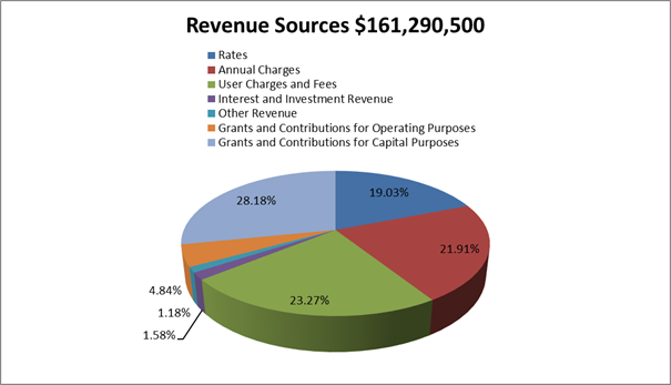
To arrive at the Draft Budget Results outlined in Table 1 for the 2024/25 financial year, Council’s revenue and operational expenses are expected to be derived from the following sources and allocated respectively as outlined in the graphs below:
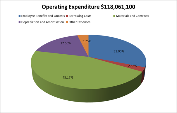
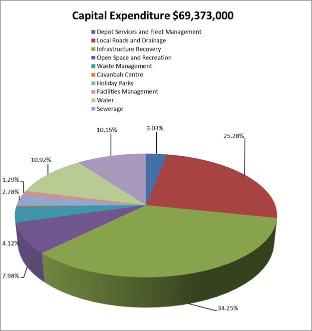
In addition to the operational aspects of the proposed Draft 2024/25 Budget Estimates, Council is proposing a capital works program of $69.373million. By Fund, the projected capital works are:
· General Fund $54.760million
· Water Fund $7.573million
· Sewerage Fund $7.040million
Specific capital works projects have been detailed in Attachment 2. As in previous years, the General Fund is presented in a different format, to improve the disclosure of funding sources for specific projects including:
· Developer contribution funding to describe the specific part of the Developer contribution plan and catchment that is providing the funding for a project.
· Where reserve funds are funding a project, identification of the reserve being utilised.
· Separation of funding provided by the 2017/18 Special Rate Variation (SRV) for which Council has reporting obligations for 10 years from 2017/18.
Of the $54.760million for capital works related to the General Fund, the following major components are proposed:
· Local Roads and Drainage $17.536million
· Infrastructure Recovery $23.760million – infrastructure restoration associated with February/March 2022 flood events
· Open Space and Recreation $5.537million
· Waste Management $2.860million
· Holiday Parks $1.927million
· Facilities Management $0.897million
The Draft 2024/25 Budget Estimates at this point do not include any budgeted expenditure for the Bio-Energy facility.
The Draft 2024/25 Budget Estimates also propose new loan borrowings of $4.194million to fund the following projects:
· Lot 12 Bayshore Drive Roundabout construction $2.500million.
· First Sun Holiday Park Masterplan Works $0.852million
· Suffolk Beachfront Holiday Park Cabin Replacements $0.842million.
The amount of actual loan funds Council will need to borrow may be reduced pending how the above projects proceed: Council decision to proceed formally, and capital expenditure reviews submitted to the Office of Local Government where required.
Draft General Land Rates and Charges (Statement of Revenue Policy)
The Draft 2024/25 Revenue Policy includes the proposed general land rating structure, consistent with the structure revised by Council for the 2017/18 financial year. This is outlined in Attachment 3. Whilst the general land rating structure is the same in terms of yield split, categorisation and retaining the use of a minimum rate subject to an ad valorem rate, Council has continued to incorporate land values with a 2022 base date for the purposes of general land rating for 2024/25 provided by the NSW Valuer General.
The rating structure also incorporates the approved rate peg of 4.80% determined by the Independent Pricing and Regulatory Tribunal (IPART) for Byron Shire Council representing the standard rate peg of 3.90% plus superannuation adjustment 0.40% plus Emergency Services Levy factor 0.20% plus a population increase factor of 0.30%.
The proposed general land rating structure included in the Draft 2024/25 Statement of Revenue Policy provided at Attachment 3 is again provided as two scenarios due to Council’s resolution for the 2023/24 Revenue Policy to consider maintaining the minimum rate at $1,000 opposed to increasing the minimum rate by the rate peg. Therefore two options are proposed as follows:
Option 1 – minimum rate set at $1,048 (2023/24 minimum rate plus 4.80% rate peg) provides the following rating structure:
|
Category, Sub-Category or Reduced Minimum Rate |
Estimated Number of Properties |
Rate in the Dollar ($) |
Minimum Rate ($) |
Total Estimated Income ($) |
Proportional Contribution of Yield (%) |
Estimated Average Rate |
|
Residential |
14,207 |
0.1135 |
1,048 |
22,981,412 |
73.97% |
1,618 |
|
Residential – Flood/Coastal |
15 |
0.1135 |
524 |
9,347 |
0.03% |
623 |
|
Business |
1,191 |
0.2087 |
1,048 |
3,884,279 |
12.50% |
3,261 |
|
Business - Byron Bay CBD |
359 |
0.3043 |
1,048 |
2,641,504 |
8.50% |
7,358 |
|
Mining |
0 |
0.2087 |
1,048 |
0 |
0.00% |
0 |
|
Farmland |
534 |
0.0878 |
1,048 |
1,552,772 |
4.99% |
2,922 |
|
Farmland – Flood/Coastal |
2 |
0.0878 |
524 |
1,048 |
0.01% |
524 |
|
TOTALS |
16,308 |
|
|
31,070,362 |
100.00% |
1,905 |
Option 2 – maintain the minimum rate at $1,000 provides the following rating structure:
|
Estimated Number of Properties |
Rate in the Dollar ($) |
Minimum Rate ($) |
Total Estimated Income ($) |
Proportional Contribution of Yield (%) |
Estimated Average Rate |
|
|
Residential |
14,207 |
0.1157 |
1,000 |
22,987,611 |
73.97% |
1,619 |
|
Residential – Flood/Coastal |
15 |
0.1157 |
500 |
9,221 |
0.03% |
615 |
|
Business |
1,191 |
0.2102 |
1,000 |
3,884,093 |
12.50% |
3,261 |
|
Business - Byron Bay CBD |
359 |
0.3048 |
1,000 |
2,641,767 |
8.50% |
7,359 |
|
Mining |
0 |
0.2102 |
1,000 |
0 |
0.00% |
0 |
|
Farmland |
534 |
0.0879 |
1,000 |
1,552,933 |
4.99% |
2,922 |
|
Farmland – Flood/Coastal |
2 |
0.0879 |
500 |
1,000 |
0.01% |
500 |
|
TOTALS |
16,308 |
|
|
31,076,625 |
100.00% |
1,906 |
Modelling has been done comparing Option 1 and 2 with results as follows:
· Reducing the minimum rate from $1,048 to $1,000 reduces the number of properties subject to the minimum rate by 692 assessments being 669 residential, 21 business and 2 farmland.
· Land value where the ad valorem rate applies for residential category reduces from $923,348 to $864,304.
· Given the high proportion of strata titled properties, 36%, the reduction in the minimum rate for Option 2 only seems to have impact in the urban areas of the Shire but not the rural areas.
· The reduction of the minimum rate from $1,048 to $1,000 requires the redistribution of $333,985 in general land rate income through needing to change the ad valorem rate. With the minimum set at $1,000, there would be 6,745 out of 16,308 assessments paying the minimum rate and of the 6,745 paying the minimum 2,596 of these are strata titled assessments.
· The maximum benefit any property subject to a minimum rate would receive is $48 i.e. the difference between the minimum of $1,048 and the current minimum of $1,000.
· Of all ratepayers on the minimum rate, 27% or 1,821 of these have rate notices not sent to the property address which may indicate they are investors.
Should Council wish to adopt the general land rating structure outlined in Option 2, it would need to alter the proposed Draft 2024/25 Statement of Revenue Policy provided at Attachment 3 through resolution prior to public exhibition to incorporate the preferred rating structure.
Irrespective of which general land rating structure Council selects, it will need to derive $31.076million in allowable general land rating income inclusive of the 4.80% rate peg.
In respect of other charges, the Draft 2024/25 Statement of Revenue Policy includes:
· Waste Charges – increase of 3% to 4.7%
· Water access charges increasing by 9.00% and usage charges increasing by 9.00%
· Sewerage charge - increased by 9.00%.
· The stormwater charge has not increased. It is a regulated charge that has not changed over the last eighteen years.
For the average residential ratepayer, the increases proposed for 2024/25 to general land rates and charges if a fully serviced property are indicated below compared on the same basis to that applicable in 2023/24:
Draft Fees and Charges (Statement of Revenue Policy)
The Draft 2024/25 Fees and Charges have been reviewed by the respective program managers and included at Attachment 3 as part of the Draft 2024/25 Statement of Revenue Policy. Where possible, fees have been altered/increased to reflect the following:
· Increases in the Consumer Price Index (CPI)/Indexation – 5.4% at the time of preparation.
· Review of fees and charges including benchmarking/cost of service provision and where possible, introduction of new fees to assist Council to generate additional/ enhanced revenue.
· Regulated fees updated (if known) to reflect latest changes in legislative regulations. There will be further updates to regulated fees for Council to endorse at the 27 June 2024 Council Meeting.
The 2024/25 Draft Fees and Charges have seen a further review of a number of Council’s Hall/Community Centre which has resulted in the creation of some new fees. It is understood this outcome has been undertaken in consultation with the respective Committees.
Council has recently been considering revision of parking fees in conjunction with establishment of pay parking at Brunswick Heads. For the information of Councillors, the pay parking permit fee for residents is still listed at $55 for 2024/25 but has a disclosure note to indicate this fee will revert to $0 upon commencement of the Brunswick Heads Pay Parking Scheme.
Provided at Attachment 4 for the information of Councillors is a report that identifies changes to proposed fees and charges that are greater than the general indexation of 5.4%. This attachment also includes any new fees that can be designated as there is no 2023/24 comparative fee.
At the time of preparing the Draft 2024/25 Statement of Revenue Policy, the statutory fees for a Section 603 certificate and the proposed interest rate to be charged on outstanding general land rates and charges has not been advised by the Office of Local Government. These two items will be reported to Council at the 27 June 2024 Ordinary Meeting for adoption based on the determination advised by the Office of Local Government which should be advised to Council by then.
Strategic Considerations
Community Strategic Plan and Operational Plan
|
CSP Objective |
CSP Strategy |
DP Action |
Code |
OP Activity |
|
1: Effective Leadership |
1.1: Enhance trust and accountability through open and transparent leadership |
1.1.1: Leadership - Enhance leadership effectiveness, capacity, and ethical behaviour |
1.1.1.3 |
Develop 2024/25 Operational Plan |
Recent Resolutions
· 22-335 – adoption of the Byron Shire Community Strategic Plan 2023
· 23-389 – adoption of the revised Delivery Program 2022-26
Legal/Statutory/Policy Considerations
The requirements for Integrated Planning and Reporting are governed by Sections 402-406 of the Local Government Act 1993.
Section 404 requires that a council must have a 4-year delivery program detailing the principal activities to be undertaken within available resources.
Section 405 outlines the Operational Plan requirements including public exhibition and timeframes.
The specific statements required by Council to be disclosed as part of its Revenue Policy are determined by Clause 201 of the Local Government (General) Regulation 2005.
Detailed requirements are outlined in the Integrated Planning and Reporting Guidelines and Handbook.
Financial Considerations
As outlined in the report.
Consultation and Engagement
In accordance with the Local Government Act, the draft Operational Plan (including the annual budget, revenue policy, and fees and charges) must be exhibited for 28 days. Prior to the adoption the Operational Plan, Council must consider any submissions received during the exhibition period.
Feedback will be sought primarily through Your Say Byron Shire. Public notices and media releases will also be distributed.
Two Community Conversations are scheduled to be held, the first on 30 April (in person) and 7 May (online) as part of the exhibition period. These sessions will provide members of the community an opportunity to discuss how the budget and operational plan have been developed, and projects planned for the 2024/25 financial year. Any input provided by the community as an outcome of the community conversations will be included as a submission to be considered by Council when adopting the final plans.
Staff Reports - Corporate and Community Services 13.4
Report No. 13.4 Draft Submission - Standing Committee on State Development into the ability of local governments to fund infrastructure and services
Directorate: Corporate and Community Services
Report Author: Esmeralda Davis, Director Corporate and Community Services
File No: I2024/470
Summary:
The NSW Parliament’s Standing Committee on State Development released terms of reference for an inquiry into the ability of local governments to fund infrastructure and services.
The terms of reference for the review are broad and include consideration of several long-standing matters of central importance to the local government sector including the adequacy of past rate pegs to meet costs borne by local government, alternative approaches to the rate peg and the operation and effectiveness of the special rate variation process. The committee will also examine the impact of cost shifting on service delivery and financial sustainability.
This report seeks Council endorsement to make a submission prior to the closing date of 26 April 2024. It is anticipated that the Committee will report ahead of the Local Government elections, which are scheduled for 14 September 2024.
RECOMMENDATION:
That Council endorses the draft submission to the NSW Parliament’s Standing Committee on State Development inquiry into the ability of local governments to fund infrastructure and services as per Attachment 1 (E2024/28530).
1 Draft
Submission to the Standing Committee on State Development regarding the Ability
of local governments to fund infrastructure and services - March 2024, E2024/28530 ![]()
Report
The NSW Parliament’s Standing Committee on State Development released terms of reference for an inquiry into the ability of local governments to fund infrastructure and services.
Based on the adopted Terms of Reference, the Standing Committee on State Development will inquire into and report on the ability of local governments to fund infrastructure and services, and in particular:
a) the level of income councils require to adequately meet the needs of their communities
b) examine if past rate pegs have matched increases in costs borne by local governments
c) current levels of service delivery and financial sustainability in local government, including the impact of cost shifting on service delivery and financial sustainability, and whether this has changed over time
d) assess the social and economic impacts of the rate peg in New South Wales for ratepayers, councils, and council staff over the last 20 years and compare with other jurisdictions
e) compare the rate peg as it currently exists to alternative approaches with regards to the outcomes for ratepayers, councils, and council staff
f) review the operation of the special rate variation process and its effectiveness in providing the level of income Councils require to adequately meet the needs of their communities
g) any other related matters
Key issues
The concept of ‘financial sustainability’ in the terms of reference is currently undefined. Previous attempts by State Government to define financial sustainability, for example through the Fit For the Future Reforms, remain contested. The use of the Office of Local Government’s performance indicators assist in communicating information to communities about how councils are funded and the general position of the council, however the current financial benchmarks are flawed and fall short in providing a comprehensive evaluation of local government financial sustainability.
The primary revenue sources for councils typically include rates, government grants, user fees, and charges. However, an over reliance on rates places significant pressure on ratepayers, many of whom may already be experiencing financial strain. Moreover, regional councils in particular, may face difficulties in generating revenue from user fees and charges due to lower population densities and limited demand for certain services. This revenue stream often proves insufficient to meet the growing demands for essential services and infrastructure upgrades. Compounding this issue, councils face constraints in generating additional revenue streams due to legislative restrictions.
The rate peg is a tool used to manage rate increases within a framework of fiscal responsibility and affordability, but while it aims to reflect increases in costs borne by local government, it does not always align with the specific financial circumstances of individual councils. While councils have various strategies and options available to manage their finances and deliver services within the constraints of the rate peg (e.g. service reviews, process improvements), the costs borne by local government often exceed the revenue generated. When required to manage service delivery within the confines of rate pegs, councils are forced to make difficult decisions about prioritisation of services and in some cases, provision of services may need to be withdrawn altogether.
Council acknowledges the recent review of the rate peg methodology, conducted by IPART in 2023, from which IPART recommended the NSW Government commission an independent review of the financial model for councils in NSW. Some of the suggested measures for consideration from that review (Chapter 9.3) included:
• Better targeting eligibility criteria for rates exemptions
• Allowing councils to use the Capital Improved Value method to set the variable component of rates
• Ensuring statutory charges reflect the costs incurred by councils in providing statutory services
• Alternative funding mechanisms to provide essential social services
• Comprehensive state-wide evaluation of the existing pensioner concessions
Implementing these recommendations, would be a positive initial step to considering alternative approaches.
Government grants, while essential, are often insufficient to cover the cost of necessary infrastructure projects and service delivery and/or require a co-contribution from Council. Furthermore, grants are often only available for new capital works, with the ongoing maintenance costs shifted to councils. Many councils grapple with an infrastructure backlog resulting from years of underinvestment and deferred maintenance. Addressing this backlog requires substantial financial resources, which may not be readily available to regional councils.
In regard to cost shifting, it is well documented that in NSW, councils have experienced significant cost shifting from state and federal governments over the years, particularly in areas such as social services, emergency management, and infrastructure maintenance. This places additional strain on council budgets and can affect their ability to maintain service levels and financial sustainability.
LGNSW’s latest cost shifting report, released in November 2023, highlighted a total cost shift to councils of $1.36 billion in 2021-22, which is the equivalent of more than $460 per ratepayer annually. This is an increase from $820 million in 2015/16. For regional councils with a low rate base, such as Byron Shire, the effect of this can be crippling.
Overall, councils in NSW face ongoing challenges in balancing service delivery expectations with financial constraints, exacerbated by factors such as cost shifting and increasing demand for services. Addressing these challenges requires a collaborative approach between local, state, and federal governments, as well as innovative strategies to enhance revenue streams, improve efficiency, and prioritise community needs. Regular review and reform of funding arrangements and intergovernmental relations are essential to support the long-term sustainability of local government in NSW.
Strategic Considerations
Community Strategic Plan and Operational Plan
|
CSP Objective |
CSP Strategy |
DP Action |
|
1: Effective Leadership |
1.3: Ethical and efficient management of resources |
1.3.1: Financial Management - Ensure the financial integrity and sustainability of Council through effective financial management |
|
1: Effective Leadership |
1.3: Ethical and efficient management of resources |
1.3.5: Resourcing - Identify and investigate resourcing to meet future needs |
Recent Resolutions
· 24- 067
Council made a submission to the Terms of Reference for the council financial model review, per resolution 24-067 “that Council endorses the submission on the draft Terms of Reference at Attachment 2 (E2024/11641) to be lodged with the Independent Pricing and Regulatory Tribunal prior to the closing time on 15 March 2024.”
Subsequently, on 19 March 2024, IPART received a letter from the NSW Government withdrawing the referral for the review of the financial modelling of councils to avoid unnecessary duplication, as the matter will now be considered by the NSW Parliament’s Standing Committee on State Development (the subject of this report). The themes in the submissions received by IPART will be provided to the Senate Committee inquiry.
Legal/Statutory/Policy Considerations
Nil associated with the preparation and lodgement of a submission.
Financial Considerations
Nil associated with the preparation and lodgement of a submission.
Consultation and Engagement
On 20 March 2024, Councillors were contacted by email with notice of this inquiry and invited to provide feedback into the draft submission. At the time of preparing this report, there was no feedback received.
Staff Reports - Sustainable Environment and Economy 13.5
Staff Reports - Sustainable Environment and Economy
Report No. 13.5 Information regarding the use of non-trapping investigative methods and monitoring to monitor and trap dingoes, feral/roaming dogs, foxes and cats.
Directorate: Sustainable Environment and Economy
Report Author: Liz Caddick, Biodiversity Officer
Claudia Caliari, Biodiversity Projects Officer
File No: I2023/1968
Summary:
Council Resolution 23-351 resolved (part 4) that Council receives a report by March 2024 (prior to the 2024 trapping season) on ‘the use of non-trapping investigative methods, monitoring and if necessary, cage traps, which can be used to successfully monitor and trap dingoes, roaming dogs, foxes and cats if used properly’. This report summarises the findings of this investigation.
There are significant differences in opinion amongst scientists regarding the ecological role, risk and management of wild dogs and dingoes, as well as a broad range in cultural and community perspectives. The dingo is a culturally significant totemic species for many Aboriginal people, but for many rural landholders it presents a risk to pets, people and livestock.
The Biosecurity Act 2015 requires Council to discharge its General Biosecurity Duty on all land it manages, which includes taking measures to prevent, minimise or eliminate the risk of negative impacts of biosecurity matters (wild dogs including dingoes) on Council and neighbouring land, as far as reasonably practicable.
Local Land Services (LLS) administer the delivery of the North Coast Regional Strategic Pest Animal Management Plan, which guides the application of the Biosecurity Act 2015 in this region. LLS advised on 29 November 2023 that:
‘Council cannot release a pest animal if caught in a cage trap or any other trap, That includes wild dogs (which include dingoes), foxes feral cats’.
And further on 8 March 2024 that:
‘if wild dogs are creating a biosecurity risk then that risk needs to be managed as required by the Biosecurity Act. Council needs to be informed that they have a General Biosecurity Duty the same as every other person/land manager in NSW and must do everything in their power to meet the GBD regardless of personal opinions’.
The legislation is not clear, particularly in relation to what it means by 'risk of negative impacts'. It is recommended that Council continues to seek further written clarification from Local Land Services regarding Council and community obligations with regard to discharging general biosecurity duty in relation to dingoes, and acceptable options to prevent, minimise or eliminate the risk of negative impacts of biosecurity matters. This could be a matter that would be better approached by more than one Council such as through the Norther Rivers Joint Organisation of Councils.
Humane trapping and monitoring methods include soft-jaw leg hold traps with SIM-activated infra-red cameras, cage traps, camera monitoring, detection dogs, scat and saliva analyses. Most practitioners identified soft-jaw leg hold traps as the most effective for either scientific catch, collar and release programs (as on K’gari) and for lethal control of foxes, cats and feral dogs. SIM-activated IR cameras may help to decrease response times when an animal is caught. Cage traps are used in some instances (e.g. catch, collar and release monitoring), but animals are very wary of cages and tend to avoid them. Detection dogs, camera monitoring and expert ecological knowledge are also effective in making sure trapping programs can be highly targeted towards a particular species (e.g., foxes).
While ongoing trapping of foxes, feral cats and wild dogs/dingoes is currently required on Council land in order for Council to discharge Council’s General Biosecurity Duty, Local Land Services have advised that the revised North Coast Regional Strategic Pest Animal Management Plan (NCRSPAMP) may enable dingo conservation in areas where wild dogs/dingoes do not impose a risk or where no impact is logged. In these circumstances it would be up to the land manager to first demonstrate that there is no risk/impact. This presents an opportunity for Council to partner with scientists, community, and other local land managers to learn more about the population dynamics, risk and impact of dingoes in high ecological value parts of the shire, in order to guide future management. (Note: the NCRSPAMP is currently under review and will likely go on public exhibition in April-May 2024. LLS will provide local government staff with an update on the progress of this via the Pest Technical Working Group in April).
As part of the review of Council’s Pest Animal Management Plan, staff are currently in discussion with researchers from the University of NSW, Taronga Zoo and the Humane Society International, regarding a range of research and monitoring projects that could provide the information needed to develop an evidence-based wild dog/dingo management approach for the shire. This report details those research projects.
A second essential requirement in the development of an evidence-based management approach, is ongoing community engagement and education, as community and stakeholder support will be essential for the implementation of any management change. This process can begin as part of Council’s Pest Animal Management Plan review, which will involve consultation with traditional owners, land managers, farmers and government agencies.
RECOMMENDATION:
That Council:
1. Engages with community stakeholders (traditional custodians, farmers, landholders, government agencies) regarding the risks and impacts of wild dogs/dingoes and alternate management strategies, as part of the Pest Animal Management Plan review.
2. In revising the Pest Animal Management Plan, prioritises community engagement and education regarding roaming domestic dogs and considers methods of coexisting with dingoes.
3. Continues to fulfil its General Biosecurity Duty under the Biosecurity Act 2015, by carrying out monitoring followed by targeted trapping on Council land of animals that are listed as a biosecurity matter.
4. Continues to work with the University of NSW to seek funding for a dingo monitoring project to understand the behaviour, risks and impacts of dingoes/wild dogs in Byron Shire in order to guide future management.
5. Continues to work with the Humane Society International to seek funding for a livestock guardian animal trial in Byron Shire.
6. Continues to seek further written clarification from Local Land Services regarding Council and community obligations with regard to discharging general biosecurity duty in relation to dingoes, and acceptable options to prevent, minimise or eliminate the risk of negative impacts of biosecurity matters.
7. Requests that item 6 above be tabled at the next available Northern Rivers Joint Organisation of Councils’ meeting to see if there is collective interest in receiving this advice from Local Land Services.
1 Summary
of conflicting cultural, historical and scientific opinion relating to the
role, risk and management of dingoes/wild dogs, E2024/15488 ![]()
2 Local
Land Services - Advice regarding release of trapped pest animals - 29 November
2023, E2024/15782 ![]()
3 Case
Studies of non-lethal Dingo Management in Australia, E2024/9845 ![]()
Report
Council Resolution 23-351 resolved (part 4) that Council receives a report by March 2024 (prior to the 2024 trapping season) on the use of non-trapping investigative methods, monitoring and if necessary, cage traps, which can be used to successfully monitor and trap dingoes, roaming dogs, foxes and cats if used properly. This report summarises the findings of this investigation.
In looking into this issue, staff have investigated the following:
· The context and history of wild dog/dingo management – i.e., what has led to current management practices, and why there is a debate over management.
· What the current legislation permits regarding management of wild dogs/dingoes, including non-lethal trapping and release.
· Case studies of non-lethal management and monitoring occurring elsewhere in Australia.
· The practicalities, pros and cons of different types of non-lethal trapping (cage traps, soft jaw traps).
· Other management options, including non-lethal deterrents and community education.
The information collated has been used to guide a proposed management program that meets Council’s legal obligations under the Biosecurity Act, and enables community engagement, data collection and risk assessment to develop a long term strategic adaptive management response.
Key issues
With the global expansion of production landscapes, areas of native habitat are diminishing, often forcing wildlife and livestock to co-exist, compete for resources, and increasing the frequency of their interactions[1]. Management interventions that aim to promote coexistence between wildlife and humans can only be successful if they incorporate an understanding of the factors that shape human attitudes and behaviours associated with wildlife conflicts. Humans often respond to real or perceived conflict with wildlife by killing the wildlife, seeking to remove the threat.
In Australia, different cultures have very different perceptions and values in relation to wild dogs/dingoes. The dingo is a culturally significant totemic species, and many first nations people have a cultural obligation not to harm dingoes. Additionally, there is an ongoing scientific debate over:
· Whether dingoes and dogs are taxonomically different,
· Whether hybridisation between dingoes and dogs threatens dingo purity,
· Whether dingoes play an ecological role as a top order predator, particularly in degraded ecosystems,
· Whether lethal control is effective in managing risks (to livestock and people) or whether it exacerbates the risk.
Attachment 1 provides a summary of these issues, together with relevant references, to provide context for this report.
Because of the cultural/historical complexity of this issue, gaps in local data and the ongoing scientific debate, extensive community engagement, education and conversations will be a critical part of getting support for any changes to management interventions.
Legislation and its interpretation
Full detail of Legal and Statutory Considerations is provided on page 22 below. Here we summarise the impacts of legislation on management options, as this is a key issue in determining how Council proceeds with the management of wild dogs/ dingoes and other pest animal species.
Under the NSW Biosecurity Act Council, as a landholder, is required to discharge its General Biosecurity Duty. The General Biosecurity Duty requires any person dealing with a biosecurity matter and who knows or ought to know of the biosecurity risks posed by that biosecurity matter, to take measures to prevent, minimise or eliminate the risk as far as reasonably practicable.
The NSW Biosecurity Act does not specify which species are a biosecurity matter. Identification of biosecurity matters is done via the NSW Wild Dog Management Strategy and Regional Strategic Pest Animal Management Plans (RSPAMP), both of which identify wild dogs (including dingoes) as a biosecurity matter.
Therefore, to discharge its General Biosecurity Duty under the NSW Biosecurity Act, Council must take measures to prevent, minimise or eliminate the risk of negative impacts of biosecurity matters (including wild dogs and dingoes) on Council and neighbouring land, as far as reasonably practicable.
Under the NSW Biosecurity Act, this can be achieved in Byron Shire by following the guidance of the NSW Wild dog Strategy 2022-2027 and the North Coast Regional Strategic Pest Animal Management Plan (RSPAMP).
The NSW Wild Dog Management Strategy, 1.2.2 Conservation of dingoes (p.16), requires that both, State and regional Wild Dog Management Plans focus wild dog control in areas where the risk of negative impacts is greatest, and not undertake control in parts of the landscape where the risk of negative impacts from wild dogs is low, which allows wild dogs to fulfil their natural ecological role. Areas where the risk of negative impacts from wild dogs is low are not identified.
The current North Coast RSPAMP (2018-23) reiterates this. Wild dogs (including dingoes) are identified as priority pest species under the asset protection category. Management guidance provided is: “to find a balance between managing wild dogs in areas where they have negative impacts and conserving dingoes” and “to focus control on areas where the risk of negative impacts is greatest, and not undertake control in parts of the landscape where the risk of negative impacts from wild dogs is low, which allows wild dogs to fulfil their natural ecological role”. Again, areas of ‘low risk’ are not identified, and Council does not have access to DPI FeralScan wild dog data (due to privacy constraints), which may help in identifying these areas.
Additionally, the repeal of Schedule 2 areas (Dingo Conservation Areas LLS Act part 10) by the Biosecurity Act 2015, has resulted in a gap in resources designated for the establishment of Dingo Conservation Areas and has created uncertainty regarding resources and the coordination of conservation efforts.
It is important to note that the Biosecurity Act, the NSW Wild Dog Management Strategy and the North Coast RSPAMP all require landholders to respond to a ‘risk posed or likely to be imposed’ by a biosecurity matter rather than considering actual impacts as a driver for management. This is intended to encourage landholders to take proactive rather than a reactive management. The legislation also encourages the principle of shared responsibility, by requiring landholders to manage the risk that a ‘biosecurity matter’ may create to surrounding lands, as well as their own land.
North Coast Local Land Services have advised that, under this risk-based approach:
‘one could argue that a Dingo residing in the interior of a National Park, where encounters with livestock, domestic pets and humans are improbable, presents minimal risk, thus potentially obviating the need for management intervention. However, relocating the same animal to the periphery of a large National Park or fragmented areas within it, or onto lands managed by Local Governments, as commonly observed on the North Coast, markedly increases the likelihood of encounters with livestock, domestic pets, and humans. Consequently, the risk of negative impacts escalates, necessitating the management of this biosecurity risk posed by the wild dog or dingo in accordance with the definition of the general biosecurity duty’.
It remains unclear whether there exists an acceptable level of risk for coexistence. Local Land Services are currently revising the North Coast Regional Strategic Pest Animal Management Plan and have advised that the revised plan will reflect the guidance given in the NSW Wild Dog Management Strategy through promoting dingo conservation in areas where wild dogs do not impose a risk or where no impact is logged, but with a requirement for land managers to prove that there is no risk prior to ceasing control. Council will have an opportunity to comment on the revised North Coast RSPAMP when it goes on public exhibition in mid-2024, and will be updated on the progress of this plan via the Pest Technical Working Group.
Simply put, for any non-lethal management of wild dogs or dingoes to be compliant with NSW legislation, Council needs to begin with monitoring and trials that enable us to demonstrate that ceasing lethal control at any site is not imposing a risk.
Recent written advice from Local Land Services is that:
‘Council cannot release a pest animal if caught in a cage trap or any other trap, that includes wild dogs (which include dingoes), foxes feral cats’ (29/11/2023, Attachment 2).
And:
‘if wild dogs are creating a biosecurity risk then that risk needs to be managed as required by the Biosecurity Act. Council needs to be informed that they have a General Biosecurity Duty the same as every other person/land manager in NSW and must do everything in their power to meet the GBD regardless of personal opinions’ (08/03/2024).
Council management area
Under the General Biosecurity Duty (GBD), Council is responsible for pest animal management on land owned or managed by Council, which represents less than 1% of Byron Shire (Figure 1). Management of the remaining land is the responsibility of individual landholders or other agencies, and Local Land Services is the key agency responsible for providing pest animal management support to private landholders.
Figure 2 below gives a rough overview of the distribution of wild dog/dingoes in Byron Shire, based only on observations reported to FeralScan (2012-2023). These maps indicate that there may be a small correlation between Council owned and managed land and wild dog observation & damage sites.
Figures 3 and 4 show that on Council land, in comparison to the rest of the shire, the greater impact is from foxes, rather than wild dogs/dingoes.
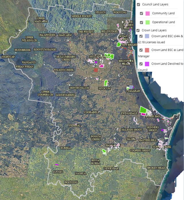
Figure 1. Council owned and managed land.
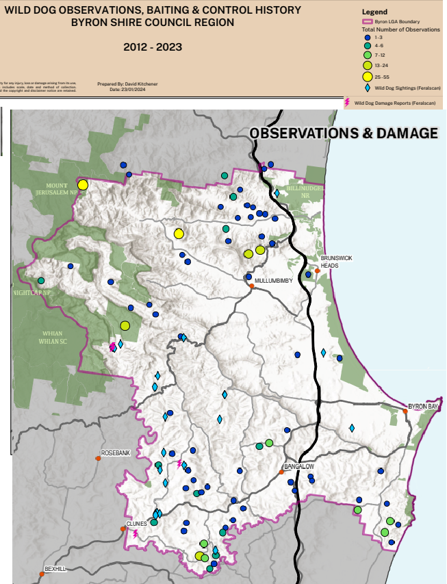
Figure 2. Feral Scan data 2012-2023.
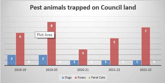
Figure 3. Trapping data from Council land, indicating that the majority of the pest animal risk is from foxes.
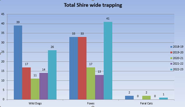
Figure 4. Shire-wide trapping data.
Current costs associated with pest animal control/management:
Council has a current annual budget of $18,000 for wild dog, feral fox, and feral cat management.
Across Australia, there is a high investment in pest animal control (Figure 5), with costs varying depending on location, method, density and impact. It is notable that the pest control cost for wild dogs is higher than the cost of agricultural losses avoided (Figure 5). Abares (2023[2]) suggests that the higher values in expenditure for wild dog control relate to animal welfare concerns - landholders are motivated to remove the stress and pain suffered by stock from predation and are responding to more than just the financial impacts on agricultural production. Landholder concern regarding welfare of their stock will be a key issue in any conversations with landholders regarding changes to management, and this is also a key concern for Local Land Services.
Table 1. Annual pest animal control costs and value of agricultural losses avoided in Australia (Abares 20232)
|
Pest animal |
Annual cost of control (Australia) |
Value of agricultural losses avoided by control |
|
Fox |
$25 million |
$25 million |
|
Rabbit |
$5 million |
$31 million |
|
Feral pig |
$30 million |
$44 million |
|
Wild dog |
$110 million |
$76 million |
Options
Comprehensive non-lethal management of dingoes is not widespread across Australian Local Government Areas. However, some ecologically significant areas are managed proactively to minimise lethal control. These areas tend to be relatively isolated locations, where the dominant land use is for conservation (e.g., National Parks). Attachment 3 details case studies of non-lethal dingo management programs at Myall Lakes and K’gari (Fraser Island), as well as some local dingo monitoring studies at Minyumai Indigenous Protected Area and Goonengerry.
Council staff have met with the researchers involved in all of these projects, and these case studies provide the context and background for the management options proposed in Next Steps, below.
The following sections describe non-lethal methods to monitor and trap wild dogs/dingoes, foxes and cats including pros and cons of each method, and requirements under biosecurity legislation.
Trapping
Non-lethal trap options
Non-lethal trapping options include cage traps and soft-jaw leg-hold traps. Soft jaw leg-hold traps are used by indigenous rangers on K’gari and also by researchers involved in the Myall Lakes Dingo Project (refer Attachment 3), without harm to animals. Local animal management consultants have advised that it is possible for expert trappers to use soft jaw traps to selectively trap feral cats and foxes, using knowledge of animal behaviour to locate traps to avoid non-target animals. Use of SIM-enabled infra-red cameras that send an instant image to the trapper’s phone allows a rapid response that reduces stress to the animal.
Currently in Byron Shire, any animals caught in a soft jaw trap (feral cat, fox, feral dog, wild dog/dingo) are euthanised in accordance with the requirements of the NSW Biosecurity Act. On K’gari and at Myall lakes, a pole stick is used to restrain dingoes while they are sedated, collared, measured, and sampled for DNA. Dingoes are then released into the Management Area under a Scientific Research license.
Purpose-built cage traps are also used by researchers involved in the Myall Lakes Dingo Project for collar and release monitoring. Advice from local trappers, animal management consultancies, and staff from Taronga Zoo, indicates that mature dingoes are very wary of cage traps (as are feral cats). Even with use of scent and audio lures, many animals are reluctant to enter cage traps – they are a large obstacle in the landscape (at least 2x1x1 metres), making them easy for animals to detect. It may be possible to trap young foxes in cage traps and not dingoes, by trapping outside of the season when dingo pups emerge from dens. It will, however, increase costs. Cage traps are stressful for the animal and release conditions are strictly limited (see below).
Permits for non-lethal trap and release
Because legislation lists them as a pest species, catch and release of dingoes at Myall Lakes and K’gari is only allowed under strict permit conditions (research), under a scientific license[3], and is carried out by trained expert researchers, including veterinarians, who have the appropriate animal care and ethics licenses in place.
At Mid-Coast LGA the permit operates strictly within an area that is currently being managed for dingo conservation (approx. 2.5% of the LGA), on land managed by NSW Parks and Wildlife, which was previously included as a Schedule 2 area under Part 10 of the Local Land Services Act 2013 (note that Schedule 2 areas have now been repealed, refer page 24). If a dingo is accidentally trapped outside of the permit conditions, the legislation requires it to be euthanised. The researchers advise that undertaking a dingo catch, collar and release program outside of previously listed Schedule 2 areas would be difficult regarding permitting and approvals.
There are several classes of scientific licence for various activities and there is an assessment period of 28 and 56 days. To be able to apply Council would have to partner with a researcher or an ecological consultant to deliver a monitoring project, with a clearly defined management area and intent (restrictions related to the General Biosecurity Duty also apply).
North Coast Local Land Services have advised Council in writing that Council, ‘cannot release a pest animal if caught in a cage trap or any other trap. That includes wild dogs (which include dingoes), foxes and feral cats.’ (Attachment 2). It is more difficult to euthanase an animal caught in a cage than a leg-hold trap. Humane shooting is difficult because it must be done at close range, and the alternative transportation to a vet for euthanasia is stressful for the animal.
Non-trapping investigative methods
Council staff have spoken with researchers from the University of NSW and Taronga Zoo, who strongly suggest an important first step for Byron Shire before changing our management, is to undertake monitoring to understand what is going on in the local landscape and where to prioritise management of both feral animals and dingoes. A monitoring program would help to justify any future proposed management actions under the North Coast Strategic Pest Animal Management Plan, which requires land managers to prove that there is no risk prior to ceasing control of dingoes in dingo conservation areas.
A local monitoring project in the Byron hinterland could provide information on dingo distribution, diet (including livestock), home ranges, pack structure and population demographics. Monitoring results can be used to develop a systematic, evidence-based management program. The advantage of evidence-based management is the increased likelihood of community support and involvement.
Camera monitoring and detection dogs
Researchers we have spoken with consider camera monitoring to be a more appropriate first stage investigation, rather than cage trapping and collaring. Camera monitoring is more cost effective, easier with regards to permits and licenses, less stressful for wildlife, minimises impacts on natural animal behaviour and helps guide where more intensive studies or management may be worthwhile. Camera monitoring programs usually operate on a grid, and also identify other native and pest species using a site.
Detection dogs can be useful in identifying the most suitable sites to locate cameras. Detection dogs are currently used by local trappers to identify sites for highly targeted control. In Tweed Shire, detection dogs are used to search for fox dens impacting on threatened bird habitat, which are subsequently fumigated.
Several local ecological consultancy firms have capacity to carry out camera monitoring, and indigenous rangers from Minyumai IPA are also trained in this and may be able to provide support (Attachment 3).
A recent camera-monitoring study in Byrangery Grass Reserve (14.5 ha), using eight cameras over 104 trap nights, cost around $22,000 (Attachment 3).
Scat analysis
Researchers at Myall Lakes and Minyumai IPA are using metabarcoding of dingo scats to understand their diets (Attachment 3). Scat analysis is a relatively inexpensive tool ($15/sample) that can contribute to understanding the impacts of local wild dogs and may be something that could be done as part of a small university project in this area.
Hair and saliva analysis
Researchers are currently trialling non-lethal passive collection of saliva and hair to investigate genetics of dingoes/wild dogs. Trials have had limited success to date, due to the high risk of contamination of these samples, but they are likely to become a cost-effective sampling method in the future and staff are continuing to liaise with researchers over novel data-collection methods such as these.
DNA photo library
A photo library, linking dingo/wild dog DNA data to images taken at the time of sampling can be useful additional information to show the morphology of dingoes inhabiting a particular area. This type of information can be particularly useful for community engagement. Both the Myall Lakes and Minyumai IPA dingo projects are developing photo libraries to understand dingo family structures within a defined area (Attachment 3).
Non-lethal deterrents
Some advocacy groups and researchers support the use of non-lethal deterrents as a way to reduce the risk of dingoes/wild dogs and feral dogs, foxes and cats on livestock. Non-lethal deterrents include exclusion fencing, light, sound, flags, fertility control, harbour removal and live capture and release of animals (Sharp and Saunders 2005).
The Humane Society International (HSI) have been researching and trialling Predator Smart Farming Techniques as an alternative to dingo culling, including guardian animals, sound, visual and light deterrents. Guardian animals such as donkeys are territorial and will defend their territory from a predator, by chasing the predator, making noise or by placing themselves between the predator and livestock. With a life span of 30 years or more, guardian donkeys may protect a farm for decades.
HSI and other researchers have documented positive results with these methods (HSI-Predator-Smart-Farming-Digital.pdf[4], but to date there has been limited testing beyond open, rangeland landscapes. HSI are interested in expanding their trials into the more hilly, densely vegetated environments of the Northern Rivers, and staff are in discussions with HSI regarding a future trial in Byron Shire.
The trial would involve placing donkeys that have been trained to be livestock guardians from the Last Stop Donkey program on up to 4 farms in Byron Shire LGA for a 6-month trial period. HSI would project manage the trial and Council would seek landowners to participate. Funding contributions would be required from both HSI and Council to cover the costs of transporting the donkeys (approximately $15,000 per organisation). Council would need to seek a $15,000 grant to cover the cost of this. Landholder training would be provided by HSI and the Last Stop Donkey program, and landholders would be responsible for care and maintenance of the donkeys during the trial, with an option to purchase afterwards.
Community engagement and education
Because of the ongoing scientific debate relating to dingo/wild dog management, and the cultural/historical complexity of this issue, extensive community engagement, education and conversations will be a critical part of getting support for any changes to management interventions.
Mid-Coast Council have implemented an on-line community dingo sighting reporting system [Contribute to our dingo conservation research by reporting your carnivore sightings here! (kobotoolbox.org)], which provides information on where dingoes are roaming, as well as where negative impacts occur.
Mid-Coast Council use signs, leaflets and fines in the villages of Hawks Nest and Tea Gardens to discourage residents/campers from feeding dingoes. This is not a key issue in Byron Shire, and an education campaign in this area would be better directed at:
a) Discouraging roaming domestic dogs,
b) Providing information regarding non-lethal management options.
Next steps
As described above, the NSW Biosecurity Act requires Council to discharge its general biosecurity duty by taking measures to prevent, minimise or eliminate the risk of all biosecurity matters, including feral cats, foxes, and wild dogs/dingoes. Under the new North Coast Regional Strategic Pest Animal Management Plan, Council would have to clearly demonstrate that it has taken measures to prevent, minimise or eliminate the risk as far as reasonably practicable before ceasing lethal control of wild dogs/dingoes. For a scientific license to capture and release dingoes, Council would need to partner with a research organisation, such as a university, and demonstrate a clear scientific research objective, and only trap/release animals within the strict area and conditions defined by that permit.
The management of dingoes/wild dogs is a highly complex and emotive issue, research is conflicting and current management practices reflect the different histories and cultures of different land managers [Attachment 1]. Encouragingly though, new research is sparking greater debate and discussion of this issue, particularly in relation to the impact of different management methods on risk, and the importance of considering indigenous knowledge, culture, and values in management.
For Byron Shire to show leadership in this issue, to fulfil Council’s legal obligations under the Biosecurity Act, and continue to support all relevant stakeholders (including traditional owners, farmers, wildlife care groups and LLS), we recommend that future management includes a combination of community engagement and education, risk assessment, highly targeted pest predator monitoring and trapping on Council-managed land, and research to understand the ecology, impacts and community concerns with regards to wild dogs/dingoes in Byron Shire.
Further refinement of this management approach will occur through development of Councils Pest Animal Management Plan. Below we provide a draft management approach, including resourcing and relevant stakeholders:
1. Community engagement and education
As part of the current Pest Animal Management Plan review, Council has the opportunity to ensure this plan prioritises community engagement with regards to issues such as roaming domestic dogs and protecting stock from dingoes.
The Pest Animal Management Plan review also presents an opportunity to begin the conversation with community stakeholders (traditional owners, farmers, landholders, government agencies) regarding the risks and impacts of wild dogs/dingoes and alternate management strategies.
Following the Pest Animal Management Plan review, development of an on-line sightings form, similar to that used by the Myall Lakes Project (Figure 5) may be a useful tool to collect information regarding wild dog/dingo occurrence and impacts. This form can also provide a landing page for people to access to other educational resources, for example tips on responsible pet ownership, information on guardian animals and other deterrents.
· Stakeholders – Council communications staff, Local Land Services, local farmers and land management educators, Brunswick Valley Landcare, National Parks, Local Indigenous Groups, Mid-Coast Council officers, North Coast Regional Pest Animal Committee.
· Cost – Approximate costs for a media campaign is $6,000, including printing, advertisements, design, and social media. A social media campaign would be most effective if coordinated with the delivery of the revised Pest Animal Management Plan in 2025. Funds could come from a grant or a budget bid for the 2025-26 budget.
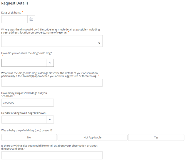
Figure 5. Mid Coast Council dingo sightings form
2. Risk Assessment
Council will work with Ecosure, the contractor for the Pest Animal Management Plan review, in developing a risk assessment matrix to analyse all the data collected through the community engagement process and throughout the dingo monitoring project. The risk assessment data will be evaluated with the guidance from relevant government agencies and researchers.
· Stakeholders: Byron Shire community, farmers and rural landholders, tourists, community groups.
· Cost: this can be done in-house in staff time. Council biodiversity projects officer 2hours/week for management.
3. Pest predator monitoring and trapping on Council-managed land
As per Figures 1-3, wild dogs/dingoes are known to occur only in very low numbers on Council land. Local ecologists and trappers advise that the greater impact is from foxes and cats.
In order to fulfil its GBD, Council is obliged to continue to monitor for and reduce biosecurity risks (cats, foxes, wild dogs/dingoes, rabbits and feral deer) on Council-managed land (Attachment 2). Local trappers use their ecological expertise, together with tools such as detection dogs and SIM activated IR cameras, to ensure that trapping is highly targeted to the species requiring control and minimises stress to the animal. Wild dog/dingo DNA samples can be collected and analysed using up to date genetic markers to confirm identify of dingo or feral domestic dogs.
· Stakeholders – local trappers, utilities and open spaces staff, landholders neighbouring Council property.
· Cost – The cost of the trapping program in 2022 was $18,000. If Council wants to use additional technologies such as SIM activated cameras and greater use of detection dogs, the cost of the trapping program is likely to be upwards of $40,000. We are also currently negotiating with researchers for DNA analysis of a limited number of samples free of charge to bolster existing data for this region.
4. Research to understand the ecology, impacts and community concerns with regards to wild dogs/dingoes in Byron Shire
The NSW Wild Dog Management Strategy and the draft North Coast Regional Strategic Pest Animal Management Plan enable Council to work towards focussing wild dog/dingo control in areas where the risk of negative impacts is greatest, while building our knowledge of wild dog/dingo numbers, movements and behaviour in the local area and ceasing control if Council can demonstrate that wild dogs do not impose a risk (as defined under the Biosecurity Act).
The research projects outlined below would enable Council to build our understanding of wild dog/dingo occurrence, impacts and risk/perceived risk, and to develop a strategic adaptive management approach in partnership with traditional owners, farmers, other land managers and Local Land Services. Key objectives of the project outlined below are:
A. To consult, engage and inform community
B. To improve management where data indicates so
C. To understand the population dynamics, genetic diversity, and ecological impact of dingoes in the Byron Shire region through camera monitoring and scat DNA analysis (possibly including other DNA sample extraction samples).
Note: all research proposed is subject to availability of grant funding, and development of a partnership with researchers and traditional custodians.
Catch and release monitoring programs are run over a strictly limited area and are funded by university research grants, not local councils. As advised by relevant researchers at UNSW and Mid North Coast Council, prior to developing any catch, collar and release program, it is important to carry out lower impact camera and scat monitoring, to get a clearer picture of animal numbers, movements and behaviour. This data can then help to guide what additional studies may be beneficial within a particular location/community.
UNSW have proposed some preliminary monitoring options summarised in Table 2 below, which involve around 60 cameras in different sites around the shire (including Council owned and managed areas) and scat analysis (DNA metabarcoding to identify key prey species).
Table 2: Project tasks brief description and costs associated in three distinct operational resources scenarios
|
Project tasks brief description and costs associated |
Option 1
|
Option 2
|
Option 3
|
|
Post-doc researcher |
PhD student (salary included in grant) |
PhD student (salary not included in grant) |
|
|
On-costs post doc salary |
547,000 |
In-kind 1.0FTE salary (Aus government). Cost to project =0 (significant time costs to UNSW supervisor, so would need further thought) |
140,000 |
|
UNSW, genetics) salary support, 0.05FTE (level A step 8) |
30,000 |
30,000 |
30,000 |
|
Consider 6 trips/ annum. $3k/trip |
47,000 |
47,000 |
47,000 |
|
60x cameras (30 sites). ~$1000/camera, including batteries, spares and locks. |
60,000 |
60,000 |
60,000 |
|
200 scat samples/year. DNA metabarcoding for diet: $200/sample. $40kpa x 2 years |
90,000 |
90,000 |
90,000 |
|
TOTAL (2 years project total cost estimated) |
$774k |
$227k |
$367k |
· Stakeholders – this project would be led by researchers from UNSW, with Council as a partner. Other stakeholders would include council land managers, farmers, traditional owners and other land management agencies including National Parks.
· Cost – Research grant funds would need to be sought for this project, to the value of between $227,000 and $774,000 over two years.
Strategic Considerations
Community Strategic Plan and Operational Plan
|
CSP Objective |
CSP Strategy |
DP Action |
Code |
OP Activity |
|
3: Nurtured Environment |
3.1: Partner to nurture and enhance biodiversity, ecosystems, and ecology |
3.1.2: Pest and weed management - Use best practice land management to improve ecological resilience and reduce threats to biodiversity |
3.1.2.1 |
Implement dog, fox and cat trapping program |
|
3: Nurtured Environment |
3.1: Partner to nurture and enhance biodiversity, ecosystems, and ecology |
3.1.2: Pest and weed management - Use best practice land management to improve ecological resilience and reduce threats to biodiversity |
3.1.2.5 |
Respond to biosecurity threats in accordance with regulatory direction and agreement |
|
3: Nurtured Environment |
3.1: Partner to nurture and enhance biodiversity, ecosystems, and ecology |
3.1.2: Pest and weed management - Use best practice land management to improve ecological resilience and reduce threats to biodiversity |
3.1.2.7 |
Review of Pest Animal Management Plan |
Recent Resolutions
Resolution 23-351
Resolved that Council:
1. Reviews the 2018-2023 Byron Shire Pest Animal Management Plan early in 2024 and that this review includes:
a) Community engagement to identify community priorities and impacts on land managed by primary producers, traditional owners, rural lifestyle landholders, local community members and Land for Wildlife.
b) Engagement with researchers including those using updated DNA methods and non-lethal management practices to collate data relevant to the Byron Shire local environment to inform best practice pest animal management.
2. Works with Local Land Services, independent scientists, traditional owners, and animal protection organisations to develop the best-informed Pest-Predator Management Plan for Byron Shire which will prioritise non-lethal pest management options.
3. Requests that the previously DNA tested samples from Local Land Services be shared with UNSW scientist Dr Kylie Cairns to run updated DNA testing.
4. Receives a report by March 2024 (prior to the 2024 trapping season) on the use of non-trapping investigative methods, monitoring and if necessary, cage traps, which can be used to successfully monitor and trap dingoes, roaming dogs, foxes and cats if used properly.
5. Explores opportunities for funding to work alongside above stakeholders to create awareness and education campaigns about Dingoes, as part of the Pest Animal Management Plan review.
6. Notes that there is a National Inaugural First Nations Dingo Forum 15-16 September 2023, hosted by GIRRINGUN Aboriginal Corporation, in relation to the cultural significance of the Dingo to First Nations People. The forum will review current methods of management, review legislation, and provide first nations perspectives.
7. Considers sending a delegate/s to the above events and for the findings to be considered as part of ongoing inclusion and consideration into the Byron Shire Pest Animal Management Plan in 2024.
8. Notes this resolution does not replace, Council Resolution on 27 April 2023 (23-124)
Legal/Statutory/Policy Considerations
As Local Government, Byron Council is subject of a network of legislation, regulations and plans that have direct influence on local pest management. The follow section summarises key pest animal management legislation and plans, described from national, through to state and then regional level. Following this is a summary of other related legislation.
The Biodiversity and Conservation Act 2016
· Schedule 5 of this act defines protected species as all native species of Australia, but specifically excludes dingoes. Protected animals include:
Any of the following that are native to Australia or that periodically or occasionally migrate to Australia (including their eggs and young):
a. amphibians—frogs or other members of the class amphibia.
b. birds—birds of any species.
c. mammals—mammals of any species (including aquatic or amphibious mammals but not including dingoes).
d. reptiles—snakes, lizards, crocodiles, tortoises, turtles or other members of the class Reptilia.
The NSW Biosecurity Act 2015
· Under the NSW Biosecurity Act 2015, wild dogs/dingoes are primarily managed through the General Biosecurity Duty (GBD), which shares the responsibility between land managers and owners to prevent, eliminate or minimise biosecurity risks caused by wild dogs and other pest animals (Figure 7 – What does the General Biosecurity Duty mean).
· The General Biosecurity Duty requires any person dealing with a biosecurity matter (such as wild dogs), and who knows or ought to know of the biosecurity risks posed by that biosecurity matter, to take measures to prevent, minimise or eliminate the risk as far as reasonably practicable.
· The NSW Biosecurity Act defines biosecurity matter among others as ‘any thing declared by the regulations to be biosecurity matter’.
· The Biosecurity Act does not identify specific pest animal species as ‘biosecurity matters’. Instead, biosecurity matters, including wild dogs/dingoes, are identified in the NSW Wild dog Strategy 2022-2027 (see below). Local Land Services are also responsible for identifying and prioritising pest species at a regional scale in Regional Strategic Pest Animal Management Plans (see below).
· The occupier of lands (both private and public) is required to take all practical measures to minimise the risk of any negative impacts of wild dogs on their land or neighbouring lands. The occupier could discharge their general biosecurity duty by complying with control actions outlined in a Wild Dog Management Plan and the overarching guidance provided by Regional Strategic Pest Animal Management Plans.
· The NSW Biosecurity Act defines dealing with a biosecurity matter as to ‘have possession, care, custody or control of biosecurity matter or a carrier and release biosecurity matter or a carrier from captivity’.
· Part 3 of the NSW Biosecurity Act defines “Offence of failing to discharge biosecurity duty” related to biosecurity matters.
· The Biosecurity Act 2015 repealed Part 10 of the Local Land Services Act 2013 (LLS Act) which previously provided the regulatory framework for the control of pest animals across NSW. The Biosecurity Act also repealed parts of the Wild Dog Destruction Act 1921 relating to destruction of wild dogs and renamed that Act to the Border Fence Maintenance Act 1921 to more accurately describe its major purpose.
· Note that in NSW, it’s illegal to remove a dingo from the wild (e.g., requires licensee or needs to be euthanised under Biosecurity Act 2015). However, under the Companion Animal Act 1998, dingoes and dingo hybrids bred in captivity can be kept legally as pets. Dingoes brought into veterinarian care must be euthanised what can be problematic issue for many professionals in that industry.
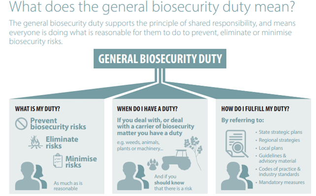
Figure 7. Extracted from DPI General Biosecurity Act 2015 - General-biosecurity-duty-with-diagram.pdf
A note on Schedule 2 Areas
· Prior to the Biosecurity Act 2015, the Local Land Services (Wild Dogs) Pest Control Order 2015 (under Schedule 10 of the Local Land Services Act 2013) provided the regulatory framework for the control of wild dogs across NSW, imposing obligations on occupiers of land to undertake activities and work collaboratively with Local Land Services to achieve effective and efficient control of those animals.
· While wild dogs were declared as pest animals throughout NSW under the Pest Control Order, Schedule 2 areas for Dingo Conservation were also defined.
· In Schedule 2 areas, the obligation to eradicate wild dogs was able to be satisfied through the preparation of wild dog management plans addressing both control and conservation objectives. Schedule 2 lists 74 national parks, 28 nature reserves, seven state conservation areas, 144 state forests, four Crown land reserves and the Sydney Catchment Authority Special Area (see Figure 8). These included Nightcap, Whian Whian, Goonengerry and Mt Jerusalem. Also, Wollumbin, Mebbin and Border Ranges.

Figure 8. Extracted from Wild Dog Management 2010-11[5]. Schedule 2 areas in dark green.
The Australian Pest Animal Strategy 2017–2027
· This Strategy defines a pest animal as those animals that cause more damage than benefits to human valued resources and social wellbeing. It also recognises that in some instances, native animals such as kangaroos, corellas or possums can become pests, and recommend that native animals as pests should be managed in accordance with state and territory legislation.
· The strategy provides general guidance on best practice pest animal management, policy foundations. It does not establish priority species; however it presents 7 case studies, including two about wild dogs, showcasing the National Wild Dog Action Plan.
The National Wild Dog Action Plan
· The National Wild Dog Action Plan (2020-2030) guides the implementation of a nationally-agreed framework for strategic and risk-based approaches to wild dog management; emphasising humane, safe and effective management techniques and appropriate scales for mitigating the impacts of wild dogs.
· The National Wild Dog Action Plan is a livestock-industry driven initiative that aims to promote a nationally coordinated approach to managing the negative impacts of wild dogs on primary production, environment and social assets throughout Australia[6].
· It states that “In most jurisdictions, there are legislative mechanisms to protect dingoes in specific areas, while also ensuring that livestock and wildlife are protected from their impacts” (p.7) citing a reference from 2014 which is prior the Biosecurity Act 2015, consequently prior to Schedule 2 areas repeal.
· It is aligned with the Australian Pest Animal Strategy 2017-2027 and the Intergovernmental Agreement on Biosecurity 2019.
· It outlines priorities, targets, strategies and indicators for wild dog management.
The NSW Wild dog Strategy 2022-2027
· The NSW Wild dog Strategy 2022-2027 defines which species are considered a biosecurity matter under the Biosecurity Act. The strategy includes wild dogs as biosecurity matter (pg. 22):
· Strategy 1.2.2 Conservation of dingoes (p.16) in the NSW Wild Dog Management Strategy requires that State and regional Wild Dog Management Plans focus control on areas where the risk of negative impacts is greatest, and not undertake control in parts of the landscape where the risk of negative impacts from wild dogs is low, which allows wild dogs to fulfil their natural ecological role.
Regional Strategic Pest Animal Management Plans
· The Regional Strategic Pest Animal Management Plan for each LLS region identifies priority pest animals in that region. Identified priority pest animals are considered to be a biosecurity matter under the Biosecurity Act.
· Wild dogs (including dingoes) are listed as a priority pest in all NSW regions.
· The North Coast Regional Strategic Pest Animal Management Plan 2018-2023 does not recognise dingoes as a native species[7], but does have a program management objective to “build knowledge that improves determination of dingo conservation status”. The plan also lists wild dogs (including dingoes) as a regional pest.
· LLS are currently revising the North Coast Regional Strategic Pest Animal Management Plan. Council officers have been advised that the new plan will promote Dingo conservation in areas where wild dogs do not impose a risk or where no impact is logged, but that Councils will need to prove that there is no risk prior to ceasing control. The Plan will be available for Public Exhibition anytime soon (in verbal conversations it was informed that the date would be 17/02/2024, however this hasn’t happened yet).
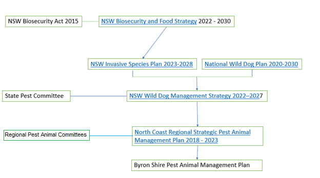
Figure 9. Governance and guiding documents affecting wild dog management in NSW.
Byron Shire Pest Animal Management Plan
Council started feral animal control in 2011, after a community meeting triggered by community concerns related to feral animals. Council’s first plan, Feral Animal (wild dog, fox and cat) Management Plan 2013-2015, was adopted in 2013[8].
Since then, Council has been engaging with a local trapper that monitors Council Land with detection dogs searching for pest animals. Current results of this trapping were shown on Figure 3 and 4.
The current Pest Animal Management Plan 2018-2023 is in its preliminary stages of review. Council has engaged with a consultant that has developed the current Byron shire Pest Animal Management Plan 2018-2023 and has also benchmark experience in the Dingo Management topic, including the development of the Fraser Island Dingo Management Strategy Review (2012) K’gari.
The core of the project will be community consultation, Council’s procedures review and legislation clarifications and review.
Byron Shire Integrated Pest Management Policy [*Policy-Integrated-Pest-Management-2024-current_policies.pdf]
The goal of this policy is to provide a policy framework for the effective and efficient control of pests on Council-managed land through an Integrated Pest Management approach that uses a range of appropriate prevention and control methods while minimising the use of pesticides on a continuous improvement basis.
An integrated pest management approach is a holistic approach that integrates ecological factors with a range of control methods to manage and ideally reduce pest species. IPM programs include monitoring to identify risks, in order to make appropriate control decisions. There is a strong emphasis on prevention – i.e. using surveillance, education and awareness to help avoid pest impacts or prevent the spread of pests.
The policy also adopts a principle of Continuous Improvement, acknowledging that improved pest management methods may take time to be researched, developed and disseminated, and ensuring that best practice outcomes are attained in a practical manner and timeframe.
Other related legislation:
National Parks and Wildlife Act 1974
· Under the National Parks and Wildlife Act it is unlawful to harm protected fauna, or to buy, sell or possess protected fauna, without a licence.
· It is also an offence to import or export ‘protected fauna’ (other than specified categories) without a licence.
· ‘Protected fauna’ has the same definition as the Biodiversity Conservation Act 2016 (mammals—mammals of any species (including aquatic or amphibious mammals but not including dingoes).
· It is also an offence to liberate an animal anywhere in New South Wales without a licence to do so.
Companion Animals Act 1998
· This act provides for the ownership and control of companion animals.
· The owner of a dog is guilty of an offence if the dog attacks, chases or harasses any person or animal.
· The owner of a dog is liable for injury to other animals caused by the dog.
· Part 5 Division 1 of the Act gives councils the power to declare a dog dangerous and require measures for the dog to be kept under control.
Rural Lands Protection Act 1998
· Part 11 of the Act provides for the control of pests, and is binding on the Crown as well as individual landowners. The Minister has the power to declare any animal to be a pest on particular land, and to impose a variety of obligations with respect to control of that pest.
· It is an offence not to comply with certain obligations under the Act. These obligations include a general destruction obligation (obligation to eradicate), a limited destruction obligation (obligation to eradicate at specified points of the animal’s lifecycle) and notification obligations (obligation to notify of the pest’s existence).
· The Minister may confer power on Boards to serve an individual order to eradicate or a general order within their district.
· Occupiers of public land have similar obligations, but qualified by the words “to the extent necessary to minimise the risk of the pest causing damage on any land”.
· An authorised officer may enter land and perform necessary pest animal control work if there is an order to that effect, or if the occupier of land has failed to comply with a pest control order.
Game and Feral Animal Control Act 2002
· ‘Game animals’ under the Act fall into two categories:
· Category 1: deer, California quail, pheasant, partridge, peafowl and turkey.
· Category 2: pigs, dogs (not dingoes), cats, goats, rabbits, hares and foxes. Hunting animals in this category does not require a licence on private land.
· It is an offence to release a game animal into the wild for the purpose of hunting. – note here that Game and Feral Animal Control Regulation, effective 1 September 2022, removed some requirements for deer hunting till 15/11/2026
Financial Considerations
Associated costs discussed in Options.
Consultation and Engagement
Stakeholders consulted during preparation of this report are listed below. While there has not been time for full discussion and follow up with all parties, further consultation and engagement is planned as part of the review of Councils Pest Animal Management Plan.
· Dean Chamberlain, North Coast Local Land Services
· Peter West, FeralScan DPI
· LGA Pest representatives of all North Coast Councils (LGA Invasive Species Group)
· Neil Jordan, UNSW
· Ben Pitcher, Taronga Conservation Society Australia
· Kylie Cairns, UNSW
· Mathew Bell and Nicholas Colman, Mid North Coast Council
· Louise Boronyak and Nicola Benyon, Humane Society International
· David Brook, Wild BnB
· Minyumai Rangers
· Craig Faulkner and David Brooke, Reconeco
· Kurt Lane, Ecosure
· Lionel Currie
· Leweena Williams, Tweed-Byron LALC
· Sole Herrera
Note here that Council received a letter (31/10/2023) from NSW Farmers expressing serious concerns about the wild dog situation in the area and the importance of ensuring that effective management practices including trapping, are in place to control the spread and impact of pest animals.
Staff Reports - Sustainable Environment and Economy 13.6
Report No. 13.6 PLANNING - DA 10.2023.235.1 Demolition and construction of mixed-use development comprising basement parking, ground floor courtyard with commercial premises, food and drink premises, two levels of shop top housing (total of 21), rooftop terraces and pool and associated plant at 119-121 Jonson Street BYRON BAY 2481
Directorate: Sustainable Environment and Economy
Report Author: Patricia Docherty, Planner
File No: I2024/430
Proposal:
|
DA No: |
10.2023.235.1 |
|
|||
|
Planning Portal Ref: |
PAN-344436 |
|
|||
|
Proposal description: |
Demolition and construction of mixed-use development comprising basement parking, ground floor courtyard with commercial premises, food and drink premises, two levels of shop top housing (total of 21), rooftop terraces and pool and associated plant |
|
|||
|
Property description: |
LOT: 1 SEC: 48 DP: 758207, LOT: 2 SEC: 48 DP: 758207, LOT: 3 SEC: 48 DP: 758207 |
|
|||
|
|
119-121 Jonson Street BYRON BAY, 123 Jonson Street BYRON BAY |
|
|||
|
Parcel No/s: |
34620, 34630, 192070 |
|
|||
|
Applicant: |
Planners North |
|
|||
|
Owner: |
JD Kingsley Pty Ltd |
|
|||
|
Zoning: |
E1 Local Centre |
|
|||
|
Date received: |
3 August 2023 |
|
|||
|
Integrated / Designated Development: |
☒ Integrated |
☐ Designated |
☐ Not applicable |
|||
|
Concurrence required |
Yes – Enter CNR No.58597 Dewatering Management – General Terms of Approval from Water NSW (Integrated development) |
|||||
|
Public notification or exhibition: |
- Level 3 advertising under Council’s Community Participation Plan. - Pre-lodgement consultation by applicant: 25 November 2022 – 12 December 2022 - First Round Exhibition period: 15 August 2023 – 28 August 2023 - Second Round Exhibition period: 23 January 2024 – 5 February 2024 - Total unique submissions received: 38 (34 Support, 4 Oppose). - Submissions acknowledged: ☒ Yes ☐ No ☐ N/A |
|||||
|
Variation request to Development Standards under an EPI (e.g. clause 4.6) |
Name of clause – Height of buildings - 9 metres, Measurement of height of buildings, and Floor Space Ratio (FSR) 1.3:1; Clause number – 4.3, 4.3A, 4.4 Percentage value of variation sought – max. 49.1% (4.3 height) – lift overrun and the proposed FSR is 1.428: representing a variation of 9.89%. Percentage value of the variation approved – 49.1 % (4.3 height) and 9.89%. (FSR). Brief justification for the variation – The extent of variation to the building height at its fullest extent is the lift overrun on the roof. Roof terraces, represent a 7.3% variation and are screened around the building parapet by landscape roof features (14.4% variation). The floor space ratio and height are considered acceptable. The benefits of a 4.0m floor to ceiling height vs a 3.3m floor to ceiling height for ground floor commercial/retail spaces, was discussed by the Design Review Panel members with the applicant. An increase was supported by the Design Review Panel members. The applicant has gone with a 3.8m ground floor to ceiling height, which in turn contributes to pushing the overall building height above the 9.0m Height of Building (Flood Allowance level). Council being the consent authority can be satisfied the applicant has demonstrated that: (a) compliance with the development standards is unreasonable or unnecessary in the circumstances, and (b) there are sufficient environmental planning grounds to justify the contravention of the development standards. |
|||||
|
Delegation to determine |
Council |
|||||
|
Issues |
4.6 Variation – Height and Floor Space Ratio. |
|||||
Summary:
The DA proposes demolition and construction of mixed-use development comprising basement parking, ground floor courtyard with commercial premises, food and drink premises, two levels of shop top housing (total of 21), rooftop terraces and pool and associated plant.
The proposal is subject to Design Excellence provisions and has been through a rigorous assessment process. The applicant has worked proactively with the Council assessment team and responded to all requests for additional information and design amendments.
During the assessment process a series of plan iterations were submitted that addressed key areas of concern with the proposal. These areas were:
· Building bulk, articulation, and built form in relation to setbacks and number of storeys;
· External appearance;
· Rooftop layout and roofscape greening;
· Residential amenity;
· Visual and acoustic amenity in units;
· Ground floor porosity;
· Driveway ramp and back of house;
· Sustainability;
· Increasing floor to ceiling heights;
· Increased floor space to support design excellence;
· Open up spaces, landscape and encourage through traffic; and
· consideration of public art proposal.
The Arts and Creative Industries Advisory Committee supports the proposed public art proposal for the development at 119-123 Jonson Street, Byron Bay DA 2023.235.1; and provided feedback that has been considered in this assessment and recommended conditions.
The applicant has now addressed the above areas to the satisfaction of the Design Excellence Panel with conditions in the recommended consent. The final design shown on plans in Attachment 1 (Council Doc #E2024/34924) is considered to be appropriate to the site and in the circumstances meets the requirements for Design Excellence applicable to Byron Bay Town Centre.
The application includes a request to vary the height of building and floor space ratio development standards and the following matters were considered by the Design Excellence Panel:
Floor to ceiling heights: The benefits of a 4.0m floor to ceiling height vs a 3.3m floor to ceiling height for ground floor commercial/retail spaces, was discussed by the Panel members with the applicant. An increase was supported by the Panel members. The applicant has gone with a 3.8m ground floor to ceiling height, which in turn contributes to pushing the overall building height in part above the 9.0m Height of Building (Flood Allowance level).
Floor Space Area: To accommodate design changes to support Design Excellence the FSR for the building is now 1.428: representing a variation of 9.89%.
Proposed works required on Middleton Lane including a retaining wall, will encroach onto land owned by the Anglican Church and the Church has provided their written owner’s consent to the development application.
The application appropriately addresses the relevant constraints applying to the site.
The application is recommended for approval subject to the conditions in Attachment 2 (Doc # E2024/35180).
NOTE TO COUNCILLORS:
In accordance with the provisions of S375A of the Local Government Act 1993, a Division is to be called whenever a motion for a planning decision is put to the meeting, for the purpose of recording voting on planning matters. Pursuant to clause 2(a) under the heading Matters to be Included in Minutes of Council Meetings of Council's adopted Code of Meeting Practice (as amended) a Division will be deemed to have been called by the mover and seconder of all motions relating to this report.
1. Approves the variation requested to clause 4.3 Height of buildings, clause 4.3A Measurement of height of buildings and clause 4.4 Floor space ratio in accordance with clause 4.6 Exceptions to development standards of the Byron Local Environmental Plan 2014; and
2. Grants consent subject to the recommended condition in Attachment 2 (#E2024/35180) pursuant to Section 4.16 of the Environmental Planning & Assessment Act 1979, to Development Application No. 10.2023.235.1 for demolition and construction of mixed-use development comprising basement parking, ground floor courtyard with commercial premises, food and drink premises, two levels of shop top housing (total of 21), rooftop terraces and pool and associated plant.
1 10.2023.235.1
- Proposed Plans, E2024/34924 ![]()
2 10.2023.235.1
- Recommended Conditions of Consent, E2024/35180
![]()
3 10.2023.235.1
redacted submission received on exhibition from 15/8/23 to 28/8/23, E2024/32367 ![]()
4 10.2023.235.1
redacted submssions received on exhibition 23/1/24 to 5/2/24, E2024/32356 ![]()
5 10.2023.235.1
- Preliminary Public Art Plan, E2024/4302
![]()
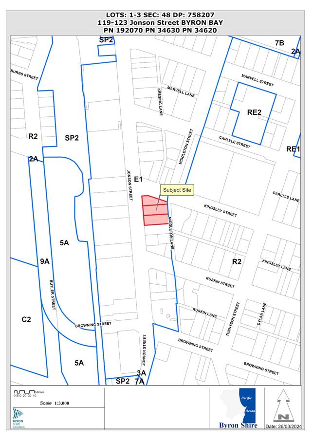
Report
1. INTRODUCTION
History/Background
|
Description |
Determination |
Date |
|
|
10.2015.263.4 |
Modification - Change of use to restaurant / function centre |
Withdrawn/ Cancelled |
21/12/2023 |
|
10.2015.263.3 |
S4.55 to Amend Stage 1 Regarding Sale of Alcohol and Change Stage 2 to Use of Premises as Cafe involving Minor Kitchen Works |
Withdrawn/ Cancelled |
15/10/2021 |
|
10.2015.263.2 |
Modify conditions relating to limiting the duration of the consent to three years, noise monitoring and management, infrastructure upgrade works, water and sewer charges and street trees |
Approved |
20/10/2016 |
|
10.2015.263.1 |
Change of use to restaurant/function centre |
Approved |
04/12/2015 |
|
10.2004.77.2 |
Modification to 10.2004.77.1 (Toy Library) for waivering of S94 fees |
Approved |
07/10/2004 |
|
10.2004.77.1 |
Community Building to operate as a Toy Library Community Building to operate as a Toy Library |
Approved |
25/05/2004 |
|
6.1988.2310.1 |
Playground Equipment |
Finalised |
28/06/1988 |
The site contains structures on three existing lots that are proposed to be demolished.
Description of the proposed development
This application seeks approval for Demolition and construction of mixed-use development comprising basement parking, ground floor courtyard with commercial premises, food and drink premises, two levels of shop top housing (total of 21), rooftop terraces and pool and associated plant.
Ground floor: restaurant café with gross floor area (GFA) of 200m² and nine commercial premises varying is size from 14 m² to 140 m²;
First Floor: Twelve shop top housing apartments - 2x2 bedroom, 7x3 bedroom, 2x3bedroom mezzanine, 1x4 bedroom. Two are accessible.
Second Floor: Nine shop top housing apartments 1x2 bedroom, 8x3 bedroom. One is accessible.
Roof Terraces, amenities, and pool deck area for residents only. The rooftop also contains solar photovoltaic cells, plant, and landscaping planter features.
Basement car parking for 85 spaces with 44 allocated for residential use and 41 allocated for the commercial retail component of the development. The development also includes 8 motorcycle spaces.
Parking for bicycles is located throughout the site including at the Kingsley Street frontage and in a dedicated end of trip storage area located off the ground floor courtyard.
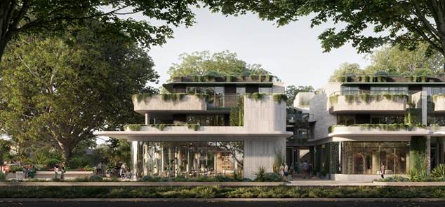
Figure 1: View of building Jonson Street Frontage
Extract of the proposed floor and roof plans are provided at Figure 2:
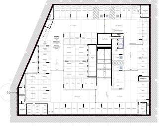
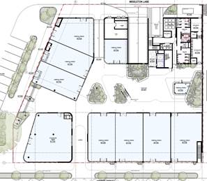
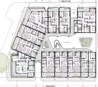
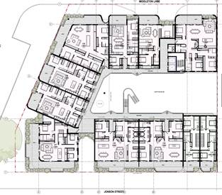
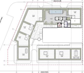
Figure 2: Floor Plans Basement to Roof
Description of the site
A site inspection was carried out on 2 April 2024
|
Land is legally described |
LOT: 1 SEC: 48 DP: 758207, LOT: 2 SEC: 48 DP: 758207, LOT: 3 SEC: 48 DP: 758207 |
|
|
Property address |
119-121 Jonson Street BYRON BAY, 123 Jonson Street BYRON BAY |
|
|
Land is zoned: |
E1 Local Centre |
|
|
Land area is: |
2,727 m2 |
|
|
Property is constrained by: |
Flood Liable Land; Acid Sulfate Soils Class 3 and Class 5; Mosquito risk zone. |
|
|
|
Is a BDAR required due to the location of the proposed development? |
☐ Yes ☒ No |
|
|
Are there any easements in favour of Council affecting the site? |
☐ Yes ☐ No |
|
|
Is there a Vegetation Management Plan which might affect the proposal? |
☐ Yes ☒ No |
|
|
Is there a Voluntary Planning Agreement which might affect the proposal? |
☐ Yes ☒ No |
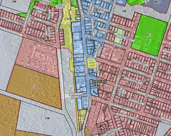
Figure 3: Zoning
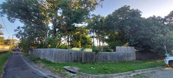
Figure 4: Site photos
2. SUMMARY OF REFERRALS
|
External Referrals |
Comment |
|
Essential Energy |
Conditions provided in the referral are included in the recommendation of this Report |
|
Water NSW (Water Management Act 2000) |
General Terms of Approval issued; included in recommended consent |
|
Internal Referrals |
Comment |
|
Environmental Health Officer |
Conditions provided in the referral are included in the recommendation of this Report |
|
Development Engineer |
Conditions provided in the referral are included in the recommendation of this Report |
|
Developer Contributions Officer |
Conditions provided in the referral are included in the recommendation of this Report |
|
S64 Systems / ET Engineer |
Conditions provided in the referral are included in the recommendation of this Report |
|
Public Art |
Conditions provided in the referral are included in the Recommendation of this Report |
1. SECTION 4.14 – BUSH FIRE PRONE LAND
Effect of 10/50 rule on significant vegetation-Nil.
2. SECTION 4.15C – MATTERS FOR CONSIDERATION – DISCUSSION OF ISSUES
Having regard to the matters for consideration detailed in Section 4.15(1) of the Environmental Planning & Assessment Act 1979 (EP&A Act), the following is a summary of the evaluation of the issues.
State Environmental Planning Policies (SEPP)
Biodiversity and Conservation SEPP 2021
Consideration: The proposal requires removal of vegetation.
A total of eleven small to medium sized native trees, shrubs and ferns, require removal. Trees identified for removal are Cottonwood Hibiscus (Hibiscus), Swamp Mahogany (Eucalyptus robusta), Spotted Gum (Corymbia maculate). Pink-flowered Doughwood (Melicope elleryana), Pandanus (Pandanus tectorius) and Straw Treefern.
There are no threatened flora species located on the land and no significant habitat vegetation (e.g., those with hollows). Native vegetation species to be removed consist of a variety of trees, shrubs and ferns, all of which have been planted, with the potential exception of a large Swamp Mahogany located in the northeast corner of the site. Swamp Mahogany is a koala food tree. This tree is separated from native vegetation communities located approximately 150 m to the west, by Jonson Street, other commercial developments, the railway corridor, and existing fences. No koala habitat areas are affected by the proposal.
One large Broad-leaved Paperbark (Melaleuca quinquenervia), located within the road corridor of Kingsley St, immediately to the north of the subject land is likely representative of the original vegetation community. This tree is proposed to be retained and protected.
The application for removal of vegetation to provide for a mix of permissible uses in the E1 zone is assessed as acceptable.
Consideration:
Chapter 4 Design of Residential Apartment Development
This Policy applies to the development as it is a new building with shop top housing comprising 3 storeys. Section 145 requires that a development application for residential apartment development be referred Design Review Panel. Details of this referral and design improvements are documented in this report.
Section 147 provides that prior to the determination of development applications, the matters to be taken into consideration relating to the design quality of the development. The proposed development of shop top housing is required to meet the provisions of the apartment deign guide. Detailed further in this section of the report below.
A design verification statement has been submitted in support of the proposal.
A detailed evaluation of the proposal in relation to the design quality principles and the apartment design guide has been completed and is assessed as compliant.
Design Quality Principles
A design verification statement prepared by Bayley Ward Architects as prescribed by the SEPP has been submitted to support the application. All modification in response to the Design Review Panel have been signed off by Bayley Ward Architects.
The SEPP requires that residential apartment development satisfactorily address nine (9) design quality principles and considers the recommendations in the Apartment Design Guide (ADG).The proposal is consistent with the design principles for the reasons outlined below:
|
Requirement |
Council Officer comments |
|
Principle 1: Context and Neighbourhood Character |
The proposal is on an existing commercial allotment with frontage to Jonson Street, Kingsley Street and Middleton Lane in the Byron Bay Town Centre. The area is currently undergoing a significant transition. The proposal is considered to respond and contribute to the local context, especially having regard to the desired future character of the area. The scale of building and type of proposed uses are compatible with the town centre location and adjoining nearby land uses including the fire station and Anglican Church. |
|
Principle 2: Built Form and Scale |
The design achieves an appropriate built form for the site and the building’s purpose in terms of building alignments, proportions, type and the manipulation of building elements that is enhanced with landscaping elements integrated with the built form. |
|
Principle 3: Density |
The proposal would result in a density appropriate for the site and its context, in terms of floor space yield, number of units and potential number of new residents. The proposed density of the development is regarded as sustainable and consistent with the desired future density of the area. |
|
Principle 4: Sustainability |
The proposal provides opportunities in this regard, as reflected within the submitted BASIX Certificates. Further a site-specific sustainability plan has been developed in consultation with Council staff to address sustainability outcomes for the proposal as well as the monitoring and reporting regime. |
|
Principle 5: Landscape |
The concept landscaping solutions depicted in the application plans are of high quality and appropriately respond to the proposed built environment. |
|
Principle 6: Amenity |
The proposal is satisfactory in this regard, optimising internal amenity through appropriate room dimensions and shapes, access to sunlight, natural ventilation, visual and acoustic privacy, storage, indoor and outdoor spaces, outlook, efficient layouts and service areas. The proposal provides for a mix of units offering housing choice and provides access and facilities for people with disabilities. Apartment amenity for residents is satisfactory when assessed against the best practice design guidelines identified in the ADG, which supports Chapter 4 of the Housing SEPP (cf SEPP 65). The proposal includes generous courtyard and landscaping as well as communal facilities at the roof level for use by residents. |
|
Principle 7: Safety |
The proposal is satisfactory in terms of future residential occupants overlooking public and communal spaces while maintaining internal privacy. The building has been designed to be satisfactory in terms of perceived safety in the public domain |
|
Principle 8: Housing Diversity and Social Interaction |
The proposal provides a mix of apartment sizes, that are capable of catering for different demographic needs. The proposal provides high quality communal open spaces, which will foster social interaction. It is considered that the proposal satisfies these requirements. |
|
Principle 9: Aesthetics |
The proposal is appropriate in terms of the composition of building elements, textures, materials and colours and reflect the use, internal design and structure of the resultant building. The proposed buildings aesthetically respond to the environment and context, contributing to the desired future character of the area. |
Apartment Design Guide (ADG)
The SEPP requires consideration of the ADG which supports the associated design quality principles by giving greater detail as to how those principles might be achieved. The assessment below considers the proposal against key design criteria in the ADG:
|
Element |
Compliance |
|
3B-1 Orientation |
The positioning of the building responds to the urban form of the block and the street, providing for an appropriate street interface to all street frontages, whilst maintaining an acceptable level of residential amenity including solar access with apartments oriented north where possible. The courtyard on the site provides opportunities for units to also be orientated north, east, and west. |
|
3B-2: Overshadowing |
The site does overshadow land zoned E1 to the south of the development. It has been indicated by the applicants that they have been in discussions with immediately adjoining owners to the south and that the design has considered the future desired plans for that property including opportunities for shared access via the proposed basement ramp and car park. |
|
3C: Public domain interface |
The public domain interface is considered to positively contribute to the streetscape by providing high quality materials and distinct access to residential/commercial components of the design. The courtyard provides through site connection with proposed access to Jonson Street, Kingsley Street and Middleton Lane. |
|
3D: Communal Open Space |
A large area of communal open space is provided on the rooftop which includes a pool, deck area, amenities, and landscaping. The ground floor courtyards and throughfares coupled with the planted garden areas further contribute to the number and types of communal open space areas spread throughout the development. Each area has been located and designed to ensure privacy, solar access and daylight access are achieved. |
|
2D-4: Public Open Space |
Public open space via the ground floor courtyard provides for through site links between all public spaces. These links are designed with weather protection, safety, inclusive accessibility, and activity in mind. Setbacks further enhance the public footpath interface and the use of public art on the corner of Kingsley Street provides further visual interest in the public realm. |
|
3E: Deep Soil Zone |
The landscape design has achieved deep soil zones where planting is not covered by the building that does not meet the minimum (15% of site area) requirements. In support of this variation, the architect provides the following justification, that is supported: Ground floor landscaping: 127sqm soft landscaping m² 600mm-1200mm deep covering 5% of site area. In lieu of deep soil planting the site due to the basement requirements an integrated landscaping strategy has been developed with the Landscape Architects on all levels from Ground to Roof providing significant amounts of sub-tropical endemic planting in planters of varying depths as well as areas of vertical climbing vegetation to provide connections to nature for the public and residents throughout the development. Also, significant amounts of hard landscaping and seating throughout the 530sqm Ground floor courtyard will be provided as well upgrades to streetscape including paving, street trees, public seating and planters. Stormwater systems have been designed with an OSD tank and filtration system in consultation with the Civil Engineer and Council. |
|
3F: Visual Privacy |
All setback requirements are compliant as indicated on the plans and would provide adequate privacy separation. Unit windows and balconies are located and oriented to maximise visual privacy between dwellings on site and for neighbouring buildings. |
|
3G: Pedestrian Access and Entries |
The ground floor access to the residential development is serviced by a lift. It is considered that suitable pedestrian access is accommodated on site and will be in the form of grade ramps and lifts. Separate entries have been provided for pedestrian and vehicles. Clear and distinct pedestrian links are provided through the site. |
|
3H: Vehicle Access |
The proposal incorporates separate entry point to the site for the basement level car parking area off of Middleton Lane. The vehicular entry point is separated from the pedestrian building entry point to improve pedestrian safety and comfort. The proposal provides for loading facilities off of Middleton Lane. The waste collection area will be managed to ensure collections do not impede traffic movements or dominate the use of the active frontage to the laneway for waste management purposes. Access will be subject to management measures as per conditions in the recommended consent. |
|
3J-4: Parking |
The proposed basement parking access and layout ensures that visual and environmental impacts of underground car parking are minimised. The design standards for parking have been met as per conditions in the recommended consent. |
|
4A: Solar and daylight access |
Plans submitted show that 3 or more hours of sunlight are received in midwinter for 18 (86% of the apartments in mid-winter. Three of the units (apt 1.08-1.10) receives 2 hours of sunlight (14%). This satisfies the design standards, that a maximum of 15% of apartments in a building receive no direct sunlight between 9 am and 3 pm at mid-winter. All apartments have dual aspects and there are also two dual level mezzanine apartments to the south on Jonson Street. |
|
4B: Natural Ventilation |
Plans submitted show that natural cross ventilation is achieved to the apartments via stack ventilation provided to the internal courtyard, window openings in the apartments. 60-70% of breezes during the summer months (Dec-Jan) come from the North-East. Apartments all have dual aspects in terms of natural ventilation (East-West and North-South). Balcony Sliding Doors act as large effective openable areas. Bedrooms include operable windows or full height sliding doors. |
|
4C: Ceiling Heights |
The ground floor has a floor to ceiling height of 3.8m, due to its commercial nature. It is noted that this meets the 3.3m for commercial uses and is less than the recommended 4m height of cafes/restaurants. Apartments at first floor have floor to ceiling heights 2.7m and 2.8m at second floor, which exceeds the maximum guide of 2.7m. The proposal achieves sufficient natural ventilation and daylight access to apartments. Based on merit the proposal satisfies the objectives of this control. |
|
4D: Apartment layout |
Plans indicate that the average apartment sizes exceed the design standard of 70m² for 2 bed apartments, 90m² for 3 bed apartments. A fourth bedroom and further additional bedrooms increase the minimum internal area by 12m² each (102m²). Apartments meet the area requirements. 2 Bedroom: 89-91m² (Excluding balcony/s) 3 Bedroom: 102-129m² (Excluding balcony/s) 4 Bedroom: 124-160m² (Excluding balcony/s) Kitchens are not part of the primary circulation spaces. Each habitable space has more than 10% glazing. |
|
4E: Private open space and balconies |
Plans indicate that all balcony sizes comply with the design standards for units. Smallest balcony/ private open space: 15m² Smallest Depth: 2.6m. Level 2 apartments have roof terraces in addition to covered balcony/ terrace. Noting that BDCP 2014 includes a requirement for a 15m² balcony. |
|
4F: Internal circulation |
Common circulation spaces are naturally ventilated and promote safety and provide for social interaction between residents.11 apartments per floor with 3 circulation cores (3 stairs + 1 lift pair): 3-4 apartments per core. This meets the requirements of this control. |
|
4G: Storage |
Secure accessible storage rooms are provided in the basement. All apartments have no storage areas other than robes within the apartment. For 2 bedrooms, the control is 8m² and for 3+ bedroom apartments, the control is 10m² within the apartment. The proposal does not meet the minimum of 50 percent of the required storage within the apartments. However, on merit the provision of storage is considered to satisfy the objectives of this control to provide adequate, well designed storage. |
|
4H: Acoustic privacy |
The proposal has generally been designed so that like-use areas of the apartments are grouped to avoid acoustic disturbance of neighbouring apartments where possible. Noisier areas such as kitchens and laundries are also located away from bedrooms when possible. The proposal satisfies the objectives of this control. |
|
4J: Noise and Pollution |
The application includes an acoustic report which recommends construction methods/materials/treatments to be used to meet the criteria for the site, given both internal and external noise sources. The recommendations cover acoustic treatments such as glazing, building construction, separation between uses, mechanical noise, and commercial delivery times. The report recommends the following conditions: • Background music shall be limited to 70 dBA in all commercial spaces when measured at 1m from the speakers. Alternatively, staff can verify audibility by standing at the boundaries of the neighbouring receivers, listening, and adjusting the volume until the sound is inaudible. • The pool and recreational area shall be limited to the day and evening time periods (7am to 10pm). • Doors and windows on the western and northern façade to commercial spaces 1 to 6 shall remain closed during the night periods (10pm to 7am Mondays to Saturdays and 10pm to 8am Sundays). • We recommend that waste collection be conducted in accordance with the surrounding commercial properties with recommended hours of 7am to 6pm and 8am to 6pm weekends. A condition in the recommended consent requires the recommendations in the report be implemented. |
|
4K: Apartment mix |
The proposal provides 2-, 3- and 4-bedrooms apartments that address local demographic need and would be large enough for families: 2 bed – 14%, 3bed – 81% 4 bed – 5% It is considered that the proposal satisfies the need to cater for different household types now and into the future. |
|
4M: Facades |
The proposed building façade is well articulated through varying setbacks, modulation, and materiality. The building incorporates distinct elements of separation, including the courtyard and lanes through the site. The proposal satisfies the objectives of this control to provide visual interest along the street while respecting the character of the local area. |
|
4N: Roof design |
The roof design has been integrated into the building design with the use of modulated vertical elements has also been included. The roof top provides opportunity for residential open space to be maximised. The roof incorporates sustainability features including photovoltaic solar cells. The proposal satisfies the objectives of this control. |
|
4O: Landscape design |
The proposal includes a landscape plan which demonstrates that the proposed building, courtyard, facades, and roof will be adequately landscaped. The landscaping to the public domain will enhance the streetscape as well as contributing to the amenity of the occupants. The existing Melaleuca tree to the northeast public domain is to be retained and protected with protection measures as recommended by landscape architect. The proposal satisfies the objectives of this control. |
|
4Q: Universal design |
Three of the units is adaptable/accessible. Accessible parking and storage is provided for these units. |
|
4S: Mixed Use |
The proposal provides for a ground floor retail, cafe/restaurant and commercial use which assists in separating the residential units from the noisier street level. The proposal provides separate entries for the retail and residential uses and avoids blank walls. Service areas are identified and separated while not dominating the laneway and views from Kingsley Street. |
|
4T: Awnings and signage |
Awnings are provided to Jonson and Kingsley Street continuing the predominant retail character and providing protection to footpaths. The awnings are masonry and integrated into the design of the façade. Signage will be limited to building identification, navigation, and statutory signs. Commercial signage will be subject to future and separate development applications. |
|
4U: Energy efficiency |
The application was accompanied by BASIX certificates indicating energy efficiency for each residential unit provided. Further a site-specific sustainability strategy has been developed to address sustainability outcomes for the proposal as well as the monitoring and reporting regime. |
|
4V: Water management |
The BASIX Certificates demonstrate that the development achieves the pass mark for water conservation. Further a site-specific sustainability strategy has been developed in to address sustainability outcomes for the proposal as well as the monitoring and reporting regime. |
|
4W: Waste management |
A construction and operational waste management plan has been prepared by a qualified waste consultant adhering to waste controls. All units are provided with sufficient areas to store and dispose of waste/recyclables. |
Resilience and Hazards SEPP 2021- Chapter 4 Remediation of land
Consideration: A Preliminary Site Contamination Report has been submitted in support of the application and is assessed as acceptable.
Transport and Infrastructure SEPP 2021
Consideration: The application was referred to Essential Energy in accordance with Section 2.48 of this policy due to location of and proximity of existing powerlines. A new pad mount electricity substation is proposed. Conditions of consent address this matter.
Sustainable Buildings SEPP 2022
Consideration: A valid BASIX Certificate was submitted with the application in accordance with the BASIX SEPP, which was in effect before the commencement of the Sustainable Buildings SEPP.
4.2 Byron Local Environmental Plan 2014 (LEP 2014)
LEP 2014 is an applicable matter for consideration in the assessment of the subject development application in accordance with subsection 4.15(1) of the EP&A Act because it applies to the subject land and the proposed development.
In accordance with LEP 2014 clauses 1.4 and 2.1 – 2.3:
(a) The proposed development is defined in the LEP 2014 Dictionary as mixed use development, which means a building or place comprising 2 or more different land uses. The land uses within the proposed development are defined in the dictionary as:
· Restaurant or café
· Commercial premises
· Shop top housing
(b) The land is within the E1 Local Centre according to the Land Zoning Map;
(c) The proposed development is permissible with consent; and
(d) Regard is had for the Zone Objectives as follows:
|
Zone Objective |
Consideration |
|
• To provide a range of retail, business and community uses that serve the needs of people who live in, work in or visit the area. |
The mixed use development will serve the needs of residents and visitors. |
|
• To encourage investment in local commercial development that generates employment opportunities and economic growth. |
The ground floor uses, and active frontages will provide an attractive investment opportunity for commercial purposes and generates employment and economic growth. |
|
• To enable residential development that contributes to a vibrant and active local centre and is consistent with the Council’s strategic planning for residential development in the area. |
The shop top housing and active frontages will contribute to a vibrant and active local centre while providing residential accommodation. |
|
• To encourage business, retail, community and other non-residential land uses on the ground floor of buildings. |
The entire ground floor is for commercial purposes. |
|
• To maximise public transport patronage and encourage walking and cycling. |
The through site connection and courtyard enhances pedestrian movement and on-site cycle parking is provided. |
Clause 2.7 – Demolition requires consent
Clause 2.7 requires that demolition of a building may be carried out only with development consent, except where it is demolition of development specified as exempt development under State Environmental Planning Policy (Exempt and Complying Development Codes) 2008. The proposal seeks consent for the demolition of all existing structures. This type of demolition is not exempt development. It is permissible with consent under Clause 2.7.
Clause 4.3 – Height of buildings
Clause 4.3 provides that the height of a building on any land is not to exceed the maximum height shown for the land on the Height of Buildings Map. The clause establishes that this height is measured from existing ground level to the finished level of the roof or parapet.
The Height of Buildings Map shows a maximum allowable height of 9m in this part of the town centre.
As discussed further below, some building components exceed the 9m development standard.
The application includes a submission under clause 4.6 of the LEP, arguing that compliance with the 9m building height standard is unreasonable and unnecessary. That submission is assessed below under Clause 4.6 Exceptions to Development Standards.
Clause 4.3A – Measurement of height of buildings
The objective of this clause is to align building height and flood planning provisions within Byron Bay town centre. It specifies that, in flood prone parts of the Byron Town Centre, the maximum height is measured from a nominated height, rather than from existing ground level.
To provide for a consistent point of reference for the measurement of building heights in flood prone areas. This clause applies to land identified as “Minimum Level Australian Height Datum (AHD)” on the Building Height Allowance Map. The maximum height of a building on land to which this clause applies is to be measured from the minimum level AHD permitted for that.
The building height allowance level mapped for this land is partly RL 3.3 AHD along the Jonson Street Frontage and RL 3.4 AHD through the middle of the site.
The 9m maximum building height is therefore measured from Existing ground level along the eastern part of the site. RL 3.4 through the middle of the site and RL3.3 along the Jonson Street part of the site. For the purposes of this assessment, the maximum height is discussed as RL i.e. 9m and above the RL 3.3-3.4 AHD – being up to RL12.3 - RL 12.4 AHD.
The application includes a written request from the applicant under Clause 4.6 of the LEP, arguing that strict compliance with the 9m building height standard is unreasonable and unnecessary. That submission is assessed below under Clause 4.6 Exceptions to Development Standards.
Clause 4.4 – Floor space ratio
The maximum floor space ratio (FSR) for a building on any land is not to exceed the FSR shown for the land on the floor space ratio map. The maximum permissible FSR on the site is 1.3:1.
FSR is the ratio of the total gross floor area of a building to the total area of the property. The site area is 2,727m2. A compliant FSR would be 3,545.1m2. The proposed development has a total gross floor space of 3,896m2. (350.9 m2) over the maximum. The proposed FSR is 1.428: representing a variation of 9.89%.
Clause 4.6 Exceptions to Development Standards
Where a DA includes a variation to a development standard, an application under Clause 4.6 Exceptions to Development Standards of the LEP is required.
Clause 4.6 provides that development consent must not be granted for development that contravenes a development standard unless the consent authority has considered a written request from the applicant that seeks to justify the contravention of the development standard, by demonstrating that compliance with the development standard is unreasonable or unnecessary in the circumstances of the case, and that there are sufficient environmental planning grounds to justify contravening the development standard.
As per the planning circular PS 18-003 - Variations to development standards, the Secretary’s concurrence can be assumed in relation to variations. Where variations are greater than 10%, the secretary’s concurrence can only be assumed by a decision of the Council (i.e. not delegated to a Council officer).
Building Height and FSR:
1. Summary of Development Standard Exceedance
The site is subject to a maximum height development standard of 9m. For the purposes of this assessment, the maximum height varies across the site i.e. 9m above ground level, RL 3.30 and 3.4. The height of the proposal is not compliant lift overrun, amenities, pool coping, terraces, services, solar array and the landscape features on the roof parapet. See table below.
The proposed FSR is 1.428: representing a variation of 9.89%.
2. Clause 4.6 Exceptions to Development Standards
1) The objectives of this clause are as follows—
(a) to provide an appropriate degree of flexibility in applying certain development standards to particular development,
(b) to achieve better outcomes for and from development by allowing flexibility in particular circumstances.
(2) Development consent may, subject to this clause, be granted for development even though the development would contravene a development standard imposed by this or any other environmental planning instrument…
(3) Development consent must not be granted to development that contravenes a development standard unless the consent authority is satisfied the applicant has demonstrated that—
(a) compliance with the development standard is unreasonable or unnecessary in the circumstances, and
(b) there are sufficient environmental planning grounds to justify the contravention of the development standard.
A written request has been submitted to Council demonstrating:
a) That compliance with the development standards is unreasonable or unnecessary in the circumstances of the case,
b) That there are sufficient environmental planning grounds to justify contravening the development standard,
c) the proposed development will be in the public interest because it is consistent with the objectives of the standards and the objectives for the development within the zone in which the development is proposed to be carried out.
3. The Development Standards to be varied
The 9m building height, prescribed by the Height of Buildings Map applicable to the site under Clause 4.3 of LEP 2014.
The 1.3:1 FSR, prescribed by the Floor Space Ratio Map applicable to the site under Clause 4.4 of the LEP 2014.
4. Extent of Variation to the Development Standard
· These areas are shown in the table below:
|
Building Component |
Proposed Height (m) RL AHD |
Height above 9 m as measured from RL 3.3 AHD (along the Jonson Street Frontage |
Height above 9 m measured from RL 3.4 AHD (through middle of site) |
Height above 9 m measured from Existing Ground level (lowest level on survey) |
% Height Variation (max extent) |
|
Roof terraces |
13.0 |
0.7 |
0.6
|
0.62 (noting lowest level below terraces is RL 3.38m) |
7.8% |
|
Parapet / Landscape Roof Feature |
13.6 |
1.3 |
1.2 |
1.08 (noting lowest level below parapet is RL 3.52m) |
14.4% |
|
Pool coping |
14.2 |
n/a |
n/a |
0.97 (lowest level below pool is RL 4.23m |
10.8% |
|
Amenities roof |
16.4 |
n/a |
4.0 |
3.92 (lowest level below amenities is RL 3.48m |
44.4% |
|
Lift overrun |
16.8 |
n/a |
4.4 |
4.42 (lowest level below lift overrun is RL 3.38m |
49.1% |
·
Figure 5: Roof plan extract
5. Justification under Clause 4.6(3)(a) and (b)
The applicant seeks to justify the contravention of the maximum height development standard on the following basis:
a) Compliance with the development standard is unreasonable and unnecessary in the circumstances of the case:
Height
1. The proposed height variation will not add to the development's perceived scale, bulk or intensity.
2. The proposed elements materially exceeding the 9m height limit are provided to give the roof wheelchair accessibility and are set well back from Jonson Street and Kingsley Street and will not result in adverse visual impacts.
3. The proposed central siting of the elements exceeding the height limit means that no adverse impacts from overshadowing will occur to surrounding properties.
4. The proposed built form provides generous areas of a publicly accessible courtyard. The provision of these elements on the ground floor is facilitated by locating resident facilities on the roof. A requirement to strictly comply with the 9m would likely reduce the publicly accessible areas on the ground floor as a result.
5. Strict compliance with the 9m height limit would not significantly alter the design of the building apart from removing resident amenities on the upper level and limiting the variety of uses at the ground floor.
FSR
• The development provides a compatible streetscape with that envisaged by the Town Centre Masterplan;
• The proposed bulk and scale do not create any adverse visual impacts;
• There is an appropriate visual relationship with nearby developments with reasonable separation distances;
• There are no adverse shadow, view, visual and acoustic privacy impacts occasioned by the Floor Space Ratio proposed; • The development provides for high-quality internal amenity;
• There are no adverse heritage impacts;
• The parking is fully compliant with the DCP control, and the development will have no adverse traffic impacts associated with the additional density;
• The landscaping is compliant with the ADG controls and contributes to the amenity of the site;
• The setbacks are compliant, and the range of housing associated with the additional floor space is a better planning outcome;
• The high level of design and performance of internal amenity indicators is confirmed by the project's full consistency with the ADG; and
• The public benefit associated with compliance with the aspirations for the Town Centre Masterplan also contributes to demonstrating that the proposal is a better planning outcome than a compliant development
b) There are sufficient environmental planning grounds to justify contravening the standard:
Height
it is considered that there are sufficient grounds to justify the proposed variation. The siting of those elements exceeding the building height limit in the central portion of the site and set well back from the public street system and will preserve the streetscape and not impact on the bulk or scale of the proposed building. The siting of the proposed encroachments will not result in adverse impacts on surrounding properties in terms of solar access or the disruption of views. The provision of resident amenities on the roof enables generous publicly accessible areas on the ground floor. It is considered in the circumstances that the contravention of the development standard does not raise any significant issues
FSR
It is considered that there are sufficient grounds to justify the proposed variation and in the circumstances that the contravention of the development standard does not raise any significant issues
c) The proposed development will be consistent with the objectives of the zone as follows:
· To provide a range of retail, business, entertainment, and community uses that serve the needs of people who live in, work in and visit the local area.
· To encourage employment opportunities in accessible locations.
· To maximise public transport patronage and encourage walking and cycling.
· To encourage vibrant centres by allowing residential and tourist and visitor accommodation above commercial premises.
Height and FSR
The proposal is consistent with the objectives of the E1 Local Centre Zone, providing for a range of uses to serve the needs of people who live in, work and visit the local area. The provision of a wide range of commercial uses in the town centre will provide employment opportunities in an accessible location. The proposal seeks to encourage walking and cycling with the provision of end-of-trip facilities for those walking and cycling to the site. The provision of residential accommodation in a variety of bedroom sizes and configurations above commercial premises within the town centre will enhance activity and promote a vibrant and active Town Centre.
d) The proposed development will be consistent with the objectives of the standard as follows—
Height
(a) to achieve building design that does not exceed a specified maximum height from its existing ground level to finished roof or parapet,
(b) to ensure the height of buildings complements the streetscape and character of the area in which the buildings are located,
(c) to minimise visual impact, disruption of views, loss of privacy and loss of solar access to existing development.
The architects’ design report includes a sheet entitled “Emerging Context”. That drawing shows the building is consistent with and complements the character of the locality. Those main elements exceeding the 9m are significantly set back from Jonson Street and Kingsley Street and will not adversely impact on the visual amenity of the streetscape:
Figure 6: Emerging context
The siting of the elements that materially exceed the height limit towards the central part of the building means that the proposed variation will have no impact on surrounding properties in terms of solar access or visual amenity.
FSR
(a) to ensure that new buildings are appropriate in relation to the character, amenity and environment of the locality,
(b) to enable a diversity of housing types by encouraging low scale medium density housing in suitable locations,
(c) to provide floor space in employment and mixed-use zones adequate for the foreseeable future,
(d) to regulate density of development and generation of vehicular and pedestrian traffic,
(e) to set out maximum floor space ratios for dual occupancy in certain areas.
The proposed bulk of the development is compatible with the area's character, amenity and landform in a manner consistent with the comprehensive strategic planning work undertaken for the Town Centre Masterplan. The floor space proposed permits a diversity of apartment types and sizes. The density of development does not overstretch the local transport system concerning the generation of vehicular and pedestrian traffic.
Clause 5.21 – Flood Planning
The site is mapped as flood prone. A flood planning level of RL3.44 AHD applies to the site. The application has been assessed by staff as adequate to address flood planning for the proposal. Relevant conditions are included in the Recommendation to the Report.
Clause 6.1 – Acid Sulfate Soils
This clause provides that, where applicable, development consent must not be granted for the carrying out of works unless an acid sulfate soils management plan (ASSMP) has been prepared in accordance with the Acid Sulfate Soils Manual. An Acid Sulfate Soils and Assessment Plan has confirmed that the soils to be excavated for the development require treatment and correct disposal. Relevant conditions are included in the Recommendation to the Report.
Clause 6.2 - Earthworks
Clause 6.2(3) requires the consent authority to consider the effects of the proposed development on the environment and surrounding area as a result of any proposed earthworks.
The earthworks associated with the proposed development are significant, for the excavation of the proposed basement car park.
The proposal comprises Integrated Development as approval is required under the Water Management Act 2000. The development application was referred to Water NSW and General Terms of Approval (GTA’s) were issued on 6 February 2024.
A condition limits any excavations or dewatering to be in accordance with the GTA’s. The impacts of the proposal can be addressed through appropriate conditions of consent.
Clause 6.6 – Essential services
Clause 6.6 requires the consent authority to be satisfied that essential services are available for the proposed development. Council officers are satisfied that the site is fully serviced and meets the requirements of clause 6.6. Relevant conditions are included in the Recommendation to the Report.
Clause 6.13 – Design excellence – Byron Bay town centre
Development consent must not be granted to a new building in the town centre unless Council is satisfied that it exhibits design excellence.
To achieve design excellence the proposal inter alia must incorporate sustainable design principles, have a high standard of architectural design, materials, and detailing, respond well to the environmental and built forms characteristics of the site and neighbouring buildings, and improve the quality of the public domain.
The clause also states that development consent must not be granted to a development unless the Byron Design Excellence Panel has endorsed the development as exhibiting design excellence.
The applicant has worked proactively and collaboratively with the Council assessment team and responded to these requests and submitted a series of plan iterations to address key areas of concern with the proposal as submitted:
· Building bulk, articulation, and built form in relation to setbacks and number of storeys;
· External appearance;
· Rooftop layout and roofscape greening;
· Residential amenity;
· Visual and acoustic amenity in units;
· Ground floor porosity;
· Driveway ramp and back of house;
· Sustainability;
· Increasing floor to ceiling heights;
· Increased floor space to support design excellence;
· Open up spaces, landscape and encourage through traffic; and
· Consideration of public art proposal.
Design and sustainability excellence has been addressed by the applicant to the satisfaction of the design excellence expert and staff. Changes are summarised in the summary of this report, shown on the revised plans Attachment 1 and or addressed by relevant conditions in the recommendation.
In response to waste collection, parking and loading bays further comment is provided on the applicant’s most recent submission in section DCP 2014 comments Chapters B4 and B8 to this report.
Clause 6.14 – Active Street frontages in Byron Bay Town Centre
The clause applies to the subject site.
Development consent must not be granted to a new building in the town centre unless Council is satisfied that it will have an active street frontage.
For the purposes of this clause, a building has an active street frontage if:
(a) all premises on the ground floor of the building facing the street or a public space are used for the purposes of business premises or retail premises
Commercial tenancies are located on the ground floor facing Jonson, Kingsley Street and Middleton Lane corner with Kingsley.
Basement car park access is located facing the lane to the eastern edge of the building. A fire exit and fire infrastructure are also located at the Jonson Street front boundary. A single access facing the lane for access to and from the waste storeroom is located facing the Lane boundary. Under the clause these elements are ‘excepted’ from that part of the building that promotes an active street frontage. It is considered that the street activation of the site is fully maximised.
the street frontage of the building enables direct visual and physical connection between the street and the interior of the building
There will be a direct visual connection for the ground floor tenancies at the street frontage. The through site courtyard provides direct visual connection from the street, lane and interior of the building.
all premises on the ground floor are built to the boundary or are built to create a continuous building edge with adjoining commercial premises
Ground floor is built to the boundaries except where to provide amenity for dining, streetscape and waste collection and loading.
the street frontage of each premises on the ground floor of the building facing the street is not greater than 20 metres
None of the ground floor tenancies are greater than 20m in length.
parking, or loading and unloading, areas that are above ground level are not located at the front of the site
All parking is within the basement car park and loading areas are provided adjacent to the laneway frontage without detracting from the active frontages and tenancies.
Any proposed Instrument that has been the subject of public consultation and has been notified to the consent authority
No draft Environmental Planning Instruments apply.
Byron Shire Development Control Plan 2014 (DCP 2014)
DCP 2014 is an applicable matter for consideration in the assessment of the subject development application in accordance with subsection 4.15(1) of the EP& A Act because it applies to the land to which LEP 2014 applies. The DCP 2014 Parts/Chapters that are of relevance to the proposed development are addressed below:
|
Part A |
Compliance |
Comment |
|
||||||||||
|
A13.4 |
Level 3 |
Yes |
Level 3 advertising under Council’s Community Participation Plan: - Pre-lodgement consultation by applicant: 25 November 2022 – 12 December 2022 - First Round Exhibition period: 15 August 2023 – 28 August 2023 - Second Round Exhibition period: 23 January 2024 – 5 February 2024 Total unique submissions received: 38 (34 Support, 4 Oppose). |
|
|||||||||
|
Chapter B3 Services |
Compliance |
Comment |
|
||||||||||
|
B3.2.1 |
Provision of Services: |
Yes |
Water Supply The site is serviced by a reticulated water supply. Council’s Systems Planning Engineers advise that there is existing capacity in the system to service the proposed development. Sewage The site is serviced by a sewage supply. Council’s Systems Planning Engineers advise that there is existing capacity in the system to service the proposed development. Access See Chapter B4 below. Other No issues are raised regarding electricity of telecommunications infrastructure. |
|
|||||||||
|
B3.2.3 |
Stormwater Management |
Yes |
A concept stormwater plan was submitted with the application and suitable conditions of consent are recommended. |
|
|||||||||
|
B3.2.4 |
Sedimentation and Erosion Control Measures |
Yes |
Standard conditions can adequately address issues. |
|
|||||||||
|
Chapter B4 Traffic Planning, Vehicle Parking, Circulation and Access |
Compliance |
Comment |
|
||||||||||
|
B4.2 |
Development controls |
Yes |
Parking is provided for in the basement car park and is provided at the required rate generated by the development with consideration of provision of car share, accessible parking etc. There is an on-site loading bay. |
|
|||||||||
|
Chapter B5 Provisions for Cycling |
|
|
|
||||||||||
|
B5 |
Provisions for Cycling |
Yes |
Parking for bicycles at ground level with end of trip facilities and allocated storage rooms in the basement for all shop top housing units. |
|
|||||||||
|
Chapter B7 Mosquitoes and Biting Midges |
Compliance |
Comment |
|||||||||||
|
B7.2.1 |
Mosquito and Biting Midge Risk Zones |
Yes
|
The site is located within a mapped risk zone. A standard condition for screening of openings is recommended. |
||||||||||
|
Chapter B8 Waste Minimisation and Management |
Compliance |
Comment |
|||||||||||
|
B8.3.1 |
Demolition of Buildings or Structures |
Yes
|
A Site Waste Minimisation and Management has been submitted in support of the application, addressing the requirements of the DCP. The SWMMP has been reviewed and is considered acceptable, subject to recommended conditions of consent to ensure that actions are implemented during demolition stage of the project. |
||||||||||
|
B8.3.2 |
Construction of Buildings or Structures |
Yes |
The construction stage is acceptable, subject to recommended conditions of consent to ensure that actions are implemented during the construction stage of the project. |
||||||||||
|
B8.3.3 |
Bin Sizes and Collection Measures |
Yes |
An Operation SWMMP provides recommendations that are consistent with part of the DCP. A site-specific collection contract will be used for all collection. |
||||||||||
|
Chapter B9 Landscaping |
Compliance |
Comment |
|
||||||||||
|
B9.2.2 |
Landscape Plans for Development Applications |
Yes
|
A detailed landscape plan has been submitted with the application, to address the requirements of these parts of the DCP. Relevant conditions of consent are included in the recommendation. |
|
|||||||||
|
B9.2.3 |
Further Requirements for more Complex Developments |
Yes |
As above. |
|
|||||||||
|
Chapter B11 Planning for Crime Protection |
Compliance |
Comment |
|
||||||||||
|
B11.2.1 |
Development that requires a formal crime risk assessment |
Variation
|
The development includes a basement car park, and a formal crime risk assessment was undertaken. |
|
|||||||||
|
B11.2.3 |
CPTED design opportunities |
Yes |
The proposal is for a mixed-use development with shop top housing. The design, layout and managed access to the site has provided adequate passive surveillance and is able to meet CPTED principles. The main features to increase the safety of the users of the development include passive surveillance of public spaces, clearly defined access points and an overall understanding of public versus private areas. The proposal incorporates clear sightlines, appropriate landscaping, and appropriate lighting |
|
|||||||||
|
Chapter B13 Access and Mobility |
Compliance |
Comment |
|
||||||||||
|
B13.2.2 |
Shop top housing and serviced apartments |
Yes |
An Access Assessment Report has been submitted in support of the application, demonstrating that the design complies with the DCP and all relevant legislation and standards. 10% of units should be adaptable. There are 21 units three are shown as “accessible/adaptable” and another is liveable in accordance with the NSW Apartment Design Guide. |
|
|||||||||
|
Chapter B15 Public Art |
Compliance |
Comment |
|
||||||||||
|
B15.2.1 |
Provision of public art See Attachment 5 for details of Art works proposed) |
Yes |
Development to which this Section applies must include the provision of public art to the value of at least 2.5% of development costs (calculated in accordance with the Environmental Planning & Assessment Regulation) up to $2 million, and 1% of further development costs exceeding $2 million. The cost of works is $23,075,428 (contribution calculated as above: $50,000+$+210,754.28=260,754.28). It should be noted that a substantial part of the development involves residential shop top housing that is not required to meet the provisions of public art under Chapter B15. This amount includes costs for uses that do not trigger the provision of public art, Public Art proposal with a total cost (Inc. GST) of $271,566 was supported by the Arts and Creative Industries Advisory Committee Meeting 29 February 2024 and endorsed by a meeting of Council on 4 April 2024*. The $ amount offer exceeds the amount specified in the DCP and feedback / comments received from the Advisory committee are considered in the consent conditions for roads act approval, with regards setting and curtilage. |
|
|||||||||
|
Figure 7 Public Art Concept for Corner of Jonson and Kingsley Street
|
|
||||||||||||
|
Chapter C2 Areas Affected by Flood |
Compliance |
Comment |
|
||||||||||
|
C2.13 |
Planning objectives and development controls |
Yes |
The proposal meets the objectives of the E1 zone. |
|
|||||||||
|
Chapter D1 Residential Accommodation in Urban, Village and Special Purpose Zones |
Compliance |
Comment |
|
||||||||||
|
D1.10. |
Shop top housing |
Yes |
This Section applies to shop top housing, which includes dwellings located above ground floor retail premises or business premises |
|
|||||||||
|
D1.10.1 |
Density Control |
Yes |
A minimum of 25% of the floor space of the entire development, not including car parking, must be set aside for commercial/ retail purposes. All ground floor space fronting the street must be devoted to retail premises and/or business premises . 1199m² of the total 3896 m² (30.8%) |
|
|||||||||
|
D1.10.2 |
Accessibility |
Yes |
Development designed to ensure that adequate direct pedestrian and disabled accessible resident access is provided to the residential component of the development from all areas of the street, courtyard, units and terraces. |
|
|||||||||
|
D1.10.3 |
Private Open Space |
Yes minor variation regards solar access. |
The private open space has a minimum area of 15m2 and a minimum width of 2.5 metres and directly accessible from living areas. All units meet the requirements for solar access. |
|
|||||||||
|
D1.10.4 |
Soundproofing |
Yes |
Apartments will be appropriately sound proofed. |
|
|||||||||
|
D1.10.5 |
Clothes drying facilities |
Yes |
Apartments will provide for laundry areas that can incorporate clothes driers or spaces to provide clothes drying areas. |
|
|||||||||
|
Chapter D4 Commercial and Retail Development |
Compliance |
Comment |
|
||||||||||
|
D4.2.1 |
Design and character of retail and business areas |
Yes |
See assessment above.
|
|
|||||||||
|
D4.2.2 |
Design detail and appearance |
Yes |
See assessment above. |
|
|||||||||
|
D4.2.3 |
Vehicle access and parking |
Yes |
See assessment above. |
|
|||||||||
|
D4.2.4 |
Loading docks |
Yes |
See assessment above. |
|
|||||||||
|
D4.2.5 |
Street setbacks |
Yes |
Ground floor setbacks are varied and complement and enhance the streetscape and the character of the centre. Upper floors are setback, with balconies utilised in setback. |
|
|||||||||
|
D4.2.10 |
Restaurants, cafes, small bars etc |
Yes |
Noise is unlikely to be an issue at this location. Hours of operation and other requirements can be conditioned. |
|
|||||||||
|
Chapter E10 Byron Bay Town Centre |
Compliance |
Comment |
|
||||||||||
|
E10.2.1 |
Uses |
Yes |
Retail and active uses dominate the ground floor. Each proposed retail space has a depth to width ratio of between 1:1 and 3:1. |
|
|||||||||
|
E10.2.2 |
Character |
Yes |
Development provides active street frontage, articulated facades, is fine grained safe and legible connections through it. |
|
|||||||||
|
E10.2.3 |
Built form |
Yes |
See assessment above. |
|
|||||||||
|
|
Buildings must contain no more than 3 storeys |
Yes |
Complies. |
|
|||||||||
|
|
Roof-top facilities not to contravene maximum building height |
No but acceptable in this case |
See discussion above regarding building height variation. |
|
|||||||||
|
|
Floor to ceiling heights |
No (ground and first floor); but acceptable in this case. |
Ground floor: required 4.0m; proposed: ground floor has a floor to ceiling height (FTCH) of 3.8m. First floor: required 3.3m; proposed 2.7m Second floor: required 2.7m; proposed 2.8m The FTCH controls relate to the creation of comfortable and high-quality internal environments for occupants and users. The proposal has otherwise satisfied amenity and build excellence criteria for this type of development. The applicant has gone with a 3.8m ground floor to ceiling height at ground floor, which in turn contributes to pushing the overall building height in part above the 9.0m Height of Building (Flood Allowance level The variation to FTCH is acceptable. |
|
|||||||||
|
|
Upper levels to be setback 3.0m (can be used for balconies) |
Yes |
Upper floors each meet the 3 m depth with some parts of minor variation being minimum 2.6m deep balconies at street frontage. |
|
|||||||||
|
|
Access to sunlight for adjoining properties |
Yes |
Adjoining buildings retain the required access to daylight hours of sunlight. |
|
|||||||||
|
10.2.4 |
Climate and context |
Yes |
See assessment above. Relevant conditions included in the recommendation. |
|
|||||||||
|
10.2.5 |
Acoustic and visual privacy |
Yes |
Achieved by design. Relevant conditions included in the recommendation. |
|
|||||||||
|
10.2.6 |
Car parking |
Yes |
See assessment above. Relevant conditions included in the recommendation. |
|
|||||||||
|
10.2.7 |
Waste and Recycling |
Yes |
See assessment above. Relevant conditions included in the recommendation. |
|
|||||||||
|
10.2.9 |
Roof form, access and use |
Yes |
Relevant conditions included in the recommendation. |
|
|||||||||
|
10.2.10 |
Green infrastructure |
Yes |
The proposal includes planting and planters that will provide landscaping throughout the site and partially screen vertical elements including parapets and balconies. Relevant conditions included in the recommendation. |
|
|||||||||
|
10.2.11 |
Design Excellence |
Yes |
See assessment above. Relevant conditions included in the recommendation. |
|
|||||||||
|
* Public Art Endorsement Report No. 4.1 DCP Public Art Plan Referral, 119 - 123 Jonson Street DA 2023.235.1 File No: I2024/58 |
|
Committee Recommendation: That the Arts and Creative Industries Advisory Committee: 1. Supports the proposed public art proposal for the development at 119-123 Jonson Street, Byron Bay DA 2023.235.1; and 2. Provides feedback to Council’s Assessment Officer that: a. There were a variety of opinions expressed by the Committee. b. There was a high level of support for the materials, location and scale. c. There was an appreciation for the landscaping and seating. d. There was a general desire for a more contemporary or courageous piece. e. There was some feedback around the potential objectification and controversy around the subject. f. Recommend they explore the potential for increased curtilage. (Dods/Napier) |
The recommendation was put to the vote and declared carried.
Gwenyth Broug and Lou Hodgson voted against Point 1.
All Members voted in favour of Point 2.
4.5 Environmental Planning and Assessment Regulation 2021
|
Environmental Planning and Assessment Regulations 2021 |
Applicable to the proposal: |
Considered the control as it relates to the proposal: |
If this control is applicable, does the proposal comply? |
|
Section 61 - Additional matters that consent authority must consider |
☒ Yes ☐ No |
☒ Yes ☐ No ☐ NA |
☒ Yes ☐ No ☐ NA |
|
Section 62 - Consideration of fire safety |
☐ Yes ☒ No |
☐ Yes ☐ No ☒ NA |
☐ Yes ☐ No ☒ NA |
|
Section 64 - Consent authority may require upgrade of buildings |
☐ Yes ☒ No |
☐ Yes ☐ No ☒ NA |
☐ Yes ☐ No ☒ NA |
|
Section 63 - Considerations for erection of temporary structures |
☐ Yes ☒ No |
☐ Yes ☐ No ☒ NA |
☐ Yes ☐ No ☒ NA |
* Non-compliances and any other significant issues discussed below
4.6 The likely impacts of that development, including environmental impacts on both the natural and built environments, and social and economic impacts in the locality
|
Impact on: |
Likely significant impact/s? |
|
Natural environment |
No. The proposal will not have a significantly adverse impact on the natural environment of the locality. |
|
Built environment |
No. The proposal will not have a significantly adverse impact on the built environment of the locality. |
|
Social Environment |
No. The proposal will not have a significant social impact on the locality. |
|
Economic impact |
The proposal will have a significant positive economic impact on the locality. |
|
Construction Impacts |
The development will generate impacts during its construction. Conditions of consent recommended to control hours of work, builders waste, construction noise, installation of sedimentation and erosion control measures and the like to ameliorate such impacts. |
Marine Estate Management Act 2014
The development is unlikely to have an effect on the plants or animals within the Cape Byron Marine Park or their habitat.
4.7 The suitability of the site for the development
The site is a serviced, unconstrained property and is suitable for the proposed development.
4.8 Submissions made in accordance with this Act or the Regs.
The development application was publicly exhibited. There were 38 submissions made on the development application:
- (34 Support, 4 Oppose)
|
Issue / Impact |
Comment Consideration |
|
Traffic |
Upgrades required to the existing surrounding roads will be subject to a Roads Act application to be approved prior to issue of a construction certificate and suitable conditions of consent are recommended. |
|
Stormwater |
A concept stormwater plan was submitted with the application and suitable conditions of consent are recommended. |
|
Noise |
The potential impacts of the roof top pool area on surrounding residential receptors and other noise impacts on the future residents of the development from include road traffic, approved land uses and have been assessed in an acoustic assessment and suitable conditions of consent are recommended to require the recommendations of the noise impact assessment to be implemented at all times. |
|
Local services / infrastructure |
The developer is required to pay contributions towards the provision of services and infrastructure in accordance with Byron Shire Developer Contributions Plan. |
|
Scale, FSR, height, overshadowing |
The design of the building, including consideration of height and scale has involved a rigorous Design Review Panel assessment and a variation of the height of building and FSR in the particular circumstances of this site are considered in this report. The immediately adjoining neighbour to the south has provided their written support. |
|
Holiday letting |
A standard condition of consent is recommended to limit the use of the shop top housing, preventing its use for short term rental accommodation (STRA) subject to separate consent modification. This approach is consistent with current resolutions of Council and also recommendations made in the Independent Planning Commission’s report on Byron Shire Short Term Rental Accommodation Planning Proposal. Notwithstanding the above it is acknowledged that, State planning provisions that come into effect in 23 September 2024 will allow this land to be used for un-hosted STRA under the State Environmental Planning Policy (Housing) 2021. Changes for non-hosted STRA were endorsed by the NSW Government in September 2023. There will be a 12-month transition period for the community and industry to prepare. The new day caps will take effect on 23 September 2024. The changes are: · A house or unit cannot be used for non-hosted STRA for more than 60 days in a 365-day period, for most of the Shire. · Some areas in Byron Bay (and Brunswick Heads) will be able to operate without a cap on holiday letting, for 365 days per year. Maps for these areas are available on the NSW Department of Planning portal website. · View the Byron Bay 365-day precinct map This land is in the 365-day precinct. |
4.9 Public interest
The proposed development is unlikely to prejudice or compromise the public interest or create an undesirable precedent.
3. DEVELOPER CONTRIBUTIONS
5.1 Water & Sewer Levies
Section 64 levies will be payable.
5.2 Developer Contributions
Section 7.11 Contributions will be payable.
4. DISCLOSURE OF POLITICAL DONATIONS AND GIFTS
|
Disclosure details |
Response |
|
Has a Disclosure Statement been received in relation to this application? If Yes, Provide Disclosure Statement register reference: 91. |
Yes ☐ No ☒ |
|
Have staff received a ‘gift’ from anyone involved in this application that needs to be disclosed. |
Yes ☐ No ☒ |
5. CONCLUSION
The DA proposes demolition and construction of mixed-use development comprising basement parking, ground floor courtyard with commercial premises, food and drink premises, two levels of shop top housing (total of 21), rooftop terraces and pool and associated plant.
The proposed development is satisfactory having regard to the relevant environmental planning instruments and planning controls applicable to the site. The proposal raises no significant issues in terms of environmental impacts which cannot be managed. The site is a serviced, unconstrained property and is considered suitable for the proposed development.
The application appropriately addresses the relevant constraints applying to the site and is recommended for approval subject to the conditions listed in the Recommendation in Attachment 2 of this report.
Staff Reports - Sustainable Environment and Economy 13.7
Report No. 13.7 PLANNING - DA 10.2016.625.5 - 35-37 Burringbar Street Mullumbimby 2482
Directorate: Sustainable Environment and Economy
Report Author: Alissa Magnifico, Planner
File No: I2024/62
Proposal:
|
Modification No: |
10.2016.625.5 |
|
Proposed modification: |
S4.55 Modification to Condition 65 to Extend Operating Hours |
|
Original Development: |
Alterations and Additions to Existing Commercial Building to Create a Café and Day Spa |
|
Type of modification sought: |
4.55(1A) Modifications involving minimal environmental impact |
|
Property description: |
LOT: B DP: 302891 |
|
35-37 Burringbar Street MULLUMBIMBY |
|
|
Parcel No/s: |
7150 |
|
Applicant: |
Mr M Scott |
|
Owner: |
The Mullum Triangle Pty Ltd |
|
Zoning: |
E1 Local Centre |
|
Date received: |
22 July 2023 |
|
Original DA determination date: |
7 August 2017 |
|
Public notification or exhibition: |
- Level 2 advertising under the Byron Shire Council Community Participation Plan. - Exhibition period: 2 August 2023 to 15 August 2023 - Submissions received: 1 objection |
Summary:
This s4.55(1A) application seeks approval for modification to Condition 65 to Extend Operating Hours for the Banya Spa House at 35-37 Burringbar Street, Mullumbimby.
The existing condition states:
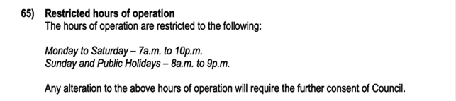
The applicant proposes the hours of operation to be modified to:
Monday to Saturday - 7am. to mid-night
Sunday and Public Holidays - 7am. to 10 pm.
There was one submission objecting the proposal in relation to impacts on amenity. It is understood there are upper level shop top housing in the vicinity to the premises. The application was accompanied by an Acoustic report which was then updated to address noise impacts.
This assessment finds that the modification is acceptable, subject to reviewable consent conditions and reduced hours on Sunday and Public Holidays. The S4.55 Application is recommended for approval.
NOTE TO COUNCILLORS:
In accordance with the provisions of S375A of the Local Government Act 1993, a Division is to be called whenever a motion for a planning decision is put to the meeting, for the purpose of recording voting on planning matters. Pursuant to clause 2(a) under the heading Matters to be Included in Minutes of Council Meetings of Council's adopted Code of Meeting Practice (as amended) a Division will be deemed to have been called by the mover and seconder of all motions relating to this report.
That Pursuant to Section 4.55 of the Environmental Planning & Assessment Act 1979, that Application No.10.2016.625.5, for Modification to Condition 65 to Extend Operating Hours, be approved by modifying Development consent number 10.2016.625.1 in accordance with the Recommended Amended Conditions of Consent in Attachment 1 #E2024/30680.
1 10.2016.625.5
modified conditions of consent, E2024/30680
![]()
2 10.2016.625.5
Acoustic Report, E2024/23326 ![]()
3 10.2016.625.5
submission, E2024/31259 ![]()
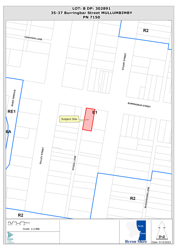
Assessment:
1. INTRODUCTION
1.1. History/Background
The building was originally built in 1928 and opened in 1929 for the English, Scottish and Australia Bank which later became the ANZ Bank. Prior to the opening of the bank at this site the bank operated from 98 Dalley Street, Mullumbimby which was constructed in 1909 after fire destroyed the previous building in 1908. The use of the site as a bank ceased approximately 15-20 years ago.
There have been a number of applications relating to the Banya Bathhouse as follows:
|
Application Number |
Proposal |
Decision |
|
10.2016.625.1 |
Alterations and Additions to Existing Commercial Building to Create a Recreation Facility (Indoor - Spa) and Food and Drink Premises (Café – Juice Bar) |
Approved 07.08.2017 |
|
10.2016.625.2 |
Minor Modifications to Design and Conditions |
Approved 25/05/2020 |
|
10.2016.625.3 |
Amend First Floor Layout |
Approved 12.02.2021 |
|
10.2016.625.4 |
S4.55 Changes to Floor Plan (addition of a plant room, installation of fires in the seating area and sauna, and inclusion of cool room in the storeroom) |
Approved |
1.2. Description of the proposed development
This application seeks approval to modify Condition 65 to Extend Operating Hours.
The applicant proposes to extend the hours of operation to:
Monday to Saturday - 7a.m. to mid-night
Sunday and Public Holidays - 7a.m. to 10p.m.
The Statement of Environmental Effects states,
“The proposed extended hours of operation are a response to customer requests. The extended hours of operation assist to ensure the central business district of Mullumbimby remains a vibrant and alive people place, and that the facility is open at convenient times for a wider cross section of the community”.
1.3. Description of the site
The site was inspected on 16 February 2024.
Land is legally described as LOT: B DP: 302891.
Property address is 35-37 Burringbar Street MULLUMBIMBY
Land is Zoned: B2 Local Centre
Land area is: 607 m2
Property is constrained by:
· Flood Prone Land
· Acid Sulfate Soils (Class 4)
· Heritage Conservation Area
The site contains an older style commercial building that was historically a Bank which has been repurposed into the Banya Bathhouse in recent years.
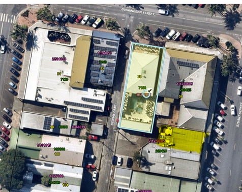
Figure 1: Site map and proximity to Shop Top Housing is highlighted yellow.
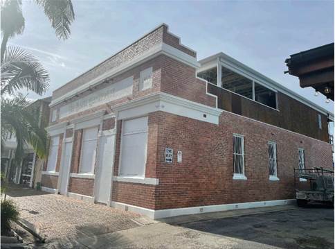
Figure 2: Street Frontage
Figure 3: Outdoor Spa area proximity to Shop Top housing (orange brick)
2. SUMMARY OF REFERRALS
|
Referral |
Issue |
|
Environmental Health Officer |
Supported subject to conditions. Refer to Doc # A2021/36275 |
|
ET Engineer |
No Objection subject to conditions. |
3. SECTION 4.15 – MATTERS FOR CONSIDERATION – DISCUSSION OF ISSUES
Having regard for the matters for consideration detailed in Section 4.15(1) of the Environmental Planning & Assessment Act 1979, the following is a summary of the evaluation of the issues.
|
Is the person who made the application entitled to act on the Consent? |
☒ Yes |
☐ No |
|
Is the modification of minimal environmental impact? |
☒ Yes |
☐ No |
|
Is the development, as modified substantially the same as the development for which the consent was originally granted. |
☒ Yes |
☐ No |
Use of Premises
The applicant was asked to justify the proposed extended operating hours and confirm the ongoing use of the premises. The applicant advised on 5/3/24 (doc #E2024/23328),
“Mr Lawless (property owner) is applying for the extended hours of operation as it will give exclusive access to the Banya Bathhouse by guests staying in the motel adjoining the hotel (eg the Middle Pub) before and after the general public has entry.
Accommodation guest will have the opportunity to experience a few days of relaxation and 'resetting' themselves and improves the desirability and viability of the motel operation business which is struggling against the likes of Airbnb. It opens up a fantastic opportunity.
Mr Lawless estimates that a maximum of 30 people might utilise the facility during the proposed extended hours of operation of which the majority will be using the sauna and steam room where there is very little to no potential for noise as those are enclosed rooms.”
The applicant confirmed the ongoing use of the development will remain as a Café and Day Spa.
Guests using the spa arrive at the reception area, pay for their appointment and are then shown through by the reception staff for either their massage or Bathhouse appointment. Only paying guests enter the spa area (common servery, seating areas, spas, sauna, pool, showers, toilets, massage / treatment rooms, outdoor health exercise area) via a secure glass door.
3.1. State/Regional Planning Policies, Instruments, EPA Regulations 2021
Proposed amendments raise no issues under the relevant SEPPS, Policies or clauses of the EPA Regulations 2021.
3.2. Byron Local Environmental Plan 2014
Proposed amendments raise no issues under the LEP.
3.3. Draft EPI that is or has been placed on public exhibition and details of which have been notified to the consent authority - Issues
No draft EPIs affect the proposal.
3.4. Development Control Plans
Proposed amendments do not generate any additional issues that have not been previously considered.
3.5. The likely impacts of that development, including environmental impacts on both the natural and built environments, and social and economic impacts in the locality
Noise impacts
Council’s Environmental Health Officer reviewed earlier acoustic reports and Statement of Environmental Effects from the original DA and subsequent modifications found that the acoustic impact on the balcony of the most exposed residential unit (99 Stuart St) and the windows of the residential apartments at 39 Burringbar St had not been assessed. These residential units were identified as commercial units in the first acoustic report provided in the initial Development Application.
In the second acoustic report submitted as part of a modification application they were identified as residential units. However, the impact on the patio area of the most exposed dwelling was not taken into consideration. Instead, the report focused on internal noise levels and sleep disturbance within bedrooms. Both initial applications heavily implied that the development would be a very quiet, zen like day spa experience. With music being considered as no more than background noise. The pool area of the day spa is however being utilised in a different manner and involves amplified music and clearly audible conversation between guests.
The submitted acoustic reports recommendations and conclusions are based on the Australian Standard AS2107’s recommendation of an internal noise level of 30-35 for bedrooms. The modelling conducted for this assessment indicated that a sound pressure level of 45 dB(A) would be experienced at the façade of the residential dwellings, which would result in an internal level of 35 dB(A).
The report utilises the assumption that a reduction of 10 dB is possible through an open window. Upon review of the design of the most exposed dwelling, this assumption can not be supported. The bedroom has two windows (one of which is a large sliding door) facing directly onto the pool area (see images below). A reduction of 5 – 7 dB is more likely, resulting in an internal noise level of 38-40. Which is in exceedance of the relevant criteria.
In addition, the current activity onsite is not incompliance with relevant criteria regarding noise exposure at the outdoor patio. Based on an expected background level of 30 – 35 dB(A) within the immediate environment in the early to late evening. To extend the approved operating hours would further exacerbate this issue, which was not picked up by Council or the applicant in earlier applications.
Taking into consideration the accumulative impact of exposure to the amplified music and conversation for an entire day, an extension of hours through to 12pm or earlier in the morning, cannot be supported. The occupant of the dwelling would then be exposed to a continuation of the noise, clearly audible in the bedroom, while attempting to fall asleep. At a level which is in excess of the guidance criteria, both at the patio and within the bedroom (located directly off of the patio, and directly exposed to the noise source (see images below).
Following an onsite meeting with the applicant’s town planning and acoustic consultants on 13/2/24, an amended acoustic report has been submitted. It is noted that the applicant has reduced the modelled sound power level of the outdoor speakers from 75 to 65 dB(A). And has increased the noise level associated with the crowd noise. The information provided allows Council to approve the application on the following recommended conditions:
• That the extension of hours condition is reviewable upon the receipt of noise complaints and noncompliance with Councils conditions.
• The number of people in the pool area is limited to 24 individuals.
• The sound system is set and limited to 65dB(A).
• An acoustic barrier is installed in the opening between the pool area and the neighbouring courtyard, as required by the submitted acoustic report.
It is recommended the hours of operation for Monday to Saturday be supported for 7am to midnight, however the requested increase in hours on Sundays and Public Holidays from 7am to 10pm be reduced to 8am to 10pm to give nearby residents some early morning respite.
Condition recommended:
Hours of operation (Reviewable Condition)
The permitted hours of operation are:
7:00am to 12:00am – Monday to Saturday.
8:00am to 10:00pm – Sunday & Public Holidays.
This is a ‘Reviewable Condition’ pursuant to Section 80A(10B) & 80A(10E)(a) of the Environmental Planning and Assessment Act 1979. This Condition will be subject to a review by Byron Shire Council (the Consent Authority) when a noise related complaint or complaints are established to Council’s satisfaction.
The condition may be varied following such a review in accordance with the Environmental Planning and Assessment Regulation 2021. Byron Shire Council must give the operator of the development subject to this condition not less than fourteen (14) days written notice that a review is to be carried out under this condition and must consider any submission the operator may make.
3.6. The suitability of the site for the development
Proposed amendments do not affect the Site’s Suitability.
3.6 Submissions made in accordance with this Act or the regulations
The modification application was advertised for a period of 14 days in accordance with the Community Participation Plan. One objection was received:
|
Music blaring continually from 8:00 AM till 10:00 PM every single day. Extending the time to 12 midnight, I can only express my categoric disagreement that such a right be granted.
|
Amended acoustic report submitted and reviewed by Council’s Environment Health Officer who advise the information required allows Council to approve the extension of hours, subject to conditions, including acoustic controls, reviewable hours of operation and restriction on patron numbers after 10pm. |
|
Smoke Odours |
The applicant has informed Council of the steps they have taken to reduce emissions and ensure that the chimney is in compliance with the relevant codes. The complainants have also submitted letters to Council confirming that the odour and smoke problem is under control. Existing conditions on the activity can control this issue. |
|
Chlorine Odours
|
Existing conditions on the activity can control this issue.
|
3.7 Public interest
To ensure toilet facilities within the premises are available for guest and patrons using the facilities including the restaurant/ café area, conditions to apply. Subject to conditions, the proposal is unlikely to prejudice or compromise the public interest.
4. DEVELOPER CONTRIBUTIONS/ WATER AND SEWER CHARGES
There is nexus to charge additional development servicing levies.
Water and Sewer Charges
Marked up plans were provided by the applicant confirming areas used for the Spa, Café Seating, Servery/Kitchen and Liquor Licenced areas. Amended ET contributions and conditions recommended.
4. CONCLUSION
The application to Extend Operating Hours is satisfactory having regard to relevant matters for consideration and the section 4.55(1A) application is recommended for approval subject to amended conditions of consent.
Staff Reports - Sustainable Environment and Economy 13.8
Report No. 13.8 PLANNING - 26.2023.3.1 - Submissions report - changes to DCP 2014 Chapter E5 - Certain locations in Byron Bay and Ewingsdale
Directorate: Sustainable Environment and Economy
Report Author: Lachlan Wall, Land Use Planner
File No: I2024/273
Summary:
This Report presents the exhibition outcomes of the amendment to Byron DCP 2014 Chapter ‘E5: Certain Locations in Byron Bay and Ewingsdale’, to allow for residential development within the land to the North-west of the Elements of Byron resort at Belongil. Also referred to by the proponent as the “North Byron Beach Site”.
The Development Control Plan (DCP) was exhibited from 19 January 2024 to 23 February 2024. Thirty-nine (39) submissions were received. A summary of issues raised by the submissions received is included in the body of this report. Only a minor change is proposed in response to submissions received.
It is recommended that the amended Byron DCP 2014 Chapter E5: Certain Locations in Byron Bay and Ewingsdale be adopted, as attached to this report.
NOTE TO COUNCILLORS:
In accordance with the provisions of S375A of the Local Government Act 1993, a Division is to be called whenever a motion for a planning decision is put to the meeting, for the purpose of recording voting on planning matters. Pursuant to clause 2(a) under the heading Matters to be Included in Minutes of Council Meetings of Council's adopted Code of Meeting Practice (as amended) a Division will be deemed to have been called by the mover and seconder of all motions relating to this report.
RECOMMENDATION:
That Council adopts the amended Draft Byron Development Control Plan Chapter E5: Certain Locations in Byron Bay and Ewingsdale, as contained in Attachment 1 (E2023/129893), which includes provisions for ‘Precinct 3 – Environmental Living’ and publishes the amended DCP on Council’s website.
1 26.2023.3.1
Byron Shire DCP 2014 Chapter E5 Certain locations in Byron Bay and Ewingsdale -
March 2024 ~ Post public exhibition version, E2023/129893
![]()
2 Confidential - 26.2023.3.1 All Submissions for confidential attachment to Council's submission report - DCP 2014 Chapter E5 Certain Locations in Byron Bay & Ewingsdale re North Beach, E2024/28463
3 26.2023.3.1
All Submissions for redacted attachment to Council's submission report - DCP
2014 Chapter E5 Certain Locations in Byron Bay & Ewingsdale re North Beach,
E2024/35427 ![]()
Report
At the 7 December 2023 Council (Planning) Meeting, Council resolved to exhibit amendments to the Byron DCP 2014 in relation to residential development within the North Byron Beach site.
Resolution 23-601 was as follows:
1. That Council proceeds to exhibit the
draft DCP 2014 – Draft Chapter E5 incorporating the amendments shown in
Attachment 1 (E2023/120263) and
below, for a period of 28 days.
a. That
Section 5.6.10.2 be amended at point 3 to read “No cats or dogs are to be
kept on, or brought to or through the site.”
2. That following exhibition, Council
receives a further report detailing key submission issues and planning response
to these.
3. Should there be no submissions as of the close of the exhibition period, that Council adopts the amended Chapter and give notice of its decision in accordance with the Environmental Planning and Assessment Regulation.
In accordance with Part 1(a) of the resolution, the exhibition version of chapter E5 was amended to include a restriction on cats and dogs throughout the ‘Precinct 3 – environmental living area’ within section 5.6.10.2.
The draft DCP chapter was exhibited from 19 January 2024 to 23 February 2024. Submissions received are contained in Attachment 2.
During the exhibition period thirty-nine (39) submissions were received. Submissions received were generally in support of the proposed amendments. A summary of the public submission issues and staff response to these is provided in Table 1 below.
Table 1 - summary of the public submission issues and staff response
|
No. |
Issues raised in submissions |
Staff Comment |
|
1. |
The amendments should incorporate a provision that allows for a shared path / cycle way from Bayshore Drive to Brunswick Heads. |
To achieve this Council would need to acquire/reserve the land to construct the pathway within the site. Additionally, an agreement with the National Parks and Wildlife service (NPWS) would be required to construct the remainder of this cycleway to Brunswick Heads. Without an agreement from NPWS this would only provide a secondary access to the beach, which is unnecessary given the retention of the existing access point from Bayshore Drive. Furthermore, there is no nexus between this DCP amendment and need to provide for additional land to be dedicated for a cycleway path. |
|
2. |
The changes to the DCP and future DA’s should not impact on the clothes optional beach. |
NSW National Parks and Wildlife Service is the responsible authority who manages the clothes optional beach. The Development control plan is not the appropriate document to address the clothes optional beach use. |
|
3. |
The proposed restriction on keeping of cats and dogs needs to be enforceable |
The proposed controls will provide for an enforceable framework to be conditioned during the development application process. Future compliance with restrictions and controls would be subject to modified community behaviours i.e. landowners abiding by these restrictions and controls, and / or Council’s compliance team enforcement actions if required. It must be noted however that Council cannot legally restrict the keeping of assistance animals or service animals as defined within the Commonwealth law (Disability Discrimination Act 1992). This would include animals that are trained to provide assistance to people with a disability to help alleviate the effect of that disability. E.g. a seeing eye dog for a vision impaired person. |
|
4. |
Dogs should be able to live in the area, they are excellent companions and provide people with PTSD a way to heal. I can understand why cats would be excluded. However, we have come a long way in our ability to manage dogs in sensitive areas. |
Council resolved not to permit cats and dogs within the area, as noted in item 3 above. This restriction cannot prohibit the keeping of assistance animals or service animals. A note explaining this exemption is to be included in the DCP. |
|
5. |
A wildlife protection area should be created |
Council can declare a wildlife protection under the Companion Animals Act; however, this only applies to “public places”. The Companion Animals Act defines a ‘public place’ to include a pathway, road, park, or any other place the public are entitled to use. A dog or another animal that is an assistance animal being genuinely used by a person with a disability is not prohibited from a Wildlife Protection Area. It is beyond the scope of the amendments to the DCP chapter E5 to declare a wildlife protection area as a part of this report. It is otherwise noted that both the beach area and National Parks land are prohibited dog areas. |
|
6. |
Impacts to Latham’s Snipe, and other Migratory birds. |
The Latham’s Snipe was identified at the planning proposal stage as a species of specific concern. The Commonwealth Environment Protection and Biodiversity Conservation Act 1999 (EPBC Act) is not triggered in this process and will require further consideration at the DA stage. Council’s Development Control Plan 2014, Chapter B1 – Biodiversity provides for Vegetation Management Plans (VMP) and Biodiversity Conservation Management Plans (BCMP). A BCMP is required for any development that includes the subdivision of land. BCMP contains similar information and management actions as a Vegetation Management Plan. However, a BCMP generally has increased management actions over a longer period of time and requires more detailed information. Any future BCMP for this site will further consider habitat requirements for the Latham’s Snipe. |
|
7. |
Coastal erosion impacts |
Coastal erosion impacts were considered during the rezoning of the land. The E4 zone was applied to the cleared parts of the site located landward of the contemporary 100-year coastal hazard line, i.e. land not subject to coastal hazards. Existing controls within chapter E5 include controls relating to coastal erosion impacts as a matter for consideration for future Development Applications to ensure future development will be landward of the 2120 erosion line as identified within the coastal assessment undertaken during the planning proposal. Council is also progressing with a Coastal Management Plan that can be reviewed and updated as required. |
|
8. |
Traffic impacts of the future development |
The planning proposal to support the rezoning of the site implemented a 1ha minimum lot size, which restricts future development to a maximum of 9 residential lots. It was determined that the resultant traffic would not be significant. More detailed design at the development application stage would require a review of traffic impacts in accordance with chapter B4 of the DCP 2014. |
|
9. |
Development of the site will have environmental impacts and should not proceed.
|
The vegetated areas within the site are zoned C2 Environmental Protection which does not permit the housing to be built within this zone which will limit any impact to the area. A further area of C2 zoned land exists between the seaward boundary and the beach front area. This area will also exclude development from occurring. Existing development controls within the other DCP chapters, or other relevant legislation, will require further environmental assessment at the development application stage. |
|
10. |
The zoning should have gone to protect and enhanced the natural environment. |
The rezoning process has been finalised and the proposed DCP amendments support protection of the natural environment. |
|
11. |
Flooding impacts of the site. |
Flood hazards were considered during the rezoning process. More detailed assessment of the flood planning requirements will be required during the development application stage for subdivision and any future dwelling development, the design of which will be required to consider flood risk. |
|
12. |
Pesticide and herbicide use and runoff should be taken into account and addressed. |
Existing controls within E5.7.9.6 Landscape seeks to minimise the need to use of herbicides or artificial fertilisers. The use of such chemicals is also managed through the Protection of the Environment Operations Act 1997. The use of Pesticides are controlled by the NSW EPA and is managed through the . Council may also issue orders under this legislation. |
|
13. |
Inundation of the site resulting from sea level rise as a result of Climate Change. |
The rezoning of the site considered the potential for sea level rise based on a 2120 level plus Climate change increase within the model assumptions. The existing provisions within the LEP and DCP in relation to flood planning will apply to any future development and more detailed assessment of flood impacts will be undertaken at the development application stage. |
|
14. |
Various concerns in relation to the “Becton Consent’, comprising. - Non-compliance with a number of conditions of consent of the “Becton Consent”. - The amendment to the DCP is invalid given the “Becton Consent”.
|
Council has previously provided advice to this submitter in relation to the “Becton Consent”. Council has no record of any documentation, as required by that Deferred Commencement Condition, being submitted to the Director-General of the Department to activate that consent. As such, the Becton consent is no longer valid. Council may, at any time, seek to review its development control plan — either in response to a request from an applicant, or as an action to maintain the DCP generally, and is not restricted by a particular development consent. |
|
15. |
Development of the site fails to comply with the 2020 Guidelines for consent and planning authorities issued by the NSW department of Planning, industry and Environment, for developments adjacent to National Parks and Wildlife Service |
The site has been assessed previously under the rezoning process (planning proposal reference 26.2019.10.1.) in which environmental impacts were considered. Additional assessment of the site will be required as part of any future development application. Existing controls within the planning assessment framework will require consideration of items noted within the guidelines. Future development of the site will need to take into account environmental constraints, including the adjacent land owned by the National Parks and Wildlife Service. Through the DA process, Council may refer applications to the NPWS where necessary for advice. The detailed design stage will also ensure that bushfire protection measures, including asset protection zones, can be located away from NPWS land and existing vegetation protected. |
|
16. |
Council must firstly refer any development of this site to the NSW Planning Minister to determine whether the previous DA conditions apply prior to making any changes to the DCP. |
As per comments above, Council has no record of any documentation as required by that Deferred Commencement Condition being submitted to the Director-General of the Department to activate that consent. The prior Consent has no relevance to the proposed changes and as such, no action is required. |
In response to the above submission issues, only one minor change is proposed to the exhibited version of the DCP. This is outlined in Table 2 below and identified by red text with yellow highlight in Attachment 1.
Table 2 - Summary of proposed DCP changes (post-exhibition)
|
Control |
Proposed change |
Proposed wording |
|
E5.7.10.2 Environmental Management - Prescriptive measure 3. |
Insert a note shown to clarify that the cat and dog restriction does not apply for service or assistance animals under the disability discrimination act 1992. |
“ Note: Prescriptive measure ‘3’ of E5.7.10.2 applies to a “companion animal” as defined within the Companion Animals Act 1998 but does not apply to an assistance or service animal. This includes an animal that is trained to provide assistance to people with a disability to help alleviate the effect of that disability as defined within the Commonwealth law Disability Discrimination Act 1992. “ |
Next steps
If adopted, the Development Control Plan will come into effect once uploaded to Council’s website.
Strategic Considerations
Community Strategic Plan and Operational Plan
|
CSP Objective |
CSP Strategy |
DP Action |
Code |
OP Activity |
|
4: Ethical Growth |
4.1: Manage responsible development through effective place and space planning |
4.1.4: LEP & DCP - Review and update the Local Environmental Plan and Development Control Plans |
4.1.4.2 |
Review and update LEP and DCP to reflect strategic land use priorities and/or legislative reforms |
Recent Resolutions
Resolution 23-601 – 7 December 2023 Council (Planning) Meeting
Legal/Statutory/Policy Considerations
If adopted this will amend Byron Development Control Plan 2014 Chapter E5: Certain Locations in Byron Bay and Ewingsdale.
Financial Considerations
This is an Applicant funded DCP amendment, all costs will be borne by the applicant.
Consultation and Engagement
The outcome of the community engagement process has been outlined within this report.
Staff Reports - Sustainable Environment and Economy 13.9
Report No. 13.9 Wallum Subdivision DA10.2021.575.1 - Response to Council Resolution 23-454 - Stormwater and Cultural Heritage Site Inspection Plan
Directorate: Sustainable Environment and Economy
Report Author: Chris Larkin, Manager Sustainable Development
File No: I2024/260
Summary:
Council considered a Notice of Motion 9.2 Wallum DA10.2021.575.1 referral and assessment Agenda of Ordinary (Planning) Meeting - Thursday, 12 October 2023 and resolved under Parts 5, 6 and 7 of Resolution 23-454 to receive certain assessments of certain plans, and for those assessments to be reported back to Council.
This report responds to Parts 5(e) and (f) in terms of stormwater maintenance management plan for the existing drain (Condition 12), the Cultural Heritage Inspection Plan (Condition 18), Part 6 in terms of further consultation with the traditional custodians of the land and Part 7 in relation to further stormwater commentary around Condition 11.
The development has been approved in a number of stages. The matters for consideration in this report relates to three of the sixteen conditions relevant to Early Stage 2 Bulk Earthworks.
Based on the assessment below, staff recommend that Council notes the report.
RECOMMENDATION:
That Council notes the report Wallum Subdivision DA 10.2021.575.1 - Response to Council Resolution 23-454 - Stormwater and Cultural Heritage Site Inspection Plan.
1 14.2021.575.2
- Stormwater Maintenance & Management Plan - Existing Drain, E2024/32112 ![]()
2 14.2021.575.2
- Cultural Heritage Site Inspection Plan, E2024/35615
![]()
3 DA10.2021.575.1
- Letter to Bundjalung of Byron Bay Aboriginal Corp (Arakwal) regarding Wallum
Subdivision, A2023/57052 ![]()
4 DA10.2021.575.1
- Letter to Tweed Byron Local Aboriginal Land Council regarding Wallum
Subdivision, A2023/57055 ![]()
Report
Council resolved on 12 October 2023 under Part 5, 6 and 7 of Resolution 23-454 the following:
5. Receives assessments of the Amended Management Plans submitted to Council for the development at Bayside Brunswick (DA10.2021.575.1) to ensure that those Plans comply with Consent Conditions set by the NRPP and with Federal, State and Local regulations, including separate assessments of Plans for:
a) Vegetation Management (Condition 6);
b) Wallum Froglet Management (Condition 7);
c) Construction Environmental Management (Condition 8);
d) Updated Surface and Groundwater Management (Condition 9);
e) Stormwater Maintenance Management (Condition 12);
f) Cultural Heritage Site Inspection (Condition 18).
6. Consults with traditional custodians connected to the site about its cultural significance as also revealed by mapping held under a Memorandum of Understanding with Tweed Byron Local Aboriginal Land Council.
7. Determines at a Council meeting the suitability of those Amended Plans and the efficacy of the proposed stormwater system, as pointed out in the note under consent condition 11b, after considering: a) the assessments resulting from Part 5 above; and b) return correspondence from the Federal Government resulting from Parts 2 and 3 above; and c) return correspondence from the State Government resulting from Parts 2 and 4 above.
A previous report has been submitted to Council whereby the matters raised under 5a) to 5d) have been dealt with (see Resolution 24-015) as they pertained to the Subdivision Works Certificate for Early Stage 1 Ecological Rehabilitation Works.
After resolution 23-454, Council considered Aboriginal Cultural Heritage again at its meetings on 8 and 22 February 2024 and engaged with Bundjalung of Byron Bay Aboriginal Corporation (Arakwal) and Tweed Byron Local Aboriginal Lands Council (TBLALC). Arakwal provided Council with two letters and Tweed Byron Local Aboriginal Lands Council made representations to Council in person during public access on 22 February 2024. Those organisations provided Council with clear information that they support the Aboriginal Cultural Heritage assessment and management processes. Having considered that additional information, Council resolved to note the report Res 24-048. This subsequent engagement and the information that was presented to Council addressed part 5f) and 6 of Res 23-454.
This report addresses Parts 5e) and 5f) in relation to the Stormwater Maintenance Management Plan for the existing drain and the Cultural Heritage Site Inspection Plan.
Stormwater Maintenance Management Plan
Condition 12 of development Consent DA10.2021.575.1 requires the submission of the following:
12) Stormwater Maintenance Management Plan for the Existing Drain
Prior to the issue of the Subdivision Works Certificate for Early Stage 2, a Stormwater Maintenance Management Plan to be prepared and submitted to Council for approval for the existing north south drain bisecting the subject land. The plan is to be consistent with the Approved Wallum Frog Management Plan and include initial work to be completed prior to its dedication to Council and ongoing management measures post dedication to Council for a functional stormwater drain. The plan to be prepared and signed off by a suitably qualified ecologist and stormwater engineer prior to submission to Council for approval.
Comment:
The existing north south drain takes stormwater from the southern end of Kingsford Drive and the recently constructed pod village and links with Everitts Creek before joining the southern arm of the Brunswick River known as Simpsons Creek.
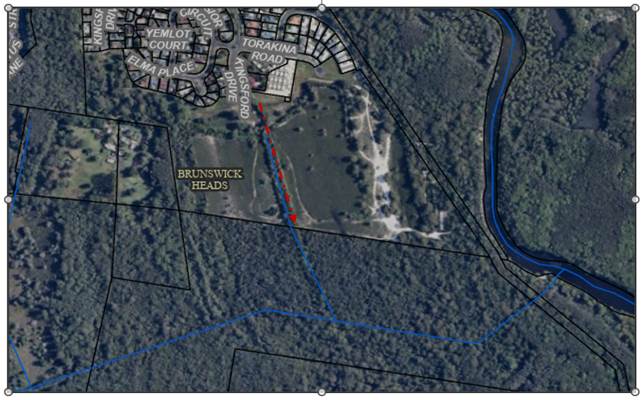
Existing North South Drain (Red Arrow)
The age of the drain is unknown. Aerial photography from 1986 below shows the location of what was probably an ephemeral watercourse which directed water into the more formalised drain to the property to the south before entering Everitts Creek. It is likely the drain was then formalised with the completion of the existing Bayside Brunswick Estate, however the drain remained on private property.
It is understood Council has maintained the drain in the past, however it appears such work has not been undertaken for a number of years, considering the regrowth either side of the drain.
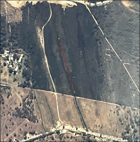
Aerial Photo 1986
The applicant has submitted a stormwater maintenance and management plan for the drain (See Attachment 1). The plan indicates the drain has a length of 340 metres a width of approximately 5 metres and drains a small urban catchment of less than 1 hectare.
Sediment in the drain needs to be removed with two main deposits located at the norther end of the drain near the Kingsford Drive Entrance and the southern end near the boundary to the neighbouring property. The submitted plan is attached to this report and can be found at Attachment 1. An extract is provided below, with the two areas to be cleaned mapped in yellow with red outline below.
Access (lime green mark UP) is located on the eastern side of the drain avoiding existing Wallum Frog habitat and constructed wallum frog ponds on the western side of the drain. Instead of removing the sediment from the drain by excavator, the applicant has proposed to undertake this work by way of a vacuum truck and hose.
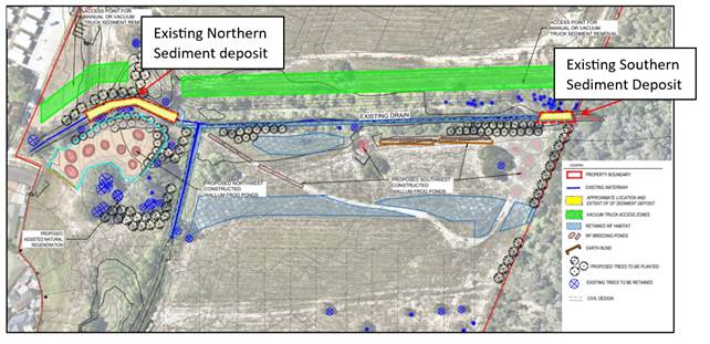
Plan Extract
It is considered the proposed method of cleaning the drain is substantially more subtle than by bob-cat, excavator or other heavy machinery and is not inconsistent with the overarching plan of maintaining and enhancing wallum habitat around the drain.
In terms of maintenance, the plan indicates the drain to be inspected every 6 months and manually raked for the removal of debris and sediment, rubbish and fallen vegetation by hand. Any weeds growing within the drain should also be controlled and appropriate action undertaken as required. In the unlikely event of a larger build-up of sediment occurring again, the vacuum trucks should be redeployed, with access provided from the eastern side of the drain from the constructed road.
The plan has been prepared by Australian Wetland Consulting and co-signed by Civiltech Consulting Engineers.
It is considered the submitted plan satisfies Condition 12 of the consent.
Part 7 of the resolution references the note under condition 11b. Condition 11 in its entirety states with the note highlighted yellow:
11) Engineering Construction Plans
Engineering construction plans and specifications must accompany the Subdivision Works Certificate application demonstrating compliance with Council's standards for the required engineering works.
Each set of drawings must be accompanied by a Certification Report which must be signed by a suitably qualified Civil Engineer or Registered Surveyor. The Certification Report will comprise the certificate and check lists set out in Annexure DQS-A of the Northern Rivers Local Government Development & Design Manuals.
The information shown on the drawings must be logically collected on discrete sheets generally in accordance with Annexure DQS-B and the Sample Drawings of the Northern Rivers Local Government Development & Designs. The drawings are to provide for the following works:
a) Earthworks Plan
A Bulk Earthworks Plan to be prepared showing existing and finished levels relevant to this stage including sections and details for compaction.
b) New North South Drain
The new north south drain design in CivilTech Consulting Engineers plan 1133-DA11 must be amended to provide the following: -
· Absolute minimum channel slope of 0.25%. This is a construction hold point with a tolerance of -0.0m. The vegetation inside the new north south drain must be designed to cater for the velocity within the drain.
· Provision must be made to provide safety mechanism to prevent pedestrians accessing the new drain. It is noted that the v x d product of safety has been exceeded.
· Provision must be made to provide energy dissipating devices to prevent erosion downstream of the 3 x 600mm dia RCP and weir.
Note: The stormwater management plan prepared by Civiltech Engineers, and Marten & Associates did not fully demonstrate compliance to Chapter 1 of Part N of BDCP2010 due to noncompliance to the minimum channel slope specified in Northern Rivers Local Government Guidelines and AustRoads. The slope of channel of the new north south drain must be amended to encourage positive drainage to the basin outlet and to prevent water logging.
c) Existing North South Drain
Any works required by the Stormwater Maintenance Management Plan for the existing drain.
Background of Condition 11b)
CivilTech plan 1133-DA 11 originally proposed an earth drain with bed slope of 0.1%. This proposal was rejected due to ability to construct the proposed grade over the full length of the earth drain and possible waterlogging issues of the channel bed.
![]()
Extract from Submitted DA Plans with 0.1% Gradient (CivilTech Plan 1133-DA 11)
To address the constructability and waterlogging issues, consideration was made to adopt 0.25% hard lined channel in accordance with Austroads Guide to Road Design Part 5B: Drainage – Open Channels, Culverts, and Floodway Crossings.
To address flow efficiency issues, investigation of the water and invert levels of the existing drain from the site and up to Everitts Creek was conducted by Council officer and the applicant’s design engineer. This revealed that the invert of the drain at the southern boundary of the site is 1.07m lower than the invert of the outlet in Everitts Creek, a natural channel average grade of 0.5% The channel grade of the drain south of the site and up to Everitts Creek also meets Austroads Guide to Road Design Part 5B: Drainage – Open Channels, Culverts, and Floodway Crossings for vegetated and bare-earth channels. This drain will remain in its natural form.
Current Proposal – 14.2021.575.2 refer CivilTech drawing 1133-ST1-EW13 Issue A
A 1.0m wide concrete invert was proposed over the channel bed and a bed slope of 0.27%. This resulted in increased top water level from RL 3.80 to RL 3.89, overflow weir level from RL 3.60 to RL 3.65 and increased water depth from 1.0m to 1.32m.
(i) The proposed design complies with Austroads Guide to Road Design Part 5B: Drainage – Open Channels, Culverts, and Floodway Crossings (minimum grade) and ARR 2019 Guidelines (prevention of waterlogging in the channel bed).
(ii) The proposed design of the North South Drain meets the desired outcome of Condition 11b).
An extract from the plans submitted with the subdivision works certificate is provided below showing a gradient of 0.27% and a cross section indicting the drain will be concrete lined.
![]()
Plan Extract showing Long Section and Cross Section of the New North South Drain
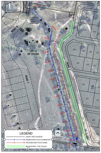
Plan Extract showing location of New North South Drain – Red Arrow
Conclusions and Recommendations
Condition 11b) was designed to accommodate both constructability and flow efficiency of the New North South Drain. It is considered the design will meet the requirements of the condition.
Cultural Heritage Site Inspection Plan
Condition 18 of development Consent DA10.2021.575.1 requires the submission of the following:
18) Cultural Heritage Site Inspection Plan
A Cultural Heritage Site Inspection Plan to be prepared and approved by Council prior to the issue of the subdivision works certificate incorporating site inspection protocols for officers from the Tweed Byron Aboriginal Land Council and or the Arakwal Corporation to be engaged for the Early Stage 2 Bulk Earthworks and Civil Stages 1 to 5 to monitor the site in relation to the protection of Aboriginal Cultural items and objects that may be disturbed during the construction of the development. The plan to be prepared by a suitably qualified archaeologist and is to include a letter of support or certification from the Land Council or the Arakwal Corporation.
Comment: A Cultural Heritage Site Inspection Plan has been submitted to Council for approval. A copy of the plan is attached to this report.
The Plan has been prepared by Everick Heritage who are suitably qualified archaeologists. The author of the report has qualifications in archaeology and over 40 years’ experience working in the cultural heritage management nationally and they are not only a member of the Australian Association of Consulting Archaeologists Inc (AACAI) but peer review membership applications to that industry organisation.
Everick liaised with both Tweed Byron Local Aboriginal Land Council and the Bundjalung of Byron Bay Aboriginal Corporation (Arakwal - BoBBAC).
Section 4 of the Plan discusses the consultation with the two stakeholders as required in the Condition 18. Everick advises in the plan of the following on discussions with TBLALC:
Everick then goes on to state in the plan the following in reference to comments received from BoBBAC:
Council also wrote to both organisations on 1 December 2023 in accordance with part 6 of the Council Resolution 23 - 454 which stated:
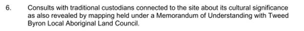
A copy of the Inspection Plan was attached to the letters. Written responses to those letters were not received before the events that occurred in February 2024 overtook them. Instead, both BOBBAC by letter and TBLALC in person during Public Access to the 22 February 2024 meeting, provided information to Council that confirmed they have no objection to the Aboriginal Cultural Heritage processes for the Wallum development - an extract from the minutes to that meeting is provided below.
BOBBAC’s letter presented during public access, amongst many things, stated that: “BOBBAC wishes to officially state that it maintains its endorsement of the site survey report prepared by BOBBAC including recommendations for continued presence of cultural heritage monitors commissioned through BOBBAC as the work progresses” and “BOBBAC confirms its endorsement for the position of TBLALC in this matter”.
As noted above, the submitted Plan includes continuing involvement of cultural heritage monitors commissioned through BOBBAC and TBLALC advised they do not need to be involved in monitoring, which was endorsed by Arakwal.
The matter was also reviewed by Councils Aboriginal Project Officer who raised no objection to the Inspection Plan being approved.
It is concluded that Condition 18 has been satisfied.
Strategic Considerations
Community Strategic Plan and Operational Plan
|
CSP Objective |
CSP Strategy |
DP Action |
Code |
OP Activity |
|
4: Ethical Growth |
4.1: Manage responsible development through effective place and space planning |
4.1.1: Development assessment - Manage development through a transparent and efficient assessment process |
4.1.1.1 |
Assess and determine development assessments in accordance with the relevant legislation |
|
4: Ethical Growth |
4.1: Manage responsible development through effective place and space planning |
4.1.1: Development assessment - Manage development through a transparent and efficient assessment process |
4.1.1.2 |
Certify development in accordance with relevant legislation |
Recent Resolutions
· 23-454
· 24-015
· 24-048
Legal/Statutory/Policy Considerations
As previously advised in staff report 13.6 dated 8 February 2024, there remains concerns about the role of the elected Council in post consent matters and certification. For further detail please see report 13.6 Page 71 of the Agenda (Agenda of Ordinary (Planning) Meeting - Thursday, 8 February 2024 (infocouncil.biz))
Financial Considerations
It is noted the applicant has lodged an appeal for deemed refusal of the Subdivision Works Certificate (SWC) for Bulk Earthworks – Stage 2. Should the matter progress through the Land Environment Court, Council would need to finance any defence and costs associated with an appeal. External consultants and legal advice fees will vary and are a cost consideration for this matter should it proceed.
Staff Reports - Sustainable Environment and Economy 13.10
Report No. 13.10 PLANNING - Report of the Planning Review Committee held 7 March 2024
Directorate: Sustainable Environment and Economy
Report Author: Chris Larkin, Manager Sustainable Development
Noreen Scott, EA Sustainable Environment and Economy
File No: I2024/364
Summary:
This report provides the outcome of the Planning Review Committee (PRC) held on 7 March 2024.
NOTE TO COUNCILLORS:
In accordance with the provisions of S375A of the Local Government Act 1993, a Division is to be called whenever a motion for a planning decision is put to the meeting, for the purpose of recording voting on planning matters. Pursuant to clause 2(a) under the heading Matters to be Included in Minutes of Council Meetings of Council's adopted Code of Meeting Practice (as amended) a Division will be deemed to have been called by the mover and seconder of all motions relating to this report.
RECOMMENDATION:
That Council endorses the outcomes of the Planning Review Committee meeting held 7 March 2024.
Report
The PRC meeting was held on 7 March 2024. The meeting commenced at 4.15pm and concluded at 4:45pm.
Councillors: Mayor M Lyon, Cr D Dey, Cr S Ndiaye, Cr P Westheimer, Cr C Coorey.
Apologies: Shannon Burt (Director Sustainable Environment and Economy),
Staff: Chris Larkin (Manager Sustainable Development).
Conflict of Interest: Cr S Ndiaye (10.2014.753.9)
|
DA No. / Applicant |
Property Address / Proposal |
Consultation / Submissions |
Reason/s / Outcome |
|
10.2023.451.1 Town Planning Studio |
46 Melaluca Drive Swimming Pool, Three (3) Paddle Courts, replacement Office and Ancillary Works associated with an Existing Dwelling House and Recreation Facility |
Level 1 8/12/23 to 12/01/24 8 submissions against |
The validity of the matters raised in the public submissions. The lack of policy to direct determination. Report to Council |
|
10.2023.491.1 KJ Ackland |
541 Federal Drive New Dwelling to create Dual Occupancy (detached) |
Level 1 11/01/24 to 24/01/24 |
The validity of the matters raised in the public submissions. The perceived public significance of the application. Report to Council |
The S 4.55 applications to modify these development consents are referred to the Planning Review Committee to decide if the modification applications can be determined under delegated authority.
|
DA No. / Applicant |
Property Address / Proposal |
Consultation / Submissions |
Reason/s / Outcome |
|
10.2014.753.9 Newton Denny Chapelle |
2 Tanner Lane s4.55(2) Modify East Coast Blues and Roots Music Festival consent to a) hold open air events without the need for a marquee; and b) adjustment to hours of operation |
Level 2 29/11/23 to 12/12/23 No submissions |
Staff Delegation |
|
10.2021.370.3 Newton Denny Chapelle |
10-12 Shirley Street Modification to Conditions of the Consent for the Approved Community Hub including Community Facility, Office Premises, Light Industry and Restaurant or Cafe Components and Education Facility
|
Level 2 6/02/24 to 19/2/24 1 submission against |
Staff Delegation
|
Staff Reports - Sustainable Environment and Economy 13.11
Report No. 13.11 PLANNING - 26.2022.3.1 Planning Proposal - Stage 4 C zone Implementation Program
Directorate: Sustainable Environment and Economy
Report Author: Alex Caras, Land Use Plannning Coordinator
File No: I2024/427
Summary:
The purpose of this report is to present the Stage 4 Planning Proposal (Attachment 1) for Council’s endorsement to enable submission to the Department of Planning, Industry & Environment (the Department) for Gateway determination.
The implementation of Environmental Zones commenced in 2018 and is being delivered in a number of stages. To date Stages 1 -3 are complete and have collectively resulted in a net gain of 1,420ha of C2 Environmental Conservation zones on private land, when compared to areas previously zoned 7a, 7b, 7k & 7j in Byron LEP 1988.
Stage 4 is the subject of this report and seeks to apply approximately 35 ha of C1 National Parks and Nature Reserves, 625 ha of C2 Environmental Conservation, 270 ha of C3 Environmental Management and 0.04 ha of C4 Environmental Living zones to a mix of land owned by public authorities and our traditional owners and custodians, as well as private land deferred from the Stage 3 planning proposal (by the Department) to allow for further site investigations as part of this review. Stage 4 also applies to non-environmental zones where applicable.
The Stage 4 Planning Proposal (PP4) also amends other LEP 2014 maps such as Minimum Lot Size, Height of Building, Floor Space Ratio, Drinking Water Catchment, Acid Sulfate Soils and Multiple Occupancy & Community Title Maps.
In relation to private land, there are forty (40) properties where landowner agreement on proposed C zones either could not be reached or no response was provided. Eighteen (18) of these already have an existing environmental zone under LEP 1988 (namely 7a Wetlands, 7b Coastal Habitat and or 7k Habitat). An analysis of the outstanding 'Not Agreed' Stage 3 sites deferred by the Department, including landowners’ reasons for not agreeing and Council’s response to these, is contained in Attachment 2.
NOTE TO COUNCILLORS:
In accordance with the provisions of S375A of the Local Government Act 1993, a Division is to be called whenever a motion for a planning decision is put to the meeting, for the purpose of recording voting on planning matters. Pursuant to clause 2(a) under the heading Matters to be Included in Minutes of Council Meetings of Council's adopted Code of Meeting Practice (as amended) a Division will be deemed to have been called by the mover and seconder of all motions relating to this report.
RECOMMENDATION:
That Council:
1. Submits the Planning Proposal contained in Attachment 1 (E2024/32968) to the NSW Department of Planning, Housing and Infrastructure for Gateway determination;
2. Pending Gateway determination, undertakes public exhibition of the Planning Proposal and consults with government agencies in accordance with the Gateway determination; and
3. Receives a Report outlining the exhibition outcomes.
Attachments:
1 26.2022.3.1
- Planning Proposal Stage 4 C zone Implementation Program, E2024/32968 ![]()
2 26.2022.3.1
Summary of Outstanding 'Not Agreed' Stage 3 sites deferred by the Department -
C-Zones PP4 FINAL, E2024/9396 ![]()
3 Form
of Special Disclosure of Pecuniary Interest, E2012/2815
![]()
Report
Council at its 22 March 2018 Ordinary Meeting resolved (Res 18-188) to implement the Department’s ‘Northern Councils E Zone Review Final Recommendations Report’ in several stages to deliver more timely and effective outcomes for affected landowners. An overview of the latest staged implementation program is shown in Figure 1 below.
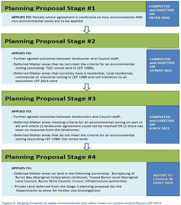
Stage 1 Planning Proposal (PP1)
PP1 applied environmental and non-environmental zones to 64 properties in the Shire based on agreed outcomes. This included approximately 340 ha of C2 Environmental Conservation zones and 60 ha of C3 Environmental Management zones (formerly E2 and E3 respectively).
Status: completed and gazetted on 28 February 2020.
Stage 2 Planning Proposal (PP2)
PP2 applied environmental and non-environmental zones to 619 properties in the Shire based on agreed outcomes. Approximately 1,485 ha of C2 Environmental Conservation zones and 400 ha of C3 Environmental Management zones (formerly E2 and E3 respectively) are applied in PP2. It also amends other LEP 2014 maps such as Minimum Lot Size, Height of Building, Drinking Water Catchment and Acid Sulfate Soils Maps.
Status: completed and gazetted on 14 May 2021.
Stage 3 Planning Proposal (PP3)
PP3 applied environmental and non-environmental zones to over 2,200 properties in the Shire, which included approximately 4,740 ha of C2 Environmental Conservation zones and 816 ha of C3 Environmental Management zones (formerly E2 and E3 respectively).
Status: completed and gazetted on 8 November 2022.
Stage 4 Planning Proposal (PP4) – subject of this report
This planning proposal (Attachment 1) represents Stage 4 of a staged program to integrate the remainder of deferred matters into the Byron LEP 2014, with exception of Coastal 7(f1) and 7(f2) zones and the 7(d) Scenic Escarpment zone, which will be considered under a separate process in consultation with the State Government.
Stage 4 includes land owned by public authorities and our traditional owners and custodians, as well as private land deferred from the Stage 3 planning proposal (by the Department) to allow for further site investigations as part of this review.
Of the 22 ‘Stage 3’ sites deferred by the Department, agreed outcomes have not been reached on 11 of these. An analysis of these properties, including landowners’ reasons for not agreeing and Council’s response to these, is contained in Attachment 2.
Overall, Stage 4 applies environmental and non-environmental zones to 1,494 land parcels, of which 1,050 are road reserves (State, Crown or Council). The proposed environmental zones comprise approximately 35 ha of C1 National Parks and Nature Reserves, 625 ha of C2 Environmental Conservation, 270 ha of C3 Environmental Management and 0.04 ha of C4 Environmental Living zones.
CONSULTATION AND ENGAGEMENT TO DATE
Council undertook an early engagement program from early 2022 with the following stakeholders:
- Bundjalung of Byron Bay Aboriginal Corporation (Arakwal); Tweed Byron Local Aboriginal Land Council, Byron Shire Council; Crown Lands; Infrastructure authorities (e.g. TfNSW) and other state agencies (e.g. Dept of Education).
- Private Land deferred from the Stage 3 planning proposal to allow for further site investigations and or land not captured in Stages 1-3
The Feedback received has informed the proposed zoning of the respective land parcels in this planning proposal.
RECOMMENDATION
It is recommended that Council endorse the E zone Stage 4 Planning Proposal (Attachment 1) to enable submission to the Department of Planning, Housing & Infrastructure for Gateway determination.
Strategic Considerations
Community Strategic Plan and Operational Plan
|
CSP Objective |
CSP Strategy |
DP Action |
Code |
OP Activity |
|
3: Nurtured Environment |
3.2: Deliver initiatives and education programs to encourage protection of the environment |
3.2.3: Planning - Plan to improve the quality of the natural environment |
3.2.3.5 |
Continue the E zone review program (Action No.9 from Rural Land Use Strategy) |
Legal/Statutory/Policy Considerations
The process of applying C zones (previously E zones) and mapped overlays in Byron LEP 2014 is being undertaken in accordance with Section 117 Direction 3.4 – Application of E2 and E3 Zones and Environmental Overlays in Far North Coast LEPs. This direction specifically requires that a planning proposal that introduces or alters an E2 Environmental Conservation or E3 Environmental Management Zone, or an overlay and associated clause must be consistent with the Northern Councils E Zone Review Final Recommendations.
Financial Considerations
The remaining 2023/24 budget for the E zone Implementation program will most likely be exhausted before Stage 4 is completed in 2024 and as such, a budget bid has been included in the Draft 2024/25 Budget (the subject of a separate report to this Council meeting).
Consultation and Engagement
Staff undertook an early engagement program from early 2022 with the following stakeholders:
- Bundjalung of Byron Bay Aboriginal Corporation (Arakwal); Tweed Byron Local Aboriginal Land Council, Byron Shire Council; Crown; Infrastructure authorities.
- Private Land deferred
from the Stage 3 planning proposal (by the
Department) to allow for further site investigations
The Feedback received has informed the proposed zoning of the respective land in this planning proposal.
Further consultation will be carried out in accordance with Council’s Community Participation Plan 2019 and as directed by any future gateway determination from the Department of Planning, Housing and Infrastructure.
Staff Reports - Sustainable Environment and Economy 13.12
Report No. 13.12 PLANNING - DA 10.2023.73.1 Demolition and construction of mixed-use development comprising basement parking, ground floor cafe/restaurant and retail, two levels of shop top housing (total of eight), rooftop pool, decking and associated plant and strata subdivision at 9 Marvell Street BYRON BAY 2481
Directorate: Sustainable Environment and Economy
Report Author: Patricia Docherty, Planner
File No: I2024/429
Proposal:
|
DA No: |
10.2023.73.1 |
||
|
Planning Portal ref |
PAN-311650 |
||
|
Proposal description: |
Demolition and construction of mixed-use development comprising basement parking, ground floor cafe/restaurant and retail, two levels of shop top housing (total of eight), rooftop pool, decking and associated plant and strata subdivision |
||
|
Property description: |
LOT: 8 SEC: 26 DP: 758207 |
||
|
9 Marvell Street BYRON BAY |
|||
|
Parcel No/s: |
117900 |
||
|
Applicant: |
Planners North |
||
|
Owner: |
BBDC Investments Pty Ltd |
||
|
Zoning: |
E1 Local Centre |
||
|
Date received: |
1 June 2023 |
||
|
Integrated / Designated Development: |
☒ Integrated |
☐ Designated |
☐ Not applicable |
|
Concurrence required |
Yes – Enter CNR No. 56141 Dewatering Management – General Terms of Approval from Water NSW S100B Bushfire – General Terms of Approval from RFS |
||
|
Public notification or exhibition: |
- Level 2 advertising under Council’s Community Participation Plan. - Exhibition period: From: 14 June 2023 To: 27 June 2023 - Submissions received: nil - Submissions acknowledged: ☐ Yes ☐ No ☒ N/A |
||
|
Planning Review Committee |
Not applicable |
||
|
Variation request to Development Standards under an EPI (e.g. clause 4.6) |
Clause 4.6 Name of clause – Height of buildings, Measurement of height of buildings; Clause number - 4.3 and 4.3A; Percentage value of variation sought - 0.93% (pool deck)- 23.6% (lift overrun); Brief justification for the variation – Council being the consent authority can be satisfied the applicant has demonstrated that: (a) compliance with the development standard is unreasonable or unnecessary in the circumstances, and (b) there are sufficient environmental planning grounds to justify the contravention of the development standard. |
||
|
Estimated cost |
$ 13,255,000
|
||
|
Delegation to determine |
Council |
||
|
Issues |
Clause 4.6 Variation Request - Height Design Excellence and Sustainability Planning Agreement – Public Art |
||
Summary:
The DA proposes demolition and construction of mixed-use development comprising basement parking, ground floor cafe/restaurant and retail, two levels of shop top housing (total of eight), rooftop pool, decking and associated plant and strata subdivision.
The proposal is subject to Design Excellence provisions and has been through a rigorous assessment process.
The applicant has worked proactively and collaboratively with the Council assessment team and responded to all requests for additional information and design amendments.
During the assessment process a series of plan iterations were submitted that addressed key areas of concern with the proposal. These areas were:
1. Redistribution of gross floor area from upper to ground floor to open up courtyard;
2. Solar access improvements;
3. Increasing ceiling heights at ground level
4. Show this increased height impacts on streetscape and solar access to south side of Marvell Street;
5. Explore other options to reduce overall height.
6. Landscape architect input on shade planning;
7. Opening part of basement to provide for basement planting, possibility of palms planted to basement with green canopy at or above ground.;
8. Sustainability commitments and reporting;
9. Street presence, human scale to Fletcher Lane lofty cavernous spaces resolved including basement ramp and loading bay;
10. Discrete location on Marvell Street for signage;
11. Narrow basement ramp and entry similar to approved 7 Marvell;
12. Further reducing voids adjoining lift and stair core;
13. Relocate pedestrian ramp, remove stairs, widen path to reduce obstructions and a direct wider view through the site and improve flow for all users including disability;
14. Increased retail and further activate frontage to Fletcher Lane,
15. Reorganised bin storage and separation of storage for larger commercial shared bins service and necessary organics;
16. Modify existing crossover on Marvell Street to a new loading area;
17. Incorporating small window to kitchen in Apartments 2 and 6 as in Apartments 4 and 8.
The applicant has now addressed the above areas to the satisfaction of the Design Excellence Panel with conditions in the recommended consent. The final design shown on Plans in Attachment 1 (Doc # E2024 25402) is considered to be appropriate to the site and in the circumstances meets the requirements for Design Excellence applicable Byron Bay Town Centre.
The application submitted includes a request to vary the height of buildings development standard. The request to vary the development standard is supported in this instance given the site context, land use mix and location in the town centre area.
The application appropriately addresses the relevant constraints applying to the site.
The application is recommended for consent subject to recommended conditions in Attachment 2 (Doc # E2024/33552).
NOTE TO COUNCILLORS:
In accordance with the provisions of S375A of the Local Government Act 1993, a Division is to be called whenever a motion for a planning decision is put to the meeting, for the purpose of recording voting on planning matters. Pursuant to clause 2(a) under the heading Matters to be Included in Minutes of Council Meetings of Council's adopted Code of Meeting Practice (as amended) a Division will be deemed to have been called by the mover and seconder of all motions relating to this report.
RECOMMENDATION:
That Council:
1. Approves the variation requested to clause 4.3 Height of Buildings and additional provisions in clause 4.3A Measurement of height of buildings in accordance with clause 4.6 ‘Exceptions to Development Standards’ of the Byron Local Environmental Plan 2014; and
2. Considers entering a planning agreement for a monetary value of $80,000 inclusive of GST offered by the developer for the provision of public art (Doc #E2024/14957); and
3. Grants Consent subject to recommended conditions of consent in Attachment 2 (Doc #E2024/33552) pursuant to Section 4.16 (3) of the Environmental Planning and Assessment Act 1979, to Development Application 10.2023.73.1 for demolition and construction of mixed use development comprising basement parking, ground floor cafe/restaurant and retail, two levels of shop top housing (total of eight), rooftop pool, decking and associated plant and strata subdivision.
1 10.2023.73.1
- Proposed Development Plans, E2024/33545
![]()
2 10.2023.73.1
- Recommended Conditions of Consent, E2024/33552
![]()
3 10.2023.73.1
- Voluntary Planning Agreement, E2024/14957
![]()
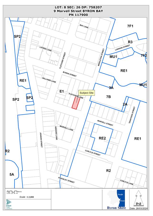
Report
Assessment:
1. INTRODUCTION
History/Background Relevant
|
Application No. |
Description |
Determination Date |
Decision |
|
10.2007.239.1 |
Footpath - Goods & Chattels |
18/06/2007 |
Approved |
|
10.2005.137.1 |
Use of footpath to display Goods and Chattels - Byron Longboards |
20/05/2005 |
Approved |
|
10.2002.469.1 |
Goods & Chattels - 'Byron Bay Longboards' - Display Racks |
02/10/2002 |
Approved |
|
10.2002.132.1 |
Change the use to Hostel Accommodating Eight (8) people |
21/11/2002 |
Approved |
|
6.1998.2125.1 |
Swimming Pool |
24/03/1998 |
Approved Delegation |
|
6.1997.2762.1 |
Garage |
29/01/1998 |
Approved Delegation |
|
5.1997.283.1 |
Change of Use - Change of Use of retail space |
07/11/1997 |
Approved Delegation |
|
5.1996.344.1 |
Tree Removal |
04/07/1997 |
Approved Delegation |
|
5.1995.343.1 |
Raise existing dwelling and construction of two shops |
28/11/1995 |
Approved Delegation |
The site contains existing structures that are proposed to be demolished including a swimming pool and shed.
Description of the proposed development
This application seeks approval for demolition and construction of mixed-use development comprising basement parking, ground floor cafe/restaurant and retail, two levels of shop top housing (total of eight), rooftop pool, decking and associated plant and strata subdivision.
The proposed development includes:
· Ground floor restaurant café with gross floor area (GFA) of 139.94 m² plus undercover outdoor dining with an active frontage to Marvell Street;
· Ground floor retail (two) with GFA of 16.77m² and 23.18m² and active frontage to Fletcher Lane;
· Level 1 shop top housing 4x3 bedroom apartments;
· Level 2 shop top housing 4x3 bedroom apartments;
· A rooftop pool and deck area for residents only. The rooftop also contains solar photovoltaic cells, plant room, landscape planting and skylights to two of the shop top housing units.
· Basement car parking for 23 cars (14 residential, 2 of which are car share) and (9 retail/café); and
· Parking for 6 bicycles at ground level with allocated storage rooms in the basement for all shop top housing units.
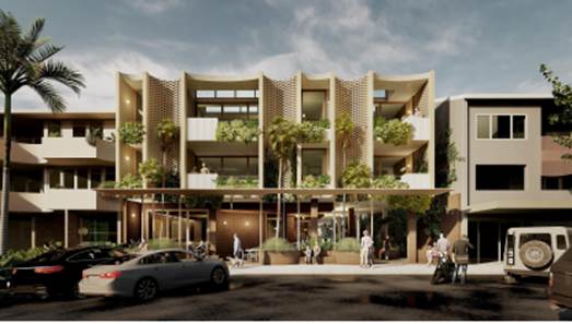
Figure 1: View of building façade Marvell Street frontage
Extract of the proposed floor and roof plans are provided at Figures 2-4:
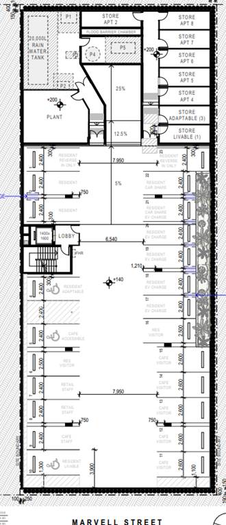
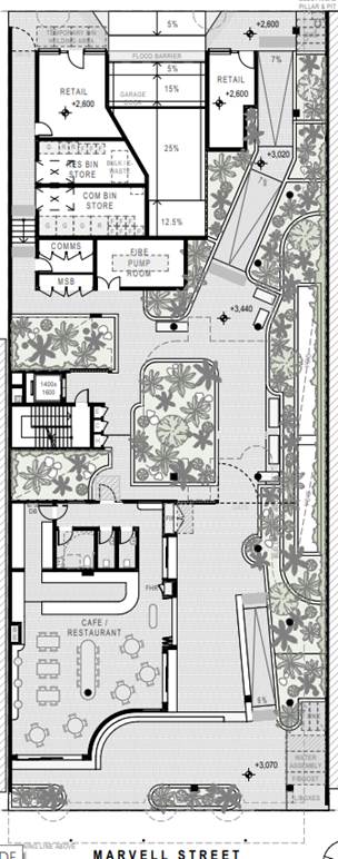
Figure 2: Basement and Ground Floor Plans
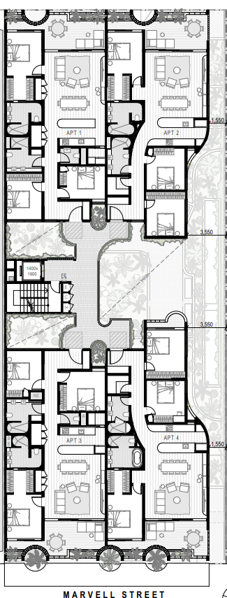
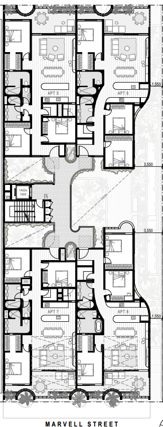
Figure 3: Shop Top Housing Levels One & Two Floor Plans
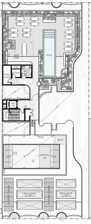
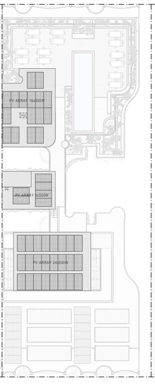
Figure 4: Roof Plans
Description of the site
A site inspection was carried out on 29 September 2023.
|
Land is legally described |
LOT: 8 SEC: 26 DP: 758207 |
|
|
Property address |
9 Marvell Street BYRON BAY |
|
|
Land is zoned: |
E1 Local Centre |
|
|
Land area is: |
1013.6 m2 |
|
|
Property is constrained by: |
Flood Liable Land; Bushfire prone land; Acid Sulfate Soils Class 3; and Mosquito Risk |
|
|
|
Is a BDAR required due to the location of the proposed development? |
☐ Yes ☒ No |
|
|
Are there any easements in favour of Council affecting the site? |
☐ Yes ☒ No |
|
|
Is there a Vegetation Management Plan which might affect the proposal? |
☐ Yes ☒ No |
|
|
Is there a Voluntary Planning Agreement which might affect the proposal? |
☒ Yes ☐ No |


Figure 5: Site photos Marvell Street and Fletcher Lane
2. SUMMARY OF REFERRALS
|
External Referrals |
Comments |
|
Water NSW (s.90 Water Management Act 2000) |
General Terms of Approval issued; included in recommended consent. |
|
Essential Energy |
Comments received and considered in the recommended conditions of consent. |
|
Rural Fire Service S100B |
General Terms of Approval still to be issued; included in recommended consent. |
|
Internal Referrals |
Comments |
|
Environmental Health Officer |
Conditions provided in the referral are included in the Recommendation of this Report |
|
Development Engineer |
Conditions provided in the referral are included in the Recommendation of this Report |
|
S64 / Systems Planning Officer |
Conditions provided in the referral are included in the Recommendation of this Report |
|
S7.11 / Contributions Planner |
Conditions provided in the referral are included in the Recommendation of this Report |
|
Resource Recovery |
Conditions provided in the referral are included in the Recommendation of this Report |
|
Design Review Panel |
Conditions provided in the referral are included in the Recommendation of this Report |
3. SECTION 4.14 – BUSH FIRE PRONE LAND
Under section 4.14 of the Act, Council must be satisfied prior to making a determination for development on bush fire prone land, that the development complies with the document ‘Planning for Bush Fire Protection 2019’’. The site is bush fire prone land.
The proposal includes strata subdivision involving a residential land use and was referred to the Rural Fire Service under section 100B of the Rural Fires Act 1997. General Terms of Approval are included in the Recommendation of this Report.
Effect of 10/50 rule on significant vegetation- no vegetation is impacted.
4. SECTION 4.15C – MATTERS FOR CONSIDERATION – DISCUSSION OF ISSUES
Having regard to the matters for consideration detailed in Section 4.15(1) of the Environmental Planning & Assessment Act 1979 (EP&A Act), the following is a summary of the evaluation of the issues.
State Environmental Planning Policies (SEPP)
Biodiversity and Conservation SEPP 2021
Consideration: No significant vegetation or koala food species or habitats are affected by the proposed development.
Consideration:
Chapter 4 Design of Residential Apartment Development
This Policy applies to the development as it is a new building with shop top housing comprising 3 or more storeys. Section 145 requires that a development application for residential apartment development be referred to the Design Review Panel. Details of this referral and design improvements are documented in this report.
Section 147 provides that prior to the determination of development applications the matters to be taken into consideration relating to the design quality of the development. The proposed development of shop top housing is required to meet the provisions of the NSW Apartment Design Guide. Detailed further in this section of the report below.
A design verification statement has been submitted in support of the proposal.
A detailed evaluation of the proposal in relation to the design quality principles and the apartment design guide has been completed and is assessed as compliant.
Design Quality Principles
A design verification statement as prescribed by the SEPP and as amended by Harley Graham Architects 7/2/2023 has been submitted to support the application. All modification in response to the Design Review Panel have been signed off by Harley Graham Architects.
The SEPP requires that residential apartment development satisfactorily address nine (9) design quality principles and considers the recommendations in the Apartment Design Guide (ADG).The proposal is consistent with the design principles for the reasons outlined below:
|
Requirement |
Council Officer comments |
|
Principle 1: Context and Neighbourhood Character |
The proposal is on an existing commercial allotment with frontage to Marvell Lane and Fletcher Lane in the Byron Bay Town Centre. The area is currently undergoing a transition. The proposal is considered to respond and contribute to the local context, especially having regard to the desired future character of the area. The scale of building and type of proposed uses are compatible with the town centre location. |
|
Principle 2: Built Form and Scale |
The design achieves an appropriate built form for the site and the building’s purpose in terms of building alignments, proportions, type and the manipulation of building elements. |
|
Principle 3: Density |
The proposal would result in a density appropriate for the site and its context, in terms of floor space yield, number of units and potential number of new residents. The proposed density of the development is regarded as sustainable and consistent with the desired future density of the area. |
|
Principle 4: Sustainability |
The proposal provides opportunities in this regard, as reflected within the submitted BASIX Certificates. Further a site-specific sustainability plan has been developed in consultation with Council staff to address sustainability outcomes for the proposal as well as the monitoring and reporting regime. |
|
Principle 5: Landscape |
The concept landscaping solutions depicted in the application plans are of high quality and appropriately respond to the proposed built environment. |
|
Principle 6: Amenity |
The proposal is satisfactory in this regard, optimising internal amenity through appropriate room dimensions and shapes, access to sunlight, natural ventilation, visual and acoustic privacy, storage, indoor and outdoor space, outlook, efficient layouts and service areas. The proposal provides for an acceptable unit mix for housing choice and provides access and facilities for people with disabilities. Apartment amenity for residents is satisfactory when assessed against the best practice design guidelines identified in the ADG, which supports Chapter 4 of the Housing SEPP (cf SEPP 65). The proposal includes communal facilities at the roof level for use by residents. |
|
Principle 7: Safety |
The proposal is satisfactory in terms of future residential occupants overlooking public and communal spaces while maintaining internal privacy. The building has been designed to be satisfactory in terms of perceived safety in the public domain |
|
Principle 8: Housing Diversity and Social Interaction |
The proposal provides a mix of apartment sizes, that are capable of catering for different demographic needs. The proposal provides high quality communal open spaces, which will foster social interaction. It is considered that the proposal satisfies these requirements. |
|
Principle 9: Aesthetics |
The proposal is appropriate in terms of the composition of building elements, textures, materials and colours and reflect the use, internal design and structure of the resultant building. The proposed buildings aesthetically respond to the environment and context, contributing to the desired future character of the area. |
Apartment Design Guide (ADG)
The SEPP requires consideration of the ADG which supports the associated design quality principles by giving greater detail as to how those principles might be achieved. The assessment below considers the proposal against key design criteria in the ADG:
|
Element |
Compliance |
|
3B-1 Orientation |
The positioning of the building responds to the urban form of the block and the street, providing for an appropriate street interface to both the Marvel Street and Fletcher Lane Street frontages, whilst maintaining an acceptable level of residential amenity including solar access with apartments oriented north where possible. The courtyard on the site provides opportunities for the southern units to also be orientated north. |
|
3B-2: Overshadowing |
The site does not overshadow other residential development. An approved hotel is under construction at number 7 Marvell Street and the design has considered the design of adjoining plans (existing and proposed) |
|
3C: Public domain interface |
The public domain interface is considered to positively contribute to the streetscape by providing high quality materials and distinct access to residential/commercial components of the design. The throughfare connection provides access to both Marvell Street and Fletcher Lane. |
|
3D: Communal Open Space |
A large area of communal open space is provided on the rooftop which includes a pool, deck area and landscaping. The ground floor courtyards and throughfare coupled with the planted garden areas further contribute to the number and types of communal open space areas spread throughout the development. Each area has been located and designed to ensure privacy, solar access and daylight access are achieved. |
|
2D-4: Public Open Space |
Public open space via the ground floor courtyard provide for through site links between Marvell Street and Fletcher Lane.. These links are designed with weather protection, safety, inclusive accessibility and activity in mind. |
|
3E: Deep Soil Zone |
The landscape design has achieved deep soil zones where planting is not covered by the building in excess of the minimum (7% of site area) requirements. |
|
3F: Visual Privacy |
All setback requirements are compliant as indicated on the plans and would provide adequate privacy separation. Units windows and balconies are located and oriented to maximise visual privacy between dwellings on site and for neighbouring buildings. |
|
3G: Pedestrian Access and Entries |
The ground floor access to the residential development is serviced by a lift. It is considered that suitable pedestrian access is accommodated on site and will be in the form of grade ramps and lifts. Separate entries have been provided for pedestrian and vehicles. Clear and distinct pedestrian links are otherwise provided through the site. |
|
3H: Vehicle Access |
The proposal incorporates separate entry point to the site for the basement level car parking area off of Fletcher Lane. The vehicular entry point is separated from the pedestrian building entry point to improve pedestrian safety and comfort. The proposal provides for loading facilities in the location of the current driveway crossover. The scale of the development was considered to be dominated by the originally proposed loading bay on Fletcher Lane and the laneway activation is considered an important reason for allowing off site loading in the street network to be supported. The waste collection area will be managed to ensure collections do not impede traffic movements or dominate the use of the active frontage to the laneway for waste management purposes. Access will be subject to management measures as per conditions in the recommended consent. |
|
3J-4: Parking |
The proposed basement parking access and layout ensures that visual and environmental impacts of underground car parking are minimised. The design standards for parking have been met as per conditions in the recommended consent with including car parking for the liveable apartment. |
|
4A: Solar and daylight access |
Plans submitted show that 3 or more hours of sunlight are received in midwinter for 75% of the apartments in mid-winter. One of the units (apt 3) receives less than one hour of sunlight (12.5%). This satisfies the design standards, that a maximum of 15% of apartments in a building receive no direct sunlight between 9 am and 3 pm at mid-winter. |
|
4B: Natural Ventilation |
Plans submitted show that natural cross ventilation is achieved to the apartments via stack ventilation provided to the internal courtyard and basement, window openings and ceiling fans enhance natural ventilation in the apartments. |
|
4C: Ceiling Heights |
The ground floor has a floor to ceiling height of 3.6m, due to its commercial nature. It is noted that this is less than the recommended 4m height of cafes/restaurants. Apartments at first floor have floor to ceiling heights 3 m and 3.45 m at second floor, which exceeds the maximum guide of 2.7m. The proposal achieves sufficient natural ventilation and daylight access to apartments. Based on merit the proposal satisfies the objectives of this control. |
|
4D: Apartment layout |
Plans indicate that the average apartment sizes exceed the design standard of 90m² for 3 bed apartments. The minimum apartment size is 138.03m². Kitchens are not part of the primary circulation spaces. Each habitable space has more than 10% glazing. |
|
4E: Private open space and balconies |
Plans indicate that all balcony sizes comply with the design standards for 3-bedroom units. 12m² / 2.4m depth. Noting that BDCP 2014 includes a requirement for a 15m² balcony. The smallest balcony is 17.61m², exceeding the minimum area. |
|
4F: Internal circulation |
Plans indicate that there is 8 units using one circulation core. This meets the requirements of this control. Common circulation spaces promote safety and provide for social interaction between residents. |
|
4G: Storage |
All apartments have between 3.5m² and 5.5m² within the apartment and additional dedicated secure accessible storage rooms in the basement. For 3-bedroom apartments, the control is 10m² within the apartment. The proposal does not meet the minimum of 50 percent of the required storage within the apartment. However, on merit the provision of storage is considered to satisfy the objectives of this control to provide adequate, well designed storage is provided in each apartment. |
|
4H: Acoustic privacy |
The proposal has generally been designed so that like-use areas of the apartments are grouped to avoid acoustic disturbance of neighbouring apartments where possible. Noisier areas such as kitchens and laundries are also located away from bedrooms when possible. The proposal satisfies the objectives of this control. |
|
4J: Noise and Pollution |
The application includes an acoustic report which recommends construction methods/materials/treatments to be used to meet the criteria for the site, given both internal and external noise sources. The recommendations cover acoustic treatments such as glazing, building construction, separation between uses, mechanical noise, and commercial delivery times. A condition in the recommended consent requires the recommendations in the report be implemented. It is noted that the café / restaurant is proposed to operate during daytime operations only, which is 7:00 am to 6:00pm. If these hours are to be extended by future operator a modification to the consent can be sought with suitable acoustic reporting. Due to the location of the premises in Byron Bay town centre, there is scope for future review and assessment of the operational hours with the intention to extend these beyond the 6pm closing time subject to separate consent. Use of the outdoor recreation area (BBQ and pool area) at the roof deck is proposed to be limited to 7:00 am to 10:00pm; Waste collection or deliveries will not occur before 7:00am. |
|
4K: Apartment mix |
The proposal provides three bedrooms apartments that address local demographic need and would be large enough for families. Due to the size of the site and need to meet design quality criteria including light and ventilation, it is considered reasonable that there is not a wider mix of smaller apartments. It is considered that the proposal satisfies the need to cater for different household types now and into the future |
|
4M: Facades |
The proposed building façade is well articulated through varying setbacks, modulation, and materiality. The building incorporates distinct elements of separation, including the courtyard thoroughfare.. The proposal satisfies the objectives of this control to provide visual interest along the street while respecting the character of the local area. |
|
4N: Roof design |
The roof design has been integrated into the building design with the. use of modulated vertical elements has also been included. The roof top provides opportunity for residential open space to be maximised. The roof incorporates sustainability features including skylights. The proposal satisfies the objectives of this control. |
|
4O: Landscape design |
The proposal includes a landscape plan which demonstrates that the proposed building, courtyard, facades and roof will be adequately landscaped. The landscaping to the public domain will enhance the streetscape as well as contributing to the amenity of the occupants. The proposal satisfies the objectives of this control. |
|
4Q: Universal design |
One of the eight units is accessible, and a second unit meets the liveable design requirements. Accessible parking and storage is provided for both of these units. |
|
4S: Mixed Use |
The proposal provides for a ground floor retail, cafe/restaurant use which assists in separating the residential units from the noisier street level. The proposal provides separate entries for the retail and residential uses and avoids blank walls. Service areas are identified and separated while not dominating the laneway. |
|
4T: Awnings and signage |
Sun and rain protection is provided by a continuous building overhang around the ground floor. Signage will be limited to building identification, navigation, and statutory signs. Commercial signage will be subject to future and separate development applications. |
|
4U: Energy efficiency |
The application was accompanied by BASIX certificates indicating energy efficiency for each residential unit provided. Further a site-specific sustainability strategy has been developed in consultation with Council staff to address sustainability outcomes for the proposal as well as the monitoring and reporting regime. |
|
4V: Water management |
The BASIX Certificates demonstrate that the development achieves the pass mark for water conservation. Further a site-specific sustainability strategy has been developed in consultation with Council staff to address sustainability outcomes for the proposal as well as the monitoring and reporting regime. |
|
4W: Waste management |
A construction and operational waste management plan has been prepared by a qualified waste consultant adhering to waste controls. All units are provided with sufficient areas to store and dispose of waste/recyclables. |
Resilience and Hazards SEPP 2021 - Chapter 4 Remediation of land
Consideration: The application included reporting that provides results from soil analysis and groundwater analysis which showed contaminant levels are below the relevant Australian and New Zealand Environmental and Conservation Council (ANZECC) and National Environmental Protection Measure (NEPM 2013) guideline limits. Further assessment concluded that Heavy Mineral Sands encountered on site are not considered radioactive material, and do not pose a risk to public safety.
The applicant provided a Hazardous Materials Site Assessment report which identifies the potential contaminants located within the existing buildings, “Limited Destructive Hazardous Building Materials Assessment, Dive Shop, 9 Marvell St, Byron Bay NSW, CoBild, September 2022, Client No:CO380, Job No:107106”. Hazardous Materials site assessment identified one small area of fibre cement sheeting which should be handled as hazardous. The submitted report has provided sufficient information to support the application and apply conditions onto the development application.
Given the extent and depth of excavations for the proposed basement car park, and lack of access to the entire site due to existing buildings, an Unexpected Findings Protocol (UFP) must be prepared and submitted to Council for approval prior to the issue of Construction Certificate. The UFP must be prepared by a suitable qualified person experienced in matters relating to Contamination of Land and Remediation.
Conditions will also be set which ensure that demolition, construction and building works are in accordance with the UFP.
Transport and Infrastructure SEPP 2021
Consideration: Division 5 Subdivision 2 Development likely to affect an electricity transmission or distribution network, Section 2.48 Determination of development applications—other development.
The application was referred to essential energy due to location and proximity of existing powerlines. Conditions of consent address their comments.
Sustainable Buildings SEPP 2022
Consideration: A valid BASIX Certificate was submitted with the application in accordance with the BASIX SEPP, before the commencement of this instrument.
4.2 Byron Local Environmental Plan 2014 (LEP 2014)
LEP 2014 is an applicable matter for consideration in the assessment of the subject development application in accordance with subsection 4.15(1) of the EP&A Act because it applies to the subject land and the proposed development.
In accordance with LEP 2014 clauses 1.4 and 2.1 – 2.3:
(a) The proposed development is defined in the LEP 2014 Dictionary as mixed use development, which means a building or place comprising 2 or more different land uses. The land uses within the proposed development are defined in the dictionary as:
· Restaurant or café
· Retail premises
· Shop top housing
(b) The land is within the E1 Local Centre according to the Land Zoning Map;
(c) The proposed development is permissible with consent; and
(d) Regard is had for the Zone Objectives as follows:
|
Zone Objective |
Consideration |
|
• To provide a range of retail, business and community uses that serve the needs of people who live in, work in or visit the area. |
The mixed-use development will serve the needs of residents and visitors. |
|
• To encourage investment in local commercial development that generates employment opportunities and economic growth. |
The ground floor uses and active frontages to both facades will provide an attractive investment opportunity for commercial purposes and generates employment and economic growth. |
|
• To enable residential development that contributes to a vibrant and active local centre and is consistent with the Council’s strategic planning for residential development in the area. |
The shop top housing and active frontages will contribute to a vibrant and active local centre while providing residential accommodation. |
|
• To encourage business, retail, community and other non-residential land uses on the ground floor of buildings. |
The entire ground floor is for commercial purposes. |
|
• To maximise public transport patronage and encourage walking and cycling. |
The through site connection enhances pedestrian movement and on site cycle parking is provided. |
Clause 2.7 – Demolition requires consent
Clause 2.7 requires that demolition of a building may be carried out only with development consent, except where it is demolition of development specified as exempt development under State Environmental Planning Policy (Exempt and Complying Development Codes) 2008. The proposal seeks consent for the demolition of all existing structures. This type of demolition is not exempt development. It is permissible with consent under Clause 2.7.
Clause 4.3 – Height of buildings
Clause 4.3 provides that the height of a building on any land is not to exceed the maximum height shown for the land on the Height of Buildings Map. The clause establishes that this height is measured from existing ground level to the finished level of the roof or parapet.
The Height of Buildings Map shows a maximum allowable height of 11.5m in this part of the town centre.
As discussed further below, some building components exceed the 11.5m development standard.
The application includes a submission under clause 4.6 of the LEP, arguing that compliance with the 11.5m building height standard is unreasonable and unnecessary. That submission is assessed below under Clause 4.6 Exceptions to Development Standards.
Clause 4.3A – Measurement of height of buildings
The objective of this clause is to align building height and flood planning provisions within Byron Bay town centre. It specifies that, in flood prone parts of the Byron Town Centre, the maximum height is measured from a nominated height, rather than from existing ground level.
To provide for a consistent point of reference for the measurement of building heights in flood prone areas. This clause applies to land identified as “Minimum Level Australian Height Datum (AHD)” on the Building Height Allowance Map. The maximum height of a building on land to which this clause applies is to be measured from the minimum level AHD permitted for that. The building height allowance level mapped for this land is RL 3.5 AHD.
The 11.5 maximum building height is therefore measured from RL 3.5. For the purposes of this assessment, the maximum height is discussed as RL i.e. 11.5m above RL 3.5 – being RL 15.
The application includes a written request from the applicant under Clause 4.6 of the LEP, arguing that strict compliance with the 11.5m building height standard is unreasonable and unnecessary.
That submission is assessed below under Clause 4.6 Exceptions to Development Standards.
Clause 4.4 – Floor space ratio
The maximum floor space ratio (FSR) for a building on any land is not to exceed the FSR shown for the land on the floor space ratio map. The maximum permissible FSR on the site is 1.3:1.
FSR is the ratio of the total gross floor area of a building to the total area of the property.
The proposed development has a total gross floor space of 1,306.9m2. According to the site survey, the site area is 1013.6m2, resulting in a FSR of 1.29:1.
Clause 4.6 Exceptions to Development Standards
Where a DA includes a variation to a development standard, an application under Clause 4.6 Exceptions to Development Standards of the LEP is required.
Clause 4.6 provides that development consent must not be granted for development that contravenes a development standard unless the consent authority has considered a written request from the applicant that seeks to justify the contravention of the development standard, by demonstrating that compliance with the development standard is unreasonable or unnecessary in the circumstances of the case, and that there are sufficient environmental planning grounds to justify contravening the development standard.
As per the planning circular PS 18-003 - Variations to development standards, the Secretary’s concurrence can be assumed in relation to variations. Where variations are greater than 10%, the secretary’s concurrence can only be assumed by a decision of the Council (i.e., not delegated to a Council officer).
Building Height:
1. Summary of Height Exceedance
The site is subject to a maximum height development standard of 11.5m. For the purposes of this assessment, the maximum height is discussed i.e. 11.5m above RL 3.50 – being RL 15.
The height of the proposal is generally compliant with the permissible height except for the lift overrun, lift core and amenities, pool coping, pool deck, services, solar array and pop out roof.
See table below.
2. Clause 4.6 Exceptions to Development Standards
1) The objectives of this clause are as follows—
(a) to provide an appropriate degree of flexibility in applying certain development standards to particular development,
(b) to achieve better outcomes for and from development by allowing flexibility in particular circumstances.
(2) Development consent may, subject to this clause, be granted for development even though the development would contravene a development standard imposed by this or any other environmental planning instrument…
(3) Development consent must not be granted to development that contravenes a development standard unless the consent authority is satisfied the applicant has demonstrated that—
(a) compliance with the development standard is unreasonable or unnecessary in the circumstances, and
(b) there are sufficient environmental planning grounds to justify the contravention of the development standard.
A written request has been submitted to Council demonstrating:
a) That compliance with the development standard is unreasonable or unnecessary in the circumstances of the case,
b) That there are sufficient environmental planning grounds to justify contravening the development standard,
c) the proposed development will be in the public interest because it is consistent with the objectives of the standard and the objectives for the development within the zone in which the development is proposed to be carried out.
3. The Development Standard to be varied
The 11.5m building height, prescribed by the Height of Buildings Map applicable to the site under Clause 4.3 of LEP 2014.
4. Extent of Variation to the Development Standard
|
Building Component |
Proposed Height (m) RL AHD |
Height above 11.5m as measured from RL 3.5 AHD |
% Height Variation |
|
Pool deck |
15.14 |
0.14 |
1.2% |
|
Pool coping |
15.34 |
0.34 |
3% |
|
Pop out roof |
15.57 |
0.57 |
5% |
|
Services Plant, Solar Array |
16.74 |
1.74 |
15.1% |
|
Lift core & amenities |
17.34 |
2.34 |
20.3% |
|
Lift overrun |
18.54 |
3.54 |
30.8% |
These areas are shown in Figure 6 below, noting that all areas shaded in green are below the permissible height.
![]()
Figure 6: Height plan
5. Justification under Clause 4.6(3)(a) and (b)
The applicant seeks to justify the contravention of the maximum height development standard on the following basis:
a) Compliance with the development standard is unreasonable and unnecessary in the circumstances of the case:
1. The proposed encroachments will not adversely impact on the streetscape.
2. The proposed variation sought does not add to the bulk or scale of the proposed building.
3. Strict compliance with the development standard would likely result in the removal of access to amenities on the rooftop for residents but would not alter the overall design of the building.
4. The proposed variation will not adversely impact on adjoining properties in terms of views, solar access or privacy.
b) There are sufficient environmental planning grounds to justify contravening the standard:
· “The proposed variation to the building height will not result in adverse impacts on adjoining properties in terms of solar access or views. The proposed elements in relation to which variations are sought are sited as such as to not disrupt views from surrounding properties or the public street. The provision of rooftop amenities for residents is reasonable in the circumstances and provides the opportunity for the provision of additional communal open space. It is noted that the provision of an open outdoor courtyard provides the opportunity for pedestrian connectivity rather than the provision of resident amenities on the ground floor. It is also noted that 253.3m2 or approximately 25% of the site is unroofed and open above courtyard area.”
c) The proposed development will be consistent with the objectives of the zone as follows:
· To provide a range of retail, business, entertainment and community uses that serve the needs of people who live in, work in and visit the local area.
· To encourage employment opportunities in accessible locations.
· To maximise public transport patronage and encourage walking and cycling.
· To encourage vibrant centres by allowing residential and tourist and visitor accommodation above commercial premises.
The proposed mixed use development is consistent with the objectives of the B2 Local Centre, providing for retail uses to serve the B2 Local zone needs of people who live in and visit the local area.
The proposal provides for employment opportunities in an accessible location with the development located in the Byron Bay Town Centre.
The site is within walking distance to many of Byron Bay’s retail and recreational offerings, including the beach, lighthouse and town centre facilities. The provision of residential accommodation on this site will contribute to the vibrancy of the town centre.
d) The proposed development will be consistent with the objectives of the standard as follows—
(a) to achieve building design that does not exceed a specified maximum height from its existing ground level to finished roof or parapet,
(b) to ensure the height of buildings complements the streetscape and character of the area in which the buildings are located,
(c) to minimise visual impact, disruption of views, loss of privacy and loss of solar access to existing development.
The proposed finished roof does not exceed the 11.5m as detailed in this submission with the exception of some “pop out” elements that slightly protrude beyond this height. The proposed height of the building complements the streetscape and character of the area. The general height of the building proposed is consistent with development in the immediate vicinity. The elements of the building that do not comply are set back to minimise their visibility from the surrounding streetscape.
Clause 5.21 – Flood Planning
The site is mapped as flood prone. A flood planning level of RL3.44 AHD applies to the site. The application has been assessed by staff as adequate to address flood planning for the proposal. Relevant conditions are included in the Recommendation to the Report.
Clause 6.1 – Acid Sulfate Soils
This clause provides that, where applicable, development consent must not be granted for the carrying out of works unless an acid sulfate soils management plan (ASSMP) has been prepared in accordance with the Acid Sulfate Soils Manual. An Acid Sulfate Soils and Assessment Plan has confirmed that the soils to be excavated for the development require treatment and correct disposal. Relevant conditions are included in the Recommendation to the Report.
Clause 6.2 - Earthworks
Clause 6.2(3) requires the consent authority to consider the effects of the proposed development on the environment and surrounding area as a result of any proposed earthworks.
The earthworks associated with the proposed development are significant, for the excavation of the proposed basement car park.
The proposal comprises Integrated Development as approval is required under the Water Management Act 2000. The development application was referred to Water NSW and General Terms of Approval (GTA’s) were issued on 15 February 2024.
A condition limits any excavations or dewatering to be in accordance with the GTA’s. The impacts of the proposal can be addressed through appropriate conditions of consent.
Clause 6.6 – Essential services
Clause 6.6 requires the consent authority to be satisfied that essential services are available for the proposed development. Council officers are satisfied that the site is fully serviced and meets the requirements of clause 6.6. Relevant conditions are included in the Recommendation to the Report.
Clause 6.13 – Design excellence – Byron Bay town centre
Development consent must not be granted to a new building in the town centre unless Council is satisfied that it exhibits design excellence.
To achieve design excellence the proposal inter alia must incorporate sustainable design principles, have a high standard of architectural design, materials, and detailing, respond well to the environmental and built forms characteristics of the site and neighbouring buildings, and improve the quality of the public domain.
The clause also states that development consent must not be granted to a development unless the Byron Design Excellence Panel has endorsed the development as exhibiting design excellence.
The applicant has worked proactively and collaboratively with the Council assessment team and responded to these requests and submitted a series of plan iterations to address key areas of concern with the proposal as submitted:
1. Redistribution of gross floor area from upper to ground floor to open up courtyard;
2. Solar access improvements; incorporating small window to kitchen in Apartments 2 and 6 as in Apartments 4 and 8.
3. Increasing ceiling heights at ground level’;
4. Landscape architect input on shade planning and opening part of basement to provide for basement planting;
5. Sustainability commitments and reporting;
6. Street presence, human scale to Fletcher Lane lofty cavernous spaces resolved including basement ramp and loading bay, Increased retail and further activate frontage to Fletcher Lane, modified existing crossover on Marvell Street to a new loading area;
7. Discrete location on Marvell Street for signage;
8. Relocate pedestrian ramp, remove stairs, widen path to reduce obstructions and a direct wider view through the site and improve flow for all users including disability;
9. Reorganised bin storage and separation of storage for larger commercial shared bins service and necessary organics.
Design and sustainability excellence has been addressed by the applicant to the satisfaction of the design excellence expert and staff. Changes are summarised in the summary of this report, shown on the revised plans Attachment 1 and or addressed by relevant conditions in the recommendation.
In response to waste collection, parking and loading bays further comment is provided on the applicant’s most recent submission in section DCP 2014 comments Chapters B4 and B8 to this report.
Clause 6.14 – Active Street frontages in Byron Bay town centre
The clause applies to the subject site.
Development consent must not be granted to a new building in the town centre unless Council is satisfied that it will have an active street frontage.
For the purposes of this clause, a building has an active street frontage if:
(a) all premises on the ground floor of the building facing the street or a public space are used for the purposes of business premises or retail premises
Three tenancies are located on the ground floor facing Marvell Street (café/restaurant) and Fletcher Lane (two retail tenancies).
Basement car park access are located facing the lane to the northern edge of the building. A fire exit and fire infrastructure are also located at the street front at the northern boundary. A single gate facing the lane for access to and from the waste store room is located on the Fletcher Lane boundary. Under the clause these elements are ‘excepted’ from that part of the building that promotes an active street frontage. It is considered that the street activation of the site is fully maximised.
the street frontage of the building enables direct visual and physical connection between the street and the interior of the building
There will be a direct visual connection for the ground floor tenancies at the street front. The through site courtyard provides direct visual connection from the street, lane and interior of the building.
all premises on the ground floor are built to the boundary or are built to create a continuous building edge with adjoining commercial premises
Ground floor is built to the boundaries except where to provide amenity for dining and waste collection (temporary storage at collection time only).
the street frontage of each premises on the ground floor of the building facing the street is not greater than 20 metres
None of the ground floor elements are greater than 20m in length.
parking, or loading and unloading, areas that are above ground level are not located at the front of the site
All parking is within the basement car park and loading areas are provided adjacent to the frontage without detracting from the active frontages and tenancies.
Any proposed Instrument that has been the subject of public consultation and has been notified to the consent authority
No draft planning instruments apply.
Byron Shire Development Control Plan 2014 (DCP 2014)
DCP 2014 is an applicable matter for consideration in the assessment of the subject development application in accordance with subsection 4.15(1) of the EP& A Act because it applies to the land to which LEP 2014 applies. The DCP 2014 Parts/Chapters that are of relevance to the proposed development are addressed below:
|
Part A |
Compliance |
Comment |
|
|||||||||||||
|
A13.4 |
Level 2 |
Yes |
Level 2 advertising under Council’s Community Participation Plan Exhibition period: From: 14 June 2023 To: 27 June 2023 No submissions were received. |
|
||||||||||||
|
Chapter B3 Services |
Compliance |
Comment |
|
|||||||||||||
|
B3.2.1 |
Provision of Services: |
Yes |
Water Supply The site is serviced by a reticulated water supply. Council’s Systems Planning Engineers advise that there is existing capacity in the system to service the proposed development. Sewage The site is serviced by a sewage supply. Council’s Systems Planning Engineers advise that there is existing capacity in the system to service the proposed development. Access See Chapter B4 below. Other No issues are raised regarding electricity of telecommunications infrastructure. |
|
||||||||||||
|
B3.2.3 |
Stormwater Management |
Yes |
A concept stormwater plan was submitted with the application and suitable conditions of consent are recommended. |
|
||||||||||||
|
B3.2.4 |
Sedimentation and Erosion Control Measures |
Yes |
Standard conditions can adequately address issues. |
|
||||||||||||
|
Chapter B4 Traffic Planning, Vehicle Parking, Circulation and Access |
Compliance |
Comment |
|
|||||||||||||
|
B4.2 |
Development controls |
Yes |
Parking is provided for in the basement car park and is provided at the required rate generated by the development with consideration of provision of car share, accessible parking etc. There is a variation to the provision of on-site loading bay. Works to the location of the former driveway crossover is being recommended to provide for loading and unloading on the street. This is recommended as a direct consequence of design excellence requirements and preference for street frontage activation to Fletcher Lane. This is based on the small scale of the site and lot width and suitable available space being available. This variation is supported in the particular circumstances of this development on this site. |
|
||||||||||||
|
Chapter B5 Provisions for Cycling |
|
|
|
|||||||||||||
|
B5 |
Provisions for Cycling |
Yes |
Parking for 6 bicycles at ground level with allocated storage rooms in the basement for all shop top housing units.
|
|
||||||||||||
|
Chapter B7 Mosquitoes and Biting Midges |
Compliance |
Comment |
||||||||||||||
|
B7.2.1 |
Mosquito and Biting Midge Risk Zones |
Yes
|
The site is located within a mapped risk zone. A standard condition for screening of openings is recommended. |
|||||||||||||
|
Chapter B8 Waste Minimisation and Management |
Compliance |
Comment |
||||||||||||||
|
B8.3.1 |
Demolition of Buildings or Structures |
Yes
|
A Site Waste Minimisation and Management has been submitted in support of the application, addressing the requirements of the DCP. The SWMMP has been reviewed by Council’s Resource Recovery Team and planning staff. This is considered acceptable, subject to recommended conditions of consent to ensure that actions are implemented during demolition stage of the project. |
|||||||||||||
|
B8.3.2 |
Construction of Buildings or Structures |
Yes |
The construction stage is acceptable, subject to recommended conditions of consent to ensure that actions are implemented during the construction stage of the project. |
|||||||||||||
|
B8.3.3 |
Bin Sizes and Collection Measures |
Yes |
An Operation SWMMP provides recommendations that are consistent with part of the DCP. A site-specific collection contract will be used for all collection. |
|||||||||||||
|
Chapter B9 Landscaping |
Compliance |
Comment |
|
|||||||||||||
|
B9.2.2 |
Landscape Plans for Development Applications |
Yes
|
A detailed landscape plan has been submitted with the application, to address the requirements of these parts of the DCP. Relevant conditions of consent are included in the recommendation. |
|
||||||||||||
|
B9.2.3 |
Further Requirements for more Complex Developments |
Yes |
As above. |
|
||||||||||||
|
Chapter B11 Planning for Crime Protection |
Compliance |
Comment |
|
|||||||||||||
|
B11.2.1 |
Development that requires a formal crime risk assessment |
Variation
|
The development includes a basement car park but did not undertake a formal crime risk assessment. On the basis of the scale of the car park and strict design assessment, the provisions for securing the car park with a gated entry are considered to be satisfactory. |
|
||||||||||||
|
B11.2.3 |
CPTED design opportunities |
Yes |
The proposal is for a mixed-use development with shop top housing. The design, layout and managed access to the site has provided adequate passive surveillance and is able to meet CPTED principles. |
|
||||||||||||
|
Chapter B13 Access and Mobility |
Compliance |
Comment |
|
|||||||||||||
|
B13.2.2 |
Shop top housing and serviced apartments |
Yes |
An Access Assessment Report has been submitted in support of the application, demonstrating that the design complies with the DCP and all relevant legislation and standards. 10% of units should be adaptable. There are 8 units one is shown as “accessible/ adaptable” and another is liveable in accordance with the NSW Apartment Design Guide. |
|
||||||||||||
|
Chapter B15 Public Art |
Compliance |
Comment |
|
|||||||||||||
|
B15.2.1 |
Provision of public art |
Variation to monetary offer. |
Development to which this Section applies must include the provision of public art to the value of at least 2.5% of development costs (calculated in accordance with the Environmental Planning & Assessment Regulation) up to $2 million, and 1% of further development costs exceeding $2 million. According to the QS report submitted with the application, the cost of works associated with commercial uses is not more than $4,234,949. (Contribution calculated as above: $50,000+$22,349.49 = $72,349.49). The applicant submitted a draft Planning Agreement (PA) proposing to provide a monetary contribution toward public art. The amount offered is $80,000.00 (inclusive of GST) for the purposes of Council providing public art. This PA has been exhibited and considered by Council’s Contributions Officer. Relevant condition of consent included in the recommendation to consider the terms of the PA. |
|
||||||||||||
|
Chapter C2 Areas Affected by Flood |
Compliance |
Comment |
|
|||||||||||||
|
C2.13 |
Planning objectives and development controls |
Yes |
The proposal meets the objectives of the B2 zone. |
|
||||||||||||
|
Chapter D1 Residential Accommodation in Urban, Village and Special Purpose Zones |
Compliance |
Comment |
|
|||||||||||||
|
D1.10. |
Shop top housing |
Yes |
This Section applies to shop top housing, which includes dwellings located above ground floor retail premises or business premises |
|
||||||||||||
|
D1.10.1 |
Density Control |
Yes |
A minimum of 25% of the floor space of the entire development, not including car parking, must be set aside for commercial/ retail purposes. All ground floor space fronting the street must be devoted to retail premises and/or business premises. 179.89m² of the total 1306.89 m² (13.8%) The retail component of the development comprises one (1) cafe/restaurant tenancy fronting Marvell Street, and two (2) retail tenancies to Fletcher Lane. All ground floor street frontage engages with retail premises. The proposal also incorporates generous outdoor courtyard areas. Whilst the proposal does not comply with the 25% of floor space for commercial/retail purposes, given the configuration of the floor area proposed it is considered that the commercial area provided is appropriate and provides for pedestrian connectivity through the site. |
|
||||||||||||
|
D1.10.2 |
Accessibility |
Yes |
Development designed to ensure that adequate direct pedestrian and disabled accessible resident access is provided to the residential component of the development from both Fletcher Lane and Marvell Street. |
|
||||||||||||
|
D1.10.3 |
Private Open Space |
Yes minor variation regards solar access. |
The private open space has a minimum area of 15m2 and a minimum width of 2.5 metres and directly accessible from a living areas. Due to the north south orientation two of the units on level 1 has limited solar access. |
|
||||||||||||
|
D1.10.4 |
Soundproofing |
Yes |
Apartments will be appropriately sound proofed. |
|
||||||||||||
|
D1.10.5 |
Clothes drying facilities |
Yes |
Apartments are all shown with laundry areas that can incorporate clothes driers or spaces to provide clothes drying areas. |
|
||||||||||||
|
Chapter D4 Commercial and Retail Development |
Compliance |
Comment |
|
|||||||||||||
|
D4.2.1 |
Design and character of retail and business areas |
Yes |
See assessment above.
|
|
||||||||||||
|
D4.2.2 |
Design detail and appearance |
Yes |
See assessment above. |
|
||||||||||||
|
D4.2.3 |
Vehicle access and parking |
Yes |
See assessment above. |
|
||||||||||||
|
D4.2.4 |
Loading docks |
Yes |
See assessment above. |
|
||||||||||||
|
D4.2.5 |
Street setbacks |
Yes |
Ground floor setbacks are varied and complement and enhance the streetscape and the character of the centre. Upper floors are setback, with balconies utilised in setback. |
|
||||||||||||
|
D4.2.10 |
Restaurants, cafes, small bars etc |
Yes |
Noise is unlikely to be an issue at this location. Hours of operation and other requirements can be conditioned. |
|
||||||||||||
|
Chapter E10 Byron Bay Town Centre |
Compliance |
Comment |
|
|||||||||||||
|
E10.2.1 |
Uses |
Yes |
Retail and active uses dominate the ground floor. Each proposed retail space has a depth to width ratio of between 1:1 and 3:1. |
|
||||||||||||
|
E10.2.2 |
Character |
Yes |
Development provides active street frontage, articulated facades, is fine grained safe and legible connections through it. |
|
||||||||||||
|
E10.2.3 |
Built form |
Yes |
See assessment above. |
|
||||||||||||
|
|
Buildings must contain no more than 3 storeys |
Yes |
Complies. |
|
||||||||||||
|
|
Roof-top facilities not to contravene maximum building height |
No; but acceptable in this case |
See discussion above regarding building height variation. |
|
||||||||||||
|
|
Floor to ceiling heights |
No (ground and first floor); but acceptable in this case |
Ground floor: required 4.0m; proposed: ground floor has a floor to ceiling height (FTCH) of 3.6m. First floor: required 3.3m; proposed 3.0m Second floor: required 2.7m; proposed 3.45m The FTCH controls relate to the creation of comfortable and high-quality internal environments for occupants and users.. The proposal has otherwise satisfied amenity and build excellence criteria for this type of development. The variation to FTCH is acceptable. |
|
||||||||||||
|
|
Upper levels to be setback 3.0m (can be used for balconies) |
Yes |
Upper floors each have 3.2m deep balconies at street frontage. |
|
||||||||||||
|
|
Access to sunlight for adjoining properties |
Yes |
Adjoining buildings retain the required access to daylight hours of sunlight. |
|
||||||||||||
|
10.2.4 |
Climate and context |
Yes |
See assessment above. Relevant conditions included in the recommendation. |
|
||||||||||||
|
10.2.5 |
Acoustic and visual privacy |
Yes |
Achieved by design. Relevant conditions included in the recommendation. |
|
||||||||||||
|
10.2.6 |
Car parking |
Yes |
See assessment above. Relevant conditions included in the recommendation. |
|
||||||||||||
|
10.2.7 |
Waste and Recycling |
Yes |
See assessment above. Relevant conditions included in the recommendation. |
|
||||||||||||
|
10.2.9 |
Roof form, access and use |
Yes |
Relevant conditions included in the recommendation. |
|
||||||||||||
|
10.2.10 |
Green infrastructure |
Yes |
The proposal includes vertical planting green walls and landscaping throughout the site. Relevant conditions included in the recommendation. |
|
||||||||||||
|
10.2.11 |
Design Excellence |
Yes |
See assessment above. Relevant conditions included in the recommendation. |
|
||||||||||||
4.5 Environmental Planning and Assessment Regulation 2021 considerations
|
Environmental Planning and Assessment Regulations 2021 |
Applicable to the proposal: |
Considered the control as it relates to the proposal: |
If this control is applicable, does the proposal comply? |
|
Section 61 - Additional matters that consent authority must consider Demolition Code – AS2601 -2001 The building will need to be demolished in accordance with the AS. Conditions to apply. |
☒ Yes ☐ No |
☒ Yes ☐ No ☐ NA |
☒ Yes ☐ No ☒ NA
|
|
Section 62 - Consideration of fire safety |
☐ Yes ☒ No |
☐ Yes ☐ No ☒ NA |
☐ Yes ☐ No ☒ NA |
|
Section 64 - Consent authority may require upgrade of buildings |
☐ Yes ☒ No |
☐ Yes ☐ No ☒ NA |
☐ Yes ☐ No ☒ NA |
|
Section 63 - Considerations for erection of temporary structures |
☐ Yes ☒ No |
☐ Yes ☐ No ☒ NA |
☐ Yes ☐ No ☒ NA |
4.6 The likely impacts of that development, including environmental impacts on both the natural and built environments, and social and economic impacts in the locality
4.6.1
|
Impact on: |
Likely significant impact/s? |
|
Natural environment |
No. The proposal will not have a significantly adverse impact on the natural environment of the locality. |
|
Built environment |
No. The proposal will not have a significantly adverse impact on the built environment of the locality. |
|
Social Environment |
No. The proposal will not have a significant social impact on the locality. |
|
Economic impact |
No. The proposal will not have a significant economic impact on the locality. |
|
Construction Impacts |
No. The development will generate minor impacts during its construction. Conditions of consent recommended to control hours of work, builders waste, construction noise, installation of sedimentation and erosion control measures and the like to ameliorate such impacts. |
4.7 The suitability of the site for the development
It is considered that the proposal is suitable for the site. It will not have any adverse amenity impacts on the adjoining properties, and it meets the desired future character and built form controls for the Byron Bay Town Centre.
4.8 Submissions made in accordance with this Act or the Regulations
The development application was publicly exhibited.There were no submissions made on the development application.
4.9 Public interest
The proposed development is unlikely to prejudice or compromise the public interest or create an undesirable precedent.
5. DEVELOPER CONTRIBUTIONS
5.1 Water & Sewer Levies
Section 64 levies will be payable.
5.2 Developer Contributions
Section 7.11 Contributions will be payable.
6. DISCLOSURE OF POLITICAL DONATIONS AND GIFTS
|
Disclosure details |
Response |
|
Has a Disclosure Statement been received in relation to this application? |
Yes ☐ No ☒ |
|
Have staff received a ‘gift’ from anyone involved in this application that needs to be disclosed. |
Yes ☐ No ☒ |
7. CONCLUSION
The DA proposes demolition and construction of mixed-use development comprising basement parking, ground floor cafe/restaurant and retail, two levels of shop top housing (total of eight), rooftop pool, decking and associated plant and strata subdivision.
The proposed development is satisfactory having regard to the relevant environmental planning instruments and planning controls applicable to the site. The proposal raises no significant issues in terms of environmental impacts which cannot be managed. The site is a serviced, unconstrained property and is considered suitable for the proposed development.
The application appropriately addresses the relevant constraints applying to the site and is recommended for approval subject to the conditions in Attachment 2 of this Report.
Staff Reports - Sustainable Environment and Economy 13.13
Report No. 13.13 PLANNING - Amendments to Byron Shire DCP 2014 Chapter C2: Areas Affected by Flood - Draft for Exhibition
Directorate: Sustainable Environment and Economy
Report Author: Kristie Hughes, Natural Disaster Policy Planner
File No: I2024/437
Summary:
This report presents draft updates to the Byron Shire DCP 2014, Chapter ‘C2: Areas Affected by Flood’. An updated flood planning framework benefits both the community and developers by ensuring better alignment with Council’s adopted flood risk management studies and plans, in addition to NSW government legislation and policy changes, including the Flood Prone Land Package and relevant recommendations arising from the 2022 NSW flood Inquiry. The updated DCP Chapter also addresses safe occupation and evacuation of people, a critical component of managing the economic and social impacts of flooding.
This report outlines the scope of DCP matters identified for review and highlights key changes proposed to draft DCP Chapter C2 (Attachment 1).
Staff seeks endorsement by Council to place the document on public exhibition for a minimum period of 28 days. Engagement will also include a presentation to the Floodplain Management Advisory Committee by the consultant, BMT. At the conclusion of this process, a further report will be brought back to Council detailing the feedback received and the next steps within the review.
In accordance with the provisions of S375A of the Local Government Act 1993, a Division is to be called whenever a motion for a planning decision is put to the meeting, for the purpose of recording voting on planning matters. Pursuant to clause 2(a) under the heading Matters to be Included in Minutes of Council Meetings of Council's adopted Code of Meeting Practice (as amended) a Division will be deemed to have been called by the mover and seconder of all motions relating to this report.
RECOMMENDATION:
That Council:
1. Proceeds to exhibit the draft DCP 2014 Chapter C2: Areas Affected by Flood, as contained in Attachment 1 (E2023/129624) for a minimum period of 28 days; and
2. Following exhibition, receives a further report detailing submissions made and any recommended changes.
1 Amended
Draft DCP chapter C2 - marked up version showing new additions in yellow
highlight, deleted items in red strikethrough_7-12-23, E2023/129624 ![]()
2 Form
of Special Disclosure of Pecuniary Interest, E2012/2815
![]()
Report
Background
In July 2021 the Department of Planning and Environment introduced the Flood-prone land package to provide advice to councils on considering flooding in land use planning and the areas where flood-related development controls should apply. Council at its 5 August 2021 Planning Meeting considered a report on the NSW government’s Flood Prone Land Package, following it’s commencement on 14 July 2021.
This package included the Considering flooding in land use planning guideline which advised councils should also update their development control plans (DCPs) to indicate the relevant flood planning levels and flood planning areas that have been identified through the Flood Risk Management process and where they apply.
In early 2022 regions across NSW experienced significant flood events. This was followed by the NSW Flood Inquiry, an independent inquiry, the findings of which were published in July 2022.
As a result of the above events and following Council’s adoption of the North Byron Floodplain Risk Management Study & Plan, Council engaged BMT WBM to review Chapter ‘C2 Areas Affected by Flood’ in Byron Development Control Plan 2014 (DCP) in order to:
· Ensure consistency of terminology
· Place greater emphasis on the safe occupation and efficient evacuation of people in the event of a flood
· Replace outdated flood study references
· Implement relevant actions (where possible) identified in North Byron Floodplain Risk Management Study.
Scope of DCP matters identified for review
The review of Chapter C2 was structured as follows:
General (whole of Chapter ‘C2’)
· Review how each of the adopted flood management plans define the “flood planning area” and ensure DCP consistency;
· Ensure terminology aligns with the new BLEP 2014 flood planning cl 5.21 and optional ‘Special flood considerations’ cl. 5.22 (e.g. DCP objectives, application, key terms/ definitions, LEP references, etc), as well as with current NSW flood policy and legislation; For example, the relationship between Flood Planning Area (new cl 5.21) and Future Flood Planning Level (current DCP) needs to be clarified and chapter ‘C2’ and Part A of DCP 2014 updated accordingly. Include definition for ‘Probable Maximum Flood’ in anticipation of new optional LEP clause 5.22 Special flood considerations;
Specific sections
· Review of chapter objectives (C2.1.2)
· C2.3.1 - Update adopted flood study references and Figure C2.1 flow chart (where applicable). Consider whether this section should be more general to allow for future updates to Flood Studies and Flood Risk Management Plans without the need to update the DCP;
· C2.3.3 / Table C2.1 Flood
Planning Matrix – update to:
(i) address absence of ‘future flood planning level’ definition in
new LEP clause 5.21;
(ii) address control measures regarding purpose of “minimum fill
level” ; and
(iii) reflect new optional LEP clause 5.22 Special flood considerations;
· C2.3.5 Special Provisions – update to reflect adopted North Byron FRMP and references to other applicable floodplain management plans
· Other DCP updates to high priority actions identified in North Byron Floodplain Risk Management Study and Plan (namely 11.6.6. PM06: incorporate the recommendations detailed in the FRMS; 11.6.7 PM07: guidance on the principles of wet proofing, appropriate design and materials, with direct reference to available guidelines; and 11.6.8 PM08: Property Level Protection)
· Any corresponding updates to definitions contained in DCP 2014 Part A - Preliminary.
New sections
· Include new DCP section/s to provide guidance regarding:
o “safe occupation and efficient evacuation of people in the event of a flood”;
o “measures to manage risk to life in the event of a flood”;
o “detrimental increases in the potential flood affectation of other development or properties” (ie. need to quantify acceptable threshold)
o ‘overland flow’ and ‘fill exclusion’ areas
o building controls to be applied “fill exclusion zones”
· additional provisions for those
parts of the LGA that don’t have an adopted flood risk management study
or plan
Key changes proposed
The more notable changes to Chapter C2 (Attachment 1) include:
1. Replacement of reference to ‘future flood planning level’ with ‘flood prone land’, with the latter defined as “lands at or below the probable maximum flood level. Also called flood liable land”;
This aligns with terminology in LEP 2014 clauses 5.21 & 5.22 and the former Department of Planning, Industry and Environment’s publication Considering flooding in land use planning – Guideline.
2. Introduces the following new terms:
· Defined flood event
· Flood function
· Probable maximum flood (PMF)
· Probable maximum precipitation (PMP)
Following exhibition, these will be transferred to Part A – Preliminary, which includes definitions of DCP words and phrases.
3. Updated to reflect most current adopted ‘catchment-based’ flood studies.
4. Figure ‘C2.1 – Flow chart illustrating process for determining flood planning controls on flood prone land’
Updated to reference:
a) development types specifically identified in Council’s Climate Change Strategic Planning Policy, namely: New Release Areas (including rezonings for development), Critical Facilities and Special Purpose Facilities;
b) recently introduced LEP 2014 flood clauses 5.21 & 5.22;
c) application to include planning proposals, in addition to DA’s;
5. Flood Planning Matrix
Expanded to enable users to identify the relevant flood management elements to guide development form. Updates include:
a) Simplification of flood plan area constraints columns to incorporate climate change into present considerations (rather than two columns, present and future, which previously caused confusion).
b) Expansion and further clarification of elements to be assessed when considering development, these include;
· Minimum Fill Levels
· Minimum Floor Level
· Building Components
· Structural Soundness
· Flood Effect
· Flood Emergency
6. Flood Proofing
References to relevant external guidelines have been included. These may assist with recommendations for flood proofing of buildings undergoing construction or retrofit.
7. Special Provisions
Addition of the following new sections:
2. Cumulative Development and No-fill (or No Development) Zones
8. Rural Crossings
8. Flood Emergency Management
Provides current information and guidance to consider Flood Risk Management for the following;
· Redevelopment & Infill
· Greenfield Developments, rezoning & new communities
· Evacuation capability assessment
This includes flowcharts for the first two planning categories above, sourced from Flood Risk Management Guide EM01 (DPE, 2022) .
Conclusion and Recommendation
The proposed amendments to DCP 2014 Chapter ‘C2’ reflect current policies and legislation that should be considered when addressing ‘flood risk’ in planning decisions. It is recommended that Council place the draft DCP chapter on exhibition for a minimum period of 28 days and receives a submissions report following exhibition. During exhibition, the consultant undertaking the review (BMT WBM) will present the proposed DCP changes to the Floodplain Management Advisory Committee.
Strategic Considerations
Community Strategic Plan and Operational Plan
|
CSP Objective |
CSP Strategy |
DP Action |
Code |
OP Activity |
|
4: Ethical Growth |
4.1: Manage responsible development through effective place and space planning |
4.1.4: LEP & DCP - Review and update the Local Environmental Plan and Development Control Plans |
4.1.4.2 |
Review and update Local Environmental Plan and Development Control Plans to reflect strategic land use priorities and/or legislative reforms |
Recent Resolutions
Legal/Statutory/Policy Considerations
The review of the DCP planning controls will be used to inform Council’s future strategic land use planning and development control framework. The proposed amendments will be exhibited as per the statutory requirements.
Financial Considerations
This is a Council initiated DCP amendment that has been funded by Natural Disaster Funding grant. All other processing costs will be borne by Council.
Consultation and Engagement
It is recommended that the DCP be exhibited for a minimum of 28 days as per legislative requirements. Exhibition will include Consultants presenting to the Floodplain management advisory committee.
Staff Reports - Infrastructure Services 13.14
Staff Reports - Infrastructure Services
Report No. 13.14 Bangalow Street Trees Succession Plan
Directorate: Infrastructure Services
Report Author: Andrew Erskine, Open Space Technical Services Officer
File No: I2024/282
Summary:
This report is seeking Council approval to place on public exhibition the Succession Plan for Trees in Bangalow Village Streetscape.
The roots of Leopard Trees on Byron Street are strong and invasive.
Recurrent trip and fall hazards are required to be addressed within the pedestrian path due to root movement. Owners of adjoining Heritage listed buildings have advised of concerns around impacts to foundations from the aggressive root systems and complain that the small leaves of the Leopard trees choke roof guttering, even when equipped with Gutter Guard products. This is reported to have resulted in leaking ceilings and damaged stock.
RECOMMENDATION:
That Council:
1. Approves for the proposed Succession Plan for Trees in Bangalow Village Streetscape to be placed on public exhibition, as detailed in this report with Option 2 as the preferred Council option; and.
2. Receives a further Report to consider any submissions received from the community during the exhibition period.
Report
During the1990’s Bangalow was bypassed by the Hinterland Way. Street trees comprising Leopard Trees (Caesalpinia ferrea) and Bangalow Palms (Archontophoenix cunninghamiana) were subsequently planted in the upper section of Byron Street.
Leopard trees are endemic to Brazil and are a widely used street tree in Australia, valued for its adaptability and general vigour in a variety of soils and climates. The species is semi-deciduous and capable of growing to 12-15m in height with a spread of 10-15m.
The roots of Leopard Trees on Byron Street are strong and invasive. Recurrent trip and fall hazards are required to be addressed within the pedestrian path due to root movement, as images below demonstrate. Owners of adjoining Heritage listed buildings have advised of concerns around impacts to foundations from the aggressive root systems and complain that the small leaves of the Leopard trees choke roof guttering, even when equipped with Gutter Guard products. This is reported to have resulted in leaking ceilings and damaged stock.

Figure 1: Leopard tree roots exposed before resealing the pavement.
Another tree issue is seen in Station Street where two large Liquidambar (Liquidambar styraciflua) are found. These are large, fast-growing trees that can reach 25 metres high, spread to around 12 metres wide and although beautiful, have strong, aggressive root systems. In 2011 issues with root intrusion from three of these Liquidamber trees saw a proposal to remove them. Community pressure resulted in Council taking action to install root barriers and protect the adjoining building, allowing two trees to be saved. Since then the Liquidambars have again disturbed the surrounding pavement, meaning the exercise will need to be repeated if these trees are to be retained.
Works to mitigate root movement create potential risk to the health and stability of trees. The Structural Root Zone of the Leopard Tree in the above image is a radius of 3.17m and is the minimum root protection zone required to be retained to ensure tree stability. Removal of roots within the RPZ may result in instability and death of the tree.
Bangalow Palms, while endemic to the area and strongly associated with the town, also create ongoing issues with seed and frond drop hazards for pedestrians along Byron Street.
Had more appropriate species selection been undertaken, and plantings supported with root containment pits installed prior to planting, these issues could have been avoided. Several of the street plantings have already failed and not been replaced due to current unsuitability of the site.
Figure 2: Byron St tree surrounds.
The health of the existing mature trees appears to be challenged, with one smaller Leopard tree in decline and one of the larger trees showing signs of stress. This can be seen in the image below taken December 2023 where unseasonal loss of foliage is apparent.
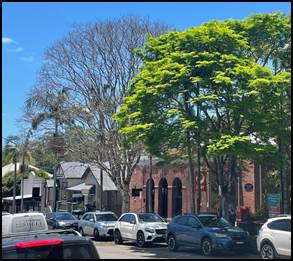
Figure 3: Ailing Leopard Tree on Byron St
Decisions regarding the potential removal of a Council-owned tree are complex. Mature street tree removal is an emotive issue for residents, some may have formed attachments to trees over many years. Trees have great value to the streetscape but do have a finite life. The decline in health of individual trees, or whole streets of trees, varies according to suitability, their natural life expectancy, and growing conditions.
Community Engagement
The Bangalow Streetscape Materials Design Guide addressed the requirement for succession planning around the Byron Street Leopard Trees. This document was placed on public exhibition and has had eight submissions. In relation to the succession planning for street trees the following input was received within six submissions:
1. Proposal that Tibouchina trees are utilised as varieties were developed by Ken Dunstan in Alstonville. Tibouchina are a spectacular flowering tree native to north-western South America, growing to 5m in height.
Response - Given that these are not native and do not have the size or presence required of a street tree, they are not considered an appropriate option.
2. Some of the mature street trees in Byron Street, whilst offering much needed shade are now of a scale that obscure building facades as well as the other noted issues. The selection of replacement future trees should consider some visibility of the historic facades when at mature height.
Response – agreed
3. Over the past 15 years, many of the mature Bangalow Palm on both
sides of Byron Street have died and haven’t been replaced. These are
essential for historic tropical character for Byron Street.
Response – Bangalow Palms are problematic over a sloping pedestrian footpath due to seeds creating slip hazards. Locations in adjacent parks are preferred.
4. The existing leopard trees look lovely, however they have caused ongoing problems
with the pavement and existing buildings, particularly the heritage buildings. Therefore, the removal of these trees would be a vast improvement.
Response – Agreed.
5. Tree plantings, Byron and Station Streets - we need to remove the old trees, esp the leopard trees and aging trees in Station Street and replant corridors of trees for shade and visual amenity along both Byron Street & Station Streets.
As the climate gets warmer shade trees are even more important for pedestrian and shop amenity. We need shade trees in the species identified and recommended in the Document.
Response - agreed
6. Byron Street Leopard trees have become the subject of ongoing critical comment from some Byron St business owners, expressing concerns about litter outfall, pedestrian safety and potential interference with heritage building foundations, so marking these trees for immediate investigation, outside Design Guide scope, is an appropriate action.
Response - agreed
Proposed Improved Planting
Options for replacement include the use of dedicated sub-soil root vaults to reduce the potential for damage to pavement and underground infrastructure (see below).
Trees will be replaced with local native species, considerations to include;
· Ultimate size
· Compatibility with surrounding infrastructure
· Minimal leaf litter, fruit drop, allergy causing agents or unpleasant odour.
· Resistance to disease
· Aesthetically appropriate to the heritage character of Bangalow
Suggested species for Byron Street:
Waterhousia floribunda. Weeping Lily Pilli (Myrtle Rust resistant, hybrid form)
Mature size 15x9m
Well behaved root system
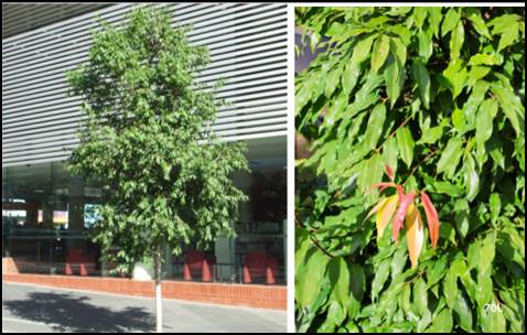
Figure 5: Waterhousia floribunda ‘Sweeper’
Suggested species for Station St:
Buckinghamia celsissima. Ivory Curl Tree
Mature size: 6-8M
Features: Prolific Grevillia like flowers in summer
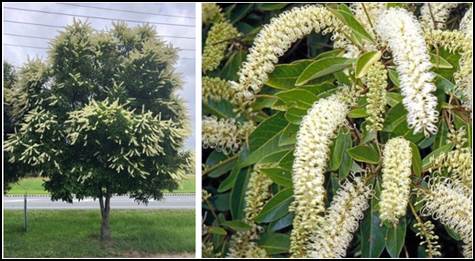
Figure 6: Buckinghamia celsissima
Proposed Sucession Plan
The position of existing and failed trees on Byron Street are shown in the image below.
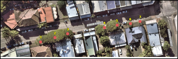
Option 1
Start replacement by removing trees in worst condition and remnants of dead palms (1, 4, 6 and 7), construct root containment pits before planting new trees.
As the new plantings develop to around 6m (or height of awnings) the remaining three Leopard trees (2, 3 and 5) will be removed and replaced with the preferred species.
Advantages of this option. Less initial tree removal may be less confronting to the community.
Disadvantages. Multiple construction areas at once requires more pedestrian control and more disruption. The works may appear piecemeal and disjunct.
Option 2
Address the replacement in 2 distinct stages.
Remove lower section of trees 4, 5, 6 and 7. Install root containment pits and new trees. Remediate pavement using style recommended in the Design Guide.
When new works well established, plan replacement of trees 1, 2 and 3 and proximal pavement.
Advantages of this option. Allows a better-defined work area resulting in economy of resources. A complete and uniform section informs the public of what the next section will look like.
Disadvantages. Removal of mature trees may prove confronting to some members of the public.
Strategic Considerations
Community Strategic Plan and Operational Plan
|
CSP Objective |
CSP Strategy |
DP Action |
Code |
OP Activity |
|
1: Effective Leadership |
1.2: Engage and involve community in decision making |
1.2.1: Community-led decision making - Engage with community to inform Council decision making |
1.2.1.1 |
Provide opportunities for the community to have input, comment and feedback to Council on projects and matters of interest |
|
4: Ethical Growth |
4.1: Manage responsible development through effective place and space planning |
4.1.3: Town / Village Masterplans - Develop, implement and update Place Plans that promote place-based forward planning strategies and actions |
4.1.3.3 |
Deliver street tree plan for Bangalow main street and village entries (action from the Bangalow Village Plan) |
Risk
Land managed by Council is not maintained or managed appropriately resulting in serious injury or death to a member of the public, potential legal ramifications, financial loss and reputational harm. This can be mitigated through proactive response to identified issue.
Financial Considerations
Budget:
Planning for this project arose from an Operational Plan (“OP”) Action to deliver street tree plan for Bangalow main street and village entries (action from the Bangalow Village Plan), with adopted budget of $28,500.
$70,000 of S94 funds for new street tree plantings in Bangalow has been identified to enable this project to be realised.
Insurance:
Does the project, policy, or proposal have any insurance implications for Council?
☒Yes or ☐No (select one option)
These works will reduce the risk to pedestrians of tripping on raised tree roots and will reduce the potential for the trees to cause damage to adjacent heritage buildings.
Consultation and Engagement
|
Who was consulted? |
How did consultation occur? e.g. email, verbal etc |
Comments/Feedback |
|
Bangalow Community |
Public Exhibition of Bangalow Streetscape Materials Guide. |
Included in body of report. |
|
Place Planning Staff |
Meeting |
Desire to be included in future community engagement around succession planning. |
Next steps
Council approve staff to advance the proposal for succession plantings to the community, with recommendation Option 2 being the preferred option.
Staff Reports - Infrastructure Services 13.15
Report No. 13.15 Draft Litter and Illegal Dumping Prevention Strategy
Directorate: Infrastructure Services
Report Author: Danielle Hanigan, Manager Resource Recovery
File No: I2024/480
Summary:
The Draft Litter and Illegal Dumping Prevention Strategy 2024-2029 (the Strategy) sets out the strategic direction for the effective management of litter and illegal dumping in the Byron Shire for the next 5 years. This report seeks Council’s endorsement to place the Strategy on Public Exhibition prior to adoption.
That:
1. The Draft Litter and Illegal Dumping Prevention Strategy 2024-2029 (Attachment 1 E2024/32361) be placed on public exhibition for a minimum of 28 days.
2. a) Should there be no submissions, the Draft Litter and Illegal Dumping Prevention Strategy 2024-2029 is endorsed from the date after the close of the exhibition period and;
b) Should submissions be received, the Draft Litter and Illegal Dumping Prevention Strategy be reported back to Council noting the submissions and any amendments made as a result of the feedback received.
Attachments:
1 DRAFT
Litter_Illegal_Dumping_Prevention_Strategy 2024-2029, E2024/32361 ![]()
Report
Litter and illegal dumping have huge financial, social, cultural, and environmental impacts on our organisation, community, and environment. Not only do these issues damage community pride and impact visual amenity but they can have detrimental impacts on wildlife and marine life. Managing litter alone costs Council over $1.4 million per year (according to the Byron Shire Council Cost of Litter analysis).
To mitigate these impacts, this Strategy builds on the foundation of a proven effective integrated approach to litter and illegal dumping prevention, evident through the success of Council’s Illegal Dumping and Litter Education and Enforcement Plan (IDLEEP) 2018 - 2022, which achieved a:
• 40% reduction in litter volume
• 30% reduction in illegal dumping incidents
Building on this success, this Strategy sets ambitious new targets to achieve an additional:
• 20% reduction in plastic litter items by 2029 (new baseline)
• 40% reduction in all littered items by 2029 (new baseline)
• 20% reduction in illegal dumping incidents by 2029 (2017 baseline)
Given Council’s success to date – our revised targets are building on existing achievements and will contribute to overall State targets.
The Strategy targets the most problematic items and issues within the Byron Shire, using a variety of approaches to create long-term behaviour change. The Strategy outlines the significant actions that, together with our stakeholders and community, we need to take to reduce litter and illegal dumping for the long term. Everyone has their part to play.
In accordance with the NSW EPA, an integrated approach will be utilised to achieve our objectives and targets. Approaches include a combination of those outlined in the NSW Litter Prevention Strategy 2022 - 2027 and NSW Illegal Dumping Prevention Strategy 2022 -2030, as well as those highlighted by our community during consultation (Table 2). Icons are used to demonstrate the various approaches being used to achieve each of the objectives within the Strategy.
Our strategic intent is underpinned by four key Litter themes:
1. Business and tourism – We must increase visitor awareness through collaborating with business and tourism sector on targeted education campaigns and reduce business related litter.
2. Protection of environment and waterways – We must protect and improve the health of waterways, local environment, and wildlife by reducing the amount of litter that enters these environments.
3. Improved infrastructure and services – We must ensure Council provides infrastructure and services to prevent litter and ensure the Shire's townships are clean, vibrant and activated.
4. Community pride and empowerment – We must ensure our community is inspired, empowered and supported to look after their local areas and is proud of the level of cleanliness in the Byron Shire.
And four key Illegal Dumping themes:
1. Household waste dumping - Reduce incidence of household waste, green waste, building waste and charity dumping by householders.
2. Commercial and construction waste dumping - Reduce incidence of construction and demolition waste including hazardous waste, and commercial waste being dumped by businesses.
3. Circular Economy - Develop, promote, and support circular economy initiatives to increase resource recovery over incorrect disposal.
4. Improved Infrastructure, Services and Enforcement - Council waste disposal services, infrastructure, and approach to enforcement minimises illegal dumping behaviours.
Development of the litter component of this Strategy has been funded by the NSW EPA under Stream 2 of their Litter Prevention Grant program and is a key requirement for future funding applications.
Whilst funding has supported the litter component of the strategy, the integrated nature of litter and illegal dumping means that they sit together within one strategic document.
We continue to build organisational capacity to ensure that litter and illegal dumping prevention is a high priority for Council, and our organisational approach and investment reflects its importance. We will continue to collect long-term litter data so that our challenges (and successes) are clearly identifiable through evaluating trends.
The Strategy has been created in consultation with the Byron Shire community, key internal and external stakeholders and supports the Our Byron Our Future – Community Strategic Plan 2032 objective to nurture and enhance the natural environment.
Strategic Considerations
Community Strategic Plan and Operational Plan
|
CSP Objective |
CSP Strategy |
DP Action |
Code |
OP Activity |
|
|||||
|
3: Nurtured Environment |
3.5: Minimise waste and encourage recycling and resource recovery practices |
3.5.1: Waste management and resource recovery strategy - Implement Integrated Waste Management and Resource Recovery Strategy - Towards Zero |
3.5.1.1 |
Maintain membership and participation in the North East Waste regional waste management group |
|||||
|
3: Nurtured Environment |
3.5: Minimise waste and encourage recycling and resource recovery practices |
3.5.1: Waste management and resource recovery strategy - Implement Integrated Waste Management and Resource Recovery Strategy - Towards Zero |
3.5.1.3 |
Improve management of Council generated waste through development and implementation of a policy that supports circular economy and waste hierarchy principles by eliminating single use packaging and materials |
|||||
|
3: Nurtured Environment |
3.5: Minimise waste and encourage recycling and resource recovery practices |
3.5.1: Waste management and resource recovery strategy - Implement Integrated Waste Management and Resource Recovery Strategy - Towards Zero |
3.5.1.4 |
Develop updated Illegal Dumping and Litter Education and Enforcement Plan (IDLEEP) for 2024 - 2029 in accordance with new NSW EPA litter and illegal dumping strategies and targets |
|||||
|
3: Nurtured Environment |
3.5: Minimise waste and encourage recycling and resource recovery practices |
3.5.2: Recycling - Work with business and tourism sector to reduce waste to landfill |
3.5.2.1 |
Develop and deliver targeted anti-littering and waste avoidance campaign for visitors, tourists and short-term accommodation providers |
|||||
|
3: Nurtured Environment |
3.5: Minimise waste and encourage recycling and resource recovery practices |
3.5.2: Recycling - Work with business and tourism sector to reduce waste to landfill |
3.5.2.2 |
Expand reusable networks in the takeaway food sector and decrease single use, disposable packaging |
|||||
|
3: Nurtured Environment |
3.5: Minimise waste and encourage recycling and resource recovery practices |
3.5.2: Recycling - Work with business and tourism sector to reduce waste to landfill |
3.5.2.5 |
Develop and implement Zero Waste Event processes and policies |
|||||
|
3: Nurtured Environment |
3.5: Minimise waste and encourage recycling and resource recovery practices |
3.5.3: Waste collection and landfill - Maintain and enhance solutions to recover / treat / dispose of residual waste |
3.5.3.1 |
Maintain and manage Waste and Resource Recovery Collection, processing and disposal contracts |
|||||
Recent Resolutions
Resolution Number: 23-667
2. Adopts the Single-use Packaging and Materials Policy 2023 with amendment as per Attachment 2 (E2023/124762)
Legal/Statutory/Policy Considerations
State and Regional
• NSW Waste and Sustainable Materials Strategy 2041 (WASM)
• NSW Plastic Actions Plan
• The Protection of the Environment Operations Act 1997 (associated Waste 2014 Regulation)
• Local Government Act 1993
• NSW EPA Strategic Plan 2021 – 2024
• NSW Marine Estate Management Strategy 2018 - 2028
• North East Waste Regional Waste Strategy 2022-2027
Council
• Byron Shire Council Towards Zero Integrated Waste Management and Resource Recovery Strategy 2019- 2029
• Single-use Packaging and Materials Policy 2023 Enforcement Policy 2020
• Open Spaces Asset Management Plan 2020 – 2029
• Water Sensitive Urban Design Policy Coastal Management Program Southern Coastline including Estuaries and Northern Coastline
Financial Considerations
Council funds a permanent full-time role for a Litter and Illegal Dumping Prevention Officer and budget for delivery via the waste. This will be supported by grant funding wherever feasible.
Application has been made to the NSW EPA for $420,000 under WASM Litter Prevention Grant Stream 3 funding to support implementation of the litter actions within the Strategy.
Additional applications will be made to support the Illegal Dumping actions in future funding rounds.
Consultation and Engagement
Community consultation was undertaken to inform the Strategy via a Community Survey. 158 responses were received which gave insight into the community needs and attitudes towards litter, illegal dumping and Council services.
A workshop was held for external stakeholders which was delivered by an external consultant, enabling key community members to have input and involvement into the strategy development and identify areas where key partnerships and collaboration could achieve best outcomes. Stakeholders include:
• North East Waste
• Sea Bin Project
• Positive Change for Marine Life
• Bruns Valley Local Landcare
• Byron Bird Buddies
• Bronwyn Elliot
• National Parks and Wildlife Services
• Ocean Youth
• Take 3 for the Sea
• Tangarao Blue
• No more Butts
• Oz Fish
Presentations were made to the Climate Change and Resource Recovery Advisory Committee, the Community Board Association for feedback.
An internal working group across several Council departments to inform the Strategy and will continue as a Steering Group through the duration of the delivery of the Strategy, as supported by Councils executive team. This will ensure a cross-departmental, holistic approach to tackling litter and illegal dumping issues which is a key component to the Strategies success.
Staff Reports - Infrastructure Services 13.16
Report No. 13.16 Emergency access at Belongil Beach
Directorate: Infrastructure Services
Report Author: Claire McGarry, Place Manager - Byron Bay
Chloe Dowsett, Biodiversity and Sustainability Coordinator
File No: I2024/534
Summary:
Due to recent coastal erosion and wave events in Byron Bay, the existing emergency vehicle access point from Main Beach carpark to Belongil Beach has been damaged and is unusable.
Staff have been approached by the Byron Surf Life Saving Club and emergency service providers to repair the access as a matter of urgency.
Already, 2024 has seen multiple beach emergencies, and direct access to the incidents has not been available for emergency services. This reduces response time and ability of first responders to provide timely care for beach users.
This report recommends repair of the access way in the form of a concrete ramp. It details the project aims and objectives and identifies the appropriate planning pathway and funding source to facilitate construction.
RECOMMENDATION:
That Council:
1. Notes the project aims, objectives and urgency.
2. Notes the Review of Environmental Factors (Attachment 1; E2024/30353) which has been Determined under delegation on 8 April 2024.
3. Allocates $80,000 from Crown Paid Parking to fund the construction of the emergency access at Belongil Beach.
1 Review
of Environmental Factors - Belongil Beach Access Ramp - 8 April 2024, E2024/30353 ![]()
Report
Local emergency services and surf lifesavers have requested that Council restore an access way from Main Beach carpark to enable vehicular and pedestrian access to Belongil Beach. Vehicles are currently unable to access Belongil Beach during emergencies. Given the rising number of incidents at this location, including a recent fatality, staff propose prioritising the repair of the access way by constructing a concrete ramp (Figure 1).
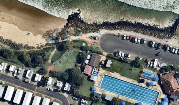
Figure 1: Approximate works area shown in blue dash line = western access to Belongil Beach, Byron Bay.
Project Aim
The aim of the project is to:
· facilitate a safe and robust access point to Belongil Beach for both vehicles/machines and pedestrians; and
· improve the public’s beach safety, access and amenity.
Project Objectives
The project objectives are as follows:
1. Identify an appropriate planning pathway to facilitate the work and assess potential environmental impacts of the project.
2. Design and construct an access ramp that:
a) Is constructed with durable materials and design features to withstand coastal erosion processes i.e. wave run-up, wave overtopping, beach profile lowering.
b) Facilitates vehicle and pedestrian movements from the car park to the beach.
c) Allows for a reasonable change in beach height without compromising the structure.
d) Reduces the risk of accidents and injuries when accessing the beach.
e) Seamlessly integrates with the existing rock revetment, ensuring structural stability and minimising impacts on the revetment’s effectiveness.
f) Complete the ramp construction in a timely manner without impacting public amenity or safety.
3. Link the ramp back to the car park with a gravel track.
Options
Option 1 – Do nothing
If Council were to take no action and not repair the beach access, this would significantly impact the ability of emergency services to undertake beach rescues and respond in a timely manner. This is not suitable.
Option 2 – Basic maintenance
Council could take action to try to keep the access useable for emergency services with less permanent materials, however this has been undertaken over the years and is subject to wash out from wave events. Basic maintenance may only provide useable access in the short-term and provides no confidence for emergency services or Surf Lifesavers. This option is not suitable.
Option 3 – Wait and align works with the Main Beach Shoreline Project
Beach access design and works will be undertaken as part of implementation of the preferred design solution for modification of the Jonson Street Protection Works. The preferred option is not yet known. As such, construction works may be 2 – 3 years away. This option is not suitable.
Option 4 – Preferred option
There is an immediate need for pedestrian and vehicular access at the location for the safety of beach users and to allow access for emergency services.
The proposed Concept Design for the works is provided in Figure 2.
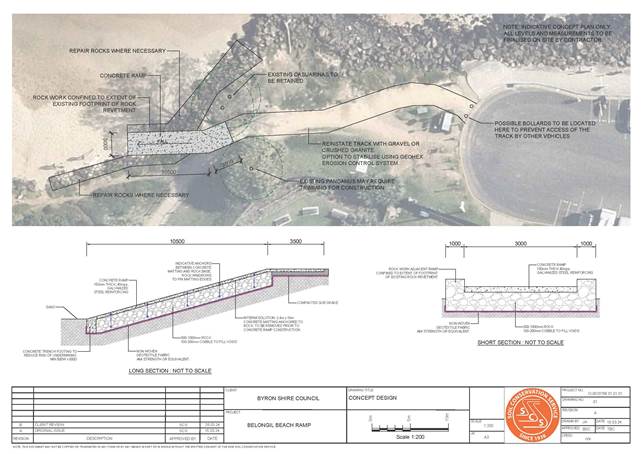
Figure 2: Concept Design for the works.
The footprint of the current access is nestled within the section of the coastal protection works at Main Beach (also known as the Jonson Street Protection Works / JSPW) that was constructed as part of the upgrade of the structure in 1975 prior to the commencement of the Coastal Protection Act 1979.
With limited maintenance since the 1990’s, the JSPW are in poor condition and have been previously identified as being degraded and not comply with contemporary coastal engineering standards.
Council considers that the proposed works are ‘repair’ to coastal protection works being simply repair and maintenance of a small portion of an existing asset (JSPW) to a like for like situation. In consideration of the beach access, the proposed works are renewal (enhancement) of the access as it will provide a better level of service of the asset beyond which it had originally. The proposed works seek to provide an interim solution to access for up to 5 years.
The Review of Environmental Factors (REF) provided in Attachment 1 provides further background to the proposed works and details its relationship to other projects including Council’s coastal management programs and the Main Beach Shoreline Project.
Next steps
1. Allocation of budget for the works.
2. Contractor engagement.
3. (Further) consultation with agencies and stakeholders.
4. Pre-beach monitoring of the beach condition and sand levels subject to works.
5. Construction is estimated to take place over 4 days and could be completed late April or early May if approved.
· Day 1: re-align rock revetment, build rock ramp, reinstate access with gravel, stockpile small amount for backfilling.
· Day 2: Concreters form ramp and steel.
· Day 3: Pour concrete.
· Day 4: Strip formwork, backfill around ramp with gravel & compact.
Strategic Considerations
Community Strategic Plan and Operational Plan
|
CSP Strategy |
DP Action |
Code |
OP Activity |
|
|
3: Nurtured Environment |
3.1: Partner to nurture and enhance biodiversity, ecosystems, and ecology |
3.1.3: Habitat restoration - Restore degraded areas that provide high environmental or community value |
3.1.3.8 |
Commence the 'Belongil and Cavanbah Beach Dune Recovery Project' |
|
3: Nurtured Environment |
3.3: Protect the health of coastline, estuaries, waterways, and catchments |
3.3.1: Coastal Management Program planning and implementation - Undertake Coastal Management Program planning and implementation |
3.3.1.7 |
Develop concept plans for upgrades of Byron Bay Main Beach foreshore from Belongil to Clarke’s Beach |
|
3: Nurtured Environment |
3.3: Protect the health of coastline, estuaries, waterways, and catchments |
3.3.1: Coastal Management Program planning and implementation - Undertake Coastal Management Program planning and implementation |
3.3.1.8 |
Identify and evaluate management options and opportunities for addressing threats to the Byron Shire coastal zone and prepare Costal Management Programs |
Recent Resolutions
The below recent resolutions relate to coastal projects (Main Beach Shoreline Project and development of Coastal Management Programs (CMPs)) and coastal erosion issues in general.
· 23-146
· 21-463
· 21-164
· 20-730
· 20-525
Legal/Statutory/Policy Considerations
Section 3 of the attached REF details the relevant environmental planning instruments related to the project, including:
· SEPP (Transport and Infrastructure) 2021
· SEPP (Resilience and Hazards) 2021
· Byron Local Environmental Plan 2014 (and/or Byron LEP 1988)
SEPP (Transport and Infrastructure) 2021
Section 2.165 of SEPP (Transport and Infrastructure) permits foreshore management activities without consent on any land when undertaken by a public authority. The relevant sections of the SEPP are as follows:
Division 25 Waterway or foreshore management activities
2.164 Definition
In this Division—
waterway or foreshore management activities means—
(a) riparian corridor and bank management, including erosion control, bank stabilisation, resnagging, weed management, revegetation and the creation of foreshore access ways, and
(c) coastal management and beach nourishment, including erosion control, dune or foreshore stabilisation works, headland management, weed management, revegetation activities and foreshore access ways, and
2.165 Development permitted without consent
(1) Despite clause 129A, development for the purpose of waterway or foreshore management activities may be carried out by or on behalf of a public authority without consent on any land.
A REF is being undertaken under Part 5 of the EPA Act 1979 to ensure that all aspects of the project are covered by an environmental assessment.
SEPP (Resilience and Hazards) 2021
Part 2.3 Miscellaneous
2.16 Coastal protection works
Note—
Section 4 (1) of the Coastal Management Act 2016 defines coastal protection works to mean—
(a) beach nourishment activities or works, and
(b) activities or works to reduce the impact of coastal hazards on land adjacent to tidal waters, including (but not limited to) seawalls, revetments and groynes.
Section 27 of the Coastal Management Act 2016 also contains provisions dealing with the granting of development consent to development for the purpose of coastal protection works.
(1) Coastal protection works by person other than public authority. Development for the purpose of coastal protection works may be carried out on land to which this Chapter applies by a person other than a public authority only with development consent.
(2) Coastal protection works by public authority. Development for the purpose of coastal protection works may be carried out on land to which this Chapter applies by or on behalf of a public authority—
(a) without development consent—if the coastal protection works are—
(i) identified in the relevant certified coastal management program, or
(ii) beach nourishment, or
(iii) the placing of sandbags for a period of not more than 90 days, or
(iv) routine maintenance works or repairs to any existing coastal protection works, or
(b) with development consent—in any other case.
The proposed works include a gravel access track, concrete ramp and repairs to an existing beach access way to improve public safety. Council considers that the current access is within a section of rock wall that was constructed as part of the upgrade to coastal protection works in 1975 prior to the commencement of the Coastal Protection Act 1979 and prior to the EPA Act 1979. It is therefore a lawfully erected structure.
As the beach access lies within the existing coastal protection works this project includes works that are considered to include routine maintenance works or repairs to any existing coastal protection works. In accordance with the SEPP (Resilience and Hazards) 2021 routine maintenance works or repairs may be carried out by or on behalf of a public authority on any land without development consent.
An REF is required (refer Attachment 1).
Byron Local Environmental Plan 2014 (and/or Byron LEP 1988)
The coastal area of the Byron Bay embayment falls within the Coastal Land Zone No 7 (f1) under the Byron Local Environmental Plan (1988). Beach and coastal restoration works are permitted with Council consent in this zone. In this case, SEPP (Transport and Infrastructure) 2021 and SEPP (Resilience and Hazards) 2021 override Byron LEP 1988 and the works can be undertaken under Part 5 of the EPA Act, 1979.
Financial Considerations
The estimated project cost is $80,000 which could be fully funded through Crown Paid Parking and adjusted in the next quarterly budget review. This cost is an upper limit estimate and likely cost for works will come under this amount.
Consultation and Engagement
Consultation has been undertaken with relevant key stakeholders and agencies as part of the REF preparation and their feedback has been provided as an attachment to the REF and has been incorporated into the scope where relevant. Further consultation will occur upon approval of the works to go ahead.
This includes:
· Australian Lifeguard Service
· Byron Bay Surf Lifesaving Club
· Department of Planning and Environment
· Crown Lands
· Arakwal Corporation
· DPI Fisheries – Cape Byron Marine Park
· Other relevant key stakeholders.
Reports of Committees - Infrastructure Services 14.1
Reports of Committees - Infrastructure Services
Report No. 14.1 Report of the Floodplain Management Advisory Committee Meeting held on 13 February 2024
Directorate: Infrastructure Services
File No: I2024/268
Summary:
The attachment to this report provides the minutes of the Floodplain Management Advisory Committee Meeting of 13 February 2024 for determination by Council.
RECOMMENDATION:
1. That Council notes the minutes of the Floodplain Management Advisory Committee Meeting held on 13 February 2024.
|
5. That Council does not adopt Committee Recommendation(s) 4.3 as shown in the attachment to this report, but instead adopts the Management Recommendation(s) as follows:
Report No. 4.3 Post 2022 Event Flood Behaviour Analysis - Brunswick River - Final Draft Report - September 2023-NSW Department of Planning & Environment File No: I2024/178
Committee Recommendation 4.3.1 That: 1. The Flood Advisory Committee notes that DCCEEW has issued its “Post 2022 Event Flood Behaviour Analysis - Brunswick River - Final Report”. 2. Council adheres to the North Coast Settlement Planning Guidelines 2019, and not develop areas either where the land is flood prone at 1% AEP, or where there is no evacuation route. 3. Council uses the higher of two sets of levels, as the basis for determining flood planning levels: 1. Levels from the three adopted FPMS&P; 2. Levels from a peak water surface established from community data throughout the floodplains (peak levels February and March 2022). Management Recommendation That The Flood Advisory Committee notes that DCCEEW has issued its “Post 2022 Event Flood Behaviour Analysis - Brunswick River - Final Report”. |
|
|
|
6. That Council adopts the following Committee and Management Recommendation(s):
Additional Recommendation That: 1. Council acknowledges that Rebecca Brewin and Ziwar Sattouf have resigned from the Committee effective immediately. 2. The Committee has decided not to advertise the position. |
1 Minutes
13/02/2024 Floodplain Management Advisory Committee, I2024/181 ![]()
Report
The attachment to this report provides the minutes of the Floodplain Management Advisory Committee Meeting of 13 February 2024 for determination by Council. The agenda for this meeting can be located on Council’s website at:
The following items were considered by the Committee:
Report No. 4.1 Floodplain Management Advisory Committee Goals for 2024
This report addresses the Floodplain Advisory Committee recommendations of Report 4.1 tabled at the Friday 8 December 2023 committee meeting.
Report No. 4.2 Community Education Strategy and Review of Flood Options - Project Update
This report provide update on Community Education Strategy and Review of Flood Options Project.
Report No. 4.3 Post 2022 Event Flood Behaviour Analysis - Brunswick River - Final Draft Report - September 2023-NSW Department of Planning & Environment
The purpose of the report is to discuss in detail the Committee’s concerns of Post 2022 Flood Event Development Controls and provides an update on Post 2022 Event Flood Behaviour Analysis - Brunswick River - Final Draft Report.
Management Comments
Management do not agree with the following Committee recommendation for the reasons given below and have provided alternative recommendations above:
Committee Recommendation 4.1.3 is not supported for the following reasons.
Council has been providing flood information certificates for some time, as per Council’s fees and charges. The purchase of the program and staff time to manage the process being covered by the fees.
Flood Information Certificate - Byron Shire Council (nsw.gov.au)
2022 Flood impacted property owners looking to house raise or retrofit, however have been able to apply for and receive flood information certificates on a request basis, without charge. The cost for this allocated in the operational budget as part of flood recovery.
The usual fees for provision of the flood information certificates to the wider community, prospective house purchasers and landowners still remain in place as per the link above and in the fees and charges.
This request to make flood information certificates free and open, is not simple, is without clear parameters of what it is and who is responsible for managing it, and is problematic for staff to implement.
The potential legal implications of having property owners floor levels freely available online also needs further consideration on approach and caveats re the date of information and basis for it.
Currently staff review each application before release to ensure it provides the best and most current information. If we are to provide flood information certificates for every ‘dwelling’ online there would be a significant staff or consultant resource requirement to prepare every flood information certificate, check it for currency and then publish.
Following this each flood information certificate would require this process again to update when a Floodplain Management Plan is updated. This cost needs further reporting to Council.
Committee Recommendation 4.3.1 is not supported for the following reasons.
Using a historic single flood event to guide the production of a Flood Planning Level is not supported because it carries risks to Council, is not best practice and is not supported in the 2005 or 2023 Floodplain Development Manual, which guides how all NSW Council’s manage flood risk.
Council is recommended to derive all Flood Planning Level’s from a floodplain risk management process, i.e a Council adopted Floodplain Management Plan.
Single events have many localised impacts like blockages that can impact flood levels making them potentially not a true representation of a design flood event.
Staff have reviewed mapping of the 2022 flood event against Council’s Flood Planning Level. The 2022 flood event peak did not exceed Council’s existing Flood Planning Level, this shows the suitability of the current mapping as being fit for purpose.
The Post 2022 Event Flood Behaviour Analysis - Brunswick River recommends Council complete a North Byron flood study and plan update, which includes new modelling, model calibration, event mapping and flood mitigation options.
Staff plan to seek funding in April 2024 to commence this work in late 2024. This work will follow the process detailed in the 2023 Floodplain Development Manual to develop an updated Flood Planning Level and is therefore the appropriate process for Council to follow when updating this mapping.
Further The North Coast Settlement Planning Guidelines 2019 provides two types on constraints to development in the region:
Primary constraints are considered to include Land within the 1:100-year floodplain and land where there is no available safe evacuation route in the event of flood or bushfire.
However, under Manageable constraints the guideline notes ‘where a council proposes urban development on flood prone land it must have an adopted and approved Floodplain Risk Management Plan that is not more than 5 years old which covers the land.’
Therefore, the guidance in this guideline is not a clear no to development within the floodplain as noted in the committee recommendation. There is an allowance to develop this land where studies find it to be appropriate.
For this reason, is it recommended that Council continue to follow the processes detailed in the NSW 2023 Floodplain Development Manual to update flood planning requirements for the shire and proceed with any urban development as guided by the updated and adopted Floodplain Risk Management Plan’s.
Financial Implications
As per the Reports listed within the Floodplain Management Advisory Committee Meeting of 13 February 2024.
Committee Recommendation 4.1.3 has a cost that needs investigating and further reporting.
Statutory and Policy Compliance Implications
As per the Reports listed within the Floodplain Management Advisory Committee Meeting of 13 February 2024.
Reports of Committees - Infrastructure Services 14.2
Report No. 14.2 Report of the Water and Sewer Advisory Committee Meeting held on 21 March 2024
Directorate: Infrastructure Services
File No: I2024/448
Summary:
The attachment to this report provides the minutes of the Water and Sewer Advisory Committee Meeting of 21 March 2024 for determination by Council.
RECOMMENDATION:
1. That Council notes the minutes of the Water and Sewer Advisory Committee Meeting held on 21 March 2024.
1 Minutes
21/03/2024 Water and Sewer Advisory Committee, I2024/400 ![]()
Report
The attachment to this report provides the minutes of the Water and Sewer Advisory Committee Meeting of 21 March 2024 for determination by Council. The agenda for this meeting can be located on Council’s website at:
Agenda of Water and Sewer Advisory Committee Meeting - Thursday, 21 March 2024 (infocouncil.biz)
The following items were considered by the Committee:
Report No. 4.1 IS Utilities Status Report - November 2023 - January 2024
This report summarises the performance of Utilities Department delivery for November 2023 – January 2024.
Report No. 4.2 Response to Questions - Future Water Strategy
The report provide responses to questions raised by the Committee in relation to the Mullumbimby Future Water Strategy.
Report No. 6.1 Utilities Digital Asset Management Plan (dAMP) Presentation
The report presents the finalised and published digital Asset Management Plan (dAMP) of Utilities to the Water and Sewer Advisory Committee.
Committee notes the report.
Committee Recommendation
The committee recommendations are supported by management and are provided in the attachment to this report.
Financial Implications
As per the Reports listed within the Water and Sewer Advisory Committee Meeting of 21 March 2024.
Statutory and Policy Compliance Implications
As per the Reports listed within the Water and Sewer Advisory Committee Meeting of 21 March 2024.
Questions With Notice 15.1
Questions With Notice
Question with Notice No. 15.1 Residual land from Tallowood Estate
File No: I2024/475
Cr Dey asks the following questions:
Council manages many parcels of land around the Shire. Some are Open Space left over from sub-divisions like Tallowood. Some of that Open Space is bushland, like Lot 282 in Tallowood.
Council are not well funded to manage those parcels.
1. What area of Open Space does Council manage in Byron Shire?
2. What portion of that is bushland and what is the annual cost of maintaining that portion?
3. What area of Open Space (the answer to Q1) is within or adjacent to Tallowood Estate?
4. What is the annual cost of maintaining that land (the answer to Q3)?
5. If Council acquires Lot 282, what is the likely annual cost of maintaining it in perpetuity?
Response Director Infrastructure Services:
QUESTION 1:
Council manages approximately 680 hectares of Open Space in Byron Shire.
Approximately 270 Hectares of Council managed Open Space is bushland (not including STPs).
It is difficult to attribute costs in entirety as some expenditure is shared across the Open Space suite for the Shire, including administration and strategic planning.
The annual cost of maintaining bushland areas (around 70 sites) cannot be completely specified due to the areas where bush regeneration and weed control works have not been completed. Until a complete area of bushland reaches maintenance level, an annual cost to maintain it cannot be provided. Currently, only portions of the bushland areas, or certain weeds are treated where funding allows.
Of the 70 sites currently being worked 44 Sites are at a maintenance level. To maintain these 44 sites is approximately $300,000 per year.
Open Space within or adjacent to Tallowood Estate equates to:
Parkland:
· Council maintained = 4.4 hectares
· Contractor maintained = 2.3 hectares
Bushland:
· Council maintained = 7 hectares
· Contractor maintained = approximately 3 hectares (to be handed to Council)
QUESTION 4:
Annual cost of maintaining the open space land:
Parkland:
· Approximate cost to mow and brush cut the open space per annum is $113,000. This does not include emergent works (tree pruning) or asset infrastructure maintenance (seats, shelters, play equipment).
Bushland:
· Approximate expenditure cost to conduct bush regeneration per annum is $20,000, however there are a range of significant weeds unable to be addressed due to limited budget.
QUESTION 5:
If Council acquires Lot 282, the likely annual cost of bush regeneration work to maintain in perpetuity would be around $7,000.00 per year. This type of vegetation also requires periodic burning to keep it in good condition and maintain diversity. Ideally, it should have a fire every 6-10 years. This cost is unknown at this stage.
A further requirement of $10,000 annually is required to manage trees on the urban interface.
Total predicted annual Bush Regeneration and bush maintenance budget for Lot 282 is $17,000.
[1] Foley, J.A., DeFries, R., Asner, G.P., Barford, C., Bonan, G., Carpenter, S.R., Chapin, F.S., Coe, M.T., Daily, G.C., Gibbs, H.K., 2005. Global consequences of land use. Science 309, 570–574.
[4] L Boronyak and B.C. Jacobs (2023) Pathways to coexistence with dingoes across Australian Farming Landscapes. Frontiers in Conservation Science 10.3389/fcosc.2023.1126140; L. van Bommel and C.N. Johnson (2023), Still a good dog! Long-term use and effectiveness of livestock guardian dogs to protect livestock from predators in Australia’s extensive grazing systems. Wildlife Research 51 WR23008 https://doi.org/10.1071/WR23008)
[7] Pg. 8 item 1.4 – Managing native animals and pg. 46 item 5.12 Wild Dog.
[8] E2013/24014