Agenda
Ordinary
(Planning) Meeting
Thursday,
21 May 2020
held
at Council Chambers, Station Street, Mullumbimby
commencing
at 9:00am
 Public Access relating to items
on this Agenda can be made between 900am and 9.30am on the day of the
Meeting. Requests for public access should be made to the General Manager
or Mayor no later than 12.00 midday on the day prior to the Meeting.
Public Access relating to items
on this Agenda can be made between 900am and 9.30am on the day of the
Meeting. Requests for public access should be made to the General Manager
or Mayor no later than 12.00 midday on the day prior to the Meeting.
Mark
Arnold
General
Manager
What is a “Conflict of Interests” - A conflict of
interests can be of two types:
Pecuniary - an interest that a person has in a matter because of a reasonable
likelihood or expectation of appreciable financial gain or loss to the person
or another person with whom the person is associated.
Non-pecuniary – a private or personal interest that a Council
official has that does not amount to a pecuniary interest as defined in the Code
of Conduct for Councillors (eg. A friendship, membership of an association,
society or trade union or involvement or interest in an activity and may
include an interest of a financial nature).
Remoteness – a person does not have a pecuniary interest in a matter
if the interest is so remote or insignificant that it could not reasonably be
regarded as likely to influence any decision the person might make in relation
to a matter or if the interest is of a kind specified in the Code of Conduct
for Councillors.
Who has a Pecuniary Interest? - a person has a pecuniary interest in a
matter if the pecuniary interest is the interest of the person, or another
person with whom the person is associated (see below).
Relatives, Partners - a person is taken to have a pecuniary interest in a
matter if:
§ The person’s
spouse or de facto partner or a relative of the person has a pecuniary interest
in the matter, or
§ The person, or a
nominee, partners or employer of the person, is a member of a company or other
body that has a pecuniary interest in the matter.
N.B. “Relative”, in relation to a person means any of the
following:
(a) the
parent, grandparent, brother, sister, uncle, aunt, nephew, niece, lineal
descends or adopted child of the person or of the person’s spouse;
(b) the
spouse or de facto partners of the person or of a person referred to in
paragraph (a)
No Interest in the Matter - however, a person is not taken to have a
pecuniary interest in a matter:
§ If the person is
unaware of the relevant pecuniary interest of the spouse, de facto partner,
relative or company or other body, or
§ Just because the
person is a member of, or is employed by, the Council.
§ Just because the
person is a member of, or a delegate of the Council to, a company or other body
that has a pecuniary interest in the matter provided that the person has no
beneficial interest in any shares of the company or body.
Disclosure and participation in meetings
§ A Councillor or a
member of a Council Committee who has a pecuniary interest in any matter with
which the Council is concerned and who is present at a meeting of the Council
or Committee at which the matter is being considered must disclose the nature
of the interest to the meeting as soon as practicable.
§ The Councillor or
member must not be present at, or in sight of, the meeting of the Council or
Committee:
(a) at any
time during which the matter is being considered or discussed by the Council or
Committee, or
(b) at any
time during which the Council or Committee is voting on any question in
relation to the matter.
No Knowledge - a person does not breach this Clause if the person did
not know and could not reasonably be expected to have known that the matter
under consideration at the meeting was a matter in which he or she had a
pecuniary interest.
Non-pecuniary Interests - Must be disclosed in meetings.
There are a broad range of options available for managing conflicts &
the option chosen will depend on an assessment of the circumstances of the
matter, the nature of the interest and the significance of the issue being
dealt with. Non-pecuniary conflicts of interests must be dealt with in at
least one of the following ways:
§ It may be appropriate
that no action be taken where the potential for conflict is minimal.
However, Councillors should consider providing an explanation of why they
consider a conflict does not exist.
§ Limit involvement if
practical (eg. Participate in discussion but not in decision making or vice-versa).
Care needs to be taken when exercising this option.
§ Remove the source of
the conflict (eg. Relinquishing or divesting the personal interest that creates
the conflict)
§ Have no involvement by
absenting yourself from and not taking part in any debate or voting on the
issue as of the provisions in the Code of Conduct (particularly if you have a significant
non-pecuniary interest)
RECORDING OF VOTING ON PLANNING MATTERS
Clause 375A of the Local Government Act 1993
– Recording of voting on planning matters
(1) In this section, planning
decision means a decision made in the exercise of a function of a council
under the Environmental Planning and Assessment Act 1979:
(a) including a decision
relating to a development application, an environmental planning instrument, a
development control plan or a development contribution plan under that Act, but
(b) not including the making of
an order under that Act.
(2) The general manager is
required to keep a register containing, for each planning decision made at a
meeting of the council or a council committee, the names of the councillors who
supported the decision and the names of any councillors who opposed (or are
taken to have opposed) the decision.
(3) For the purpose of
maintaining the register, a division is required to be called whenever a motion
for a planning decision is put at a meeting of the council or a council
committee.
(4) Each decision recorded in
the register is to be described in the register or identified in a manner that
enables the description to be obtained from another publicly available
document, and is to include the information required by the regulations.
(5) This section extends to a
meeting that is closed to the public.
Ordinary (Planning) Meeting
BUSINESS OF Ordinary (Planning) Meeting
1. Public Access
2. Apologies
3. Requests for Leave of
Absence
4. Declarations of Interest
– Pecuniary and Non-Pecuniary
5. Tabling of Pecuniary
Interest Returns (Cl 4.9
Code of Conduct for Councillors)
6. Adoption of Minutes from
Previous Meetings
6.1 Ordinary
(Planning) Meeting held on 16 April 2020
7. Reservation of Items for
Debate and Order of Business
8. Mayoral Minute
9. Notices of Motion
Nil
10. Petitions
11. Submissions and Grants
12. Delegates' Reports
13. Staff Reports
Sustainable Environment and Economy
13.1 PLANNING
- Saddle Road affordable housing precinct - Expression of interest........................................................................................................................... 5
13.2 PLANNING
- 26.2019.7.1 - Submissions Report Old Byron Hospital Planning Proposal.......................................................................................................... 19
13.3 PLANNING
- 26.2018.2.1 The Linnaeus Estate - Options for proceeding with Community Title
Subdivision........................................................................... 24
13.4 PLANNING
- Byron Shire Affordable Housing Contribution Scheme and Planning Agreements
Policy and Procedure................................................... 34
13.5 PLANNING
- 26.2018.4.1 Environmental Zone Implementation Program: Stage 2 Planning
Proposal 'Submissions Report'............................................ 44
13.6 PLANNING
- 26.2019.10.1 Proposed Rezoning North Beach Byron - Options Report.............................................................................................................. 78
13.7 PLANNING
- 26.2016.4.1 Submissions to Planning Proposal Rural Events... 85
13.8 PLANNING
- DA 10.2019.616.1 Mixed Use Development cnr Jonson & Browning Streets Byron
Bay............................................................................ 96
13.9 PLANNING
- DA10.2019.517.1 Mixed Use Development Stage 4 of Habitat 145
13.10 PLANNING
- 24.2020.15.1 Habitat Stage 5 DCP Amendment; Chapter E5 Certain Locations in
Byron Bay and Ewingsdale........................................... 163
13.11 PLANNING
- Place Planning Collective Charter and Nominations............... 168
13.12 PLANNING
- Update on Resolution 19-266 - Review of DCP 2014 and the introduction of the
Low Rise Medium Density Code...................................... 172
13.13 PLANNING
- DA 10.2019.451.1 Subdivision of Two (2) Lots into Two (2) Lots at 62 and 64
Corkwood Crescent, Suffolk Park............................................. 180
13.14 PLANNING
- Report of the 9 April 2020 Planning Review Committee.......... 194
13.15 PLANNING
- Section 4.55 Application - 10.2019.196.2 - Proposed Modification to amend
location of Kitchen and Wet Bar in Building 8 and amend timeframe for
Demolition of Buildings 1, 2, 3, 4 and 6 - 541 Friday Hut Road Possum Creek............................................................................................................. 197
13.16 PLANNING
- DA 10.2020.110.1 Alterations & Additions to existing dwelling house
at 58 Main Arm Road Mullumbimby.................................................... 206
13.17 PLANNING
- 10.2016.625.2 - S4.55 Minor Modifications to Design and Conditions...................................................................................................... 220
Councillors are
encouraged to ask questions regarding any item on the business paper to the
appropriate Director prior to the meeting. Any suggested amendments to the
recommendations should be provided to Councillor Support prior to the meeting
to allow the changes to be typed and presented on the overhead projector at the
meeting.
Staff Reports - Sustainable Environment and Economy 13.1
Staff Reports - Sustainable Environment and
Economy
Report No. 13.1 PLANNING
- Saddle Road affordable housing precinct - Expression of interest
Directorate: Sustainable
Environment and Economy
Report
Author: Sam
Tarrant, Planning Support Officer
File No: I2020/236
Summary:
Following on from Council resolutions 18-823 and 18-543
an expression of interest (EOI) was sent to all property owners within the Residential
Strategies ‘Area 17’ precinct along The Saddle Road. The purpose of
the EOI was to seek landowner interest on having their property considered in
the Rural Land Use Strategy (RLUS) as a site for providing at least 80%
affordable housing in the form of intentional eco-communities.
These resolutions came about in relation to the Brunswick
Eco Village, which was a significant planning proposal submitted in 2017 for
the Saddle Road precinct which proposed a mix of rural residential and
residential lots.
During Council’s assessment of this
planning proposal, the then Department of Planning raised concerns about the
planning proposal proceeding ahead of an approved Residential Strategy. As a
result of this and other advice received from the Department regarding Area 17
(Saddle Road Precinct), Council resolved (Res 18-543) to not proceed with
assessment of the Saddle Road Planning Proposal. This was followed by
Resolution 18-823 to investigate suitable sites for ‘intentional
eco-communities’ in the RLUS including the Brunswick Eco Village site.
The EOIs where sent out to the landowners in January 2020.
Those who were not interested in their property being considered for the
purpose of providing at least 80% affordable housing in the form of intentional
eco-communities did not need to respond to the EOI. Two responses were received
and these are summarised within this report.
Amending the RLUS to identify The Saddle Road as a site for
future rural-residential housing requires an assessment against the relevant
policy directions in the applicable strategic plans.
An assessment against the relevant criteria in the North
Coast Regional Plan 2036, North Coast Settlement Planning Guidelines 2019 and
the RLUS is provided in this report. The assessment has identified a number of barriers to including either of these sites in
the RLUS for this purpose of an intentional
community (in the form of rural-residential housing) within The Saddle Road
precinct.
|
RECOMMENDATION:
1. That
Council note the Expression of Interest received for providing
affordable housing in the form of intentional eco-communities within Area 17,
The Saddle Road.
2. That
Council not proceed with amending the Rural Land Use Strategy to
identify The Saddle Road as a site for providing affordable housing in the
form of intentional eco-communities.
3. That
Council notify those who submitted an Expression of Interest proposal
of Council’s decision not to proceed with amending the Rural Land Use
Strategy.
|
Attachments:
1 Confidential
- EOI Responses Area 17 Saddle Road, E2020/17901
REPORT
Council at its 13
December 2018 meeting considered a report on the draft Residential Strategy and
resolved amongst other matters to (Res 18-823 part e):
e) Commence
an amendment to the Rural Land Use Strategy to include that land subject to
Resolution 18-543 (2) that is not identified in the Residential Strategy as a
source of land for housing supply 2016-2036, but is deemed suitable for
inclusion as a priority site/s for future rural lifestyle living opportunities
in the form of ‘intentional eco-communities’ in the Rural Land Use
Strategy
In relation to
item ‘e)’, Resolution 18-543 (2) stated that:
2. Council
invite individual site proposals from within Area 17 (Saddle Road) that include
a provision of at least 80% affordable housing.
The above resolutions are a result of the Brunswick Eco
Village proposal that was submitted in 2017. The original planning proposal was
for a new urban growth area for the Saddle Road precinct that has the potential
to supply approximately 475 rural residential and residential lots, of
which 20% of the resulting dwellings would be secured
for accessible housing.
During Council’s assessment of this
planning proposal, the then Department of Planning raised concerns about the
planning proposal proceeding ahead of an approved Residential Strategy. As a
result of this and other advice received from the Department regarding Area 17
(Saddle Road Precinct), Council resolved (Res 18-543) not to proceed
with assessment of the Saddle Road Planning Proposal. This was followed
by Resolution 18-823 (above) to investigate suitable sites for
‘intentional eco-communities’ in the RLUS including the Brunswick
Eco Village site.
Noting the original ecovillage proposal,
and the changes in land ownership and time, Council moved forward with the
above resolutions to gauge interest from landowners within this precinct for
the purpose of providing 80% affordable housing in the form of an intentional
eco-community.
In January 2020 Council invited land owners within Area 17
to provide an expression of interest to have their property considered in the RLUS
as a site for intentional eco-communities that includes a provision of at least
80% affordable housing.
A letter seeking interest from the land owners was sent out
on 30 January to all residents within Area 17. The letter included a summary of
why this area is being considered and what is intended by an intentional
eco-community with a provision of 80% affordable housing.
Land owners who were interested were asked to provide a
short proposal of why their site would be suitable and appropriate for
providing affordable housing in the form of an intentional eco-community and
how this might be delivered. Those who were not interested did not need to
respond. Two proposals were received.
Summary of the proposals
A summary of the proposals received and staff comment is
provided in the following table. The complete proposals are contained in Attachment
1.
Site
1 - 82 The
Saddle Road
|
Site
suitability
|
|
Proposal
|
Staff
comment
|
|
The site is approx. 5 acres. The respondent has
plans to build granny flats on the property in the future that could be
utilised as affordable housing.
|
The site is not considered large enough to accommodate a fully
self-contained intentional community and could only allow for minimal
affordable housing.
Also, the current position of the existing dwelling would
impede the logical development of affordable housing on site.
|
|
Method for delivering the
affordable housing component
|
|
Proposal
|
Staff comment
|
|
No
information provided on how affordable housing would be delivered on site.
|
No
information provided on which to assess this matter.
The
intent of the resolution was to ensure access to a range of affordable
housing options with housing managed by an affordable housing provider.
See
further assessment against policy framework below.
|
Site 2
- 219 & 251 The Saddle Road
|
Site
Suitability
|
|
Proposal
|
Staff
comment
|
|
The
respondent owns 2 properties on saddle road totalling 25.5 hectares. It is
proposed that 3 hectares be used for intentional eco-community housing. The
property currently operates as Byron Rainbow Farm and has eight share farmers
operating on the site. The farm promotes organic farming techniques and has
room for additional share farmers to operate across the sites.
An
intentional eco-community would provide affordable housing for those who farm
on site or with shared agricultural interests.
|
Building
on the existing farming practices whilst allowing
for room to expand is a good basis for creating an intentional community with
common interests.
Further
information would be required, if proceeding, on the location of the proposed
affordable housing to assess suitability.
See
assessment against policy framework below.
|
|
Method
for delivering the affordable housing component
|
|
Proposal
|
Staff
comment
|
|
20
small cottages are proposed within a 3 hectare footprint, with each cottage
containing two bedrooms and a loft. A shared laundry and community facility
would also be provided on site.
It is
proposed that the average weekly rent of each cottage must not exceed 30% of
the median household weekly income of Byron Shire equating to the weekly rent
for each cottage being $345.
All
leases would need to be for a minimum of 12 months and copies of the lease
would be provided to Council to ensure no short term or holiday letting.
|
A
mixture of housing types would be beneficial including one bedroom dwelling
and a variety of housing tenures.
There
would need to be an agreement with a community housing provider to manage the
housing.
See further
assessment against policy framework below.
|
Staff acknowledge the importance
of delivering affordable housing options in rural areas, and the need to ensure
that any proposal will achieve the desired outcomes. Without considering the
entire Area 17 precinct for affordable rural residential housing, Site 2 EOI presents
the stronger case for being considered as a potential site to provide for
affordable housing in the form of an intentional community.
Notwithstanding this, there are a
number of key barriers to including either of these sites in the RLUS for this
purpose. The barriers are addressed further in the policy framework consistency
assessment, but in summary include:
- being located outside an identified
town/village centre;
- potential fragmentation of regionally
significant farmland
- are of a
scale that is unlikely to be ‘self-contained’ and provide a mix of
land uses to provide for daily needs of residents
- contain less than 10ha of unconstrained land
- current inadequate road infrastructure that is not at a
suitable standard/condition to accommodate the likely increase in traffic (for
20 dwellings)
Collectively these barriers do not
justify support for an amendment to the RLUS. The significant investment
required to upgrade the access and road infrastructure to a suitable standard
for the likely increase in traffic generation is a key barrier for this site
and is not feasible for the minor gain in affordable housing likely to result.
Also, given that only two
proposals have been received, it appears that there is limited interest in Area
17 being an ‘affordable housing precinct’.
A more detailed assessment of both
proposals against the regional and local policy framework is provided below.
Policy Framework Consistency Assessment
In order to proceed with an amendment to the RLUS, it is
important that the location (Area 17, The Saddle Road) is consistent with the
relevant policy framework for providing housing within the Byron Shire. To
support an amendment to the RLUS the department would require an assessment
against the relevant policy framework.
The North Coast Regional Plan 2036, North Coast
Settlement Planning Guidelines 2019 and the Rural Land Use Strategy
set out the policy framework for assessing appropriate locations for future
residential land use and releases in Byron Shire.
Utilising these sites as stand-alone intentional communities
poses inconsistencies with a number of key policy directions from the above
mentioned plans. These inconsistencies are highlighted below.
Site 1 is the first proposal being 82 The Saddle Road. Site 2 is the second proposal
being 219 & 251 The Saddle Road.
Note: the
numbering of items in the following tables is based on their numbering in their
respective plans.
Table 1 - North Coast Regional Plan 2036
|
Principle
|
Comment
|
Consistency
|
|
Direct growth to identified urban growth areas.
|
The sites are not located
within the Byron Urban Growth Boundary.
|
Site 1: No
|
|
Site 2: No
|
|
Actions
|
Comment
|
Consistency
|
|
1.3 Identify
residential, commercial or industrial uses in urban growth areas by
developing local growth management strategies endorsed by the Department of
Planning and Environment.
|
The sites are not located within the Byron Urban Growth
Boundary or within the applicable local growth management strategies.
|
Site 1: No
|
|
Site 2: No
|
|
2.1 Focus development
to areas of least biodiversity sensitivity in the region and implement the
‘avoid, minimise, offset’ hierarchy to biodiversity, including
areas of high environmental value.
|
High environmental value vegetation is mapped on a large
portion of Site 1.
Site 2 is relatively clear of high environmental
vegetation mapping although there is some mapped on 251 The Saddle Rd.
|
Site 1: No
|
|
Site 2: Depends on location of future dwellings
|
|
3.1 Reduce the risk
from natural hazards, including the projected effects of climate change, by
identifying, avoiding and managing vulnerable areas and hazards
|
While the area is not flood prone and is outside of the
coastal strip, parts of both sites are mapped as bushfire prone land.
|
Site 1: Partly consistent
|
|
Site 2: Partly consistent
|
|
6.3 Reinforce centres
through local growth management strategies and local environmental plans as
primary mixed-use locations for commerce, housing, tourism, social activity
and regional services.
|
Site suitability analysis for ‘investigation
areas’ has been undertaken as part of the draft Residential Strategy.
This analysis indicated the subject area as ‘an area to be deferred
from further consideration until more suitable land (as identified in this
Strategy) has been fully developed, or post 2036.
The site is not within or
adjacent to an identified town/village centre.
|
Site 1: No
|
|
Site 2: No
|
|
7.1 deliver
infrastructure and coordinate the most appropriate staging and sequencing of
development.
|
Infrastructure upgrades may be required, including water
and sewer as well as road upgrades, to facilitate any increased development
along The Saddle Road.
Although the Business &
Industrial Lands Strategy identifies possible employment land near the north
Gulgan Rd/Brunswick Heads interchange, and this land forms part of the Shire
wide infrastructure planning investigations currently underway, the subject
sites in this report are outside the scope of these investigations.
|
Site 1: No
|
|
Site 2: No
|
|
11.3 Identify and
protect intensive agriculture clusters in local plans to avoid land use
conflicts, particularly with residential and rural residential expansion
|
There are no intensive
agriculture clusters identified in the locality. Site 1 is surrounded by farmland
rated agricultural activities to the North, West and East.
Site 2 is located well away
from the nearest farmland rated agricultural activities to the west, as well
as separated by a topographical divide.
|
Site 1: No
|
|
Site 2: Yes
|
|
21.2
Maximise the cost-effective and efficient use of infrastructure by directing
development towards existing infrastructure or promoting the co-location of
new infrastructure.
|
Infrastructure upgrades may be required, including water
and sewer as well as road upgrades, to facilitate any increased development
along The Saddle Road.
Although the Business &
Industrial Lands Strategy identifies possible employment land near the north
Gulgan Rd/Brunswick Heads interchange, and this land forms part of the Shire
wide infrastructure planning investigations currently underway, the subject
sites in this report are outside the scope of these investigations.
Enabling
an eco-community on these sites may compromise the potential of the wider
Saddle Road precinct as a longer-term urban release area, particularly from a
future infrastructure planning and feasibility standpoint.
|
Site 1: No
|
|
Site 2: No
|
|
22.1 Deliver an
appropriate supply of residential land within local growth management
strategies and local plans to meet the region’s projected housing
needs.
|
An appropriate supply has been established in Councils
existing Strategies without the need to incorporate this precinct.
Also, enabling an
eco-community on these sites may compromise the precincts potential as a
future urban release area, particularly from a future infrastructure planning
and feasibility standpoint.
|
Site 1: No
|
|
Site 2: No
|
|
23.1 Encourage housing
diversity by delivering 40 per cent of new housing in the form of dual
occupancies, apartments, townhouses, villas or dwellings on lots less than
400 square metres, by 2036.
|
Although smaller lots and increased density would put
pressure on the agricultural value of the area, such impacts could be
minimised by requiring a clustered settlement pattern.
|
N/A (Sites 1 & 2)
|
|
24.1
Facilitate the delivery of well-planned rural residential housing areas by:
•
identifying new rural residential areas in a local growth management strategy
or rural residential land release strategy endorsed by the Department of
Planning and Environment; and
• ensure
that such proposals are consistent with the Settlement Planning Guidelines:
Mid and Far North Coast Regional Strategies (2007) or land release criteria
(once finalised).
|
Council has a Rural Land
Use Strategy and a Residential Strategy that have been endorsed by the
Department.
New Settlement Planning
Guidelines have been introduced (2019) which any new proposal must be
consistent with. Both proposals are inconsistent with the Settlement
Guidelines (as discussed below).
|
Consistency addressed below
|
Table 2 - North Coast
Settlement Planning Guidelines 2019
|
Principle
|
Comment
|
Consistency
|
|
3: Prioritise increased
housing diversity and choice in existing urban growth areas
|
The Saddle Road precinct is not within an existing urban
growth area.
|
Site 1: No
|
|
Site 2: No
|
|
Land Release
Criteria
|
|
Principle
|
Comment
|
Consistency
|
|
1. Hazards and Constraints.
Primary constraints are
generally considered to make the land unsuitable for all types of residential
and employment development and should be avoided in most instances when
considering land for new urban areas.
|
The sites are mapped with a number of primary constraints
including bushfire prone land, high environmental vegetation and important
farmland. Further information would be required to identify Aboriginal
cultural significance of the land.
Site 1 is completely mapped as important farmland and is
mostly occupied by high environmental vegetation and bushfire prone mapping.
Site 2 is only partly affected by primary constraint
mapping and may be suitable for residential development, depending on the
location of future dwellings.
|
Site 1: No
|
|
Site 2: Mostly consistent
|
|
2. Location and Settlement
Form.
New urban areas are to be
either associated with an existing urban area which can provide the day to
day needs of the residents, or the new urban area is to be of a suitable
scale to permit an appropriate land use mix to provide the day to day needs
of residents, such as shopping, recreation, employment and child care.
|
The Saddle Road precinct is within 5km of the Mullumbimby
and Brunswick Heads urban areas, but is not currently easily connected to or
associated with these townships. Any development is unlikely to be at a scale
that is ‘self-contained’ and can provide a mix of land uses to
provide for daily needs of residents.
|
Site 1: No
|
|
Site 2: No
|
|
3. Physical and Social
Infrastructure.
New urban areas need to
maximise infrastructure efficiency and service provision and consider
servicing viability.
|
Infrastructure upgrades may be required, including water
and sewer as well as road upgrades, to facilitate any increased development
along The Saddle Road.
Although the Business & Industrial Lands Strategy
identifies possible employment land near the north Gulgan Rd/Brunswick Heads
interchange, and this land forms part of the Shire wide infrastructure
planning investigations currently underway, the subject sites in this report
are outside the scope of these investigations.
Enabling an eco-community on
these sites may compromise the potential of the wider Saddle Road precinct as
a longer-term urban release area, particularly from a future infrastructure
planning and feasibility standpoint.
|
Site 1: No
|
|
Site 2: No
|
|
4. Access and Transport
Infrastructure.
Access to new urban areas and
their connection with existing urban areas and local road networks is an
essential component of choosing the right location for new urban areas.
|
Road connection to the Pacific Motorway and nearby towns
is available, although considerable upgrades may be required to ensure The
Saddle Road can accommodate increased traffic volumes and connect with the
existing road network.
|
Further information needed (Sites 1 & 2)
|
|
6. Specific Considerations
for Large Lot Residential Land.
- Large
lot residential development, commonly referred to as rural residential
development should not be considered an essential component of a local
government area’s future housing needs, the majority of which should be
provided in urban areas.
- New large lot residential
release areas are to have a direct relationship with a town or village or be
clustered with existing large lot residential land to achieve a more
resilient community and efficient provision of infrastructure and services.
|
Refer to comments in ‘2’ and ‘3’
above.
|
Site 1: No
|
|
Site 2: No
|
Table 3 - Rural Land Use
Strategy
|
Our Rural Environment Policy Directions
|
Comment
|
Consistency
|
|
2. Future rural
development will not be supported on sites, or areas within a site:
- having
high environmental value vegetation
- generally
requiring significant landform modification in the form of excavation or
filling
|
Most of Site 1 is mapped as containing high environmental
value vegetation, with only small parts of Site 2 affected.
Due to the topography, some land modification may be
required to support additional housing on The Saddle Road Further information
would be required to determine this.
|
Site 1: No
|
|
Site 2: Partly consistent
|
|
Our Rural Economy
Policy Directions
|
Comment
|
Consistency
|
|
1. Future rural
development will avoid identified state or regionally significant farmland
|
Site 1 is entirely mapped as regionally significant
farmland.
Site 2 is partly mapped as regionally significant
farmland.
|
Site 1: No
|
|
Site 2: Partly consistent
|
|
2. Future rural
development will be located to ensure the protection of existing agricultural
land uses and to protect viability of high quality agricultural land.
|
Integrating higher density
housing along The Saddle Road may be inconsistent with protecting the areas
high agricultural values, unless (in the case of Site 2) delivered via a
robust community title scheme centred on primary production and occurring on
an economically viable sized parcel.
|
Site 1: No
|
|
Site 2: Partly consistent
|
|
3. The planning
framework will encourage a viable and diverse agricultural industry through
appropriate zoning provisions, allotment size and buffers.
|
Refer to comments above.
|
Site 1: No
|
|
Site 2: Partly consistent
|
|
Criteria for identifying
new large lot residential subdivision opportunities
(Table 6 in RLUS)
|
|
Criteria
|
Comment
|
Consistency
|
|
1. Situated west of the Pacific Highway
(undeveloped sites only)
|
Both sites are consistent
|
Site 1: Yes
|
|
Site 2: Yes
|
|
2. Within a 5km radius of a town with a high school
|
Both sites are within 5km of Mullumbimby
|
Site 1: Yes
|
|
Site 2: Yes
|
|
3. Not identified in a draft or adopted strategy
for future urban purposes, or for future village/urban development in this
strategy
|
Both sites are not identified in any Council strategies.
|
Site 1: Yes
|
|
Site 2: Yes
|
|
4. Contains at least 10ha of unconstrained land
|
Site 1 is only 2 ha.
Site 2 is over 23ha but contains approximately 7.5 ha of
unconstrained land.
|
Site 1: No
|
|
Site 2: No
|
|
5. Does not require access through constrained
land, as identified in Table 1 of the Site Suitability Criteria and Mapping
Methodology
|
Further information required on the location of the
dwellings and access
|
Site 1: Yes
|
|
Site 2: Yes
|
|
6. Can be adequately serviced by existing or committed road
infrastructure at a standard suitable for the predicted level and type
of traffic resulting from development, at no cost to the wider community.
|
Access to the sites via The Saddle Road is not currently
at a suitable standard for the level of traffic resulting from increased
development on these sites, and would require significant upgrading.
Council’s traffic engineer has advised that there
would likely be a number of concerns regarding increased development along
The Saddle Road, including inadequate sight lines along Mullumbimby Road
access, the carriage way width and that part of Saddle Road is unsealed.
There are also concerns about increased traffic generation utilising the
access along Gulgan Road.
Significant upgrades would be required to support an
additional 20 dwellings in order to bring the road and access up to standard.
|
Site 1: No
|
|
Site 2: No
|
Recommendation and next
steps
As identified in the above tables,
there are a number of barriers to including
either of these sites in the RLUS for the purpose of an intentional community (in the form of rural-residential housing)
within The Saddle Road precinct. Collectively
these barriers do not justify support of an amendment to the RLUS and as such,
this report recommends:
- not to proceed with amending the RLUS to
identify either site for the purpose of providing affordable housing in the
form of intentional eco-communities; and
- notifying the submitters of both EOI
proposals of Council’s intention not to proceed
STRATEGIC CONSIDERATIONS
Community Strategic Plan and
Operational Plan
|
CSP Objective
|
L2
|
CSP Strategy
|
L3
|
DP Action
|
L4
|
OP Activity
|
|
Community
Objective 4: We manage growth and change responsibly
|
4.2
|
Support
housing diversity in appropriate locations across the Shire
|
4.2.1
|
Establish
planning mechanisms to support housing that meets the needs of our community
|
4.2.1.2
|
Amend Rural
Land Use Strategy to include priority site/s for future rural lifestyle
living opportunities in the form of ‘intentional’
communities’
|
|
|
|
|
|
|
|
|
|
|
|
|
|
|
Legal/Statutory/Policy
Considerations
The relevant legal/statutory/policy considerations have been
noted above.
Financial Considerations
N/A at this time.
Consultation and Engagement
Consultation with the land owners is outlined in this
report.
Staff Reports - Sustainable Environment and Economy 13.2
Report No. 13.2 PLANNING
- 26.2019.7.1 - Submissions Report Old Byron Hospital Planning Proposal
Directorate: Sustainable
Environment and Economy
Report
Author: Sam
Tarrant, Planning Support Officer
File No: I2020/432
Summary:
In November 2019 Council resolved (19-561) to forward
the planning proposal for the former Byron hospital site to the Department of
Planning, Industry and Environment for a Gateway determination and following a
positive Gateway, proceed to public exhibition.
Gateway was received on 7 January 2020. The planning
proposal was placed on public exhibition from 19 February to 20 March 2020.
One public submission and three agency submissions were
received. These submissions are addressed within this report.
One administrative change to the planning proposal is
necessary, updating the additional permitted use map from “Area F”
to “Area G”.
No other changes to the planning proposal are recommended.
It is recommended that the planning proposal be forwarded to
the Parliamentary Counsel’s Office for finalisation.
NOTE TO COUNCILLORS:
In accordance with the
provisions of S375A of the Local Government Act 1993, a Division is to be
called whenever a motion for a planning decision is put to the meeting, for the
purpose of recording voting on planning matters. Pursuant to clause 2(a)
under the heading Matters to be Included in Minutes of Council Meetings of
Council's adopted Code of Meeting Practice (as amended) a Division will be
deemed to have been called by the mover and seconder of all motions relating to
this report.
|
RECOMMENDATION:
1. That
Council forward the planning proposal to amend Byron LEP 2014, as
included in Attachment 1 (E2020/23102), to NSW Parliamentary Counsel’s
Office (PCO) requesting that a draft LEP instrument be prepared.
2. That
Council liaise with PCO as necessary to finalise the content of the
draft LEP and to enable PCO to issue an opinion that the plan can be made.
3. That
Council make the draft LEP under delegated authority and forward the
plan to the NSW Department of Planning, Industry and Environment for
notification on the NSW Government legislation website.
|
Attachments:
1 26.2019.7.1
Planning Proposal Byron Hospital Site Post Exhibition Version, E2020/23102 
2 26.2019.7.1
Combined submissions redacted, E2020/21474
3 Form of
Special Disclosure of Pecuniary Interest, E2012/2815
REPORT
Background
In May 2019 Council resolved (19-223)
to purchase the old Byron hospital site from NSW Health Administration
Corporation and classify it as operational land.
The Byron community has been
instrumental in liaising with Council and NSW Health to ensure the site
continues to provide for the community.
In July 2019 Council noted (19-286)
the intention of the community steering committee to form a not-for-profit
incorporated association to manage the project and nominated the incorporated
association formed by said group to be the direct lessee for the site.
The steering committee, with
support from Council, put together a proposal to adaptively reuse the building
for a range of community uses, including education, community facilities
and administrative offices for arts, community and welfare organisations.
There is also a desire to adaptively reuse the previous hospital kitchen as a
commercial kitchen available for hire.
In order to facilitate these uses
on the site, Council prepared a planning proposal and resolved (19-561)
to seek a Gateway determination from the Department of Planning, Industry and
Environment and proceed to public exhibition.
The planning proposal seeks to
include a Schedule 1 amendment to Byron LEP 2014 to permit office premises,
light industry, being for a commercial kitchen with a maximum floor space of
100m2 and restaurant/café for the old Byron hospital site.
This
amendment will enable these uses to be permissible for this site.
Public
Exhibition
The planning proposal was placed
on public exhibition from 19 February to 20 March 2020. The planning
proposal was advertised in the Echo and on Councils website. A letter was
sent out to notify the adjoining landowners.
Relevant agencies were notified of
the planning proposal and asked to provide comment as per the Gateway
determination. The agency responses are as follows.
|
Agency
|
Staff response
|
|
Transport
for NSW
|
|
Raise
no objection to the amendment proposed.
|
Noted.
|
|
Suggest
a traffic impact assessment (TIA) be prepared for any significantly different
land uses, such as an educational establishment and be referred to Transport
for NSW for comment.
|
Noted.
This will be considered when further details are known on the scale of each
proposed land use, and would be addressed in subsequent development
applications.
|
|
For
future development of the site council should be satisfied that the impact of
turning and through traffic is addressed.
|
Noted.
To be addressed in subsequent development applications.
|
|
Service
vehicles should leave the site in a forward manner.
|
Noted.
To be addressed in subsequent development applications.
|
|
Regulatory
signs and devices will require endorsement of the local traffic committee.
|
Noted.
To be addressed in subsequent development applications.
|
|
Consideration
should be given to public and active transport.
|
Noted.
To be addressed in subsequent development applications.
|
|
Department
of Premier and Cabinet (Heritage Division)
|
|
No
direct impact on any State heritage items. However, the site is within
Shirley Street Conservation Area listed under the LEP. Given the low
impact of the proposal it is considered that it will not have a significant
impact on the conservation area.
|
Noted.
|
|
NSW
Rural Fire Service
|
|
Raise
no objection to the planning proposal
|
Noted
|
|
Recommends
that Council develop a site vegetation management plan that incorporates bush
fire risk and minimises on site fuel loads
|
To
be addressed in subsequent development applications.
|
|
Recommends
that Council develops a bush fire and evacuation plan in accordance with Planning
for Bush Fire Protection 2019
|
To
be addressed in subsequent development applications.
|
|
Tweed
Byron Aboriginal Land Council
|
|
No
response received.
|
|
One public submission was received
and is addressed below.
The submission does not object to
the planning proposal but identifies issues that should be considered with any
redesign and operation of the site to minimise impacts on neighbours. The
issues raised are not directly applicable to the planning proposal process and
can be addressed at the development application stage. These points will
be passed onto the steering committee and those involved with the redesign and
reuse process and can be addressed in subsequent development applications.
|
Issue raised
|
|
That
access be via Shirley St. and Wordsworth St. with no general vehicle access
via Shirley Lane.
|
|
Smoking
and gathering areas not be situated adjacent to the neighbouring residential
property.
|
|
The
old loading dock backing onto Shirley Lane be decommissioned.
|
|
Sound
and lighting associated with the repurpose not impact on adjoining neighbours
|
|
Maintenance
is required with regard to fencing and landscaping.
|
|
A
pedestrian connection between Shirley Lane and Shirley St. should be
included.
|
|
Rubbish
bins should be placed in Wordsworth St.
|
|
Trees
in the property require maintenance and are currently a fire and storm hazard
|
The agency and public submissions
are attached to this report (Attachment 2).
Next steps
This planning proposal will be
forwarded to the Parliamentary Counsel’s Office for legal drafting.
Additional work will be required
to progress development applications for the new uses permitted under this LEP
amendment.
Work is continuing with regard to
remediation of the site and building.
STRATEGIC CONSIDERATIONS
Community Strategic Plan and
Operational Plan
|
CSP Objective
|
L2
|
CSP Strategy
|
L3
|
DP Action
|
L4
|
OP Activity
|
|
Community
Objective 4: We manage growth and change responsibly
|
4.1
|
Support the
visions and aspirations of local communities through place-based planning and
management
|
4.1.1
|
Develop,
implement and update Place Plans that promote place-based forward planning
strategies and actions
|
4.1.1.8
|
Amend Local
Environmental Plan and Development Control Plan in accordance with Byron
Hospital plan
|
|
|
|
|
|
|
|
|
|
|
|
Legal/Statutory/Policy Considerations
This planning proposal will amend the Byron LEP 2014
Financial Considerations
Council initiated proposal. Funded through existing Council operating
budget.
Consultation and Engagement
.
Outlined within this report.
Staff Reports - Sustainable Environment and Economy 13.3
Report No. 13.3 PLANNING
- 26.2018.2.1 The Linnaeus Estate - Options for proceeding with Community Title
Subdivision
Directorate: Sustainable
Environment and Economy
Report
Author: Steve
Daniels, Project Officer - Planning Reforms
File No: I2020/301
Summary
This report is in response to Resolution 20-158 from
the 16 April Planning Meeting where Council resolved as follows in response to
Report No 13.7 - PLANNING - 26.2018.2.1 Linnaeus Estate Planning Proposal -
Submissions Report:
Resolved:
1. That Council
defer consideration of the planning proposal.
2. That Council
request staff to notify the applicant of this decision.
3. That Council
request staff to hold without prejudice discussions with the applicant to
establish options for proceeding with the proposed community title subdivision,
either by way of a development application and merit based assessment, or
following a further amendment to Byron LEP 2014 that rectifies the issues noted
in this report.
4. That Councillors
participate in a session at a Strategic Planning Workshop within this timeframe
to gain further information on this matter.
5. That Council
receive a further report that considers options to amend Byron LEP 2014 in a
manner that achieves the objectives of the applicant, Council, the DPIE
consistent with the objectives of the Rural Land Use Strategy in relation to
the subject land.
6. That these
discussions also consider the matter of establishing a Voluntary
Conservation Agreement to ensure creating protective design and
infrastructure in place that clearly delineates revegetation areas, protection
zones particularly littoral rainforest and wetland rehabilitation, prior to any
granting of further development.
By way of
background, on 21 February 2019 Council considered a planning proposal in
relation to land at Lot 1 DP 1031848, Broken Head Road, Broken Head (The
Linnaeus Estate). The planning proposal (Attachment 1) seeks to amend
Schedule 1 of Byron LEP 2014 and Schedule 8 of Byron LEP 1988 to
permit a community title development comprising
33 neighbourhood lots with a minimum size of 250 m2 and
one lot for association property on the subject land. The small
lots correspond with existing approved accommodation units on the property,
with the use of these buildings for the purpose of dwellings foreshadowed subject to future
development consent.
A Gateway determination (Attachment 2) was issued by the
Department of Planning, Industry and Environment (DPIE) on 29 May 2019.
In accordance with the Gateway determination, the planning proposal was placed
on public exhibition for a period of 4 weeks from 24 July to 23 August 2019,
and consultation was undertaken with relevant public authorities.
A report was considered by Council at the 16 April 2020
Council Planning Meeting (Report 13.7)
https://byron.infocouncil.biz/Open/2020/04/PLAN_16042020_AGN_1157.PDF
which concluded that the exhibited planning proposal does
not achieve its stated objectives due fundamental errors in the way the existing and proposed LEP Controls for this site apply
to land zoned SP1 Special Activities – Mixed use development. The
report also noted that part of the subject land is located within what is highly likely to be the coastal
erosion zone; therefore a current coastal
hazard study is considered necessary if Council is to give adequate
consideration to coastal erosion risks.
Following consideration of the report, Council resolved
that staff hold without prejudice discussions with the proponent to establish
options for proceeding with the proposed community title subdivision, either by
way of a development application and merit based assessment, or following a
further amendment to Byron LEP 2014 that rectifies the issues noted in the
report. Discussions also considered the matter of establishing a
Voluntary Conservation Agreement for the site.
Discussions were held with the proponent on 27 April 2020
and 1 May 2020. This report includes the outcome of those
discussions.
The proponent has indicated that they will be submitting a
DA for Community Title subdivision as permitted by the existing planning
controls and is committed to implementing an appropriate Biodiversity
Conservation Act 2016 Conservation Agreement for the site.
This report recommends that the current planning proposal
be amended in a manner that achieves Council’s objectives for the site,
and that the proposed changes be reported to Council for consideration.
It is considered critical that the proponent provide a coastal hazard study to
support the planning proposal (and DA). The proponent has indicated
support for this approach in discussions with Council staff.
NOTE TO COUNCILLORS:
In accordance with the
provisions of S375A of the Local Government Act 1993, a Division is to be
called whenever a motion for a planning decision is put to the meeting, for the
purpose of recording voting on planning matters. Pursuant to clause 2(a)
under the heading Matters to be Included in Minutes of Council Meetings of
Council's adopted Code of Meeting Practice (as amended) a Division will be
deemed to have been called by the mover and seconder of all motions relating to
this report.
|
RECOMMENDATION:
1. That
Council note the report PLANNING - 26.2018.2.1 The Linnaeus Estate -
Options for proceeding with Community Title Subdivision.
2. That
Council support the preparation of an amended planning proposal for
Lot 1 DP 1031848, Broken Head Road, Broken Head (The Linnaeus Estate) that
rectifies the issues noted in this report.
3. That
Council require the proponent to provide a current coastal hazard
study that informs the amended planning proposal to Council’s
satisfaction.
4. That
Council receive a further report that considers (i) proposed
amendments to the planning proposal, (ii) the outcomes of the coastal hazard
study, and (iii) submissions that were received during the public exhibition
period.
5. That
Council support staff to continue to engage with the proponent to
ensure that any DA lodged in relation to this site is consistent with
Council’s objectives for the amended planning proposal.
|
Attachments:
1 26.2018.2.1
Planning Proposal – Linnaeus Estate Broken Head - Version 2 - Public
Exhibition Version - amended 24 7 19, E2019/54171
2 26.2018.2.1
Gateway Determination - Linnaeus Estate, E2019/39583
3 Form of
Special Disclosure of Pecuniary Interest, E2012/2815
REPORT
Background
On 16 April 2020,
Council considered a submissions report following public exhibition of a
planning proposal relating to land at Lot 1 DP 1031848, Broken Head Road,
Broken Head (The Linnaeus Estate, Broken Head).
The subject land has
an area of 111 hectares with a 1500 metre beach frontage and a 530 metres
frontage to Broken Head Road. It is located on the boundary with Ballina
Shire immediately south of Broken Head. It has a series of approvals
relating to its use as a private education facility. These approvals
include 33 accommodation units of which 20 have been built.
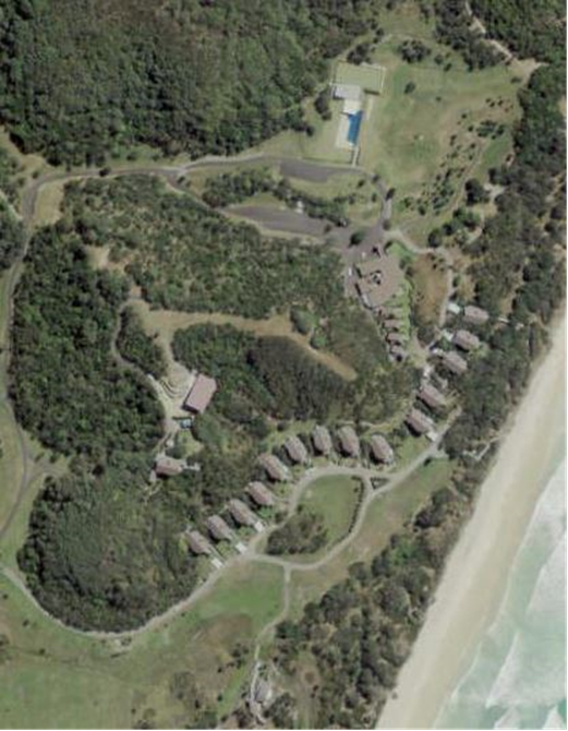
Figure 1: Subject
site (in part) showing existing structures
Planning Proposal
The planning proposal (Attachment 1) seeks to amend
Schedule 1 of Byron LEP 2014 and Schedule 8 of Byron LEP 1988 to
permit a community title development comprising
33 neighbourhood lots with a minimum size of 250 m2 and
one lot for association property on the subject land. The small
lots correspond with existing approved accommodation units on the property,
with the use of these buildings for the purpose of dwellings foreshadowed subject to future
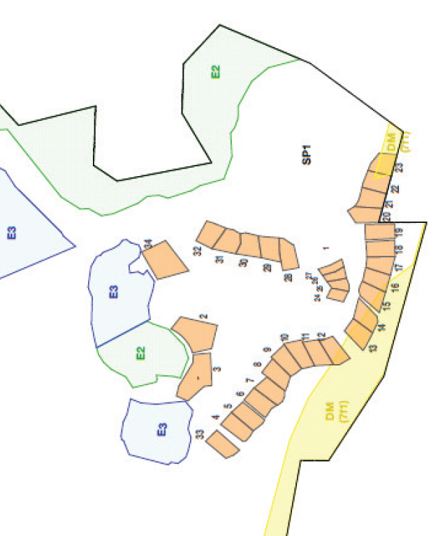
development consent. Figure 2 below provides an indicative
community title lot layout (subject to the findings of an updated coastal
hazard study), with existing zones shown on the map.
Byron Rural Land Use Strategy 2017 has
identified the subject land as a “priority
site for future rural lifestyle living opportunities”. The subject
land is identified for “Community Title conversion of approved
accommodation units only (i.e. no additional dwelling yield)”. This
strategy was endorsed by the NSW Department of Planning and
Environment (DPE) in July 2018.
Figure
2: Indicative community title lot layout and existing zone map
Issues
raised in the 16 April 2020 Submissions Report
The 16 April 2020 submissions report detailed a range of issues that prevent
the exhibited planning proposal from achieving its key objectives of regulating
community title subdivision and permitted land uses on the site.
A brief summary of these issues is
provided below:
Issues
relating to Byron LEP 2014 controls for the subject land
· The “zone objectives” of the SP1 Special
Activities are expansive and include “facilitate development”,
while the ‘mixed used development’ label permits any 2 uses
or more in relation to land uses on the site. Therefore, any
number of uses could be subject to a DA under this label and objectives.
For this reason, the objectives of the planning proposal that relate to land
use cannot be achieved under the current zoning. The resulting permitted
land uses do not align with the intended land uses envisioned by Council or the
DPIE.
· Byron LEP 2014 Schedule 1 – Additional Permitted Uses can only be used to add to land uses that are
already permissible under the current zoning and cannot be used to restrict
development that is already permissible. This means that the Schedule 1
clause cannot restrict use of the neighbourhood lots to the purpose of
dwellings (as per the planning proposal) due to the current zoning of the land
allowing for any 2 or more uses. Additionally, dwellings are a permitted
use under the zoning, making the proposed additional permitted use provision
redundant. This is primarily a result of the current SP1 Special
Activities zoning and ‘mixed used development’ label discussed
above.
· The existing Byron LEP 2014 community title subdivision
controls negate the need for a planning proposal to permit community title
subdivision on that part of the land zoned SP1 Special Activities –
Mixed use development under Byron LEP 2014. That is, Community title
subdivision is already permitted in the SP1 Zone on the subject land and the
number of lots is not restricted. For this reason, Byron LEP 2014
Schedule 1 – Additional Permitted Uses cannot be used to restrict
future community title subdivision of the land to 33 neighbourhood lots with 1
lot for association property (as intended by the current planning
proposal).
Issues
relating to proposed Byron LEP 1988 controls for the subject land
· There is concern that allowing the creation of lots for the purpose
of dwellings in the 7(f1) Coastal Lands Zone could expose Council to
liability risks in the event that property is damaged by coastal erosion
processes.
· At
the present time, a study has not been prepared that adequately establishes
coastal erosion processes south of Broken Head and on the subject land in
particular. The planning proposal cannot respond to, or effectively
manage coastal erosion risks in the absence of this study. In these
circumstances, Council is unable to make an informed decision in good faith as
per section 733 Local Government Act.
·
Following
consideration of the 16 April 2019 Council report, 20-158 resolved:
1. That
Council defer consideration of the planning proposal.
2. That
Council request staff to notify the applicant of this decision.
3. That Council request
staff to hold without prejudice discussions with the applicant to establish
options for proceeding with the proposed community title subdivision, either by
way of a development application and merit based assessment, or following a
further amendment to Byron LEP 2014 that rectifies the issues noted in this
report.
4. That Councillors
participate in a session at a Strategic Planning Workshop within this timeframe
to gain further information on this matter.
5. That Council
receive a further report that considers options to amend Byron LEP 2014 in a
manner that achieves the objectives of the applicant, Council, the DPIE
consistent with the objectives of the Rural Land Use Strategy in relation to
the subject land.
6. That these
discussions also consider the matter of establishing a Voluntary Conservation
Agreement to ensure creating protective design and infrastructure in place that
clearly delineates revegetation areas, protection zones particularly littoral
rainforest and wetland rehabilitation, prior to any granting of further
development.
Discussions with the
proponent and agreed outcomes
In accordance with items 3 and 6
of the above resolution, Council staff held without prejudice discussions with
the applicant. The outcomes are summarised below:
Key issues discussed on 27/4/20
and 1/5/20
· Staff discussed with the proponent the range of issues
noted in this report. The details of an amended planning proposal to
rectify these issues were considered.
· Staff advised that under the current planning controls, the
proponent has the option to submit a DA for Community Title subdivision and
conversion of approved accommodation units to dwellings. The proponent
indicated that they will pursue this option.
· Options for planned retreat in relation to coastal erosion
risks were discussed.
· Staff advised that a coastal study identifying the location
of the erosion escarpment and establishing future coastal erosion risks is
required for any DA or LEP amendment going forward. The proponent has
agreed to satisfy this requirement and will be submitting an updated coastal
hazard study for the subject land.
· Staff and the proponent agreed that the development
application and amended planning proposal can proceed concurrently.
Proponent to lodge DA for
Community Title subdivision
The proponent has indicated that
they will be submitting a DA for Community Title subdivision as permitted by
the existing planning controls. The proposed plan of subdivision seeks to
create 33 neighbourhood lots and 1 lot for association property. The community
title subdivision changes the tenure model for the site; however it does not
result in an expansion of development.
Neighbourhood lots will be located
in the SP1 Special Activities zone and align with approved accommodation
units located within that zone. It is worth noting that some of the
existing accommodation units encroach into the 7(f1) Coastal Lands Zone. Under the NSW planning system the applicant has the
option to seek a variation to development standards if an encroachment of the
lot into the 7(f1) Coastal Lands Zone can be justified. Among other considerations, any
such justification would need to be supported by the updated coastal hazard
study. The association lot will encompass the remainder of the
site.
As noted above, some of the
existing accommodation units encroach into the 7(f1)
Coastal Lands Zone and/or may be at risk of coastal
erosion processes, therefore a planned retreat strategy is necessary as part of
any subdivision approval. Vacant
‘relocation lots’ can be created in a suitable location in the SP1
Special Activities zone to allow for the orderly relocation of these
buildings, and corresponding conditions of consent can be applied as
necessary. It is important to note that the plan of subdivision and
planned retreat strategy will be informed by a coastal hazard study that
identifies the location of the immediate erosion escarpment and establishes
long-term coastal erosion risks in this area, as well as the framework
prescribed in Council’s DCP 2010 Chapter 1
Part J.
DCP 2010 Part J requires that a
building be relocated or demolished if the erosion escarpment comes within 50
metres of the building line. If the coastal study finds that an
existing building is already in breach of this rule, then a corresponding
neighbourhood lot will not be created in that location. However, a
corresponding ‘relocation lot’ will only be provided subject to
relocation conditions being applied to the existing development consent for the
subject building.
This is because relocation conditions were not applied to the original
consent conditions for some buildings on the site.
The proponent has also indicated
that they will seek to amend current approvals to replace 11 of the 3 bedroom
accommodation units with 27 one bedroom eco tourism cabins/treehouses.
This would result in a slight reduction in the total number of bedrooms
currently approved on the site and is a permitted use under the existing SP1
Special Activities
zoning.
Proponent to implement a
Conservation Agreement for the site
The proponent has indicated a
commitment to implementing an appropriate Biodiversity Conservation Act 2016
Conservation Agreement for the site. Proposed details of the
Conservation Agreement are expected to form part of the DA to be submitted by
the proponent. Consideration of the Conservation Agreement would take
place under that process, or under the planning proposal process if necessary
(under Section 7.4 of the Environmental Planning &
Assessment Act).
Council to prepare an amended
planning proposal addressing issues noted in this report
This report seeks Council’s
support for the preparation of a planning proposal that amends Byron LEP 2014
and Byron LEP 1988 in a manner that addresses the issues noted in this report
and achieves Council’s objectives in relation to this site. It is
anticipated that the amendment will include the rezoning of land zoned SP1
Special Activities to an E4 Environmental Living zone, and will
include an Additional Permitted Uses clause to manage land use.
Consequential amendments will also be required to certain clauses in Byron LEP
2014 that regulate community title subdivision.
The coastal study that informs the
impending DA will also inform the amended planning proposal for this
site. It is anticipated that the planning proposal will include
provisions that enable Council to manage land use in accordance with the
coastal erosion risks identified in the study.
The development application lodged
by the proponent and the planning proposal initiated by Council will need to be
complementary in terms of outcomes for this site, and it is expected that both
will progress concurrently.
Consideration of submissions lodged during the public
exhibition period
In accordance with the Gateway
determination, the planning proposal was placed on public exhibition for a period
of 4 weeks from 24 July to 23 August 2019, and consultation was undertaken with
relevant public authorities.
The 16 April Council report noted
that the exhibited planning proposal could not proceed due to fundamental
issues with the proposed planning controls. For this reason, submissions
could not be addressed in a meaningful way and hence did not form part of that
report.
This report recommends that
Council receive a further report to consider an amended planning proposal that
deals with these fundamental issues. It is appropriate that the
submissions already received during the public exhibition period be considered
in that report.
Recommended path forward
Having regard to the information presented in this report,
it is recommended that Council:
1) Support the
preparation of an amended planning proposal that rectifies the issues noted in
this report, with the proposed amendments to be considered under a separate
report to Council.
2) Require the proponent
to provide a current coastal hazard study that informs the amended planning
proposal to the satisfaction of Council.
3) Receive a further
report that considers (i) proposed amendments to the planning proposal, (ii)
the outcomes of the coastal hazard study, and (iii) submissions that were
received during the public exhibition period.
4) Continue to liaise
with the proponent to ensure that any development application lodged in
relation to this site is consistent with Council’s objectives for the
amended planning proposal.
STRATEGIC CONSIDERATIONS
Community Strategic Plan and Operational Plan
|
CSP Objective
|
L2
|
CSP Strategy
|
L3
|
DP Action
|
L4
|
OP Activity
|
|
Community Objective 4: We manage growth and
change responsibly
|
4.1
|
Support the visions and aspirations of local communities
through place-based planning and management
|
4.1.3
|
Manage development through a transparent and efficient
assessment process
|
4.1.3.10
|
Prepare and assess Planning Proposals and Development
Control Plans, and amend Local Environmental Plan maps
|
|
|
|
|
|
|
|
|
|
|
|
|
|
|
|
|
Legal/Statutory/Policy
Considerations
The relevant legal/statutory/policy considerations have been
noted above.
Financial Considerations
If Council chooses to proceed with the above
recommendations, further costs may be accrued in relation to the preparation of
an amended planning proposal. As the amended planning proposal is being
initiated by Council, it is appropriate that associated costs will be borne by
Council. However, it should be noted that the proponent is expected to
fund the updated coastal study in relation to the subject land.
Consultation and Engagement
Consultation has been undertaken
for the existing planning proposal in accordance with the Gateway
determination. If Council chooses to amend the planning proposal as
recommended in this report, a further report that details the proposed
amendments will be presented for Council’s consideration. It is
expected that further consultation will be required in relation to an amended planning
proposal.
Staff have had ongoing discussions
with the applicant as presented in this report.
Staff Reports - Sustainable Environment and Economy 13.4
Report No. 13.4 PLANNING
- Byron Shire Affordable Housing Contribution Scheme and Planning Agreements
Policy and Procedure
Directorate: Sustainable
Environment and Economy
Report Author: Natalie
Hancock, Senior Planner
File No: I2020/402
Summary:
The draft Byron Shire Residential Strategy sets out a
land-use vision that includes addressing housing affordability.
Council on 11 April 2019, in response to a report on State
Environmental Planning Policy No 70 Affordable Housing (Revised Schemes) (SEPP
70) resolved amongst other items, Res19-152: to prepare planning
agreement policy for Byron Shire .The purpose of this report is to provide
Council with a draft Byron Shire Affordable Housing Contribution Policy
(Attachment 1) and supporting Procedures (Attachment 2) setting a framework to
advocate for, facilitate, provide and manage affordable housing contributions
in Byron Shire.
Analysis supporting the draft Residential Strategy identified
limited opportunities for the market to meet the demand for affordable housing
in Byron LGA and significant underlying demand for affordable housing. The
analysis concluded that there is a gap between the current needs and supply of
rental accommodation for very low, low, and moderate income households and so
the collecting of affordable housing contributions by Council, where the
development remains viable, is warranted.
The purpose of this report is to seek Council support to
publicly exhibit draft Byron Shire Affordable Housing Contribution Policy
setting a framework to advocate for, facilitate, provide and manage affordable
housing contributions in Byron Shire acquired through a planning agreement or
delivered through an affordable housing contribution scheme.
In addition, this report provides an update on the status of
the establishment of a SEPP 70 Affordable Housing Contribution Scheme for Bryon
Shire.
|
RECOMMENDATION:
1. That
Council adopt the Draft Byron Shire Affordable Housing
Contribution Policy in Attachment 1 (E2020/33355) and accompanying
Procedures Attachment 2 (E2020/33359) and place the documents on public
exhibition for minimum a period of 28 days.
2. That
following exhibition, Council receive a further report detailing submissions
made. Should there be no submissions as of the close of the exhibition
period, that Council adopt the Draft Byron Shire Affordable Housing
Contribution Policy in Attachment 1 (E2020/33355) and accompanying Procedures
Attachment 2 (E2020/33359).
|
Attachments:
1 Attachment
1 Draft Byron Shire Affordable Housing Contribution Policy, E2020/33355
2 Attachment
2 Procedures to accompany draft Byron Shire Affordable Housing Contribution
Policy, E2020/33359
3 Special
Disclosure of Pecuniary Interest Annexure, E2012/2815
REPORT
The draft Byron Shire Residential Strategy sets out a
land-use vision that includes housing affordability.
Council on 11 April 2019, in response to a report on State
Environmental Planning Policy No 70 Affordable Housing (Revised Schemes) (SEPP
70) resolved amongst other items, (Res19-152) to prepare planning
agreement policy for Byron Shire .The purpose of this report is to provide
Council with a draft Byron Shire Affordable Housing Contribution Policy
(Attachment 1) and supporting Procedures (Attachment 2) setting a framework to
advocate for, facilitate, provide and manage affordable housing contributions
in Byron Shire.
Analysis supporting the draft Residential Strategy identified
limited opportunities for the market to meet the demand for affordable housing
in Byron Shire and significant underlying demand for affordable housing. The
analysis concluded that there is a gap between the current needs and supply of
rental accommodation for very low, low, and moderate income households and so
the collecting of affordable housing contributions by Council, where the
development remains viable, is warranted.
The purpose of this report is to seek Council support to
publicly exhibit a draft Byron Shire Affordable Housing Contribution Policy and
Procedures setting a framework to advocate for, facilitate, provide and manage
affordable housing contribution in Byron Shire.
While this Policy is not legally binding, it is intended
that the Council and all persons dealing with Council in relation to affordable
housing contributions will follow this policy to the fullest extent possible.
The Procedures for Affordable Housing Contributions is intended to assist with
implementation of the policy and to allow for more responsive approaches,
including shorter review cycles and realistic resource allocations.
Key aspects
Why is the policy warranted?
One of the objectives of the Environmental Planning and Assessment Act 1979 (the Act) is to promote the delivery
and maintenance of affordable housing. To do this the Act
incorporates a number of enabling mechanisms.
In the case of Byron Shire, Council has or is in the process
of activating the following mechanisms:
· Local Environmental
Plan 2014 Additional local provisions Clause 6.7 Affordable housing in
residential and business zones to enable imposing conditions relating to
providing, maintaining or retaining affordable housing - currently operational.
· Planning Agreements
with negotiated terms for affordable housing contributions as part of the early
implementation affordable housing project.
· SEPP 70 Affordable
Housing Contribution Scheme (AHCS) for lands that undergo an upzoning.
Upzoning means a change of zone to enable residential
development or a change of planning controls (such as floor space ratio) which
enables greater residential density on a site.
Regulations, S119 Directions and
the Guidelines for Development Affordable Housing Contribution
Schemes (NSW Govt. Feb 2019) all help to inform the terms under
which contributions for affordable housing can be accepted/required. Environmental Planning and Assessment (Planning Agreement)
Direction 2019 requires Council to prepare and publish a
policy that sets out the circumstances in which it may negotiate a Planning
Agreement for affordable housing contributions.
An Affordable Housing Contribution
Policy (Policy) provides a local context by setting out how Council intends to
operate the contribution framework in Byron Shire for housing acquired through
a planning agreement or delivered through an affordable housing contribution
scheme.
Who will be informed by this policy?
While this Policy is not legally binding, it is intended
that the Council and all persons dealing with Council in relation to affordable
housing contributions will follow this Policy to the fullest extent possible.
The Policy (Attachment 1) identifies guiding objectives. The objectives are to:
i. ensure
that the Council’s affordable housing contributions framework is
efficient, fair, transparent and accountable.
ii. encourage
and adopt innovative and flexible approaches to the provision of affordable
housing in a manner that is consistent with Byron Shire Council’s
strategic and infrastructure plans and as so enabled under the Act.
iii. give
local communities greater clarity about affordable housing contribution schemes
in Byron Shire by Council.
iv. give
local communities greater clarity about affordable rental housing planned in
their local area.
v. establish
a framework governing the use of Planning Agreements by Council for affordable
housing contributions.
vi. identify
the circumstances in which Council will and those where Council will not
consider entering a Planning Agreement and the contribution form that is
acceptable to Council.
vii. supplement,
but not replace or be in lieu of, the application to development of Byron Shire
Developer Contributions Plan established under the Act.
viii. give
stakeholders greater involvement in determining the type, standard and location
of affordable housing and other public benefits.
ix. allow
the community, through the community participation process under the Act, to
agree to the redistribution of the costs and benefits of development in order
to realise the community preferences for the provision of affordable housing.
What is the intent of the policy?
The draft Policy contains statements of intent setting out
Council’s policy position for facilitating, considering and accepting
affordable housing contributions. The draft
Policy includes amongst the statements of intent, a number of which have
previously not been made clear by Council to developers and the community.
These particular ‘intents’, are drawn from draft Residential
Strategy and the ongoing SEPP 70 Affordable Housing Contribution Scheme analysis
state Council:
1. Supports
a target of about of 60 -70 rental units for very low to moderate income
households via development affordable housing contribution schemes in the urban
areas over the next 15 to 20 years.
2. Favours
affordable housing contributions that improve the supply of smaller dwellings
(1- 2 bedroom) such as self contained units in retirement villages, residential
flat buildings and multi-dwelling housing suited to smaller households.
3. Seeks
the concurrent application of a SEPP 70 Affordable Housing Contribution Scheme
clause over land subject to an upzoning.
4. In
all cases, will determine the affordable housing contribution form, in order
to:
a) Support
a more even distribution of affordable housing within urban areas
b) Improve
housing choice, diversity and equity
c) Promote
affordable housing principles.
5. Supports,
where appropriate, use of Local Environmental Plan (LEP) maps to help
illustrate what is the preferred affordable housing contribution form for
certain land.
6. Supports
engaging with developers on Planning Agreements for the provision of affordable
housing however, acceptance of an offer to enter into a Planning Agreement is
at the absolute discretion of Council.
7. Respects
in setting contribution rates, the NSW government policy position of a need for
a developer’s ability to achieve an investment return in order to
maintaining a sustainable development market and continued housing supply.
8. Guides
the Residential Strategy to set a minimum affordable housing contribution rate
for areas based on Council’s understanding of development feasibility.
How does the policy and procedures guide the
contribution making process?
To assist Council, developers and the community understand
the contribution process the policy is accompanied by a set of procedures
including a flow diagram for upzoning processes. A copy of the diagram is shown
below:
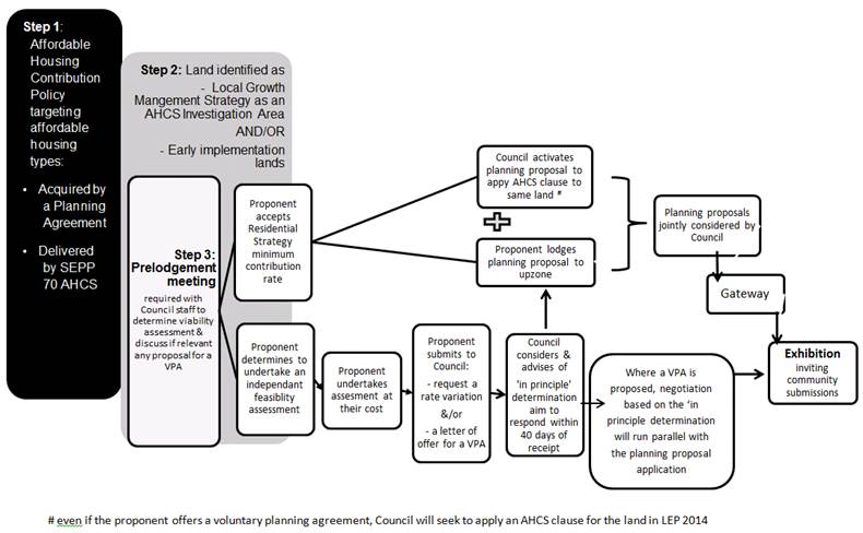
Key points in the contribution process
· The use of the
term proponent means the landowner and/or developer making a development
application or a request for an LEP instrument change.
· Even if the
proponent offers a voluntary Planning Agreement for affordable housing, Council
will seek to apply an AHCS clause for the land in LEP 2014. The basis for this
is to cover instances where the Planning Agreement falls over or where further
upzonings are sought after the initial upzoning.
· Even though the
Residential Strategy will set a contribution rate, scope will be provided for
proponents to as part of a planning proposal for the upzoning and AHCS
undertake an independent viability testing for their individual
precincts/project.
· Council may
negotiate an alternative contribution rate request by a proponent in connection
with any upzoning planning proposal. A report containing the independent
viability testing undertaken in line with the Guidelines for Development
Affordable Housing Contribution Schemes (NSW Govt. Feb 2019) will need to be
undertaken at the proponent’s expense and submitted with the request.
· Before undertaking
an independent viability testing a planning proposal pre-lodgement meeting is
to be held with Council staff to discuss the upzoning, alternative contribution
rate request and set terms for the testing.
· An offer for a
Planning Agreement or a request for a contribution rate variation is to be made
in writing to the Council by the developer before lodging a planning proposal
application.
· Council
will aim to consider the offer/request within 40 days of receipt and advise of
the proponent of the ‘in principle determination’ to enable the
proponent to progress with the lodgement of the planning proposal. This
‘in principle’ determination will provide the basis for the
Planning Agreement negotiation and preparation of the AHCS. The Policy includes
capacity for Council to delegate this advisory determination process in the
interest of efficiency.
· The acceptance of
a request for an alternative contribution rate and/or offer for a Planning
Agreement is at the absolute discretion of Council.
The pre-lodgement meeting and offer for a Planning Agreement
or a request for a contribution rate variation steps will assist Council and
the proponent to reach agreement on the key issues and information necessary to
justify further consideration of the proposed change to land use or development
controls. It will also ensure that a proponent does not commit time and
resources undertaking unnecessary studies or preparing information that does
not address the main areas of concern with appropriate detail.
Where are affordable housing contributions
anticipated?
The procedures supporting the Policy set the form under
which a contribution may be accepted:
In case of AHCS, Council can determine an affordable housing
contribution in the following forms:
a) a
percentage of dedicated floor space
b) land
(may be part of the said land, or other land of the applicant)
c) monetary
contribution or
d) combination
of the above
In the case of a Planning Agreement, the Policy limits the
contribution form to land only. The land must be fit for residential purpose.
Included in the Policy ‘statements of intent’ is
one that states;
Council guides the Residential Strategy to set a minimum
affordable housing contribution rate for areas based on Council’s
understanding of development feasibility.
The procedures provide more detail as to the likely rates
and where housing may be delivered:
Greenfield Investigation Areas
• Mullumbimby private land greenfield
housing contribution areas: 5% of the additional lots or developable areas
whichever the greater that is to be used for residential uses
• Mullumbimby Council land greenfield
housing contribution areas: 15% of the additional lots or developable areas
whichever the greater that is to be used for residential uses.
• Bangalow greenfield housing contribution
areas: 5% of the additional lots or developable areas whichever the greater
that is to be used for residential uses.
• Belongil greenfield housing contribution
area: 5% of the additional lots or developable areas whichever the
greater that is to be used for residential uses.
Infill Investigation Areas
• Mullumbimby old hospital Council land
housing contribution area: 15% of the additional dwellings or total gross floor
area that is to be used for residential uses
• Byron Bay Town Centre housing
contribution area: 3% of the additional total gross floor area that is
to be used for residential uses and 1% of non- residential total gross floor
area
The above contribution rates are a work in progress at this
time, figures will be further rationalised as part of the implementing of an
AHCS. They are considered to be reasonably reflective of what may be expected
based on maintaining development viability. The rate is set at a higher level
for Council land as it is assumed Council will not be seeking the same return
on investment margin as a property developer. The private land feasibility
includes a 10 - 15% risk margin, usually expected by financiers.
The Policy continues on to state that… in the
interest of transparency, Table 1: Investigation areas affordable housing yield
shows potential affordable dwellings yields for each area when applying the
above rates. The areas listed have been publicly exhibited as an
investigation upzoning in forward planning documents and/or a planning
proposal.
Table 1:
Investigation areas affordable housing yields
|
Area
|
Potential rental affordable housing yield
|
Activating referencing document
|
|
Mullumbimby non Council land
|
17 dwellings
|
Residential Strategy
|
|
Mullumbimby Lot 22
|
15 dwellings
|
Residential Strategy
|
|
Mullumbimby old hospital
|
10 dwellings
|
Mullumbimby Master Plan
|
|
Bangalow
|
5 dwellings
|
Residential Strategy
|
|
Belongil
|
1 dwelling
|
Residential Strategy
|
|
Byron Bay town centre
|
10 dwellings
|
Byron Town Centre Master Plan & 26.2017.6.1 Planning
Proposal – FSR removal
|
Will it apply to all
development in these areas?
The Guidelines for AHCS
require an affordable housing contribution scheme to clearly state the types of
development that are exempt from a contribution levy and why. The Procedures
guides exemptions, with sample below:
• community facilities
• residential purposes that will result in
the creation of less than 200 square metres of total floor area or
• non-residential purposes that will result
in the creation of less than 60 square metres of total floor area or
• refurbishment of non-residential or
residential development when no change of use or increase in floor space areas
occurs
• child care centres
• schools.
Using the Procedures as
overarching guidance on possible exempt developments, as well as the LEP 2014,
the AHCS could provide a statutory list of exemptions, most likely in a
schedule. As a proposed AHCS is required to be exhibited, the process is
open and transparent to the community as to what is exempted from a levy.
What is intended on receipt
of contributions?
The Procedures indicates that Council
will establish an affordable housing delivery program articulating terms
guiding contribution collection, responsibilities of a private certifier, contribution
administration, administrator selection and accountability.
They also indicate intent of Council to retain ownership of
the assets and to select one or more non-profit housing organisations to
deliver and manage housing generated under affordable housing contributions.
How do the Policy, Procedures and SEPP 70 Affordable
Housing Contribution Scheme work together?
The Policy and Procedures provides a framework for housing
contributions to be acquired through a planning agreement or delivered through
an affordable housing contribution scheme.
As reported to the December 2019 Council meeting, work is
progressing on an affordable housing contribution scheme under SEPP 70 for
Byron Shire. Since December, feasibility investigations have:
• established a need for affordable
housing; and
• determined that a scheme would have
a general ‘likely viability’ on certain proposed new release
residential lands in the Shire.
At this stage, Council initiated planning proposals such as
Lot 22, Mullumbimby upzoning are anticipated to be the initial land in Byron
Shire to which an affordable housing contribution scheme will be applied.
Staff have sought Departmental of Planning, Industry and
Environment input on the proposed pathway for introduction of the scheme focusing
on:
i. The
ability for Council, concurrent to processing a rezoning request, to seeking an
amendment of Byron LEP 2014 so as to applying a SEPP 70 AHCS clause
ii. The
inclusion of ‘land’ as a contribution form option
iii. Use
of LEP Maps to depict differing contributions forms within specific identified
lots/areas.
Verbal advice received to-date
indicates that this approach, may be acceptable to the Department and that
Council could expect a formal response over the coming weeks.
On this basis, the Affordable
Housing Contribution Policy has been framed.
Next steps for the draft
Policy
This Policy although not legally binding is necessary to
provide Council and all persons dealing with Council guidance in relation to a
AHCS.
As staff are currently drafting
AHCS clauses in LEP 2014 for Council lands and require a policy on Planning
Agreements for affordable housing contributions, it recommended that Council adopt
for public exhibition the attached draft Byron Shire AHCS and Procedure; and:
a) should
no submissions be received, be determined as adopted from date that public
exhibition closes.
b) should
submissions be received that all submissions be reported back to Council.
Length of time for consultation
on the draft Policy
Council must
give public notice of a draft Policy after it is prepared under Local Government Act 1993 – Section 160
Public notice and exhibition of draft local policy.
Under Local Government Act 1993
– Section 160 the period of
public exhibition must be not less than 28 days.
STRATEGIC CONSIDERATIONS
Community Strategic Plan and Operational Plan
|
CSP Objective
|
|
CSP Strategy
|
|
DP Action
|
|
OP Activity
|
|
Community Objective 4: We manage growth and
change responsibly
|
4.2
|
Support housing diversity in appropriate locations
across the Shire
|
4.2.1
|
Establish planning mechanisms to support housing that
meets the needs of our community
|
4.2.1.4
|
Investigate and implement planning controls to encourage
an increase in the supply of affordable and inclusive housing stock (Action
in Residential Strategy)
|
|
|
Community
Objective 4: We manage growth and change responsibly
|
4.2
|
Support
housing diversity in appropriate locations across the Shire
|
4.2.1
|
Establish
planning mechanisms to support housing that meets the needs of our community
|
4.2.1.3
|
Prepare an
Affordable Housing contribution scheme under SEPP 70 to be incorporated in
the local planning framework controls (Action in Residential Strategy)
|
|
|
|
|
|
|
|
|
|
|
|
|
|
|
|
North Coast Region Plan 2036
Direction 25 Deliver more
opportunities for affordable housing
5.1 Deliver more opportunities for
affordable housing by incorporating policies and tools into local growth
management strategies and local planning controls that will enable a greater
variety of housing types and incentivise private investment in affordable
housing.
Byron Shire Draft Local
Strategic Planning Statement
A Liveable Shire
Local Priority 3: Support housing
diversity and affordability with housing growth in the right locations.
Byron Shire Draft
Residential Strategy
Policy 2: Improved housing choice,
diversity and equity
DIRECTION 2.1: Enable
opportunities for innovative new residential forms and models that give a sense
of place, promote environmental stewardship and encourage social, economic and
cultural diversity and equity.
DIRECTION 2.2: Facilitate and
promote growth in the proportion of rental and to buy housing aimed at the
lower end of the market, including those with very low incomes.
Legal/Statutory/Policy Considerations
As
discussed in the report.
Financial Considerations
Not
applicable to this report.
Consultation and Engagement
Consultation and engagement will be provided in a manner
consistent with management requirements in dealing with COVID 19.
Staff Reports - Sustainable Environment and Economy 13.5
Report No. 13.5 PLANNING
- 26.2018.4.1 Environmental Zone Implementation Program: Stage 2 Planning
Proposal 'Submissions Report'
Directorate: Sustainable
Environment and Economy
Report
Author: Alex
Caras, Land Use Planning Coordinator
File No: I2020/403
Summary:
Council at its 22 March 2018
Ordinary Meeting resolved (Res 18-186) to implement the Department’s ‘Northern Councils E Zone Review Final Recommendations Report’ in several stages to deliver more
timely and effective outcomes for affected landowners.
The
engagement process to date has been robust,
constructive and well received by the majority of those affected. The conciliatory and consistent approach taken by staff to
achieve agreed outcomes has also generated a
considerable amount of goodwill for Council.
Stage 2 Planning Proposal (PP2) applies
environmental and non-environmental zones to 619 properties in the Shire based
on agreed outcomes. Approximately 1,900 hectares of environmental (E2/E3)
zones will be applied in PP2. It also amends other LEP 2014 maps such as
Minimum Lot Size, Height of Building, Drinking Water Catchment and Acid Sulfate
Soils Maps.
This report presents:
· a summary of submissions received during exhibition of
Stage 2 Planning Proposal; and
· proposed property-specific LEP mapping amendments for
adoption.
NOTE TO COUNCILLORS:
In accordance with the
provisions of S375A of the Local Government Act 1993, a Division is to be
called whenever a motion for a planning decision is put to the meeting, for the
purpose of recording voting on planning matters. Pursuant to clause 2(a)
under the heading Matters to be Included in Minutes of Council Meetings of
Council's adopted Code of Meeting Practice (as amended) a Division will be
deemed to have been called by the mover and seconder of all motions relating to
this report.
|
RECOMMENDATION:
1. That
Council adopt the property-specific
LEP mapping amendments identified in Table 1 of this report.
2. That
Council forward a revised Stage 2 Environmental Zoning planning
proposal (incorporating Table 1 mapping amendments) to the NSW Parliamentary
Counsel’s Office requesting that a draft LEP instrument be prepared.
3. That
Council liaise with Parliamentary Counsel’s Office (PCO)
as necessary to finalise the content of the draft LEP and to enable PCO to
issue an Opinion that the plan can be made.
4. That
Council request that the NSW Department of Planning and
Environment, as the plan-making authority in this instance, make the final
LEP for notification on the NSW Government legislation website.
5. That Council
note when Council has considered the submissions
received during public exhibition and has endorsed the final planning
proposal, landowners whose land will be subject to an E zone are to be
notified in writing of Council's decision and advised that they have 28 days
to notify the Department of Planning and Environment to request a review of
the proposed zoning of their property.
|
Attachments:
1 Confidential
- 26.2018.4.1 E Zones PP2 submissions, E2020/28918
2 Agency
Responses - Stage 2 E Zone Implementation Program, E2020/31116
3 Form of
Special Disclosure of Pecuniary Interest, E2012/2815
REPORT
Council at its 22 March 2018
Ordinary Meeting resolved (Res 18-186) to implement the Department’s ‘Northern Councils E Zone Review Final Recommendations Report’ in several stages to deliver more
timely and effective outcomes for affected landowners. An overview of the
latest staged implementation program is shown in Figure 1 below.
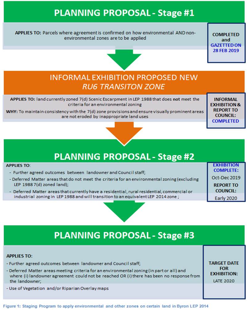
The Stage 1 Planning Proposal was
adopted by Council on 20 June 2019 and gazetted on 28 February 2020.
Reports on the status of the staged E zone implementation program were considered at the
22 November 2018 and 12 December 2019 meetings of Council, where (on both
occasions council resolved to re-allocate funds from other planning projects in
order to continue to progress the staged E
zone implementation program and build on the high level of community goodwill
generated through the preparation of Planning Proposals 1 and 2.
The purpose of this report is to
present:
· a summary of submissions received during exhibition of
Stage 2 Planning Proposal; and
· corresponding property-specific LEP mapping amendments for
adoption.
Planning Proposal #2
Planning
Proposal 2 (PP2) applies environmental and
non-environmental zones to 619 properties in the Shire based on agreed
outcomes. Approximately 1485 ha of E2 Environmental Conservation
zones and 400 ha of E3 Environmental Management zones will be applied in
PP2. It also amends other LEP 2014 maps such as Minimum Lot Size, Height of
Building, Drinking Water Catchment and Acid Sulfate Soils Maps.
PP2 was submitted to Department of
Planning & Environment for gateway determination in December 2018. A
positive gateway determination was received in June 2019 subject to the
following conditions:
· Consulting with following government agencies (during
exhibition):
- NSW Rural Fire Service;
- Office of Environment and Heritage;
- NSW Department of Primary Industries;
- the Local Aboriginal Land Council; and
- NSW Division of Resources and Geoscience
· Notifying all affected landowners in writing of the
planning proposal and the public exhibition arrangements
· Amending the planning proposal as follows:
- section 1.3 is to be corrected to clarify that the proposal
now applies to 618 land parcels;
- section 3.1 (last paragraph on page 11) is to be amended to
clarify that the proposed E2 and E3 land use tables will be added to Byron LEP
2014 through the Stage 1 planning proposal;
- the discussion on section 9.1 direction 1.5 Rural Land in
Appendix 1 is to be updated to reflect the revised direction which no longer
refers to SEPP (Rural Lands) 2008; and
- the maps in Appendix 5 of the planning proposal are to be
amended to ensure all polygons which depict proposed zones and development
controls are labelled clearly and correctly.
· When Council has considered the submissions received during
public exhibition and has endorsed the final planning proposal, landowners
whose land will be subject to an E zone are to be notified in writing of
Council's decision and advised that they have 28 days to notify the Department
of Planning and Environment to request a review of the proposed zoning of their
property.
Public
Exhibition and submissions received
PP2 was exhibited from 6 October to 6 December 2019. Forty
eight (48) public submissions were received and these are summarised in Table 1
below. Confidential copies of the submissions are contained in Attachment
‘1’.
Table 1 – Summary of public
submissions received
|
Subject
land (Parcel No)
|
Issue
/ Comment
|
Response
|
|
1. 11 Coolamon Avenue
Mullumbimby (PN 12180)
|
E2019/79606
Requests that exhibited RU2 Rural Landscape zone
be changed to R5 Large Lot Residential (consistent with
adjoining R5 zone on this land), with small expansion of E2 Environmental
Conservation in SE corner, resulting in only 2 zones (instead 3) for
this property.
|
Minor changes applied to as per submission [namely:
RU2 zone changed to R5 (pink); small expansion of E2 zone in SE corner
(green)].
Lot Size map updated accordingly (see below).
|
|
|
‘As Exhibited’: Zones
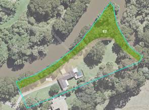
|
As Amended’: Zones
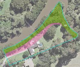
Lot Size (R5 = 4000m2
/ E2 = 40ha)
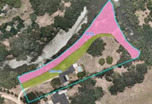
No change to Max Building Height
(9m)
|
|
2. 1034
Main Arm Rd Upper Main Arm (PN 117350)
|
E2019/75503
A missing parcel in same
ownership as adjoining land (immediately north) was excluded by
oversight. Include missing parcel in PP2 by applying E3 Environmental
Management zone over riparian area and RU2 Rural
Landscape zone over remainder, consistent with adjoining parcel.
|
Changes
applied as per submission.
Lot
Size AND Max Building Height maps updated accordingly (see below).
|
|
|
‘As Exhibited’: Zones
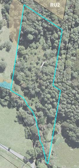
|
As Amended’: Zones
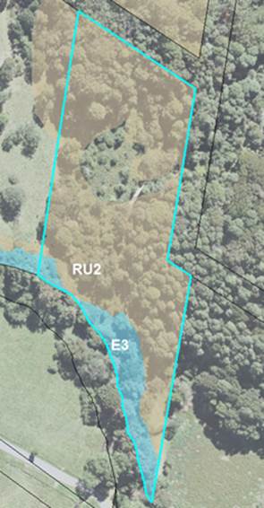
Lot Size (40ha)
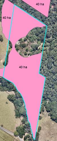
Max Building Height (9m)
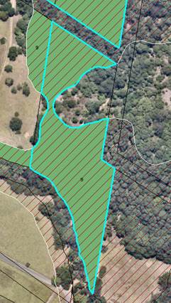
|
|
3. 10
Hamiltons Lane Byron Bay (PN 240081) and Cemetery Rd Byron Bay (PN 240082) J
|
E2019/81070
Requests that: (i) both parcels (10 Hamiltons Lane and
65 Cemetery Road) be included in draft Planning Proposal 2, as they are
in same ownership; and (ii) an RU2 Rural Landscape zone be
applied to the residual 1A General Rural zone
areas of both parcels.
|
Changes applied as per
submission.
Lot Size AND Max Building
Height maps updated accordingly (see below).
|
|
|
‘As Exhibited’: Zones
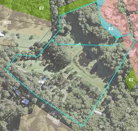
|
‘As Amended’: Zones
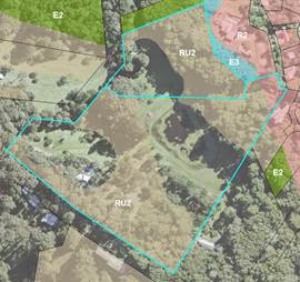
Lot Size (40ha)
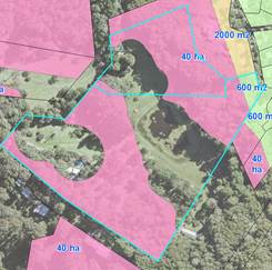
Max Building Height (9m)
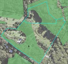
|
|
4. 10
Coolalie Place Byron Bay (PN 212480) T
|
E2019/81070
Correct existing zone boundary issue so that house +
back garden are included in R2 Low Density Residential zone,
(previously 2a Residential Zone), with RU2 Rural Landscape zone
applied to the remaining 1A General Rural zone on subject
land.
Landowner not supportive of RU2 Rural Landscape
zone
|
Applying RU2 Rural Landscape zone over
remaining 1A General Rural zone is consistent with
surrounding landscape.
Maps below show correct zone areas, lot size and Max building Height (9m) for subject land
|
|
|
‘As Exhibited’: Zones
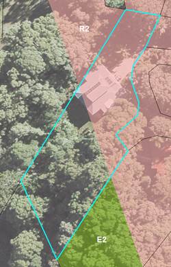
|
‘As Amended’: Zones
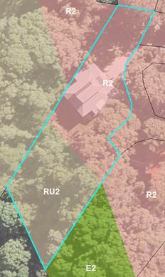
Lot Size (RU2 = 40ha / R2 = 600m2)
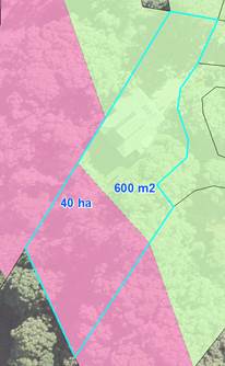
Max building Height (9m)
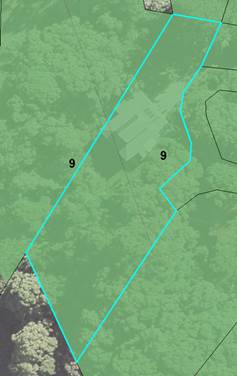
|
|
5. Seacliffs
Hayters Drive Suffolk Park (PN 268113)
|
E2019/81230
Amend boundaries of E2
Environ-mental Conservation zone to
exclude approved housing lots, all of which should be zoned R2
Low Density Residential zone consistent with existing R2 zoning on
subject land.
|
E2 Environmental
Conservation zone amended to R2
Low Density Residential zone on approved housing lots, as
per submission.
|
|
|
‘As Exhibited’: Zones
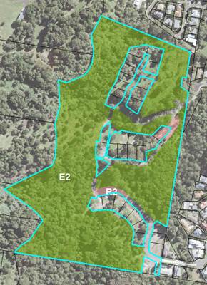
|
‘As Amended’: Zones
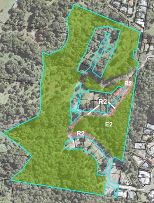
|
|
6. 21 Kingsvale Rd
Myocum (PN 39350)
|
E2019/79635
Requests that previously agreed E3 Environmental
Management zones be changed to E2 Environmental Conservation
|
By oversight,
landowner’s submission referred to an earlier version of a map showing
both E2 & E3 zones on the subject land, and not the PP2 exhibited map (showing E2 zone only). Therefore no change as
proposed E2 zoning is correct as per the exhibited PP2 map (below left).
|
|
|
‘As Exhibited’:
Zones
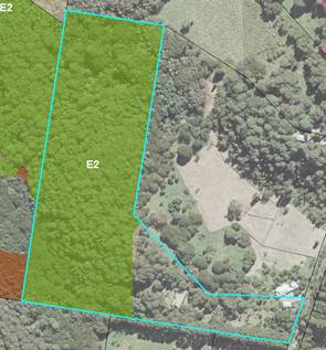
|
|
|
7. 274 Wanganui Rd
(PN 210170)
|
E2019/79639
Requests that a small area of Lantana ¾ previously agreed E3 Environmental
Management zone ¾
be changed to RU2 Rural Landscape zone
|
Minor change applied as per submission.
|
|
|
‘As Exhibited’: Zones
  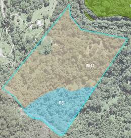
|
‘As Amended’: Zones
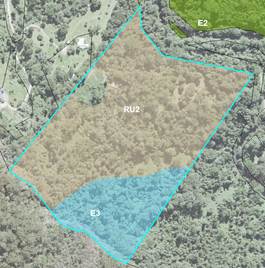
|
|
8. 373 Left Bank
Rd, Mullumbimby Creek, (PN 240038)
|
E2019/80980, E2019/80960
Requests that proposed RU1 Primary Production
zone (previously Agricultural
Protection (b1) Zone)
be amended to RU2 Rural Landscape zone, consistent with
the current land use as a school.
|
Minor changes applied as per submission.
|
|
|
‘As Exhibited’:
Zones
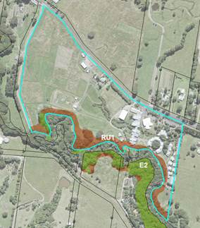
|
‘As Amended’:
Zones
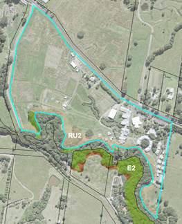
|
|
9. 59B Kingsvale
Road, Myocum
(PN 195290)
|
E2019/84285
Submission relates to site features that do not affect
proposed zones on subject land.
|
No change to proposed zoning as the exhibited PP2 map (below left) was correct.
|
|
|
‘As Exhibited’: Zones
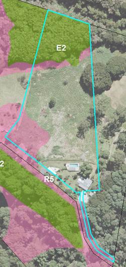
|
|
|
10. Coopers
West Lane (PN 15690)
|
E2019/90464
Submission was supportive of
the mapped/exhibited E-zones and rezoning process. However notes that mapping
of the zone boundaries and cadastral alignment problems need to be rectified.
|
Cadastral
issues to be amened in future as part of a shire wide rectification process,
but in the meantime proposed zoning to follow vegetation so subject land can
be finalised for gazettal.
Therefore
no change to exhibited map (below left).
|
|
|
‘As Exhibited’: Zones
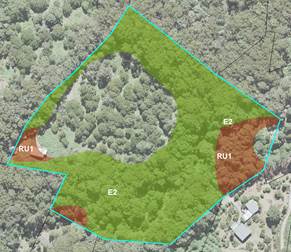
|
|
|
11. 315
Coorabell Rd Coorabell (PN16630)
|
Change proposed RU2 zones to E2
Environmental Conservation zoning as per approved Vegetation
Management Plan for DA 10.2019.236.1 (Community Title subdivision of Approved
Multiple Occupancy).
|
Changes applied as per
submission.
|
|
|
‘As Exhibited’: Zones
|
‘As Amended’:
Zones
|
|
12. 62 Tickles Rd Upper Coopers Creek (PN
93560)
|
E2019/85455
Site visit found proposed E2 zone areas comprise
mainly regrowth and planted Blackbutt. E3 Environ-mental
Management zone was agreed for consistency with 2 similar adjoining
properties and land use, including forestry.
|
E2 zone areas changed to E3 Environmental
Management zone, for consistency with surrounding properties and
potential farm forestry.
|
|
|
‘As Exhibited’: Zones
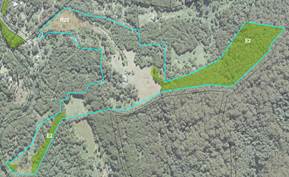
|
‘As Amended’: Zones
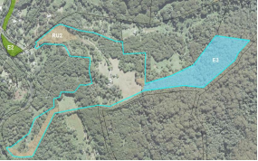
|
|
13. 25 Goonengerry Rd Goonengerry
(PN 29610)
|
E2019/76972
Supports proposed E2/R5 zones; however requests change
to the Drinking Water Catchment DWC map layer to align with proposed
E2 zoning.
|
Exhibited DWC map only shows LEP updates on the
‘Deferred Matter’ area of this parcel, not the entire
parcel. The DWC map will apply to entire parcel once planning proposal
is finalised.
Therefore no change required.
|
|
|
‘As Exhibited’:
Zones
(E2 = green / R5 = pink)
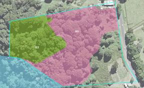
|
|
|
14. 89 Parmenters Rd (PN 190690)
|
E2019/90559, E2020/17044
Requests minor change from E2 Environmental
Conservation zone to E3 Environmental Management zone
allow a dam to be built for drought storage and access for fire.
|
E2020/17044 – Confirmed with WaterNSW that dams
allowed in all zones. An E2 zone will not affect
landowner’s ability to apply for a water storage dam via the
applicable legislation.
No change to mapping.
|
|
|
‘As Exhibited’:
Zones
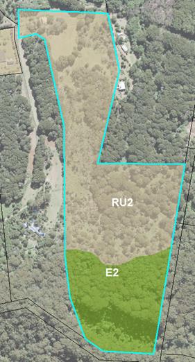
|
|
|
15. 499A Binna Burra Road, Federal
(PN 159390, 238679)
|
E2019/88518
Objects to application of
Drinking Water Catchment (DWC) map to affected part of property.
|
DWC mapping layer is fixed by
State government and can only be amended by State Govt. It is a mandatory map
relating to clause 6.5 in LEP 2014.
Landowner was contacted with an
explanation of the above.
No change to mapping.
|
|
|
‘As Exhibited’: DWC map
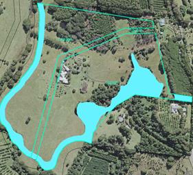
|
|
|
16. 242
Broken Head Rd, SUFFOLK PARK
(PN 135130)
|
E2019/89281 plus others
Requests change in Minimum Allotment Size from 40ha to
600m2 to allow subdivision potential consistent with surrounding
residential zoned lots.
|
Changes applied as per submission.
|
|
|
‘As Exhibited’: Lot size (40ha)
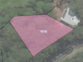
|
‘As Amended’: Lot size (600m2)
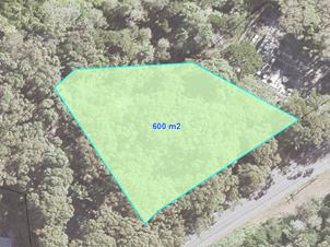
|
|
17. 94 Cemetery Rd. Byron Bay (PN 10060)
|
E2019/89397
Requests
that the floor space ratio be changed from 0.3:1 to 0.5: 1 for this parcel,
citing differences from remaining urban lots in Lilli Pilli
|
Due to large size of land in
the proposed R2 zone (> 7,000m2), there are no compelling
reasons for applying a 0.3:1 FSR. A 0.5:1 FSR is considered acceptable
and the map has been amended accordingly.
|
|
|
‘As Exhibited’ (FSR = 0.3:1)
|
‘As Amended’ (FSR = 0.5:1)
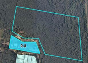
|
|
18. 17
Scenic Vista Ewingsdale (PN68602 PN88600).
|
E2019/90623
Requests that small areas in north originally mapped
as E2 Environmental Conservation zone
be changed to RU2 Rural Landscape zone. This change was
already made before exhibition. Large E2 Environ-mental
Conservation zone was exhibited
correctly.
|
No change.
|
|
|
‘As Exhibited’: Zones
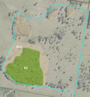
|
|
|
19. 409 Coorabell Road, Coorabell
(PN 241401)
|
PFP S2019/9564
Received notification of Timber
plantation agreement over part of the site (11 Dec 2019).
|
Minor amendments to zoning map
amended to exclude timber plantation areas from E2 Environmental
Conservation zone.
|
|
|
‘As Exhibited’: Zones
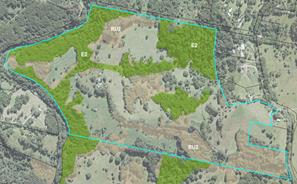
|
‘As Amended’: Zones
 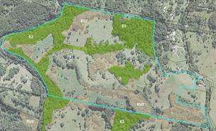
|
|
20. Johnsons Rd Huonbrook (PN34040)
|
E2019/81223
Requests area around
existing house be changed from E3 Environmental Management to RU2 Rural Landscape zone, consistent with neighbouring lands and existing land
use.
|
Changes applied as per submission.
|
|
|
‘As Exhibited’:
Zones
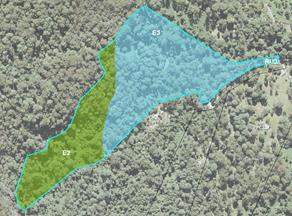
|
‘As Amended’:
Zones
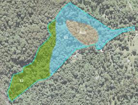
|
|
21. 1016
Wilsons Creek Road WILSONS CREEK
(PN99350)
|
E2019/78629, E2019/93312
Concerned that E-zoned sections of the property extend
outside the mapped cadastral boundary, so would miss out on being zoned E2
Environmental Conservation because they
appear to be on the neighbours property.
|
Cadastral issues to be
amened in future as part of a shire wide rectification process, but in the
meantime proposed zoning to follow vegetation so subject land can be finalised
for gazettal.
Therefore no change to
exhibited map (below left).
|
|
|
‘As Exhibited’: Zones
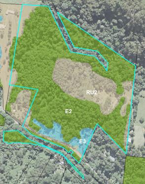
|
|
|
22. 131 The Tunnel Rd,
Billinudgel (PN93350)
|
E2019/74919, E2020/6584
Requests no E zone anywhere on the property as primary
land use is agricultural.
|
As both of the exhibited E2 Environmental
Conservation zones were less than 0.5 ha,
the zoning of these areas has been amended to RU2 Rural
Landscape zone), consistent with remainder of property.
|
|
|
‘As Exhibited’: Zones
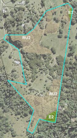
|
‘As Amended’: Zones
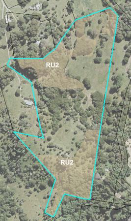
|
|
23. 361 Huonbrook Rd
Huonbrook
(PN210910)
|
E2019/78064
Supports proposed mix of E2/RU2 zoning, but queried
Drinking Water Catchment (DWC) layer and potential for Community title on
land (unrelated to this planning proposal. Landowner contacted to explain
these matters.
|
DWC mapping layer fixed by
State government and can only be amended by State Govt. It is a mandatory map
relating to clause 6.5 in LEP 2014.
Therefore no change to mapping.
|
|
|
‘As Exhibited’: DWC map
|
|
|
24. 252 Settlement Rd Main Arm
(PN
81610)
|
E2019/79603
E2019/79603
Exhibited
E2 Environmental Conservation
area considered invalid, as area contains an access road, powerlines and very
few trees, therefore lacking an E zone vegetation structure.
|
Zoning map amended to remove E2
zone and replace with RU1 zone, consistent with
submission request and surrounding zoning on this property.
|
|
|
‘As Exhibited’:
Zones
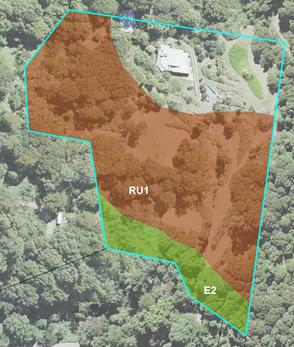
|
‘As Amended’:
Zones
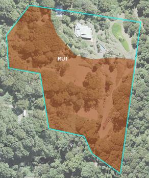
|
|
25. 1356
Main Arm Rd Upper Main Arm (PN 47560)
|
E2019/89421
Supports proposed zones on this property, but suggests
that the adjoining E3 Environmental Management zone on eastern
neighbours (Kohinoor Pty Ltd) land be changed to E2 Environmental
Conservation to strengthen wildlife corridor, as per map provided.
|
This request was discussed with Kohinoor Pty Ltd, but
a historical multiple occupancy share exists near boundary, an E3 Environmental
Management zoning is considered more suitable.
No change
|
|
|
‘As Exhibited’:
Zones
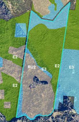
|
‘As Amended’:
Zones
|
|
26. 11 Luan Court Byron Bay (PN 211770)
|
E2019/89775
Objects to R2 Low Density
Residential zone zoning in favour of E4
Environmental Living, consistent with
the established environmental values and community character of the Lilli
Pilli neighbourhood.
|
The Northern Councils E Zone
Review FINAL Recommendations Report (2015) stipulates that Byron Shire
Council shall “apply a suitable residential zone to that land where
an E4 zone was proposed under the draft Byron LEP”. This
includes the
Lilli Pilli neighbourhood.
No change.
|
|
|
‘As Exhibited’ (proposed R2 zone)
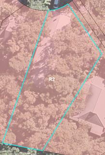
|
|
|
27. 294 Skinners Shoot Rd
(PN
84380)
|
E2019/79204
Support
for the zoning RU2 Rural Landscape zone.
|
Noted.
No change.
|
|
|
‘As Exhibited’:
Zones
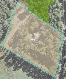
|
|
|
28. 47
Cemetery Rd
(PN 267630)
|
E2019/89764
Requests that the floor
space ratio be changed from 0.3:1 to 0.5: 1 for Lilly Pilly, as site coverage
is a more effective control
|
The 0.3 FSR applied to properties in the 'Lilli Pilli'
residential area is consistent with the draft LEP 2012 exhibition mapping,
due to its established environmental setting and character.
No change.
|
|
29. 121-123
Broken Head Rd Suffolk Park
(PN 2970)
|
S2019/9169, S2019/9170
Confusion about proposed R5
Large Lot Residential zoning, as mistakenly thought zone was changing
to RU2 Rural Landscape zone and
doesn’t want the current 2A residential zoning to change.
|
Landowner was contacted and
proposed zoning explained.
It was agreed to treat this
parcel the same as the surrounding land in this precinct, namely:
· change proposed R5 Large Lot Residential Zone to
R2 Low Density Residential Zone
· change proposed 4,000m2 Min Lot Size to 2,000m2
Min Lot Size, consistent with draft LEP 2012 exhibition map for this precinct
(i.e. before becoming DM)
|
|
|
‘As Exhibited’: R5 Zone proposed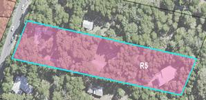
|
‘As Amended’: R2 Zone proposed
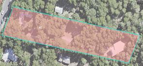
Lot size (2,000m2)
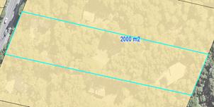
|
|
30. 17 Ti
Tree Road
(PN 94260)
|
E2019/85184
Does not support proposed
environmental zoning (shown below in green), but no reasons given.
|
Current property zonings are
7a Wetlands zone and 7b
Coastal Habitat Zone. As vegetation in these areas
still satisfies criteria for
E2 Environmental Conservation, no change.
|
|
|
‘As Exhibited’: Zones
|
|
|
31. 6
Bunjil Place Byron Bay (PN 204620)
|
E2019/89021
Objects to R2 Low Density Residential zone
zoning in favour of E4 Environmental Living, consistent with the established environmental values and
community character of the Lilli Pilli neighbourhood.
|
The Northern Councils E Zone Review FINAL
Recommendations Report (2015) stipulates that Byron Shire Council shall “apply
a suitable residential zone to that land where an E4 zone was proposed under
the draft Byron LEP”. This includes the Lilli Pilli neighbourhood.
No change.
|
|
|
‘As Exhibited’
(proposed R2 zone)
|
|
|
32. 4
Bunjil Place Byron Bay (PN 204630)
|
E2019/89787
Objects to R2 Low Density Residential zone
zoning in favour of E4 Environmental Living, consistent with the established environmental values and
community character of the Lilli Pilli neighbourhood.
|
The Northern Councils E Zone Review FINAL
Recommendations Report (2015) stipulates that Byron Shire Council shall “apply
a suitable residential zone to that land where an E4 zone was proposed under
the draft Byron LEP”. This includes the Lilli Pilli neighbourhood.
No change.
|
|
|
‘As Exhibited’
(proposed R2 zone)
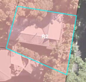
|
|
|
33. Coopers
West Lane (PN15720)
|
S2019/9597
New landowner. Did not receive a letter when PP2 was
on public exhibition so hasn’t had a chance to comment. After review of
new mapping, areas of Lantana and Camphor Laurel were changed to RU2
Rural Landscape zone and a small
area of E3 Environmental Management added in south.
|
Changes applied as agreed by current landowner.
|
|
|
‘As Exhibited’:
Zones
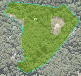
|
‘As Amended’:
Zones
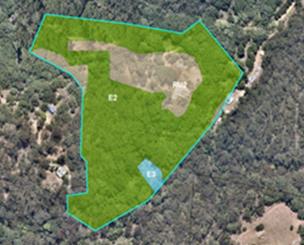
|
|
34. 390
Blindmouth Rd Main Arm
(PN 107150)
|
E2019/80093
Supports proposed zones.
|
Noted. No change.
|
|
35. Middle
Pocket Rd Middle Pocket
(PN 240578).
|
E2019/79310
Supports proposed zones.
|
Noted. No change.
|
|
36. 248
Broken Head Rd Suffolk Park (PN3750)
|
E2019/80091
Supports proposed zones.
|
Noted. No change.
|
|
37. 1982
Coolamon Scenic Drive, MULLUMBIMBY
(PN 240596)
|
E2019/77188, E2020/3202
Requests no E2 Environmental Conservation
zone due to farming practices on land
|
Landowner was contacted to discuss/explain confusion
about continuation of existing uses. No changes proposed.
|
|
|
‘As Exhibited’:
Zones
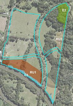
|
|
|
38. 99
Broken Head Rd, Suffolk Park (PN 242056)
|
E2019/88392, E2020/1214 Questions regarding rezoning
of “Cypress” land.
|
Current legislation reviewed and landowners advised
that Cypress will be protected by LEP vegetation overlay. No
change.
|
|
|
‘As
Exhibited’: Zones (R2 / E3)
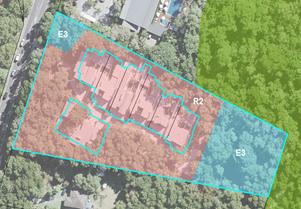
|
|
|
39. 19
Blueberry Court, Byron Bay
|
E2019/88729
Objects to R2 Low Density Residential zone
zoning in favour of E4 Environmental Living, consistent with the established environmental values and
community character of the Lilli Pilli neighbourhood.
|
The Northern Councils E Zone Review FINAL
Recommendations Report (2015) stipulates that Byron Shire Council shall “apply
a suitable residential zone to that land where an E4 zone was proposed under
the draft Byron LEP”. This includes the Lilli Pilli neighbourhood.
No change.
|
|
|
‘As Exhibited’
(proposed R2 zone)
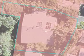
|
|
|
40. Kohinoor
Pty Ltd, Upper Main Arm (PN197850)
|
E2019/87169
Requests minor changes to E3 Environmental
Management boundaries based on new mapping showing show areas of
activity (i.e. orchards etc.) and lantana infestation.
|
Changes applied as per submission.
|
|
|
‘As Exhibited’: Zones
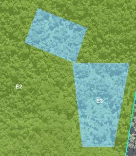
|
‘As Amended’: Zones
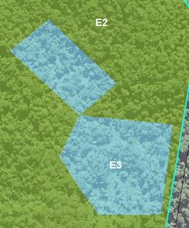
|
|
41. 7
Blueberry Court, Byron Bay
|
E2019/89020
Objects to R2 Low Density Residential zone
zoning in favour of E4 Environmental Living, consistent with the established environmental values and
community character of the Lilli Pilli neighbourhood.
|
The Northern Councils E Zone Review FINAL
Recommendations Report (2015) stipulates that Byron Shire Council shall “apply
a suitable residential zone to that land where an E4 zone was proposed under
the draft Byron LEP”. This includes the Lilli Pilli neighbourhood.
No change.
|
|
|
‘As Exhibited’
(proposed R2 zone)
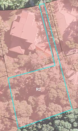
|
|
|
42. 65 Citriodora Drive
(PN 267705)
|
Island quarry (IQ) submission
recommends that proposed RU2 Rural Landscape zone along adjoining
neighbour’s NE boundary should be E2 Environmental Conservation.
However IQ does not want any Environmental zoning on their own adjoining
land, which is same condition.
|
The RU2 area in question was
ground-truthed and found not to meet E2/E3 criteria. The proposed Ru2
Rural landscape zone is consistent with adjoining land having same
attributes.
No change.
|
|
|
‘As Exhibited’:
Zones
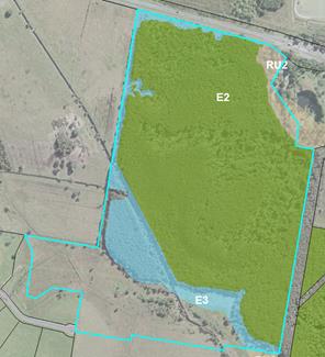
|
|
|
43. 4/2-6 Cemetery Road Byron Bay
(PN
226940)
|
E2019/89418
Objects to R2 Low Density Residential zone
zoning in favour of E4 Environmental Living, consistent with the established environmental values and
community character of the Lilli Pilli neighbourhood.
|
The Northern Councils E Zone Review FINAL
Recommendations Report (2015) stipulates that Byron Shire Council shall “apply
a suitable residential zone to that land where an E4 zone was proposed under
the draft Byron LEP”. This includes the Lilli Pilli neighbourhood.
No change.
|
|
|
‘As Exhibited’
(proposed R2 zone)
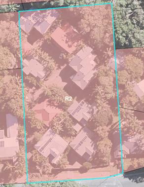
|
|
|
44. 230 Mafeking Road, Goonengerry (PN 241871)
|
E2019/36072
26.2018.4.1 Internal
Submission to include missed “road reserve” polygon in PP2; in
same ownership as adjoining E2 area
|
Changes applied as per
submission.
Lot Size and Height of
Building maps amended accordingly.
|
|
|
‘As Exhibited’: Zones
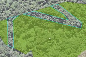
|
‘As Amended’: Zones
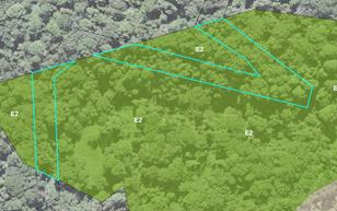
Lot size (40ha)
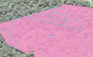
Max Building Height (9m)
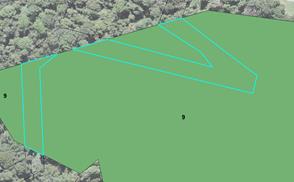
|
|
45. 168 Tandys Lane Brunswick
Heads 267780.
|
New owner advised of agreed zoning outcomes with
previous landowner. No objection received.
|
No changes required
|
|
|
‘As Exhibited’: Proposed E2 / RU2 Zones
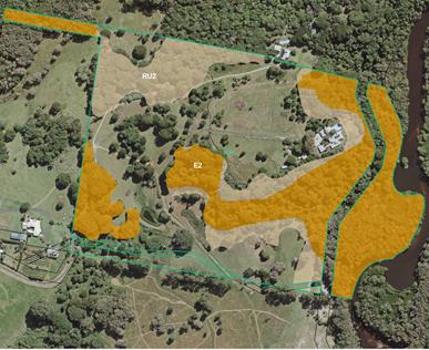
|
|
|
46. Hayters
Drive (PN 268113)
|
Supports zoning as
exhibited.
|
Noted. No changes
required.
|
|
|
|
|
RECOMMENDATION: That Council adopt the
property-specific LEP mapping amendments identified in Table 1.
Agency
Submissions
In
accordance with the Gateway Determination issued 19 June 2019, the following
public authorities were consulted under section 3.34(2)(d) of the Act and/or to comply with the requirements of relevant
section 9.1 Directions:
-
NSW Rural Fire Service;
-
Office of Environment, Energy & Science (formally Office of Environment and
Heritage);
-
NSW Department of Primary Industries
-
Arakwal Aboriginal Corporation;
-
Tweed Byron Aboriginal Land Council; and
-
NSW Division of Resources and Geoscience .
Three (3)
government agency submissions were received. These are summarised
in Table 2 below. Copies of the actual submissions are contained in
Attachment ‘2’.
Table 2 – Summary of government agency submissions
received
|
Agency
Name
|
Comments
|
Response
|
|
1.
NSW Rural Fire Services
|
Requested further information on:
- parcels mapped
bush fire prone land; and
- proposed land use
zone changes on mapped bush fire prone land, with respect to increased (i)
subdivision yields and/or (ii) dwelling opportunities
|
This
information was sent to RFS confirming that no increased subdivision yields
or dwelling opportunities based on proposed land use zones in PP2.
[No further
response from RFS had been received at time of writing this report.
NO
CHANGE RECOMMENDED
|
|
2. Office
of Environment, Energy & Science
|
General
Outlines a suggested decision process to follow when applying E
zones to land formerly zoned 7(a), 7(b), 7(j) or 7(k) under BLEP 1988, as
well as land not formerly zoned as such.
E2 Environmental Conservation zones
Recommends applying 40ha Minimum Lot Size (MLS) to all land
proposed to be zoned E2
E3 Environmental Management zones
Raised concerns about applying large Minimum Lot Size (generally
40ha) to land proposed to be zoned ‘E3’, given the wide range of
land uses permitted with consent. Notes that as a result, any future
development in such areas is unlikely to trigger the Biodiversity Offset
Scheme requirements. Recommends a smaller MLS be applied to E3 area
according to their total lot size.
|
Noted.
The process applied in PP2 is largely consistent with that contained in the
OEES submission.
Noted.
PP2 has applied a 40ha MLS to the majority of affected parcels.
The MLS
applied to the majority of proposed E3 zones is based on maintaining ‘like
for like’ where possible with the current subdivision potential of the
land. This is a key part of the process for achieving agreed outcomes
with landowners. Applying a smaller MLS to these areas according to
actual lot size is likely to result in increased subdivision potential
throughout the Shire and hence greater impacts on native vegetation and/or
threatened species habitat.
NO
CHANGE RECOMMENDED
|
|
3. NSW Division of Resources &
Geoscience (GSNSW)
|
GSNSW advises that it has no resource sterilisation issues for
consideration under section 9.1 of the Environmental Planning and Assessment
Act 1979, Direction 1.3 – Mining, Petroleum production and
Extractive industry.
|
Noted.
|
Conclusion
The
relatively low number of public submissions received (< 10% of affected
properties) is a reflection of the conciliatory and consistent engagement
approach taken by staff to achieve agreed outcomes. Such agreements were
either ‘explicit’ (i.e. confirmed by landowner email, letter or a signed zoning map) or
‘implicit’ (i.e. where e zone has been removed on affected land in
accordance with submission). Inevitably there will be a minority of
landowners where there’s been (i) a change of mind about what was
originally agreed to on their land, (ii) a change in ownership since an agreed
outcome was reached or (iii) cadastral boundary issues were identified which
were outside the scope of the zoning review. Staff have addressed such all
issues personally with each landowner and where required, amended the exhibited
maps accordingly. These circumstances form the basis for the minor mapping
amendments identified in Table 1.
Financial
Implications
The
remaining 2019/20 budget for the E zone Implementation program will be
exhausted by 30 June 2020. A budget bid has been included in the 2020/21
budget to finalise Stage 3 planning proposal and commencement Stage 4. Stage 4
includes council and public authority lands and will be the final stage of
applying E Zones.
Statutory and Policy
Compliance Implications
The
process of applying E zones and mapped overlays in Byron LEP 2014 is being
undertaken in accordance with Section 117
Direction 2.5 – Application of E2 and E3 Zones and Environmental
Overlays in Far North Coast LEPs. This direction specifically requires
that a planning proposal that introduces or
alters an E2 Environmental Conservation or E3 Environmental
Management Zone, or an overlay and associated clause must be consistent
with the Northern Councils E Zone Review Final Recommendations.
Staff Reports - Sustainable Environment and Economy 13.6
Report No. 13.6 PLANNING
- 26.2019.10.1 Proposed Rezoning North Beach Byron - Options Report
Directorate: Sustainable
Environment and Economy
Report
Author: Rob
Van Iersel, Major Projects Planner
File No: I2020/321
Summary:
Council has received a request to amend Byron Local
Environmental Plan (BLEP) 2014 to rezone a section of beach-front land
immediately to the north-west of the Elements of Byron resort. The land
had previous use as a private golf course associated with a former tourist
facility on the land.
The rezoning request is made to enable a residential
subdivision of the land to create nine (9) larger lots, each with provision for
a single dwelling.
Part of the subject land is zoned SP3 Tourist under Byron
Local Environmental Plan 2014, with other parts of the land deferred, retaining
the zoning under Byron Local Environmental Plan 1988, including 2(t) Tourist
Area, 7(a) Wetlands, 7(b) Coastal Habitat and 7(f1) Coastal Lands.
The requested rezoning only relates to the cleared grassed
parts of the land, to implement a zoning of E4 Environmental Living. This
zoning has not previously been applied within LEP 2014, and this would be the
first property zoned as such in the Shire.
The land has long been identified as subject to coastal
hazards, with the previously adopted 100 year hazard line forming the
landward boundary of the existing 7(f1) Coastal Lands zone.
The request for rezoning is supported by a detailed Coastal
Hazards Assessment, which has been undertaken for the site by Royal Haskoning DHV,
who are acknowledged coastal experts.
The report maps 50 year (2070), 80 year (2100) and 100 year
(2120) hazard lines for the site, based on contemporary
“probabilistic” modelling. This modelling approach was agreed
by staff of the Department of Planning, Industry and Environment, and therefore
forms a sound basis for the hazard assessment. The same modelling
approach will be used to undertake the Shire-wide hazard assessment, soon to be
commenced.
The modelling shows that the contemporary 100 year hazard
line is located approx. 135m seaward of the previously mapped 100 year hazard
line (i.e. the existing 7(f1) zone boundary), demonstrating that the area
within the site subject to coastal hazard is far smaller than previously
thought. This result is consistent with the findings of a 2013 hazard
review undertaken for Council by WBMBMT.
The rezoning proposal requests the application of the E4
zone over all of the cleared parts of the land, with an accompanying
Development Control Plan (DCP) to address coastal risks for the part of the
land identified as being within the 50 and 100 year hazard areas.
Council is currently working on a Coastal Management Program
for the whole of the Shire. Amongst other things, the Program will
identify all lands subject to coastal risk, by way of contemporary
“probabilistic” modelling, and develop policies for how that land
will be managed.
Pending the completion of that work, it is recommended that
a precautionary approach be taken in respect of land currently identified as
subject to coastal risk.
In relation to the rezoning request, therefore, such a
precautionary approach would allow for the E4 zoning of the cleared parts of
the site located landward of the contemporary 100 year hazard line. It is
recommended, however, that the current 7(f1) Coastal Land zoning remain in
place for the part of the site located seaward of the contemporary 100 year
hazard line, until completion of the Coastal Management Program, at which time
it could be reviewed.
The coastal assessment demonstrates that the majority of the
cleared part of the property is not constrained by coastal hazard, and other
supporting information indicates that a zoning of E4 Environmental Living would
be suitable for that area.
Council is requested to consider whether the rezoning should
proceed prior to completion of the Coastal Management Program and, if so, how
the land seaward of the contemporary hazard line should be managed in the
interim.
The options are:
1. Decline
to proceed with any rezoning of the land at this time, pending the outcomes of
the Coastal Management Program;
2. Proceed
with a Planning Proposal to rezoning the land, consistent with the approach
requested by the applicant, which is:
· apply the E4
Environmental Living zone to all of the cleared parts of the land, including
the land seaward of the 100 year 1% coastal hazard line; and
· manage future
development within the identified coastal risk area through the application of
DCP provisions which mirror the current controls within Part J of DCP 2010.
3. Proceed
with a Planning Proposal to rezone only the part of the cleared site that is
located landward of the 100 year 1% coastal hazard line, leaving the existing
7(f1) zone in place seaward of that line.
The land owners have expressed a strong preference for
Option 2, arguing that this approach has formed the historical basis for
managing coastal hazard throughout the Shire.
Written advice from the Biodiversity and Conservation
Division of the Department of Planning, Industry and Environment recommended
that an E2 Environmental Conservation Zone be applied to land seaward of the
hazard line, which would prohibit residential development in that area.
However, without the written consent of the land owner, applying the E2 zone on
land that does not have biodiversity values is inconsistent with the
Minister’s Guidelines for applying E zones.
Those Guidelines suggest that coastal hazards should be
addressed by an LEP overlay map and local LEP provision. The overlay map
and LEP provision could not prohibit development; it could only outline
assessment considerations that would apply to applications to develop the
mapped land.
Leaving the 7(f1) Coastal Land zone in place seaward of the
hazard line achieves substantially the same outcome as that recommended by the
Biodiversity and Conservation Division, as residential development is
prohibited in that zone.
It is considered that, pending completion of the Coastal
Management Program, a precautionary approach is warranted to development in
areas of identified hazard. Option 3, above, is therefore recommended by
staff.
This approach would allow the preparation of a Planning
Proposal to apply the E4 Environmental Living zone, but only over the cleared
parts of the site, landward of the identified hazard line. The existing
7(f1) zoning would remain in place prohibiting residential development seaward
of that line.
This option would allow the land owner to pursue a
residential subdivision of the land, albeit creating lots with ‘split zoning’
of E4 & 7(f1). Construction of dwellings on those lots would need to
located within the E4 parts of the sites (i.e. landward of the 100 year hazard
line).
NOTE TO COUNCILLORS:
In accordance with the
provisions of S375A of the Local Government Act 1993, a Division is to be
called whenever a motion for a planning decision is put to the meeting, for the
purpose of recording voting on planning matters. Pursuant to clause 2(a)
under the heading Matters to be Included in Minutes of Council Meetings of Council's
adopted Code of Meeting Practice (as amended) a Division will be deemed to have
been called by the mover and seconder of all motions relating to this report.
|
RECOMMENDATION:
1. That
Council endorse the preparation of a Planning Proposal for the land, to apply
an E4 Environmental Living zone to the area identified as unconstrained by
coastal hazard, leaving the current zoning in place for the parts of the site
identified as subject to the 100 year coastal hazard.
2. That
the draft planning proposal be reported to the June Planning meeting of
Council.
|
Attachments:
1 Form of
Special Disclosure of Pecuniary Interest, E2012/2815
REPORT
1. The
Site
|
Property
|
Total Area (ha)
|
Zoning
|
Existing Uses
|
|
Lot 1 DP 1215893
|
32.73
|
SP3 Tourist
|
Elements of Byron resort
|
|
|
|
2(t) Tourist Area
|
|
|
|
|
7(a) Wetland
|
|
|
|
|
7(f1) Coastal Lands
|
|
|
Lot 2 DP 1215893
|
2.02
|
SP3 Tourist
|
Vacant
|
|
|
|
7(f1) Coastal Lands
|
|
|
Lot 12 DP 243218
|
2.73
|
SP3 Tourist
|
Vacant
|
|
|
|
7(f1) Coastal Lands
|
|
|
Lot 13 DP 243218
|
3.95
|
SP3 Tourist
|
Vacant
|
|
|
|
7(f1) Coastal Lands
|
|
|
Lot 449 DP 812102
|
32.08
|
SP3 Tourist
|
Vacant
|
|
|
|
2(t) Tourist Area
|
|
|
|
|
7(a) Wetland
|
|
|
|
|
7(b) Coastal Habitat
|
|
|
|
|
7(f1) Coastal Lands
|
|
The land is located at the northern end of Bayshore
Drive. The lots subject to the proposed rezoning are located generally to
the north and east of Bayshore Drive. All of the subject land is owned by
Ganra Pty Ltd.
Lot 1 contains the approved Elements of Byron resort.
The remaining lots are vacant.
The north-eastern boundary of the land abuts vegetated sand
dunes landward of Belongil beach. The Belongil Creek mouth is located at
the south-east end of the subject land.
North of the Elements resort, the land is predominantly
cleared, having been used in the 1980s as a private golf course. An
existing 3.0 m wide Right of Way is located in this area, across Lot 2
DP 1215893 & 12 DP 243218, connecting public parking areas on Bayshore
Drive and the beach, to provide for public access to the beach.
The whole of the land is generally flat, with levels
averaging around RL 1.8 to 2.2 m AHD in the central part of the land. It
rises to the rail line to approximately 3.0 m AHD, and to a ridge along the
north-eastern sand dunes to around RL 7.5 to 10.0 m AHD.
Two main drainage lines traverse the site, draining to
Belongil Creek, with a number of artificial water bodies located across the
property.
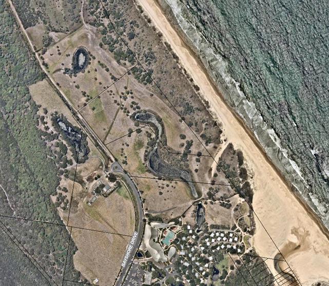
Figure 1 Subject Land
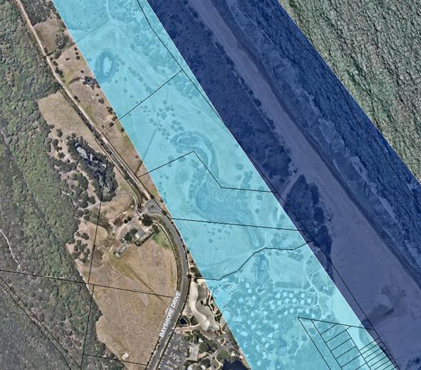
Figure 2 Location of
current 100 year hazard line (shown light blue)
2. Proposed
Zone Changes
The land owner requested proposal seeks to apply an E4
Environmental Living zone over the cleared parts of the property, to facilitate
a subdivision of the land to create nine (9) single dwelling lots.
The rezoning request was supported by assessments of
flooding, biodiversity and coastal hazard. Preliminary assessment of
those studies indicates that, while there are some issues to be fully
addressed, there is a sound basis for moving forward with the proposal.
The Coastal Hazards Assessment, which has been undertaken
for the site by Royal Haskoning DHV, maps 50 year (2070), 80 year (2100) and
100 year (2020) hazard lines for the site, based on contemporary
“probabilistic” modelling. The modelling approach was agreed
by staff of the Department of Planning, Industry and Environment Coastal
Division, and therefore forms a sound basis for the hazard assessment.
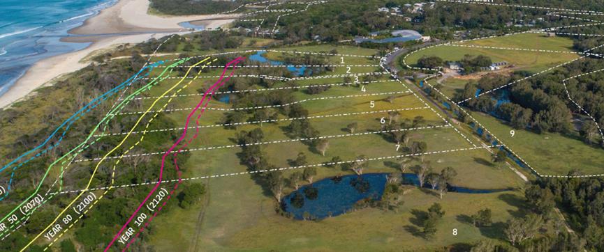
Figure 3 Contemporary Hazard
Lines from Royal Haskoning DHV Study
The figure above shows the potential subdivision of the land
with the position of the various coastal hazard lines.
The Scoping Report prepared for the first stage of the
Coastal Management Program addresses land understood to be subject to year 2100
hazards, which is represented on this site by the “Year 80”
line above.
The Scoping Study is a precursor to Shire-wide hazard
studies that will result in contemporary hazard mapping across the whole
coastline. In accordance with the mandatory requirements of the Coastal
Management Manual, that hazard mapping will need to identify areas of immediate
hazard, as well a projected hazards over 20, 50 and 100 year timeframes.
Assuming that hazard assessment will take place later this
year, it will result in a 100 year line, which equates to the year 2120.
Given that, it is recommended that the 2120 line (100 year)
be adopted as the basis of zoning at this property. This is considered to
be a conservative approach, as it effectively relates to a 1% chance that the
coastal erosion would be ‘worse’ than this in 100 years from now.
Given that this rezoning is seeking to move forward prior to
the completion of the Coastal Management Program, this conservative approach is
recommended.
The contemporary 100 year line shown above is located
approx. 135m seaward of the 100 year hazard line that currently forms the basis
of the 7(f1) zoning and Part J Erosion Precinct 3, demonstrating that the
area within the site that is subject to coastal hazard is far smaller than
previously thought.
In relation to the rezoning request, such a precautionary
approach would allow for the E4 zoning of the cleared parts of the site located
landward of the contemporary 100 year hazard line. It is recommended,
however, that the current 7(f1) Coastal Land zoning remain in place for the
part of the site located seaward of the contemporary 100 year hazard
line.
STRATEGIC CONSIDERATIONS
Community Strategic Plan and
Operational Plan
|
CSP Objective
|
L2
|
CSP Strategy
|
L3
|
DP Action
|
L4
|
OP Activity
|
|
Community
Objective 3: We protect and enhance our natural environment
|
3.3
|
Partner to
protect and enhance the health of the Shire’s coastlines, estuaries,
waterways and catchments
|
3.3.1
|
Implement
Coastal Management Program
|
3.3.1.1
|
Continue
preparing a Coastal Management Program (CMP) in accordance with the staged
process
|
|
|
|
|
|
|
|
|
|
|
|
|
|
|
|
Legal/Statutory/Policy Considerations
If Council adopts the recommendation, a Planning Proposal
will be finalised to seek the rezoning of parts of the land. That
Proposal will be reported to Council with the intention that it be forwarded to
the Department of Planning, Industry and Environment for a Gateway
Determination that would allow the proposed rezoning to proceed.
Financial Considerations
This is a land owner funded proposal.
Consultation and Engagement
No consultation has occurred at this stage.
Consultation will occur after a Gateway determination.
Staff Reports - Sustainable Environment and Economy 13.7
Report No. 13.7 PLANNING
- 26.2016.4.1 Submissions to Planning Proposal Rural Events
Directorate: Sustainable
Environment and Economy
Report
Author: Rob
Van Iersel, Major Projects Planner
File No: I2020/462
Summary:
Council has been investigating the potential to create an approval
pathway for weddings/ events on rural land in the Shire. Preliminary
community engagement regarding this issue was undertaken in late 2017, leading
to a report to Council in June 2018 recommending that the Byron LEP 2014 be
amended to provide for approval for rural events on land zoned RU2 Rural
Landscape.
Following receipt of Gateway Determination from the State
Government, a Planning Proposal was formally exhibited for community comment in
late 2018.
Following that exhibition, an amended Planning Proposal was
reported to Council in June 2019, resulting in a resolution to seek an amended
Gateway Determination (Res 19-275). That resolution
included extending the planning proposal to apply to land zoned RU1 Primary
Production in addition to RU2 Rural Landscape.
An amended Gateway determination was issued on 3 December
2019. The Gateway required two changes to the planning proposal:
· removal of the
reference to permitting rural events on land zoned RU1 Primary Production, (events
would only be permitted on land zoned RU2 Rural Landscape); and
· removal of a number
of detailed provisions to be included within an amendment to the Byron
Development Control Plan 2014 (DCP).
The required changes do not fundamentally alter the
recommend approach, which is to provide for a “rolling approval”, establishing
an LEP provision that allows a temporary use, with both a maximum number of
annual events and a restricted 3-year approval.
Public exhibition of the amended planning proposal and
proposed DCP amendment was undertaken in January/ February 2020, including
letters to all who had previously made submissions, notification and
information on Council’s website and a public information forum at
Bangalow on 11 February.
Following the exhibition, a total of 25 submissions were
received:
· 4 in support of
the proposal & DCP;
· 7 opposing the
proposal & DCP on the basis that weddings/ events should not be allowed in
the rural area;
· 9 opposing the
proposal & DCP on the basis that the controls are too restrictive,
particularly requesting that a greater number of weddings/ events be allowed;
· 2 opposing on the
basis that proposal & DCP should apply to all rural zones; and
· 3 providing
commentary/ suggestions for inclusion.
The issues raised in the submissions are addressed in this
report. Divided opinions remain; some respondents are of the view that
the wedding industry is an important part of the Shire that can be managed to
avoid disturbance to neighbours; while others are strongly opposed to such
activities in the rural hinterland, concerned that the approval mechanism will
lead to a proliferation of event sites and that it will not be possible to
ensure that disturbance is avoided or minimised.
Based on the assessment, it is recommended that the planning
proposal be forwarded to the Parliamentary Counsel’s Office for finalisation,
and that Byron Development Control Plan 2014 be amended by the addition of
Chapter D9 – Rural Event Sites, with the following minor amendments:
· amendment to
prescriptive measure 2 in D4.9.1 Site Suitability, to read: “a Traffic
Impact Assessment has been prepared, addressing traffic numbers, impact on
local roads, access and on-site parking, demonstrating that the use of the site
for a Rural Event Site will not result in unacceptable adverse impacts on the
safety or efficiency of local traffic or the amenity of the
neighbourhood”;
· amendment to
prescriptive measure 3 in D4.9.1 Site Suitability, to read: “a Land Use
Conflict Risk Assessment has been prepared demonstrating that the use of the
site for a Rural Event Site will not result in any land use conflict in
relation to adjoining or nearby farming activities or preclude future farming
activities”; and
· add a note to the
end of the new Chapter to read: “A condition of approval will be applied
for all development consents for Rural Event Sites specifying that development
consent would cease if three substantiated complaints were received in relation
to functions at the site within a twelve-month period”.
NOTE TO COUNCILLORS:
In accordance with the
provisions of S375A of the Local Government Act 1993, a Division is to be
called whenever a motion for a planning decision is put to the meeting, for the
purpose of recording voting on planning matters. Pursuant to clause 2(a)
under the heading Matters to be Included in Minutes of Council Meetings of
Council's adopted Code of Meeting Practice (as amended) a Division will be
deemed to have been called by the mover and seconder of all motions relating to
this report.
|
RECOMMENDATION:
1. That
Council forward the planning proposal to amend Byron LEP 2014, as
included in Attachment 1 (E2020/26186), to the NSW Parliamentary
Counsel’s Office (PCO) requesting that a draft LEP Instrument be
prepared.
2. That
Council liaise with PCO as necessary to finalise the content of the
draft LEP and to enable PCO to issue an opinion that the plan can be made.
3. That
Council make the draft LEP under delegated authority and forward the
plan to the NSW Department of Planning, Industry and Environment for
notification on the NSW Government legislation website.
4. That
Council upon the LEP being made, adopt the amendment to Byron DCP
2014, as included in Attachment 2 (E2020/26188), and give notice of this
decision in accordance with the Environmental Planning and Assessment
Regulation.
|
Attachments:
1 26.2016.4.1
Planning Proposal Rural Events v.9 - Following public exhibition, E2020/26186
2 26.2016.4.1
Proposed Amendment to Byron Development Control Plan 2014, E2020/26188
3 Confidential
- 26.2016.4.1 Combined submissions - Rural weddings and events Planning
Proposal and DCP Chapter D9, E2020/28974
4 Form of
Special Disclosure of Pecuniary Interest, E2012/2815
REPORT
Background
The most recent report on this planning proposal was
considered at the Council (Planning) Meeting of 20 June 2019, following
previous community engagement activities.
That report recommended that Council amend a previous
planning proposal, to provide an approval mechanism for rural event sites in
the RU2 Rural Landscape zone and seek an updated Gateway Determination from the
Department of Planning, Industry & Environment (DPIE) that would allow
further community exhibition.
At the meeting, Council resolved (Res 19-275):
1. That
Council forward the amended Planning Proposal (Attachment 1 E2019/23021) to NSW
Department of Planning, Industry and Environment for an amended Gateway
Determination, to provide an approval mechanism for rural event sites in the
RU2 Rural Landscape Zone and RU1 Primary Production Zone.
2. That,
following Gateway, if required, the Planning Proposal be publicly exhibited for
a period of 28 day; and following this time a further report be put to Council.
In accordance with that resolution, DPIE was requested on 25
June 2019 to consider amending the previous Gateway determination. An
amended Gateway was received on 3 December, 2019. It was conditioned to
require amendment of the planning proposal to:
· remove the
reference to permitting rural events on land zoned RU1 Primary Production, (events
would only be permitted on land zoned RU2 Rural Landscape); and
· remove a number of
detailed provisions to be included within an amendment to the Byron Development
Control Plan 2014 (DCP).
Exhibited Provisions
Based on the amended Gateway, the proposed new LEP provision
was redrafted to:
6.11 Temporary Use – Rural Event Site in
RU2
(1) Despite
any other provision of this Plan, development consent may be granted for development
on land within Zone RU2 Rural Landscape for a Rural Event Site, up to a maximum
of 20 events per calendar year over a period of three (3) years.
(2) In
this clause:
Rural Event Site
means the temporary use of a building or defined area within a property zoned
RU2 Rural Landscape, where weddings and other similar gatherings/ events are
held for commercial purposes for a maximum number of events in the three (3)
year period, with a maximum number of 150 attendees per event, but does not
include convention centres or exhibition centres or music festivals.
In addition, a new Chapter was drafted to be included in
Byron Development Control Plan 2014 – Chapter D9 Rural Event Sites.
It sets out provisions addressing site suitability and management of events,
primarily containing the provisions that were included in the previous version
of the draft LEP amendment.
Chapter D9 – Rural
Event Sites
D9.1 Introduction
Under Clause 6.11 of Byron
Local Environmental Plan 2014, rural event site is defined as:
the temporary use of a
building or defined area within a property zoned RU2 Rural Landscape, where
weddings and other similar gatherings/ events are held for commercial purposes
for a maximum number of events in a three (3) year period, with a maximum of 150
attendees per event, but does not include convention centres or exhibition
centres or music festivals.
By definition, rural event site is a land use only
permissible on land zoned RU2 Rural Landscape.
D9.2 Aim
of this Chapter
The aim of this chapter is to manage weddings and events
of a similar scale held in the Byron Hinterland, to address a history of
disturbance to neighbours associated with these unregulated events.
The provisions of this Chapter address the suitability of
potential sites and establish minimum standards for the management of events on
those sites.
D9.3 Application
of this Chapter
This Chapter applies to development applications for
rural event sites, as defined in Clause 6.11 of the Byron Local Environmental
Plan 2014.
D9.4 Provisions
D9.4.1 Site
Suitability
Objective
To ensure that rural events are held on sites that are
suitable to such events, particularly in relation to the ability to avoid or
manage disturbance to the amenity of the neighbourhood.
Performance Criteria
1. Use
of the property for events will not result in offensive or intrusive noise at
neighbouring residences.
2. The
local road network has the capacity to accept the additional traffic associated
with event use at the site without compromise to safety or efficiency.
3. Event
use at the site will not result in land use conflicts with neighbours,
particularly in respect of local farming activities.
Prescriptive Measures
Development consent must not be
granted for a Rural Event Site unless the consent authority is satisfied that:
(1) the
proposal is supported by a site specific acoustic assessment, prepared by a
suitably qualified person, quantifying existing background noise levels and
noise levels predicted for events in relation to all nearby dwellings, and
demonstrating that the use of the property for events will not result in the
generation of offensive noise, as defined in the Protection of the Environment
Operations Act 1997;
(2) the
use of the site for a Rural Event Site will not result in unacceptable adverse
impacts on any adjoining land or the amenity of the neighbourhood, particularly
in relation to noise and traffic;
(3) the
use of the site for a Rural Event Site will not result in any land use conflict
in relation to adjoining or nearby farming activities or preclude future
farming activities;
(4) no
clearing of native vegetation is required for the Rural Event Site;
(5) the
Rural Event Site is not located in or immediately adjacent to areas of high
Aboriginal cultural heritage significance.
D9.4.2 Management
of Events
Objective
To ensure that events held on approved sites do not
disturb the amenity of the neighbourhood.
Performance Criteria
1. Use
of the property for events will not result in offensive or intrusive noise at
neighbouring residences.
2. Event
use at the site will not result in land use conflicts with neighbours,
particularly in respect of local farming activities.
Prescriptive Measures
Applications for development
consent for a temporary Rural Event Site must include an Events Management
Plan, which contains (as a minimum) provisions that:
(1) provide
for all event guests (other than the bridal party) to be transported to and
from each event by bus, suitable to the road network to be utilised for
transportation to the event; and
(2) ensure
that all amplified music will cease no later than 10:00pm; and
(3) ensure
that all event attendees (other than those residing on site) will be off-site
no later than 11:00pm, other that those staying overnight on the premises; and
(4) outline
measures that will be in place to ensure predicted noise levels are not
exceeded at nearby dwellings; and
(5) provide
for the monitoring of noise generated at events and annual compliance reporting
to Council; and
(6) provide
for the notification of nearby residents, including contact details for an
appropriate management person who must be on-site and contactable during each
event and provision of a sign, located so that it can be viewed from a public
space outside of the property notifying the name and contact phone number of
the management person; and
(7) ensure
that adequate arrangements are in place to manage wastewater and general waste
for each event; and
(8) manage
the potential noise/ amenity impacts associated with any persons staying
overnight at the site at the conclusion of the function; and
(9) prohibit
the use of fireworks, helicopters and/or other comparable activities known to
cause disturbance to livestock and/or farming activities.
In deciding whether to grant consent for a temporary
Rural Event Site, the consent authority must consider:
(1) the
maximum number of events permitted in any calendar year; and
(2) the
potential loss of farming on the property, particularly where part or all of
the site is mapped as State and/ or Regionally Significant Farmland; and
(3) the
potential impact on areas of environmental value, whether on the property the
subject of the Rural Event Site or on adjacent and nearby land, including koala
habitat; and
(4) whether
a trial period is appropriate; and
(5) the
need to impose a condition specifying that development consent would cease if
three substantiated complaints were received in relation to functions at the
site within a twelve-month period; and
(6) the
need for a biosecurity management plan.
Public Exhibition
Public exhibition of the draft LEP amendment and proposed
DCP amendment was undertaken in January/ February 2020, including letters to
all who had previously made submissions, notification and information on
Council’s website and a public information forum at Bangalow on 11
February. Approx. 40-50 people attended that forum.
As required by the Gateway, letters were also sent to
Department of Planning, Industry and Environment – Agriculture &
Biodiversity and Conservation divisions; NSW Rural Fire Service and Transport
for NSW (RMS).
Submissions
The agency responses to exhibition of the proposal area
addressed below:
|
Agency Comment
|
Staff Response
|
|
Department Primary Industries - Agriculture
|
|
|
Support amended proposal, based on removal of consent
opportunity in RU1 Primary Production zone
|
Noted.
|
|
Suggest that a requirement for a Land Use Conflict Risk
Assessment be added to draft DCP provisions
|
Accepted – provision added.
|
|
Where there is potential for land use conflict an
acceptable vegetated buffer should be established on the proponent’s
land.
|
This would be a logical outcome of a Land Use Conflict
Risk Assessment where risk is identified. It is not considered
necessary to add this to the draft DCP.
|
|
Transport for NSW
|
|
|
Question need for guests to be transported to and from
venues by bus in all cases; suggest that each site be assessed on their
merits
|
Impacts associated with the number of cars attending rural
weddings have been a significant issue of concern for many rural residents.
It is considered that limiting
cars will have a significant benefit not only for the amenity of neighbours,
but also in relation to safety and efficiency for local roads.
The current provisions require
applicants to demonstrate that local roads have sufficient capacity for the
safe movement of buses, and that buses can enter and leave event sites in a
forward direction.
No changes recommended.
|
|
Recommend that development applications for rural event
sites should be supported by a Traffic Impact Assessment, addressing traffic
numbers, impact on local roads, access and on-site parking.
|
Accepted – provision added.
|
Council did not receive a response from NSW Rural Fire
Service or the Biodiversity Conservation Division of DPIE.
25 submissions were received from the community:
· 4 in support of
the proposal & DCP;
· 7 opposing the
proposal & DCP on the basis that weddings/ events should not be allowed in
the rural area;
· 9 opposing the
proposal & DCP on the basis that the controls are too restrictive,
particularly requesting that a greater number of weddings/ events be allowed;
· 2 opposing on the
basis that proposal & DCP should apply to all rural zones; and
· 3 providing
commentary/ suggestions for inclusion.
The following table summarises some of the key themes and
comments:
|
Theme
|
Various Opinions
|
|
Support for proposal
|
Well run venues are needed and support the community with
jobs and as well as our local community
|
|
|
Provisions will provide for appropriate regulation and
control to avoid/ minimise amenity impacts
|
|
Opposition to allowing weddings & events
|
Weddings and events are inconsistent with the objectives
of the RU2 zone
|
|
|
Weddings and events are inconsistent with rural amenity
– it is not possible to avoid or minimise impacts associated with
traffic and noise
|
|
|
20 events per year are too many – experience
indicates at each wedding involves parties before and after, associated with
accommodation at the venue
|
|
|
DCP does not provide sufficient protection as State
Government requires that Councils be flexible in applying DCPs
|
|
|
Acoustic assessment cannot be solely relied on to
determine potential impacts – weather conditions can vary noise
‘travel’ greatly
Significant lack of trust in the
assessment process
|
|
|
Traffic impacts – rural roads do not have sufficient
capacity; associated safety issues
|
|
|
There is no need for the plan change – there are
sufficient venues in urban areas and community halls
|
|
|
Creating jobs and associated economic benefits should not
be at the expense of the amenity of existing rural residents
|
|
Opposition based on inability to enforce controls
|
The planning proposal should not be considered without a
corresponding compliance and enforcement proposal that has approved
funding/resourcing
|
|
Many objectors do not believe that it is possible for
Council to enforce compliance
|
|
It is not fair that neighbours need to
‘police’ activities, needing to provide unrealistic evidence to
substantiate complaints
|
|
|
Previous experience has demonstrated that Council is not
able to shut venues
|
|
Objection on basis that provisions are too restrictive
|
Restrictions would be devastating to small
businesses, jobs, and the tourism industry at whole
|
|
|
Only 20 weddings/ events per year is too restrictive
|
|
Objection to deletion of RU1 and/ or R5
|
Council should support farmers by allowing supplementary
income
|
|
|
Weddings should be allowed where there is an approval for
rural tourist use in RU1
|
|
|
Regardless of zoning, each proposed site should be
assessed on its merits
|
|
Comments/Suggestions
|
Proposal should include minimum separation distance to
nearby homes
|
|
|
The host of an approved event must provide written notice
by registered mail of the date of any event to the owners of the properties
directly adjoining to the event location at least 14 days prior to the event
so that the adjoining owners can relocate themselves on the day of the event
|
|
|
The “three strikes” provision should be
strengthened to apply in all cases.
|
|
|
Amplified music should not be allowed – if this were
enforced, most noise issues would disappear
|
|
|
Separation distance of at least 2kms
|
|
|
Require an annual approval fee and a fee for each event
|
|
|
Limit guests to 50
|
|
|
All guests off site no later than 8pm
|
|
|
Functions only permitted inside approved Council
structures
|
Key Issues
Local Amenity Impacts
Many rural residents remain strongly of the view that
allowing weddings/events will erode their rural amenity.
In many cases, this view is based on a history of activities
at previous unauthorised sites. In some of those cases, it is clear that
events were being held on sites that were not suitable, where there was no
assessment of potential disturbance.
There is no doubt that activities associated with weddings
in the rural area have resulted in significant disturbance to neighbours in
some locations.
It is also clear, however, that there have been wedding
venues that have operated with no history of complaints. As outlined in
previous reports to Council, staff have heard from neighbours of such venues
who report that, while they are aware of the weddings and events, their amenity
is not disturbed by such events.
The intention of the proposed LEP & DCP provisions is
provide a mechanism whereby the suitability of a site can be measured and
management measures can be put in place so that the wedding and event industry
can proceed but only in locations that will protect the amenity of neighbours.
The requirement for a site-specific professional acoustic
assessment and the limits on approvals – i.e. approval period of 3 years;
maximum of 20 events per calendar year; maximum of 150 attendees –
provide the primary mechanisms for the protection of amenity.
Additional DCP provisions regarding transport by bus curfews
and the like also provide protection for rural amenity.
There is also the DCP “three strikes” provision
that allows the application of a condition on any approval specifying that
development consent would cease is three substantiated complaints were to be
received in a 12 month period.
It was suggested that this should be strengthened to be
applicable in all cases. That suggestion has merit, and the draft DCP
provisions have been amended accordingly (see Attachment 2).
Compliance/ Enforcement
The ability to enforce planning controls and/or conditions
of approval is an issue of significant concern for the community. Many of
the submissions and comments opposing the proposed LEP amendment were from
rural residents who had previously experienced negative impacts from
neighbouring unauthorised events.
In addition to outlining the nature and severity of
disturbance from those experiences, many of the objectors indicated frustration
that Council had been unable to take immediate, or in some case any, action to
stop events.
Enforcement actions and infringements are governed by the
provisions of the Environmental Planning and Assessment Act 1979.
Under this Act, Council does not have the authority to arbitrarily ‘shut
down’ a venue. Council can, however, issue orders to stop
unauthorised use of a venue or in respect to compliance with conditions.
For ‘development without consent’ Council has
authority to issue fines of up to $3,000 for individuals or $6,000 for
companies, if sufficient evidence is collected. For continuing offences
or serious issues, Council can issue Court Attendance Notices.
The current situation, where there is continued strong
demand for rural weddings and events, but a significantly limited ability to
approve such land uses, has led to the proposal to provide a controlled
approval mechanism.
There has been, and continues to be, regular community
complaints arising from weddings and events on rural properties.
In order for Council to take
enforcement action regarding these complaints, evidence needs to demonstrate a
breach of the LEP. For example, evidence needs to demonstrate that the
event was commercial in nature rather than a family event. This can be
difficult to prove.
Anecdotally, it has also been
suggested that some venues have been “building in” the potential
for a $3,000 fine into their site fees, to address the risk of infringement
action.
A number of the engagement
attendees, both residents and industry, expressed the views that fines could be
increased. This, however, is not possible
as the amount of the fines is set in State legislation.
Establishing the approval mechanism as a “rolling
approval” system provides that approved sites would need to apply, toward
the end of the three year approval period, for a further three year
approval. In doing so, they would need to demonstrate that events at the
site have operated without creating unacceptable neighbourhood impacts.
This “rolling approval” system provides a
balanced approach, addressing the issues and concerns raised through the
engagement process. It also avoids the potential whereby Council is
required to continually act against an operator with a “permanent”
approval who does not comply with conditions of that approval.
Requiring annual compliance reporting will also allow
Council to collate data regarding events. Further, the “three-strike”
provision would allow intervention within a three-year approval period in
extreme circumstances.
Restricting approval
pathway to RU2 zone
These concerns were addressed in some detail in the staff
report of 20 June 2019. The recommendation of that report was that the
approval mechanism not be extended to other zones.
In considering that report, Council resolved to seek
approval for the mechanism to extend to the RU1 Primary Industry Zone.
In providing the amended Gateway Determination, the
Department of Planning, Industry and Environment has specifically required that
the planning provisions not apply to the RU1 zone.
That avenue, therefore, is closed and there is no further
opportunity to extend the provisions to RU1 (or other zones) as part of this
planning proposal.
Provisions are too
restrictive
There were 9 written submissions expressing the view that
the proposed provisions are too restrictive and would have a significant impact
on many small businesses associated with the wedding industry.
Previous discussions with industry representatives indicated
that they were willing to work with Council to develop an approval mechanism
that provides for continuation of opportunities for the industries in a manner
that protects rural amenity.
Achieving this balance is the primary objective of this
proposal, and it is considered that the approach outlined in the planning
proposal is not overly ‘punitive’ on the wedding industry.
Conclusion
Based on assessment of all submissions, it is recommended
that the draft LEP amendment be forwarded to the Parliamentary Counsel’s
Office for finalisation without change.
It is also recommended that the proposed amendment to Byron
Development Control Plan 2014, by the addition of Chapter D9 – Rural
Event Sites, be adopted with the following minor amendments (as included in
Attachment 2):
· amendment to
prescriptive measure 2 in D4.9.1 Site Suitability, to read: “a Traffic
Impact Assessment has been prepared, addressing traffic numbers, impact on
local roads, access and on-site parking, demonstrating that the use of the site
for a Rural Event Site will not result in unacceptable adverse impacts on the
safety or efficiency of local traffic or the amenity of the
neighbourhood”;
· amendment to
prescriptive measure 3 in D4.9.1 Site Suitability, to read: “a Land Use
Conflict Risk Assessment has been prepared demonstrating that the use of the
site for a Rural Event Site will not result in any land use conflict in
relation to adjoining or nearby farming activities or preclude future farming
activities”; and
· add a note to the
end of the new Chapter to read: “A condition of approval will be applied
for all development consents for Rural Event Sites specifying that development
consent would cease if three substantiated complaints were received in relation
to functions at the site within a twelve-month period”.
STRATEGIC CONSIDERATIONS
Community Strategic Plan and
Operational Plan
|
Objective:
3:
|
We protect and enhance our
natural environment
|
|
Strategy
3.4:
|
Support and secure our farming
future
|
|
Action
|
Develop and implement strategies
to support agriculture, agri-business and farmers
|
|
Activity:
|
Implement priority actions of the
Rural Land Use Strategy
|
|
Objective:
4:
|
We manage growth and change
responsibly
|
|
Strategy
4.5
|
Work to improve community
resilience in our changing environment
|
|
Action
4.5a)
|
Develop and implement strategies
for our community's needs
|
|
Activity:
|
Prepare planning controls to
facilitate Rural Events
|
This Planning Proposal also supports Objective 4 – We
Manage Growth and Change Responsibly, Strategy 4.3 – Promote and support
local business development, education and employment opportunities and action
4.3 – Facilitate and support sustainable development of our business
community.
Legal/Statutory/Policy Considerations
The planning proposal has received Gateway determination and
can proceed.
Financial Considerations
Council initiated planning
proposal. Funding from the existing operational budget.
Consultation and Engagement
Relevant consultation has been discussed above.
Staff Reports - Sustainable Environment and Economy 13.8
Report No. 13.8 PLANNING
- DA 10.2019.616.1 Mixed Use Development cnr Jonson & Browning Streets
Byron Bay
Directorate: Sustainable
Environment and Economy
Report
Author: Rob
Van Iersel, Major Projects Planner
File No: I2020/599
Proposal:
|
DA No:
|
10.2019.616.1
|
|
Proposal description:
|
Demolition of Existing
Buildings and Construction of Mixed Use Development
|
|
Property description:
|
LOT: 21 DP: 247289, LOT: 5
SEC: 51 DP: 758207, LOT: 60 DP: 1256365, LOT: 61 DP: 1256365
|
|
Address:
|
137 Jonson Street BYRON BAY, 139 Jonson Street BYRON BAY,
3 Browning Street BYRON BAY
|
|
Parcel No/s:
|
34700, 34710, 269932, 269933
|
|
Applicant:
|
Mr M Scott
|
|
Owner:
|
JGD Developments Pty Ltd
|
|
Zoning:
|
B2 Local Centre
|
|
Date received:
|
26 November 2019
|
|
Integrated / Designated Development:
|
☒
Integrated
|
☐
Designated
|
☐
Not applicable
|
|
Concurrence required
|
No
|
|
Public notification or exhibition:
|
- Level
2 advertising under DCP 2014 Part A14 – Public Notification and
Exhibition of Development Applications
- Exhibition
period: 2/1/20 - 29/1/2020
- Submissions received:
64; 40 support; 24 objection
|
|
Planning Review Committee:
|
Not applicable
|
|
Variation request
|
Clause 4.6 – request to vary 9.0m building height
and 1.3:1 floor space ratio
|
|
Delegation to determine
|
Council
|
|
Issues:
|
· Clause 4.6
Submission – Building Height
· Clause 4.6
Submission – Floor Space Ratio
· Traffic –
access via Ruskin Lane
· Consistency with
SEPP 65 Apartment Design Guide
|
Summary:
The development application proposes the construction of a
mixed use development involving two levels of underground car parking, retail,
commercial and café tenancies at ground level, with 28 shop top
residential units in two levels above.
A previous development application for a mixed use proposal
was refused by the Northern Regional Planning Panel on 14 November 2018.
That application proposed a four storey development that included commercial
premises, a child care centre, shop top housing, serviced apartments and
basement car parking.
The Regional Panel refused the application on the basis that
the height of the building was excessive. The applicant’s clause
4.6 submission, arguing that compliance with the development standard was
unreasonable or unnecessary, was not accepted by the Panel.
The maximum height applicable in this part of the town
centre is 9.0m. The previous application proposed a maximum height of
approx. 12m (to a lift overrun) and sought to justify the noncompliance with
the standard on the basis that the Byron Bay Town Centre Masterplan contains a
recommendation that the maximum building height be increased to match the 11.5m
standard applicable throughout the majority of the town centre.
The current development application presents a redesign of
the previous proposal. The key changes are:
· removal of
the top storey;
· deletion of
the child care centre; and
· deletion of
serviced apartments.
This development application seeks approval for demolition
of all existing buildings, removal of on-site vegetation and the construction
of a mixed use development comprising two three-storey buildings either side of
a central courtyard, over two levels of basement car parking.
The architectural plan set is contained as Attachment 1.
Development Summary:
|
Ground Floor
|
Upper Floors
|
|
614m2 retail floor space
|
2 x 1 bedroom units
|
|
120m2 café/
restaurant
|
20 x 2 bedroom units
|
|
799m2 commercial floor
space
|
2 x 3 bedroom units
|
|
57m2 ancillary space
(storage, amenities, etc.)
|
4 x 4 bedroom units
|
|
Central landscaped courtyard
|
|
The application proposes that all residential units would be
for permanent occupation. Conditions of consent proposed to prevent there use
for holiday letting or as tourist and visitor accommodation.
The proposed building has a maximum height of 9.9m over a
relatively small part of the roof edge. The majority of the structure
complies with the 9.0m maximum height standard.
The floor space ratio of the proposal is 1.42:1, which
exceeds the 1.3:1 development standard applicable to the locality.
The application includes clause 4.6 submissions in respect
of these two non-compliances, arguing that strict adherence to the standards is
unnecessary or unreasonable in the subject circumstances.
These submissions are addressed in detail in the report
below and are considered to be acceptable in the circumstances.
Access to the development is proposed off the southern end
of Ruskin Lane, and has been designed in consideration of the roundabout
proposed at the Jonson / Browning Street intersection, which will be constructed
as part of the town centre bypass works. A left in/ left out restriction
is proposed for the Ruskin Lane/ Browning Street intersection, by way of a
concrete median in the centre of Browning Street and appropriate signage.
The proposal also includes the widening of Ruskin Lane from Browning Street to
the north for approx. 65m to cater for two-way traffic entering from Browning
Street. Restrictions at the development exit point discourage traffic
from using the remainder of Ruskin Lane.
A loading bay is proposed adjacent to the car park access
ramp, accessed from Ruskin Lane, also providing for garbage collection, with
enclosed waste collection stores located either side of the bay. Garbage
collection undertaken by a Heavy Rigid Vehicle (such as those used by Solo
Waste), will be undertaken in Ruskin Lane, with the HRV using the loading bay
to turn so as to exit Ruskin Lane in a forward direction.
The traffic assessment submitted in support of the
application estimates that the completed development will generate 976 daily
vehicle trips, 163 trips in the morning peak and 117 trips in the afternoon
peak.
Public exhibition of the development application resulted in
40 submissions in support of the proposal, mostly citing the benefit of increased
residential housing in the town centre, and 24 submissions of objection,
primarily relating to traffic issues and associated impacts on the character
and amenity of neighbours, particularly properties fronting Ruskin Lane.
The site is located at the southern end of the town centre,
on land zoned B2 Local Centre. The Ruskin Lane frontage of the property
forms the boundary between this zone and the R2 Low Density Residential zoning
on land to the east. The property currently contains a number of residential
houses, most of which are singe storey.
The two properties immediately opposite the site, on the
eastern side of Ruskin Lane, contain single storey dwellings that are used for
holiday accommodation. These properties would be most impacted by the proposed
development, and there is no doubt that construction of the development would
alter the existing character of the locality and the current amenity.
A two storey dwelling is located on the property adjoining
to the north, on land zoned B2 Local Centre. The dwelling was obviously
built prior to the current zoning, which prohibits residential development
other than shop top housing. That dwelling enjoys existing use rights,
but it is reasonable to consider that the property would be redeveloped for a commercial
uses at some time in the future commensurate with the B2 zoning.
Land to the north along Jonson Street is zoned for
commercial development, and it is reasonable to expect the existing character
and amenity to change, in line with the nature and scale of the development
permitted in that zone. In this way, the proposed development establishes the
future character of the southern end of the Byron Bay town centre.
The Byron Bay Town Centre
Masterplan sets out a strategy for this locality to “Incrementally
transform Jonson Street South into a mixed use district that supports medium
density living and local business. By achieving this outcome a greater
population of residents and workers can be located within walking distance of
the town centre core.”
This Masterplan strategy
is consistent with the objectives of the B2 zone. In providing a mix of
retail, commercial and residential uses, the proposed development is consistent
with both the existing zoning and the Masterplan strategy for the locality.
Objections have been raised in regard to traffic impacts,
particularly concerned with increased traffic volumes within Ruskin Lane, which
has a sealed width of only 3m for much of its length.
The combination of entrance orientation and regulatory signage
will prevent additional traffic within Ruskin Lane for all but the short length
between the access ramp and Browning Street.
Overall, the measures proposed to manage traffic associated
with the development are considered to be sufficient to mitigate the impacts of
the additional traffic likely to be generated.
A report has been provided by opponents of the development,
reviewing the traffic assessment provided in support of the applicant.
That review was prepared by a qualified traffic consultant and is critical of a
number of matters in the applicant’s report. The review report has been
assessed by Council’s Development Engineer, who concludes that, on
balance of all issues, the traffic management measures proposed by the
applicant will successfully manage potential traffic impacts associated with
the development.
In addition to traffic / amenity issues, many of the
objections suggest that the proposal is an over-development of the site,
because of non-compliances with height and floor space requirements of the
Byron LEP and inconsistencies with guidelines within the SEPP 65 Apartment
Design Guide, primarily associated with deep soil zones and sunlight to all
apartments.
These issues are addressed in this report and it is
considered that non-compliances and inconsistencies are justified in the
circumstances. In conclusion, it is recommended that Council approve the
development application subject to a range of specific conditions of consent.
NOTE TO COUNCILLORS:
In accordance with the
provisions of S375A of the Local Government Act 1993, a Division is to be
called whenever a motion for a planning decision is put to the meeting, for the
purpose of recording voting on planning matters. Pursuant to clause 2(a)
under the heading Matters to be Included in Minutes of Council Meetings of
Council's adopted Code of Meeting Practice (as amended) a Division will be
deemed to have been called by the mover and seconder of all motions relating to
this report.
|
RECOMMENDATION:
That, pursuant to Section 4.16 of the Environmental
Planning & Assessment Act 1979, Development Application No. 10.2019.616.1
for a mixed use development, be granted consent subject to the conditions of
approval in Attachment 3 (E2020/29438).
|
Attachments:
1 10.2019.616.1
Architect Plan Set, E2019/86364
2 10.2019.616.1
SEPP 65 Evaluation, E2020/744
3 10.2019.616.1
Recommended Conditions of Consent, E2020/29438
4 Confidential
- 10.2019.616.1 - Submissions Received, E2020/14989
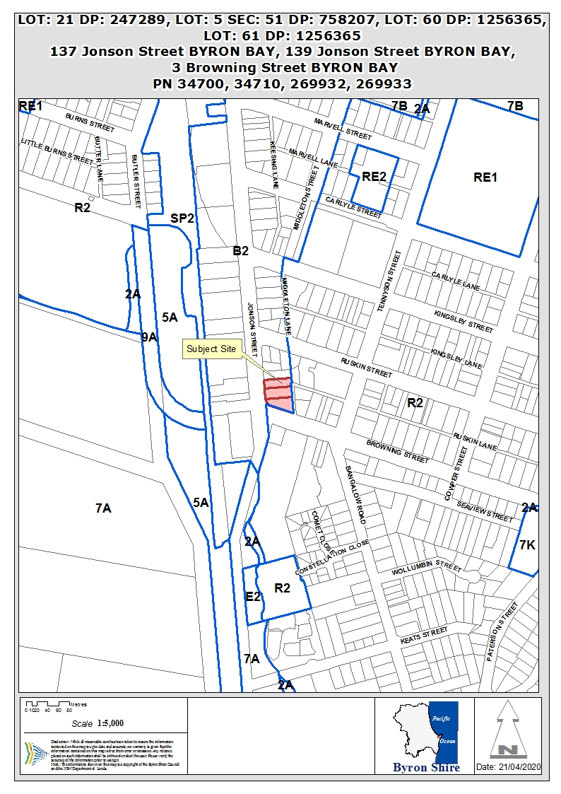
Assessment:
1. INTRODUCTION
1.1. History/Background
|
137 Jonson Street – Lot
21 DP 247289:
|
|
BA 1974/80
|
Dwelling – 4 bedrooms
|
Approved 24/05/1974
|
|
DA 5.1988.398.1
|
Conversion of garage to dual
occupancy
|
Approved 11/10/1988
|
|
BA 1998/2746
|
Alterations to existing flat
|
Approved 01/12/1998
|
|
BA 1991/2038
|
Additions to Dwelling
|
Approved 26/02/1991
|
|
139 Jonson Street – Lot
5 Sec 51 DP 758207:
|
|
DA 10.2011.553.1
|
Car hire business & use of garage as office
|
Approved 06/04/2012
|
|
3 Browning Street – Lots
61 & 61 DP 1256365 (previously Lot 6 Sec 51 DP 758207);
|
|
DA 10.2009.9.1
|
Tree removal – 1 tree
|
Approved 28/01/2009
|
|
Whole site:
|
|
DA 10.2017.510.1
|
Mixed use development comprising
demolition of all existing structures, removal of vegetation and construction
of commercial premises, cafe, child care centre, shop top housing, serviced
apartments and associated basement car parking and landscaping.
|
Refused (JRPP) 14/11/2018
|
DA 10.2017.510.1:
The application proposed a building of four storeys, with a
maximum height of 12.2m. It included a clause 4.6 objection in relation
to exceedance of the 9.0m maximum building height standard, which relied, in
part, on recommendations of the Byron Bay Town Centre Masterplan that the
height limit in this part of Jonson Street be increased to match the 11.5m
standard applicable in the remainder of the Town Centre.
The JRPP refused the clause 4.6 variation because:
a) the
extent of the non-compliance with the development standard (height of
buildings) is excessive (being most of the top level of Building 1 and all of
the top level of Building 2);
b) the
applicant’s justification relies on the proposed amendment to the height
control in Planning Proposal 26.2017.6.1, a Proposal that has not passed the
Gateway stage, has not been publicly exhibited, and the making of which is
neither imminent nor certain;
c) notwithstanding
the applicant’s reliance on Planning Proposal 26.2017.6.1, the applicant
proposes four storey buildings rather than the preferred three storey buildings
anticipated in the Byron Bay Masterplan which preceded the Planning Proposal;
d) the
applicant has not demonstrated any particular site characteristics that justify
the proposed variation;
e) the
applicant has not addressed the relationship of the proposed variation to
existing or potential future buildings to the north and east of the site, nor
the context of the development, apart from considering land to the west across
Jonson Street which is subject to a different height control.
Based on this, the Panel refused the Development Application
for the following reasons:
· The
proposal does not comply with the Apartment Design Guide criteria pursuant to
the SEPP 65 with respect to setbacks, deep soil zones and other matters,
and therefore does not adequately address the amenity impacts on neighbouring
properties;
· The
proposal does not comply with the requirements of Byron LEP 2014 with respect
to height and floor space ratio and the applicant’s written submissions
do not adequately justify the proposed contravention of the standards;
· The
development relies excessively on compliance with proposed planning controls in
a draft planning proposal, rather than seeking to comply with the current
planning controls. It would not be in the public interest for this
application to be approved, thereby pre-empting the public consultation and
consideration of submissions required by the Environmental Planning and
Assessment Act 1979 before a local environmental plan amending development
standards can be made.
Planning Proposal 10.2017.6.1:
The Proposal was originally reported to Council in November
2017, recommending a number of amendments to existing planning controls
applicable to the Byron Bay Town Centre. The proposal was prepared in
response to recommendations of the Byron Bay Town Centre Masterplan.
Of relevance to the subject application, the Planning
Proposal addressed building height, floor space ratio and car parking controls,
and also sought to introduce a ‘design excellence’ provision into
Byron LEP 2014.
Following preliminary community engagement, the draft
Proposal was reported to Council’s Meeting of 20 September 2018. In
relation to building height, the report recommended that the 9.0m maximum
applicable to this lower part of Jonson Street be retained.
At the meeting, Council resolved (18-609) to
seek an increase in the 9.0m maximum, to 11.5m to match the maximum applicable
elsewhere in the Town Centre.
That resolution was overturned at Council’s meeting of
22 November 2018, where Council resolved (18-777) to maintain the
existing 9.0m maximum building height in this location.
The Department of Planning, Industry and Environment issued
Gateway for the Planning Proposal in June 2019, and public exhibition was
undertaken in September to November 2018.
Consideration of the Planning Proposal is continuing.
Based on submissions received, a number of matters are being analysed in more
detail, including the applicability of floor space ratio as a development
control. There is also an opportunity to link the Planning Proposal to
work being undertaken in relation to an affordable housing contributions
scheme, to determine whether such a scheme could be extended to the Byron Bay
Town Centre.
At the Planning Meeting of 16 April 2019, Council resolved (20-151)
to defer further consideration of the Planning Proposal to enable the
establishment of a Design Panel and to allow for further consideration of
applying SEPP 70 within the Byron Bay Town Centre.
Byron Bay Town Centre
Masterplan:
The Masterplan was adopted by Council on 9 June 2016,
following an extensive community engagement program.
Within the Masterplan, the strategy for this location is:
“Incrementally transform Jonson Street South into a mixed use district
that supports medium density living and local business. By achieving this
outcome a greater population of residents and workers can be located within
walking distance of the town centre core.”
1.2. Description
of the proposed development
This development application seeks approval for demolition
of all existing buildings, removal of on-site vegetation and the construction
of a mixed use development comprising two three-storey buildings either side of
a central courtyard.
The architectural plan set is contained as Attachment 1.
Development Summary:
|
Ground Floor
|
Upper Floors
|
|
614m2 retail floor
space
|
2 x 1 bedroom units
|
|
120m2 café/
restaurant
|
20 x 2 bedroom units
|
|
799m2 commercial floor
space
|
2 x 3 bedroom units
|
|
57m2 ancillary space
(storage, amenities, etc.)
|
4 x 4 bedroom units
|
|
Central landscaped courtyard/
walkway
|
|
The development includes two levels of basement parking:
· Level
1: fifty-eight (58) car spaces, including two (2) disabled accessible
spaces; two (2) staff spaces in a stacked arrangement; two (2) electric car
charging bays; eight (8) motorcycle spaces; fifteen (15) bicycle racks and
charging station for battery operated bicycles; four (4) lifts –
one (1) immediately adjacent to cycle parking and one (1) goods lift; one
(1) plant room; two–way vehicle ramp access to exit above and two-way
vehicle ramp access to basement below.
· Level
2: sixty-five (68) car spaces, including forty (40) with private storage;
four (4) disabled accessible spaces; six (6) motorcycle spaces; two (2) lifts
plus one (1) goods lift; two (2) stairwells; one (1) plant room; two (2)
store rooms; and a two-way vehicle ramp access to basement level 1 above.
Above the basement levels, the development involves two (2)
building modules either side of a central open courtyard.
· Building
1 (north): a three (3) storey building containing:
- Ground level –
café/ restaurant (120m2); retail premises (74m2
& 226m2); commercial premises (311m2);
manager’s office (20m2); end of trip facilities (bike racks
and amenities/ change rooms); storage; toilets; tank room; stairs and lift off
the landscaped courtyard;
- Level 1 – seven (7) shop
top dwellings – 1 x one bedroom; 4 x two bedrooms; 2 x four bedrooms; and
- Level 2 – seven (7) shop
top dwellings – 1 x one bedroom; 4 x two bedrooms; 2 x four bedrooms.
· Building
2 (south): a three (3) storey building containing:
- Ground level – retail
premises (313.6m2); commercial premises (478.5m2);
vehicular access ramps from Ruskin Lane; a service area/ loading bay and
storage area accessed from Ruskin Lane; stairs and lift off the landscaped
courtyard.
- Level 1 – seven (7) shop
top dwellings – 6 x two bedrooms; 1 x three bedrooms; and
- Level 2 – seven (7) shop
top dwellings – 6 x two bedrooms; 1 x three bedrooms.
The proposed development also includes works within the
roads reserves, including new footpaths, street tree planting and awnings in
the Jonson and Browning Street frontage, ‘undergrounding of existing
electrical services, and the upgrade of Ruskin Lane for the frontage of the
property.
A landscaped central courtyard is a key feature of the
design, with open pedestrian walkways connecting the courtyard to the Jonson /
Browning Street intersection and to Ruskin Lane. It provides an
interesting visual focal point off the roundabout and also provides a vibrant,
attractive and useful passive space for the residents and users of the site.
It also provides a ‘light well’ for the
development and supports natural ventilation of residential units.
Excavation for the basement car parking will extend over the
majority of the property, to varying depths, involving the removal of approx.
21,500m3 of existing material (silts, sand and gravelly clay).
Tree removal will involve:
· 1
Lilly pilli;
· 2
Tuckeroos;
· 1
Brazilian pepper;
· 1
Chinese elm;
· 1
Frangipani;
· 1
Liquid amber; and
· 1
Oleander.
The proposed development has a total of 4,042.2m2
of gross floor area, as defined in Byron LEP 2014.
Commercial Uses:
The ground floor of the proposed development includes a
number of retail and commercial tenancies, as well as a café. At
this stage, the individual uses of the retail and commercial spaces are not
known.
The café has a total floor area of 120m2
and a seating capacity of approx. 35 people inside and 20 people in the
courtyard. Hours of operation for the café are proposed as 6:30am
to midnight.
Shop Top Housing:
A total of 28 residential units are proposed. The
developer has stated that they will be available for permanent occupation.
Four of the dwellings provide for people with disabilities
and another two are potentially adaptable. Strata subdivision of the
completed development is also proposed in this application.
All units face the external faces of the building and
include open balconies in addition to the internal living spaces. The
units are accessed via lifts and staircases from the basement and open onto
internal walkways, which frame the central landscaped courtyard. Timber
screens are proposed on the edge of the walkways to provide privacy.
Landscaping, including mature trees, is proposed within the
courtyard and on the internal walkways, as shown below:

Access:
Access to the development is proposed off the southern end
of Ruskin Lane. A left in/ left out restriction is proposed for the
Ruskin Lane/ Browning Street intersection, with a further restriction at the
development exit point to prevent traffic from using the remainder of Ruskin
Lane.
The proposal includes the widening of Ruskin Lane from
Browning Street to the north for approx. 65m to cater for two-way traffic
entering from Browning Street.
A medium rigid vehicle (MRV) loading bay is proposed
adjacent to the car park access ramp, also accessed from Ruskin Lane. The
loading bay will also provide for garbage collection, with enclosed waste
collection stores located either side of the bay, catering for both the
commercial and residential components of the development. Garbage
collection undertaken by a Heavy Rigid Vehicle (such as those used by Solo Waste),
will be undertaken in Ruskin Lane, with the HRV using the loading bay to turn
so as to exit Ruskin Lane in a forward direction. The on-site manager
will be responsible for the movement of waste bins for this collection.
Waste collection is proposed to be undertaken once per week for each of the
waste streams.
The traffic assessment submitted in support of the
application estimates that the completed development will generate 976 daily
vehicle trips, 163 trips in the morning peak and 117 trips in the afternoon
peak.
Building
Height:
All of the proposed building is three (3) storeys in
height. The ground floor of the development (i.e. the commercial
component) is set at around ground level at the Jonson and Browning Street
frontages. Because of the slope of the land, that ground floor level is
below existing ground level within the majority of the site.
As such, the major part of the building is well below the
9.0m height limit, when measured from existing ground level to the top of the
roof.
There are, however, parts of the roof edges that exceed the
9.0m height limit (see below).
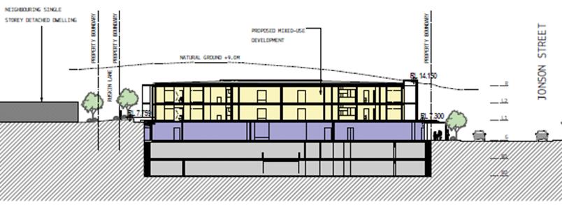
Building section - height in relation to 9.0m height
standard
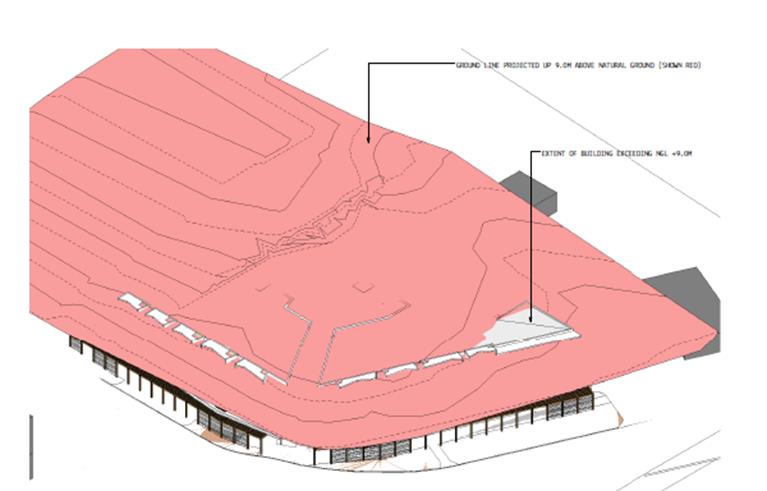
Perspective view - extent of building height exceedance
shown
Sustainability:
The proposed development achieves
an average 7.6 star band rating in the Nationwide House Energy Rating Scheme
(NatHERs). This is as an average across all apartments with individual
apartments reaching up to 8.6 stars.
For apartment design, this is a
high standard that is difficult to achieve. The rating depends on:
· the
layout
· the
construction of roof, walls, windows and floor
· the
orientation of windows and shading to the sun's path and local breezes; and
· how
well these suit the local climate.
Note: Typical ratings - Houses
built in 1990 averaged about one star on the NatHERS scale. Before the
introduction of national energy efficiency regulations for houses in 2003, less
than one per cent of Australian houses achieved six stars. Many well designed
houses are now being built that are rated at seven stars or more. (www.nathers.gov.au)
The design provides a number of
sustainability initiatives, including:
· significant
natural ventilation for all apartments, through the use of the central
courtyard/ void, and good solar access to most;
· vertical
timber screening to block western sun;
· connection
to reticulated treated wastewater for all landscape irrigation;
· photovoltaic
solar system to power building, services etc. and
· innovative
use of planting (green walls etc.) to increase the cooling effects of
vegetation.
The overall building performance
exceeds the minimum requirements of BASIX in terms of water and energy
efficiency.
Construction staging:
The development is proposed to be constructed in two stages,
with the basement carparking levels constructed first, followed by the
remainder of the building.
1.3. Description
of the site
The Site:
|
137 Jonson Street
|
Lot 21 DP 247289
|
758.8m2
|
|
|
139 Jonson Street
|
Lot 5 Sec 51 DP 758207
|
1,012.0m2
|
|
|
3 Browning Street
|
Lot 60 DP 1256365
|
1,009.0m2
|
|
|
|
Lot 61 DP 1256365*
|
29.1m2
|
|
|
|
|
2,835.9m2
|
|
|
* Lot 61 is currently owned by Byron Shire Council. It was created as
part of a ‘land swap’ arrangement to facilitate the construction
of the Bypass roundabout at the Jonson/ Browning Street intersection, where
part of the previous lot (Lot 6 Sec 51 DP 758207) was dedicated to Council
for road widening, in exchange for a strip of land approx. 0.6m wide along
the Browning Street frontage. A condition of consent is recommended
requiring the amalgamation of all lots prior to occupation of the building.
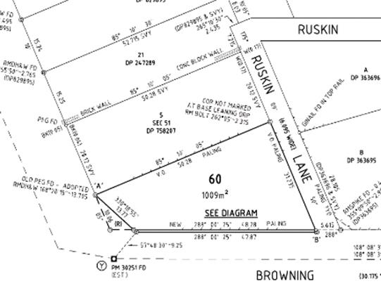
|
|
Land is zoned:
|
B2 Local Centre
|
|
Property is constrained by:
|
Acid Sulfate Soils (Class 5)
|
|
|
Proximity to Heritage Items – Norco Building located
on opposite side of Jonson Street; Jasmin House located on opposite side of
Browning Street.
|
|
|
|
|
|
Each of the existing properties contains a dwelling, with a
second dwelling located on Lot 21. The dwellings are single storey,
except for the two-storey dwelling at the Jonson Street frontage of
Lot 21. There are a number of existing trees across the properties
that will be removed for the proposed development.
The combined properties have a frontage to Jonson Street of
approx. 49m, with approx. 48m to Browning Street and approx. 60m to Ruskin
Lane. The property has a high point in its north-east corner, at approx. RL
8.0m AHD. It slopes to the south west at around 30, with low
points at the Browning Street frontage of approx. RL 3.8m AHD. The Jonson
Street frontage of the property is at approx. RL 4.2m AHD. The property is
oriented towards the Jonson/ Browning Streets intersection. The approved
Byron Town Centre Bypass will exit at this point, with a new four-way
roundabout proposed.
The property is located at the southern fringe of the Byron
Bay Town Centre. It is zoned B2 Local Centre, as is land immediately
north and on the opposite side of Jonson Street. Land on the eastern side
of Ruskin Lane is zoned R2 Low Density Residential. Land in the vicinity of the
property, on the eastern side of Jonson Street and further to the east, is currently
largely residential in nature, although there are a number of holiday
properties among the existing dwellings. On the opposite side of Jonson Street,
land uses are more commercial, other than shop-top dwellings immediately
opposite. Byron RSL Club is located in close proximity.
The approved design for the Byron Bypass includes the
construction of a roundabout at the Jonson/ Browning Streets intersection,
directly in front of the site. An acquisition of a small part of the
subject land has previously occurred to allow for a widening of the road
reserve in this location to accommodate the roundabout works. That
adjustment also provided for the creation of Lot 61 DP 1256365, which is a
narrow (approx. 0.6m wide) strip of land along the Browning Street frontage of
the property, which will be transferred to the land owners and consolidated
with the larger property holding.
Construction of the bypass roundabout is planned for
completion in late 2020 and it is likely to be in operation before construction
of the subject development.
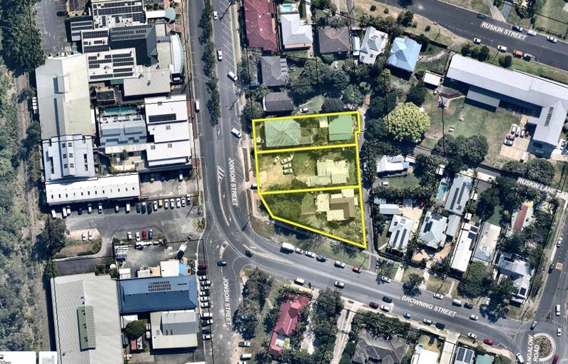
Site Locality
|
No.137Jonson St
|
No. 139 Jonson St
|
|
Existing dwelling No. 3
Browning St
|
Existing dwellings No .137
and No.139 Jonson Street from Ruskin Lane
|
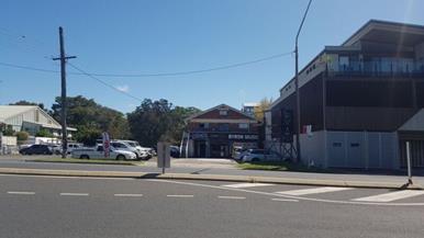
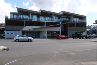
Existing buildings and shop
top apartments on western side of Jonson Street
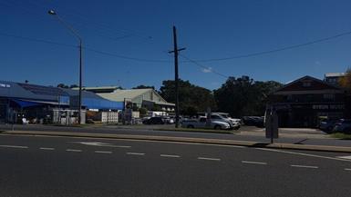
|
Location of proposed
by-pass road looking from site to west
|
Dwelling No. 5 Browning St
(approved as B&B)
|
|
Corner of Ruskin Lane
looking south
|
No 5 Browning Street
including solar panels
|
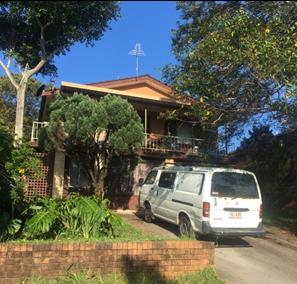
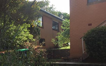
Existing dwelling to the
north
|
Ruskin Lane looking to Browning Street
|
Browning Street looking to Ruskin Lane
|
2. SUMMARY
OF REFERRALS
|
Referral
|
Issue
|
|
Environmental Health Officer
|
No objections subject to conditions.
|
|
Development Engineer
|
No objections subject to conditions.
|
|
Building Surveyor
|
No objections subject to conditions.
|
|
S64 / Systems Planning Officer
|
No objections subject to conditions.
|
|
Contributions Officer
|
The proposed development is mixed use and s7.12 levy or
s7.11 contributions may apply. The contributions plan requires that
whichever the greater amount is to be applied.
The estimated cost of works is
$19,340,326. The s7.12 levy would equate to 1% of that, which is
$193,403.
The S7.11 levy, calculated based
on the residential component of the development, will be $254,240.11.
This larger amount is therefore
imposed by consent condition.
|
|
Local Traffic Committee
|
The proposal includes a number of regulatory and advisory
traffic signs associated with the access off Ruskin Lane. The signs
were considered and endorsed at the Local Traffic Committee meeting of 12 May
2020.
|
|
Roads & Maritime Services
|
RMS has provided a response highlighting the traffic
issues to be considered. See discussion below.
|
RMS advice to Council suggests that Council should be
satisfied that:
· The
impacts of through and turning traffic have been adequately addressed.
Westbound right-turning traffic into Ruskin Lane will have an impact on through
traffic due to the kerbside parking on the southern side of Browning
Street. This will have an impact on the safety and efficiency of the
regional road.
Note: A median is proposed to be
placed in the centreline of Browning Street to prevent the right-turn movement
referred to above.
· Adequate
parking is being provided for staff, customers and residents.
· Service
vehicles should enter and leave the site in a forward manner. The loading
dock will be able to be utilised by the proposed retail, commercial and
residential uses. Garbage and waste collection services have been safely
and adequately catered for.
· Adequate
consideration should be given to connectivity for public transport facilities
and active transport modes such as walking and cycling. Traffic exiting
Ruskin Lane will have to give-way to pedestrians.
· Regulatory
signs and devices will require the endorsement of the Local Traffic Committee
prior to Council approval.
The proposed road works at
Ruskin Lane are clear of the extent of works for the bypass. The traffic
study is adequate to demonstrate that the proposal will have limited impact on
the functionality of the bypass, with Ruskin Lane should be left in left out
only and a central median extended from pedestrian refuge in the bypass roundabout.
3. SECTION
4.14 – BUSH FIRE PRONE LAND
Under section 4.14 of the Act, Council must be satisfied
prior to making a determination for development on bush fire prone land, that
the development complies with the document Planning for Bush Fire Protection
2006.
The site is not bush fire prone land.
4. SECTION
4.15C – MATTERS FOR CONSIDERATION – DISCUSSION OF ISSUES
Having regard to the matters for consideration detailed in
Section 4.15(1) of the Environmental Planning & Assessment Act 1979
(EP&A Act), the following is a summary of the evaluation of the issues.
4.1 State
Environmental Planning Instruments
|
|
Satisfactory
|
Unsatisfactory
|
|
State Environmental
Planning Policy No 44 - Koala Habitat Protection
|
☒
|
☐
|
|
Consideration: The subject site has an area less than
1ha. The development control provisions of this SEPP therefore do not
apply.
[Note: On 1 March
2020, this SEPP was repealed and replaced by SEPP (Koala Habitat Protection)
2019. The savings provisions of the new SEPP provide, however, that a development application made, but not
finally determined, before the commencement of the new Policy must be
determined as if this Policy had not commenced]
|
|
State
Environmental Planning Policy No 55 - Remediation of Land
|
☒
|
☐
|
|
Consideration: Clause 7 of the policy requires the consent
authority to consider whether the land is contaminated. A Stage 1
Preliminary Contamination Assessment, prepared by ENV Solutions dated June
2019 (updating their previous report of May 2017), demonstrates, based on a
review of site history as well as soil sampling across the property, that
further investigations in relation to contamination are not required.
The Stage 1 Preliminary Contamination Assessment for the
proposed development has been considered and is deemed to satisfy the
requirements of clause 7.
|
|
State
Environmental Planning Policy No 65 - Design Quality of Residential Apartment
Development
|
☒
|
☐
|
|
Consideration: The SEPP applies as the proposal involves
more than four (4) shop top dwellings in a three (3) storey building.
Clause 28 of SEPP 65 requires
that, in determining an application to which the SEPP applies, Council must
consider the Design Quality Principles contained in Schedule 1 of that
Policy, as well as consistency with Apartment Design Guide (Dept
Planning & Environment, 2015).
Assessment of the proposed
development in relation to the principles and the Guide is contained at
Attachment 2.
The Guide is primarily applicable
to residential development, although there are some areas where guidance is
provided for mixed-use situations such as this, where shop-top housing is
proposed within a commercial zone.
If the apartments were proposed as
tourist use, SEPP 65 would not apply.
The Apartment Design Guide - Desired future character also provides for
developments that will vary from the established character of an area.
This is particularly relevant in the context of this site, which proposes a
density and mix of uses on the most southern edge of Byron Bay Town Centre
that is very different to the existing buildings within and immediately
adjoining the site. Other developments on the western side of Jonson Street
already approved or under construction including the old butter factory site
and the ‘Marcato’ development have established a precedent for
this emerging built form.
The proposed development is consistent with the design
principles, and is generally consistent with the Apartment Guide, with
exceptions addressed below:
· Section 3D Communal open space
|
Objective:
|
provide open space to enhance
residential amenity and opportunities for landscaping.
|
|
Criteria:
|
communal
open space should have an area of at least 25% of the site.
|
|
|
there should be at least 50%
direct sunlight to open space for a minimum of 2hrs between 9am & 3pm
mid-winter.
|
|
Inconsistency:
|
central courtyard area only 14%
of the site area.
|
|
|
only 22% of courtyard receives
the required amount of direct sun.
|
|
Justification:
|
The design guide indicates
that, where developments are unable to achieve the design criteria, they
should:
- provide communal spaces
elsewhere such as a landscaped roof top terrace or a common room;
- provide larger
balconies or increased private open space for apartments;
- demonstrate good
proximity to public open space and facilities and/ or provide contributions
to public open space.
The development includes
balconies that, in all cases, are larger than suggested by the design
guide. The applicant also suggests that the site is located in easy
walking distance to a range of open space areas, including main beach and
the Byron Bay Rec Grounds.
|
· Section 3E Deep soil zones
|
Objective:
|
provide deep soil areas to
support plant and tree growth, to provide amenity and promote good
stormwater management (i.e. infiltration).
|
|
Criteria:
|
deep soil
areas should equate to 7% of the site area, and have a minimum width of 6m.
|
|
Inconsistency:
|
deep soil areas limited to 2.3%
of site area and none have the required 6m width.
|
|
Justification:
|
The location of the primary
deep soil area is along the Ruskin Lane boundary, hard up against the
eastern wall of the building, with a width of only 1.5m. This is
unlikely to allow for and support healthy plant and tree growth.
Existing trees on boundaries
are not retained, with limited opportunity to replace except within
streetscape.
The guide provides for
alternate forms of planting. The application proposes podium planting
of all levels, as well as ‘green walls’ and significant
streetscape planting.
The guide provides that achieving
the design criteria may not be possible on some sites including where:
· the
location and building typology have limited or no space for deep soil at
ground level (e.g. central business district, constrained sites, high
density areas, or in centres)
· there is
100% site coverage or non-residential uses at ground floor level
Where a proposal does not
achieve deep soil requirements, acceptable stormwater management should be
achieved and alternative forms of planting provided such as on structure.
In this case, provisions
relating to commercial uses in the B2 zone allow for 100% site coverage,
which is typical of a town centre area.
Stormwater management for the
development will include on-site detention as well as treatment, to ensure
that post-development flows are maintained and that discharge quality meets
the required standards.
Alternative forms of planting
are proposed, in addition to the podium planting within the central
courtyard, including green walls and trellises.
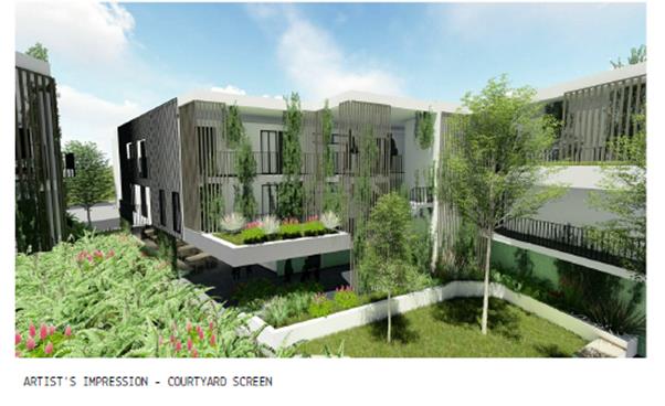
It is considered that,
notwithstanding the numerical non-conformance, the development as proposed
is consistent with the design objectives of this part of the Guide, in that
alternate landscape proposals will result in significant podium planting.
|
· Section 3F Visual privacy
|
Objective:
|
separation to neighbouring
sites achieves reasonable levels of visual privacy.
|
|
Criteria:
|
6m from
property boundary to habitable rooms and balconies.
|
|
Inconsistency:
|
northern boundary – 6m to
habitable rooms, but 3m to edge of balconies.
|
|
Justification:
|
The adjoining property is also
zoned B2 Local Centre, and the existing dwelling on that land is
aged. The dwelling on that lot is approx. 3.5m north of the common
boundary. It is reasonable to assume that the site would be
redeveloped for commercial and/ or mixed uses in future.
Landscape planting in the
setback will assist in reducing privacy issues.
|
· Section 4A Solar and daylight
access
|
Objective:
|
optimise the number of
apartments receiving sunlight to habitable rooms.
|
|
Criteria:
|
living rooms
and private open space of at least 70% of apartments receive a minimum of
3hrs direct sunlight between 9am and 3pm in mid-winter.
|
|
Inconsistency:
|
36% of apartments comply.
21% receive no direct sunlight between 9am and 3pm mid-winter.
|
|
Justification:
|
The orientation of the site,
with three street frontages, on the east, west and south, make it difficult
to achieve solar access to all units without significantly altering the
design so that units do not face the street frontages.
In terms of good design for
this prominent corner, it is considered that having the shop top apartments
face the street frontages is a good outcome.
|
· Section 4C Ceiling heights
|
Objective:
|
ceiling heights provide good natural
ventilation and daylight access.
|
|
Criteria:
|
in mixed use
areas – 3.3m ground & first floor (to promote future flexibility
of use for first floor); 2.7m for residential floors.
|
|
Inconsistency:
|
ground floor – 3.0m;
first floor (which is residential) – 2.7m.
|
|
Justification:
|
For ground floor commercial
uses, 0.3m discrepancy is minor and will not significantly impact
ventilation or sunlight. 3.3m is not considered necessary for first
floor, given the location of the property at the southern end of the business
zone, and the extent of land zoned for business uses – it is very
unlikely that there would be future demand to change first floor to
commercial use.
|
|
|
State
Environmental Planning Policy (Building Sustainability Index: BASIX) 2004
|
☒
|
☐
|
|
Consideration: Clause
6 (1) provides that proposed
BASIX affected development for which the regulations under the Act require a
BASIX certificate to accompany a development application.
The proposal is accompanied by a
valid BASIX and NatHers certificate. The SEPP has been addressed and
the proposal is considered to comply.
|
|
State Environmental Planning
Policy (Coastal Management) 2018
|
☒
|
☐
|
|
Consideration: The property is not located within the
Coastal Zone and is not affected by any mapping under this SEPP.
|
|
State
Environmental Planning Policy (Infrastructure) 2007
|
☒
|
☐
|
|
Consideration: Clauses 101, 102 and 104 of the SEPP are
applicable, as the property fronts Jonson Street and Browning Street, which
are part of the classified road (MR 454).
· Clause 101
The clause applies to
development on land that has a frontage to a classified road. The
objectives are to ensure that new development does not
compromise the effective and ongoing operation and function of classified
roads, and to prevent or reduce the potential impact of traffic noise and
vehicle emission on development adjacent to classified roads.
Both Jonson and
Browning Streets are part of the classified road network in this area
(MR454).
The clause requires that a
consent authority must not consent to development on such land unless it is
satisfied that:
· where practicable
and safe, vehicular access to the land is provided by a road other than the
classified road
This is
addressed in more detail in section 4.8 of this report (below). The
proposed development is designed to have access from Ruskin Lane, to avoid access
directly from the classified roads (Jonson & Browning Street).
The
assessment below indicates that the access as proposed is both practicable
and safe, and the proposal therefore complies with this requirement.
· the safety,
efficiency and ongoing operation of the classified road will not be adversely
affected by the development as a result of:
(i) the
design of the vehicular access to the land, or
(ii) the
emission of smoke or dust from the development, or
(iii) the
nature, volume or frequency of vehicles using the classified road to gain
access to the land
The detailed assessment of
traffic aspects of the development is outlined in Section 4.8 of this report
(below). Restricting access at the intersection of Browning Street and
Ruskin Lane to left in / left out is the primary measure that addresses
traffic safety and efficiency in this location.
· the development is
of a type that is not sensitive to traffic noise or vehicle emissions, or is
appropriately located and designed, or includes measures, to ameliorate
potential traffic noise or vehicle emissions within the site of the
development arising from the adjacent classified road.
An acoustic assessment has
been submitted, demonstrating that the residential uses will not be adversely
impacted by road noise.
· Clause 102
Clause 102 provides that the consent authority considers the
impact of road noise or vibration on proposed residential accommodation that
is adjoining a road with an annual average daily traffic volume of more than
20,000 vehicles. An Environmental Noise Impact Report Environmental
Noise Impact Report by CRG Acoustics Pty Ltd, dated 06 November 2019, recommends a number of inclusions to
minimise noise impact from the development. The proposed
development is considered to be satisfactory with regards to the classified
road subject to conditions of consent.
· Clause 104 of
State Environmental Planning Policy (Infrastructure) 2007
Clause 104 requires that Roads and Maritime
Services (RMS) is given the opportunity to comment on development that is
traffic generating development specified under Schedule 3 of the SEPP.
The proposed development is traffic generating development based on the
proposed number of motor vehicle trips per hour. The RMS provided
written comments in a letter to Council dated 19 December 2019 to assist in
making a determination. The proposed development is considered to be
satisfactory with regards to traffic generating development, subject to
conditions of consent.
|
|
State
Environmental Planning Policy (State and Regional Development) 2011
|
☒
|
☐
|
|
Consideration: The previous application (DA 10.2017.510.1)
met the criteria of “regional development”, as defined at the
time it was lodged. Determination of that application was therefore
undertaken by the Northern Joint Regional Planning Panel.
Since that time, the threshold
for ‘general development’ has increased from $20M to $30M.
The current application has an estimated cost of approx. $19M, and it
therefore is not regional development.
Council is therefore the
determining authority for this application.
|
4.2 Byron Local
Environmental Plan 2014 (LEP 2014)
LEP 2014 is an applicable matter for consideration in the
assessment of the subject development application in accordance with subsection
4.15(1) of the EP&A Act because it applies to the subject land and the
proposed development.
In accordance with LEP 2014 clauses 1.4 and 2.1 – 2.3:
(a) The
proposal is defined as mixed use development in the LEP
dictionary, which means a
building or place comprising 2 or more different land uses.
The individual land uses within the proposed development are defined in the
dictionary as:
· Commercial
Premises, including
- Business Premises;
- Office Premises; and
- Retail Premises,
including:
- Food and Drink
Premises, being:
- Restaurant or
café;
· Shop
top housing;
(b) The
land is within the B2 Local Centre according to the Land Zoning Map;
(c) All
components of the proposed development are permitted with development consent;
and
(d) Regard
is had for the Zone Objectives as follows:
|
Zone Objective
|
Consideration
|
|
To provide
a range of retail, business, entertainment and community uses that serve the
needs of people who live in, work in and visit the local area.
|
The provision of shops/ commercial uses will serve the
needs of people who live and work in Byron Bay Town Centre.
|
|
To encourage employment
opportunities in accessible locations.
|
The commercial uses will generate employment.
|
|
To maximise public transport
patronage and encourage walking and cycling.
|
The site is located on a bus route. Cycling spaces
are provided as well as ‘end of trip’ facilities. The site is
located in easy walking distance to the remainder of the town centre.
|
|
To encourage vibrant centres
by allowing residential and tourist and visitor accommodation above
commercial premises.
|
Consistent.
|
Clause 2.7 – Demolition
requires consent
Clause 2.7 requires that demolition of a building may be
carried out only with development consent, except where it is demolition of development specified as
exempt development under State Environmental Planning Policy (Exempt and
Complying Development Codes) 2008. The proposal seeks consent for
the demolition of all existing structures including four (4) dwelling houses
and ancillary structures. This type of demolition is not exempt
development. It is permissible with consent under Clause 2.7.
Clause 4.3 – Height of buildings
Clause 4.3 provides that the height of a building on any
land is not to exceed the maximum height shown for the land on the Height
of Buildings Map. The height is measured from existing ground level to
the finished level of the roof or parapet.
The maximum building height applicable to this part of the
town centre is 9.0m. This height limit applies to land on the eastern
side of Jonson Street, between Browning Street and Kingsley Street.
Elsewhere within the town centre, the majority of land has a maximum height of
11.5m.
The proposed building has a maximum height of 9.9m over a
relatively small part of the building (see illustrations below), 0.9m above the
LEP maximum.
The applicants have provided a submission under clause 4.6
of the LEP (see below), arguing that compliance with the 9.0m development
standard is unreasonable and unnecessary. The submission is addressed
below.
It is considered that the parts of the site over 9.0m can be
justified on the basis of the clause 4.6 submission (see below).
Clause 4.4 – Floor space ratio
Clause 4.4 provides that the maximum floor space ratio (FSR)
for a building on any land is not to exceed the FSR shown for the land on
the floor space ratio map. The maximum permissible FSR on the site is 1.3:1.
FSR is the ratio
of the total gross floor area of a building to the total area of the property.
The proposed FSR
of 1.425:1 exceeds the maximum and the application includes a request to
vary the development standard. It is considered that the variation can be
justified on the basis of the clause 4.6 submission (see below).
Clause 4.6 – Exceptions to development
standards
Where a DA includes a variation to a development standard,
an application under clause 4.6 of the LEP is required.
Clause 4.6 provides that development consent must not be
granted for development that contravenes a development standard unless the
consent authority has considered a written request from the applicant that
seeks to justify the contravention of the development standard, by
demonstrating that compliance with the development standard is unreasonable or
unnecessary in the circumstances of the case, and that there are sufficient
environmental planning grounds to justify contravening the development
standard.
The clause 4.6 submission addresses the following variations
to development standards:
Height:
1. Introduction
– Summary of Height Exceedance
The building presents a maximum
height of 9.9m above ground level (existing) for a small portion of the roof line,
being 0.9m higher than the prescribed numerical development standard (see
below).
Other than the parapet and roof
elements shown below, the building otherwise complies with the 9.0m height
limit. Given the slope of the land, and excavation proposed at the
northern end of the site, there are substantial portions of the building that
will be significantly less than 9.0m above existing ground level. The
illustrations below, extracted from the architectural plan set at Attachment 1,
show the nature and extend of exceedance.
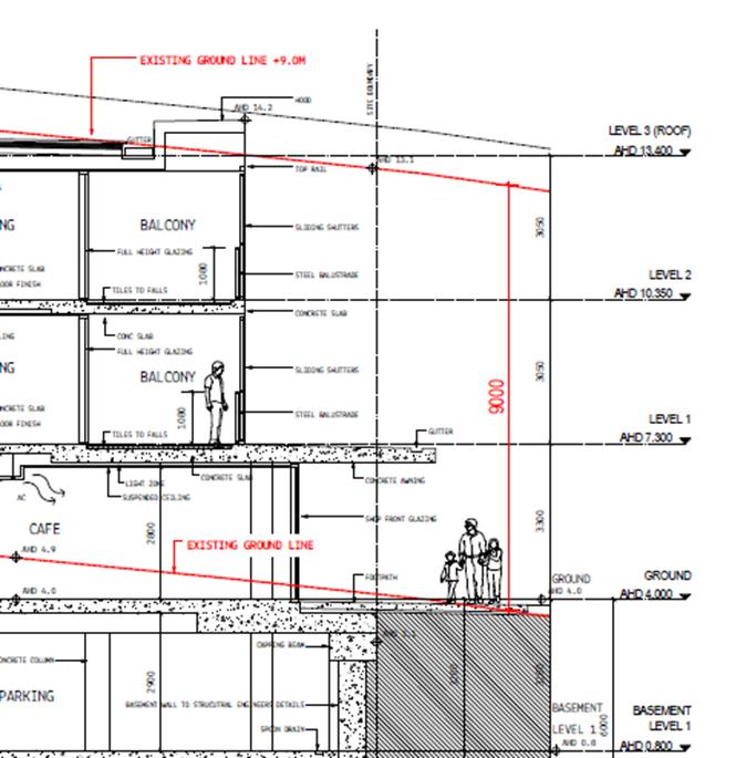
Section highlighting building
height exceedance
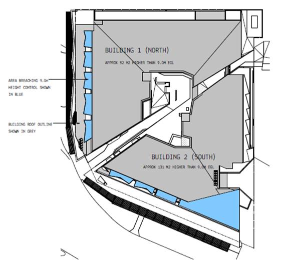
Roof plan – parapets
exceeding 9.0m limit shown in blue
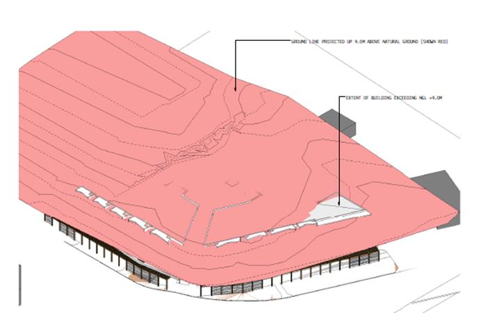
Perspective view –
extent of building height exceedance shown – ground line projected up
9.0m above existing ground level (shown red)
2. Clause 4.6
Exception to Development Standards
Byron LEP 2014 Clause 4.6 allows the granting of a development consent in the instance that a
development would contravene a development standard. However, Council
must first be satisfied by a written request from the Applicant, that:
a) compliance
with the development standard is unreasonable or unnecessary in the
circumstances of the case, and
b) there
are sufficient environmental planning grounds to justify contravening the
development standard, and
c) the
proposed development will be in the public interest because it is consistent
with the objectives of the particular standard and the objectives for the
development within the zone in which the development is proposed to be carried
out.
3. The
Development Standard to be varied
The Development Standard to be
varied is the 9.0m building height, prescribed by the Height of Buildings Map
applicable to the site under Clause 4.3 of LEP 2014.
4. Extent of
Variation to the Development Standard
Approx. 52m2 (5.4%) of
the roof of Building 1 (total roof area of 950m2) is above the 9.0m
standard. Approx. 131m2 (15.1%) of the roof of Building 2
(total roof area of 862m2) is above the 9.0m standard.
5. Objective of
the Development Standard
The objectives of the development
standard, as outlined in subclause 4.3(1), are:
a) to
achieve building design that does not exceed a specified maximum height from
its existing ground level to finished roof or parapet,
b) to
ensure the height of buildings complements the streetscape and character of the
area in which the buildings are located,
c) to
minimise visual impact, disruption of views, loss of privacy and loss of solar
access to existing development.
6. Objective of
the Zone
The objectives of the B2 Local Centre
zone have been addressed in the section above.
7. Assessment
– specific questions to be addressed under LEP Clause 4.6:
(a) Clause 4.6(3)(a)
– Is compliance with the development standard unreasonable or unnecessary
in the circumstances of the case?
As shown in the extracts above, the bulk of the height
exceedance comes primarily from the parapets at the roof edges (shown below).
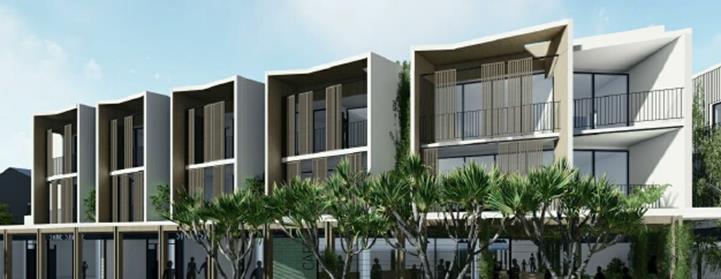
Parapets – Jonson
Street frontage
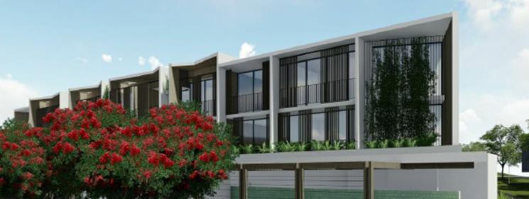
Parapets – Browning
Street frontage
The parapets are a key part of
the buildings design; part of the articulation of the buildings that break up
its bulk. Whilst they could be lowered to achieve compliance, that would
likely result in the loss of the angled elements across the top, resulting in a
far more ‘boxy’ look.
The applicant’s submission
argues that strict compliance with the development standard is unnecessary and
unreasonable because:
· there
will be no loss of amenity or excessive or unreasonable shadowing of the open
space areas on adjoining lands or on adjoining public domain
The height exceedance on the Jonson
Street frontage does not contribute at all to shadowing from the building.
The height exceedance along Browning
Street does contribute, with the maximum shadowing – i.e. 3pm mid-winter
– shown below:
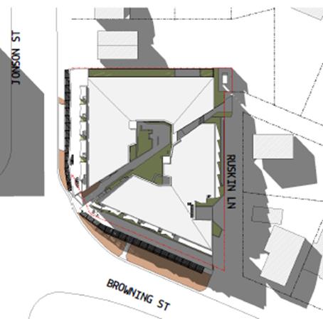
Given that the height exceedance
is less than 1m and over a relatively small area, lowering the building roof
elements to comply with the 9.0m limit would have very little impact on the
extent of shadow.
The proposed development will
alter the existing amenity of the immediate area, particularly in relation to
the two existing properties immediately to the east. The current amenity,
however, is related to single storey dwellings on the subject site, which is
inconsistent with the zoning of the land.
The location of the height
exceedances, as shown above, has little to no impact on the change to existing
amenity. In terms of a relationship with the two adjoining dwellings, a
building compliant with the maximum height would have the same impact.
The impact is further mitigated by existing vegetation and
fencing along the Ruskin Lane boundary of the two adjoining lots, as shown
below.
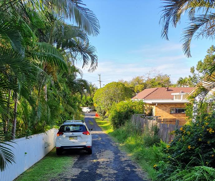
Ruskin Lane looking south –
development site on right; adjoining lots to the left
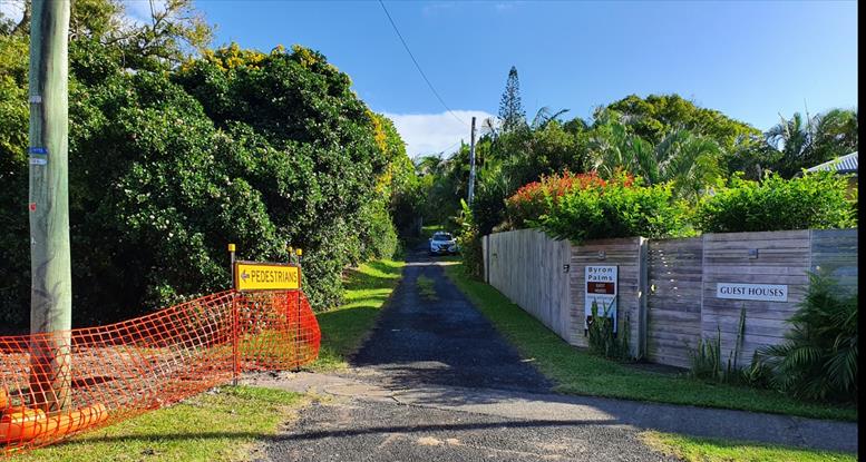
Ruskin Lane looking north –
development site on left; adjoining lots to the right
· the
development is compatible and consistent with the height, scale, size,
character, bulk, mass and use of buildings to the west
While the subject site is not
directly adjacent to the buildings referred to, those existing structures
provide a context to development at the southern end of Jonson Street, which is
more consistent with the zone objectives than the buildings directly adjoining
to the north.
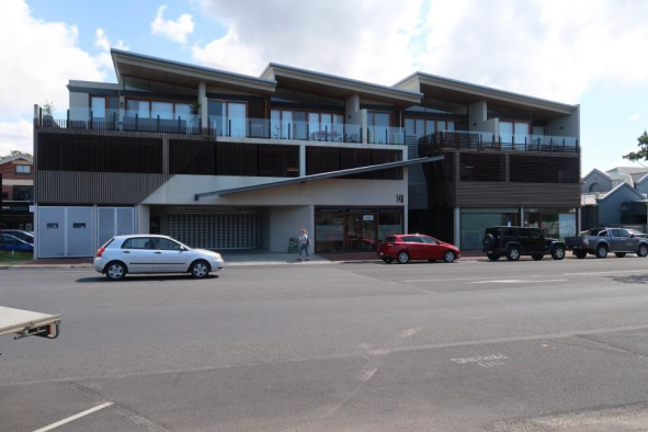
Development on western side of
Jonson Street, directly opposite site
Approved plans of the
building shown, which was approved under BLEP1988, indicate that it has a
maximum height of 13.5m.
The maximum allowable
building height on the western side of Jonson Street is currently 11.5m from
existing ground to the highest point. Under the previous LEP/ DCP
provisions, height was controlled differently, with maximums set from existing
ground to the ceiling of the first floor and another maximum for the ceiling of
the highest level.
Other existing
buildings located behind the RSL, which were previously part of the NORCO
factory, have maximum heights similar to the building shown above.
Existing buildings on
the eastern side of Jonson Street in this locality are all residential in
nature, with a maximum of two storeys. Given the nature of the type and
age of buildings on this eastern side, it is reasonable to assume that
redevelopment will occur in the short to medium timeframe to provide buildings
and uses more consistent with the commercial zoning, which are expected to be
larger structures.
(b) Clause 4.6(3)
(b) – Are there sufficient environmental planning grounds to justify
contravening the development standard?
The environmental planning grounds
are:
· The
development meets the objectives of the B2 Local Centre zone.
· The height
exceedance comes from a small building element only. The majority of the
building complies. The elements that exceed the 9.0m limit – i.e.
parapets and a small section of roof – are an important design element
associated with articulation of the building façade. If the
parapets were reduced by 0.9m (or less in some areas) to comply with the height
limit, it would result in a more ‘boxy’ look to the facades but
otherwise make no difference to the scale of the building or its impacts on
neighbours.
· The
relatively minor exceedance does not result in any significant amenity of
shadowing impacts on adjoining properties.
(c) Clause
4.6(4) (a) (ii) – Is the proposed development in the public interest? Is
it consistent with the objectives of the standard and the zone as set out
above?
The objectives of the standard are:
a) to
achieve building design that does not exceed a specified maximum height from
its existing ground level to finished roof or parapet,
This is somewhat of an anomaly, in
that cl 4.6 would have no work to do in allowing flexibility to the application
of the maximum building height standard if this objective meant that the
maximum height always had to be met.
b) to
ensure the height of buildings complements the streetscape and character of the
area in which the buildings are located,
The building will be of a height
appropriate to this location, given the existing development to the west and
the anticipated future development to the north.
Development to the east is located on
land zoned residential (R2 Low Density Residential). The amenity of that
adjoining development is addressed by the 9.0m height limit in this part of the
B2 zone, whereas 11.5m applies elsewhere.
As outlined above, the exceedance of
this 9.0m limit is minor in terms of the numerical exceedance (i.e. 0.9m) and
the area of roof that is above the limit.
c) to
minimise visual impact, disruption of views, loss of privacy and loss of solar
access to existing development.
This is addressed above. The
design minimises such impacts. It is also noted that the two properties
located immediately to the east are both used for tourism accommodation and it
would therefore be expected that there would be periods where both properties
are not occupied.
The proposal and associated request to vary a development
standard is considered to meet subclause (3) of clause 4.6, and therefore
the request to vary a development standard is supported in this case.
Floor Space Ratio:
1. Introduction
– Summary of FSR Exceedance
A maximum floor space ratio of
1.3:1 applies to the subject site under BLEP 2014. This ratio applies to
the whole of the B2 Local Centre zone within the Byron Town Centre.
The proposed FSR of 1.42:1 exceeds the maximum.
2. Clause 4.6
Exceptions to Development Standards
LEP 2014 Clause 4.6 allows the granting of development consent in the instance that a
development would contravene a development standard. However, Council
must first be satisfied by a written request from the Applicant, that:
a) compliance
with the development standard is unreasonable or unnecessary in the
circumstances of the case, and
b) there
are sufficient environmental planning grounds to justify contravening the
development standard, and
c) the
proposed development will be in the public interest because it is consistent
with the objectives of the particular standard and the objectives for the
development within the zone in which the development is proposed to be carried
out.
3. The
Development Standard to be varied
The Development Standard to be
varied is the 1.3:1 maximum floor space ratio, prescribed by the Floor Space
Ratio Map applicable to the site, under Clause 4.4 of LEP 2014.
4. Extent of
Variation to the Development Standard
Given that the site area is
2,835.9m2, the specified floor space ratio of 1.3:1 would allow a
maximum floor space of 3,686.7m2. The proposed development has
a total floor space of 4,042.2m2, which equates to a 9.6%
variation.
In terms of floor area, the
exceedance is 355.5m2.
5. Objective of
the Development Standard
The objectives of the development
standard, as outlined in subclause 4.4(1) are:
a) to ensure that new buildings are
appropriate in relation to the character, amenity and environment of the
locality;
b) to enable a diversity of housing types by encouraging
low scale medium density housing in suitable locations;
c) to provide floor space in the business and
industrial zones adequate for the foreseeable future;
d) to regulate density of development and
generation of vehicular and pedestrian traffic;
e) to set out maximum floor space ratios for
dual occupancy in certain areas.
6. Objective of
the Zone
The objectives of the B2 Local
Centre zone have been addressed in the section above.
7. Assessment
– specific questions to be addressed under LEP Clause 4.6:
(a) Clause 4.6(3)
(a) – Is compliance with the development standard unreasonable or
unnecessary in the circumstances of the case?
The applicant’s submission
argues that strict compliance with the development standard is unnecessary and unreasonable
because:
· The
development reflects the character of existing commercial and accommodation
buildings in Jonson Street and will define the southern edge of the Byron Bay
town centre, consistent with the streetscape and character strategy of the
Byron Bay Masterplan.
Within the Masterplan, the strategy
for this location is: “Incrementally transform Jonson Street South
into a mixed use district that supports medium density living and local
business. By achieving this outcome a greater population of residents and
workers can be located within walking distance of the town centre core.”
This Masterplan strategy is
consistent with the objectives of the B2 zone. In providing a mix of
retail, commercial and residential uses, the proposed development is consistent
with both the existing zoning and the Masterplan strategy for the locality.
· a
diversity of housing types is provided, directly consistent with the objective
of the development standard.
· Exceeding
the floor space ratio does not substantially contribute to the buildings’
height, scale, bulk or density. The proposed development is compatible in
height, scale and bulk to those on lands to the west.
Existing buildings to the west are
consistent with the B2 Local Centre zoning of the locality and indicate the
likely future development of the area as older residential buildings are
replaced.
The size and scale of the proposed
building is consistent with those to the west, and generally consistent with
what could reasonably be expected in the future.
· The DA is
consistent with the strategic directions of the draft Planning Proposal
26.2017.6.1 (Byron Bay Town Centre Planning Control Review)
See further detail in Section 4.3
below. This Planning Proposal has been subject of public
consultation. In part, it proposes to remove floor space ratio as a
development standard applicable to the town centre.
Consideration of public submissions
in response to this proposal is continuing and Council has not yet made a
decision on proceeding with it.
Whilst final recommendations have not
yet been prepared, it is likely that such recommendations will include changes
to the floor space ratio standard, either to remove it or to increase it to
1.5:1 where design excellence can be demonstrated.
(b) Clause 4.6(3)(b)
– Are there sufficient environmental planning grounds to justify
contravening the development standard?
See above. The environmental
planning grounds are:
· The
development meets the objectives of the B2 Local Centre zone.
· The floor
space exceedance is minor and does not significantly contribute to the bulk of
the buildings.
· The
relatively minor exceedance does not result in any significant amenity impacts
on adjoining properties.
(c) Clause
4.6(4)(a) (ii) – Is the proposed development in the public interest? Is
it consistent with the objectives of the standard and the zone as set out
above?
The objectives of the standard are:
a) to ensure that new buildings are
appropriate in relation to the character, amenity and environment of the locality;
See above. The proposed
buildings are consistent with the character of existing development on the
western side of Jonson Street, which reflect the type and scale of development
that is reasonably expected in the B2 zone in the future.
b) to
enable a diversity of housing types by encouraging low scale medium density
housing in suitable locations;
The development contributes to the provision of diverse rental
accommodation, within walking distance to the Byron Bay town centre.
c) to
provide floor space in the business and industrial zones adequate for the
foreseeable future;
Council’s recently adopted Business and Industrial Lands Strategy
concludes that there is sufficient zoned land within the town centre to cater
for the anticipated business demands into the future, if developed in
accordance with current planning provisions.
The ground floor component of the development contributes to achieving
this goal.
d) to
regulate density of development and generation of vehicular and pedestrian
traffic;
The exceedance of floor space ratio does not result in any significant
impact on the traffic generation of the development as a whole.
e) to set
out maximum floor space ratios for dual occupancy in certain areas.
Not relevant to current application.
The proposal and associated request to vary a development
standard is considered to meet subclause (3) of clause 4.6, and therefore
the request to vary a development standard is supported in this case.
Clause 5.6 – Architectural roof features
The parapets described above could be considered as
architectural roof features, in that their form is designed to add variety to
what would otherwise be straight rectangular roof features.
Considered in this way, clause 5.6 allows a building to
exceed the maximum height limit if that exceedance is due to the architectural
features.
In this case, there are other minor roof elements that
exceed the 9.0m height limit (see diagrams above), so justification for the
exceedance does not rely on this clause.
Clause 5.10 – Heritage Conservation
Part 5 of this clause specifies that, in relation to
development of land within the vicinity of heritage items, Council can require
an assessment of the extent to which the development would affect the heritage
significance of the items.
The site is located in the vicinity of two heritage items
– the old NORCO factory on the west side of Jonson Street, and an older
dwelling on the southern side of Browning Street, used as a wellness facility
known as Jasmin House. The applicant concludes that the proposed
development will not diminish the heritage significance of these items given
the distance between the site and the items, particularly given the separation
by busy roads.
In relation to the NORCO building, contemporary development
has been approved and constructed on the Jonson Street frontage, providing a
visual separation between the subject site and the remaining heritage
buildings.
Clause 6.1 of Byron Local Environmental Plan
2014 - Acid sulfate soils
This clause provides that, where applicable, development
consent must not be granted for the carrying out of works unless an acid
sulfate soils management plan (ASSMP) has been prepared in accordance with the
Acid Sulfate Soils Manual and has been provided to the consent authority.
An ASSMP prepared by ENV Solutions P/L dated June 2019 provides that Actual
Acid Sulfate Soils and Potential Acid Sulfate Soils can be adequately
managed.
Clause 6.2 of Byron Local Environmental Plan
2014 – Earthworks
Clause 6.2(3)
requires the consent authority to consider the effects of the proposed
development on the environment and surrounding area as a result of any proposed
earthworks. The earthworks associated with the proposed development are
significant.
The proposal
comprises Integrated Development as approval is required under the Water
Management Act 2000. The development application was referred to WaterNSW
and General Terms of Approval (GTA’s) were issued on 3 April
2020. A condition limits any excavations or dewatering to be in accordance
with the GTA’s. The
impacts of the proposal can be addressed through appropriate conditions of
consent.
Clause 6.6 of Byron Local Environmental Plan
2014 - Essential services
Clause 6.6
requires the consent authority to be satisfied that essential services are
available for the proposed development. Council officers are satisfied
that the site is fully serviced and meets the requirements of clause 6.6.
It is noted that the electrical power lines will be relocated underground as
proposed. The timing and location of these works are addressed by
condition of development consent.
4.3 Any
proposed Instrument that has been the subject of public consultation and has
been notified to the consent authority
Planning Proposal 26.2017.6.1 was publically exhibited in
September 2019. It proposes the following amendments to Byron LEP 2014 as
they relate to the Byron Bay town centre:
· Change
the zoning of the Town Centre from the current B2 Local Centre, to B3
Commercial Core, and apply that zoning to the entirety of the area currently
zoned B2.
· Maintain the
current maximum building height at 11.5m within the LEP and introduce new
provisions within Byron DCP 2014 to clarify that the maximum height will be
three (3) storeys.
Amend the LEP to provide that,
for flood prone land within the Town Centre, the 11.5m maximum building height
is measured from the applicable Flood Planning Level rather than natural ground
level [NOTE: the Proposal also maintains the current 9.0m building
height controls applicable to the subject site]
· Amend the
Building Heights Map to extend the area within which a maximum height of 11.5m
applies to land bounded by Lawson Street to the south, Bay Lane to the north,
Jonson Street to the west and Middleton Street to the east.
· Introduce new
provisions within the DCP to set minimum floor to ceiling heights for mixed use
buildings in the Town Centre.
· Amend the Floor
Space Ratio Map to remove the control from within the Byron Bay Town Centre.
· Amend the LEP
to introduce new clauses requiring that applications for new buildings
demonstrate Design Excellence, and that streets and laneways are activated at
ground level.
· Amend the car
parking provisions within the DCP, in relation to the Town Centre, to specify a
maximum rather than minimum number of spaces for residential and / or tourist
accommodation proposed above ground floor level, with the option for developers
to ‘opt out’ of providing any parking for those uses, in exchange
for practical measures that will provide and promote sustainable transport
alternatives. (Current parking rates will continue to be applied for
ground floor commercial uses).
Consideration of submissions made to the exhibition is continuing
and, at the time of drafting of this report, the outcome is not certain.
It is likely, however, that staff recommendations will
include:
· Create the
B3 Commercial Zone and apply it to the whole of the area currently zoned B2
Local Centre – this would include the subject site; but has no direct
implications for the permissibility of the proposed development.
· Implement
the new clause relating to design excellence. In this regard, Council has
resolved to establish a Design Excellence Panel, made up of suitably qualified
design professionals, to advise both Council and applicants on design issues
for the town centre.
One of the matters being considered
in association with the design excellence panel is whether incentives based
around floor space ratio might be used to encourage applicants to seek and use
their advice.
A floor space ratio of, for example,
1.5:1 might be applicable to those applications, where 1:1 might apply in other
circumstances.
Assessment of that proposal, and
final recommendations in that regard, has not yet concluded.
In investigating FSR as part of the Planning Proposal, it
was noted that such a control did not previously apply to the town centre, or
other business zones, under Byron LEP 1988. When the State Government
introduced the Standard Template LEP across the State, an FSR clause was
included.
In translating the previous LEP 1988 provisions to a new LEP
(which eventually became LEP 2014), Council staff recommended an FSR of 1.5:1
be applied to the town centre and other business zones.
The justification for that was based on extrapolation of the
previous 0.5:1 FSR applicable for low scale residential development, and
applying that over the three (3) storeys allowed in the town centre (0.5:1 per
storey; hence 1.5:1).
It appears that the 1.5:1 was reduced to 1.3:1 during debate
on the draft LEP on the floor of Council.
Overall, while the proposal is consistent with the proposed
planning controls, there is currently insufficient certainty for them to be the
sole basis for variations sought.
4.4 Byron Shire
Development Control Plan 2014 (DCP 2014)
DCP 2014 is an applicable matter for consideration in the
assessment of the subject development application in accordance with subsection
4.15(1) of the EP& A Act because it applies to the land to which LEP 2014
applies.
Many part of the proposed development are subject to
provisions within State Environmental Planning Policy 65 – Design Quality
of Residential Apartment Development (SEPP 65) and only parts of the DCP that
do not repeat or contradict that SEPP have been taken into consideration in the
assessment of the subject development application.
The proposed development complies with all relevant sections
of the DCP 2014 (in some cases subject to conditions and/or to the satisfaction
of other assessing officers), including requirements in relation to car
parking, public art, street landscaping.
Part A Preliminary
A13.4 Community Consultation Prior to Development
Application Lodgement
Pre-consultation is required for community
significant development, the definition of which includes residential
accommodation resulting in 10 or more dwellings.
Pre-consultation was undertaken by the proponents in
accordance with the DCP requirements, and included letterbox drops, personal
neighbour contact, site sign, emails to community stakeholders, the
establishment of a project-specific website, and three public community
information sessions.
A report on the pre-consultation was submitted with the
application, outlining the process and the results.
Chapter B4 Traffic Planning,
Vehicle Parking, Circulation and Access
B4.2.1 Traffic Impact
A Traffic Impact Study, prepared by
Planit Consulting, dated October 2019, has been provided in support of the
development application.
Key traffic management proposals include:
· Ruskin Lane
widened to 2 lanes near the intersection of Browning Street;
· Movements
restricted to left-in/ left-out only at the intersection of Ruskin Lane and
Browning Street (by way of a median in Browning Street); and
· Access into
the carpark access also restricted to left-in/ left-out (through a combination
of signage and layout/ orientation).
The assessment report estimates net traffic volumes
generated by the completed development to be:
· 163 trips
per hour in AM peak;
· 117 trips
per hour in PM peak; and
· 976 vehicle
trips per day.
The report also contains an assessment of the suitability of
using Jonson Street to access the development, rather than Browning Street, and
notes:
· there is
insufficient space for the access at the Jonson Street location as it would
impact on the proposed new road alignment and pedestrian median for the bypass;
· exiting
traffic would interfere with efficient operation of the bypass roundabout;
· the access
would create safety concerns due to close proximity to a high use pedestrian
refuge (to be constructed at the bypass roundabout);
· Council’s
DCP 2014, Chapter B4.2.6 states “….rear lane or secondary street
access to the basement car park is preferred to minimise amenity impacts to
streetscape and remove pedestrian conflicts”; and
· access from
the lane rather than from a high traffic/ high pedestrian street is safer.
With the bypass roundabout completed, and the bypass
operational, traffic arriving at the site from the north can come either via
Jonson Street or the bypass. Once through the roundabout, that traffic
can ‘slip-off’ to the left into Ruskin Lane and the property
access, with minimal disruption to traffic flows.
If the access were in Jonson Street, a similar left-in from
Jonson Street could be used to minimise traffic disruption for vehicles
travelling south-bound on Jonson. However, traffic using the bypass would
need to turn north into Jonson Street and then cross oncoming south-bound
traffic to enter into the site. With the proximity of the intersection,
that movement has the potential to impact on efficient traffic flow on the
roundabout.
A centre median could be used to prevent that cross-flow
movement, but that would move traffic northward to turn at Ruskin Street, still
needing to cross oncoming traffic.
The left in / left out restrictions will be sufficient to
manage potential traffic impacts on Browning Street. Access location,
design and signage will prevent significant traffic volumes within Ruskin Lane
north of the access ramp.
A report has been provided by opponents of the development,
reviewing the traffic assessment provided in support of the applicant.
That review was prepared by a qualified traffic consultant and is critical of a
number of matters in the applicant’s report.
The review report has been assessed by Council’s
Development Engineer, who concludes that, on balance of all issues, the traffic
management measures proposed by the applicant will successfully manage
potential traffic impacts associated with the development.
D4.2.2 Car Parking
The car parking requirements for
this development are:
|
Component
|
Floor Area/ No. of bedrooms
|
Required Rate
|
Spaces
|
|
Shop-top housing
|
2 x 1 bedroom units
|
1 space per unit
|
2.0
|
|
|
20 x 2 bedroom units
|
1 space per unit
|
20.0
|
|
|
2 x 3 bedroom units
|
2 spaces per unit
|
4.0
|
|
|
4 x 4 bedroom units
|
2 spaces per unit
|
8.0
|
|
Visitor parking
|
28 dwellings
|
1 space per 4 dwellings
|
7.0
|
|
Sub Total
|
|
|
41.0
|
|
Commercial premises
|
789.4m2
|
1 space per 20m2
|
39.5
|
|
Retail premises
|
614.0m2
|
1 space per 20m2
|
30.7
|
|
Café
|
120.0m2
|
1 space per 20m2
|
6.0
|
|
Manager’s office
|
20m2
|
1 space per 20m2
|
1.0
|
|
Showers, lockers, end of trip facilities
|
47m2
|
1 space per 20m2
|
2.4
|
|
Sub Total
|
|
|
79.6
|
|
TOTAL
|
120.6
|
A total of 125 spaces are proposed, within 2 levels of
basement parking. This includes 6 disabled spaces. 14 motorcycles
spaces are also proposed within the basement levels. Bicycle parking
racks are proposed within the ground level courtyard area, adjacent to the café.
Chapter B5 Providing for
Cycling
Development applications must demonstrate that all
potential modes of transport have been addressed in assessing the requirements
for transport and access to and from the proposed development. The assessment
must address the potential for cycling as a means of transport to and from the
site and the resultant need for the provision of facilities for cycling and
cyclists at the site.
Cycleways planned as part of the Byron Bypass and
Council’s adopted bike plan will build on existing cycleways in this
location such that dedicated cycle paths will pass the subject site, connecting
north and south.
25 bicycle parks are proposed as part of the development,
with 10 at ground level and 15 provided within basement level 1. Within
the basement, charging facilities will be available for electric bikes.
At ground level, the dedicated bike parking is within a space directly next to
the manager’s office and includes showers/ change rooms.
An additional public bike rack is located at ground level
adjacent to the café.
Chapter B8 Waste Minimisation
and Management
The application includes a Site Waste Minimisation and
Management Plan in accordance with the requirements of this chapter. It
includes details of demolition and construction materials that demonstrate
reuse and recycling of materials as appropriate.
In relation to operational waste management, the proposal
includes a dedicated waste storage area at ground level, to contain bins for
residents and for the commercial operations. Waste chutes, incorporating
separate compartments for the three waste streams, are located on each
residential level.
The loading bay has been designed to provide for a medium
rigid waste vehicle (MRV) to collect from within the bay. At this time, however,
SOLO waste contractors do not have MRV vehicles, and use a Heavy Rigid Vehicle
(HRV), which is a larger truck.
A HRV will be able to turn into and out of the loading bay,
but will not be able to load bins within that bay. As such, the site
manager will be responsible for taking the bins to Ruskin Lane, where the HRV
will empty the bins and then manoeuvre using the loading bay to leave the site
in a forward direction.
The developer would enter into a contract with Solo or other
existing waste collection authority, which would specify collection
arrangements. The application indicates that waste collection would occur
on a maximum of three days, i.e. one day for each of the three waster streams,
and it would also be possible to have more than one collection combined into
one day.
An on-site manager will have responsibility for managing
collection activities and wash-out of bins/ skips.
Chapter B9 Landscaping
B9.7 Commercial and Retail
Development
For stand-alone large scale
retail or commercial development, a minimum 10% of the site area must be
dedicated to landscaping.
The landscape plans indicate only 66m2 of deep
planting within the boundary; which is only 2.3% of the site. Other
landscaping is proposed as podium planting within the central courtyard (89m2),
along the northern boundary (140m2), and “green roof
planting” (94m2).
This provides a total of 364m2 of landscaping,
which equates to approx. 13% of the site area. Additional vertical
planting is proposed on green walls and trellises within the central courtyard.
Chapter D1 Residential
Accommodation in Urban Zones
D1.10 Shop Top Housing
D1.10.1 Density Control
1. The density
of the dwelling component of the development must not be greater than one (1)
dwelling per 150 square metres of site area where no floor space ratio
restriction applies under Byron LEP 2014.
This provision is not applicable as
a 1.3:1 FSR applies (see above).
2. A minimum of
25% of the floor space of the entire development, not including car parking,
must be set aside for commercial/ retail purposes. All ground floor space
fronting the street must be devoted to retail premises and/or business
premises.
Complies. 38.4% of the total
floor space is commercial and the ground floor frontage is devoted to retail/
commercial.
D1.10.2 Accessibility
Each dwelling must have direct access from the main
street frontage of the premises (or side street where located on a
corner). This may be by means of a separate, isolated passage or stairway
connecting to the street frontage, which would allow unrestricted access to the
dwelling without the need to pass through any associated retail premises or
business premises.
Complies. Access to dwellings
is by way of the central courtyard (lifts and stairwell).
D1.10.3 Private Open Space
The provisions of Part 4E of the
SEPP 65 Apartment Guide take precedence over the DCP in this regard. The
proposal complies with the requirements of that Guide (see Attachment 2).
D1.10.4 Sound Proofing
The provisions of Part 4H of the
SEPP 65 Apartment Guide take precedence over the DCP in this regard. The
proposal complies with the requirements of that Guide (see Attachment 2).
D1.10.5 Clothes Drying Area
Dwellings without private open
space at ground level must provide internal laundry facilities in each unit and
must provide either a clothes drying area on site, or a space for a clothes
dryer in each unit.
Complies. All units have
laundry facilities that include space for a dryer.
D1.10.6 Site Facilities
The provisions of the SEPP 65
Apartment Guide take precedence over the DCP in regard to facilities such as
storage and mailboxes etc. The proposal complies with the requirements of
that Guide (see Attachment 2).
Chapter D4 Commercial and
Retail Development
D4.2.11 Building Forms (south
eastern end of Jonson Street)
1. Setbacks
are as follows:
(a) A
general setback of two and half (2.5) metres to the road frontage to apply;
(b) Setbacks
down to a zero building line will be considered for a maximum of 60% of the
street frontage where by the remainder of the development to be set back a
minimum of four and half (4.5) metres from the street boundary;
(c) Upper
levels to be set back a minimum of four and half (4.5) metres from the road
frontage to assist with vertically articulating the development;
(d) Alfresco/
outdoor dining permissible within the front setback, but footpath dining on the
road reserve will not be approved;
(e) Where
buildings are set back from the road frontage, the setback areas to be
appropriately landscaped with locally indigenous plants including grasses and
groundcovers to the area. Plans for development to include a landscape plan
prepared in accordance with Chapter B9 Landscaping showing how the area set
back from the street will be appropriately landscaped.
Proposal does not comply
The ground floor level has a zero
setback for the whole of both street frontages.
Upper levels are set back 2.35m from
the Jonson Street frontage, 3.0m from the Browning Street frontage, and 1.4m
from the Ruskin Lane frontage.
The DCP controls pre-date the Town
Centre Masterplan and have not been updated since adoption of that Plan.
[Note: This part of the DCP is likely
to be deleted upon adoption of a new DCP chapter for the Byron town centre,
which is proposed as part of the current planning controls review]
Chapter D8 Public Art
This Chapter applies to commercial and/ or tourism
developments that have an estimated cost of $1M or more.
The total estimated cost of the development is approx.
$19,340,00, which includes a commercial component as well as a residential
component (shop top housing). The applicants have provided a break-down
of estimated development costs, indicating that the commercial component accounts
for approx. $7.5M, which is 38.8% of the total.
In accordance with Section D8.2.1, applications are required
to include the provision of public art to the value of at least 2.5% of the
development costs up to $2M, and 1% of further development costs exceeding $2M,
or where development costs exceed $5 million, to a value no less than $80,000.
In this case, the applicants argue that, as the commercial
components of the development amount to 38.8% of the total development costs,
the value of the public art should be $38.8% of $80,000, or $31,040.
The applicants have submitted a preliminary public art plan
committing to art to the value of $32,000.
The preliminary plan suggests that murals or the like would
be placed on the large walls located at the entry to the pedestrian courtyard,
as shown on the illustrations below. This location is at the prominent
entrance to the site, directly adjacent to the new bypass roundabout, and will
therefore be very visible.
The preliminary plan has been considered by Council’s
Public Art Panel, who have provided comments to assist in determining
appropriate art treatments for the development.
The DCP states: “Where development costs exceed $5
million, the provision of public art may be negotiated at a value no less than
$80,000”.
In this case, the commercial component of the development
has an estimated cost in excess of $5M. The value of the public art
should, therefore, be no less that $80,000. A condition of consent is
recommended in this regard.
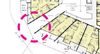
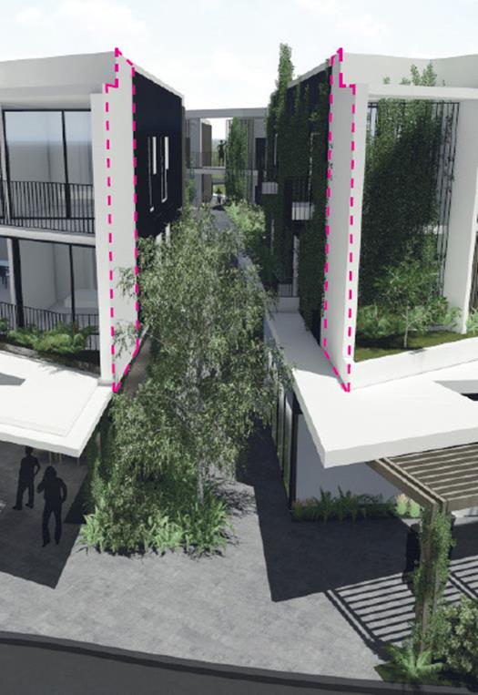
4.5 Any
Planning Agreement or Draft Planning Agreement?
|
|
Yes
|
No
|
|
Is there any applicable planning agreement or draft
planning agreement?
|
☐
|
☒
|
4.6 Environmental
Planning & Assessment Regulation 2000 Considerations
|
Clause
|
This control is applicable
to the proposal:
|
I have considered this
control as it relates to the proposal:
|
If this control is
applicable, does the proposal comply?
|
|
92
|
Y
|
Y
|
Y
|
|
93
|
N
|
N/A
|
N/A
|
|
94
|
N
|
N/A
|
N/A
|
|
94A
|
N
|
N/A
|
N/A
|
|
97A
|
Y
|
Y
|
Y
|
4.7 Any
Coastal Zone Management Plan?
|
|
Satisfactory
|
Unsatisfactory
|
Not applicable
|
|
Is there any applicable coastal zone management plan?
|
☐
|
☐
|
☒
|
4.8 The
likely impacts of that development, including environmental impacts on both the
natural and built environments, and social and economic impacts in the locality
Traffic/ Access:
The traffic impact assessment submitted in support of the
application includes an assessment of the suitability of access to the
development off Jonson Street. The figure below, taken from that
assessment, indicates where such access would be located (shown in red), given the approved roundabout works that will
occur at the Jonson/ Browning Streets intersection.
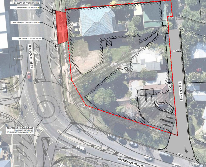
The traffic assessment notes the following:
· There is
insufficient space for the access at the Jonson St access location as it would
impact on the proposed new road alignment and pedestrian median for the Byron
Bay Bypass which is currently under construction. The driveway access
shown in red in Figure 4 is in accordance with AS2890.2 (0.3m minimum offset from
adjacent property, 1.5m minimum splays and 14m minimum driveway width);
· Jonson St
access location creates safety concerns with its close proximity to a high use
pedestrian crossing median;
· BSC’s DCP
Chapter 4 states that laneway access to basement carparks is preferred over
street access;
· Byron Shire
Council has a pedestrian/cycle friendly emphasis as per council’s adopted
masterplan. Utilising an existing lane access instead of creating a new access
point across a high use pedestrian/cycle path is a safer and better outcome for
the community;
· Vehicles
exiting in close proximity to the roundabout which would cause issues during
peak AM and PM hours with vehicles exiting the development having to enter mid
queue for the roundabout travelling south. This would interrupt the
traffic flow of the roundabout and result in a worse performance of the
roundabout; and
· Council
currently utilise the street frontage on Jonson St for paid parking, it is
estimated that Council would lose 7 paid parking spaces if the Jonson St access
was constructed.
The proposed left in / left out restrictions will be
sufficient to manage potential traffic impacts on Browning Street. Access
location, design and signage will prevent significant traffic volumes within
Ruskin Lane north of the access ramp.
A report has been provided by opponents of the development,
reviewing the traffic assessment provided in support of the applicant.
That review was prepared by a qualified traffic consultant and is critical of a
number of matters in the applicant’s report.
The review report has been assessed by Council’s
Development Engineer, who concludes that, on balance of all issues, the traffic
management measures proposed by the applicant will successfully manage
potential traffic impacts associated with the development.
Construction Impacts
Construction of the proposed building will involve
significant excavation for the two levels of basement car parking. That
excavation is likely to intercept groundwater, and temporary dewatering will be
required.
A dewatering management plan has been prepared to guide the
excavation, dealing with collection, treatment and disposal of water during the
works. This plan has been reviewed by Council staff and by WaterNSW, who
have issued conditions that would be applied to an approval under the Water
Management Act 200.
The management plan provides an appropriate basis for
avoiding/ mitigating impacts associated with excavation.
Subsequent construction of the remainder of the building
will cause temporary disturbance in the neighbourhood. This is managed by
standard restrictions on construction times and conditions requiring both
environmental and noise management plans prior to construction.
4.9 The suitability of the site
for the development
The site is zoned B2 Local Centre and is within the Byron
Town Centre. Mixed use development is a permissible and preferred use of
land in that zone. The Town Centre Masterplan outlines a recommended
strategy for this part of the town centre to transform from its current low
scale residential character to provide for mixed use development precisely like
the proposed.
This is the first application for redevelopment in this
small town block. As such, it will significantly alter the existing
character of this end of Jonson Street. However, the change of character
is consistent with the zoning of the land and the adopted strategy for the
locality.
The site is also adjacent to residentially zoned land, and
there is therefore an additional tension between the nature and scale of
commercial mixed use development and existing single storey residences.
Notwithstanding that tension, the site is suitable for the
mixed-use development as proposed given the desired future context and the
planning provisions in place, which include provisions that allow justifiable
flexibility.
4.10 Submissions made in accordance with
this Act or the regulations
The development application was publicly exhibited from 2
January 2020 to 29 January 2020.
There were 64 submissions made on the development application:
· 40 For
· 24 Against
Issues raised in submissions are addressed below:
|
Issue
|
Comment
|
|
Support:
|
|
|
Byron Bay has an embarrassing deficiency when it comes
to offering a range of dwelling types. We rely too much on single
detached dwellings in greenfield suburban subdivision, which is both
environmentally and socially unsustainable by comparison
|
The application proposes that all apartments will be for
residential, rather than tourism, use.
Background studies undertaken for
the draft Residential Strategy indicate that, in 2016, separate houses were
the most common housing type in the Shire (77%), with medium density
dwellings being only 44% of housing stock.
In 2016, 3 bedroom dwellings were
the most common, accounting for 38.5% of all private dwellings.
The proposed dwelling mix will add to housing
diversity in Byron Bay.
|
|
Density in in the form of apartment housing is a key
component to having a vibrant, active, walkable town centre that is not 100%
reliant on externally generated car trips to access the town's goods and
services
|
The site is located in easy walking distance to the core
town centre, and it is reasonable to expect that residents would walk to
service many shopping and recreational needs.
|
|
Southern Jonson St is a key element in the success of
the Byron Masterplan. This development will help activate and put focus on
this end of the town centre
|
The objective of the Master
Plan is addressed above. Currently, this southern end of Jonson Street,
at least on its eastern side, is characterised by older dwellings, which is
not consistent with the Masterplan vision for this area.
|
|
The development will compliment the new southern entry
of the Byron Bypass, which will in turn help take pressure off the northern
end of town
|
With completion of the bypass, the site will be more
strategically important as a ‘gateway’ to the town centre.
|
|
The design presents very well to Jonson and Browning
Streets and the internal courtyard space and openness of the design will create
a vibrant and enjoyable space to work and live for the residents and tenants.
(The proposal provides) new quality architecture in the town that remains
consistent with the existing building scale and also the Town Centre
Masterplan intent
|
The central courtyard is a key feature of the
design. It provides an interesting visual focal point off the
roundabout and also provides a vibrant, attractive and useful space for the
residents and users of the site.
It also provides a ‘light
well’ for the development and supports natural ventilation of
residential units.
|
|
Objection:
|
|
|
Significant increase in traffic on Ruskin Lane, which:
· does not have
sufficient capacity (restricted sealed width);
· will impact on
amenity and safety of properties that rely on lane for access.
|
Traffic impacts are addressed above.
The layout and design will
restrict impacts within Ruskin Lane to the southern end, directly adjacent to
the entrance.
The design restricts left turns
out of the basement ramp, so that all vehicles will turn right, avoiding
traffic onto Ruskin Lane.
Signage is proposed at the
Tennyson Street end of the lane advising that access to the basement car park
is not available from that entrance. This will be supported by the
design of the ramp, which will prevent cars from turning into it when
travelling south on Ruskin Lane.
This will prevent amenity impacts for the majority of
properties along Ruskin Lane, certainly for those properties on the narrow
east/west section from Tennyson Street.
|
|
Significant traffic impacts more generally, including:
· development traffic
will cause problems on the new roundabout
· impacts on safety
of pedestrians/ cyclists on Browning Street
· need for convex
mirror highlights safety risks
|
See traffic assessment above.
The convex mirror is recommended
in the applicants’ traffic report, to address pedestrian safety.
There is a tall timber fence along the Ruskin Lane corner of the adjoining
property, and the Browning Street footpath is currently hard up to the
properties frontages.
As a result, it is difficult for
drivers leaving Ruskin Lane to see pedestrians moving westward along the
footpath. The convex mirror is suggested so that pedestrians are able
to see vehicles in Ruskin Lane.
As an alternative, it is
suggested that any consent be conditioned requiring the developer to adjust
the location of the footpath, moving it further away from the adjoining
property’s frontage. This will provide adequate vision for
drivers and pedestrians.
|
|
Significant amenity impacts on residential properties
to the east of Ruskin Lane – noise, overshadowing, traffic
Overshadowing of residential
gardens to the east and associated loss of privacy
Significant impacts on
accommodation businesses being carried out
|
Shadow diagrams submitted with the applications show the
worst case – i.e. 3pm mid-winter – as shown below:
Both adjoining lots to the east contain substantial tall
vegetation along their Ruskin Lane boundaries (see below), which would
currently shadow the western parts of their properties in the afternoons.
The existing vegetation also acts
to protect the privacy of the adjoining dwellings. In addition, privacy
screens are proposed on all external balconies, to minimise the opportunities
for residents to look down into neighbours properties.
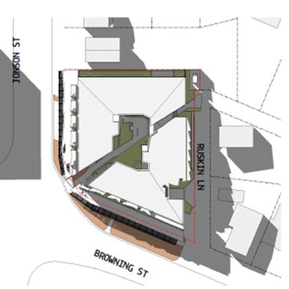
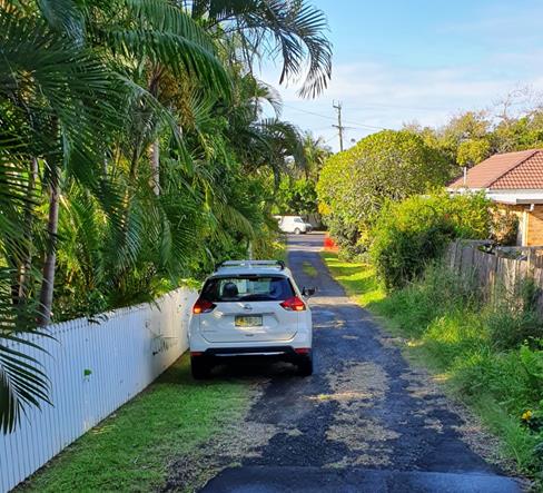
|
|
Noise impacts and
Neighbourhoood character
|
A noise impact assessment has been provided, concluding
that the uses associated with the completed development will not generate
noise in excess of ‘acceptable’ standards. The report
includes a recommendation for construction of a 1.8m high acoustic fence
along the Ruskin Lane boundary of the adjoining property (at cnr Ruskin Lane
& Browning St). The owner of that property has provided written
consent for such a fence.
The development will change the
existing character and amenity. However, a change to character/ amenity
is to be expected given the business zoning of the subject land.
Ruskin Lane provides the boundary
between the business zone and residential zone, and it is reasonable to expect
that land within the business zones would be developed to its potential,
based on the planning controls in place.
The proposed development exceeds
the maximum height limit at points noted above, at the roof/parapet
edges. In relation to impacts on adjoining properties, the exceedance
on the southern roof edge is the only part of the building that has any
potential impact in terms of increased shadow.
The extent of that exceedance is
shown below:
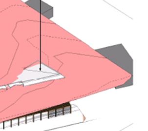
Given the direction of mid-winter shadow (see above), the
‘additional’ shadow associated with the height exceedance is very
minor.
|
|
Development is out of context with this location
– which is characterised by small scale historic buildings
|
The context of the development is discussed above.
Given the zoning of the land, the development should be considered against
the anticipated and desired future character, rather than the existing
character, which does not reflect the commercial zoning.
|
|
Scale and design inconsistent with Byron Bay –
suggest it should have a “small town village feel”
|
Neither the current planning controls nor the
recommendations of the Town Centre Masterplan envisage a “village
character” for Byron Bay.
|
|
Non-compliance with development standards/ policies
cannot be justified – over-development of the site.
|
Non-compliances are addressed in this report.
|
4.11 Public interest
The proposed development is unlikely to prejudice or
compromise the public interest or create an undesirable precedent.
5. DEVELOPER
CONTRIBUTIONS
5.1 Water & Sewer Levies
Section 64 levies will be payable.
5.2 Section
7.11 Contributions
The proposed development is
mixed use and s7.12 levy or s7.11 contributions may apply. The
contributions plan requires that whichever the greater amount is to be
applied.
The estimated cost of works is $19,340,326. The s7.12
levy would equate to 1% of that, which is $193,403.
The S7.11 levy, calculated
based on the residential component of the development, will be
$254,240.11.
This larger amount is therefore
imposed by consent condition.
6. CONCLUSION
The proposed development will result in a significant change
to the existing character of the southern end of Jonson Street. This is,
however, consistent with the B2 Local Centre zoning of the property and the recommendations
of the Byron Bay Town Centre Masterplan.
With construction of the bypass, a new roundabout at the
intersection of Jonson and Browning Streets will be a southern gateway into the
town centre, and the location, design and scale of the proposed building is an
appropriate response to that future context.
The building will alter the existing amenity for the
residential land to the east, particularly the two single-story dwellings on
the eastern side of Ruskin Lane, which are used for tourism accommodation.
The change to that amenity is what can be reasonably expected given the zoning
of the land. The building will not significantly overshadow the adjoining
properties and the combination of privacy screens on the buildings external balconies
and the existing vegetation and fencing protects the privacy of neighbours.
Significant objection has been received regarding traffic
impacts, primarily concerned with additional traffic on Ruskin Lane. The
development will generate approx. 976 vehicle trips per day, but this
additional traffic will be restricted to the short section of Ruskin Lane
between the proposed basement access ramp and Browning Street. A
combination of signage and orientation prevents traffic from using the
remainder of Ruskin Lane to access the basement parking.
A concrete median in the centreline of Browning Street will
prevent right-turns in or out of the lane, which will avoid impacts for traffic
moving through the roundabout.
The building has a minor exceedance of maximum height, with
the western and southern roof edges exceeding the 9.0m limit. The
majority of the building is under the 9.0m maximum.
The building height does not result in significant issues of
overshadowing or privacy, and can be supported in this case.
The building exceeds the 1.3:1 floor space ratio, with a
proposed FSR of around 1.4:1. The exceedance is minor and does not add to
the size or bulk of the building.
There are also some inconsistencies with the SEPP 65
Apartment Design Guide criteria, most notably in the quantum of deep soil zone
available for landscaping. That criterion is primarily applicable to a
full residential building, and the Guide provides for flexibility where the
residential apartments are part of a mixed-use development where commercial
uses make up a ground floor.
In this case, significant podium landscape planting is
proposed, mostly within the central courtyard, which is a positive feature of
the development. Green walls, roof planting and street trees are all
proposed.
The proposed development is permissible in the zone and will
establish the future character of this part of Jonson Street in a way that is
consistent with the adopted Town centre Masterplan.
The proposal raises no significant issues in terms of
environmental impacts which cannot be managed and the site is considered
suitable for the development. The application is recommended for approval
subject to conditions of consent.
Staff Reports - Sustainable Environment and Economy 13.9
Report No. 13.9 PLANNING
- DA10.2019.517.1 Mixed Use Development Stage 4 of Habitat
Directorate: Sustainable
Environment and Economy
Report
Author: Rob
Van Iersel, Major Projects Planner
File No: I2020/523
Proposal:
|
DA No:
|
10.2019.517.1
|
|
Proposal description:
|
Mixed Use Development (Stage 4 Habitat)
|
|
Property description:
|
Part Lots 1 & 12 DP 271119
|
|
2 Gallagher Street BYRON BAY
|
|
Parcel No/s:
|
270081
|
|
Applicant:
|
Planners North
|
|
Owner:
|
Community Association DP 271119 & Bayshore Development
Pty Ltd
|
|
Zoning:
|
B4 Mixed Use
|
|
Date received:
|
1 October 2019
|
|
Integrated / Designated Development:
|
☐
Integrated
|
☐
Designated
|
☒
Not applicable
|
|
Concurrence required
|
No
|
|
Public notification or exhibition:
|
- Level
2 advertising under DCP 2014 Part A14 – Public Notification and
Exhibition of Development Applications
- Exhibition
period: 24/10/19 to 6/11/19
- Submissions received: 1
|
|
Planning Review Committee:
|
Not applicable
|
|
Variation request
|
☒
Clause 4.6
|
☐
SEPP 1
|
☐
Not applicable
|
|
Delegation to determine
|
Council
|
|
Issues:
|
· Clause 4.6
Submission – Building Height
|
Summary:
This development application seeks approval for a mixed-use
development, which will be Stage 4 of Habitat. The proposal involves the
construction of three individual buildings, connected by covered walkways, on a
flat cleared part of the site, located between the existing commercial precinct
at Habitat and the recently constructed pocket living apartments at the western
end of that site. The development site is bounded by internal private roads
within Habitat.
Two of the buildings are three (3) storeys in height, with
retail tenancies at ground level and business/ office tenancies above.
The third building is two (2) stories in height with a café in one part
of the ground level, and a recreation facility (indoor) in the remaining
part. The upper level contains further tenancies for recreation
facilities (indoor).
Individual uses are not yet known, but the recreation
facilities tenancies could include things such as bathhouse; martial arts
studio; dance studio; massage/ wellness; allied health treatment rooms; sauna/
steam room; yoga studios and the like. Most of the internal spaces in all
buildings are designed to be flexible, with an ability to combine individual
components for larger spaces if required.
A new car parking area, containing 37 spaces, is proposed on
the southern part of the site, with entry from Gallagher Street (western end)
and exit onto Fullerton Lane. Additional parking is available within
existing car park areas within Habitat. A cumulative assessment of car parking
demonstrates that, with the addition of the proposed 37 spaces that are
provided by this Stage 4 development, sufficient car parking is available for
all existing uses at Habitat. In addition to spaces provided in
accordance with previous development consent, and in accordance with Byron DCP
2014, Habitat now has 5 car share vehicles located on site, with all residents
and tenants provided with membership to that service.
The three storey buildings exceed the 9.0m maximum building
height applicable to the site. The application therefore includes a
clause 4.6 submission arguing that, in the circumstances, compliance with that
height standard is unnecessary. The height exceedance does not result in any
overshadowing, overlooking or privacy issues. The buildings have been
appropriately setback from neighbouring buildings within Habitat, and have no
impact for any adjoining development outside of Habitat. The clause 4.6
submission is considered to be well-founded and the additional building height
is considered acceptable in the circumstances.
A noise impact assessment has been undertaken in relation to
the café and anticipated recreational uses and demonstrates that these
uses are unlikely to result in unacceptable noise impacts for people living
either external to Habitat or within the development.
The proposed development is consistent with relevant
statutory and policy requirements, and the application is recommended for
approval is recommended.
NOTE TO COUNCILLORS:
In accordance with the
provisions of S375A of the Local Government Act 1993, a Division is to be
called whenever a motion for a planning decision is put to the meeting, for the
purpose of recording voting on planning matters. Pursuant to clause 2(a)
under the heading Matters to be Included in Minutes of Council Meetings of
Council's adopted Code of Meeting Practice (as amended) a Division will be
deemed to have been called by the mover and seconder of all motions relating to
this report.
|
RECOMMENDATION:
That pursuant to Section 4.16 of the Environmental Planning
& Assessment Act 1979, Development Application No. 10.2019.517.1 for a
mixed use development, be granted consent subject to the conditions of
approval in Attachment 2 (E2020/24920).
|
Attachments:
1 Updated
Plans for Habitat Stage 4 10.2019.517.1, S2020/331
2 Recommended
Conditions of Consent 10.2019.517.1, E2020/24920
3 Confidential
- Submission Habitat Stage 4 10.2019.517.1, E2020/24924
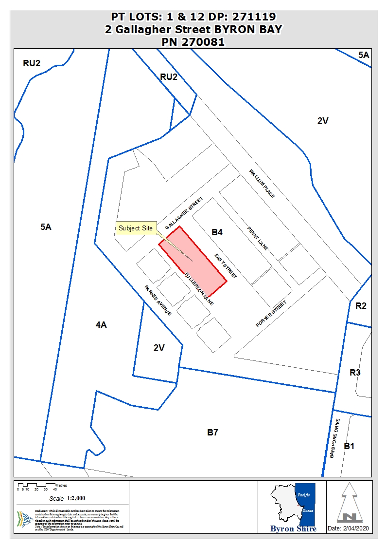
Assessment:
1. INTRODUCTION
1.1. History/Background
The property has an extensive
history of approvals, the key approvals ones being:
|
DA 10.2005.705.1
|
Stockpiling of 15,000m3 of landfill over an
area of 12,500m2 at a height of approximately 1.5m
|
Deferred Commencement 25/09/2006
|
|
|
Deferred commencement consent conditions satisfied
|
12/06/2008
|
|
DA 10.2007.177.1
|
Environmental enhancement work
|
Approved 04/01/2008
|
|
DA 10.2008.360.1
|
Mixed use development comprising 82 residential dwellings, plus commercial,
retail and creative industrial units, with the provision of fill, roadworks,
carparking, landscaping, water, sewer, drainage and communication services
|
Deferred Commencement 06/01/2009
|
|
CC 11.2008.360.1
|
Bulk earthworks
|
Approved 06/01/2009
|
|
DA 10.2009.12.1
|
Community title subdivision of approved mixed use
development
|
Approved 09/12/2009
|
|
|
Consent surrendered 12/11/2014
|
|
|
DA 10.2011.162.1
|
Mixed-use development comprising 67 residential
dwellings, commercial, retail, live/work and creative industry units, with
the provision of road works, car parking, landscaping, water, sewer, drainage
and communication services, plus subdivision of the site under a Community
Scheme
|
Approved (JRPP) 24/02/2012
|
|
DA 10.2015.353.1
|
Stage 1 - Mixed use development comprising 28
Residential dwellings, plus commercial and retail units, recreation
facilities, associated infrastructure and subdivision
|
Approved 04/02/2016
|
|
DA 10.2017.4.1
|
Live/work buildings - Residential flat building and
light industry (creative industries)
|
Approved 10/05/2017
|
|
DA 10.2017.628.1
|
Sixty (60) Pocket Living Apartments and Subdivision to
create One (1) Additional Community Title Lot
|
Approved (JRPP) 26/07/2018
|
1.2. Description
of the proposed development
This application seeks approval for a mixed-use development,
which will be Stage 4 of Habitat. The proposal involves the construction
of a number of individual buildings, connected by roof and covered walkways,
containing a mix of retail, offices, recreation facilities and a café.
The buildings are described
further below. The summary of proposed land uses is:
|
Land Use
|
Floor Area (m2)
|
|
Retail
|
448
|
|
Café
|
102
|
|
Recreation facility (indoor)
|
613
|
|
Office/ business
|
898
|
|
Amenities
|
74
|
The development includes the following buildings, detailed
in the architectural plan set at Attachment 1:
· S4-A: A
three-storey building containing flexible retail spaces at ground level, with
two levels of business/ office space above. Each level is designed to
include flexible internal partitioning, to allow various configurations
dependant on tenants’ needs.
This building contains:
- 178.37m2 retail at
ground level;
- 178.69m2 business/
office at each of the upper 2 floors.
· S4-B: A
similarly designed three-storey building with ground floor retail and business/
office above; including:
- 269.93m2 retail;
- 270.41m2 business /
office on each of the 2 upper levels.
· S4-C: A
two-storey building, with two parts at ground level separated by a
walkway. The northern part contains restaurant/café area at ground
level, capable of being divided into two separate tenancies, one of 34.57m2
and another of 67.53m2. An outdoor dining terrace is proposed
on the northern side of the café, within the Easy Street road reserve
(private road).
The café is proposed to
operate from 7am to 7pm, with a seating capacity of 50 people (internal and
external).
The southern part contains 208.14m2
recreation facility (indoor) space, with flexible internal panelling that could
allow separate tenancies.
The upper floor of this building
contains recreation facility (indoor) spaces over the two ground floor
components, with a total floor space of 405.29m2, also including
flexible internal panelling that could allow separate tenancies.
The individual tenancies are
expected to include uses such as bathhouse; martial arts studio; dance studio;
massage/ wellness; allied health treatment rooms; sauna/ steam room; yoga
studios and the like.
The proposed hours of operation for
all tenants are 7am to 7pm, and the facility has a capacity of 100 people.
· A central
‘core’ building, containing a lift well and toilet facilities for
each building level.
Recycling/garbage storage is proposed at ground level, under
the stair well adjacent to Fullerton Lane (southern frontage).
A new car parking area, containing 37 spaces, is proposed on
the southern part of the site, with entry from Gallagher Street (western end)
and exit onto Fullerton Lane. Three (3) existing car spaces in Gallagher
Street are proposed to be converted to two (2) loading bays. A further
six (6) spaces in Easy Street (north side) are proposed to be converted to
provide three (3) loading bays. 19 bicycle spaces are also proposed,
adding to the existing bike storage room located immediately east of the
development site.
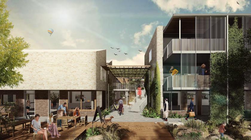
Artist’s perspective
– view from Easy Street to junction between S4B & S4C (showing
outdoor dining)
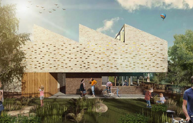
Artist’s perspective
– view from existing recreation facilities to Building S4C (showing
outdoor dining)
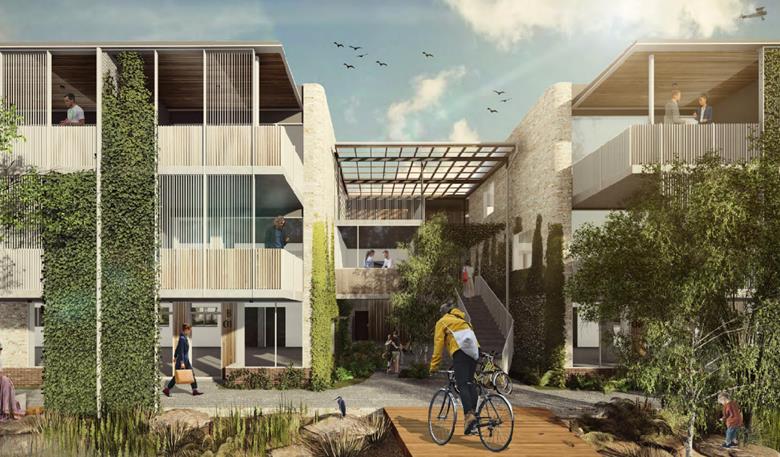
Artist’s perspective
– view from Easy Street to junction between S4A & S4B
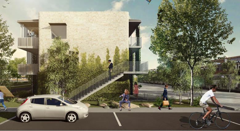
Artist’s perspective
– view from Gallagher Street to S4A (existing live/work buildings in far
right)
Additional landscaping is proposed within Easy Street
(northern frontage of development site), together with two timber entry decks
that cross the existing drainage swale within that street. A 60m2
timber terrace/deck is also proposed within the Easy Street, outside of
restaurant. Further landscaping is proposed on the Gallagher Street and
Fullerton Lane frontages and within the site.
The proposed development incorporates a variety of
sustainability measures/ principles, including:
· Sub-tropical
design – includes large eaves, good building orientation,
cross-ventilation, insulation, covered walkways and large, protected openings.
· Locally
indigenous landscaping;
· Water
sensitive urban design – use of swales and bioretention;
· Green waste
– utilisation of ‘subpod’ composting systems throughout the
development;
· Water
conservation – recycled water, purchased from Council’s nearby
treatment plant, used for toilets and landscape irrigation;
· On-site
stormwater detention – stormwater is to be captured and released slowly
to the wetland areas around the Habitat site, which is particularly
advantageous to the acid frog habitat in this area;
· Solar
– Habitat has an Embedded Energy Network, whereby electricity generated
by the solar network is distributed through the site for use in peak
periods. Stage 4 will include a further 50kW system;
· Lighting
– low energy fittings and LED lighting used throughout;
· Two electric
car charging stations will be incorporated in the car park;
· Dedicated
bike storage to promote cycle use.
1.3. Description
of the site
A site inspection was carried out on 7 November 2019.
|
Land is legally described as
|
Part Lots 1 & 12 DP: 271119
Note: The various
‘parts’ of Habitat are within a registered Community Plan (i.e.
community title).
Lot 1 is the Community Lot,
containing internal private roads, car parks, and recreation areas.
Lot 12 contains the remaining
undeveloped cleared sites within Habitat (which will be Stages 4 & 5).
|
|
Property address is
|
2 Gallagher Street BYRON BAY
|
|
Land is zoned:
|
B4 Mixed Use
|
|
Land area is:
|
2,403.4m2 – this
is the area of the “development site”, being Part Lot 12.
|
|
Property is constrained by:
|
Acid Sulfate Soils Class 3
|
Habitat is a mixed use development, purpose-built to
accommodate a variety of commercial, retail and residential uses. To
date, three (3) stages have been constructed. The commercial precinct at the
eastern (Bayshore Drive) frontage of the site contains a number of retail and
office spaces, a restaurant/ café, and shared office facilities.
Two live/work precincts are located west of the commercial
precinct, containing individual units that provide for office/ commercial space
at ground level with a combination of one and two bedroom residences above and
behind. A central recreation space has also been constructed, including a pool
and play area, with associated amenities. A residential precinct, containing 60
one-bedroom units, is on the western end of the Habitat property.
The site that is subject of this application is part of Lot
12 DP 271119, which contains part of the cleared area within Habitat yet to be
developed. It is bounded by Easy Street (north-east), Fullerton Lane (south-west),
Gallagher Street (north) and the completed recreational precinct (south).
The roads within Habitat, including those surrounding the
subject site, are private roads within the Community Lot, which is Lot 1 DP
271119. Use of these private roads are governed by the property’s
Community Management Statement, which allows “bona fide members of the
public” to use the roads. The roads are managed by the Community
Association. The Stage 4 development site is cleared and generally flat, with a
very slight north-south fall.
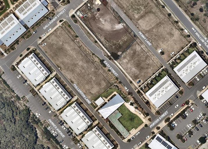
Stage
4 Development Site – between Easy Street and Fullerton Lane
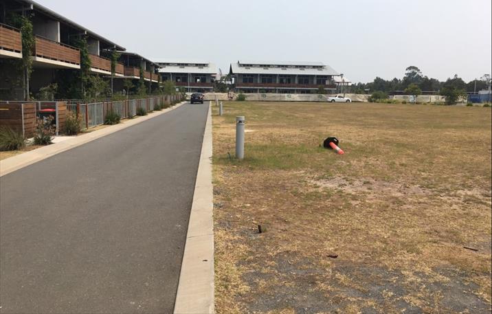
Photo
1: Stage 4 Development Site – looking north from Fullerton Lane
(live/work units on left)
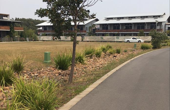
Photo
2: Stage 4 development Site looking south-west from Easy Street (Pocket-living
apartments at rear)
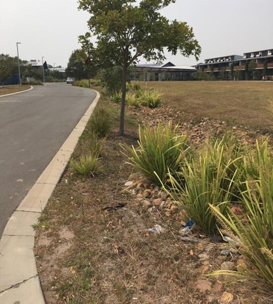
Photo
3: Easy Street drainage swale (looking east) with Stage 4 development
site on right
2. SUMMARY OF
REFERRALS
|
Referral
|
Issue
|
|
Environmental Health Officer
|
No objections subject to conditions. Potential for
generation of noise from café and recreational facilities was
identified as key issue. See below.
|
|
Development Engineer
|
No objections subject to conditions. Car parking
assessment has taken into account the existing on-site parking and the parking
required in association with previous development approvals. See below.
|
|
S64 / Systems Planning Officer
|
No objections subject to conditions.
|
|
S7.11 / Contributions Officer
|
No contributions are payable, as contributions were levied
on previous applications for the site based on residential yield. The
subject application does not have any residential components.
|
Issues:
Noise: A detailed noise impact assessment was
undertaken, concentrating on the operation of the proposed café and
activities anticipated within the proposed recreation facilities
(indoor). The noise report assessed the cumulative anticipated noise,
i.e. associated with the existing Habitat uses (including Barrio restaurant)
and noise sources associated with the land uses proposed in this application.
Noise predictions were provided for a number of external properties, located on
the eastern side of Bayshore Drive, as well as a number of residential
properties within Habitat.
A distinction is made between the residential amenity
expected external to Habitat, which in acoustic terms is described as residential
receiver, and the amenity of residences within Habitat, which is described
as commercial interface receivers. It is reasonable to expect that
the amenity in Sunrise residential area would be quieter than that within the
mixed-use Habitat development. The adopted noise level criteria reflect this,
with a 5dB difference between the receiver types.
The noise modelling undertaken assumed that all noise
sources were operating simultaneously. The results indicated that noise
levels are predicted to be within the relevant criteria for all receivers.
Car Parking: There are approx. 310 existing car
parking spaces spread throughout the Habitat development, provided in association
with previous development consents. This includes 53 spaces in excess of
the previous DA requirements. The development generates a need for 74 car
parking spaces, in accordance with the standards in Byron DCP 2014.
The application proposes an additional car parking area
located on the Stage 4 development site, which will contain 37 parking
spaces. The remaining Stage 4 requirement will be met by utilisation of
the ‘extra’ existing spaces.
In addition, Habitat has a corporate subscription with an
existing car share operator, with a van and two (2) hybrid vehicles located on
site. Through the corporate subscription, everyone who lives or works at
Habitat has free access to these vehicles, only needing to pay per kilometre
usage.
3. SECTION 4.14 –
BUSH FIRE PRONE LAND
Under section 4.14 of the Act, Council must be satisfied
prior to making a determination for development on bush fire prone land, that
the development complies with the document Planning for Bush Fire Protection
2006. The site of the proposed development (i.e. part Lot 1 & part
Lot 12), is not bush fire prone land.
EFFECT OF 10/50 RULE ON SIGNIFICANT VEGETATION
The 10/50 exemption to clear vegetation cannot be exercised
on this parcel of land, as the wider Habitat property is identified as being
directly adjacent to an identified Coastal Wetland area.
4. SECTION 4.15C
– MATTERS FOR CONSIDERATION – DISCUSSION OF ISSUES
Having regard to the matters for consideration detailed in
Section 4.15(1) of the Environmental Planning & Assessment Act 1979
(EP&A Act), the following is a summary of the evaluation of the issues.
4.1 State Environmental
Planning Instruments
|
|
Satisfactory
|
Unsatisfactory
|
|
State
Environmental Planning Policy No 44 - Koala Habitat Protection
|
☒
|
☐
|
|
Consideration: The development site has an area less than
1ha. The development control provisions of the SEPP therefore do not
apply. In any case, there is no mature vegetation on the development
site.
[Note: This SEPP has
been repealed and replaced by SEPP (Koala Habitat Protection) 2019. The
savings provisions of the new SEPP, however, provide that it does not apply
to an application lodged prior to its commencement. SEPP 44 remains
applicable in this case.]
|
|
State
Environmental Planning Policy No 55 - Remediation of Land
|
☒
|
☐
|
|
Consideration: The potential for site contamination was
considered in detail in previous stages of the development. No further
assessment is considered to be warranted.
|
|
State
Environmental Planning Policy (Coastal Management 2018)
|
☒
|
☐
|
|
Consideration: The eastern fringe of Lot 1 is mapped as
being within proximity to a Coastal Wetland (Note: the development site is
remote from this mapped area). The proposed development will not result
in any direct or indirect impacts on the nearby wetland.
|
4.2 Byron Local Environmental Plan 2014 (LEP 2014)
LEP 2014 is an applicable matter for consideration in the
assessment of the subject development application in accordance with subsection
4.15(1) of the EP&A Act because it applies to the subject land and the
proposed development.
In accordance with LEP 2014
clauses 1.4 and 2.1 – 2.3:
(a) The
land uses within the proposed development are defined in the LEP 2014
Dictionary as:
· Commercial Premises,
including:
- Business Premises;
- Office Premises; and
- Retail Premises, including:
- Food and Drink Premises, being:
- Restaurant or café; and
· Recreational
Facility (Indoor)
(b) The land is within
the B4 Mixed Use according to the Land Zoning Map;
(c) All components of the
proposed development are permissible with consent; and
(d) Regard
is had for the Zone Objectives as follows:
|
Zone Objective
|
Consideration
|
|
To
provide a mixture of compatible land uses.
To integrate suitable business, office, residential,
retail and other development in accessible locations so as to maximise public
transport patronage and encourage walking and cycling.
|
The uses proposed in this application continue and expand
on the commercial activities existing at the site.
The new commercial buildings have
been located on the northern part of the development site to maximise
separation from the live/work units existing on the opposite side of
Fullerton Lane. Perimeter car parking and location of the car park will
minimise potential visual, overlooking and overshadowing impacts.
Bike parking is provided for the
development, in addition to that already provided on the site, to maximise
the potential for cycling. The site is also located in close proximity
to the solar train platform, allowing patrons/ workers to travel from the
town centre to the site.
Car share vehicle are available
on site to all tenants.
|
The following LEP provisions are relevant:
Clause 4.3 height of buildings:
The Height of Buildings Map sets a maximum building height
of 9m for the locality. Buildings S4-A & S4-B will exceed this
height, proposed at a maximum height of approx. 10m.
The application includes a submission under Clause 4.6 of
the LEP seeking approval for the contravention of this standard. This is
addressed in detail below.
Clause 4.4 Floor space ratio:
The Floor Space Ratio Map sets an FSR of 0.9:1 for this
property.
The development site has a total area of 2,403.4m2.
The proposed development has a total gross floor area of 2,162.1m2,
resulting in an FSR of 0.9:1.
Clause 4.6 Exceptions to development standards:
The clause provides a mechanism for the approval of a
development application where the development would contravene a development
standard.
In this case, the development contravenes the 9.0m maximum
building height development standard. The applicant has submitted a
written request to justify the contravention of this standard.
The Development Standard
to be varied
The Building Height development standard is outlined at
clause 4.3 of Byron LEP 2015. The clause references the Height of
Buildings Map, which, in relation to the subject land, specifies a maximum
height of 9.0m.
For the purpose of that clause, building height is
defined as the vertical distance
from ground level (existing) to the highest point of the building.
Extent of Variation to the
Development Standard
Buildings S4-A
and S4-B contravene the 9.0m development standard, with details shown in the
table below:
|
Ref. Point*
|
Existing Ground Level (AHD)
|
Proposed Height Level (AHD)
|
Proposed Height (m)
|
Maximum (m)
|
Variation (m)
|
Variation (%)
|
|
Building
S4-A
|
|
A
|
5.83
|
15.8
|
9.97
|
9.0
|
0.97
|
10.78
|
|
B
|
5.97
|
15.8
|
9.83
|
9.0
|
0.83
|
9.22
|
|
C
|
5.85
|
15.8
|
9.95
|
9.0
|
0.95
|
10.55
|
|
D
|
5.75
|
15.8
|
10.05
|
9.0
|
1.05
|
11.67
|
|
Building
S4-B
|
|
E
|
6.03
|
15.8
|
9.77
|
9.0
|
0.77
|
8.56
|
|
F
|
6.11
|
15.8
|
9.69
|
9.0
|
0.68
|
7.67
|
|
G
|
5.96
|
15.8
|
9.84
|
9.0
|
0.84
|
9.33
|
|
H
|
5.91
|
15.8
|
9.89
|
9.0
|
0.89
|
9.88
|
|
Building
S4-C
|
|
I
|
6.11
|
12.33
|
6.22
|
9.0
|
No variation
|
0
|
|
J
|
6.10
|
12.33
|
6.23
|
9.0
|
No variation
|
0
|
|
K
|
5.67
|
14.44
|
8.77
|
9.0
|
No variation
|
0
|
|
L
|
5.70
|
14.44
|
8.74
|
9.0
|
No variation
|
0
|
|
Main
amenities building
|
|
M
|
5.83
|
15.8
|
9.97
|
9.0
|
0.97
|
10.78
|
|
N
|
5.87
|
15.8
|
9.93
|
9.0
|
0.93
|
10.33
|
|
O
|
5.81
|
15.8
|
9.99
|
9.0
|
0.99
|
11.00
|
|
P
|
5.80
|
15.8
|
10.00
|
9.0
|
1.00
|
11.11
|
* The reference points are the external corners of each
building – See Plan DA210 Rev 02
The maximum contravention of the 9.0m height standard is
just over 1m, or approx. 11.7%.
Objective of the
Development Standard
The objectives of the building height development standard
are:
a) to
achieve building design that does not exceed a specified maximum height from
its existing ground level to finished roof or parapet,
b) to
ensure the height of buildings complements the streetscape and character of the
area in which the buildings are located,
c) to
minimise visual impact, disruption of views, loss of privacy and loss of solar
access to existing development.
Objective of the Zone
The objectives of the B4 Mixed Use Zone are:
1. To provide a mixture of compatible land
uses.
2. To integrate suitable business, office,
residential, retail and other development in accessible locations so as to
maximise public transport patronage and encourage walking and cycling.
Assessment
Where a development relies on
clause 4.6 in relation to a development standard, Council cannot grant consent
unless it has considered the applicant’s cl 4.6 request and is satisfied
that it has adequately demonstrated that:
· compliance with
the standard is unreasonable or unnecessary in the circumstances of the case;
and
· there are
sufficient environmental planning grounds to justify contravening the standard;
and
· the proposed
development will be in the public interest because it is consistent with the
objectives for development within the zone and of the standard in question.
Is compliance with the development standard unreasonable
or unnecessary in the circumstances of the case?
The contravention of the standard arises from buildings A
& B being three storeys, rather than two.
The applicant’s cl 4.6 submission argues that, in the
context of the Habitat development, compliance with the 9.0m maximum building
height standard is unnecessary primarily because the development is consistent
with the height of adjacent buildings and achieves the objectives of both the
standard and the B4 zone.
Existing buildings within Habitat are all two storey.
However, the two-storey pocket living apartments, located on the opposite side
of Gallagher Street, are the same height to the peak of the roof as proposed
Buildings A & B. The units within the upper floor of the pocket
living buildings contain mezzanine bedrooms. Visually, therefore, proposed
buildings A & B will be consistent with the nearby pocket living buildings.
Although higher than the live/ work buildings on the
opposite side of Fullerton Lane, the siting of the proposed buildings toward
Easy Street, with the car parking and two-storey elements toward Fullerton Lane
minimises any potential for impacts.
Given the above, the buildings’ height will not result
in any material loss of urban character or amenity in this locality.
Are there sufficient environmental planning grounds to
justify contravening the development standard?
The height exceedance does not result in impacts on any view
corridors, nor does it result in any overshadowing, overlooking or privacy
issues.
The environmental planning grounds that justify contravention
of the development standard are outlined above, associated with a combination
of positive impacts for local character and an absence of any impacts
associated with overlooking or overshadowing of neighbouring development.
Is the proposed development in the public interest? Is it
consistent with the objectives of the standard and the zone as set out above?
In relation to the objectives of the building height
standard:
· the height of the
proposed buildings complements the streetscape and built form within the
Habitat development. As outlined above, the height is the same as the
pocket living buildings to the north, and the siting and design of the
buildings minimises any impacts on the lower live/ work buildings; and
· the application
demonstrates that the proposed development will not result in overshadowing or
overlooking and there will not be any associated privacy impacts.
In the context of the Habitat development, the current
proposal is also consistent with the objectives of the zone by providing
additional compatible land uses in an accessible location.
Overall, it is considered that the variation to the building
height standard is justified in the circumstances and the clause 4.6 request is
supported.
4.3 Any proposed Instrument
that has been the subject of public consultation and has been notified to the
consent authority
None applicable.
4.4 Byron Shire Development Control
Plan 2014 (DCP 2014)
Chapter E5 of the DCP specifically applies to
development at the Habitat site.
Concurrent with this Development Application, the applicants
submitted a request to amend this Chapter of the DCP, to be consistent with the
development currently proposed. This was considered at the Planning
meeting of 12 December 2019, where Council resolved (19-692):
1. That
Council proceed to exhibit the draft DCP 2014 Chapter E5 amendment as shown in
Attachment 1 (E2019/84596) for a period of 28 days.
2. That
the exhibition documents reference the associated Development Application and
provide a synopsis of what is sought in that DA
3. That
following exhibition, Council receive a further report detailing submissions
made. Should there be no submissions as of the close of the exhibition period,
that Council adopt the amended Chapter and give notice of its decision in
accordance with the Environmental Planning and Assessment Regulation.
The proposed DCP amendment was exhibited for public comment
from 15 January to 14 February 2020. No submissions were received.
In accordance with part 3 of the Council resolution, therefore, the amended
Chapter is adopted and therefore applicable.
The development application therefore complies with the
provisions of this Chapter of the DCP.
Chapter B4 Traffic and Car
Parking
The car parking requirements outlined in Chapter E5 take
precedence over the standards in Chapter B4.
The car parking provided for the proposed development
complies with the required standards, as discussed above.
In addition, car share vehicles are in place at Habitat and
are available for use by all tenants and residents. Previous research
indicates that each car share vehicle, when used regularly, is equivalent to
approx. 5 – 10 private vehicles.
Chapter D8 Public Art
A condition of consent is recommended requiring the
provision of public art in accordance with the requirements of this Chapter, to
a minimum value of $25,000. The applicants have indicated that planning
is underway for a substantial art installation that would address the
requirements of the this stage, the previous stage (pocket living apartments)
and the remaining future stage of development at Habitat.
4.5 Any
Planning Agreement or Draft Planning Agreement?
|
|
Yes
|
No
|
|
Is there any applicable
planning agreement or draft planning agreement?
|
☐
|
☒
|
|
Consideration:
|
4.6 Environmental Planning
& Assessment Regulation 2000 Considerations
|
Clause
|
This control is
applicable to the proposal:
|
I have considered
this control as it relates to the proposal:
|
If this control is
applicable, does the proposal comply?
|
|
92
|
No
|
N/A
|
N/A
|
|
93
|
No
|
N/A
|
N/A
|
|
94
|
No
|
N/A
|
N/A
|
|
94A
|
No
|
N/A
|
N/A
|
4.7 Any Coastal Zone Management
Plan?
|
|
Satisfactory
|
Unsatisfactory
|
Not applicable
|
|
Is there any applicable coastal zone management plan?
|
☐
|
☐
|
☒
|
|
|
4.8 The likely impacts of that
development, including environmental impacts on both the natural and built
environments, and social and economic impacts in the locality
|
Impact on:
|
Likely significant impact/s?
|
|
Natural environment
|
No. The proposal will not have a significantly
adverse impact on the natural environment of the locality.
|
|
Built environment
|
No. The proposal will not have a significantly
adverse impact on the built environment of the locality.
|
|
Social Environment
|
No. The proposal will not have a significant social
impact on the locality.
|
|
Economic impact
|
Proposal will generate economic impacts during the
construction phase with associated multiplier effects through the local
economy.
Additional housing and commercial floor space will be
provided.
|
|
Construction impacts
|
Minor impacts likely during the construction phase.
Standard conditions of consent recommended to control construction activities
including hours of work, builders waste, sedimentation and erosion control
measures, and construction noise.
|
4.9 The suitability of the site
for the development
The site is a serviced, unconstrained property within an
existing mixed-use precinct, and is suitable for the proposed
development. The buildings proposed are of a design and scale that is
consistent with the existing Habitat buildings and the land uses will add to
the commercial and recreational opportunities and activities at this site.
4.10 Submissions made in
accordance with this Act or the regulations
The development application
was exhibited for public comment from 24/10/19 to 6/11/19.
There was one (1) submission made on the development
application, expressing concern at the inclusion of an additional restaurant/
café with an outdoor dining terrace, primarily associated with noise
issues (Attachment 3). The submission suggests that Council not approve this
component of the application, or, in the alternative, apply strict conditions
to limit patron noise. The submission requests that, if Council are to
approve the café, strict conditions of approval be applied, governing
opening hours, patron numbers and prohibiting weddings or similar events.
As detailed above, a Noise Impact Assessment was undertaken
to support this application. That assessment examined the potential for
noise impact associated with all uses – i.e. existing and proposed
– operating simultaneously.
Based on the noise measurements and modelling, the
assessment report concludes that none of the Stage 4 uses, including the
café and/ or recreational facilities will generate intrusive or
offensive noise for residents located within Habitat and external to Habitat.
Given that, it is considered that the café hours
proposed – 7am to 7pm – are reasonable, and a condition of approval
is recommended that would apply these hours to all uses. It is not
considered necessary to set a limit on patron numbers for the
café.
4.11 Public interest
The proposed development is unlikely to prejudice or
compromise the public interest or create an undesirable precedent.
5. DEVELOPER
CONTRIBUTIONS
5.1 Water & Sewer Levies
Section 64 levies will be payable.
5.2 Section 7.11 Contributions
Section 7.11 Contributions will
be payable.
6. CONCLUSION
The DA proposes Mixed Use Development (Stage 4
Habitat). The proposed development is satisfactory having regard to the
relevant environmental planning instruments and planning controls applicable to
the site. The proposal raises no significant issues in terms of
environmental impacts which cannot be managed and the site is considered
suitable for the development. The application appropriately addresses the
relevant constraints applying to the site, and is recommended for approval
subject to the conditions listed in the Recommendation of this Report below.
Staff Reports - Sustainable Environment and Economy 13.10
Report No. 13.10 PLANNING
- 24.2020.15.1 Habitat Stage 5 DCP Amendment; Chapter E5 Certain Locations in
Byron Bay and Ewingsdale
Directorate: Sustainable
Environment and Economy
Report
Author: Kristie
Hughes, Planner
File No: I2020/611
Summary:
Council has received an application from Planners North on
behalf of Bayshore Development Pty Ltd seeking to amend Chapter E5 of Byron
Development Control Plan 2014 (DCP 2014). The application has been lodged
concurrently with Development Application 10.2020.87.1, which proposes a Mixed
Use Development with basement car parking, forming Stage 5 of the Habitat
development.
The key amendments to the current DCP chapter are:
· Amend
Precinct 1A from ‘tiered living’ to ‘mixed use’ which
entails commercial premises, hotel or motel accommodation, serviced apartments,
high technology industry, function centre, information and education facility,
medical centre, recreation facility (indoor), and food and drink premises.
· Various
wording changes relating to Precinct 1A to reflect the mixed use development
proposed within Development Application 10.2020.87.1.
A ‘marked up’ copy of the draft DCP chapter
showing the proposed changes is appended to this report as Attachment 1.
The received application including the ‘Statement of Environmental
Effects and DCP Modification Request Habitat Stage 5’ is appended as
Attachment 2.
Development Application 10.2020.87.1 has recently completed
exhibition, with submissions received consisting of 2 objections and 24 letters
of support.
While assessment of that application is continuing, it is
recommended that the draft DCP amendment proceed to exhibition, with the
intention that the DCP amendment and the Development Application can then be
determined concurrently.
Note that due to the estimated cost of the proposed
development, the Northern Regional Planning Panel will be the consent authority
for the DA.
NOTE TO COUNCILLORS:
In accordance with the
provisions of S375A of the Local Government Act 1993, a Division is to be
called whenever a motion for a planning decision is put to the meeting, for the
purpose of recording voting on planning matters. Pursuant to clause 2(a)
under the heading Matters to be Included in Minutes of Council Meetings of
Council's adopted Code of Meeting Practice (as amended) a Division will be
deemed to have been called by the mover and seconder of all motions relating to
this report.
|
RECOMMENDATION:
1. That Council proceed
to exhibit the draft DCP 2014 Chapter E5 amendment as shown in
Attachment 1 (E2020/31046) for a period of 28 days.
2. That
following exhibition, Council receive a further report detailing submissions made.
Should there be no submissions as of the close of the exhibition period, that
Council adopt the amended Chapter and give notice of its decision in
accordance with the Environmental Planning and Assessment Regulation, subject
to and concurrent with any approval of development application 10.2020.87.1.
|
Attachments:
1 24.2020.15.1
Draft Byron Shire DCP 2014 Chapter E5 Certain Locations in Byron Bay and
Ewingsdale for Habitat Stage 5, E2020/31046
2 DA
10.2020.87.1 - STAGE 5 STATEMENT OF ENVIRONMENTAL EFFECTS, E2020/13968
3 Form of
Special Disclosure of Pecuniary Interest, E2012/2815
REPORT
Council has received an application from Planners North (the
Applicant) on behalf of Bayshore Development Pty Ltd seeking to amend Chapter
E5 of Byron Development Control Plan 2014 (DCP 2014), relating to the Development
Application 10.2020.87.1 – Mixed Use Development (Habitat Stage 5).
Details of this request are presented below.
Subject Site
The subject site is described as Lot 1 & Lot 12 DP
271119 and known as Habitat. It is located immediately northwest of the
Byron Arts and Industry Estate.
Chapter E5 of Byron DCP 2014 contains a range of controls
and guidelines relating to the development of the site. The controls are
precinct-based, with the existing Habitat Precinct Plan shown below in Figure
1.
Figure 1 Map E5.3 Habitat Precinct Plan
Background
The site originally received development approval in 2008
(DA 10.2008.360) for a mixed use development comprising residential dwellings,
commercial, retail and creative industrial units. Chapter E5 was
originally drafted at that time to facilitate the anticipated development.
Development has been approved and constructed within
Precincts 2, 3 and 4 as shown above. A current development application
– 10.2020.87.1 – proposes an increase in mixed use development,
replacing ‘tiered living’ with ‘mixed use’ within
Precinct 1A.
Due to the development being implemented in stages, changes
have been made to the original site plan and design concept as Habitat has evolved
into a successful mixed use development supporting residential, commercial and
industrial purposes. Therefore, several amendments to the DCP have been
made across these stages of development.
Stage 1: DA 10.2015.353.1 provided for the mixed-use development
comprising residential dwellings, commercial and retails units, recreational
facilities, associated infrastructure and subdivision – located within
Precinct 4.
Stage 2: involved the building of a residential flat
building associated with associated light industry, approved pursuant to DA
10.2017.4.1. This development application provided for two additional live/work
buildings extending on the two buildings approved at stage 1 – located
within Precinct 3.
Stage 3: DA 10.2017.628 60 ‘pocket living’ apartments;
currently under construction within Precinct 2.
Stage 4: DA 10.2019.517.1 Amended the Habitat Precinct Plan,
dividing Precinct 1 into two precincts 1A and 1B. Land uses allocated to
the precincts were ‘tiered living’ (1A) and ‘mixed use’
(1B) [Note: an assessment
report on this DA is on the agenda for this Planning Meeting, recommending
conditional approval]
Summary of Proposed Changes
The proposal relates to the proposed stage 5, as outlined in
Development Application 10.2020.87.1. The application to amend Chapter E5
of the DCP has been made concurrently with that DA.
Under the proposed amendments, the land use, ‘tiered
living’ is replaced with ‘mixed use’ for the whole of
Precinct 1A. The built gross floor area within the precinct has been
increased by approximately 700m2 to 6,716m2.
The following DCP amendments are proposed:
· Update to
the Habitat Precinct Plan description of land use Precinct 1A, from tiered
living to mixed use (Section E5.5.3.4);
· Update
land use descriptions within Table E5.1 to reflect precinct land use change and
current development proposal;
· Update
Table E5.2 amending minimum setbacks for external property boundary and
external roads;
· Update
to Table E5.3 to set out the appropriate parking requirements for Precinct 1A;
and
· Update
to Map E5.3 – Habitat Precinct Plan adding indicative service access from
internal carpark to Precinct 4
In accordance with the Environmental Planning and Assessment
Regulation 2000 and Byron Community Participation Plan, the proposed DCP
amendment is required to be publicly advertised for a minimum of 28 days.
Development Application 10.2020.87.1 has recently been
exhibited, submissions received included 2 objections and 24 letters of support.
While assessment of that application is continuing, it is recommended that the
draft DCP amendment proceed to exhibition, with the intention that the DCP
amendment and the Development Application can then be determined concurrently.
As the Habitat development has evolved in stages over time,
the intended land uses of the precincts have changed. It is important to
note that while Stage 5 involves the conversion of Precinct 1A from tiered
living to more commercial uses, housing allocation has increased in other areas
of the Habitat development. Such as Precinct 2, originally envisaged as
light industrial, is now under construction with 60 ‘pocket living’
apartments.
Proceeding with the exhibition of this proposed DCP
amendment will give further opportunity for public comment and enable a more
holistic assessment of the development application to be presented to Council
and the Northern Regional Planning Panel.
STRATEGIC CONSIDERATIONS
Community Strategic Plan and
Operational Plan
|
CSP Objective
|
L2
|
CSP Strategy
|
L3
|
DP Action
|
L4
|
OP Activity
|
|
Community
Objective 4: We manage growth and change responsibly
|
4.1
|
Support the
visions and aspirations of local communities through place-based planning and
management
|
4.1.3
|
Manage
development through a transparent and efficient assessment process
|
4.1.3.10
|
Prepare and
assess Planning Proposals and Development Control Plans, and amend Local
Environmental Plan maps
|
|
|
|
|
|
|
|
|
|
|
|
|
|
|
Legal/Statutory/Policy Considerations
This proposal seeks to amend the DCP 2014. All
relevant policy implications have been discussed above. The proposed
amendment will be exhibited as per the statutory requirements.
Financial Considerations
This is an Applicant funded DCP amendment, all costs will be
borne by the applicant.
Consultation and Engagement
It is recommended that the
DCP be exhibited for a minimum of 28 days as per legislative requirements.
Staff Reports - Sustainable Environment and Economy 13.11
Report No. 13.11 PLANNING
- Place Planning Collective Charter and Nominations
Directorate: Sustainable
Environment and Economy
Report
Author: Andrew
FitzGibbon, Place Liaison Officer
File No: I2020/548
Summary:
The Place Planning Collective held
its first meeting on 16 March 2020 and is continuing to meet via online
conferencing in order to progress place planning priorities.
Council endorsement is now sought for the Place Planning
Collective Charter, which has been developed by the group (Attachment 1).
Key aspects of the charter are:
· Purpose:
The Collective will collaborate with Council and contribute co-ordinated,
community-led governance to Council’s place planning decision-making.
Specifically, the Collective will prioritise projects identified by communities
within existing and future place plans in Byron Shire, and make recommendations
to Council for their implementation.
· Authority:
Council will collaborate with the Place Planning Collective in prioritising
place planning projects and will incorporate the Collective’s advice and
recommendations into Council decisions to the maximum extent possible.
· Media:
Members of the Collective must not discuss sensitive, confidential or political
matters with the media. Confidentiality agreements to be signed by each member.
The Mullumbimby and Bangalow Place Plans have previously
been adopted by Council, and a number of priority actions and initiatives have
commenced or are in the planning stage. The draft Arts and Industry
Estate Precinct Plan has also been adopted for public exhibition purposes, and
the exhibition will take place from 29 April to 26 May. This is supported
by further work that has been undertaken in relation to Lot 12 Bayshore Drive
and the proposed one-way traffic trial for Centennial Circuit.
The Place Planning Collective will not
‘re-visit’ the actions and initiatives already underway, but
instead concentrate on assisting the remaining priority projects to move forward.
Council is also requested to nominate up to three (3)
Councillors to be members of the Place Planning Collective. At a minimum,
this would require participation in (approximately) monthly 2hr meetings.
NOTE TO COUNCILLORS:
In accordance with the
provisions of S375A of the Local Government Act 1993, a Division is to be
called whenever a motion for a planning decision is put to the meeting, for the
purpose of recording voting on planning matters. Pursuant to clause 2(a)
under the heading Matters to be Included in Minutes of Council Meetings of
Council's adopted Code of Meeting Practice (as amended) a Division will be
deemed to have been called by the mover and seconder of all motions relating to
this report.
|
RECOMMENDATION:
1. That
Council endorse the Place Planning Collective Charter as per
Attachment 1 (E2020/31059).
2. That
Council nominate up to three Councillors to be members of the Place
Planning Collective as follows:____________________________.
|
Attachments:
1 Place
Planning Collective Charter - May 2020, E2020/31059
REPORT
In September 2019, Council resolved to establish a Place
Planning Cluster Group (now known as the “Place Planning
Collective”) to manage the implementation of the Mullumbimby, Bangalow,
and Byron Arts and Industry Estate Place Plans (Res 19-451).
In December 2019, Council nominated seven (7) members who
had formally expressed their interest to sit on the collective (Res 19-690).
These members were joined by five (5) randomly selected community members from
the citizens lottery database to form the Collective.
The Place Planning Collective held an establishment workshop
on 16 March 2020, to provide a context for the members and establish
operational parameters for how they will work together. Following that
workshop, staff will arrange online conferencing meetings to progress the
discussion of Place Plan priorities.
At the workshop, the members contributed to a draft Place
Planning Collective charter, which guides the future working of the group (as
per Attachment 1). Key aspects of the charter are:
· Purpose:
The Place Planning Collective exists to enable and facilitate community
recommendations and priorities as detailed in the place plans for Bangalow,
Mullumbimby, Byron Arts and Industry Estate, and future place plans developed
in Byron Shire.
· Authority:
Council will look to the Place Planning Collective for advice and innovation
and incorporate the Collective’s recommendations into decisions to the
maximum extent possible..
· Media:
Members of the Collective must not discuss sensitive, confidential or political
matters with the media. Confidentiality agreements to be signed by each member.
The Mullumbimby and Bangalow Plans have previously been
adopted by Council, and a number of priority actions and initiatives have
commenced or are in the planning stage. The draft Arts and Industry
Estate Precinct Plan has also been adopted for public exhibition purposes, and
the exhibition will commence shortly, supported by further work that has been
undertaken in relation to Lot 12 Bayshore Drive and the proposed one-way
traffic trial for Centennial Circuit.
The Collective includes members located across the Shire,
which will be important in providing a ‘Shire-wide lens’ when
formulating recommendations for individual towns and villages.
In the initial ‘set-up’ phase of the Collective,
Council staff will assist the members in coming up to speed on the adopted
Plans, assisted by members of the Collective with previous involvement.
Staff will also bring members up to speed on Council’s budget process and
alternative funding options such as grants and/or community partnerships.
Importantly, the Collective will not re-visit actions and
initiatives that have already commenced, although input may be sought, if and
where appropriate, in relation to continuation and finalisation of those
projects.
Moving forward with implementation of the adopted plans,
particularly in light of the current COVID situation, will require careful
consideration of the future projects nominated in each plan to provide
recommendations that can realistically be achieved within defined
budgets. The Collective will need to identify where Council and the
community can achieve the ‘best bang for the buck’.
This approach is consistent with Council’s previous
community collaboration initiatives such as the Citizen’s Jury.
Council is also requested to nominate up to three (3)
Councillors to be members of the Place Planning Collective. At a minimum,
this would require participation in (approximately) monthly 2hr meetings.
Note that Councillors who are not members of the Place
Planning Collective would still be able to attend meetings at their discretion
with prior notice provided to the group.
STRATEGIC CONSIDERATIONS
Community Strategic Plan and
Operational Plan
|
CSP Objective
|
L2
|
CSP Strategy
|
L3
|
DP Action
|
L4
|
OP Activity
|
|
Community
Objective 4: We manage growth and change responsibly
|
4.1
|
Support the
visions and aspirations of local communities through place-based planning and
management
|
4.1.2
|
Ensure
consistency of place-based projects with community Place Plans through
embedding a governance framework that includes planning, implementation
and ongoing management
|
4.1.2.1
|
Facilitate
Guidance Groups
|
|
|
|
|
|
|
|
|
|
|
|
Legal/Statutory/Policy Considerations
Nil
Financial Considerations
Nil
Consultation and Engagement
One of the expectations of the members is that they would
consult with their communities as work progresses.
Staff Reports - Sustainable Environment and Economy 13.12
Report No. 13.12 PLANNING
- Update on Resolution 19-266 - Review of DCP 2014 and the introduction of the
Low Rise Medium Density Code
Directorate: Sustainable
Environment and Economy
Report
Author: Natalie
Hancock, Senior Planner
File No: I2020/549
Summary:
On 6 April 2018 a Low Rise Medium Density Housing Code (SEPP
Exempt and Complying Development Codes) 2008 (the Code) was introduced in NSW
to facilitate the development of low rise medium density housing. The state
government granted Byron Shire a deferral of the introduction of the Code until
1 July 2020 to allow Council to progress with its strategic planning
initiatives and demonstrate how they intend to meet their local housing needs.
In readiness for the Code, on 20 June 2019 Council resolved
(Res 19-266) to proceed with a planning proposal to amend clause
4.1E of Byron Shire LEP 2014, by inserting minimum lot size standards for
‘manor houses’ and ‘multi dwelling housing
(terraces)’. Council considered this planning proposal at the 20
February 2020 meeting and it is now with the Department of Planning, Industry
& Environment requesting they finalise the plan. Council also agreed, as
part of Res 19-266, to:
· initiate a review
of Byron Shire Development Control Plan 2014 (DCP) as it relates to low rise
medium density housing, and prepare a draft amendment to strengthen DCP 2014
where necessary and include references to ‘manor house’ and
‘multi dwelling housing (terraces)’ development; and
· receive a further
report to consider the proposed DCP amendments before proceeding to public
exhibition.
The DCP review has commenced with an appraisal of DCP
provisions as they relate to the state government’s supporting Low
Rise Medium Density Design Guides for complying development (Code
assessable) and development applications (non-Code assessable).
The purpose of this report is to update Council on the
review process. It recommends that Council commence with a DCP 2014 amendment
to insert a new Chapter containing residential locality narratives and that
these be based on the exhibited draft Residential Strategy narratives. It
further recommends that the DCP include cross referencing between the new
Chapter, Design Verification Statements and existing DCP provisions in Chapter
D1, under D 1.4.3 Siting, Design and Character (secondary dwellings), D1.5.2 Character
(dual occupancy and semi-detached dwellings) and D1.6 multi-dwelling housing,
residential flat buildings and attached dwellings).
Design
Verification Statements are required under both Design Guides. They confirm
that a certifying authority (such as Council or private certifier) has assessed
the proposed development and is satisfied that it meets design criteria at the
local, neighbourhood and site scale.
The report also notes that for certain design criteria
further discussion is required with the Department of Planning, Industry and
Environment as to how standards are to be interpreted.
Due to the Code’s 1 July 2020 introduction date, it is
recommended that Council proceed with the proposed amendments to Byron DCP 2014
as set out in this report.
NOTE TO COUNCILLORS:
In accordance with the
provisions of S375A of the Local Government Act 1993, a Division is to be
called whenever a motion for a planning decision is put to the meeting, for the
purpose of recording voting on planning matters. Pursuant to clause 2(a)
under the heading Matters to be Included in Minutes of Council Meetings of
Council's adopted Code of Meeting Practice (as amended) a Division will be
deemed to have been called by the mover and seconder of all motions relating to
this report.
|
RECOMMENDATION:
1. That
Council endorse an amendment to Byron Shire DCP 2014, to:
a) include
Residential Locality Narratives (Attachment 1 E2020/29897); and
b) cross
reference Chapter D1, Residential Accommodation in Urban, Village and Special
Purpose Zones with Residential Locality Narratives and Design
Verification Statements.
2. That
Council request staff to proceed with preparation and public
exhibition of the Byron DCP 2014 amendments proposed in this report.
3. That
Council receive a further report for consideration of
submissions following the statutory public exhibition period.
4. That
Council agree that should there be no submissions as of the
close of the statutory public exhibition period, adopt the Byron Shire DCP
2014 amendments as exhibited and give public notice of this decision in
accordance with the Environmental Planning and Assessment Regulation 2000.
5. That
Council note that for certain design criteria
further discussion is required with the Department of Planning, Industry and
Environment as to how standards are to be interpreted.
|
Attachments:
1 Draft
Residential Strategy Narratives updated, E2020/29897
2 Special
Disclosure of Pecuniary Interest Annexure, E2012/2815
REPORT
Background
On 6 April 2018 a Low Rise Medium Density Housing Code (SEPP
Exempt and Complying Development Codes) 2008 (the Code) was introduced in NSW
to facilitate the development of low rise medium density housing. The State
government granted Byron Shire a deferral of the introduction of the Code until
1 July 2020 to allow Council to progress with its strategic planning
initiatives and demonstrate how they intend to meet their local housing needs.
In readiness for the Code, on 20 June 2019 Council resolved
(Res 19-266) to proceed with a planning proposal to amend Byron
Local Environmental Plan (LEP) 2014 clause 4.1E, by inserting minimum lot size
standards for ‘manor houses’ and ‘multi dwelling housing
(terraces)’. Council considered this planning proposal at the 20
February 2020 meeting and it is now with the Department of Planning, Industry
& Environment requesting they finalise the plan. Council also agreed, as
part of Res 19-266, to:
· initiate
a review of Byron Shire Development Control Plan 2014 (DCP) as it relates to
low rise medium density housing, and prepare a draft amendment to strengthen
DCP 2014 where necessary and include references to ‘manor house’
and ‘multi dwelling housing (terraces)’ development; and
· receive a further
report to consider the proposed DCP amendments before proceeding to public
exhibition.
The DCP review has commenced with an appraisal of DCP
provisions as they relate to the State government’s supporting Low
Rise Medium Density Design Guides for complying development (Code
assessable) and for development applications (non-Code assessable). A review of
DCP 2010 provisions is not required as the Code does not apply to deferred
zones under LEP 1988.
The purpose of this report is to update Council on the
review process. It recommends that Council commence with a DCP 2014 amendment
to insert a new Chapter containing residential locality narratives and that
these be based on the exhibited draft Residential Strategy narratives. It
further recommends that the DCP include cross reference between the narratives,
Design Verification Statements and existing DCP provisions in Chapter D1 under
D1.4.3 Siting, Design and Character (secondary dwellings), D1.5.2 Character
(dual occupancy and semi-detached dwellings) and D1.6 multi-dwelling housing,
residential flat buildings and attached dwellings).
Design Verification
Statements are required under both Design Guides. They confirm that a
certifying authority (such as Council or private certifier) has assessed the
proposed development and is satisfied that it meets design criteria at the
local, neighbourhood and site scale.
Byron DCP 2014 as it relates to the Code and Low Rise
Medium Density Design Guides
Effectively the amendment to the State Environmental
Planning Policy (Exempt and Complying Development Codes) 2008 (Codes SEPP) to
include a ‘Low Rise Medium Density Housing Code’ (the Code) allows
for the fast track approval of one and two storey dual occupancies, manor
houses and terraces as complying development in the R2 and R3 in Byron Shire as
of 1 July 2020. It also introduces definitions for the new housing types (manor
houses and terraces), and allows for these housing types to be assessed as either
complying development or as a development application by Council where the
proposals exceed the controls specified in the Code.
The above new uses may be defined as:
· Manor
house – being a maximum two-storey residential flat building
which contains 3 or 4 dwellings. At least one dwelling must be located above
another, and dwellings are attached by a common wall or floor.
· Multi
dwelling housing (terraces) – being three or more attached
dwellings on one lot of land, facing and generally aligned along one or more
public roads
In
introducing the Code, the State government provided two design guides:
1. Low Rise
Medium Density Design Guide for Development Applications (DA Design Guide), and
2. Low Rise
Medium Density Design Guide for Complying Development (Complying Design Guide).
The Environmental Planning and Assessment Regulation 2000
(Regulation) requires councils to consider the DA Design Guide when
assessing DAs for these new housing types, until such time as local development
controls for these new housing types are in place. That said, for development
applications, the majority of the design guide criteria refer to the
requirements of Council’s LEP or the DCP and hence tend to apply only
where these two local planning documents are silent.
In contrast, the Complying Design Guide criteria does
not in most cases refer to LEP or DCP provisions. It states the design criteria
that must be met in order to obtain a complying development certificate under
the Code. The design criteria include layout, landscaping, private open space,
light, natural ventilation and privacy; a number of these are also a provision
in DCP 2014.
In brief, an appraisal of the Complying Design Guide and DCP
2014 found in some instances:
· more comprehensive
criteria in the Complying Design Guide
· different standards
· support for DCPs to
contain additional information.
An example of each is provided below.
More comprehensive criteria
As an example, the Complying Design Guide articulates
architectural form and roof design criteria, providing objectives to achieve a
balanced composition of elements, responding to internal layouts and desirable
elements in the streetscape. An applicant must describe in a Design
Verification Statement how the architectural form reduces the visual bulk and
responds and provides a cohesive design response, as well as how the roof
treatments are integrated into the building design and positively respond to
the street.
In comparison, the DCP 2014 does not include such guidance
on this building element and hence for this element the Complying Design Guide
may be seen as value adding to development assessment.
Different Standards
Table 1 provides two examples of difference between the
Complying Design Guide criteria for complying development and Byron DCP 2014
provisions.
Table 1: Divergent
standards
|
Criteria
|
Code – Complying
Development
|
DCP 2014 - D1.6
Multi Dwelling Housing, Residential Flat Buildings and Attached Dwellings
|
|
Minimum areas for
- private open space
courtyards
- private open space
balconies
|
Terraces
The area of principal
private open space provided for each dwelling is at least 16m² with a
minimum length and width of 3m.
Terraces - Each dwelling is
orientated front to back, with private open space typically arranged at the
rear of the property. This achieves good visual privacy outcomes between
dwellings and minimises privacy issues to adjoining neighbouring properties.
Manor houses
All
dwellings have access to principal private open space with a minimum length
and width of 3m:
• 1 bed or studio 8m2
• 2+ bed 12m2
• dwellings with living area at ground
level 16m2
Private
open space can be obtained by the use of balconies and communal private open
space in the rear of the development.
|
Prescriptive Measures
Each dwelling must have
access to an individual courtyard at ground level having a minimum area of
30m2 and a minimum length and width each of 4 metres, not
including any area used exclusively for the circulation or parking of
vehicles. The courtyard must be designed to facilitate access to winter
sunshine and must be landscaped to Council’s satisfaction.
A private
open space balcony must have a minimum area of 15m2 and a minimum
length and width of 2.4 metres. A private open space balcony must be
demonstrated to have appropriate orientation and adequate provision for
winter sun and summer shade.
|
|
Parking
|
Terraces and Manor houses
At least 1 car parking space must be provided for each
dwelling
|
DCP Chapter B4
1 space per 1 or 2 bed unit,
2 spaces per 3 or more bed unit,
1 visitor space per 4 dwellings or part thereof.
|
In some cases the different standards may not be an issue;
in others is may lead to outcomes inconsistent with community expectations.
The private open space criteria are an example where
differences may not be an issue. Whilst the minimum area of private open pace
under Byron DCP 2014 is different the Complying Design Guide criteria, DCP
section D1.6 – Multi Dwelling Housing, Residential Flat Buildings and
Attached Dwellings states that:
Council wishes to encourage
variation in medium density housing development by providing simple, flexible
controls that are intended to produce more attractive and innovative
residential buildings, more imaginative use of outdoor spaces, more privacy and
better access to sunlight and shade.
To enable this and to facilitate good design an applicant is
required to provide a ‘Context and Site Analysis Plan’. It is
considered in this instance the difference is not significant as both the
Complying Design Guide and DCP are seeking similar outcomes such as privacy and
solar access and the DCP currently anticipates a need to be flexible when
applying standards.
In contrast, the difference in car parking standards between
the Complying Design Guide and DCP may lead to outcomes not supported by the
community. During consultation on the draft Residential Strategy some community
members raised issues with the impact of parking on traffic flow, safety and
local character and had specifically requested no reduction in the level of
on-site parking.
For Complying Design Guide criteria that may lead to
outcomes inconsistent with local community expectations, staff are continuing
to work with the Department of Planning, Industry and Environment to determine
how best to apply the standards to address this issue.
Support for DCPs to contain additional information
Regarding the relationship of the Low Rise Medium Density
Design Guides and development control plans and council policies, both the
Complying and DA Design Guides states:
A DCP can also contain local
strategic planning statements that describe local character and will inform the
content of the Design Verification Statement and site analysis required by the
Design Criteria.
Both Design Guides further state
that an applicant is to ‘provide a description in the Design
Verification Statement how the built form of the development contributes to the
character of the local area’ and it is to be prepared by a qualified
designer or a building designer accredited by the Building Designers
Association of Australia. The Design Guides encourage council’s to
establish the desired future character of an area though consultation.
The work on the draft Residential Strategy has provided a
good start in the establishment of future residential character for each town
and urban village. Staff initially worked with local guidance groups to
formulate draft residential character narratives. This was followed by
‘Shaping Our Neighbourhoods’ discussion with the whole community in
May 2019. Understanding the possible implications of the Low Rise Medium
Density Housing Code was a key topic for discussion and feedback in relation to
these draft narratives. Subsequently, the narratives were refined and exhibited
as part of the draft Residential Strategy in August 2019, with Action 18
indicating that they will be advanced for inclusion in the DCP. Attachment 1 is
an updated version of the exhibited narratives encompassing feedback from
submissions.
Given the Code’s 1 July 2020 commencement in Byron
Shire and need for our DCP to articulate local character and context in order
to inform any Design Verification Statement after this date, it is recommended
the draft Residential Strategy narratives be incorporated in DCP 2014 as a
matter of priority.
The proposed DCP 2014 amendments to enable this are:
Amendment 1: Addition of a new Chapter –
Residential Locality Narratives
Below is a suggested lead statement for the new Chapter
Residential Locality Narratives introducing the narratives:
This Chapter contains the
locality narratives to provide supporting principles for development within the
residential areas of our town and urban villages. The statements are
place-specific and draw on the unique qualities of each neighbourhood and
provide an important direction for the development controls and built form
guidelines. Each locality statement also includes a figure (for
‘figure’ examples see attachment 1) showing a tiered approach to
possible character change by signalling how new development should respond to
the streetscape and the neighbourhood in different parts of a town or village.
The localities are divided into pockets based on context including topography,
setting, heritage, streetscape, land uses and built form. The statements build
on the existing structure, character of the neighbourhoods and important
elements that contribute to the existing character. These narratives have been
established via the Residential Strategy through consultation with the
community and other key stakeholders.
Amendment 2: Cross reference between the Residential
Locality Narratives, Design Verification Statements and existing DCP Chapter D1
– Residential Accommodation in Urban, Village and Special Purpose
Zones provisions.
With this amendment additional provisions would be inserted
into D 1.4.3 Siting, Design and Character (secondary dwellings), D1.5.2
Character (dual occupancy and semi-detached dwellings) and D1.6 multi-dwelling
housing, residential flat buildings and attached dwellings) requiring
consideration of the narratives as part of development assessment.
As an example of the cross referencing, in D1.6 - multi-dwelling
housing, residential flat buildings and attached dwellings (which includes
manor houses and terraces) the following would be inserted after the words
‘To facilitate good design a Context and Site Analysis Plan will be
required as per Part A13.1.1.’:
To
facilitate good design a Design Verification Statement will be required. In
demonstrating how the built form of the development contributes to the
character of the local area, the statement should articulate how
it is consistent with the relevant locality narrative as contained in Chapter ? Residential Locality Narratives.
Next steps
It is
strongly recommended that Council proceed to public exhibition with the
proposed amendments to the Byron DCP 2014 as set out in this report as a matter
of urgency to ensure that local controls can be in place prior to the
commencement of the Low Rise Medium Density Code comes in Byron Shire on 1 July
2020.
STRATEGIC CONSIDERATIONS
Community Strategic Plan and
Operational Plan
The Byron Shire Community Strategic Plan - Our Byron Our
Future under Community Objective 4 - we manage growth and change responsibly
identifies that a community desire for ‘controlled development which
is congruent with the existing local aesthetics of our towns and
villages’. The recommendations of this report are consistent with
this object and desire.
|
CSP Objective
|
L2
|
CSP Strategy
|
L3
|
DP Action
|
L4
|
OP Activity
|
|
Community
Objective 4: We manage growth and change responsibly
|
4.1
|
Support the
visions and aspirations of local communities through place-based planning and
management
|
4.1.3
|
Manage
development through a transparent and efficient assessment process
|
4.1.3.11
|
Prepare DCP
Character Design Guideline for Low Rise Medium Density Housing Code
|
|
|
|
|
|
|
|
|
|
|
|
Legal/Statutory/Policy
Considerations
The amendment of development control plans is governed
by Environmental Planning and Assessment Regulation 2000 (Part 3
– Development Control Plans). The amendment process is summarised below:
Part 3 of the regulation states that a draft development
control plan must be published the Council’s website together with the
period during which submissions about the draft plan may be made.
Council’s community participation plan recommends public exhibition for
28 days.
After considering any submissions about the draft
development control plan that have been duly made, the Council:
(a) may approve the plan in the form in which it
was publicly exhibited, or
(b) may approve the plan with such alterations as
the council thinks fit, or
(c) may decide not to proceed with the plan.
Council must publish notice of
its decision on its website within 28 days after the decision is made. If
a notice of a decision not to proceed with a development control plan, it
must include the Council’s reasons for the decision. If to approve, the
development control plan comes into effect on the date that notice of the
Council’s decision to approve the plan is published on its website, or on
a later date specified in the notice.
Financial Considerations
As this is a Council initiated DCP amendment, the costs are
managed within the existing operational budget.
Consultation and Engagement
It
is recommended that the amendments proposed in this report be publicly
exhibited in accordance with Councils Community Participation Plan for a
minimum period of 28 days.
Staff Reports - Sustainable Environment and Economy 13.13
Report No. 13.13 PLANNING
- DA 10.2019.451.1 Subdivision of Two (2) Lots into Two (2) Lots at 62 and 64
Corkwood Crescent, Suffolk Park
Directorate: Sustainable
Environment and Economy
Report
Author: Greg
Smith, Team Leader Planning Services
File No: I2020/552
Proposal:
|
DA No:
|
10.2019.451.1
|
|
Proposal description:
|
Subdivision Two (2) Lots into Two (2) Lots
|
|
Property description:
|
LOT: 283 DP: 1198641, LOT: 285 DP: 1198641
|
|
62 Corkwood Crescent SUFFOLK PARK, 64 Corkwood Crescent
SUFFOLK PARK
|
|
Parcel No/s:
|
267359, 267361
|
|
Applicant:
|
Ardill Payne & Partners
|
|
Owner:
|
Mr R F & Mrs N M Kempnich
|
|
Zoning:
|
R2 Low Density Residential Zone, 2(a) Residential Zone and
7(d) (Scenic / Escarpment Zone)
|
|
Date received:
|
9 September 2019
|
|
Integrated / Designated Development:
|
☒
Integrated
|
☐
Designated
|
☐
Not applicable
|
|
Concurrence required
|
Yes – Department of Planning, Industry and
Environment
|
|
Public notification or exhibition:
|
- Level
2 advertising under DCP 2014 Part A14 – Public Notification and
Exhibition of Development Applications
- Exhibition
period: 3/10/19 to 16/10/19
- Submissions received:
Nil
|
|
Variation request
|
☐
Clause 4.6
|
☒
SEPP 1
|
☐
Not applicable
|
|
Delegation to determine
|
Council
|
|
Issues:
|
· Minimum lot size
|
Summary:
The DA proposes Subdivision of Two (2) Lots into Two (2)
Lots. The proposal essentially transfers 345m2 from existing Lot 285
to proposed Lot 2. The majority of this land transfer is zoned R2 Low Density
Residential under Byron LEP 2014 with a small portion zoned 7(d) Scenic
Escarpment under Byron LEP 1988.
The minimum allotment area development standard under clause
11 of LEP 1988 applicable to the 7(d) Zone is 40 hectares. The DA is supported
by a SEPP 1 objection seeking variation of the 40 hectare development standard.
Existing and proposed lots all contain areas of land within the 7(d) Zone.
Existing lot areas are 1,258m2 and 1.983 hectares, and proposed lot
areas are 1,603m2 and 1.9485 hectares respectively. The Department
of Planning, Industry and Environment has granted concurrence to the variation
to the lot area development standard. The SEPP 1 objection is well founded, and
compliance with the development standard is unreasonable and
unnecessary in the circumstances of the case.
The subdivision will in effect provide a more useable parcel
(proposed Lot 2) of residential land fronting Corkwood Crescent, with the
larger parcel which is in effect a battle axe lot, dominated by the sloping and
vegetated land backing onto the escarpment to the west up to Coopers Shoot. The
DA appropriately addresses the relevant constraints applying to the site, and
is recommended for approval subject to the conditions listed in the
Recommendation of this Report below.
NOTE TO COUNCILLORS:
In accordance with the
provisions of S375A of the Local Government Act 1993, a Division is to be
called whenever a motion for a planning decision is put to the meeting, for the
purpose of recording voting on planning matters. Pursuant to clause 2(a)
under the heading Matters to be Included in Minutes of Council Meetings of Council's
adopted Code of Meeting Practice (as amended) a Division will be deemed to have
been called by the mover and seconder of all motions relating to this report.
|
RECOMMENDATION:
That pursuant to
Section 4.16 of the Environmental Planning & Assessment Act 1979,
Development Application No. 10.2019.451.1 for Subdivision Two (2) Lots into Two (2) Lots, be granted consent
subject to the conditions of approval in Attachment 2 (E2020/26155).
|
Attachments:
1 Proposed
Plans - 10.2019.451.1, E2020/26167
2 Recommended
conditions of approval - 10.2019.451.1, E2020/26155
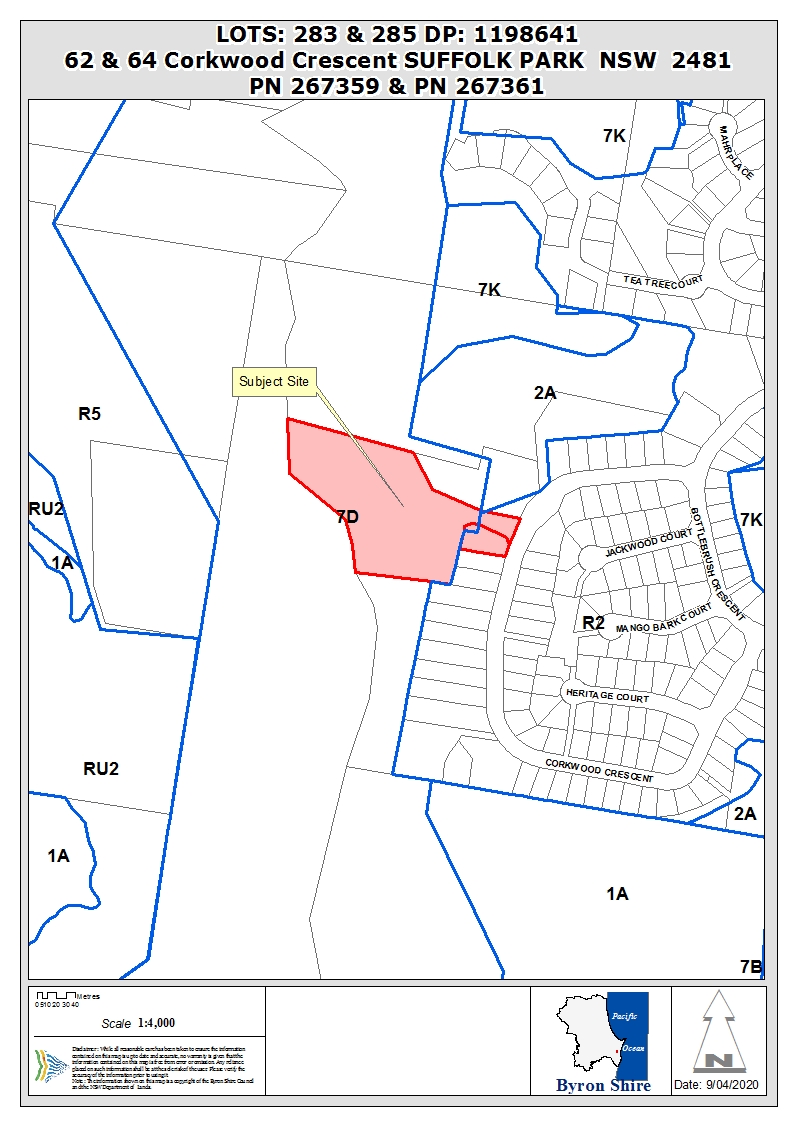
REPORT
Assessment:
1. INTRODUCTION
1.1. History/Background
The DA advises as follows in relation to site improvements:


1.2. Description
of the proposed development
This application seeks approval for Torrens Title
subdivision of two lots into two lots. The proposal is to essentially transfer
345m2 of land from No. 64 Corkwood Crescent to the adjoining No. 62 Corkwood
Crescent. The areas of existing and related proposed lots after subdivision are
as follows:
|
Existing
|
Proposed
|
|
Lot 283 (No. 62)
|
(1258m2)
0.1258ha
|
Lot 2
|
(1603m2)
0.1603ha
|
|
Lot 285 (No. 64)
|
1.9830ha
|
Lot 1
|
1.9485ha
|
|
TOTAL
|
2.1088ha
|
|
2.1088ha
|
The area of land to be transferred is adjacent to the
driveway which accesses the larger parcel to the west. This will increase the
size of the residential allotment facing Corkwood Crescent by 345 m2 at the
expense of the lifestyle hinterland allotment to the west which backs onto the
escarpment leading up to Coopers Shoot.
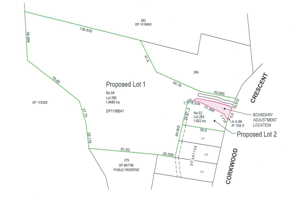
1.3. Description
of the site
A site inspection was carried out on 2 October 2019.
|
Land is legally described as
|
LOT: 283 DP: 1198641, LOT: 285 DP: 1198641
|
|
Property address is
|
62 Corkwood Crescent SUFFOLK PARK, 64 Corkwood Crescent
SUFFOLK PARK
|
|
Land is zoned:
|
Existing Lot 283 and the related proposed Lot 2
are within the R2 Low Density Residential Zone under LEP 2014 and 7(d)
(Scenic / Escarpment Zone) under LEP 1988.
Existing Lot 285 and the related proposed Lot 1
are within the R2 Low Density Residential Zone under LEP 2014 and the 2(a)
Residential Zone and 7(d) (Scenic / Escarpment Zone) under LEP 1988.
|
|
Land area is:
|
2.1088 hectares total
|
|
Property is constrained by:
|
· Bush fire prone
land
· High
Environmental Value Vegetation, but not in the location of the land transfer
part of the site, and no further consideration of this site constraint is
required.
|
|
Is a BDAR required due to the location of the proposed development?
|
☐ Yes ☒ No
|
|
Are there any easements in favour of Council affecting the
location of the proposed development?
|
☐ Yes ☒ No
|
|
Is there a Vegetation Management Plan which might affect
the proposal?
|
☐ Yes ☒ No
|
|
Is there a Voluntary Planning Agreement which might affect
the proposal?
|
☐ Yes ☒ No
|
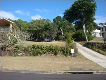
Location of land to
be transferred
2. SUMMARY OF
REFERRALS
|
Referral
|
Issue
|
|
Development Engineer
|
No objections subject to conditions.
|
|
S64 / Systems Planning Officer
|
No objections subject to conditions.
|
|
S94 / Contributions Officer
|
No objections, no conditions.
|
|
Rural Fire Service
|
No objections, subject to General Terms of Approval and
Bush Fire Safety Authority granted.
|
|
Department of Planning, Industry & Environment
|
No objections, no conditions, concurrence granted for the
SEPP 1 variation. See discussion below.
|
3. SECTION 100B
– Rural Fires Act 1997
Under section 4.14 of the Act, Council must be satisfied
prior to making a determination for development on bush fire prone land, that
the development complies with the document ‘Planning for Bush Fire
Protection 2006’. The site is bush fire prone land and as such approval
from the RFS is required under Section 100B of the Rural Fires Act 1997. The
development application was referred to the NSW Rural Fire Service, which
provided a bushfire safety authority with integrated conditions. This included
in the list of recommended conditions of consent.
4. SECTION 4.15C
– MATTERS FOR CONSIDERATION – DISCUSSION OF ISSUES
Having regard to the matters for consideration detailed in
Section 4.15(1) of the Environmental Planning & Assessment Act 1979
(EP&A Act), the following is a summary of the evaluation of the issues.
4.1 State Environmental
Planning Instruments
4.2A Byron Local Environmental Plan 2014 (LEP 2014)
LEP 2014 is an applicable matter for consideration in the
assessment of the subject development application in accordance with subsection
4.15(1) of the EP&A Act because it applies to the subject land and the
proposed development.
In accordance with LEP 2014 clauses 1.4 and 2.1 – 2.3:
(a) The
proposed development is defined in the Environmental Planning and Assessment
Act 1979 as subdivision of land;
(b) The
land is within the R2 Low Density Residential according to the Land Zoning Map;
(c) The
proposed development is permitted with consent; and
(d) The
proposed development is satisfactory having regard to the R2 Low Density Zone
Objectives.
Minimum Lot Size
As indicated above, the proposed lots are greater than the
600m2 minimum lot size development standard applicable to the land
to which LEP 2014 applies.
Clause 6.6 –
Essential Services
The subject site has access
to all necessary services including power, telecommunications, access, water
and sewer. A drainage swale is to be constructed around proposed Lot 2 to
manage overland flow of stormwater. Conditions of consent to apply.
The proposed development raises no other issues against the
LEP clauses.
4.2B Byron Local Environmental Plan 1988 (LEP 1988)
The subject site is partly zoned 7(d) Scenic Escarpment
under Byron LEP 1988. The following comments are made against the relevant LEP
clauses.
In accordance with LEP 1988 clauses 5, 8 and 9:
(a) The
proposed development is defined in the Environmental Planning and Assessment
Act 1979 as subdivision of land;
(b) The
land is within the 2(a) and 7(d) Zones according to the map under LEP 1988;
(c) The
proposed development is permitted with consent; and
(d) The
proposed development is consistent with the relevant objectives of the 2(a) and
7(d) Zones.
Clause 11 – Subdivision in rural areas for
agriculrure etc
Subclause 11(1) of LEP 1988 states
in relation to the 7(d) Zone that the
council shall not consent to the subdivision of land for (in this instance) a
dwelling-house within the 7(d) Zone unless the area of each of the allotments
to be created is not less 40 hectares and, in the opinion of the council, each
allotment is of satisfactory shape and has a satisfactory frontage. Each
proposed lot is of satisfactory shape and has a satisfactory frontage when a
comparison is made of the existing lot characteristics versus the equivalent
proposed lot characteristics.
However both proposed lots are within the 7(d) Zone and have
an area of less than 40 hectares. The area of proposed Lots 1 and 2 are 1.9485
hectares and 1603m2 respectively, representing variations to the development standard of 95% and 99.6%
respectively. Accordingly, the development application does not meet the
40 hectare minimum lot area requirement and the DA is supported by an objection
pursuant to SEPP 1.
The Land Environment Court judgment
in Wehbe v Pittwater Council [2007] identified requirements needed in
order to uphold a SEPP 1 objection. These are addressed in the circumstances of
this particular case as follows:
Is the requirement a development standard?
The
40 hectare minimum lot area requirement is a development standard as defined by
section 1.4 of the Environmental Planning and Assessment Act 1979, because it
is a provision of an environmental planning instrument in relation to the
carrying out of development, being a provision by or under which requirements
are specified and standards are fixed in respect of the area of any land.
Is the objection in writing, is it an objection “that
compliance with the development standard is unreasonable or unnecessary in the
circumstances of the case” and does it specify “the grounds of the
objection”?
The
Applicant submitted a written objection under SEPP 1 (refer to Doc
#E2019/66798, being Appendix F of the Statement of Environmental Effects
submitted in support of the DA). It is an objection that compliance with the
development standard is unreasonable and unnecessary in the circumstances for
the following reasons:
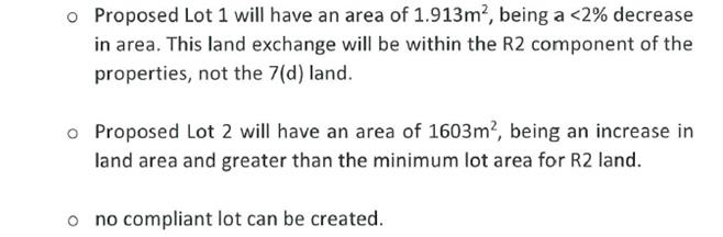
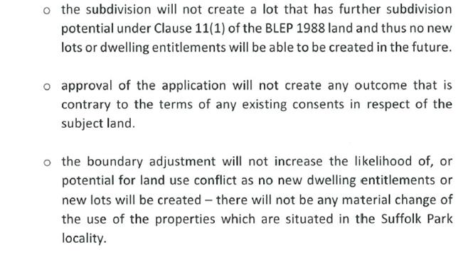
The
SEPP 1 objection specifies the grounds of the objection as follows:
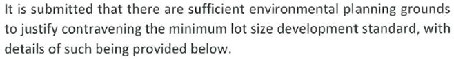
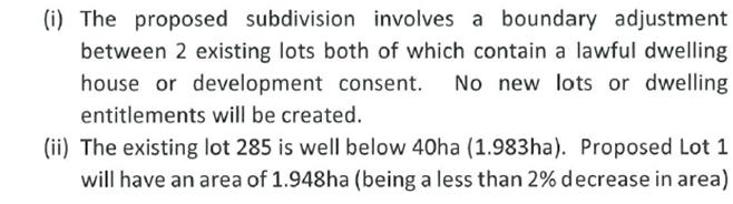
Is “the objection well founded” and will
“granting of consent to the development application be consistent with
the aims of SEPP 1 as set out in clause 3”?
An
objection under SEPP 1 may be well founded and be consistent with the aims set
out in clause 3 of the Policy in one of a variety of ways (according to the
above mentioned judgment). These are:
1. Compliance with
the development standard is unreasonable or unnecessary because the objectives
of the development standard are achieved notwithstanding non-compliance with
the standard.
2. The underlying
objective or purpose is not relevant to the development with the consequence
that compliance is unnecessary.
3. The underlying
objective or purpose would be defeated or thwarted if compliance was required
with the consequence that compliance is unreasonable.
4. The development
standard has been virtually abandoned or destroyed by the Council’s own
actions in granting consents departing from the standard and hence compliance
with the standard is unreasonable and unnecessary.
5. The zoning of
particular land was unreasonable or inappropriate so that a development
standard appropriate for that zoning was also unreasonable or unnecessary as it
applied to that land and compliance with the standard in that case would also
be unreasonable or unnecessary.
Clause
11 does not provide any stated objectives. The underlying objective, as
suggested by subclause 11(1) and in so far as being of relevance to the proposed
development, is considered to be as follows:
· To ensure that subdivided lots are of
sufficient area for the intended purpose of dwelling-houses in the 7(d) zoned
areas which are environmentally sensitive locations, particularly in terms of
scenic and escarpment constraints and hazards.
The
development achieves the underlying objective of the development standard
because the proposed lots are
of sufficient area for the intended purpose of dwelling-houses in the 7(d)
zoned areas for the following reasons:
· the existing lot areas are not
significantly changed as a result of the proposal;
· the existing lots already depart
significantly from the minimum 40 hectare lot area development standard, and a
comparison of the existing variation with the proposed variation as per the
table below confirms that the change to the variation as a result of the
proposal is not significant;
|
Existing
|
Proposed
|
|
Lot 283 (No. 62)
|
99.69% variation
|
Lot 2
|
99.60% variation
|
|
Lot 285 (No. 64)
|
95.04% variation
|
Lot 1
|
95.13% variation
|
· no new lots or opportunities for
additional dwellings are created within the 7(d) zoned part of the site
(without prejudicing Council’s assessment of any subsequent DA, it is
acknowledged that it might be possible for proposed Lot 2 to be further
subdivided into 2 lots within the LEP 2014 affected part of the site and
containing a minimum of 600m2 in accordance with the applicable
minimum lot size development standard, with the residue 7(d) zoned land being
included only within 1 of those lots);
· no new dwelling entitlements will be
created within the 7(d) zoned part of the site as a result of the proposal;
· the smaller lot is being marginally
increased in size to improve useability, the larger lot is being marginally
decreased in size without significant impact on functionality;
· the proposed lots do no cause any
significant conflicts with existing or approved development relating the site;
· the affected land is part of the
battle-axe handle access to No. 64 Corkwood Crescent, and the proposal does not
affect the location nor usefulness of the constructed driveway and access
dimensions to that land;
· the proposed lots will not have a
significant environmental impact because the area affected is not within the
sensitive scenic nor hazardous escarpment parts of the site; and
· there
is no public benefit in maintaining the development standard in this instance
as confirmed by the Department.
Granting of consent to the
DA is consistent with the aims of SEPP 1 because it provides flexibility in the application of
planning controls operating by virtue of development standards in circumstances
where strict compliance with those standards would, in the particular case, be
unreasonable, unnecessary and tend to hinder the attainment of the applicable
objects of the Environmental Planning and Assessment Act 1979. The Department of Planning, Industry and
Environment has granted concurrence to the variation. Compliance with the development
standard is unreasonable and unnecessary in the circumstances of the case and the SEPP 1 objection is well founded. For these
reasons it is recommended that the DA be approved notwithstanding the
development standard.
4.3 Any proposed Instrument
that has been the subject of public consultation and has been notified to the
consent authority
There are no draft environmental planning instruments
significantly applicable to the proposed transfer of 345m2 of land.
4.4A Byron Shire Development Control Plan 2014
(DCP 2014)
DCP 2014 is an applicable matter for consideration in the
assessment of the subject development application in accordance with subsection
4.15(1) of the EP& A Act because it applies to the land to which LEP 2014
applies.
Chapter D6: Subdivision
The proposed boundary adjustment raises no issues against
the DCP. Access and services remain available to both parcels. Standard
conditions of consent are to apply in relation to the completion of the
subdivision including the submission and approval of a subdivision certificate
Chapter E1: Suffolk Park.
The proposal raises no issues against the DCP provisions for
Suffolk Park.
4.4B Byron Shire Development Control Plan 2010 (DCP 2010)
DCP 2010 is an applicable matter for consideration in the
assessment of the subject development application in accordance with subsection
4.15(1) of the EP& A Act because its purpose is to provide planning
strategies and controls for various types of development permissible in
accordance with LEP 1988.
Chapter 1 Part B: Subdivision.
Similar to the DCP 2014, standard conditions of consent are
proposed to address the subdivision requirements to enable the development to
be completed.
4.5 Any Planning Agreement or
Draft Planning Agreement?
|
|
Yes
|
No
|
|
Is there any applicable planning agreement or draft
planning agreement?
|
☐
|
☒
|
|
Consideration: There are no planning agreements of draft
planning agreements applicable to the proposed transfer of 345m2
of land.
|
4.6 Environmental Planning
& Assessment Regulation 2000 Considerations
|
Clause
|
This control is applicable to the proposal:
|
I have considered this control as it relates to the
proposal:
|
If this control is applicable, does the proposal
comply?
|
|
92
|
No
|
N/A
|
N/A
|
|
93
|
No
|
N/A
|
N/A
|
|
94
|
No
|
N/A
|
N/A
|
|
94A
|
No
|
N/A
|
N/A
|
4.7 The likely impacts of that
development, including environmental impacts on both the natural and built
environments, and social and economic impacts in the locality
|
Impact on:
|
Likely significant impact/s?
|
|
Natural environment
|
No. The proposal will not have a significantly adverse
impact on the natural environment of the locality.
|
|
Built environment
|
No. The proposal will not have a significantly adverse
impact on the built environment of the locality.
|
|
Social Environment
|
No. The proposal will not have a significant social impact
on the locality.
|
|
Economic impact
|
No. The proposal will not have a significant economic
impact on the locality.
|
4.8 The suitability of the site
for the development
The site is serviced, and generally unconstrained in terms
of the proposal as submitted and is suitable for the proposed boundary
adjustment.
4.9 Submissions made in
accordance with this Act or the regulations
The development application was publicly exhibited. There
were no submissions made on the development application.
4.10 Public interest
The proposed development is unlikely to significantly
prejudice or compromise the public interest or create an undesirable precedent.
5. DEVELOPER
CONTRIBUTIONS
There is no nexus to levy
developer contributions.
6. CONCLUSION
The DA proposes Subdivision Two (2) Lots into Two (2) Lots.
The proposed development is satisfactory having regard to the relevant
environmental planning instruments and planning controls applicable to the
site. The proposal raises no significant issues in terms of environmental
impacts which cannot be managed and the site is considered suitable for the
development. The application appropriately addresses the relevant constraints
applying to the site, and is recommended for approval subject to the attached
approval conditions.
7. REASONS
FOR DECISION, HOW COMMUNITY VIEWS WERE ADDRESSED
Note:
From July 1 2018, Council’s are required to give and publicly notify
reasons for a range of planning decisions where they are deciding if
development should proceed to help community members to see how their views
have been taken into account and improve accountability to stakeholders. A
statement of reasons for the determination of this application is provided
below.
|
Statement of Reasons
|
|
The proposed development complies with the provisions of
Byron Local Environmental Plan 1988.
|
|
The proposed development complies with the provisions of
Byron Local Environmental Plan 2014.
|
|
The proposed development complies with relevant State
Environmental Planning Policies.
|
|
The proposed development complies with relevant provisions
of Development Control Plan 2014.
|
|
The proposed development complies with relevant provisions
of Development Control Plan 2010.
|
|
The proposed development complies with Environmental
Planning & Assessment Regulation 2000 considerations.
|
|
The proposed development will not have significant adverse
impact on the natural, built or social environment or economic impacts on the
locality.
|
|
The proposed development is considered suitable for the
proposed site.
|
|
The development application was advertised in accordance
with Development Control Plan 2010/2014.
|
|
The proposed development is unlikely to prejudice or
compromise the public interest.
|
|
How community views were addressed
|
|
The DA was advertised in accordance with Development
Control Plan 2014. No submissions were received.
|
Staff Reports - Sustainable Environment and Economy 13.14
Report No. 13.14 PLANNING
- Report of the 9 April 2020 Planning Review Committee
Directorate: Sustainable
Environment and Economy
Report
Author: Chris
Larkin, Manager Sustainable Development
File No: I2020/565
Summary:
This report provides the outcome of the Planning Review
Committee (PRC) held on 9 April, 2020. Due to COVID-19, the PRC meeting was
held partly via Skype with two Councillors attending in person. Of the five
development applications reported to PRC, four are to be reported to Council
for determination and one application remains with staff to determine under
delegation.
NOTE TO COUNCILLORS:
In accordance with the
provisions of S375A of the Local Government Act 1993, a Division is to be
called whenever a motion for a planning decision is put to the meeting, for the
purpose of recording voting on planning matters. Pursuant to clause 2(a)
under the heading Matters to be Included in Minutes of Council Meetings of
Council's adopted Code of Meeting Practice (as amended) a Division will be
deemed to have been called by the mover and seconder of all motions relating to
this report.
|
RECOMMENDATION:
That Council endorse the outcomes of the
Planning Review Committee meeting held on 9 April 2020.
|
REPORT
The Planning Review Committee meeting scheduled for 9 April,
2020, was held via a Skype meeting with Crs Martin and Ndiaye attending in
person.
Councillors: Crs Martin, Hunter, Hackett, Lyon, Ndiaye
Apologies: Crs Richardson, Coorey, Spooner, Cameron
Staff: Chris Larkin (Manager Sustainable Development)
The following development
applications were reviewed with the outcome shown in the final column.
|
DA No.
|
Applicant
|
Property Address
|
Proposal
|
Exhibition Submissions
|
Reason/s
Outcome
|
|
10.2020.110.1
|
Mr S Gilbert
|
58 Main Arm Road
MULLUMBIMBY
|
Use of Relocated Dwelling
House
|
Level 1
1 submission
|
Report to Council
Reasons: The validity of
the matters raised in the public submissions.
The perceived public
significance of the application.
|
|
1002020.158.1
|
Land Company Design and
Construction Pty Ltd
|
32 Charlotte Street
BANGALOW
|
Earthworks for change in
Levels and Retaining Walls
|
Level 0
1 submission
|
Staff Delegation
|
|
10.2020.100.1
|
Planners North
|
533 Bangalow Road TALOFA
|
Tourist and Visitor Accommodation
Comprising Eight (8) Cabins
|
Level 2
19/3/20-1/4/20
2 submissions
|
Report to Council
Reason: The validity of the
matters raised in the public submissions.
The perceived public
significance of the application.
|
|
10.2020.47.1
|
Ardill Payne & Partners
|
1 Cavvanbah Street BYRON
BAY
|
Alterations and Additions
to Tourist and Visitor Accommodation including Three (3) Additional Rooms and
a Pool Cabana
|
Level 2
13/2/20-26/2/20
3 submissions
|
Report to Council
Reason: The validity of the
matters raised in the public submissions.
The perceived public
significance of the application.
|
Council determined the following original development
application. The Section 4.55 application to modify the development consent is
referred to the Planning Review Committee to decide if the modification
application can be determined under delegated authority.
|
DA No.
|
Applicant
|
Property Address
|
Proposal
|
Exhibition/
Submissions
|
Reason/s
Outcome
|
|
10.2019.196.2
|
Ardill Payne & Partners
|
541 Friday Hut Road POSSUM
CREEK
|
4.55 to Modify Kitchen
Design for Building Eight
|
Level 1
7/4/20-27/4/20
|
Report to Council
Reason: The perceived
public significance of the application.
|
Staff Reports - Sustainable Environment and Economy 13.15
Report No. 13.15 PLANNING
- Section 4.55 Application - 10.2019.196.2 - Proposed Modification to amend
location of Kitchen and Wet Bar in Building 8 and amend timeframe for
Demolition of Buildings 1, 2, 3, 4 and 6 - 541 Friday Hut Road Possum Creek
Directorate: Sustainable
Environment and Economy
Report
Author: Dylan
Johnstone, Planner
File No: I2020/642
Proposal:
|
Section 96 Application No:
|
10.2019.196.2
|
|
|
Proposed modification:
|
S4.55 to Modify location of Kitchen and Wet Bar in
Building 8 and amend timeframe for Demolition of Buildings 1, 2, 3, 4 and 6
|
|
|
Original Development:
|
Use of Existing Buildings as a Detached Dual Occupancy and
Demolition / Removal of Five (5) Buildings
|
|
|
Type of modification sought:
|
|
|
|
|
|
Property description:
|
LOT: 3 DP: 252483
|
|
|
541 Friday Hut Road POSSUM CREEK
|
|
|
Parcel No/s:
|
26280
|
|
|
Applicant:
|
Ardill Payne & Partners
|
|
|
Owner:
|
Mr S L Bassett & Ms V Polasek
|
|
|
Zoning:
|
RU2 Rural Landscape / PART DM Deferred Matter
|
|
|
S96 Date received:
|
25 March 2020
|
|
|
Original DA determination date:
|
21/11/2019
|
|
|
Integrated Development:
|
No
|
|
|
Public notification or exhibition:
|
- Level
1 advertising under DCP 2014 Part A14 – Public Notification and
Exhibition of Development Applications
- Exhibition
period: 7/4 - 27/4/2020
- Submissions received: Nil
|
|
|
Planning Review Committee:
|
09/04/20
|
|
|
Delegation to determination:
|
Council
|
|
|
Issues:
|
· Existing
unauthorised structures
|
|
|
|
|
|
|
|
Summary:
A Deferred Commencement Consent 10.2019.196.1 was granted on
21 November 2019 for Use of Existing Buildings as a Detached Dual Occupancy and
Demolition / Removal of Five (5) Buildings.
The site contains eight (8) existing buildings:
Building 1 – existing dwelling (historical approval)
Building 2 – existing dwelling (unauthorised)
Building 3 – existing shed
Building 4 – existing observatory
Building 5 – existing dwelling (approved as part of
detached Dual Occupancy 10.2019.196.1)
Building 6 – existing shed/laundry
Building 7 – existing portico
Building 8 – existing dwelling (approved as part of
detached Dual Occupancy 10.2019.196.1)
Consent conditions of 10.2019.196.1 required the demolition
/ removal of Buildings 1, 2, 3, 4 and 6.
Building 8 comprises two pavilions that are approved as one
dwelling forming part of a Dual Occupancy (detached). The approved floor plan
for Building 8 included both a kitchen and “wet bar” and
appropriate conditions were placed on the consent to ensure that the “wet
bar” does not become a second kitchen and to ensure that this building
does not become two separate dwellings. The approved lower pavilion included
the kitchen for the dwelling while the approved upper pavilion included a wet
bar.
This S4.55 (1A) application seeks to amend consent
conditions to swap the kitchen to the upper pavilion and the wet bar to the
lower pavilion and make other minor amendments to the configuration of bedrooms
and ensuites. The changes to the layout raise no planning issues and are
recommended for approval.
The application also seeks to amend the timeframe by which
Buildings 1, 2, 3, 4 and 6 are required to be demolished / removed from the
site. The reason for changes being sought is to enable the residents to
continue to live in Building 1 which is an existing approved dwelling on the
property while works are ongoing in the two approved dual occupancy dwelling
houses and for building 2 to be used a site office / builders storage.
This aspect of the proposal is not supported due to the
history of unauthorised building work on the site, and the use of these
structures without development consent. Further, there is no demonstrated need
for this to occur as alternates exist to accommodate the needs of the residents
on site.
It is therefore recommended that this S4.55 (1A) application
be only part approved subject to modified conditions.
NOTE TO COUNCILLORS:
In accordance with the
provisions of S375A of the Local Government Act 1993, a Division is to be
called whenever a motion for a planning decision is put to the meeting, for the
purpose of recording voting on planning matters. Pursuant to clause 2(a)
under the heading Matters to be Included in Minutes of Council Meetings of
Council's adopted Code of Meeting Practice (as amended) a Division will be
deemed to have been called by the mover and seconder of all motions relating to
this report.
|
RECOMMENDATION:
That pursuant
to Section 4.55 of the Environmental Planning & Assessment Act 1979, Application
No. 10.2019.196.2:
1. Be
part approved to change the location of kitchen and wet bar in Building 8 by
modifying Development Consent Number 10.2010.196.1 subject to amended
conditions (Attachment 2); and
2. Be
part refused and not change the timeframe for Demolition of Buildings 1, 2,
3, 4 and 6 by modifying Development Consent Number 10.2010.196.1 as in the
circumstances of the case there is no demonstrated need for amendment of
Conditions 2 and 5 and it is not the public interest.
|
Attachments:
1 10.2019.196.2
- Proposed Amended Plans, E2020/23504
2 10.2019.196.2
- Proposed Amended Conditions, E2020/30435
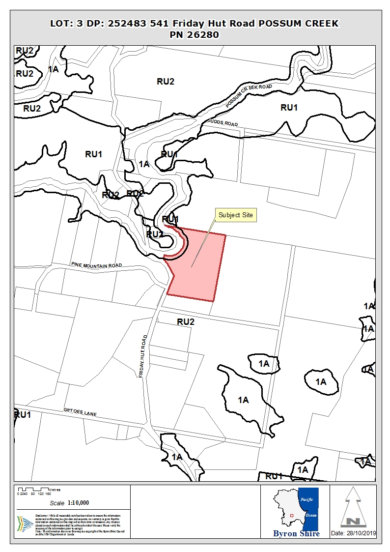
Assessment:
1. INTRODUCTION
1.1. History/Background
BA 209/79 Building Application for a workshop and
studio, lodged 8 June 1979.
BA
389/80 Building Application for extension to existing dwelling, determined
8 September 1980.
BA 216/81 Building Application for pottery studio,
determined 10 June 1981.
BA 588/87 Building Application in-ground swimming
pool, determined 10 November 1987.
10.2019.196.1 Use of Existing Buildings as a Detached
Dual Occupancy and Demolition / Removal of Five (5) Buildings – Deferred
Commencement approved 21 November 2019
Deferred commencement Conditions 1 (requirement to obtain a
Building Information Certificate for Buildings 5 and 8) and 2 (requirement to
obtain a Section 68 approval for an on-site sewage management facility) have
been satisfied and consent 10.2019.196.1 is now operational.
1.2. Description of the
proposed development
This Section 4.55 (1A) application seeks approval to modify
the location of the Kitchen and Wet Bar in Building 8 and amend the timeframe
for demolition / removal of Buildings 1, 2, 3, 4 and 6.
Building Eight consists of two pavilions that are approved
as one dwelling forming part of a Dual Occupancy (detached).
The approved lower pavilion included the kitchen for the
dwelling while the approved “upper pavilion” included a wet bar.
This application seeks approval to amend the floor plan to
swap the kitchen to the upper pavilion and the wet bar to the lower pavilion
and make other minor amendments to the configuration of bedrooms and ensuites.
No specific reasons are provided within the application; however the upper
pavilion appears to be the more substantial of the two structures constructed
from masonry and sandstone, while the lower pavilion is more industrial in
design in terms of a shed through the use of glass and sheet metal.
From a planning perspective changes to the kitchen and wet
bar locations raise no issues and Council staff have no objections to amending
Conditions 1 and 38 as requested by the applicant to permit the above.
The application also seeks to amend the timeframe by which
Buildings 1, 2, 3, 4 and 6 are required to be demolished / removed from the
site.
The site contains eight (8) existing buildings:
Building 1 – existing dwelling (historical approval)
Building 2 – existing dwelling (unauthorised)
Building 3 – existing shed
Building 4 – existing observatory
Building 5 – existing dwelling (approved as part of
detached Dual Occupancy 10.2019.196.1)
Building 6 – existing shed/laundry
Building 7 – existing portico
Building 8 – existing dwelling (approved as part of
detached Dual Occupancy 10.2019.196.1)
Condition 2 of consent 10.2019.196.1 requires demolition /
removal of Buildings 1, 2, 3, 4 and 6 within 2 years of the date of issue of
the Deferred Commencement consent or prior to issue of a Construction Certificate
whichever comes first.
Condition 5 requires the demolition / removal of these
structures prior to issue of a Construction Certificate.
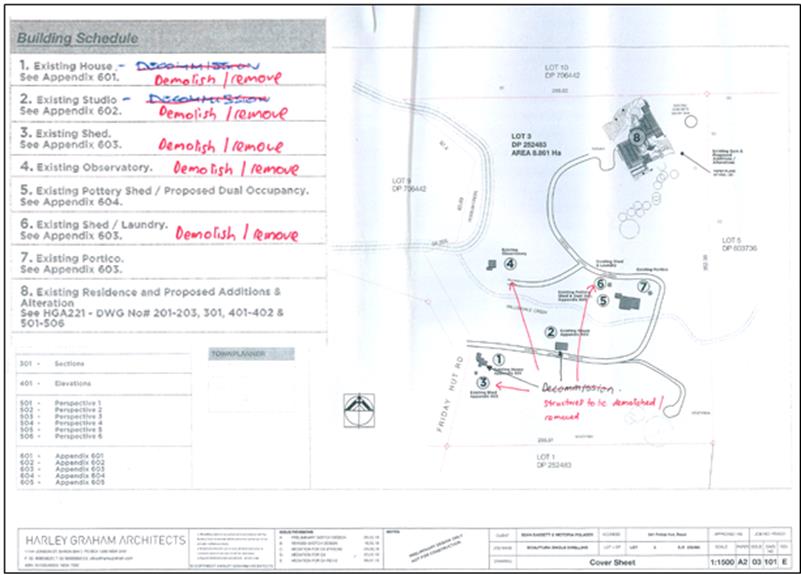
Figure 1: Site Layout Plan
and Building Schedule
The application seeks to amend Conditions 2 and 5 to enable
Buildings 1 and 2 to be used whilst works to Buildings 5 and 8 are under
construction. The applicant estimates that the period to complete construction
works on Buildings 5 and 8 will take approximately 12-16 months and feels that
it would be reasonable for Building 1 to continue to be used as a dwelling
during this construction period and to use Building 2 as a site office /
builders storage sheds during these works (no habitation is sought for this
structure).
The applicant proposed that the conditions of 10.2019.196.1
could be modified to require that the structures are demolished prior to the
issue of an Occupation Certificate, and argued that this would give Council
satisfaction that there would be no more than 2 dwellings located on the
property at any time and hence the intent of the consent would continue to be
satisfied.
Council staff are mindful of past unauthorised use of
structures on the site, and seek a definitive timeframe by which these
structures are to be removed rather than leaving it open ended.
It is not unusual for residents to remain (on site) in their
dwellings while construction work such as alterations and additions are being
undertaken. It is noted that Building 5 only requires minimal work for it to be
finished so that the owners of the property can reside in this dwelling while
other work is completed. This has been confirmed by a recent
inspection of the building by Council’s Building Certifier assessing an
application for a Building Information Certificate. Building 5 appeared to be
occupied as a dwelling at the time of this inspection.
Given the history of unauthorised building work on the site,
the use of these structures without development consent, and the ability for
the owners to reside in Dwelling 5 whilst other works are occurring on Dwelling
8 if this becomes untenable; there is no demonstrated need for amendment of Conditions
2 and 5 and as such this aspect of the application is not supported.
2. Description of the site
|
Land is legally described
as
|
LOT: 3 DP: 252483
|
|
Property address is
|
541 Friday Hut Road POSSUM
CREEK
|
|
Land is zoned:
|
RU2 Rural Landscape / PART
DM Deferred Matter
|
|
Land area is:
|
8.861 ha
|
|
Property is constrained by:
|
Bushfire prone
land
High Conservation Value
High
Environmental Value;
and
Cattle Dip Buffer
|
3. SUMMARY OF
REFERRALS
|
Referral
|
Issue
|
|
Rural Fire Service S4.14
|
No objections subject to recommended conditions.
|
4. SECTION 4.15 – MATTERS FOR CONSIDERATION
– DISCUSSION OF ISSUES
Having regard for the matters for consideration detailed in
Section 4.15(1) of the Environmental Planning & Assessment Act 1979, the
following is a summary of the evaluation of the issues.
4.1. Section 4.55 of the EPA
Act 1979
The modifications to the pavilion style house (Building 8)
in terms of the kitchen redesign raise no issues in terms of the built form or
use of the dwelling house.
As outlined above, amendment of Conditions 2 and 5 pertaining
to the timing of demolition and removal of other dwellings and cabins on the
subject land is not supported. Therefore there remains a two year time frame
for the removal of these buildings (or prior to issue of a Construction
Certificate whichever comes first) as per the original conditions, starting
from 21 November 2019.
It is considered the proposed development is substantially
the same development and satisfies the provisions contained with Section 4.55
of the EPA Act 1979.
4.2. State/Regional Planning
Policies, Instruments, EPA Regulations 2000
Proposed amendments raise no issues under the relevant
SEPPS, Policies or clauses of the EPA Regulations 2000.
4.3. Byron Local Environmental
Plan 2014
Proposed amendments raise no issues under the LEP.
4.4. Draft EPI that is or has
been placed on public exhibition and details of which have been notified to the
consent authority - Issues
No draft EPIs affect the proposal.
4.5. Development Control Plans
The proposed amendments do not generate any additional
issues that have not been previously considered.
4.6. The likely impacts of that
development, including environmental impacts on both the natural and built
environments, and social and economic impacts in the locality
The proposed amendments do not generate any impacts that
have not been previously considered.
4.7. The suitability of the
site for the development
The proposed amendments to the kitchen arrangements do not
affect the sites suitability. The Bushfire conditions have been amended to
reflect changes to the use of Building 1 until it is demolished or removed.
4.8 Submissions
made in accordance with this Act or the regulations
No submissions were received.
4.9 Public
interest
Proposed amendments to the location of the kitchen and wet
bar are unlikely to prejudice or compromise the public interest. However it is
considered not in the public interest to provide for an extension of time for
the demolition or removal of the other buildings, cabins and dwellings on the
land as discussed above.
5. DEVELOPER
CONTRIBUTIONS/ WATER AND SEWER CHARGES
There is no nexus to levy additional contributions.
6. DISCLOSURE
OF POLITICAL DONATIONS AND GIFTS
|
Has a Disclosure Statement been received in relation
to this application
|
No
|
|
Have staff received a ‘gift’ from anyone involved
in this application that needs to be disclosed. Where the answer is yes, the
application is to be determined by the Director or Manager of the Planning,
Development and Environment Division.
|
No
|
|
Provide Disclosure Statement register details here:
|
Not applicable
|
7. REASONS FOR
DECISION, HOW COMMUNITY VIEWS WERE ADDRESSED
Note: From July 1 2018, Council’s are required to
give and publicly notify reasons for a range of planning decisions where they
are deciding if development should proceed to help community members to see how
their views have been taken into account and improve accountability to stakeholders.
A statement of reasons for the determination of this application is provided
below.
|
Statement of Reasons – Part Approval only
|
|
The proposed modifications were minor and substantially
the same as the original development approval with no detrimental environmental
impacts.
|
|
How community views were
addressed
|
|
The S4.55 was
notified/advertised in accordance with the Byron Community Strategic Plan
2018. No submissions were received.
|
8. CONCLUSION
As discussed in the report application 10.2019.196.2 is
recommended for part approval and part refusal.
Staff Reports - Sustainable Environment and Economy 13.16
Report No. 13.16 PLANNING
- DA 10.2020.110.1 Alterations & Additions to existing dwelling house
at 58 Main Arm Road Mullumbimby
Directorate: Sustainable
Environment and Economy
Report
Author: Rebecca
Mercer, Team Leader Planning Services
File No: I2020/651
Proposal:
|
DA No:
|
10.2020.110.1
|
|
Proposal description:
|
Use of Relocated Dwelling House
|
|
Property description:
|
LOT: 2 DP: 1256643
|
|
58 Main Arm Road MULLUMBIMBY
|
|
Parcel No/s:
|
269923
|
|
Applicant:
|
Mr S Gilbert
|
|
Owner:
|
Mr S T & Mrs A J Gilbert
|
|
Zoning:
|
R2 Low Density Residential
|
|
Date received:
|
3 March 2020
|
|
Integrated / Designated Development:
|
☐
Integrated
|
☐
Designated
|
☒
Not applicable
|
|
Concurrence required
|
No
|
|
Public notification or exhibition:
|
- Level
0 advertising under DCP 2014 Part A14 – Public Notification and
Exhibition of Development Applications
- Exhibition
period: Not applicable
- Submissions received: 5
in objection, 2 in support
- Submissions
acknowledged: ☒
Yes ☐ No
|
|
Planning Review Committee:
|
9 April 2020
|
|
Variation request
|
Not applicable
|
|
Delegation to determine
|
Council
|
|
Issues:
|
The relocated dwelling is not sited in accordance with CDC
16. 2019.108.1
Building height plane encroachment on eastern boundary
Flood liable land
|
Summary:
The development application is seeking approval for the use
of a relocated dwelling house on residential land at 58 Main Arm Road,
Mullumbimby. The subject property is zoned R2 Low Density Residential under the
Byron LEP 2014. The 119.8m2 dwelling house is one-storey, contains 2
bedrooms and an office, and involves a maximum height of 5.6m. An existing
42.3m2 shed is currently situated adjacent to the western boundary
towards the rear of the site and approximately 1.12 metres from the dwelling
house.
The relocated dwelling house was originally approved under a
Complying Development Certificate (CDC) 16.2019.108.1 with a front setback of
8m and a side setback on the east of 1172mm. However, the dwelling was not sited
on the property in accordance with the approved CDC. The owners of the subject
site expressed to Council that they wish to retain the current location of the
relocated dwelling house. In this regards the front of the dwelling house is
located 6.0 metres from the front boundary. Although compliant with Councils
standard setback requirements of 4.5 metres to front boundaries for residential
areas, the dwelling could not proceed under the approved CDC.
Objections received related to the impact on the eastern
neighbour, the main concerns raised relate to proximity to eastern boundary,
overshadowing, stormwater and contamination.
The relocated dwelling involves an encroachment into the
building height plane on the eastern boundary; however the majority of the
building height plane encroachment is due to the dwelling house being raised
approx. 1m above the natural ground level to comply with flood requirements. Further
the dwelling is single storey weatherboard construction and is arguably
consistent with the low density character and vernacular of Mullumbimby. The
setback to the side boundary satisfies the minimum requirements of 900 mm and
the level of overshadowing caused by the dwelling is considered acceptable
having regards to the orientation of the lot and the height of the dwelling
house. Other matters raised n the objections as discussed in the body of this
report have been considered and conditions of consent are recommended to
address matters raised in relation to stormwater and contamination.
The development is otherwise consistent with the applicable
planning instruments and development controls, and it is recommended that the
application be approved subject to conditions.
NOTE TO COUNCILLORS:
In accordance with the
provisions of S375A of the Local Government Act 1993, a Division is to be
called whenever a motion for a planning decision is put to the meeting, for the
purpose of recording voting on planning matters. Pursuant to clause 2(a)
under the heading Matters to be Included in Minutes of Council Meetings of Council's
adopted Code of Meeting Practice (as amended) a Division will be deemed to have
been called by the mover and seconder of all motions relating to this report.
|
RECOMMENDATION:
That pursuant to Section 4.16 of the
Environmental Planning & Assessment Act 1979, Development Application No.
10.2020.110.1 for Alteration & Additions to existing Dwelling House, be
granted consent subject to the conditions of approval listed in Attachment 3
(#E2020/30239).
|
Attachments:
1 Amended
Plans 10.2020.110.1.1, E2020/30202
2 Shadow
Plan 10.2020.110.1.1, E2020/31579
3 Conditons
of Consent 10.2020.110.1.1, E2020/30239
4 Confidential
- Submissions received 10.2020.110.1, E2020/30187
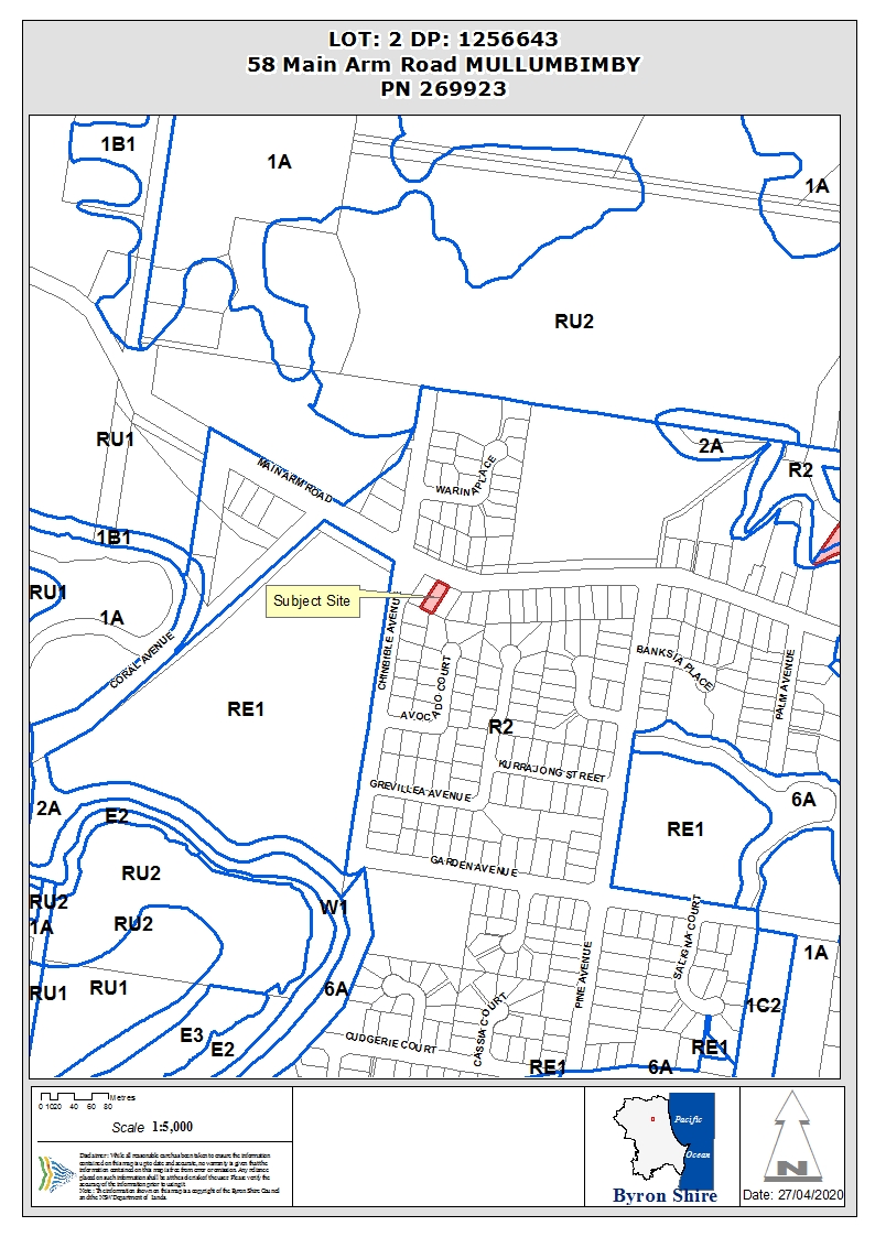
REPORT
Assessment:
1. INTRODUCTION
1.1. History/Background
The following previous determinations have been made on the
subject site:
· DA 10.2018.513.1
for subdivision two (2) lots was approved on 29 March 2019.
· CDC 16.2019.108.1
for relocated dwelling including alterations and additions to front entry was
approved 16 December 2019.
The above CDC approved the relocated dwelling house with a
front setback of 8m and a side setback on the east of 1172mm. However, the
dwelling was later sited on the property not in accordance with the CDC
approval, necessitating the need for the DA.
1.2. Description
of the proposed development
This application seeks approval for the Use of Relocated
Dwelling House. The dwelling house is already situated on the site on steel
posts, however no footings have been poured. The dwelling comprises of 2
bedrooms, 1 bathroom, an office, living room, dining room, kitchen, and
laundry. The dwelling has an area of approximately 120m2 and the
property has an area of 654 m2. There is an existing 42.3m2
garage/shed located adjacent to the western boundary towards the rear of the
site.
Figure 1. Plans of the
dwelling as it fronts Main Arm Road
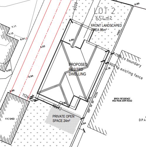
Figure
2 – Proposed site plan
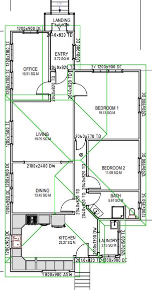
Figure 3 – Proposed
floor plan
1.3. Description
of the site
|
Land is legally described
|
LOT: 2 DP: 1256643
|
|
Property address
|
58 Main Arm Road MULLUMBIMBY
|
|
Land is zoned:
|
R2 Low Density Residential
|
|
Land area is:
|
653.9 m2
|
|
Property is constrained by:
|
Flood Liable
Land
|
The subject site is accessed via Main Arm Road and contains
minimal vegetation and with an existing shed/garage adjacent to the western
boundary towards the rear of the site.
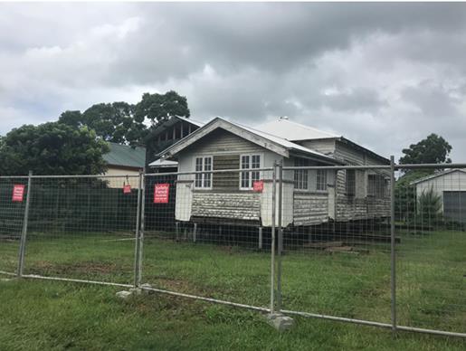
Figure
4 - Relocated dwelling
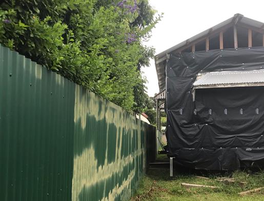
Figure
5 – Proximity of the dwelling to the boundary fence. Fence currently is
not located on the boundary and favours neighbour to the east in that regard.
2. SUMMARY OF
REFERRALS
|
Referral
|
Issue
|
|
Building Certifier
|
No objections subject to conditions
|
|
Development Engineer
|
No objections subject to conditions.
|
3. SECTION 4.14
– BUSH FIRE PRONE LAND
Under section 4.14 of the Act, Council must be satisfied
prior to making a determination for development on bush fire prone land, that
the development complies with the document ‘Planning for Bush Fire
Protection 2006’. The site is not bush fire prone land.
4. SECTION 4.15C
– MATTERS FOR CONSIDERATION – DISCUSSION OF ISSUES
Having regard to the matters for consideration detailed in
Section 4.15(1) of the Environmental Planning & Assessment Act 1979
(EP&A Act), the following is a summary of the evaluation of the issues.
4.1 State Environmental
Planning Instruments
4.2 Byron Local Environmental Plan
2014 (LEP 2014)
LEP 2014 is an applicable matter for consideration in the
assessment of the subject development application in accordance with subsection
4.15(1) of the EP&A Act because it applies to the subject land and the
proposed development. The LEP 2014 clauses that are checked below are of
relevance to the proposed development:
|
Part 1
|
☒1.1|
☒1.1AA| ☒1.2| ☒1.3| ☒1.4| ☒Dictionary| ☒1.5| ☒1.6| ☒1.7| ☒1.8| ☒1.9
|
|
Part 2
|
☒2.1|
☒2.2| ☒2.3| ☒Land Use Table
|
|
Part 3
|
N/A
|
|
Part 4
|
☒4.3|
☒4.4
|
|
Part 5
|
N/A
|
|
Part 6
|
☒6.2|
☒6.3| ☒6.6
|
In accordance with LEP 2014 clauses 1.4 and 2.1 – 2.3:
(a) The
proposed development is defined in the LEP 2014 Dictionary as Dwelling;
(b) The
land is within the R2 Low Density Residential according to the Land Zoning Map;
(c) The
proposed development is permissible with consent; and
(d) Regard
is had for the Zone Objectives as follows:
|
Zone Objective
|
Consideration
|
|
To provide for the housing needs of the community within a
low density residential environment.
|
The relocated dwelling
house is consistent with the surrounding low density residential environment
in terms of built form, design, character, setbacks, bulk and scale, and site
coverage.
|
|
To enable other
land uses that provide facilities or services to meet the day to day needs of
residents.
|
Not other land uses proposed.
|
Clause 4.3 Height of Buildings
The relocated dwelling involves a maximum height of 5.6m
above natural ground level; therefore the development satisfies the 9m building
height limit.
Clause 4.4 Floor Space Ratio
The subject site has an area of 654m2, the
relocated dwelling has a floor area of 119.8m2, therefore the floor
space ratio is 0.248:1. The development is compliant with the required FSR of
0.5:1.
Clause 6.3 Flood Planning
The relocated dwelling house has a finished floor level of
7.8m AHD. The flood planning level for the subject site is 7.73 AHD; therefore
the development complies with flood requirements.
Clause 6.6 Essential Services
The subject site is capable of being connected to water,
sewage, electricity, and stormwater. Driveway access is proposed from Main Arm
Road, and is capable of complying with Council standards. Appropriate
conditions of consent have been recommended.
4.3 Any proposed Instrument
that has been the subject of public consultation and has been notified to the
consent authority
Not applicable.
4.4 Byron Shire Development Control
Plan 2014 (DCP 2014)
DCP 2014 is an applicable matter for consideration in the
assessment of the subject development application in accordance with subsection
4.15(1) of the EP& A Act because it applies to the land to which LEP 2014
applies. The DCP 2014 Parts/Chapters that are checked below are of relevance to
the proposed development:
|
Part A
|
☒
|
|
Part B Chapters:
|
☒B2|
☒B3| ☒B4| ☒B8| ☒B14
|
|
Part C Chapters:
|
☒C2
|
|
Part D Chapters
|
☒D1
|
|
Part E Chapters
|
☒E3
|
Chapter B3: Services
The dwelling house is capable of connecting to water,
sewage, electricity, and stormwater (conditions have been recommended).
Driveway access is proposed from Main Arm Road, and is capable of complying
with Council standards.
Chapter B4: Traffic Planning, Vehicle Parking,
Circulation and Access
The subject site contains an existing garage adjacent to the
western boundary towards the rear of the site. Driveway access is proposed to
the garage from Main Arm Road, the driveway will provide enough space for 2
vehicles in a stacked arrangement whilst complying with the front setback.
Although stacked parking is not favoured, it is a discernible characteristic
within the immediate surrounding area and the Mullumbimby locality, the
proposed stacked parking arrangement is considered acceptable in this instance.
Chapter C2: Areas Affected By Flood
The relocated dwelling house has a finished floor level of
7.8m AHD. The flood planning level for the subject site is 7.73 AHD; therefore
the development complies with flood requirements.
Chapter D1: Residential Accommodation in Urban, Village
& Special Purpose Zones
D1.2.1 Building Height Plane
The relocated dwelling house encroaches into the building
height plane on the eastern boundary (see figure 5 below). It is not considered
to adversely impact on the privacy, solar access, or views of the adjoining
property to the east. The dwelling will overshadow the neighbouring property during
the evening hours however as the structure is one-storey the extent of the
shadowing is not considered an unreasonable outcome for an urban residential property.
Prescriptive measure 2(a) states: An exemption from the
building height plane may be considered in relation to one or more boundaries
in the following circumstances where the floor level is required to be above
ground level to comply with Council’s requirements for flood protection.
The majority of the building height plane encroachment is
due to the dwelling house being raised approx. 1m above the natural ground
level to comply with flood requirements. The solar access impacts resulting
from the encroachment are not considered unreasonable having regard to the
constraints of the site and the urban residential environment. The dwelling is
compliant with the required side setback and is considered compliant with the
objectives, performance criteria, and prescriptive measures of the building
height plane planning control.
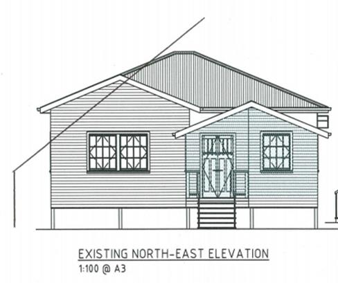
Figure 6 – Eastern
boundary BHP encroachment
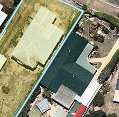
Figure
7 – Proximity of relocated dwelling to neighbouring property
Similarly the neighbouring dwelling to the east would also
breach the building height plane and it is likely it also generates a degree of
overshadowing onto the subject property during the morning hours. It is also
noted there is a dividing fence in place; however it is located inside the
applicants property not on the boundary. The fence provides a degree of
residential privacy as expected in residential areas of Byron Shire.
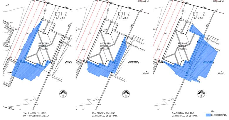
Figure 8 shadow plans for
midwinter.
The shadow plans do not indicate the level of overshadowing
caused by the dividing fence.
D1.2.2 Setbacks from Boundaries
The dwelling complies with Councils setback requirements. It
is 1186mm from the eastern side boundary, approx. 6m from the western side
boundary, and approx. 16m from the rear boundary, satisfying the required 900mm
side and rear setback. It’s also set back 6m from the front boundary
satisfying the required 4.5m front setback.
D1.2.4 Character and Visual Impact
The DA seeks approval for a relocated 1930s Queenslander
style dwelling. The development is consistent with the surrounding low density
residential environment having regard to built form, character, design,
setbacks, bulk and scale, and site coverage. In particular the dwelling is not
overbearing having regards to its footprint, height and provision of open space
area within the front and rear yards of the property. It is considered the
proposal compliments the streetscape and is consistent with existing development
within the surrounding neighbourhood. In conclusion the proposal is not out of
character with the vernacular for Mullumbimby, and has generates no detrimental
visual impacts on he neighbourhood.
Chapter E3 Mullumbimby
The subject site is situated within precinct 4 – West
Mullumbimby Residential. Houses within this area are predominately more of a
brick and tile construction, however there are also many weatherboard and metal
roof dwellings such as the immediate neighbour to the west at 60 Main Arm Road.
The relocated 1930s Queenslander style dwelling compliments the established
streetscape character of the surrounding Mullumbimby precinct and is also a
reflection of development within the older precincts of Mullumbimby. The
development is compatible with the low rise character and scale of Mullumbimby
and sits comfortably within the urban fabric. The dwelling is consistent with
the existing design characteristics, built form, and scale of development
within Mullumbimby.
4.5 Any Planning Agreement or
Draft Planning Agreement?
|
|
Yes
|
No
|
|
Is there any applicable planning agreement or draft
planning agreement?
|
☐
|
☒
|
|
|
4.6 Environmental Planning
& Assessment Regulation 2000 Considerations
|
Clause
|
This
control is applicable to the proposal:
|
I
have considered this control as it relates to the proposal:
|
If
this control is applicable, does the proposal comply?
|
|
92
|
No
|
Not applicable
|
Not applicable
|
|
93
|
No
|
Not applicable
|
Not applicable
|
|
94
|
No
|
Not applicable
|
Not applicable
|
|
94A
|
No
|
Not applicable
|
Not applicable
|
* Non-compliances and any other significant issues
discussed below
4.7 Any Coastal Zone Management
Plan?
|
|
Satisfactory
|
Unsatisfactory
|
Not applicable
|
|
Is there any applicable coastal zone management plan?
|
☐
|
☐
|
☒
|
|
|
4.8 The likely impacts of that
development, including environmental impacts on both the natural and built
environments, and social and economic impacts in the locality
|
Impact on:
|
Likely significant impact/s?
|
|
Natural environment
|
No. The development site is generally clear of vegetation
and the proposal will not have a significantly adverse impact on the natural
environment of the locality.
|
|
Built environment
|
No. The proposal will not have a significantly adverse
impact on the built environment of the locality. The dwelling is generally
consistent with development within the surrounding area in terms of built
form, character, bulk and scale, setbacks, and height. The proposal involves
a single dwelling residential development within a low density residential
environment.
|
|
Social Environment
|
No. The proposal will not have a significant social impact
on the locality. The dwelling will provide further housing in the Mullumbimby
area.
|
|
Economic impact
|
No. The proposal will not have a significant economic
impact on the locality.
|
|
Construction impact
|
The development will generate minor impacts during its
construction. Conditions of consent recommended to control hours of work,
builders waste, construction noise, installation of sedimentation and erosion
control measures and the like to ameliorate such impacts.
|
4.9 The suitability of the site
for the development
The site is a serviced and relatively unconstrained property
and is suitable for the proposed development. The property is situated within
flood liable land, however the dwelling house is capable of meeting flood
requirements and is conditioned accordingly.
4.10 Submissions made in accordance with
this Act or the regulations
The development application was publicly exhibited. There were
7 submissions made on the development application, 5 in objection and 2 in
support:
|
Submissions of Objection
|
|
Issues:
|
Comments:
|
|
Too close to eastern neighbour / intrusive / doesn’t
comply with side setback
|
The dwelling complies with the 900mm setback control; it
is setback 1186mm from the side boundary. The dwelling encroaches into the
building height plane on the eastern boundary however; the majority of the
building height plane encroachment is due to the dwelling being raised
approx. 1m above the natural ground level to comply with flood requirements.
|
|
Overshadowing/blocking light
|
Due to the orientation of the lots the neighbour to the
east will experience overshadowing in the afternoon during the winter
solstice. The solar access impacts resulting from the encroachment are not
considered unreasonable having regard to the constraints of the site and the
urban residential environment and it is noted existing fencing on the
boundary and landscaping would also create overshadowing at this time of the
day.
|
|
Reduction in air flow
|
The dwelling is correctly setback from the side boundary;
the two dwellings will be approx. 2.5m apart. The development is not
considered to adversely reduce airflow.
|
|
Will set a precedent
|
It is considered the proposal will not create a dangerous
precedent with all DA’s considered on there merits and the
circumstances of the case.
|
|
The awnings on the house are on the fence line and are
causing stormwater run off
|
The awnings are within the property boundary and are not
on the fence line. It is noted the house is yet to be completed and awaiting
approval and main stormwater issues are caused by a lack of guttering on the
roof of the house. Once approved gutters will be installed and stormwater
managed accordingly. Stormwater conditions are recommended to ensure gutters
are installed within 6 months of the date of the consent.
|
|
Lead paint and asbestos
|
Conditions are recommended to ensure any asbestos, lead
paint, or any other dangerous wastes will be managed appropriately.
|
|
Flooding – doesn’t comply with the required
FPL
|
The relocated dwelling house has a finished floor level of
7.8m AHD. The flood planning level for the subject site is 7.73 AHD;
therefore the development complies with flood requirements.
|
|
There is sufficient space between the garage and the
dwelling to relocate the dwelling further from the eastern boundary
|
The dwelling is currently 1126mm from the existing garage.
Although there is sufficient space to relocate the dwelling 1m to the west,
it can be appreciated the owners wish to have a space between the dwelling
and the garage to access the rear yard comfortably.
|
|
Submissions of Support
|
|
Comments by Submitters:
|
|
I would like to give my approval to the house and its
position. Neighbour to property at 8 Chinbible Ave Mullumbimby.
|
|
I'm writing to inform you that I have no objections to the
proposed development on the neighbouring property, 58 Main Arm Rd
Mullumbimby. We live at 60 Main Arm Rd. The new home owner, Steve has
been very respectful and transparent with us about his plans, and has proved
his good intentions, trying his best to please all of the surrounding
neighbours. He is a very lovely man and we look forward to having him and his
family as our new neighbours.
|
4.11 Public interest
The proposed development is unlikely to prejudice or
compromise the public interest or create an undesirable precedent.
5. DEVELOPER
CONTRIBUTIONS
There is no nexus to levy developer contributions for the
dwelling house.
6. CONCLUSION
The proposed development is satisfactory having regard to
the relevant environmental planning instruments and planning controls
applicable to the site. The proposal raises no significant issues in terms of
environmental impacts which cannot be managed and the site is considered
suitable for the development. The application is recommended for approval
subject to the conditions listed in the Recommendation of this Report below.
7. REASONS
FOR DECISION, HOW COMMUNITY VIEWS WERE ADDRESSED
Note:
From July 1 2018, Council’s are required to give and publicly notify
reasons for a range of planning decisions where they are deciding if
development should proceed to help community members to see how their views
have been taken into account and improve accountability to stakeholders. A
statement of reasons for the determination of this application is provided
below.
|
Statement of Reasons
|
|
The proposed development complies with the provisions of
Byron Local Environmental Plan 2014.
|
|
The proposed development complies with relevant State
Environmental Planning Policies
|
|
The proposed development complies with relevant provisions
of Development Control Plan 2014
|
|
The proposed development complies with Environmental
Planning & Assessment Regulation 2000 considerations.
|
|
The proposed development will not have significant adverse
impact on the natural, built or social environment or economic impacts on the
locality.
|
|
The proposed development is considered suitable for the
proposed site.
|
|
The development application was notified/advertised in
accordance with Development Control Plan 2014. Issues raised in the
submissions have been addressed during assessment of the application.
|
|
The proposed development is unlikely to prejudice or
compromise the public interest.
|
|
How community views were addressed
|
|
The DA was advertised in accordance with Development
Control Plan 2014. The submissions received were considered on merit and
addressed during assessment of the application.
To view the considerations, please contact Council to view
a copy of the assessment report relating to this DA.
|
8. DISCLOSURE OF
POLITICAL DONATIONS AND GIFTS
|
Has a Disclosure Statement been received in relation
to this application
|
No
|
|
Have staff received a ‘gift’ from anyone
involved in this application that needs to be disclosed. Where the answer is
yes, the application is to be determined by the Director or Manager of the
Planning, Development and Environment Division.
|
No
|
Provide Disclosure Statement register details here: Not
applicable
Staff Reports - Sustainable Environment and Economy 13.17
Report No. 13.17 PLANNING
- 10.2016.625.2 - S4.55 Minor Modifications to Design and Conditions
Directorate: Sustainable
Environment and Economy
Report
Author: Luke
Munro, Planner
File No: I2020/657
Proposal:
|
Section 4.55 Application No:
|
10.2016.625.2
|
|
Proposed modification:
|
S4.55 Minor Modifications to Design and Conditions
|
|
Original Development:
|
10.2016.625.1
|
|
Type of modification sought:
|
|
|
|
|
|
Property description:
|
LOT: B DP: 302891
|
|
35-37 Burringbar Street MULLUMBIMBY
|
|
Parcel No/s:
|
7150
|
|
Applicant:
|
Mr B J Lawless
|
|
Owner:
|
The Mullum Triangle Pty Ltd
|
|
Zoning:
|
B2 Local Centre
|
|
S96 Date received:
|
21 January 2020
|
|
Original DA determination date:
|
7 August 2017
|
|
Integrated Development:
|
No
|
|
Public notification or exhibition:
|
- Level
2 advertising under DCP 2014 Part A14 – Public Notification and
Exhibition of Development Applications
- Exhibition
period: 30/01/20 to 12/2/20
- No Submissions were
received.
|
|
Delegation to determination:
|
Council
|
|
Issues:
|
· Heritage
Conservation Area
· Flood Prone Land
|
Summary:
An application has been received to S4.55 Minor
Modifications to Design and Conditions to development consent 10.2016.625.1
which approved Alterations and Additions to Existing Commercial Building to
create a Recreation Facility (Indoor - Spa) and Food and Drink Premises
(Café – Juice Bar) over land at 35-37 Burringbar Street,
Mullumbimby.
The proposal seeks to make minor modifications to the
approved development following further review of the design and detailing for
the Construction Certificate application. The changes are considered minor in
nature and will retain the character of the building in the conservation area.
In this regard changes are recommended in relation to flooding conditions which
will ensure the bank safes are retained, without the need to raise the existing
floor level of the building. Changes proposed to the external appearance of the
buildings are considered acceptable having regards to the buildings location in
the conservation area.
The proposal is satisfactory having regard to relevant
matters for consideration and the development is considered to be substantially
the same development as approved. The Section 4.55 application is recommended
for approval subject to amended conditions of consent.
NOTE TO COUNCILLORS:
In accordance with the
provisions of S375A of the Local Government Act 1993, a Division is to be
called whenever a motion for a planning decision is put to the meeting, for the
purpose of recording voting on planning matters. Pursuant to clause 2(a)
under the heading Matters to be Included in Minutes of Council Meetings of
Council's adopted Code of Meeting Practice (as amended) a Division will be
deemed to have been called by the mover and seconder of all motions relating to
this report.
|
RECOMMENDATION:
That pursuant to Section 4.55 of the Environmental
Planning & Assessment Act 1979, Application No. 10.2016.625.2, for S4.55
Minor Modifications to Design and Conditions, be approved by modifying
Development consent number 10.2016.625.1 and modified subject to conditions listed in Attachment 2 (E2020/31526).
|
Attachments:
1 Plans
10.2016.625.2, E2020/30472
2 Amended
Conditions of Consent 10.2016.625.2, E2020/31526
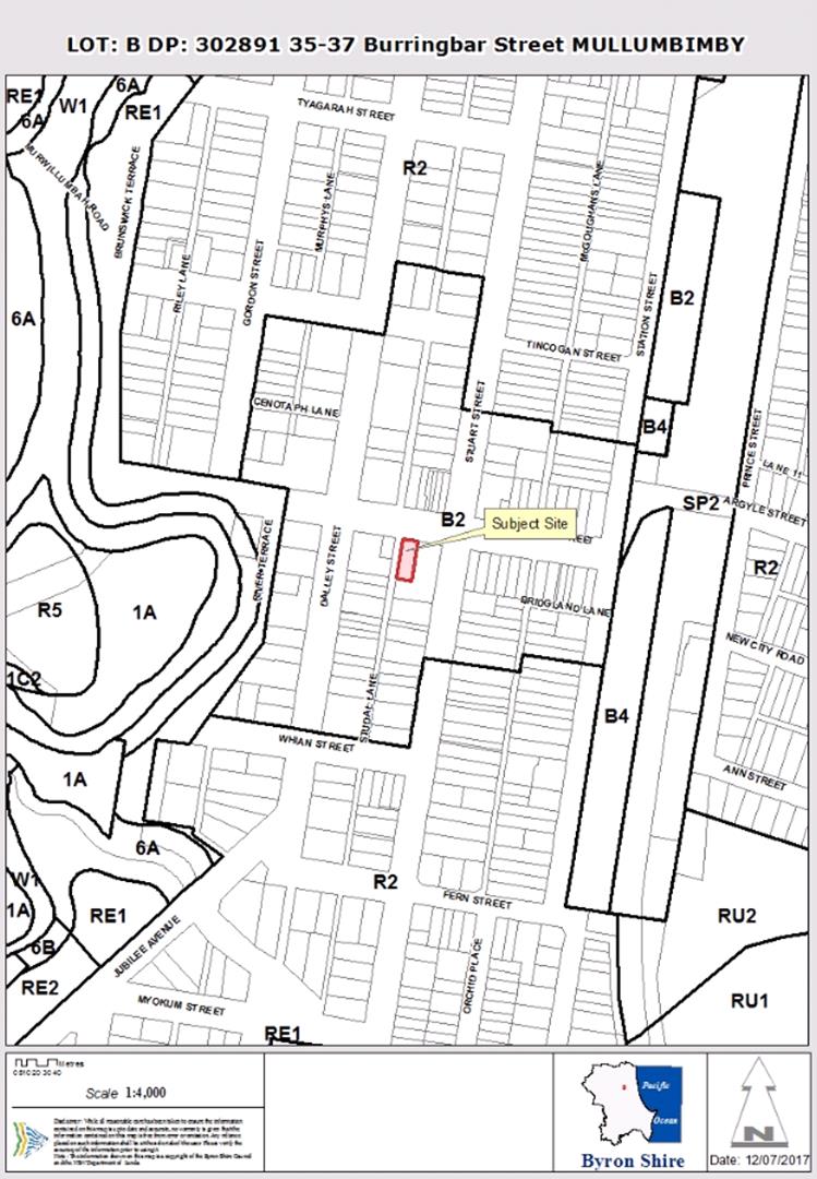
Assessment:
1. INTRODUCTION
1.1. History/Background
The building was originally built in 1928 and opened in 1929
for the English, Scottish and Australia Bank which later became the ANZ Bank.
Prior to the opening of the bank at this site the bank operated from 98 Dalley
Street, Mullumbimby which was constructed in 1909 after fire destroyed the
previous building in 1908. The use of the site as a bank ceased approximately
15-20 years ago.
There have been a number of applications relating to the
site in recent times which are described below:
|
Application Number
|
Proposal
|
Decision
|
|
06.1995.2618.1
|
Alteration/Addition to Office - reroof
|
Approved 21.11.1995
|
|
10.2002.689.1
|
Sign
|
Approved 06.02.2003
|
|
10.2008.217.1
|
Change of Use – Bank to Shop with recreation centre
(yoga)
|
Approved 25.08.2008
|
|
10.2009.158.1
|
Demolition of existing toilet block, new toilet block and
verandah
|
Refused 19.06.2009
|
|
10.2010.78.1
|
New Toilet Block and Carport (including demolition of
existing toilet)
|
Approved 17.05.2010
|
|
10.2016.625.1
|
Alterations and
Additions to Existing Commercial Building to Create a Recreation
Facility (Indoor - Spa) and Food and Drink Premises (Café –
Juice Bar)
|
Approved 07.08.2017
|
10.2016.625.1 is the subject of the s4.55 application which
approved the development including the following:
|
Ground Level
|
|
· Café
(Juice Bar)
|
|
· Recreation
Facility (Spa) including reception, treatment and exercise areas.
|
|
First Floor
|
|
· Three (3)
treatment rooms each with shower toilet and hand basin including 10.8m2
deck.
|
|
· Lift
|
|
· Large covered
roof deck for health and relaxation (approx. 162m2).
|
|
Rear Yard
|
|
· Two (2) Spa
Pools
|
|
· Plunge Pool and
Lap Pool
|
|
· Toilet and
Change room facilities
|
|
· Plant and
Equipment Room
|
|
· Covered and
enclosed Garbage store
|
|
· Covered seating area
|
|
· Male and Female
Steam Rooms
|
|
· Sauna
|
1.2. Description of the
proposed development
This application seeks approval
for a S4.55 Minor Modifications to Design and Conditions. The purpose for the
s. 4.55(1A) Application are to make minor modifications to the approved
development following the further design development and detailing prior to a
Construction Certificate application (outlined below). In order to enable the
modifications minor changes are required to a number of Conditions 1, 10, 26,
60, 61 and 65 to facilitate the proposed modifications.
The proposed changes are summarised as comprising minor
changes to:
1) the
internal floor level to be retained at the existing floor height;
2) the
Burringbar St entrances to the building;
3) the
fence and location and design of the side eastern access to the building;
4) deck
louvres / railing;
5) the
layout of the juice bar / café;
6) acoustic
screening;
7) the
location of the lift and configuration of treatment room #3;
8) configuration
of the equipment and garbage storerooms;
9) configuration of the layout of lap,
plunge and spa pools; and
10) configuration and floor height of the layout of
the building containing the sauna and steam rooms.
The changes to the approved plans of the ANZ Bank building
are highlighted below:
|
  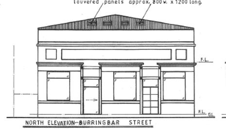
|
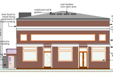
|
|
North Elevation – As approved
|
North Elevation – Modified Proposal new front
floor to facilitate disabled access and lift overrun for access to the upper
level
|
|
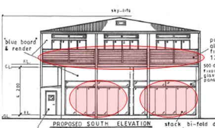
|
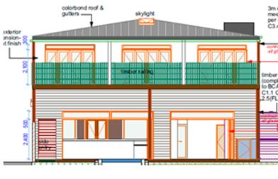
|
|
South Elevation – As approved
|
South Elevation – Modified Proposal –
changes to balustrading on upper level deck and changes to the ground
floor openings onto the rear courtyard areas
|
|
 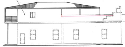
|
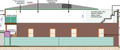
|
|
Eastern Elevation – As approved
|
Eastern Elevation - Modified Proposal – frosted
glass noise wall on boundary
|
|
  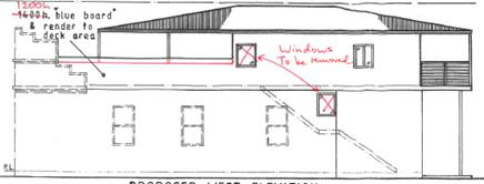
|
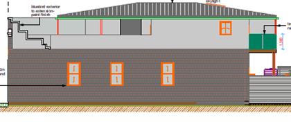
|
|
West Elevation – As approved
|
West Elevation - Modified Proposal – windows
removed as required by original consent conditions and changes to
balustrading.
|
The main change to the development sought is the amendment
of conditions relating to flooding and finished floor heights (Condition10)
which currently require the internal floor heights to be raised from the
existing floor level to above the adopted flood level in accordance with BDCP
2014 Chapter C2. (5.56m)
1.3. Description of the site
The site was inspected on 4 March 2020
Land is legally described as LOT: B DP: 302891.
Property address is 35-37 Burringbar Street MULLUMBIMBY
Land is Zoned: B2 Local Centre
Land area is: 607 m2
Property is constrained by:
· Flood Prone Land
· Acid Sulfate Soils
(Class 4)
· Heritage
Conservation Area
The site contains an older style single storey commercial
building which was originally built in 1928 and opened in 1929 for the English,
Scottish and Australia Bank which later became the ANZ Bank. Prior to the
opening of the bank at this site the bank operated from 98 Dalley Street,
Mullumbimby which was constructed in 1909 after fire destroyed the previous
building in 1908. The use of the site as a bank ceased approximately 15-20
years ago. Currently the building is used as a Shop with the internal floor
plan intact which includes several rooms, two (2) bank safes and two (2)
bathrooms. The building has a gross floor area of approximately 234m2.
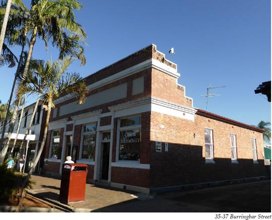
The rectangular
allotment fronts Burringbar Street to the north and Studal Lane to the
west. Commercial developments are situated on the adjacent allotments to
the east, north and west.
The site is
relatively level and vegetation on the site generally consists of lawn at the
rear of the building. The site is not identified as being designated bushfire
prone land and is identified as being Class 4 potential acid sulfate soils
however there are no works proposed 2m below ground level with the deepest pool
being the lap pool having a depth of 1.4m. The allotment however is identified
as being flood prone land and is burdened by a sewer line adjacent to the rear
property boundary.
The site is
located within the Mullumbimby Heritage Conservation Area and is adjacent to a
Heritage Item being Commercial Premises to the east of the site.
The proposed modifications to consent 10.2016.625.1 will not
significantly alter the external appearance of the development and all proposed
modifications are consistent with the outcomes sought in regards to the
surrounding Heritage Items and Heritage Conservation Area.
The site is
located within the Mullumbimby Heritage Conservation Area and is adjacent to a
Heritage Item being Commercial Premises to the east of the site.
2. SECTION 4.15 – MATTERS FOR CONSIDERATION
– DISCUSSION OF ISSUES
Having regard for the matters for consideration detailed in
Section 4.15(1) of the Environmental Planning & Assessment Act 1979, the
following is a summary of the evaluation of the issues.
Section 4.55 of the EPA Act 1979
It is considered the proposed development as amended is
substantially the same development and satisfies the provisions contained with
Section 4.55 of the EPA Act 1979.
It is noted that two conditions relating to the Smoke Free
Environment Act and the Workplace Health and Safety Act have been updated to
correct minor errors in the wording, whilst a further condition and notes are
recommended in relation to the food shop fitout for the juice bar component of
the development.
2.1. State/Regional
Planning Policies, Instruments, EPA Regulations 2000
The proposed modifications do
not raise additional issues under relevant SEPPS, Policies or clauses of the
EPA Regulations 2000
2.2. Byron Local Environmental
Plan 2014
Clause 5.10 - Heritage Conservation
The proposed modifications will have only minor external
changes when viewed from surrounding streets and will not detrimentally impact
on the buildings presence within the Mullumbimby Town Centre or Heritage
Conservation Precinct.
The proposed modifications to consent 10.2016.625.1 will not
significantly alter the external appearance of the development and all proposed
modifications are consistent with the outcomes sought in regards to the
surrounding Heritage Items and Heritage Conservation Area.
Clause 6.3 Flood Planning
The development will comply with the relevant Flood Planning
requirements for the site as discussed below under the DCP provisions.
The proposed modifications do not raise any additional
issues under the BLEP 2014.
2.3. Draft EPI that is or has
been placed on public exhibition and details of which have been notified to the
consent authority - Issues
No draft EPIs affect the proposal.
2.4. Development Control Plans
Chapter C1 – Non Indigenous Heritage
The subject property is located within a Conservation Area.
The proposed modifications will not significantly alter the external appearance
of the development and in some instances are aimed at preserving part of the
original fabric of the building (as discussed below). The proposed
modifications to the southern (rear) elevation of the existing building will
retain a greater portion of the original fabric through the use of smaller
doorway cut outs in this elevation. It is concluded the proposal is consistent
with the heritage requirements under the DCP.
Chapter C2 Areas affected by Flood.
The most significant change to the development sought is the
internal finished floor height and proposed amendment of conditions relating to
flooding and finished floor heights (Condition 10) which currently require the
internal floor heights to be raised from the existing floor level to above the
adopted flood level in accordance with BDCP 2014 Chapter C2 – the adopted
Flood Planning Level for the site is 5.56m.
Raising the existing floor level would result in loss of one
of the historical bank safes and affects the entrance into the site from the
Burringbar Street footpath. It is recommended Condition No. 10 be amended to
reflect the need for flood compatible materials below the flood planning
level.
Under Chapter 2 – Areas Affected by Flood, C2.3.5
Special Provisions of the BDCP 2014 existing commercial buildings are
not required to comply with the flood planning level (however must comply with
C2.3.4 Flood Proofing). Materials used below the flood planning level must be
constructed from flood compatible materials.
It is recommended that the flood conditions be amended accordingly.
2.5. The likely impacts of that
development, including environmental impacts on both the natural and built
environments, and social and economic impacts in the locality
Noise
The application seeks to amend the approved hours of
operation from Monday to Friday from 7am to 6pm, Saturday, Sunday and Public
Holidays 8am to 5pm to extend the hours of operation. Having regards to the
sites use and location within the town centre and proximity to two hotels it is
recommended the hours be extended 10pm (Monday – Saturday) and to 9pm on
Sundays or public holidays.
The proposed amendments do not generate any impacts that
have not been previously considered.
2.6. The suitability of the
site for the development
The site is located within the Mullumbimby Town Centre with
the proposed reuse of a existing commercial building and is suitable for the
proposed commercial land uses. The proposed amendments do not affect the Sites
Suitability.
2.7 Submissions
made in accordance with this Act or the regulations
The S4.55 application was exhibited between 30 January 2020
to the 12 February 2020 with no submissions received in relation to the
proposed modifications.
2.8 Public
interest
The proposed modifications to consent 10.2016.625.1 will not
prejudice or compromise the public interest.
2.9 DEVELOPER
CONTRIBUTIONS/ WATER AND SEWER CHARGES
The proposed modifications will reduce the size of the Sauna/Steam
Room – Ground Floor, Open Air area from 34.96m2 to 27.67m2
and will reduce the contributions commensurate with the reduction in GFA.
3.0 Conclusion
The proposed changes to the plans are minor and satisfy the
provisions contained with Section 4.55 of the EPA Act 1979. The application is
recommended for approval subject to amended conditions of consent.
STATEMENT
OF REASONS
Note:
From July 1 2018, Council’s are required to give and publicly notify
reasons for a range of planning decisions where they are deciding if
development should proceed to help community members to see how their views
have been taken into account and improve accountability to stakeholders. A
statement of reasons for the determination of this application is provided
below.
|
Statement of Reasons
|
|
S.96
|
The proposed modifications were minor and substantially
the same as the original development approval with no detrimental
environmental impacts.
|
|
DA
|
The proposed development will not have a detrimental
impact on the heritage character of the precinct or the buildings contained
on the site. It is considered consistent with the heritage provisions
contained within Clause 5.10 of Local Environmental Plan 2014.
|
|
DA
|
The proposed development will not have a detrimental
impact on the heritage character of the precinct or the buildings contained
on the site. It is considered consistent with the heritage provisions
contained within Development Control Plan 2014.
|
|
How community views were addressed
|
|
|
The DA was notified/advertised in accordance with
Development Control Plan 2014. No submissions were received.
|