 Agenda
Ordinary Meeting

Thursday, 14 December 2023
Agenda
Ordinary Meeting
Thursday, 14 December 2023
Agenda Ordinary Meeting
held at Council Chambers, Station Street, Mullumbimby
commencing at 9:00am
Public access relating to items on this agenda can be made between 9:00 and 10:30 am on the day of the meeting. Requests for public access should be made to the General Manager or Mayor no later than 12:00 midday on the day prior to the meeting.

Mark Arnold
General Manager
CONFLICT OF INTERESTS
What is a “Conflict of Interests” - A conflict of interests can be of two types:
Pecuniary - an interest that a person has in a matter because of a reasonable likelihood or expectation of appreciable financial gain or loss to the person or another person with whom the person is associated.
Non-pecuniary – a private or personal interest that a Council official has that does not amount to a pecuniary interest as defined in the Code of Conduct for Councillors (eg. A friendship, membership of an association, society or trade union or involvement or interest in an activity and may include an interest of a financial nature).
Remoteness – a person does not have a pecuniary interest in a matter if the interest is so remote or insignificant that it could not reasonably be regarded as likely to influence any decision the person might make in relation to a matter or if the interest is of a kind specified in the Code of Conduct for Councillors.
Who has a Pecuniary Interest? - a person has a pecuniary interest in a matter if the pecuniary interest is the interest of the person, or another person with whom the person is associated (see below).
Relatives, Partners - a person is taken to have a pecuniary interest in a matter if:
· The person’s spouse or de facto partner or a relative of the person has a pecuniary interest in the matter, or
· The person, or a nominee, partners or employer of the person, is a member of a company or other body that has a pecuniary interest in the matter.
N.B. “Relative”, in relation to a person means any of the following:
(a) the parent, grandparent, brother, sister, uncle, aunt, nephew, niece, lineal descends or adopted child of the person or of the person’s spouse;
(b) the spouse or de facto partners of the person or of a person referred to in paragraph (a)
No Interest in the Matter - however, a person is not taken to have a pecuniary interest in a matter:
· If the person is unaware of the relevant pecuniary interest of the spouse, de facto partner, relative or company or other body, or
· Just because the person is a member of, or is employed by, the Council.
· Just because the person is a member of, or a delegate of the Council to, a company or other body that has a pecuniary interest in the matter provided that the person has no beneficial interest in any shares of the company or body.
Disclosure and participation in meetings
· A Councillor or a member of a Council Committee who has a pecuniary interest in any matter with which the Council is concerned and who is present at a meeting of the Council or Committee at which the matter is being considered must disclose the nature of the interest to the meeting as soon as practicable.
· The Councillor or member must not be present at, or in sight of, the meeting of the Council or Committee:
(a) at any time during which the matter is being considered or discussed by the Council or Committee, or
(b) at any time during which the Council or Committee is voting on any question in relation to the matter.
No Knowledge - a person does not breach this Clause if the person did not know and could not reasonably be expected to have known that the matter under consideration at the meeting was a matter in which he or she had a pecuniary interest.
Non-pecuniary Interests - Must be disclosed in meetings.
There are a broad range of options available for managing conflicts & the option chosen will depend on an assessment of the circumstances of the matter, the nature of the interest and the significance of the issue being dealt with. Non-pecuniary conflicts of interests must be dealt with in at least one of the following ways:
· It may be appropriate that no action be taken where the potential for conflict is minimal. However, Councillors should consider providing an explanation of why they consider a conflict does not exist.
· Limit involvement if practical (eg. Participate in discussion but not in decision making or vice-versa). Care needs to be taken when exercising this option.
· Remove the source of the conflict (eg. Relinquishing or divesting the personal interest that creates the conflict)
· Have no involvement by absenting yourself from and not taking part in any debate or voting on the issue as of the provisions in the Code of Conduct (particularly if you have a significant non-pecuniary interest)
RECORDING OF VOTING ON PLANNING MATTERS
Clause 375A of the Local Government Act 1993 – Recording of voting on planning matters
(1) In this section, planning decision means a decision made in the exercise of a function of a council under the Environmental Planning and Assessment Act 1979:
(a) including a decision relating to a development application, an environmental planning instrument, a development control plan or a development contribution plan under that Act, but
(b) not including the making of an order under that Act.
(2) The general manager is required to keep a register containing, for each planning decision made at a meeting of the council or a council committee, the names of the councillors who supported the decision and the names of any councillors who opposed (or are taken to have opposed) the decision.
(3) For the purpose of maintaining the register, a division is required to be called whenever a motion for a planning decision is put at a meeting of the council or a council committee.
(4) Each decision recorded in the register is to be described in the register or identified in a manner that enables the description to be obtained from another publicly available document, and is to include the information required by the regulations.
(5) This section extends to a meeting that is closed to the public.
OATH AND AFFIRMATION FOR COUNCILLORS
Councillors are reminded of the oath of office or affirmation of office made at or before their first meeting of the council in accordance with Clause 233A of the Local Government Act 1993. This includes undertaking the duties of the office of councillor in the best interests of the people of Byron Shire and the Byron Shire Council and faithfully and impartially carrying out the functions, powers, authorities and discretions vested under the Act or any other Act to the best of one’s ability and judgment.
1. Public Access
3. Attendance by Audio-Visual Link
4. Requests for Leave of Absence
5. Declarations of Interest – Pecuniary and Non-Pecuniary
6. Tabling of Pecuniary Interest Returns (Cl 4.14 Code of Conduct for Councillors)
7. Adoption of Minutes from Previous Meetings
7.1 Ordinary Meeting held on 23 November 2023
8. Reservation of Items for Debate and Order of Business
9. Notices of Motion
Nil
10. Mayoral Minute
11. Petitions
11.1 Petition expressing objection to the Proposed Development of Tyagarah Sanctuary at 29 Buckleys Road Tyagarah........................................................................................ 9
12. Delegates' Reports
12.1 Cape Byron Marine Park Advisory Committee meeting 22 November 2023..... 11
12.2 NSW Coastal Conference held 30 October to 3 November 2023....................... 13
13. Staff Reports
General Manager
13.1 Proposed lease of former Byron hospital site......................................................... 24
13.2 PLANNING - DA 10.2021.114.1 - Light Industrial Development, ("Fed Sheds") at 467 Federal Drive, Federal................................................................................................ 30
Corporate and Community Services
13.3 Section 355 Guidelines Update................................................................................. 50
13.4 Grants November 2023............................................................................................... 53
13.5 Council Investments - 1 November 2023 to 30 November 2023......................... 57
Sustainable Environment and Economy
13.6 Housing Options Paper Submissions Report.......................................................... 65
13.7 Update
Resolution 22-685 Rural Land Use Strategy -
Review Scoping Report............................................................................................ 115
13.8 Flying-fox Camp Management Plan 2024-2029 for Council endorsement...... 120
13.9 Former Mullumbimby Hospital Site - Project Update........................................... 129
13.10 PLANNING - DA 10.2022.248.1 – Multiple Occupancy Comprising 14 Dwelling Sites and Associated Infrastructure at 16 Whian Road, Eureka.................................. 137
13.11 PLANNING - DA 10.2023.194.1 - Proposed demolition of existing dwelling (part of dual occupancy (detached)), associated swimming pool and outbuildings; and proposed new dwelling (part of dual occupancy (detached)), swimming pool, earthworks and landscaping – 150 Tandy's Lane Brunswick Heads................ 186
13.12 Wallum Subdivsion DA 10.2021.575.1 - Response to Council Resolution 23-454...................................................................................................................................... 210
Infrastructure Services
13.13 Brunswick Heads Parking Study - Outcomes....................................................... 211
13.14 Single-use Packaging and Materials Policy.......................................................... 225
13.15 s7.11 and s7.12 Contributions Plans Review Update......................................... 231
13.16 Approval for Supplier of Automated Flooded Road Signage.............................. 243
13.17 Tender - Suffolk Beachfront Holiday Park Long Term Precinct Dwelling Installations...................................................................................................................................... 248
13.18 Byron Bay Drainage Upgrade - Concept Design Approval................................. 254
13.19 Council Land at Belongil........................................................................................... 264
14. Reports of Committees
Corporate and Community Services
14.1 Report of the Arts and Creative Industries Advisory Committee Meeting held on 19 October 2023.............................................................................................................. 273
14.2 Report of the Audit, Risk and Improvement Committee Meeting held on 16 November 2023............................................................................................................................. 279
14.3 Report of the Audit, Risk and Improvement Committee Meeting held on 19 October 2023............................................................................................................................. 283
Sustainable Environment and Economy
14.4 Report of the Biodiversity Advisory Committee Meeting held on 16 November 2023...................................................................................................................................... 286
14.5 Report of the Housing and Affordability Advisory Committee Meeting held on 16 November 2023.......................................................................................................... 289
14.6 Report of the Coast and ICOLL Advisory Committee Meeting held on 21 November 2023............................................................................................................................. 292
Infrastructure Services
14.7 Report of the Water and Sewer Advisory Committee Meeting held on 16 November 2023............................................................................................................................. 295
14.8 Report of the Local Traffic Committee Meeting held on 21 November 2023... 299
15. Questions With Notice
15.1 Mullumbimby’s future water supply......................................................................... 305
16. Confidential Reports
General Manager
16.1 Confidential - Annual Review of General Manager's Performance Agreement...................................................................................................................................... 308
Questions with Notice: A response to Questions with Notice will be provided at the meeting if possible, that response will be included in the meeting minutes. If a response is unable to be provided the question will be taken on notice, with an answer to be provided to the person/organisation prior to the next Ordinary Meeting and placed on Councils website www.byron.nsw.gov.au/Council/Council-meetings/Questions-on-Notice
Councillors are encouraged to ask questions regarding any item on the business paper to the appropriate Director prior to the meeting. Any suggested amendments to the recommendations should be provided to Councillor Support prior to the meeting to allow the changes to be typed and presented on the overhead projector at the meeting.
BYRON SHIRE COUNCIL
Petitions 11.1
Petition No. 11.1 Petition expressing objection to the Proposed Development of Tyagarah Sanctuary at 29 Buckleys Road Tyagarah
Directorate: Sustainable Environment and Economy
Report Author: Shannon Burt, Director Sustainable Environment and Economy
File No: I2023/1870
Council is in receipt of a petition containing 19 signatures which states:
“I wish to express my opposition to the proposed development of 'Tyagarah Sanctuary" at 29 Buckleys Rd, Tyagarah as described in the private advertisement on page 17 of "Echo" magazine Volume 38 #211st November 2023”.
Comments from Director Sustainable Environment and Economy:
Council Resolution 23-429 resolved to include the land known as 29 Buckleys Road, Tyagarah for further investigation as part of the recently exhibited Housing Options Paper public comment period.
This petition relates to a public notice placed in the Echo by the landowner pre-emptive of this, and the public comment period for submissions to be made to the Housing Options Paper thereafter.
1. That the petition regarding opposition to the proposed development of 'Tyagarah Sanctuary" at 29 Buckleys Rd, Tyagarah be noted.
2. That the petition be referred to the Director Sustainable Environment and Economy.
Attachments:
1 Petition
expressing objection to the Proposed Development of Tyagarah Sanctuary at 29
Buckleys Road Tyagarah - 19 Signatures ~ submission to Housing Options
Paper_Redacted, E2023/124123 ![]()
Delegates' Reports 12.1
Delegate's Report No. 12.1 Cape Byron Marine Park Advisory Committee meeting 22 November 2023
File No: I2023/1920
I am the Alternate for Cr Coorey on this Committee, which meets at the National Parks and Wildlife Service (NPWS) office in Byron Bay. I attended via Teams and was late due to a clash with a meeting with high school students in Council’s YouthSay Program. It’s so good to hear from these not-yet-voters.
Matters discussed at the Cape Byron Marine Park (CBMP) Advisory Committee included:
1. Department of Primary Industries (DPI) Fisheries administer Vehicles on Beaches, as that is associated with beach fishing. Visitors from Queensland are used to signage and barriers to instruct them where to drive, or not, on beaches. They do not respond to maps.
2. DPI Fisheries also administer fishing at sea. They map Offence Hotspots within the Marine Park. They presented annual numbers of inspections: 315, of which 51 (16%) were non-compliant.
3. Southern Cross University is undertaking a project to investigate the impacts of visitors at Nguthungulli. There are five dive boats out of Brunswick Heads and one from Byron Bay. The newer boats are bigger, so numbers of visitors are up. Reports of interference with wildlife, such as manta rays and turtles are growing. Pascal Scherrer is running the “Nguthungulli Visitor Management” study.
4. Marine Parks explained their permit system (like traffic lights): 1. no permission; 2 full permission; and 3 needs a permit. Currently, commercial permits include 12 surf and SUP schools. Non-commercial permits include 17 for events; 14 for research; 13 for recreational horse-riding; 7 for works (like geobags); and 1 “other”.
5. The Committee needs to appoint a Chair from amongst its members.
Signed: Cr Duncan Dey
Delegates' Reports 12.2
Delegate's Report No. 12.2 NSW Coastal Conference held 30 October to 3 November 2023
File No: I2023/1921
Thanks Council, for sponsoring me to attend the 30th NSW Coastal Conference in Newcastle in October and November. It was also the National Coast to Coast Conference. Theme was “one coast, one community”.
The Awabakal and Worimi peoples are the Traditional Custodians of land and waters within Newcastle LGA.
The conference papers and presentations can be downloaded from:
https://www.coastalconference.com/project/papers-and-presentations/
Costs to the public (ie to Council) for me to attend were:
Early bird conference registration $930;
My car to & from Newcastle $510;
Accommodation in Newcastle $474;
total cost $1,914.
I am very grateful for the knowledge I acquired. I share highlights below.
Most presentations were in concurrent sessions (session A, B, C or D).
Monday: Pre-conference Workshop, with three themes.
Theme 1: Unlocking Science – Estuary Reporting, chaired by Dept of Planning & Environment (DPE) staff
1. Estuary Report Card.
These are online for each estuary, at:
The state is looking for “no adverse change” from 2015. Assessment is done on 177 estuaries in three sectors of NSW (north, central, south). One sector per year means each estuary is updated every third year. Six estuaries are excluded, including the mighty Clarence River.
Stressors do not include ‘pharma’, just simple factors like the two forms of chlorophyll, and turbidity. The factors for future Report Card will be revised in 2026.
2. Human Centre Design.
... begins with understanding human needs and ends with solutions to address them.
3. Empathy mapping.
4. SEED.
This online portal is at:
SEED is the NSW Government’s central resource for Sharing and Enabling Environmental Data. It was developed in a collaborative effort between NSW government agencies to provide an accessible and reliable platform for environmental data.
Theme 2: Navigating Estuary Health Measurement, chaired by DPE staff
5. NSW has 184 estuaries. Fifty Councils are developing Coastal Management Programs (CMP’s).
Avoca Lagoon (ICOLL) has 1187 hectares of catchment and 70 ha of estuary. It has a reputation as the state’s worst estuary. It was mined for rutile and still has deep dredge holes of 300 to 400 m3. About 25% of the catchment is urban and there are STP inputs. Enterococci numbers are always above thresholds for primary and secondary contact.
Avoca Lagoon is opened 3 or 4 times per year to reduce flooding.
Group Activity 1 - knowledge gaps: (i) current and future impacts of Sea Level Rise (SLR); (ii) impacts of STP inputs; and (iii) impacts of stormwater inputs.
Group Activity 2 – threat & risk assessment.
Group Activity 3 – management actions: develop a MER Plan (Monitoring, Evaluation, Reporting).
Theme 3: Coast and Marine Team, chaired by DPE staff
6. Online portals for coastal data include:
a) SEED: https://www.seed.nsw.gov.au/ [see point 4 above]
b) Australian Ocean Data Network (AODN): https://portal.aodn.org.au/
c) ELVIS (elevation and bathymetry): https://elevation.fsdf.org.au/
d) NSW Beach Profile Database: http://www.nswbpd.wrl.unsw.edu.au/photogrammetry/nsw/
e) Aus Seabed (bathymetry): https://ausseabed.gov.au/data
And for those who have an account:
f) ESRI Story Maps: https://storymaps.arcgis.com/
And a tool for wave modelling, using “data from offshore wave buoys and global climate models”:
g) https://www.environment.nsw.gov.au/topics/water/coasts/research/ocean-and-coastal-waves (and choose the “Extreme Value Analysis”)
Most wave buoys have two or three decades of data. Wave history prior to that can be “hind-cast”. That means correlating recent historic weather data to the wave data that resulted from it, then using older weather data to hind-cast a wave record. This expands the record out to about eighty years, ie to encompass the stormy years 1940-70’s.
DD comment: the state has developed so much data and so many modelling tools, I would think they could analyse our Coast without the need for consultants.
Tuesday: the Conference proper.
7. Welcomes.
Aunty Cheryl and Uncle Ray Smith welcomed us to country. Aunty Cheryl sang, really well.
Professor Bruce Thom mentioned the two conferences’ histories and that 50% of Australia’s population lives within 80 km of our coast. He noted the first CMP adopted in NSW was in 2020 for Stockton Beach, just north of Newcastle, ie across the mouth of the Hunter River. It is now receiving mass sand nourishment. He encourages membership (for $35) of the Australian Coastal Society.
8. Associate Professor Hannah Power, University of Newcastle.
She spoke about predicting extreme wave runup. “Capture” means two waves combining. Behaviour varies at beaches, for example according to whether the beach is contained or open. Response in estuaries depends on entrance shape. “Sunny Day Flooding” is water levels rising on king tides or big waves when there is no rain.
9. 2.1 B Senator Peter Whish-Wilson.
He talked about the film “Tasmania’s Troubled Waters”. Giant Kelp and Golden Kelp were the first EPBC listed habitat (Environmental Protection & Biodiversity Conservation Act = federal Act of 1999). They are part of the Great Southern Reef. They suffer from invasive species and loss of habitat.
10. 2.2 A - Phebe Bicknell, Alluvium Consulting.
Adaptation Pathways, to cope with uncertain climate conditions. Methodology allows exploration of a range of actions and elimination of less suitable actions. Worked example in Victoria with a planning horizon of 2040 = 0.2 m Sea Level Rise (SLR); 2070 = 0.5 m SLR; 2100 = 0.8 m SLR.
Describing pathways provides a communication tool to engage stakeholders.
DD comment: yes, consultants should ask society about its future.
11. 2.3 A – Aysin Dedekorkut-Howes, Griffith University.
Queensland’s QCoast 2100 Program and Coastal Hazards Adaptation Strategy (CHAS).
12. 2.4 A – Peter Horton, Horton Coastal Engineering.
This presentation was defensive. Peter built the recent concrete walls on Collaroy Beach in Sydney. The 7m vertical wall and 20m-wide rockwall were 80% privately funded.
13. 3.1 A – Natallie Patterson, Royal Haskoning DHV.
She discussed advantages of rockbags over sandbags. Examples include Barrie Crescent in Stockton. She thinks legislation should change to enable rockbags, especially because they can be re-used.
14. 3.2 C – Tim Dilworth & Mars Oram.
They used hardwood posts and logs to create mangrove and fish habitat in the Coomera River, Gold Coast (the river’s south bank, about 1km upstream of the highway). They relied on cross sections taken at 10m stations along the riverbank. Logs deflect flow away from the bank, which was eroding. The work was done by barge, so the bank would not be disturbed.
15. 3.3 D – Oxana Repina, University of Wollongong.
She used 6 models to compare 40 years of shoreline change on Narrabeen-Collaroy Beach in Sydney. The first 20 years was used for calibration and the second 20 for testing. The best result was for the 1H-Moose model - it had been developed for that beach after all.
16. 3.4.1 D – Madison Carberry, DPE.
They undertook water quality monitoring after the 2022 floods, for 25 parameters in 20 waterways across 28 Local Government Areas. Priorities were Northern Rivers and Hawkesbury-Nepean River.
17. 3.4.2 D – Alexandra Maskell, JBPacific.
She examined effects of storm clustering, where storms follow in succession (in the same season) using Wave Buoy data. Modellers of beach erosion should consider the impacts of consecutive smaller events as well as of rarer large events.
18. 4.1 C – Roger McLean, University of NSW.
He revisited the 1974 storms including extreme events in Brisbane, Lismore, Darwin, 23-29 May (which drove the ship Sygna onto Stockton Beach just north of Newcastle), and 3-16 June. Coastal students has set up transects on Bengello Beach near Moruya prior to the 1974 storms. The dune scarp from 1974 is still visible on that beach.
19. 4.2 C – Indra Jayewardene, Many Hydraulics Laboratory.
Storm damage over the last three decades, included June 2016. He estimates the “mothers day” storm of 1987 was a 1-in-2-year ocean event and 2009 1-in-40-year. He observed that the north entrance wall of the Clarence River was damaged by north-east wave direction in May 2009.
20. 4.3 C – Ben Hague, Bureau of Meteorology.
ANCHORS = Australian National Collection of Homogenized Observations of Relative Sea Level.
see: https://rmets.onlinelibrary.wiley.com/doi/full/10.1002/gdj3.136
It’s a new national tide gauge-based sea level dataset for monitoring sea level changes around Australia. It provides coastal sea levels at hourly resolution with homogenization performed on annual means. The homogenization uses a two-step process that involves the detection of steps in the data (inhomogeneities) followed by a correction applied to remove that change. Data starts from about 1960.
ANCHORS enables forecasting. For example, Melbourne will have low areas flooded with 0.7m SLR. Compared with other ports, Melbourne has lower variability in its high tides (due to Port Phillip Bay).
DD comment: I hope our consultants are examining this for the Byron Bay Drainage Design.
21. 4.4 A – Uncle Lennie Anderson (Worimi Nation) and Charlene Wellard (City of Newcastle).
In the past, 14 cabins were put on sacred land then followed by power and sewer at Burrabihngarn (Stockton area). Since 2010 such projects must consult with the registered land title holder. The Land Council can’t go beyond advising who that is. AHIMS falls short.
Council has a Worimi Reconciliation Action Plan (RAP). Worimi Land Council is doing an Aboriginal Cultural Assessment. The NPW Act of 1974 and LG Act of 1993 only protect Objects and Artifacts. Worimi were recognised as native title holders in 1995. They then ‘gave’ the title to NPWS, so all people could enjoy it.
Wednesday: Field Trip #4 (full day).
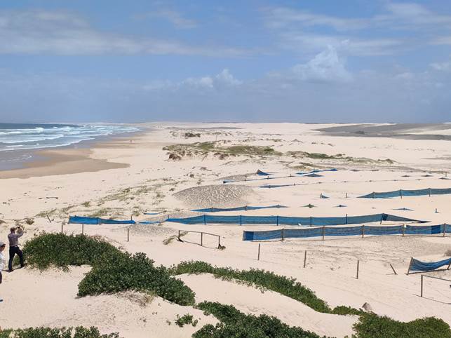
22. Coastal Geomorphology and Sediments of the Newcastle to Port Stephens Region.
It was fascinating to have so much knowledge and insight shared, much based on this long sandy south-east facing stretch of coast. Do we all realise sea level was 120m lower just 20,000 years ago, as it had been in several previous ice ages? And that it is currently nearly as high as it has ever been? See the attached graph, derived in 2014.
This geomorphological history explains the massive inner and outer barrier dunes behind Stockton Beach. They were placed during high sea levels, which may have matched hotter weather. That in turn includes bigger storms.
They are big dunes and spread a long way inland. Here’s the north end of the beach:
Thursday: more presentations.
23. Teagan Shields, University of Melbourne.
Indigenous Knowledge is saving our iconic species. The 3 interconnected domains for assessing Culturally Significant Entities (CSE’s) are: country, kin, culture. CSE’s are species or ecological communities with cultural or customary value. They are central to indigenous knowledge. Collaborative management, between western science and indigenous knowledge.
A case study on Bundjalung country examined 194 species and suggests management actions including (i) being on country, (ii) burning, (iii) streamflow, and (iv) <missed it L>.
She recommends ILUA’s with ongoing updates, changing as ‘the space’ changes.
24. 7.1 C – Angela Maharaj, Department of Climate Change, Energy, the Environment and Water (DCCEEW).
The National Climate Risk Assessment and National Adaptation Plan, for 11 zones federally. Steps are to (i) prioritise risks in 2023, and (ii) examine those with highest risks in 2024. NCRA Hazards are: 1.5 to 2⁰C temperature rise, plus SLR 20 to 25cm for 2050, and 38 to 60cm for 2100.
25. 7.2 A – Thomas Dunlop, University of NSW.
Nature-based Solutions (NbS) for Estuaries. Compared to rockwalls, NbS’s create habitat and improve water quality. For example, logs promote oyster growth on adjacent rocks. Four stages are (i) establishment; (ii) growth; (iii) recovery and mortality; and (iv) functionality. This will enable predictive modelling. He thinks it can be applied to saltmarsh and elsewhere.
26. 7.3 C – Tim Smith, University of the Sunshine Coast.
Current focus at the micro-scale occupies policy while macro-scale drivers are ignored, eg financing. Socio-ecological vulnerabilities include the occupation of floodplains by poorer people. He showed a graph of trends in wealth. Urgent support is required for systemic changes like investing in action, not in paper. Mental Health benefits of access to coast are elaborated in:
We are still doing science as usual. A way forward is proposed at:
https://www.futureearthcoasts.org/
DD comment: this was the best presentation of the week. It matches my view that long-term coastal management should simply prevent investment in Coastal hazard areas.
27. 7.4 C – Marc Daley, DPE.
Triggers and thresholds should permeate CMP’s, not just dates. Monitoring is required for triggers and thresholds. It’s best to tie into existing monitoring setups. He recommends listing the triggers and thresholds in a CMP, for example in a case study at Byron Bay.
DD question: are we doing this?
28. 8.1 C – Robbi Bishop-Talyor, Geoscience Australia.
We have 37 years of satellite imagery but with pixels representing 25m squares. Gaps on topography of the intertidal zone can be filled using these pixels especially for north-east Australia. Each pixel is either wet or dry. That change happens at a known tide level and hence can be used for mapping.
29. 8.2 B – Pam Dean-Jones, NSW Coastal Council.
The Coastal Council surveys members each year since 2018 on implementation and gets about 100 responses (standard set of 47 questions). It’s a valuable channel for Council’s to use for feedback.
In November 2022 there were 6 certified CMP’s and in November 2023 there are 10.
About 50 CZMP’s will cease in December 2023.
The state has not yet mapped Vulnerable Areas of the coast.
30. 8.3 B – Kirsten Gerathy, HWL Ebsworth Lawyers.
It’s 5 years since laws were changed to integrate coast into planning. Resilience and Hazards SEPP. There are two pillars – the second is the four mapped areas.
31. 8.3 D – Simon Rowe, Ocean Watch Australia.
In 2014 the Australian Government recognised OceanWatch as the national organisation responsible for the delivery of its marine Natural Resource Management (NRM) related programs. Jurisdiction extends to 200 Nm seaward (Australia’s Exclusive Economic Zone).
32. 8.4.1 A – Dana Lanceman, University of NSW.
Blue carbon restoration also restores wetland services like flood mitigation, and nutrient sorption. They measured traits as indicators of function (ie services). Traits include stem height or diameter. Saltmarsh traits take less than 5 years to develop. For Sporobolus, it’s about 30 years. Grey Mangrove traits peak at 12 years then decline.
33. 8.4.2 A – Chris Owers, University of Newcastle.
Supratidal forests are typically Melaleuca and Swamp Oaks. Mapping by Digital Earth Australia (DEA). See also Global Mangrove Watch, Australia Saltmarsh Watch.
34. 9.2 C – Julian O’Grady, CSIRO.
National probabilistic coastal inundation hazard assessment tool:
https://coastalrisk.com.au/home
and an article about it:
The tool applies ‘bathtub’ water to the coast using storm tide, with ocean overtopping and backflow into stormwater pipes, plus catchment rain. Input data includes: water levels; ground levels; drainage systems; geomorphology and erodibility; coastal protection structures; local knowledge. Catchment input is on a 5km2 grid. It derives probability that land will be flooded, for various Climate Change scenarios. It includes storm surge and wave runup.
DD comment: with modelling tools like this, we could analyse our Coast without consultants.
35. 9.3 A – Shaun Morris, North Coast Local Land Services, Natural Asset Protection team.
Emigrant Creek project on 700m of oxbow near its junction with Maguires Creek. The catchment is farmed and puts nutrients and sediment into the Creek. They used a composite of rocks and logs. This provided ‘corrugation’ (ie hydraulic roughness) so energy wouldn’t be transferred downstream. Connections use hemp rope. The “snag hotels” emulate a log jam. The inside bend is accreting and is well vegetated.
36. 9.4 B – Yanyan Zhang, Royal HaskoningDHV.
They renovated several stormwater outlets on beaches. Many had defects, some were undersized.
At South Steyne in Sydney, they lined the old pipe and covered it in concrete seating.
At Fairy Bower nearby, they used stainless steel pipes as there was no access for heavier materials. The driving issue was sand ingress into the pipes.
At Balmoral in Sydney Harbour, they added three deflectors at the outlet, as it faces seaward.
At Willyana Cove, they extended the existing pipe into deeper water.
At Whale Beach in Sydney, they will add a rock apron to counteract beach erosion.
At Foresters Beach on the so-called Central Coast, they will add a drop structure & scour protection.
At Ramsay Street Collaroy, they replaced old gate valves with “duckbill valves”.
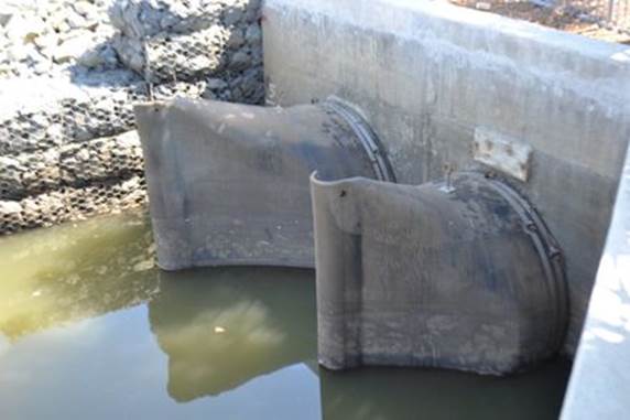
Here is a typical duckbill stormwater valve:
Friday: more presentations.
37. 10.1 – Roger Christie, Propel (social media specialist).
Important to participate, less risky than “watch and wait”. Don’t talk at people, it’s about listening. Propel espouses 5 drivers of digital reputation and recommends having a clear purpose - see their Purpose Pyramid.
38. 10.2 – Alexa Stuart, of Rising Tide and Newcastle’s Young Citizen of the Year.
Engaging Youth Voices. For Newcastle youth, access to beaches is really important. Youth also need their own spaces. She enjoys the influence of peers and mentors. She asks: What do we value more, somebody’s real estate or the public’s beaches.
DD comment: this is young music to my old ears.
39. 11.1.1 D – Tom Oliver, UNSW Canberra.
Studied the June 2022 event at Bengello Beach (see also number 18 above). There was retreat and loss of foredune but no major loss of cross-sectional volume.
40. 11.1.2 D – Robbi Bishop-Talyor (for Rachel Nanson), Geoscience Australia.
Two-part seabed geomorphology classification scheme:
https://www.ausseabed.gov.au/resources/news
This ‘tool’ examines the seabed offshore, down to 70m depth. An example was able to classify underwater dunes as having once been coastal. As they would have formed recently, such dunes could contain archaeological information.
41. 11.2 C – video on Worimi Conservation Lands.
Adapting to Climate Change where there are middens, artifacts, and 4WD’s. Saltwater will intrude into freshwater lagoons and billabongs. In some places, change can be slowed with sand fencing. Climate Change is changing traditional timing relationships, like the timing of the mullet run.
Sadly in recent history, eight families were relocated from Soldiers Point on Port Stephens to Karuah Reserve inland, because the Point was ‘required’ for observing naval traffic in the Port.
42. 12.1.1 D – Tom Doyle, DPE.
Dunes in NSW are modified by (i) adding development, (ii) shifting the sand, or (iii) removing vegetation. He studied 48 dunes on the NSW coast. Conclusions : a) that modified dunes contain less sand; b) that lowering dune elevation makes them more vulnerable; and c) that it’s best to use the local natural form for re-establishing a dune profile.
At Berri Beach south of Sydney, they eradicated bitou bush by bull dozing a trench and burying it. Sand volume was thus retained.
43. 12.1.2 D – Tom Murray, Griffith University.
Minjerribah (Stradbroke) was one island until 1896 when the ocean broke through its centre. Bribie Island has a more recent breakthrough. The location of the mouth of the Nerang River is now pinned by rockwalls. 630,000 m3 of sand is pumped north per year. Its delta is still building northwards.
44. 12.2 C – Sally Whitelaw, City of Coffs Harbour.
Their CZMP for the Shire’s open coast was certified in 2013. It mapped 9 hazard lines: for timing (now, 2050, 2100) and likelihood (very likely, medium, unlikely). Properties east of the “yellow line” (2100, unlikely) get a Section 10.7 Certificate.
For the estuary, Council added flood levels established by the ‘bathtub’ method.
Their Policy was adopted without much objection. Problems arose later, when trying to put that approach into the LEP and DCP. With the Coastal Reforms of 2015, the project was abandoned.
In 2018 the CZMP lines were refined where the coast was solid bedrock. Also in 2018, Council proposed a planning proposal that structures must avoid or be able to withstand coastal hazards. This was adopted in August 2022 and by DPE in August 2023. The lines are now in a SEPP.
45. 12.3 C – Dave Hanslow, DPE.
Two more tools, for managing inundation in estuaries. The first addresses Nuisance Inundation, otherwise known as Sunny Day Flooding:
https://www.mhl.nsw.gov.au/NuisanceInundation
The second tool addresses SLR, of which there is already 25cm since 1880:
https://www.mhl.nsw.gov.au/SLR
Within the SLR tool, select a location (relevant tide gauge); select a threshold level (m AHD); lastly select a future scenario.
Estuaries have so much low-lying land around them. It is estimated that 75,000 properties will be impacted by 1m of SLR.
Thresholds could range across: (i) just the ingress of seawater into stormwater pipes; or (ii) flooding because the pipes are full; or (iii) the level at which overland flow paths are impacted.
46. 12.4 B – Nicola Johnstone, DPI-Fisheries.
The Marine Estate goes to 3km offshore. The Marine Estate Management Authority (MEMA) crosses four agencies and has a 10-year Strategy 2018-28 with nine Initiatives.
Next year.
The 2023 event will be held in Eurobodalla Shire (south coast of NSW).
Attachments:
1 Field
Trip graph, E2023/125079 ![]()
BYRON SHIRE COUNCIL
Staff Reports - General Manager 13.1
Staff Reports - General Manager
Report No. 13.1 Proposed lease of former Byron hospital site
Directorate: General Manager
Report Author: Matt Meir, Solicitor
Claire McGarry, Place Manager - Byron Bay
File No: I2023/1768
Summary:
This report is about the proposed lease between Council and Social Futures Ltd regarding the former Byron hospital site.
RECOMMENDATION:
That Council authorises the General Manager to negotiate and settle changes to the proposed lease to Social Futures Ltd regarding 10-12 Shirley Street, Byron Bay, subject to the following principles:
1. A 20-year term is required to help secure an “anchor subtenant” for the site.
2. The penalty for the head tenant not meeting key performance indicators is termination of the lease rather than full commercial rent (at request of head tenant).
Report
This report suggests changes to the proposed lease regarding the former Byron hospital site and recommends delegation of authority to the General Manager to negotiate final terms.
Context
As Councillors are aware, the land comprising the former Byron hospital site is currently being redeveloped into a community hub and university campus, via a mix of Council and grant funding. The new premises are expected to be completed by mid-2024.
By a competitive tender process and series of previous resolutions (the most recent being resolution 21-229), Council has committed to leasing the refurbished premises to non-profit community services provider, Social Futures Ltd.
This commitment currently takes the form of an agreement for lease between Council and Social Futures, which the parties signed in August 2021.
Currently:
· Under the agreement for lease, the lease is for a term of 10 years, with an opportunity for Council to grant a second, 10-year term if Social Futures desires.
· The intention is for Social Futures to sublet the premises to a range of subtenants, including various non-profits and other community service providers, at a lower rate than market value in order to retain and/or attract important services otherwise priced out of the Shire.
· In response, Social Futures is offered a rent incentive via a further agreement, which discounts the lease’s nominal rent to a below-market rate if Social Futures hits the KPIs around tenancy mix and community / social benefit. The rent Social Futures actually pays will allow Council to recover its costs from the site’s redevelopment.
· In this way, Council will effectively provide a non-market commercial rent option to small, non-profit firms that otherwise wouldn’t be able to afford rental premises in the Byron Bay town centre.
Two issues
Council and Social Futures have been negotiating the lease and the proposed rent discount arrangement periodically since 2021. In recent weeks, Social Futures’ leadership have indicated to Council that there are two challenges presented by the status quo above.
Lease term
The first of these is the proposed 10-year lease term.
The financial model for the site developed over time by community, Council and Social Futures is reliant on an ‘anchor tenant’ renting approximately 50% of available square metreage for a university campus. This tenancy needs to have the ability to pay something approaching the market value of its space, which allows Social Futures to pay its rent to Council and maintain the sinking fund for the building required by the head lease.
In this context, Council and Social Futures have spoken with potential university providers about the opportunity this site presents.
As part of the discussions, potential anchor tenants have indicated that in order to make the business case for the required investment in the reconfiguration and fit out of their section of the site, a 20-year tenure would be required.
However, Social Futures cannot legally sublet part of the premises to a university for 20 years when the former only has a ten-year term.
Rent
As noted above, the lease is currently drafted so that the rent would reflect the site’s market rent. A further agreement between Council and Social Futures would then provide the rent the latter would actually pay, subject to it subletting the premises in the required way.
Social Futures have advised Council that as long as the former hospital site’s commercial rent is contained within the lease, this potential liability must be included on Social Futures’ books. This places material restrictions on the other projects that Social Futures is able to pursue.
Requests
Social Futures have indicated that without alterations to the lease term and how the rent is recorded, Social Futures’ occupation and management of the site is imperilled.
In recent meetings with the General Manager, Social Futures’ leadership have requested that:
· The lease term be extended to 20 years.
· Only the actual rent Social Futures will pay is recorded in the lease and the penalty for not meeting key performance indicators change from a full commercial rent being payable, to a termination of the lease.
Analysis
Lease term
The report writers regard the proposed lease extension as carrying a relatively low risk for Council in net terms. This is because while the proposed extension binds Council and Social Futures together for a longer time – and so heightens the incentive for both parties to work well together – this is more than offset by the assumed benefit Council and Social Future will derive from securing an anchor tenant.
The low risk of the proposed lease extension is further mitigated by the existing obligations on Social Futures under the lease. These obligations are substantial. Foremost among these, and as noted above, is that Social Futures’ rent is tied to its ability to secure suitable non-profits for the building. The building’s tenancy composition is also a discrete obligation under the lease. Beyond this, there are further obligations, including various financial reporting requirements.
Together, this oversight provides a suitable context for Council to extend Social Futures’ proposed term so that the site’s chosen financial model can be realised.
Rent
The lease’s use of the market rent, combined with a separate agreement providing for a potential discount in rent, was part of Council’s approach to mitigating the risk of the lease being assigned and enabling the assignee to make a windfall profit (the argument being that if the lease contained a discounted rent in the first instance and was then assigned, the assignee could potentially make a windfall profit by subletting the relevant parts of the premises for market rent while only paying a below market rent).
Staff view this risk as having a low chance of materialising. There are three main reasons for this. The first is the nature of Council and Social Futures’ relationship. While no one can say with certainty how things will look across 20 years, the parties’ relationship would need to deteriorate significantly for Social Futures to look to transfer its interest in the site.
Secondly, neither entity exists for the purpose of profit. Both have entered the relationship for the purpose of providing space for other non-profits to provide much-needed services in Byron Bay. Profit maximisation isn’t driving either party’s willingness to pursue this project.
Thirdly is the balance of the lease terms. The provisions are complex, but essentially, they:
· Don’t allow Social Futures to transfer its interest without Council having the first right to end the lease, or alternatively, Council approving the transfer.
· Would require any transfer to account for the existing building occupants.
· Wouldn’t automatically relieve Social Futures of its obligations under the lease even if it did transfer its interest.
Given Social Futures’ representations regarding the real and present difficulty created by the retention of the market rent in the lease, staff regard this risk as needing to be managed ahead of the low risk of placing the proposed discounted rent amount into the lease.
Staff note, too, that the vast majority of Council leases (whether regarding land owned by Council or Crown land Council manages) provide for a below market rent to non-profit tenants. While the former hospital site is arguably more prominent than other Council sites due its location and redevelopment, the policy of providing below market rent to non-profit firms is the rule rather than the exception.
Recommended response
Staff recommend that:
· Social Futures’ lease term be extended to 20 years to enable it to sublet part of the premises to an anchor tenant and enable investment in the building.
· The lease rent is set at the rate Social Futures will actually pay, with a termination clause for failure to meet key performance indicators.
Next steps
Prior to Social Futures’ recent representations to Council on the above matters, the parties had worked well together to largely settle the existing lease and separate agreement providing for Social Futures’ rent discount.
If Council resolves according to the above principles, further work will be required between Council and Social Futures to give effect to the proposed lease changes.
This work will take some time. It is important but not urgent given the current estimate that the redeveloped premises won’t be available for occupation until the middle of next year.
Strategic Considerations
Community Strategic Plan and Operational Plan
|
CSP Objective |
CSP Strategy |
DP Action |
Code |
OP Activity |
|
1: Effective Leadership |
1.5: Empower community leadership through collaboration, capacity building, and cultivating community driven initiatives |
1.5.2: Collaboration and capacity building - Collaborate with stakeholders to build community capacity |
1.5.2.2 |
Continue redevelopment of the former Byron Hospital site |
Recent Resolutions
· 21-229 (tender award to Social Futures regarding Byron hospital site).
Legal/Statutory/Policy Considerations
Council’s land comprising the former Byron hospital site is classified operational land under the Local Government Act 1993. Council is free to lease this land for 20 years, as well as enter an agreement regarding the future lease of the land.
Regarding the rent, Council’s adopted fees and charges provide that the cost of a lease (i.e., the rent) is determined by a “market valuation/competitive process”. The right to manage the premises was subject to an open tendered by Council in 2021. The proposed rent discount’s substance was on the public record as part of this tender.
Financial Considerations
N/A – lease negotiations can be finalised with existing staff resources.
Consultation and Engagement
Extensive and ongoing between Byron Shire Council, Social Futures and the project’s Community Advisory Group.
BYRON SHIRE COUNCIL
Staff Reports - General Manager 13.2
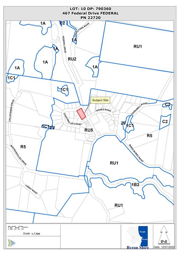
Report No. 13.2 PLANNING - DA 10.2021.114.1 - Light Industrial Development, ("Fed Sheds") at 467 Federal Drive, Federal
Directorate: General Manager
Report Author: Ralph James, Legal Counsel
Chris Larkin, Manager Sustainable Development
File No: I2023/1796
Summary:
The application was reported to Council on the 15 December 2022. Council resolved to refuse the application.
On 28 February 2023 the Applicant commenced proceedings in Class 1 of the Land and Environment Court’s jurisdiction appealing Council’s refusal of the development application (Proceedings No 2021/44517).
A conciliation conference pursuant to section 34 of the Land and Environment Court Act 1979 was held on 7 August 2023.
The matter was unable to be resolved during the conference and for a period of time thereafter.
On 9 October 2023 the Court terminated the conciliation conference as the parties were not able to reach an in principle agreement.
The matter is fixed for hearing before a Commissioner of the court on 2 and 3 April 2024.
Since the termination of the conciliation conference discussions between the parties’ experts have continued.
NOTE TO COUNCILLORS:
In accordance with the provisions of S375A of the Local Government Act 1993, a Division is to be called whenever a motion for a planning decision is put to the meeting, for the purpose of recording voting on planning matters. Pursuant to clause 2(a) under the heading Matters to be Included in Minutes of Council Meetings of Council's adopted Code of Meeting Practice (as amended) a Division will be deemed to have been called by the mover and seconder of all motions relating to this report.
RECOMMENDATION:
That the General Manager be authorised to enter into a s34 Conciliation Agreement approving development application 10.2021.114.1, subject to appropriate conditions to be finalised under delegation.
Attachments:
1 CV
of Jeff Mead Planning Expert, E2023/124030
![]()
2 Letter
from Planning expert Jeff Mead, E2023/124385
![]()
3 CV
of Andrew Norris Wastewater and Stormwater Expert, E2023/124029 ![]()
4 Letter
from Andrew Norris Principal Engineer Martens as to Wastewater and Stormwater
contentions, E2023/123834 ![]()
5 10.2021.114.1
- Master LEC_Federal DA00-DA69 - "Fed Sheds" Amended
plans, E2023/120654 ![]()
6 Re
notification letter sent to submitters, E2023/125076
![]()
7 Confidential - Submissions, E2023/127474
8 Draft
Conditions of Consent, E2023/127562
![]()
9 Confidential - Legal advice from Marsdens Law Group, E2023/127061
Report
Background
Development Application No. 10.2021.114.1 was refused by Council on 15 December 2022 for the following reasons:
1. Pursuant to Section 4.15(1)(a)(i) of the EP&A Act 1979 the proposed development is inconsistent with the objectives of the RU5 Village Zone under Byron LEP 2014.
2. Pursuant to Section 4.15(1)(a)(i) of the EP&A Act 1979 the proposed development is inconsistent with Clause 6.6 of the Byron LEP 2014 in terms of services to the property including stormwater management.
3. Pursuant to Section 4.15(1)(a)(iii) of the EP&A Act 1979 the proposed development is inconsistent with the provisions under Chapter B3 Services under Byron DCP 2014 in terms of onsite sewage management system (including the covered nature of the application area, the lack of allocation of land for a reserve application area, and the inadequate buffer to boundaries) and stormwater management (including stormwater being piped to a locality with pre-existing flood problems).
4. Pursuant to Section 4.15(1)(a)(iii) of the EP&A Act 1979 the proposed development is inconsistent with the provisions under Chapter E6 Federal under Byron DCP 2014 in terms of character, bulk and scale, and the village centre area provisions.
5. Pursuant to Section 4.15(1)(b) of the EP&A Act 1979 the proposed development will have an unacceptable environmental impact in terms of the onsite sewage management system.
6. Pursuant to Section 4.15(1)(b) of the EP&A Act 1979 the proposed development is out of character with the built environment and is not compatible with the Village Character of Federal.
7. Pursuant to Section 4.15(1)(c) of the EP&A Act 1979 the site is not suitable for the development.
8. Pursuant to Section 4.15(1)(e) of the EP&A Act 1979 the proposed development is not in the public interest having taken into account the Federal Village Masterplan.
In essence the size and bulk and scale of the proposed building was considered out of character with the Village, whilst the measures for managing stormwater and effluent disposal onsite were considered inadequate.
The original proposal was to construct 3 buildings for light industrial use comprising eight tenancies of varying floor areas, six (6) with mezzanine levels, and car parking for 26 vehicles, motorbike spaces and two loading zones. The subject site is within the heart of the village and sits opposite the Federal Hall. The land has an area of 4000 m2 and is zoned RU5 Village which permits a range of uses including light industry.
Access and egress to the development is proposed via two new vehicle crossovers in a one-way direction through the site with all vehicles entering and leaving the site in a forward direction.
The development proposed stormwater storage tanks beneath each building and on-site sewage management and a land application area was proposed below the car park with effluent to be treated by way of a tertiary system.
For details on the original assessment of the application see Council (Planning) Meeting of 11 August 2022 and Agenda of Ordinary Meeting - Thursday, 15 December 2022 (infocouncil.biz)
The buildings, although compliant with the 9 metre height limits due to their design and appearance to Federal Drive, were considered somewhat overbearing having regard to the church and hall opposite the site, and other surrounding development in Federal.
On 28 February 2023 the Applicant commenced proceedings in Class 1 of the Land and Environment Court’s jurisdiction appealing Council’s refusal of the development application (Proceedings No 2021/44517).
The General Manager approved Legal Counsel’s recommendation the Marsdens Law Group be instructed to appear for Council in the proceedings.
Council’s Contentions in the proceedings were:
Objectives of the Zone RU5
The proposal failed to specify the nature of the proposed use of the factory units beyond a general description of the proposed development as “light industry” (excluding artisan food and drink industry). The building typology is generic in terms of the types of uses it may accommodate and it has not been demonstrated that future uses will be consistent with the zone objective.
Streetscape and Character
The proposed development is not consistent with the streetscape and existing and desired future character of the Federal Village.
Stormwater Management
The proposed development does not incorporate adequate arrangements for stormwater drainage as required pursuant to clause 6.6 of BLEP 2014. It is also not possible to assess the potential impacts of the development on water quality.
Wastewater Management
The proposed development does not incorporate adequate arrangements for the disposal and management of sewage as required pursuant to clause 6.6 of BLEP 2014.
Insufficient Information
The development application should be refused because insufficient information has been provided to enable a proper assessment of the proposed development in terms of future uses, lighting and stormwater management
Suitability of Site
The site is not suitable for the proposed development having regard to the contentions raised above.
Public Interest
The development application should be refused because the proposed development is not in the public interest having regard to the contentions raised above, and the submissions made to the Respondent.
Conciliation Conference
A conciliation conference pursuant to section 34 of the Land and Environment Court Act 1979 was held on 7 August 2023. At the conciliation conference Council's contentions were advanced by external experts Jeff Mead (Planning) and Andrew Norris (Stormwater/Wastewater).
At the Conciliation Conference the Commissioner took oral statements from 6 resident objectors.
In principle agreement was not able to be reached during the conference and for a period of time thereafter.
The main issues which were not resolved included the built form of the shed and stormwater management.
On 9 October 2023 the Court terminated the conciliation conference.
The matter was listed for a further directions hearing on 16 October 2023. On that day the Court made the following orders:
1. The proceedings are fixed for hearing on 2 and 3 April 2024 commencing on site at 10:30am and returning to the Land and Environment Court in Sydney.
2. The proceedings are listed for a further directions hearing on 4 December 2023.
3. Under rr 31.19 and 31.20 of the Uniform Civil Procedure Rules 2005 (‘UCPR’), the Court makes the following directions regarding expert evidence:
a. Jeff Mead (Respondent’s planning expert) and Derek Sinclair (Applicant’s planning expert) are to confer in relation to Contentions 1, 2, 5, 6, 7 and 8 under r 31.24 UCPR and prepare a joint expert report;
b. Andrew Norris (Respondent’s stormwater expert) and Derek McKenzie (Applicant’s stormwater expert) are to confer in relation to Contention 3 under UCPR r 31.24 and prepare a joint expert report;
c. Andrew Norris (Respondent’s wastewater expert) and Jo Whitehead (Applicant’s wastewater expert) are to confer in relation to Contention 4 under UCPR r 31.24 and prepare a joint expert report;
d. The joint expert reports are to be filed and served by 4 March 2024.
Further, the stormwater management and onsite sewage management has also been amended.
The amended plans are contained in attachment 5.
Resolution of the contentions
Planning
As was outlined above Council's expert in the discipline of Planning was Jeff Mead.
Mr. Mead’s CV is attachment 1.
On 27 November 2023 Mr. Mead provided a letter to Council setting out his view as to the Planning contentions. That letter is attachment 2.
In understanding Mr. Mead’s comments Councillors should refer to the list of contentions referred to above.
Wastewater and Stormwater Management
As was outlined above Council's expert in the disciplines of Wastewater and stormwater management was Andrew Norris.
Mr. Norris’ CV is attachment 3.
On 20 November 2023 Mr. Norris provided a letter to Council setting out his view as to the wastewater and stormwater contentions. That letter is attachment 4.
The following sets out the contentions Mr. Norris refers to and (in red) the comments he makes in relation to them:
Stormwater Management
3. The development application must be refused because the proposed development does not incorporate adequate arrangements for stormwater drainage as required pursuant to clause 6.6 of BLEP 2014. It is also not possible to assess the potential impacts of the development on water quality.
Particulars
a) Clause 6.6 of BLEP 2014 provides as follows:
“6.6 Essential services
Development consent must not be granted to development unless the consent authority is satisfied that any of the following services that are essential for the development are available or that adequate arrangements have been made to make them available when required—
(d) stormwater drainage or on-site conservation,…”
This particular is resolved as the consent authority can be satisfied, on the basis of the Updated Stormwater Plan provided, that the site stormwater management solution has been prepared in accordance with relevant Council controls, the LEP and industry best practice approaches to stormwater quality and quantity modelling.
b) Clause 6.5 of BLEP 2014 provides as follows:
6.5 Drinking water catchments
(1) The objective of this clause is to protect drinking water catchments by minimising the adverse impacts of development on the quality and quantity of water entering drinking water storages.
(2) This clause applies to land identified as “Drinking water catchment” on the Drinking Water Catchment Map.
(3) In deciding whether to grant a development application for development on land to which this clause applies, the consent authority must consider the following—
(a) whether or not the development is likely to have any adverse impact on the quality and quantity of water entering the drinking water storage, having regard to the following—
(i) the distance between the development and any waterway that feeds into the drinking water storage,
(ii) the on-site use, storage and disposal of any chemicals on the land,
(iii) the treatment, storage and disposal of waste water and solid waste generated or used by the development,
(b) any appropriate measures proposed to avoid, minimise or mitigate the impacts of the development.
(4) Development consent must not be granted to development on land to which this clause applies unless the consent authority is satisfied that—
(a) the development is designed, sited and will be managed to avoid any significant adverse impact on water quality and flows, or
(b) if that impact cannot be reasonably avoided—the development is designed, sited and will be managed to minimise that impact, or
(c) if that impact cannot be minimised—the development will be managed to mitigate that impact.”
This particular is resolved as the consent authority can be satisfied, on the basis of the Updated Stormwater Plan provided, that the development is designed, sited and will be managed to avoid any significant adverse impacts on water quality and flows. The MUSIC model has demonstrated that the developed site shall generate no greater load of priority pollutants TSS, TN and TP than the undeveloped site. The DRAINS model has demonstrated that the post development flows from the site shall not exceed pre development flows for the range of storms up to the 1% AEP event.
c) Clause B3.2.3 in Chapter B3 of Part B of BDCP 2014 contains the following relevant objectives and performance criteria:
“B3.2.3Stormwater Management
Objectives
1. To promote on-site stormwater management practices that support the ‘pre-development’ hydrological regime (surface flow, streams and groundwater).
2. To ensure that new development does not reduce the effectiveness of existing drainage patterns (including built infrastructure).
3. To minimise the impacts of stormwater runoff from a site on adjoining properties.
4. To provide an acceptable level of protection against personal injury and property damage due to localised stormwater runoff.
5. To promote on-site retention, detention and infiltration of stormwater.
6. To promote stormwater harvesting and other forms of innovative water conservation.
7. To promote better integration of stormwater management into development proposals.
8. To ensure that on-site stormwater management facilities can be economically maintained, and that adequate arrangements are made for on-going maintenance.
9. To provide for the ongoing environmental health of receiving waters;
10. To ensure that stormwater management systems protect ground and surface water and other ecological values;
11. To achieve best practice stormwater treatment targets for stormwater quality.
…
Prescriptive Measures
1. Development Applications
Development applications must contain sufficient information to assess whether the proposed stormwater system is effective and feasible, both within the site and in its connection to the public drainage system.
…
Plans showing the method of draining the land are to be in accordance with the Northern Rivers Local Government Development Design and Construction Manuals, Byron Shire Council Comprehensive Guidelines for Stormwater Management and relevant Australian Standards. Sample drawings developed as part of the Northern Rivers Local Government Development Design and Construction Manuals provide guidance on the type of information that should be included in stormwater management plans for subdivision works. AS/NZS 3500.3:2003 Plumbing and drainage
- Stormwater drainage is the relevant Australian Standard at the time of writing this document. Appendices C and K of AS/NZS 3500.3:2003 provide guidance on the type of information that should be included in stormwater management plans for building works.
7. Stormwater Quality and Treatment
b) Applications for subdivisions and developments involving an area of land greater than 2,500m2 must provide measures to address the “key” pollutants in accordance with Table B3.2 for all stormwater flows up to 25% of the 1 year ARI peak flow from the development site.…”
This particular is resolved as the consent authority can be satisfied, on the basis of the Updated Stormwater Plan provided, that the stormwater management system satisfies clause B3.2.3 of Chapter B3 of Part B of Byron DCP 2014. The MUSIC model demonstrates the water quality objectives, and the DRAINS model demonstrates the flow objectives, have been satisfied.
d) The analysis of stormwater quality control design appears in error in that it is inconsistent with the wastewater assessment, and therefore does not adequately address Table B3.2 of BDCP 2014.
The Updated Stormwater Plan and the wastewater system as described in the Whitehead Letter, as documented jointly on Plan DA40, resolve the past inconsistency between the stormwater and wastewater solutions on the site.
e) Specifically, the reported reuse rates (Table 2.2 of the Stormwater Management Plan) include errors so that the daily reuse rate does not correspond with the annual reuse rates. The daily rate (being the lower of the two rates) does not correspond with the wastewater assessment in that the stormwater assessment is assuming use on 7 days per week, whereas the wastewater assessment assumes 6 days per week. The On-site Sewage Management Feasibility Assessment (Rev E) (“OSSM Report”) further modifies the design by assuming effluent reuse for toilet flushing, which shall further reduce the stormwater demand.
The Updated Stormwater Plan and the wastewater system as described in the Whitehead Letter, as documented jointly on Plan DA40, resolve the past inconsistency between the stormwater and wastewater solutions on the site.
f) The MUSIC modelling assumed landscape irrigation at a rate of 516kL/year. The landscaped area in the development is given on Drawing No. DA40 as 1,354m2. This equates to an irrigation rate of 4ML/ha/year, which is high. It is unclear whether this is appropriate for the landscaping treatment proposed on site or whether the model should be adjusted.
The Updated Stormwater Plan adopts industry standard reuse rates for external irrigation assuming 75% of landscaping is irrigated.
g) The floor of the raingarden / detention basin is 173.0m AHD and the 1 in 100 year water level in the basin is 173.71m AHD (Floodworks plan SK-04). The floor level of Building C is as low as 172m AHD (Drawing No. DA30) and the levels in the carpark vary from 174.5m AHD (north-west corner) to 171m AHD (at its south-west corner) as shown on Drawing No. DA20.2. The basin is accordingly unable to receive water from much of the site. It will therefore not perform as modelled in the water quality and quantity assessment, and shall be ineffective with regards to both the water quality and water quality functions proposed.
The Updated Stormwater Plan and Plan DA40, resolve the past design flaws by relocating the raingarden to a position to which the majority of the site can drain.
h) Having regard to the above matters, it has not been shown that the proposed development incorporates adequate arrangements for stormwater drainage and the impacts of the development on water quality cannot be appropriately assessed. There is no power to grant consent to the development application having regard to clauses 6.5 and 6.6 of BLEP 2014.
The Updated Stormwater Plan, DRAINS model and MUSIC model allow for the adequate assessment of the site stormwater solution. Further, the updated design allows for the conclusion that the solution now proposed is adequate and acceptable in accordance with BDCP and BLEP.
i) Additionally, the design of the basin is considered inappropriate from a safety and aesthetic perspective having regard to the following matters:
(i) The proposed basin includes a vertical drop of 1m from the adjacent car park to the basin floor (as shown on Floodworks plan SK-04). No provision has been made for safety fencing or vehicle barriers.
(ii) The top of wall around the basin is at 174.01m AHD. At the southern end of the basin, the survey indicates a level of approximately 170.5m AHD. The difference in height of 3.5m is not reflected in the shadow diagrams provided, nor is it included in any of the cross-sections of the site. This structure is likely to be quite imposing given the setback from the western boundary is only 3m.The exclusion of the basin from the majority of plans wrongly presents a 6.3m setback from the boundary. Instead, the basin shall be a significant structure setback only 3m from the boundary. The basin design and operational requirements are likely to be incompatible with the landscaping shown on the application plans. In this regard, trees are generally incompatible with a raingarden, and certainly incompatible with a “sealed” raingarden as is proposed.
(iii) The raingarden / detention basin section presented on SK04 of the plans prepared by Floodworks shows the ground level adjacent to the basin at approximately 172.8m AHD adjacent to the overflow weir. The natural ground level in this area is approximately 170.5m AHD. Either the Applicant is proposing considerable filling (and then retaining walls to reach natural levels on adjacent sites) or SK04 misrepresents the site situation. This discrepancy needs to be clarified in order to properly understand this aspect of the proposed development.
Item (i) of the particular remains unresolved. The updated design (see SK-04 of the Updated Stormwater Plan) retains a > 1.0 m drop from the carpark level to the basin surface. A note that a ‘Handrail for Level Change Greater Than 1m’ has been provided. However, this is considered inadequate for a carpark. The requirement for a W-Beam safety barrier should be considered by Council Engineering staff and, in our opinion, should be imposed as a condition of consent.
Staff have considered this comment and have addressed it in the draft conditions of consent.
Items (ii) – (iv) are resolved by the Updated Stormwater Plan.
Wastewater Management
4. The development application should be refused because the proposed development does not incorporate adequate arrangements for the disposal and management of sewage as required pursuant to clause 6.6 of BLEP 2014.
Particulars
a) Clause 6.6 of BLEP 2014 provides as follows:
“6.6 Essential services
Development consent must not be granted to development unless the consent authority is satisfied that any of the following services that are essential for the development are available or that adequate arrangements have been made to make them available when required—
…
(c) the disposal and management of sewage,…”
This particular is resolved as the consent authority can be satisfied, on the basis of the wastewater management solution detailed in the Whitehead Letter and on Plan DA40, that adequate arrangement have been made for the management of sewage as required pursuant to clause 6.6 of BLEP 2014.
b) Clause B3.2.2 in Chapter B3 of Part B of BDCP 2014 provides the following relevant objectives and prescriptive measures in relation to on-site sewage management:
“B3.2.2 On-site Sewage Management
Objectives
1. To ensure that on-site sewage management systems are designed and operated to ensure protection of ground and surface water, including drinking water supplies;…
3. To ensure on-site sewage management systems that service or are required for industrial, commercial and rural industries are appropriately designed.…
5. To minimise public health risk including the spread of disease by micro- organisms;
6. To prevent degradation of soil and vegetation including soil structure, salinisation, water logging, chemical contamination and soil erosion; and
7. To ensure that neighbouring properties are not adversely affected by effluent or effluent management systems.
…
Prescriptive Measures
1. Residential, commercial and industrial development that produces sewage and is not to be connected to the urban sewage system must comply with the Council’s Design Guidelines for On-Site Sewage Management for Single Households.
2. A detailed on-site sewage management report may be required with a development application depending upon the scale of the development, the size of the land and distances to watercourses. A report is generally required with a Development Application for systems that service rural dwellings on land less than 1 hectare, rural and rural residential subdivisions creating lots smaller than 5 ha, rural tourist and commercial developments…”
This particular is resolved as the consent authority can be satisfied, on the basis of the wastewater management solution detailed in the Whitehead Letter and on Plan DA40, that the wastewater management solution provided satisfies the requirements of Clause B3.2.2 in Chapter B3 of Part B of BDCP 2014.
c) The wastewater assessments submitted in support of the development application are considered deficient having regard to the following matters:
(i) Whitehead’s peer review queries the claimed TN and TP removal in the wastewater treatment system. While the claimed rates may be reasonable for domestic sewage treatment system receiving sewage from a single dwelling, they are unlikely to be achieved in a blackwater only system from a commercial development.
(ii) The OSSM Report includes the design assumption that greywater will be treated and used for toilet flushing. This is inconsistent with the stormwater assessment, which assumes 900L/day (7 days per week) of stormwater will be consumed, in part, for these purposes.
(iii) It is claimed that the absorption system beneath the carpark shall achieve nutrient assimilation. The mechanism for this claimed nutrient removal is not explained. The most likely actual outcome is that mobile nutrients (nitrogen species in particular) will migrate from the absorption area and either move off site, or down profile to the underlying groundwater.
(iv) No evidence is presented for a commercially available treatment system capable of treating a commercial development’s greywater stream to a standard acceptable for toilet flushing in a commercial premises. Similarly, there is no analysis provided demonstrating that a system is available to treat the blackwater generated to the standard assumed in the OSSM Report for disposal system design.
(v) Recycling of greywater for toilet flushing may also significantly increase the salt content of the generated effluent. No analysis of the salt balance within the absorption system has been made.
(vi) No description of the likely monitoring and maintenance requirements of the greywater reclamation system has been provided. While such a detail may be appropriately provided at the stage of applying for an approval under section 68 of the Local Government Act 1993 for a typical treatment solution such as an AWTS, it is necessary to be provided for assessment at the development application stage where the solution relies on advanced treatment solutions, the technical and commercial feasibility of which is unclear. Should the maintenance and operational requirements of the proposed effluent reclamation plan be unachievable within the commercial context of the proposed development, the result would be an approved development which could not be feasibly serviced.
(vii) The proposed Analysis of LTAR in Table 4 of the OSSM Report is incorrect. The author has incorrectly converted mm/day to m/day resulting in LTARs being adopted for 0.5m/day permeability rather than the measured rate of 0.05m/day (51 – 56mm/day).
(viii) No consideration has been made as to the impact of the loading of the absorption field with a car park (and parked vehicles) over time. It is likely that the continual loading of the saturated soils in the absorption area will lead to consolidation of underlying clay (and possible pavement issues) and thereby a significant decline in the permeability of the underlying soils. It is possible this will lead to catastrophic failure of the absorption system. While the Applicant has identified sufficient area to provide for a reserve field (designed on soil hydraulics only), the reserve area is similarly impacted by the overlying car park and could be similarly compromised.
(ix) The proposed layers of 50mm drainage cells, and the effluent distribution pipework applying effluent to them, shall have no ability to be serviced or maintained should they accumulate sediments or wastes or be compromised in any other way as a result of the operation of the sewage treatment system. The only way that remedial works could be undertaken in the absorption area would be to excavate the concrete carpark. This is not considered to be a best practice system design, particularly on a site with known, highly reactive soils.
(x) The OSSM Report assumes 35% of wastewater is blackwater. While this may be a split appropriate for a residence, there is no analysis to justify how this is an appropriate assumption for a commercial operation.
(xi) Available suitable treatment systems include a reverse osmosis system. Such systems generate a highly saline brine stream which cannot be applied to a land application system. This highlights the inadequate and incomplete analysis of the overall system as it is presented for approval.
(xii) It is likely that a licence under the Water Industry Competition Act 2006 (“WICA”) shall be required for the reticulation of the treated effluent to the commercial premises for the purposes of toilet flushing. This is a matter which requires further assessment prior to the determination of the development application. The need for a WICA licence, and conditions on such a licence, may significantly impact upon the viability of the proposed development.
(xiii) The risk assessment presented does not address the risk of toilet flushing effluent being of inadequate quality for this purpose. No provision has been made for the monitoring of the effluent to ensure public health risks are addressed. The disposal system design detailed in the OSSM Report “Exhibit 3” includes “layered compacted fill” beneath the drainage cell area for all areas of the carpark in fill. Engineered fill will have hydraulic properties that are very different from the natural underlying soils.
The wastewater management solution detailed in the Whitehead Letter and on Plan DA40, is a full redesign of the solution previously proposed. The amended design uses conventional onsite solutions to achieve an appropriate site design. Modifications to the site development layout has facilitated the creation of irrigation areas suitable for conventional subsurface irrigation and removed the reliance on the effluent absorption system under the carpark and the reliance on toilet flushing effluent reuse. Proposed sewage treatment systems are conventional and acceptable in the context of the site.
d) The car park / drainage cell design provided on page 29 of the OSSM Report indicates cut and fill to provide final car park grade of 6.25 %. However, this detail is not indicated on development plans provided by Building Studio (e.g. Drawing DA20.1 Amended Site Layout and Car Parking Plan), which show no change in grade from natural.
The amended onsite wastewater solution described in the Whitehead Letter and Plan DA40 do not raise the issues raised by the previous OSSM Report.
e) Furthermore, the Report on Geotechnical Investigation prepared by Geotech Investigation Pty Ltd includes a series of recommendations that are inconsistent with the requirements for the construction of an effluent absorption system beneath the car park. These include:
(i) Section 5.1 – requirement for the compaction of the subgrade prior to filling or construction of pavement. This will create a hardpan (impermeable layer) through which effluent migration shall be greatly reduced. The geotechnical requirements for the construction of the car park are therefore at odds with the requirements for the construction of an effective absorption system.
(ii) Fill material is to be well compacted, which again will result in greatly reduced permeability and likely lead to short-to-medium term hydraulic failure of the absorption systems.
(iii) Section 5.2 – the soils of the site are identified as being highly reactive. Due to this, Section 5.5 recommends that soil moisture should be controlled to limit moisture content change. This is at odds with the proposed use of the area for effluent absorption.
(iv) Section 5.5 recommends that underground services should be made flexible to accommodate movement due to the soil’s reactivity. The proposed absorption cells with pipework throughout for effluent distribution is likely to be vulnerable to damage with the highly reactive soils and the use of the area as an effluent absorption area. This further compounds concerns regarding the inability of the infrastructure to be access for maintenance.
The geotechnical recommendations for the carpark are no longer of consequence for the onsite wastewater solution as the solution described in the Whitehead Letter and Plan DA40 do not rely on effluent absorption beneath the carpark.
f) Having regard to the above, the consent authority cannot be satisfied that the proposed development incorporates adequate arrangements for the disposal and management of sewage as is required pursuant to clause 6.6 of BLEP 2014. There is no power to grant development consent in the absence of satisfaction as to that matter.
The consent authority can now be satisfied that the proposed development incorporates adequate arrangement for the disposal and management of sewage as required pursuant to clause 6.6 of BLEP 2014.
Insufficient Information
5. The development application should be refused because insufficient information has been provided to enable a proper assessment of the proposed development.
Particulars
a) The development application provides limited details in terms of the proposed use, which does not allow a proper assessment of the potential impacts of specific land use(s). It is inappropriate to “manage” potential uses through the crafting of conditions of development consent.
b) The development application provides no details as to the proposed lighting for the site and therefore a proper assessment of impacts cannot be undertaken.
c) The Applicant’s XP-SWMM model has not been provided for assessment.
The Updated Stormwater Plan does not rely on the past reference XP-SWMM model, the DRAINS model provided adequately addresses matters of site hydrology and hydraulics for stormwater management purposes.
Suitability of Site
6. The development application should be refused because the site is not suitable for the proposed development having regard to the contentions raised above.
As it relates to wastewater and stormwater the Updated Stormwater Management Plan, Whitehead Letter and Plan DA40 demonstrate the suitability of the site for the development proposed.
2.5 Submissions made in accordance with this Act or the regulations
Amended plans notification
Attachment 6 is a copy of the letter which was sent on 17 November 2023 to all previous submitters.
The notification period was from 17 November 2023 to 1 December 2023 (by 5:00pm).
This period was extended to 9:30 am on 4 December 2023.
Council received 15 submissions in favour of the amended development and 40 against.
Copies if the submissions are Confidential attachment 7.
Draft conditions of consent
Attachment 8 contains the current draft of the conditions of consent based on the amended plans and the experts’ comments together with input from staff.
Recent Resolutions
22-374
22-735
Legal/Statutory/Policy Considerations
Prospects of success
Staff sought legal advice from Council’s external solicitors as to Council’s prospects of succeeding in the Land and Environment Court appeal if Council were to continue to defend its refusal of the development application, having regard to the amended plans and the experts’ opinions.
That advice is contained in confidential attachment 9.
Adverse costs
Costs are at the Court’s discretion, subject to any applicable rules or legislation including the Land and Environment Court Act 1979 and Land and Environment Court Rules 2007.
Costs are awarded to compensate a successful party, not to penalise the losing party.
In civil proceedings, the discretion is also subject to the Civil Procedure Act 2005.
The usual rule is that costs follow the event unless the Court considers another order should be made.
In Class 1 proceedings, the usual rule may not apply.
Costs orders must not be made in Class 1 proceedings, unless it is ‘fair and reasonable’ in the circumstances to do so. Examples of the circumstances in which it may be ‘fair and reasonable’ to award costs are:
• a party acted unreasonably in the proceedings;
• a party maintained a defence which had no reasonable prospects of success.
Section 34 Conferences
Conciliation in the Court is undertaken in accordance with Section 34 of the Court Act (otherwise known as a Section 34 Conference).
Section 34 Conferences, as articulated by the Chief Judge in (2008) 19 ADRJ 72, provide:
“for a combined or hybrid dispute resolution process involving first, conciliation and then, if the parties agree, adjudication. The conciliation involves a Commissioner with technical expertise on issues relevant to the case acting as a conciliator in a conference between the parties. The conciliator facilitates negotiation between the parties with a view to their achieving agreement as to the resolution of the dispute. If the parties are able to reach agreement, the conciliator, being a Commissioner of the Court, is able to dispose of the proceedings in accordance with the parties’ agreement.”
The Court’s practice note encourages parties to consider using Section 34 Conferences to resolve disputes or narrow the scope of issues in dispute. The parties should properly prepare for each conference with this purpose in mind.
In accordance with Section 34(1A) of the Court Act it is the duty of each party to proceedings where a conciliation conference has been arranged to participate, in good faith, in the conciliation conference.
Duty of the Expert Witness
The role of the expert witness is to assist the Court. Their overriding duty is to the Court and not to his or her client. Importantly, the expert witness is not to be an advocate for a party.
The views of an expert may change depending on the information provided to them.
The Expert Witness Code of Conduct, contained at Schedule 7 of the Uniform Civil Procedure Rules sets out the duties of the expert witness when giving evidence in court and/or when providing evidence in a report or statement.
Key concepts within Expert Witness Code of Conduct include:
· Overriding duty to assist the court impartially on matters relevant to expertise;
· Duty is to the court and not to any party;
· Not advocate for a party;
· Duty to work cooperatively with other experts;
· Exercise independent and professional judgment;
· Endeavour to reach agreement with other experts;
· Must not act on an instruction or request to withhold agreement;
Financial Considerations
Current professional legal costs of the proceedings together with an estimate of professional legal costs should Council resolve to continue to defend its refusal is contained in Confidential attachment 9. So too is a discussion as to adverse costs.
DISCLOSURE OF POLITICAL DONATIONS AND GIFTS
|
Has a Disclosure Statement been received in relation to this application |
No |
|
Have staff received a ‘gift’ from anyone involved in this application that needs to be disclosed. Where the answer is yes, the application is to be determined by the Director or Manager of the Planning, Development and Environment Division. |
No |
Provide Disclosure Statement register details here: Not applicable
Staff Reports - Corporate and Community Services 13.3
Staff Reports - Corporate and Community Services
Report No. 13.3 Section 355 Guidelines Update
Directorate: Corporate and Community Services
Report Author: Cynthia McDermott, Social and Cultural Planning Project Officer
File No: I2023/616
Summary:
Section 355 of the Local Government Act 1993 allows a council to delegate certain functions to committees of council. Council currently has nine facilities managed by Section 355 Committees (s355 Committees). These Committees should operate in accordance with the s355 Committee Guidelines.
Updates have been made to the s355 Committee Guidelines which require endorsement by Council.
The key update is the addition of Point 7.10. This amendment enables Council and local emergency management services fee-free access to s355 managed buildings during emergency situations where the facilities are required, for example for use as a recovery centre.
Additional minor updates have also been included to simplify the Guidelines and to assist with implementation.
RECOMMENDATION:
That Council endorses the updated Section 355 Guidelines at Attachment 1 (E2022/83249).
1 Section
355 Committee Guidelines November 2023, E2022/83249
![]()
Report
Section 355 of the Local Government Act 1993 allows a council to delegate certain functions to Committees of Council. Council currently has nine facilities managed by Section 355 Committees (s355 Committees).
Updates have been made to the s355 Committee Guidelines and require endorsement by Council.
The key update is the addition of Point 7.10. This amendment enables Council and local emergency management services fee-free access to s355 managed buildings during emergency situations where the facilities are required, for example for use as a recovery centre.
The recent disaster events experienced in Byron Shire highlight the need to include this amendment in the Guidelines. The amendment will support both Council and s355 Committees to have clear expectations in an emergency and during recovery.
Amendments
The following additional minor updates have also been made to simplify the Guidelines and assist with implementation:
- Clarification of risk management and insurance coverage for volunteers and hirers.
- Adjustments to information on purchasing of goods and services, in line with Council’s updated Procurement Guidelines (2023).
- Addition of information on asset disposal.
- Clarification that the Guidelines apply to all Committees, including those using online booking platforms such as SpacetoCo.
- Removal of references to redundant processes, dates, and figures.
Strategic Considerations
Community Strategic Plan and Operational Plan
|
CSP Objective |
CSP Strategy |
DP Action |
Code |
OP Activity |
|
1: Effective Leadership |
1.5: Empower community leadership through collaboration, capacity building, and cultivating community driven initiatives |
1.5.3: s355 Committees - Support the management of community halls to delegated s355 committees |
1.5.3.1 |
Support Council volunteers with the management and operation of community halls |
Financial Considerations
If Council agrees to the changes suggested in this report, specifically by adding point 7.10, it would mean that the Section 355 Committee won't receive any income when a facility covered by the guidelines is used during emergency situations. In such cases, there won't be any alternative revenue for the committee during the emergency period and Council during this period, would be responsible for the associated costs. Ultimately, the decision rests with Council as the facility owner.
According to Section 377(1)(e) of the Local Government Act 1993, Council cannot delegate the authority to the General Manager to determine fees. Additionally, there are limits to the amount the General Manager can waive as a debt. It's possible that the debt incurred for using a facility during an emergency, like a recovery centre for example, could surpass the General Manager's authority to waive.
To avoid creating a debt in emergency situations, it would be better for the Council to establish a fee of $0.00 for each facility, specifically designated for emergency situations (e.g., declared natural disaster events). This way, no financial obligation would be incurred during such emergencies.
If Council approves the updated S355 Guidelines presented in this report, the proposed $0 fee for facility use during emergencies will be included in the Draft 2024/2025 Fees and Charges. Council in such cases will be responsible for operating expenses (e.g., cleaning and utilities) during the period the building is used for emergency purposes.
Legal/Statutory/Policy Considerations
Section 355 of the Local Government Act 1993 provides that a council may appoint a committee and delegate under Section 377 certain functions to a committee, including the authority for the care, control, and management of community buildings.
Consultation and Engagement.
Feedback from s355 volunteers obtained throughout the year has informed the proposed amendments.
BYRON SHIRE COUNCIL
Staff Reports - Corporate and Community Services 13.4
Report No. 13.4 Grants November 2023
Directorate: Corporate and Community Services
Report Author: Donna Johnston, Grants Coordinator
File No: I2023/1818
Summary:
Council is waiting on determination of eight grant applications which, if successful, would provide funding to enable the delivery of identified projects. This report provides an update on grant applications.
RECOMMENDATION:
That Council notes the grant submissions report for the month of November 2023 (Attachment 1 #E2023/127134).
1 Grant
submissions as at 30 November 2023, E2023/127134
![]()
Report
Currently Council has eight grant applications awaiting determination (refer to Grants Submissions as of 30 November 2023 - Attachment 1, E2023/127134.
Successful applications
The Expression of Interest for the Australian Government Growing Regions Program – Round 1 was approved to progress through to full application. Full application closes 15 January.
|
Funding scheme |
Project name |
Total project |
Amount requested |
Council |
|
|
Australian Government |
Growing Regions Program – Round 1 (EOI) |
Byron Bioenergy Facility |
$24,636,000 |
$12,318,000 |
$12,318,000 |
Unsuccessful applications
No grants announced.
Upcoming Grant opportunities
Get NSW Active 2024/2025 | Transport for NSW
For this year’s program, there is $60 million in total grant funding available to local councils to deliver projects that enable more people to walk or bike ride. Of the $60 million funding, $10 million is for projects that enable walking or bike riding to school, with the remaining funding for broader active transport projects.
Projects under consideration include:
· Market Street (Bangalow) footpath – design
· Beach Avenue (South Golden Beach) shared footpath – design
· Byron Street (Bangalow) footpath – construction
Disaster Ready Fund | NSW Government EOI
The Australian Government has established the Disaster Ready Fund (DRF), to help communities protect themselves against the impacts of natural hazards across Australia. Expression of Interest applications are made to NSW Reconstruction Authority who then assess and invite applicants to progress to a full application. Full applications are then submitted to the Commonwealth by the NSW Government.
25 to 50% Council co-contribution is required which makes it a challenging process. Staff are currently exploring options to try and leverage the NSW Infrastructure betterment funding to support additional elements of the Preferred Byron Bay Drainage Strategy.
Community Strategic Plan and Operational Plan
|
CSP Objective |
CSP Strategy |
DP Action |
Code |
OP Activity |
|
1: Effective Leadership |
1.3: Ethical and efficient management of resources |
1.3.1: Financial Management - Ensure the financial integrity and sustainability of Council through effective financial management |
1.3.1.9 |
Coordinate grant applications to support the delivery of Council projects and services within management plans, masterplans, strategic plans, council resolutions and high priority actions from feasibility studies; and support the management of successful grants |
Legal/Statutory/Policy Considerations
Under section 409 3(c) of the Local Government Act 1993 Council is required to ensure that ‘money that has been received from the Government or from a public authority by way of a specific purpose advance or Grant, may not, except with the consent of the Government or public authority, be used otherwise than for that specific purpose’. This legislative requirement governs Council’s administration of Grants.
Financial Considerations
If Council is successful in obtaining the identified Grants, this would bring funding sought to approximately $25 million which would provide significant funding for Council projects. Some of the Grants require a contribution from Council (either cash or in-kind) and others do not. Council’s contribution is funded.
The potential funding is detailed below:
Funding applications submitted and
awaiting notification (total value) $25,258,683
Requested funds from funding bodies $12,805,110
Council contribution cash $12,453,573
Council co-contribution in-kind $4,500
Other contributions $0
Funding determined in November 2023:
Successful
applications
$0 (total project value)
Unsuccessful/withdrawn
applications
$0 (total project value)
Consultation and Engagement
Cross-organisational consultation has occurred in relation to the submission of relevant grants, and the communication of proposed grant applications.
BYRON SHIRE COUNCIL
Staff Reports - Corporate and Community Services 13.5
Report No. 13.5 Council Investments - 1 November 2023 to 30 November 2023
Directorate: Corporate and Community Services
Report Author: James Brickley, Manager Finance
File No: I2023/1955
This Report includes a list of investments and identifies Council’s overall cash position for the period 1 November 2023 to 30 November 2023 for information.
This Report is prepared to comply with Section 212 of the Local Government (General) Regulation 2021.
RECOMMENDATION:
That Council notes the report
listing Council’s investments and overall cash position as of 30 November
2023.
Report
Council has continued to maintain a diversified portfolio of investments. As of 30 November 2023, the average 90-day bank bill rate (BBSW) for the month was 4.27%. Council’s performance for November 2023 was 4.30%.
Interest rates have been steady over recent months. Due to investments made when rates were higher, Council is performing above the average BBSW. The table below identifies the investments held by Council as at 30 November 2023.
Schedule of Investments held as at 30 November 2023
|
Purch Date |
Principal ($) |
Description |
CP* |
Rating |
Maturity Date |
Fossil Fuel |
Type |
Int. Rate |
Current Value ($) |
|
15/11/18 |
1,000,000.00 |
NSW Treasury Corp (Green Bond) |
N |
AAA |
15/11/28 |
N |
B |
3.00% |
935,620.00 |
|
20/11/18 |
1,000,000.00 |
QLD Treasury Corp (Green Bond) |
N |
AA+ |
22/03/24 |
N |
B |
1.78% |
996,220.00
|
|
28/03/19 |
1,000,000.00 |
National Housing Finance & Investment Corporation |
Y |
AAA |
28/03/29 |
N |
B |
2.38% |
904,960.00
|
|
21/11/19 |
1,000,000.00 |
NSW Treasury Corp (Sustainability Bond) |
N |
AAA |
20/03/25 |
N |
B |
1.25% |
960,600.00
|
|
27/11/19 |
500,000.00 |
National Housing Finance & Investment Corp |
Y |
AAA |
27/05/30 |
N |
B |
1.52% |
415,610.00
|
|
15/06/21 |
500,000.00 |
National Housing Finance & Investment Corp |
Y |
AAA |
01/07/31
|
N |
B |
1.99% |
500,630.00
|
|
06/09/21 |
1,000,000.00 |
Northern Territory TCorp |
N |
Aa3 |
15/12/26 |
N |
B |
1.40% |
1,000,000.00 |
|
16/09/21 |
1,000,000.00 |
QLD Treasury Corp (Green Bond) |
N |
AA+ |
02/03/32 |
N |
B |
1.83% |
772,360.00 |
|
30/10/23 |
850,000.00 |
Bank Australia Ltd |
P |
BBB |
30/10/26 |
N |
FRN |
5.72% |
850,000.00 |
|
01/09/23 |
2,000,000.00 |
NAB |
P |
AA- |
01/04/24 |
Y |
TD |
5.00% |
2,000,000.00 |
|
04/09/23 |
2,000,000.00 |
NAB |
N |
AA- |
04/12/23 |
Y |
TD |
4.95% |
2,000,000.00 |
|
04/09/23 |
2,000,000.00 |
NAB |
N |
AA- |
04/12/23 |
Y |
TD |
4.95% |
2,000,000.00 |
|
05/09/23 |
2,000,000.00 |
Beyond Bank |
P |
BBB |
06/12/23 |
N |
TD |
4.95% |
2,000,000.00 |
|
14/09/23 |
1,000,000.00 |
NAB |
N |
AA- |
12/01/24 |
Y |
TD |
4.90% |
1,000,000.00 |
|
12/09/23 |
2,000,000.00 |
NAB |
N |
AA- |
12/12/23 |
Y |
TD |
4.85% |
2,000,000.00 |
|
19/09/23 |
2,000,000.00 |
NAB |
N |
AA- |
19/12/23 |
Y |
TD |
4.90% |
2,000,000.00 |
|
20/09/23 |
1,000,000.00 |
Bank of QLD |
P |
BBB+ |
22/01/24 |
Y |
TD |
4.75% |
1,000,000.00 |
|
25/09/23 |
2,000,000.00 |
Bank of QLD |
N |
BBB+ |
24/01/24 |
Y |
TD |
4.85% |
2,000,000.00 |
|
26/09/23 |
2,000,000.00 |
NAB |
N |
AA- |
22/12/23 |
Y |
TD |
4.90% |
2,000,000.00 |
|
28/09/23 |
1,000,000.00 |
Judo Bank |
P |
BBB- |
04/01/24 |
N |
TD |
4.85% |
1,000,000.00 |
|
04/10/23 |
2,000,000.00 |
Judo Bank |
N |
BBB- |
03/01/24 |
N |
TD |
4.90% |
2,000,000.00 |
|
09/10/23 |
2,000,000.00 |
NAB |
N |
AA- |
08/01/24 |
Y |
TD |
4.85% |
2,000,000.00 |
|
19/10/23 |
1,000,000.00 |
AMP Bank |
P |
BBB |
18/01/24 |
Y |
TD |
4.85% |
1,000,000.00 |
|
25/10/23 |
1,000,000.00 |
Police Bank |
P |
BBB |
22/02/24 |
N |
TD |
5.00% |
1,000,000.00 |
|
25/10/23 |
1,000,000.00 |
Police Credit Union |
P |
BBB |
22/02/24 |
N |
TD |
5.00% |
1,000,000.00 |
|
30/10/23 |
2,000,000.00 |
NAB |
N |
AA- |
29/01/24 |
Y |
TD |
5.00% |
2,000,000.00 |
|
01/11/23 |
1,000,000.00 |
NAB |
N |
AA- |
30/01/23 |
Y |
TD |
5.00% |
1,000,000.00 |
|
08/11/23 |
1,000,000.00 |
Auswide Bank |
N |
BBB |
07/02/24 |
N |
TD |
5.05% |
1,000,000.00 |
|
20/11/23 |
1,000,000.00 |
NAB |
N |
AA- |
19/02/24 |
Y |
TD |
5.00% |
1,000,000.00 |
|
27/11/23 |
1,000,000.00 |
Westpac Tailored |
P |
AA- |
27/11/24 |
N |
TD |
5.40% |
1,000,000.00 |
|
29/11/23 |
1,000,000.00 |
Bank of QLD |
P |
BBB+ |
02/04/24 |
Y |
TD |
5.20% |
1,000,000.00 |
|
N/A |
25,588,939.16
|
CBA Business Saver |
P |
AA- |
N/A |
Y |
CALL |
4.35% |
25,588,939.16
|
|
N/A |
3,170,069.35
|
CBA Business Saver – Tourism Infrastructure Grant |
N |
AA- |
N/A |
Y |
CALL |
4.35% |
3,170,069.35
|
|
N/A |
10,533,423.95
|
Macquarie Accelerator Call |
N |
A |
N/A |
Y |
CALL |
3.97% |
10,533,423.95
|
|
Total |
80,142,432.46 |
|
|
|
|
|
AVG |
4.30% |
79,628,432.46 |
|
Note 1. |
CP = Capital protection on maturity |
|||
|
|
|
|||
|
|
N = No Capital Protection |
|||
|
|
Y = Fully covered by Government Guarantee |
|||
|
|
P = Partial Government Guarantee of $250,000 (Financial Claims Scheme) |
|||
|
|
|
|||
|
Note 2. |
Fossil Fuel ADI |
|||
|
|
N = No investment in Fossil Fuels |
|||
|
|
Y = Investment in Fossil Fuels |
|||
|
|
U = Unknown Status |
|||
|
|
|
|
|
|
|
|
|
|
|
|
|
Note 3. |
Type |
Description |
|
|
|
|
B |
Bonds |
Principal can vary based on valuation, interest payable via a fixed interest, payable usually each quarter. |
|
|
|
FRN |
Floating Rate Note |
Principal can vary based on valuation, interest payable via a floating interest rate that varies each quarter. |
|
|
|
TD |
Term Deposit |
Principal does not vary during investment term. Interest payable is fixed at the rate invested for the investment term. |
|
|
|
CALL |
Call Account |
Principal varies due to cash flow demands from deposits/withdrawals. Interest is payable on the daily balance. |
|
Environmental and Socially Responsible Investing (ESRI)
An additional column has been added to the schedule of Investments to identify if the financial institution holding the Council investment has been assessed as a ‘Fossil Fuel’ investing institution. This information has been sourced through www.marketforces.org.au and identifies financial institutions that either invest in fossil fuel related industries or do not. The graph below highlights the percentage of each classification across Council’s total investment portfolio in respect of fossil fuels only.
The notion of Environmental and Socially Responsible Investing is much broader than whether a financial institution as rated by ‘marketforces.org.au’ invests in fossil fuels or not. Council’s current Investment Policy defines Environmental and Socially Responsible Investing at Section 4.1 of the Policy which can be found on Council’s website.
Council may from time to time have an investment with a financial institution that invests in fossil fuels but is nevertheless aligned with the broader definition of Environmental and Socially Responsible investments. When this occurs, the investment will be marked as no fossil fuels given the investment purpose.
During the month of November 2023 as an example, Council undertook an investment with Westpac Bank as a tailored deposit. The investment proceeds are utilised for environmental purposes as this investment in Climate Bond Ceritifed.
With the lifting of the NSW Treasury Corporation loan borrowing covenant on Council’s investments, growth has recommenced in acquiring investments not aligned with fossil fuels. Council’s portfolio reached its lowest point in August 2023 at 15% but as at 30 November 2023, the portfolio has already increased to 22%.
The below table identifies compliance with Council’s Investment Policy by the proportion of the investment portfolio invested with financial institutions, along with their associated credit ratings compared to parameters in the Investment Policy. The parameters are designed to support prudent short and long-term management of credit risk and ensure diversification of the investment portfolio. Note that the financial institutions currently offering investments in the ‘ethical’ area are still mainly those with lower credit ratings (being either BBB or not rated at all i.e., credit unions).
|
Investment policy compliance |
|
|
||
|
% should not exceed the following |
ACTUAL |
|
||
|
|
|
|
|
|
|
AAA to AA |
A1+ |
100% |
71% |
Meets policy |
|
A+ to A- |
A1 |
60% |
13% |
Meets policy |
|
BBB to NR |
A2,NR |
40% |
16% |
Meets policy |
The investment portfolio is outlined in the table below by investment type for the period 1 November 2023 to 30 November 2023:
Dissection of Council Investment Portfolio as at 30 November 2023
|
Investment Linked to: |
Current Market Value ($) |
Cumulative Unrealised Gain/(Loss) ($) |
|
|
33,000,000.00 |
Term Deposits |
33,000,000.00 |
0.00 |
|
25,588,939.21 |
CBA Business Saver |
25,588,939.21 |
0.00 |
|
3,170,069.35
|
CBA Business Saver – Tourism Infrastructure Grant |
3,170,069.35
|
0.00 |
|
10,533,423.95 |
Macquarie Accelerator |
10,533,423.95 |
0.00 |
|
7,850,000.00 |
Bonds/Floating Rate Notes |
7,336,000.00 |
(514,000.00) |
|
80,142,432.51 |
Total |
79,628,432.51 |
(514,000.00) |
Council’s overall ‘cash position’ is not only measured by funds invested but also by the funds retained in its consolidated fund or bank account for operational purposes. The table below identifies Council’s overall cash position for the month of November 2023 as follows:
Dissection of Council’s Cash Position as at 30 November 2023
|
Principal Value ($) |
Current Market Value ($) |
Cumulative Unrealised Gain/(Loss) ($) |
|
|
Investments Portfolio |
|||
|
Term Deposits |
33,000,000.00 |
33,000,000.00 |
0.00 |
|
CBA Business Saver |
25,588,939.16
|
25,588,939.16
|
0.00 |
|
CBA Business Saver – Tourism Infrastructure Grant |
3,170,069.35
|
3,170,069.35
|
0.00 |
|
Macquarie Accelerator |
10,533,423.95
|
10,533,423.95
|
0.00 |
|
Bonds |
7,850,000.00 |
7,336,000.00 |
(514,000.00) |
|
Total Investment Portfolio |
80,142,432.46 |
79,628,432.46 |
(514,000.00) |
|
Cash at Bank |
|||
|
Consolidated Fund |
3,107,776.29 |
3,107,776.29 |
0.00 |
|
Total Cash at Bank |
3,107,776.29 |
3,107,776.29 |
0.00 |
|
Total Cash Position |
83,250,208.75
|
82,736,208.75
|
(514,000.00) |
Strategic Considerations
Community Strategic Plan and Operational Plan
|
CSP Objective |
CSP Strategy |
DP Action |
Code |
OP Activity |
|
1: Effective Leadership |
1.3: Ethical and efficient management of resources |
1.3.1: Financial Management - Ensure the financial integrity and sustainability of Council through effective financial management |
1.3.1.6 |
Maintain Council's cash flow |
Legal/Statutory/Policy Considerations
In accordance with Section 212 of the Local Government (General) Regulation 2021, the Responsible Accounting Officer of Council must provide Council with a monthly report detailing all monies it has invested under section 625 of the Local Government Act 1993.
The Report must be presented at the next Ordinary Meeting of Council after the end of the month being reported. The current Council Meeting cycle does not always allow this to occur, especially as investment valuations required for the preparation of the report are often received after the deadline for the submission of reports. Endeavours are being made to achieve a better alignment and for some months this will require reporting for one or more months.
Council’s investments are made in accordance with section 625(2) of the Local Government Act 1993 and Council’s Investment Policy. The Local Government Act 1993 allows Council to invest money as per the Minister’s Order – Forms of Investment, last published in the Government Gazette on 11 March 2011.
Council’s Investment Policy includes the objective of maximising earnings from authorised investments and ensuring the security of Council Funds.
Financial Considerations
Council uses a diversified mix of investments to achieve short, medium, and long-term results.
BYRON SHIRE COUNCIL
Staff Reports - Sustainable Environment and Economy 13.6
Staff Reports - Sustainable Environment and Economy
Report No. 13.6 Housing Options Paper Submissions Report
Directorate: Sustainable Environment and Economy
Report Author: Shannon Burt, Director Sustainable Environment and Economy
Sharyn French, Manager Environmental and Economic Planning
File No: I2023/1949
Summary:
Council Resolution 23-429:
· Supported the period for public comment on the Housing Options Paper from 9 October 2023 to 6 November 2023.
· Noted that a submissions report on the Housing Options Paper public comment period will be presented back to Council in December 2023.
· Resolved that the following additional lands be investigated for inclusion:
o 29 Buckleys Road, Tyagarah
o 75 New City Road, Mullumbimby
o 64 Corkwood Crescent, Suffolk Park
o Council owned land including the property on Vallances Road and any depot or other flood free land.
Previous Resolutions 22-247 Residential Strategy Refresh, 22-739 After the Floods Discussion Paper, 23-165 IPC and Short-Term Rental Accommodation and 23-315 Housing Targets Commitment Department of Planning still apply also as they relate to and inform the Housing Options Paper and 2020 Residential Strategy Refresh.
In particular, Resolutions 23-165 and 23-315 note the Minister for Planning and Department of Planning and Environment (DPE) requirement for Council to have a final Residential Strategy 2024 updated and submitted to DPE no later than 31 March 2024.
This report is presented in a number of parts for ease of review and understanding of the issues raised.
· Background
· Community Engagement
· Submissions
· Department of Planning and Environment letter 2 November 2023
· Other State Agency Feedback
· Lands subject to resolution 23-429 (9)
· New Lands Assessment (Submissions from owners on sites identified in the Strategy
· Other matters for consideration
o Resilient Lands Strategy (Resolutions 23-303 and 23-429)
o Contributions Plans Review (Resolutions 21-240 and 23-387)
o Aboriginal Housing On Country (Resolution 23-509)
o Affordable Housing Delivery and Contributions Plan Scheme 2 (Resolution 23-429)
· Residential Strategy Refresh (Residential Strategy 2024)
· Housing Options Paper Recommendations
· Next Steps
RECOMMENDATION:
That Council:
1. Adopts the Housing Options Paper including existing mapped lands and updates a) to d) and Recommendations below to enable staff to complete the 2020 Residential Strategy Refresh:
a) New Dwelling Yield Assumptions
b) Certain New Lands for inclusion
c) Updates to policy and associated actions in 2020 Residential Strategy to address the issues raised during the public comment period where relevant to the 2020 Residential Strategy Refresh
d) The changes needed to the body, content, format and name of the 2020 Residential Strategy to refresh it.
2. Supports the inclusion of new sites/lands in the 2024 Residential Strategy as identified in Tables 1 and 2 of this report and Attachment 16 (E2023/127137). These lands are to be notified on Council web page and letters to adjoining owners for the period December 2023 – January 2024.
3. Does not support inclusion of sites/lands in the 2024 Residential Strategy identified in Tables 1 and 2 of this report and Attachment 17 (E2023/126871).
4. Acknowledges the sites/lands, identified in Table 3 of this report, inside the North Coast Regional Plan 2041 urban growth boundary that do not need to rely upon the 2024 Residential Strategy and that these can proceed to an owner-initiated planning proposal at the landowner’s discretion.
5. Supports the inclusion of sites/lands identified in the Resilient Lands Strategy in the 2024 Residential Strategy and associated actions to confirm a collaborative approach to the planning and development of these sites with State Agencies, Landowners and other stakeholders involved at the relevant time.
6. Notifies State agencies of the decision of Council and agrees to continue to work with them on their submissions.
7. Notes that staff will update the 2020 Residential Strategy as per the report and recommendations adopted in 1.
8. Notes that a Final updated 2024 Residential Strategy will be presented to Council February 2024 for approval to submit to the Department of Planning and Environment.
9. Notes its submission needs to be made before 31 March 2024 to meet Department of Planning and Environment requirements as per Resolutions 23-165 and 23-315.
10. Agrees to receive further updates on a number of recent and related housing resolutions mentioned in the report at future meetings of Council.
1 Residential
Strategy 2020 as adopted by Council Res 20-686, E2020/100650 ![]()
2 Housing
Options Paper - Public Exhibition Version - September 2023, E2023/95937 ![]()
3 Website
analytics - Have your say on future housing options in Byron Shire, E2023/127107 ![]()
4 Housing
Options Paper - Engagement Report, E2023/127449
![]()
5 Confidential - Community General Submissions numbered 5 TO 100, E2023/127451
6 Confidential - Community General Submissions numbered 101 TO 200, E2023/127452
7 Confidential - Community General Submissions numbered 201 TO 292, E2023/127453
8 Confidential - Community General Non online submissions, E2023/125988
9 Confidential - Submissions from landowners for New Sites, E2023/127736
10 Confidential - Submissions from landowners for sites already existing in the Housing Options Paper, E2023/127755
11 Confidential - Submissions 3 Properties further investigation Res 23_429, E2023/123833
12 Confidential - Submissions from Resident and Business Groups, E2023/125971
13 Confidential - Resilient Lands Strategy Submissions, E2023/125978
14 Department
of Planning and Environment Letter dated 2 November 2023, E2023/115592 ![]()
15 Agency
Submissions, E2023/127448 ![]()
16 Summary
Table - Requests to include new sites in the Residential Strategy (Supported), E2023/127137 ![]()
17 Summary
Table - Requests to include new sites in the Residential Strategy (Not
Supported), E2023/126871 ![]()
18 Summary
table - Submissions relating to sites already identified in the Housing Options
Paper, E2023/127142 ![]()
19 Confidential - Submissions for Sites within Urban Growth Boundary, E2023/127722
Report
Background
Report No 13.11 - Byron Shire Housing Options Paper was presented to 28 September 2023 Council meeting. This report provided a detailed background on, and specific resolutions to explain the work completed to date on Council’s 2020 Residential Strategy Refresh. Copy of 2020 Residential Strategy Attachment 1.
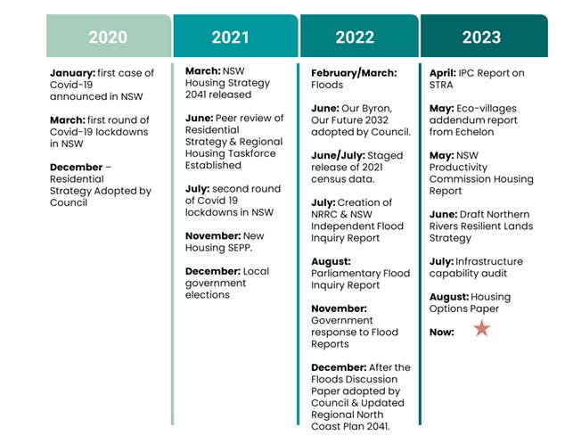
Specifically, the report introduced the Byron Shire Housing Options Paper (Attachment 2)
The Housing Options Paper as exhibited explores what has changed since 2020 and explains how this impacts the 2020 Residential Strategy. It outlines the options for how housing could now be delivered whilst responding to these changes.
In addition to the above, under the North Coast Regional Plan 2041 (nsw.gov.au) an implied housing target has been set by the DPE and Minister for Planning (Resolution 23-315) for Byron Shire as follows:
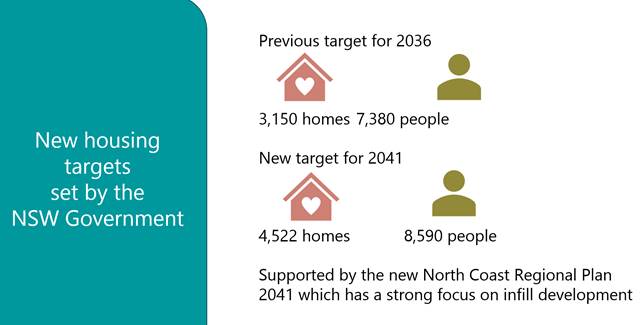
In order to meet our implied housing target by 2041, Council has identified 4 Keyways housing supply will be delivered over the next 20 years.
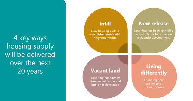
Each of these Keyways are explored in the Housing Options Paper in more detail, with the preferred Keyways recommended to meet the DPE housing target (Resolution 23-315) being a mix of infill, new release and vacant land supported by living differently specific to each locality.
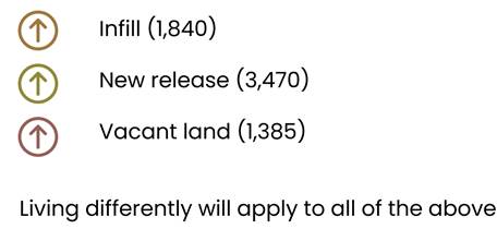
The preferred Keyways, as exhibited, combine to provide for up to 6,695 new homes in the Byron Shire over the next 20 years. This exceeds the DPE 2041 implied housing target.
Community engagement
· Housing Options Paper was open for public comment from 9 October 2023 to 6 November 2023. There were some late submissions also.
· Print media
· Have your Say Page and Social Media (Attachment 3)
· Online submissions
· Landowners of new release, vacant and removed land identified notified
· Individual meetings with community and landowners
· Staff telephone hotline
Presentations were made to:
· 20 September – Community Roundtable
· 21 September – Housing & Affordability Advisory Committee
· 4 October – Byron Town Centre Master Plan
Four in-person consultation sessions were held in Byron Bay, Mullumbimby, Brunswick Heads and Bangalow on 30 & 31 October with around 85 people attending these.
The primary purpose of the sessions was to inform members of the public about the proposed changes. This included a presentation outlining the changes and a facilitated question and answer session. People could also submit questions online via a QR or via an iPad. People were also invited to provide feedback by locality using feedback frames.
Community Submission Summary
See Attachment 4 Housing Options Paper Engagement Report for the details of feedback received.
Overall, 286 submissions were received during the public comment period. These are categorised as follows:
· Community General, Attachments 5, 6, 7 & 8
· Landowners (new sites and supporting existing sites in the Housing Options Paper), Attachments 9 &10
· Three sites proposed in Resolution 23-429 (9), Attachment 11
· Resident and Business Groups, Attachment 12
· Resilient Land Strategy landowners, Attachment 13
Generally, there was broad acceptance that Council needs to provide for diverse housing options to meet the needs of the community.
However, the level of acceptance for the extent of proposed change and how that housing should be delivered (i.e. by greater density by infill, release of new land or development of existing residential zoned land) was subject to a wide range of viewpoints which varied from locality to locality.
Key themes to emerge from the public comment period and submissions received are summarised below with a staff comment.
1. Policy Directions and Outcomes
Feedback
Multiple submissions noted that they understood the housing situation in the Byron Shire and the need to take action to develop new housing including medium-density options. Generally, there was support for new housing in areas that are flood-free, close to bike trails or the rail trail, close to town, eco-village structures, with community space and that are family-friendly.
On the other hand, multiple submissions were also received opposing any more housing, with concern that creating more housing will not address the affordability problem in the Shire and that growth conflicts with respecting the character of existing towns and villages.
Others submitted that the options have not been comprehensively assessed and therefore cannot be supported, and some felt that there needed to be more consultation about any proposed height increases and a focus on community-led solutions.
Staff comment
Council remains concerned about the housing crisis in the Shire. This is having a significant social and economic impact on the community and requires action by all levels of government as well as the broader community.
There are many resolutions of Council relating to housing, the declared housing emergency, current housing issues and responses to all.
As we know recent factors such as bushfires, COVID19 and flooding exacerbated an already pressurised housing market in Byron Shire and wider northern rivers region.
There have been many steps to develop the Housing Options Paper to inform the 2020 Residential Strategy Refresh. These have been reported to Council on numerous times, most recently September 2023.
Council has also been proactive and facilitated projects and implemented change, where able, to respond to the changing housing needs of the community.
Housing Affordability Initiatives - Byron Shire Council (nsw.gov.au)
To this end, the Housing Options Paper recommendations once endorsed will set a clear plan for housing in the Shire through to 2041. It will enable the 2020 Residential Strategy Refresh to reflect current social, economic, and environmental considerations. It will provide pathways, to enable housing choice, diversity, and affordability to meet the current and future needs of the community.
By definition a ‘residential strategy’ is a document to guide the location, type and form of housing within an area. It addresses how to cater to a growing population with changing housing needs while ensuring housing is available to ‘all’ in the future. It supports and is supported by other levels of planning.

The 2020 Residential Strategy as adopted by Council achieved the above definition. However, as detailed in the report to Council in September 2023, a refresh of this Strategy is needed.
Further details on the 2020 Residential Strategy Refresh are provided in this report.
2. Housing Targets
Feedback
Multiple submissions made specific comments on the ‘housing target’ in the Housing Options Paper, in particular noting concern that Council’s preferred keyways to meet this significantly exceeds the NSW Government target. It was also noted that Council has already supplied more housing than required in the past and the Shire is already above the NSW 10-year average population increase.
Others felt Council’s housing target should be reduced to align with infrastructure capacity and that Council should push back on, or reject, the NSW Government housing targets, with a more realistic target being set that reflects the unique nature of the area and potential impacts on the environment and wellbeing. Others did not agree with Council exceeding the NSW Government target by such a significant amount and submitted the imposed growth targets lacked research and analysis.
It was noted it would be helpful to have:
· the total of the current number of homes in each locality along with the number of proposed new homes
· details about the assumptions underlying the projected housing numbers
· maps with street name
Staff comment
The Housing Options Paper as exhibited used a high dwelling yield assumption to calculate future dwelling supply projections to meet our implied housing target across the Keyways. A number of submissions made comment on this. There was concern that in doing so Council had gone over and above in terms of future housing supply given past housing supply.
It should be noted that the dwelling yield assumption used to inform the Housing Options Paper was the same used in the 2020 Residential Strategy, adopted by Council. The dwelling yield assumption applied for new release was in the order of 26 dwellings per hectare. The DPE did not object to this approach back then.
In response to community feedback, and questions from the DPE about the dwelling yield assumptions in the Housing Options Paper, a change to our blanket approach to dwelling yield is now proposed.
What a change in approach will look like is a range of different dwelling yield assumptions applied via the Local Environmental Plan Residential zones and development standards across the infill, vacant and new release land Keyways in the towns and villages
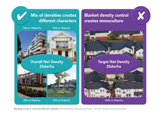
As show in the image above, this approach will deliver better housing diversity more directly via a mix of dwelling typologies, delivered through variations to lot size, floor space ratio and height, nuanced to suit the circumstances of the town, village, or site. Masterplans and or Place Plan controls will be used to inform the specific approach applied.
The delivery of these dwelling yield assumptions via LEP Dwelling Density Controls is consistent with the North Coast Regional Plan 2041 and that being used by other councils to meet their dwelling targets. For Byron Shire, it will ensure the right type of housing in the right locations.
Examples of this include: The Hills Local Environmental Plan 2019 - NSW Legislation and Tamworth Regional Local Environmental Plan 2010 (2011 EPI 27) - NSW Legislation
The revised recommended dwelling yield assumptions that will now be used to meet our implied housing target and inform Masterplan, Place Plan and LEP controls are summarised below:
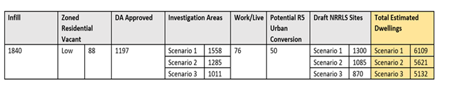
Investigation Area Dwelling Yield Assumptions
|
Scenario |
Dwellings/ha |
|
S1 |
26 Dwellings/ha |
|
S2 |
21 Dwellings/ha |
|
S3 |
16 Dwellings /ha |
These dwelling yield assumptions are represented in the images below – comparatively.
Figure: Lot layout 15-25 dwellings per hectare
Typical characteristics of this residential density range are:
· Predominantly a mix of detached dwelling houses, semi-detached dwellings and dual occupancies with some secondary dwellings.
· Focused areas of small lot dwelling houses (i.e. attached, abutting and semi-detached dwellings, multi-dwelling houses with secondary or studio dwellings on lots
· Single and double storey dwellings.
· Mainly suburban streetscapes, the occasional urban streetscape
Images: Streetscape and
examples 15 dwellings per hectare
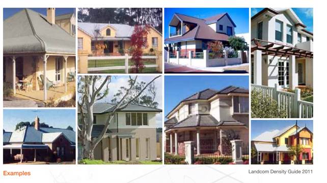
Figure: Lot layout 20 -25 dwellings per hectare
Typical characteristics of this residential density range are:
· Consists of predominantly small lot housing forms (including detached, semi-detached and attached or abutting dwellings and secondary or studio dwellings) with some multi-dwelling housing and some manor homes.
· Generally single and double storey dwellings.
· Incorporates some laneways and shared driveways.
· Be designed to provide for activation of the public domain, including streets and public open space through the orientation and design of buildings and communal spaces.
· Some urban streetscapes, some suburban streetscapes.
Images: Streetscape and examples 20 dwellings per hectare

Figure: Lot layout 25-30 dwellings per hectare
Typical characteristics of this residential density range are:
· Consists of predominantly small lot housing forms (including detached, semi-detached and attached or abutting dwellings and secondary or studio dwellings) with some multi-dwelling housing, manor homes and residential flat buildings located close to the local centre and public transport
· Generally single and double storey with some 3 storey buildings
· Incorporates laneways and shared driveways
· Be designed to provide activation for the public domain including streets and public open space through the orientation and design of building and communal spaces
· Mainly urban streetscapes, some suburban streetscapes
Image: Streetscape and examples 25 dwellings per hectare
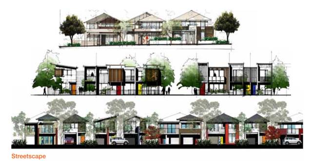
Images: Streetscape and examples 30 dwellings per hectare
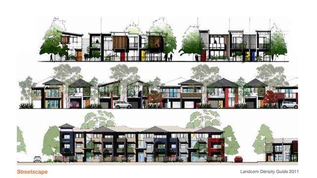
Staff are aware that dwelling yield assumptions although a useful planning tool to measure outcomes like implied housing targets (as set by DPE), should not be applied as blanket controls across areas or sites, as this results in a monoculture rather than variety of built form with respect to character, environment, and other matters such as site constraints and infrastructure capacity.
To this end, 2020 Residential Strategy included Policy 2: Improved housing choice, diversity and equity and associated directions and actions. The Tables on Pages 51 & 52 of this Strategy show how it was intended to deliver on a Byron Shire Housing and Lot Typology Mix through planning controls. The controls were to apply to each residential zone to achieve a recommended mix of lots and housing typology. As that Strategy was not endorsed by the DPE this work was not able to be progressed.
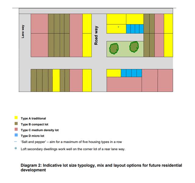
It is recommended that the revised dwelling yield assumptions described above, and changes needed to the associated Policy and actions in the 2020 Residential Strategy to deliver on these, be included in the 2024 Residential Strategy.
3. Flood
Feedback
Multiple submissions raised concerns about further fill or housing development on the floodplain, with concerns about how this would impact existing and future residents. It was also felt that the Housing Options Paper does not adequately consider the lessons from the 2022 floods in particular the recommendations in the 2022 NSW Independent Flood Inquiry and Council’s own After The Floods: Settlement Discussion Paper.
It was noted that Floodplain Risk Management Study needs to be updated with the 2022 flood data levels. It was submitted that any residential development already approved should be reassessed using the 2022 flood data. Also, clarity is needed on how Council’s development approval process will be tailored to make approvals contingent on the suitability of the house for the block particularly for flood-prone land.
A number of submissions also identified the need to prioritise housing for flood-impacted people.
Staff Comment
The current requirements of the North Coast Regional Plan, Settlement Guidelines and Urban Growth Area Variation Principles have been used to inform the Housing Options Paper. Location and settlement form has also had regard to hard (primary) and manageable constraints which include flood hazard risk and other flood planning considerations (e.g. Climate Change).
The 2020 Residential Strategy includes principles for ‘suitable-for-use urban lands’ including that the land is safe from hazards or risks such as high flood hazard, coastal erosion, tidal inundation, slip, dunal movement, extreme bushfire and slopes greater than 20%.
Lands included in the Housing Options Paper have been assessed using the above as well as the following flood-related criteria:
· Land identified in adopted flood studies with a medium or high future flood hazard risk (based on 2100 Climate Change)
· Land within a Fill Exclusion Zone
It is acknowledged that the NSW Government has supported, either in full or in principle, the recommendations of the 2022 Flood Inquiry and noted some will require further work on implementation, including further consultation with local and Commonwealth governments.
It is also acknowledged that further work and updates to Council’s current flood management plans is needed to incorporate the 2022 flood data levels (once this information is publicly available); but is also dependent on State Government making formal policy decisions about the 2022 Flood events and releasing updated flood planning and development requirements for use by councils. This will assist with Council’s review of DCP flood planning controls, which is currently underway.
In the meantime, the DPE is working with councils to determine how the planning for hazards is to occur, including flooding at the Strategy and or masterplan/rezoning stage.
It is recommended that a new or updated action be included in the 2024 Residential Strategy to address the issue of current and future flood planning more clearly, having regard to 2023 Flood risk management Manual and latest policy guidance.
Further, housing for the flood displaced remains a priority for Council. It forms part of ongoing discussions with the Reconstruction Authority and their Housing Taskforce. This includes looking at short medium- and long-term housing solutions – like the future of the temporary housing villages in Mullumbimby, Bayside and Brunswick Heads. Further updates will be reported separately to Council on this and will address concerns raised in submissions on same.
4. Housing In Rural Areas
Feedback
Multiple submissions noted that consideration should be given to the rezoning of rural land to create additional housing supply. This includes:
· innovative co-living arrangements
· alternative housing options (e.g., tiny houses, share houses)
· exploring how small neighbourhood centres could be created within rural areas
· considering the development of one or more new towns
· creating more housing in existing village areas such as Billinudgel, Federal and Ewingsdale
· more terrace style, shop-top and other medium-density housing along the rail trail.
· Three potential areas between Mullumbimby and Byron were suggested as being suitable:
o End of Quarry Lane, Ewingsdale
o 70 Foxes Lane, Tyagarah
o Dingo Lane/McAuley’s Lane, Myocum
· Council owned and operated tiny villages (similar to existing pod sites) to provide affordable housing at the following locations:
o Myocum north of Possum Shoot
o North of Mullum along rail trail
Staff comment
Some of the matters/suggestions raised in submissions are already possible under existing planning controls like expanded dwellings, co- living/multiple occupancy development. Modular housing is a form of building construction that can also be permitted subject to approvals. Some of the matters can be dealt with relatively easily by a new or revised Policy Statement or Action. Some matters however like new towns, new release areas and tiny villages are more complex and may not be able to be realised in the short term due to inconsistencies with the North Coast Regional Plan 2041 and or infrastructure capacity constraints. All feedback received will otherwise be reviewed as part of the 2020 Residential Strategy Refresh.
5. Infrastructure
Feedback
Multiple submissions queried whether there is sufficient infrastructure capacity to support the project housing growth, with particular concern about how infrastructure upgrades will be funded. There is particular concern for:
· sewer infrastructure capacity (e.g., sewerage treatment plants)
· water supply capacity
· stormwater system capacity
· road network capacity
· provision of car parking and public transport It was suggested that the transport strategy should be adopted concurrently with the refreshed Residential Strategy.
Comments were also received that any infrastructure options such as water supply and sewer should not punish the environment (e.g., problems created by West Byron STP), with new homes being required to have passive solar, water tanks and solar panels to reduce impact on infrastructure in the future.
Staff comment
There are different developer contribution regimes in place for local government:
Local infrastructure contributions, also known as developer contributions
These are charged by councils when new development occurs. They help fund infrastructure like parks, community facilities, local roads, footpaths, stormwater drainage and traffic management.
There are 2 forms of local infrastructure contributions:
· Section 7.11 contributions: Charged where there is a demonstrated link between the development and the infrastructure to be funded. Councils prepare contributions plans that specify what infrastructure will be provided and approximately how much it will cost. This is used to calculate a contribution rate, usually charged per dwelling or per square metre. Councils that want to charge a contributions rate above the threshold set by the minister (PDF, 290 KB) must submit their plans to IPART for independent review, amend per the minister’s advice, and approve the plans. Section 7.11 was previously known as section 94.
· Section 7.12 levies: are an alternative to s7.11 contributions and are charged as a percentage of the estimated cost of the development. The maximum percentage that can be charged in most areas is 1%. There are a small number of areas that charge a higher percentage. Section 7.12 was previously known as section 94A.
Water and Sewerage Developer Contributions (s64 Development Servicing Charges)
These are applied under Section 64 of the Local Government Act 1993. This enables Council to levy developer charges for water supply and sewerage.
These charges are an upfront charge, to recover part of the infrastructure costs from servicing new and existing developments.
· Developer servicing charges provide:
· A source of funding for infrastructure required for new urban development or growth.
· Pricing signals regarding the actual cost of urban development.
A Development Servicing Plan for both Water Supply and Sewerage needs to be prepared by any NSW Local Water Utilities (LWU) who propose to levy s64 charges for water supply and/or sewerage.
The diagram below shows how the inputs into a Residential Strategy are connected to and inform the development contributions plans of Council.

Source: Audit Office
Council has existing DSP, s7.11 and 7.12 plans in place.
A review of the DSP and s7.11 and s7.12 contribution plans is being progressed parallel to the 2020 Residential Strategy Refresh. See below for further comments.
Otherwise, water and sewerage infrastructure capacity and ability to connect to existing infrastructure has been confirmed for land in the urban growth boundary. Planning for future growth does include an allowance for climate change in relation to water security. New water and sewerage infrastructure to connect unserved / new properties however will need to be planned in detail including the capacity of existing systems to receive the additional loads created. Some of this modelling has already occurred and shows capacity for new release areas, with and without works. Funding of new infrastructure is also an issue that needs to be resolved through the development service plan review and at State level.
6. Affordable Housing
Feedback
Multiple submissions made comments about the importance of the supply of affordable and social housing and submitted that this should be a focus of the Residential Strategy. Concern was expressed about whether any new housing would be affordable particularly given land values. Others noted that there is no social housing in the plan and it is unclear how many homes will be rental and to buy housing aimed at the lower end of the market including those with very low incomes. In particular, suggestions were made that:
· A percentage of any new housing supply should be social housing or affordable housing
· New subdivisions should have a minimum of 30% affordable housing contribution
· The Affordable Housing Contributions Scheme should be extended to include new release
· Areas and increased infill areas in Brunswick Heads, Ocean Shores and Myocum
· The development of Council’s own land is the only way to ensure affordable housing (e.g. Model used by Ballina to develop housing)
· Council should advocate to the NSW Government for more public housing
· There must be a focus on housing for essential workers and volunteers
Staff comment
One of Council’s key initiatives to help deliver affordable housing for our community is to collect contributions from landowners when their land is upzoned.
An upzoning is defined as a change of zone to enable residential development or a change of planning controls (such as floor space ratio) which enables greater residential density on a site.
In Byron Shire there are several ways to do this.
• Local Environmental Plan 2014 Additional local provisions Clause 6.7 - Affordable housing in residential and business zones to enable imposing conditions relating to providing, maintaining or retaining affordable housing (currently operational).
• Voluntary Planning Agreements with negotiated terms for affordable housing contributions as part of the early implementation affordable housing project.
• Affordable Housing Contribution Scheme for lands that undergo an upzoning.
Council’s Affordable Housing Contribution Policy, 2020 includes the following statements of intent in relation to affordable housing as they apply to the Residential Strategy:
4.6 supports the Residential Strategy in identifying affordable housing contribution scheme investigation areas where a need and a general likely viability to contributions are established.
4.7 seeks the concurrent application of a SEPP 70 Affordable Housing Contribution Scheme clause over land subject to an upzoning.
4.8 supports, where appropriate, use of LEP Maps to help illustrate what is the preferred affordable housing contribution form for certain land
4.10 supports engaging with developers on Planning Agreements for the provision of affordable housing however, acceptance of an offer to enter into a Planning Agreement is at the absolute discretion of Council.
4.11 commits to implementing LEP 2014 Additional local provisions Clause 6.7 Affordable housing in residential and business zones to enable imposing conditions relating to providing, maintaining or retaining affordable housing.
4.12 commits as part of the Residential Strategy monitoring and review ongoing research, analysis and monitoring of local needs for affordable housing in the Shire.
4.13 respects in setting contribution rates, the NSW government policy position of a need for a developer’s ability to achieve an investment return in order to maintaining a sustainable development market and continued housing supply.
4.14 guides the Residential Strategy to set a minimum affordable housing contribution rate for areas based on Council’s understanding of development feasibility.
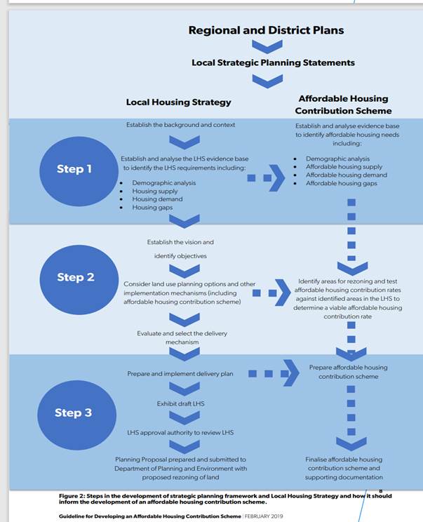
Staff intend to commence feasibility assessments of all new land identified in the Housing Options Paper as a precursor for inclusion in the 2024 Residential Strategy and new AHCS 2 for Byron Shire. From a timing standpoint, finalisation of AHCS 2 will need to align with the State government’s endorsement of the 2024 Residential Strategy.
Further, a review of the above AHC Policy is due next year. This review needs to include reference to the Residential Strategy 2024, and other matters of policy not currently addressed like: target groups for housing, types of housing needed, mechanisms for dedication and implementation of the dedication once received.
In response to Council land being used to pilot development for affordable, key worker and community housing there are two live projects attempting to do this:
57 Station Street Mullumbimby
Affordable housing project in Station Street Mullumbimby - Byron Shire Council (nsw.gov.au)
Former Mullumbimby Hospital Site
Mullumbimby Hospital redevelopment - Byron Shire Council (nsw.gov.au)
See below for further comments.
7. Living on Country
Feedback
Multiple submissions noted that the Residential Strategy should include consideration of housing for local Aboriginal people as a matter of priority including:
· actions about how Arakwal people can access affordable land and housing particularly additional areas on the East of the Pacific Highway and in the proposed Saddle Road precinct
· need for consultation with Minjungbal people and Native Title holders in the area
Staff comment
The above comments are acknowledged and will be further actioned by staff under Resolution 23-509. See below for further comments.
8. Environment
Feedback
Multiple submissions raised concern about the impact of future housing growth on the natural environment and biodiversity of the Shire. It was noted that the environment is highly valued by those who live in the area. Others noted that the Housing Options Paper does not adequately consider climate change risk and sea-level rise and how this will impact where housing should be located in the future. It was submitted that the Housing Options Paper should be delayed until the NSW Parliamentary Inquiry into the planning system and the impacts of climate change on the environment and communities has been completed.
Staff comment
The North Coast Regional Plan 2041 sets out clear requirements for where urban housing is to occur and how. The Environment is a major consideration in the Plan.
The 2020 Residential Strategy already includes consideration of the environment, biodiversity and climate change and adaptation in the policy statements and actions.
It is recommended that a new or updated actions be included in the 2024 Residential Strategy to address the current and potential environment, climate change and resilience considerations more clearly.
9. Short Term Rental Accommodation
Feedback
Multiple submissions made comments about short-term rental accommodation (STRA) and the need to consider the impacts of tourism more generally in the refresh of the Residential Strategy. In particular, this included:
The Housing Options Paper does not consider the supply of housing to be returned to permanent housing after September 2024 when the new STRA rules start.
Council should ensure any new homes are not converted to STRA including prohibiting STRA in new subdivisions.
Council should audit the use of granny flats to ensure these are not being used for STRA.
Staff comment
Changes for non-hosted STRA were endorsed by the NSW Government in September 2023. There will be a 12-month transition period for the community and industry to prepare. The new day caps will take effect on 23 September 2024.
Report No. 14.1 Deputy Secretary NSW Planning requirements of Byron Shire Council to address Independent Planning Commission Advice Report on Byron Shire Short Term Rental Accommodation in relation to Housing Supply 26.2020.1.1 Late Items Agenda of Ordinary (Planning) Meeting - Thursday, 10 August 2023 (infocouncil.biz) talks to the relationship between STRA and housing supply as per the IPC Findings Report endorsed by the Minister for Planning.
In addition to the above, there are various resolutions of council that relate to STRA, including monitoring and enforcement of rules around use.
Notice of Motion No. 9.3 Short Term Rental Accommodation Consent Conditions
Agenda of Ordinary (Planning) Meeting - Thursday, 9 March 2023 (infocouncil.biz)
Report No. 13.10 Update Resolution 23-056 Short Term Rental Accommodation Consent Conditions Agenda of Ordinary Meeting - Thursday, 26 October 2023 (infocouncil.biz)
10. Infill Key way
Feedback
There was mixed feedback about the options relating to infill development. It was noted that Council’s assumptions underlying Option 1B need to be spelt out.
Multiple submissions supported the reduction of the minimum lot size to create a mix of housing that better meets people’s housing needs including affordability.
This includes more one- and two-bedroom homes near amenities. There was also support for greater density subject to infrastructure being upgraded to deal with additional demand.
However, other submissions raised concerns that communities are already at capacity and the existing character and identity of villages should be respected.
It was submitted that deducing the minimum lot size and increasing building heights would not maintain the local character of neighbourhoods and adversely affect amenity.
Specific concerns were raised about increased stormwater runoff from smaller lots and implications for managing stormwater and flooding impact. There was also some concern that smaller lot sizes, and the creation of apartment-style living, would create “Gold Coast slums” and destroy the natural environment and current way of life, with negative outcomes for people’s wellbeing.
Other submissions noted the need to undertake a detailed infrastructure analysis to confirm capacity. Other submissions noted that established homes have not been designed for infill (e.g., granny flat boom has resulted in noise and parking issues) and consideration needs to be given to Council’s efforts in recent years to increase infill through granny flat development.
Staff comment
Infill, density, and infrastructure are discussed in this report.
It is also acknowledged that additional flood affected areas in the Shire warrant identification in the Strategy as an “Infill Exclusion Area”. This should apply to areas where flood hazard characteristics may restrict any future planning for infill at a greater density.
11. New release Keyway
Feedback
Multiple submissions stated support for new investigation areas for housing especially in flood-free areas, areas that are already cleared, are near the rail-trail or close to town. It was noted that there was a preference to create new villages rather than densify existing ones.
However, other submissions were opposed to the use of farmland for housing particularly in Brunswick Heads, Bangalow and Billinudgel or submitted that any use of significant farmland should be very limited, with additional planning controls being developed by Council before rezoning proceeds.
It was noted that this land was important for future food security. Some raised concerns that the proposed investigation areas have not adequately considered for constraints and more information is needed about the position of the NSW Government agencies.
Others raised concerns about the development of rural land for multiple occupancies and noted that conversion to community title has been a way to subvert the Rural Land Use Strategy and that any more residential development on RU1 and RU2 land should be stopped, other than where there is an existing dwelling.
This will help preserve the agricultural capacity of the land. Others submitted any new subdivisions must:
· Prohibit dogs and cats
· Provide adequate wildlife corridors
· Manage all stormwater and runoff.
Staff comment
Divergent views on new release lands as a keyway have been received.
Specific sites have been assessed against the North Coast Regional Plan 2041 and or identified in the Resilient Lands Strategy. Comments on the future planning of these areas has been made elsewhere in the report or in response to submissions generally.
The 2020 Residential Strategy already includes requirements for structure plan preparation for new release areas to address planning, design, infrastructure, environment, and community needs.
It is recommended that these principles be updated as new actions in the 2024 Residential Strategy.
Commentary made about rural land multiple occupancies and community title conversation is noted. This pathway already exists in the Byron Shire LEPs and DCPs.
Restrictions on subdivision as suggested are a matter for a development application.
12. Vacant land Keyway
Feedback
Several submissions were received about the options for vacant land. There was general support for this option, with particular support for increasing densities on existing zoned vacant land. It was also noted that any increase in density requires detailed consideration of land capability and impacts.
Staff comment
The above comments form part of the Housing Options Paper recommendations.
13. Living differently Keyway
Feedback
Multiple submissions were received in general support of this option with feedback that more information is needed to fully understand this option, particularly incentives.
Comments were made that Council should:
· Provide incentives and guidance for living differently including splitting existing homes into a secondary dwelling
· Include granny flats as a way forward
· Acknowledge and explore living in vans / sleeping in cars as a valid low footprint way of living and consider creating designating areas for this type of living
· Consider how to change existing rules to increase underutilised homes and to enable people to age in place
· Re-install the train to provide more options
· Include options to encourage more affordable housing
· Better use existing community assets and buildings
· Consider houseboats, caravans and tiny homes as an option
· Create a matching service
· Consider new solutions such as a community land trust and rent-to-buy options
· Consider new construction modes such as pre-fabricated, modular homes
· Consider pavilion homes where the kitchen and laundry are communal
· Focus on innovative housing for lower-income groups that are at risk of being marginalised by increasing housing prices
· Several submissions also noted that this option suggests the way we are living now is inappropriate.
Concern was also raised that increasing density by turning a single-family house into a home for multiple residents will not enable Council to capture additional rates for demands on infrastructure. Others noted that it will be difficult to create dual-key housing and ensure that it is not used for STRA.
Staff comment
The feedback received and suggestions for Living Differently are acknowledged.
Some of the suggestions raised are already possible under existing planning controls like expanded dwellings, co living/shared housing development, dual key housing. Modular housing is a form of building construction that can also be permitted subject to approvals, and in certain circumstances caravans and movable dwellings are permitted on certain lands.
Council will need to further expand on and explore what inter-generational and intentional co living, Fonzie Flats, look like for Byron Shire.
Is multi-generational living the future of housing? | Modus | RICS
Cohousing Australia - Transition Australia
Also, what changes to policy/legislation/ Building Codes is needed to support these, or incentives to landowners to convert existing stock over.
Some of the matters can be dealt relatively easily by a new or revised policy or action. Some matters however like implementing different governance models on development e.g., build to rent, rent to own, and shared equity is more complex, and can impact a developments viability. These are also out of scope for a council to require on private land.
The further investigation of new and suitable types of, and changes to controls and regulations to support Living Differently in Byron Shire will be a new action in the 2024 Residential Strategy. Council may also look to pilot some forms thereafter on its own land or through an expression of interest with private landowners.
14. Town and Village Specific issues Summary
Town and village specific issues raised included:
· New housing must be safe
· Infrastructure must be adequate to support growth
· Village character must be respected and retained
· There should be a consistent height across the Byron Town Centre CBD
· Need for more opportunities for housing in the Town Centre
· Impacts of STRA need to be considered
For the most part these issues are addressed under similar headings elsewhere in the report. See Attachment 4 Housing Options Paper Engagement Report for full details and feedback received.
The comments in relation to the Byron Bay Town Centre heights however relate to the Business zones that were subject to a previous planning control review by Council. This reviewed informed LEP and DCP updates and also introduced Design Excellence controls for the Byron Bay Town Centre.
For the most part the Business Zone has a height control of 11.5m except for those parts of the town centre deemed better to retain 9m due to an interface with the adjoining residential zone or scenic / amenity considerations from Main Beach.
This is a Housing Options Paper to inform the refresh of the 2020 Residential Strategy, whereas the Business zones are subject to the Business and Industrial Lands Strategy.
Notwithstanding the above, the Housing Options Paper includes a defined residential area that wraps around the Byron Town Centre for development standard review (See Map 4 in Housing Options Paper, Attachment 2) to optimise housing potential close to the Town Centre. It may be that those areas that retain the 9m height limit in the Business zone can be reviewed again then. This will be a decision about project scope when and if the project is funded by the DPE. A grant application is pending.
15. Specific Sites Feedback
Divergent views have been expressed on several sites already included in the Housing Options Paper. These have been taken into consideration by staff in making their recommendations about these sites.
See Attachment 4 Housing Options Paper Engagement Report for full details and feedback received.
Department of Planning and Environment Feedback
A submission was received from the Department of Planning & Environment (DPE) on 2 November 2023, Attachment 14. It is under consideration.
The submission commends Council on revisiting its strategy approach to deliver housing and strongly encourages it to pursue options within the existing planning framework which will help increase housing supply and ensure Council fulfils its commitments to the Minister for Planning.
In particular, the submission notes:
· The refreshed Residential Strategy must be consistent with all relevant State planning policies, plans and directions.
· The Strategy should also incorporate options to increase housing supply and diversity that help support community needs.
The Strategy should plan for increased density within the existing urban growth boundary to meet the infill targets in the North Coast Regional Plan 2041. This will be critical to establishing new release areas on important farmland.
· Any new investigation areas outside the existing urban growth boundary must hazard-free and be assessed against the State Guidelines for suitability. Density in these areas must be maximised.
· The Strategy must include a staging and sequencing plan and monitoring program.
· The Strategy should identify key infrastructure works required to support growth as well as further infrastructure servicing strategies that are needed to support future planning proposals.
· The Strategy should recognise recent changes to short-term rental accommodation rules and the impacts this will have on future housing supply, and Council should consider whether certain forms of tourist and visitor accommodation are appropriate in some residential areas to support tourism.
· The Strategy should include an evidence base.
· Consultation with the State agencies should be undertaken before finalising the Strategy refresh.
The letter also states – ‘that Council has committed to adopt and submit the Residential Strategy for the Department’s approval by March 2024 and reaffirms the importance of Council delivering to its commitments and the milestones nominated to the Minister to enable increased housing supply’.
Other State Agency Feedback
A meeting with relevant state government agencies including (Planning, Primary Industry, Environment, Coastal, Transport and Reconstruction Authority) occurred 15 November 2023.
The objective of the meeting was to bring State agencies together with Council to discuss Councils ‘Housing Options Paper’ and the revised Housing Strategy refresh options for both infill and new release keyways.
This feedback is needed to enable Council to finalise the Housing Strategy Refresh for submission to the DPE.
Attachment 15 Agency feedback. Not all Agency feedback was provided in time for inclusion in the report.
Any Agency feedback received after this report was written, will be considered prior to finalising the 2020 Residential Strategy Refresh as per the report recommendation.
Generally speaking, the agencies at the meeting were supportive of the Housing Options Paper Keyways approach and made high level comments where relevant to their agency on the land identified for future housing on the Maps.
Once adopted by Council and submitted to the DPE for final review, further changes may still be required to address Agency submissions where there is a difference of opinion, to enable DPE ‘Strategy endorsement’.
Notwithstanding the above, Council will need to continue to consult with the DPE to finalise the Residential Strategy 2024. This will ensure State Policy is met and the level of technical information required is adequate for sign off.
Lands subject to resolution 23-429 (9)
9. a) Further investigates additional land identified by land holders for potential inclusion in the Strategy, including but not limited to the land identified in Buckleys Road Tyagarah, 75 New City Road Mullumbimby and 64 Corkwood Crescent Suffolk Park.
Submissions were received from each landowner or their representative which are in Attachment 11 Staff also meet with each landowner or their representative during the public comment period.
Following a review/investigation of these lands, as per the resolution, the New City Rd and Corkwood Cres sites were supported for inclusion in the Strategy and the Buckleys Rd site was not supported, refer to Attachments 16 (supported sites) and 17 (not supported site), for further details.
Table 1: Lands subject to Res 23-429 supported and not supported
|
Sites Supported |
Sites Not Supported |
|
75 New City Road, Mullumbimby |
Buckleys Road Tyagarah |
|
64 Corkwood Crescent, Suffolk Park |
|
b) Further investigates all Council owned land including the property on Vallances Road and any depot or other Council owned, flood free land.
Given the amount of work involved in (b) and the complexities around council land management and use, it is recommended that this item be included as an updated action in the 2024 Residential Strategy.
In relation to the two sites listed specifically in the resolution, comments are provided below:
|
Vallances Road |
The site is currently owned by the sewer fund and is classified as operational land for the purposes of sewerage treatment works and other council operations as identified. This classification and primary use of the site remains necessary and current. As to the Housing Options Paper: inclusion of any land into the Housing Options Paper (to inform the Residential Strategy Refresh) has been based on the specific lands ability to meet the Department of Planning requirements for inclusion in a Strategy under the North Coast Regional Plan 2041 and Settlement Planning Guidelines as current. This site does not meet the requirements and as such is not included. Further, any new or additional uses of the site must consider potential/proposed expansion of the Brunswick Valley STP (or other operational use of the land) in terms of land area requirements and also the buffer zone requirements around an STP that must be maintained. Otherwise, the existing dwellings on the site are currently being used and repaired for the purpose of council staff housing. As you can appreciate in this current market, recruiting and retaining key staff is also a challenge for council, and being able to provide housing has been one way to secure key skilled staff that otherwise would not be able to move here to work. Resolution Vallances Road options and next steps (Res 22-658) will be subject of a separate report to Council. |
|
Council depot Bayshore Drive |
Subject to an action in the current Operational Plan 23/24: 1.3.5.10 Review future options for current depot site This action will be the subject of a separate report to Council. |
Submissions on Sites/Land included in the Housing Options Paper
Submissions were received from landowners and others on the lands included in the Housing Options Paper. After consideration of the submissions received all sites are proposed to be retained in the 2024 Residential Strategy. Attachment 18 provides more details and Attachment 10 (landowner submissions).
New Sites/Land Assessment
Requests were also received from landowners for consideration of their land to be included in the 2024 Residential Strategy.
This land has been assessed through a sieve constraints analysis that has taken into consideration inter alia the North Coast Regional Settlement Planning Guidelines, North Coast Regional Plan 2041, Ministerial Directions, State Policies, Council plans and policies and recent infrastructure capability assessment.
The sieve constraints analysis considers primary and manageable constraints, including environmental and geophysical i.e., slope, flood hazard, vegetation, important farmland categorisation. There is also an implied principle that new release land should be a contiguous extension of the existing urban area unless the development is of a new village scale.
Through this analysis some sites are proposed to be supported and others are not supported. Below is a list of sites supported and not supported. Attachment 16 provides further details on the sites supported for inclusion in the Residential Strategy. Attachment 17 provides further details on those sites not supported. Attachment 9 includes submissions from landowners for new sites.
Table 2: New sites supported and not supported
Sites/Land already located within the urban growth boundary
There were several requests for sites to be included in the 2024 Residential Strategy that are already located within the urban growth boundary. These requests were in relation to the land below. As these sites are in the urban growth boundary, they don’t need to be included in the 2024 Residential Strategy as they can already proceed with a planning proposal.
These sites were assessed against the same primary and manageable constraints as the New Lands Assessment. Of the seven sites, four sites have less constraints and three sites were highly constrained. Attachment 16 (supported sites) includes the four less constrained sites and Attachment 17 (not support sites) includes the highly constrained sites. Submissions for sites within the urban growth boundary can be found in Attachment 19.
Table 3: Sites already located within the urban growth boundary
|
Sites less constrained |
Sites highly constrained |
|
62 Broken Head Road, Byron Bay (Byron Bay Golf Course) Lot 365 DP704227, Lot 11 DP1200712, Lot 13 DP227607 Submission #E2023/127550 |
94-106 Broken Head Rd, Suffolk Park Lot 1 DP408810, Lot 6 DP111821 Submission No.237 |
|
139 Bangalow Road, Byron Bay Lot PT22 DP549688 Submission #E2023/121775 |
10 Ironbark Ave, Byron Bay, Lot 435 DP729107 Submission No.181 Owner: Bundjalung of Byron Bay Aboriginal Corporation (Arakwal) |
|
Lot 451 DP1175252 Lawson Street and Lot 452 DP48493 Tallow Beach Road, Byron Bay Submission No.181 Owner: Bundjalung of Byron Bay Aboriginal Corporation (Arakwal) |
1-5 Broken Head Road, Byron Bay Lot 1 DP573835, Lot 2 DP573835, Lot 9 DP708338, Lot 7 DP580423 Submission No.181
|
|
Lot 2 DP1275809 and Lot 438 DP729107 Bangalow Road, Byron Bay Submission No.181 Owner: Bundjalung of Byron Bay Aboriginal Corporation (Arakwal) |
|
Other matters for consideration
· Resilient Lands Strategy (Resolutions 23-303 and 23-429)
Discussions have been ongoing with the Northern Rivers Reconstruction Corporation, now NSW Reconstruction Authority, about the sites identified by them as B1 and B2 short term sites, and the yellow medium-term site in their Resilient Lands Strategy.
The Reconstruction Authority is yet to release a final Resilient Lands Strategy, although at the time of writing this report, it is understood to be imminent.
Although not confirmed in writing, there appears to be agreement amongst Reconstruction Authority, DPE and Council that the Resilient Lands Strategy sites should be part of a Council managed process which would see a master plan including service infrastructure, transport, environment and housing typology considerations part of a planning proposal and associated planning agreement/s submitted to Council for progression to gateway (rezoning).
A current example of this being Lismore Council has recently supported a proposal for a rezoning of land at Goonellabah.
Rezoning Planning Proposal for land at 1055 and 1055A Bruxner Highway Agenda of Lismore City Council - Tuesday, 21 November 2023 (nsw.gov.au) Precis extract below:
The Planning Proposal seeks to amend the land zones, minimum lot size and height of building controls within the Lismore Local Environment Plan 2012 to enable future residential, commercial, industrial and recreational development across the 75 hectares of the site.
The site is identified in Lismore Council’s Growth and Realignment Strategy (2022) and the supporting addendum that specifically addresses the need for new flood free employment lands in the region. The mix of zonings proposed across the site will allow for the integration of new housing, employment, recreation and community facilities.
A Draft Voluntary Planning Agreement (VPA) will also ensure there are opportunities for the affordable relocation of dwellings from high flood-risk areas, as well as the provision of environmental benefits along Tucki Tucki Creek.
As with the Lismore example - grant/other funding agreements through the Resilient Lands Fund seem possible to enable development on the Resilient Lands Strategy sites to meet housing need and demand post 2022 Floods.
Specific actions in the 2024 Residential Strategy will confirm a collaborative approach to the planning and development of these sites with all stakeholders involved at the relevant time.
In addition, lands owners for B1, B2 and orange sites in the Resilient Lands Strategy have made individual submissions to the Housing Options Paper, including details of potential development density and layouts. See Attachment 13.
The merits of the proposals in the submissions have not been assessed by staff.
These submissions will be used to inform discussions with the Reconstruction Authority, DPE and landowners on the planning pathways to progress to rezoning/masterplan and development plans for these sites.
· Contributions Plans Review (Resolutions 21-240 and 23-387)
Updated and or new Local Contributions Plans for community facilities, open space, road, cycleways infrastructure needs to be prepared as a result of the Housing Options Paper Keyways.
Discussions with Reconstruction Authority and other agencies like Transport for NSW will also occur about the land identified for short- and medium-term development in the Resilient Lands Strategy, and implications for Council’s local contribution planning should this land be developed early.
A separate report on this Agenda talks to the 7.11 and 7.12 Contribution Plans review to progress in response to the Council resolutions and the Housing Options Paper recommendations.
Further, a new revised Development Servicing Plan (Water and Sewer) is in the process of being drafted. Inputs needed include the capital works and infrastructure renewal program and hydraulic models that rely on population growth inputs, etc reliant on the Housing Options Paper recommendations.
It is understood that an update to Council via workshop and report will occur in early 2024 about this work and review to coincide with the finalisation of the 2024 Residential Strategy.
The existing 2020 Residential Strategy already refers to the following principles for infrastructure to support new development:
· the need for forward planning of infrastructure, both in new release areas and associated town centres and other related infrastructure networks (e.g., transportation, drainage) to effectively integrate new areas with existing areas.
· recognising the benefits of development in and around transportation nodes, particularly rail, as well as pedestrian/cycle connectivity between new release and established areas.
· the need to create mechanisms and a level of certainty in delivering housing diversity that is consistent with residential character and community objectives, ensuring policies can be achieved.
· recognising the benefits of increased density in and around town centres
· the new land is connected or capable of being connected in a logical sequence to water, sewer, stormwater, and communication infrastructure that can accommodate projected demand at no additional cost to the council or the community.
It is recommended that these principles be updated in the 2024 Residential Strategy.
· Aboriginal Housing On Country (Resolution 23-509)
This resolution is multi-faceted and cross directorate.
There are some parts of it that can be included as new actions in the 2020 Residential Strategy Refresh. There are others that will need to progress by separate actions of Council.
The existing Residential Strategy already refers to ‘working with the Aboriginal Community’:
Action 20: Work with the Bundjalung of Byron Bay (Arakwal) people to respect, recognised and safeguard culture through establishment an application of a Protocol framework for participatory working with the Aboriginal community (as outlined in Strategy Appendix B) including for: a) assessing appropriate locations for housing b) review of planning framework provisions for housing, local character and infrastructure.
It is recommended that this action and protocol be updated with any additions as identified necessary in the 2024 Residential Strategy to align with Resolution 23-509.
Further, discussions will continue to occur with relevant agencies like DPE and Reconstruction Authority, and landowners about the Resilient Lands Strategy. It is likely that planning agreements will be necessary between the various parties to acknowledge and facilitate a pathway for housing on country on these lands where agreed to.
In addition, Bundjalung of Byron Bay Aboriginal Corporation has made a submission to the Housing Options Paper in relation to 3 sites. Two of these sites have been supported and one has not, as discussed above.
· Affordable Housing Delivery and Contributions Plan Scheme 2 (Resolution 23-429)
The development of an Affordable Housing Contributions Scheme (AHCS) is complex and has many stages.

Under the current system that enables these contributions, Council may only impose a condition of development consent if it has an AHCS in place, and the AHCS is authorised by Council’s Local Environmental Plan.
As such it is imperative that AHCS 2 is in place prior to the new lands in the Residential Strategy 2024 proceeding to planning proposals.
Further discussions with the DPE about this are needed to ensure that the intent of the 2024 Residential Strategy and AHCS 2 are not undermined by an out of sequence endorsement of the 2024 Residential Strategy.
There may be exceptions to this, including the Resilient Lands Strategy sites that can be subject to separate planning agreements and arrangements with RA, DPE and Council to secure a contribution of affordable housing on site.
Following adoption of the Housing Options Paper recommendations and confirmation of new lands, staff will formally write to landowners to advise them of their obligations under the existing Affordable Housing Contribution Policy 2020 (as applicable) should they seek an upzoning of their land.
For the new sites identified, landowners will be advised that an AHCS 2 is progressing in parallel with the update and final endorsement of Council’s 2024 Residential Strategy.
2020 Residential Strategy Refresh (Residential Strategy 2024)
There are changes needed to the body, content, format, and name of the 2020 Residential Strategy to refresh it.
The 2020 Residential Strategy Refresh (to become Residential Strategy 2024) and will generally retain the vision and four policy areas of the previously adopted Strategy. These remain accurate to the current context, with some minor editing to reflect current industry language - the intent remains the same as reflected in the below diagram.
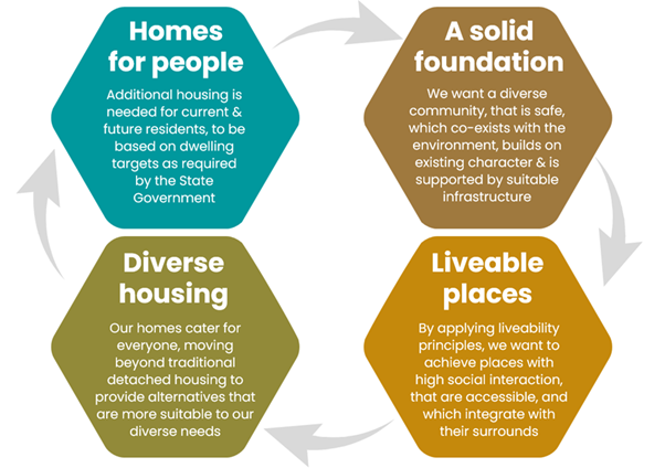
Directions and actions of the previous Strategy will be adjusted to account for the changes established through the Housing Options Paper, updated for data (e.g., 2021 Census) and policy changes (e.g., North Coast Regional Plan 2041), and reflect the progression of Council’s other efforts and completion of actions of the previous Strategy (e.g., STRA and Affordable Housing Contributions Scheme). It will also reflect the changes requested through the Peer Review process of 2021, with particular reference to developing implementation sequencing and monitoring.
The layout of the document will be updated to reflect the State Government’s requirements under the Local Housing Strategy Guideline that was released after the previous Strategy was developed. The look and feel of the document will also more closely align with the After the Floods Discussion Paper and Housing Options Paper for consistency with the community and to reflect Council’s updated style guidance. The generalised layout of the Residential Strategy 2024 is reflected in the diagram below.
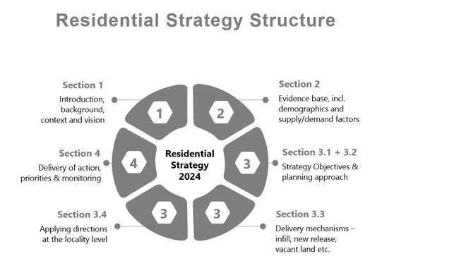
Due to feedback received and staff responses to it, and changes needed to the 2020 Residential Strategy document described above, staff will update and present a final 2024 Residential Strategy to Council in February 2024 for final approval prior to submitting it to the DPE for endorsement.
The format and content to generally align with the table below.
|
Working draft RESIDENTIAL STRATEGY refresh POLICY AND DIRECTION STRUCTURE |
|
|
Direction |
Sample of key issues to be addressed |
|
Policy 1 – Providing land for future housing |
|
|
Direction 1.1 - The majority of our Shire’s future housing will be in urban towns and villages. |
· Prioritise housing delivery in areas with high access to services · Recognise that some housing will be delivered in rural areas, as envisaged by the Rural Lands Strategy · Meet Regional Strategy requirements for urban infill |
|
Direction 1.2 - Land for housing will be suitable for the use. |
· Ensure land for housing meets appropriate standards, including being safe from floods and other hazards · Provide for infrastructure that is adequate to support projected growth · Protect sensitive natural environments and other strategically important lands · Facilitate infill by reducing the minimum lot size, reviewing development standards (e.g. Byron Bay town centre) and progressing the urban conversion of rural residential areas |
|
Direction 1.3 - New subdivisions and infill will support the attributes of liveable neighbourhoods. |
· Avoid standard approach to development / urban sprawl · Ensure new release areas are supported and informed by master plans or neighbourhood plans, where appropriate · Promote social resilience, community cohesion and sustainability · Encourage cycling, walking and public transport use · Ensure diversity in lot size and urban form to support a diverse community · Integrate public space, environmental, cultural and other site attributes · Ensure future development does not exacerbate risks for existing residents |
|
New - Direction 1.4 - Monitor housing to facilitate short, medium and long-term new release or infill opportunities. |
· Monitor and manage the housing pipeline · Sequence infrastructure and housing delivery for efficiency · Fund and progress infrastructure in line with Council’s 10-year priority infrastructure plan · Meet Peer Review recommendations |
|
Policy 2 – Improved housing choice, diversity and equity |
|
|
Direction 2.1 - Support a range of urban lot sizes that facilitate a greater range of housing. |
· Encourage greater housing diversity in new release and vacant land areas through a ‘salt and pepper’ approach to subdivision lot size · Support greater diversity in housing cost and affordability |
|
Combined - Direction 2.2 - Enable opportunities for new and/or innovative residential forms, including a range of low-rise medium density housing types. |
· Encourage more compact urban forms to facilitate greater connectivity · Provide a more diverse range of housing for broader community needs · Enable new forms of housing that can assist in more affordable outcomes over the longer term · Be open to different approaches in the future, even where not part of the mainstream planning system |
|
Direction 2.3 - Encourage the use of adaptable and liveable house design outcomes. |
· Cater for an aging population · Cater for more inclusive housing types for a range of abilities · Explore ways to incentivise the efficient use of land and existing homes · Focus on awareness and education about adaptable and liveable home design and use |
|
Direction 2.4 - Facilitate growth in the proportion of rental and rent-to-buy housing for lower income groups. |
· Support the delivery of affordable and social housing including the provision of housing for key workers · Incentivise delivery of housing types suitable for a range of groups, with a particular focus on affordable and social housing · Facilitate housing through the delivery of the Affordable Housing Contributions Scheme
|
|
Policy 3 – Housing that reflects the local in places |
|
|
Direction 3.1 - Respect the current and/or emerging character and values, as recognised in residential character narratives, for specific areas. |
· Respect, retain and build upon the local character of towns and villages · Introduce measures to promote good design that is appropriate for the locality · Develop design guidance to ensure that character is consistently applied |
|
Direction 3.2 - Maintain and enhance the sense of community |
· Further develop local identity through place planning · Include opportunities for community expression through localised place making initiatives · Ensure that future development is consistent with liveability principles |
|
New - Direction 3.3 - Work with local Aboriginal community and Native Title holders to allow Bundjalung People to live on and connect to Country |
· Support initiatives by Aboriginal people and associated groups to increase investment in, and supply of, housing that meets Aboriginal resident needs · Encourage partnerships to facilitate housing projects, such as development of land holdings owned by Local Aboriginal Land Councils for Aboriginal housing |
|
Policy 4 – Make our neighbourhoods local |
|
|
Direction 4.1 - Make dwellings homes again |
· Monitor the impact of STRA changes as homes are transitioned back to the market or to permanent rental · Encourage conversion of STRA properties to permanent resident homes |
|
Modified - Direction 4.2 - Implement and enforce changes to STRA regulation, whilst supporting the broader tourist accommodation sector |
· Work with the tourism industry through the transitional introduction of new STRA provisions to ensure alternative accommodation choices are available · Enforcement and monitoring undertaken of STRA properties in conjunction with State authorities |
Housing Options Paper Recommendations
The Housing Options Paper identified a number of Housing Pressures in the Byron Shire that the 2020 Residential Strategy Refresh needs to address:
· Housing Stress is growing
· Housing affordability and availability is worsening
· Housing for Key Workers has become a more pressing issue
· Homelessness is growing
· Impacts of Short-Term Rental Accommodation
From what we have heard there are other pressures like:
· Current housing stock is not diverse enough to cater for current and future demand
· Constraints impede the supply and availability of zoned and serviced land for housing
· Desire to balance housing growth and the attributes that community values about the area
With this in mind the Housing Options Paper and additional recommendations below are now proposed to inform the 2020 Residential Strategy Refresh:
· New Dwelling Yield Assumptions
· Certain New Lands for inclusion
· Updates to policy and associated actions in 2020 Residential Strategy to address the issues raised during the public comment period where relevant to the 2020 Residential Strategy Refresh
· The changes needed to the body, content, format and name of the 2020 Residential Strategy to refresh it.
· Council to adopt the Housing Options Paper and Recommendations to enable staff to complete the 2020 Residential Strategy Refresh.
· 2020 Residential Strategy updated as per the report and its recommendations.
· Final updated 2024 Residential Strategy presented to Council February 2024 for approval to submit to DPE.
· Submission to DPE made before 31 March 2024 as per Resolutions 23-165 and 23-315.
Strategic Considerations
Community Strategic Plan and Operational Plan
|
CSP Objective |
CSP Strategy |
DP Action |
Code |
OP Activity |
|
4: Ethical Growth |
4.1: Manage responsible development through effective place and space planning |
4.1.2: Growth Management Strategies - Implement Local Growth Management Strategies |
4.1.2.5 |
Revise and update Residential Strategy |
|
4: Ethical Growth |
4.1: Manage responsible development through effective place and space planning |
4.1.4: LEP & DCP - Review and update the Local Environmental Plan and Development Control Plans |
4.1.4.7 |
Progress Short Term Rental Accommodation planning proposal |
|
4: Ethical Growth |
4.2: Enable housing diversity and support people experiencing housing insecurity |
4.2.2: Partnerships and pilots to address housing needs - Investigate partnerships and pilots that deliver an innovative and affordable housing model for the Shire |
4.2.2.1 |
Consider residential rezoning proposals, as identified within existing North Coast Regional Plan growth boundary and the Affordable Housing Contribution Scheme. |
Recent Resolutions
· 22-247 Residential Strategy Refresh
· 22-739 After the Floods Discussion Paper
· 23-165 IPC and Short-Term Rental Accommodation
· 23-303 Resilient Lands Strategy
· 23-315 Housing Targets Commitment DPE
· 23-509 Aboriginal Housing On Country
Legal/Statutory/Policy Considerations
A Residential Strategy (now known as a Local Housing Strategy) is a document prepared by Council which addresses the planning issues relating to the future housing needs of a local government area.
These strategies must align with State Government Plans. The North Coast Regional Plan 2041 most relevant.
The Department of Planning endorses Residential/ Local Housing strategies as fit for purpose. Following endorsement, councils are to make their strategy and supporting background information available to the public on their website.
The implementation of a strategy can be phased over a number of years, with multiple actions including multiple planning proposals and other giving effect to its actions.
Financial Considerations
As per Operational Plan and Project Budgets.
Consultation and Engagement
BYRON SHIRE COUNCIL
Staff Reports - Sustainable Environment and Economy 13.7
Report
No. 13.7 Update Resolution 22-685
Rural Land Use Strategy -
Review Scoping Report
Directorate: Sustainable Environment and Economy
Report Author: Alex Caras, Land Use Plannning Coordinator
File No: I2023/1837
Summary:
Council considered Report No. 13.3 PLANNING - Rural Land Use Strategy Review Scoping Report and Resolved 22-685 that Council:
1. Supports staff progressing the scope of work and process as outlined in this report to review the Rural Land Use Strategy (RLUS) and to deliver RLUS Action 21: Investigate capacity for re-subdivision within existing Large Lot Residential estates.
2. Acknowledges:
a) that infrastructure capacity is a key consideration when denser land use as proposed under Action 21 is considered;
b) that staff will investigate capability, capacity, and feasibility of any site considered for change from rural to serviced residential;
c) a requirement of the Department of Planning, Industry, and Environment’s North Coast Regional Plan is that, where transition to urban is not feasible, then the potential for smaller lot R5 subdivision (with on-site sewage) will be investigated.
3. Supports staff progressing as a precursor to the Action 21 delivery, Residential Strategy refresh and the RLUS review, preparation of a Housing Response Options Paper that would encompass Resolution 22-246 Item 4.
4. Notes that funding to progress both the Housing Response Options Paper and Action 21 of the RLUS will be funded from Flood Response Planning Grant from the NSW Planning Delivery Unit.
5. Notes that any new or additional funding for the comprehensive review of the RLUS, will be considered in the 2023/24 budget process/compilation amongst other priorities.
Since this resolution certain parts have been independently progressed and reported to Council, namely in relation to items 1, 3 and 4 above.
Notwithstanding this, the 8 December 2022 report outlined a scope of work to facilitate a comprehensive review of the RLUS (over 5 stages). What has become apparent however in commencing the scope drafting, is that there are two (2) outstanding actions from the current RLUS that are in urgent need of expediting prior to a lengthy whole of Strategy review, being:
1. Review of remaining land in the 7D Scenic/Escarpment Zone
2. Investigate a strategic framework for resolving dwelling entitlement issues (Action 22)
Item ‘1’ has a more immediate priority given the C Zone Review has been completed for private land and a separate review of outstanding 7D (Deferred Matter) areas is required before such areas can be transitioned into Byron LEP 2014.
The purpose of this report is to briefly scope out the way forward for these priority matters to be progressed ahead of the comprehensive review of the RLUS over the coming 12-18 months, including their required budget allocations in 2024/25.
RECOMMENDATION:
That Council:
1. Notes the progress made by staff in relation to items 1, 3 and 4 of Resolution 22-685 as discussed in this report.
2. Supports staff progressing two outstanding actions from the current RLUS that are in urgent need of expediting prior to a lengthy whole of Strategy review, being:
(i) Review of remaining land in the 7D Scenic/Escarpment Zone
(ii) Investigate a strategic framework for resolving dwelling entitlement issues
3. Supports a corresponding 2024/25 budget allocation bid for the above actions in order of priority as follows:
(i) $100,000 (Review of remaining 7D Scenic/Escarpment Zone areas)
(ii) $20,000
(Preparation of a strategic framework for resolving dwelling entitlement
issues)
Report
Council considered Report No. 13.3 PLANNING - Rural Land Use Strategy Review Scoping Report and Resolved 22-685 that Council:
1. Supports staff progressing the scope of work and process as outlined in this report to review the Rural Land Use Strategy (RLUS) and to deliver RLUS Action 21: Investigate capacity for re-subdivision within existing Large Lot Residential estates.
2. Acknowledges:
a) that infrastructure capacity is a key consideration when denser land use as proposed under Action 21 is considered;
b) that staff will investigate capability, capacity, and feasibility of any site considered for change from rural to serviced residential;
c) a requirement of the Department of Planning, Industry, and Environment’s North Coast Regional Plan is that, where transition to urban is not feasible, then the potential for smaller lot R5 subdivision (with on-site sewage) will be investigated.
3. Supports staff progressing as a precursor to the Action 21 delivery, Residential Strategy refresh and the RLUS review, preparation of a Housing Response Options Paper that would encompass Resolution 22-246 Item 4.
4. Notes that funding to progress both the Housing Response Options Paper and Action 21 of the RLUS will be funded from Flood Response Planning Grant from the NSW Planning Delivery Unit.
5. Notes that any new or additional funding for the comprehensive review of the RLUS, will be considered in the 2023/24 budget process/compilation amongst other priorities.
Since this resolution, certain parts of it have been independently progressed and reported to Council, as follows:
· Item ‘1’ –investigation of capacity for re-subdivision commenced for the Mullumbimby and Myocum R5 Large Lot Residential estates (including preliminary review of infrastructure capacity) with priority list developed as part of draft Housing Options Paper;
· Item ‘3’ – Alternative Housing Models Addendum report completed (Echelon, 2023); Housing Options Paper prepared and exhibited (refer to separate submissions report to this meeting);
· Item ‘4’ – use of Flood Response Planning Grant to progress both the Housing Response Options Paper and Action 21 of the RLUS;
The RLUS audit reported to Council in June 2022 found that the majority of actions in the Action Plan were either substantially progressed or had been completed. Notwithstanding this, the 8 December 2022 report outlined a scope of work to facilitate a comprehensive review of the RLUS (over 5 stages). Aside from this work being both time and budget intensive (taking approximately 2 years), the review would largely pick up any outstanding actions from the current RLUS (as per the audit) and carry these forward as future actions.
What has become apparent however in commencing the scope drafting, is that there are two (2) outstanding actions from the current RLUS that are in urgent need of expediting prior to a lengthy whole of Strategy review. These are:
1. Review of remaining land in the 7D Scenic/Escarpment Zone
2. Investigate a strategic framework for resolving dwelling entitlement issues (Action 22)
Item ‘1’ has a more immediate priority given completion of the C Zone Review for private land and a separate review of the outstanding 7D Scenic/Escarpment (Deferred Matter) areas is required before these areas can be transitioned into Byron LEP 2014.
The purpose of this report is to briefly scope out the way forward for these matters to be progressed ahead of the comprehensive review of the RLUS over the coming 12-18 months.
Review of land in the 7D Scenic/Escarpment Zone
This will require engagement of a specialist consultant to undertake spatial analysis, identification and mapping of ‘landscape character units’ within the remaining 7D Scenic/Escarpment Zone areas. Such units, for example, may include visually prominent escarpments (topographical/geological), significant vegetation corridors and or other natural landscape features. The resulting work in turn will inform establishment of landscape management zones and corresponding land use planning considerations for purposes of incorporating such areas into LEP 2014 and DCP 2014.
A budget allocation of $100k will be required for this review, which would commence in 2024.
Strategic framework for resolving dwelling entitlement issues (Action 22)
There are approximately 600 land parcels in Byron Shire identified as not having a legal dwelling entitlement. This is because they do not satisfy the provisions of clause 15 in LEP 1988 and or clause 4.2A in LEP 2014.
Some of these parcels are either vacant or contain an approved/unapproved dwelling. A strategic policy framework will enable Council to articulate the relevant criteria for determining which parcels would be eligible to seek a dwelling entitlement via the planning proposal process.
Although the majority of work required to develop a strategic policy framework can be undertaken by staff, certain parts of the process are likely to require an external consultant to expedite. A budget allocation of $20k for this purpose is required in 2024/25, noting that any planning proposals that follow the adopted strategic framework would be fully funded by the applicants in accordance with Council’s fees and charges at the time.
Based on the above information, it is recommended that Council support a 2024/25 budget allocation bid for the following RLUS implementation actions in order of priority:
1. Review of remaining 7D Scenic/Escarpment Zone areas: $100,000
2. Preparation
of a strategic framework for resolving dwelling entitlement issues
(Action 22): $20,000
Strategic Considerations
Community Strategic Plan and Operational Plan
|
CSP Objective |
CSP Strategy |
DP Action |
Code |
OP Activity |
|
4: Ethical Growth:
|
4.1: Manage responsible development through effective place and space planning |
4.1.2: Growth Management Strategies - Implement Local Growth Management Strategies |
4.1.2.1 |
Review Rural Land Use Strategy |
Recent Resolutions
· 22-246 Comprehensive five-year Rural Land Use Strategy review
· 22-685 Rural Land Use Strategy Review Scoping Report.
Legal/Statutory/Policy Considerations
The RLUS and associated implementation actions were endorsed by the Department of Planning & Environment in July 2018. The Strategy remains consistent with the State and regional planning framework, as facilitated under the provisions of the Environmental Planning and Assessment Act 1979 and North Coast Regional Plan 2041.
Financial Considerations
The estimated cost of using external consultants to progress actions recommended in this report is $120,000 and this forms part of the report recommendations.
Consultation and Engagement
A custom consultation and engagement strategy will be prepared prior to commencing each action and subject to sufficient budget allocations in the 2024/25 budget.
BYRON SHIRE COUNCIL
Staff Reports - Sustainable Environment and Economy 13.8
Report No. 13.8 Flying-fox Camp Management Plan 2024-2029 for Council endorsement
Directorate: Sustainable Environment and Economy
Report Author: Claudia Caliari, Biodiversity Projects Officer
File No: I2023/1456
Summary:
The Flying-fox Camp Management Plan (FFCMP) 2018-2023 provides a framework for Council to respond to community concerns about flying-foxes while supporting staff and protecting threatened species and wildlife. During the past 4 months Council engaged EarthScapes Consulting to update the Plan, with $25,500 grant funding.
Some key highlights of the updated draft plan include ongoing engagement with Traditional Custodians, winter and spring ecological assessments of all known Flying-fox camps in Byron Shire, the shift to a broader approach in identifying and managing our local camps and development of two new strategies – for managing Heat Stress and Education and Awareness. A community information session is planned to guide community submissions in early 2024.
RECOMMENDATION:
That Council:
1. Endorses the public exhibition of the Flying-fox Camp Management Plan 2024-2029 for a minimum 5 weeks to allow for community feedback and submissions (Attachment 1 – E2023/124321) and Attachment 2 – E2023/124101).
2. Receives a submissions report following the public exhibition period.
Attachments:
1 Byron
Shire Council Flying-fox Camp Management Plan 2024-2029 Part A public
exhibition, E2023/124321 ![]()
2 Byron
Shire Council Flying-Fox Camp Management Plan- Part B - Camps Information
2024-2029 draft - Exhibition version, E2023/124101
![]()
Report
The Byron Shire Flying-fox Camp Management Plan (FFCMP) 2018-2023 is Council’s first Flying Fox Camp Management Plan. It was prepared to guide the management of five flying-fox camps (where flying-foxes roost/rest during the day) in our Shire: Beech camp, Butler camp, Middleton camp, Mullumbimby camp, Paddy’s Creek camp. These camps were selected due to their location in urban areas, proximity to houses and high levels of customer concern and enquiries. At that time, Byron Shire had 16 known camps. The 2018-2023 Plan is based on a Department of Planning and Environment (DPE) template.
In 2023, Council started reviewing the plan, focusing on new research, industry best practice, and any missing information that could support better decisions and inform our community. After extensive research, consultation with experts, discussions with relevant land managers, flying-fox officers in other Local Government areas and relevant State officers, we identified that a more comprehensive approach would bring more consistency to flying-fox management and consequently more community benefits. This decision reflects current ecological understanding of flying-foxes, which are now known to move around so frequently that they are best treated as one large population in Australia, rather than multiple smaller populations associated with particular locations.
The structure of the FFCMP has changed, with more emphasis on providing cultural and ecological information as introductory management as well as increasing local education and awareness. The Plan is presented in 2 parts:
1. Part A (Attachment 1) - objectives of the Plan, local indigenous input (an ongoing process), species profile, camp overview, heat stress strategy, legislation, health updates and specific management action proposed.
2. Part B (Attachment 2) – details in each camp area and surrounding, vegetation, other relevant matters related to the land and surrounding areas.
The FFCMP will also provide more information on the reason for conflicts and the search for long-term impact mitigation strategies, as well as the currently available short-term actions.
Byron Shire has currently 20 known camps (Figure 1 below).
The draft Flying-Fox Camp Management Plan (Attachment 1 and 2) has been peer reviewed by ecological experts and by members of Council’s Biodiversity Advisory Committee. We are now seeking Councillor support to put the plan on public exhibition.
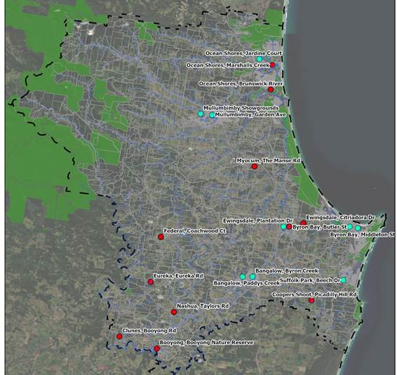
Figure 1: Flying-fox Camps in Byron Shire area 2023 – Rural camps are denoted by red dots, urban camps denoted by aqua dots.
Key issues
The main updates to the revised plan are:
· legislation review,
· updated science and monitoring methodology and
· detailed information on all known camps in Byron Shire.
New approaches include:
· a strategy for managing heat stress events,
· engagement with Traditional Custodians (which will be an ongoing process),
· evaluation of achievements to date
· an Education and Awareness Strategy.
Next steps
The draft FFCMP was peer reviewed by flying-fox expert Dr Peggy Eby (University of NSW), local wildlife consultants from Reconeco Consulting, and members of Council’s Biodiversity Committee. Next steps include:
· Public exhibition period 15 January to 19 February 2024.
· Community information session, week of 22 January 2024.
· Review of community submissions – Feb-March 2024.
· Report to Council on public submissions and final FFCMP – May 2024.
Strategic Considerations
Community Strategic Plan and Operational Plan
|
CSP Objective |
CSP Strategy |
DP Action |
Code |
OP Activity |
|
|
1: Effective Leadership |
1.2: Engage and involve community in decision making |
1.2.1: Community-led decision making - Engage with community to inform Council decision making |
1.2.1.2 |
Support staff to consider communication and engagement as part of all project development and implementation |
|
|
1: Effective Leadership |
1.2: Engage and involve community in decision making |
1.2.2: Communication - Provide timely information to the community about Council projects and activities through traditional and digital media |
1.2.2.5 |
Ensure information can be read and understood by our community regardless of their level of education, language spoken, lived experience of disability |
|
|
1: Effective Leadership |
1.2: Engage and involve community in decision making |
1.2.3: Customer Service - Deliver efficient customer service consistent with our Customer Service Standards |
1.2.3.2 |
Deliver efficient service to our customers by providing consistent, accurate and timely information |
|
|
2: Inclusive Community |
2.3: Respect Aboriginal culture, value cultural knowledge, and acknowledge history |
2.3.1: Aboriginal community and First Nations People - Develop strong and productive relationships that empower the Aboriginal community |
2.3.1.1 |
Continue working with Traditional owners on land management matters |
|
|
3: Nurtured Environment |
3.1: Partner to nurture and enhance biodiversity, ecosystems, and ecology |
3.1.1: Native species - Use best practice land management to improve ecological resilience and reduce threats to biodiversity |
3.1.1.5 |
Review Flying Fox Camp Management Plan |
|
|
3: Nurtured Environment |
3.2: Deliver initiatives and education programs to encourage protection of the environment |
3.2.2: Environmental education and awareness - Coordinate and support environmental education to the community |
3.2.2.8 |
Provide advice and information to the community regarding flying foxes |
|
Legal/Statutory/Policy Considerations
1. Biodiversity Conservation Act 2016 - administered by the Department of Planning and Environment.
Under this Act, a person who harms or attempts to harm an animal of a threatened species, an animal that is part of a threatened ecological community, or a protected animal, is guilty of an offence. The Grey-headed Flying-fox is listed as threatened under the BC Act. A biodiversity conservation licence under Part 2 of the BC Act may be required if the proposed action is likely to result in one or more of the following:
• harm to an animal that is a threatened species, or part of a threatened population;
• the picking of a plant that is a threatened species, or part of a threatened population or ecological community;
• damage to habitat of a threatened species, population or ecological community;
• damage to a declared area of outstanding biodiversity conservation value.
2. Prevention of Cruelty to Animals Act 1979
It may be an offence under this Act if there is evidence of unreasonable/unnecessary torment associated with management activities. Adhering to welfare and conservation measures provided in Section 10.3 will ensure compliance with this Act.
3. Environmental Planning and Assessment Act 1979 - administered by the Department of Planning and Environment
Development control plans under the Act should consider Flying-fox camps so that planning, design and construction of future developments is appropriate to avoid future conflict.
Local Policies
|
Documentation |
Administered by |
Relevance to subject camps |
|
Byron Local Environmental Plans 1988 & 2014 |
Council |
Matters for consideration are camps within ‘Deferred Matter’ (DM) zones of Byron LEP 2014. Byron LEP 1988 currently applies to all DM areas, which are currently being assessed as part of Council’s Environmental Zone review process. |
|
Development Control Plan 2014 |
Council |
Advice and guidance on planning for land use compatibility, avoiding land use conflict and the use of buffers. The emphasis is on identifying current and potential future land use conflicts at the outset and designing to avoid them during the development process where possible. |
|
Byron Biodiversity Conservation Strategy 2020 - 2030 |
Council |
Matters for consideration when developing planning controls. New developments or activities that occur in close proximity to ecological attributes and/ or habitats can impose negative impacts to human health, safety or comfort values (e.g. where in close proximity to Flying-fox camp). The Strategy supports appropriate buffers as required. The accuracy and availability of mappable information held within Council note high environmental values, but indicates the need to continually update mapping including Flying-fox camps, as new and/ or emerging camps establish. |
|
Open Spaces Asset Management Plan 2020 |
Council |
The plan details information about infrastructure assets including actions required to provide an agreed level of service in the most cost-effective manner while outlining associated risks. |
|
Byron Shire Council Operational Plan for Pine Avenue Sports Field Mullumbimby Crown Reserve 85663 for Public Recreation |
Council |
The Operational Plan provides a framework for the management and development of Crown Land under Council’s control. Council has responsibility for two main types of public land; Crown Land whose control is vested in Council under the Crown Lands Act 1989 and Council owned and managed community land dedicated under the Local Government Act 1993. The land included in the Operational Plan is Crown Land identified as Crown Reserve 85663, comprising Lot 451 DP 728526, which is located in Mullumibmby, west of the township and bordered by Pine Avenue, Garden Avenue and the tributaries of Chinbible Creek, being the Yalgany and Yoga-bera Creeks. The land is known locally as the Pine Avenue Sports fields, and also includes the Rotary Rainforest Park. |
|
Mullumbimby Flying-fox Camp Management Actions Plan |
Council |
Management actions support the Mullumbimby Flying-fox Camp Management Actions Plan and comply with the Flying-fox camp management policy. The Flying-fox camp management policy has been considered during the preparation of the proposed management actions in this Plan and the Mullumbimby Flying-fox Camp Management Actions Plan and as such recommends level 1 then level 2 management actions. |
|
Plan of Management for Butler Street Reserve, Byron Bay – Reserve 88993 for Public Recreation |
Crown Land |
Management actions support the Plan of Management for Butler Street by seeking to minimise adverse environmental impacts of the Reserve use on adjacent land uses, water bodies and areas of significant habitat. However, under the Plan of Management for Butler Street, proposals to develop a skate park, children’s playground and additional 20-space car parking would need to consider the negative impacts of Flying-foxes on such infrastructure e.g. smell, faecal drop and reduced general amenity. |
|
Cumbebin Wetland Sanctuary Site Restoration and Weed Management Plan |
Cumbebin Wetland Trust |
Management actions support the Cumbebin Wetland Sanctuary Site Restoration and Weed Management Plan (2006) by assisting in managing the site in order to ensure that existing bushland elements are protected from excessive human induced disturbance. Focus is on bush regeneration and weed control. |
Financial Considerations
Grant funding of $25,200 provided for development of the Flying-Fox Camp Management Plan.
Consultation and Engagement.
The table below summarises stakeholder engagement to date. Following expert peer review, it is intended to put the FFCMP on public exhibition from 15/1/2024 to 19/02/2024, with a community information session held during the week of 22-27/01.
|
Who was consulted |
How did the consultation occur? |
Comments |
|
Arakwal Corporation |
Email and online meeting |
Feedback is ongoing |
|
Jali Local Aboriginal Council |
Email and in-person meeting |
Feedback is ongoing |
|
Tweed Byron Local Aboriginal Council |
Email, online and in-person meetings |
Feedback is ongoing |
|
Ngulingah Local Aboriginal Council |
|
Waiting response |
|
Widjabul-Wiabal Gurrumbil Aboriginal Corporation RNTBC |
|
Waiting response |
|
Biodiversity Advisory Committee |
In-person meeting |
Feedback by 21/11/2023
|
BYRON SHIRE COUNCIL
Staff Reports - Sustainable Environment and Economy 13.9
Report No. 13.9 Former Mullumbimby Hospital Site - Project Update
Directorate: Sustainable Environment and Economy
Report Author: Andrew FitzGibbon, Place Planning Coordinator
Sharyn French, Manager Environmental and Economic Planning
File No: I2023/1554
Summary:
This report provides an update on the Former Mullumbimby Hospital Site project matters:
a) The Planning Proposal
b) The Enquiry by Design (EbD)
This aligns with recent resolution 23-298 from Byron Shire Council Meeting on 22 June 2023.
In relation to the planning proposal:
· A draft planning proposal and supporting technical studies were submitted in August 2023 to the Department of Planning and Environment (the Department) for the purpose of obtaining a gateway determination.
· A gateway determination was received on 3 November 2023.
· At the time of writing this report the planning proposal was being updated and discussed with the Department to address points raised within the gateway determination.
· Once the planning proposal has been updated and those updates have been accepted by the Department, we will proceed to public exhibition of the planning proposal.
· The aim is to begin that consultation period this year and have an extended exhibition until the end of January 2024.
· A submissions report to Council will then follow.
In relation to the Enquiry by Design:
· A community drop-in session was held on Saturday 11 November at which approximately 40 community members participated in the interactive themed stations.
· The EbD was held over 2 days, 13 & 14 November at the Mullum Civic Hall with key stakeholders. This culminated in 3 design options for the site.
· A further report will be tabled with Council in the new year to consider the governance structure for the site and other key matters.
· Understanding Council’s position on these key matters will then assist with refinement of the options and the development of a high-level feasibility assessment.
· A site-specific Byron Development Control Plan 2014 chapter will then be prepared based on Council’s preferred design option.
RECOMMENDATION:
That Council:
1. Notes the update on Resolution 23-298 relating to the Former Mullumbimby Hospital Site Planning Proposal and Enquiry by Design as provided in this report.
2. Expresses their sincere appreciation to the stakeholders who attended the 2-day Enquiry by Design process.
3. Notes that further reports to Council will be provided in early 2024 on the Planning Proposal’s exhibition and on the governance structure for the site and other key matters.
1 Gateway
determination (date 3 Nov 2023) - Department of Planning and Environment -
Former Mullumbimby Hospital Site, E2023/120964
![]()
2 Former
Mullumbimby Hospital Site Draft Planning Proposal 17 August 2023 Byron Shire
Council, E2023/90990 ![]()
3 Biodiversity
Assessment (date 17 April 2023) by Earth Scapes Consulting - Former Mullumbimby
Hospital Site, E2023/76200 ![]()
4 Bushfire
Assessment (date 4 July 2023) by Bushfire Certifiers - Former Mullumbimby
Hospital Site, E2023/72456 ![]()
5 Contamination
Summary (date 28 July 2023) by Tim Fitzroy and Associates - Former Mullumbimby
Hospital Site, E2023/77489 ![]()
6 Flooding
and Stormwater Assessment (date 3 August 2023) by BMT - Former Mullumbimby
Hospital Site, E2023/79687 ![]()
7 Infrastructure
Capability Audit (date 15 August 2023) by PLANIT Consulting - Former
Mullumbimby Hospital Site, E2023/84342
![]()
8 Transport
Strategy (date 9 August 2023) by PLANIT Consulting - Former Mullumbimby
Hospital Site, E2023/120961 ![]()
9 Primer
Pack - Mullumbimby Hospital EbD, E2023/116238
![]()
10 HvH
Concept Mapping following workshop - Mullumbimby Hospital EbD, E2023/127100 ![]()
Report
Council Meeting resolution 23-298 from 22 June 2023 states that Council:
1. Notes the update on Resolution 22-737 Former Mullumbimby Hospital Site.
2. Authorises staff to finalise and forward a planning proposal (informed by the Site Strategy and Urban Design Protocol and technical studies) to the Department of Planning and Environment for the purpose of obtaining a Gateway Determination, and that Council exhibit the Planning Proposal in accordance with the Gateway requirements.
3. Notes that an Enquiry by Design Workshop, Development Feasibility Assessment, and draft Development Control Plan for the Former Mullumbimby Hospital Site will progress along with the Planning Proposal to enable completion of these by early 2024.
This report provides an update on these resolution matters being:
· The Planning Proposal
· The Enquiry by Design (EBD) that will support a Development Feasibility Assessment and underpin a site specific Byron Development Control Plan 2014 (DCP) chapter.
The diagram below illustrates the relationship between each of these processes:
The Site
For reference site location plans are shown below. Further information about the site and detailed project background can be found in the Site Strategy and Urban Design Protocol which was endorsed by Council in December 2022.
Figure 1: Context Plan showing the site and its surrounds.
Figure 2: Subject Site Plan showing the site boundary and internal allotments
Planning Proposal
The objectives of the planning proposal are to amend the Byron Local Environmental Plan 2014 (LEP) to facilitate the provision of a high quality residential and community precinct on the former Mullumbimby Hospital site.
To achieve this, the planning proposal is seeking the following updates to the Byron LEP.
· Change the Land Use Zone over part of the site from SP2 Infrastructure (Health Services Facility) to R1 General Residential and a small area to C2 Environmental Conservation.
· Increase the Height of Buildings development standard over part of the site from 9m to 11.5m.
· Introduce Additional Permitted Uses for the site to facilitate complimentary and site-specific uses.
· Introduce an Affordable Housing Contributions Scheme Map over the development area that links to the Byron Shire Affordable Housing Contributions Scheme.
· Include the site in the Design Excellence provisions.
· Make other minor consequential LEP amendments to align with the above.
Note that the intention is to also make an amendment to the Byron Development Control Plan 2014 that will provide site specific design guidelines for the precinct.
The Byron Shire Council Meeting on 22 June 2023 endorsed the scope for this planning proposal as per Resolution (23-298). At this meeting Council authorised staff to finalise and forward a planning proposal (informed by the Site Strategy and Urban Design Protocol and technical studies) to the Department of Planning and Environment for the purpose of obtaining a gateway determination, and to exhibit the planning proposal in accordance with the gateway requirements.
A draft planning proposal and supporting technical studies were submitted in August 2023 to the Department of Planning and Environment for the purpose of obtaining a gateway determination. Refer to Attachments 2-8.
A gateway determination was received on 3 November 2023, Attachment 1. All documentation from the state government relating to the planning proposal can be found via the link below.
At the time of writing this report the planning proposal was being updated and discussed with the Department to address points raised within the gateway determination.
Once the planning proposal has been updated and those updates have been accepted by the Department, we will proceed to public exhibition of the planning proposal.
The aim is to begin that consultation period this year and have an extended exhibition until the end of January 2024. A submissions report to Council will then follow.
Enquiry by Design Workshop
Consultants Hip v Hype and Austin Maynard Architects were engaged by Council to work with the community and key stakeholders to develop concept designs for the site through a community drop-in session and EbD process.
The community drop-in session was held on Saturday 11 November 2023 at which approximately 40 community members participated in the five interactive themed stations.
The purpose of the EbD process was to ensure knowledge held by key stakeholders influences the design process and fosters stakeholder ownership of the outcomes.
The EbD was held over 2 days, 13 and 14 November 2023 at the Mullum Civic Hall with key stakeholders (invited attendee list below). This culminated in 3 design options for the site.
The EbD process included:
· A rundown of previous work done to-date, including the technical assessments, strategies and community consultation led by Council.
· Confirming the project’s driving Vision and Principles.
· A Site Visit to analyse the project’s opportunities and constraints.
· Active engagement in the project’s conceptual designs, based on five key themes (see below).
· A presentation of the project’s conceptual designs based on the outcomes of the EbD session.
The work leading up to this EbD process included a review of relevant Council policies and strategic documents, as well as project-specific technical assessments (e.g. biodiversity, bushfire, transport etc.) This led to the development of five key themes that informed the EbD and community drop-in session discussions:
1. Transport and Access
2. Housing and Built Form
3. Blue and Green Infrastructure
4. Climate
5. People and Culture
Representatives from the following organisations were invited to participate in the design process along with council staff.
• Housing & Affordability Advisory Committee
• Planit Consulting
• BMT Consulting
• Tallowwood Ridge Community Association
• Place Planning Collective
• Mullumbimby Residents Association
• Mullumbimby Hospital Action Group
• Mullumbimby Chamber of Commerce
• Mullumbimby District & Neighbourhood Centre
• Creative Mullum
• NSW Dept. Planning and Environment
• North Coast Community Housing
• Mullumbimby District & Neighbourhood Centre
A primer pack centred around the five themes was provided to participants in preparation for the EbD process, Attachment 9.
Conceptual maps of the three design options have been prepared and provided in Attachment 10.
A further report will be tabled with Council in the new year to consider the governance structure for the site and other key matters. Understanding Council’s position on these key matters will then assist with refining the options and the development of a high-level feasibility assessment.
Once Council has decided on a preferred concept design, a site-specific Byron Development Control Plan 2014 chapter will be prepared.
Strategic Considerations
Community Strategic Plan and Operational Plan
|
CSP Objective |
CSP Strategy |
DP Action |
Code |
OP Activity |
|
4: Ethical Growth |
4.1: Manage responsible development through effective place and space planning |
4.1.3: Town / Village Masterplans - Develop, implement and update Place Plans that promote place-based forward planning strategies and actions |
4.1.3.7 |
Amend Local Environmental Plan and Development Control Plan in accordance with Mullumbimby Hospital Precinct Plan |
Recent Resolutions
· Resolution 18-721 (22 November 2018) Mullumbimby Hospital Site Project Reference Group Recommendations: future use of the site
· Resolution 22-571 (27 October 2022) Endorsement to exhibit Draft Site Strategy and Urban Design Protocol
· Resolution 22-737 (15 December 2022) Endorsement of Site Strategy and Urban Design Protocol
· Resolution 23-298 (22 June 2023) Endorsement to lodge planning proposal and Enquiry by Design workshop update
Legal/Statutory/Policy Considerations
Requirements under the Environmental Planning and Assessment Act and Regulation as applicable.
Financial Considerations
Land Use Planning and Development Assessment for council owned land is funded through an operational budget allocation.
In terms of the overall cost of the Mullumbimby Hospital Site, it was premised when Council took on ownership of the site that whatever funds Council expends on the site are to be fully reimbursed from the eventual site redevelopment outcomes. In this regard, given that Council, at June 2023, had expended over $5.1million, it is recommended that outcomes on the site also need to consider the potential to return this amount to Council.
Consultation and Engagement
Planning proposal consultation will be carried out in accordance with Council’s Community Participation Plan 2019 and as directed by the gateway determination from the Department of Planning and Environment. The aim is to begin that consultation period this year and have an extended exhibition until the end of January 2024.
An overview of the outcomes from the Enquiry by Design workshop is intended to be included in the planning proposal consultation documents.
BYRON SHIRE COUNCIL
Staff Reports - Sustainable Environment and Economy 13.10
Report No. 13.10 PLANNING - DA 10.2022.248.1 – Multiple Occupancy Comprising 14 Dwelling Sites and Associated Infrastructure at 16 Whian Road, Eureka.
Directorate: Sustainable Environment and Economy
Report Author: Ben Grant, Planner
File No: I2023/1673
Proposal:
|
DA No: |
10.2022.248.1 |
||
|
NSW PP |
PAN-91427 |
||
|
Proposal description: |
Multiple Occupancy consisting of Fourteen (14) Dwelling Sites, and Associated Infrastructure. |
||
|
Property description: |
LOT: 25 DP: 1102773 |
||
|
16 Whian Road EUREKA |
|||
|
Parcel No/s: |
270827 |
||
|
Applicant: |
Balanced Systems Planning Consultants |
||
|
Owner: |
Mrs M F Olive |
||
|
Zoning: |
RU1 Primary Production / RU2 Rural Landscape / C2 Environmental Conservation |
||
|
Date received: |
16 June 2022 |
||
|
Integrated / Designated Development: |
☐ Integrated |
☐ Designated |
☒ Not applicable |
|
Concurrence required |
CNR-41203. Essential Energy s. 2.48 SEPP Transport and Infrastructure) 2021. |
||
|
Public notification or exhibition: |
- Level 1 advertising under Council’s Community Participation Plan. - Exhibition period: 28 June 2022 to 11 July 2022. - Submissions received: 16 objections. - Submissions acknowledged: ☒ Yes ☐ No ☐ N/A |
||
|
Planning Review Committee |
Considered by the PRC on 4 August 2022 and called up to Council for determination. |
||
|
Variation request to Development Standards under an EPI (e.g., clause 4.6) |
Not applicable |
||
|
Estimated cost |
$1,150,657.00 |
||
|
Delegation to determine |
Council |
||
|
Issues |
· Potential impacts on Eureka Village Landscape Heritage Conservation Area and adjoining heritage listed Church and Rectory Buildings. · Reduced buffers from neighbouring macadamia orchards (potential land use conflict resulting from spray drift). · Earthworks exceeding 1m in limited parts of the site. |
||
Summary:
This development application seeks consent for a multiple occupancy comprising 14 dwelling sites along with roadworks, tree removal and environmental enhancement works at 16 Whian Road, Eureka.
The Multiple Occupancy is arranged into four dwelling clusters to be constructed over three stages comprising two ‘Village Clusters’, one ‘Rural Living Cluster’, and one ‘Farm Residence Cluster’. A new primary access road will be constructed off Federal Drive servicing the Village and Rural Living clusters, while a secondary access servicing the Farm Residence cluster will be constructed off Whian Road.
Four of the proposed dwelling sites are within the Eureka Village Landscape Conservation Area (EVLCA) and are in proximity to the heritage listed Anglican Church and Rectory on the corner of Federal Drive and Whian Road.
Council officers initially expressed concerns about potential impacts of the proposed development on site’s heritage and landscape values, prompting the submission of a revised layout plan in August 2023 along with further information in relation to visual impacts, bushfire, and biodiversity issues.
The amended layout plan has shifted three of the dwelling sites to the eastern side of the access road and relocated a fourth site into the Farm Residence cluster. The revised design provides a greater separation distance from the historic Church and Rectory and will assist in reducing the perceived encroachment of the development into the EVLCA.
Council’s Heritage Advisor expressed general support for the revised layout but noted that one of the sites near the Church and Rectory (site VB1) should be relocated to minimise view loss from these historic buildings. It is also recommended that a landscape masterplan be prepared to ensure key views of the site are preserved and to soften the appearance for future residential development on the landscape.
To address land use conflicts, the proponent plans to establish a biological vegetation buffer along the boundary with neighbouring macadamia orchards to the east and south-east. The buffer will comprise dense plantings to filter windborne spray droplets emitted during periods of spraying on adjoining farms. Council’s Environmental Health Officer endorsed the proposal as a suitable strategy to mitigate future land use conflict.
A significant ecological restoration project is proposed as part of the development that aims to enhance the remnant Big Scrub rainforest near Whian Road through natural and assisted regeneration; eventually creating a link corridor with an adjoining rainforest remnant on the property to the north. Enhancement and connection of these isolated vegetation communities is likely to provide significant ecological benefits if fully implemented.
Although the proposed development is likely to change the character of the surrounding rural landscape, it is acknowledged that the site has been identified in previous strategic planning studies as being suitable for additional rural housing opportunities. A balance needs to be found between competing planning provisions to allow for new housing near the Eureka village while minimising potential impacts on the scenic qualities and heritage significance of the locality.
The proposed development will provide 14 additional dwelling sites in the Eureka area and has been redesigned to minimise potential impacts on the EVLCA and the adjoining Church and Rectory. The proposal is considered to be generally compliant with the relevant planning controls applying to the site and is recommended for approval subject to conditions of consent.
This development application has been a difficult proposal to resolve with a lack of specific planning controls in the Byron DCP 2014 for the Eureka Village Landscape Conservation Area. Other than broad policy directions in the DCP, the provisions under Chapter C1.6.6 include no prescriptive measures to guide future rural and residential development in the area. Whilst the proposal by ultimately adding further residences to the village area will strengthen it as a rural centre, noting that Eureka has a school and a soccer club. It is also arguable that the mapping and incorporation of the conservation area into Byron LEP 2014 was undertaken with limited consideration that some of the properties within it were also listed for Multiple Occupancy Development under Byron LEP 1988 at the time. As such it is also recommended that the Eureka Village Landscape Conservation Area be reviewed and DCP provisions be drafted to give clear direction and guidance to future development in this area as per Recommendation B below.
NOTE TO COUNCILLORS:
In accordance with the provisions of S375A of the Local Government Act 1993, a Division is to be called whenever a motion for a planning decision is put to the meeting, for the purpose of recording voting on planning matters. Pursuant to clause 2(a) under the heading Matters to be Included in Minutes of Council Meetings of Council's adopted Code of Meeting Practice (as amended) a Division will be deemed to have been called by the mover and seconder of all motions relating to this report.
RECOMMENDATION:
It is recommended that:
1. Pursuant to Section 4.16 of the Environmental Planning & Assessment Act 1979, Development Application No. 10.2022.248.1 for Multiple Occupancy consisting of Fourteen (14) Dwelling Sites, Associated Infrastructure, Land Management and Environmental Enhancement including Removal of Three (3) Trees, be granted consent subject to the conditions of approval detailed in Attachment 1 #E2023/118779.
2. The Eureka Village Landscape Conservation Area under Byron LEP 2014 be reviewed by staff (with a view to reducing or removing it by separate LEP amendment). New DCP provisions be drafted to otherwise give clear direction and guidance to future development in this area. A further report on both to be submitted to Council before the end of the 2023/24 financial year.
1 DA
10.2022.248.1 Recommended Conditions of Consent, E2023/118779 ![]()
2 DA
10.2022.248.1 Plans, E2023/123102
![]()
3 DA
10.2022.248.1 Draft Rural Landsharing Management Plan, E2023/91249 ![]()
4 DA
10.2022.248.1 Vegetation Management Plan, E2023/123121
![]()
5 DA
10.2022.248.1 Visual Impact Assessment, E2023/91251
![]()
6 Confidential - DA 10.2022.248.1 Submissions Received, E2023/123774
7 Confidential - Confidential - Late Submissions, E2023/127161
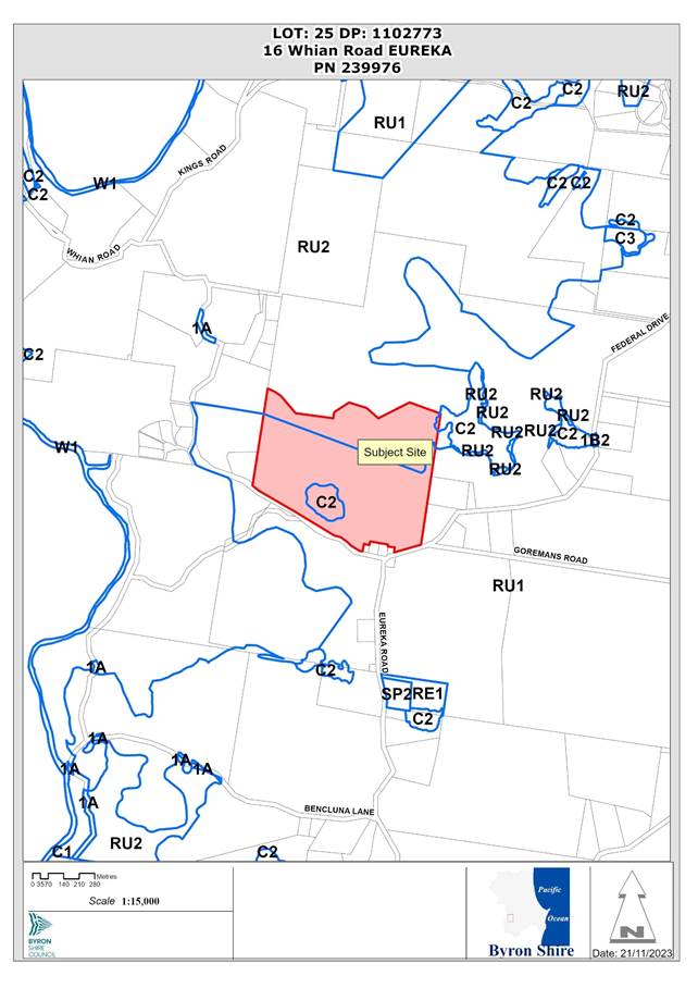
Assessment:
1. INTRODUCTION
Brief site history
The property was once part of a larger rural holding that was established as a dairy farm by the Anderson family in the late 1800’s. The farm originally contained a main homestead, dairy bales and a piggery building located near the central north-facing ridgeline of the existing property. The remainder of the land was used for grazing dairy cows.
The dairy ceased operations in 1965 following purchase by the Olive family. The new owners transitioned the farms operations primarily to beef cattle grazing which has remained to the current day. The original homestead, diary bales and piggery buildings were eventually removed due to disrepair.
Previous determinations
Lot 25 DP 1102773 was registered on 22 September 2006. There are no previous determinations for the property in Council’s records.
Strategic planning context
The subject site is one of several properties in the Federal–Eureka district that was identified for multiple occupancy development in the former Byron Rural Settlement Strategy 1998 (‘BRSS’), which included a rural land release program to guide the location of future rural lifestyle opportunities in the Byron Shire over a 10-year horizon.
The site was subsequently included in Amendment no. 67 to Byron Local Environmental Plan 1988 (‘LEP 1988’) which permitted multiple occupancy development in accordance with Clause 17A of the LEP. These provisions were largely transferred into Clause 4.2B of Byron Local Environmental Plan 2014 (‘LEP 2014’) upon its commencement on 21 July 2014.
Clause 4.2B also introduced a change to the planning rules which allows an approved multiple occupancy to be converted to a community title (CT) estate without the need for it to be properly established. Under the former LEP 1988 provisions, conversion to CT was only available to a small number of properties containing established multiple occupancies that were already in existence.
Secondary dwellings and dual occupancy in CT estates
Amendment no. 36 to Byron LEP 2014 was made on 20 January 2023 which permits dual occupancies and secondary dwellings to be erected in rural community title estates with development consent. The amendment followed Council resolution 21-498 and aims to provide additional housing opportunities in rural areas as one of a suite of measures to address the current housing crisis. As such, any future community title subdivision of this property would theoretically allow up to 28 dwellings. This does not apply to the currently multiple occupancy proposal.
Description of the proposed development
This development application seeks approval for a multiple occupancy consisting of fourteen dwelling sites, internal access road, plus land management and environmental enhancement works including removal of three trees, at 16 Whian Road, Eureka.
The following is proposed in detail:
(a) Dwelling sites
· Fourteen dwelling sites located within four dwelling clusters.
· Each site is located on cleared land with sufficient area for construction of a dwelling and on-site wastewater management system.
(b) Roads and infrastructure
· Construction of internal access roads including bushfire passing bays and turn arounds, and associated stormwater management.
· Construction of a new access road connection to Federal Drive along with a pedestrian pathway connecting the site to Eureka Village.
· Construction of a secondary access to Whian Road.
· Water supply, electricity, and telecommunications infrastructure.
(c) Tree removal and environmental enhancement works
· Removal of two Silk Oak trees and one Foam bark tree to facilitate construction of the access road.
· Assisted and natural regeneration of the Big Scrub rainforest remnant near Whian Road as detailed in the submitted Vegetation Management Plan.
(d) Multiple Occupancy Management
The site has been allocated the following ‘management zones’:
· Agriculture.
· Village Living.
· Rural Living.
· Habitat.
· Access / Infrastructure.
Access and infrastructure to be managed by the community includes roads and passing bays, water supply infrastructure, electricity and telecommunications infrastructure, potential community buildings.
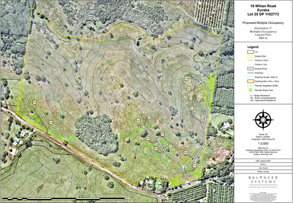
Figure 1: Site plan illustrating the intended dwelling site layout and road network.
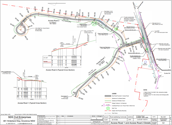
Figure 2: Civil Engineering Plans illustrating the proposed access road and new footpath in Federal Drive.
Description of the site
A site inspection was carried out on 5 September 2022.
|
Land is legally described |
LOT: 25 DP: 1102773 |
|
|
Property address |
16 Whian Road EUREKA |
|
|
Land is zoned: |
RU1 Primary Production / PART RU2 Rural Landscape / PART DM Deferred Matter Byron LEP 1988 |
|
|
Land area is: |
42.1 hectares2 |
|
|
Property is constrained by: |
Bushfire prone land, High Conservation Value Vegetation |
|
|
|
Is a BDAR required due to the location of the proposed development? |
☐ Yes ☒ No |
|
|
Are there any easements in favour of Council affecting the site? |
☐ Yes ☒ No |
|
|
Is there a Vegetation Management Plan which might affect the proposal? |
☐ Yes ☒ No |
|
|
Is there a Voluntary Planning Agreement which might affect the proposal? |
☐ Yes ☒ No |
The site is a 42-hectare rural property located adjacent to Eureka Village and approximately 4km south-west of Federal. The area is characterised by a mix of grazing land, macadamia orchards, stands of bushland, small scale agriculture and rural dwellings on lots with varying size and area. Three community title estates also exist to north and west of the subject site including the neighbouring property at 149 Federal Drive.
The property is located partially within the Eureka Village Landscape Conservation Area under Byron Shire LEP 2014 and lies in proximity to three heritage listed items which form the triangle of the Eureka Village: the Eureka Public Hall, the Former Anglican Church, and former Anglican Rectory.
A large macadamia orchard is present to the south-east on the opposite side of Federal Drive, while a smaller orchard adjoins the eastern boundary. Adjoining properties to the south-west on opposite side of Whian Road are used for beef cattle grazing while land to the west is primarily used for rural living and small-scale agriculture.
The site currently contains no dwellings or farm buildings and is currently solely utilised for beef cattle grazing activities. The site has undulating land that generally slopes away to the northern boundary from the southern boundary that borders Whian Road and Federal Drive.
A stand of Big Scrub subtropical rainforest lies near the southern boundary near Whian Road. The remainder of the property is open pasture aside from scattered trees. Another Big Scrub rainforest remnant (Allensby remnant) and a large-scale regeneration project is occurring on the adjoining property at 149 Federal Drive.
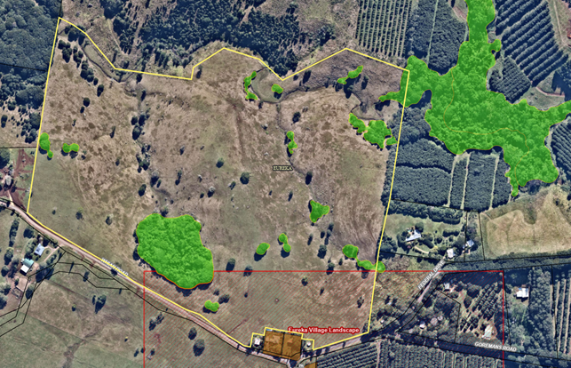
Figure 3: Aerial image overlays of the Eureka Village Landscape Heritage Conservation Area (red) high environmental value vegetation (green).
Figure 4: View north from Dwelling Sites VA1-VA3. This land is within the Eureka Village Landscape Conservation Area.
Figure 4: View north-east towards Sites RL1-RL4 which lie outside the conservation area.
Figure 5: View north from Sites VB1-VB4 and site AG1.
Figure 6: View towards Big Scrub remanent near Whian Road.
2. SUMMARY OF REFERRALS
External referrals
|
Issue |
|
|
Essential Energy |
The Application was referred to Essential Energy for comment in accordance with s. 2.48 of the SEPP (Transport and Infrastructure) 2021. Essential Energy noted that minimum safety clearances from electricity infrastructure should be maintained at all times. |
|
NSW Rural Fire Service |
The RFS did not accept the application as integrated development because the proposal is not considered to be a Special Fire Protection Purpose as defined in the Rural Fires Act 1997. Bush fire assessment is to be carried out by Council under s. 4.14 of the Act. |
|
Rous County Council |
The site has access to the Rous Count Council (RCC) water supply network. RCC recommended that a condition should be imposed requiring a Certificate of Compliance to be obtained prior to the issue of any construction certificate. |
|
Referral |
Issue |
|
Environmental Health Officer |
Council’s Environmental Health Officer (EHO) recommended that a planted vegetation buffer be established along the eastern and south-western boundaries to limit the effects of chemical spray drift from neighbouring macadamia orchards. The proposal was otherwise deemed to be acceptable from an environmental health perspective. |
|
Development Engineer |
No objections subject to conditions of consent including road widening and upgrades. |
|
Natural Resource Planner |
No objection to the proposal subject to conditions of consent. |
|
Heritage Consultant |
Council’s Heritage Advisor commented that the proposed multiple occupancy is likely to change the rural character of the landscape; however, it is acknowledged that the site has been identified for future dwelling opportunities as part of previous strategic planning work prior to the introduction of the Eureka Landscape Conservation Area in 2014. Council’s Heritage Advisor recommended that a landscape masterplan be prepared as a condition of consent to assist in the conservation of principal views and vistas from the site, and to soften the visual impact on 14 dwellings and associated outbuildings. In addition, it is recommended that Dwelling site VB1 be removed or relocated outside the conservation area as its current location will potentially create a visual obstruction to views from St Aiden’s Church and the Old Rectory. |
3. SECTION 4.46 – INTEGRATED DEVELOPMENT
The NSW Rural Fire Service concluded that the development application does not need a Bush Fire Safety Authority under s. 100B of the Rural Fires Act 1997 because the proposal is not for the purposes of residential or rural-residential subdivision and does not meet the definition of a special fire protection purpose. The proposed development is not integrated development.
4. SECTION 4.14 – CERTAIN BUSH FIRE PRONE LAND
The site is affected by vegetation hazards comprising grassland surrounding the proposed dwelling sites and two patches of subtropical rainforest in the southwest and north-east corners of the property. Neighbouring macadamia plantations are not considered a bush fire hazard.
A report has been provided by a BPAD Level 2 accredited bushfire consultant which confirms that the proposed development is able to comply with the specifications and requirements of Planning for Bushfire Protection 2019 subject to conditions of consent.
Each of the proposed dwelling sites can achieve BAL-12.5 subject to the establishment and maintenance of an asset protection zone. Access roads can be provided with passing bays and turning heads in accordance with RFS requirements. Each dwelling site will be required to provide 10kL of firefighting water supply in addition to domestic water supply storage.
5. SECTION 4.15C – MATTERS FOR CONSIDERATION – DISCUSSION OF ISSUES
Having regard to the matters for consideration detailed in Section 4.15(1) of the Environmental Planning & Assessment Act 1979 (EP&A Act), the following is a summary of the evaluation of the issues.
State Environmental Planning Policies (SEPP)
|
Considerations |
Satisfactory |
Unsatisfactory |
|
Biodiversity and Conservation SEPP 2021 Chapter 3 Koala habitat protection 2020 Most of the site comprises cleared grazing paddocks although there is a stand of subtropical rainforest located in the south-west corner of the property near Whian Road. The vegetation is understood to be an original Big Scrub remanent and is identified for ecological enhancement as part of the proposed development. Step 1–is the land potential koala habitat? Less than 15% of vegetation in the upper and lower strata of the Big Scrub remnant comprises koala feed tree species listed in schedule 1 of the Biodiversity SEPP. The site is not considered to be a potential or core koala habitat as defined in this policy. In accordance with Section 3.6, Council can grant consent to the development application without requiring a koala plan of management. |
☒ |
☐ |
|
Resilience and Hazards SEPP 2021 Chapter 4 Remediation of land The application is accompanied by a contaminated land investigation report which included a detailed history of the properties former land uses based on aerial photographs and statements obtained from the current and former landowners. It is concluded that the land is suitable for multiple occupancy development in its current state and does not require remediation. |
☒ |
☐ |
|
Transport and Infrastructure SEPP 2021 2.48 Determination of development applications—other development The proposed development was referred to Essential Energy for comment in accordance with s.2.48 of the Transport and Infrastructure SEPP. Essential Energy did not raise any specific objections to the proposal and provided a set of recommended notes regarding safety precautions to be taken when building near powerlines. 2.122 Traffic-generating development The site does not have a frontage to a classified road and will likely generate less than 200 vehicle movements per hour should all the proposed dwelling site be fully developed. In accordance with section 2.122 and Schedule 3 of this policy, Council does not need to give written notice to TfNSW prior to determining the development application. |
☒ |
☐ |
4.2A Byron Local Environmental Plan 2014 (LEP 2014)
In accordance with LEP 2014 clauses 1.4 and 2.1 – 2.3:
(a) The proposed development is defined in the LEP 2014 Dictionary as Multiple Occupancy;
(b) The land is within the RU1 Primary Production / RU2 Rural Landscape / C2 Environmental Conservation according to the Land Zoning Map;
(c) The proposed development is permitted with consent via Clause 4.2B and
(d) Regard is had for the Zone Objectives as follows:
|
Zone Objective RU1 Primary Production |
Consideration |
|
To encourage sustainable primary industry production by maintaining and enhancing the natural resource base. |
The proposal is not antipathetic to the zone objectives, noting that the residual land has the potential for ongoing agricultural use and conditions are recommended to minimise potential impacts on the site’s landscape vales.
|
|
To encourage diversity in primary industry enterprises and systems appropriate for the area. |
|
|
To minimise the fragmentation and alienation of resource lands. |
|
|
To minimise conflict between land uses within this zone and land uses within adjoining zones. |
|
|
To encourage consolidation of lots for the purposes of primary industry production. |
|
|
To enable the provision of tourist accommodation, facilities and other small-scale rural tourism uses associated with primary production and environmental conservation consistent with the rural character of the locality. |
|
|
To protect significant scenic landscapes and to minimise impacts on the scenic quality of the locality. |
|
Zone Objective RU2 Rural Landscape |
Consideration |
|
To encourage sustainable primary industry production by maintaining and enhancing the natural resource base. |
Sites RL1 to RL 4 will be located within the RU2 zone on the eastern side of the property. These sites are located on the periphery of the main view north towards the nightcap ranges and will not have a significantly adverse impact on the character of the surrounding rural landscape. Areas of RU2 Zoned land remain available for agricultural pursuits.
|
|
To maintain the rural landscape character of the land. |
|
|
To provide for a range of compatible land uses, including extensive agriculture. |
|
|
To enable the provision of tourist accommodation, facilities and other small-scale rural tourism uses associated with primary production and environmental conservation consistent with the rural character of the locality. |
|
|
To protect significant scenic landscapes and to minimise impacts on the scenic quality of the locality. |
|
Zone C2 Environmental Conservation |
Consideration |
|
To protect, manage and restore areas of high ecological, scientific, cultural or aesthetic values. |
The Big Scrub remnant near Whian Road is zoned C2 Environmental Conservation. No development is proposed in the C2 zone, apart from environmental enhancement works to restore and protect the remnant vegetation. The proposed restoration work is permitted without consent and is generally consistent with the C2 zone objectives. |
Part 4 – Principal Development Standards
|
Provision |
Compliance |
Comment |
||||||
|
4.1B Minimum subdivision lot size for multiple occupancy or rural community title developments |
N/A |
Community title subdivision is not sought as part of the current application but would be permissible with consent should this application be approved. |
||||||
|
4.2B – Maximum number of dwelling houses or dual occupancies on multiple occupancy or rural land sharing community developments
|
No |
Pursuant to this clause, a multiple occupancy is permissible with consent on the subject site in accordance with the following provisions: (3) Development may be carried out with consent for the erection of more than one dwelling house or dual occupancy (attached) on such a lot provided that— (a) if there is a number shown for that lot on the Multiple Occupancy and Community Title Map—the total number of dwellings on the lot will not exceed the number marked for that lot on that Map, or (b) if there is no number shown for that lot on that Map—there will not be less than 3 dwellings, and not more than 1 dwelling for every 3 hectares, up to a maximum of 15 dwellings, on the lot. Assessment The site is identified on the Multiple Occupancy and Community Title Map under LEP 2014. No maximum number of dwellings is specified on the MO/CT Map. Up to 14 dwellings are permitted on the land in accordance with the formula specified in Subclause (3)(b) as shown below.
(4) Development consent must not be granted under subclause (3) unless the consent authority is satisfied that— (a) there will be appropriate management measures in place that will ensure the protection of the landscape, biodiversity and rural setting of the land, and (b) the development is complementary to the rural and environmental attributes of the land and its surrounds. Assessment The application is accompanied by a VMP proposing natural and assisted regeneration of the rainforest remnant near Whian Road, including connection to the Allensby rainforest remnant on the adjoining property. Appropriate management measures will be in place via the Rural Landsharing Management Plan ensure the landscape and biodiversity values of the site are adequately protected. |
||||||
|
4.3 Height of Buildings |
Yes |
A maximum height of 9m is permitted. Physical works associated with the development such as bridges and roads will not exceed 9m in height. |
Part 5 – Miscellaneous provisions
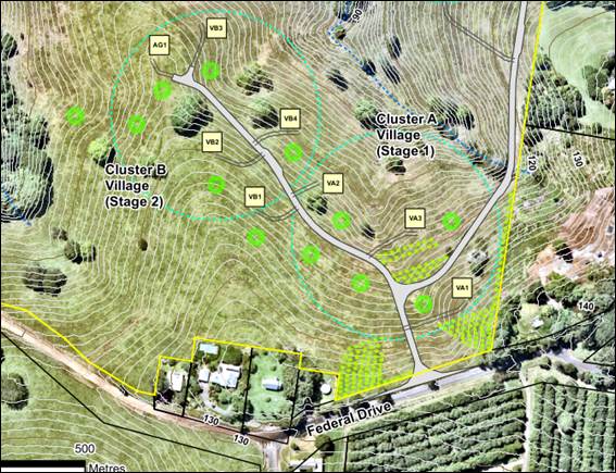
Extract of MO Dwelling Site Plan
|
Provision |
Compliance |
Comment |
|
5.10 Heritage conservation |
Yes, subject to conditions |
Four of the proposed dwelling sites are located on within the Northern periphery of Eureka Village Landscape Conservation Area being dwelling sites VA1, VA2, VA3 and VB1. The other dwelling sites are located outside of this Conservation Area. The site also adjoins two locally listed heritage items being the Old Rectory and St Aiden’s Church which are located on the corner of Whian Road and Federal Drive. The conservation area Statement of Significance is reproduced below: “The place is a rare group of buildings and landscape elements illustrating the Eureka community's historical antecedents and its continuing cohesion. It is in the hinterland of the Shire and although when settled, was considered remote, it came to form part of the pattern of settlement associated with the Far North Coast dairying industry. The village represents one of the earliest settlements of the Shire and retains rare integrity”. Assessment Council’s Heritage Advisor acknowledged the proposed development has the potential to change the landscape values of the site as described in the Statement of Significance. Notwithstanding, the amended plans have reduced the potential impact of the development by moving three sites east of the access road and relocating a fourth site into the Farm Residence Cluster near Whian Road. These amendments have increased the separation distance of sites from St. Aiden’s Church and the Old Rectory building and reduced the perceived encroachment into the EVLCA. It is also recognised that the site has been identified in previous strategic planning studies as being suitable for additional rural housing opportunities. A balance needs to be found between competing planning provisions which allows for new housing near the Eureka village while minimising potential impacts on the scenic qualities and heritage significance of the locality. Refer to the LEP 2014 discussion section of this report. |
Part 6 Additional local provisions
|
Provision |
Compliance |
Comment |
|
Clause 6.2 Earthworks |
Yes |
The civil engineering report indicates that approximately 7600m3 of excess soil will be displaced to construct the internal road network. The soil is intended to be stockpiled on the property and used on-farm over time. The proposed earthworks are unlikely to affect drainage patterns or soil stability in the are subject to conditions of consent. Visual impacts can be addressed through the use of landscaping to soften any cuttings or retaining walls required to achieve compliant road gradients. Conditions are recommended to ensure excess soil is removed from the sites or integrated into landscaping elements for the proposed development. |
|
Clause 6.5 Drinking water catchments |
Yes |
The proposed multiple occupancy will not adversely affect the quality or quantity of water entering the drinking water storage. Conditions are recommended for an erosion and sediment control plan to be prepared to control sedimentation and runoff during construction of the internal road network. |
|
Clause 6.6 Essential services |
Yes |
Each site in the proposed multiple occupancy is capable of being adequately serviced and will have suitable vehicular access subject to conditions of consent. |
|
Clause 6.18 Affordable housing contribution for certain development in affordable housing contribution areas |
N/A |
The proposed development is outside the scope of Clause 6.18 as it does not propose subdivision or development for the purposes of residential accommodation. |
4.2B Byron Local Environmental Plan 2014 – Issues
Clause 5.10 Heritage conservation
Four of the proposed dwelling sites and the main access road are located within the Eureka Village Landscape Conservation Area (EVLCA). The EVLCA also forms part of the historic setting of St. Aiden’s Church and the Old Rectory located on the corner of Whian Road and Federal Drive. Both buildings are locally listed heritage items.
The Statement of Significance for the Eureka Village Landscape Conservation Area is reproduced below:
Statement of Significance
The place is a rare group of buildings and landscape elements illustrating the Eureka community's historical antecedents and its continuing cohesion. It is in the hinterland of the shire and although when settled it was considered remote, it came to form part of the pattern of settlement associated with Far North Coast dairying industry. The village represents one of the earliest settlements of the Shire and retains rare integrity.
Clause 5.10(4) Effect of proposed development on heritage significance
(4) Effect of proposed development on heritage significance The consent authority must, before granting consent under this clause in respect of a heritage item or heritage conservation area, consider the effect of the proposed development on the heritage significance of the item or area concerned. This subclause applies regardless of whether a heritage management document is prepared under subclause (5) or a heritage conservation management plan is submitted under subclause (6).
Council’s Heritage advisor was concerned the development could adversely affect the heritage significance of the EVLCA and the setting of the adjoining Church and Rectory. The initial proposal was also not clearly aligned with C1.6.6 of Byron DCP 2014, which requires new development to respect the open scale, low-density, rural form of existing development in the EVLCA.
In response to these concerns, the Applicant submitted a revised layout plan which moves three of the dwelling sites further east of the access road and relocates a fourth site into the Farm Residence cluster near Whian Road. Council’s Heritage Advisor noted that the amended design had reduced the potential impact on the adjoining Church and Rectory and would minimise the perceived encroachment in the EVLCA by maintaining a view corridor northwest to the Nightcap range both from the public road and the heritage items.
On balance, it is considered that the proposed development can be supported from a heritage perspective for the reasons listed below; acknowledging that the site has been identified to provide additional housing opportunities in the Byron LEP 2014 which envisioned a closer form of rural settlement in the Eureka area:
1. The amended layout plan has minimised encroachment in to the EVLCA and maintains space around the Church and Rectory
The relocated dwelling sites have been given a greater separation distance from the St. Aiden’s Church and the Old Rectory and are positioned further below the ridgeline. Future development of these sites will be less visually intrusive than the original design and are less likely to interrupt views from public and private viewing locations. The increased separation distance maintains the setting of the Church and Rectory and reduces the perceived encroachment in to the EVLCA.
2. Dwelling site VB1 is to be relocated to minimise visual impact and reduce potential view loss
Council’s Heritage consultant noted that Dwelling Site VB1 would potentially create a visual obstruction in views from the Church and Rectory given a building of up to 9m would be permissible in this location. It is therefore recommended that Dwelling Site VB1 be relocated over to the Farm Residence cluster, to minimise impacts on the EVLCA and views from the adjoining heritage items. Relocation of site VB1 will assist in reducing the perceived visual impact of the development whilst also maintaining views from the heritage listed buildings.
3. Landscaping master plan
A landscape masterplan is recommended to help define and conserve the principal views and vistas from the site, to ensure that new vegetation is planned to maintain these view corridors, and to provide a framework to soften the impact of future residential development, including a requirement for canopy shade trees which are of appropriate species. The landscaping masterplan will help to integrate future development into the landscape and minimise visual impacts on the ELVCA.
4. The eastern and southern clusters are not visually prominent and will not affect the EVLCA or St. Aiden’s Church and the Old Rectory
There are two dwelling clusters outside of the EVLCA boundary, being Cluster C (rural living) on the eastern side and the Farm Residence Cluster near Whian Road. Cluster C will not be clearly visible in northerly views of the Night Cap Range, and the sites will sit below a green backdrop of vegetation formed by the adjoining Macadamia plantation to the east. The Farm Residence Cluster near Whian Road is visually separated by a stretch of road and rainforest vegetation from this view corridor and will not be readily perceived in northerly views from the Whian Road or the main village area.
5. The site has been identified for additional rural housing opportunities, and 10 of the proposed dwellings lie outside of the boundary of the EVLCA
While it is acknowledged that the proposal will alter the surrounding landscape, this change needs to be balanced against competing planning provisions which have identified the site as being suitable for future rural housing opportunities. A flexible approach is warranted which facilitates additional dwellings near the Eureka village while also taking care to minimise the potential impacts of such development on conservation area and the adjoining heritage listed buildings.
The amended plans, along with the conditions to remove site VB1 and to incorporate a detailed landscape master plan will ensure an appropriate balance can be achieved that minimises impacts on rural character whilst also achieve broader planning objectives to provide additional rural settlement opportunities in the Eureka area.
4.3 Any proposed Instrument that has been the subject of public consultation and has been notified to the consent authority
There are no proposed instruments with relevance to the subject application.
4.4A Byron Shire Development Control Plan 2014 (DCP 2014)
Chapter B1 Biodiversity
|
Development control |
Compliance |
Comment |
|
B1.2.1 Development Envelope Controls |
Yes |
The proposed dwelling sites, roads and infrastructure have substantial separation distance from the remnant subtropical rainforest near Whian Road and satisfy the ecological setback requirements detailed in Part B1.2.1. |
|
B1.2.5 Vegetation Management Plans & Biodiversity Conservation Management Plans |
Yes |
A Vegetation Management Plan (VMP) has been prepared in accordance with Part B1.2.5. The VMP proposed a mixture of tree planting and assisted natural regeneration to restore the Midlands Big Scrub remanent (Stage 1) with the Allensby Remnant (Stages 1 and 2) which is located on an adjoining property. Restoration of the eastern valley will occur later in Stage 3. |
Chapter B3 Services
|
Development control |
Compliance |
Comment |
|
B3.2.1 Provision of Services |
Yes |
The site has access to reticulated water from Rous County Council water supply. Electricity, telecommunications, and road infrastructure can be provided subject to conditions of consent. |
|
B3.2.2 On-site Sewage Management |
Yes |
Council’s Environmental Health Officer commented that each proposed dwelling site has adequate area for effluent disposal. |
|
B3.2.3 Stormwater Management |
Yes |
Stormwater systems will be incorporated into the proposed road design. The site is capable of assimilating stormwater runoff from proposed future dwellings in the multiple occupancy. |
|
B3.2.4 Sedimentation and Erosion Control Measures |
Yes |
An erosion and sediment control plan is required. |
Chapter B4 Traffic Planning, Vehicle Parking, Circulation and Access
|
Development control |
Compliance |
Comment |
|
B4.2.1 Traffic Impact |
Yes, subject to conditions.
|
The Applicant’s Civil Engineering Report estimated that the proposed multiple occupancy would generate 104 Vehicle Movements Per Day (VPD) with a peak hour demand 11 Vehicles Per Hour (VPH). Existing traffic flows on Federal Drive are 900 VPD, resulting in a likely future traffic impact of 1004 VPD should all dwelling sites be developed with a single dwelling house. Council’s Development Engineer recommended that Federal Drive should be upgraded to meet the minimum road design standards for rural residential development detailed in The Northern Rivers Local Government Development and Design Guidelines, which requires a 6m wide bitumen seal and 1m wide road shoulders. Conditions are recommended. |
Chapter B6 Buffers and Minimising Land Use Conflict
|
Development control |
Compliance |
Comment |
|
B6.2.4 Buffers |
Yes, subject to conditions. |
Table B6.1 provides that rural dwellings should have a minimum separation distance of at least 200m from horticulture (i.e., macadamia and fruit orchards). A variation to the minimum buffer distance is proposed as follows: · Proposed sites VA1-VA3 are located between 80m and 180m from a large macadamia orchard to the south at 460 Eureka Road. · Proposed sites RL1-RL4 are located between 70m and 100m from a neighbouring macadamia orchard to the east at 149 Federal Drive. A Land Use Conflict Risk Assessment report has been submitted which proposes the establishment of a 30m wide biological vegetation buffer to mitigate potential spray drift impacts from the neighbouring orchards. Refer to DCP 2014 issues section for further discussion. |
Chapter B8 Waste Minimisation and Management
|
Development control |
Compliance |
Comment |
|
B8.3.2 Construction of Buildings or Structures |
Yes, subject to conditions |
A condition is recommended for an amended waste management plan to be submitted for approval prior to the issue of a construction certificate detailing measures for dealing with excavated soil, signage, and the location and the size and location of waste storage areas. |
|
B8.3.3 Bin Sizes and Collection Measures |
Yes, subject to conditions |
Council’s Resource and Recovery Officer did not support garbage collection off Federal Drive noting that up to 28 bins could potentially be placed in front of the property on bin collection days. It is recommended that garbage collection should occur via a centralised waste collection point within the site, or via kerbside collection from the internal access road for each dwelling site. Internal garbage collection will require an agreement to be reached with between the landowners and Council or another private garbage collection company. Conditions are recommended. |
Chapter B9 Landscaping
|
Development control |
Compliance |
Comment |
|
B9.3.1 General Landscape Design Principles |
Yes, subject to conditions |
A combined site plan and landscape concept plan was provided as part of the Applicant’s further information which outlines a concept of planting shade trees along the internal access road to Sites VA1-VB3, and the southern frontage to Whian Road. As discussed in section 4.2B, Council’s Heritage Advisor commented that a more detailed landscape masterplan is necessary to soften the appearance of the additional dwellings and to maintain views of the site from public roads and the existing heritage items of St Aiden’s Church and the Old Rectory. Conditions are recommended. |
Chapter B14 Excavation and Fill
|
Development control |
Compliance |
Comment |
|
B14.2 Excavation and Fill in all Zones |
Yes, subject to conditions |
The internal road network will generally follow the contours of the land, although excavation and filling of up 2.6m in depth will be required on the eastern side of the property where the land has steeper topography. The visual impact of the earthworks will be acceptable subject to appropriate conditions for landscaping and appropriate use of earth batters to provide smooth transitions between natural and filled surfaces. Refer to DCP 2014 issues section for further discussion. |
Chapter C1 Non-Indigenous Heritage
|
Development control |
Compliance |
Comment |
|
C1.5.1 New Development in the Vicinity of a Heritage Item |
Yes, subject to conditions |
The amended plans have increased the separation distance from St. Aidan’s Church and the Old Rectory and moved two additional sites out of the EVLCA. In addition, Council’s Heritage Advisor commented that site (VB1) should be relocated outside the conservation area to further protect views from the church and minimise impacts on the EVLCA. The proposal is able to meet the Objectives and Performance Criteria of C1.5.1 subject to the above condition. Refer to Section 4.2B of this report for further discussion of Heritage issues. |
|
C1.6.6 Eureka Village Landscape Conservation Area & C1.6.11 New Development in Heritage Conservation Areas |
Yes, subject to conditions |
The proposal is likely to change the surrounding landscape however a balance needs to be found which facilitates additional dwelling opportunities near the Eureka village whilst also taking care to minimise the potential impacts of such development on conservation area and the adjoining heritage listed buildings. The proposed development is generally capable of achieving the objectives of C1.6.6 and C1.6.11 subject to conditions which require the preparation of a landscape masterplan and removal of Site VB1 to minimise views for the adjoining Church and Rectory. Refer to Section 4.2B of this report for further discussion of Heritage issues. Applications for dwellings in the heritage conservation area in the future will need to address the relevant heritage provisions at that time under both the LEP and DCP. |
Chapter C3 Visually Prominent Sites, Visually Prominent Development and View Sharing
|
Development control |
Compliance |
Comment |
|
C3.2.1 Visual Impact Assessment |
Yes |
A visual impact assessment was provided as part of the applicant’s further information. The VIA demonstrates that the proposed development will not be clearly visible from within the Eureka Village although it will be visible in public views from Federal Drive and Whian Road, as well as in views from St. Aiden’s Church and the Old Rectory. No photomontages of the likely future built form (including roads and indicative building envelopes) were provided although photos from key viewing locations were included. As discussed elsewhere in this report, conditions are recommended for a landscape master plan to be prepared to minimise the visual impact of the proposed development and to maintain principal view corridors and vistas from public viewing locations. The proposed development is considered to be acceptable subject to the implementation of the aforementioned landscaping plan and site relocation in accordance with the heritage advisors’ recommendations. |
|
C3.2.2 Assessment of Impacts on Views and View Sharing |
Yes, subject to conditions |
Council’s Heritage Consultant noted that Dwelling site VB1 will potentially obstruct northerly views from St. Aiden’s Church and the Old Rectory as a building of up to a 9m height limit would be permissible in this location. Conditions are recommended for Site VB1 to be relocated ore removed to reduce visual obstruction of a likely future dwelling in northerly views from the Old Church and Rectory. |
Chapter C4 Development in the Drinking Water Catchment
|
Development control |
Compliance |
Comment |
|
C4.2.1 On-Site Sewage Management and Potentially High Impact Land Uses |
Yes |
Council’s Environmental Health Officer noted that the dwelling sites were capable of assimilating wastewater from a single dwelling subject to further design details being provided at the development application stage for each future dwelling. |
|
C4.2.3 Catchment Impact Assessment |
Yes |
The proposed development will not compromise the quality and quantity of water in the drinking water catchment. |
Chapter D2 Residential Accommodation and Ancillary Development in Rural Zones
|
Development control |
Compliance |
Comment |
|
D2.6.1 Multiple Occupancy Development of Rural Land – Prescriptive Measures |
||
|
1. Siting and Clustering of House Sites |
Yes, subject to conditions |
The proposed development involves the creation of three main dwelling clusters in the central and eastern parts of the property, along with a fourth cluster containing two dwelling sites near Whian Road in the south-west corner of the property. The Whian Road Cluster (sites AG2-AG3) is not strictly in accordance with the Prescriptive Measures of D2.6.1 because only two dwelling sites are located within this Cluster instead of three. It is recommended that Dwelling Site VB1 be relocated within the Whian Road Cluster as a solution to increase the number of sites in this Cluster to three, while also reducing impacts on the conservation area. The proposal is capable of meeting the requirements of Prescriptive Measure 1(a) subject to compliance with this condition. |
|
2. Environmental Impact Assessment Report |
Yes, subject to conditions |
The Statement of Environmental Effects and supporting plans and reports adequately address the potential environmental impact of the proposal in relation to bushfire, environmental repair, water catchments, land contamination, distances to community facilities, and the overall unconstrained potential of the site. |
|
3. Rural Land Sharing Management Plan |
Yes, subject to conditions |
A draft Rural Landsharing Management Plan has been submitted which is generally in accordance with the requirements of DCP 2014. The draft RLMP outlines provisions for the allocation of shareholder entitlements, occupancy rights, dispute resolution, disposal of sewage, keeping of pets plus environmental and community management. Certain details that were not clearly explained, including the future built form of the MO and management of agricultural activities are to be detailed in an amended to RLMP to be submitted for approval prior to the issue of a construction certificate. Conditions are recommended. |
|
4. Access roads |
Yes |
Access Road details are specified in the civil engineering plans. |
|
5. Bushfire Management |
Yes |
Bushfire Management is detailed in a separate bushfire management plan. The proposal complies with the provisions of PBP 2019. |
|
6. Vegetation Management Plan |
Yes |
A vegetation management plan has been provided detailing an ecological enhancement strategy of the remnant big scrub. |
|
7. Water Management Plan |
Yes |
A water management plan has been provided. Each dwelling will be required to provide at least 40kL drinking water tank and 20kL firefighting tank. |
|
8. Effluent Disposal |
Yes |
An effluent disposal management plan has been provided. |
|
9. Dwelling houses |
Yes |
A site plan has been provided showing the building site or envelopes for each site. |
4.4B Byron Shire Development Control Plan 2014 – discussion of issues
B6.2.4 Buffers
The proposal attempts to mitigate the potential impact of chemical spray drift from neighbouring orchards by establishing a planted biological buffer with a minimum width of 30m, which will be planted along the eastern and southern boundaries near sites VA1-VA3 and RL1-RL4.
The vegetation buffer is intended to filter wind-borne droplets emitted during periods of spraying on neighbouring properties, allowing farmers to continue normal operations without affecting future residential development within the proposed multiple occupancy.
Council’s Environmental Health Officer endorsed the findings of the Applicant’s Land Use Conflict Risk Assessment Report and agreed that a reduced buffer from the adjoining orchards for certain sites was acceptable subject to the establishment of the proposed biological vegetation buffer. Vegetation will need to be installed prior to the occupation of any future dwelling within the affected dwelling sites and will need to be maintained in perpetuity to mitigate potential land use conflict issues.
Conditions are recommended for further details to be provided in an amended landscaping plan, along with the creation of a positive covenant on the title of the property which requires the biological buffer to be maintained at all times. The proposal is capable of meeting the Performance Criteria and Objectives of part B6.2.4 subject to compliance with these conditions.
B14.2 Excavation and Fill in all Zones.
The internal road network generally follows the contours of the land although excavation and filling of up 2.6m in depth will be required for parts of Access Road 2 on the western side of the property due to topographical constraints. The proposal exceeds the 1m maximum excavation depth stipulated in Prescriptive Measure 1 of Part B14.2.
The applicant’s civil engineering plans demonstrate earthworks for the internal road network will use a 1:2 batter along with boulder retaining walls to a height of 1.5m where needed. Excavation and fill for Access Road 1 (which is more visible and passes through the conservation area) will typically be less than 1m in depth and is unlikely to have a significantly adverse visual impact in views across the site from Federal Drive in the north.
Any potential adverse visual impact can be mitigated using conditions requiring earth battering (rather than high retaining walls) to achieve smooth transitions between areas of deeper cut and fill. Where retaining walls area necessary due to topographical constraints, such works are to be kept to a maximum height of 1.5m and shall incorporate landscaping treatments to soften the visual effect of proposed access road and any associated retaining structures on the surrounding landscape. Landscaping over and areas of excavation and filling will be a requirement of the landscaping plan to ensure the access road blends into the hillside to the greatest degree possible and does not detract from the surrounding scenery.
1.5 Environmental Planning and Assessment Regulation 2021 considerations
There are no provisions in Part 4, Division 1, of the Regulation that have relevance to the proposed development.
1.6 The likely impacts of that development, including environmental impacts on both the natural and built environments, and social and economic impacts in the locality
|
Impact on: |
Likely significant impact/s? |
|
Natural environment |
Tree removal Two Silky Oaks (Grevillia robusta) and one Foam bark tree (Jagera pseudorhus) have been identified for removal to facilitate construction of the internal road network and site entrance to Federal Drive. The proposed tree removal is largely unavoidable and will be adequately offset by environmental enhancement and restoration works on the western part of the property. Conditions of consent to apply. Site enhancement and rehabilitation The proposed development will involve rehabilitating the Big Scrub rainforest near Whian Road and connecting this isolated remnant with the Allenby Big Scrub restoration project occurring on the adjoining property to the north-east. The restoration project will provide a net benefit to the environment if fully implemented. |
|
Built environment |
Roads, traffic, and safety Traffic generation for the proposed development is estimated to be 104 vehicle movements per day with a peak hour demand of 11 vehicle movements per hour. The existing traffic flows on Federal Drive are estimated to be 900 vehicle movements per day which results in a total of 1004 vehicle movements per day should all sites be developed with a single dwelling house. Council’s Development Engineer noted that the section of Federal Drive in front of the property should be upgraded to comply with the rural-residential carriageway requirements in Table 1.27 of the NRLG design guidelines which requires a 6m wide seal with 1m shoulders. Pedestrian access A 1.2m wide concrete pedestrian pathway is proposed from the main site entrance along Federal Drive, terminating at the Eureka Hall Driveway. The pathway will facilitate access for residents in the village centre. |
|
Social Environment |
The proposed will potentially have a positive social impact in the Shire by offering up to 14 additional housing opportunities near the Eureka village. |
|
Economic impact |
No. The proposal will not have a significant economic impact on the locality. |
|
Construction Impacts |
The development will generate minor impacts during its construction. Conditions of consent recommended to control hours of work, builders waste, construction noise, installation of sedimentation and erosion control measures and the like to ameliorate such impacts. |
4.7 The suitability of the site for the development
The site characteristics are suitable for the proposed development subject to the conditions outlined in the recommendations of this report.
4.8 Submissions made in accordance with this Act or the regulations
The development application was publicly exhibited for a period of 14 days from 28 June to 14 July in accordance with the Byron Shire Community participation Plan.
There were 16 total submissions received from 14 separate submission authors on the development application. 15 submissions were opposed to the development and 1 submission was in favour.
Issues raised in the submissions are summarised and addressed in the following table.
|
Issue |
Comment |
|
Farm residence too close to adjoining dwellings |
|
|
The Stage 1 Farm Residence AG2 has been positioned way too close to 70 Whian Road. We note this is listed as a “farmhouse” so would expect not only a house but associated farm buildings, shedding for farm vehicles and machinery to maintain the agricultural sections of the MO. |
Dwelling site AG1 has a 60-metre setback from the western boundary adjoining 70 Whian Road. A 60-metre setback is considered to be acceptable in a rural context. |
|
Too many MOs in the hinterland – no strategic planning considerations |
|
|
There are too many MO's being approved or approved in this section of the hinterland. |
This property is one of twelve properties in the Eureka–Federal area that was identified for MO development in the Byron Rural Settlement Strategy 1998. Several properties in Coorabell were also included in the Strategy. Increase rural settlement in this part of the Shire’s hinterland has been part of the planning framework for several years. |
|
It is concerning there has been no discussion of Council Infrastructure, roads, footpaths for kids to walk or cycle to school or safe play areas, for children. Does council have plans for upgrading any of the roads or infrastructure in the area as part of the MO? |
Conditions of consent are to apply in terms of road works to facilitate the development and for a footpath for part of the sites frontage. |
|
Not in favour of fragmented subdivisions dotted throughout the farming community with the possible conflict that comes with that. |
The proposed development being a multiple Occupancy is a recognised form of development and has been encouraged in Byron Shire under both Byron LEP 1988, the Byron Settlement Strategy 1998 and now Byron LEP 2014. |
|
The proposal is more like an urban subdivision than a multiple occupancy |
|
|
MOs are intended to promote communal living with shared facilities and resources. The pattern of the dwelling sites, the length of the proposed road and the position of the clusters on the overall site mean the development reads like a residential subdivision and, indeed, is a de facto subdivision. |
Many multiple occupancies in Byron Shire over the years have converted to a Community Title. The future conversion of this MO is permissible with consent under Byron LEP 2014. |
|
The reality of the DA would simply seem to be smoke screen for a suburban subdivision over 5+ acres of land with the remainder of the land being effectively retained by the applicant as the owner of AG1 and AG2. |
See above. Council is obliged to assess the development application as a multiple occupancy (as submitted) although it is acknowledged that the site could potentially be converted to a community title estate should consent be granted to the application. |
|
Risk of Future Community Title Subdivision. Council recently approved a similar MO proposal only a few hundred meters from the current DA. Their website offers multimillion-dollar acreage to ‘build your dream home’. This development proposal however is not an attempt to provide affordable housing. Nor is it planned as a low impact development. |
The cost of purchasing a house site within the MO is driven by market forces. The development will nevertheless provide additional housing opportunities within close proximity to Eureka village. |
|
The proposal is out of character with the surrounding rural landscape and the EVLCA |
|
|
Proposal is out of character with the landscape. The visual quality is not a subjective judgement in this case. The landscape, character and visual quality from the EVLCA are specifically identified in State and Local Heritage listings. The density of the development in not sympathetic to the rural character of the land and the current village. |
As discussed above in the assessment report the proposal considered acceptable on heritage grounds |
|
No visual analysis provided of the potential impacts of the development. |
The applicant provided a visual impact assessment as part of their further information which is included in Attachment 5. |
|
Community buildings, sheds, granny flats and dual occupancies not considered |
|
|
MO or CT dwellings with garages, fencing and pending second dwelling entitlements could add up to 60 structures to the rural form of the area. This is very high-density impact in an open landscape that is Heritage listed for its spectacular view. The density of the development in not sympathetic to the rural character of the land and the current village. |
Noted Any further development of the house sites within the Conservation Area will need to address the relevant heritage provisions at that time. |
|
While concerns can be addressed to protect the EVLCA with changes to the proposal, there is nothing preventing planting of shade trees and other vegetation, as well as uncharacteristic development including second dwellings and garages/sheds that will, in the long term remove that rarity and reduce the value of the significant community heritage asset. |
Conditions are recommended to limit the development to one house per site and to limit the number of outbuildings per site. |
|
The nature of the proposed buildings is addressed in scant form through relying on each being the subject of future DAs. The precise nature and style of the buildings should be committed to now. For example, heritage style restrictions on materials, colour, style, roof height, footprint etc. |
Acknowledged – No dwellings are proposed at present. Future proposals will need to be considered on their merits against the planning controls at that time. . |
|
Density and style of future development is unclear |
|
|
What are the likely future built forms? I cannot see any information on the style of the homes required for the MO development. Ideally, they are in keeping with the existing village. Not 'home world' mass produced homes but ones that reflect the architecture of the area. Preclude the building of other structures within the “Village” through a restrictive covenant in favour of Council to this effect. |
The future built form of each dwelling house cannot be easily controlled as part of this assessment. Each dwelling house will need to be assessed on its merits. |
|
Use and Management of MO land unclear |
|
|
It also seems to be anticipated that the site be used for “small scale agricultural uses”, including “market gardens, orchards, grazing and mixed species cropping”. Again, there is no detail on where this would occur as there is no “management zones map”, “Rural Land sharing Management Plan” or “Vegetation Management Plan” attached. |
The residual land is capable of being used for small scale agriculture (i.e., limited cattle grazing) however, it is acknowledged that the draft RLSMP does not provide a sufficient level of detail to explain how any such agricultural uses would be managed by the community. A condition is recommended for an amended RLSMP to be prepared and approved by Council prior to the commencement of works including a proper management plan for future agricultural uses within the MO. |
|
The use, protection and obligations to manage that land should be locked in perpetuity to retain and enhance the rural nature of the land. Who has ownership rights over the remaining 95 acres? |
The ownership rights and management obligations will rest with the MO community. As discussed above, amendments to the RLSMP are recommended to clarify how the residual land will be appropriately managed and used for agriculture. |
|
Impacts on drinking water catchment |
|
|
High number of septics in a concentrated area which runs alongside creeks that appear in heavy rain and down to a permanent creek at the base. As this is a drinking water catchment, I wanted to be assured this had been considered. |
Council’s Environmental Health Officer noted that the land was capable of assimilating wastewater from up to 14 dwellings. The proposal is unlikely to affect the quality of water entering the drinking water catchment. |
|
Insufficient information in relation to Drinking water catchments |
|
|
Impact on views |
|
|
The proposal will adversely impact the views from adjoining properties (the rectory etc.) |
A condition is recommended that requires removal of Dwelling Site VB1 to reduce the potential for view loss from St. Aiden’s Church, The Rectory and adjoining dwelling at 8 Whian Road. |
|
Nowhere in the DA Heritage Report is there an analysis or modelling to show the line-of-sight impact of the development on the views of the Church and the Old Rectory and the heritage conservation areas, with consideration of the historic views at the time St Aidan’s (the church) and the Old Rectory were established (as supported by the photographs of the time). |
The applicant provided a visual impact assessment as part of the further information response. As discussed above, a condition is recommended that requires Dwelling Site VB1 to be removed to ensure the northern view corridor from the heritage listed buildings towards Nightcap Range is not unreasonably obstructed. |
|
The roof heights of the proposed dwellings and landscaping will directly impose upon this rare and protected rural vista. The proposed dwelling will sit at minimum RL 134. The Heritage listed Eureka church sits on RL 133. |
See above. |
|
Noise |
|
|
Adversely impact noise levels with the ingress and egress of vehicles and the general noise associated with residential living. Adversely impact the general amenity of what is a rural landscape. |
There may be a slight increase in noise associated with vehicles entering the site however the potential impact on amenity is unlikely to be significant. |
|
Impact on Eureka Landscape Heritage Conservation Area |
|
|
Development does not comply with Byron DCP 2014 C1 and C3 – Degradation of Heritage Listed Visual Amenity and Byron LEP 2014 Precautionary Principle. Byron Shire Council Policy outlined in C1.6.6 of the Byron Shire CDP 2014 is very specific about the EVLCA. Development must respect the open scale, low density rural form of existing development. |
The amended plans have relocated three sites east of the access road and relocated a fourth site into the Farm Residence Cluster. The amended design reduces the perceived encroachment into the EVLCA. |
|
The requirement for planting nine hundred (900) trees will also significantly change the Heritage listed rural vista and create a greater fire risk to the one hundred and twenty-eight (128) year old Heritage listed wooden buildings only meters from the development. The State Heritage Inventory states under Criteria (f) that ‘the presence of such an unaltered setting from the past, is rare in the Byron Shire’. |
Proposed restoration efforts will be focused on enhancing and regenerating the isolated Big Scrub remanent near Whian Road. Such works are unlikely to have a detrimental impact on the rural vista or significantly increase the risk of bushfire to the heritage listed buildings. |
|
There is no evidence that the Heritage Impact Statement was prepared by such a qualified person. The Statement takes no account of the impact the proposed development will have on two of the buildings identified in the Eureka Village Landscape conservation Area: the Church and the Rectory. |
Council’s Heritage Advisor commented that the amended plans have increased the separation distance between the proposed dwelling sites and the adjoining heritage listed buildings. Further conditions are recommended for site VB1 to be removed/relocated to minimise view loss from these buildings. |
|
Impact on nearby heritage listed buildings |
|
|
Viewsheds directly detract from the quality of Heritage listed buildings This group of buildings and its landscape form one of the earliest settlements of the shire. The Church is the oldest Church in the Shire. These items and their viewsheds are specifically identified and protected under State and Local legislation. The roof heights of the proposed dwellings and landscaping will directly impose upon this rare and protected rural vista. The proposed dwelling will sit at minimum RL 134. The Heritage listed Eureka church sits on RL 133. |
See above. The layout plan has been altered by moving the several dwelling sites away from the view shed of the Church and Rectory. |
|
Road safety |
|
|
I have grave concerns about the safety of cars entering or turning off into this MO. The 3-way intersection is already quite dangerous at times, particularly when school buses are required to reverse through the intersection each day. The access point to Federal Drive is already dangerous, being just after a blind bend near the corner of Goremans Road. Adding an entry point for 12-14 additional residences at that point in the road would in my opinion significantly increase the likelihood of an accident. |
Council’s Development Engineer noted that the design of the proposed access road is acceptable from an engineering perspective. Conditions are recommended for federal drive to be upgraded and widened as part of the development which will improve road safety near the development site. |
|
Capacity of local road network insufficient |
|
|
Eureka does not have the roads not the infrastructure to support such developments. I oppose to the number of dwellings considered for development. |
Local road network can cater for the development. Conditions are recommended for Federal Drive to be upgraded as part of the development. |
|
The MO will offer additional housing |
|
|
I support this application as it would open-up land for myself and husband to buy in and bring up children in the area. |
Noted. The proposal will provide opportunities for an additional 14 dwellings close to Eureka village. |
|
Non-compliance with Byron Shire Rural Land Use Strategy |
|
|
Any reliance on BRSS 1998 is irrelevant, except in for the current legacy map. That strategy has been replaced by the Byron Rural Land Use Strategy (RLUS) 2017, which has significantly different directions and strongly favours rural-related residential development in the subject area to occur in Federal Village. Tellingly, the Eureka location no longer appears as a rural settlement hub. |
As discussed elsewhere in this report, the MO/CT map (which is derived from the former BRSS 1998) is still relevant for the purposes of development assessment and prevails over the RLUS 2017.
|
|
Impact on prime agricultural land - including buffers |
|
|
Significant negative impacts on the availability of high-quality agricultural land in the district, and on the amenity of the surrounding area |
About 2/3rds of the residual land will be capable of being used for agriculture. Conditions are recommended for an updated RLSMP to provide more details on how the residual land will be managed by the community. |
|
The subject land is, in its entirety, constrained. Land that land mapped as State Significant Farmland, Regionally Significant Farmland or having High Environmental Value Vegetation is automatically constrained. The proposed location of the residential lots will alienate directly approximately 5 ha of land that has been repeatedly classified as prime agricultural land in the RU1 zone, and a further 3 ha of land zoned RU2. The requirement for buffers is likely to, in effect, alienate a further area from commercial agricultural production, other than the current grazing. This loss of agricultural land will negatively impact the carrying capacity and viability of the remaining property. |
See above comment. |
|
The proposed development is to occur on a rural property adjacent to an operating macadamia orchard on the eastern side and another macadamia orchard across the road from the southern side of Federal Drive. This places all four proposed dwellings in Cluster C and proposed dwellings VA1, VA2, VA3, VA4 and VB1 within 200m of an orchard. |
Council’s Environmental Health Officer concluded that a planted vegetation buffer along the southern and eastern boundaries will be required to limit the effects of spray drift from neighbouring macadamia plantations to the south and south-east. Conditions are recommended for a detailed landscaping plan including vegetation buffers to be provided for approval with the construction certificate application. |
|
Concerns about land use conflict issues due to the houses being within the spray drift buffer. |
See above. |
|
Missing documents and insufficient information |
|
|
· The DA does not satisfy the Rural Strategy 2017. · Reports not prepared by qualified experts. · Clusters A and B located within the Eureka Landscape Conservation Area. · No visual analysis provided of the potential impacts of the development. · No information provided to demonstrate how agricultural uses will be maintained by the MO. · The proposal is inconsistent with the 2017 Rural Strategy in relation to rural living development. · Potential impacts on big scrub remanent that have not been considered. · Five-part test inadequate. · The proposal is on ‘environmentally sensitive land’ as defined in the 2017 rural strategy (i.e. >25% slope and within 100m of watercourse). · No information provided concerning how the proposal will affect the scenic amenity of the area. · The site is mapped as State significant agricultural land. No further details are provided into the primary production activities to be conducted on the site as part of the proposed multi occupancy development. · Non-compliance with zone objectives. · No details provided concerning impacts on drinking water catchment. · No soil testing carried out (contamination). · Heritage reports inadequate – view analysis not provided. |
The available information (including the amended plans and further information) is considered acceptable to determine the application. |
|
Cumulative impacts – ongoing development around Eureka |
|
|
It concerns me there has been no discussion of Council Infrastructure, roads, footpaths for kids to walk or cycle to school, safe play areas for children. Better road surfaces. Does council have plans for upgrading any of this or as part of the MO? |
Conditions to apply in terms of road upgrades and footpath construction to facilitate the proposed development. Any development that results in additional housing will by default result in additional residential lighting and domestic related noise. With the property identified for more housing by way of Multiple occupancy development this is acknowledged. |
|
The current DA needs to be considered in conjunction with the impact of the adjacent Community Title at 149 Federal Drive (there will be cumulative impacts). The density of the proposal will cause light and noise pollution. |
|
Late Submissions
Two late submissions were received on the 30 November and 1 December 2023. These submissions are included in Attachment 7 to this report.
The late submissions request that Council defer deciding on the development application until the public has had further time to consider the amended plans and additional information provided by the applicant and to prepare a revised submission if necessary.
The issues raised in the late submissions are similar to those raised in the original submissions, namely:
· Insufficient information regarding the rights and responsibilities of shareholders in the MO and also regarding the likely future built form within the MO.
· Insufficient information regarding the cumulative impacts of the proposal on roads and infrastructure in the Eureka area, noting there is an MO to the north at 149 Federal Drive under construction, and another MO application for 15 dwelling sites at 189 Federal Drive currently under assessment.
· Loss of amenity due to noise and light pollution carrying across the valley to existing residences in Eureka village.
· Potential environmental impacts not properly explained.
· Inadequate and deficient reports not prepared by qualified experts.
· Adverse impacts on the historic significance of the EVLCA and St. Aiden’s Church and Rectory.
· Inconsistency with planning rules regarding development in the EVLCA.
· Adverse visual impacts which have not been properly assessed in the Applicant’s VIA.
· Amended plans not formally renotified.
The amended Site Layout Plan and additional information provided by the applicant were published on the Council’s DA Tracker. However, the application was not formally readvertised given that the amendments were aimed at addressing the issues raised in the original public submissions and resulted in a reduced impact on the natural and built environments. It is also noted that the Byron Shire Community Participation Plan (p.26) provides that Council may alter or waive notification or exhibition of a development application which provides a degree a flexibility when dealing with amended applications.
4.9 Public interest
The proposed development will not compromise the public interest.
5. DEVELOPER CONTRIBUTIONS
5.1 Water & Sewer Levies
The site has access to reticulated water supply from Rous County Council. A condition is recommended for a certificate of compliance to be obtained from Rous County Council prior to the issue of a construction certificate. Development Servicing levies will be calculated by Rous at the time of the application.
5.2 Developer Contributions
The proposed development will result in an increase in the Shire’s population. Developer contributions are payable.
1. DISCLOSURE OF POLITICAL DONATIONS AND GIFTS
|
Disclosure details |
Response |
|
Has a Disclosure Statement been received in relation to this application? If Yes, Provide Disclosure Statement register reference: 91. |
Yes ☐ No ☒ |
|
Have staff received a ‘gift’ from anyone involved in this application that needs to be disclosed. |
Yes ☐ No ☒ |
2. CONCLUSION
This development application seeks consent for a multiple occupancy comprising 14 dwelling sites along with roadworks, tree removal and environmental enhancement works at 16 Whian Road, Eureka.
The amended layout plan has shifted three of the dwelling sites to the eastern side of the access road and relocated a fourth site into the Farm Residence cluster. The revised design provides a greater separation distance from the historic Church and Rectory and will assist in reducing the perceived encroachment of the development into the EVLCA.
Although the proposed development is likely to change the character of the surrounding rural landscape, it is acknowledged that the site has been identified in previous strategic planning studies as being suitable for additional rural housing opportunities. A balance needs to be found between competing planning provisions to allow for new housing opportunities near the Eureka village while minimising potential impacts on the scenic qualities and heritage significance of the locality.
The proposed development will provide 14 additional dwelling sites in the Eureka area and has been redesigned to minimise potential impacts on the EVLCA and the adjoining Church and Rectory. The proposal is considered to be generally compliant with the relevant planning controls applying to the site and is recommended for approval subject to conditions of consent.
This development application has been a difficult proposal to resolve with a lack of specific planning controls in the Byron DCP 2014 for the Eureka Village Landscape Conservation Area. Other than broad policy directions in the DCP, the provisions under Chapter C1.6.6 include no prescriptive measures to guide future rural and residential development in the area. Whilst the proposal by ultimately adding further residences to the village area will strengthen it as a rural centre, noting that Eureka has a school and a soccer club. It is also arguable that the mapping and incorporation of the conservation area into Byron LEP 2014 was undertaken with limited consideration that some of the properties within it were also listed for Multiple Occupancy Development under Byron LEP 1988 at the time. As such it is also recommended that the Eureka Village Landscape Conservation Area be reviewed and DCP provisions be drafted to give clear direction and guidance to future development in this area.
BYRON SHIRE COUNCIL
Staff Reports - Sustainable Environment and Economy 13.11
Report No. 13.11 PLANNING - DA 10.2023.194.1 - Proposed demolition of existing dwelling (part of dual occupancy (detached)), associated swimming pool and outbuildings; and proposed new dwelling (part of dual occupancy (detached)), swimming pool, earthworks and landscaping – 150 Tandy's Lane Brunswick Heads.
Directorate: Sustainable Environment and Economy
Report Author: Greg Yopp, Planner
File No: I2023/1869
Proposal:
|
Property description: |
LOT: 5 DP: 863320 |
||||||
|
150 Tandy’s Lane BRUNSWICK HEADS |
|||||||
|
Parcel No/s: |
213810 |
||||||
|
Applicant: |
NEWTON DENNY CHAPELLE PTY LTD |
||||||
|
Owner: |
Ms H E Sali |
||||||
|
Zoning: |
PART C2 Environmental Conservation / PART RU1 Primary Production / PART RU2 Rural Landscape |
||||||
|
Date received: |
20 June 2023 |
||||||
|
Integrated / Designated Development: |
☐ Integrated |
☐ Designated |
☒ Not applicable |
||||
|
Concurrence required |
No |
||||||
|
Public notification or exhibition: |
- Level 2 advertising under Council’s Community Participation Plan. - Exhibition period: 4/7/2023 to 17/7/2023 - Submissions received: 0 - Submissions acknowledged: ☐ Yes ☐ No ☒ N/A |
||||||
|
Concurrent approvals included with DA |
☒ N/A |
☐ W & S (68) |
☐OSMS (68) |
☐ ST (68) |
☐ RA (138) |
||
|
Other: |
|
||||||
|
Planning Review Committee |
Not applicable / Date of PRC |
||||||
|
Variation request to Development Standards under an EPI (eg clause 4.6) |
Name of clause – Erection of dual occupancies (detached) and secondary dwellings in Zones RU1 and RU2 Clause number – 4.2D Percentage value of variation sought – 100% Percentage value of the variation approved – 100% Justification for the variation – The subject site is divided by Anderson’s Lane with one approved dual occupancy dwelling located on the northern side of the road reserve and another dual occupancy dwelling located on the southern side of that road reserve. The proposed demolition of one approved dwelling and its replacement with another new dwelling in the same location maintains the approved two driveway status quo. Moreover, the configuration of the allotment inhibits the use of a single driveway and it is contended that the proposed vehicular access is the only practical solution in the current site context. |
||||||
|
Estimated cost |
$10,100,070.00 |
||||||
|
Delegation to determine |
Council |
||||||
|
Issues |
Bush fire prone land Clause 4.6 variation of clause 4.2D (2 driveways) DCP Section B14.1 Excavation and Fill in all Zones |
||||||
Summary:
The DA proposes demolition of an existing dwelling, (part of dual occupancy (detached)) associated swimming pool and outbuildings and proposed new dwelling (part of dual occupancy (detached)), swimming pool, earthworks, and landscaping.
The application is consistent with the relevant SEPPs and LEP 2014 provisions with the exception of non-compliance with clause 4.2D of Byron LEP 2014 which requires dual occupancies (detached) in the RU1 or RU2 zones to utilise a shared vehicular access. A clause 4.6 variation was submitted with the DA and is supported.
The application is generally consistent with DCP 2014 requirements with the exception of an inconsistency with the Prescriptive Measures of Section B14.2 Excavation and Fill in all Zones, however the proposal is consistent with the relevant Objectives and Performance Criteria. The DA is recommended for approval subject to the conditions listed in Attachment 1 of this report.
In accordance with the provisions of S375A of the Local Government Act 1993, a Division is to be called whenever a motion for a planning decision is put to the meeting, for the purpose of recording voting on planning matters. Pursuant to clause 2(a) under the heading Matters to be Included in Minutes of Council Meetings of Council's adopted Code of Meeting Practice (as amended) a Division will be deemed to have been called by the mover and seconder of all motions relating to this report.
RECOMMENDATION:
Pursuant to Section 4.16 of the Environmental Planning & Assessment Act 1979, Development Application No. 10.2023.194.1 for proposed demolition of an existing dwelling, (part of dual occupancy (detached)) associated swimming pool and outbuildings and proposed new dwelling (part of dual occupancy (detached)), swimming pool, earthworks, and landscaping, be granted consent subject to the conditions of approval in Attachment 1 (#E2023/123622).
Attachments:
1 DA
10.2023.194.1 Conditions of Consent, e2023/123622
![]()
2 DA
10.2023.194.1 Architectural Plans, e2023/58428
![]()
3 DA
10.2023.194.1 Architectural Sketches, e2023/80909
![]()
4 DA
10.2023.194.1 Bulk Earthworks Layout Plan, e2023/109651
![]()
5 DA
10.2023.194.1 LEP Clause 4.6 Variation Request, e2023/122657 ![]()
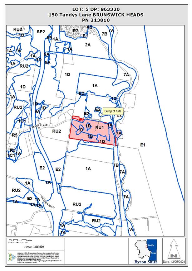
Assessment:
INTRODUCTION
History/Background
Table 1 below provides a history of the applications for the subject allotment.
Table 1 – Application history
|
Application |
Proposal |
Determination |
Comments |
|
BA 6.1994.2388.1 |
Rural shed |
Approved 12/7/1994 |
Subject DA proposes demolition |
|
DA 5.1995.147.1 |
Dwelling |
Approved 10/5/1995
|
Subject DA proposes demolition |
|
BA 6.1995.2174.1 |
Dwelling |
Approved 15/5/1995 |
|
|
DA 5.1995.249.1 |
Extractive Industry (Quarry) |
Withdrawn 24/7/2006 |
|
|
DA 10.2004.544.1 |
Single storey dwelling |
Approved 1/3/2005
|
Not constructed, consent appears to have lapsed |
|
DA 10.2016.818.1 |
Use of building as dwelling to create dual occupancy (detached), demolition of movie room and use of building as art studio |
Approved 9/8/2017 |
|
|
S4.55 10.2016.818.2 |
Modify conditions of consent |
Approved 19/7/2019 |
|
|
S4.55 10.2016.818.3 |
Change bathroom design |
Approved 29/4/2020 |
|
|
DA 10.2018.366.1 |
Change of use of existing dwelling house to bed and breakfast |
Withdrawn 7/5/2019 |
|
|
DA 10.2019.343.1 |
Tourist and visitor accommodation comprising 4 (four) 1-bedroom cabins |
Approved 14/10/2021 |
Not constructed, consent still active |
|
DA 10.2023.41.1 |
Use of unauthorised development in approved farm shed Use of unauthorised development in approved art studio |
Returned 29/3/2023 |
Subject DA proposes demolition of the shed |
|
Use of unauthorised development in approved farm shed Use of unauthorised development in approved art studio |
Returned 12/9/2023 |
Subject DA proposes demolition of the shed |
Figure 1 provides a site plan with an overview of historical approvals of relevance to this DA.
Figure 1 – Historical approvals of relevance to this DA
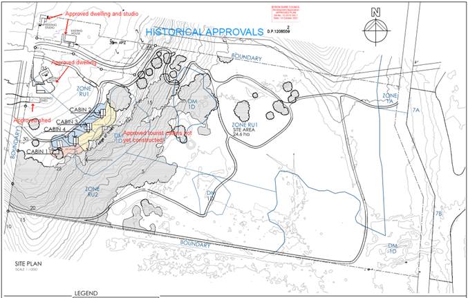
Outstanding compliance matters associated with the subject property:
· The studio in the north western portion of the allotment, approved under DA 10.2016.818.1. Installation of additional benches. DA 10.2023.217.1 sought to rectify this matter, however, the application was returned by Council as it was not a complete application. Compliance staff have been informed and will follow this matter up separately.
· Unauthorised works associated with an approved shed, that is proposed for demolition as part of the DA that forms the subject of this report. If consent is granted for DA 10.2023.194.1, this matter will be considered as resolved.
· Two unauthorised elevated wooden platforms located near the bank of Simpson Creek. The landowner’s planning consultant has previously advised that a development application will be submitted seeking consent for the use of these wooden platforms, however, a DA has not been lodged at the time of writing. In the event no DA is lodged early in the new year, further compliance action will need to be considered to get this matter resolved.
Description of the proposed development
This application seeks approval for demolition of an existing dwelling (part of dual occupancy (detached)), associated swimming pool and outbuildings and proposed new dwelling (part of dual occupancy (detached)), swimming pool, earthworks, and landscaping. The proposed new dwelling is to be constructed on the site of the demolished dwelling.
Proposed dwelling
The proposed large dwelling is set on two levels and is comprised of two wings linked by an internal courtyard, covered walkways and terraces. The northern wing includes the kitchen / dining / living area on the ground floor and three bedrooms on the upper level. This wing opens onto a paved terrace and swimming pool set to the north of the proposed dwelling.
The southern wing is described in the Statement of Environmental Effects as the guest wing on the ground floor as well containing two home offices for use of the residents of the dwelling on the upper level. The guest wing is proposed as an integral part of the dwelling and is not proposed for commercial tourist and visitor accommodation.
The proposed dwelling has a gross floor area of 1,426m2 and the components of the building are set out in Table 2. Refer to Attachment 2 for full architectural plan set. Refer to Attachment 3 for architectural sketches of the proposed dwelling.
Table 2 – Dwelling components
|
Northern Wing |
Southern Wing |
|
Lower Level |
|
|
· Pantry / scullery · Open plan kitchen / lounge / dining · Drawing room · Cellar · Study · Powder room x 2 · Laundry / mudroom · 6 car garage |
· Guest suite / bedroom with ensuite · 4 x bedrooms, sharing 2 x ensuites · Recreation area / rumpus room · Services / store room · Bathroom · Home gym |
|
Upper Level |
|
|
· 3 x bedrooms, each with ensuite · TV lounge · Powder room x 1 · Roof gardens |
2 x home offices, one with powder room 2 x roof terraces Roof gardens |
Proposed east and north elevations are provided in Figure 2.
Figure 2 – Proposed east and north elevations
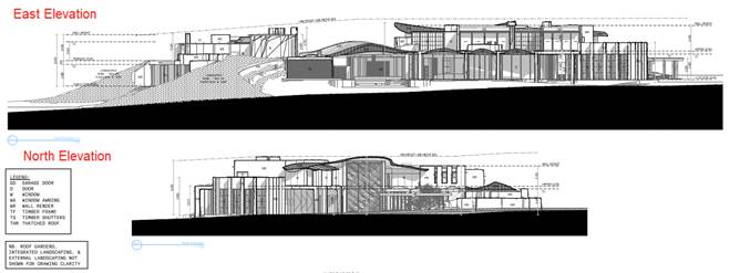
Proposed west and south elevations are provided in Figure 3.
Figure 3 – Proposed west and south elevations
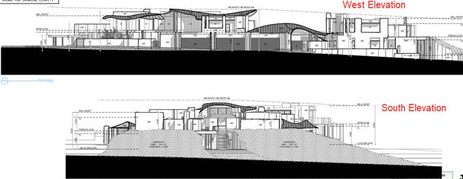
Proposed demolition of existing dwelling
The proposed demolition of the existing dwelling is shown in Figure 4.
Figure 4 – Existing dwelling proposed for demolition
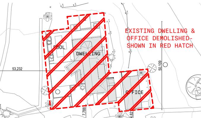
Proposed earthworks
Refer to Attachment 4 of this report for Bulk Earthworks Layout Plan.
The proposed earthworks footprint covers an area of approximately 5,000m2. The volume of cut is 950m3. The volume of fill is 2,470m3. Soil from the cut will be used for fill, thus making the total fill import 1,520m3. Table 3 provides a summary of the approximate depth of earthworks.
Table 3 – Summary approximate depth of earthworks
|
Cut/fill |
Depth (metres) |
Approximate percentage of 5,000m2 earthworks footprint |
|
Cut |
0.5 – 1.5 |
15% |
|
Cut |
2.5 – 3.0 |
4% |
|
Fill |
Application of topsoil only |
40% |
|
Fill |
0.2 – 1.5 |
33% |
|
Fill |
1.5 – 2.5 (southern mounding). Refer to Figure 5. |
4% |
|
Fill |
2.5 – 6.0 (southern mounding). Refer to Figure 5. |
4% |
Figure 5 – Proposed mounding adjacent to southern side of dwelling
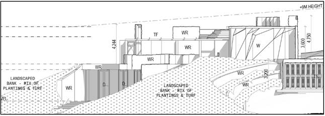
Description of the site
An aerial map with LEP 2014 Land Zoning overlay is provided at Figure 6.
Figure 6 – Aerial View with LEP 2014 Zone overlay
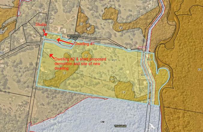
The subject site is a 24.5-hectare property located at the end of Tandy’s Lane on the eastern side of the Pacific Highway. The property is bisected by Anderson Lane which splits the lot into a small northern portion containing a recently approved dual occupancy dwelling and studio and a larger southern portion containing the second dual occupancy dwelling (proposed for demolition as part of the subject DA) and the balance of remaining land. The land slopes down from the road over undulating terrain for 750m until it meets Simpsons Creek at the eastern boundary. Access to the proposed development site is from an unformed Crown Road reserve that connects with Tandy’s Lane.
Historically, the property has been used for farming and sand mining which has left the landscaped disturbed and mostly cleared of vegetation apart from a patch of subtropical rainforest on the western slopes and a corridor of forest along the bank of Simpsons Creek.
Land to the north and west of the site near Tandy’s Lane is characterised by small to medium sized lots used for rural living, small-scale agriculture. The adjoining northern land is used as a plant nursery. Land to the south comprises a larger property that is undeveloped and covered by vegetation. Tyagarah Nature Reserve is located on the eastern side of Simpsons Creek.
|
Land is legally described |
LOT: 5 DP: 863320 |
|
|
Property address |
150 Tandy’s Lane BRUNSWICK HEADS |
|
|
Land is zoned: |
The subject allotment includes the following land zones: C2 Environmental Conservation / PART RU1 Primary Production / PART RU2 Rural Landscape. The proposed development is located within Zone RUI and RU2. The proposal is over 100m away from Zone C2. |
|
|
Land area is: |
24.6ha |
|
|
Property is constrained by:
|
The subject allotment is constrained by · Flood Liable Land · Bushfire prone land · Acid Sulfate Soils Class 1 · High Conservation Value & High Environmental Value vegetation The proposed development site is only constrained by bushfire. |
|
|
|
Is a BDAR required due to the location of the proposed development? |
☐ Yes ☒ No |
|
|
Are there any easements in favour of Council affecting the site? |
☐ Yes ☒ No |
|
|
Is there a Vegetation Management Plan which might affect the proposal? |
☐ Yes ☒ No |
|
|
Is there a Voluntary Planning Agreement which might affect the proposal? |
☐ Yes ☒ No |
SUMMARY OF REFERRALS
The following internal referrals were required for the DA.
|
Referral |
Issue |
|
Environmental Health Officer |
Acid Sulfate Soils The area of land to be developed is not mapped as containing Acid Sulfate Soils. Contaminated land Preliminary site assessment found the site to be suitable for continued residential use. On-Site Sewage Management The OSMS Report for the proposed development has been assessed and deemed acceptable. The proposed system consists of a septic system followed by a AWTS to a suitably sized ETA land application area.
The s68 application has been decoupled from this DA as the current system is in urgent need of upgrade and is failing. Waste Management Serviced by Council for waste pick up. The applicant submitted a Non – Destructive Hazmat Survey Report, which identified asbestos (nonfriable) in the office/granny flat. A waste management/demolition plan is to be submitted to Council for approval prior to issuing of the Construction Certificate. Land Use Conflicts Surrounding land uses are compatible with the intended use. |
|
Development Engineer
|
Access and Parking No road work upgrades are required for this development. Roads Act consent is required for the construction/upgrade of the driveway to Council’s standards – conditions recommended. The proposed access and parking arrangements complies with the minimum requirements of AS2890.1:2004.
Traffic Operational phase: The long-term increase in traffic is minimal and will not have any significant impact on the surrounding road network.
Construction phase: Mitigation measures are appropriate. Conditions are recommended to provide a traffic management plan and follow the proposed mitigation measures.
The existing road pavement in Tandy’s Lane is generally in poor condition and the importation of fill for earthworks has the potential for road pavement damage, which must be repaired to predevelopment conditions – conditions recommended.
Stormwater The large rural site is capable of disposing and treating stormwater runoff and quality on site without creating a nuisance to adjoining property or significant impacts on downstream drainage regime – conditions recommended.
Soil and Water Management Condition recommended for soil and water management plan due to area of soil disturbance (i.e. approximately 5000m2 (77.95 x 62.8)). Calculations for the bulk earthworks: The total cut volume = 950m3 Total fill volume = 2,470m3 Total import = 1,520m3 Earthworks are to be appropriately supervised and certified – conditions recommended.
|
|
S64 / Systems Planning Officer |
Water and Sewer Current Situation The subject parcel of land is not serviced by Byron Shire Council water supply systems or sewerage systems. In properties with bulk water supply only, Rous Water will assess the developer contributions.
Proposed Development The application seeks development consent for Proposed Demolition of an Existing Dwelling, (part of Detached Dual Occupancy) associated Swimming Pool and Outbuildings and Construction of a New Dwelling House, Swimming pool, Earthworks and Landscaping.
The proposed development does not generate additional loading onto Council’s Water, and or Sewer systems. |
|
S7.11 Contributions Officer |
Development contributions are not applicable. One dwelling of the approved dual occupancy (detached) is proposed for demolition and replaced by another dwelling. |
* Conditions provided in the above referrals are included in the Recommended Conditions located at Attachment 1 to this report.
SECTION 4.14 – BUSH FIRE PRONE LAND
Under section 4.14 of the Act, Council must be satisfied prior to making a determination for development on bush fire prone land, that the development complies with the document ‘Planning for Bush Fire Protection 2019’. The site is bush fire prone land. The development application is accompanied by a Report by Bushfire Certifiers dated 25/4/2023 (Revision B) which provides conditions.. A Condition of consent is included in the Recommended Conditions located at Attachment 1 to this report requiring that the development must comply at all times with the requirements of Report by Bushfire Certifiers dated 25/4/2023 (Revision B).
Effect of 10/50 rule on significant vegetation
The land is excluded from the operation of the 10/50 Code.
SECTION 4.15C – MATTERS FOR CONSIDERATION – DISCUSSION OF ISSUES
Having regard to the matters for consideration detailed in Section 4.15(1) of the Environmental Planning & Assessment Act 1979 (EP&A Act), the following is a summary of the evaluation of the issues.
4.1 State Environmental Planning Policies (SEPP)
|
Considerations |
Satisfactory |
Unsatisfactory |
|
Biodiversity and Conservation SEPP 2021 Consideration: No tree removal is proposed as part of the development. No tree removal is required as part of the bushfire protection asset protection zones (APZs). APZ’s are only required over maintained lawns.
|
☒ |
☐ |
|
Resilience and Hazards SEPP 2021 Consideration: Preliminary contaminated land assessment found the site to be suitable for continued residential use.
|
☒ |
☐ |
|
Transport and Infrastructure SEPP 2021 Consideration: No referral required for electricity authority.
|
☒ |
☐ |
|
Sustainable Buildings SEPP 2022 Consideration: The DA was submitted prior to the commencement of this policy. In accordance with clause 4.2(1)(a) this policy does not apply and the submitted BASIX Certificate that accompanied the DA is to be used as a condition of consent. BASIX Certificate No. 1389425S, dated 04/05/2023. |
☒ |
☐ |
4.2 Byron Local Environmental Plan 2014 (LEP 2014)
In accordance with LEP 2014 clauses 1.4 and 2.1 – 2.3:
(a) The proposed development is defined in the LEP 2014 Dictionary as dwelling / dual occupancy (detached);
(b) The land is within the PART RU1 Primary Production / PART RU2 Rural Landscape according to the Land Zoning Map;
(c) The proposed development is permitted with consent; and
(d) Regard is had for the Zone Objectives as follows:
Zone RU1 Primary Production Zone Objectives
• To encourage sustainable primary industry production by maintaining and enhancing the natural resource base.
• To encourage diversity in primary industry enterprises and systems appropriate for the area.
• To minimise the fragmentation and alienation of resource lands.
• To minimise conflict between land uses within this zone and land uses within adjoining zones.
• To encourage consolidation of lots for the purposes of primary industry production.
• To enable the provision of tourist accommodation, facilities and other small-scale rural tourism uses associated with primary production and environmental conservation consistent with the rural character of the locality.
• To protect significant scenic landscapes and to minimise impacts on the scenic quality of the locality.
Zone RU2 Rural Landscape Objectives of zone
• To encourage sustainable primary industry production by maintaining and enhancing the natural resource base.
• To maintain the rural landscape character of the land.
• To provide for a range of compatible land uses, including extensive agriculture.
• To enable the provision of tourist accommodation, facilities and other small-scale rural tourism uses associated with primary production and environmental conservation consistent with the rural character of the locality.
• To protect significant scenic landscapes and to minimise impacts on the scenic quality of the locality.
Compliance comment
The proposed dual occupancy dwelling will be located generally in the same position as the existing approved dwelling on the land. As such, the proposed development wil not negatively impact on any existing primary production activities and will not result in the fragmentation of land.
The location of the dwelling does not raise any potential land use conflicts. In this regard, the locality comprises a combination of rural lifestyle allotments and grazing. No intensive livestock agriculture or horticulture occurs in proximity to the site of the proposed dwelling. The proposed dwelling is designed to be set within the landscape and will not adversely impact on the scenic quality of the locality.
Other applicable LEP 2014 provisions are addressed in the compliance table below.
|
LEP 2014 Compliance table |
||
|
Clause |
LEP Requirement |
Assessment Comment |
|
4.2D Erection of dual occupancies (detached) and secondary dwellings in Zones RU1 and RU2 |
(a) the development will not impair the use of the land for agriculture or rural industries, and |
Complies No adverse impacts on agricultural production. |
|
(b) each dwelling will use the same vehicular access to and from a public road, and |
Variation sought Development consent is sought an existing approved dwelling, part of a dual occupancy (detached). The existing non-compliance with respect to the two dwellings sharing a single driveway was considered and approved as part of DA 10.2016.818.1. The current proposal seeks to continue the use of two driveways. A variation is sought to this requirement via clause 4.6 LEP 2014. Refer to Attachment 5 of this report. |
|
|
(c) for dual occupancies (detached)—dwellings will be situated within 100 metres of each other, and |
Complies The dual occupancy dwellings will be located 47m from each other. |
|
|
(d) the land is physically suitable for the development, and |
Complies The development site is full serviced, free of all constraints, with the exception of bushfire which can be managed with no negative impacts (APZs on maintained lawns). No negative impacts with regards views, overlooking, solar access or the like. The land is suitable for the proposed development. |
|
|
(e) the land is capable of accommodating the on-site disposal and management of sewage for the development, and |
Complies An upgraded Onsite Wastewater Management System has recently been approved by Council that will cater for the proposed development. Appropriate conditions apply. |
|
|
(f) the development will not have an adverse impact on the scenic amenity or character of the rural environment. |
Complies The proposal incorporates a range of design measures to ensure that the proposed dwelling integrates well within the locality. No adverse impacts on scenic amenity or character of the rural area. |
|
|
Clause 4.3 Height of Buildings |
9m |
Complies The proposed dwelling has a maximum building height of 8.89m. |
|
Clause 4.6 Exceptions to Development Standards |
Clause 4.6 enables the variation of clause 4.2D subject to criteria. Refer to Attachment 5 of this report for clause 4.6 variation request. |
Variation sought The subject site is divided by Anderson’s Lane with one approved dual occupancy dwelling located on the northern side of the road reserve and another dual occupancy dwelling located on the southern side of that road reserve. The proposed demolition of one approved dwelling and its replacement with another new dwelling in the same location maintains the approved two driveway status quo. Moreover, the configuration of the allotment inhibits the use of a single driveway and it is contended that the proposed vehicular access is the only practical solution in the current site context.
It is submitted that compliance with the development standard is both unreasonable and unnecessary in the circumstances given that the lot is severed by a road reserve. The proposed development is considered to be consistent with the public interest in terms of ensuring appropriate access is provided to the development site.
Refer to Attachment 5 of this report for clause 4.6 variation request. |
|
Clause 6.2 Earthworks |
(a) the likely disruption of, or any detrimental effect on, drainage patterns and soil stability in the locality of the development, |
Complies The proposed building site does not contain any creeks or drainage lines. Moreover, it is located approximately 500m from the closest ephemeral draining line and 750m from Simpsons Creek.
Appropriate engineering conditions recommended. |
|
(b) the effect of the development on the likely future use or redevelopment of the land, |
Complies The proposed earthworks will enable the southern side of the dwelling to be partially ‘buried’ within the landscape. This will reduce the visual prominence of the structure, particularly when viewed from the east. It is proposed to place water tanks within the embankments, thus reducing the volume of fill. It is highly unlikely that the future use of the land will change from rural lifestyle/agriculture as the land is not located in any future land use strategy for higher order zoning.
Refer to Figure 3 for proposed southern mounding. Refer to Attachment 4 for Bulk Earthworks Layout Plan. |
|
|
(c) the quality of the fill or the soil to be excavated, or both, |
Complies Proposed to source fill by importation. All materials imported into the property will be certified for residential uses in accordance with the EPA requirements. Condition of consent. |
|
|
(d) the effect of the development on the existing and likely amenity of adjoining properties, |
Complies The proposed earthworks enable the dwelling to be nestled within landscaped embanks on the southern side. The proposed works are spatially separated dwellings to the extent that no adverse character or amenity impacts are expected. |
|
|
(e) the source of any fill material and the destination of any excavated material, |
Complies All excavated material to be used as fill. Additional fill imported. Condition of consent. |
|
|
(f) the likelihood of disturbing relics, |
Complies A recent AHIMS search identified an Aboriginal site (midden) in the vicinity of Simpsons Creek. The proposed development will not disturb the Aboriginal site for the following reasons: · Condition of consent and State legislative requirements. · The AHIMS site is located in a the low lying sandy location 650m from the proposed dwelling. The proposed dwelling is located within red Krasnozem soils on the far western side of the 24ha allotment. · The AHIMS site is set at approximately 5m AHD, whilst the proposed dwelling is set on an elevated portion of the site with a finished level of 34m AHD. · The proposed dwelling footprint is generally the same as that occupied by the existing dwelling and associated outbuildings. As such, the development footprint is already heavily disturbed. · Conditions of consent to apply in relation to a Cultural Heritage Site Inspection Report to be prepared prior to works commencing for Site Monitoring. |
|
|
(g) the proximity to, and potential for adverse impacts on, any waterway, drinking water catchment or environmentally sensitive area, |
Complies Conditions of consent. |
|
|
|
(h) any appropriate measures proposed to avoid, minimise or mitigate the impacts of the development. |
Complies Conditions of consent. |
|
Clause 6.6 Essential Services |
Adequate arrangement for: · Water · Electricity · Sewage · Drainage · Vehicular access |
Complies Suitable servicing arrangement are proposed and conditioned in accordance with clause 6.6. |
4.3 Any proposed Instrument that has been the subject of public consultation and has been notified to the consent authority
Not applicable.
4.4A Byron Shire Development Control Plan 2014 (DCP 2014)
The following comments are provided on relevant DCP controls.
|
DCP 2014 Compliance Table |
||
|
Chapter / Section |
DCP Requirement |
Assessment Comment |
|
B3 Services |
· Water · Electricity · Telecommunications · Sewage management · Stormwater and Drainage · Road Access |
Complies · Conditions of consent · Tandy’s Lane vehicle access · Water supply – existing 75kL, proposed additional 150kL, bushfire 20kL · Wastewater Management – Council approved new system with capacity for proposed dwelling earlier in 2023. · Stormwater collected for water supply. Conditions for overflow · The existing dwelling currently serviced with electricity and telecommunication. These services will be utilised for the proposed new dwelling. |
|
B4 Traffic Planning, Vehicle Parking, circulation and Access |
· Driveway access · 2 car parking spaces |
Complies · Conditions of consent · Roads Act consent required for driveway · 6 covered carparking spaces and additional informal visitor parking · Traffic Management Plan required for construction phase |
|
B6 Buffers and Minimising Land Use Conflict |
· Conflict risk assessment · Planning principles to minimise land use conflict · Buffers |
Complies · Council’s EHO has assessed the proposed as adequate with regards land use conflict. · The proposed development does not conflict with existing land use pattern in the locality. |
|
B8 Waste Minimisation and Management |
· Waste Minimisation Management Plan |
Complies · Council’s EHO has assessed the proposed as adequate with regards waste minimisation. · Condition of consent |
|
B11 Planning for Crime Prevention |
· CPTED |
Complies · The proposed development is not expected to increase crime in the locality. In this regard, the entrance to the property clearly defines the premises as ‘private’, rather than ‘public’ land. |
|
B14.2 Excavation and Fill in all Zones |
· 1m cut and fill |
Inconsistent with Prescriptive Measures, consistent with Objectives and Performance Criteria · Refer to the description of the proposed development in the Introduction section of this report; and comments on LEP Clause 6.2 in the LEP Compliance Table. · Compatible with the natural features and does not detract from the immediate locality. Landscaped earthworks used to ‘bury’ part of the building for positive thermal performance and blending into landscape to diminish adverse visual impacts. · No overshadowing. · Resultant landform and buildings compatible with surrounds. · Conditions of consent for stormwater and drainage. · Engineering assessment – no geotechnical issues. · Refer to DCP compliance Table C3 & D2.2.3 Proposal considered acceptable. |
|
C3 Visually Prominent Sites and View Sharing |
· This chapter applies to visually prominent development of visually prominent site · >60m AHD in Zones RU1 or RU2 or in coastal zone
|
Not applicable · The building site is not within the Coastal Zone and is 34m AHD.
However, proposed large dwelling is set on an elevated and open position with expansive views to the east and south. The following design features of the proposed dwelling will assist with blending the proposed development into the landscape and minimise and negative visual impacts. · Existing mature fig trees provide a backdrop within the adjoining western road reserve. · Extensive landscaped mounding on the southern end of the dwelling. · Landscaped roof terraces incorporating green elements within the building. · Splitting the dwelling into integrated structures separated by extensive landscaped courtyards. · Earth coloured external walls and thatched roofing. · Standard colour / material condition of consent. |
|
D2.2.1 Location and Siting |
· Minimise impact on environmental conservation values · Buffers · Visually prominent site |
Complies · Replacement of an existing dwelling in a cleared location. Bushfire APZ’s on maintained lawns only · Setback >100m from HEV vegetation. · No land use conflict · Not visually prominent site |
|
D2.2.2 Setbacks from Boundaries |
· Front 15m · Side and rear BCA |
Complies · Front setback from Tandy’s Lane > 15m · The dwelling is setback 10m from the western boundary which is an unformed Crown road reserve only servicing the subject lot · Side and rear setbacks exceed DCP requirements |
|
D2.2.3 Character and Visual Impact |
· Address the climate · Rural character · Protected outdoor elements · Eaves · No reflective roof · Compatible building materials · Rural character |
Complies · Numerous outdoor sheltered spaces · Extensive landscaped mounding insulating lower level and integrates development with landscape · Standard condition regarding colours / materials · Proposed removal of one dwelling and replacement with a new dwelling maintains status quo. |
|
D2.5.1 On-site Car Parking |
· Two car parking spaces |
Complies · Six car garage & informal visitor parking |
|
D2.5.2 Character and Siting of Dwellings |
· Minimise land use conflicts · Clustering of buildings · Prevent fragmentation of primary production · Reduce environmental impacts |
Complies · By placing the proposed dwelling in the same location as the existing house, site disturbance and off site impacts are minimised. No adverse offsite land use conflicts have been identified. |
|
D2.5.4 Private Open Space |
· Minimum area 30m2 · Minimum length and width 4m · Not located on proposed effluent fields |
Complies · Each dwelling has substantial ground level private open space. · Private open space well removed from effluent fields. |
|
D2.5.5 Adjoining and Nearby Development |
· Dual Occ set back > 10m side and rear boundaries |
Complies · Side and rear setbacks well in excess of requirements. |
4.6 The likely impacts of that development, including environmental impacts on both the natural and built environments, and social and economic impacts in the locality
4.6.1
|
Impact on: |
Likely significant impact/s? |
|
Natural environment |
No. The proposal will not have a significantly adverse impact on the natural environment of the locality. |
|
Built environment |
No. The proposal will not have a significantly adverse impact on the built environment of the locality. |
|
Social Environment |
No. The proposal will not have a significant social impact on the locality. |
|
Economic impact |
No. The proposal will not have a significant economic impact on the locality. |
|
Construction Impacts |
No. The development will generate minor impacts during its construction. Conditions of consent recommended to control hours of work, builders waste, construction noise, installation of sedimentation and erosion control measures and the like to ameliorate such impacts. |
4.6.2 Marine Estate Management Act 2014
The development is unlikely to have an effect on the plants or animals within the Cape Byron Marine Park or their habitat.
4.7 The suitability of the site for the development
The site is a serviced, unconstrained property and is suitable for the proposed development.
4.8 Submissions made in accordance with this Act or the regulations
The development application was publicly exhibited.
There were 0 submissions made on the development application:
4.9 Public interest
The proposed development is unlikely to prejudice or compromise the public interest or create an undesirable precedent.
DEVELOPER CONTRIBUTIONS
5.1 Water & Sewer Levies
No Section 64 levies will be required.
5.2 Developer Contributions
No Developer Contributions will be required.
DISCLOSURE OF POLITICAL DONATIONS AND GIFTS
|
Disclosure details |
Response |
|
Has a Disclosure Statement been received in relation to this application? If Yes, Provide Disclosure Statement register reference: 91. |
Yes ☐ No ☒ |
|
Have staff received a ‘gift’ from anyone involved in this application that needs to be disclosed. |
Yes ☐ No ☒ |
CONCLUSION
The application is consistent with the relevant SEPPs and LEP 2014 provisions with the exception of non-compliance with clause 4.2D of Byron LEP 2014 which requires dual occupancies (detached) in the RU1 or RU2 zones to utilise a shared vehicular access. A clause 4.6 variation was submitted with the DA and is supported.
The application is generally consistent with DCP 2014 requirements with the exception of an inconsistency with the Prescriptive Measures of Section B14.2 Excavation and Fill in all Zones, however the proposal is consistent with the relevant Objectives and Performance Criteria. The DA is recommended for approval subject to the conditions listed in Attachment 1.
BYRON SHIRE COUNCIL
Staff Reports - Sustainable Environment and Economy 13.12
Report No. 13.12 Wallum Subdivsion DA 10.2021.575.1 - Response to Council Resolution 23-454
Directorate: Sustainable Environment and Economy
Report Author: Chris Larkin, Manager Sustainable Development
File No: I2023/1965
This report will be provided in a supplementary agenda to the 14 December 2023 Council Meeting. Once published, the report will be available to view on the ‘Agenda and Minutes’ page of Council’s website - Agendas and Minutes - Byron Shire Council (nsw.gov.au).
BYRON SHIRE COUNCIL
Staff Reports - Infrastructure Services 13.13
Staff Reports - Infrastructure Services
Report No. 13.13 Brunswick Heads Parking Study - Outcomes
Directorate: Infrastructure Services
Report Author: Judd Cornwall, Traffic & Transport Engineer
File No: I2023/984
Summary:
Further to Council Resolution 22-534, which pertains to pay parking potential in Brunswick Heads and Mullumbimby, Council staff provide the following update in relation to the outcomes of the recent Brunswick Heads Parking Study.
Resolution 22-534
1. That in relation to parking in Brunswick Heads, Council;
a) allocates $140,000 in the September quarterly budget review to fund an updated parking study including an expansion of the pay parking areas and an assessment of current supply and demand, time limits; and
b) receives a further report in April 2023 on the above and also on comparative pay parking rates in other Local Government Areas.
2. That in relation to parking within Mullumbimby, staff:
a) Consult with Transport for New South Wales (TfNSW) in relation to parking/overflow associated with the temporary housing within the rail corridor and possible legacy outcomes from this initiative related to parking areas; and
b) provide a further report on options to progress/fund a revised parking study.
3. That staff provide a further report recommending rules on the number of parking permits per residence and how a permit relates to a residence.
4. That Council notes, that stage 1 of the Broken Head Reserve Road parking improvements is scheduled to commence in September/October 2022 and at the completion of these works, a parking assessment to consider an expansion of the existing pay parking precinct will be undertaken and reported to Council for consideration.
RECOMMENDATION:
That Council:
1. Notes the consultant’s report provided in Attachment 1 (E2023/1203356);
2. Endorses the implementation of Brunswick Heads pay parking regime scenario 4 (extended boundary) contained within this report as recommended by staff and Bitzios Consulting.
3. Endorses the use of parking sensors on a trial basis within the core commercial centre of town on:
a) the eastern side of Park Street, between Fingal Street and Mullumbimbi Street,
b) the northern side of Fingal Street, between Park Street and Brunswick Tce,
c) the western side of Brunswick Tce, between Fingal Street and Mullumbimbi Street
d) the southern side of Mullumbimbi Street, between Park Street and Brunswick Tce.
4. Receives a further report detailing the implementation, resourcing and funding plan to deliver and operate the Brunswick Head pay parking scheme.
Attachments:
1 Brunswick
Heads Parking Study Report (Draft)_17 November 2023, E2023/120356 ![]()
Report
The purpose of this review is to assess the outcomes resulting from the implementation of parking improvements based on recommendations from earlier parking studies for Brunswick Heads. These improvements involved modifications to the timed restrictions aimed at encouraging better parking turnover and providing more people with the opportunity to enjoy and conduct business in the town.
Please refer to Figure 1 which shows the current restrictions previously recommended.
Figure 1: Current parking restrictions within Brunswick Heads
Parking assessment findings
Following an investigation of previous parking survey data and results from the validation parking surveys undertaken within this review there was found to be no significant improvement to occupancy from an overstay and turnover perspective. A detailed explanation of these findings can be found within part 4. Current Parking Situation, of the attached report (attachment 1).
One of the main takeaways from the study was that during this low season, considering weather conditions etc. the centre of town is still reaching a trigger point for further intervention (72% occupancy) when considering growth (Please refer to figure 2).
On the day of the surveys which produced figure 2 (below) the weather was generally poor, from a beachgoing perspective. This indicates that from a base background parking demand point of view, under poor weather and weekday conditions Brunswick is still approaching capacity in the commercial precinct without the tourist overlay.
Figure 2: Weekday Parking occupancy (low season)
Parking surveys were also undertaken during the peak season (October, fine weather), which indicated that the weekday parking demand within the centre of town reached 77% occupancy, with the foreshore reaching around 60% occupancy. It is worth noting that it is hard to give a true indication of occupancy given that some areas are not maximised to the full potential due to un-formalised and underutilised kerb space. A detailed breakdown of this assessment can be found within attachment 1 contained within this report in section 4.4.2. The figure below (figure 3) shows the peak demand for the weekday, high season.
Figure 3: Weekday peak parking occupancy (High season)
The weekend peak parking demand as expected reaches capacity at the peak in town (85% occupancy) during the low and high periods.
The high season weekend peak period for the high season is well over capacity (please refer to figure 4).
Figure 4: Weekend peak, high season parking occupancy
Forecasted parking demand
The anticipated parking demand is determined by various growth factors outlined in the attached report (Attachment 1, Part 5, Future Parking Demand).
This assessment suggests that in the short term, the growth analysis indicates an increase in demand for the core Brunswick center, rising from 72% weekday occupancy to 81% by 2028 (please refer to Figure 5).
Additionally, it is anticipated that the
projected peak parking demands in the foreshore parking area could surpass the
current available parking supply by approximately 20% to 50% from 2028 to 2038.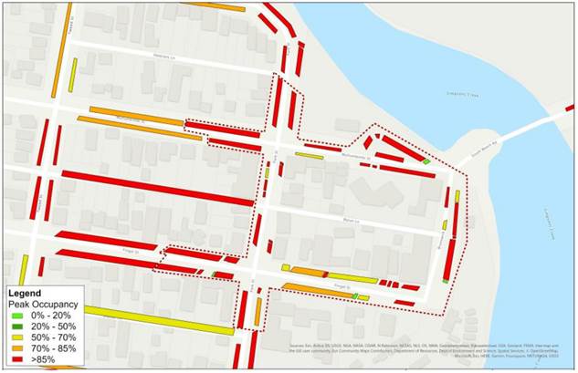 Figure
5: 2028 forecasted parking demand
Figure
5: 2028 forecasted parking demand
Summary
Parking demands in the town center, even during the low season, have reached a point where an update to the parking management regime needs to be considered in the short term.
Reducing time limits is an option, but it would be too restrictive and would require significant enforcement to ensure compliance. Additional formalised parking (surfacing, signs/lines) would help increase supply but would come at a substantial cost, given that much of the kerbside within Brunswick is unsealed.
Following the consultants' review, they have concluded that the implementation of pay parking would be the most effective way to achieve improved parking outcomes.
Therefore, several options were analysed to determine which paid parking scenario would best enhance parking efficiency throughout the township (please refer to Attachment 1, Part 7, Pay Parking Assessment for further details).
A summary of the different parking scenarios is presented below (Table 2: Pay parking options and evaluation).
Table 2: Pay parking options and evaluation
|
Scenario Tested |
Advantages |
Disadvantages |
|
Scenario 1: $3/hr with resident permit exemption |
▪ Consistent pay parking regime with Byron Bay, with provision of resident permit exemption and allows for consistent messaging
|
▪ Level of parking users with permit exemption may mean
pay parking
|
|
Scenario 2: First 1-hour |
▪ Generates estimated at $1.83 million per annum
|
▪ Would incur additional implementation costs with signage changes to apply simplified 2P or 4P parking restrictions by removing 1/2P, 1P parking areas
|
|
Scenario 3: First 30 |
▪ Generates higher revenue compared with Scenario 1 and 2
in the order of
|
|
|
Scenario 4: Scenario 1 fees with expanded pay parking area |
▪ Consistent pay parking regime with Byron Bay with provision resident permit exemption and inclusion of popular foreshore parking
|
▪ Higher initial capital cost for implementation
|
|
Scenario 5: Peak season pay parking only |
▪ Generates an estimate $1 million in revenue per annum
|
▪ Reduced return on investment from parking infrastructure
|
|
Scenario 6: Seasonal parking pricing |
▪ Estimated to generate $1.3 million in revenue per annum
|
▪ Mixed regime may create confusion for parking users
|
Based on the results of the pay parking assessment and workshop discussions (Councillor Workshop on 2 November 2023), the consultant has recommended that Scenario 1 or Scenario 4 be the preferred options to progress the implementation of pay parking in Brunswick Heads. While Scenario 2 or 3 would likely achieve more optimal parking management outcomes for turnover and availability, there is a need to consider the local context, given:
· The growing parking pressures in the centre are a result of increasing tourists and visitor demands in Brunswick Heads.
· Nearby in Byron Bay, pay parking has been implemented with a resident permit exemption and other permit provisions for workers.
· Across other benchmarking examples, some form of resident permit is provided (for a fee).
Council staff support the consultant’s recommendation, particularly regarding the lower hourly parking rate, which will lessen the impact of a reduction in visitation. Staff believe that the 4B boundary option would be the best scenario, as the 4A staged approach (town then foreshore after 2 years) would be unpredictable and likely have a significant impact on the foreshore in terms of nuisance camping and all-day parking (please refer to figures 6 and 7 for the Option 4 pay parking boundary). This option would not alter the current time limit restrictions within Brunswick Heads.
For further details regarding the Parking Cost and Revenue Calculation for each pay parking scenario, please refer to Attachment 1, Appendix B: Parking Cost and Revenue Calculation Sheets.
Another consideration regarding the introduction of a pay parking regime is that Brunswick Heads suffers from nuisance camping, and the installation of pay parking has shown to give the impression of surveillance, which may improve the social environment within an area. Staff also believe that this may be a great opportunity for the Council to trial additional technology (sensors) that can monitor occupancy in real time for enforcement purposes. Sensors may be an additional way to enforce and discourage nuisance camping while helping enforcement officers better manage their patrols.
Further details on these additional implementations and costs are contained within Attachment 1, Part 6.2 Implementation Considerations.

Figure 6: Recommended parking regime boundary (no change to current parking time restrictions)
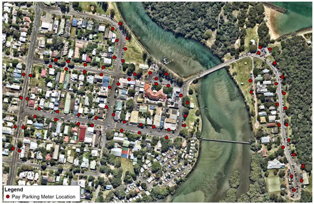
Figure 7: Parking meter location (preferred parking regime)
Other Considerations
§ Worker long term parking – a worker permit can be provided that would allow workers to park and overstay in a designated area. One area proposed for this designation would be Park St, between Mullumbimbi St and Fawcett St.
§ Compliance: the use of parking sensors will assist enforcement as it will provide them with real time overstay data so they can manage their beat times more efficiently. Also parking technologies like meters and sensors give the impression that users are being monitored which can increase parking compliance.
Next Steps
§ Seek TfNSW concurrence to implement the Brunswick Heads pay parking scheme.
§ Provide Council with a further report detailing the implementation, resourcing and funding plan to deliver and operate the Brunswick Head pay parking scheme.
Strategic Considerations
Community Strategic Plan and Operational Plan
|
CSP Objective |
CSP Strategy |
DP Action |
Code |
OP Activity |
||||
|
5: Connected Infrastructure |
5.2: Connect the Shire through integrated transport services |
5.2.4: Parking - Manage parking through effective controls that support Movement and Place Plans and are coordinated with other initiatives such as park and ride |
5.2.4.1 |
Undertake regular and frequent parking patrols to increase availability and turnover in the town and village centres and compliance with mobility parking |
||||
Recent Resolutions
Resolution 22-534
1. That in relation to parking in Brunswick Heads, Council;
a) allocates $140,000 in the September quarterly budget review to fund an updated parking study including an expansion of the pay parking areas and an assessment of current supply and demand, time limits; and
b) receives a further report in April 2023 on the above and also on comparative pay parking rates in other Local Government Areas.
2. That in relation to parking within Mullumbimby, staff:
a) Consult with Transport for New South Wales (TfNSW) in relation to parking/overflow associated with the temporary housing within the rail corridor and possible legacy outcomes from this initiative related to parking areas; and
b) provide a further report on options to progress/fund a revised parking study.
3. That staff provide a further report recommending rules on the number of parking permits per residence and how a permit relates to a residence.
4. That Council notes, that stage 1 of the Broken Head Reserve Road parking improvements is scheduled to commence in September/October 2022 and at the completion of these works, a parking assessment to consider an expansion of the existing pay parking precinct will be undertaken and reported to Council for consideration.
(Lyon/Westheimer)
Legal/Statutory/Policy Considerations
RMS approval is required for:
· All day parking devices of systems hat are used in NSW (refer Appendix A)
· Pay parking schemes proposed on classified roads
· Cashless metered or ticket pay parking schemes
RMS concurrence must be sought for the implementation of all day parking schemes. This is because parking signs, meters/machines, etc. are prescribed traffic control devices therefore must go through the local traffic committee before they can be installed.
RMS will maintain a list of all approved pay parking devices or systems on its website.
RMS may also provide advice on matters relating to traffic management, traffic efficiency and road safety, including proposals involving parking schemes on roads and road related areas. Parking authorities may engage with RMS either directly or through the local traffic committee.
All submissions seeking RMS approval or concurrence must be discussed with or forwarded to the local RMS office in the first instance.
Financial Considerations
It is important to note that the introduction of pay parking does not instantaneously result in a revenue stream for Council. The introduction of pay parking requires a substantial amount of resource effort up front and on an ongoing basis. The key issues that can absorb resources (and budgets) rapidly include:
▪ the need to monitor the operational performance of the system
▪ the need to have the systems and resources in place to deal with parking fines and disputes
▪ the need to adequately enforce the parking restrictions
▪ the need to manage associated resident permit parking schemes
▪ the need to effectively communicate with the public and manage complaints received and
▪ the need to continually monitor, enhance and fine tune the paid parking system. Byron Shire benefits from already having introduced paid parking into Byron Bay so some of these costs may be able to be absorbed. Additional staff resources however may be needed for an expansion of pay parking within the shire to manage, enforcement and monitor the pay parking system.
Please refer to Appendix B: Parking Cost and Revenue Calculation Sheets of the attached report (attachment 1) for indicative capital costs versus revenue for all analysed pay parking scenarios.
Table 2: indicative cost versus revenue for the proposed pay parking scenario
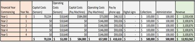
Consultation and Engagement
Bitzios Consulting was engaged by Council to undertake an on-street car parking capacity and management review to identify improvements to maximise the efficiency of available on-street parking.
This study builds upon previous parking studies that were conducted (by others) of behalf on Council in 2018-2020.
Previous studies found that parking demands were at a point where the study recommended that Council should undertake a cost/benefit analysis with the objective to introducing metered parking into Brunswick Heads in order to address the capacity and compliance issues.
Understandably however the outcomes of these previous studies were deferred to allow Council the opportunity to monitor conditions within Brunswick Heads post COVID.
Staff have scheduled a meeting with representatives the Brunswick Heads Chamber of Commerce, Brunswick Heads Progress Association and Brunswick Heads Public School on 5 December 2023 to provide advice of the findings of the study.
BYRON SHIRE COUNCIL
Staff Reports - Infrastructure Services 13.14
Report No. 13.14 Single-use Packaging and Materials Policy
Directorate: Infrastructure Services
Report Author: Danielle Hanigan, Manager Resource Recovery
File No: I2023/1649
Summary:
At its 26 October 2023 Ordinary Meeting, Council endorsed the draft Single-use Packaging and Materials Policy for public exhibition.
The Policy outlines the principles and decision-making framework for Council staff, the community and businesses to phase out single-use and disposable materials in all Council business, on Council owned and managed lands, and in Council buildings and facilities.
The Policy was placed on public exhibition for a period of 30 days during which time Council received 5 submissions. This report provides an overview of those submissions and minor amendments to the Policy. It recommends Council adopts the revised Single-use Packaging and Materials Policy.
RECOMMENDATION:
That Council:
1. Notes the submissions received during the public exhibition period as outlined in Attachment 1 (E2023/124753)
2. Adopts the Single-use Packaging and Materials Policy 2023 with amendment as per Attachment 2 (E2023/124762)
Attachments:
1 Single-use
Packaging and Materials Policy - Submissions received during Public Exhibition,
E2023/124753 ![]()
2 Single-use
Packaging and Materials Policy 2023 FINAL, E2023/124762
![]()
Report
Community consultation for the draft Single-use Packaging and Materials Policy occurred via a feedback form hosted online on the Your Say Byron Shire engagement platform.
Community members, sporting organisations, event organisers, committee members and staff were invited to share their feedback on the draft Policy over the 30 day public exhibition period from 30 October to 28 November 2023.
Six responses were received via Your Say during the public exhibition period, and these submissions are outlined in Attachment 1(E2023/124753).
Single-use Packaging and Materials Policy
The Single-use Packaging and Materials Policy supports the delivery of the NSW government waste reduction targets, as well as key objectives within Council’s Towards Zero: Integrated Waste Management and Resource Recovery Strategy.
Single-use packaging and materials are designed to be ‘thrown away’ or disposed of after a short period of time.
These products are created without considering what happens to them at the “end of life” or the resources required to manufacture them in the first place. This includes single-use materials described as “recyclable”, “compostable” or “biodegradable.”
Single-use and takeaway packaging makes up 40% of the litter found in our environment.
The Policy sets a standard, and encourages industry, business and the broader community working with Council to design and implement aligning values and practices.
The Single-use Packaging and Materials Policy will help us to phase out unnecessary waste from our operations, facilities and open spaces, and encourage a change in behaviour amongst staff and community dealing with Council.
The Single-use Packaging and Materials Policy will:
· Reduce plastic pollution and litter on our beaches and open spaces.
· Reduce carbon emissions in making, moving and disposing.
· Minimise landfill.
· Preserve natural resources.
The Policy will be supported with guidelines, resources and investment in the necessary infrastructure to drive a switch from single-use to reusable alternatives.
Implementation of this Policy will be staged to allow for appropriate stakeholder engagement and ensure Council operations are not negatively impacted. Details of the staged implementation, and who the Policy applies to are outlined in Attachment 2 (E2023/124762)
Balloons and decorations
The first phase of the Policy implementation (6 months from the date the Policy is adopted) includes the use of all types of balloons and other environmentally problematic decorations from all Council owned or managed sites (buildings, facilities, parks, land and road reserves.)
Amendment to the draft Policy
The following line item has been added to Table 3.3.1 in section 3.3 of the Policy: Single-use packaging and materials not permitted to be procured, used, sold or distributed .
4. Food Containers (takeaway)
With or without lids. Plastic, bioplastic, paper, bamboo or any other material described as compostable or biodegradable
Although the intent of the items listed in the draft Policy was to include takeaway food containers, it was noted that this was not explicit, and therefore the additional line item has been added. This aligns with the NSW EPA’s proposed actions to address takeaway food and beverage items, which make up 32% of the NSW litter stream.
No further amendments, other than administrative have been made to the draft Policy.
Strategic Considerations
Community Strategic Plan and Operational Plan
|
CSP Objective |
CSP Strategy |
DP Action |
Code |
OP Activity |
|
3: Nurtured Environment |
3.5: Minimise waste and encourage recycling and resource recovery practices |
3.5.1: Waste management and resource recovery strategy - Implement Integrated Waste Management and Resource Recovery Strategy - Towards Zero |
3.5.1.3 |
Improve management of Council generated waste through development and implementation of a policy that supports circular economy and waste hierarchy principles by eliminating single use packaging and materials |
|
3: Nurtured Environment |
3.5: Minimise waste and encourage recycling and resource recovery practices |
3.5.2: Recycling - Work with business and tourism sector to reduce waste to landfill |
3.5.2.2 |
Expand reusable networks in the takeaway food sector and decrease single use, disposable packaging |
|
3: Nurtured Environment |
3.5: Minimise waste and encourage recycling and resource recovery practices |
3.5.2: Recycling - Work with business and tourism sector to reduce waste to landfill |
3.5.2.5 |
Develop and implement Zero Waste Event processes and policies |
|
3: Nurtured Environment |
3.5: Minimise waste and encourage recycling and resource recovery practices |
3.5.4: Education - Empower the community to increase avoidance, reuse, and recycling activities |
3.5.4.3 |
Develop and support community-based sustainability and circular economy initiatives that increase reuse, repair and upskilling |
Recent Resolutions
Resolution 23-501
Resolved that:
1. The Draft Single-use Packaging and Materials Policy (Attachment 1 E2023/32923) be placed on public exhibition for a minimum of 28 days.
2. a) Should there be no submissions, the Draft Single-use Packaging and Materials Policy is endorsed from the date after the close of the exhibition period and;
b) Should submissions be received, the Draft Single-use Packaging and Materials Policy be reported back to Council noting the submissions and any amendments made as a result of the feedback received.
3.
a) Council writes to the NSW government to lobby that they expand the list of banned single-use plastics under the Plastic Reduction and Circular Economy Act 2021 in a timely manner.
b) Council distributes the adopted Policy to other Councils within the region for their information.
c) Council promotes the most up to date information as to which items go in which bin, through various channels including Council’s website.
Legal/Statutory/Policy Considerations
As outlined in Attachment 2 (E2023/124762)
Financial Considerations
Implementation of the Policy will be funded via the Waste Reserve – Strategy Implementation budget as adopted by Council.
Grant funding will also be sought to support identified infrastructure upgrade needs.
As an organisation, Council spends approximately $230,000 per annum on internal waste management costs across its administration buildings and facilities. Through implementing Polices such as this, in combination with other waste reduction initiatives, Council aims to reduce this amount by 30% over the next two years.
Consultation and Engagement
The draft Single-use Packaging and Materials Policy was subject to 30 day public exhibition from Monday 30 October to Tuesday 28 November.
Community feedback was sought online via Your Say Byron Shire. Emails to a variety of stakeholders, newspaper advertisements, media releases, social media posts across several platforms and face to face engagement was conducted throughout the public exhibition period.
Emails were distributed to noted stakeholder groups via relevant staff to sporting groups, Section 355 Committees and Event organisers advising of the Policy, the exhibition period and how to provide feedback or submission.
Increased engagement with these groups will commence once the Policy is adopted to ensure they are supported in a way that is appropriate to them to enable implementation of the Policy.
The submissions have been considered and a summary of the 6 submissions is provided in Attachment 1(E2023/124753). The submissions were largely in favour of the Policy, and in addition made comments and suggestions to address supermarket packaging. One event organiser voiced concerns on the impact of the Policy on their event and has been contacted for further engagement to ensure adequate support and transition periods are applied to enable viability of the event under the Policy guidelines. Council will work closely with stakeholders to ensure that they can contribute to the toolkits and resources that will be developed to assist the implementation of the Policy.
Consideration will also be given to next steps beyond the Policy given the theme of the submissions regarding packaging in supermarkets. Lobbying of state and federal governments, in accordance with Council resolutions will support this.
BYRON SHIRE COUNCIL
Staff Reports - Infrastructure Services 13.15
Report No. 13.15 s7.11 and s7.12 Contributions Plans Review Update
Directorate: Infrastructure Services
Report Author: Christopher Soulsby, A/ Manager Assets & Major Projects
Shannon Burt, Director Sustainable Environment and Economy
File No: I2023/1836
Summary:
This report is in response to Resolution 21-240 review of Council’s contributions plans and Resolution 23-387 requiring a report be presented to the December 2023 meeting to outline a program to carry out Resolution 21-240.
This report provided information on the current plans, the regulatory framework, principles, and the link to the Residential Strategy.
This report also details a set of basic tasks to be included in the consultants brief to prepare a new contributions plan and requests Council to allocate a budget to undertake the plan preparation and consultation.
RECOMMENDATION:
That Council allocates a budget of $150,000 from the developer contributions plan administration reserve to engage a consultant to prepare a new contributions plan based on the Final updated version of the Residential Strategy to be adopted by Council in February 2024.
Report
Background
Local infrastructure contributions, also known as developer contributions, are charged by councils when new development occurs. They help fund infrastructure like parks, community facilities, local roads, footpaths, stormwater drainage and traffic management.
There are 2 forms of local infrastructure contributions:
· Section 7.11 contributions: Charged where there is a demonstrated link between the development and the infrastructure to be funded. Councils prepare contributions plans that specify what infrastructure will be provided and approximately how much it will cost. This is used to calculate a contribution rate, usually charged per person, dwelling, or lot square metre.
Councils that want to charge a contributions rate above the threshold set by the minister (PDF, 290 KB) must submit their plans to IPART for independent review, amend per the minister’s advice, and approve the plans. Section 7.11 was previously known as section 94.
· Section 7.12 levies: are an alternative to s7.11 contributions and are charged as a percentage of the estimated cost of the development. The maximum percentage that can be charged in most areas is 1%. There are a small number of areas that charge a higher percentage. Section 7.12 was previously known as section 94A.
Councils administer the local infrastructure contributions for their area.
Current plans
Byron Shire currently has two (2) contributions plans and a planning agreement policy in place to collect local infrastructure contributions.
Developer contributions - Byron Shire Council (nsw.gov.au)
The plans were adopted in 2012 and came into force on 1 January 2013. The plans have been amended 4 times since adoption with Amendment 4 coming into force October 2019.
The current plan has the following components:
1. Local Open Space & Recreation
2. LGA Wide Open Space & Recreation
3. LGA wide Community Facilities
4. Local Community Facilities
5. Bikeways & Footpaths
6. LGA Wide Bikeways & Footpaths
7. Urban Roads
8. LGA urban Roads
9. Rural Roads
10. Administration Levy
The plans are catchment based in terms of project identification and funding allocations.
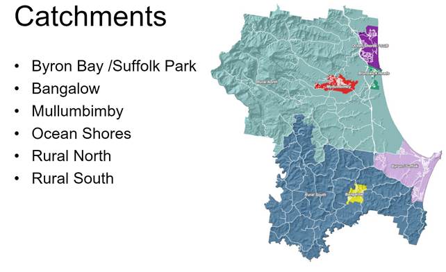
The plan requires that Council spend the contributions for the purpose within the catchment that they were collected. That is open space contributions collected in Bangalow are spent on open space works in Bangalow. The plan does allow for internal borrowings between catchments and types, but these borrowings have to be repaid back into the correct reserves.
Contributions are indexed quarterly in accordance with Sydney consumer price index.
The current rate of contributions as of December 2023 is set out in the table below:
|
Byron Bay Suffolk Park |
15,232.07 |
|
Bangalow |
11,672.95 |
|
Mullumbimby |
20,000.00 |
|
Ocean Shores |
8,149.10 |
|
Rural North |
20,000.00 |
|
Rural South |
20,000.00 |
|
Brunswick Heads |
10,947.04 |
It is to be noted that both rural catchments and Mullumbimby have exceeded the $20,000 ministerial cap (mentioned above) due to indexation and are limited to $20,000.
Both the s7.11 and s7.12 plans are due to for replacement with new plans. The new plan will provide the infrastructure to meet the needs of the population created by The Residential Strategy 2024.
Program to carry out Resolution 21-240
Prepare a new s711 plan and prepare a new s7.12 plan. These plans should be complimentary. The following information sets out the requirements for the s7.11 plan.
Developers pay infrastructure contributions to the State Government and local councils.
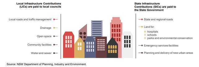
Below is a diagram that represents the framework and inputs to support local contributions plans.
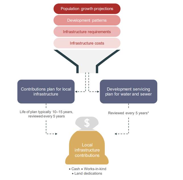
It is proposed to engage a suitably qualified consultant to prepare a new contributions plan based on The Residential Strategy 2024 to be adopted in February 2024.
The Residential Strategy will set out the population projections and the development patterns. Based on the population projections and growth patterns we can determine the infrastructure needs of the new population.
A consultants brief can be prepared to develop the new plan. The development of the new plan will have to conform to the following principles.
Development contributions are imposed by way of a condition of development consent or complying development, and can be satisfied by:
· dedication of land
· a monetary contribution
· material public benefit
· a combination of some or all of the above.
The new plan will have to conform to the following principles:
Developer contributions may only fund new capital. Capital funding means the initial one-off designed to meet the cost of providing infrastructure and include:
· the costs of land acquisition including all things necessary to bring the land into council ownership and to a standard suited for the end use
· construction and provision of facilities including all the things necessary to facilitate construction and to bring the facility to a standard that is suited to the end use.
Capital costs do not include on-going operational and maintenance costs.
Generally, contributions can only be sought for the following:
· capital costs, including land acquisition costs
· public facilities that a council has responsibility to provide
· public facilities that are needed as a consequence of, or to facilitate, new development.
The following principles must be adhered to when preparing a contribution plan.
Reasonableness comprises concepts of fairness, equity, sound judgement and moderation. The two key principles underlying reasonableness are nexus and apportionment.
Nexus is the relationship between the expected types of development in the area and the demonstrated need for additional public facilities created by those developments. The requirement to satisfy nexus is one of the core components of a valid development contributions plan and is a specific requirement of EP & A Regulation.
Apportionment is a tool to arrive at the correct nexus to ensure that a developer contributions only ever reflects the demands of development and not other demands.
In order to ensure the new plan is reasonable in terms of nexus and apportionment the location and number of new dwellings will need to be determined. Where are facility services both the needs of the current population and the new population the percentage of demand must be determined and applied in order to calculate the contribution.
Reconciliation is a process where the funds collected under the previous contributions plan is allocated to the works proposed in the new plan. This has the effect of lowering the cost of works in the new plan.
The formula for indexation of a contribution is:

C = The original contribution amount as shown on the consent
Ind1 = The Consumer Price Index Number (Sydney - All Groups) currently available from the Australian Bureau of Statistics at the time of payment.
Ind2 = The Consumer Price Index Number (Sydney - All Groups) last published by the Australian Bureau of Statistics at the time of the grant of development consent.
The calculation of the charge of a facility should be a reasonably simple formula of:

W = Total cost of works
N = Number of dwellings in the catchment
However, this fails to take into account the requirements of apportionment and to reconcile the money already collected but not yet spent under the terms of the 2012 contributions plan.
When the need to apportion cost and reconcile the old plan is applied then the formula used to calculate the contribution for each line item for a works schedule in a Catchment is:

Where:
W = Total cost of works
R = Reconciliation amount
P = Percentage attributable to new development
N = Number of dwellings in the catchment
The formula to calculate the total contribution (TC) per dwelling in a catchment at the time of consent the grant of consent is the sum of all the line items multiplied by the increase in the consumer price index:
Where:
CPI = Ind1 at date of consent / Ind2 at date of adoption of plan
n = number of line items to be summed in a catchment
C = Contribution(per line item)
Once the development areas are confirmed from the Housing Options Paper recommendations (December) a consultants brief can be prepared to develop the new plan. This will include the following tasks for the section 7.11 plan:
1. Review the catchment boundaries in the context of The Residential Strategy
2. Allocate new population to catchments
3. Prepare works schedules for facilities to meet the needs of the new population
4. Undertake cost estimates for the work schedules
5. Reconcile old plan
6. Consult with stakeholders on new work schedules
7. Determine the new rates of contribution for each catchment
8. Report the draft plan to Council
9. Formal exhibition of draft plan.
10. Report on submissions and adoption of new plan.
The s7.12 plan currently has a separate schedule of works to the 7.11 plan with little overlap. It is proposed to mirror the works schedules from the 7.11 plan to enable the fixed levy from the 7.12 plan to pay for Council’s share of the apportionment in the 7.11 plan.
In addition to mirroring the works schedule from the 7.11 plan there will be important additions to the works schedules of the 7.12 plan to fund works where there is no direct nexus to population growth. These are some civic and urban improvement works as identified in the Byron Bay Town Centre Masterplan and increased funding for public art. A separate report on public art funding and proposed amendments to the Public Art Chapter of DCP 2014 will be presented to Council in 2024.
Key issues
The updated contributions plan will also have to take into consideration the process and technical recommendations from the internal audit recently undertaken and to be presented to the Audit Risk and Improvement Committee.
Resolution 21-240 asked the following specific questions:
a) whether the separate s7.12 policy is working as envisaged, and in the best interests of our community, since development contributions were split into s7.11 and s7.12.
b) whether the s7.12 policy and its current levels of contribution are ‘fit for the future’ given the current and predicted influx of larger DAs in the shire’s non-residential areas.
c) whether the s7.12 policy adequately covers the range of civic infrastructure facing increasing demands from non-residential development.
d) whether the current s7.12 policy’s failure to collect contributions for the road network be amended as non-residential development generates further demands on roads.
The answer to these was in part presented to Councillors at the workshop held on 2 March 2023. The current practice of collecting s7.11 contributions for residential development and s7.12 levy for all other types of development is working as designed and is yielding a higher level of funding than if all the development were combined into the one pool of works under s7.11.
With reference to the formulas above if you add additional (tourist) population to N where N= Number of dwellings in the catchment. This reduces the individual charge on a per lot basis but is does not change the value of works (W) nor does it change the yield other than to eliminate the income stream from the s7.12 plan in entirety.
The current level of the s7.12 levy is in staff’s view inadequate. However, this percentage of the cost of works is fixed by the Department of Planning and can only be amended by regulation. As part of the preparation of the new 7.12 plan a request will be made to the Department to increase the fixed levy from 1% to 3% of the cost of development.
As was noted above the works schedules in the new s7.12 plan will mirror the s7.11 plan to ensure that non residential development is contributing to the same works, including roads, as the residential development.
Next steps
· Council adopts the Housing Options Recommendations to enable staff to complete the Residential Strategy 2020 refresh (December 2023).
· Council resolution on scope of work for the consultant and budget allocation to prepare new contributions plans.
· Request for Tender or Quotation to suitable consultants in accordance with Council’s procurement guidelines.
· March 2024 present a project plan on the implementation of items 1-10 above to a Councillor workshop.
Strategic Considerations
Community Strategic Plan and Operational Plan
|
CSP Objective |
CSP Strategy |
DP Action |
Code |
OP Activity |
|
|||||
|
1: Effective Leadership |
1.3: Ethical and efficient management of resources |
1.3.2: Revenue Sources - Identify and investigate additional revenue sources |
1.3.2.1 |
Undertake a financial review and productivity improvements to facilitate future consideration of additional revenue sources; including evaluation of the need and impact of a Special Rate Variation, Developer Contributions, and other levies |
|||||
Recent Resolutions
Resolved 21-240 that Council:
1. Be provided with a report by February 2022 reviewing the s7.11 and s7.12 contribution policies and providing options for amendment, including addressing:
a) whether the separate s7.12 policy is working as envisaged, and in the best interests of our community, since development contributions were split into s7.11 and s7.12.
b) whether the s7.12 policy and its current levels of contribution are ‘fit for the future’ given the current and predicted influx of larger DAs in the shire’s non-residential areas.
c) whether the s7.12 policy adequately covers the range of civic infrastructure facing increasing demands from non-residential development.
d) whether the current s7.12 policy’s failure to collect contributions for the road network be amended as non-residential development generates further demands on roads.
2. Be provided with a report by November 2021 which outlines the scope of the review above and flagged in the staff report.
3. Notes the proposed review for the contributions plan and considers the following within the scope of such a review:
a) strategic directions contained in town and village masterplans
b) potential for contributions toward public transport infrastructure
c) movement and place framework
d) changes in community expectations due to the COVID pandemic, as to the use of public space and priority infrastructure
Councillor Workshop 2 March 2023 specifically discussed what was involved in the preparation of a new developer contributions plan.
Topics covered:
1. Works delivered, income and expenditure to date under the 2012 contributions plan.
2. Relationship to grant funding.
3. Basis of contributions plan
a. User pays system;
b. Apportionment and unfunded apportionment risk;
c. Nexus;
d. Works schedules;
e. Types of contributions;
f. Ministerial Cap on contributions;
g. What a contributions plan can and can’t deliver.
4. Population projections
5. Catchments.
6. New works schedules.
7. Community consultation on new works.
At the workshop staff also canvassed timing difficulties given the need to synchronise the updates and review of the plans with the Residential Strategy Refresh. The anticipated timing for this being end of 2023.
Resolved 23-387 that Council:
1. Notes the information provided in this report on active Council Resolutions in Attachment 1 (#E2023/67986).
2. Notes the completed Resolutions in Attachment 2 (#E2023/67999).
3. Does not record Resolutions 23-196 and 23-271 as complete, and returns those resolutions to ‘Active Resolutions’.
4. That a report be presented to the December 2023 meeting to outlining a program to carry out Resolution 21-240
Legal/Statutory/Policy Considerations
· Environmental Planning and Assessment Act 1979 – Provides the legislative framework for
infrastructure contributions.
For more details see Part
7 Division 7.1 on the NSW legislation website.
· Environmental Planning and Assessment Regulation 2021
– Provides further requirements relating to the making, amending and
revocation of contributions plans, giving public notice and other procedural
arrangements.
For more details see Part
9 on the NSW legislation website
Further the Environmental Planning and Assessment Regulation 2021 has been amended to improve transparency and accountability in how infrastructure contributions are received and spent in NSW. The new reporting requirements will commence on 1 July 2022.
Section 7.12 fixed development consent levies – Practice note – February 2021 (nsw.gov.au)
Practice Note – Local Infrastructure Contributions – January 2019 (nsw.gov.au)
Financial Considerations
A budget allocation of $150,000 is required to fund the work.
Due to the specific and technical nature of the work and need to expedite it ahead of business as usual, a consultant will be engaged to undertake the plan review and update. This budget allocation can be funded from the developer contributions administration reserve. There is adequate funds in this reserve to fund this project.
Consultation and Engagement
It is proposed to undertake stakeholder engagement in the preparation of the works schedules prior to undertaking the formal exhibition process as required under the legislation.
BYRON SHIRE COUNCIL
Staff Reports - Infrastructure Services 13.16
Report No. 13.16 Approval for Supplier of Automated Flooded Road Signage
Directorate: Infrastructure Services
Report Author: Katie Hughes, Project Engineer
File No: I2023/1922
Summary:
Council has received a $300,000 grant to install four Automated Flood Warning Signage in the Shire. The signage is to be installed by June 2024 as per the grant funding deadline.
Council staff approached four suppliers to design and construct the signage, targeting the four main suppliers in the market due to the specialised nature work.
Two suppliers did not provide quotes due to excessive workloads and an acknowledgement that one supplier would not be able to provide a competitive price.
Two quotes were received, details provided in confidential attachment 1.
The preferred supplier had provided environmental monitoring services to the Carmichael Mine to help improve environmental outcomes. They do not have any current connections to the mine.
Council resolved in 2017 (17-585) to not engage with suppliers that have had involvement with Carmichael mine, or otherwise have ties to Adani as follows:
“Resolves not to award future contracts to those companies identified in point three that are involved with Adani or the construction of the Carmichael mine until they renounce any involvement with Adani and the Carmichael mine”.
Council approval is required to engage this supplier and undertake the works.
RECOMMENDATION:
That Council:
1. Approves the engagement of the preferred supplier, as outlined in Confidential Attachment 1 (E2023/120221), to deliver Automated Flooded Road Signage; and
2. Notes this is approved despite Council’s resolution (17-585) not to engage with contractors who have had previous involvement with the Carmichael Mine considering the involvement was to help improve environmental outcomes unrelated to this scope of services and considering they do not have any current connections to the mine.
1 Confidential - Memo to GM seeking approval for Automated Flooded road Closure Signage, E2023/120221
Report
Council has received a $300,000 grant from the Disaster Risk Reduction Fund, jointly funded by the NSW Government and the Commonwealth of Australia to install four Automated Flood Warning Signage in the Shire. The signage is to be installed by June 2024.
The Project will deliver on expanding Council’s flood gauge and warning systems via design and installation of automatically triggered flashing road flooded illuminated signs.
Council staff approached four (4) suppliers to design and construct the signage, targeting the four main players in the market because it is quite a specialist field.
Two (2) suppliers did not provide quotes due to excessive workloads and an acknowledgement that one supplier would not be able to provide a competitive price.
Two quotes were received, details provided in confidential attachment 1.
The preferred supplier’s price per sign is significantly less than the alternative. If the preferred supplier is approved, four signs will be able to be delivered with the grant funding as per the approved scope; whereas if the alternative supplier is selected then only two signs will be able to be purchased and these signs will incur an excessive annual fee of approximately $30,000 to maintain. This ongoing fee is not covered by the grant and would need to be funded by Council.
The preferred supplier is the only supplier that has indicated they will be able to meet the grant criteria and is able to deliver four Automated Flood Warning Signage by June 2024. They are well known is this industry and have been installing similar signs for over 20 years. They are also experienced with linking signs into our IMS as most of their work is in QLD.
However, the preferred supplier provided environmental monitoring services to the Carmichael Mine to help improve environmental outcomes. They do not have any current connections to the mine.
Strategic Considerations
Community Strategic Plan and Operational Plan
|
CSP Objective |
CSP Strategy |
DP Action |
Code |
OP Activity |
|
4: Ethical Growth |
4.5: Support a resilient community that can adapt and respond to change |
4.5.2: Recovery - Support disaster recovery following the 2022 flood events |
4.5.2.1 |
Support and coordinate community-centred, responsive and flexible disaster resilience and recovery activities |
|
4: Ethical Growth |
4.5: Support a resilient community that can adapt and respond to change |
4.5.2: Recovery - Support disaster recovery following the 2022 flood events |
4.5.2.4 |
Coordinate natural disaster recovery works programs in consideration of operational works, capital works and other grant requirements |
Recent Resolutions
· Resolution 17-585
Legal/Statutory/Policy Considerations
The following Council resolution 17-585 was made by Council in regards to companies that have had involvement with Carmichael mine, or otherwise have ties to Adani:
“Resolves that Council:
3. Investigates further companies to which at present or in the future Council may award contracts that may have any involvement in contracting for the development and operation of the Carmichael mine, or otherwise have ties to Adani.
4. Resolves not to award future contracts to those companies identified in point three that are involved with Adani or the construction of the Carmichael mine until they renounce any involvement with Adani and the Carmichael mine. (Lyon/Ndiaye)”
Note: Parts 1-2 and 5-6 omitted for conciseness.
The intent of the Council resolution is captured in the Procurement Guidelines 2023 (p. 15):
Council will not contract with companies who gain financial benefit from Australia’s offshore detention centres or which have any involvement in contracting for the development and operation of the Carmichael Mine, or otherwise has ties to the Bravus Resources Group (previously known as Adani Group) (Resolution 17-585).
While approval for a deviation from the Procurement Guidelines has been obtained by the General Manager, the General Manager’s delegation should not overrule a resolution of Council. On this basis, this matter has been referred to Council for determination.
The Memo to the GM seeking approval to consider the price provides further information and has been attached to this report in Confidential Attachment 1.
Financial Considerations
The options are as follows:
1. Award the contract to the preferred supplier and construct four automated flooded road signs as per the approved scope of the grant.
2. Award the contract to the alternative supplier and apply for a variation to the grant to construct only two signs. If the variation is approved Council would need to find a funding source for the $30,000 annual fee for ongoing maintenance for the signs. The risk with this option is that there may not be adequate time for a variation to be approved and construction to be completed by the funding spend deadline.
3. Return the grant funds.
Consultation and Engagement
Not required.
BYRON SHIRE COUNCIL
Staff Reports - Infrastructure Services 13.17
Report No. 13.17 Tender - Suffolk Beachfront Holiday Park Long Term Precinct Dwelling Installations
Directorate: Infrastructure Services
Report Author: Pattie Ruck, Manager Open Space & Facilities
File No: I2023/1493
Summary:
On 7 September 2023, the General Manager, under delegated authority, approved the use of the open tender method to call for tenders for Contract 2023-1916 – RFT Suffolk Beachfront Holiday Park Long-term Precinct Dwelling Installations.
The Request for Tender was advertised from 29 September 2023 to 16 November 2023. Tenders were received from the following organisations:
· Bishton Group Pty Ltd
· CIRCL Group Pty Ltd
· DeltaCorp Australia Pty Ltd
· Quadracon Building Pty Ltd
Tenders have been assessed in accordance with the provisions of the Local Government (General) Regulations 2021. This report summarises the background and assessment of the tenders and provides a recommendation to award the tender for Contract 2023-1916.
RECOMMENDATION:
1. That Council awards Tender Suffolk Beachfront Holiday Park Long-term Precinct Dwelling Installations to the preferred supplier identified in the tender evaluation report. (Confidential Attachment #E2023/94304).
2. That Council makes public its decision, including the name and amount of the successful tenderer, in accordance with Clause 179(b) of the Local Government (General) Regulation 2021.
1 Confidential - *Confidential - Evaluation Panel Recommendation Report, E2023/94304
Report
On 7 September 2023, the General Manager, under delegated authority, approved the use of the open tendering method to call for tenders for Contract 2023-1916 – RFT Suffolk Beachfront Holiday Park Long-term Precinct Dwelling Installations.
The park is required to complete the programmed compliance works detailed in its Approval to Operate Renewal.
The Request for Tender sought responses from proponents to provide the goods and/or services to undertake these compliance works as follows:
1. Demolition and disposal of 4 dwellings
2. Supply and install 6 new dwellings
3. Relocate 2 dwellings
4. Provide car spaces to 6 new dwelling sites plus 1 existing site
5. Supply and install 7 privacy screens and 7 sheds
6. Obtain Section 68 approvals for items 2 and 3 above.
The Contract is expected to commence in February 2024 for a period of 12 months.
The Contract will be managed by Manager Open Space & Facilities.
Tenders were advertised as follows:
VendorPanel Online: 29 September to 16 November 2023.
Council website: 29 September to 16 November 2023.
A mandatory site visit was held on 10 October 2023 at 9:30 am (AEDT), onsite at Suffolk Beachfront Holiday Park, Alcorn Street. Six companies attended the site visit. A further site visit was supported by the probity officer and held on 26 October and 10 November with two more companies.
An Evaluation Panel comprising of three Council staff members was formed, additionally a probity officer.
Tenders closed on16 November 2023 and tenders were received from the following proponents:
· Bishton Group Pty Ltd
· CIRCL Group Pty Ltd
· DeltaCorp Australia Pty Ltd
· Quadracon Building Pty Ltd
Tenders were evaluated by the Evaluation Panel in accordance with the following evaluation criteria:
Mandatory criteria:
a) Tender lodged on time, in accordance with the Conditions of Tender.
b) Respondent has a valid Australian Business Number.
c) Respondent substantially conforms to Conflicts of Interest requirements.
d) Respondent substantially complies with the Statement of Requirements.
e) Respondent substantially complies with the Conditions of Contract.
f) Respondent holds the required insurances or has the ability to obtain the insurances.
g) Holds current Workers Compensation insurance for all employees.
h) Respondent has satisfactory work health and safety and environmental compliance practices.
i) Financial capacity to undertake the contract.
j) Commitment to ethical business practice principles.
k) Does not obtain financial benefit from Australia’s offshore detention centres.
l) Tenderer confirms no ties to Bravus Mining previously Adani Mining, no ties with Carmichael mine and no involvement with offshore detention centres.
m) Respondent has confirmed they, and their supply chains, do not engage in Modern Slavery practices.
n) Satisfactory environmental controls, Cultural Heritage Protection Procedure.
o) Responses have been provided to other social enterprise questions (eg sustainability, disability employment organisation).
Qualitative criteria:
|
Criteria |
Elements |
|
Profile and relevant experience |
Tenderer profile |
|
Previous relevant experience |
|
|
Sustainable practices - environmental |
|
|
Quality and availability of resources |
Proposed key personnel |
|
Proposed staff |
|
|
Use of subcontractors |
|
|
Delivery Plan |
Goods/services standards and methodology, and timeframe fits Council’s requirements |
|
Implementation plan |
|
|
Product sustainability |
|
|
Employment opportunities, local business, social enterprise and Indigenous and Torres Strait Islander business |
|
|
|
Opportunities for disadvantaged people |
|
|
Conditions of Contract |
|
Price |
Total contract price |
Following the evaluation, the Evaluation Panel conducted referee and financial checks on the preferred tenderer. The results of these checks were deemed by the Evaluation Panel to be satisfactory as detailed in the attached Evaluation Report.
Financial Considerations
The price basis for the contract is a lump sum.
Council has budgeted $1,295,000.00 for this project.
There is sufficient funding for the proposed contract in the current and next financial year budget. Council has already approved loan borrowings of $540,000 in the 2023/24 financial year for this purpose with the remaining funds coming from the Holiday Park Reserve over the current and next financial year.
Statutory and Policy Compliance Considerations
The tendering process has been undertaken in accordance with Council’s Purchasing and Procurement Policy, and the provisions of the Local Government (General) Regulation 2021.
The Local Government (General) Regulations 2021 define the options available to Council. An extract is provided below.
Local Government (General) Regulation 2021 - Reg 178
178 Acceptance of tenders
(1) After considering the tender submissions for a proposed contract, the council must either—
(a) accept the tender submission that, having regard to all the circumstances, appears to it to be the most advantageous, or
(b) decline to accept any of the tender submissions.
(1A) Without limiting subsection (1), in considering the tender submissions for a proposed contract for the performance of domestic or other waste management services, the council must take into account whether or not existing workers (within the meaning of section 170) will be offered employment or engagement on terms and conditions comparable to those applicable to the workers immediately before the tender submissions.
(2) A council must ensure that every contract it enters into as a result of a tender submission accepted by the council is with the successful tenderer and in accordance with the tender (modified by any variation under section 176). However, if the successful tender submission was made by the council (as provided for in section 55(2A) of the Act), the council is not required to enter into any contract in order to carry out the requirements of the proposed contract.
(3) A council that decides not to accept any of the tender submissions for a proposed contract or receives no tender submissions for the proposed contract must do one of the following—
(a) postpone or cancel the proposal for the contract,
(b) invite, in accordance with section 167, 168 or 169, fresh tender submissions based on the same or different details,
(c) invite, in accordance with section 168, fresh applications from persons interested in making a tender submission for the proposed contract,
(d) invite, in accordance with section 169, fresh applications from persons interested in making a tender submission for contracts of the same kind as the proposed contract,
(e) by resolution of the council, enter into negotiations with any person (whether or not the person was a tenderer) with a view to entering into a contract in relation to the subject matter of the tender,
(f) carry out the requirements of the proposed contract itself.
(4) If a council resolves to enter into negotiations as referred to in subsection (3)(e), the resolution must state the following—
(a) the council’s reasons for declining to invite fresh tender submissions or applications as referred to in subsection (3)(b)–(d),
(b) the council’s reasons for determining to enter into negotiations with the person or persons referred to in subsection (3)(e).
Council’s endorsement of the recommendation to award the tender as recommended in the attached Evaluation Report is sought.
BYRON SHIRE COUNCIL
Staff Reports - Infrastructure Services 13.18
Report No. 13.18 Byron Bay Drainage Upgrade - Concept Design Approval
Directorate: Infrastructure Services
Report Author: James Flockton, Infrastructure Planning Coordinator
File No: I2023/1229
Summary:
The Byron Bay Drainage Upgrade is a Floodplain Management Measure in the Council’s adopted Belongil Creek Floodplain Risk Management Plan (2015).
The project’s design phase is funded by the "Preparing Australian Communities" grant to develop the drainage upgrade through Concept Design to Detailed Design. Essentially developing a construction ready project.
Council have engaged consultant Engeny to complete the Concept Design to Detailed Design process.
The concept design is now complete, and staff are ready to commence the detail design stage.
Two concept options are presented for consideration, a option with flood pumps and a option that purely relies upon gravity.
RECOMMENDATION:
That Council:
1. Endorses the commencement of the detail design stage for the Byron Bay Drainage Upgrade as per Attachment 2 to 5 of the Report.
2. Notes that the Byron Bay Drainage Upgrade detail design will be prepared to support the gravity network being built first as a stand alone system that can operate without pump stations and levees, allowing these to be added as part of the Shirley Street upgrade.
1 Memorandum
Report - Byron Bay Gravity Drainage Network Option Modelling and Results, E2023/121388 ![]()
2 100% Final Concept Design Drawings for Byron Bay Drainage
Upgrade by Engeny, E2023/117652
![]()
3 100%
Final Concept Design Hydrology and Hydraulics basis of modelling for Byron Bay
Drainage Upgrade by Engeny, E2023/117653
![]()
4 100% Final Concept Design Flooding Assessment Report for
Byron Bay Drainage Upgrade by Engeny, E2023/117657
![]()
5 100%
Final Concept Design - Engineering Assessment Report for Byron Bay Drainage
Upgrade by Engeny, E2023/117661 ![]()
Report
The drainage network in Byron Bay has design storm capacity of 3-6 months. This means it is expected that you will see street flooding 2-4 times per year. The Belongil Creek Flood plan investigated options to resolve this and recommended the most cost-effective option would be a drainage upgrade that meets the 10 year design storm event and that this would require the use of flood pumps.
In 2015 Council supported the construction of a 10 year design capacity drainage upgrade that included stormwater pumps as part of the Belongil Creek Flood Mitigation Program.
Council have received grant funding to design this system.
A concept design for this has been prepared.
Three distinct areas make up the Byron Bay Drainage Upgrade. At this time, it is proposed that they can be delivered separately or together, this will be confirmed through detail design. The areas are as follows:
• Town Centre – Includes upgrades of the gravity drainage system within the town centre.
• Shirley Street – Includes construction of gravity networks, pump stations and levees, protecting the properties of the Shirley Street area from regional flooding and improving drainage from the town centre
• Cowper Street – Includes construction of a flood storage basin (Sandhills wetland) and upgrades to Cowper Street pipe outlet to Clarkes Beach. Also includes upgrades to cross drainage linkages between the Town Centre drainage, Cowper Street trunk drainage and possible flood pump. The Sandhills Wetland will be delivered separately but is part of the overall scheme.
Council have engaged consultant Engeny to complete the Concept Design and Detailed Design.
The concept design is now complete, and staff are ready to commence the detail design stage.
The following attachments to this report make up the 100% concept package with the addition of a memorandum report that investigates the effectiveness of a design without pumps:
1. Memorandum Report - Byron Bay Gravity Drainage Network Option Modelling and Results
2. 100% Final Concept Design Drawings for Byron Bay Drainage Upgrade
3. 100% Final Concept Design Hydrology and Hydraulics basis of modelling for Byron Bay Drainage Upgrade
4. 100% Final Concept Design Flooding Assessment Report for Byron Bay Drainage Upgrade
5. 100% Final Concept Design - Engineering Assessment Report for Byron Bay Drainage Upgrade
Key issues
Council resolved on 26th October, resolution 23-508
Committee Recommendation 4.2.1
That the Council notes the update on the Byron Drainage Upgrade Strategy and recommend that a scenario be examined with gravity system with flood gates instead of pumps
Therefore, two options have been investigated to help Council understand the difference and impacts between a gravity and pumped system.
Options
The following two options are discussed below:
Option 1 - Gravity system with pump and levee support
Option 2 - Gravity system only
A detailed assessment of the options is provided in attachment 1. The assessment of option 2 includes consideration of flood levels during Mean Sea Level and Highest Astronomical Tide tailwater scenarios.
Construction Costs
The total estimated cost to construct either option 1 or 2 is provided below. Option 1 is approximately $30 million cheaper than option 2.
|
Option |
Total Estimated Construction Cost |
|
Option 1 |
$48,000,000 |
|
Option 2 |
$17,950,000 |
Difference between options:
The following discussion is taken from attachment 1:
The results demonstrate that the proposed gravity drainage upgrade option (option 2) does not achieve the benefits of the design upgrade scenario (option 1) for the Mean Sea Level and Highest Astronomical Tide tailwater scenarios assessed. The following performance is noted for the specific areas of the study:
• Shirley Street area - The gravity drainage (option 2) works in isolation are anticipated to provide a benefit to only a single dwelling across all assessed AEP’s (events) and perform significantly worse than the preferred drainage strategy (option 1). It is noted that the Shirley Street area is significantly affected by storm surge and regional flood conditions and therefore the proposed gravity drainage upgrade option is less effective for flood mitigation in the Shirley Street area. There are also some flood impacts to two properties from the gravity drainage system which requires mitigation.
• Town Centre - Flood benefits provided by the gravity drainage only option (option 2) in the Town Centre achieve a similar number of flood improved properties to the Design Upgrade Scenario (option 1). It is also observed that whilst the Town Centre gravity drainage option does not provide the overall benefits of the design scenario upgrade, the gravity drainage scenario is most effective in the Town Centre when compared to the Shirley Street or Cowper Street areas.
• Cowper Street - Flood benefits provided by the gravity drainage (option 2) only option in the Cowper and Middleton Street area achieve approximately a quarter of the number of flood improved properties to the Design Upgrade Scenario (option 1). The gravity drainage upgrades in Cowper Street are therefore more effective than the Shirley Street area, but less effective than the Town centre area.
· On further consideration of these results, they are indicative of the following fundamental catchment characteristics:
• Town centre is generally at a higher level than the other areas (i.e., less affected by regional flooding/storm surge). It is the area most constrained by poor existing stormwater drainage conveyance.
• Cowper /Middleton Street is lower lying than the Town Centre but does not rely on a pump station in the concept design. Therefore, the changes in this area are directly related to the flood improvements gained in the stormwater network across the town centre catchment in the scenarios assessed.
• Shirley street is low lying and the most prone area to regional flooding / tidal ingress. Therefore, the gravity drainage in this area is least effective in isolation and significant flood improvements rely on flood levees and pumping.
Furthermore, some flood impacts are observed due to the upgrades, near Kendall street and in Railway Park. These impacts were previously mitigated by the levee and pump station in the overall preferred drainage strategy (option 1) and may require further consideration and mitigation if the preferred drainage strategy is not implemented in full
The table below provides an overview of the more detailed analysis provided in attachment 1.
These values represent the total maximum reduction across the 50%, 10% and 1% design events for comparison purposes and are a simple metric to demonstrate the performance of the options. The results clearly show that option 1 provides significantly more reduction to property and building flooding.
|
Upgrade Option |
Reduction in Number Flooded Properties |
Reduction in Number Flooded Building |
|
Option 1 |
105 |
56 |
|
Option 2 |
46 |
27 |
This assessment of gravity drainage only upgrades has demonstrated there are significant improvements to be achieved if they are implemented without levees and pump stations across most of the project area, particularly in the Town Centre. Gravity drainage upgrades in isolation would cost significantly less than the overall Byron Bay preferred drainage strategy with an estimated capital cost in the order of $18 million for the gravity drainage only upgrades compared to $48million for the overall preferred drainage strategy.
There is significant benefit in proceeding with gravity upgrades in the Town Centre and to a lesser extent Middleton/Cowper Street regardless of the status of the more costly scheme components such as stormwater pump stations and flood levees.
It is noted however that the full effectiveness of the flood mitigation strategy can never be achieved without the future implementation of stormwater pumping and flood levees.
The gravity drainage only upgrades have the greatest benefits in the Town Centre, followed by the Middleton/Cowper Street areas and is least effective in the Shirley Street area.
Next steps
Based on this assessment, the following recommendations are made in attachment 1 and are supported by staff:
• The Town Centre gravity drainage upgrade has the most flood benefits of all the areas, and significant benefits are realised regardless of the implementation of future stormwater pumping or not. It is considered the gravity drainage upgrades should be the highest priority to proceed regardless of stormwater pumping or not in the future. Upgrades to the town centre gravity drainage may require mitigation of flood impacts downstream and upgrade to the town drain as part of the gravity system design.
• Gravity drainage benefits in Middleton/ Cowper Street are also significant and this area experiences residual benefits from the improvements made from the Town Centre gravity drainage upgrade.
• The Shirley Street gravity drainage system has marginal benefits as the area is most affected by regional flooding. This requires a flood levee and pumps to mitigate effectively. Gravity drainage upgrades of Shirley Street do provide minor improvement, however, are the lowest priority of the gravity drainage upgrades in the project.
Full detail designs will be prepared once Council have approved the concept design proceeding to detail design.
It is not proposed that a gravity or pump option be chosen at this time. This can be decided as funding is sourced and once the project is at a construction ready status by designing the system appropriately for either option.
It is also noted that when pumps are added the pumped option will be designed in a way that the pumps will only operate when they need to operate. While the gravity system is managing the rain falling the system will run as a gravity system. Once the gravity system becomes overwhelmed the pumps will kick in, in a staged process as the rain increases.
Therefore, it is recommended that Council endorse the commencement of detail design for the Byron Bay Drainage Upgrade in accordance with attachments 2 to 5 and that the detail design and staging support the town gravity network being built first as a stand alone system without pump stations and levees.
Pump and levee construction should commence with the Shirley Street network upgrade stage. It is noted that detail design may still include a pump station in the Cowper Street area, but Council will be advised if this needs to be included.
Strategic Considerations
Community Strategic Plan and Operational Plan
|
CSP Objective |
CSP Strategy |
DP Action |
Code |
OP Activity |
|
3: Nurtured Environment |
3.3: Protect the health of coastline, estuaries, waterways, and catchments |
3.3.2: Floodplain management - Mitigate the impact of flooding on private and public property |
3.3.2.5 |
Undertake survey and concept design for Byron Bay drainage upgrade |
Recent Resolutions
· 22-608, 22-573, 22-350, 23-508.
Legal/Statutory/Policy Considerations
The Floodplain Development Manual supports the policy and guides councils through the floodplain risk management process. The manual helps councils develop and implement local floodplain risk management plans and outlines the technical assistance provided by the NSW Government.
The manual details the roles and responsibilities of various NSW agencies and includes information on:
• the preparation of flood studies, floodplain risk management studies and plans
• floodplain risk management options
• flood planning levels and areas
• hydraulic and hazard categorisation
• emergency response planning.
The manual was originally gazetted in 2005 with a new updated manual being gazetted in 2023. It is the manual relating to the development of flood-liable land for the purposes of section 733 of the Local Government Act 1993.
Financial Considerations
The budget for this stage of the project is $1,280,000.00
Detailed Design is a provisional item within the contract for Engineering Design and will be subject to final pricing at the completion and adoption of concept design when the scope can be confirmed.
Environmental planning assessments are excluded from the Engeny’s engineering design scope and is subject to a separate engagement. Appointment of a planning consultant is complete and investigations are underway.
The project is currently projected to be delivered under budget.
Staff are currently seeking funding for the construction stages of the project.
Consultation and Engagement
A communication plan has been prepared in consultation with Council’s Communications team and is discussed at the monthly internal Project Reference Group meeting.
This is the concept design stage and engagement with the community and directly impacts properties needs to occur as part of the detailed design process. This may result in changes or modification to the design as required.
Engagement with the community and directly impacts properties will commence once Council have supported the concept design.
BYRON SHIRE COUNCIL
Staff Reports - Infrastructure Services 13.19
Report No. 13.19 Council Land at Belongil
Directorate: Infrastructure Services
Report Author: Christopher Soulsby, A/ Manager Assets & Major Projects
File No: I2023/827
Summary:
The purpose of this report is to seek a Council resolution to proceed with an LEP amendment and public hearing to reclassify Council owned land at Manfred Street, Belongil from community to operational.
This is to rectify a long standing building encroachment that has been the subject of multiple court cases.
RECOMMENDATION:
1. That Council enter into a cost sharing arrangement with the owners of lot 5 section 3 DP 1623 to undertake the preparation of a planning proposal for the reclassification of lot 6 section 3 DP 1623 and part of lot 7 section 3 DP 1623 from community land to operational in order to rectify a building encroachment (depicted as Option1 in this report).
2. A budget of $50,000 be allocated at the December quarterly budget review to fund Council’s share of the cost arrangement.
Report
At its ordinary meeting on 25 May 2023 Council resolved:
That Council receives a report regarding 3 lots it owns at Belongil, namely 6/3/1623, 7/3/1623 and B/371044 on:
1. Vegetation types;
2. Other constraints such as easements, encroachments or the land classification;
3. The planning pathways available to Council should it wish to place removable cabins for the purposes of tourist and visitor accommodation, or to create a public recreation space on any part or all of the 3 lots.
The red outline shows the lots the area of interest for this report.
The parcels owned by Council are Lot 6 Section 3 in DP 1623 and/or Lot 7 Section in DP 1623 and Lot B DP 371044.
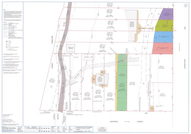
The above survey plan shows the current boundaries and locations of the buildings and features on the site.
Each of lots 6 and 7 are 20 perches (from the old DP) which converts to 505m2 for each.
Lot B DP 371044 is approximately 1,011m2.
Council became the registered proprietor of Lots 6 and 7 of DP 1623 on 28 August 1972. Council obtained title to Lots 6 and 7 in lieu of unpaid rates. The land was classified as 'community' land by default.
Lots 3, 4 and 5 were acquired by Alfred William Vidler on 20 April 1949. There is a house which straddles Lots 5 and 6 which was erected, it seems, by Mr Vidler in the early 1950s. The house was 60-65% erected on Lot 5 and 40-45% on Lot 6.
Between 1998 and 2002 there were five sets of court proceedings concerning the encroachment of the house onto Lot 6.
The proceedings, in essence, related to the representation by Council that the house was constructed within lots 3 to 5 and that the Vaughan's had assumed that what they were purchasing was Lots 3 to 5 with a house on it.
On 30 May 2001 Lloyd J in the Land and Environment Court made a declaration that Council was estopped from asserting any claim pursuant to the Encroachment of Buildings Act 1992 against the Vaughans in respect of any encroachment by the Vaughan's house onto Council's property being Lot 6.
Council's appeal from that declaration was dismissed by the Court of Appeal on 30 May 2002.
On 29 July 2021 the Supreme Court of NSW noted terms in proceedings between the Vaughans (plaintiffs) and Council (defendant) that:
1. The plaintiffs or either of them may not commence further proceedings against the defendant which relate to any encroachment onto Lot 6 Section 3 in DP 1623 and/or Lot 7 Section in DP 1623.
2. The plaintiffs or either of them may not commence further proceedings against the defendant which relate to the defendant's conduct with respect to the Earlier Proceedings, the current claims and/or the Encroachments.
Planning Process Considerations
The current Community land classification of Lot 6 places restrictions on how the land can be used, including the ability to regularise the building encroachment by way of a boundary adjustment. Operational land, by contrast, has no special restrictions other than those that may apply to any piece of land. A partial lot reclassification to classify the subject land as operational, encompassing the portion of land necessary to regularise the building encroachment, would allow for the proposed boundary adjustment to be made possible.
Reclassification of land from community to operation land requires an LEP amendment and therefore a planning proposal. The amendment must be finalised before any subdivision and disposal of the land can take place. Additional steps in the planning proposal process are required when reclassifying community land to operational land, including a public hearing following the issue of a Gateway determination.
Key issues
In order to proceed with item 3 of resolution 23-199 the issues of the building encroachment need to be resolved. A two stage process is recommended to complete resolution 23-199. The first stage is to resolve the issues with the Vaughans and then as a separate process reclassify lots B and 7 to operational for the purposes of tourist cabins.
The first part of the process is to agree to a part land reclassification of lot 6 and a part reclassification of lot 7 to where the fence is located from community to operational land. Council may also include all of lot 7 into the classification as part of a larger solution discussed in the options below.
Until the issue of the building encroachment is resolved it is the opinion of staff that a planning proposal to reclassify the land as operational for tourist accommodation purposes is unlikely to succeed.
Options
Council may opt to address the encroachment issue with a simple reclassification and sale.
Option 1: The smaller solution is to resolve to proceed with a reclassification of lot 6 and a small part of lot 7 to operational to enable the eventual sale of this land to the Vaughans. This report is not addressing the price for the sale of the land or other mechanisms such as land swaps that were presented to the Councillors at the 6 April 2023 workshop. That would be determined after the land is reclassified but before the transfer.
The indicative layout of the land to be reclassified is shown below. This would have to be confirmed by survey and the survey agreed to by both parties. The area includes lot 6 and that part of lot 7 enclosed by the existing fence. This is the preferred option
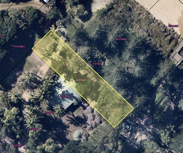
Option 2: The next option is more complex as it involves reclassifying land that is not associated with the building encroachment. This option includes additional area of Council land on which there is a vehicle access to the Vaughans primary residence. This option is depicted in the image below.
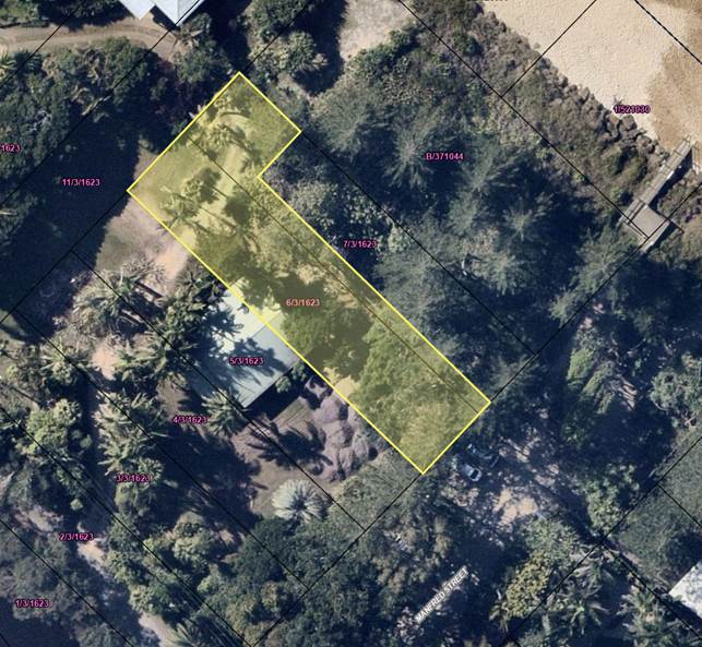
Option 3: This option was presented to the Councillors at the 6 April workshop. It is the most complex and involves a much more difficult reclassification approval, a difficult boundary adjustment development application and a series of land swaps to achieve the outcome. This option involves the reclassification of lot 5, part reclassification of lot 6 and lot B to provide access to the Vaughans primary residence and rectify the encroachment.
This option is not preferred as it is too complex.
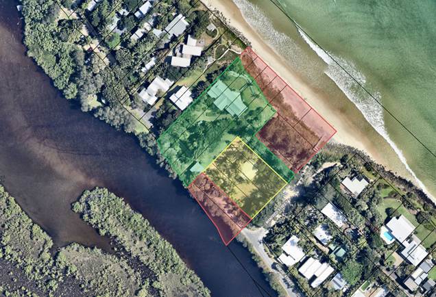
Next steps
The following steps will be undertaken to progress this matter:
1. Agree to cost sharing arrangement.
2. Set budget and engage consultants.
3. Draft LEP Amendment to reclassify community land to operational land.
4. Public Hearing.
5. Amend LEP.
6. Seek a resolution of Council for the sale of land. At this point the price is set by Council.
Upon completion of these Council may then proceed with progressing resolution 23-199.
Strategic Considerations
Community Strategic Plan and Operational Plan
This issue is not related to an item listed in the CSP or operational plan.
Recent Resolutions
23-199 That Council receives a report regarding 3 lots it owns at Belongil, namely 6/3/1623, 7/3/1623 and B/371044 on:
1. Vegetation types;
2. Other constraints such as easements, encroachments or the land classification;
3. The planning pathways available to Council should it wish to place removable cabins for the purposes of tourist and visitor accommodation, or to create a public recreation space on any part or all of the 3 lots.
Legal/Statutory/Policy Considerations
The Environmental Planning and Assessment Act 1979 and the associated regulation set out the procedures to be followed for the classification of community land to operational.
Financial Considerations
A preliminary budget is estimated to be $50,000 to cover staff time and the required consultants to prepare the LEP amendment and to conduct the public hearing. A source of funds will be identified and a budget allocated at the December quarterly budget review.
The cost sharing arrangement will be 50-50 between the parties for the preparation of the documentation and conduct of the public hearing.
Consultation and Engagement
Should Council proceed with the reclassification then the consultation will require a public hearing in addition to the public exhibition of the proposed classification.
BYRON SHIRE COUNCIL
Reports of Committees - Corporate and Community Services 14.1
Reports of Committees - Corporate and Community Services
Report No. 14.1 Report of the Arts and Creative Industries Advisory Committee Meeting held on 19 October 2023
Directorate: Corporate and Community Services
File No: I2023/1850
Summary:
The Arts and Creative Industries Advisory Committee met on 19 October 2023. The Minutes of this meeting are attached for noting by Council.
RECOMMENDATION:
1. That Council notes the minutes of the Arts and Creative Industries Advisory Committee Meeting held on 19 October 2023.
|
2. That Council adopts the following Committee Recommendations:
Report No. 4.2 Decommissioning of artwork "Catch a Falling Fish" from Federal Park File No: I2023/1449
Committee Recommendation 4.2.1 That Council: 1. Decommissions the public artwork ‘Catch a Falling Fish’ by Suvira McDonald and thanks the artist for their creative contribution. 2. Requests the Federal Community Centre Committee provides notice of an alternate proposal for the support structure within four months. In the absence of such a proposal, the Committee recommends its removal. |
|
3. That Council does not adopt Committee Recommendation 4.3 as shown in the attachment to this report, but instead adopts the Management Recommendation as follows:
Report No. 4.3 Public Art Proposal for Brunswick Nature Sculpture Walk File No: I2023/1473
Management Recommendation 4.3.1 That Council: 1. Removes the requirement for the Brunswick Nature Sculpture Walk prize to be awarded to a work that is permanently acquired.
2. Requests further information from Brunswick Nature Sculpture Walk and artist Hiromi Tango to inform a subsequent report to the Arts and Creative Industries Advisory Committee regarding the proposed installation. |
|
4. That Council adopts the following Committee Recommendation:
Report No. 4.4 Amendments to Public Art Development Control Plan File No: I2023/1564
Committee Recommendation 4.4.1 That the Art and Creative Industries Committee notes the report and receives further information to the proposed amended DCP for comment by email prior to it being reported to Council.
|
1 Minutes
19/10/2023 Arts and Creative Industries Advisory Committee, I2023/1587 ![]()
Report
The attachment to this report provides the minutes of the Arts and Creative Industries Advisory Committee Meeting of 19 October 2023 for determination by Council.
The agenda for this meeting can be located on Council’s website at:
Agenda of Arts and Creative Industries Advisory Committee Meeting - Thursday, 19 October 2023
The following items were considered by the Committee:
Report No. 3.1 Adoption of Minutes of the Arts and Creative Industries Advisory Committee Meetings held 29 June and 17 August 2023
This Report was noted by the Committee with no recommendations made to Council. The previous meetings minutes were confirmed.
Report No. 4.1 Update from Aboriginal Project Officer
This Report was noted by the Committee with no recommendations made to Council. The Report provided an update on Council’s work to acknowledge and celebrate Aboriginal voices and stories, communities, cultural expression, and creativity.
The Aboriginal Project Officer provided an overview of Collaboration and planning with Arakwal Corporation, the Widjabal Wia-bal native title determination and recent projects in partnership with Aboriginal artists and Creatives.
The Aboriginal Project Officer also represented the Bundjalung community on the Arts and Creative Industries Advisory Committee at this meeting while recruitment for a new representative is underway.
That the Committee:
1. Notes the report and update provided by the Aboriginal Project Officer.
2. Invites a local Bundjalung artist to join the Committee.
Report No. 4.2 Decommissioning of artwork "Catch a Falling Fish" from Federal Park
The public artwork ‘Catch a Falling Fish’ by Suvira McDonald at Federal Park, Federal has been identified for decommissioning due to safety concerns.
The Committee determined:
That Council:
1. Decommissions the public artwork ‘Catch a Falling Fish’ by Suvira McDonald and thanks the artist for their creative contribution.
2. Requests the Federal Hall Committee provides notice of an alternate proposal for the support structure within four months. In the absence of such a proposal, the Committee recommends its removal.
Report No. 4.3 Public Art Proposal for Brunswick Nature Sculpture Walk
A proposal has been received from Brunswick Nature Sculpture Walk (BNSW) seeking changes to Council’s contribution to the triennial festival and requesting financial support for a public artwork by local Japanese-Australian artist Hiromi Tango.
As per the Public Art Guidelines and the Arts and Creative Industries Advisory Committee Constitution, the Committee reviewed the public art proposal and made a recommendation to Council.
The Committee:
1. Recommends Council removes the requirement for the Brunswick Nature Sculpture Walk prize to be awarded to a work that is permanently acquired.
2. Provides feedback and recommendations to Council on the proposal for installation of the Hiromi Tango work YU KA 夢花 (Dream Flower).
3. Supports Option 2, which involves a three-year loan of three flowers from the Brisbane Festival installation, with the possibility to acquire the artwork permanently.
4. Requests information regarding the likely cost for acquisition from Brunswick Nature Sculpture Walk, as well as any potential matched funding.
Management Comments In relation to Report No. 4.3 Public Art Proposal for Brunswick Nature Sculpture Walk:
Further work is currently underway to confirm temporary installation options which may influence approval processes. Staff has also sought additional information relating to project costs, site approval considerations and insurance implications.
Specifically, in reference to the Committee’s recommendation:
· Provides feedback and recommendations to Council on the proposal for installation of the Hiromi Tango work YU KA 夢花 (Dream Flower).
· Supports Option 2, which involves a three-year loan of three flowers from the Brisbane Festival installation, with the possibility to acquire the artwork permanently.
· Requests information regarding the likely cost for acquisition from Brunswick Nature Sculpture Walk, as well as any potential matched funding.
Response: Further information is required in order to progress the Committee’s recommendation noted above, with key issues including:
· Full project costs
· Site approvals including licensing, Native Title and Crown Land considerations
· Installation specifications
· Maintenance requirements
· Community consultation outcomes
· Environmental considerations
Management proposes a change to the Committee recommendation for the reasons outlined and has made an alternative recommendation to Council.
Management Recommendation 4.3.1
That Council:
1. Removes the requirement for the Brunswick Nature Sculpture Walk prize to be awarded to a work that is permanently acquired.
2. Requests further information from Brunswick Nature Sculpture Walk and artist Hiromi Tango to inform a subsequent report to the Arts and Creative Industries Advisory Committee regarding the proposed installation.
Report No. 4.4 Amendments to Public Art Development Control Plan
The Arts and Creative Industries Committee previously requested a report on individual developments where the Byron Development Control Plan 2014 (DCP) public art requirements applied, whether public art onsite or Planning Agreement (PA).
This report informed the Committee that staff are working on
changes to the DCP. The committee will have the opportunity to comment
via email and this feedback will be included in the report to Council.
That the Committee:
Notes the report and receives further information to the proposed amended DCP for comment by email prior to it being reported to Council.
Financial Implications
As per the Reports listed within the Arts and Creative Industries Advisory Committee Meeting of 19 October 2023 and under the alternative management recommendation.
Statutory and Policy Compliance Implications
As per the Reports listed within the Arts and Creative Industries Advisory Committee Meeting of 19 October 2023.
BYRON SHIRE COUNCIL
Reports of Committees - Corporate and Community Services 14.2
Report No. 14.2 Report of the Audit, Risk and Improvement Committee Meeting held on 16 November 2023
Directorate: Corporate and Community Services
File No: I2023/1859
Summary:
This report provides the minutes of the Audit, Risk and Improvement Committee Meeting of 16 November 2023 for determination by Council.
RECOMMENDATION:
1. That Council notes the minutes of the Audit, Risk and Improvement Committee Meeting held on 16 November 2023.
|
3. That Council adopts the following Committee Recommendation:
Report No. 7.3 Update information regarding proposed Caravan Parks internal audit File No: I2023/1628
Committee Recommendation 7.3.1 That Council considers conducting a service review on caravan parks incorporating the comments from the Committee in the scope of the review.
|
1 Confidential - Summary of IA Recommendations - Q1 2023-2024 from Grant Thornton, E2023/113666
2 Confidential - (PRELIMINARY) Byron Shire Council - Property Services Review - Internal Audit Report, E2023/109245
3 Confidential - (FINAL) Byron Shire Council - Developer Contributions Review - Internal Audit Report, E2023/109247
4 Confidential - (FINAL) Disaster Recovery Planning Review - Internal Audit Report October 2023, E2023/111230
5 Confidential - Internal Audit Status Update - October 2023 from Grant Thornton, E2023/113667
6 Confidential - Section 355 Committees Review 2023 Grant Thornton, E2023/106222
Report
This report provides the minutes of the Audit, Risk and Improvement Committee Meeting of 16 November 2023 for determination by Council.
The minutes for this meeting can be located on Council’s website at:
16 November 2023 Audit, Risk and Improvement Committee Minutes
The agenda for this meeting can be located on Council’s website at:
16 November 2023 Audit, Risk and Improvement Committee Agenda
The attachment numbers included in the recommendations to this Report follows the numbering of the Audit, Risk and Improvement Committee Meeting Agenda. Confidential attachments from that Agenda have been included with this report for Council’s information. The non-confidential attachments are available at the link provided above.
Confidential attachments included in this report:
· Report 5.1 Attachment 1 – This has been included as Attachment 1 to this report
· Report 5.1 Attachment 1 – This has been included as Attachment 2 to this report
· Report 5.1 Attachment 1 – This has been included as Attachment 3 to this report
· Report 5.1 Attachment 1 – This has been included as Attachment 4 to this report
· Report 5.1 Attachment 1 – This has been included as Attachment 5 to this report
· Report 7.1 Attachment 1 – This has been included as Attachment 6 to this report
Committee Recommendation
The recommendations in this Report to Council list only those Committee recommendations that require endorsement by Council e.g. items the Committee simply noted have not been included in this Report (ie Report 4.1). The remainder of the Committee Recommendations are included in the attached minutes.
Further, five reports were provided to the Committee for information only, four of which required no recommendations to Council. These are listed in the Agenda and in the Minutes at Reports 7.1 to 7.5. Report 7.3 resulted in a recommendation to Council.
Financial Implications
As per the Reports listed within the Audit, Risk and Improvement Committee Meeting of 16 November 2023.
Statutory and Policy Compliance Implications
As per the Reports listed within the Audit, Risk and Improvement Committee Meeting of 16 November 2023.
BYRON SHIRE COUNCIL
Reports of Committees - Corporate and Community Services 14.3
Report No. 14.3 Report of the Audit, Risk and Improvement Committee Meeting held on 19 October 2023
Directorate: Corporate and Community Services
File No: I2023/1860
Summary:
This report provides the minutes of the Extraordinary Audit, Risk and Improvement Committee Meeting of 19 October 2023 for determination by Council.
RECOMMENDATION:
1. That Council notes the minutes of the Audit, Risk and Improvement Committee Meeting held on 19 October 2023.
Report
This report provides the minutes of the Extraordinary Audit, Risk and Improvement Committee Meeting of 19 October 2023 for determination by Council.
The minutes for this meeting can be located on Council’s website at:
19 October 2023 Audit, Risk and Improvement Committee Minutes
The agenda for this meeting can be located on Council’s website at:
19 October 2023 Audit, Risk and Improvement Committee Agenda
Committee Recommendations
The recommendations in this Report to Council list only those Committee recommendations that require endorsement by Council e.g. items the Committee simply noted have not been included in this Report (ie Report 4.1). The remainder of the Committee Recommendations are included in the attached minutes.
Financial Implications
As per the Reports listed within the Audit, Risk and Improvement Committee Meeting of 19 October 2023.
Statutory and Policy Compliance Implications
As per the Reports listed within the Audit, Risk and Improvement Committee Meeting of 19 October 2023.
BYRON SHIRE COUNCIL
Reports of Committees - Sustainable Environment and Economy 14.4
Reports of Committees - Sustainable Environment and Economy
Report No. 14.4 Report of the Biodiversity Advisory Committee Meeting held on 16 November 2023
Directorate: Sustainable Environment and Economy
File No: I2023/1913
Summary:
That Council notes the minutes of the Biodiversity Advisory Committee Meeting held on 16 November 2023.
RECOMMENDATION:
1. That Council notes the minutes of the Biodiversity Advisory Committee Meeting held on 16 November 2023.
1 Minutes
16/11/2023 Biodiversity Advisory Committee Extraordinary, I2023/1815 ![]()
Report
The attachment to this report provides the minutes of the Biodiversity Advisory Committee Meeting of 16 November 2023 for determination by Council. The agenda for this meeting can be located on Council’s website at:
https://byron.infocouncil.biz/RedirectToDoc.aspx?URL=Open/2023/11/BAC_16112023_AGN_1726_AT_EXTRA.PDF
The following items were considered by the Committee:
Report No. 4.1 Flying-fox Camp Management Plan Review - Draft
The Committee determined to:
1. Provide feedback on the FFCMP parts A and B by 21/11/2023.
2. Support the draft Report being presented to Council for Public Exhibition.
3. Notes the draft Report and thanks those involved in delivering it.
Report No. 4.2 Future Discussion Items for the Biodiversity Advisory Committee
The Committee noted the report and requests the following future report items:
· Ways to prevent wildlife death on roads.
· Nonlethal control methods for Dingoes.
· Follow up on the introduction of the Nature Repair Market Bill.
· Council land managed for biodiversity conservation – distribute existing information to Committee and a future meeting presentation by David Milledge.
· Update on Varroa Mites.
Report No. 4.3 Biodiversity and Agriculture Projects and Operations Update
The Committee noted the update on current projects and programmes being undertaken by Council staff.
Report No. 4.4 Brunswick Valley Landcare Support Officer quarterly report, July to September 2023.
The Committee noted the report.
Financial Implications
As per the Reports listed within the Biodiversity Advisory Committee Meeting of 16 November 2023.
Statutory and Policy Compliance Implications
As per the Reports listed within the Biodiversity Advisory Committee Meeting of 16 November 2023.
BYRON SHIRE COUNCIL
Reports of Committees - Sustainable Environment and Economy 14.5
Report No. 14.5 Report of the Housing and Affordability Advisory Committee Meeting held on 16 November 2023
Directorate: Sustainable Environment and Economy
File No: I2023/1914
Summary:
This report provides the minutes of the Housing and Affordability Advisory Committee Meeting held on 16 November 2023.
RECOMMENDATION:
1. That Council notes the minutes of the Housing and Affordability Advisory Committee Meeting held on 16 November 2023.
1 Minutes
16/11/2023 Housing and Affordability Advisory Committee, I2023/1814 ![]()
Report
The attachment to this report provides the minutes of the Housing and Affordability Advisory Committee Meeting of 16 November 2023 for determination by Council. The agenda for this meeting can be located on Council’s website at:
https://byron.infocouncil.biz/RedirectToDoc.aspx?URL=Open/2023/11/HAAAC_16112023_AGN_1732_AT.PDF
The following items were considered by the Committee:
Report No. 4.1 Outcomes - Enquiry By Design Workshop Former Mullumbimby Hospital Site
The Committee:
1. Thanked the community for their active participation in the design process.
2. Thanked Hip v Hype for the presentation on the outcomes Enquiry by Design workshop held for the Former Mullumbimby Hospital site.
3. Noted that staff will continue to progress the project work in accordance with Resolution 23-298.
Report No. 4.2 Discussion Items for Housing and Affordability Advisory Committee as per Resolutions 23-472 & 23-429
The Committee discussed the items as per Resolutions 23-472 and 23-429 and requested the following items be brought to a future meeting:
· Information and discussion on Government schemes including: Shared Equity, Regional First Home Buyers, Family Home Guarantee, and Rent to Buy/Rent to Own together with Dr Michael Kleins presentation
· Modular housing (tiny homes, portable, demountable homes)
· Update on Housing Options Paper and community feedback
· Staff update from the Northern Coast Roundtable initiatives 7. Accelerated rezonings 8. Land banking and 9. Contribution Framework
The Committee noted the House You Village meeting on the weekend.
Financial Implications
As per the Reports listed within the Housing and Affordability Advisory Committee Meeting of 16 November 2023.
Statutory and Policy Compliance Implications
As per the Reports listed within the Housing and Affordability Advisory Committee Meeting of 16 November 2023.
Reports of Committees - Sustainable Environment and Economy 14.6
Report No. 14.6 Report of the Coast and ICOLL Advisory Committee Meeting held on 21 November 2023
Directorate: Sustainable Environment and Economy
File No: I2023/1916
Summary:
This report provides the minutes of the Coast and ICOLL Advisory Committee Meeting held on 21 November 2023.
RECOMMENDATION:
1. That Council notes the minutes of the Coast and ICOLL Advisory Committee Meeting held on 21 November 2023.
1 Minutes
21/11/2023 Coast and ICOLL Advisory Committee, I2023/1822 ![]()
Report
The attachment to this report provides the minutes of the Coast and ICOLL Advisory Committee Meeting of 21 November 2023 for determination by Council. The agenda for this meeting can be located on Council’s website at:
https://byron.infocouncil.biz/RedirectToDoc.aspx?URL=Open/2023/11/CICOL_21112023_AGN_1654_AT.PDF
The following items were considered by the Committee:
Report No. 6.1 Presentation by Salients on 'Entrance Management Strategy Review for Belongil and Tallow Creek ICOLLs' Stage 2 CMP project outcomes.
Report No. 6.2 Presentation by BMT WBM on "Researching the Impacts of Recreational Uses and Tourism on Coastal Biodiversity and Habitats, Byron Shire' Stage 2 CMP project outcomes".
Report No. 6.3 Update on the development of Coastal Management Programs (CMPs) for the Byron Shire Coastline.
Financial Implications
As per the Reports listed within the Coast and ICOLL Advisory Committee Meeting of 21 November 2023.
Statutory and Policy Compliance Implications
As per the Reports listed within the Coast and ICOLL Advisory Committee Meeting of 21 November 2023.
BYRON SHIRE COUNCIL
Reports of Committees - Infrastructure Services 14.7
Reports of Committees - Infrastructure Services
Report No. 14.7 Report of the Water and Sewer Advisory Committee Meeting held on 16 November 2023
Directorate: Infrastructure Services
File No: I2023/1873
Summary:
The attachment to this report provides the minutes of the Water and Sewer Advisory Committee Meeting of 16 November 2023 for determination by Council.
RECOMMENDATION:
1. That Council notes the minutes of the Water and Sewer Advisory Committee Meeting held on 16 November 2023.
1 Minutes
16/11/2023 Water and Sewer Advisory Committee, I2023/1798 ![]()
Report
The attachment to this report provides the minutes of the Water and Sewer Advisory Committee Meeting of 16 November 2023 for determination by Council. The agenda for this meeting can be located on Council’s website at:
Agenda of Water and Sewer Advisory Committee Meeting - Thursday, 16 November 2023 (infocouncil.biz)
The following items were considered by the Committee:
Report No.4. 1 Utilities Operational Plan Report
This report summaries the performance of Utilities Department delivery for August – October 2023.
The committee notes the report and may submit questions by email as there was no time to discuss the matter.
Report No. 4.2 Ocean Shores STP Transfer to Bruns Valley Workshop Presentation
The purpose of this presentation is to discuss the following in relation to strategic infrastructure planning options for Ocean Shores and Brunswick Valley STP’s.
Report No. 6.1 Byron STP Condition 9 Additional Load - Quarterly Report
his report is for the Committee’s information and reviews compliance with the Byron Bay Sewerage Augmentation Scheme - Conditions of Approval (2002).
Report No. 6.2 Mullumbimby Inflow and Infiltration
This Report is for information only and summarise the works related to Council Resolution 18-054 to date.
This covers the Inflow and Infiltration assessment and remediation works program in both Mullumbimby and the rest of the Shire.
Committee Recommendation
The committee recommendations are supported by management and are provided in the attachment to this report.
Financial Implications
As per the Reports listed within the Water and Sewer Advisory Committee Meeting of 16 November 2023.
Statutory and Policy Compliance Implications
As per the Reports listed within the Water and Sewer Advisory Committee Meeting of 16 November 2023.
BYRON SHIRE COUNCIL
Reports of Committees - Infrastructure Services 14.8
Report No. 14.8 Report of the Local Traffic Committee Meeting held on 21 November 2023
Directorate: Infrastructure Services
File No: I2023/1876
Summary:
The attachment to this report provides the minutes of the Local Traffic Committee Meeting held on 21 November 2023 for determination by Council.
Council’s action on the Local Traffic Committee (LTC) advice will be:
a) If Council is in agreement with the LTC unanimous support then the proposal may be approved. In these cases, there is no conflict between Council and the advice of the LTC, consequently there is no need for Council to inform TfNSW or the NSW Police representatives of the decision.
b) If Council is in agreement with the LTC unanimous support, but no longer wants to proceed, the proposal may still be rejected.
c) If Council is in agreement with the LTC unanimous decline then the proposal may be rejected. Again, there is no conflict between Council and the advice of the LTC. Consequently, there is no need for Council to inform TfNSW or the NSW Police representatives of the decision.
d) If Council decides to proceed with a proposal where the advice of the LTC is not unanimous support, then the Council must first advise the TfNSW and the NSW Police representatives in writing of their intention to approve the proposal. TfNSW or the NSW Police may then lodge an appeal to the Regional Traffic Committee (RTC).
e) If Council decides to proceed with a proposal where the advice of the LTC is a unanimous decline, then the Council must first advise the TfNSW and NSW Police representatives in writing of their intention to approve the proposal. TfNSW or the NSW Police may then lodge an appeal to the RTC.
Due to the fact that the TfNSW and the NSW Police have the power to appeal certain decisions of the Council, the LTC cannot provide its advice to Council until both TfNSW and the NSW Police have provided their vote on the issue.
RECOMMENDATION:
1. That Council notes the minutes of the 21 November 2023.
1 Minutes
21/11/2023 Local Traffic Committee, I2023/1817
![]()
Report
The attachment to this report provides the minutes of the Local Traffic Committee Meeting of 21 November 2023 for determination by Council. The agenda for this meeting can be located on Council’s website at:
Agenda of Local Traffic Committee Meeting - Tuesday, 21 November 2023 (infocouncil.biz)
This report contains the recommendations of the Local Traffic Committee (LTC) meeting held on 21 November 2023.
Committee Recommendation
As per the Reports listed within the Local Traffic Committee Meeting of 21 November 2023.
Financial Implications
As per the Reports listed within the Local Traffic Committee Meeting of 21 November 2023.
Statutory and Policy Compliance Implications
As per the Reports listed within the Local Traffic Committee Meeting of 21 November 2023.
BYRON SHIRE COUNCIL
Questions With Notice 15.1
Question with Notice No. 15.1 Mullumbimby’s future water supply
File No: I2023/1918
Cr Dey asks the following question:
I thank Council for responses to my Questions at Item 15.2 in the agenda for our meeting of 23 November.
I learnt that Council has engaged Consultants and that stakeholders will be managed under a Stakeholder Management Plan that is being developed now, with an aim to execute it in February 2024.
Council committed in August 2023 (Res 23-365) to consult and inform the community “in a meaningful way”, before making a decision [on Mullumbimby’s future water supply].
I now ask:
1. will the Stakeholder Management Plan (SMP) refer to the Water & Sewer Advisory Committee’s option, as articulated in Part 7 of Council’s Resolution 23-120 of 27 April 2023?
2. will the consultation in February 2024 include the option described in Part 7 of Res 23-120?
3. will background information for the meaningful consultation include any of the information sought under Resolution 23-120 Part 8?
4. alternatively, what actions will take place to complete Resolution 23-120?
For information, Parts 7 and 8 of resolution 23-120 are:
7. Following the meeting with representatives of Rous, consider investigation of matters that will enable a strategy for Mullumbimby’s long term water supply based on the following concept:
a) Lavertys Gap as the source during flows in excess of environmental requirements;
b) water stored off-stream between the source and Mullumbimby;
c) water treated at a new location between the storage and Mullumbimby;
d) water delivered to Mullumbimby and possibly beyond; and
e) maximising demand management, including the harvesting of roof water.
8. The investigation above to include:
a) the topography of the terrain between Lavertys Gap and Mullumbimby, to identify potential dam sites;
b) the hydrology of Wilsons Creek and its capacity to supply, including seasonality;
c) the impact of climate change on supply and on demand (using CC data and methodologies in the pilot phase for local water supply through DPE, and applied in Regional Water Strategies);
d) infrastructure needs including offtake, storage, treatment and linkages to the town’s reservoirs;
e) environmental assessments for the creation and operation of that infrastructure, including greenhouse gas emissions;
f) assessment of the weir at Lavertys Gap including (i) structural integrity; (ii) means of creating fish passage; and (iii) how this proposal enhances its heritage and preservation; and
g) economic assessment.
Response Director Infrastructure Services:
Cr Dey did not attend the workshop with Councillors on 02 November which was the action for Part 1 of Resolution 23-365. Consultation can now commence given the workshop of 02 November 2023.
Drafting of the Mullumbimby Future Water Supply Strategy has extended well over three years with iterations and updates as requested by the committee.
Consultants and staff have addressed all the committees’ requests to date.
Additional information on the Rous Future Water Project 2060 was presented to the Committee by Rous County Council staff in May 2023 and again at the Councillor Workshop 02 November 2023.
Essentially the Hydrosphere (Mullumbimby Future Water Supply Strategy ) report covers part 7 & 8 of the Resolution 23-120.
Staff recommended that Council place the Mullumbimby Future Water Supply Strategy on public exhibition to obtain feedback on the preferred strategy. Consultation tools could include:
• Public exhibition of the strategy on Council’s Your Say Byron Shire webpage including summary text and images, background information and opportunities for the community to provide feedback.
• A public drop-in session e.g. at the Mullumbimby markets.
• Social media posts, media releases and E-news articles to promote the public exhibition.
A report on the consultation undertaken would be presented to Council for consideration.
Ongoing consultation would be required on issues relating to trunk main customers and rehabilitation and operation of the redundant assets including heritage considerations.
BYRON SHIRE COUNCIL
Confidential Reports - General Manager 16.1
Confidential Reports - General Manager
Report No. 16.1 Confidential - Annual Review of General Manager's Performance Agreement
Directorate: General Manager
Report Author: Vicki Lawrence, Manager People and Culture
File No: I2023/1863
Summary:
On 20 October 2023, the General Manager’s annual performance review for the 2022/2023 financial year was conducted by a performance review panel, in accordance with the Guidelines for the Appointment and Oversight of General Managers issued by the Division of Local Government, Department of Premier and Cabinet (the ‘Guidelines’).
The performance review and draft performance agreement for 2023/2024 financial year was tabled at the 23 November 2023 Council meeting where Council resolved
|
23-001 |
Resolved: 1. That Council notes the findings and endorses recommendations from the performance review panel with respect to the annual performance review for the General Manager contained in Attachment 1 (E2023/99864). 2. That Council defers the 2023/2024 Performance Agreement for the General Manager contained in document (E2023/114737) to December, to enable further consideration. |
This report provides the updated 2023/2024 Performance Agreement for the General Manager (Confidential Attachment 1 E2023/114737) for Council’s consideration.
RECOMMENDATION:
1. That pursuant to Section 10A(2)(a) of the Local Government Act, 1993, Council resolves to move into Confidential Session to discuss the report Annual Review of General Manager's Performance Agreement.
2. That the reasons for closing the meeting to the public to consider this item be that the report contains:
a) personnel matters concerning particular individuals (other than councillors)
3. That on balance it is considered that receipt and discussion of the matter in open Council would be contrary to the public interest, as:
The report contains confidential information about performance
1 Confidential - GM Performance Agreement - 01 July 2023 to 30 June 2024, E2023/114737