 Agenda
Ordinary Meeting

Thursday, 12 December 2024
Agenda
Ordinary Meeting
Thursday, 12 December 2024
Agenda Ordinary Meeting
held at Council Chambers, Station Street, Mullumbimby
commencing at 9.00am
Public access relating to items on this agenda can be made between 9:00 and 10:30 am on the day of the meeting. Requests for public access should be made to the General Manager or Mayor no later than 12:00 midday on the day prior to the meeting.

Mark Arnold
General Manager
CONFLICT OF INTERESTS
What is a “Conflict of Interests” - A conflict of interests can be of two types:
Pecuniary - an interest that a person has in a matter because of a reasonable likelihood or expectation of appreciable financial gain or loss to the person or another person with whom the person is associated.
Non-pecuniary – a private or personal interest that a Council official has that does not amount to a pecuniary interest as defined in the Code of Conduct for Councillors (eg. A friendship, membership of an association, society or trade union or involvement or interest in an activity and may include an interest of a financial nature).
Remoteness – a person does not have a pecuniary interest in a matter if the interest is so remote or insignificant that it could not reasonably be regarded as likely to influence any decision the person might make in relation to a matter or if the interest is of a kind specified in the Code of Conduct for Councillors.
Who has a Pecuniary Interest? - a person has a pecuniary interest in a matter if the pecuniary interest is the interest of the person, or another person with whom the person is associated (see below).
Relatives, Partners - a person is taken to have a pecuniary interest in a matter if:
· The person’s spouse or de facto partner or a relative of the person has a pecuniary interest in the matter, or
· The person, or a nominee, partners or employer of the person, is a member of a company or other body that has a pecuniary interest in the matter.
N.B. “Relative”, in relation to a person means any of the following:
(a) the parent, grandparent, brother, sister, uncle, aunt, nephew, niece, lineal descends or adopted child of the person or of the person’s spouse;
(b) the spouse or de facto partners of the person or of a person referred to in paragraph (a)
No Interest in the Matter - however, a person is not taken to have a pecuniary interest in a matter:
· If the person is unaware of the relevant pecuniary interest of the spouse, de facto partner, relative or company or other body, or
· Just because the person is a member of, or is employed by, the Council.
· Just because the person is a member of, or a delegate of the Council to, a company or other body that has a pecuniary interest in the matter provided that the person has no beneficial interest in any shares of the company or body.
Disclosure and participation in meetings
· A Councillor or a member of a Council Committee who has a pecuniary interest in any matter with which the Council is concerned and who is present at a meeting of the Council or Committee at which the matter is being considered must disclose the nature of the interest to the meeting as soon as practicable.
· The Councillor or member must not be present at, or in sight of, the meeting of the Council or Committee:
(a) at any time during which the matter is being considered or discussed by the Council or Committee, or
(b) at any time during which the Council or Committee is voting on any question in relation to the matter.
No Knowledge - a person does not breach this Clause if the person did not know and could not reasonably be expected to have known that the matter under consideration at the meeting was a matter in which he or she had a pecuniary interest.
Non-pecuniary Interests - Must be disclosed in meetings.
There are a broad range of options available for managing conflicts & the option chosen will depend on an assessment of the circumstances of the matter, the nature of the interest and the significance of the issue being dealt with. Non-pecuniary conflicts of interests must be dealt with in at least one of the following ways:
· It may be appropriate that no action be taken where the potential for conflict is minimal. However, Councillors should consider providing an explanation of why they consider a conflict does not exist.
· Limit involvement if practical (eg. Participate in discussion but not in decision making or vice-versa). Care needs to be taken when exercising this option.
· Remove the source of the conflict (eg. Relinquishing or divesting the personal interest that creates the conflict)
· Have no involvement by absenting yourself from and not taking part in any debate or voting on the issue as of the provisions in the Code of Conduct (particularly if you have a significant non-pecuniary interest)
RECORDING OF VOTING ON PLANNING MATTERS
Clause 375A of the Local Government Act 1993 – Recording of voting on planning matters
(1) In this section, planning decision means a decision made in the exercise of a function of a council under the Environmental Planning and Assessment Act 1979:
(a) including a decision relating to a development application, an environmental planning instrument, a development control plan or a development contribution plan under that Act, but
(b) not including the making of an order under that Act.
(2) The general manager is required to keep a register containing, for each planning decision made at a meeting of the council or a council committee, the names of the councillors who supported the decision and the names of any councillors who opposed (or are taken to have opposed) the decision.
(3) For the purpose of maintaining the register, a division is required to be called whenever a motion for a planning decision is put at a meeting of the council or a council committee.
(4) Each decision recorded in the register is to be described in the register or identified in a manner that enables the description to be obtained from another publicly available document, and is to include the information required by the regulations.
(5) This section extends to a meeting that is closed to the public.
OATH AND AFFIRMATION FOR COUNCILLORS
Councillors are reminded of the oath of office or affirmation of office made at or before their first meeting of the council in accordance with Clause 233A of the Local Government Act 1993. This includes undertaking the duties of the office of councillor in the best interests of the people of Byron Shire and the Byron Shire Council and faithfully and impartially carrying out the functions, powers, authorities and discretions vested under the Act or any other Act to the best of one’s ability and judgment.
BUSINESS OF Ordinary Meeting
1. Public Access
3. Attendance by Audio-Visual Link
4. Requests for Leave of Absence
5. Declarations of Interest – Pecuniary and Non-Pecuniary
6. Tabling of Pecuniary Interest Returns (Cl 4.14 Code of Conduct for Councillors)
7. Adoption of Minutes from Previous Meetings
7.1 Ordinary Meeting held on 28 November 2024
8. Reservation of Items for Debate and Order of Business
9. Notices of Motion
9.1 Senior Ecologist Position for Planning Matters......................................................... 8
9.2 EOI to host 2025 North Coast Tourism Symposium and Tourism Awards........ 12
9.3 Support for Music and Arts in the Northern Rivers................................................. 15
10. Mayoral Minute
10.1 NSW Government Vibrancy Reforms - Special Entertainment Precinct Kickstart Grant Application..................................................................................................................... 18
11. Petitions
11.1 Save Mullums Oldest House from Destruction and Keep it in Community Hands 20
12. Delegates' Reports
13. Staff Reports
General Manager
13.1 Acquisition of land - Tallowood estate, Mullumbimby............................................ 22
13.2 Land transfer - Bangalow Bowling Club to Council - part Bangalow sportsfields 27
13.3 Community Engagement Strategy............................................................................ 32
Corporate and Community Services
13.4 Grants December 2024............................................................................................... 44
13.5 Appointment of Community Representatives to Advisory Committees............... 48
13.6 Appointment of Councillor Contacts for Section 355 Committees....................... 52
Sustainable Environment and Economy
13.7 Marshalls Creek Foreshore Remediation, New Brighton...................................... 55
13.8 PLANNING - DA 10.2024.57.1 - 17 lot industrial subdivision includng creation of a drainage lot, roadworks, bulk earthworks, vegetation removal and associated infrastructure – 288 Ewingsdale Road, Byron Bay................................................. 70
13.9 PLANNING - Report of the Planning Review Committee held 21 November 2024...................................................................................................................................... 113
13.10 Council Submission on NSW Local Government Draft Filming Protocol......... 115
Infrastructure Services
13.11 Part Road Reserve closure and sale adjoining Lot 1 DP246414, 134 Lighthouse Road, Byron Bay, NSW 2481.............................................................................................. 123
13.12 Cavanbah Centre Expansion................................................................................... 131
14. Reports of Committees
Infrastructure Services
14.1 Report of the Local Traffic Committee Meeting held on 19 November 2024... 146
14.2 Report of the Local Traffic Committee Meeting held on 27 November 2024... 150
15. Questions With Notice
Nil
16. Confidential Reports
General Manager
16.1 Confidential - Annual Review of General Manager's Performance Agreement...................................................................................................................................... 154
Questions with Notice: A response to Questions with Notice will be provided at the meeting if possible, that response will be included in the meeting minutes. If a response is unable to be provided the question will be taken on notice, with an answer to be provided to the person/organisation prior to the next Ordinary Meeting and placed on Councils website www.byron.nsw.gov.au/Council/Council-meetings/Questions-on-Notice
Councillors are encouraged to ask questions regarding any item on the business paper to the appropriate Director prior to the meeting. Any suggested amendments to the recommendations should be provided to Councillor Support prior to the meeting to allow the changes to be typed and presented on the screen at the meeting.
Notices of Motion 9.1
Notices of Motion
Notice of Motion No. 9.1 Senior Ecologist Position for Planning Matters
File No: I2024/1485
That Council receives clarification on the current methods and effectiveness of ecological oversight on planning applications including:
1. Options for the establishment of a Senior Ecologist position within the Planning Directorate to enhance ecological oversight on planning applications;
2. The allocation of funds in the 2024/25 budget to support the establishment of this position, with the goal of recruitment and commencement in the early part of the new financial year; and
3. Options for short-term funding during the upcoming quarterly review to engage an ecologist on a part-time or temporary basis until the permanent role is established.
Signed: Cr Sarah Ndiaye
Councillor’s supporting information:
For nearly a decade, Byron Shire Council has lacked an in-house Senior Ecologist in the Planning Directorate, a role previously essential in evaluating the environmental impact of planning applications. Since this position was downgraded around 2014, the Council has often had to rely on external consultants or planning staff, such as Environmental Health Officers, to assess the environmental integrity of proposals. This reliance on external expertise has led to gaps in Council’s ecological assessments, with potentially significant environmental consequences. For instance, during the Wallum development at Bayside Brunswick, issues with ecological assessment methodology were only uncovered post-approval, leading to concerns from eminent ecologists.
While staff have indicated that a position titled “Natural Resource Planner” exists, it remains vacant and does not address the Council’s need for the Senior Ecologist role as initially proposed. Additionally, staff responses have noted recruitment attempts; however, the lack of clear updates or visibility of this position on Council’s website suggests an ongoing gap in resources. Council must consider that previous solutions, such as engaging external ecologists, only serve as temporary measures and do not provide the sustained, in-depth expertise of an in-house Senior Ecologist who would provide continuity and strategic oversight across projects.
The requested role aligns with Council’s long-term environmental objectives, reinforcing Byron Shire’s commitment to responsible, ecologically sound planning decisions that protect the area’s unique natural assets. Establishing this role, with clearly allocated funds in the upcoming budget, is essential to uphold Byron Shire’s environmental standards in planning matters and to restore public trust in Council’s ecological stewardship. This motion, therefore, calls for immediate and definitive action to secure this expertise within Council’s structure, ensuring timely and informed ecological assessments on all relevant planning matters.
Staff comments
by Shannon Burt, Director, Sustainable Environment and Economy:
This motion seeks clarification on how effective ecological oversight on planning applications is being undertaken. Staff response follows.
An identified position titled “Natural Resource Planner’ exists in the organisation structure.
This position sits in the Sustainable Development Team and works alongside planners to undertake ecological and environmental impact assessment of development applications and associated post development consent matters. The role has not changed since 2014 although the position title has from ‘Ecological Planner’.
The position is vacant and has been since the most recent incumbent left for a position in State Government. With all other recent attempts to recruit for a suitably qualified and experienced person being unsuccessful.
There are many reasons that this position is difficult to recruit for including: potential conflicts of interest that incumbents have with development assessment work (albeit value based or personal); the statutory framework, timelines, and tools that must be used as part of the work; the complexity, changing and conflicting nature of environmental and other related legislation; and State Government and Private Enterprise employment opportunities in the region and beyond.
To address the need for this important position to be filled, we have by necessity instead successfully contracted development application referrals to a range of senior external ecological consultants. These have been used for development assessment matters and land and environment court matters.
This approach is consistent with Council’s adopted Workforce Strategy. It has allowed us to ‘buy’ the right expert ecology consultant to suit the development assessment and approval pathway triggered by legislation and specific plant or animal species. Byron Shire is home to 71 threatened plants and 167 threatened animals.
The complexity of assessment is determined by the land use zone, size of land, development type and mapped attributes. This varies from site to site and from development to development.
Buying expertise is more appropriate for immediate, high-impact roles such as this, where specific skills are lacking internally, and or cannot be filled otherwise through traditional recruitment.
There are other councils that use the ‘buy’ approach including Port Stephens. Whereas a number of other councils that do not have a specific ecologist/natural resource planner for development assessments like Mid Coast and Coffs Harbour councils struggle with staff managing competing work interests and loads and complex assessments. Other councils like Ballina are currently reviewing their position due to similar workload and recruitment reasons relating to those above.
We intend to test the market again for a natural resource/ecological planner early 2025.
Financial/Resource/Legal Implications:
Council’s Model Code of Conduct for Land use planning, development assessment and other regulatory functions requires staff to:
· ensure that land use planning, development assessment and other regulatory decisions are properly made, and that all parties are dealt with fairly.
· avoid any occasion for suspicion of improper conduct in the exercise of land use planning, development assessment and other regulatory functions.
· ensure that no action, statement or communication between yourself and others conveys any suggestion of willingness to improperly provide concessions or preferential or unduly unfavourable treatment.
Council has otherwise effectively discharged it responsibilities under the Local Government Act in terms of allocating the resources to the function of natural resource planner/ecologist.
OLG Circular to Councils 24-09 / 12-06-2024 / A901423
The Local Government Act 1993 (the Act) was amended by the Local Government Amendment (Employment Arrangements) Act 2024 (the amending Act). The Amending Act received assent on 31 May 2024.
As a result of the amendments, as at 1 September 2024, Council will no longer have the option to determine positions within its organisation structure as “senior staff positions” and to employ the holders of those positions under statutory contract approved by the “departmental chief executive” of the Office of Local Government (OLG).
The amendment means that the governing bodies of Councils and the general manager will have responsibilities in determining the organisation structure of a council.
· The governing body is required to approve the resources to be allocated to the employment of staff after consulting the general manager. (Note: A budget allocation has been included in the current adopted budget for this purpose and there is no further work to do for either the council or the general manager.)
· The general manager is in turn responsible for determining the organisation structure of the council after consulting with the governing body. (Note: A position has been identified in the organisation structure for a natural resource/ecological planner. With the functions of this role being currently undertaken as described above and that Council will again test the market in early 2025.)
Is the proposal consistent with any Delivery Program tasks?
Not applicable.
Notices of Motion 9.2
Notice of Motion No. 9.2 EOI to host 2025 North Coast Tourism Symposium and Tourism Awards
File No: I2024/1594
I move that:
1. Council submits an Expression Of Interest application to Destination North Coast to host the 2025 North Coast Tourism Symposium and Tourism Awards; and
2. A budget of $20,000 plus GST be allocated to meet the Council’s host financial contribution, if successful, through the next Quarterly Budget Review.
Signed: Cr Sarah Ndiaye
Councillor’s supporting information:
Destination North Coast has asked Byron Shire Council to submit an EOI application to host the 2025 North Coast Tourism Symposium and Tourism Awards.
Of the 14 Local Government Areas in north coast region of NSW, Byron Shire Council has never been a host of these annual events.
North Coast Tourism Symposium & Awards – Destination North Coast
The Symposium and Awards Gala dinner bring together tourism industry leaders from the north coast region thereby providing an opportunity to meet, recognise and promote excellence in tourism.
The visitor economy plays a crucial role in the economic vitality of Byron Shire, driving local businesses, creating jobs, and supporting the region's vibrant culture. However, as discussions during the election highlighted, it is essential to strike a balance between growth and preservation. Byron Shire’s unique identity as a destination must be shaped with care, ensuring that tourism enhances, rather than diminishes, the community’s character and the environment. Incorporating First Nations input and embracing a circular economy are essential strategies for ensuring that Byron Shire’s tourism development is both culturally respectful and environmentally sustainable. First Nations perspectives offer valuable insights into the land, culture, and traditions that have shaped the region for thousands of years, fostering a deeper connection to place and promoting a tourism model that honours Indigenous knowledge and stewardship of the environment. By integrating First Nations voices into decision-making processes, tourism initiatives can better reflect the cultural heritage of the region, fostering respect and reconciliation. Additionally, embracing a circular economy in the context of tourism—where resources are reused, recycled, and regenerated—can help minimize waste, reduce carbon footprints, and create more sustainable practices in food production, waste management, and local supply chains. The Tourism Symposium presents an important opportunity for stakeholders and the broader community to contribute to this evolving narrative, ensuring that Byron Shire remains a welcoming and responsible destination. By fostering collaboration, the region can continue to support its natural beauty, local creativity, and economic prosperity, all while maintaining the values that make it such a sought-after place to visit.
Staff comments
by Shannon Burt, Director, Sustainable Environment and Economy:
The North Coast Tourism Symposium and Tourism Awards bring together key regional stakeholders and tourism experts to discuss and consider issues, challenges and opportunities impacting tourism across the North Coast.
The Symposium and Awards events are annual, and normally held in the last week of July.
Benefits of hosting in 2025 include the opportunity to hear from speakers on critical issues and current trends facing the tourism sector post pandemic and natural disaster. Ability to network and connect delegates with the wider tourism community and stakeholders. Plus showcasing the range of local business and experiences that may not be widely known about.
Financial/Resource/Legal Implications:
Destination North Coast requires financial and in-kind support for the Symposium and Awards Gala Dinner events. It is understood that a minimum $20,000 plus GST financial contribution is required to host the events.
The host destination and Destination North Coast will have shared responsibility for driving ticket sales and seeking positive publicity, advertising, and social media to support both events.
Staff time will otherwise be allocated to meet the in-kind component of the contribution as needed.
A $20,000 budget allocation can be considered and approved by Council through the next quarterly budget review process, should Council resolve in favour of supporting an EOI application to Destination North Coast.
EOI applications need to be made by 13 December 2024, unless otherwise notified.
Is the proposal consistent with any Delivery Program tasks?
|
CSP Objective |
CSP Strategy |
DP Action |
|
4: Ethical Growth |
4.4: Foster sustainable visitation and manage the impacts of tourism on the Shire |
4.4.1: Destination Management - Encourage visitation that aligns with our culture and values |
|
4: Ethical Growth |
4.3: Promote and support the local economy |
4.3.1: Diverse economy - Develop a Business and Visitor Economy Strategy to support a resilient and diverse economy
|
Notices of Motion 9.3
Notice of Motion No. 9.3 Support for Music and Arts in the Northern Rivers
File No: I2024/1597
I move that Council:
1. Notes the critical role that music and creative arts play in the vibrancy, diversity, and resilience of the Northern Rivers, providing many pathways to diverse and interesting employment and played a critical role during recovery from disasters and pandemics;
2. Calls on Southern Cross University to reconsider its recent decision to discontinue its undergraduate programs in art and design, contemporary music and digital media from 2025;
3. Writes to the relevant Federal Ministers urging them to restore equity to the cost of Arts Degrees to ensure that young people can pursue in a career in music and the creative arts without undue financial burden; and
4. Writes to relevant State Ministers to take urgent action to increase funding and other support for regional arts and music events, noting the negative impact that the cancellation of large music events such as Bluesfest and Splendour in the Grass will have on Byron Shire’s local economy.
Signed: Cr Sarah Ndiaye
Councillor’s supporting information:
Southern Cross University (SCU) recently announced that it would discontinue its Creative Arts courses, including the Bachelor of Art and Design, the Bachelor of Contemporary Music, and the Bachelor of Digital Media, with no new intakes from 2025. Speaking to the ABC, SCU Vice-Chancellor, Tyrone Carlin, cited the dramatic increase in the cost of Arts Degrees as one of the reasons behind the decision, referencing changes to the cost of higher education in 2021 that saw the cost of Arts degrees increase by up to 117%. This decision has been met with shock and condemnation from the creative arts sector locally and statewide, including from the Northern Rivers Community Gallery (NRCG), which described it as “a significant loss for the region,” particularly given the vital role SCU graduates have played in contributing to local exhibitions. The NRCG/SCU Graduate Prize, launched in 2017, awarded a graduating student from the Bachelor of Arts and Design degree the opportunity for a solo exhibition at the Gallery.
This decision comes at a time when the arts and creative industries in the Northern Rivers are facing mounting challenges. The region is renowned for its vibrant music, arts, and cultural scene, which not only contributes to the local identity but also plays a significant role in its economy and resilience, especially in the aftermath of disasters and pandemics. The Northern Rivers is home to a thriving creative workforce, with thousands employed in the arts, music, and film sectors, many of whom are involved in non-traditional pathways to employment. These industries provide valuable job opportunities, foster creativity and innovation, and are key drivers of tourism, attracting visitors to the region for arts festivals, performances, and exhibitions. In fact, a recent economic analysis found that the 2024 Bluesfest alone contributed over $230 million to the NSW economy, including $42 million for Byron Shire and $83 million for the Northern Rivers region.
However, despite its critical role, the arts are often undervalued, particularly when it comes to funding, education, and career pathways. The decision by SCU to cut its creative arts courses further compounds the challenges faced by the sector and underscores the need for greater investment and support for the arts in regional areas. Music, arts, and culture are not only integral to the region’s identity but are also essential to its economic future, community well-being, and long-term recovery from recent disruptions. It is vital that we continue to champion and invest in the arts, ensuring that young people have access to affordable, high-quality education in the creative sectors, and that the cultural vitality of the Northern Rivers is preserved and enhanced for generations to come.
Staff comments
by Esmeralda Davis, Director Corporate & Community Services, Shannon Burt, Director Sustainable Environment & Economy:
The proposed Notice of Motion strongly aligns with Council’s Arts and Culture Action Plan, which emphasises the importance of nurturing, amplifying and supporting our artistic and creative industries, and staff support the advocacy requested.
Council has long recognised the essential role of the creative arts in fostering vibrancy, diversity, and community resilience. These sectors not only provide significant employment opportunities but also play a crucial role in disaster recovery and community wellbeing. Recent local initiatives have demonstrated the transformative power of the arts.
Staff support advocacy to relevant Federal Ministers for cost equity, as it highlights Council’s commitment to education and aligns with broader efforts to nurture talent and create opportunities for young people in the region.
Staff also support advocacy to State Ministers to provide much needed support to assist a reboot of regional arts and music events. These events have seen a tightening of the economy result in escalated costs and risks for event organisers. Events have also been impacted by pandemics and natural disasters with some yet to recover. Council’s draft Events Strategy acknowledges the above and supports advocacy through a number of the Strategy priority actions.
Further, the NSW Government Vibrancy Reforms have been created to provide support for venues and artists, by simplifying the regulation of entertainment noise, removing red tape for local councils to host special events, supporting outdoor activation, and modernising the liquor licensing system. Staff are currently looking at these reforms and what they mean in terms of State led support for local music venues and events.
Financial/Resource/Legal Implications:
The required correspondence can be prepared within available resourcing.
Is the proposal consistent with any Delivery Program tasks?
Yes
|
CSP Objective |
CSP Strategy |
DP Action |
Code |
OP Activity |
|
2: Inclusive Community |
2.1: Foster opportunities to express, celebrate and participate in arts and cultural activity |
2.1.4: Artistic and creative industries - Build, support, and advocate for the artistic and creative industries of the Shire to inspire a thriving and sustainable arts community |
2.1.4.4 |
Coordinate implementation, monitoring and reporting on the Arts and Culture Action Plan |
|
2: Inclusive Community |
2.1: Foster opportunities to express, celebrate and participate in arts and cultural activity |
2.1.3: Events and festivals - Support and enable arts & cultural activity, festivals, projects, and events |
2.1.3.10 |
Develop an Events Strategy |
|
2: Inclusive Community |
2.1: Foster opportunities to express, celebrate and participate in arts and cultural activity |
2.1.3: Events and festivals - Support and enable arts & cultural activity, festivals, projects, and events |
2.1.3.9 |
Collaborate with government, agency and industry on policy and legislative reforms |
Mayoral Minute 10.1
Mayoral Minute
Mayoral Minute No. 10.1 NSW Government Vibrancy Reforms - Special Entertainment Precinct Kickstart Grant Application
File No: I2024/1609
I move:
That Council requests staff to prepare a Special Entertainment Precinct Kickstart Grant Application under the NSW Government Vibrancy Reforms for consideration at the first available meeting in February 2025.
Background Notes:
In the lead up to the election there was a lot of feedback from businesses and community about the struggles to bring vibrancy, community and a healthy economic outlook into our town centres.
The State Government recently introduced “vibrancy reforms” through the 24-Hour Economy Commissioner Act 2023 and the 24-Hour Economy Legislation Amendment (Vibrancy Reforms) Act 2023 last year, to revive the state’s struggling late-night entertainment sector.
In support, a Cultural State Environmental Planning Policy is proposed to amend state environmental planning policies and local environmental plans to further support creative, cultural and hospitality uses.
An Explanation of Intended Effect: Cultural State Environmental Planning Policy (SEPP) is now on exhibition until the 13 December 2024 for public feedback by the Department of Planning, Housing and Infrastructure, allowing the community to have its say on the proposed changes. Council staff are currently reviewing this Explanation of Intended Effect and will make a relevant submission.
‘The Explanation of Intended Effect proposes changes to the planning system to support more creative, hospitality and cultural uses contributing to the 24-hour economy. It builds on changes from the government’s recent Vibrancy Reforms (DPHI)’.
At the heart of the vibrancy reforms is ‘creating an environment for venues and artists to flourish, simplifying the regulation of entertainment noise, removing red tape for local councils to host special events, supporting outdoor activation, and modernising the liquor licensing system’ (DPHI).
Also included in the NSW Government’s vibrancy reforms, a $1-million grant program to encourage councils to establish their own special entertainment precincts, such as Enmore Road in Sydney’s inner west.
A special entertainment precinct (SEP) is established under the Local Government Act 1993 and is an area, streetscape, or single venue where sound conditions and trading hours are set by a council in a precinct management plan.
The Special Entertainment Precinct Kickstart Grant Program is about encouraging local councils to take up and implement Special Entertainment Precincts (SEPs).
The funding allocated to eligible local councils through the Program may be used for activities directly related to establishing one or more SEP/s in the council’s LGA, such as for strategic planning activities, preparing acoustic criteria and/or undertaking community engagement.
The Special Entertainment Precinct Kickstart Grant Program is open now until 12 March 2025. Grant amounts of $50,000 - $200,000 are available per Council. The grant is to assist councils offset the significant costs of establishing a SEP.
Consideration of a SEP for part/s of the central business area Byron Bay Town Centre is considered timely and appropriate given our need to support our night-time economy post pandemic and natural disaster.
A place-based approach via a SEP will allow council to work with local businesses and community in developing a flexible and locally suited approach to support the night-time economy, rather the accept the once size fits all Cultural SEPP approach.
Council Plan Alignment:
Delivery Program
|
4: Ethical Growth |
4.3: Promote and support the local economy |
4.3.3: Business advice and support - Support, participate, and advocate for sustainable business |
Consistent with Byron Bay Town Centre Masterplan Place Principles: Culture Place and Economic Development and sub-strategy 01: A Connected Event Network.
Consistent with Draft Events Strategy Key Priorities: 1. Identify and nurture events that align with our values; 2. Establish Byron Shire as an event friendly destination for the small and medium events; 3. Enhance events’ contribution to community wellbeing, the local environment and economy.
Consistent with the Draft Business Industry and Visitor Economy Strategy Theme and Action: Define Our Visitor Economy Identity and Streamline Regulatory Processes
Petitions 11.1
Petitions
Petition No. 11.1 Save Mullums Oldest House from Destruction and Keep it in Community Hands
Directorate: Sustainable Environment and Economy
Report Author: Shannon Burt, Director Sustainable Environment and Economy
File No: I2024/1585
At Council’s Ordinary meeting held on 12 December 2024 Cr Lyon tabled a petition containing 1330 signatures which states:
“Save Mullums Oldest House from Destruction and Keep it in Community Hands”.
Comments from Director Sustainable Environment & Economy:
This petition was previously presented to Council on Agenda of Ordinary (Planning) Meeting - Thursday, 14 November 2024 in Notice of Motion No. 9.1 Heritage buildings in Mullumbimby.
At this meeting 24-478 Resolved that Council:
1. Does everything in its power to retain, control, and restore the (old stationmaster’s) house and the train station building in the rail corridor in Mullumbimby.
2. Receives a report on the progress of the licence negotiations with TfNSW and TAHE, that will see a significant section of rail corridor coming into Council hands, including next steps on how to determine the mix of open space and parking as per the Mullumbimby Masterplan.
3. Receives an independent assessment on the contamination of the Station Master’s Cottage and Mullumbimby Station prior to any transfer.
4. Investigates the possibility of TfNSW or Flickerfest remediating the station through their insurance prior to any transfer.
Staff have this resolution under current action.
RECOMMENDATION:
That that Petition:
1. Regarding ‘Save Mullums Oldest House from Destruction and Keep it in Community Hands’ be noted; and
2. Be referred to the Director Sustainable Environment and Economy.
Attachments:
1 Petition
from Mullumbimby Chamber of Commerce - Save Mullumbimby Railway Cottage and
Railway Station with 800 signatures - 5 November 2024_Redacted, E2024/131052 ![]()
Staff Reports - General Manager 13.1
Staff Reports - General Manager
Report No. 13.1 Acquisition of land - Tallowood estate, Mullumbimby
Directorate: General Manager
Report Author: Matt Meir, Legal Counsel
File No: I2024/1546
Summary:
This report is about Council acquiring a small portion of land in Tallowood estate, Mullumbimby, and publicly notifying its intention to classify this land as operational land.
RECOMMENDATION:
That Council:
1. Acquires that part of lot 240 in DP 1297346 owned by Gainsplay Pty Ltd for the purpose of sewer infrastructure; and
2. Gives public notice of the following proposed resolution:
That part lot 240 in DP 1297346 be classified “operational” under the Local Government Act 1993
Report
The subdivision of land generally known as Tallowood estate, Mullumbimby, continues.
As part of the latest registered subdivision plan, Council land formerly known as lot 194 in DP 1281667 is now part of lot 240 in DP 1297346, due the latter plan’s registration in July.
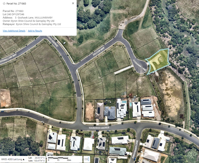
The following image shows the subject land as part of the subdivision development:
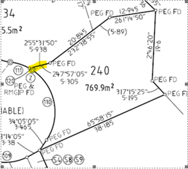
The latest plan increased the land in lot 240 by about two square metres relative to the former lot 194. The highlighted section below shows the minor adjustment:
To help keep the subdivision moving, lot 240 was created prior to the additional land being transferred to Council.
This means lot 240 currently has two owners.
Council owns the land in former lot 194. This is the vast majority of the land.
The remaining two square metres in lot 240 is owned by Gainsplay Pty Ltd.
Gainsplay wants to transfer its land to Council so that lot 240 has one owner.
Though the land size is minimal, Council land acquisition can only occur via resolution. This function cannot be delegated. Hence this Council report recommending that Council acquire the land.
Meanwhile, land acquired by Council must also be classified as operational or community land.
Lot 240 contains Council sewer infrastructure. The Council land in lot 240 is already classified as operational land.
It is recommended the remainder of lot 240 to be transferred to Council is also classified as operational land. Land classification is another function that can only be exercised by Council resolution.
Prior to classification, Council must give public notice of the proposed resolution. Again, the LG Act makes no exception for very small acquisition like this.
As a result, this report also recommends Council publicly notify its intention to classify the land as operational land.
The public notification must be a minimum of 28 days.
A further brief Council report in early 2025 will recommend the actual classification of the land as operational land. This needs to occur within three months of Council acquiring the land.
Subject to Council resolving to acquire the land, acquisition is expected to occur prior to year’s end.
· Public notice of the proposed classification.
· Land acquisition.
· Further Council report about the land’s classification.
Strategic Considerations
Community Strategic Plan and Operational Plan
|
CSP Objective |
CSP Strategy |
DP Action |
Code |
OP Activity |
|
5:
Connected Infrastructure |
5.5: Provide continuous and sustainable water and sewerage management |
5.5.1: Water supply - Provide a continuous water supply that is maintained in accordance with NSW Health guidelines |
5.5.1.3 |
Mullumbimby - Tuckeroo Ave Watermain Construction |
Recent Resolutions
· 23-309 classified Council’s land in lot 240 as operational land.
· 19-153 consented to the subdivision creating then lot 194. The consent included a condition that lot 194 be transferred to Council for utilities purposes.
Legal/Statutory/Policy Considerations
The LG Act requires a Council resolution for the following functions:
· Council acquiring land (see section 377(1)).
· Council classifying land (see section 31(2)).
Financial Considerations
The land will transfer for $1.
Staff Reports - General Manager 13.2
Report No. 13.2 Land transfer - Bangalow Bowling Club to Council - part Bangalow sportsfields
Directorate: General Manager
Report Author: Matt Meir, Legal Counsel
File No: I2024/1578
Summary:
This report asks Council to resolve to acquire part of the Bangalow sports grounds.
RECOMMENDATION:
That Council:
1. Acquires part 9 in DP 748099 comprising the tennis courts at Bangalow for the purpose of sports grounds; and
2. Gives public notice of the following proposed resolution:
That part lot 9 in DP 748099 be classified “community land” under the Local Government Act 1993.
Report
Context
For some time, Council has been working with Bangalow Bowling Club (the Club) to transfer that part of the Bangalow sports fields comprising the tennis courts from the Club to Council.
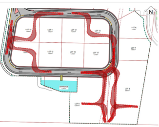
The land the subject of this report is southeast of the yellow line in the below image of the fields from Council’s Geocortex system:
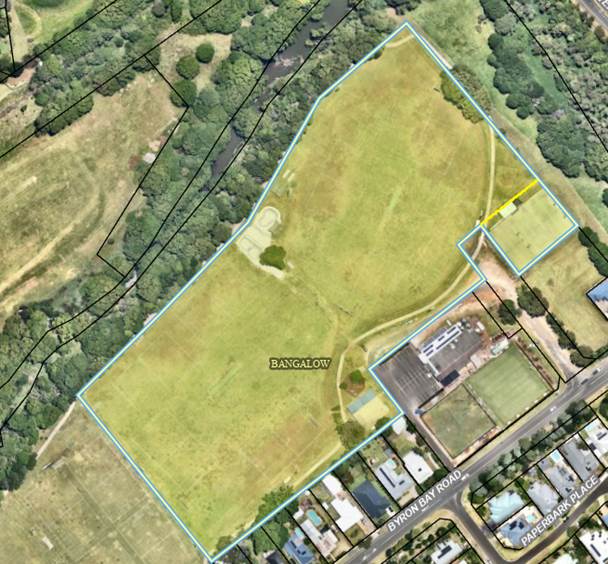
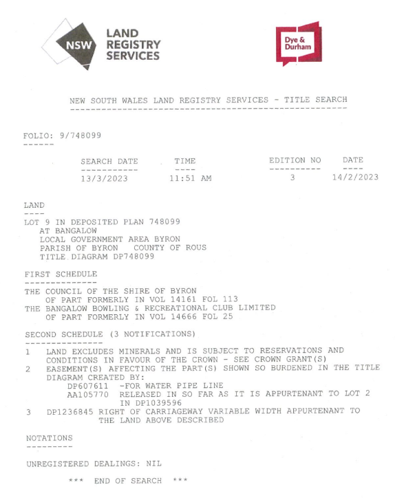
The title document for the sports fields shows its split ownership:
A brief history of the land is as follows:
· Lot 9 in DP 748099 was created by a plan of subdivision in 1987.
· The context for the subdivision was the tennis court construction via a grant awarded to the then Bangalow Sports Association. While the grant money would fund the court improvements, the land would be transferred to the public via Council.
· Despite the subdivision occurring, the land comprising the tennis courts was never transferred to Council.
· Since then, Council has had care and control of the land as part of the sports fields, with public users of the courts dealing with Council rather than the Club.
· In 2023 Council paid for the discharge of a mortgage over the tennis court land to help the proposed transfer to Council proceed.
· After this, Council wrote to the Club in March 2023 asking for the land to be transferred.
· Since then, there has been further correspondence between Council and the Club in the context of the latter’s merger with North Sydney Leagues Club (Norths), which was finalised in mid-2023.
After some further steps regarding the merger in recent months, the parties can now complete the transfer, subject to Council resolution.
Resolution required
Under the Local Government Act 1993 (LG Act), Council deciding to acquire land can only be made via resolution. It isn’t a function that can be delegated to staff.
The land will be transferred to Council for $1.
Council previously advised the Club that it would pay the latter’s costs of the transfer. These costs are estimated at about $6,500. The reason these costs are more than for a standard conveyance is due to the complexity caused by the Club merging with Norths.
Land classification
Meanwhile, land acquired by Council needs to be classified as either community or operational prior to or within three months of an acquisition. This function can also only be exercised by Council resolution.
Public notice – at least 28 days – of the proposed classification is required under the LG Act. This report’s recommendation contains the proposed resolution wording.
The recommendation suggests classifying the land as community land is preferable. This is because the balance of the Bangalow sports fields are classified as community land.
Further, a single classification for the entire site would be consistent with Council’s plan of management (POM) for the fields. The POM was adopted by Council in September 2023 (via resolution 23-384).
Next steps
If Council resolves to acquire the land, Council staff will work with the Club’s lawyers to transfer the land as soon as practicable.
Public notice of the proposed community land classification will also occur in coming weeks.
A further, brief Council report will be required in the new year to classify the land as community land.
Strategic Considerations
Community Strategic Plan and Operational Plan
|
CSP Objective |
CSP Strategy |
DP Action |
Code |
OP Activity |
|
5: Connected Infrastructure |
5.4: Provide accessible community facilities and open spaces |
5.4.4: Sporting facilities and swimming pools - Ensure ongoing maintenance and upgrade of inclusive sporting facilities and swimming pools |
5.4.4.3 |
Seek funding opportunities in consultation with community to implement adopted Landscape Masterplan for Bangalow Sports fields |
Legal/Statutory/Policy Considerations
Council can only acquire land by resolution – LG Act section 377(1)(h).
Council land must be classified by resolution – LG Act section 31(1).
Financial Considerations
The land will be acquired for $1.
Council already maintains the land and has for some time.
Staff Reports - General Manager 13.3
Report No. 13.3 Community Engagement Strategy
Directorate: General Manager
Report Author: Annie Lewis, Media and Communications Coordinator
File No: I2024/1595
Summary:
The purpose of this report is to provide the outcomes of the exhibition of the Draft Community Engagement Strategy 2024 to 2028, with a recommendation that the strategy be adopted. Council resolved to put the draft strategy on exhibition at the meeting on 24 October 2024. The draft strategy was on public exhibition from 25 October to 24 November 2024.
· Available on Your Say on Council’s website
· Two advertisements in the Byron Shire Echo (6 November 2024, 13 November 2024)
· Social media posts on Facebook and Instagram (7 November 2024, 20 November 2024, 21 November2024)
· E News (1 November 2024, 19 November 2024)
· Direct notification - Community Roundtable
Engagement summary
· 228 were informed about the project via Your Say (page views).
· Reach of 598 via Facebook, 219 on Instagram
· 8,562 people opened the E News on 1 November 2024, 8,595 on 19 November 2024 with 26 people clicking through to the Your Say page.
Submissions
10 submissions were received.
· Your Say – eight submissions
· Email – two submissions (note: one of these submissions was given in-person as well.)
RECOMMENDATION:
That Council adopts the Draft Community Engagement Strategy (Attachment 2 E2024/122782).
Attachments:
1 Submissions.Community
Engagement Strategy.redacted, E2024/139759
![]()
2 Draft
Community Engagement Strategy 2024 to 2028, E2024/122782
![]()
3 Engagement
Report - Draft Community Engagement Strategy, E2024/140343
![]()
Report
The Office of Local Government’s Integrated Planning and Reporting Guidelines require every Council in NSW to adopt a Community Engagement Strategy.
At the meeting on 24 October 2024 Council resolved to put the Draft Community Engagement Strategy on public exhibition.
The closing date for submissions was 24 November 2024.
A summary of the content of the submissions is below. The full submissions are attached to this report.
Comments/Feedback
|
Submission |
Summary |
|
Bangalow Community Association |
Supports the adoption of the draft strategy. The draft strategy recognises that community can make an essential contribution to decisions affecting social amenity and government and commercial forces should not be allowed to dominate the agendas of villages, towns etc. · Council has open and inclusive policies that encourage community engagement by various methods across all levels of decision-making. · Optimal engagement outcomes are achieved from collaboration with a broad group of community representatives such as village residents (long term), creative workers and business owners because they can contribute broad and deep knowledge and skills. · Acknowledges that broader deliberative processes have their place in resolving complex issues. · Notes absence of Heritage Advisory committee is disappointing for towns like Bangalow where heritage is important. · Council’s Community Roundtable and Place Planning Collective are valuable engagement forums. · Would like to see more workshops as these seem to have declined since COVID and are an effective way for community members to talk to staff to get an understanding of significant strategic items. · Support key stakeholders (including community groups) being involved in the masterplans/planning for community significant development so there is understanding and provision of the supporting infrastructure, business case viability. This is recommended in the Byron Residential Strategy and supported by DPHI. Staff comments The feedback provided reflects the draft strategy, and comments about the value of workshops will be promoted to staff when planning engagement activities, as well as to Managers and Directors. The comments relating to the Heritage Advisory Committee have been sent to Shannon Burt, SEE Director. Comments about Community Roundtable are noted. |
|
Mullumbimby Residents Association |
The submission by Mullumbimby Residents Association (MRA) provided an overview and commentary on the importance of meaningful and effective community engagement. The MRA emphasised that: · Well-planned and meaningful engagement is essential to developing trust within the community. · Engagement should not be a box-ticking exercise for staff but rather an opportunity to achieve good outcomes for Council and the community. · It is important for the community to see how their feedback was represented to Council/decision makers and how it was considered. · Improvement relating to engagement needs to be continuous. · Engagement should be timely and be planned and executed as early as possible. · Inclusion and accessibility – all members of the community should have the opportunity to contribute thoughts, opinions, feedback in a variety of ways. · Supportive of IAP2 spectrum of engagement and staff deciding on the appropriate level of engagement. · Essential for community engagement to be included in Council’s decision-making process. Staff comments The MRA is identified as a key stakeholder in the Byron Shire and staff met with the MRA prior to the development of the draft strategy to get information and input. The answer to a request relating to providing tracked changes between the 2022 and 2024 strategies is that the 2024 document was written as a new document. Concepts remain the same, but language has been changed and reworded to ensure the document, as much as possible complies with accessibility standards. Both versions are available on Council’s website. · 2022 Community Engagement Strategy - Byron Shire Council · 2024 Draft Community Engagement Strategy 2024 to 2028 - Byron Shire Council |
|
Community member |
· More whole-town stakeholder workshops to plan visions for the future or at the beginning of projects (planning phase). · Engagement with the community shows that people are valued, and this results in a higher likelihood that people will support the work of Council rather than ‘council-bashing’. · More face-to-face engagement with Councillors and staff will have better outcomes for everyone. · Would like to see staff assessed on their community engagement for each project and this should be more than ‘ticking boxes’. · Would like to see the community give feedback on the engagement that occurs with each Council project. · Acknowledges that community engagement has improved in recent years. Staff comments Stakeholder workshops are an important tool and are always considered when designing community and engagement plans for projects. Staff favour stakeholder workshops or drop-in sessions over town hall meetings. The reasons for this are: · Town hall meetings can be difficult to manage, require strong facilitation and often do not have productive outcomes. · Drop-in sessions, or stakeholder workshops ensure people can meet with specialist staff or consultants and have their voices heard, their questions answered, and their feedback or suggestions considered. · Drop-in sessions offer flexibility, often held across different days, venues and different times. Early engagement is certainly the preferred option for staff and results in better outcomes for the community and Council. The success or otherwise of communication and engagement plans and activities is assessed continually. There is little to be gained by adding another layer of process by assessing staff on their community engagement. Complaints can be made to the Media and Communications team directly and feedback is always taken on board. Feedback about the phone system has been passed on and thank you for acknowledging efforts to continually improve the way we work with our community. |
|
Community member |
This submission suggests the draft strategy needs to be more comprehensive and is lacking information relating to the Integrated Planning and Reporting guidelines, and how Council operates. It should contain: · Links to the Office of Local Government, Information and Privacy Commission. · A section on the Council website, explaining what information is available and how the GIPA process works. · A reference section at the end of the document that includes links to guidelines, handbooks, legislation and other relevant documents that could be of use to the community. Other feedback included: · The draft strategy should explain all Council’s responsibilities and all the opportunities where the community can engage. · The Community Engagement Strategy and the Community Participation Plan should be combined into one document. · The draft strategy could provide more information about the Integrated Planning and Reporting Framework, the hierarchy of documents the Council is required to produce, requirements under the EP&A Act, along with other documents such as the Code of Meeting Practice, Code of Conduct, Developer Contributions Plan. · Suggestions for improved terminology, formatting, public submissions. Staff comments The Community Engagement Strategy (2022) is a current document and can be found on Council’s website. The Draft Community Engagement Strategy 2024 to 2028 is a new document. · 2022 Community Engagement Strategy - Byron Shire Council · 2024 Draft Community Engagement Strategy 2024 to 2028 - Byron Shire Council In relation to the combination of the Community Engagement Strategy and the Community Participation Plan (CPP) it was noted in the report to Council on 24 October, that the CPP is due to be updated next year (2025) and when the Community Engagement Strategy is updated in 2028, the two documents will be consolidated. The Your Say page references Council’s IP&R framework, and it also provides people the option to receive a hard copy of the document draft strategy. Information about the GIPA process is on Council’s website. Council committees were referenced on p.19. The feedback relating to including additional information, links etc is noted. |
|
Community member |
Supports the appointment of a Community Engagement Officer to promote issues coming before Council to the community and to be an interface between Councillors or staff. Staff comments The role of Community Engagement Officers generally involves working with staff to ensure, to the best of their ability, the community is aware of projects, and able to contribute to or take part in activities as a way of providing input or feedback. This may be through face-to-face engagement, digital engagement, workshops, meetings etc. A Community Engagement Officer is supporting the Byron Bay Drainage Project and other major Infrastructure projects. The contact details of Councillors are available on Council’s website and can be provided to people by the Customer Service team. The importance of issues coming before Council is subjective and people concerned about something should contact Councillors directly to share their views. |
|
Community member |
The strategy looks good for community engagement but may be quite ambitious due to limited staff resources and time. The strategy was lacking in reference to older people and how we connect with that section of our community. Staff comments Noting the comments directly relating to seniors, the Corporate and Community Services team has been given a copy of this submission. In relation to communication and engagement, staff in the Media and Comms team impress to staff the importance of ensuring older members of the community have access to, and the ability to, provide feedback and participate in activities relating to engagement. This includes: · Staff being available to talk on the phone, or face-to-face with people who may struggle with technology when providing feedback about a project. · Staff arranging one-one-one meetings with less-mobile community members. · Ensuring venues are accessible. · Providing information about projects in a range of ways (radio, newspaper, digital). |
|
Community member |
Concerned the rail trail was not included in the draft strategy. Staff comment · A response relating to the rail trail has been provided. |
|
Community member |
· A comprehensive engagement strategy. · Council should do more to promote its achievements. · Not enough recognition of the work Council does in relation to the consultation for projects. Staff comment Appreciated and noted. |
|
Community member |
· Community engagement strategy is quite adequate. · Plans for engagement via a workshop style are encouraging. · The Heritage Advisory Committee was a mostly positive experience and disappointed that it is not proceeding in this council term. Staff comments Feedback about heritage and capital works has been passed on to SEE Director Shannon Burt and IS Director Phil Holloway. |
|
Community member |
Feedback presented was for the Future Pool and Aquatic Facilities consultation and was forwarded to the project officer. |
Additional information
Engagement and consultation is nuanced and this is why it is important to review and consider a range of factors when determining the success of an engagement campaign.
Often the success of an engagement/consultation piece is judged by the number of submissions. For example, the higher the number of submissions, the more successful it has been.
This is not always reliable, and background data is always considered in the review of engagement activities. This data includes activity on our Your Say web page, the number of page views versus the number of responses, engagement on Facebook and Instagram, and the open rate and ‘click’ rate from our E News.
Page clicks or page views means the number of times someone has opened or clicked on a page. This gives staff an indication of the level of interest in an issue.
The top 10 projects page views in the last 12 months are listed below along with the corresponding online responses. Note: the responses do not include email, verbal and face-to-face submissions.
|
Project |
Page views |
Online form responses |
|
Have-your-say-on-the-future-of-Byron-Bay-foreshore |
7032 |
754 |
|
Your Say landing page |
5300 |
n/a |
|
Burringbar-Street-Draft-Concept-Design |
3622 |
494 (stage 2) |
|
New-Brighton-South-Golden-Beach-and-Ocean-Shores-Place-Plan |
1293 |
Not available |
|
Future-pools-and-aquatic-facilities-in-the-Byron-Shire |
1267 |
393 |
|
Have-your-say-on-our-Active-Transport-Plan |
1218 |
Not available |
|
Proposed-changes-to-parking-at-New-Brighton |
1203 |
231 |
|
Short-term-rental-accommodation-Planning-Proposal |
1064 |
770 |
|
Securing-Mullumbimbys-water-supply |
1040 |
428 |
|
Community-Plan |
1011 |
221 |
IAP2 Spectrum – Empowerment and Deliberative Democracy
Council in the last six years, has invested in deliberative processes to find solutions to problems that are difficult to solve. Deliberative processes involve community members in decision-making, allowing them to discuss and consider difficult issues or wicked problems on a deep level with the aim of getting an informed and balanced direction from the community.
These bodies of work are not normally done for projects involving specialist or engineering solutions or those that need to be delivered as an essential part of Council’s business operations.
Deliberative processes require substantial planning, facilitation and a significant investment of staff resources and community time. They often run over many months. This approach is designed to ensure that decisions are well-informed and reflect the diverse perspectives of the community.
Examples of projects delivered recent years in the collaboration and empower areas of the IAP2 engagement spectrum are:
· Community Solutions Panel for prioritising infrastructure spending.
· Mullumbimby Hospital Site Project Reference Working Group
· The Byron Model – how to make democratic decisions in Byron Shire that can be widely supported.
· Sustainable Visitation Strategy
· Byron Arts and Industry Estate Enquiry by Design
· Federal Masterplan
Currently staff are working collaboratively on the development of a place plan for New Brighton, South Golden Beach and Ocean Shores.
Council will continue to invest in deliberative processes where is an identified need.
Next steps
The Community Engagement Strategy will be available on the website. It will be current for this term of Council e.g. 2024 to 2028.
Strategic Considerations
Community Strategic Plan and Operational Plan
|
CSP Objective |
CSP Strategy |
DP Action |
Code |
OP Activity |
|
1: Effective Leadership |
1.2: Engage and involve community in decision making |
1.2.1: Community-led decision making - Engage with community to inform Council decision making |
1.2.1.1 |
Provide opportunities for the community to have input, comment and feedback to Council on projects and matters of interest |
|
1: Effective Leadership |
1.2: Engage and involve community in decision making |
1.2.1: Community-led decision making - Engage with community to inform Council decision making |
1.2.1.2 |
Support staff to consider communication and engagement as part of all project development and implementation |
|
1: Effective Leadership |
1.2: Engage and involve community in decision making |
1.2.2: Communication - Provide timely information to the community about Council projects and activities through traditional and digital media |
1.2.2.5 |
Ensure information can be read and understood by our community regardless of their level of education, language spoken, lived experience of disability |
|
1: Effective Leadership |
1.2: Engage and involve community in decision making |
1.2.3: Customer Service - Deliver efficient customer service consistent with our Customer Service Standards |
1.2.3.1 |
Implement additional accessibility support options for customers where possible |
|
1: Effective Leadership |
1.2: Engage and involve community in decision making |
1.2.3: Customer Service - Deliver efficient customer service consistent with our Customer Service Standards |
1.2.3.2 |
Deliver efficient service to our customers by providing consistent, accurate and timely information |
Legal/Statutory/Policy Considerations
N/A
Financial Considerations
N/A
Consultation and Engagement
· Your Say on Council’s website
· Two advertisements in the Byron Shire Echo (6 November 2024, 13 November 2024)
· Social media posts on Facebook and Instagram (7 November 2024, 20 November 2024, 21 November 2024)
· E News (1 November 2024, 19 November 2024)
· Direct notification - Community Roundtable
Engagement summary228 page views about the project via Your Say.
· Reach of 598 via Facebook, 219 on Instagram
· 8,562 people opened the E News on 1 November 2024, 8,595 on 19 November 2024
· 26 direct clicks to Your Say page via E News
Staff Reports - Corporate and Community Services 13.4
Staff Reports - Corporate and Community Services
Report No. 13.4 Grants December 2024
Directorate: Corporate and Community Services
Report Author: Donna Johnston, Grants Coordinator
File No: I2024/1510
Summary:
Council is waiting on determination of 16 Grant Applications which, if successful, would provide funding to enable the delivery of identified projects. This report provides an update on grant applications.
RECOMMENDATION:
That Council notes the Grant Submissions Report for the month of December 2024 (Attachment 1 #E2024/139170).
1 Grants
awaiting determination - December 2024, E2024/139170
![]()
Report
Currently Council has 16 grant applications awaiting determination (refer to Grants Submissions as of 25 November 2024 - Attachment 1, E2024/139170
Successful applications
There were no public announcements of successful grant applications in November.
Unsuccessful applications
Staff were advised that the Expression of Interest under NSW Reconstruction Authority's Northern Rivers Towns and Villages Business Activation Program (RBAP) was unsuccessful for the Federal Village Main Street intersection and footpath improvement.
Staff are seeking feedback.
Upcoming Grant opportunities
Boating Infrastructure and Dredging Scheme | Transport for NSW
Transport for NSW Maritime
will invest $44 million into improving waterway accessibility and safety under
its new Boating Infrastructure and Dredging Scheme (BID Scheme).
The scheme replaces the previous grants program, providing $28 million in new
funding for the development of new and improved public boating infrastructure
and enhanced public access to NSW waterways. The scheme also confirms $16
million to deliver much needed dredging works along the NSW coast.
Matching co-contribution from Council is required.
Australian Government Black Spot Program | NSW Government
The objective of black spot projects is to reduce the social and economic costs of road trauma by:
· identifying and applying cost-effective treatment of locations with a record of casualty crashes
· placing significant focus on the need to reduce rural road trauma, in accordance with national road safety policy objectives
· using a proportion of funds to treat sites identified as potential crash locations, and to implement other road safety measures.
The Black Spot Program makes an important contribution in reducing the national road toll under the National Road Safety Strategy and Action Plan, providing financial assistance to improve the physical condition or management of sites noted for a high incidence of crashes involving death and injury.
The Australian Government contributes up to 100 per cent funding for black spot projects under this program. This program is administered by Transport for NSW.
Council staff are currently reviewing the following projects for eligibility and resourcing.
1. Mullumbimby Public School road safety improvements
2. Mullumbimby High School road safety improvements
3. Vehicle Activated Signs shire wide
4. Burringbar St/Station St Mullumbimby intersection reprioritisation
5. Brunswick Valley Way/Shara Blvd intersection improvements
6. Federal Village Main St Design
Community Strategic Plan and Operational Plan
|
CSP Objective |
CSP Strategy |
DP Action |
Code |
OP Activity |
|
1: Effective Leadership |
1.3: Ethical and efficient management of resources |
1.3.1: Financial Management - Ensure the financial integrity and sustainability of Council through effective financial management |
1.3.1.9 |
Coordinate grant applications to support the delivery of Council projects and services within management plans, masterplans, strategic plans, council resolutions and high priority actions from feasibility studies; and support the management of successful grants |
Legal/Statutory/Policy Considerations
Under section 409 3(c) of the Local Government Act 1993 Council is required to ensure that ‘money that has been received from the Government or from a public authority by way of a specific purpose advance or Grant, may not, except with the consent of the Government or public authority, be used otherwise than for that specific purpose’. This legislative requirement governs Council’s administration of Grants.
Financial Considerations
If Council is successful in obtaining the identified Grants, this would bring funding sought to approximately $36.3 million which would provide significant funding for Council projects. Some of the Grants require a contribution from Council (either cash or in-kind) and others do not. Council’s contribution is funded.
The potential funding is detailed below:
Funding applications submitted and
awaiting notification (total value) $39,187,898
Requested funds from funding bodies $36,291,088
Council contribution cash $2,654,610
Council co-contribution in-kind $189,200
Other contributions $0
Funding determined in November 2024:
Successful
applications
$0 (total project value)
Unsuccessful/withdrawn
applications
$0 (total project value)
Consultation and Engagement
Cross-organisational consultation has occurred in relation to the submission of relevant grants, and the communication of proposed grant applications.
Staff Reports - Corporate and Community Services 13.5
Report No. 13.5 Appointment of Community Representatives to Advisory Committees
Directorate: Corporate and Community Services
Report Author: Heather Sills, Manager Corporate Services
File No: I2024/1556
Summary:
Council received a report on 24 October 2024 to allow for advertising to take place for community representatives to its Advisory Committees for the term of Council.
Interested members of the community and existing members were invited to submit an Expression of Interest for inclusion on these committees by completing an online nomination form. This report provides information about the nominations received and recommends appointment to the various Advisory Committees.
RECOMMENDATION:
1. That Council adopts the schedule of Advisory Committee Meetings shown in Attachment 1 (E2024/114176), with meetings generally held in the Conference Room, Mullumbimby.
2. That community representatives, as recommended in confidential attachments 2-8, be appointed to each respective Advisory Committee for the 2024-2028 term ending September 2028.
3. That all appointed Advisory Committee members:
a) be notified of their appointment to the committee; and
b) complete induction, Code of Conduct, and confidentiality requirements.
4. That any unsuccessful nominees be notified.
1 Advisory
Commitee Meeting Schedule 2025, E2024/114176
![]()
2 Confidential - Arts Advisory Committee - Nominations, E2024/135417
3 Confidential - Biodiversity and Agriculture Advisory Committee - Nominations, E2024/135418
4 Confidential - Climate Change and Resource Recovery Advisory Committee - Nominations, E2024/135419
5 Confidential - Coast and ICOLL Advisory Committee - Nominations, E2024/135420
6 Confidential - Floodplain Risk Management Advisory Committee - Nominations, E2024/135421
7 Confidential - Transport and Infrastructure Advisory Committee - Nominations, E2024/135422
8 Confidential - Water & Sewer Advisory Committee - Nominations, E2024/135423
The constitution of each committee sets out the frequency meetings are to be held and is generally every quarter except for the Local Traffic Committee which is ten times per annum.
Councillors discussed the meeting schedule at the 31 October Councillor Workshop. Committee meetings continue to be held on the third Thursday of each month, as endorsed in the Council Meeting Schedule 2025 on 28 November 2024.
Committee meetings are scheduled in two hour blocks, commencing at the following times:
· 9:00am
· 11.30am
· 2.00pm
· 4.30pm
The Advisory Committee Meeting Schedule 2025, Attachment 1, provides the specific dates and times proposed for each Advisory Committee.
Councillors provided their availability for times and days of the week for meetings to be held and this has been incorporated into the scheduling.
Council received a report on 24 October 2024 to determine the committee structure for the term of Council and to invite nominations from community representatives to its Advisory Committees.
· Arts Advisory Committee – 11 nominations
· Biodiversity and Agriculture Advisory Committee – 8 nominations
· Climate Change and Resource Recovery Advisory Committee – 5 nominations
· Coastal and ICOLL Advisory Committee – 8 nominations
· Floodplain Risk Management Advisory Committee – 4 nominations
· Transport and Infrastructure Advisory Committee – 8 nominations
· Water and Sewer Advisory Committee – 2 nominations
The majority of committees received more nominations than available positions, in accordance with the structure and membership as determined by Council on 24 October 2024. Council is therefore asked to consider the nominations, as provided in confidential attachments 2-8, and determine the appointment of community representatives to each of the committees.
|
CSP Objective |
CSP Strategy |
DP Action |
Code |
OP Activity |
|
1: Effective Leadership |
1.2: Engage and involve community in decision making |
1.2.4: Advisory Committees - Coordinate advisory committees to inform decision making on their areas of expertise |
1.2.4.1 |
Coordinate and support Advisory Committees to assist with effective Council decision making |
· 24-482 – Advisory Committee Structure and Determination of Councillor Representatives – 24 October 2024
Each Advisory Committee operates under an adopted Terms of Reference and Council’s Code of Meeting Practice.
The community representatives on Advisory Committees are volunteer representatives.
In accordance with Council’s Mayor and Councillors’ Payment of Expenses and Provision of Facilities Policy, a Councillor may claim reimbursement for travelling costs to attend meetings.
Nominations were open for a period of 21 days during which time two advertisements were placed in the local newspaper, in addition to regular advertising on Council’s website and social media.
Existing committee members were also notified of the nomination process and were encouraged to reapply.
The nomination form was an online form available on Council’s website.
Staff Reports - Corporate and Community Services 13.6
Report No. 13.6 Appointment of Councillor Contacts for Section 355 Committees
Directorate: Corporate and Community Services
Report Author: Deborah Stafford, Manager Social & Cultural Planning
File No: I2024/1607
Summary:
Council received a report at the 28 November 2024 Ordinary Meeting regarding Section 355 Committees. This report responds to point 4 of the resolution from that report, being that Council “Appoints the Councillor Contacts for each Section 355 Committee at the 12 December 2024 Ordinary Council meeting.”
The role of a Councillor contact is defined in the adopted s355 Committee Hall Guidelines.
RECOMMENDATION:
Appoints the following Councillor Contacts for each Section 355 Committee:
1. Bangalow A&I Hall – Cr ________________
2. Bangalow Showgrounds – Cr ________________
3. Brunswick Heads Memorial Hall – Cr ________________
4. Durrumbul Hall (Main Arm) – Cr ________________
5. Marvell Hall (Byron Bay) – Cr ________________
6. Mullumbimby Civic Memorial Hall – Cr ________________
7. Ocean Shores Community Centre – Cr ________________
8. South Golden Beach Hall – Cr ________________
9. Suffolk Park Community Hall – Cr ________________
Report
Council received a report on 28 November to note the continuing current Section 355 Committee arrangements, to support the review of the appropriate governance form for each of the Section 355 Committee’s assets.
Council resolved to appoint Councillor contacts to each of the committees in the interim.
The role of the Councillor contact is defined in the Section 355 Committee Guidelines, extract provided below:
Council staff should be the first point of contact for Committee members to assist with any queries, concerns or matters relating to the function of Committees or the operation of the halls.
Council acknowledges that there may be instances when Committee members feel more comfortable speaking with an elected Councillor – a leader and representative of the local community. Each Committee will have a designated Councillor contact to assist Committees if they require additional input, negotiation, or advice. This acknowledges the leadership role that Councillors serve in the community.
The Councillor contact is not required to attend Committee meetings; however, the Councillor contact may attend Committee meetings upon request or if required to discuss a particular matter. The Councillor contact should not be involved in any operational decisions relating to the halls and is not eligible to vote at Committee meetings.
Strategic Considerations
Community Strategic Plan and Operational Plan
|
CSP Objective |
CSP Strategy |
DP Action |
Code |
OP Activity |
|
1: Effective Leadership |
1.5: Empower community leadership through collaboration, capacity building, and cultivating community driven initiatives |
1.5.3: s355 Committees - Support the management of community halls to delegated s355 committees |
1.5.3.1 |
Support Council volunteers with the management and operation of community halls |
|
1: Effective Leadership |
1.5: Empower community leadership through collaboration, capacity building, and cultivating community driven initiatives |
1.5.3: s355 Committees - Support the management of community halls to delegated s355 committees |
1.5.3.2 |
Develop and implement change project for Section 355 model of management for community halls |
Recent Resolutions
· 24-531 – continuation of existing appointments and delegations to Section 355 Committees while a review is undertaken. This report responds to point 4 of the resolution that Council “Appoints the Councillor Contacts for each Section 355 Committee at the 12 December 2024 Ordinary Council meeting”
Legal/Statutory/Policy Considerations
Section 355 Committee Guidelines (November 2023)
Guidelines and policy which define the roles and responsibilities.
Financial Considerations
Councillors will be entitled to reimbursement of travel expenses to attend Section 355 Committee Meetings.
Consultation and Engagement
Not required for the appointment of Councillor contacts.
Staff Reports - Sustainable Environment and Economy 13.7
Staff Reports - Sustainable Environment and Economy
Report No. 13.7 Marshalls Creek Foreshore Remediation, New Brighton
Directorate: Sustainable Environment and Economy
Report Author: Chloe Dowsett, Biodiversity and Sustainability Coordinator
File No: I2024/1129
Summary:
The foreshore area of river side land at New Brighton adjacent to Marshalls Creek along River Street and Casons Road provides a space for the local community to picnic, gather and access the creek.
The land is under various ownership including Council public road, National Parks and freehold (private). The freehold area of land is partly in the waterway (due to migration of the creek) and has been used as public space for more than 30 years, but it remains registered in the names of former owners who passed away before then. The waterway is owned and managed directly by DPIE - Crown Lands.
Bank undercutting from wash and current scour is threatening the area used as public access foreshore and the Council Road. Public trampling of the riverbank is also having an impact on the stability of the area.
The erosion at this location was identified as a key concern by community in the Ocean Shores, New Brighton, and South Golden Beach during the recent master plan consultation.
The vision for the area is for foreshore remediation works to aim to facilitate formalised public access with best practice living shoreline and riverbank rehabilitation principles. Remediation of the foreshore would provide protection of intertidal habitat within the marine park and nature reserve, along with providing stability for a designated community space.
At the 1 August 2024 Council Planning meeting a Notice of Motion was brought to Council in relation to this area. A subsequent resolution was made.
24-360 Resolved that Council:
1. Urgently Investigates Grant funding opportunities for remediation along the whole section of riverbank from Casons Rd to Pacific St, New Brighton
2. Then receives a further report:
a. On an expanded section of land from Casons Rd to Pacific Street and options for remediation on all sections of this land
b. Outlining whether compulsory acquisition is an option on the land identified in the current report, given the urgent need for remediation.
c. On restarted negotiations with the owners of the land opposite the Post Office with a view to purchase or to at least allow access for remediation.
3. Requests an urgent onsite meeting with relevant stakeholders and land managers. (Lyon/Ndiaye)
This report provides an outline of the status of the above resolution items.
RECOMMENDATION:
That Council:
1. Acknowledges the complexity of land tenure, environmental and planning considerations in play in relation to Marshalls Creek Foreshore Remediation, New Brighton;
2. Requests Legal Services Team to investigate options and prepare a report on the potential ‘acquisition’ of Lots 1, 2 and 3 in DP121484, River Street, New Brighton by Council. The report to include details of the legal requirements and process, planning process, and costs associated with any potential land acquisition option;
3. Receives the report on the land acquisition options from 2 above in the first half of 2025, and prior to making any further decision on this matter;
4. Requests Crown Lands to undertake a survey of the area to identify the location of the current creek bank; and
5. Notes that DPIRD-Fisheries are engaging a consultant to identify planning pathways and approvals advice, and to develop detailed designs for foreshore remediation works in close consultation with key stakeholders including Tweed Byron Local Aboriginal Land Council and Aboriginal Cultural Heritage knowledge holders, Marine Parks, NPWS and Council.
The foreshore area of river side land at New Brighton adjacent to Marshalls Creek along River Street and Casons Road has been used by local community as a space to picnic, gather and access the creek. Access to Marshalls Creek (north arm of the Brunswick River) is un-formalised at this site, however, it is heavily used by the community and visitors for swimming and passive recreational activities like kayaking and paddle boarding. The site in total encompasses a large precinct from the main grassy area opposite the store/café on the eastern side of the creek to upstream adjacent the end of Casons Lane (Figures 1 & 2).
The area is extremely well used and loved by the local community and has a high cultural significance. Council has mowed and maintained the area opposite the store/café and the local community are active in supporting management of the area and removing rubbish and weeds and they have a strong commitment to this community space.
The foreshore area is a mix of land tenure under various ownership, including Council Road reserve, National Parks Estate, and an area of freehold/private land. The Tweed River/Minjungbal Native Title Claim covers this land and water in this area. It is currently undetermined so all NSW agencies and Council should proceed on the basis that Native Title rights and interests continue in the waterway. The waterway is directly managed by Crown Lands and lies within the Cape Byron Marine Park – Habitat Protection Zone.
Figure 1: Approximate site location at New Brighton
![]() Figure 2: Aerial
photo of approximate site location at New Brighton.
Figure 2: Aerial
photo of approximate site location at New Brighton.
There is an area of land that is registered in the names of its former registered owners, who passed away more than 30 years ago. There are unpaid rates owing on private land, which Council and community maintain.
The waterway is Crown waterway, however the actual waterway has changed over time with migration of the creek, so the actual waterway and the mapped waterway do no align in all areas. Crown Lands has recommended that a registered surveyor should identify the location of the current creek bank. There are no Council funds available to undertake a survey in this area.
Issues
Bank undercutting from wash and current scour is threatening the foreshore and road. Previous attempts have been made to control the erosion in this area including installation of coir logs, revegetation and rock armouring. There is only a narrow riparian vegetation buffer along the foreshore and no formal access points to the creek. Public trampling of the riverbank is also having an impact on the stability of the area (Figures 3 & 4).
Figure 3: Area opposite store/café with picnic table and un-formalised access to the creek and undercutting of the riverbank

Figure 4: Area opposite store/café looking downstream showing ad hoc rock protection and bare riverbank
Foreshore Remediation Project
Responsibility for management of the waterway and riverbank sits with NSW Government, through Marine Parks, National Parks, Fisheries and Crown Lands.
Notwithstanding that is not Council’s responsibility, Council has an on-going action in the Operational Plan for investigating grant opportunities for restoration of the ‘Brunswick River estuary’.
Over the years, staff have tried to pursue funding opportunities to support this action, however all potential projects are constrained by mixed land tenure, lack of NSW Government funding and competing Council staff and budget priorities.
A foreshore remediation project in this area would align with several of Council’s existing plans, projects and/or policies including:
1. Coastal Zone Management Plan for the Brunswick Estuary, Issue 5, June 2017
As outlined above development of a Precinct Plan to design the most appropriate combination of bank stabilisation works, formalisation of public access and planting of the riparian buffer zone is an action in the in the CZMP (uncertified).
2. Byron Shire Open Space and Recreation Needs Assessment and Action Plan (draft) 2017 - 2036
Access to the natural areas, especially the waterways, and open space (parks and sports parks) and the infrastructure to support these activities is important for current and future residents and visitors. Community response to the survey noted activation of this foreshore area of Marshalls Creek through a community and recreation precinct for swimming and canoe/kayak access.
3. Community Strategic Plan (2032)
A ‘nurtured environment’ is one of Council’s five community objectives with initiative 3.3 to ‘Protect the health of coastline, estuaries, waterways, and catchments’ a key principle driving delivery and operational planning. t is well known that the community desires a protected and cared for natural environment.
4. Community feedback received during the recent consultation stages for the New Brighton, South Golden Beach and Ocean Shores Place Plan
Place planning has commenced for New Brighton to define the vision and priority projects for the area over the next 20 years. Restoration of this area has been key issue identified in the recent community engagement with requests that it be a priority for action.
Any foreshore remediation works should aim to facilitate formalised public access with best practice living shoreline and riverbank rehabilitation principles. Remediation of the foreshore in this area would provide protection of intertidal habitat within the marine park and nature reserve, along with providing stability for a designated community space.
Council Resolution
At the 1 August Council Planning meeting a Notice of Motion was brought to Council in relation to this area. A subsequent resolution was made.
24-360 Resolved that Council:
1. Urgently Investigates Grant funding opportunities for remediation along the whole section of riverbank from Casons Rd to Pacific St, New Brighton
2. Then receives a further report:
a) On an expanded section of land from Casons Rd to Pacific Street and options for remediation on all sections of this land
b) Outlining whether compulsory acquisition is an option on the land identified in the current report, given the urgent need for remediation
c) On restarted negotiations with the owners of the land opposite the Post Office with a view to purchase or to at least allow access for remediation.
3. Requests an urgent onsite meeting with relevant stakeholders and land managers.
This report provides an outline of the status of the above resolution items.
Item 1: Urgently Investigates Grant funding opportunities for remediation along the whole section of riverbank from Casons Rd to Pacific St, New Brighton
Council’s Operational Plan has an on-going action 3.1.3.4 which has been recurrent for 3+ years to:
Continue progressing the ‘Bringing Back the Bruns’ river restoration initiative
Investigating grant opportunities occurs each year as part of the general work of Coast, Estuary, Biodiversity and Agriculture staff.
A summary of current relevant grant programs/streams and opportunity is provided in the table below.
|
Description |
Opportunity? |
|
|
NSW Floodplain Management Grants |
Grant funding from the State for floodplain planning, risk assessment, investigation, and implementation of projects. Projects must have been through the planning process and be identified in a Floodplain Risk Management Plan. River restoration at this location is not an identified site for works in the North Byron Flood Risk Management Plan. |
Not a likely opportunity for foreshore rehabilitation. |
|
Addressing Priority Flood Impacts in Byron Shire |
This partnership project funded by NSW North Coast Local Land Services through the River Rehabilitation Project addressed riparian erosion at selected sites where changes to river meandering or loss of sediment was present. |
Council received $200,000 for restoration works and an additional $20,000 as a variation. The project is now complete and no further funding is possible. |
|
State-wide Riverbank Rehabilitation Project |
Led by the NSW Local Land Services for phase 2 of the State-wide Riverbank Rehabilitation Project for 11 priority catchments. The RRP was developed in response to recent flood events and will undertake targeted riverbank rehabilitation in 11 catchments including the Brunswick. A prioritisation process has been undertaken to identify strategic sites in the mid-catchment for on-ground works with a focus on the protection of high value rural agricultural, cultural, and environmental natural assets. |
This site at New Brighton was outside the spatial scope of this project. Sites have been selected. Not a potential funding source. |
|
Northern Rivers Watershed Initiative |
Multiple Northern Rivers LGA pilot project to increasing private landholder capacity for riparian restoration and catchment revegetation. |
Led by Rous County Council. Focus is on private landholders for restoration. Funding has been confirmed for $300,000 for already scoped projects/sites. Not a potential funding source.
|
|
Coast and Estuary Grants Program |
This funding stream enables local councils and communities to prepare coastal management programs (CMPs) and implement actions identified in those programs. Grant offers are subject to statewide priorities and the availability of funds each financial year. This is Council’s main funding stream for coast/estuary projects and CMP projects. Council has existing funding through this program. There is a stream for riparian restoration which can be applied for in absence of a certified CMP, however with 50% contribution. |
The program closed on 5 September.
|
|
Brunswick River Estuary Bank and Riparian Assessment – NSW Estuary Asset Protection Program (NEAP Program) |
In response to the 2022 floods, the NSW Government recently announced a $29 Million joint funding package with the Australian Government which is focused on improving the condition and resilience of flood impacted estuarine assets. As part of this package of works, the Department of Primary Industries and Regional development – Fisheries (DPIRD-Fisheries) is undertaking comprehensive Bank and Riparian Assessments across 10 estuaries in NSW, including the Brunswick River Estuary. The comprehensive assessments will assist land managers to identify and target priority areas for works designed to enhance riverbank protection and increase its resilience to future floods. DPIRD-Fisheries engaged Fruition Environmental to undertake a comprehensive bank assessment of the Brunswick Estuary. Council staff and key stakeholders have assisted Fruition and the team with provision of data and key information along with feedback on the prioritisation of sites. 355 sites were assessed during the field surveys. Sites were then reviewed/filtered against key criteria and added to a pool of ‘priority’ sites. A pool of 44 sites assessed against further ranking criteria and scored. A short-list of sites considered higher priority for management interventions to improve bank and riparian condition was developed. Sites lower in the assessment matrix are recommended to be monitored for change. |
This location has been identified as a priority site for bank rehabilitation / management intervention (high erosion severity; moderate environmental impact and moderate safety / amenity impact). Using NEAP funds DPIRD-Fisheries will seek planning pathway advice and continue project planning for this priority area. DPIRD-Fisheries are currently engaging a consultant to prepare a concept and/or detailed design, advice on planning of environmental pathways for projects and estimated costings. The NEAP program is due to be finalised on 30 June 2025, meaning all contracted projects must be completed by that date. The NEAP Program is the best opportunity for progressing rehabilitation options for this site. While Council can be contracted by NSW Government to deliver works under the NEAP Program, the leadership of the project under that project must remain with NSW Government, as Council does not have powers to carry out the proposed works in its own right. |
|
North Coast Regional Landcare Caring for Catchments |
Project aims to improve catchment health, build flood resilience, and enhance biodiversity through riparian revegetation and reforestation with the objective to restore and protect waterways by planting up to 240 hectares of native vegetation along 8 kilometres of cleared river and streambanks over the next three years. Expressions of Interest for landholders in the Brunswick Catchment have closed. |
Council as a land manager (of the road reserve section of the area) is not eligible and this program is not a potential source of funding. |
|
Recreational Fishing Trust Grants Program |
Grants are funded from the Recreational Fishing Trusts which direct revenue generated by the NSW Recreational Fishing Fee towards on ground actions to improve fish habitat and recreational fishing in NSW. Rehabilitation of riparian lands and aquatic habitat and bank stabilisation works are supported. |
Projects need to be ‘Shovel Ready’ with design, costs, planning approvals and licences obtained. Grant application closes 18 December 2024. |
Staff will continue to review and pursue any applicable grant funding opportunities as they are announced, provided the project is eligible according to the grant criteria. Staff will also continue to strongly lobby DPIRD-Fisheries, Marine Parks, and National Parks to work with Crown Land and Council to progress this potential project.
In addition to funding, the planning and design work that DPIRD-Fisheries are currently undertaking is needed before applying for funding. That should be the approach by DPIRD-Fisheries for all riparian projects, not just this one. This work will be key to DPIRD-Fisheries becoming ready to apply for and obtain the planning and land tenure approvals needed and seek funding to progress the project.
Item 2: Further report:
a. On an expanded section of land from Casons Rd to Pacific Street and options for remediation on all sections of this land
![]() The
DPIRD-Fisheries comprehensive Bank Erosion and Riparian Assessment for the
Brunswick Estuary through the NEAP Program has identified this location as priority
for bank rehabilitation. The spatial extent comprises approximately 400m of
riverbank foreshore adjacent to New Brighton Road, River Street and Casons
Road, New Brighton (Figure 5).
The
DPIRD-Fisheries comprehensive Bank Erosion and Riparian Assessment for the
Brunswick Estuary through the NEAP Program has identified this location as priority
for bank rehabilitation. The spatial extent comprises approximately 400m of
riverbank foreshore adjacent to New Brighton Road, River Street and Casons
Road, New Brighton (Figure 5).
Figure 5: approximate extent of site shown in colours
Using NEAP funds DPIRD-Fisheries will continue project planning for this priority area and they are currently engaging a consultant to complete:
· Detailed designs for foreshore remediation works that facilitate formalised public access along with best practice living shoreline principles and Connecting to Country principles. Specific design is expected to vary across the entire site to address specific erosion causes or utilisation requirements.
· Design options are to be informed by the outcomes of the bank erosion and riparian assessment.
· Detailed design is to be developed in consultation with key stakeholders including Tweed Byron Local Aboriginal Land Council and Aboriginal Cultural Heritage knowledge holders, Marine Parks, NPWS and Council and will include the provision of an accurate scope of the estimated materials and potential construction costs (expected to be within 20-30% of final implementation costs).
· Designs are to facilitate staged delivery of on-ground works, enabling construction to be undertaken pending funding opportunities.
· Advice on what environmental assessments will be required.
· Advice on the appropriate planning approval pathway and approvals required.
DPIRD-Fisheries intend to complete this work by June 2025 and Council staff will continue to partner with DPIRD-Fisheries on this work.
b. Outlining whether compulsory acquisition is an option on the land identified in the current report, given the urgent need for remediation
c. On restarted negotiations with the owners of the land opposite the Post Office with a view to purchase or to at least allow access for remediation.
Items 2 b & c are considered in parallel.
Parts of the foreshore area are currently registered in the ownership of a deceased estate. This includes the well-used community area opposite the New Brighton store/café. Council has been maintaining and managing this area and community have been using it as if it were public land.
There are various processes that Council could pursue to obtain ownership this land, including compulsory acquisition but other potential options include applying for possessory title, acquisition for unpaid rates, by voluntary agreement or forced sale, or voluntary agreement.
All options have pros and cons, different cost implications and different processes and timescales and of course, each acquisition involves specific consultation with the other parties involved, the outcomes of which can vary. Some of the options could involve no net-cost costs to Council, while others could require a budget.
For this reason, it is important that as a first step Council formally investigate and report on the options for a potential ‘acquisition’ of Lots 1, 2 and 3 in DP121484, River Street, New Brighton. This investigation to look at legal requirements, planning processes, and costs associated with any potential land acquisition option.
This work will be completed subject to the Council resolution on this report.
Item 3: Requests an urgent onsite meeting with relevant stakeholders and land managers.
Staff have met with key stakeholders and agencies over the years to gauge their feedback on a restoration project at this site. There has been overwhelming support for progressing a restoration project, however no NSW Government agency has funding available to proceed.
Staff met with members of the New Brighton Village Association on 29 August 2024 for a site walkover and discussion. Members reiterated to staff the high level of community interest and willingness for a restoration project at this location and improvement of community access and foreshore for passive recreation. Staff continue to keep the association updated as the project progresses.
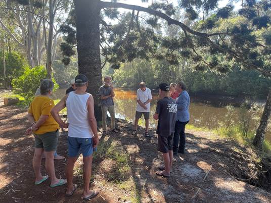
The area presents a great opportunity to restore a special/significant local community area that is well used for passive recreational purposes.
Other challenges to the project will remain, including co-management of the waterway and interests in the waterway across Native Title claimants, Marine Parks, Fisheries and Crown Lands (with Council having no powers), obtaining the required environmental approvals and securing funding not just for the remediation project but also for ongoing maintenance and repair of project works/investment (e.g. follow-up plantings, weeding, maintenance of infrastructure). Council remains committed to supporting the various NSW Government agencies involved and working with Native Title claimants, Aboriginal cultural knowledge holders and community to advocate for this project, and to pursue all available avenues to try to secure the required approvals and construction and maintenance funding.
|
CSP Objective |
CSP Strategy |
DP Action |
Code |
OP Activity |
|
3: Nurtured Environment |
3.1: Partner to nurture and enhance biodiversity, ecosystems, and ecology |
3.1.3: Habitat restoration - Restore degraded areas that provide high environmental or community value |
3.1.3.4 |
Continue progressing the 'Bringing Back the Bruns' river restoration initiative |
|
3: Nurtured Environment |
3.1: Partner to nurture and enhance biodiversity, ecosystems, and ecology |
3.1.3: Habitat restoration - Restore degraded areas that provide high environmental or community value |
3.1.3.6 |
Undertake bush regeneration activities to maintain and expand restoration of HEV sites on Council owned or managed lands forming part of the Council bush regeneration program |
|
4: Ethical Growth |
4.1: Manage responsible development through effective place and space planning |
4.1.3: Town / Village Masterplans - Develop, implement and update Place Plans that promote place-based forward planning strategies and actions |
4.1.3.10 |
Develop a Place Plan for the North Byron Coastal Communities of Ocean Shores, South Golden Beach and New Brighton |
24-360
NSW Coastal Management Framework
NSW Environmental Planning Assessment framework
There is no current budget allocation for the work associated with this project.
|
How did consultation occur and why? |
Comments/Feedback |
|
|
New Brighton Village Association |
Site visit on 29 August with representative of New Brighton Village Association and Council staff. |
Priority reconfirmed and NBVA will be kept updated on the progress of opportunities for this area. |
|
DPIRD-Fisheries |
Email and verbal discussions regarding NEAP program and potential opportunities, along with DPIRD-Fisheries engagement of consultants to do work outlined above. |
DPIRD-Fisheries are engaging a consultant to complete design options and planning pathway advice.
|
Staff Reports - Sustainable Environment and Economy 13.8
Report No. 13.8 PLANNING - DA 10.2024.57.1 - 17 lot industrial subdivision includng creation of a drainage lot, roadworks, bulk earthworks, vegetation removal and associated infrastructure – 288 Ewingsdale Road, Byron Bay
Directorate: Sustainable Environment and Economy
Report Author: Ben Grant, Senior Planner
File No: I2024/1430
Proposal:
|
DA No: |
10.2024.57.1 |
||
|
Planning Portal ref |
PAN-416736 |
||
|
Proposal description: |
17 lot industrial subdivision including creation of a drainage lot, bulk earthworks, vegetation removal and associated infrastructure |
||
|
Property description: |
LOT: 105 DP: 1297628 |
||
|
288 Ewingsdale Road BYRON BAY |
|||
|
Parcel No/s: |
270497 |
||
|
Applicant: |
HANNAS CONTRACTING SERVICES PTY LTD |
||
|
Owner: |
NSPT Pty Ltd |
||
|
Zoning: |
IN2 Light Industrial Byron LEP 1988 |
||
|
Date received: |
22 March 2024 |
||
|
Integrated / Designated Development: |
☐ Integrated |
☐ Designated |
☒ Not applicable |
|
Concurrence required |
Yes – CNR-67224 |
||
|
Public notification or exhibition: |
- Level 2 advertising under Council’s Community Participation Plan. - Exhibition period: 4 April 2024 to 17 April 2024. - Submissions received: Two (2) - Submissions acknowledged: ☒ Yes |
||
|
Planning Review Committee |
Planning Review Committee 2 May 2024. Outside staff delegation Council to determine. |
||
|
Variation request to Development Standards under an EPI (e.g., clause 4.6) |
Not applicable
|
||
|
Estimated cost |
$4,290,000.00 |
||
|
Delegation to determine |
Council (subdivision more than 10 lots). |
||
|
Issues |
· Intersection design. · Traffic impact. · Potential groundwater contamination. · Acid Frog Management Plan requires revision. |
||
Summary:
Approval is sought for a 17-lot industrial subdivision including creation of a drainage lot, roadworks, bulk earthworks, vegetation removal, environmental rehabilitation works and associated landscaping and infrastructure, at 288 Ewingsdale Road, Byron Bay.
The site is located within the West Byron Urban Release Area, located on the southern side of Ewingsdale Road, 2.5km from Byron Bay and 3km from the Ewingsdale Road interchange of the M1 Motorway.
Specifically, the project involves:
· Creation of 17 lots varying in area from 11,447m2 to 13,897m2 suitable for future land uses consistent with the existing industrial zoning.
· Protection of high biodiversity value vegetation located in the property’s south-west corner, to be incorporated into proposed development lot with appropriate covenants.
· Construction of a new public road providing access to the lots, intersecting with Ewingsdale Road in the property’s north-west corner by way of a left-in/ left-out arrangement.
· Filling of the land to provide flood immunity and to promote positive drainage, involving importation of approx. 74,000m3 of fill and associated site retaining, and
· Creation of 1 drainage lot and construction of appropriate stormwater management controls to ensure the protection of downstream wetlands and groundwater dependant ecosystems.
The proposed development will impact approximately 1.2 hectares of native vegetation, plus 3.7 hectares of modified vegetation types, primarily exotic pasture, and slash pine forest. To mitigate impacts on biodiversity, an environmental enhancement program is proposed, including habitat reconstruction and natural regeneration of vegetation within designated rehabilitation zones. Notably, the southwest corner of the site will be dedicated to the creation and restoration of acid frog breeding habitat. Residual impacts on the site’s biodiversity values will be offset by retiring 20 ecosystem credits and 62 species credits under NSW Biodiversity Offset Scheme.
The design of the intersection with Ewingsdale Road has been identified as a potential safety issue. The location of the site access creates a potential collision point between vehicles merging right off the Bayshore Drive roundabout and traffic turning left into the proposed subdivision. Council’s Development Engineer has recommended that the issue be addressed through conditions requiring an amended intersection design incorporating a through lane and dedicating turning lane off Ewingsdale Road. Should consent be granted, revised intersection plans will need to be approved by Council prior to the issue of a subdivision works certificate.
The proposed development will likely increase traffic levels on Ewingsdale Road, although the effects are considered to be acceptable in the circumstances. Short-term traffic modelling (2025) indicates that most intersection legs within the Cavvanbah and Bayshore Drive Roundabouts will maintain a reasonable level of service. However, medium to long-term (2035) forecasts suggest potential degradation in service levels that may be compounded by future industrial development in West Bryon.
In the longer-term perspective, the impacts of the development on traffic congestion are likely to be mitigated by planned upgrades to the Ewingsdale Road that will include lane duplication and intersection improvements from the Pacific Highway to Byron Bay. These upgrades are expected to enhance road network capacity and accommodate traffic from both the proposed development and future industrial expansion in West Byron. Recognizing the broader traffic management context, Council's Manager of Assets and Major Projects advised against imposing road upgrade responsibilities solely on this development, suggesting that future infrastructure improvements would be more effectively addressed through collaborative planning with Transport for NSW and Council.
Stormwater will be treated to an adequate standard through a series of street tree infiltration wells within the road reserve, a grass swale, two gross pollutant traps, and a bioretention basin with additional detention storage capacity. Hydrological and hydraulic modelling has demonstrated that pre-development and post-development rates are comparable, indicating that the surface and ground water flows into the adjoining wetland will not be significantly altered as a result of the proposed subdivision.
The development application was advertised for 14-days in accordance with the Community Participation Plan and two submissions were received from the public and the Bundjalung of Byron Bay Aboriginal Corporation (BOBBAC). Concerns were raised over stormwater management, and potential downstream impacts on the conservation and cultural landscape values of the adjacent wetland. BOBBAC also requested that any future ground disturbing works be conducted in the presence of cultural heritage site monitors. The issues raised in submissions were carefully considered and have been addressed through the provision of additional information and conditions of consent.
In conclusion, the proposed development is considered to be a reasonable response to the site’s constraints and will enable the delivery of strategically important employment lands to boost the Shire’s economic base. Unavoidable ecological impacts have been adequately addressed by avoiding sensitive areas and mitigating the residual impacts through a mixture of habitat rehabilitation works and biodiversity offsetting. Potential traffic impacts are acknowledged, although these will be addressed in the future as part of planned upgrades to Ewingsdale Road.
The proposed development has been assessed against the relevant State Environmental Planning Policies, Byron LEP 1988, and Byron DCP 2014, including site specific provisions for West Byron, and is considered to be generally compliant.
The development application is recommended for approval subject to the conditions in Attachment 1.
NOTE TO COUNCILLORS:
In accordance with the provisions of S375A of the Local Government Act 1993, a Division is to be called whenever a motion for a planning decision is put to the meeting, for the purpose of recording voting on planning matters. Pursuant to clause 2(a) under the heading Matters to be Included in Minutes of Council Meetings of Council's adopted Code of Meeting Practice (as amended) a Division will be deemed to have been called by the mover and seconder of all motions relating to this report.
RECOMMENDATION:
That pursuant to Section 4.16 of the Environmental Planning & Assessment Act 1979, Development Application No. 10.2024.57.1 for 17 lot industrial subdivision including creation of a drainage lot, roadworks, bulk earthworks, vegetation removal and associated infrastructure, be granted consent subject to the conditions in Attachment 1.
1 DA
10.2024.57.1 Recommended Conditions of Consent, E2024/140764 ![]()
2 DA
10.2024.57.1 Subdivision Plans and Reports, E2024/140767
![]()
3 DA
10.2024.57.1 Biodiversity Development Assessment Report (BDAR), E2024/13846 ![]()
4 DA
10.2024.57.1 Submissions, E2024/140768
![]()
The West Byron Urban Release Area was initially identified as a future urban development precinct in the Far North Coast Regional Strategy 2006-2031. The site had previously been identified as an urban investigation area in Council strategies dating to at least 1993. Following its declaration as a Potential State Significant Site in 2009, the site underwent formal rezoning, which was approved and gazetted by the Minister for Planning on 14 November 2014. The rezoning introduced a new "Part 4" to the Byron Local Environmental Plan 1988, establishing site-specific provisions that enabled a mixed-use urban development framework comprising residential, business, and industrial zones, supported by a comprehensive draft development control plan and concept plan prepared by the NSW Department of Planning.
A Voluntary Planning Agreement (VPA) between the minister for Planning and West Byron Landowners and was executed by all parties on 21 October 2014. The VPA requires each landowner to pay contributions towards urban roads, conservation of the conservation land and preparation and implementation of a Vegetation Management Plan for the conservation of land.
The following approvals in West Byron are relevant to the subject application:
· Development Consent 10.2017.201.1 – Harvest Estate
On 8 December 2020, the Land and Environment Court granted consent to Development Application 10.2017.201.1 for staged subdivision to create 149 residential lots and 7 green infrastructure lots, vegetation removal, earthworks, landscaping, public reserves, roads, environmental management works and stormwater infrastructure. Subdivision works at Harvest Estate are currently underway. The project includes a new public road off the southern leg of the Bayshore Drive roundabout which provides a primary access point to the West Byron Urban Release Area.
· Development Consent 10.2017.661.1 – Site R&D
On 8 March 2022, the Land and Environment Court granted development consent to DA 10.2017.661.1. for subdivision of 6 Lots into 387 lots consisting of 378 residential lots, 2 business lots, 2 industrial lots, 1 recreation lot and 4 residue lots. The land subject of the application was owned by a consortium operating under the name Site R&D, covering the eastern and southern part of the West Byron site. Subdivision works for the Site R&D development have not commenced.
· Modification Application 10.2017.201.2 – Harvest Estate
On 4 November 2021, the Northern Region Planning Panel (NRPP) approved modification application 10.2017.201.2 which sought approval to change the staging of subdivision works in Harvest Estate from 7 stages to 3 stages. The application also requested flexibility to carry out multiple stages simultaneously.
· Modification Application 10.2017.201.3 – Harvest Estate
On 27 May 2024, the NRPP approved modification application 10.2017.201.3 which sought approval to amend staging, permit sand stockpiling, delete a raised boardwalk, and make other consequential amendments to the conditions of consent for Harvest Estate.
· Modification Application 10.2017.661.2 – Site R&D Modification
Council is currently assessing modification application 10.2017.661.2 in relation to the Site R&D subdivision, which seeks approval to modify the staging of development permitting for Stages 11 and 12 in the western section of the site to proceed separately and non-sequentially with Stage A or Stages 1-10. The application also seeks approval to modify Condition 5 to reflect the staging change when the access from Ewingsdale Road to Melaleuca Drive has been constructed as approved by development consent 10.2017.201.1.
· Excision of drainage lot
Council recently issued Subdivision Certificate no. 85.2023.11.1 which excised approximately 2,759m2 of land in the north-east corner of the site for drainage purposes. The land contains drainage and sewer infrastructure for the adjoining Harvest estate will be dedicated to Council as a public reserve.
On 4 November 2024, the Applicant commenced proceedings in Class 1 of the Land and Environment Court’s jurisdiction appealing against Council’s ‘deemed refusal’ of this development application. A deemed refusal occurs when a consent authority does not determine a development application within the statutory appeal timeframe, generally 40 days after lodgement. Legal proceedings have only recently commenced and will not affect Council’s ability to determine the development application.
The development application seeks consent for a 17-lot industrial subdivision including creation of a drainage lot, roadworks, bulk earthworks, vegetation removal, environmental rehabilitation works and associated landscaping and infrastructure, at 288 Ewingsdale Road, Byron Bay.
Specific details of the proposed development are as follows:
(a) Creation of 17 new industrial lots varying in area from 1,447m2 to 13,897m2.
(b) Creation of a drainage lot with an area of 1,247m2 containing a stormwater detention basin.
(c) Construction of a new public road intersecting with Ewingsdale Road providing access to the proposed subdivision via left-in left-out turning lanes
(d) Bulk earthworks comprising approximately 1000m3 of cut, 74,000m3 of fill and associated retaining walls to raise the proposed allotments above the flooding planning level.
(e) New drainage infrastructure comprising concrete lined drainage swales, subsurface piped drainage system and a bioretention basin.
(f) Ancillary landscaping and street lighting infrastructure including a vegetation buffer to Ewingsdale Road, and internal streetscape works.
(g) Clearing of 1.2 ha of native vegetation and 3.74 ha of modified vegetation comprising mainly exotic pasture grasses and slash pine forest with emergent native vegetation regrowth as follows:
· 0.7528 ha of Far North Paperbark Fern Swamp Forest.
· 0.4539 ha of Northern Sand Swale Fernland.
· 0.2013 ha of Slash Pine (Pinus elliotti) Forest.
· 3.538 ha of modified areas including exotic grasses and native regrowth (<15% cover).
(h) Environmental enhancement and rehabilitation work including weed removal, habitat reconstruction, and assisted natural regeneration of vegetation communities within nominated rehabilitation zones.
(i) Creation and restoration of acid frog breeding habitat in the south-west corner of the site.
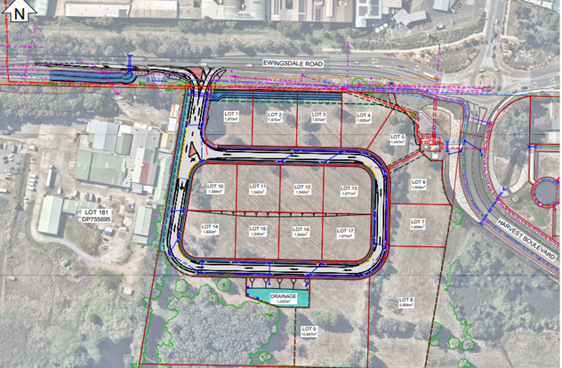
Figure 1: Extract of proposed subdivision plan.
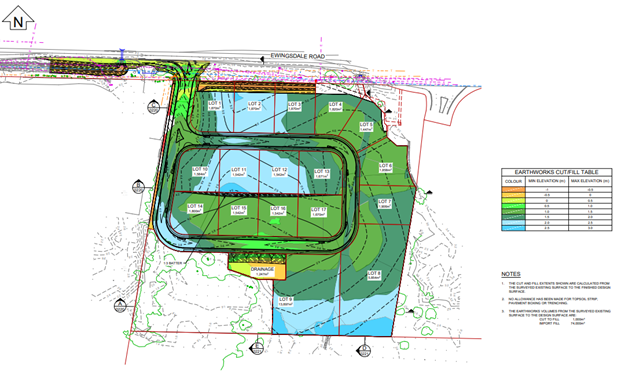
Figure 2: Extract of bulk earthworks plan indicating fill levels of the site. Vegetation in the site’s SW corner is not directly impacted by the project footprint.
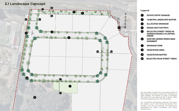
Figure 3: Extract of landscape concept plan with vegetation buffer to Ewingsdale Road.
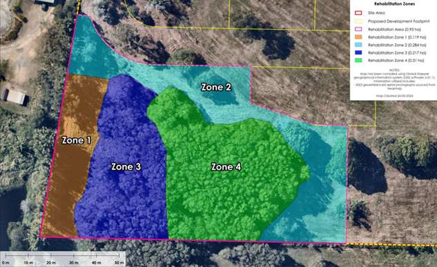
Figure 4: Extract of Rehabilitation Zone Plan illustrating retained habitat areas in the site’s SW corner.
The site is legally described as Lot 105 in Deposited Plan 1297628, commonly known as 288 Ewingsdale Road, Byron Bay. It is located near the intersection of Ewingsdale Road and Harvest Boulevarde approximately 2.5km west of the Byron Bay town centre.
The site is located within the West Byron Urban Release Area (West Byron) and is zoned IN2 Light Industrial pursuant to the Byron Local Environmental Plan 1988 (BLEP 1988). An extract from the Urban Release Area Map referred to in the LEP with the site outlined in red is provided at Figure 5.
The site has an area of 5.65 ha with northern frontage of 181m to Ewingsdale Road, a depth of 242m, and a width of 248m at the southern boundary. The land is current vacant and has historically been used for grazing purposes. The site is relatively flat with a gentle cross fall sloping down from 3.2m AHD in the north-east to 1.6m AHD towards the south west.
The site adjoins the former Inghams poultry farm and processing facility to the west at 268 Ewingsdale Road which ceased operating in 2014. The sheds and factory building are currently being used for light industrial purposes including car and bus hire. Land to the east is part of an approved residential subdivision known as “Harvest Estate” that was granted consent by the Land and Environment Court in December 2020. Subdivision works at Harvest Estate have substantially commenced and are nearing completion. Land to the south-east comprises vacant industrial and residential zoned land that forms part of a larger subdivision approval known as “Site R&D” that was granted consent by the Court in March 2022. Subdivision works for the Site R&D development have not commenced.
Vegetation on the site primarily consists of exotic pasture grasses and with some trees along the Ewingsdale Road frontage and scattered remnant vegetation in other locations. A vegetated drainage channel occurs near the eastern boundary that previously conveyed stormwater from Ewingsdale Road to wetlands in the south. There are sedgelands in low lying areas throughout the site, with freshwater wetlands and paperbark swamp forests also present. A remnant area of coastal wetlands vegetation is located in the south-west corner of the property.
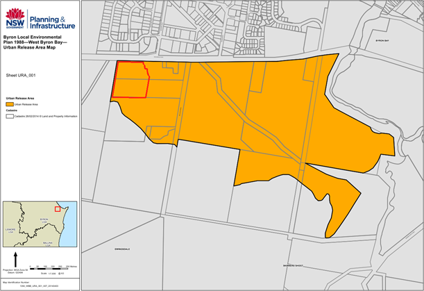
Figure 5: West Byron Urban Release Area Map. The site (north-west corner) is outlined in red.
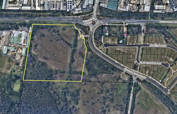
Figure 6: Aerial image of the site.
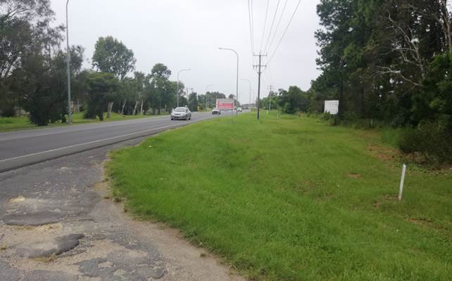
Figure 7: View east of Ewingsdale Road from the site entrance.
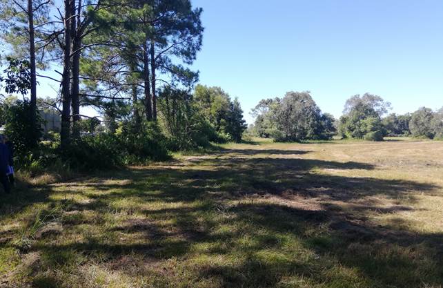
Figure 8: Location of propsoed Lots 1-5 adjacent to Ewingsdale Road.
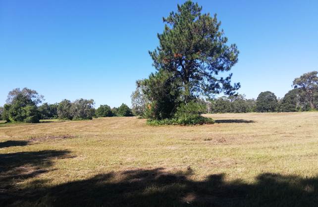
Figure 9: South-east view across the central portion of the site from Proposed Lot 1.
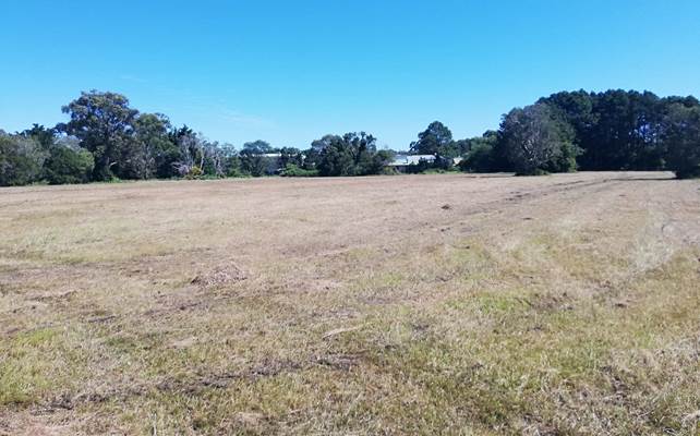
Figure 10: View west across cleared land towards the former Inghams poultry site.
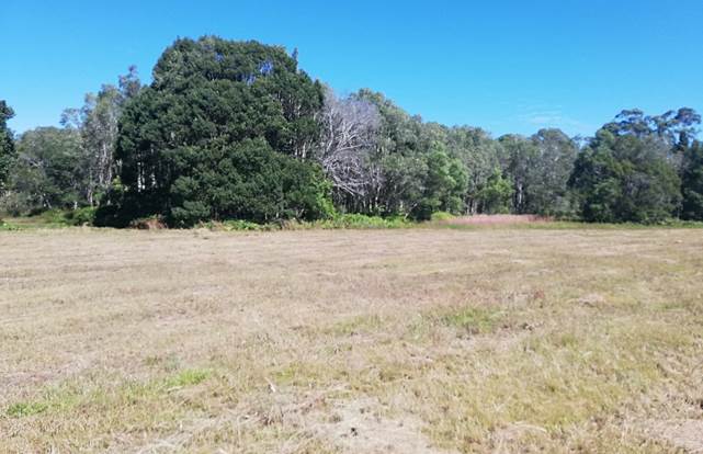
Figure 11: Coastal wetlands vegetion to be reained in the site’s SW corner.
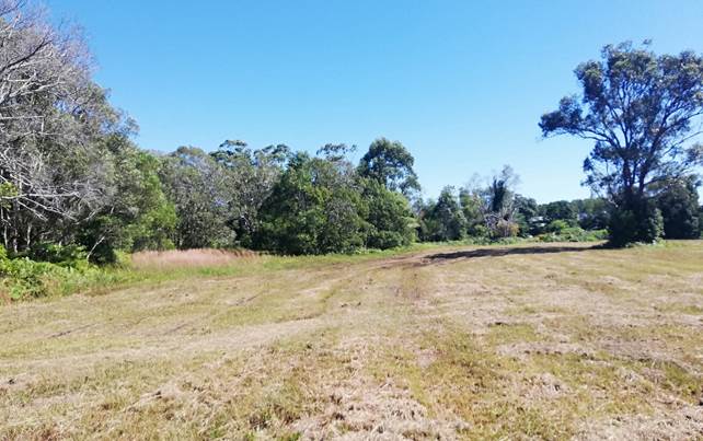
Figure 12: Location of proposed bioretention basin. From proposed Lot 9, looking west.
Internal Referrals
|
Referral |
Issue |
|
Environmental Health Officer |
Council’s Environmental Health Officer supported the proposal on environmental health grounds subject to further detailed information being provided in relation to groundwater contamination and dewatering management. Conditions are recommended for detailed remediation and dewatering management plans to be prepared and approved by Council prior to the issue of a subdivision works certificate. |
|
Development Engineer |
Council’s Development Engineer noted that the proposed intersection design requires amendment to ensure compliance with Austroads guidelines. In this regard, conditions are recommended for an additional through lane and dedicated turning lane to be constructed at the site frontage to ensure the safety and efficiency of Ewingsdale Road is not compromised. In relation to traffic impacts, Council’s Development Engineer noted that the proposal is likely to contribute to traffic congestion on Ewingsdale Road with specific regards to the two roundabouts either side of the entrance which will need to be upgraded with dual lanes provided either side of Ewingsdale Road. Councils Manager of Assets and Major Projects has advised that this is a broader traffic issue which extends beyond the site, and it is noted the nexus to levy this issue on the developer specifically is limited. In this instance it would not be fair and reasonable to impose this responsibility for upgrading the broader section of Ewingsdale Road, whereby the benefits to that upgrade will apply beyond the development site. In coming to this conclusion regard to various Land and Environment Court cases is made, whereby what is termed the Newbury Test is considered. (e.g. Masterbuilt Pty Ltd. v Tweed Shire Council [2006] NSW LEC156, Trehy & Ingold v. Gosford City Council [1995] NSWLEC 113). Ideally both sides of Ewingsdale Road would be duplicated simultaneously, however this a project to be undertaken in conjunction with Transport for NSW and Council as it involves upgrades to MR 545, Further if the adjacent Sunnybrands / Inghams Chicken site is ever rezoned, a planning agreement may be required for the Cavanbah Roundabout to be replaced. |
|
Systems Planning Officer |
Development servicing charges are to be paid at a rate of 62.31 ET for increase load on Water, Bulk Water and Sewer systems. |
|
Contributions Planner |
Council’s Contributions Planner noted that the Section 7.12 Levy is payable. |
|
Ecological Consultant |
Council’s Ecological Consultant noted that the submitted BDAR adequately addressed requirements under the Biodiversity Act and Regulations. Reasonable efforts have been made to avoid environmentally sensitive areas of the site and compensatory measures are proposed to ensure retained habitat areas are protected and enhanced. Ecosystem and species credits will need to be retired to offset the residential impact on the development on the site’s biodiversity values as specified in the BDAR. It was recommended that the proposed Biodiversity Conservation Management Plan and Acid Frog Management Plan will require further refinement to ensure that frog habitat in the south of the property will be adequately restored and managed into the future. Conditions are recommended requiring updated BCMP and AFMP reports to be approved by Council prior to the issue of a subdivision works certificate. |
External referrals
|
Referral |
Issue |
|
Department of Environment, Climate Change and Water (DCCEEW) |
The Biodiversity Conservation Division (BCS) of DCCEEW reviewed the submitted BDAR and recommended that additional information be provided in relation to threatened species, cumulative impacts, and management of retained habitat areas. The BDAR was subsequently revised to address shortcomings identified in the BCS review. |
|
Transport for NSW (TfNSW) |
TfNSW declined to comment on the potential traffic impact of the development on Ewingsdale Road (MR 545), noting that Council is the relevant Roads Authority under the Roads Act 1993. TfNSW noted that any proposed or conditioned works within the Ewingsdale Road reserve would require consent from Council and concurrence from TfNSW under Section 138 of the Roads Act. |
|
Essential Energy |
Essential Energy did not provide any comments about potential safety risks associated with the development. Standard notes were provided in relation to safety requirements when carrying out works near powerlines. |
|
Bundjalung of Byron Bay Arakwal Corporation (BOBBAC) |
Bundjalung of Byron Bay Arakwal Corporation (BOBBAC) wrote to Council on 15 April 2024 expressing concerns about potential downstream impacts on the conservation and cultural landscape values of the adjacent wetland. A request was made to defer consideration of the development application until comments on the submitted Aboriginal Cultural Heritage Assessment Report (ACHAR) had been finalised at a BOBBAC board meeting in 2024. The submission also expressed a view that the proposed subdivision was designated development pursuant to Clause 2.7 of the RH SEPP and commented that any future works should conducted in the presence of cultural heritage site monitors if consent is granted to the DA. Further email correspondence was sent to BOBBAC on 15 October and 15 November 2024 to confirm if the ACHAR had been considered by the Board and whether any additional comments would be forthcoming. No response was received prior to the finalisation of this report. |
The proposed development as submitted does not require any of the approvals listed under s 4.46 of the Environmental Planning and Assessment Act 1979 and is not integrated development.
The proposed subdivision has good vehicular access from Ewingsdale Road and will provide hydrants in strategic locations to be accessed by fire fighting vehicles during an emergency. The road design and subdivision layout generally meet the requirements of Chapters 8 and 5 of PBP and will allow for industrial and commercial development to be constructed on future lots without comprising public safety during a bushfire emergency.
All proposed lots in the subdivision will allow for the construction of future industrial development that can comply with bushfire planning requirements under PBP.
Having regard to the matters for consideration detailed in Section 4.15(1) of the Environmental Planning & Assessment Act 1979 (EP&A Act), the following is a summary of the evaluation of the issues.
5.1 State Environmental Planning Policies (SEPP)
Biodiversity and Conservation SEPP 2021
Chapter 4 Koala habitat protection 2021
The subject site has an area of more than 1 ha and is with the Koala Planning Area under the Byron Coast Comprehensive Koala Plan of Management (CKPoM). Council’s determination of the DA must be therefore consistent with the Byron CKPoM in accordance with s4.8 of the Biodiversity and Conservation SEPP.
Byron Coastal Comprehensive Koala Plan of Management
The West Byron Koala Management Precinct Map identifies three small segments of potential koala habitat in the western section of the site as shown in Figure 13. Field survey undertaken for the BDAR confirms that the mapped areas contain an individual Swamp mahogany, 3 Flooded gums, and a Slash pine. The site also contains Broad-leaved paperbark which is koala use tree species listed in Schedule 3 of the Biodiversity SEPP.
Section 12 of the CKPoM states that potential koala habitat within a Koala Management Precinct is considered to meet the definition of core koala habitat. Accordingly, development controls for large development and subdivision detailed in sections 12.3.2 and 12.3.3 of the CKPoM are applicable.
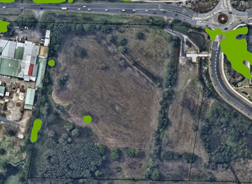
Figure 13: Potential Koala Habitat Map (Byron CKPoM).
Koala habitat assessment
The submitted BDAR included a detailed assessment of koala habitat within the proposed development site carried out by a qualified ecologist. Survey methods included SAT surveys, spotlight surveys, amplified call play backs, trail cameras and acoustic recordings. The assessment found no evidence of koala activity such as sightings, scats, or sounds during the survey period.
The site was determined to not be preferred koala habitat due to the absence of eucalypt forests and limited presence of preferred foraging trees, with only isolated stems of E. robusta identified.
CKPoM s12.3.3 – Subdivision layout and design
The proposed development demonstrates compliance with the Byron Coast Comprehensive Koala Plan of Management requirements for large development and subdivision under sections 12.3.3 and 12.3.4. Vegetation removal is minimised and will not fragment or disrupt vegetated linkages to core or potential koala habitats. Consequently, the development is assessed as unlikely to significantly impact koalas or their habitat in the locality.
Resilience and Hazards SEPP 2021
Chapter 2 Coastal management
Section 2.7 Development on certain land within coastal wetlands and littoral rainforests area
As shown in Figure 14 the site contains a small segment of land near the southern boundary that is identified as a coastal wetland on the Coastal Wetlands and Littoral Rainforest Area Map. The mapped vegetation is contiguous with a much larger expanse of coastal wetlands located to the south forming part of the Belongil-Cumbebin Swamp Wetlands Complex.
Section 2.7 of the RH SEPP provides that development consent is required for any development within a mapped coastal wetland, including earthworks, constructing a levee, draining the land, or carrying out environmental protection works. Development for such purposes, other than environmental protection works, is declared to be designated development under the Act.
Section 2.7 of the RH SEPP provides:
2.7 Development on certain land within coastal wetlands and littoral rainforests area
(1) The following may be carried out on land identified as “coastal wetlands” or “littoral rainforest” on the Coastal Wetlands and Littoral Rainforests Area Map only with development consent—
(a) the clearing of native vegetation within the meaning of Part 5A of the Local Land Services Act 2013,
(b) the harm of marine vegetation within the meaning of Division 4 of Part 7 of the Fisheries Management Act 1994,
(c) the carrying out of any of the following—
(i) earthworks (including the depositing of material on land),
(ii) constructing a levee,
(iii) draining the land,
(iv) environmental protection works,
(d) any other development.
(2) Development for which consent is required by subsection (1), other than development for the purpose of environmental protection works, is declared to be designated development for the purposes of the Act.
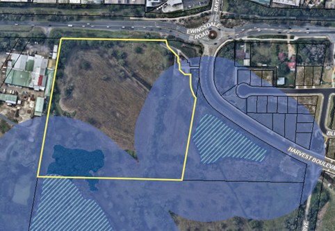
Figure 14: Aerial image with overlay of the Coastal Wetlands Area (hashed light blue) and the Coastal Wetlands Proximity Area (solid mid-blue).
Assessment
The subdivision has been designed so that no earthworks or drainage infrastructure will be located within the mapped coastal wetland area. In relation to draining effects, sufficient information has been provided to demonstrate that the hydrological function of the wetland will not be impaired due to a reduction or alteration in the volume of ground water or surface water flows.
The proposed rehabilitation works identified in the BCMP (Zones 1 and 3) cover part of the mapped wetlands area and therefore consent is required for these works under Clause 2.7(1) of the RH SEPP. Such works generally comprise weeding, planting, and habitat restoration and are defined as environmental protection works under BLEP 2014. Subclause 2.7(2) of the RH SEPP provides that environmental protection works occurring in a mapped wetland are not designated development for the purposes of the Act.
Section 2.8 Development on land in proximity to coastal wetlands or littoral rainforest
The subject site is in proximity to land identified as a coastal wetland on the Coastal Wetlands and Littoral Rainforest Area Map as shown in Figure 14.
Section 2.8 of the RH SEPP provides:
2.8 Development on land in proximity to coastal wetlands or littoral rainforest
(1) Development consent must not be granted to development on land identified as “proximity area for coastal wetlands” or “proximity area for littoral rainforest” on the Coastal Wetlands and Littoral Rainforests Area Map unless the consent authority is satisfied that the proposed development will not significantly impact on—
(a) the biophysical, hydrological, or ecological integrity of the adjacent coastal wetland or littoral rainforest, or
(b) the quantity and quality of surface and ground water flows to and from the adjacent coastal wetland or littoral rainforest.
(2) This section does not apply to land that is identified as “coastal wetlands” or “littoral rainforest” on the Coastal Wetlands and Littoral Rainforests Area Map.
Assessment
The proposed drainage system comprises an underground network within new road reserves that channels water through multiple treatment stages before discharging to an adjoining wetland area.
Hydrological and hydraulic modelling using MUSIC and DRAINS software demonstrates the system's effectiveness, with treatment elements including street tree infiltration wells, a grass swale, gross pollutant traps, and a vegetated bioretention basin with detention storage capacity. The design maintains ground water recharge through strategically placed infiltration wells.
Comparative analysis of runoff rates confirms that pre- and post-development flow characteristics remain within a comparable range. It is considered that the proposed stormwater management system will not significantly alter surface or groundwater flows and is unlikely to adversely impact the ecological or hydrological integrity of the adjacent wetland ecosystem.
Chapter 4 Remediation of Land
The development application was accompanied by a preliminary site investigation report (PSI) which investigated the site’s land use history and included an analysis of soil samples taken from the development footprint. Laboratory results confirmed that concentrations of heavy metals and organochlorine pesticides were within expected background levels. Hydrocarbon levels were noted to exceed the relevant criteria for urban residential use but were below the criteria for industrial or commercial uses.
In relation to groundwater contamination, Council’s Environmental Health Officer commented that further investigation and remediation may be required given the history of adjacent land uses including poultry processing. Although the site of the industrial lots is to be predominantly filled, conditions of consent are recommended for additional investigation of groundwater to be carried out. Should groundwater contamination by detected the site will need to be remediated to a suitable standard for future industrial use.
Section 2.119 Development with frontage to classified road
Ewingsdale Road is a Regional Classified Road (Gazetted Road Number 545). Section 2.119 of the Transport and Infrastructure SEPP (TI SEPP) states that the consent authority must not grant consent to development fronting a classified road unless practicable and safe vehicular access can be provided from a road other than the classified road, and the safety, efficient and ongoing operation of the classified road is not adversely affected by the development.
Section 2.119 of the TI SEPP is reproduced below:
2.119 Development with frontage to classified road
(1) The objectives of this section are—
(a) to ensure that new development does not compromise the effective and ongoing operation and function of classified roads, and
(b) to prevent or reduce the potential impact of traffic noise and vehicle emission on development adjacent to classified roads.
(2) The consent authority must not grant consent to development on land that has a frontage to a classified road unless it is satisfied that—
(a) where practicable and safe, vehicular access to the land is provided by a road other than the classified road, and
(b) the safety, efficiency and ongoing operation of the classified road will not be adversely affected by the development as a result of—
(i) the design of the vehicular access to the land, or
(ii) the emission of smoke or dust from the development, or
(iii) the nature, volume or frequency of vehicles using the classified road to gain access to the land, and
(c) the development is of a type that is not sensitive to traffic noise or vehicle emissions, or is appropriately located and designed, or includes measures, to ameliorate potential traffic noise or vehicle emissions within the site of the development arising from the adjacent classified road.
Assessment
Alternative Access
During the Land and Environment Court proceedings for Harvest Estate (DA 10.2017.201.1), an amended subdivision design was submitted that revised the alignment of the original "Spine Road" within the West Byron Concept Plan. This revision was necessary to avoid newly identified acid frog habitat located to the south of Harvest Estate. As a result of this adjustment, the industrial zoned land fronting Ewingsdale Road became isolated from the broader West Byron Urban Release Area.
Given these circumstances, it is considered impractical to provide access to the isolated site from any location other than Ewingsdale Road. The construction of a new access road from within West Byron would likely result in significant ecological impacts and could potentially conflict with existing subdivision approvals for the Harvest Estate and Site R&D, which were granted by the Court.
Safety, efficiency, and ongoing operation of the classified road
The proposed subdivision will be accessed via a new intersection on Ewingsdale Road, featuring left-in and left-out turning lanes. The site's left-in turning lane is positioned at the terminus of an auxiliary acceleration merging lane extending from the Bayshore Drive roundabout. The current design presents a potential safety concern, with vehicles exiting the roundabout merging in a right-hand direction at the same point where traffic will be turning left into the subdivision, creating a potential collision point.
To ensure the intersection does not compromise the safety of Ewingsdale Road, Council's Development Engineer has recommended substantial design modifications. Specifically, the access design must be amended to include a through lane and dedicated turning lane, in accordance with Austroads design guidelines. The required design amendments will need to be approved by Council prior to the issue of a subdivision works certificate.
Traffic Impacts
The submitted Traffic Study suggests that, in the short term (2025), most intersection legs within the Cavvanbah and Bayshore Drive Roundabouts will maintain a reasonable level of service. However, medium to long-term projections (2035) indicate a potential significant decline in service levels, primarily driven by increased traffic volumes on Ewingsdale Road which may be compounded by industrial development in West Byron. It also noted that there are uncertainties in the traffic modelling which may affect the accuracy of the long-term projections.
As discussed further in section 4.6 of this report ‘impacts on the built environment’, the Ewingsdale Road corridor is anticipated to undergo comprehensive infrastructure upgrades in the medium to long term, including lane duplication and intersection improvements spanning from the Pacific Highway to Byron Bay. These upgrades will improve the capacity of the road network, ensuring it can accommodate the increased traffic demand resulting from both the proposed development and future industrial growth in West Byron.
Therefore, while there is some degree of uncertainty regarding long-term traffic projections, the proposed development is deemed satisfactory in the circumstances. The infrastructure improvements planned for Ewingsdale Road are expected to adequately address the projected traffic increases, ensuring that the safety, efficiency, and ongoing operation of the classified road will not be adversely affected by the proposed development.
Section 2.122 Traffic-generating development
Schedule 3 of the TI SEPP specifies that subdivisions with access to a classified road must be referred to TfNSW for concurrence if the subdivision will create 50 or more allotments. The proposed subdivision will create a total of 17 new lots and therefore does not trigger referral to TfNSW.
In accordance with LEP 1988 clauses 5, 8 and 9:
(a) The proposed development is defined in the LEP 1988 Dictionary as subdivision of land including ancillary infrastructure.
(b) The land is within the IN2 Light Industrial Zone according to the map under LEP 1988.
(c) The proposed development is permitted with consent; and
(d) The proposed development is consistent with the relevant objectives of the Zone for the following reasons:
|
Zone Objective IN2 Light Industrial |
Consideration |
|
(a) to provide a wide range of light industrial, warehouse and related land uses, |
The proposed development is consistent with the IN2 zone objectives and aligns with long-term strategic planning objectives for the West Byron Bay Urban Release Area.
|
|
(b) to encourage employment opportunities and to support the viability of centres, |
|
|
(c) to minimise any adverse effect of industry on other land uses, |
|
|
(d) to enable other land uses that provide facilities or services to meet the day to day needs of workers in the area, |
|
|
(e) to support and protect industrial land for industrial uses. |
The following clauses are of specific relevance to the development.
Part 4 West Byron Bay site
Division 2 Provisions applying to development in West Byron Bay site
|
LEP Requirement |
Complies? |
Comment |
|
Clause 80 Subdivision—consent requirements |
Yes |
The subject land is within the West Byron Site and may be subdivided with development consent in accordance with Clause 80 of LEP 1988. |
|
Clause 81 Minimum subdivision lot size |
Yes |
There is no minimum lot size specified for the subject site on the Lot Size Map. |
|
Clause 88 Development within the coastal zone |
Yes |
The proposed development is broadly consistent with the principles of the NSW Coastal Policy as detailed in Clause 88 of BLEP 1988. The subdivision design has avoided the majority of native vegetation on the site and incorporates appropriate stormwater treatment measures to ensure that surrounding coastal ecosystems including threatened species and ecological communities will not be significantly impacted. The cumulative effect of the development alongside approved residential and commercial subdivisions in the West Byron Site will likely be manageable subject to conditions of consent. |
|
Clause 92 Heritage Conservation |
Yes |
The submitted Aboriginal Cultural Heritage Assessment Report (ACHAR) did not identify any heritage items, known Aboriginal objects, or listed places of Aboriginal heritage significance on the subject site. Conditions are recommended requiring cultural heritage site monitors to be present during earth disturbing works, along with an unexpected finds procedure to be implemented at the direction of BOBBAC. |
|
Clause 96 Suspension of covenants, agreements, and instruments. |
Yes |
There are no easements, covenants or restrictions on title which restrict the carrying out of development. The property was formerly burdened by an easement to drain water which was recently dissolved. |
|
Clause 97 Acid sulfate soils |
Yes |
The subject site is identified on the LEP 1988 Acid Sulfate Soils Map as containing Class 3 Potential Acid Sulfate Soils. An Acid Sulfate Soils Management Plan (ASMP) has been submitted with the development application which acknowledged that acid sulfate soils are likely to be intercepted during subdivision works. The ASMP proposes that excavated acid soils be neutralised using lime during the construction at a rate of 7kg/tonne (dry weight) with verification testing. Water quality monitoring is to also be undertaken on a routine basis during construction to monitor potential acid soil disturbance. Both ground water and surface water monitoring bores will be employed to ensure water quality remains within target criteria. Conditions are recommended for the ASMP measures to be employed and maintained during construction. |
|
Clause 98 Flood planning |
Yes |
The site is subject to flooding from Belongil Creek to the south. Flood modelling calculates the 2100 future Flood Planning Levels for the site at 3.13m AHD. The site will be filled to variable depth between 3.4m and 5.4m AHD to achieve a finished surface level that is above the Probable Maximum Flood (PMF), providing flood free industrial lots suitable for future development. A Flood Impact Assessment was provided demonstrating that filling of the land can be undertaken without off-site flooding impacts. |
|
Clause 98B Earthworks |
Yes |
A comprehensive Stormwater Management Plan was submitted in support of the development application, demonstrating the proposed site filling can be undertaken without compromising local drainage patterns. The filling strategy is designed to meet flood planning requirements and aligns closely with fill depths previously approved for the adjacent Harvest Estate. The proposed fill is limited to previously cleared areas and avoids high environmental value vegetation located in the property's south-west corner. Technical assessments submitted with the application demonstrate that the development can be implemented without causing detrimental impacts to the adjoining wetland area. |
Division 3 Urban release areas
|
LEP Requirement |
Complies? |
Comment |
|
Clause 99 Arrangements for designated State public Infrastructure |
Yes |
A Voluntary Planning Agreement (VPA) was entered into in 2014, between landowners of the West Byron Urban Release Area and the then Minister for Planning and Environment to provide the mechanism for the ‘satisfactory arrangement’ of infrastructure as required by this clause. The VPA requires developers to pay a monetary contribution to the Minister for Planning for each ‘urban lot’ created, and a conservation contribution through a Vegetation Management Plan for each conservation lot created. In the VPA, an ‘urban lot’ is a lot created for residential purposes. The applicant submits that contributions were paid by the developer of Harvest Estate to the Department of Planning and Environment, as required by the VPA. In late December 2023, the Department acknowledged this payment as constituting ‘satisfactory arrangements’ for the Harvest Estate and authorising the relevant lots, including the subject site to be released from the Planning Agreement. Accordingly, no further action is required to comply with the requirements of clause 99(2). |
|
Clause 100 Public utility infrastructure |
Yes |
Essential public utility infrastructure including reticulated water, sewer, electricity, and telecommunications systems will be available to the proposed subdivision. Regarding road access, amendments to the proposed intersection design are recommended to ensure the safety and efficiency of Ewingsdale Road is not adversely affected. |
|
Clause 101 Development control plan |
Yes |
The proposed subdivision has been assessed against the requirements of Chapter E8 of Byron DCP 2014 which relates to the West Byron site. |
There are no proposed instruments with relevance to the subject application.
The following provisions are of relevance to the development.
Chapter B3 Services
|
DCP Requirement |
Complies? |
Comment |
|
B3.2.1 Provision of Services |
Yes, subject to conditions |
The site is capable of connecting to existing reticulated water, sewer, electricity, and communications networks subject to conditions of consent. |
|
B3.2.3 Stormwater Management |
Yes, subject to conditions |
Stormwater will be treated to an adequate standard through a series of street tree infiltration well within the road reserve, a grass swale, two gross pollutant traps, and a bioretention basin with additional detention storage capacity. Ground water recharge will be maintained using infiltration wells installed adjacent to street trees to maintain subsurface water levels. In relation to stormwater volume and peak flow rates, hydraulic modelling has demonstrated that pre-development and post-development rates are comparable. One potential issue was identified with the bioretention basin design by Council’s Development Engineer that will further design amendments to prevent groundwater ingress during period of groundwater fluctuation. Conditions are recommended. |
|
B3.2.4 Sedimentation and Erosion Control Measures |
Yes, subject to conditions |
A detailed sediment and erosion control plan will be required with measures to ensure the adjoining waterways and wetlands are protected from increased sedimentation. |
Chapter B4 Traffic Planning, Vehicle Parking, Circulation and Access
|
DCP Requirement |
Complies? |
Comment |
|
B4.2.1 Traffic Impact |
Yes, subject to conditions |
A Traffic Study was submitted with the development application in accordance with the requirements of B4.2.1. Further consideration of traffic impacts is in s4.6 of this report ‘impacts on the built environment’. |
Chapter B5 Providing for Cycling
|
DCP Requirement |
Complies? |
Comment |
|
B4.2.1 Traffic Impact |
Yes |
A combined footpath/cycleway is proposed in Ewingsdale Road reserve connecting the site to the adjoining footpath network in the Harvest Boulevarde. The proposed aligns with the Byron Shire Bike Strategy and Action Plan. |
Chapter B6 Buffers and Minimising Land Use Conflict
|
DCP Requirement |
Complies? |
Comment |
|
B6.2.4 Buffers |
Yes |
The proposed development site is situated adjacent to the former Inghams poultry farm and processing facility located at 268 Ewingsdale Road. Currently, this adjacent land is under investigation for potential industrial rezoning and is considered highly unlikely to return to poultry processing operations in the future. Consequently, the need for odour mitigation buffers has been deemed unnecessary for the proposed development. |
Chapter B8 Waste Minimisation and Management
|
DCP Requirement |
Complies? |
Comment |
|
B8.2.2 Site Waste Minimisation and Management Plans |
Yes, subject to conditions |
The proposed road network has sufficient width to accommodate garbage collection vehicles to service future industrial development within the site. A condition is recommended for a detailed site waste and minimisation and management plan to be development for managing waste during the construction phase of the development. |
Chapter B9 Landscaping
|
DCP Requirement |
Complies? |
Comment |
|
B9.3.1 General Landscape Design Principles & B9.11 Street Trees in Subdivision and Developments |
Yes |
The proposed landscape concept includes strategic placement of street trees, featuring a diverse mix of palm and native species, complemented by garden edging. The landscape plan also incorporates vegetation for drainage swales and the bioretention basin, enhancing both aesthetic and functional aspects of the site's landscape. A vegetated buffer along the Ewingsdale Road frontage has been designed to screen the site and create visual continuity with the green buffers previously approved for the adjacent Harvest Estate and Site R&D. |
Chapter B14 Excavation and Fill
|
DCP Requirement |
Complies? |
Comment |
|
B14.2 Excavation and Fill in all Zones |
No but acceptable. |
The site is being filled in places to a depth of approximately 3m to meet the 1% AEP 2100 flood planning level consistent with other approved subdivisions in West Byron. The subdivision design therefore exceeds the 1 metre maximum fill depth specified in Prescriptive Measure B14.2(1). The proposed subdivision is capable of meeting the Objectives and Performance Criteria of B14.2 as follows: · The resulting visual effect of the fill and associated retaining walls is acceptable in the context of a developing urban release area that overtime will be filled to a similar level to provide a developable surface above the 2100 FPL. The extent and depth of fill is similar to other subdivisions in the West Byron Site (i.e. Harvest Estate and Site R&D) and is generally compatible with the likely future character of the locality. · The use of retaining structures is considered necessary to provide sufficient area for large floor plate industrial development within the estate. The visual effect of retaining structures in public views from Ewingsdale Road will not be significant. · Information has been provided demonstrating that the resultant drainage characteristics of the land will not be adversely affected and comply with Chapter B3 services and with Water sensitive Urban Design Principles. |
Chapter C2 Areas Affected by Flood
|
DCP Requirement |
Complies? |
Comment |
|
C2.3.3 Flood Planning Matrix |
Yes |
The site will be filled to a depth between 3.4m AHD and 5.4m AHD which is wholly above the 2100 Flood Planning Level of 3.13m AHD. |
Chapter D6 Subdivision
|
DCP Requirement |
Complies? |
Comment |
|
D6.2.1 Subdivision Design Guidelines |
Yes |
The proposed subdivision broadly complies with the Subdivision Design Guidelines under Part D6.2.1. Connectivity with the adjacent West Byron Urban Release Area will be maintained through the provision of a new shared pathway along Ewingsdale Road, connecting future employment lands with the adjacent pedestrian and cycleway network in West Byron. |
|
D6.5.1 Lot Size and Shape (Industrial) |
Yes |
Each lot within the proposed subdivision has a minimum width and frontage of 25m and can suitably accommodate future industrial development. There is no minimum lot size for the site under the LEP 1988 West Byron Bay Lot Size Map. |
|
D6.5.3 Subdivision design (Industrial and Commercial Development) |
Yes |
The subdivision layout promotes visibility and passive surveillance of public spaces, thereby addressing potential crime prevention considerations as outlined in Chapter B11. Technical assessments have demonstrated that potential flooding impacts and the proposed bulk earthworks are acceptable. |
Chapter E8 West Byron Urban Release Area
|
DCP Requirement |
Complies? |
Comment |
|
Yes, subject to conditions |
The proposed subdivision aligns with the following relevant Design Principles: Legible and connected The subdivision has been designed with a direct access to Ewingsdale Road which is accepted as the only practical connection point to the surrounding road network. The original West Byron Concept Plan provided a frontage to the subject lot from an internal ‘spine road’ however this was removed following the discovery of frog habitat south of Harvest Estate. A new footpath is proposed along the frontage of Ewingsdale Road that will connect the proposed industrial estate with the existing public footpath and cycleway network in West Byron. Persons travelling by public transport or those choosing to walk or cycle to work will have suitable access to the site from the adjoining residential or business areas. |
|
|
Yes, subject to conditions |
It is anticipated that West Byron Stage 1 will be implemented through a series of separate development applications rather than as one large project. Flexibility is therefore required to allow infrastructure to be delivered overtime as Stage 1 progresses. Several key infrastructure projects have already been completed including the first roundabout on Ewingsdale Road and the main entry road into West Byron (“Harvest Boulevarde”). Other infrastructure projects such as a recycled water reticulation system, sewer pump station, and provision of trunk stormwater drainage are either planned or currently being constructed. |
|
|
E8.10.4 Stormwater Water Management |
Yes, subject to conditions |
The proposed stormwater drainage system incorporates water sensitive urban design principles and will ensure an adequate standard of water quality for stormwater being discharging to the adjacent wetlands and downstream waterbodies. |
|
E8.10.5.1 Biodiversity and Vegetation Management |
Yes, subject to conditions |
A BDAR has been submitted which addresses the potential impacts of the development on threatened species and ecological communities on the site in accordance with the Biodiversity Act and Biodiversity Regulation. Rehabilitation and enhancement of retained habitat areas will be achieved under a Biodiversity Conservation Management Plan and Acid Frog Management Plan which aim to restore and manage existing habitat areas into the future. |
|
E8.10.6 Public Facilities, Services and Infrastructure |
Yes |
The site is capable of being fully serviced with water sewer, roads, drainage and underground electricity and telecommunications subject to conditions of consent. Footpaths and adequate street parking will be available. |
|
E8.10.8.3 Groundwater |
Yes |
Sufficient information has been provided to demonstrate that ground water levels and pH will not be adversely affected by the proposed development. Conditions for the management of acid sulfate soils and environmental monitoring have been recommended by Council’s Environmental Health Officer. |
|
E8.10.8.8 Buffer to Ewingsdale Road |
Yes |
The application proposes a 10m wide landscaping buffer along the northern boundary with Ewingsdale Road, located within lots 1 to 4. The buffer will be physically separated from these lots by a retaining wall and will serve a dual function as a drainage swale. Trees proposed to be planted within the landscape buffer include Swamp mahogany, Swamp sheoak, and Foambark species.
Figure 15: Section of Landscape Buffer between Lots 1 – 4 and Ewingsdale Road. The vegetation buffer provides an appropriate visual screen for the site and is generally compatible with vegetation buffers required for Harvest Estate ad Site R&D further east on Ewingsdale Road. |
|
E8.10.9 Aboriginal Cultural Heritage |
Yes |
The submitted Aboriginal Cultural Heritage Assessment report concluded that the site was of low social, cultural, spiritual, historic, and scientific significance. Conditions are recommended for all contractors and staff involved in subdivision works to receive a cultural heritage induction to be delivered by Aboriginal site officers from BOBBAC. An unexpected finds procedure is also recommended to ensure the proper handling of Aboriginal objects should they be uncovered during works. |
|
E8.10.10.4 Industrial Area Prescriptive Measure 1 |
Yes |
The subject application covers all remaining IN2 zoned land in the West Byron Site aside from a small area to the south that was approved under the Site R&D consent. The proposed industrial subdivision provides a variety of lot sizes to accommodate a range of light industrial and large floorplate warehousing uses. |
|
E8.10.10.4 Industrial Area Prescriptive Measure 3 |
Yes |
A minimum of twenty five percent (25%) of lots are to be designed with an appropriate area and width to enable Articulated Vehicles to enter and leave in a forward direction. A revised Traffic Impact Statement was provided with swept path analysis demonstrating that at least 25% of lots within the proposed subdivision can theoretically accommodate articulated vehicles entering and exiting in a forward direction.
Figure 16: Swept path analysis illustrating that 25% of lots can accommodate an articulated vehicle movement. |
Section 61 - Additional matters that consent authority must consider
There are no additional matters including demolition standards that require consideration under Clause 61 of the Regulation.
|
Impact on: |
Likely significant impact/s? |
|
Natural environment |
Biodiversity Impact Assessment and Mitigation The proposed development will directly impact approximately 1.2 hectares of vegetation, consisting of remnant and regrowth native vegetation primarily located on the site peripheries. The affected Plant Community Types include Far North Paperbark Fern Swamp Forest and Northern Sand Swale Fernland, predominantly in moderate to poor condition. An additional 3.7 hectares of modified vegetation types, primarily composed of exotic pasture grasses and slash pine forest with emergent native regrowth, are also within the project footprint. Overall, the proposed subdivision layout demonstrates a strategic approach to ecological preservation, intentionally avoiding sensitive coastal wetlands and acid frog breeding habitat located in the site's south-west corner. Development lots and road infrastructure are predominantly situated on previously cleared land, with designated habitat areas identified for protection and enhancement through a comprehensive biodiversity conservation management plan. Considering the site's location within an urban release area, the proposed design is deemed to represent a balanced effort to minimize ecological disruption while facilitating urban development. Biodiversity Offset Requirements To offset the unavoidable ecological impacts of the proposed development, the submitted BDAR specifies the retirement of 20 ecosystem credits and 62 species credits. These offsets are allocated as follows: · PCT 3989 - Far North Paperbark Fern Swamp Forest: 20 credits · Wallum Froglet (Crinia tinnula): 17 credits · Swift Parrot (Lathamus discolor): 9 credits · Southern Myotis (Myotis macropus): 8 credits · Common Planigale (Planigale maculata): 20 credits Recommended conditions of consent, in accordance with Section 7.13 of the Biodiversity Act, will require the applicant to retire these biodiversity credits to comprehensively offset the development's residual ecological impact. |
|
Built environment |
Traffic impact The submitted Traffic Study estimates that the proposed development will generate approximately 396 trips per hour, based on a projected mix of business, retail, and industrial land uses within the subdivision. As discussed in section 5.1 of this report, short-term traffic modelling suggests that congestion on Ewingsdale Road between the Cavvanbah and Bayshore Drive Roundabouts will be not significantly increased. However, medium to long-term (2035) projections suggest a more significant service level degradation, attributed to an overall increase in Ewingsdale Road traffic which may be compounded by potential future industrial development in West Byron. Long-term Traffic Network Planning Transport for NSW and Council are currently developing potential road infrastructure upgrades for the Ewingsdale Road corridor. Concept plans include lane duplication of Ewingsdale Road between the Pacific Highway and the Cavvanbah Centre, though these remain preliminary with uncertain delivery timelines. Similarly, Council is considering upgrades to the eastern section of Ewingsdale Road, but these remain unfunded and lack detailed design. Given the broader traffic management context, Council's Manager of Assets and Major Projects advised that imposing road upgrade responsibilities solely on this development would be inequitable. There could also be a limited nexus to impose such conditions from a legal perspective. Potential future road infrastructure improvements may be more effectively addressed through collaborative planning with Transport for NSW and Council, particularly if adjacent land parcels are rezoned. In the longer-term perspective, the Ewingsdale Road corridor is anticipated to undergo a major upgrade, including lane duplication and intersection improvements spanning from the Pacific Highway to Byron Bay. These upgrades are expected to improve road network capacity, effectively accommodating traffic generated by the proposed development and future industrial expansion in West Byron. Given these prospective improvements, the short-term traffic impacts of the current development are considered acceptable in the circumstances. The direct impacts of the development are to be addressed through design amendments to improve the function of the proposed intersection with Ewingsdale Road, ensuring that road safety is not compromised in the short-to medium term. |
|
Social Environment |
The proposed subdivision is likely to generate additional employment opportunities and will provide a net social benefit to the community. |
|
Economic impact |
The proposed development will positively contribute to Byron’s economic base by boosting the supply of much needed industrial and employment lands. |
|
Construction Impacts |
The development will generate minor impacts during its construction. Conditions of consent recommended to control hours of work, builders waste, construction noise, installation of sedimentation and erosion control measures and the like to ameliorate such impacts. |
The site is an industrial zoned lot in the West Byron Urban Release Area with access to all necessary services and infrastructure. Physical and environmental constraints relating to road access, flooding, acid sulfate soils and threatened species have been addressed through appropriate design and conditions of consent. Amendments to the design of the proposed intersection are recommended that will ensure the site can be accessed without compromising the safety and efficiency of Ewingsdale Road, pending future road upgrades that will likely occur in the future.
The development application was publicly exhibited for a period of 14-days in accordance with the Community Participation Plan. The application was also referred to BOBBAC for comment.
Two submissions were received objecting to the proposed development, including one submission from the public and one submission from BOBBAC.
|
Issue |
Comment |
|
Stormwater management Concerns were raised that the proposed development has not demonstrated a lawful point of discharge in accordance with Council’s DCP. The submitter expressed a lack of certainty regarding pre and post development flows, and wondered if stormwater flows onto neighbouring land would be intensified or concentrated. It was further noted that stormwater from the subject site is being discharged onto Site R&D land that is zoned C2 Environmental Conservation and is subject to restoration works as part of Stage A of development consent 10.2017.661.1. |
Hydraulic modelling has demonstrated that pre and post development flows will be maintained within a similar range. Council’s Development Engineer has accepted that the adjoining wetland area can be used as a lawful point of discharge and that runoff will be treated to an acceptable standard before discharging offsite. Stormwater discharge is unlikely to affect the environmental values of adjoining C2 zoned land. |
|
Downstream impacts on cultural landscape BOBBAC expressed concern in relation to potential impacts on downstream coastal swamp and wetlands, including Cumbebin Swamp, which BOBBAC identified a being of high conservation and cultural landscape value as an important resource use and ceremonial area. Concerns over the potential impact on native title rights and interests were also expressed. |
The potential impact on downstream ecosystems is considered to be acceptable, taking into consideration the submitted Stormwater Management Plan and BDAR. Stormwater will be treated to an acceptable standard before discharging offsite and will disperse into the adjoining wetlands complex in combination with stormwater flows from the broader West Byron Urban Release Area. It is unlikely that downstream ecosystems will be disturbed to the extent that cultural landscape values or native title rights will be significantly impacted. |
|
Site monitoring and soil disturbance BOBBAC recommends that site monitors be engaged for early works and that ongoing cultural site monitoring occur through RNTBC. |
Conditions of consent are recommended for cultural site monitoring to occur during all ground disturbing works in consultation with BOBBAC. |
|
Continued monitoring of water Continued monitoring of Cumbebin Swamp and Belongil Estuary should occur to ensure that pollution or degradation of downstream ecosystems does not occur. |
Conditions are recommended for ongoing monitoring of ground water and water quality in downstream wetlands and estuaries. |
|
Designated development Concerns were raised that the project constitutes designated development under s2.7 of the RH SEPP. It was also noted that Council must be satisfied that sufficient measures have been taken to protect the integrity of the adjacent coastal wetland. |
Impacts on the adjacent coastal wetland have been carefully considered it is concluded that the proposal does not constitute designated development. All subdivision works (bulk earthworks, drainage infrastructure etc) will occur on land outside the mapped coastal wetland. Additionally, the design of the stormwater system will ensure that the hydrological function of the wetland is not significantly altered. It is acknowledged that ancillary environmental protection works such as planting trees or weeding may occur within the mapped coastal wetlands, however, such works are declared to not be designated development under s2.7(2) of the RH SEPP. |
|
Review of Aboriginal Cultural Heritage Assessment Report The submission requested that determination of the DA be deferred until the ACHAR had been considered at a board meeting in 2024. |
No further comments regarding the proposed review of the ACHAR by the BOBBAC board have been received. Further correspondence was issued by Council seeking follow up comments however no response was forthcoming. |
The proposed development aligns with long-term strategic planning objectives to provide new industrial land in the West Byron Urban Release Area and is in the public interest.
Development Servicing Levies will be payable due to increased load on the reticulated water and sewer network.
The Section 7.12 Levy will apply as the project is for an industrial purpose.
|
Disclosure details |
Response |
|
Has a Disclosure Statement been received in relation to this application? If Yes, Provide Disclosure Statement register reference: 91. |
Yes ☐ No ☒ |
|
Have staff received a ‘gift’ from anyone involved in this application that needs to be disclosed. |
Yes ☐ No ☒ |
Approval is sought for a 17-lot industrial subdivision including creation of a drainage lot, roadworks, bulk earthworks, vegetation removal, environmental rehabilitation works and associated landscaping and infrastructure, at 288 Ewingsdale Road, Byron Bay.
The proposed development is considered to be a reasonable response to the site’s constraints and will enable the delivery of strategically important employment lands to boost the Shire’s economic base. Unavoidable ecological impacts have been adequately addressed by avoiding ecologically sensitive areas and mitigating the residual impacts through a mixture of habitat rehabilitation works and biodiversity offsetting.
The proposed development has been assessed against the relevant State Environmental Planning Policies, Byron LEP 1988, and Byron DCP 2014, including site specific provisions for West Byron and is considered to be generally compliant.
The development application is recommended for approval subject to the conditions in Attachment 1.
Staff Reports - Sustainable Environment and Economy 13.9
Report No. 13.9 PLANNING - Report of the Planning Review Committee held 21 November 2024
Directorate: Sustainable Environment and Economy
Report Author: Chris Larkin, Manager Sustainable Development
Noreen Scott, EA Sustainable Environment and Economy
File No: I2024/1596
Summary:
This report provides the outcome of the Planning Review Committee (PRC) held on 21 November 2024.
NOTE TO COUNCILLORS:
In accordance with the provisions of S375A of the Local Government Act 1993, a Division is to be called whenever a motion for a planning decision is put to the meeting, for the purpose of recording voting on planning matters. Pursuant to clause 2(a) under the heading Matters to be Included in Minutes of Council Meetings of Council's adopted Code of Meeting Practice (as amended) a Division will be deemed to have been called by the mover and seconder of all motions relating to this report.
RECOMMENDATION:
That Council endorses the outcomes of the Planning Review Committee meeting held 21 November 2024.
Report
The PRC meeting was held on 21 November 2024. The meeting commenced at 3:35pm and concluded at 4:00pm.
Councillors: Cr S Ndiaye, Cr M Lyon, Cr D Warth, Cr D Kay, Cr J Dods.
Apologies: Cr M Lowe, Cr E Hauge, Cr J Swain.
Staff: Chris Larkin Manager Sustainable Development.
Conflict of Interest: Cr Jack Dods 10.2023.266.3.3
The S 4.55 applications to modify these development consents are referred to the Planning Review Committee to decide if the modification applications can be determined under delegated authority.
|
DA No. / Applicant |
Property Address / Proposal |
Consultation / Submissions |
Reason/s / Outcome |
|
10.2014.743.7 |
41 Matong Drive Modification to the Plans and Conditions of the Approved Residential and Subdivision Development to Delete the Approved Vehicle Access to Brunswick Valley Way. |
Level 2 12/8/24 to 25/8/24 2 submissions |
Staff Delegation |
|
10.2023.266.3 |
66 The Saddle Road Modification to Original Development Consent to relocate Building Envelope. |
Level 0 |
Staff Delegation |
|
10.2020.651.2 |
2 Bangalow Road Modification to Deferred Commencement Condition, plans to include Laundry Facilities and 7.11 Contributions and Water and Sewer Levies |
|
Staff Delegation |
Staff Reports - Sustainable Environment and Economy 13.10
Report No. 13.10 Council Submission on NSW Local Government Draft Filming Protocol
Directorate: Sustainable Environment and Economy
Report Author: Arika McElroy, Business and Industry Project Lead
File No: I2024/1533
Summary:
A draft updated Protocol has now been prepared by Screen NSW and the Office of Local Government, which includes amendments made during a previous review in 2012, as well as changes to reflect current legislation, new technology and other matters. In particular, updates have been made to:
· Application timelines
· Parking
· Non-compliance with council requirements
· Exclusive use
· Drones
· Fees
· No impact filming
· Draft Code of Conduct
The key elements of the Protocol are:
· Under the provisions for filming approvals in the Act, councils must grant an application for filming unless there are compelling reasons not to do so. Councils are also required to give filmmakers a timely written response.
· There is a presumption that filming activities are allowed on council community land. However, filming on public land is always subject to conditions and exclusion in the applicable Plan of Management (PoM), which govern the use and management of that land. Councils are required to have PoMs as prescribed under the Local Government Act 1993, National Parks and Wildlife Act 1974 and Crown Land Management Act 2016.
· Council fees and charges associated with location filming must be reasonable and cost-reflective and should be included in council’s annual operational Plan. Fees & Charges listed in the Protocol are the maximum that can be charged and increase with Consumer Price Index (CPI) each year.
· Temporary structures related to filming are subject to simpler approval processes than previously under the State Environmental Planning Policy (Exempt and Complying Development Codes).
Screen NSW and the Office of Local Government are now seeking Council feedback on the draft Protocol by 19 December 2024.
A summary of feedback to guide Council’s submission is provided in Attachment 1. This follows a review of both the current and proposed protocols, including consideration of long-standing Council concerns and requests to update the Protocol to reflect best practices and developments in film production in the Shire since 2009.
RECOMMENDATION:
That Council:
1. Notes the time it has taken for a review of the NSW Local Government Filming Protocol 2009, and the short period of consultation given to Local Government to provide feedback on the review;
2. Notes that despite requests to have a more proactive and direct consultation about the Filming Protocol 2009 with Screen NSW and Office of Local Government (as evidenced by previous resolutions) that this consultation period is by submission only;
3. Requests staff to make a submission on the basis of the review of the draft Filming Protocol in Attachment 1 (E2024/137762); and
4. Requests a meeting with Screen NSW and the Office of Local Government, to discuss the issues of concern raised in the submission, and the potential pathway for Council (alone or as part of the Northern Region) to have its own film protocol.
Attachments:
1 Review
of Draft Local Government Filming Protocol 2024 to inform Council's Submission,
E2024/137762 ![]()
2 Confidential - NSW Government Draft Filming Protocol, 2024, E2024/140034
3 Confidential - Draft Code of Conduct, E2024/140036
4 Confidential - NSW Government Summary of Protocol updates, E2024/140035
Report
Screen NSW and the NSW Office of Local Government are seeking feedback by 19 December 2024 on an update to the NSW Government Filming Protocol, which was last updated in 2009.
The Office of Local Government has provided Council with several unpublished documents: a draft Protocol (Confidential Attachment 2), a supporting draft Code of Conduct (Confidential Attachment 3) and a summary of the updates to the protocol (Confidential Attachment 4).
The update to the Protocol is one of the initiatives for the screen industry from the recently released NSW Screen and Digital Games Strategy 2025-2027; Priority 2, Action 4: ‘Make government processes screen friendly and more responsive - Introduce a Screen and Digital Games Act to strengthen elements of the Making NSW Film Friendly Premier’s Memorandum and Local Government Filming Protocol’ (refer to extract from Strategy below).
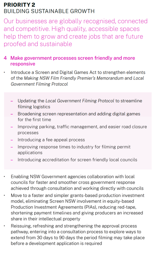
· during the shoot e.g. parking, public enquiries and noise
· after the shoot e.g. site remediation
Overall, there some positive updates, creating a clearer guiding document.
However, the review still falls short of addressing all of Council’s previous concerns.
The draft Protocol needs further additions and clarifications if it is to achieve a consistent approach for councils considering the need to balance a regulatory role with community needs, while supporting local filmmaking.
Importantly, the Protocol recognises that location filming requires a balance between the interests of the local community - both residents and businesses - and the screen industry's requirements.
A key challenge to Council is the management of Ultra-low impact productions. These typically are productions with 4-10 crew/cast, no disruption to the council’s stakeholders, retailers or motorists or events in the vicinity of the activities and restricted to footways or public open space.
In recent times these have become the highest number production category in Byron Shire, refer table below.
|
Calendar year |
Enquiries received |
Applications received |
Ultra-low impact |
Low impact |
Medium impact |
High impact |
|
2023 |
92 |
42 |
36 |
6 |
0 |
0 |
|
2024 |
81 |
46 |
38 |
8 |
0 |
0 |
A key concern of Council has been addressed by the Ultra-low impact category now requiring an application process which enables conditions of approval to apply. It is now also supported by a dispute resolution process to address community complaints and noncompliance with approvals.
However, there is still no application fee for this category. An application fees should apply, and in addition a mechanism to recover cost reflective charges for staff time.
The ability to recover cost reflective charges for staff time should be enabled for the Ultra-low Impact to High Impact categories.
Overall, the changes to the Protocol are a positive improvement with further clarity and confirmation needed which is outlined in Attachment 1.
· Mechanisms are needed to respond to community impacts when they arise post approval.
· Impact on Council:
- servicing of small productions (as no fee’s apply and they are a large component of productions in the Shire)
- multiple enquiries from the same production are responded to by council staff prior to formal application when no fee applies
- managing at times significant complaints (e.g. Byron Baes production)
· Differences of capacity between regional and metropolitan areas to support film industry are not sufficiently recognised.
· Consideration of acknowledgment of the Native Title Act and processes.
· Compliance options and roles for council and filmmakers need to be outlined.
· Land use guidance needs to be more consistent and clearer.
· Cost recovery measures need to be appropriate to the time spent by staff
· Overall aim
· Overall content
· Categories of productions defining application requirements
· Non-compliance with council requirements
· Fees and charges
· Complaints
· Native Title
· Presumption of approval
· Applications
· Parking & traffic
· Public land
· Private land
· Developments/ structures
· Film Contact Officer
· Popular sites
Next steps
Council staff have included a summary of feedback (Attachment 1) to guide the submission. This follows a review of both the current and proposed protocols, as well as past council concerns and requests to update the Protocol to reflect best practices and developments in film production in the Shire since 2009.
The Protocol retains the ability for a council or a region to have its own film protocol with the updated Protocol as a minimum. A council or regional film protocol needs to be approved by the Office of Local Government. The draft Protocol includes several important improvements for Byron Shire. However, some further additions and clarifications are needed in the final version. Depending on the uptake of feedback in the final Protocol, the development of a council or region-specific Protocol could be considered.
|
CSP Objective |
CSP Strategy |
DP Action |
Code |
OP Activity |
|
2: Inclusive Community |
2.1: Foster opportunities to express, celebrate and participate in arts and cultural activity |
2.1.3: Events and festivals - Support and enable arts & cultural activity, festivals, projects, and events |
2.1.3.8 |
Administer licences for weddings, events, activities and filming on council and crown land |
|
2: Inclusive Community |
2.1: Foster opportunities to express, celebrate and participate in arts and cultural activity |
2.1.3: Events and festivals - Support and enable arts & cultural activity, festivals, projects, and events |
2.1.3.9 |
Collaborate with government, agency and industry on policy and legislative reforms |
· 21-152: Community opposition to Byron Baes
· 21-265: Update to Resolution 21-152 as an update on Byron Baes & Resolution 21-207
· Resolution 21-254: Review of Filming in Public Places Policy and application processes, application fees and seek clarification on Byron Baes as ‘ultra-low’ impact.
Matters of concern raised in these resolutions have been included in the discussion in Attachment 1.
· Local Government Act 1993
· Section 200 (2A-2) of the Road Rules 2014
· State Environmental Planning Policy (Exempt and Complying Development Codes) 2008 (Codes SEPP)
· Crown Land Management Act 2016
· Local Government Act 1993
· Civil Aviation Safety Authority (CASA) Rules
· National Guidelines for Screen Safety by Screen Producers Australia
As discussed in the report.
Staff have initiated contact with:
· Screen NSW – to discuss and clarify inputs and exclusions used for the update. Screen NSW have advised that the draft Protocol and supporting documents is not being published at this stage.
· Ballina Shire Council, Tweed Shire Council, Lismore City Council and Wollongong City Council – to discuss commonalities before finalising our submission.
Staff Reports - Infrastructure Services 13.11
Staff Reports - Infrastructure Services
Report No. 13.11 Part Road Reserve closure and sale adjoining Lot 1 DP246414, 134 Lighthouse Road, Byron Bay, NSW 2481
Directorate: Infrastructure Services
Report Author: Tracy Armstrong, Roads & Property Officer
File No: I2024/1586
Summary:
At Councils Ordinary Meeting on 19 August 2024, Council deferred Report No 13.23 I2024/1034 and resolved:
Council defer this matter to a future Council meeting that can offer a site inspection and where the Report will be accompanied by consideration of the frequency with which encroachments occur, and then have to be resolved by selling the land encroached upon to the property responsible for encroachment.
A site inspection was attended by Councillors on 3 December 2024.
In relation to the resolution on consideration of frequency with which encroachments occur resulting in public land sales, there is currently no known data.
This report is presented to Council to endorse the closure of Council’s Road Reserve adjoining Lot 1 DP246414 (134 Lighthouse Road, Byron Bay) relating to DA10.2019.469.1.
As per Crown Land determination the road/land will vest in Council upon closure, and it is proposed to sell the land to the adjoining landowners of Lot 1 DP246414.
Land size is approximately 31.84m2.
RECOMMENDATION:
That:
1. Council endorses the closure of Part Road Reserve adjoining Lot 1 DP246414 as detailed in the report;
2. Council accepts the valuation as per Attachment 1 E2024/84984, that has been agreed upon by the landowners;
3. The applicant pays all remaining costs associated with the part road closure and consolidation, including:
a) Council application fees
b) Council’s surveyor's fees and survey, valuation, and legal costs
c) All registration fees
d) Legal costs
4. The allotments created by the part road closure to be consolidated into existing Parcel No 44850 Lot 1 DP246414; and
5. Council authorises the General Manager to execute all documents necessary to affect the road closure, sale, transfer, and consolidation of the part closed road.
Attachments:
1 Confidential - Page from E2024 83920 Valuation_ Proposed Road Closure adjoining Lot 1 DP 246414_134 Lighthouse Road Byron Bay, E2024/84984
2 Confidential - Authorities submissions_Proposed Road Closure_ Lot 1 DP 246414 adjoin 134 Lighthouse Road_Byron Bay NSW 2482_July 2024_001, E2024/83968
Report
Council does not currently have an Encroachments Policy and resolves disputes on a case-by-case assessment.
Prior to 2016, encroachments were resolved through lease agreements. After 2016, Council had legal advice confirming NSW Roads Act 1993 Section 138 approvals could be used to formalise road reserve encroachments. Council has since adopted this preferred remedy if the land is no longer required for public use.
In mid-2021, Council completed the preliminary assessment for a Section 138, related to DA10.2019.469.1 and requested removal of stone wall/garden bed encroachments from road reserve in Lee Lane (Image 1 & 2).
In 2022/23, the owner became seriously ill with the family engaging legal representation to settle the encroachment dispute. In September 2023, Council’s Solicitor negotiated to resolve the dispute through land acquisition.
In March 2024, Council commenced the closure and sale process of road reserve adjoining Lot 1 DP246414, 134 Lighthouse Road, Byron Bay (Image 3). The survey plan shows the proposed closure of 31.84m2 of road reserve adjoining Lot 1 DP246414 (Image 4).
A valuation was carried out and agreed upon by landowners and Council (Attachment 1 E2024/84984).
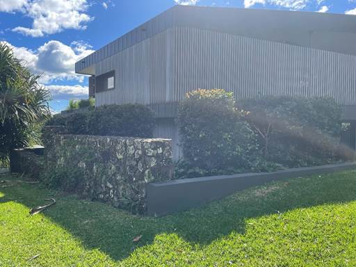
Image 1 – Arrow indicates location of encroachments adjoining Lot 1 DP246414
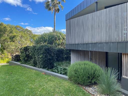
Image 2 – Front view of encroachment on road reserve adjoining Lot 1 DP246414
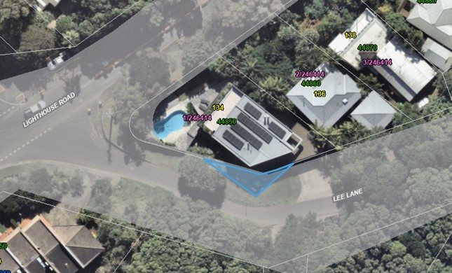
Blue indicates section of road reserve to be closed.
Image 3 - Location of proposed road closure adjoining Lot 1 DP246414
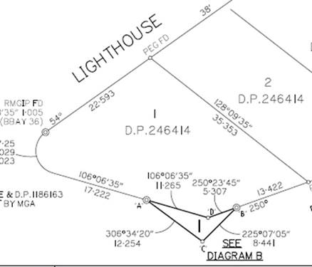
Image 4 - Survey of Part of Road Reserve adjoining Lot 1 DP246414
Road Closure Process:
Council identified as per the Roads Act 1993 (Part 4 Division 3 Closing of council public roads by council 38A When council may close council public road), that this part road area would not be reasonably required as a road for public use. This part road area is not required to provide continuity for an existing road network, and the part road does not impede vehicular access to a particular land.
A notice was placed in The Byron Shire Echo on 28 June 2024 and could be viewed on Council website. Notifications went out to adjoining landowners and all authorities advising closure of the section of road reserve off Lighthouse Road as outlined in Image 3 highlighted blue as per Roads Act 1993 Part 4 Division 3 Closing of council public roads by council 38B Notification of proposal to close council public road.
There was a 28-day submission period with no submissions for objection by authorities Attachment 2 (E2024/83968). There were no submissions by the community.
A resolution of Council is required to finalise the road closure and sale process. The final plans when completed, will be registered with Land Registry Services (LRS).
A plan of consolidation will also be drawn up and registered with LRS.
|
CSP Objective |
CSP Strategy |
DP Action |
Code |
OP Activity |
|
1: Effective Leadership |
1.3: Ethical and efficient management of resources |
1.3.3: Asset Management - Maximise asset service delivery potential and take a proactive approach to lifetime asset maintenance |
1.3.3.8 |
Provide ongoing detailed road assessment and valuation for the purposes of purchase, closure and land sale as required |
Roads Act 1993
Part 4 Closing of public roads
Division 3 Closing of council public roads by councils
38A When council may close council public road
A council may propose the closure of a council public road for which it is the roads authority if:
(a) the road is not reasonably required as a road for public use (whether for present or future needs), and
(b) the road is not required to provide continuity for an existing road network, and
(c) if the road provides a means of vehicular access to particular land, another public road provide lawful and reasonably practicable vehicular access to that land.
38B Notification of proposal to close council public road
(1) A council that is proposing to close a council public road must cause notice of the proposal:
(a) to be published in a local newspaper, and
(b) to be given to:
(i) all owners of land adjoining the road, and
(ii) all notifiable authorities, and
(iii) any other person (or class of person) prescribed by the regulations.
(2) The notice:
(a) must identify the road that is proposed to be closed, and
(b) must state that any person is entitled to make submissions to the council with respect to the closing of the road, and
(c) must indicate the manner in which, and the period (being at least 28 days) within which, any such submission should be made.
38C Public submissions and formal objections
(1) Any person may make submissions to the council with respect to the closing of the road in the manner and within the period specified in the notice published under section 38B.
(2) Without limiting subsection (1), a notifiable authority in relation to the road may include a
statement in the authority’s submission to the effect that the authority formally objects to the
closing of the road. The authority may withdraw the objection any time by written notice given
to the council.
Note.
If a formal objection is made, section 38D (2) provides that the road may not be closed until the
objection is withdrawn by the authority or set aside by the Land and Environment Court under this section.
(3) The council may appeal to the Land and Environment Court against a formal objection made by a notifiable authority against the closing of the road.
(4) On any such appeal, the Land and Environment Court may:
(a) affirm the objection, or
(b) set aside the objection.
(5) In deciding whether to affirm or set aside the objection, the Land and Environment Court must have regard to the public interest.
38D Decision of proposal
(1) After considering any submissions that have been duly made with respect to the proposal, the
council may, by notice published in the Gazette, close the public road concerned.
(2) However, a council public road may not be closed:
(a) in the case of a classified road—unless RMS consents to the closure of the road, or
(b) in the case where a notifiable authority has formally objected under section 38C to the
closing of the road—until the objection is withdrawn by the authority or set aside by the
Land and Environment Court under that section.
38E Effect of notice of closure
(1) On publication of the notice closing the council public road concerned:
(a) the road ceases to be a public road, and
(b) the rights of passage and access that previously existed in relation to the road are
extinguished.
(2) The land comprising a former road:
(a) in the case of a public road that was previously vested in a council (other than a public road in respect of which no construction has ever taken place)—remains vested in the council, and
(b) in any other case—becomes (or, if previously vested in the Crown, remains) vested in the Crown as Crown land.
38F Appeals to Land and Environment Court against closure decision.
(1) A person referred to in section 38B (1) (b) may appeal to the Land and Environment Court against the closure of a council public road by a council.
(2) On any such appeal, the Land and Environment Court may:
(a) affirm the closure, or
(b) set aside the closure.
(3) Section 38E is taken never to have applied to a closure that is set aside.
(4) To avoid doubt, an appeal under section 38C does not prevent an appeal under this section.
The costs associated with this road closure be paid for by the adjoining landowners.
As per the Roads Act 1993 requirements, the necessary notices and submissions period was undertaken, and zero objections were received.
Staff Reports - Infrastructure Services 13.12
Report No. 13.12 Cavanbah Centre Expansion
Directorate: Infrastructure Services
Report Author: Malcolm Robertson, Manager Open Space and Facilities
James Newberry, Sport and Recreation Operations Coordinator
File No: I2024/1539
Summary:
Council resolved that Staff:
1. Investigate expanding the Cavanbah Centre building eastwards in order to enable two extra basketball courts, including potential grant funding opportunities.
2. Investigate including a hydrotherapy warm water pool as part of the expansion.
This report provides available information that regarding those two options, with consideration of potential impacts. Reporting on the current Byron Shire-wide Aquatic Options Report public exhibition has been deferred in lieu of this new initiative.
Expanding the Cavanbah Centre eastwards to add two basketball courts will address current demand for indoor sports facilities and with proper planning.
It is believed that this expansion could significantly enhance the Cavanbah Centre’s capacity for both sporting and cultural activities and would support the growth of sports and recreation in the region.
Addition of new pool facilities at the Cavanbah Centre is anticipated to have a significant negative impact on both current Cavanbah Centre user groups and existing Council pool facilities.
The draft Byron Shire-wide Aquatic Options report will be considered for adoption in early 2025 and is intended to provide strategic guidance on future development of aquatic facilities within the region.
RECOMMENDATION:
That in relation to the options relating to a possible Cavanbah Centre expansion, Council:
2. Considers a 2025/26 budget allocation of $100,000 to allow detail design and costing of two additional internal courts at the Cavanbah Centre; and
3. Consider a 2025/26 budget allocation of $20,000 for a strategic planning review of the Cavanbah Centre with specific focus on user needs assessment, facility capacity, sustainability, multifunctionality, and enhanced spectator experiences.
Attachments:
1 Byron Bay AFL Clubhouse Proposal, E2024/136466
Expanding the Cavanbah Centre with two extra indoor courts
Expansion of the Cavanbah Centre building eastwards in order to enable two extra basketball courts was considered within initial designs for the facility (Figure 1). This design was at concept stage only and no detail design or costing of proposed works has been completed to date.
Location of the expanded facility was allowed for through a green space between the existing building and the outdoor courts. Consideration of linkage between the existing and new courts, relationship to outdoor courts, and the linkage to change rooms and amenities needs to be considered within the detail design. The current internal courts are naturally ventilated. Any amendment to the current eastern louvre walls will also require redesign of ventilation systems.
Expansion on available indoor playing surfaces has been sought by a wide range of current users due to the current limitations on capacity.
Figure 1: Extension of Cavanbah Centre.
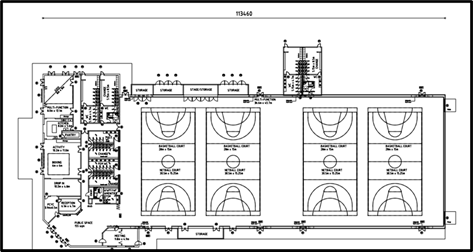
Figure 2: Indicative footprint of expanded Basketball Courts,
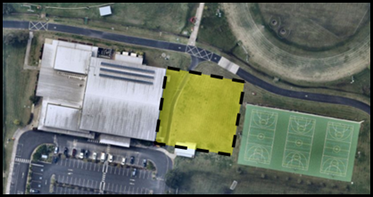
Should Council wish to advance this initiative, architectural consultants will need to be engaged to undertake detail design. This will enable a detailed cost analysis for a “shovel ready” project, which would be an essential first step in considering any potential grant funding opportunities.
Cavanbah hydrotherapy warm water pool.
The benefits of a hydrotherapy pool are well recognised. Hydrotherapy pools are particularly effective for people with injuries, chronic pain, and mobility challenges, and can also be used for general fitness, relaxation, and rehabilitation. A hydrotherapy pool would be a valuable resource within Byron Shire for both medical and wellness purposes.
Previous consideration of an aquatic facility at the Cavanbah Centre was undertaken both at initial design stage and subsequently. Concepts, draft designs and business cases were considered, but to date these have not been considered appropriate to progress. Images of previous concepts are shown in Figures 5 and 6.
In February 2017 Council completed a cost and feasibility assessment of possible options for extensions to the Cavanbah and subsequently resolved (17-539) not to proceed with the Cavanbah Centre Swimming Pool.
The matter was again considered by Council in 2018 as a wider scope that proposed addition of year-round indoor/outdoor aquatic facilities complemented by gymnasium, sauna/spa, crèche, massage room and a single additional all-purpose indoor court. This consideration was advanced with recognition of future Byron Foreshore changes linking to the Byron Bay Town Centre Masterplan and future upgrades of the Byron Bay Memorial Pool.
Figure 3: 2016 Cavanbah Warm Water Pool Consideration

Key to any changes, upgrades or renewals at the Byron Pool and associated reserve areas was the future adoption of the Byron Bay CZMP, which will allow direction on the impact of revetment wall construction and general foreshore accessibility works. The CZMP remains outstanding, however community feedback strongly supports retention of the Byron Pool in its current format.
Figure 4: 2018 Consideration of Aquatic Facilities at Cavanbah.
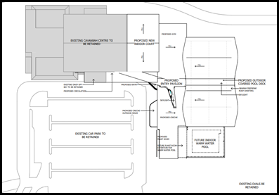
A core consideration should an aquatic facility be included with expansion of indoor playing courts is the impact on external playing areas. Extension to the internal playing space requires all available non-playing green space in this location. The addition of an aquatic facility will require expansion onto existing playing surfaces, either reducing available outdoor courts, or removing field currently used for soccer and cricket.
Figure 5: Potential footprint of expanded facility.
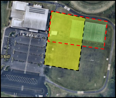
A hydrotherapy pool could differentiate the Cavanbah Centre, attracting new visitors and clients who need rehabilitation or pain management services. It could serve as a community resource for people undergoing physical therapy, making the centre a central hub for wellness.
The operating costs for a hydrotherapy pool are higher than a traditional pool. Hydrotherapy pools require constant water filtration and maintenance to ensure water quality, especially given the therapeutic nature of the pool. In addition, a hydrotherapy pool requires specialised staff such as hydro therapists or pool attendants to oversee the safe use of the facility. This would increase labour costs at the Cavanbah Centre.
Conducting a detailed feasibility study, including a financial projection and operational plan, is recommended for should this initiative be further supported. Cost estimate to engage an external consultant to investigate the feasibility of adding a hydrotherapy pool to the Cavanbah Centre, along with impacts to existing Council facilities, as an amendment to the current Byron Shire Options Report is $20,000.
Byron Shire Aquatic Options Report
In 2024 Council initiated a Byron Shire-Wide Aquatic Options Report to provide direction on provision of community aquatic facilities across the Shire. The draft Options Report has been on public exhibition.
As background, Council had in 2021 completed a feasibility study into a proposed upgrade of the existing facilities at the Mullumbimby Memorial Centre – Petria Thomas Pool site including provision of a new indoor warm water pool on the existing site. . (Figure 5).
Figure 6: 2021 Mullumbimby Pool Concept - Pre-Flood.
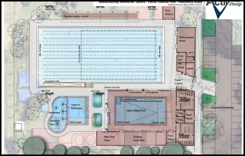 .
.
The 2022 floods demonstrated the need for development at the existing site to be reconsidered. The need for an increase in elevation to flood proof the facility.
Both Byron Shire’s two existing pools are well used but aging and will need significant renewal / upgrade in the next decade. When the Mullumbimby feasibility was tabled, a combination of estimated cost, constraints around access, parking and land for expansion, along with recognition of the current site vulnerability to flooding led to Council’s decision that wider long-term consideration of community needs across the whole Shire was needed prior to committing to a single facility upgrade.
While the population of Byron Shire only requires a single aquatic facility, the Aquatics Options Report suggests that to realise equitable supply / distribution two facilities are required – one at Byron and one at Mullumbimby. One facility at either Byron or Mullum would need to include an indoor heated pool.
Both current pool sites are physically constrained and do not allow for expansion. As an option to upgrading existing pools, cost and land opportunities to build a new facility have been explored. Potential new site criteria included:
• Council owned or managed land
• Up to 4500m2 relatively flat land.
• Vehicle access and car parking availability
• Topography and underlying geomorphology
• Central to maximum population
• Pedestrian and cycle access
• Planning constraints
• Access to services
• Central to catchment
• Close to a main population centre but allowing a buffer from residential
Site assessment was completed on the parcels of land identified as suitable, along with existing sites:
1. Existing Mullumbimby Pool Site
2. Existing Byron Pool Site
3. Lot 22 Mullumbimby
4. Old Hospital Site Mullumbimby
5. Cavanbah Centre
A core finding within the draft Options Report was that three pool facilities would not be affordable or sustainable. Any new indoor hydrotherapy pool needs to be part of an existing outdoor pool facility.
It was also confirmed that to allow equitable distribution, only one pool facility should be based in Byron Bay, with the second at Mullumbimby. In Byron Bay the option is to either retain and upgrade the existing pool location or demolish the existing and build a new pool facility at the Cavanbah Centre. At Mullumbimby the options were to either retain the existing pool, or build a new facility at Lot 22.
Options:
1) Keep Byron outdoor pool and build new facility at Mullumbimby with indoor / outdoor pools
2) Build indoor pool on current Byron Pool site and retain Mullumbimby as-is
3) Close Byron Pool and build new facility at Cavanbah, keeping Mullumbimby as-is.
Following Councillor Workshop on 30 November 2023, Councillors determined:
1. Community strongly values the current Byron Pool and would not support its closure. Keeping the Byron pool negates a new pool at Cavanbah, so upgrade of existing Byron pool was to be progressed.
2. Mullumbimby pool needs a more appropriate location, able to accommodate wider community needs.
The decision was that a new facility for Mullumbimby would be sited at Lot 22, due to the flood risk of the current pool site. The new facility would include an indoor hydrotherapy pool that operates year-round and an outdoor 50m pool. Byron Bay would be redeveloped with similar components as existing as it does not have the space to accommodate an indoor pool.
Concepts and costings were developed and developed and subsequently on 27 June 2024 Council resolved to place the concept designs from the draft Options Report on public exhibition for a minimum of 28 days, with a final options report to be returned to a future meeting of Council with consideration of Community feedback.
Findings were intended to be presented to Council December 2024, but have been put on hold with this emergent Cavanbah proposal having been given priority. Pending any decision regarding this emergent Cavanbah option, it is now intended to return the Options Report to Council in early 2025, however initial review of responses has allowed the following detail to be included in this report.
Initial analysis of responses to the public exhibition of the Shire-Wide Aquatic Options Report shows that of the 410 responses 87% of respondents agreed with redevelopment of the existing Byron Pool, and 57% of respondents supported a new Mullumbimby facility on Lot 22.
2.5% of respondents suggested that a pool at Cavanbah Centre should have been prioritised, rather than retaining the Byron pool.
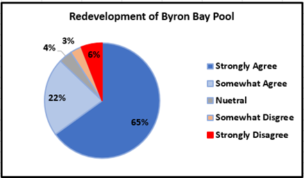
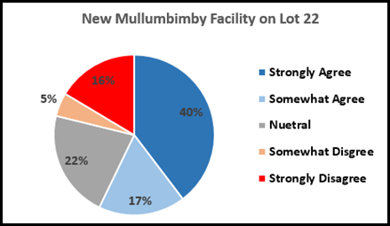
Full findings of the Byron Shire-Wide Aquatic Options Report will be returned to Council early 2025.
Open Space and Recreation Needs Assessment – Aquatic Facilities
Council’s adopted 2024 -2026 Open Space and Recreation Needs Assessment has just been through a review process, with the updated document to be presented to Council in early 2025. The reviewed Recreation Needs Assessment reconsidered requirements for Aquatic Facilities, and both reinforced original findings, and supported provisional recommendations within the Shire-wide Aquatic Facilities study.
Generally accepted provision rates for aquatic facilities by local governments are:
Town/village facilities: provision rate of 1:60,000 people
· typically, may include a heated 25m indoor program pool or a 25m or 50m outdoor lap pool, leisure pool, water play area and associated ancillary facilities.
Major/metropolitan facilities: provision rate of 1:60,000 people
· typically, may include an outdoor 50m lap pool, spectator seating, indoor 25m or 50m sports and activities pool, leisure pool or water play area, and associated ancillary facilities.
With a projected population of around 40,000 in 20 years, only one quality aquatic facility is required within Byron Shire to meet current, as well as long-term future demand, according to accepted standards of service. The Recreation Needs Assessment review has however considered the 2024 draft Byron Shire-wide Aquatic Options Report, commissioned to provide guidance to Council for the future provision of aquatic facilities across the Shire.
The Aquatic Options Report involved an analysis of the target markets for such facilities, reviewing the operational performance of both existing facilities, and investigations of sites across the Shire regarding their ability to provide suitable aquatic facilities into the future. Considering the Aquatic Options Report, the revised Recreation Needs Assessment plan noted that Aquatic Facility recommendations are warranted. Those actions being:
· Redeveloping the Byron Bay Pool War Memorial Swimming Pool
· Developing a new facility at Mullumbimby as identified (Lot 22, Mullumbimby).
The Recreation Needs Assessment review did note that given the significantly high cost of such developments, design concepts and cost estimates provided be revisited at the appropriate time. Current (and expected future) price increases being experienced in the construction industry, along with aquatic industry trends and subsequent community expectations can change relatively quickly
Impacts to Existing Cavanbah User Groups
Any expansion to facilities to expand the range of services at the Cavanbah Centre must include consideration of impacts to current usage, as well as existing demands for facilities arising from the current users. In response to Council’s Open Space and Recreation Needs Assessment one third of clubs indicated that the current number of playing fields/oval/courts at their facilities was not sufficient for their needs. Just over half were concerned that their current facilities could not accommodate growing membership numbers.
Current demand for playing areas within the Cavanbah Centre facility reflects the Rec Needs findings. The Cavanbah Centre has four main external playing field areas within the site, along with internal and external hard courts. Use of these playing areas is tightly scheduled and normal operations see use at full capacity over core demand hours.
Figure 1 shows the field layout and predominant usage.
Figure 7: Cavanbah Centre playing fields and usage.
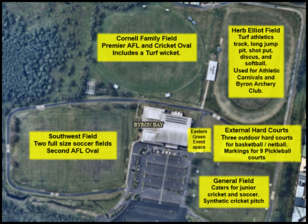
User groups with 125,000 participants had regular user agreements at the Cavanbah Centre over the last 12 - month period. The following User Groups have current agreements allowing for up to 37 sessions on external fields per week:
· Northern Rivers Football Academy (NRFA),
· Byron Bay Magpies Football Club
· Suffolk Park Football Club (SPFC)
· Byron Bay Runners Club
· Byron Bay Cricket Club
· Northern NSW Football
· Byron Bay Pickleball
· Byron Bay Netball Club
· Ultimate Frisbee
· Cocoa Cartel Football
· Byron Bay Cycle Club
· Byron Shire Archery Club
· Byron Bay Football Club (BBFC)
The following User Groups have agreements in place accommodating an average 37 sessions per week within the Cavanbah Centre building:
· Northern Rivers Football Academy (NRFA)
· Byron Bay Basketball Association (BBBA)
· AFL Queensland (Regional office)
· Futsal
· Encore Dance Performance
· That’s my Jam Dance
· Northern Rivers Roller Derby
· Byron Bay High School
· Mullumbimby High School Superstars
· Islamic Prayer Group
· Social Volleyball
· Futsal
· Pickleball
· Basketball
· Australian Red Cross
· Brazilian Jujitsu
Expansion of the Cavanbah Centre to include an addition two indoor courts would have minimal negative impact upon existing users. External areas impacted by expansion of courts are currently used for ad-hoc activities ancillary to outdoor events. These activities can be accommodated elsewhere around the grounds.
Expansion to include an aquatic facility would see a significant impact upon either the General Field area, external netball courts, or both. The General Field has just had lighting installed courtesy of the Northern Rivers Football Academy to facilitate evening use and availability of this space was a core reason for the NRFA deciding to base their operations from the Cavanbah Centre. Loss of this full-sized soccer pitch and cricket wicket would significantly impact existing users. Any reduction in external netball courts would significantly impact current netball and pickleball operations.
Current User Group Demands for Expansion
Any decision to approve expansion of existing facilities needs to consider the current unrealised requests for additional facilities from current user groups.
· Pickleball – Additional Internal Court Space needed.
Pickleball is one of the fastest growing sports in Australia. In 2023 revenue for social sport at Cavanbah increased by approximately 400%, primarily due to the growth in Pickleball. Cavanbah internal courts Pickleball runs 4 sessions per week. Additional internal court times are desired, but unavailable due to clashes with basketball. Pickleball occupies external courts Mondays, Thursdays, and Saturdays.
Additional internal courts may allow for increased programming for pickleball.
· Basketball Court Space – Additional Internal Court Space needed
Basketball is booming at junior level being alongside soccer as Australia’s most popular team sport for 15 to 24-year-olds followed by tennis and netball.
Byron Bay Basketball are currently lobbying widely seeking support for expansion of internal courts space.
Figure 8: BBBA Social Media around Expansion of Cavanbah Facilities
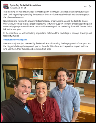
• Volleyball - Additional Internal Court Space needed
Growth at the Cavanbah has been prevented by lack of court space. Due to lack of availability, Volleyball can only occupy 1 internal court for 2 hours a week. Availability of a second volleyball court is needed due to allow for increased participation and growth.
Additional internal courts may allow for increased programming for volleyball.
• Netball - Additional Internal or undercover court Space needed
External courts at the Cavanbah centre are used for club training only. There is no existing capacity internally to accommodate the club and no wet weather options. School groups use the internal courts for Netball during the day at off peak times.
If additional facilities were available use would expand to regular netball competition.
Additional internal courts or upgrade of outdoor courts with weather protection would allow for increased programming for netball.
· Soccer playing / practice fields – Additional External field space needed.
Soccer is the most-played organised sport at the grassroots level in Australia. The NRFA uses all available fields at the Cavanbah Centre six days each week. With field use and court use now at capacity growth is restricted. Field capacity at the Cavanbah Centre is at a critical point. Losing any of the sports fields at the Cavanbah Centre would be untenable from the NRFA perspective and also extremely challenging for other existing users.
An additional playing field would allow for the increasing growth of soccer.
· AFL – Club Facilities
Byron Bay Magpies AFL Club are currently exploring options for a self-funded clubhouse and seeking approval top site this within the Cavanbah Centre grounds. (attachment 1). The club have a 3-year strategic plan aimed at building a more professional and robust club with a stronger presence in the local sporting landscape. This plan will see doubling of current player numbers, with associated increase in coaches, umpires, and volunteers.
Byron Bay Magpies wish to see enhancement of the experience at home games through a dedicated clubrooms and see this as core to their plan to improve social connection and educational elements of the sport.
Figure 9: Proposed AFL Clubrooms
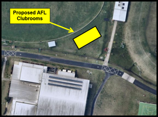
Strategic Considerations
Community Strategic Plan and Operational Plan
|
CSP Strategy |
DP Action |
Code |
OP Activity |
|
|
5: Connected Infrastructure |
5.4: Provide accessible community facilities and open spaces |
5.4.4: Sporting facilities and swimming pools - Ensure ongoing maintenance and upgrade of inclusive sporting facilities and swimming pools |
5.4.4.7 |
Pursue funding opportunities to allow implementation of adopted recommendations within Shire-wide aquatic recreation study |
• February 2018 (18-039) Concept plans for options for possible refurbishment of the Byron Bay Pool be prepared for community consultation to ascertain community priorities and preferences. This project is ongoing but has been delayed as Council seeks resolution with the Crown regarding alignment of boundaries.
• February 2020 (20-061) Council resolved to conduct a feasibility study into the financial viability of converting the Petria Thomas Swimming Pool in Mullumbimby into a year-round, solar heated facility along with addition of a disability access ramp, a splash children’s pool and a rehabilitation pool.
• August 2022 (22-422) Council resolved that the Current Mullumbimby Memorial Centre – Petria Thomas Pool feasibility study be placed on hold pending consideration of Shire-wide Aquatic Facility requirements, with results of the expanded study to be reported back to Council in the form of an Options Report
• May 2024 (NOM 9.3) Council moved to explore and implement options to heat the Mullumbimby Swimming Pool. This project is currently underway, with delays in implementation due to inability of Essential Energy to provide required supply analysis and options.
• June 2024 (24-336) Council resolved to places the concept designs from the Draft Options Report on public exhibition for a minimum of 28 days; and that the Final Options Report be returned to a future meeting of Council with consideration of Community feedback.
• September 2024 (24-447) Council resolved to investigate expanding the Cavanbah Centre building eastwards in order to enable two extra basketball courts, including potential grant funding opportunities, and investigates including a hydrotherapy warm water pool as part of the expansion. Receives a report on the above by December 2024.
Financial Considerations
Expenditure costs for operating public swimming pools are relatively fixed in relation to staffing costs, utilities, chemicals etc. so can only be offset by greater visitations, which is difficult in a smaller catchment. Byron Shire’s two existing facilities are effectively competing for population share. An additional facility would decrease financial sustainability of the existing two facilities.
A core finding of both the Recreation Needs Assessment review and draft 2024 Byron Shire-wide Aquatic Options Report, is that three pool facilities would not be affordable or sustainable. On financial grounds alone, any new indoor hydrotherapy pool needs to be part of an existing outdoor pool facility.
Expansion of the Cavanbah Centre building eastwards to enable two extra basketball courts requires detailed design and costing as a first step, to enable any grant funding opportunities to be advanced. It is anticipated that around $100,000 will be required for this work.
Conflicting demands for expansion of facilities have a flow on impact on capacities for both existing and potential users. Car parking is a major constraint on use of the Cavanbah Centre, and opportunities for expansion are limited. Allocation of $20,000 within 25/26 budget would allow for strategic planning review of the Cavanbah Centre with specific focus on usage demands, needs assessment, facility capacity opportunities for expansion, sustainability, multifunctionality, and enhanced spectator experiences.
Reports of Committees - Infrastructure Services 14.1
Reports of Committees - Infrastructure Services
Report No. 14.1 Report of the Local Traffic Committee Meeting held on 19 November 2024
Directorate: Infrastructure Services
File No: I2024/1601
Summary:
The attachment to this report provides the minutes of the Local Traffic Committee Meeting held on 19 November 2024 for determination by Council.
Council’s action on the LTC advice will be:
a) If Council is in agreement with the LTC unanimous support then the proposal may be approved. In these cases there is no conflict between Council and the advice of the LTC, consequently there is no need for Council to inform TfNSW or the NSW Police representatives of the decision.
b) If Council is in agreement with the LTC unanimous support, but no longer wants to proceed, the proposal may still be rejected.
c) If Council is in agreement with the LTC unanimous decline then the proposal may be rejected. Again there is no conflict between Council and the advice of the LTC. Consequently there is no need for Council to inform TfNSW or the NSW Police representatives of the decision.
d) If Council decides to proceed with a proposal where the advice of the LTC is not unanimous support, then the Council must first advise the TfNSW and the NSW Police representatives in writing of their intention to approve the proposal. TfNSW or the NSW Police may then lodge an appeal to the Regional Traffic Committee (RTC).
e) If Council decides to proceed with a proposal where the advice of the LTC is a unanimous decline, then the Council must first advise the TfNSW and NSW Police representatives in writing of their intention to approve the proposal. TfNSW or the NSW Police may then lodge an appeal to the RTC.
Due to the fact that the TfNSW and the NSW Police have the power to appeal certain decisions of the Council, the LTC cannot provide its advice to Council until both TfNSW and the NSW Police have provided their vote on the issue.
RECOMMENDATION:
1. That Council notes the minutes of the Local Traffic Committee Meeting held on 19 November 2024.
The minutes of the Local Traffic Committee Meeting of 19 November 2024 for determination by Council are available from:
Minutes of Local Traffic Committee Meeting - Tuesday, 19 November 2024.
The agenda for this meeting can be located on Council’s website at:
Agenda of Local Traffic Committee Meeting - Tuesday, 19 November 2024
This report contains the recommendations of the Local Traffic Committee (LTC) meeting held on 19 November 2024.
As per the Reports listed within the Local Traffic Committee Meeting of 19 November 2024.
Statutory and Policy Compliance Implications
As per the Reports listed within the Local Traffic Committee Meeting of 19 November 2024.
Reports of Committees - Infrastructure Services 14.2
Report No. 14.2 Report of the Local Traffic Committee Meeting held on 27 November 2024
Directorate: Infrastructure Services
File No: I2024/1604
Summary:
The attachment to this report provides the minutes of the Local Traffic Committee Meeting held on 27 November 2024 for determination by Council.
Council’s action on the LTC advice will be:
a) If Council is in agreement with the LTC unanimous support then the proposal may be approved. In these cases there is no conflict between Council and the advice of the LTC, consequently there is no need for Council to inform TfNSW or the NSW Police representatives of the decision.
b) If Council is in agreement with the LTC unanimous support, but no longer wants to proceed, the proposal may still be rejected.
c) If Council is in agreement with the LTC unanimous decline then the proposal may be rejected. Again there is no conflict between Council and the advice of the LTC. Consequently there is no need for Council to inform TfNSW or the NSW Police representatives of the decision.
d) If Council decides to proceed with a proposal where the advice of the LTC is not unanimous support, then the Council must first advise the TfNSW and the NSW Police representatives in writing of their intention to approve the proposal. TfNSW or the NSW Police may then lodge an appeal to the Regional Traffic Committee (RTC).
e) If Council decides to proceed with a proposal where the advice of the LTC is a unanimous decline, then the Council must first advise the TfNSW and NSW Police representatives in writing of their intention to approve the proposal. TfNSW or the NSW Police may then lodge an appeal to the RTC.
Due to the fact that the TfNSW and the NSW Police have the power to appeal certain decisions of the Council, the LTC cannot provide its advice to Council until both TfNSW and the NSW Police have provided their vote on the issue.
RECOMMENDATION:
1. That Council notes the minutes of the Local Traffic Committee Meeting held on 27 November 2024.
Report
The minutes of the Local Traffic Committee Meeting of 27 November 2024 for determination by Council are available from:
Minutes of Extraordinary Local Traffic Committee Meeting - Wednesday, 27 November 2024
The agenda for this meeting can be located on Council’s website at:
Agenda of Extraordinary Local Traffic Committee Meeting - Wednesday, 27 November 2024
This report contains the recommendations of the Local Traffic Committee (LTC) meeting held on 27 November 2024.
Financial Implications
As per the Reports listed within the Local Traffic Committee Meeting of 27 November 2024.
Statutory and Policy Compliance Implications
As per the Reports listed within the Local Traffic Committee Meeting of 27 November 2024.
Confidential Reports - General Manager 16.1
Confidential Reports - General Manager
Report No. 16.1 Confidential - Annual Review of General Manager's Performance Agreement
Directorate: General Manager
Report Author: Vicki Lawrence, Manager People and Culture
File No: I2024/1349
Summary:
On 30 August 2024, the General Manager’s annual performance review for the 2023/2024 financial year was conducted by a performance review panel, in accordance with the Guidelines for the Appointment and Oversight of General Managers issued by the Division of Local Government, Department of Premier and Cabinet (the ‘Guidelines’).
The performance review for 2023/2024 financial year was tabled at the 24 October 2024 Council meeting where Council resolved:
|
24-001 |
that Council notes the findings and endorses recommendations from the performance review panel with respect to the annual performance review for the General Manager contained in Attachment 1 (E2024/122875). |
The new performance review panel was appointed 24 October 2024, pending one final member, and a new performance agreement was drafted on 26 November 2024.
This report provides the 2024/2025 Performance Agreement for the General Manager (Confidential Attachment 1 E2024/140965) for Council’s consideration.
RECOMMENDATION:
1. That pursuant to Section 10A(2)(a) of the Local Government Act, 1993, Council resolves to move into Confidential Session to discuss the report Annual Review of General Manager's Performance Agreement.
2. That the reasons for closing the meeting to the public to consider this item be that the report contains:
a) personnel matters concerning particular individuals (other than councillors)
3. That on balance it is considered that receipt and discussion of the matter in open Council would be contrary to the public interest, as:
The report contains confidential information about performance
1 Confidential - GM Performance Agreement 24-25 Final, E2024/140965