 Agenda
Ordinary Meeting

Thursday, 12 June 2025
Agenda
Ordinary Meeting
Thursday, 12 June 2025
Agenda Ordinary Meeting
held at Council Chambers, Station Street, Mullumbimby
commencing at 9:00 AM
Public access relating to items on this agenda can be made between 9:00am and 10:am on the day of the meeting. Requests for public access should be made to the General Manager or Mayor no later than 12:00 midday on the day prior to the meeting.

Mark Arnold
General Manager
CONFLICT OF INTERESTS
What is a “Conflict of Interests” - A conflict of interests can be of two types:
Pecuniary - an interest that a person has in a matter because of a reasonable likelihood or expectation of appreciable financial gain or loss to the person or another person with whom the person is associated.
Non-pecuniary – a private or personal interest that a Council official has that does not amount to a pecuniary interest as defined in the Code of Conduct for Councillors (eg. A friendship, membership of an association, society or trade union or involvement or interest in an activity and may include an interest of a financial nature).
Remoteness – a person does not have a pecuniary interest in a matter if the interest is so remote or insignificant that it could not reasonably be regarded as likely to influence any decision the person might make in relation to a matter or if the interest is of a kind specified in the Code of Conduct for Councillors.
Who has a Pecuniary Interest? - a person has a pecuniary interest in a matter if the pecuniary interest is the interest of the person, or another person with whom the person is associated (see below).
Relatives, Partners - a person is taken to have a pecuniary interest in a matter if:
· The person’s spouse or de facto partner or a relative of the person has a pecuniary interest in the matter, or
· The person, or a nominee, partners or employer of the person, is a member of a company or other body that has a pecuniary interest in the matter.
N.B. “Relative”, in relation to a person means any of the following:
(a) the parent, grandparent, brother, sister, uncle, aunt, nephew, niece, lineal descends or adopted child of the person or of the person’s spouse;
(b) the spouse or de facto partners of the person or of a person referred to in paragraph (a)
No Interest in the Matter - however, a person is not taken to have a pecuniary interest in a matter:
· If the person is unaware of the relevant pecuniary interest of the spouse, de facto partner, relative or company or other body, or
· Just because the person is a member of, or is employed by, the Council.
· Just because the person is a member of, or a delegate of the Council to, a company or other body that has a pecuniary interest in the matter provided that the person has no beneficial interest in any shares of the company or body.
Disclosure and participation in meetings
· A Councillor or a member of a Council Committee who has a pecuniary interest in any matter with which the Council is concerned and who is present at a meeting of the Council or Committee at which the matter is being considered must disclose the nature of the interest to the meeting as soon as practicable.
· The Councillor or member must not be present at, or in sight of, the meeting of the Council or Committee:
(a) at any time during which the matter is being considered or discussed by the Council or Committee, or
(b) at any time during which the Council or Committee is voting on any question in relation to the matter.
No Knowledge - a person does not breach this Clause if the person did not know and could not reasonably be expected to have known that the matter under consideration at the meeting was a matter in which he or she had a pecuniary interest.
Non-pecuniary Interests - Must be disclosed in meetings.
There are a broad range of options available for managing conflicts & the option chosen will depend on an assessment of the circumstances of the matter, the nature of the interest and the significance of the issue being dealt with. Non-pecuniary conflicts of interests must be dealt with in at least one of the following ways:
· It may be appropriate that no action be taken where the potential for conflict is minimal. However, Councillors should consider providing an explanation of why they consider a conflict does not exist.
· Limit involvement if practical (eg. Participate in discussion but not in decision making or vice-versa). Care needs to be taken when exercising this option.
· Remove the source of the conflict (eg. Relinquishing or divesting the personal interest that creates the conflict)
· Have no involvement by absenting yourself from and not taking part in any debate or voting on the issue as of the provisions in the Code of Conduct (particularly if you have a significant non-pecuniary interest)
RECORDING OF VOTING ON PLANNING MATTERS
Clause 375A of the Local Government Act 1993 – Recording of voting on planning matters
(1) In this section, planning decision means a decision made in the exercise of a function of a council under the Environmental Planning and Assessment Act 1979:
(a) including a decision relating to a development application, an environmental planning instrument, a development control plan or a development contribution plan under that Act, but
(b) not including the making of an order under that Act.
(2) The general manager is required to keep a register containing, for each planning decision made at a meeting of the council or a council committee, the names of the councillors who supported the decision and the names of any councillors who opposed (or are taken to have opposed) the decision.
(3) For the purpose of maintaining the register, a division is required to be called whenever a motion for a planning decision is put at a meeting of the council or a council committee.
(4) Each decision recorded in the register is to be described in the register or identified in a manner that enables the description to be obtained from another publicly available document, and is to include the information required by the regulations.
(5) This section extends to a meeting that is closed to the public.
OATH AND AFFIRMATION FOR COUNCILLORS
Councillors are reminded of the oath of office or affirmation of office made at or before their first meeting of the council in accordance with Clause 233A of the Local Government Act 1993. This includes undertaking the duties of the office of councillor in the best interests of the people of Byron Shire and the Byron Shire Council and faithfully and impartially carrying out the functions, powers, authorities and discretions vested under the Act or any other Act to the best of one’s ability and judgment.
BUSINESS OF Ordinary Meeting
1. Public Access
3. Attendance by Audio-Visual Link
4. Requests for Leave of Absence
5. Declarations of Interest – Pecuniary and Non-Pecuniary
6. Tabling of Pecuniary Interest Returns (Cl 4.14 Code of Conduct for Councillors)
7. Adoption of Minutes from Previous Meetings
7.1 Ordinary Meeting held on 22 May 2025
8. Reservation of Items for Debate and Order of Business
9. Notices of Motion
9.1 Saddle Road and Mullumbimby Road Works............................................................ 9
9.2 Protection of the Environment.................................................................................... 13
9.3 Integrating Weed Management into EPAR Recovery Works and Catchment Collaboration................................................................................................................. 19
9.4 Key Worker Housing at the Rear of the Byron CoLab Building (Former Byron Hospital)........................................................................................................................................ 35
9.5 Unauthorised Camping in Brunswick Heads........................................................... 38
9.6 Strategic Water Infrastructure Opportunity.............................................................. 44
9.7 Proposal for a 30km Speed Zone in the South Beach Road Precinct, Brunswick Heads........................................................................................................................................ 49
9.8 Investigation of Traffic Calming Measures at Sporting Fields Shire-wide.......... 52
9.9 Status Report on Development Applications (DAs) before the Land and Environment Court............................................................................................................................... 55
9.10 Mullumbimby Tennis Courts Licence........................................................................ 58
10. Mayoral Minute
11. Petitions
12. Delegates' Reports
12.1 2022 Northern Rivers Flood Emergency Awards Presentation Ceremony – Tweed/Byron Police District....................................................................................... 62
12.2 Country Mayors Association – General Meeting - Friday 9 May 2025................ 64
12.3 The Remix Byron Event.............................................................................................. 68
12.4 Richmond Tweed Regional Library Meeting held 14 May 2025.......................... 70
12.5 Visit to The Buttery – 50th Anniversary Celebration.............................................. 71
12.6 Byron Town Centre Drainage Works........................................................................ 72
12.7 Delivery Program and Operational Plan (DP/OP) Information Session.............. 73
12.8 Special Entertainment Precinct Planning Meeting with Minister Graham’s Office 74
12.9 Short-Term Rental Accommodation (STRA) and Housing Affordability............. 76
12.10 Byron Bay 24-Hour Economy Roundtable............................................................... 77
12.11 Supporting Spontaneous Volunteers Meeting......................................................... 79
12.12 Rous County Council - Summary of main items of business 16 April 2025....... 81
13. Staff Reports
General Manager
13.1 Licencing for 18 Fletcher Street, Byron Bay (Fletcher St Cottage)...................... 84
Corporate and Community Services
13.2 Council Investments - 1 May 2025 to 31 May 2025............................................... 89
13.3 Grants June 2025........................................................................................................ 96
13.4 Section 355 Guidelines Update............................................................................... 100
13.5 Adoption of a Code of Meeting Practice................................................................ 104
13.6 Review of Council's Codes of Conduct.................................................................. 109
13.7 Tweed Street Pod Village - future use options..................................................... 112
Sustainable Environment and Economy
13.8 Update Resolution 24-235 Byron LGA Conservation Trust................................ 120
13.9 PLANNING - DA10.2024.168.1 - Additions to an Exising Multiple Occupancy approved under DA10.2022.181.1 consisting of 4 additional dwelling sites and Community Title Subdivision in two stages of 9 lots and 4 lots at 510 Goonengerry Rd Montecollum...................................................................................................................................... 125
13.10 PLANNING - Report of the Planning Review Committee held 1 May 2025..... 151
13.11 Planning Agreement - 53 McAuleys Lane Development Application 10.2023.454.1...................................................................................................................................... 153
13.12 Status report on Development Applications (DAs) with bodies like the Northern Regional Planning Panel (NRPP)........................................................................... 159
13.13 Amendment to DCP Chapter E10 Byron Bay Town Centre to clarify use and interpretation of controls in relation to car share spaces.................................... 165
13.14 2023-24 Annual Inventory of Council's Greenhouse Gas Emissions............... 169
13.15 Byron Bay Urban Design Housing Density Study................................................ 177
13.16 Heritage buildings in Mullumbimby......................................................................... 186
13.17 PLANNING - 10.2024.155.1 Alterations and additions to existing multi-dwelling housing development comprising the construction of six (6) x one (1) bedroom dwellings, the construction of two (2) x two (2) bedroom dwellings, and the construction of additional car parking, resulting in a total of twenty (20) dwellings, at 1 Kendall Street, Byron Bay........................................................................................ 190
13.18 PLANNING - Determination of certain s4.55 Applications during the Council recess...................................................................................................................................... 218
13.19 NSW Housing Delivery Authority - State Signficant Development Declarations 221
Infrastructure Services
13.20 Mullumbimby Pool Heating Tender......................................................................... 227
13.21 Potential renaming of Gilmore Crescent to Tennyson Street, Byron Bay........ 233
14. Reports of Committees
Corporate and Community Services
14.1 Report of the Finance Advisory Committee Meeting held on 15 May 2025..... 239
14.2 Report of the Audit, Risk and Improvement Committee Meeting held on 13 May 2025...................................................................................................................................... 242
Sustainable Environment and Economy
14.3 Report of the Biodiversity and Agriculture Advisory Committee Meeting held on 13 May 2025..................................................................................................................... 246
Infrastructure Services
14.4 Report of the Local Traffic Committee Meeting held on 3 June 2025............... 249
15. Questions With Notice
Nil
16. Confidential Reports
Infrastructure Services
16.1 Confidential - Negotiations to dispose of and acquire land interests for EPAR Works for AGRN1012 2022 NSW Severe Weather and Flooding Event ........ 253
16.2 Confidential - Tender Report - Byron Drainage Upgrade Town Centre Construction................................................................................................................ 254
Questions with Notice: A response to Questions with Notice will be provided at the meeting if possible, that response will be included in the meeting minutes. If a response is unable to be provided the question will be taken on notice, with an answer to be provided to the person/organisation prior to the next Ordinary Meeting and placed on Councils website www.byron.nsw.gov.au/Council/Council-meetings/Questions-on-Notice
Councillors are encouraged to ask questions regarding any item on the business paper to the appropriate Director prior to the meeting. Any suggested amendments to the recommendations should be provided to Councillor Support prior to the meeting to allow the changes to be typed and presented on the screen at the meeting.
Notices of Motion 9.1
Notices of Motion
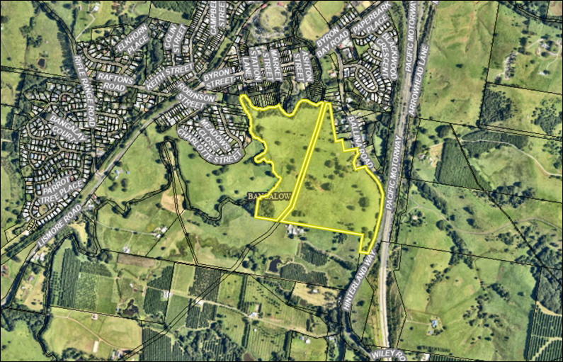
Notice of Motion No. 9.1 Saddle Road and Mullumbimby Road Works
File No: I2025/669
I move that Council:
1. Investigates the feasibility of reconfiguring Saddle Road into two cul-de-sac dead ends upon completion of the Mullumbimby Road works.
2. Explores the potential for repurposing Saddle Road as a prioritised pedestrian and bicycle pathway as part of the future planning for the development of the ‘Saddle Road Precinct’, including Gulgan Village.
Signed: Cr Sarah Ndiaye
Councillor’s supporting information:
The purpose of this Notice of Motion is to respond to concerns raised by residents and community stakeholders about the future use and planning of Saddle Road in light of the upcoming Mullumbimby Road works and the long-term planning for the Saddle Road Precinct, including the proposed Gulgan Village development.
At the 8 May 2025 Council (Planning) Meeting, it became clear through public submissions and questions that many residents felt inadequately informed about the scope and impact of the proposed road upgrades, particularly the temporary redirection of traffic—up to 5,000 vehicle movements per day—along Saddle Road during the six-month closure of Mullumbimby Road. Residents expressed concern about the environmental, safety, and amenity impacts of this detour, including the removal of vegetation and the absence of formal community consultation and environmental assessment.
Saddle Road is not only a rural residential road but also an ecologically and culturally significant corridor. It is home to diverse flora and fauna, and holds important Aboriginal heritage values. The community’s feedback has been clear: residents value this road for its character, environment, and the quiet lifestyle it supports, and wish to see its long-term use aligned with those values.
While Council staff have acknowledged a lapse in communication and consultation, this motion seeks to constructively move forward by investigating options for how Saddle Road can be better managed after the completion of the Mullumbimby Road works. Specifically, it proposes exploring the feasibility of converting Saddle Road into two cul-de-sacs, and ultimately repurposing it as a bicycle and pedestrian priority route as part of the future planning for the area.
These ideas are not new but reflect previous discussions about ensuring that new developments in the precinct are appropriately serviced by purpose-built infrastructure rather than relying on existing rural roads. The motion also reflects Council’s commitment to sustainable transport, road safety, and protecting local amenity.
By investigating these options now—before long-term decisions are locked in—we can help restore community trust, better coordinate future development, and uphold our shared values around planning, environmental stewardship, and good governance. This motion also supports Council’s broader strategic objectives around active transport and liveable communities.
Staff comments
by Phil Holloway, Director Infrastructure Services and Shannon Burt, Director Sustainable Economy and Environment:
Residents remain apprehensive about the long-term conversion of Saddle Road to a local distributor to manage traffic generated from future planning and rezoning for urban release purposes, including residential.
It is important to acknowledge that there are two separate projects relating to the Saddle Road area, which appear to be causing confusion due to their different stages and levels of communication.
Mullumbimby Road Upgrade:
· This is a grant-funded program for reconstruction, drainage, and intersection improvements to Mullumbimby Road, including:
· Betterment Works (between Gulgan Road and McAuleys Road);
· Intersection improvements - Mullumbimby Road and McAuleys Road; and
· Essential Public Asset Restoration works south of Manns Road.
· The project is scheduled over multiple stages to commence July 2025.
· The combined value of this project is $5.3 million.
· These projects are jointly funded by the Australian and NSW Governments and Council:
· Regional Roads and Transport Recovery Program Betterment Fund;
· Essential Public Asset Reconstruction Work funding;
· Australian Government Blackspot Program; and
· Transport for NSW Roads to Recovery Program.
· Whether point 1 of the recommendation can be accommodated following completion of the road works will be subject to an investigation and further report.
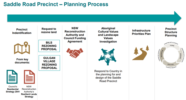
Saddle Road Precinct:
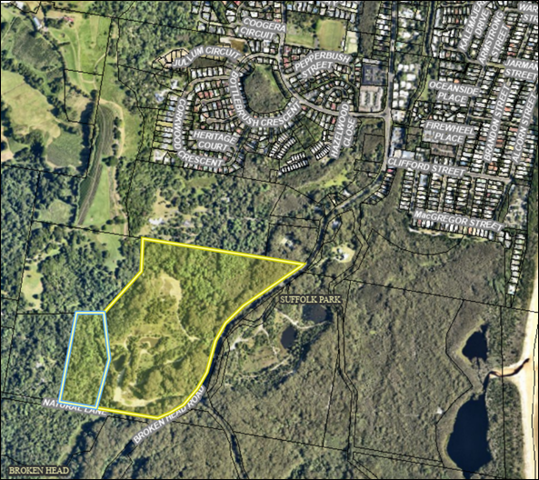
· Council received funding from the NSW Government's Reconstruction Authority (RA) to advance future housing in the Saddle Road Precinct, a medium to long-term site in Council’s Residential Strategy (10 years plus).
· The grant-funded project is being delivered in three parts:
· Assessment of Aboriginal Cultural and Landscape Values (commenced)
· Infrastructure Priority Plan (commenced)
· Precinct Structure Plan
Following this initial planning work, applicant-funded planning proposals to rezone parts of the Precinct, excluding Site B1 Gulgan Village, will be staged in accordance with the Precinct Structure and Infrastructure Delivery Plans.
Any future decision about the use of Saddle Road as a dedicated bicycle and pedestrian way will be informed by the above studies and planning work, including community consultation and reference to best practice and other adopted Council plans.
Council undertook early consultation in September 2024 with landowners about the Saddle Road Precinct to explain the process.
Financial/Resource/Legal Implications:
Projects are being managed within Program budgets and with grant funding.
Is the proposal consistent with any Delivery Program tasks?
|
CSP Objective |
CSP Strategy |
DP Action |
Code |
OP Activity |
|
4: Ethical Growth |
4.2: Enable housing diversity and support people experiencing housing insecurity |
4.2.2: Partnerships and pilots to address housing needs - Investigate partnerships and pilots that deliver an innovative and affordable housing model for the Shire |
4.2.2.5 |
Deliver on funding agreement with Reconstruction Authority for 66 The Saddle Road (site in Resilient Land Strategy) and the Saddle Road Precinct, Brunswick Heads |
|
5: Connected Infrastructure |
5.1: Provide a safe, reliable, and accessible transport network |
5.1.2: Road renewal and upgrades - Deliver road renewal and upgrade capital works program |
5.1.2.16 |
Mullumbimby Road Betterment Program |
Notices of Motion 9.2
Notice of Motion No. 9.2 Protection of the Environment
File No: I2025/660
1. Acknowledges the Community Strategic Plan (CSP) under Community Objective 3: Nurtured Environment, which commits to ‘nurturing and enhancing our natural environment,’ as well as the Biodiversity Conservation Strategy (BCS), and continues to ensure whole-of-Council support for these essential commitments.
2. Ensures Council’s works programs and procedures are aligned with the CSP and BCS by prioritising the protection of identified High Conservation Value (HCV) areas, including Endangered Ecological Communities (EEC), significant vegetation, habitats, and wildlife corridors, and by clarifying the importance of these environmental features when Council is undertaking works.
3. Operates with procedures that minimise or mitigate environmental impacts of capital, emergency, and maintenance works.
4. Where there are unavoidable impacts on biodiversity and the NSW Government Biodiversity Offsets Scheme is proposed to be used this will require a report to Council for endorsement.
5. Receives a presentation from staff at a Councillor workshop on the current processes for approval of Council’s works. The presentation is to cover:
a) Council’s Project Delivery Procedure 2022
b) Approvals pathways and environmental assessment for capital works and maintenance;
c) Exempt development such as maintenance and emergency works where vegetation management is required;
d) Development without consent (Part 5 Activities under the Environmental Planning and Assessment Act 1979) and the requirements for environmental assessment in a Review of Environmental Factors (REF);
e) Development with consent works where a DA is required.
Signed: Cr Sarah Ndiaye
Councillor’s supporting information:
Byron Shire has a long-standing commitment to environmental protection and sustainability. This is reflected in our Community Strategic Plan (CSP), where we have embedded the values of nurturing and enhancing the natural environment under Community Objective 3: Nurtured Environment. Our community has consistently rated the environment—particularly the natural landscapes, beaches, and coastlines—as the most valued aspect of living here. The preservation of native vegetation and habitats to maintain spaces for biodiversity is a key priority identified in recent consultations.
The Biodiversity Conservation Strategy (BCS) affirms our position as a biodiversity hotspot and outlines four clear aims to guide our efforts:
1. Lead – Provide clear direction, resources, and guidance to conserve and enhance biodiversity.
2. Inform – Ensure our community is well-informed about biodiversity and its protection.
3. Support – Provide support to land managers to conserve biodiversity across the landscape.
4. Manage – Implement best-practice land management to improve ecological resilience and reduce threats to biodiversity.
As a Shire, we have access to high-quality digital tools and data to help identify and protect critical ecological areas. Our Local Environmental Plan (LEP) and Development Control Plan (DCP) provide clear guidance for the protection and management of these areas, while the Biodiversity Conservation Act sets the legal framework within which we must operate.
To truly fulfil our commitment to environmental protection, Council must ensure that its own works programs are designed to avoid negative impacts on the environment, particularly in areas of high conservation value. If works are planned in these areas, Council must prioritise avoiding harm, and if destruction is unavoidable, ensure mitigation strategies are in place, including an Offset Program as a last resort.
This approach is consistent with our strategic goal to nurture, protect, and enhance the Shire’s biodiversity, contributing to CSP Theme 1: Effective Leadership. By following these principles, Council will demonstrate leadership in sustainable development, improve ecological resilience, and reduce threats to our natural environment.
By focusing on the long-term health of our natural systems, Council can continue to deliver on its promise to the community and work toward a future where Byron Shire remains a beacon of environmental stewardship, sustainability, and vibrant biodiversity.
Staff comments
By James Flockton, Infrastructure Recovery Coordinator and Christopher Soulsby, Manager Assets and Major Projects, Infrastructure Services:
Councils staff that are involved in the delivery of capital construction projects have various procedures and guidelines that are used in the successful delivery of projects. These include:
· Community Strategic Plan
· Delivery Program and Operational Plan
· Safety in Design Review Procedure
· Work Health and Safety Management System Framework
· Pulse PMC User Guide
· Grants Procedure
· Procurement and Purchasing Policy
· Procurement and Contract Management Guidelines
· Risk Management Strategy
· Infrastructure Services Transport Risk Management Procedure
Bringing all these together is the Project Delivery Procedure – Construction. This procedure was officially endorsed as a Council procedure by Council’s Executive Team in June 2021. The procedure is based on various other versions of similar documents that have been used to support project delivery since the mid 2000’s including:
· Contract Delivery Procedure 2006 (DM627569)
· The Asset Management Services Project Workflow Checklist 2012 (DM738607)
· Project Planning Pathways System; and
· templates that were developed in 2015 with a local planning consultant.
The current version of Project Delivery Procedure – Construction is a 58 page procedure that takes staff from Project Initiation through to Project Close Out.
Using various templates and Council’s Project Management Software, Pulse Project Management and Control. At the Pre Project / Project Initiation stage which is typically before the project has received funding the procedure guides staff to review a checklist of constraints on the location.
This checklist looks at the following layers spatially to understand the constraints that may occur at the site:
· Acid Sulfate Soils (State Govt)
· BSC Threatened Flora
· BSC Threatened Fauna
· Cape Byron Marine Park
· Coastal Hazard Layers (Bluecoast 2023)
· Domestic Waterfront Structure Strategy
· Erosion Precinct Layers
· Contaminated Land Parcels
· Dip Site / Buffers Layers
· Endangered Ecological Communities 2023 - Report ref E2023/44987 and E2023/33427
· Drainage Lines
· Fill Exclusion Zones
· Flood 100yr - LEP / DCP Controls
· Flying Fox Known Camps
· Freshwater Fish Threatened Species
· HEV Vegetation 2023 (no buffers)
· HEV Vegetation 2023 - report ref E2023/44987
· HEV Vegetation 2021
· HEV Vegetation 2017
· HEV Vegetation 2015
· Vegetation 2023 - report ref E2023/57278
· Vegetation 2021
· Vegetation 2017
· Vegetation 2015
· Heritage 2014
· Key Fish Habitat
· Koala Habitat
· Mitchells Rainforest Snail Potential Habitat
· National Parks
· OEH (Bionet) Threatened Fauna
· OEH (Bionet) Threatened Flora
· SEPP Layers
· Significant Trees
· Survey Marks
· Slip Prone Land
· Unhealthy Building Land
· Whale Carcass Burial Sites
· Wildlife Corridors Adopted 2023
· Wildlife Corridors (NPWS)
· Wildlife Signage Priority Sites
· Council Land Layers
· Crown Land Layers
· LEP hybrid 2014-1988
· Native Title Claims
· National Native Title Tribunal
It has been noted that Roadside Threatened Flora, Roadside Vegetation Categories is missing from this list. Roadside Threatened Flora, Roadside Vegetation Categories is being added the checklist in Council Geographic Information System. This issue pertains to operational activities such as vegetation management.
Aboriginal cultural heritage is not part of the mapping checklist as Council does not hold this information. Staff are required to conduct an AHIMS (Aboriginal Heritage Information Management System) search as part of the Due Diligence Code of Practice for the Protection of Aboriginal Objects in NSW. An AHIMS search is undertaken online through the NSW Department of Planning, Industry and Environment (DPIE) website.
All works that Council undertakes is done using either an approvals process or has been deemed to not require approvals. This is referred to as the planning approvals pathway. Planning approval pathways under the Environmental Planning and Assessment Act 1979 can come in a number of different forms for Council, including:
a) Develop with consent (Part 4) via the Development Application process;
b) Development without consent (Part 5) via a Review of Environmental Factors (REF) determined by the Director of Infrastructure Services or Director Sustainable Environment and Economy
c) Exempt Development.
Exempt Development does not require any approvals under legislation or Council policy or procedure due to so many routine tasks being completed by Council in this category, such as; pot hole patching, culvert / stormwater system cleaning, reseals, road signs and roadside vegetation management.
Some larger works such as slope stabilisation can also sometime be competed as Exempt Development.
The Project Delivery Procedure and project planning pathways system recognises that even routine activities carry a risk of unintended environmental impacts. Council’s Project Delivery Procedure includes a Conservation Risk Assessment (CRA) template. The CRA is a similar assessment process that is followed by an REF and designed to systematically consider the constraints of a location prior to proceeding with Exempt Development. Council staff are given the responsibility to decide when a CRA is warranted for Exempt Development.
Biodiversity Offset Scheme
Infrastructure Services has only once used the Biodiversity Offset Scheme (then called Biobanking) for the construction of the Byron Bay Bypass. This was done with a resolution of Council and not determined under delegation. There was also the above and beyond resolution that required additional ecological restoration over what was required by the Biobanking scheme. Should Council intend to utilise this legislative provision in the future the matter will be reported to Council for consideration.
Workshop
A workshop to take Councillors through the Project Delivery Procedure, approvals pathways, and the systems staff use is appropriate of Councillors to understand how environmental impacts are assessed and mitigated.
Financial/Resource/Legal Implications:
Nil. The workshop can be conducted with existing resources.
Is the proposal consistent with any Delivery Program tasks?
The NOM covers multiple operational and capital delivery activities in Infrastructure Services. Some of the areas will include, roads, drainage, open spaces, buildings, waste management, water and sewerage works.
|
CSP Objective |
CSP Strategy |
DP Action |
|
5: Connected Infrastructure
|
5.1: Provide a safe, reliable, and accessible transport network |
5.1.2: Road renewal and upgrades - Deliver road renewal and upgrade capital works program |
|
5.4: Provide accessible community facilities and open spaces |
5.4.2: Parks and open spaces - Provide and maintain active and passive recreational community space that is accessible and inclusive for all |
|
|
5.5: Provide continuous and sustainable water and sewerage management |
5.5.3: Storm-water - Provide stormwater infrastructure to manage flood mitigation and improve social and environmental outcomes
|
Notices of Motion 9.3
Notice of Motion No. 9.3 Integrating Weed Management into EPAR Recovery Works and Catchment Collaboration
File No: I2025/808
I move that Council:
1. Assesses the Essential Public Asset Restorations (EPARs) works undertaken to date, including land slips, road reconstructions, crossings and culverts, to identify opportunities to improve weed management protocols during and following the reconstruction phase;
2. Works collaboratively with Rous County Council and NSW Reconstruction Authority to improve weed management outcomes including:
a) Exploring options for additional funding streams, including State and Federal Grants and inclusion in natural resource management programs; and
b) Development of recommendations and initiatives for consideration to support integrated weed control and ecological restoration during and beyond the flood recovery process; and
3. Request staff bring a report to Council on this issue before the end of the year (2025).
Signed: Cr Sarah Ndiaye
Councillor’s supporting information:
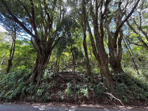
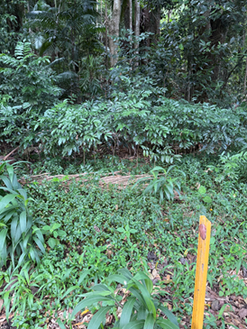
The catastrophic flooding events of 2022 left the Byron Shire with hundreds of millions of dollars' worth of damage to roads, culverts, slopes, and bridges—especially across our fragile hinterland landscape. While many critical EPAR projects have been completed and others are underway, recent site inspections with experienced Landcare practitioners have highlighted a concerning side effect: the rapid spread and dominance of invasive weed species in disturbed and reconstructed areas.
Landslips in particular have exposed entire hillsides to erosion and invasion, creating ideal conditions for aggressive weeds such as Singapore Daisy, Tobacco Bush, Running Bamboo, Devil’s Fig, Lantana, Green Cestrum, Cat’s Claw Creeper, and the highly invasive Tropical Soda Apple. There are also emerging reports of Alligator Weed, which is a serious threat to riparian systems.
Weeds are second only to land clearing in their impact on native biodiversity, and in the wake of such widespread land disturbance, strict prevention and management protocols are needed to avoid unintentionally accelerating their spread—especially where reconstruction works create open, disturbed areas prone to colonisation.
Council, through its own operations and its coordination with contractors, now has a vital opportunity to improve its contribution to long-term land health by embedding best-practice weed management and ecological restoration into the delivery of EPAR works. Proactive coordination with regional partners across catchments will strengthen consistency and effectiveness.
This approach can not only reduce future maintenance burdens and environmental damage but also deliver improved outcomes for water quality, erosion control, and native wildlife habitat. There is already significant pressure on Council’s land management resources, and we know our existing weed problem is substantial.
This motion aims to ensure that we don’t unintentionally worsen the issue, and instead use this period of reconstruction as an opportunity to protect and restore our natural environment.
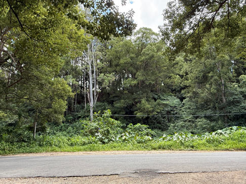
Image one Old quarry at the corner of Wilsons Creek Road and Koonyum Range Road - dumping site for lots of waste and covered in weeds. What is going to happen to it? Where is it going to be used? The Morning Glory was once under control.
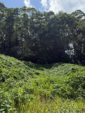
Up the back is dumped bamboo - lots of weeds but out competed by the Morning Glory. What will happen to the landfill?
This is one of the areas council slashes but it spreads the weeds.
Idea: Map weeds that are spread during slashing and instead use other methods.
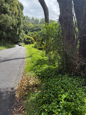
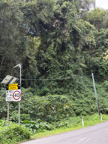
Very weedy near the school. If it’s going to be slashed it ideally needs to be done when it’s not seeding. Problematic give the proximity to the school and inability to use herbicide.
Can we apply for funding to get camphor removal along the road?
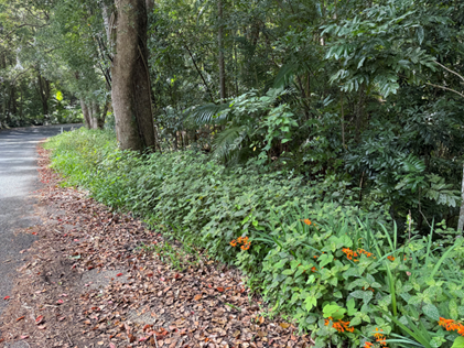
This is Black Taro. That wasn’t there prior to the floods but is now taking over. This is the area just opposite the Wilsons Creek bushfire brigade building. In close proximity to their own public land there’s also a large quantity of devils fig.
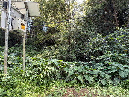
This is Black Taro.
That wasn’t there prior to the floods but is now taking over. This is the area just opposite the Wilsons Creek bushfire brigade building. In close proximity to their own public land there’s also a large quantity of Devils Fig.

The Black Tarot is very bad for water quality which is no good because this is going directly into our water system but also inhibits platypus habitation.


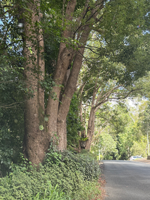
More Devils Fig. Morning Glory all over the shop. Madera vine taking over 3 years after the floods.
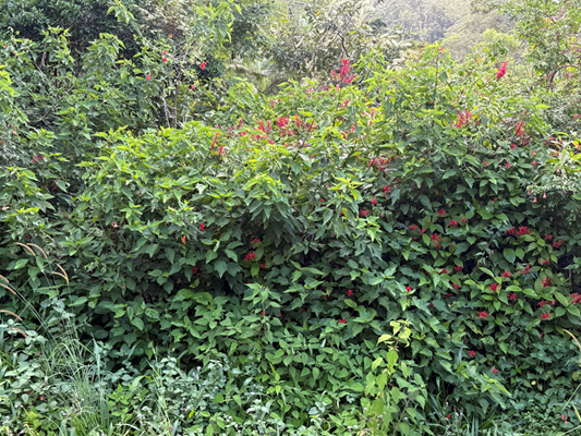
Red plant spread post flood

Kahili Ginger (toilet brush plant) spread by birds.

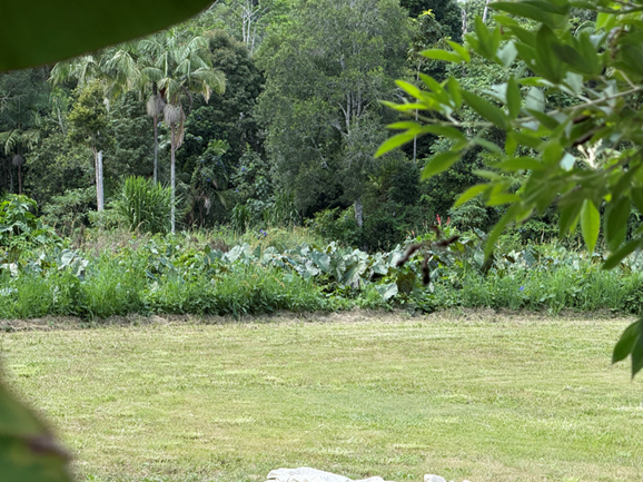
This is the site above the property that has been asked to vacate.


As a comparison, here is an area that the Landcare group have successfully removed weeds and camphor’s from 100 acre property- looks completely different.
Here are examples of some of the Camphor’s that could be removed - around 153 Hounbrook Road.

Underneath all of this is the very special border ranges lined fern so while works are being done here that needs to be taken into consideration. It’s just before the turn off to Mill Road.

This is John Seed it’s everywhere in that same area. It is also spread by the slasher so and sticks to everything.
Because so much work was done here in the past a bit of work now will save a lot of work in the future. There’s enough young saplings of black bean and other natives that can take off if the weeds are pulled back into line perhaps.

Staff comments
by Phil Warner, Manager Infrastructure Recovery, Infrastructure Services:
It is acknowledged that weed management in sensitive environments such as the Shire’s hinterland is a significant issue and challenge.
Road maintenance activities and the associated protocols as they pertain to weed management have been the subject of various initiatives over many years and can again be reviewed.
Rous County Council is the local authority responsible for managing the Biosecurity Act 2015 for NSW’s Northern Rivers region. Working with local stakeholders, they provide comprehensive and cost-effective control and management of targeted weeds in the region. The issues and locations referred to in support of this motion can be brought to their attention.
It will also be possible to work with Rous County Council and NSW RA to see what options exist to manage weeds associated with disaster recovery works, including what additional funding sources might exist.
Council has a bush regeneration team and associated expertise which could provide advice and subject to funding, potential on ground services.
It is important to note that the approval of Essential Public Asset Restorations (EPARs) and the associated funding is for a highly prescriptive scope of work. Funding for vegetation works is restricted to revegetation of the immediately effected area. To date there has been no provision for maintenance work beyond the defects liability period of works contracts which is one year.
In cases where weeds have overgrown the site of approved works e.g. a landslip, the weeds would be appropriately removed and the site revegetated as part of the scope of work.
Financial/Resource/Legal Implications:
Councils’ road maintenance budget is highly constrained.
There is currently no scope to utilize approved EPAR funding for anything other than the approved scope of work associated with restoring the asset.
Is the proposal consistent with any Delivery Program tasks?
Yes
|
CSP Objective |
CSP Strategy |
DP Action |
Code |
OP Activity |
|
3: Nurtured Environment |
3.1: Partner to nurture and enhance biodiversity, ecosystems, and ecology |
3.1.1: Native species - Use best practice land management to improve ecological resilience and reduce threats to biodiversity |
3.1.1.10 |
Support and promote restoration of Byron Shire wildlife corridors |
|
3.1.2: Pest and weed management - Use best practice land management to improve ecological resilience and reduce threats to biodiversity |
3.1.2.5 |
Respond to biosecurity threats in accordance with regulatory direction and agreement |
Notices of Motion 9.4
Notice of Motion No. 9.4 Key Worker Housing at the Rear of the Byron CoLab Building (Former Byron Hospital)
File No: I2025/810
I move that Council:
1. Takes the necessary next steps to pursue the adaptive reuse of the rear of the Byron CoLab building (formerly the Byron District Hospital site) for up to 19 co-living style rooms for key workers, with shared facilities;
2. Engages the appropriate areas within Council and works, in collaboration with Social Futures, to undertake a full feasibility study (including design) into point 1 above;
3. Seeks funding and support from all sources including both the NSW State and Federal Governments to enable the delivery of this project; and
4. Advocates for the inclusion of Byron Shire in State and Federal housing investment programs, with particular emphasis on addressing the absence of any public, social, affordable, Aboriginal or key worker housing currently in the pipeline for the Shire.
Attachments:
1 Letter
of Support - NSW Police Force - Key Worker Housing at rear of Byron CoLab
Building, E2025/57376 ![]()
Signed: Cr Sarah Ndiaye
Councillor’s supporting information:
When the decision was made to close the Byron District Hospital in 2016, the local community fought hard to ensure that the building remained in public hands. Through a strong advocacy campaign, the site was retained for community use and has since been transformed into the Byron CoLab—a vibrant space for the delivery of a range of social, educational and community services.
However, the original vision for the site included Southern Cross University as an anchor tenant—a plan that ultimately did not come to fruition. No long-term tenant has been secured for the rear portion of the site, which remains largely underutilised.
This underutilisation presents a once-in-a-generation opportunity to respond to one of the most pressing issues facing the Byron community today: the housing crisis. Byron Shire has some of the highest rates of homelessness per capita in Australia, combined with some of the highest housing and rental prices in the country.
Both the NSW and Federal Governments have committed billions in funding to housing initiatives across the country—yet Byron Shire has seen none of that investment. Despite this, not a single public, social, affordable, Aboriginal, or key worker housing project is currently in the pipeline through those initiatives for the Byron Shire.
The proposed project could deliver an adaptive reuse of the rear part of the building for up to 19 co-living style rooms for key workers in a strategically significant location—between the new Byron Central Hospital and the soon-to-be-built emergency precinct in the Sandhills estate. In discussions with the NSW Commissioner of Police, Karen Webb, and the Head of the Tweed-Byron Area Command, the shortage of appropriate housing for police, nurses, and other essential workers has been identified as a critical barrier to staff recruitment and retention.
This housing would provide safe, secure, and affordable accommodation for nurses, emergency services personnel, and other critical community emergency workers—allowing them to live in the community they serve. While the original redevelopment did not include ‘residential accommodation’, the purpose of the site—community service and health—would be deeply honoured and extended through the delivery of key worker housing.
Council now has a unique opportunity to lead a collaborative process with Social Futures and relevant government bodies to deliver a targeted and impactful solution. A feasibility study will provide the groundwork needed to unlock funding, planning approvals and long-term operational sustainability.
This proposal not only makes sense—it is necessary, timely, and aligned with community need, regional strategy, and government housing priorities.
Staff comments by: Claire McGarry, Place Manager, General Manager:
The Notice of Motion identifies an opportunity to pursue adaptive reuse of the rear half of the old Byron Hospital site to provide key worker housing.
In December 2024, Council resolved (in part) that:
1. The General Manager be authorised to commence discussions with the State Government to determine whether social, not for profit accommodation use could be supported on the Byron CoLab on Arakwal Country property; and
2. This change is not seeking to enable future for profit development of the site. (Pugh/Hauge)
The Notice of Motion, while a slightly different approach to the existing resolution, is not in conflict with it and can be pursued concurrently.
Discussions held between Council, NSW Health and Social Futures over the past six months have confirmed that:
1. Changes to the tertiary education sector have significantly and negatively impacted the viability of an education precinct on this site.
2. Social Futures are committed to:
a) delivering on a community-led response to the housing crisis; and
b) securing an anchor tenant for Byron CoLab on Arakwal Country to ensure the financial viability of the site.
3. NSW Health is open to making amendments to the permitted use, subject to market valuation and in principle agreement on proposed changes.
Additionally, discussions with local emergency services have confirmed that “housing availability and affordability remain among the most significant barriers to the recruitment and retention of essential personnel across the Byron Shire.”
This Notice of Motion directs staff to progress with a feasibility study and advocacy for key worker housing, including engagement and advocacy with relevant State and Federal agencies. This is achievable with existing staff resources, including partnership with Social Futures who hold the lease for the site.
Initially, staff will aim to secure immediate funding for a feasibility study, architectural design and approvals package to be used to attract funding for construction works.
In response to ongoing advocacy for inclusion in state and federal housing investment programs, staff will continue to seek available grant funding with the support of local members. They will also explore additional opportunities as they arise through Homes NSW and the Housing Australia Future Fund, ensuring alignment with relevant projects.
Financial/Resource/Legal Implications:
The proposal is achievable with existing staff resources, in partnership with Social Futures.
Is the proposal consistent with any Delivery Program tasks?
|
CSP Objective |
CSP Strategy |
DP Action |
Code |
OP Activity |
|
1: Effective Leadership |
1.5: Empower community leadership through collaboration, capacity building, and cultivating community driven initiatives |
1.5.2: Collaboration and capacity building - Collaborate with stakeholders to build community capacity |
1.5.2.1 |
Ongoing management of the former Byron Bay Hospital
|
Notices of Motion 9.5
Notice of Motion No. 9.5 Unauthorised Camping in Brunswick Heads
File No: I2025/811
I move that Council:
1. Acknowledges the ongoing issues with unauthorised camping/parking and ‘van-lifing’ in Brunswick Heads and the impact this has on residents, businesses, and visitors to the area;
2. Makes a public declaration that Council intends to take all necessary steps to deal with this issue and the impacts it has; and
3. Receives a report outlining:
a. The current state of enforcement action on unauthorised camping/parking in Brunswick Heads.
b. The barriers to effective enforcement, including an update on the signage required in order to enable appropriate enforcement.
c. Whether we have initiated contact with other landowners such as Reflections, Crown Lands, National Parks and Marine Parks in order to obtain delegated authority to enable our rangers to patrol their areas and issue fines.
d. Whether there is a resourcing issue.
Signed: Cr Michael Lyon
Councillor’s supporting information:
Unauthorised camping has been an ongoing issue in Byron Shire and in particular in Brunswick Heads, for many years. It was hoped that the implementation of pay parking would assist as it was expected that freeloaders would be unwilling to pay to stay. Unfortunately, the result has been to intensify the use of other spaces, including residential streets, the boat harbour car park and other areas. Whilst there are many things going on, including roadworks, which is impacting on the community and its ability to find parks, the prevalence of van-lifers is a separate issue to parking demand and demands a focused response. A public statement of zero tolerance could be a way of drawing a line in the sand and making it clear that we are not going to put up with it anymore and are determined to ensure we protect the amenity of the area.
The budget for our compliance team was increased by $250,000/year during the last term of Council, to ensure we can meet community expectations across all areas of compliance. This has easily paid for itself in extra fine revenue received since, though I understand it has levelled out now. Given the scale of the issue facing us in Brunswick Heads, it may be worthwhile to consider another increase, even if temporarily, so that we could back up any public declaration with firm action.
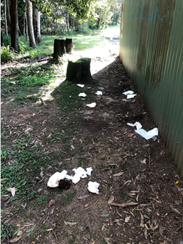
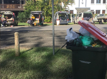
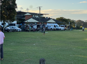
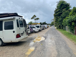
Some residents are feeling unsafe due to interactions they have had with some of the more unreasonable itinerants and are fearing reprisals. There are almost daily stories of van-lifers disrespecting our town and our Shire, and as the photos show, treating the area like a public campground. We had a similar issue in South Beach Lane (see photos 3 and 4), and Council acted decisively to ensure the park could be returned to the use of all rather than becoming an anti-social free campground. Now we can see this same site at the boat harbour every evening and in places like Fawcett St and Mona Lane, leaving rubbish, filling public bins and private bins to overflowing, playing loud music until late and treating it like a campground.
It is essential Council acts decisively and makes it clear we will no longer tolerate this behaviour. We do not want to see a situation where residents feel abandoned and start taking matters into their own hands. There has been some online commentary that this is a situation which demands a compassionate approach as many people are homeless in the area. Having spoken to a number of residents in recent weeks and having walked around, I believe this is a smokescreen and that 99% of the people involved are travellers. If we do need to consider this angle with compassion, then perhaps we can discuss ways for genuinely homeless people to register number plates so that our compliance team have the necessary information to act appropriately. Previous conversations with compliance staff seem to indicate that our teams know who the genuinely homeless locals are and we provide them information on where to park where they will not be hassled. For the rest, we need to keep moving them on, until there is nowhere in the Shire left and word gets out that we will not tolerate it. Currently, traveller websites and chat groups encourage people to come here because you don’t get hassled and that has to change.
Staff comments
by Shannon Burt, Director Sustainable Environment and Economy and Sarah Nagel, Manager Public and Environmental Services
Staff response to the matters raised in the notice of motion follows:
Points 1 and 2
Matters for Councillors to consider and resolve a position on.
Point 3
a. Council’s Compliance Officers are proactively and regularly patrolling unauthorised camping in Brunswick Heads and issuing penalty infringement notices. Council’s Parking Officers are also proactively and regularly undertaking parking patrols in Brunswick Heads and issuing penalty infringement notices.
These patrols are undertaken with an optimised roster considering the different team responsibilities and with workplace health and safety for staff put first. In the preceding three months, 15% of penalty infringement notices issued by Council’s Compliance and Parking Officers were issued in Brunswick Heads hotspots.
Both teams are engaging with unauthorised campers in hotspot areas and communicating Council’s position. Both teams have engaged with Council’s Public Space Liaison Officers, where identified as appropriate.
All enforcement action is being undertaken in accordance with Council’s Enforcement Policy, Council’s Environment & Safety Priorities Program 2024 and the NSW Government Protocol for Homeless People in Public Places. Council officers do not have the same protections or powers as NSW Police Officers.
b. Compliance Officers are restricted to their lawful jurisdiction and delegated functions. Council’s Compliance Services Team are working in partnership with Council’s Traffic Management Team to extend parking restrictions (including paid parking) in identified hotspots. Extended parking restrictions have now been reported to the Local Traffic Committee and are included in the Minutes report on this meeting’s agenda. These changes will support enforcement action in this hotspot area.
c. Compliance Officers continue to work in partnership with other responsible land managers, including Reflections, Crown Lands, Transport for NSW, National Parks and Wildlife Service, and local Police. Council has led an interagency approach to managing complaints and responding to hotspot activity since the end of COVID-19 restrictions. This includes ongoing, coordinated enforcement efforts through an executed MOU, shared media, communications, signage, patrols, and management strategies.
Brunswick Heads is now the primary hotspot in Byron Shire.
Other responsible landowners have limited resources to commit to these efforts, which affects combined and coordinated enforcement responses. Consequently, this impacts how the Compliance Services Team can operate, as does the current legislation and its application.
d. Council’s Compliance Services Team is adequately resourced to manage Council’s enforcement response. However, Compliance Officers are limited to certain functions and enforcement abilities by legislation, regulations and guidelines. Council Officers must operate within these limitations when taking enforcement action and cannot perform the enforcement functions of other enforcement agencies.
Council Officers can issue penalty infringement notices and court attendance notices but do not have move-on powers. Unauthorised camping infringements are limited to a person sleeping overnight in a location and parking fines are limited by signage restrictions under the Roads Act. The associated legislation limits the time for and the number of infringements that can be issued by a Council Officer.
Financial/Resource/Legal Implications:
The Compliance program is managed within the existing operational budget allocation.
Is the proposal consistent with any Delivery Program tasks?
|
CSP Objective |
CSP Strategy |
DP Action |
Code |
OP Activity |
|
2:
Inclusive Community |
2.2: Enhance safety and contribute to the physical, mental, and spiritual health and well being of our people |
2.2.3: Regulatory controls and compliance - Enhance public safety, health and liveability through the use of Council's regulatory controls and services |
2.2.3.1 |
Undertake proactive camping patrols of streets and public places throughout the Shire |
|
2:
Inclusive Community |
2.5: Create social impact and initiatives that address disadvantage |
2.5.3: Rough sleepers - Work in partnership to reduce and end rough sleeping through community action |
2.5.3.1 |
|
|
5:
Connected Infrastructure |
5.2: Connect the Shire through integrated transport services |
5.2.4: Parking - Manage parking through effective controls that support Movement and Place Plans and are coordinated with other initiatives such as park and ride |
5.2.4.1 |
Undertake regular and frequent parking patrols to increase availability and turnover in the Town and Village centres |
Notices of Motion 9.6
Notice of Motion No. 9.6 Strategic Water Infrastructure Opportunity
File No: I2025/812
I move that Council:
1. Notes there is a current off-market opportunity to purchase the land identified in Attachment 1 (#E2025/56288), a key strategic site relating to the future of Mullumbimby's water supply;
2. Reassesses the cost estimates from the previously commissioned water infrastructure study based on a scenario where this land is assumed to be the site for a new off-stream storage reservoir and water treatment plant;
3. Ensures that updated cost estimates include:
a) Land acquisition, noting the subject site is currently for sale off-market
b) Construction of a new water treatment plant on the site
c) Construction of a new off-stream storage reservoir to the south of the property, noting the suitable topography for such a facility;
4. Notes that the existing water main to Mullumbimby currently bisects the site, providing an opportunity for efficient integration with future infrastructure; and
5. Requests that the above be reported back to Council, or presented in a workshop format, in a timely manner, acknowledging the time-sensitive nature of the off-market property availability.
Attachments:
1 Confidential - Subject Land, E2025/56288
Signed: Cr Sarah Ndiaye
Councillor’s supporting information:
Mullumbimby is currently at a critical juncture in determining the future of its town water supply. Council has been exploring options to secure a long-term, sustainable, and resilient water source. The existing system, based on local water capture and treatment, is increasingly vulnerable to climate impacts, aging infrastructure, and population growth.
Recent strategic planning identified the need for either significant upgrades to the current system or connection to a broader regional supply. Among the preferred local solutions is the development of a new water treatment facility and an off-stream storage reservoir to enhance capacity and reliability.
The land identified in Attachment 1 has been identified as a strategically significant site for this infrastructure. The property offers key advantages:
· It is currently available for purchase off-market.
· It features suitable topography to support a large-scale water storage reservoir.
· The existing Mullumbimby water main bisects the property, offering practical and cost-effective integration with future infrastructure.
This opportunity aligns with Council’s commitment to long-term water security and infrastructure planning. By reassessing infrastructure costs with this site in mind, Council can make an informed decision that supports sustainable growth and resilience for the Mullumbimby community.
Staff comments
by Christopher Soulsby, Manager Assets and Major Projects, Infrastructure Services:
At the meeting of 24 October 2024 Council resolved (24-477) that:
1. The decision to pursue a permanent connection to Rous be deferred for up to two years.
2. Council continues with the emergency connection to Rous as planned and investigates operational regimes to minimise the risk of water quality incidents, as has been done for the existing emergency line.
3. Council seeks to renegotiate an interim agreement for a reduced cost for emergency supply during this period with Rous.
4. That a staged investigation into integrated water supply options be continued, including off stream storage and a hybrid solution with Lavertys Gap and Rous, and:
a. the investigation includes an options workshop with community, and direct community input to multi-criteria weightings to compare options;
b. regular progress reports be provided to the Council during this investigation period; and
c. investigations into the possible reinstatement of the hydroelectric plant be explored. (Ndiaye/Hauge)
At the 17 April 2025 Water and Sewer Advisory Committee meeting a project plan and timeline to deliver the outcomes required by point 4 of the resolution was presented to the committee for endorsement.
Following the committee meeting, and in accordance with the project plan, a brief to develop the decision-making framework with the community was sent out to consultants. On 12 May 2025 Natural Capital Economics (NCE) submitted their response and were appointed on 19 May 2025 to undertake the following tasks:
- Task 1 - Development of a decision-making framework that aligns with the NSW Government Business Case Guidelines - TPG24-29. These provide an established framework to guide policy or investment decisions, and will ensure that Council’s consideration of water supply options for Mullumbimby is aligned with best practice. If external public funding is required (and available), the assessments and outputs from this project can then be easily included into a detailed business case to the NSW Government.
- Task 2 - Audit and gap analysis of previous assessments, including (but not limited to):
o Technical assessments of option development.
o Extent of stakeholder/community engagement.
o Robustness of current and projected water demand assessments.
o Environmental, economic, financial and social impact assessments.
This evaluation will gauge the appropriateness of previous work to feed into the decision-making framework developed in Task 1. This will be supported by engaging with Council staff and, where feasible, with previous consultants, to understand challenges and complexities with previous assessments.
- Task 3 - Identify additional technical assessments based on the outcomes of Task 2. Consideration will be given to appropriate sequencing of these technical assessment to inform the methodology for delivery.
- Task 4 - Develop robust stakeholder engagement strategy that can directly and meaningfully feed into the decision-making process. This may include:
o Surveys to capture specific stakeholder input into multi-criteria analysis.
o Facilitating focus groups and/or workshops to identify key social impacts from options.
o Targeted engagement with a community or stakeholder reference group or other fit-for-purpose deliberative process.
- Task 5 - Consolidate approach and budgeting. This task involves consolidating findings from preceding tasks into a recommended project delivery plan and indicative budget for the next 14-16 months of work.
-
These tasks are to be completed by end of June 2025.
The notice of motion (NOM) bypasses the above tasks, options analysis, and stakeholder engagement that are required by resolution 24-477.
The NOM could run in parallel to resolution 24-477. It is noted that the NOM does not initiate the acquisition of the land but calls for a report or workshop on the findings.
The cost estimates required by part 3 of the NOM would be reported and considered by Council in the absence of the cost benefit analysis of the other options listed in the resolution 24-477 being, the hybrid solution, connection to Rous water. The NOM only considers offline storage and a new treatment plant. The approach set out in the NOM does not conform to best practice as set out in the NSW Government Business Case Guidelines - TPG24-29 as it only considers one option.
Financial/Resource/Legal Implications:
The off market approach by a land owner to sell land is an unsolicited proposal as defined in Council’s 2023 Unsolicited Proposals Guideline.
An unsolicited Proposal is an “Approach to Council from a Proponent with a proposal to deal directly with Council over a commercial proposition, where Council has not requested the proposal. This may include proposals to build and/or finance infrastructure, provide goods or services, or undertake a major commercial transaction.”
A copy of the Guideline is provided as Attachment 2.
Should the NOM be adopted then in addition to the specific actions set out in the NOM staff would manage the unsolicited proposal as per stages 1-4 set out in the guidelines.
The NOM itself does not require any additional resources as these activities can be undertaken within the existing budget.
However, should the land acquisition proceed, and offline storage is not the preferred option for the Mullumbimby water supply this could have significant adverse impacts on the Water Fund.
Is the proposal consistent with any Delivery Program tasks?
The NOM is not inconsistent with the following action in the Delivery Program.
|
CSP Objective |
CSP Strategy |
DP Action |
Code |
OP Activity |
|
5: Connected Infrastructure |
5.5: Provide continuous and sustainable water and sewerage management |
5.5.1: Water supply - Provide a continuous water supply that is maintained in accordance with NSW Health guidelines |
5.5.1.8 |
Undertake Mullumbimby Water Treatment Plan Improvement Plan |
|
5: Connected Infrastructure |
5.5: Provide continuous and sustainable water and sewerage management |
5.5.1: Water supply - Provide a continuous water supply that is maintained in accordance with NSW Health guidelines |
5.5.1.9 |
Complete emergency water supply detailed alignment construction for Mullumbimby |
Notices of Motion 9.7
Notice of Motion No. 9.7 Proposal for a 30km Speed Zone in the South Beach Road Precinct, Brunswick Heads
File No: I2025/813
I move that Council:
1. Receives a report on options for creating a 30km/h speed zone within the South Beach Road Precinct in Brunswick Heads; and
2. Investigates designating the area as a shared zone to enhance pedestrian and cyclist safety, consistent with community values and usage patterns.
Signed: Cr Sarah Ndiaye
Councillor’s supporting information:
The South Beach Road Precinct in Brunswick Heads is currently undergoing long-awaited drainage upgrades and road resealing. This presents a timely opportunity to align traffic safety with the town’s well-established community values.
Brunswick Heads, located in Northern NSW, is a small coastal village renowned for its relaxed atmosphere and its “Simple Pleasures” ethos—a philosophy that celebrates natural beauty, low-impact living, and a strong sense of community. The town draws residents and visitors who appreciate its family-friendly environment, accessible riverfront, and walkable town centre.
The South Beach Road area is one of the most actively used parts of town. It is frequented by pedestrians, families with prams, people with disabilities, surfers carrying boards, and those on bicycles and e-bikes. Vehicles are constantly manoeuvring into and out of parallel parking spaces. The popular tradition of jumping off the nearby bridge into the Brunswick River, especially among local youth, further underscores the need for safe, slow-moving traffic in this zone.
With a current speed limit of 50km/h, the area does not reflect the high level of foot and cycle traffic or the informal, family-oriented atmosphere that characterizes Brunswick Heads. A 30km/h speed limit would promote safety for all users, reduce the risk of collisions, and be in keeping with the town’s identity as a place of “simple pleasures,” not speed.
Introducing a reduced speed zone would create a more welcoming and inclusive environment for both locals and visitors and reinforce Council’s commitment to safer, healthier, and more liveable streets.
![]()


Staff comments
by Samuel Frumpui, Manager Works, Infrastructure Services:
In response to the Mayor’s Notice of Motion regarding the proposed 30 km/h speed zone along South Beach Road, Brunswick Heads, it should be noted that Transport for NSW (TfNSW) provided feedback during the design development phase of the current project, indicating in-principle support for a reduced speed zone, subject to the installation of appropriate traffic calming measures in accordance with the NSW Speed Zoning Standard.
While Council initially aimed to include raised pedestrian crossings and gateway treatments, these elements have been excluded from the current scope due to budget constraints and environmental considerations. To achieve the criteria required by TfNSW for a reduced speed environment additional works would be required including for example the provision of two raised pedestrian crossings and northern-end garden beds, in association with retaining bollards and southern-end landscaping to support pedestrian safety.
TfNSW advised that the absence of key pedestrian infrastructure may affect eligibility for a High Pedestrian Activity Area (HPAA) at this stage but acknowledged that the current road layout allows for future incorporation of required treatments.
Conclusion
The approved South Beach Road Upgrade project design does not currently include the necessary traffic calming devices to meet TfNSW’s criteria for a 30 km/h speed zone. However, the road design accommodates their inclusion in future stages, subject to environmental approvals and funding availability.
Financial/Resource/Legal Implications:
Nil cost at present. To be assessed as part of preparation of the report in response to point 1.
Is the proposal consistent with any Delivery Program tasks?
|
CSP Objective |
CSP Strategy |
DP Action |
Code |
OP Activity |
|
5: Connected Infrastructure |
5.3: Invest in renewable energy and emerging technologies |
5.3.1: Future needs - Plan for the infrastructure needs of the current and future population |
5.3.1.5 |
Report regulatory traffic matters and items requiring comment through the Local Traffic Committee for recommendation to Council for approval
|
Notices of Motion 9.8
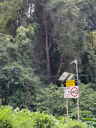
Notice of Motion No. 9.8 Investigation of Traffic Calming Measures at Sporting Fields Shire-wide
File No: I2025/814
I move that Council:
1. Receives a report on options for implementing traffic calming and safety measures at sporting field precincts across the Byron Shire, where user groups and community members identify a need;
2. Investigates a suite of traffic calming strategies that may include:
a) Enhanced line marking and signage
b) Temporary or permanent bollards to separate pedestrian and vehicle areas
c) Reduced speed zones during peak times (e.g. weekend sport, evening training)
d) Flashing lights or electronic signs similar to school zones
e) ‘Slow down – children playing’ or high pedestrian activity warnings;
3. Engages with local sporting clubs, field users, and residents to identify high-risk areas and develop location-specific recommendations; and
4. Identifies funding sources or inclusion in Council’s forward planning for traffic safety infrastructure.
Signed: Cr Sarah Ndiaye
Councillor’s supporting information:
Sporting fields across the Byron Shire play a central role in community life. On weekends and during scheduled training sessions, these precincts become high-activity zones with children, young people, families, cyclists, and pedestrians moving between games, fields, amenities, and vehicles. Car movement and on-street parking activity increase significantly during these times, often in areas without formal pedestrian infrastructure or reduced speed controls.
A recent incident involving a collision between a cyclist and a pedestrian—resulting in serious injury—highlights the very real risks when traffic and pedestrian flows mix in unmanaged environments.
NSW Government traffic safety guidance recognises the importance of managing speed and creating safer spaces in high-use public zones. The introduction of temporary or timed 40 km/h zones, improved signage, traffic-calming infrastructure, and physical separations are proven interventions to reduce collisions and improve safety, particularly where children are present.
Similar to the established school zone model—where flashing lights and reduced speed limits apply at peak times—sporting precincts would benefit from a comparable approach. These areas share many of the same risk factors: high concentrations of children and families, limited road awareness among users, and frequent crossings between fields and vehicles.
This motion proposes a proactive, consultative approach to identifying and addressing safety risks at sporting fields across the Shire. By working with local user groups and applying established traffic safety principles, Council can help ensure these beloved community spaces are safe, accessible, and welcoming for all.
Staff comments
by Malcolm Robertson, Manager Open Space & Facilities, Infrastructure Services:
Staff recognise the concerns raised and support the proposed plan to engage with local sporting clubs, field users, and residents to identify high-risk areas and develop location-specific recommendations.
Major sporting precincts across the Shire include:
· Mullumbimby Pine Avenue
· Mullumbimby Recreation Grounds
· Byron Recreation Grounds
· Brunswick Heads Recreation Grounds
· Bangalow Recreation Grounds
· Bob Bellear Sports Grounds
· Tom Kendall Sports Grounds
· Linda Vidler Park
· Cavanbah Centre
Sport and Recreation staff will undertake engagement with community around desired improvements to safety in sporting precincts. Proposed improvements will be reviewed against adopted Masterplans, the Pedestrian Access and Mobility Plan.
Following review by the Local Traffic Committee, resulting recommendations will be returned to Council for consideration and approval at a future meeting.
Is the proposal consistent with any Delivery Program tasks?
This proposal most closely aligns with aligns with DSP action 2.2.1: Safety initiatives - Support community driven safety initiatives.
Any recommended actions arising from the requested Options Report will see future OP tasks developed within CSP Strategy 5.1: Provide a safe, reliable, and accessible transport network.
|
CSP Objective |
CSP Strategy |
DP Action |
|
2: Inclusive Community |
2.2: Enhance safety and contribute to the physical, mental, and spiritual health and well being of the community |
2.2.1: Safety initiatives - Support community driven safety initiatives |
Notices of Motion 9.9
Notice of Motion No. 9.9 Status Report on Development Applications (DAs) before the Land and Environment Court
File No: I2025/816
I move that:
1. Council receives a monthly status report to each Ordinary (Planning) Meeting on all Development Applications (DAs) currently the subject of legal proceedings before the Land and Environment Court;
2. The status report includes the following details, where available:
a) DA number and property address
b) Description of the development
c) Summary of the key issues in the proceedings
d) Current stage or status of the matter
e) Any scheduled hearing dates
f) Outcomes or determinations (as they occur); and
3. This reporting commences from the next available Planning Meeting.
Signed: Cr Sarah Ndiaye
Councillor’s supporting information:
Councillors are elected to represent the interests of our residents and ratepayers, and one of the most important roles we undertake is considering and determining Development Applications (DAs). Each year, hundreds of DAs are assessed across Byron Shire, reflecting the ongoing growth, change, and investment in our local communities.
Our planning staff work diligently to assess these applications in line with relevant legislation, planning instruments, and community expectations. From time to time, certain DAs become the subject of legal proceedings before the Land and Environment Court — often due to the complexity of issues or unresolved concerns raised during the assessment process.
While the Court process is beyond Councillor’s direct control, maintaining visibility of these matters helps support informed decision-making by Councillors and ensures the community stays connected to what’s happening in their local area. It also acknowledges the important role that residents, staff, applicants and other stakeholders play in the planning system.
As a Council, we are always looking for ways to improve how we communicate, govern and serve the public interest. Providing a regular status update on DAs before the Land and Environment Court is a simple but valuable step toward greater transparency, trust, and engagement with our community. It builds on existing practices — such as the reporting we already do for matters determined by Regional Planning Panels — and reflects our ongoing commitment to doing things better.
This initiative is about keeping everyone in the loop, recognising the profound engagement of our community, the professionalism of our staff, and supporting an open and informed planning process for the benefit of all.
Staff comments
by Matthew Meir, Legal Counsel, General Manager’s office:
Councillors are updated monthly on legal proceedings involving Council. This means the primary audience for the proposed report is the public.
Staff note that submitters to a development application determination which is appealed to the Land and Environment Court are notified about the proceedings.
This includes being invited to attend the Court-required conciliation that is the first step in a development appeal.
While submitters are never parties to an appeal, the Court provides an opportunity for the former to put their views on the record regarding the relevant development determination. The Court decides how many people can address it as part of proceedings.
Beyond this, submitters are further notified if an appeal is resolved via the Court-required conciliation.
If conciliation doesn’t resolve the matter, submitters are also notified that an appeal will be determined by a hearing.
This notification will continue.
Whether an appeal is determined via conciliation or a contested hearing, every appeal decision is published on the NSW Court judgments website at: www.caselaw.nsw.gov.au.
The proposed report will complement this existing transparency by providing further information to people generally interested in the progress of appeals against development determinations.
On the report’s proposed details in section two of the notice of motion, these largely replicate the information Councillors receive each month.
Regarding the proposed ‘summary of issues’, to avoid the report being weighed down by the standard complexity of Court proceedings, a ‘bullet point’ list of key issues will be provided – based on Council’s main contentions in the relevant appeal.
For example, one current appeal before the Court’s ‘key issues’ would be summarised as:
· Stormwater
· Parking
· Flooding
· Waste servicing
Meanwhile, staff note that between the proposed report being filed and the relevant Council meeting, some things may change regarding where Court proceedings are up to.
Is the proposal consistent with any Delivery Program tasks?
|
CSP Objective |
CSP Strategy |
DP Action |
Code |
OP Activity |
|
1: Effective Leadership |
1.1: Enhance trust and accountability through open and transparent leadership |
1.1.1: Leadership - Enhance leadership effectiveness, capacity, and ethical behaviour |
1.1.1.8 |
Represent Council’s legal interests |
Notices of Motion 9.10
Notice of Motion No. 9.10 Mullumbimby Tennis Courts Licence
File No: I2025/837
I move that Council:
1. Provides details on the process leading to the award of licences for management of the Mullumbimby Tennis Facility; and
2. Outlines details of the Council Policies that supported this process.
1 Confidential - Submissions - EOI Mullumbimby Tennis Facility, E2025/58437
2 Policy:
Leasing and Licensing 2021 (current_policies), E2021/141396 ![]()
Signed: Cr Michael Lyon
Councillor’s supporting information:
Council recently ran a process seeking expressions of interest in a 5-year licence for the management of the Mullumbimby Tennis Facility. Some community members have reached out to Councillors seeking assurance that EOI was undertaken in a fair and equitable manner, given the long history that the Mullumbimby Tennis Club has on the site. There are also assurances being sought that the local coach, who is very well respected and loved, will be able to continue operating from the site.
Staff comments
by Malcolm Robertson, Manager Open Space & Facilities, Infrastructure Services:
Council is a public authority, and its procurement process must be open to, and able to
withstand, public scrutiny. It is critical that Council’s procedures are of the highest
ethical standard and provide confidence to the public. To support this approach
Council has adopted Code of Conduct, Business Ethics Statement and Procurement and Purchasing Policy. In addition, Council must also comply with the
legislative obligations:
· Local Government Act 1993
· Local Government (General) Regulation 2021
· Tendering Guidelines for NSW Local Government 2009
The Mullumbimby tennis facilities are on designated Community Land within Crown Reserve 31910.
The Local Government Act 1993 No 30 sets the responsibilities and powers of councils in relation to dealing in community land. Division 2 governs use and management of community land. Under section 35, Community land is required to be used and managed in accordance with the plan of management applying to the land.
Lease, licence or other estate in respect of community land may be granted, in accordance with an express authorisation in the plan of management, for the provision of goods, services and facilities, and the carrying out of activities, appropriate to the current and future needs within the local community and of the wider public in relation to public recreation.
Council Policy Leasing and Licensing (attached) stipulates a competitive process must be followed, and grant of a lease or licence will require approval of the General Manager or a Director when the term and value of the lease and licence permits.
The adopted Plan of Management for the Mullumbimby Recreation Reserve guides use of the reserve with the aim of satisfying community needs consistent with statutory requirements and the sustainability of this community and recreation resource.
Core objectives of the Plan of management include;
· encouraging community based shared management of facilities through principal user groups;
· promoting shared use to support the active sporting community in the Brunswick Valley;
· enabling multi-use of facilities where practicable;
· maintaining an adequate and consistent standard of facilities and maintenance of sports fields in conjunction with user groups;
· promoting easy access for non-organised sporting and recreational activities, where consistent with organised sporting activities;
Mullumbimby Tennis Facility Licence Agreement
The current licence over the Mullumbimby Tennis courts lapsed on 31 May 2025. To facilitate renewal of a Licence for a period not exceeding 5 years, an open market Expression of Interest process was followed through Council’s electronic tendering and online quotation system, VendorPanel. Distributing requests for quote and tender documents through VendorPanel ensures that all potential respondents receive the same information and that addenda can be easily distributed to all interested parties. It also creates an audit trail.
It was determined that the appropriate course of action to call for submissions was an EOI based on:
• The facility is on Crown Land and is a valuable public asset.
• Desire to improve community outcomes and sustainability
• Requirement to establish a sinking fund held by Council for capital reinvestment in the facility.
• Requirement for improved reporting on usage data to support grant funding and defined assessment usage targets are met
• To ensure that courts are available for use by the public and not operated for private profit (Crown Lands Act 1989, NSW)
• To encourage, promote and facilitate recreational pursuits in the community involving organised and informal sporting activities and games. (Local Government Act 1993, NSW)
Commercial Coaching Arrangements.
Concerns around a local coach being able to continue operating from the site have been noted. Local business, Northern Rivers Tennis Academy, has to date enjoyed exclusive control over all commercial coaching activities at the Mullumbimby tennis facility. Northern Rivers Tennis Academy also provide coaching services to Bangalow, Ballina, Tintenbar and Ocean Shores Tennis Clubs.
NET Community indicated that they have been working closely with Tennis NSW around coaching practices and talent. NET currently engage with high-performance Tennis Australia-certified coaches as well as those certified by other recognised institutions across the region as we promote and enhance the NET League.
NET Community have indicated that they intend seeking formal submissions from existing and potential tennis coaches for the facility. NET believe there will be strong interest from the professional coaching community, and that through this open process they can ensure the best options for the community. NET have advised that they are happy to discuss any concerns directly with Northern Rivers Tennis Academy
Transition Arrangements
All parties have been notified of the outcome, with preferred supplier Byron Bay Community Tennis Inc. t/as North East Tennis Community (NET) returning acceptance. At time of drafting this report, the proposed licence terms had not been settled, with intended changeover date to be 1 July 2025.
NET have expressed intention to be inclusive to current Mullumbimby members as they transition into management of the facility. NET in their submission recognised the Mullumbimby Tennis Club history and indicated appreciation and respect for the Mullumbimby locals who have worked so hard, along with intention to ensure existing members are included in the governance structure of NET.
Members of the NET already actively participate in Mullumbimby Tennis activities and in building their submission undertook consultation with Mullumbimby tennis players and club volunteers, including current and former presidents and committee members. NET intend to work with Mullumbimby residents to enhance the utilisation of the courts with a vision towards making them centre stage for major Shire tennis activities.
Is the proposal consistent with any Delivery Program tasks?
|
CSP Objective |
CSP Strategy |
DP Action |
Code |
OP Activity |
|
5: Connected Infrastructure |
5.4: Provide accessible community facilities and open spaces |
5.4.4: Sporting facilities and swimming pools - Ensure ongoing maintenance and upgrade of inclusive sporting facilities and swimming pools |
5.4.4.6 |
Work with sport and community groups to build relationships and help drive increased participation opportunities and event attraction for people of all abilities |
Delegates' Reports 12.1
Delegates' Reports
Delegate's Report No. 12.1 2022 Northern Rivers Flood Emergency Awards Presentation Ceremony – Tweed/Byron Police District
File No: I2025/832
Event: 2022
Northern Rivers Flood Emergency Awards
Date: Wednesday, 30 April 2025
Venue: Tweed Heads Civic & Cultural Centre
On Wednesday, I had the honour of attending the 2022 Northern Rivers Flood Emergency Awards at the Tweed Heads Civic Centre, hosted by the Tweed/Byron Police District.
It was a moving and meaningful event that recognised the incredible work of local police and emergency services during the devastating 2022 floods. Hearing the stories of courage and commitment from those on the front lines was truly inspiring and a powerful reminder of the strength in our communities during times of crisis.
It was especially special to have NSW Police Commissioner Karen Webb in attendance, showing her support and appreciation for our local teams. I was also glad to see many familiar faces from the Tweed/Byron Police Area Command and had the chance to personally thank award recipients for their service.
The informal part of the morning over tea and coffee allowed for great conversation about ongoing local issues—like the lack of affordable housing for key workers, local crime trends, and ideas for prevention and community safety strategies.
A big thank you to Superintendent Dave Roptell and his team for putting on such a heartfelt event. It was a privilege to be there and to represent our community in acknowledging the everyday heroes who step up when it matters most.
![]()
Detective Sergeant Donna Tutt and Commissioner Karen Webb
Superintendent Dave Roptell and Mayor Sarah Ndiaye
Signed: Cr Sarah Ndiaye
Delegates' Reports 12.2
Delegate's Report No. 12.2 Country Mayors Association – General Meeting - Friday 9 May 2025
File No: I2025/738
This month’s meeting of the Country Mayors Association (CMA) focused on rural health and the significant challenges faced by communities in regional and remote areas. A series of high-calibre presentations were delivered by key stakeholders, including both government and non-government representatives. The meeting provided a valuable opportunity to hear from and engage directly with ministers, health professionals, and other local government representatives.
Key Presentations
• Hon. Ryan Park, NSW Minister for Regional Health
• Gurmesh Singh MP, NSW Shadow Minister for Regional Health
• Mr. Luke Sloane, Deputy Secretary, NSW Rural and Regional Health
• Ms. Kath Hetherington, NSW Rural Doctors Network
• Mrs. Clare Beech, Executive Director, Clinical Capability, Safety and Quality, NSW Ambulance
• Mrs. Christine Corby AM, CEO, Walgett Aboriginal Medical Service
• Mr. Mario Barone, President, Pharmacy Guild of Australia
One presentation of particular relevance came from Bellingen Shire, which shared its innovative approach to addressing the shortage of accommodation for healthcare professionals such as doctors and nurses. Their practical, community-driven solutions were both inspiring and potentially adaptable to our own circumstances.
Advocacy and Meetings
While in Sydney, the General Manager and I also met with staff from Minister Penny Sharpe’s Office to discuss the Bioenergy Facility project. This is a long-term initiative that we have invested significant effort into. Unfortunately, the project was unsuccessful in securing ARENA funding in late 2021, and progress was further delayed due to the devastating floods in early 2022. However, the project remains a strong proposal that would convert green waste into compost and renewable energy, powering our sewerage treatment plant and reducing heavy vehicle traffic by an estimated 250 km of truck movements annually. The response from the Minister’s staff was positive, and we are hopeful for further developments.
Additionally, I had the opportunity to raise the issue of our unsuccessful grant application for the Gulgan Road Roundabout with both Minister Jenny Aitchison and the Shadow Minister. Minister Aitchison encouraged us to arrange a follow-up meeting, which I hope to secure in the near future.
I also had a productive conversation with the Minister for the North Coast, where we discussed a broad range of regional challenges including housing, transport infrastructure, and coastal erosion. It was a constructive exchange and I look forward to continued collaboration to achieve better outcomes for our community.
The CMA continues to be a vital forum for advocacy and information sharing between regional councils and state decision-makers. The focus on health this month was especially pertinent and reinforced the need for continued investment and innovation in rural service delivery. I will continue to follow up on the opportunities discussed during the meeting and advocate strongly for our region. While it is a big effort to get down to Sydney straight after the Council meeting on a Thursday, I am finding our presence there very beneficial for getting in front of ministers and understanding our shared challenges and ideas about best ways forward. I thank you for the opportunity to go and represent our community in these forums.
Delegate’s Report – Legislative Success on Reproductive Healthcare Access
We listened to a presentation from Dr Amanda Cohn, MLC about Rural and Regional Health. As a former Dr in Albury she is well aware of the challenges in Regional Health. I would like to acknowledge and commend the recent success, whose private member’s bill to improve access to reproductive healthcare in New South Wales has now passed both houses of Parliament.
Dr Cohn, a medical practitioner and Member of the NSW Legislative Council representing the Greens, has long been a principled and tireless advocate for equitable healthcare access—particularly in addressing the structural and geographic barriers faced by women in regional and rural areas.
Her work highlights an often-overlooked issue: the presence of systemic gender inequities within Medicare and the significant gaps that continue to exist in accessing safe and timely reproductive care across the state. This legislation is an important step toward addressing those inequities and ensuring that reproductive rights are upheld as fundamental human rights.
I extend my congratulations to Dr Cohn and her colleagues in the Greens, and to all those across the community who have been advocating for better reproductive healthcare in New South Wales.
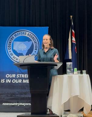
Dr Amanda Cohn MLC Greens spokesperson for health
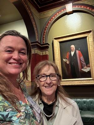
Mayor Sarah Ndiaye and Minister Janelle Saffin
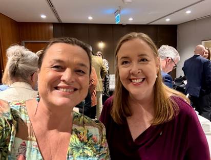
Mayor Sarah Ndiaye and Minister Jenny Aitchison
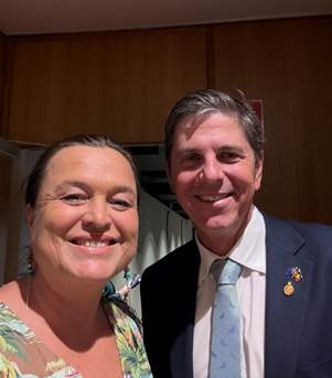
Mayor Sarah Ndiaye and Dave Layzell MP, Shadow Minister for Regional Transport and Roads
Signed: Cr Sarah Ndiaye
Delegates' Reports 12.3
Delegate's Report No. 12.3 The Remix Byron Event
File No: I2025/737
I had the pleasure of speaking at The Remix event on Wednesday 14 May, organised by Michelle and her team. Despite some personal uncertainty on the day, it turned out to be an energising and thought-provoking evening.
The event brought together a diverse group of participants - from those working in local government and funding to experts in regeneration, energy, and tech startups. The panel offered a wide range of perspectives on the future of our region in the context of climate, innovation, and community resilience.
What stood out most was the atmosphere in the room: thoughtful, curious, and genuinely open to collaboration. Events like these are not only about sharing ideas but about building the networks and momentum we need to move forward together.
My thanks to Michelle and all involved for creating such a valuable space for dialogue and connection.
Michelle Williams - The Remix Byron Founder and MD, Auden Fiskerud- Energylab, Elena Klonsky – Regen Ventures, Mitra Ardron – Natural Innovation
Michelle Williams, Mayor Sarah Ndiaye, Catherine Kerr-Department of Climate Change, Energy, The Environment and Water NSW Government
Signed: Cr Sarah Ndiaye
Delegates' Reports 12.4
Delegate's Report No. 12.4 Richmond Tweed Regional Library Meeting held 14 May 2025
File No: I2025/739
I attended the Richmond Tweed Regional Library meeting on 14 May 2025, held at the Lismore Library. The meeting discussed the following:
1. New RTRL Business Manager:
Courtney Brown (based in Lismore) introduced plans for paid, on-the-job training for library staff – a shift towards more practical and supportive upskilling.
2. Library Updates:
- Byron Bay: New children’s furniture funded by Friends of the Library; 73% of programs focused on kids; new RFID chutes installed in Mullumbimby and Brunswick Heads.
- Lismore: New library opened 3 Feb; 20% rise in visits; official launch planned for Sept/Oct with the State Arts Minister.
- Ballina: “The Social Circle” for seniors is popular, with a focus on current affairs and community engagement.
- Tweed: New children’s e-book collections have boosted membership.
3. Finance:
Efficiency measures have led to a budget surplus; discussions underway on how best to use it.
4. Governance Review:
A major review of RTRL’s governance, financial structure, and service levels is scheduled, with results to be discussed at the 9 July 2025 RTRL Committee meeting. Under the current Deed of Agreement, Lismore Council remains the executive body until June 2027.
Signed: Cr Janet Swain
Delegates' Reports 12.5
Delegate's Report No. 12.5 Visit to The Buttery – 50th Anniversary Celebration
File No: I2025/731
I recently had the privilege of attending and speaking at the 50th anniversary celebration of The Buttery, a long-standing and vital organisation in our region supporting individuals and families affected by addiction.
For five decades, The Buttery has provided life-changing support and rehabilitation services to those facing some of the most challenging circumstances. The impact of addiction is far-reaching, and The Buttery plays a critical role in helping not just individuals, but also families and the broader community to heal and rebuild.
The event included powerful stories from current residents, a tour of the facility, and an overview of the organisation’s evolving programs—including important and ongoing work in Reconciliation and cultural inclusion.
The value of The Buttery’s work cannot be overstated. I encourage anyone who can to support their efforts. More information, including how to donate, is available at: www.buttery.org.au/donate
Signed: Cr Sarah Ndiaye
Delegates' Reports 12.6
Delegate's Report No. 12.6 Byron Town Centre Drainage Works
File No: I2025/733
I recently met on-site in the Byron Town Centre with Minister Tara Moriarty, Council staff, and Anthony Pangallo from the Byron Bay Masterplan Guidance Group to discuss the upcoming major drainage works planned for the area.
These works are essential to reducing flash flooding and improving local stormwater treatment outcomes. However, it is clear that additional funding beyond what is currently allocated will be needed to deliver the project to the standard our community expects and deserves.
![]() I
appreciated the opportunity to walk through the area and explain the scope and
significance of the project directly to the Minister, with support from staff
and the Masterplan team.
I
appreciated the opportunity to walk through the area and explain the scope and
significance of the project directly to the Minister, with support from staff
and the Masterplan team.
![]()
Mayor Sarah Ndiaye with A view of the old canal that ran along Byron
Minister Tara Moriarty Street in front of the Great Northern
Signed: Cr Sarah Ndiaye
Delegates' Reports 12.7
Delegate's Report No. 12.7 Delivery Program and Operational Plan (DP/OP) Information Session
File No: I2025/818
Cr Lowe, Cr Kay, Cr Dods and I attended the first of the recent Delivery Program and Operational Plan (DP/OP) information sessions. It was an incredibly informative session, with all the Directors present and available to answer questions and provide detailed explanations about Council’s plans for the upcoming financial year.
A big thank you to the members of the public who attended both the in-person and online (second) sessions. The questions asked were thoughtful and valuable, helping to highlight key areas of interest and concern within our community. It’s just a shame that more people weren’t able to attend – these sessions offer a great opportunity to better understand how Council operates, what’s planned, and how individuals can have input into decision-making processes.
Council’s draft Operational Plan for 2025/26 was on public exhibition until 8 June 2025. The Plan outlines all proposed activities for the financial year, including the draft Budget Estimates and the Statement of Revenue Policy (which details fees and charges). It will come back to the 30th of June meeting for adoption.
![]() We encourage everyone to take a look and have their say by
visiting: www.byron.nsw.gov.au/DPOP
We encourage everyone to take a look and have their say by
visiting: www.byron.nsw.gov.au/DPOP
![]()
Signed: Cr Sarah Ndiaye
Delegates' Reports 12.8
Delegate's Report No. 12.8 Special Entertainment Precinct Planning Meeting with Minister Graham’s Office
File No: I2025/801
On Thursday 22 May, I attended a productive meeting focused on the future of the proposed Special Entertainment Precinct. While Minister Graham was unable to attend due to Transport disruptions in Sydney we had a constructive discussion with his team about both the opportunities and concerns associated with the precinct’s development, particularly in the context of revitalising our local economy and enhancing the vibrancy of our town centres.
The overarching goal is clear: to reinvigorate our towns with a diverse, inclusive and accessible mix of cultural and creative offerings that reflect our region’s unique character. This isn't about expanding the "booze economy" or increasing noise levels—on the contrary, there's widespread recognition that our community wants more than late-night venues. We’re advocating for thoughtful, family-friendly, and socially inclusive spaces that offer something for everyone—regardless of age, background or socioeconomic status.
We acknowledged that some community members have expressed concerns about the Special Entertainment Precinct—particularly around noise, anti-social behaviour, and the potential impact on residential amenity. These are valid concerns and are being taken seriously. Our goal is to ensure that any activation is balanced with careful planning, high-quality sound design, and infrastructure improvements such as better lighting and public safety measures.
A number of initiatives are in development or under discussion:
· On-Demand Bus Services to improve access to and from entertainment hubs, especially for families, young people, and those without private transport.
· A Global Development Application Strategy (Global DAS) to streamline the planning process and reduce the regulatory burden on businesses, while still maintaining strong oversight.
· The Open Streets Program, which would support regular, community-focused events such as twilight markets, local music showcases, art installations, and interactive play zones for children and families.
· The Safe Cities Program, featuring community-led lighting installations, creative use of public spaces, and curated public art to foster a sense of belonging, safety and pride of place.
These programs are designed to support local businesses, artists and creatives, and to make our towns more inviting for locals to return and re-engage with their own main streets.
Minister Graham’s team shared some helpful case studies, including successful early activation work in Wollongong using the Global DAS model. We were encouraged to:
· Engage early with Transport authorities.
· Share local case studies that illustrate the challenges unique to regional and coastal communities like ours.
· Build a broader community of practice around precinct activation—collaborating across councils, state agencies, artists, and residents.
While there are currently no open grants specific to this work, we do have access to planning support and other capacity-building resources that will assist in the early stages of development.
A formal community consultation process will begin later this year. We’ll also be reviewing outcomes from the Transport Community Feedback Session held in August 2024 to ensure that community voices are embedded in the precinct planning process from the outset.
The meeting was attended by the General Manager, Director of Sustainable Environment and Economy and Deputy Mayor, Jack Dods - which of course, he did by choice once I made the opportunity available to him.
Signed: Cr Sarah Ndiaye
Delegates' Reports 12.9
Delegate's Report No. 12.9 Short-Term Rental Accommodation (STRA) and Housing Affordability
File No: I2025/802
I recently met with Airbnb to discuss a range of issues related to short-term rental accommodation (STRA) and its impact on housing availability in our region. They have been requesting a meeting since the first days I became mayor. The conversation covered key challenges around compliance, regulation, and the broader effect of STRA on local housing.
One major concern raised was the ongoing limitations of the STRA register. While the register is intended to support transparency and enforcement, it currently lacks the detail and accuracy needed to provide a full picture of activity in the market. A council workshop is scheduled for next month to further examine these issues and explore strategies to strengthen oversight and accountability.
Airbnb outlined some of its work in the area of compliance, but the reality remains: local councils currently have limited access to granular data, making enforcement difficult. This lack of visibility has reinforced our community’s commitment to protecting housing for residents and maintaining firm control over the expansion of unregulated holiday letting.
It is essential that platforms like Airbnb understand the strong and unified stance our community has taken. We will continue to do everything in our power to uphold the existing 60-day cap on un-hosted STRA properties and to prevent further loss of permanent housing stock to the short-term rental market.
We also discussed Byron Shire’s broader tourism strategy. Our region is already well-serviced by approved hotels and tourism infrastructure. Planning studies completed by our Sustainable Environment and Economy team, including recent work on density and residential land use, will continue to guide responsible development that balances tourism with housing needs.
The ASTRA report was also raised during the discussion. While this report reflects some sector-specific trends, it is important to note that its findings are heavily weighted toward professional operators and may not fully represent the local situation.
Ultimately, the priority for our region remains clear: ensuring that housing is available and affordable for those who live and work here. The community’s resolve is strong, and we remain firmly committed to upholding regulations that support that goal. The meeting was attended by the General Manager, Director of Sustainable Environment and Economy and Deputy Mayor, Jack Dods - which of course, he did by choice once I made the opportunity available to him.
Signed: Cr Sarah Ndiaye
Delegates' Reports 12.10
Delegate's Report No. 12.10 Byron Bay 24-Hour Economy Roundtable
File No: I2025/819
This week we had the pleasure of welcoming Michael Rodrigues, NSW’s 24-Hour Economy Commissioner, to Byron Bay for a relaxed dinner and roundtable chat. The evening brought together people from the Byron Bay Chamber of Commerce, the Liquor Accord, Council, festivals and events, local businesses, and community leaders like Chris Hanley.
The vibe was warm and open, with a focus on what makes Byron special—and how we can make it even better, especially when it comes to the night-time economy. We talked about the tools available through the Commission, community concerns, and opportunities to shape a safer, more inclusive and vibrant Byron for both locals and visitors.
Some key takeaways:
• The idea of the Special Entertainment Precinct came up often—not just about nightlife, but how we activate our streets and public spaces. Think better lighting, more coordination of buskers, streamlined small scale event approvals, and family-friendly spaces.
• There was strong interest in shifting the focus away from alcohol-heavy venues to more diverse offerings—like coffee spots open early for sunrise walks, beachside Pilates, or small venues for poetry and film nights. The bigger venues already cater to those who love that and there is enough of them to cater to our local and visitor economy.
• One thing that really stood out is how much Byron needs better transport options. Getting around, especially at night, is a real challenge and came up again and again as a barrier for people wanting to participate in local life.
It was a dynamic and hopeful conversation, and I think it’s just the beginning. Big thanks to everyone who came along—and especially to the Commissioner for taking the time to really listen. There’s so much potential here if we work together to do it our way, the Byron way.
Signed: Cr Sarah Ndiaye
Delegates' Reports 12.11
Delegate's Report No. 12.11 Supporting Spontaneous Volunteers Meeting
File No: I2025/821
On Tuesday, I had the privilege of attending a regional coordination meeting for recipients of the NSW Reconstruction Authority’s Supporting Spontaneous Volunteers Program (SSVP). The meeting brought together representatives from Community Services, grassroots community groups, volunteer organisations, local councils, and the NSW Reconstruction Authority.
The purpose of the meeting was to share project goals, timelines, and deliverables, and to identify opportunities for regional collaboration and support. Byron Shire Council is one of the successful recipients of this program and has been awarded $100,000 to help strengthen our local capacity to support spontaneous volunteers—community members who step up during emergencies without formal affiliation to response organisations.
As we’ve seen during the 2022 floods and more recently in the aftermath of Tropical Cyclone Alfred, these volunteers play an indispensable role in community recovery. However, without a cohesive coordination framework, their efforts can be difficult to integrate safely and effectively. This program begins to address some of this gap by supporting communities to be better prepared, supported, and mobilised during times of crisis.
The meeting reinforced just how much knowledge and goodwill exists across our region, and how essential grassroots and local knowledge is in disaster response. It also highlighted ongoing gaps in the system that require stronger state-level support and reform.
While the SSVP grant is a positive step forward, broader, long-term improvements are still needed in the resilience and recovery space. These include:
· Permanent
Resilience and Recovery Staffing
Councils need permanent, embedded roles to maintain continuity, relationships,
and local knowledge. This was strongly validated during the TC Alfred response.
· Strategic
Coordination of Spontaneous Volunteers
Short-term grants are a start, but the region needs a comprehensive, long-term
strategy. We are calling on the NSW Reconstruction Authority to take a lead
coordination role, especially for post-disaster clean-up activities like
‘muck and gut’ operations.
· Proper
Resourcing of Response and Recovery Agencies
Agencies such as SES and RFS should be adequately resourced to coordinate
spontaneous volunteers during the response phase, and NSWRA in the recovery
phase.
· Inclusion
in Disaster Recovery Funding Arrangements (DRFA)
Spontaneous Volunteer Coordination should be eligible for DRFA reimbursement,
ensuring organisations can act quickly and responsibly without being
financially penalised.
· Improved
Emergency Evacuation Centre (EEC) Support
Evacuation centres need better planning, resourcing, and coordination. Mental
health support, security, and clear messaging must be consistently provided.
· Housing
Resilience
Greater investment in social and affordable housing and temporary
accommodation is essential to protect people in the immediate aftermath of
disasters.
· Support
for Rough Sleepers
We need dedicated funding and planning to support rough sleepers during severe
weather events. For example, local faith-based groups are willing to assist
with wet weather shelters but require financial support to operate effectively.
· Preparedness
for Vulnerable People
Disaster preparedness must include targeted planning for vulnerable
populations, such as assistance with evacuations, interpreting warnings, and
accessing supplies.
Next Steps
The Council SSVP project is currently in its early stages of implementation. Council staff are in the process of developing the scope of the grant-funded activities and will provide a more detailed update to Councillors in due course.
This was timed well as it was also WOW week where we celebrate community volunteers. I extend my deepest thanks to all community volunteers and grassroots groups who continue to be the foundation of our local resilience. Your time, energy, and care make all the difference.
Volunteer Community Resilience Hub groups (CHUBS) are based throughout many of the locales in our Shire. If you’re interested in joining your local CHUB group, and becoming part of this vital network of community support, you can find more information here: Byron Shire Community Resilience Networks - Byron Shire Council
Let’s continue working together to build a safer, more resilient Northern NSW.
Signed: Cr Sarah Ndiaye
Delegates' Reports 12.12
Delegate's Report No. 12.12 Rous County Council - Summary of main items of business 16 April 2025
File No: I2025/834
Notice of Motion to fully fund the $150M, 15-year Northern Rivers Watershed Initiative (NRWI) Program.
The Northern Rivers Watershed Initiative (NRWI) is a catchment and estuary restoration program devised for the Northern Rivers Joint Organisation (NRJO) footprint to address ecosystem health, water security and flood risk issues across the Tweed, Brunswick, Richmond and Evans River systems.
In 2024, Hon Janelle Saffin MP secured $5M for the implementation of a package of shovel-ready works, to be completed by Rous and the project partners by October 2026.
Cr. Sharon Cadwallader moved a Notice of Motion that Council write to and lobby the:
1. Hon. Janelle Saffin, MP, Minister for the North Coast;
2. Hon. Tara Moriarty, MLC, Minister for Agriculture;
3. Hon. Penny Sharpe, MLC, Minister for the Environment; and,
4. Hon. Tamara Smith, MP,
to fully fund the $150M, 15-year Northern Rivers Watershed Initiative (NRWI) Program, highlighting the early signs of effectiveness and to build upon the growing momentum, which when put to a vote the motion was approved.
Reports to Council
· Quarterly Budget Review Statement (at 31 March 2025)
· Draft Integrated Planning and Reporting Framework (incorporating the 2025/26 Budget and Statement of Revenue policy) – adjustments will be included in the Framework on public exhibition for 28 days
· Reappointment of Independent Voting Member – Audit, Risk, and Improvement Committee
· Direct engagement of NSW Soil Conservation Service to restore Bungawalbin Levee
Audit, Risk and Improvement Committee
Audit, Risk and Improvement Committee Council endorsed the reappointment of Andrew MacLeod as Independent Voting Member for a term of four (4) years, which has also been supported by the Committee Chair and the General Manager.
Members may be appointed for two consecutive four (4) year terms. This will be the final consecutive term that Andrew MacLeod will be eligible to serve as a member of the Audit, Risk and Improvement Committee.
Council received and noted the resignation of the Committee Chair and approach to seeking a replacement for the position.
NSW Soil Conservation Service to restore Bungawalbin Levee
Bungawalbin Levee is an earthen flood mitigation asset of Council, located between Woodburn and Coraki in the Richmond Valley Local Government Area, which was damaged during the 2022 floods.
Rous received $6.9M from the Natural Disaster Relief Assistance Program to restore Bungawalbin Levee to its pre-2022 flood condition.
To complete the project by June 2026 (with a possible extension to February 2027), activities need to be outsourced. The NSW Soil Conservation Service (Soil Con) has been identified as a suitable provider, who has the expertise and capacity to deliver the on-ground restoration of Bungawalbin Levee.
Their engagement will also increase the value for money and maximise the benefit to the local community and follows on from their successful completion of other major programs on the floodplain which has earned them the respect of local landowners.
The value of the work exceeds the delegation of the General Manager, and Council approved authorisation for the General Manager to negotiate a contract with Soil Con to complete the work.
Policy Reviews
1. On exhibition: Local Approvals Policy – Water Supply – Retail Customers (for 49 days)
The new policy outlines circumstances in which Rous will allow retail customers to connect directly to its supply network. This is supported by the new Standards and Conditions of Retail Water Supply with mandatory conditions including smart meters and requirements for backflow prevention.
2. On exhibition: Water Account Assistance policy (for 28 days)
Among the proposed changes, the policy will make provision for financial assistance for low-income customers and not-for profit organisations whereby the Backflow Device Management Change may be reduced to 75% of the standard annual charge ($196/annum).
3. On exhibition: Debt Management and Financial Hardship policy (for 28 days)
4. Council adopted: Fraud and Corruption Control policy
Reports
Council received and noted various information reports including:
· Investments – February 2025
· Investments – March 2025
· Gallans Road update – 31 March 2025
· Audit Risk and Improvement Committee – meeting updates
· Actions Pending
o Proposed Dunoon Dam – acquisition of properties
o Update on interim arrangements for Lismore Levee Scheme
For a copy of the agenda for the meeting click here: https://rous.nsw.gov.au/about/business-papers- minutes/
Signed: Cr Sarah Ndiaye
Staff Reports - General Manager 13.1
Staff Reports - General Manager
Report No. 13.1 Licencing for 18 Fletcher Street, Byron Bay (Fletcher St Cottage)
Directorate: General Manager
Report Author: Lyndal Brennan, Leasing Coordinator
File No: I2025/448
Summary:
This report considers options for the future licensing of the Council-owned building at 18 Fletcher Street, Byron Bay.
RECOMMENDATION:
That Council:
1. Authorises the General Manager to negotiate and grant a licence on terms consistent with this report to the Byron Bay Community Association Incorporated (BCC) to occupy the building at 18 Fletcher Street, Byron Bay (Cottage) for the purpose of providing the ‘homelessness services hub’.
2. Notes that if a licence is agreed, it would start immediately after the BCC’s current licence to occupy the Cottage ends on 7 May 2026.
3. Notes that the Cottage’s annual, market rent is valued at about $60,000, which the BCC will not pay under the proposed licence.
4. Notes that the forgone annual rent will be covered via a dividend or community service obligation contribution by Council’s water fund.
Report
The Council-owned building at 18 Fletcher Street, Byron Bay, is part of the town’s central business district.
The building is known colloquially as Fletcher Street Cottage (the Cottage).
The Cottage is currently occupied by the Byron Community Centre (BCC).
The BCC occupies the Cottage for the purpose of providing a ‘homelessness services hub’.
The BCC commenced its occupation in 2021. This was after a Council public expression of interest (EOI) about the Cottage’s use. The BCC was the only EOI respondent.
The BCC’s current Cottage licence expires on 6 May 2026.
The BCC has approached Council about the former continuing to occupy the Cottage after May 2026.
Since the BCC’s approach, other not-for-profit organisations have also expressed an interest to Council in using the Cottage to support local people experiencing, or at risk of, homelessness.
Given this, Council needs to decide whether to:
1. Negotiate solely with the BCC for the purpose of continuing its Cottage occupation beyond May 2026; or
2. Determine the Cottage’s post-2026 occupant via another expression of interest (EOI).
Each of these options is considered below.
Option one – Directly negotiate further licence with BCC
This option would continue to support the provision of homelessness services to the community through a known licensee and service provider. BCC has delivered valuable homelessness and related services to the community through the site.
BCC’s current licence conditions are centred around service design, review and reporting. These requirements would be reviewed and updated for a subsequent licence.
During the existing licence term, BCC also partnered with Creative Capital to make improvements to the site above and beyond what Council resourcing could achieve.
The improvements have helped with service delivery to community members and contributed to asset renewal.
Alongside the benefits noted above, this option also comes with trade-offs.
The BCC currently pays a nominal licence fee for the Cottage of just a few hundred dollars a year. The opportunity cost of this is the potential market rent for the Cottage, which is valued at about $1,200 a week.
Meanwhile, despite its fundraising and volunteering efforts, BCC’s service provision has been constrained during the current licence due to a lack of resources.
This has reduced the Cottage’s opening hours and days. Currently, the Cottage is open Tuesday-Friday mornings, plus one weekly session from 1-3pm for women only.
This means the Cottage’s potential community benefit is not what it could be.
This may change if BCC receives funding through the upcoming Specialist Homelessness Service Recommissioning (due in July 2026), or other revenue sources. But this can’t be guaranteed.
BCC initially approached Council seeking a 30-year term. The BCC subsequently revised this down to a 20-year licence term. Staff advised that a long-term licence wasn’t a reasonable response to the above context.
Instead, the proposed new licence for the BCC would:
· Run for five years.
· Provide the opportunity for a further five-year licence.
· Be subject to the provision of certain service levels.
· Provide for the licence fee to be reasonably reviewed.
The proposed five-year licence from May 2026 also aligns with the strategic asset planning currently underway across Council.
Option two – expression of interest (EOI)
Under option two, Council would test interest in the Cottage’s occupation after May 2026.
This testing isn’t mandatory. This is because the Cottage is classified as Council operational land. Council is generally free to deal with its operational land at it chooses.
The reason to test the Cottage’s demand anyway is due to Council’s broader commitment to the transparent use of public assets like the Cottage
Public testing would provide an opportunity for other not-for-profit service providers to make their case to occupy the Cottage and demonstrate how they can best deliver services that help people experiencing, or at risk of, homelessness.
If a new service provider was granted a Cottage licence, this may increase the services available to local people experiencing homelessness.
The trade-off of an EOI is that it may only be of marginal benefit in this context. This is because an EOI for the Cottage wouldn’t be seeking interest in using the site for any purpose. It would only be seeking interest in the site for the purpose of providing homelessness services.
Because these services are only provided by non-profits, the opportunity cost of the foregone rent is likely the same via an EOI.
There is also no guarantee an EOI would lead to superior services being provided relative to the status quo.
BCC recommended
Given the BCC’s largely successful occupation of the Cottage since 2021, and that Council isn’t looking to change the Cottage’s use, it is recommended that Council authorises the General Manager to negotiate with BCC for a licence for the latter to provide homelessness services from May 2026.
|
CSP Objective |
CSP Strategy |
DP Action |
Code |
OP Activity |
|
1: Effective Leadership |
1.5: Empower community leadership through collaboration, capacity building, and cultivating community driven initiatives |
1.5.2: Collaboration and capacity building - Collaborate with stakeholders to build community capacity |
1.5.2.3 |
Establish and maintain leasing and licensing arrangements to ensure the tenure of Council owned and controlled assets |
s55 of the Local Government Act provides that requirements for tendering do not apply to contracts where, “(e) a contract for the leasing or licensing of land by the council, other than the leasing or licensing of community land for a term exceeding 5 years to a body that is not a non-profit organisation (see section 46A)”
Council’s Leasing and Licensing Policy states that the leasing and licensing of Council land and facilities aims to provide public assets that are well managed and maintained, while also ensuring that interests are granted transparently (section 4.1).
Council is currently reviewing its approach to both unsolicited approaches and lease and licence renewals. This work will continue throughout next financial year.
BCC pays the Crown minimum rent with an annual inflation adjustment under its current licence. The Crown minimum rent is $609 a year.
The Cottage’s nominal market rent value is $60,300 (ex-GST) a year.
This amounts to a current subsidy of $59,691 annually. The total subsidy on the current licence by May 2026 will be $298,455.
Another five-year licence to BCC from May 2026, along with a subsequent five-year renewal, would require a further $596,910 subsidy.
Internal: Corporate and Community Services; Legal, Leasing and Licensing and Director Infrastructure Services.
External: Valuer, Byron Bay Community Association Incorporated.
Staff Reports - Corporate and Community Services 13.2
Staff Reports - Corporate and Community Services
Report No. 13.2 Council Investments - 1 May 2025 to 31 May 2025
Directorate: Corporate and Community Services
Report Author: James Brickley, Manager Finance
File No: I2025/840
Summary:
This Report includes a list of investments and identifies Council’s overall cash position for the period 1 May 2025 to 31 May 2025 for information.
This Report is prepared to comply with Section 212 of the Local Government (General) Regulation 2021.
RECOMMENDATION:
That Council notes the report listing Council’s investments and overall cash position as of 31 May 2025.
Council has continued to maintain a diversified portfolio of investments. As of 31 May 2025, the average 90-day bank bill rate (BBSW) for the month was 3.73%. Council’s performance for May 2025 was 4.48%. Performance higher than the BBSW indicates that Council earned a better return on its short-term investments compared to the market average.
The table below identifies the investments held by Council as at 31 May 2025.
Schedule of Investments held as at 31 May 2025
|
Purch Date |
Principal ($) |
Description |
CP* |
Rating |
Maturity Date |
Fossil Fuel |
Type |
Int. Rate |
Current Value ($) |
|
15/11/18 |
1,000,000.00 |
NSW Treasury Corp (Green Bond) |
N |
AAA |
15/11/28 |
N |
B |
3.00% |
964,560.00 |
|
28/03/19 |
1,000,000.00 |
National Housing Finance & Investment Corporation |
Y |
AAA |
28/03/29 |
N |
B |
2.38% |
939,650.00
|
|
27/11/19 |
500,000.00 |
National Housing Finance & Investment Corp |
Y |
AAA |
27/05/30 |
N |
B |
1.52% |
439,808.50
|
|
15/06/21 |
500,000.00 |
National Housing Finance & Investment Corp |
Y |
AAA |
01/07/31
|
N |
B |
1.99% |
499,681.02
|
|
06/09/21 |
1,000,000.00 |
Northern Territory TCorp |
N |
Aa3 |
15/12/26 |
N |
B |
1.40% |
1,000,000.00 |
|
16/09/21 |
1,000,000.00 |
QLD Treasury Corp (Green Bond) |
N |
AA+ |
02/03/32 |
N |
B |
1.83% |
815,320.00 |
|
30/10/23 |
850,000.00 |
Bank Australia Ltd |
P |
BBB+ |
30/10/26 |
N |
FRN |
5.84% |
857,595.39 |
|
21/02/24 |
500,000.00 |
Bank Australia Ltd |
N |
BBB+ |
21/02/28 |
N |
FRN |
6.04% |
507,194.93 |
|
12/05/25 |
5,000,000.00 |
Bank of QLD |
P |
A- |
12/11/25 |
N |
TD |
4.45%
|
5,000,000.00 |
|
27/11/24 |
1,000,000.00 |
Westpac Tailored |
P |
AA- |
27/11/25 |
N |
TD |
5.08% |
1,000,000.00 |
|
02/12/24 |
5,000,000.00 |
NAB |
P |
AA- |
02/06/25 |
Y |
TD |
5.10% |
5,000,000.00 |
|
05/12/24 |
5,000,000.00 |
Bank of QLD |
N |
A- |
03/06/25 |
N |
TD |
5.18% |
5,000,000.00 |
|
03/01/25 |
1,000,000.00 |
Bank of QLD |
N |
A- |
03/07/25 |
N |
TD |
5.00% |
1,000,000.00 |
|
03/01/25 |
2,000,000.00 |
MyState Bank |
P |
BBB |
07/07/25 |
N |
TD |
5.00% |
2,000,000.00 |
|
30/01/25 |
1,000,000.00 |
AMP Bank |
P |
BBB+ |
29/07/25 |
Y |
TD |
5.05% |
1,000,000.00 |
|
19/02/25 |
2,000,000.00 |
Judo Bank |
N |
BBB- |
20/08/25 |
N |
TD |
4.70% |
2,000,000.00 |
|
03/03/25 |
2,000,000.00 |
NAB |
N |
AA- |
02/06/25 |
Y |
TD |
4.70% |
2,000,000.00 |
|
04/03/25 |
2,000,000.00 |
Beyond Bank |
P |
BBB |
02/09/25 |
N |
TD |
4.70% |
2,000,000.00 |
|
04/03/25 |
2,000,000.00 |
Beyond Bank |
N |
BBB |
03/06/25 |
N |
TD |
4.65% |
2,000,000.00 |
|
04/03/25 |
2,000,000.00 |
Judo Bank |
N |
BBB- |
03/06/25 |
N |
TD |
4.65% |
2,000,000.00 |
|
12/03/25 |
1,000,000.00 |
Auswide Bank |
P |
BBB |
10/06/25 |
N |
TD |
4.65% |
1,000,000.00 |
|
17/03/25 |
2,000,000.00 |
NAB |
N |
AA- |
16/06/25 |
Y |
TD |
4.70% |
2,000,000.00 |
|
18/03/25 |
2,000,000.00 |
NAB |
N |
AA- |
16/06/25 |
Y |
TD |
4.75% |
2,000,000.00 |
|
19/03/25 |
2,000,000.00 |
Auswide Bank |
N |
BBB |
18/06/25 |
N |
TD |
4.70% |
2,000,000.00 |
|
21/03/25 |
2,000,000.00 |
Judo Bank |
N |
BBB- |
20/06/25 |
N |
TD |
4.70% |
2,000,000.00 |
|
03/04/25 |
2,000,000.00 |
Bank of QLD |
N |
A- |
03/10/25 |
N |
TD |
4.80% |
2,000,000.00 |
|
10/04/25 |
5,000,000.00 |
MyState Bank |
N |
BBB |
09/10/25 |
N |
TD |
4.80% |
5,000,000.00 |
|
07/04/25 |
2,000,000.00 |
NAB |
N |
AA- |
07/07/25 |
Y |
TD |
4.70% |
2,000,000.00 |
|
07/04/25 |
5,000,000.00 |
NAB |
N |
AA- |
07/07/25 |
Y |
TD |
4.70% |
5,000,000.00 |
|
14/04/25 |
5,000,000.00 |
Judo Bank |
N |
BBB- |
14/07/25 |
N |
TD |
4.60% |
5,000,000.00 |
|
14/04/25 |
1,000,000.00 |
NAB |
N |
AA- |
14/07/25 |
Y |
TD |
4.60% |
1,000,000.00 |
|
17/04/25 |
1,000,000.00 |
Judo Bank |
N |
BBB- |
16/07/25 |
N |
TD |
4.60% |
1,000,000.00 |
|
28/04/25 |
1,000,000.00 |
NAB |
N |
AA- |
28/07/25 |
Y |
TD |
4.50% |
1,000,000.00 |
|
01/05/25 |
1,000,000.00 |
AMP Bank |
N |
BBB+ |
05/08/25 |
Y |
TD |
4.35% |
1,000,000.00 |
|
19/05/25 |
1,000,000.00 |
AMP Bank |
N |
BBB+ |
20/10/25 |
Y |
TD |
4.50% |
1,000,000.00 |
|
21/05/25 |
1,000,000.00 |
Judo Bank |
N |
BBB- |
20/08/25 |
N |
TD |
4.30% |
1,000,000.00 |
|
N/A |
19,205,637.99
|
CBA Business Saver |
P |
AA- |
N/A |
Y |
CALL |
4.10% |
19,205,637.99
|
|
N/A |
211,379.47
|
CBA Business Saver – Tourism Infrastructure Grant |
N |
AA- |
N/A |
Y |
CALL |
4.10% |
211,379.47
|
|
N/A |
1,948,950.89
|
Macquarie Accelerator Call |
P |
A |
N/A |
Y |
CALL |
4.15% |
1,948,950.89
|
|
Total |
91,715,968.35 |
|
|
|
|
|
AVG |
4.48% |
91,389,778.19 |
|
Note 1. |
CP = Capital protection on maturity |
|||
|
|
|
|||
|
|
N = No Capital Protection |
|||
|
|
Y = Fully covered by Government Guarantee |
|||
|
|
P = Partial Government Guarantee of $250,000 (Financial Claims Scheme) |
|||
|
|
|
|||
|
Note 2. |
Fossil Fuel ADI |
|||
|
|
N = No investment in Fossil Fuels |
|||
|
|
Y = Investment in Fossil Fuels |
|||
|
|
U = Unknown Status |
|||
|
|
|
|
|
|
|
|
|
|
|
|
|
Note 3. |
Type |
Description |
|
|
|
|
B |
Bonds |
Principal can vary based on valuation, interest payable via a fixed interest, payable usually each quarter. |
|
|
|
FRN |
Floating Rate Note |
Principal can vary based on valuation, interest payable via a floating interest rate that varies each quarter. |
|
|
|
TD |
Term Deposit |
Principal does not vary during investment term. Interest payable is fixed at the rate invested for the investment term. |
|
|
|
CALL |
Call Account |
Principal varies due to cash flow demands from deposits/withdrawals. Interest is payable on the daily balance. |
|
Environmental and Socially Responsible Investing (ESRI)
An additional column has been added to the schedule of Investments to identify if the financial institution holding the Council investment has been assessed as a ‘Fossil Fuel’ investing institution. This information has been sourced through www.marketforces.org.au and identifies financial institutions that either invest in fossil fuel related industries or do not. The graph below highlights the percentage of each classification across Council’s total investment portfolio in respect of fossil fuels only.
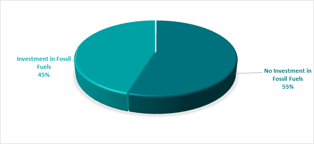
The notion of Environmental and Socially Responsible Investing is much broader than whether a financial institution as rated by ‘marketforces.org.au’ invests in fossil fuels or not. Council’s current Investment Policy defines Environmental and Socially Responsible Investing at Section 4.1 of the Policy which can be found on Council’s website.
Council may from time to time have an investment with a financial institution that invests in fossil fuels but is nevertheless aligned with the broader definition of Environmental and Socially Responsible investments. When this occurs, the investment will be marked as no fossil fuels given the investment purpose.
During the month of November 2024 as an example, Council undertook a reinvestment with Westpac Bank as a tailored deposit. The investment proceeds are utilised for environmental purposes as this investment in Climate Bond Ceritifed.
With the lifting of the NSW Treasury Corporation loan borrowing covenant on Council’s investments, growth has recommenced in acquiring investments not aligned with fossil fuels. Council’s portfolio reached its lowest point in August 2023 at 15% and as at 31 May 2025, the portfolio has been stable and is currently at 55%.
Investment Policy Compliance
The below table identifies compliance with Council’s Investment Policy by the proportion of the investment portfolio invested with financial institutions, along with their associated credit ratings compared to parameters in the Investment Policy. The parameters are designed to support prudent short and long-term management of credit risk and ensure diversification of the investment portfolio. Note that the financial institutions currently offering investments in the ‘ethical’ area are still mainly those with lower credit ratings (being either BBB or not rated at all i.e., credit unions).
The investment portfolio is outlined in the table below by investment type for the period 1 May 2025 to 31 May 2025:
|
Investment policy compliance |
|
|
||
|
% should not exceed the following |
ACTUAL |
|
||
|
|
|
|
|
|
|
AAA to AA |
A1+ |
100% |
50% |
Meets policy |
|
A+ to A- |
A1 |
60% |
16% |
Meets policy |
|
BBB to NR |
A2,NR |
40% |
34% |
Meets policy |
Dissection of Council Investment Portfolio as at 31 May 2025
|
Principal Value ($) |
Investment Linked to: |
Current Market Value ($) |
Cumulative Unrealised Gain/(Loss) ($) |
|
64,000,000.00 |
Term Deposits |
64,000,000.00 |
0.00 |
|
19,205,637.99 |
CBA Business Saver |
19,205,637.99 |
0.00 |
|
211,379.47
|
CBA Business Saver – Tourism Infrastructure Grant |
211,379.47
|
0.00 |
|
1,948,950.89 |
Macquarie Accelerator |
1,948,950.89 |
0.00 |
|
6,350,000.00 |
Bonds/Floating Rate Notes |
6,023,809.84 |
(326,190.16) |
|
91,715,968.35 |
Total |
91,389,778.19 |
(326,190.16) |
Council’s overall ‘cash position’ is not only measured by funds invested but also by the funds retained in its consolidated fund or bank account for operational purposes. The table below identifies Council’s overall cash position for the month of May 2025 as follows:
Dissection of Council’s Cash Position as at 31 May 2025
|
Item |
Principal Value ($) |
Current Market Value ($) |
Cumulative Unrealised Gain/(Loss) ($) |
|
Investments Portfolio |
|||
|
Term Deposits |
64,000,000.00 |
64,000,000.00 |
0.00 |
|
CBA Business Saver |
19,205,637.99 |
19,205,637.99 |
0.00 |
|
CBA Business Saver – Tourism Infrastructure Grant |
211,379.47 |
211,379.47 |
0.00 |
|
Macquarie Accelerator |
1,948,950.89 |
1,948,950.89 |
0.00 |
|
Bonds |
6,350,000.00 |
6,023,809.84 |
(326,190.16) |
|
Total Investment Portfolio |
91,715,968.35 |
91,389,778.19 |
(326,190.16) |
|
Cash at Bank |
|||
|
Consolidated Fund |
3,723,200.40 |
3,723,200.40 |
0.00 |
|
Total Cash at Bank |
3,723,200.40 |
3,723,200.40 |
0.00 |
|
Total Cash Position |
95,439,168.75 |
95,112,978.59 |
(326,190.16) |
Strategic Considerations
Community Strategic Plan and Operational Plan
|
CSP Objective |
CSP Strategy |
DP Action |
Code |
OP Activity |
|
1: Effective Leadership |
1.3: Ethical and efficient management of resources |
1.3.1: Financial Management - Ensure the financial integrity and sustainability of Council through effective financial management |
1.3.1.6 |
Maintain Council's cash flow |
Legal/Statutory/Policy Considerations
In accordance with Section 212 of the Local Government (General) Regulation 2021, the Responsible Accounting Officer of Council must provide Council with a monthly report detailing all monies it has invested under section 625 of the Local Government Act 1993.
The Report must be presented at the next Ordinary Meeting of Council after the end of the month being reported. The current Council Meeting cycle does not always allow this to occur, especially as investment valuations required for the preparation of the report are often received after the deadline for the submission of reports. Endeavours are being made to achieve a better alignment and for some months this will require reporting for one or more months.
Council’s investments are made in accordance with section 625(2) of the Local Government Act 1993 and Council’s Investment Policy. The Local Government Act 1993 allows Council to invest money as per the Minister’s Order – Forms of Investment, last published in the Government Gazette on 11 March 2011.Council’s Investment Policy includes the objective of maximising earnings from authorised investments and ensuring the security of Council Funds.
Financial Considerations
Council uses a diversified mix of investments to achieve short, medium, and long-term results.
Staff Reports - Corporate and Community Services 13.3
Report No. 13.3 Grants June 2025
Directorate: Corporate and Community Services
Report Author: Donna Johnston, Grants Coordinator
File No: I2025/142
Summary:
Council is waiting on determination of 10 Grant Applications which, if successful, would provide funding to enable the delivery of identified projects. This report provides an update on grant applications.
RECOMMENDATION:
That Council notes the Grant Submissions Report for the month of May 2025 (Attachment 1 #E2025/51462).
1 Grants
awaiting determination - as at 20 May 2025, E2025/48452
![]()
Currently Council has 10 grant applications awaiting determination (refer to Grants Submissions as of 29 May 2025 - Attachment 1, E2025/51462.
The following grant announcements were made during May.
|
Funding body |
Funding scheme |
Project name |
Total project |
Amount requested |
Council |
|
Transport for NSW |
Get NSW Active FY2025/26 |
Lighthouse Road Byron Bay– Footpath Connection |
$1,248,800 |
$1,248,800 |
$0 |
|
Funding body |
Funding scheme |
Project name |
Total project |
Amount requested |
Council |
|
NSW Department of Planning, Housing and Infrastructure |
Round 3 – Regional Housing Strategic Planning Fund | Planning |
North Byron Shire Alternative Infill Pilot Program |
$80,000 |
$80,000 |
$0 |
|
Feedback: Program was oversubscribed with 61 applications received. The application could be strengthened with providing further information on the project’s need, impact and urgency. |
|||||
|
Funding body |
Funding scheme |
Project name |
Total project |
Amount requested |
Council |
|
Transport for NSW |
Get NSW Active FY2025/26 |
NRRT Byron Bay to Mullumbimby - Concept Design |
$998,008 |
$998,008 |
$0 |
|
Transport for NSW |
Get NSW Active FY2025/26 |
Byron Street Footpath - Bangalow |
$866,073 |
$866,073 |
$0 |
|
Transport for NSW |
Get NSW Active FY2025/26 |
Station Street, Mullumbimby - footpath |
$539,305 |
$539,305 |
$0 |
|
Feedback: No feedback available at time of report. |
|||||
Upcoming Grant opportunities
Community War Memorials Fund · Office for Veterans Affairs
The purpose of the CWMF is to help conserve, repair and protect war memorials across NSW to support community commemoration, by funding projects that follow best practice conservation principles and processes. The CWMF is targeted at organisations who are responsible for the management of war memorials in NSW.
Staff are working with the Byron Bay RSL Sub-branch to repair the Byron Bay Memorial Gate. The application would be made under Category B for physical works with an estimated cost of repairs at $70,000. If successful, the grant would provide $15,000, Council would match this with $15,000 from the Open Spaces budget and the Byron Bay RSL Sub-branch would also contribute up to $45,000.
|
CSP Objective |
CSP Strategy |
DP Action |
Code |
OP Activity |
|
1: Effective Leadership |
1.3: Ethical and efficient management of resources |
1.3.1: Financial Management - Ensure the financial integrity and sustainability of Council through effective financial management |
1.3.1.9 |
Coordinate grant applications to support the delivery of Council projects and services within management plans, masterplans, strategic plans, council resolutions and high priority actions from feasibility studies; and support the management of successful grants |
Under section 409 3(c) of the Local Government Act 1993 Council is required to ensure that ‘money that has been received from the Government or from a public authority by way of a specific purpose advance or Grant, may not, except with the consent of the Government or public authority, be used otherwise than for that specific purpose’. This legislative requirement governs Council’s administration of Grants.
If Council is successful in obtaining the identified Grants, this would bring funding sought to approximately $37.4 million which would provide significant funding for Council projects. Some of the Grants require a contribution from Council (either cash or in-kind) and others do not. Council’s contribution is funded.
The potential funding is detailed below:
Funding applications submitted and
awaiting notification (total value) $37,370,979
Requested funds from funding bodies $35,010,345
Council contribution cash $2,360,634
Council co-contribution in-kind $147,000
Other contributions $0
Funding determined in May 2025:
Successful
applications
$1,248,800 (total project value)
Unsuccessful/withdrawn
applications
$2,483,386 (total project value)
Cross-organisational consultation has occurred in relation to the submission of relevant grants, and the communication of proposed grant applications.
Staff Reports - Corporate and Community Services 13.4
Report No. 13.4 Section 355 Guidelines Update
Directorate: Corporate and Community Services
Report Author: Cynthia McDermott, Section 355 Strategic Change Project Officer
File No: I2025/530
Summary:
Section 355 of the Local Government Act 1993 allows a council to delegate certain functions to committees of council. Section 355 Committees of Council (s355 Committees) currently manage nine Council facilities which are available for community use. These Committees should operate in accordance with the s355 Committee Guidelines.
Proposed amendments have been made to the s355 Committee Guidelines which require endorsement by Council. These proposed changes relate to use of facilities for disaster preparedness, response and recovery and to hire fee waivers.
The key update is revised wording of clause 7.10 ‘Disaster Preparedness, Response and Recovery’ (currently titled ‘Emergency Management’). The proposed amendments refer to permitted use and permitted users of s355-managed facilities before, during or after a natural disaster. Council’s endorsement of the proposed amendments will enable staff to develop the procedural documentation required for implementation of the amended clause.
A minor update at clause 7.3 provides additional information about hire fee waivers in accordance with a recent resolution of Council (Res 25-135), i.e., in the first instance, requests for fee-waivers should be sought through Council’s ongoing grant programs. This amendment provides information which clarifies Council’s assessment of fee waiver requests.
RECOMMENDATION:
That Council endorses the updated Section 355 Guidelines at Attachment 1 (E2025/53773).
1 DRAFT
Section 355 Committee Guidelines - Halls and Venues - June 2025, E2025/53773 ![]()
Section 355 of the Local Government Act 1993 allows a council to delegate certain functions to Committees of Council. Nine of Council’s community facilities are managed by Section 355 Committees (s355 Committees).
Amendments have been made to the s355 Committee Guidelines and these require endorsement by Council.
Proposed amendment to clause 7.3
A minor update is proposed in accordance with a Council resolution (Res 25-135) regarding requests for hall fee waivers. The following addition is proposed to this section, specifically to state: “In the first instance, facility hire fee waivers should be sought through Council’s ongoing grant programs or other available funding sources.”
Proposed amendments to clause 7.10
The proposed amendments offer the following improvements:
· Change the heading title from ‘Emergency Management’ to ‘Disaster Resilience, Response and Recovery’. This amendment clarifies the breadth of activities that may be covered by the provisions.
· Introduces the terms ‘permitted disaster users’ and ‘permitted disaster uses’. This amendment provides terminology which scopes users and uses.
· Identifies that application to the General Manager is required for a permitted disaster users to gain access to a facility for permitted disaster uses for $0.00 fee, to be decided on a case-by-case basis.
· Establishes that use of a Council facility is still subject to a hall hire agreement in the usual way. This amendment clarifies that the regular process of hall hire agreements, including risk management provisions, must be met.
· States that Council facilities may be closed to all users when required based on advice from emergency management authorities.
If endorsed by Council, staff will develop procedural documentation prior to accepting applications for use in accordance with clause 7.10. This may include:
· Eligibility and evaluation criteria
· Application form
· Amendments to hire agreements and other hire documentation
· Communications materials for Committees and bookings officers
When these materials are developed, staff will provide further advice to Committee members and bookings officers to understand the application of the procedures.
|
CSP Objective |
CSP Strategy |
DP Action |
Code |
OP Activity |
|
1: Effective Leadership |
1.5: Empower community leadership through collaboration, capacity building, and cultivating community driven initiatives |
1.5.3: s355 Committees - Support the management of community halls to delegated s355 committees |
1.5.3.1 |
Support Council volunteers with the management and operation of community halls |
|
4: Ethical Growth |
4.5: Support a resilient community that can adapt and respond to change |
4.5.3: Disaster preparedness - Support and coordinate disaster prevention, preparedness, response and recovery activities |
4.5.3.8 |
Collaborate with community groups across the Shire to enhance capacity for community disaster preparedness, resilience and recovery |
Financial Considerations
To avoid creating a debt in emergency situations, in 2024-25, Council established a hire fee of $0.00 for each facility, specifically designated for use by Council or emergency management authorities. Since it was established, this fee provision has not yet been applied.
If the proposed amendments in this report are endorsed, they offer provisions for a potentially broader set of approved permitted disaster users to access Council’s community halls for $0.00 fee. Where this occurs, Council bears the loss of funds that could be generated by fee paying hall hires.
This potential loss of income impacts the s355 Committee and Council’s ability to meet operational expenses. The Committee would continue to pay ongoing costs for power and water used by the permitted disaster user for the duration of their use.
Where existing hires are cancelled or deferred due to preferencing of a permitted disaster use, or closure of a facility, hirers may also experience a financial impact through loss of income or costs of rescheduling an activity / event.
The evaluation criteria used to assess applications for permitted disaster use should therefore include consideration of financial impacts, existing hires and overall community need.
Section 355 of the Local Government Act 1993 provides that a council may appoint a committee and delegate under Section 377 certain functions to a committee, including the authority for the care, control, and management of community buildings. Committee members are Council volunteers, and the revenue generated through hall hire are Council funds.
Advocacy from some s355 Committees for broader disaster uses has also informed the proposed amendments.
Staff Reports - Corporate and Community Services 13.5
Report No. 13.5 Adoption of a Code of Meeting Practice
Directorate: Corporate and Community Services
Report Author: Heather Sills, Manager Corporate Services
File No: I2025/710
Summary:
The Model Code of Meeting Practice for Local Councils in NSW is made under section 360 of the Local Government Act 1993 and clause 232 of the Local Government (General) Regulation 2021.
Council must adopt a code of meeting practice that incorporates the mandatory provisions of the Model Meeting Code within 12 months of the local government elections. Council’s adopted meeting code must not contain provisions that are inconsistent with the mandatory provisions. Council’s adopted meeting code may also incorporate the non-mandatory provisions of the Model Meeting Code and any other supplementary provisions adopted by the council.
In 2024, the Office of Local Government (OLG) proposed amendments to the Model Meeting Code and invited feedback from councils. Council endorsed a submission (Resolution 25-017), outlining key implications and recommendations. According to the OLG’s website, the new Model Code was expected to be prescribed in early 2025.
However, as the updated Model Meeting Code has not yet been prescribed and Council is legislatively required to adopt a Code of Meeting Practice within 12 months of the election, a draft Code of Meeting Practice is now presented for consideration. This draft is identical to the current adopted Code, which has been in effect since 2022.
This will enable Council to meet its obligations under section 361 of the Local Government Act 1993, that councils must first exhibit a draft of the code of meeting practice for at least 28 days and provide members of the community at least 42 days in which to comment on the Draft Code of Meeting Practice.
RECOMMENDATION:
That Council:
1. Notes that the Code of Meeting Practice (#E2025/52682) incorporates both the mandatory and non-mandatory provisions of the prescribed Model Code of Meeting Practice for Local Councils in NSW.
2. Places the Code of Meeting Practice on public exhibition for a period of 28 days and invites submissions for a period of 42 days (those periods running partly concurrently) and that:
a) Should no submissions be received, the Code of Meeting Practice be adopted, or
b) Should any submissions be received, those submissions be reported to Council prior to adoption.
Attachments:
1 Draft
Code of Meeting Practice 2025, E2025/52682
![]()
The Office of Local Government (OLG) prescribes a Model Code of Meeting Practice for Local Councils in NSW (Model Meeting Code). The Model Meeting Code contains both mandatory and non-mandatory provisions.
The OLG sought feedback earlier this year on draft amendments to the Model Meeting Code. These changes were proposed as part of broader reforms flagged by the Minister for Local Government in a September 2024 discussion paper, Councillor Conduct and Meeting Practice: A New Framework.
Council reviewed the proposed amendments to the draft Model Meeting Code and, through Resolution 25-017, made a formal submission raising concerns and outlining several points of disagreement.
The OLG has yet to release an updated Model Meeting Code, despite the webpage indicating that it is expected to be prescribed in early 2025.
Under the Local Government Act 1993, councils are required to adopt a Code of Meeting Practice within 12 months of the local government elections, therefore by September 2025.
As the new Model Meeting Code has not been prescribed, Council is now required to proceed with public exhibition of a draft Code of Meeting Practice. A Draft Code of Meeting Practice 2025 has been prepared for Council’s consideration (Attachment 1).
It is anticipated that the OLG may release the updated Model Meeting Code after this process. If that occurs, Council will be required to revisit and re-adopt its Code of Meeting Practice in line with the prescribed provisions.
This draft is based largely on the current adopted version, in effect since 2022.
A minor administrative correction has been made to include a reference to the welcome and Acknowledgement of Country at the start of each meeting. This has been a common practice for many years.
The Conflict of Interest template has also been updated to reflect the provisions of the Code of Meeting Practice relating to not significant non-pecuniary declarations of interest. That is, to remove options for the Councillor to remain in the Chamber but not participate in the vote, as this action has unintended consequences in the application of provisions in the Code of Meeting Practice (11.4) which state that “A councillor who is present at a meeting of the council but who fails to vote on a motion put to the meeting is taken to have voted against the motion.”
The Model Meeting Code comprises of mandatory and non-mandatory provisions.
Council must adopt a code of meeting practice that incorporates the mandatory provisions of the Model Meeting Code. Council’s adopted meeting code must not contain provisions that are inconsistent with the mandatory provisions.
Council’s adopted meeting code may also incorporate the non-mandatory provisions of the Model Meeting Code, and any other supplementary provisions adopted by the council. The non-mandatory provisions cover areas of meeting practice that are common to most councils but where there may be a need for some variation in practice between councils based on local circumstances.
The Code of Meeting Practice, once adopted, applies to all meetings of council and committees of council of which all the members are councillors (committees of council). Council committees whose members include persons other than councillors may adopt their own rules for meetings unless the council determines otherwise.
|
CSP Objective |
CSP Strategy |
DP Action |
Code |
OP Activity |
|
1: Effective Leadership |
1.1: Enhance trust and accountability through open and transparent leadership |
1.1.2: Governance - Ensure legislative compliance and support Councillors to carry out their civic duties |
1.1.2.7 |
Implement and manage training in respect of Council's Code of Meeting Practice |
· 22-016 - Current Code of Meeting Practice adopted following exhibition per resolution
· 25-017 – submission to the Office of Local Government on the draft Model Code of Meeting Practice
Local Government Act s361 – requires public exhibition of a draft code of meeting practice for a period of 28 days, with submissions able to made for 42 days.
Local Government Act s362 – council must consider all submissions received prior to amending or adopting the code
Nil.
The Office of Local Government invited submissions on the draft Model Meeting Code. Council made a submission to this review.
Council’s draft Code of Meeting Practice will be placed on public exhibition for a period of 28 days and members of the community will have at least 42 days in which to comment on the Draft Code of Meeting Practice.
Any submissions received will be reported back to Council prior to adoption of the Code of Meeting Practice.
Staff Reports - Corporate and Community Services 13.6
Report No. 13.6 Review of Council's Codes of Conduct
Directorate: Corporate and Community Services
Report Author: Heather Sills, Manager Corporate Services
File No: I2025/711
Summary:
It is a statutory requirement that council must, within 12 months after each ordinary election, review its adopted Code of Conduct and make such adjustments as it considers appropriate and as are consistent with the Local Government Act 1993.
A Model Code of Conduct (Model Code) is prescribed by the Local Government (General) Regulation 2021 and sets the minimum standards of conduct for council officials.
RECOMMENDATION:
That Council, having reviewed its Codes of Conduct included at Attachment 1 (#E2025/54378), Attachment 3 (#E2025/54382) and Attachment 4 (#E2025/54384) and the related Procedures for the Administration of the Code of Conduct included at Attachment 2 (#E2025/54380), adopts these Codes and Procedures with no adjustments.
1 Draft
Policy: Code of Conduct for Councillors 2025, E2025/54378
![]()
2 Draft
Procedure: Procedures for the Administration of the Code of Conduct 2025, E2025/54380
![]()
3 Draft
Policy: Code of Conduct for Council Staff 2025, E2025/54382 ![]()
4 Draft
Policy: Code of Conduct for Council Committee Members, Delegates of Council and
Council Advisers 2025, E2025/54384
![]()
The Model Code of Conduct is prescribed under section 440 of the Local Government Act 1993 (LG Act) and the Local Government (General) Regulation 2005 (the Regulation).
Under section 440 of the LG Act, each council is required to adopt a code of conduct based on the Model Code of Conduct prescribed under the Regulation. Councils may enhance or strengthen the standards prescribed under the Model Code of Conduct in their adopted codes of conduct to make them more onerous. Councils may also supplement the provisions contained in the Model Code of Conduct with additional provisions in their adopted codes of conduct.
However, councils cannot dilute or weaken the standards prescribed in the Model Code of Conduct in their adopted codes of conduct. Provisions contained in a council’s adopted code of conduct that are less onerous than those prescribed under the Model Code of Conduct will be invalid and the equivalent provisions of the Model Code of Conduct will override them through the operation of section 440 of the LGA.
The Model Code has binding legal force on local government officials under section 440(5) of the Local Government Act 1993 (NSW). The Code Procedures have binding legal force on local government officials in relation to the investigation of complaints about breaches of the new Model Code and associated matters under s440AA(5) of the LG Act.
The Office of Local Government prepared bespoke versions of the Model Code of Conduct for councillors, staff, and delegates and committee members for adoption, instead of a single code of conduct.
Council adopted separate Codes.
LGA section 440(7) provides that a council must, within 12 months after each ordinary election, review its adopted code and make such adjustments as it considers appropriate and as are consistent with this section.
Since the adoption of the Codes no legislative changes or other matters have arisen which warrant adjustments to the Codes or the Procedures.
|
CSP Objective |
CSP Strategy |
DP Action |
Code |
OP Activity |
|
1: Effective Leadership |
1.1: Enhance trust and accountability through open and transparent leadership |
1.1.1: Leadership - Enhance leadership effectiveness, capacity, and ethical behaviour |
1.1.1.5 |
Implement and manage Code of Conduct training programs for Councillors, staff, and committee members |
|
1.1.1.6 |
Manage Code of Conduct matters |
As set out in the Report.
LG Act s439: councillors, staff, and delegates must act honestly and exercise a reasonable degree of care in diligence in carrying out their functions
· council must adopt a code of conduct consistent with the model code
· councillors, staff, and delegates must comply with the applicable provisions
· council must review its adopted code within 12 months of an ordinary election
LG Regs s180: prescribes the Model Code of Conduct for Local Councils in NSW
LG Regs s181: prescribes the model procedures for administering the model code
Not applicable.
Nil.
Staff Reports - Corporate and Community Services 13.7
Report No. 13.7 Tweed Street Pod Village - future use options
Directorate: Corporate and Community Services
Report Author: Esmeralda Davis, Director Corporate and Community Services
File No: I2025/717
Summary:
In May 2022, Council resolved (Res 22-183) to enter lease arrangements with Resilience NSW, now the NSW Reconstruction Authority (NSWRA), for temporary accommodation sites at Tweed Street and Bayside in Brunswick Heads known as “Pod Villages”.
These sites were established following the NSW Government announcement of a $350 million investment in temporary modular housing to give people displaced by the February and March 2022 floods a place live, while they rebuilt their lives.
The term of the leases over both sites was an initial 3 years with 2 x 1 year renewal options. The Bayside site is being decommissioned from 1 July 2025, with tenancies ceasing on 27 June 2025. The NSW RA and Council recently executed a variation to the lease for the Tweed Street site under delegation to the General Manager per Res 22-183 (part 2). This variation extends the lease for the Tweed Street site until June 2027, with tenancies expected to end in December 2026. Staff understand that residents have been informed about this extension.
From 1 July 2025, management of villages will be transferred from the NSWRA to Homes NSW. Community Housing Providers (CHPs) will continue to manage the day-to-day operations of the villages
Through Res 24-206 (part 3), it was resolved that Council:
3. Authorises the General Manager, under delegation, to continue discussions with the NSW Reconstruction Authority on the transition plan for the Tweed Street site.
This report provides an update on the ongoing discussions and outlines a proposed pathway for the continued use of the Tweed Street Pod Village for housing, beyond the current lease with the NSW RA, which expires in June 2027.
RECOMMENDATION:
That Council:
1. Delegates to the General Manager authority to undertake the following actions in relation to 125 Tweed Street (Lot 1, DP 560486):
a) Collaborate with relevant government agencies and continue discussions about the future use of this site to deliver housing outcomes, which may include social, affordable, transitional and/or temporary accommodation, post June 2027.
b) Investigate and progress the required statutory pathways to enable continued use of the site for the purposes of residential accommodation.
c) Subject to b) initiate a market sounding process, such as an Expression of Interest, with Community Housing Providers for the management of the site, which includes (but is not limited to) proposals that outline financial feasibility and identification of a suitable tenancy mix for the site.
d) Undertake community consultation to enable feedback on the proposed future housing uses of the site.
e) Subject to c) and d) negotiate the transfer of the asset at nil cost to Council, taking into consideration potential end of life and decommissioning costs.
f) Subject to e) conduct a selective tender process to appoint a Community Housing Provider to manage the site, including tenancy arrangements.
2. Requests staff to provide updates to Councillors on key milestones of this project.
3. Requests staff seek funding opportunities to resource the associated project management costs, where they exceed existing resource allocation.
Background
In May 2022, Council resolved (Res 22-183) to enter lease arrangements with Resilience NSW, now the NSW Reconstruction Authority (NSWRA), for temporary accommodation sites at Tweed Street and Bayside in Brunswick Heads known as “Pod Villages”.
These sites were established following the NSW Government announcement of a $350 million investment in temporary modular housing to give people displaced by the February and March 2022 floods a place live, while they rebuilt their lives.
The term of the leases over both sites was an initial 3 years with 2 x 1 year renewal options. The Bayside site is being decommissioned from 1 July 2025, with tenancies ceasing on 27 June 2025. The NSWRA and Council recently executed a variation to the lease for the Tweed Street site under delegation to the General Manager per Res 22-183 (part 2). This variation extends the lease for the Tweed Street site until June 2027, with tenancies expected to end in December 2026. Staff understand that residents have been informed about this extension.
From 1 July 2025, management of villages will be transferred from the NSWRA to Homes NSW. Community Housing Providers (CHPs) will continue to manage the day-to-day operations of the villages
Through Res 24-206 (part 3), it was resolved that Council:
3. Authorises the General Manager, under delegation, to continue discussions with the NSW Reconstruction Authority on the transition plan for the Tweed Street site.
The need
Rental prices in Byron Shire are significantly higher than the regional NSW average, making it one of the most expensive areas to rent outside of Sydney. According to the 2021 Census data from the Australian Bureau of Statistics, the median weekly rent in Byron Shire was $520, compared to $420 in New South Wales and $375 nationally. Rental prices have continued to increase significantly over time.
The region is grappling with a severe shortage of social housing, and wait times are often prolonged, particularly for those with complex needs or special circumstances. As of 31 March 2025, there are 195 households in the Byron Shire on the NSW Housing Register, waiting for social housing allocation.
Byron Shire has the second-largest number of people sleeping rough in NSW, with 291 individuals identified through the latest Department of Communities and Justice (DCJ) Street Count 2025.
These combined challenges highlight the urgent need for continued State Government investment in temporary, transitional and long-term solutions, including social and affordable housing, to address the critical housing shortage in the region.
Council has been very active in its advocacy for change through ongoing dialogue with relevant Ministers and government agencies.
The opportunity
At the time of establishing the Pod Villages, the NSWRA emphasised the importance of transitioning residents from temporary accommodation to permanent housing. This included connecting residents to recovery support services and ensuring they were on the Social Housing Register to facilitate access to long-term housing options.
While the pod villages provided immediate relief to flood-affected individuals and families, the ongoing challenge remains in securing permanent housing solutions amidst a broader housing crisis in the region.
While exact figures across individual Pod Villages are not publicly disclosed, the total investment of $350 million was allocated across various components of the program in the Northern Rivers including:
· Site Preparation and Infrastructure: This included the establishment of essential services such as electricity, water, sewerage, and access roads.
· Construction of Modular Units: A total of 546 modular dwellings were constructed, including 115 refurbished demountable units and 50 purpose-built modular units.
· Caravan Accommodation: 64 caravans were installed across three of the 11 sites, with additional units provided under the "Caravans at Home" program.
· Community Housing Provider (CHP) Management: Local community housing providers managed the day-to-day operations of the villages, including tenant allocations and support services.
Source: Northern Rivers Flood Recovery Temporary Housing Program | Public Works
At the end of the current lease arrangements in June 2027, Council has an unprecedented opportunity to leverage this infrastructure investment to retain an immediate and flexible housing solution, using the existing modular housing.
This would require a change to the statutory planning instruments, the transfer of assets to Council and partnering with a CHP to deliver a blend of affordable, social, temporary or transitional housing options on site.
The following definitions are provided to support a shared understanding of the different models:
Temporary Accommodation: provides short-term, emergency housing for individuals who are homeless, at risk of homelessness, or in urgent need of housing due to financial or social circumstances, including Aboriginal and Torres Strait Islander people and those experiencing family or domestic violence. Although government-funded, it is often provided through private sector arrangements (e.g., motels, caravan parks, boarding houses). Due to high demand, temporary accommodation is limited and frequently unavailable. The Byron Shire has only three temporary accommodation providers, none of which accept men.
Transitional Accommodation: offers supported, independent housing for individuals moving from homelessness to longer-term housing. Typically lasting up to 18 months, it provides residents with case management support to overcome barriers to stable housing. Exit pathways may lead to social housing or private rental, depending on the person's needs.
Affordable Housing: refers to rental properties offered below market rate, specifically for low-income households or those undergoing financial hardship. Housing costs in this category should generally be less than 30% of a person’s gross income, helping to ensure financial stability and access to secure housing.
Social Housing: provides long-term, secure, and affordable housing for individuals and families on low incomes. It includes properties owned or managed by Homes NSW, Community Housing Providers (CHPs), and the Aboriginal Housing Office. The aim of social housing is to offer stable accommodation to those with significant housing needs.
The management of housing across these different typologies in NSW is shared between NSW Department of Communities and Justice (Homes NSW), and CHPs. Homes NSW primarily oversees the provision of temporary or crisis accommodation, as well as the allocation of social housing. Meanwhile, CHPs play a significant role in managing transitional accommodation and a large portion of affordable housing, ensuring that tenants receive both stable housing and the necessary support services.
Other Considerations
Asset condition
The pods are modular units made from durable materials that are designed to withstand the elements for a temporary period, depending on environmental conditions and usage. Their lifespan can be extended if they are well-maintained. The estimated remaining lifespan of these units post 2027 is approximately seven years.
This would be verified through an inspection program as part of the handover process to Council.
Financial feasibility
In accordance with Res 24-206 (part 3) staff have been engaging with Homes NSW on the transition plan for the site and options for future use. Homes NSW have prepared financial modelling to demonstrate the feasibility of the site, based on a set of assumptions which include tenancy mix, rental income, site management and other costs. These assumptions and modelling need to be validated in the open market.
The current proposal does not generate operational expenditure for Council as it would be proposed that the contracted Community Housing Provider would be responsible for all site and tenancy management costs.
Tenancy mix
The balance of affordable, social, transitional and/or temporary housing must be informed by expert advice from CHPs. This can help ensure that the housing mix meets local demand, considering factors like demographics and the compatibility of different tenancies. This approach not only supports residents' needs but also promotes a sense of community and belonging on and around the site.
Should Council support the recommendations in this report, staff will continue discussions with relevant government agencies and take necessary steps to retain the modular housing on the Tweed Street site. The lease, expiring in June 2027, allows sufficient time to complete the required work.
|
CSP Objective |
CSP Strategy |
DP Action |
|
4: Ethical Growth |
4.2: Enable housing diversity and support people experiencing housing insecurity |
4.2.1: People experiencing housing insecurity - Seek opportunities that provide fair, appropriate, and affordable housing for people experiencing housing insecurity |
|
4: Ethical Growth |
4.2: Enable housing diversity and support people experiencing housing insecurity |
4.2.2: Partnerships and pilots to address housing needs - Investigate partnerships and pilots that deliver an innovative and affordable housing model for the Shire |
|
4: Ethical Growth |
4.2: Enable housing diversity and support people experiencing housing insecurity |
4.2.3: Legislation changes - Establish planning mechanisms and advocate for changes to legislation to support housing that meets the needs of our community |
· Res 22-183 Temporary Accommodation Leases
· Res 23-001 Housing Options Paper Submissions Report
· Res 24-080 Byron Shire Residential Strategy
· Res 24-206 In Principle Support for Temporary Accommodation Lease Extensions
Statutory planning requirements
The original Pod Villages were established by the State Government through amendments to various legislations, bypassing the usual planning and local government approvals. This was done on the condition that the use was temporary and specifically for housing those affected by the 2022 Floods.
As discussed in the report, there is now an opportunity to retain and use the Pod Village as a longer-term flexible housing solution. However, transitioning the current use of the Pod Village to a longer-term occupation, with a tenancy mix not limited to the 2022 Floods, will require further legislative change.
Previous discussions with the Department of Planning and NSWRA teams overseeing the Pod Village program suggested that the preferred approval pathway for the necessary statutory changes would be an amendment to the Housing State Environmental Planning Policy 2021. Such an amendment can be initiated and notified by the Minister.
Residential Strategy 2041
Aligns with Residential Strategy 2041 - IMPLEMENTATION & DELIVERY PLAN
Action 12 - Continue to be an active participant in the support and delivery of affordable housing in Byron Shire.
Council’s adopted Residential Strategy 2041 aims to guide future housing development over the next 20 years, and to address the housing shortage by identifying suitable areas for residential development and advocating for increased investment in affordable housing.
The Tweed Street Pod Village is incorporated into Council’s adopted Residential Strategy 2041 (Investigation Area 15).
Council is the landowner of 125 Tweed Street. Within Council’s financial structure, this property is classified as an asset of the Sewerage Fund.
At present, the NSWRA is charged a monthly lease fee of $11,351.08 (GST exclusive), equating to an annual lease revenue of $136,212.96. This revenue is recorded as income for the Sewerage Fund, and a dedicated reserve titled Property Development – Temporary Housing has been established within the Fund. As of 30 June 2025, it is projected that this reserve will have a balance of $272,400. Council would need to consider, at the appropriate time, whether full or partial subsidisation of the current lease fees would be offered to the Community Housing Provider for use of the site.
Although the provision of housing does not fall within the core activities of the Sewerage Fund, if Council intends to continue using the site for housing purposes, it must ensure that the operation is fully self-financing and not subsidised by sewerage revenues. Under Section 409 of the Local Government Act 1993, specific-purpose revenue, such as funds generated from sewerage charges, may only be used for the purposes for which it was collected. Providing housing does not meet this criterion.
If Council wishes to maintain housing at 125 Tweed Street beyond the current lease arrangement with the NSWRA, and should this activity require ongoing funding, the ownership of the land may need to be transferred out of the Sewerage Fund. As such, the financial feasibility of continuing the housing activity, especially if it is not financially self-sustaining, must be carefully considered.
Further, it is suggested that end of life decommissioning costs should be considered and form part of the negotiation of the potential asset transfer agreement.
Council should be mindful of the above financial considerations. At a minimum, if the land remains in the Sewerage Fund, any continuation of the housing beyond the current lease term with the NSWRA must ensure that the activity generates sufficient revenue to cover its costs, with no reliance on subsidisation from the Sewerage Fund.
Consultation was undertaken in the preparation of the Housing Options Paper on the various investigation areas. This subsequently informed the now adopted Residential Strategy. More information can be located here: Agenda of Ordinary Meeting - Thursday, 14 December 2023
Multiple submissions commented on the importance of the supply of affordable and social housing and that this should be a focus of the refresh of the Residential Strategy.
Around five submissions specific to Investigation Area 15 (Tweed Street Pod Village site) were received opposing the inclusion of this site as an investigation area as it should remain part of the foreshore parklands of Brunswick Heads and open space for public recreation. Concerns were also raised about flood and bushfire hazards and that pods were only meant to be a temporary housing solution.
Should Council resolve to support staff recommendation, further community consultation and engagement would form part of the project plan to progress this work.
Staff Reports - Sustainable Environment and Economy 13.8
Staff Reports - Sustainable Environment and Economy
Report No. 13.8 Update Resolution 24-235 Byron LGA Conservation Trust
Directorate: Sustainable Environment and Economy
Report Author: Shannon Burt, Director Sustainable Environment and Economy
Chris Larkin, Manager Sustainable Development
File No: I2025/525
Summary:
Council considered Notice of Motion No. 9.2 Byron LGA Conservation Trust Agenda of Ordinary Meeting - Thursday, 23 May 2024 and resolved 24-235 that Council:
1. Explores, at a Councillor workshop in Q1 2025, options for facilitating the creation of a Conservation Trust to Council within 12 months of this Resolution, using a similar model to the Byron Shire Council-Led Land Trust including a company limited by guarantee structure.
2. Considers:
a) Establishing a Conservation Trust whose task it is to identify and manage land with high ecological value within the LGA for the purpose of long-term habitat conservation, regeneration and rewilding.
b) Engaging with local First Nations stakeholders including the Tweed Byron Local Land Council and Arakwal Corporation to inform the establishment of a Conservation Trust.
c) Engaging with other key stakeholders including local members of state and federal parliaments, and Bush Heritage Australia, to inform the establishment of a Conservation Trust.
3. Notes the role of the Minister and the constraints on Council in creating any entity under Section 358 of the Local Government.
This report responds to this resolution.
RECOMMENDATION:
That Council:
1. Notes the staff comments regarding Resolution 24-235 and decides not to pursue the formation of a corporation or entity under Section 358 of the Local Government Act for a Byron LGA Conservation Trust.
2. Supports the investigation of other established conservation trust models from NSW and other states for a Byron LGA Conservation Trust.
3. Refers the investigation in point 2 to the Biodiversity and Agricultural Advisory Committee. The Committee will consider forming a working group (with relevant key stakeholders) to progress this investigation, identify the best and most practical option, and decide whether to pursue a Byron LGA Conservation Trust.
Report
Council considered Notice of Motion No. 9.2 Byron LGA Conservation Trust Agenda of Ordinary Meeting - Thursday, 23 May 2024 and resolved 24-235 that Council:
1. Explores, at a Councillor workshop in Q1 2025, options for facilitating the creation of a Conservation Trust to Council within 12 months of this Resolution, using a similar model to the Byron Shire Council-Led Land Trust including a company limited by guarantee structure.
2. Considers:
a) Establishing a Conservation Trust whose task it is to identify and manage land with high ecological value within the LGA for the purpose of long-term habitat conservation, regeneration and rewilding.
b) Engaging with local First Nations stakeholders including the Tweed Byron Local Land Council and Arakwal Corporation to inform the establishment of a Conservation Trust.
c) Engaging with other key stakeholders including local members of state and federal parliaments, and Bush Heritage Australia, to inform the establishment of a Conservation Trust.
3. Notes the role of the Minister and the constraints on Council in creating any entity under Section 358 of the Local Government.
Response to Resolution 24 -235 (1) and (3)
The Council report on the establishment of a Council Led Land Trust (for Affordable Housing purposes) to the 8 February 2024 meeting outlined the key legislative, approval pathway and the key challenges to establishing a Council Led Land Trust.
The OLG Formation of Corporations and Entities (Section 358) Guideline guide the application and establishment of a such an entity (Trust).
These guidelines make it clear that a significant amount of work is needed to support an application to the Minister for Council to form any corporation or entity under Section 358. This includes being the best and only option for the said purpose, justification for this against existing structures, governance arrangements, business case and public interest test.
Based on the above, it is recommended that alternates to the formation of a corporation or entity under Section 358 Local Government Act are pursued instead for a Byron LGA Conservation Trust.
Examples of established Land Conservation Trusts and Programs
The NSW Biodiversity Conservation Trust Private land conservation outcomes (BCT) manages over 2,500 private land conservation agreements, covering more than 2.1 million hectares. These agreements help protect at least 204 threatened species and 39 ecological communities
Landholders can enter into various types of agreements, such as biodiversity stewardship agreements, conservation agreements, and wildlife refuge agreements, each offering different levels of protection and incentives.
In other Australian states, similar initiatives exist:
Victoria: Trust for Nature works with private landowners to protect biodiversity through conservation covenants and stewardship programs.
Queensland: The Queensland Trust for Nature focuses on conserving and restoring private land through voluntary conservation agreements and land management support 3.
South Australia: The Nature Foundation SA supports private land conservation through heritage agreements and grants for land management.
These trusts and programs are essential for preserving Australia's unique ecosystems and biodiversity by encouraging private landowners to participate in conservation efforts.
Land for Wildlife is a voluntary property registration scheme in Australia that encourages landowners to manage their land for biodiversity and wildlife habitat. Key aspects about the program include:
Voluntary and Non-Binding: Landowners can join the program for free, and it does not change the legal status of their property.
Support and Resources: Participants receive support, including signs, newsletters, and information on wildlife management.
Regional Coordination: The program is coordinated by regional providers, such as Landcare groups and government organizations, which work with landowners to promote conservation.
Established History: The program was established in Victoria in 1981 and has since expanded to other states.
Land for Wildlife helps landowners integrate nature conservation with other land management objectives, fostering a community of conservation-minded individuals.
Bush Heritage Australia is a non-profit organization dedicated to conserving Australia's unique ecosystems and wildlife. Founded in 1991 by environmental activist Bob Brown, the organization initially focused on purchasing and protecting land with high conservation value. Key aspects of Bush Heritage Australia include:
Land Acquisition: They buy land to restore and protect native habitats.
Partnerships: Collaborating with Traditional Custodians and farmers to manage and heal the land.
Conservation Efforts: Activities include managing overgrazing, controlling invasive species, fire management, bushland restoration, and soil erosion control.
Impact: Bush Heritage Australia contributes to the protection of over 11.3 million hectares, including reserves and partnership lands. They aim to influence conservation efforts on 10 million hectares of agricultural land by 2030.
|
CSP Objective |
CSP Strategy |
DP Action |
Code |
OP Activity |
|
3: Nurtured Environment |
3.2: Deliver initiatives and education programs to encourage protection of the environment |
3.2.3: Planning - Plan to improve the quality of the natural environment |
3.2.3.6 |
Explore options for facilitating the creation of a Conservation Trust
|
· 24-235
As discussed in the report.
Unknown and dependant on Council resolution.
Not relevant to this report.
Staff Reports - Sustainable Environment and Economy 13.9
Report No. 13.9 PLANNING - DA10.2024.168.1 - Additions to an Exising Multiple Occupancy approved under DA10.2022.181.1 consisting of 4 additional dwelling sites and Community Title Subdivision in two stages of 9 lots and 4 lots at 510 Goonengerry Rd Montecollum
Directorate: Sustainable Environment and Economy
Report Author: Alissa Magnifico, Senior Planner
File No: I2025/495
Proposal:
|
DA No: |
10.2024.168.1 |
||
|
Planning Portal ref |
PAN-436929 |
||
|
Proposal description: |
Additions to an existing Multiple Occupancy comprising four new dwelling sites and Community Title Subdivision in two stages of 9 Lots and 4 Lots. |
||
|
LOT: 201 DP: 1271944 |
|||
|
510 Goonengerry Road MONTECOLLUM |
|||
|
Parcel No/s: |
270666 |
||
|
Applicant: |
Balanced Systems Planning Consultants |
||
|
Owner: |
MH Village Pty Ltd |
||
|
Zoning: |
C2 Environmental Conservation / PART RU2 Rural |
||
|
Date received: |
5 June 2024 |
||
|
Type of development |
☐ Local |
☒ Integrated |
☐ Designated |
|
Concurrence required |
Yes – Rural Fire Service S100B CNR No. 70084 |
||
|
Public notification or exhibition: |
- Level 2 exhibition. - Exhibition period:25/6/24 to 8/7/24 - Submissions received: 3 - Submissions acknowledged: ☒ Yes ☐ No ☐ N/A |
||
|
Variation request to Development Standards under an EPI (eg clause 4.6) |
Not applicable
|
||
|
Estimated cost |
$1,243,748.00 |
||
|
Delegation to determine |
Council – Exceeds 10 lots |
||
Summary:
This Development Application ultimately seeks approval for Community Title Subdivision of a Multiple Occupancy (MO) development at 510 Goonengerry Road, Montecollum.
The property has a current approval for 9 dwelling sites under a previous development consent, DA 10.2022.181.1.
This application (in addition to the ultimate CT subdivision) seeks consent for an additional 4 dwelling sites to the MO development.
To achieve this outcome, the development will be carried out in three stages as follows:
1. Multiple Occupancy for a further four dwelling sites (totalling 13 dwelling sites) and associated Works
2. Community title Subdivision with 9 Residential lots
3. Community title Subdivision for a further 4 Residential lots
The site has an area of 50.63 hectares, is zoned RU2 Rural Landscape Zone and partly C2 Environmental Conservation under Byron LEP 2014 and is identified on Council’s Multiple Occupancy Map.
The proposed use is permissible with development consent, with the ultimate 13 dwelling sites located in generally cleared areas of the property. The proposal meets the density requirements for multiple occupancy (1 dwelling per 3 hectares) under clause 4.2B of Byron LEP 2014.
A Biodiversity Assessment has been submitted showing the 4 new dwelling sites located on pasture like the first 9 dwelling sites.
The property retains significant areas of wet sclerophyll forest and subtropical rainforest in good condition, however, there remains large sections of the property dominated with camphor laurel and other weeds mixed with native rainforest and eucalypt species comprising almost 13 hectares.
The applicant has submitted a Vegetation Management Plan VMP which is heavily focused on the weed removal to encourage natural regeneration. The VMP is considered appropriate for the development in these circumstances and conditions of consent to apply.
Access to the property is from Goonengerry Road and has previously been considered with the approval of the first Multiple Occupancy development. The entrance needs to be upgraded and an application under S138 of the Roads Act is currently under consideration and is likely to be approved in the near future. As such conditions of consent are proposed requiring this entrance to be upgraded in accordance with this S138 Application.
In terms of converting the Multiple Occupancy development to Community Title, this will be completed over two further stages with 9 lots released first, followed by the remaining 4 lots.
The Vegetation Management Plan works will commence with the Multiple Occupancy Stage of the development with KPI’s to be met as the development is completed and minimum targets achieved prior to completing the subdivision stages of the development.
It is noted the land also contains various structures and sheds on the land with limited approvals. A number of these are to be demolished or brought into compliance with previous approvals, with conditions of consent to apply.
The land is constrained by bushfire with the application referred to the NSW RFS who have issued general terms of approval.
Three submissions were received with view loss, privacy being the primary concerns relating to the four extra dwelling sites on the eastern side of the property. Bushfire, access, waste management and ecological impacts were also general concerns raised.
These concerns are considered within the development assessment report. It is noted that the four new dwelling sites are setback a suitable distance from the neighbours adjoining which sit within a rural residential setting, with the applicant proposing a landscape buffer to be planted to further lessen any visual impacts that might arise. Such planting will need to occur in the first stage of the development well before any new dwellings are erected on these lots.
In summary the subject site is considered suitable for a multiple occupancy under Byron LEP 2014. The ultimate 13 dwelling sites and subsequent subdivision under Community Title is permissible with consent and the application is recommended for approval subject to conditions of consent.
NOTE TO COUNCILLORS:
In accordance with the provisions of S375A of the Local Government Act 1993, a Division is to be called whenever a motion for a planning decision is put to the meeting, for the purpose of recording voting on planning matters. Pursuant to clause 2(a) under the heading Matters to be Included in Minutes of Council Meetings of Council's adopted Code of Meeting Practice (as amended) a Division will be deemed to have been called by the mover and seconder of all motions relating to this report.
RECOMMENDATION:
Pursuant to Section 4.16 of the Environmental Planning & Assessment Act 1979, Development Application No. 10.2024.168.1 for an expanded Multiple Occupancy comprising 13 dwelling sites and subsequent Community Title Subdivision in two stages comprising 9 residential lots and 4 residential lots and associated works be approved subject to the Conditions in Attachment 1 E2025/42244.
1 10.2024.168.1
Recommended Conditions of Consent, E2025/42244
![]()
2 10.2024.168.1
DA Collated Plans, E2025/55406 ![]()
3 10.2024.168.1
Submissions Redacted, E2025/42075
![]()
4 10.2024.168.1
VMP - REVC - May 2025-V1, E2025/54182
![]()
5 10.2024.168.1
- Landscape Buffer Plan, E2025/4766
![]()
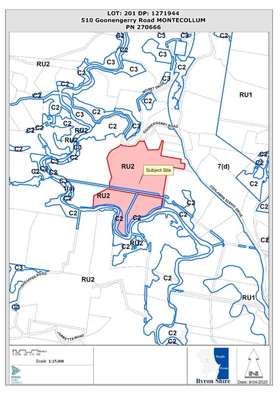
Figure 1: Locality Plan
The site was once part of a larger historic dairy farm that has been subdivided in the past and was subject to a boundary adjustment with the adjoining property to the west in 2019. The site currently contains an existing dwelling, various sheds and structures and is used for rural living purposes. The property to the west at 506 Goonengerry Road was approved for multiple occupancy development containing 6 sites in 2020 (DA 10.2020.472.1).
The following determinations are relevant to the subject application:
· BA 1977/74 – Dwelling House - Approved 23/7/1977
· BA 1979/180 – Garage and Workshop - Approved
· BA 1983/52 - Alterations and additions to an existing dwelling - Approved 24/3/1983
· BA 1983/192 - Storage Shed – Approved 30/8/1983
· BA 1987/590 – Swimming pool – Approved
· 5.1998.188.1 - Two lot subdivision, Approved 1/9/1998.
· 10.2019.282.1 - Boundary Adjustment Two (2) Lots, Approved 12/1 2019.
· 10.2022.181.1 – Multiple Occupancy Consisting of 9 dwelling sites, deferred commencement 16 May 2023.
A Roads Act Application (51.2022.181.1) for the Driveway Entry Upgrade was submitted and is currently under assessment as per the conditions of consent under DA10.2022.181.1.
The application seeks to expand the existing multiple occupancy to a total of 13 dwelling sites followed by community title subdivision as follows:
· Stage 1 – Expand the Multiple Occupancy (MO) from 9 to 13 dwelling sites
· Stage 2 – Community title Subdivision with 9 Residential lots
· Stage 3 – Community title Subdivision with a further 4 Residential lots
The 13 dwelling sites for the MO are broken up into 4 clusters with:
· Cluster A – two dwelling sites near the entrance to the property,
· Cluster B – three dwelling sites,
· Cluster C – four dwelling sites including the original dwelling house, pool and workshop garage
· Cluster D – being the expansion four more dwelling sites in the northeast section of the property.
Clusters A, B and C are located consistent with the previously approved DA10.2022.181.1 and sited in the central ridge area of the property.
As part of the MO stage of the development the applicant is proposing to bring a number of previously constructed buildings back into compliance with their original approvals and the Dairy Bales in the north of the site are to be demolished. A community building located within the common property is proposed to be used as such. The applicant is also proposing to commence vegetation management works for the site which has a focus on rehabilitating an area of 12.5 hectares which is heavily infested with camphor laurel and other weeds. Works required for the MO beyond the driveway upgrade include construction of the internal road network and services.
Stage 2 of the development comprises the community title subdivision with 9 residential lots, (Lots 2 - 10) a community development lot and Community Property (common property). The community development lot contains the 4 additional dwelling sites in Cluster D. The lots sizes are follows:
· Lot 1 – 39.88 ha Community Property (common property)
· Lot 2 – 0.7 ha
· Lot 3 – 0.7 ha
· Lot 4 – 0.7 ha
· Lot 5 - 0.7 ha
· Lot 6 – 0.75 ha
· Lot 7 – 0.7 ha
· Lot 8 – 0.7 ha
· Lot 9 – 0.7 ha
· Lot 10 – 1.3 ha (Existing dwelling)
· Community Development Lot – 3.8 ha
Stage 3 of the development comprises the subdivision of the community development lot to create the final four residential lots with the following areas:
· Lot 11 – 0.6 ha
· Lot 12 – 0.6 ha
· Lot 13 – 0.6 ha
· Lot 14 – 2.0 ha
|
Land is legally described |
LOT: 201 DP: 1271944 |
|
|
Property address |
510 Goonengerry Road MONTECOLLUM |
|
|
Land is zoned: |
C2 Environmental Conservation / PART RU2 Rural Landscape |
|
|
Land area is: |
50.63ha |
|
|
Constraints and Attributes:
|
Bushfire prone land High Conservation Value High Environmental Value Drinking Water Catchment
|
|
|
|
Is a BDAR required due to the location of the proposed development? |
☐ Yes ☒ No |
|
|
Are there any easements in favour of Council affecting the site? |
☐ Yes ☒ No |
|
|
Is there a Vegetation Management Plan which might affect the proposal? |
☒ Yes ☐ No |
|
|
Is there a Voluntary Planning Agreement which might affect the proposal? |
☐ Yes ☒ No |
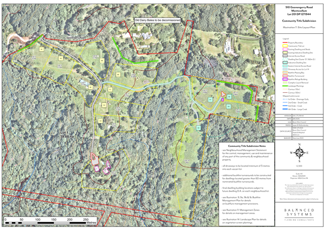
Figure 2: Community Title Layout
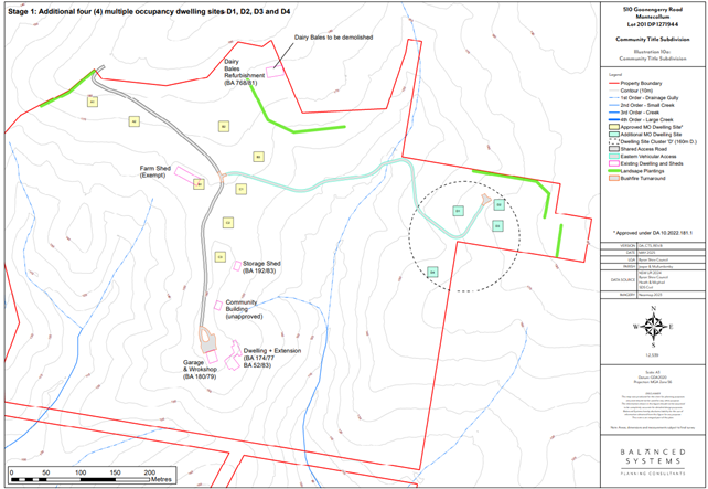
Figure 3: MO Layout
Figure 4: Site Entrance from Goonengerry Road
![]()
Figure 5: MO Sites D2 and D3
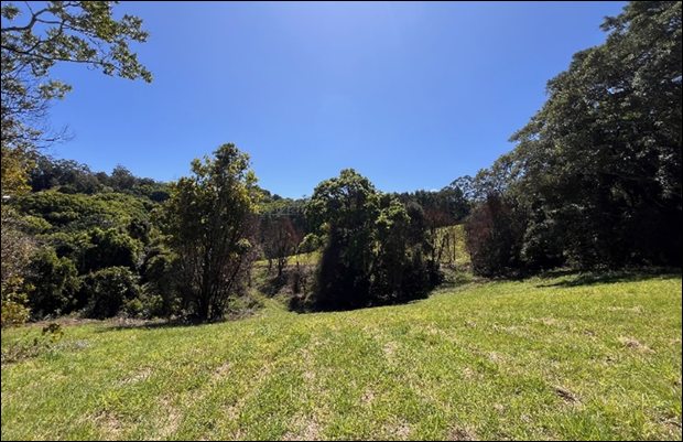
Figure 6: MO Site D4
![]()
Figure 7: MO Site D1
|
Referral |
Issue |
|
Environmental Health Officer |
No objections subject to conditions. |
|
Development Engineer |
No objections subject to conditions. |
|
Ecologist |
No objections subject to conditions. |
|
Essential Energy |
No objections subject to general comments. |
Section 100 B of the Rural Fires Act 1997
This development is integrated development under Sections 4.46 and 4.47 of the Environmental Planning and Assessment Act 1979, requiring an approval under Section 100B of the Rural fires Act 1997. The proposal was forwarded to the NSW Rural Fire Service who have issued General Terms of Approval under the Rural Fires Act 1997. Conditions of consent to apply.
The site is identified as contains five vegetation communities being:
1. Managed grassland and planted vegetation
2. Lowland Subtropical Rainforest
3. Wet Sclerophyll (forest)
4. Regrowth Camphor Laurel w/ Rainforest component
5. Ecotone transition between Subtropical Rainforest and Wet Sclerophyll
The following threatened flora species have been recorded:
· Macadamia tetraphylla – Rough-shelled Bushnut
· Hicksbeachie pinnatifolia – Red Boppel Nut
· Pedleya acanthocladum – Thorny Pea
The applicant notes in the Biodiversity Assessment Report BAR that areas of subtropical rainforest on the site are likely to satisfy the criteria of an endangered ecological community. In terms of fauna the vegetated areas on the property provide habitat for a range of native birds, mammals, reptiles and amphibians.
As to the entire development the applicant proposes to remove in total 33 exotic and non-endemic planted trees from the property and 42 natives predominantly to facilitate the upgrade to the existing driveway and access to the extra four dwelling sites. These are located generally on cleared grassland, no tree impacts are likely because of future dwellings and associated infrastructure. A ground cover assessment completed as part of the BAR determined that grassland at the site is not ‘native vegetation’ and hence the biodiversity offsets scheme (BOS) in the BC Act is not triggered. No impacts are anticipated on the subtropical rainforest sections of the property.
Having regard to the areas to be rehabilitated the proposal is considered acceptable in terms of the Biodiversity Conservation Act 2016.
Having regard to the matters for consideration detailed in Section 4.15(1) of the Environmental Planning & Assessment Act 1979 (EP&A Act), the following is a summary of the evaluation of the issues.
|
Considerations |
Satisfactory |
|
Biodiversity and Conservation SEPP 2021 Consideration: No objections have been raised by Council’s Ecologist in relation to the provisions of the Biodiversity and Conservation SEPP. |
☒ |
|
Resilience and Hazards SEPP 2021 Consideration: Chapter 4 Remediation of Land Preliminary Site Investigation report prepared by Balanced Systems Planning Consultants dated May 2024 (Version 2) has been submitted. The report concludes that investigation areas would not represent a significant risk of harm to end uses of the proposed residential development. The proposal is satisfactory with regards to the provisions of the SEPP. |
☒ |
|
Consideration: Chapter 2: Primary production and rural development The site is not identified as State significant agricultural land in the North Coast Regional Plan 2041. The site is zoned Rural Landscape and not Primary Production. The proposed development is not inconsistent with the aims of the SEPP relevant to the site and the proposal. |
☒ |
|
Transport and Infrastructure SEPP 2021 Consideration: The proposed development was referred to Essential Energy in accordance with Clause 2.48 of the SEPP. No objections or safety concerns were raised. |
☒ |
In accordance with LEP 2014 clauses 1.4 and 2.1 – 2.3:
(a) The proposed development is defined in the LEP as Multiple Occupancy and Subdivision;
(b) The land is within the C2 Environmental Conservation /and RU2 Rural Landscape according to the Land Zoning. All proposed development is located within the RU2 zoning;
(c) The proposed development is permitted with consent; and
(d) Regard is had for the Zone Objectives as follows:
|
Zone Objective RU2 |
Consideration |
|
To encourage sustainable primary industry production by maintaining and enhancing the natural resource base. |
The proposal is not expected to have a significantly adverse impact on any sustainable primary industry production or the natural resource base of the locality. |
|
To maintain the rural landscape character of the land. |
The proposal appropriately maintains the rural landscape character of the land having regard to the multiple occupancy approvals which have already been granted. |
|
To provide for a range of compatible land uses, including extensive agriculture. |
The proposal supports the multiple occupancy usage and fits into the range of compatible land uses, including extensive agriculture. |
|
To enable the provision of tourist accommodation, facilities and other small-scale rural tourism uses associated with primary production and environmental conservation consistent with the rural character of the locality. |
The proposal does not diminish the extent to which tourist accommodation, facilities and other small-scale rural tourism uses associated with primary production and environmental conservation consistent with the rural character of the locality can be provided. |
|
To protect significant scenic landscapes and to minimise impacts on the scenic quality of the locality. |
The proposal will not have a significant impact on any significant scenic landscapes and appropriately minimises impacts on the scenic quality of the locality. |
|
C2 Zone Objective |
Consideration |
|
A small section of the property along the southern boundary of the property with Wilsons Creek is zoned C2 Environmental Conservation. No part of the development extends into this area other than weed management. The following comments are made against the zone objectives accordingly. |
|
|
To protect, manage and restore areas of high ecological, scientific, cultural or aesthetic values. |
The proposal appropriately protects, manages and restores areas of high ecological, scientific, cultural or aesthetic values of the locality. |
|
To prevent development that could destroy, damage or otherwise have an adverse effect on those values. |
The proposal minimises the extent of destruction, damage or adverse effects on these values. |
4.1B Minimum subdivision lot size for multiple occupancy or rural community title developments
In relation to subclause 4.1B(3) the size of any lot resulting from the subdivision of land may be less than the minimum lot size shown on the Lot Size Map as the total number of neighbourhood lots located on the land following the subdivision does not exceed the number of dwelling sites approved under the development consent for the multiple occupancy being 9 lots under DA10.2022.181.1 plus 4 lots under stage 2 of this DA equalling, 13 lots. There will also be one lot comprising community property which will is heavily vegetated and will be managed and maintained in terms of the VMP.
The proposed subdivision of the MO in stages as proposed is permissible under the Clause.
In relation to subclause 4.1B(4)
(a) The application was accompanied by draft Neighbourhood Management Statement, Vegetation Management Plan, Water Management Plan and Wastewater Management Plan. With large parts of the site heavily vegetated and a portion of it to be rehabilitated, it is considered that the proposal will ensure the long-term protection and enhancement of the landscape, biodiversity and rural setting of the land. Condition to apply.
(b) The provision of 13 residential lots on this property will provide for further dwellings which is a normal housing typology within the Byron Hinterland. It is considered this will not generate adverse social and economic impacts on the locality.
(c) The proposal includes the removal of a dairy bales near the northern boundary which has been potentially used for residential purposes and other activities that needed approval. The bales are located near a neighbouring residential property and with the removal of this building, this potential land use conflict has been removed. As to dwelling sites in cluster D, D2 and D3 9Lots 12 and 13) are situated in the vicinity of neighbouring dwellings of Coolamon scenic drive (Lots 11-14) which site within a similar rural residential setting. The dwelling sites within these lots are well setback from boundaries and spatially are considered appropriate considering topography and vegetation along the boundaries.

Figure 8 – Distances to surrounding dwellings House sites D2 (Lot12) and D3 (Lot 13)
Having regard to the surrounding land uses, it is considered the approval of the community title subdivision is unlikely to generate adverse land use impact conflicts with neighbouring development in this instance.
Clause 4.2B Maximum number of dwelling houses or dual occupancies on multiple occupancy or rural land sharing community developments
The property is identified on the Multiple Occupancy and Community Title Map under Clause 4.2B (3)(b). There is no number of dwellings shown on the map, so the clause reverts to a numerical calculation of 1 dwelling per 3 ha of land area. With an area of 50 hectares a maximum of 15 dwellings is permissible with consent. The applicant has proposed a total of 13 dwelling sites in this instance. The proposal satisfies the dwelling density requirements under the LEP. The application also includes a vegetation management plan for the ongoing protection of the ecological values on the site and it is considered the proposal complement the rural and environmental values of the property and the surrounds.
5.16 Subdivision of, or dwellings on, land in certain rural, residential or conservation zones
In relation to clause 5.16(4) the development is not likely to have a significant impact on the preferred and the predominant land uses in the vicinity of the development, which is predominantly rural residential in character and nature
Clause 6.6 Essential Services
Regarding sewage management, the applicant has submitted an Onsite Sewage Management System Capability Assessment prepared by Balanced Systems Planning Consultants dated May 2024. The report satisfactorily demonstrates that there is area available for each proposed dwelling site to have their own individual OSMS system and land application area.
In relation to access, the proposal was accompanied by a Traffic Assessment Report. Council’s Development Engineer reviewed the proposal and the construction of the access in accordance with DA10.2022.181.1 can cater for the future traffic generated in this proposal.
Not Applicable.
Chapter B1 Biodiversity
The applicant has submitted a Biodiversity Assessment Report BAR for the development. The property includes three main vegetation communities being Subtropical rainforest, west sclerophyll forest and camphor laurel dominated forest in addition to cleared grassland and areas that transition between wet sclerophyll and rainforest. The map below shows these three main areas with the red mapped areas being the camphor laurel dominated areas
t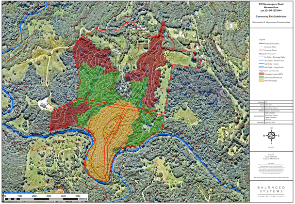
Figure 9 Vegetation types - Red mapped areas Camphor Laurel dominated forest >80%
Section 4 of the BAR also includes a Vegetation Management Plan VMP accompanied by a map showing work zones and requirements. The additional 4 dwellings require the planting of 3600 trees or equivalent as per Chapter D2 of the DCP. In conjunction with the other 9 dwelling sites this equates to a total of 11700 trees or equivalent rehabilitation in terms of weed management and the like.
The works are to be carried out in two main areas being the eastern gully and the western gully and a smaller riparian area near the Wilsons Creek of approximately half a hectare. The VMP is appropriate for the site and will provide for a substantial benefit to the ecology of the area with the enhancement and rehabilitation of the property in these camphor laurel dominated area on the land.
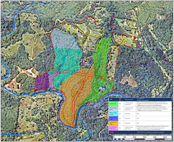
Figure 10 - Extract from the VMP showing areas to be Rehabilitated
The Vegetation Management works will need to commence with the Multiple Occupancy stage of the development with the applicant proposing the following minimum timelines:
· Stage 1 Multiple Occupancy Occupation Certificate - Year 1 KPIs
· Stage 2 Community title Subdivision 9 lots – Year 2 KPIS
· Stage 3 Community Title Subdivision – Year 5 KPIs.
In terms of weeds found on the site, the following significant species have been identified, camphor laurel, small and large leaf privet, lantana, devils fig, coral tree, night flowering jasmine, and madeira vine
In summary the KPI’s if achieved will deliver the following:
Environmental Weed Management Environmental weeds are eradicated, controlled and prevented from spreading within the property. Weed management works will result in the following coverage of the VMZs:
· End of year 1 - Weed cover reduced to <25% of original cover
· End of Year 2 – Weed cover reduced to <10% of original cover
· End of Year 5 – Weed cover reduced to <5% of original cover
Removal of all large weed trees to be reduced in two stages:
· End of year 1, Camphor Laurel tree canopy reduced to <50% of original cover.
· End of year 2, weed tree canopy reduced to 0% of original cover
It is noted that cats and dogs are not proposed to be strictly prohibited within this property.
However having regard to the site’s location with significant areas of habitat for native fauna, this restriction is justified and conditions to apply.
Chapter B3 Services
The site can be adequately serviced with power and telecommunications with water to be provided by means of roof water collection and harvesting. Effluent is to be disposed of onsite and the dwelling sites and future lots are of suitable size and dimension for this to occur, with the specific details to be considered when application is made to construct housing on each lot.
Chapter B4 Traffic Planning, Vehicle Parking, Circulation and Access
Access to the site is proposed from Goonengerry Road and a driveway application is currently before Council for approval in accordance with the conditions previously issued under DA10.2022.181.1. It is considered that these access arrangements provide suitable capacity for the four extra dwelling sites proposed under this DA. Conditions to apply.
Chapter D2 residential Accommodation and Ancillary Development in Rural Zones
D2.6 Multiple Occupancy Development
It is considered the four additional dwelling sites satisfy the siting and clustering arrangements under the DCP with sufficient detail to justify their location in terms of flooding, bushfire, topography, vegetation, contamination and the like. The proposal includes the use of an existing building to be used as a community building located near C3 and C4. Conditions of consent are proposed to bring this building into compliance and or have it demolished as there is no approval in place for its original construction.
Internal access to sites D1 – D4 is required and will follow an existing farm access track through the property which links with the other main internal road back to the driveway with Goonengerry Road. Conditions to apply in terms of its upgrade
No specific rural landsharing management plan has been prepared for the MO with the applicant reliant upon moving the MO onto a community title arrangement in a short time frame.
Notwithstanding the above, there is no guarantee that this will occur as proposed. As such a condition of consent is included requiring a management plan document be prepared and submitted to Council for approval. As discussed above cat and dogs will be prohibited and provisions incorporated into the rural land sharing management plan as well as any community management statement for when it converts to community title.
As this development will in effect replace the previous Multiple Occupancy approval for nine dwelling sites it is recommended that this approval if enacted upon will become the document to direct and guide the development of the land going forward.
Because of this, conditions for stage 1 Multiple Occupancy include not only the additional 4 dwelling sites but also the original 9 sites with the aim of avoiding confusion by having a single development consent apply.
Chapter D6 Subdivision
D6.3.5 Rural Community Title Subdivision:
The number of lots resulting from the proposed subdivision (being a conversion of approved multiple occupancies to rural community title subdivision) equals the number of approved dwelling sites (excluding the neighbourhood lot/common land) identified in the multiple occupancy approvals, being 13 in each case.
The applicant has submitted the required management plans addressing water supply, waste management, bushfire management onsite sewage management and vegetation management. The plans are considered appropriate and conditions of consent to apply.
As discussed previously the property contains a number of sheds and other structures which are potentially being used/occupied for purposes outside their approval. The applicant is proposing to bring some of these back into compliance and demolition of others such as the Dairy Bales. Conditions of consent to apply.
The applicant has also submitted a Community Management Statement which is considered generally satisfactory, however condition will apply for it to be amended and returned to Council for approval with the First Stage Subdivision Certificate.
|
Environmental Planning and Assessment Regulations 2021 |
Applicable to the proposal: |
Considered the control as it relates to the proposal: |
If this control is applicable, does the proposal comply? |
|
Section 61 - Additional matters that consent authority must consider |
☒ Yes ☐ No |
☐ Yes ☐ No ☒ NA |
☐ Yes ☐ No ☒ NA |
|
Section 62 - Consideration of fire safety |
☐ Yes ☒ No |
☐ Yes ☐ No ☒ NA |
☐ Yes ☐ No ☒ NA |
|
Section 64 - Consent authority may require upgrade of buildings |
☒ Yes ☐ No |
☒ Yes ☐ No ☐ NA |
☐ Yes ☒ No ☐ NA |
|
Section 63 - Considerations for erection of temporary structures |
☐ Yes ☒ No |
☐ Yes ☐ No ☒ NA |
☐ Yes ☐ No ☒ NA |
4.6.1
|
Impact on: |
Likely significant impact/s? |
|
Natural environment |
The proposal will not have a significantly adverse impact on the natural environment of the locality and will result in improved ecological outcomes across the site which are unlikely to occur without the development proceeding. |
|
Built environment |
The proposal will not have a significantly adverse impact on the built environment of the locality, which is best characterised by rural residential hinterland development. it is considered the proposal is not out of character with the built environment. |
|
Social Environment |
The proposal will provide an additional four dwelling sites adding to the housing stock within the shire. It is considered the proposal will not have a significant social impact on the locality. |
|
Economic impact |
The development will generate short term economic impacts with the construction of infrastructure and ongoing vegetation management. |
|
Construction Impacts |
The development will generate impacts during its construction. Conditions of consent recommended to control hours of work, builders waste, construction noise, installation of sedimentation and erosion control measures and the like to ameliorate such impacts. |
4.6.3 Council Policies applicable to the proposed development
|
Council Policy |
Consideration |
|
The four additional dwelling sites are considered suitable in terms of past land uses. |
The site can be adequately serviced for this type of development and with constraints effectively managed. The site is considered suitable for the development.
The development application was publicly exhibited.
There were 3 submissions of objection made on the development application
Issue- Impact on neighbours privacy and views
Comment: The 4 proposed additional dwelling sites are located greater than 100m away from neighbouring dwellings. Landscape buffers are proposed along the lot boundaries to provide further privacy between neighbouring lots.
The proposed 4 new dwelling sites are unlikely to adversely impact on the visual amenity of the neighbourhood due to the slope of the land and the existing vegetation between the sites.
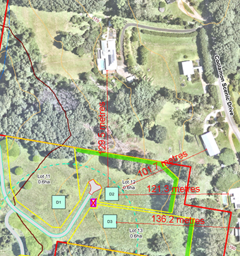
Issue - Bushfire Impacts
Comment: The proposal has been assessed by the NSW Rural Fire Service who raised no concerns, subject to compliance with conditions of consent.
Issue - Not compatible with rural land objectives of the zone
Comment: The proposed development is permitted with consent and located within the approved multiple occupancy mapping. The site is surrounded by existing small sized RU2 zoned lots being utilised for rural residential hinterland purposes. It is considered the proposal is not inconsistent with the character of the area nor the zone objectives.
Issue - Waste management and location of bin collections
Comment: Garbage bins for each dwelling must be stored within a secure location within each dwelling site or stored in a central bin storage area for the multiple occupancy. Garbage bins must be placed in a neat and orderly manner on/near Goonengerry Road on days for Council garbage collection and shall be removed promptly following garbage collection.
Issue - Ecological impacts
Comment: Proposal will result is some 13 ha of land being rehabilitated and enhanced via the approved VMP. It is considered the proposal will have positive ecological impacts
Issue - Traffic Impacts
Comment: As discussed in the report access to the site is appropriate and conditions to apply.
The proposed development is unlikely to prejudice or compromise the public interest or create an undesirable precedent.
No Section 64 levies will be required.
Section 7.11 Contributions will be payable.
|
Disclosure details |
Response |
|
Has a Disclosure Statement been received in relation to this application? If Yes, Provide Disclosure Statement register reference: 91. |
Yes ☐ No ☒ |
|
Have staff received a ‘gift’ from anyone involved in this application that needs to be disclosed. |
Yes ☐ No ☒ |
The DA proposed Multiple Occupancy development and subsequent Community Title Subdivision over two further stages is permissible with consent. The proposal raises no significant issues in terms of environmental impacts and the site is considered suitable for the proposed development.
The application is recommended for approval subject to the conditions of consent.
Staff Reports - Sustainable Environment and Economy 13.10
Report No. 13.10 PLANNING - Report of the Planning Review Committee held 1 May 2025
Directorate: Sustainable Environment and Economy
Report Author: Chris Larkin, Manager Sustainable Development
Noreen Scott, EA Sustainable Environment and Economy
File No: I2025/642
Summary:
This report provides the outcome of the Planning Review Committee (PRC) held on 1 May 2025.
NOTE TO COUNCILLORS:
In accordance with the provisions of S375A of the Local Government Act 1993, a Division is to be called whenever a motion for a planning decision is put to the meeting, for the purpose of recording voting on planning matters. Pursuant to clause 2(a) under the heading Matters to be Included in Minutes of Council Meetings of Council's adopted Code of Meeting Practice (as amended) a Division will be deemed to have been called by the mover and seconder of all motions relating to this report.
RECOMMENDATION:
That Council endorses the outcomes of the Planning Review Committee meeting held on 1 May 2025.
The PRC meeting was held on 1 May 2025. The meeting commenced at 4:20pm and concluded at 4:45pm.
Councillors: Cr S Ndiaye Cr J Dods, Cr M Lyon, Cr D Kay, Cr J Swain.
Apologies: Cr M Lowe, Cr A Pugh, Cr E Hauge.
Staff: Chris Larkin (Manager Sustainable Development).
Conflict of Interest: Cr Dods, Cr Lyon, 10.2024 239.3 at 38 Tweed Street, Brunswick Heads.
Council determined the following original development applications. The S4.55 application/s to modify these development consents are referred to the Planning Review Committee to decide if the modification applications can be determined under delegated authority.
|
DA No. / Applicant |
Property Address / Proposal |
Consultation / Submissions |
Reason/s / Outcome |
|
10.2024.239.3 Town Planning Studio |
38
Tweed Street Modifications to conditions of consent including drainage and lighting requirements, change to the location of on-street parking and acknowledgement of historic parking credits. |
Level 2 9/04/25 to 24/04/25 4 submissions
|
Staff Delegation |
|
10.2021.511.4 Town Planning Studio |
865 Broken Head Road Modification - Original Consent: Dual occupancy (detached) and Swimming Pool Proposed Modification: Modifications to the form and layout of the eastern dwelling |
Level 1 22/04/25 to 5/05/25 Nil submissions |
Staff Delegation subject to no submissions being received during the exhibition period |
|
10.2023.235.4 Planners North |
Jonson St Modification - Demolition and construction of mixed-use development comprising basement parking, ground floor courtyard with commercial premises, food and drink premises, two levels of shop top housing (total of 22), roof top terraces and pool and associated plant. (Secret Gardens) |
Level 2 7/05/25 to 20/05/25 10 Submissions |
Staff Delegation - subject to no submissions being received during the exhibition period Submissions received – matter to be reported back to PRC for re-consideration
|
Staff Reports - Sustainable Environment and Economy 13.11
Report No. 13.11 Planning Agreement - 53 McAuleys Lane Development Application 10.2023.454.1
Directorate: Sustainable Environment and Economy
Report Author: Shannon Burt, Director Sustainable Environment and Economy
Rob Van Iersel, Contract Planner
File No: I2025/540
Summary:
At the Council (Planning) Meeting of 27 October 2022, Council resolved to accept a draft Planning Agreement associated with a rezoning proposal for land at 53 McAuleys Lane Myocum, subject to final legal review.
The Planning Agreement provided the developers commitment to undertake works to upgrade the intersection of McAuleys Lane and Mullumbimby Road.
Following final legal review, the Planning Agreement was signed on 20 December 2022.
The rezoning of the site was finalised on 16 December 2022, implementing a zoning of R5 Large Lot Residential over the majority of the site and amending the Multiple Occupancy and Community Title Map to include the site and indicate a maximum yield of 39 lots.
Development Application 10.2023.454.1 was subsequently lodged in December 2023, seeking consent for the Community Title subdivision of the land to create 39 dwelling lots and 1 common lot. The endorsed Planning Agreement was submitted as information to support the Development Application.
Assessment of the Development Application is nearing completion and will be reported to Northern Regional Planning Panel (NRPP) 18 June 2025.
Assessment of the Development Application has resulted in the need to update the Planning Agreement, as the upgrade works at the McAuleys Lane / Mullumbimby Road have changed.
The draft (revised) Planning Agreement (Attachment 2) continues to require the developer to fund and implement the intersection upgrade works, and now also provides that Council will use its powers under the Roads Act 1993 to facilitate the acquisition of a small portion of privately-owned land required to achieve intersection upgrades that meet the current applicable safety standards. All acquisition costs would be borne by the developer, with approximately 1,000 m2 of land required.
It is recommended that Council use these powers in this case as the outcomes will assist in achieving road safety improvements associated with a current grant-funded project underway to upgrade all of Mullumbimby Road, from Gulgan Road to the eastern edge of the Mullumbimby township.
A draft (revised) Planning Agreement has been submitted to achieve these outcomes. The draft was exhibited in conjunction with the development application from 9 April to 19 May 2025.
The draft (revised) Planning Agreement was exhibited along with revised plans and reports for the development application. Four submissions were received specifically addressing the draft Agreement.
The submissions objected to the draft (revised) Planning Agreement on the basis that it does not provide suitable public benefit, instead benefiting only a private developer.
If the draft (revised) Planning Agreement is not approved, then the Development Application for the subdivision will have traffic safety issues at the intersection that may not be able to be resolved which may prove fatal to the Development Application.
The relocation of the intersection to the west, along with the associated land acquisition, will result in an intersection that meets current safety criteria. This upgrade will provide a wide public benefit not just to the developer of 53 McAuleys Lane by significantly enhancing safety and efficiency for all road users on Mullumbimby Road and McAuleys Lane. Additionally, it will support other landowners in McAuleys Lane who may seek consent for additional dwellings, such as dual occupancy and secondary dwellings, thereby contributing to the broader community development.
Council is undertaking broader safety improvements along Mullumbimby Road using State grants. However, the funding is limited and insufficient to cover the full safety enhancement that relocating the intersection would provide. If the updated Planning Agreement is not approved and executed, the non-compliant intersection will remain in its current location until additional grant funding or other financial resources are secured to widen the intersection.
Council using its powers under the Roads Act will therefore have a wide public benefit for all users of Mullumbimby Road and McAuleys Lane.
This report recommends that delegation be granted to the General Manager to execute the draft (revised) Planning Agreement.
RECOMMENDATION:
That Council grants delegation to the General Manager to execute the Planning Agreement in Attachment 2 (E2025/35741), associated with Development Application 10.2023.454.1 for the subdivision of land at 53 McAuleys Lane, Myocum.
Attachments:
1 Original
Signed Planning Agreement, E2023/122105
![]()
2 Revised
Draft Planning Agreement - As Exhibited, E2025/35741
![]()
3 Submissions
referencing Draft Planning Agreement, E2025/53398
![]()
Background
At the Council (Planning) Meeting of 27 October 2022, Council resolved to accept a draft Planning Agreement associated with a rezoning proposal for 53 McAuleys Lane Myocum, subject to final legal review.
The Planning Agreement requires the developers to:
· pay a contribution to Council of approx. $200,000 toward the provision of cycle and pedestrian pathways; and
· undertake, at their cost, upgrade works and safety improvements at the intersection of McAuleys Lane and Mullumbimby Road, in accordance with plans assessed and approved as part of the proposed rezoning.
Following final legal review, the Planning Agreement was signed on 20 December 2022 (Attachment 1).
The rezoning of the site was finalised on 16 December 2022, implementing a zoning of R5 Large Lot Residential over the majority of the site and amending the Multiple Occupancy and Community Title Map to include the site and indicate a maximum yield of 39 lots.
Development Application 10.2023.454.1 was subsequently lodged in December 2023, seeking consent for the Community Title subdivision of the land to create 39 dwelling lots and 1 common lot.
Assessment of the development application is nearing completion. Under the provisions of State Environmental Planning Policy (Planning Systems) 2021, the development is Regionally Significant, and the Northern Regional Planning Panel (NRPP) is the consent authority.
Determination of the Development Application is targeted for an NRPP meeting 18 June 2025.
The plans submitted with the Development Application for the upgrade works for the McAuleys Lane / Mullumbimby Road intersection were the same as those assessed under the rezoning proposal.
Assessment of those plans indicated that the upgraded intersection would not meet the required Safe Intersection Sight Distance, as specified in AUSTROADS for a rural road with a speed limit of 80km/hr.
As a separate matter, as reported to Council’s Local Traffic Committee in November 2024, Council has utilised blackspot grant funding for the design and implementation of a range of safety upgrades within Mullumbimby Road, from the intersection with Gulgan Road in the east to the edge of the Mullumbimby Township.
The grant funding is limited and is not sufficient to achieve a full safety upgrade to the McAuleys Lane / Mullumbimby Road intersection. While the proposed design will improve the safety of the current intersection, the design consultants for that project note that a compliant Safe Intersection Sight Distance is not currently possible due to the proximity of a crest in Mullumbimby Road to the east of the intersection, which restricts sight distance between motorists exiting the intersection and those travelling west on Mullumbimby Road.
Council is the roads authority for the classified road. Transport for NSW (TfNSW) are responsible for speed limit changes. The design consultants discussed the safe intersection sight distances issues with TfNSW and with Council. The option of reducing the current 80km/hr speed limit on Mullumbimby Road to resolve the sight distance issue was considered. TfNSW advised that this would not be an acceptable option.
As the speed limit can’t be reduced without TFNSW approval, the issue can be addressed by lowering the crest of the hill within Mullumbimby Road or by moving the centreline of McAuleys Lane at this intersection approx. 10m to the west, which would then provide the compliant sight distance between cars at the intersection and the crest of the hill to the east.
The grant funding available to Council is not sufficient to achieve either of these options.
Moving the intersection would require the acquisition of approx. 1,000m2 of an adjoining privately-owned property on the western side of the intersection. Preliminary discussions with the owner of that land indicated an openness to consider the proposal for acquisition.
The funding currently available for the Mullumbimby Road safety upgrade is not sufficient to cover the costs of the intersection relocation and/ or land acquisition.
The situation (and timing) of Development Application provides an opportunity for the safety upgrade for this intersection to be achieved.
Council could utilise its powers under the Roads Act 1993 to facilitate the private land acquisition. Given this would also benefit the developer, it would be reasonable for that developer to bear the costs of the acquisition in addition to the costs associated with delivering the upgraded intersection in its relocated position.
Following discussions with the applicant, a draft (revised) Planning Agreement has been submitted to achieve these outcomes (Attachment 2).
The updated provisions of the Draft Planning Agreement require:
· if Development Consent is issued, Council will commence the process of acquisition of the identified portion of land in accordance with the relevant legislation
· Council will use its best endeavours to progress and complete the acquisition process
· the developer will pay Council for all acquisition costs, including the compensation payable to the landowner and all application/ process fees and Council’s legal costs; and
· the developer will construct the intersection upgrades, including the relocation of the centreline of McAuleys Lane to achieve the compliant Safe Intersection Sight Distance.
The remaining original provisions regarding pedestrian / cycleway contributions and other local road safety improvements remain in the draft (revised) Planning Agreement.
Facilitating the improved safety outcome for the intersection upgrade will also ensure that adequate arrangements for vehicle access can be available to the proposed subdivision at 53 McAuleys Lane, as required by clause 6.6 of Council’s Local Environmental Plan 2014.
While that development application will be determined by the Northern Regional Planning Panel, staff are unlikely to recommend support for the application without the access safety improvements facilitated by the draft (revised) Planning Agreement.
Public Exhibition
The draft (revised) Planning Agreement was exhibited in conjunction with updated plans and reports for the Development Application from 9 April to 19 May 2025.
Twelve submissions were received in total, while only 3 of those specifically address the draft (revised) Planning Agreement (see Attachment 3).
The submissions object to the draft (revised) Planning Agreement on the basis that it benefits a private land development rather than providing a public benefit.
As outlined above, in the circumstances of this case, the provisions of the draft (revised) Planning Agreement do both – provide for a wide public benefit, while also providing a benefit to the development (at a significant cost to them).
The safety improvements that can be gained by relocation of the intersection can only be gained at the current time by requiring the developer to meet all costs. The grant funding provided to Council for safety improvements on Mullumbimby Road is too limited to achieve the same results.
|
CSP Objective |
CSP Strategy |
DP Action |
Code |
OP Activity |
|
5: Connected Infrastructure |
5.1: Provide a safe, reliable, and accessible transport network |
5.1.2: Road renewal and upgrades - Deliver road renewal and upgrade capital works program |
5.1.2.16 |
Mullumbimby Road Betterment Program |
|
5: Connected Infrastructure |
5.1: Provide a safe, reliable, and accessible transport network |
5.1.2: Road renewal and upgrades - Deliver road renewal and upgrade capital works program |
5.1.2.30 |
Mullumbimby Rd and McAuleys Lane Intersection, Myocum safety improvements |
· 24-59 Resolved that Council adopts the following Committee recommendation:
That the Local Traffic Committee supports the signage, line markings and traffic control devices associated with the Mullumbimby Road works generally in accordance with Attachment 1 (E2024/130657) and Attachment 2 (E2024/130677).
The relevant legal/statutory/policy considerations have been noted above.
The draft revised Planning Agreement requires that all costs associated with the intersection upgrade, including costs of land acquisition, will be borne by the developer of the subdivision of 53 McAuleys Lane, Myocum, if approved.
Details of the exhibition of the draft Planning Agreement are provided above.
Staff Reports - Sustainable Environment and Economy 13.12
Report No. 13.12 Status report on Development Applications (DAs) with bodies like the Northern Regional Planning Panel (NRPP)
Directorate: Sustainable Environment and Economy
Report Author: Shannon Burt, Director Sustainable Environment and Economy
File No: I2025/671
Summary:
At the Council (Planning) Meeting of 12 October 2023 it was resolved as part of 23-461
that Council: “Receives status reports monthly to each Ordinary (Planning) Meeting on all
DA’s that are being processed by Council for determination by other bodies such as the
Northern Regional Planning Panel or the Independent Planning Commission.”
Resolution 22-559 further requires: “That Councillors receive, as a standard procedure, a copy of the Assessment Report prepared by Council staff for any DA that is to be determined by the Northern Regional Planning Panel on the next working day after it is lodged on the Planning Portal.”
RECOMMENDATION:
That Council notes the status report on Development Applications (DAs) with bodies like the Northern Regional Planning Panel (NRPP).
The following applications are a matter for determination by the Northern Regional Planning Panel in accordance with the Sydney District & Regional Planning Panels Operational Procedures. There are no matters currently with the Independent Planning Commission.
|
Planning Authority |
Application Description and link |
Status |
|
Northern Regional Planning Panel |
PPSNTH-285 Community Title Subdivision 53 McAuleys Lane Myocum 2481 Community Title Subdivision | Planning Portal - Department of Planning and Environment (nsw.gov.au) Link to DA tracker for DA 2023.454.1 information and documents here: |
Submitted 12/12/2023 Record of Briefing - PPSNTH-285.pdf Exhibition of DA and amended Planning Agreement 9 April /25 – 9 May 25. Planning Agreement report to 12 June 2025 Council meeting. Determination meeting date – 18 June 2025
|
|
Northern Regional Planning Panel |
PPSNTH-405 Review of Determination (Refusal) - Temporary extension to existing coastal protection works 144 Bayshore Drive Byron Bay 2481 Link to DA tracker for DA 2023.287.2 information and documents here: |
Submitted 13/01/25 Review of determination (refusal) comprising the temporary extension of an existing geobag wall on private property. The Development Application was refused on 26 September, 2024 by the Northern Regional Planning Panel. An appeal by Ganra Pty Ltd against the refusal has been lodged with LEC and is likely to go to hearing in September 2025. Date to be set. The S8.2 Review is yet to be determined. |
|
Northern Regional Planning Panel |
PPSNTH-409 Modification to residential flat building including increase in building height within R3 Medium Density Residential and 7(F2) Urban Coastal Land zones and increase in size of rooftop areas across all buildings. 29 Shirley Street, 4 Milton Street and 2 Milton Street Byron Bay Link to DA tracker DA 10.202.371.4 information and documents here: Byron Shire Council - Application Tracker
|
Submitted: 14/02/25 Currently Under assessment. Likely Panel determination hearing date July 2025. A deemed refusal appeal was lodged with the LEC 14/4/25. Court directions held on 12 May 2025 with a Section 34 Conciliation conference set for 18 September 2025.
|
|
CSP Objective |
CSP Strategy |
DP Action |
|
1: Effective Leadership |
1.1: Enhance trust and accountability through open and transparent leadership |
1.1.2: Governance - Ensure legislative compliance and support Councillors to carry out their civic duties |
· 23-461
The Planning Panels determine regionally significant development applications (DAs), certain other DAs and s4.55(2) and s4.56 modification applications including:
· Regionally significant development, as outlined in Schedule 6 of the State Environmental Planning Policy Planning Systems 2021
· Regionally significant development relating to Aboriginal land, as outlined in Chapter 3 of the State Environmental Planning Policy Planning Systems 2021
· Development with a capital investment value (CIV)* over $30 million.
· Development with a CIV* over $5 million which is:
o Council related
o lodged by or on behalf of the Crown (State of NSW)
o private infrastructure and community facilities
o eco-tourist facilities
o extractive industries, waste facilities and marinas that are designated development
o certain coastal subdivisions and
o certain coastal protection works.
*Capital investment value (CIV) is calculated at the time of lodgement of the DA for the purpose of determining whether an application should go to a Planning Panel - refer to Planning Circular PS 10-008.
Section 10 of the Sydney District & Regional Planning Panels Operational Procedures talks to Roles of councils and other panels.
10.1 states the elected Council and Council staff have different roles in the assessment of DAs. Under the Local Government Act 1993, the independence of Council staff is protected in the preparation of advice and recommendations. Staff members are not subject to direction by the Council or by a Councillor as to the content of any advice or recommendation made by the staff member. Equally, a Council or Councillor is not bound by the advice or recommendation made by a member of staff.
10.3 states historically, one of the roles of an elected Council has been to determine or make decisions on DAs in their capacity as a consent authority. There are occasions, however, where the determination role is performed by other people or bodies, either because the Council has delegated that function, or because it has been conferred upon another person or body. For example, where local planning panels have been introduced, elected Councils no longer determine DAs (see section 2.17 of the EP&A Act). The Panel for the area in which the development is to be carried out is the consent authority for regionally significant development (see section 4.5 of the EP&A Act).
10.4 states Council staff are responsible for post-determination functions including:
· notifying Panel determinations on DAs (see sections 4.7(2)(e), 4.18 and 4.59 of the EP&A Act),
· registering Panel development consents on the NSW Planning Portal (see sections 4.7(2)(e) and 4.20 of the EP&A Act), and
· monitoring and enforcing compliance with conditions of the development consent.
The notice of determination should be issued once Council receives a copy of the endorsed and final determination from the Panel. The notice of determination must include all conditions imposed by the Panel, including any additional or amended conditions.
The Council has no power to amend conditions or include additional conditions following the Panel’s determination.
Council will advise any person who made a submission on the DA of the determination.
The Council continues to be responsible for the monitoring of, and enforcing compliance with, any conditions of the development consent.
Where an application has been approved subject to a ‘deferred commencement’ condition Council is responsible for determining whether the requirements of the condition have been met (see section 4.16(3) of the EP&A Act). Council advises the chair of the Panel in writing when the matter specified in the condition has been satisfied (see section 277(2) of the EP&A Regulation).
Microsoft Word - Att C - Amended RPP Operational Procedures.docx (amazonaws.com)
11.13 talks to Council representation to the Planning Panel.
An elected Council may make a submission on a DA within their LGA that is to be determined by a Panel up to seven days before the Panel meeting. After the assessment report is sent to the Secretariat, it may be given to the elected Council to assist in its decision as to whether it will be making a submission to the Panel. The elected Council’s submission should not be prepared by persons involved in the assessment of the application but could be prepared by another Council officer, or a consultant.
A Council submission should not be specifically referenced in the assessment report or recommendations prepared by the Council staff. If Council makes a submission, a staff representative or individual Councillors may register to address the Panel at the meeting to express the views of Council. Councillors who are also Panel members have an independent role because they have been nominated by their Council as its nominee to the Panel.
A Code of Conduct also applies to members of the Planning Panels.
Appeals from Planning Panel determinations
Section 8.15(4) of the EPA Act was introduced on 1 March 2018. It provides relevantly:
If the determination or decision appealed against under this Division was made by a Sydney district or regional planning panel or a local planning panel, the Council for the area concerned is to be the respondent to the appeal but is subject to the control and direction of the panel in connection with the conduct of the appeal. The Council is to give notice of the appeal to the panel.
In respect of the conduct and potential resolution of appeals, Councils are subject to the direction and control of planning panels in respect of decisions they make after 1 March 2018.
The Land and Environment Court has said that in circumstances where the panel and Council have conflicting views on a development, the appropriate approach would be for the panel to apply to be joined as a party to the appeal proceedings.
None relevant to this report.
Applications are exhibited as per the Council’s Community Participation Plan.
Otherwise, consultation, engagement and reporting must be in accordance with the Planning Panels Operations Procedure and Code of Conduct.
Staff Reports - Sustainable Environment and Economy 13.13
Report No. 13.13 Amendment to DCP Chapter E10 Byron Bay Town Centre to clarify use and interpretation of controls in relation to car share spaces
Directorate: Sustainable Environment and Economy
Report Author: Cameron Thiessen, Land Use Planner
File No: I2025/681
Summary:
The Byron Development Control Plan (DCP) 2014 is periodically reviewed to ensure its currency with NSW planning legislation and policy, and to correct errors, omissions or provide clarity of content as identified through the day-to-day use of the plans in development assessment.
Current use and interpretation of Chapter E10 Byron Bay Town Centre has identified a need to amend specific Performance Criteria contained in the car parking section to clarify when and how car share provisions are applied. The proposed DCP Performance Criteria change will address this and apply to change of use and new development applications.
NOTE TO COUNCILLORS:
In accordance with the provisions of S375A of the Local Government Act 1993, a Division is to be called whenever a motion for a planning decision is put to the meeting, for the purpose of recording voting on planning matters. Pursuant to clause 2(a) under the heading Matters to be Included in Minutes of Council Meetings of Council's adopted Code of Meeting Practice (as amended) a Division will be deemed to have been called by the mover and seconder of all motions relating to this report.
RECOMMENDATION:
That Council:
1. Proceeds with the public exhibition of the Byron Development Control Plan 2014 amendments to Chapter E10 Byron Bay Town Centre to include the proposed new measures for car share schemes detailed in the report;
2. Receives a further report on the amendments that receive submissions following the public exhibition period; and
3. Notes that should there be no submissions received (to certain or any amendments), that the amendment to the DCP be adopted as of the close of the statutory public exhibition period date and notified accordingly.
Attachments:
1 DRAFT
Byron Shire DCP 2014 Chapter E10 Byron Bay Town Centre May 2025, E2025/49952 ![]()
2 Special
Disclosure of Pecuniary Interest Annexure for matters relating to environmental
planning instruments, E2012/2815 ![]()
The Byron Development Control Plan 2014 (DCP 2014) is periodically reviewed to ensure that planning controls are current and correct. A need to provide additional measures in the Performance Criteria for car parking in Chapter E10 Byron Bay Town Centre has been identified.
DCP 2014, Chapter E10 was adopted on 13 May 2021, and it introduced a Car parking sub-clause (E10.2.6) for controls that apply a principle of “cars out – people in”.
A reference to “car share spaces” in Performance Criteria (4.) was intended to address this principle. An additional measure has been identified to ensure that any reference to car share spaces, only has an effect on Residential Accommodation and Tourist and Visitor Accommodation within the land to which this DCP chapter applies, Byron Bay Town Centre.
The proposed additional measure to be included in the Performance Criteria under D10.2.6 Car parking is as follows:
Amend the following performance criteria:
“4. Where car share spaces with car share cars are provided on site, parking rates may be discounted by a maximum of 3 car spaces per car share vehicle.”
with an additional measure clarifying the land uses to which this performance criteria applies:
“4. Where car share spaces with car share cars are provided on site, parking rates may be discounted by a maximum of 3 car spaces per car share vehicle. This discount in car parking rates only applies to residential accommodation and tourist and visitor accommodation proposed in the Byron Bay Town Centre.”
The proposed amendments to the chapter are included as an attachment to this report (Attachment 1).
The draft DCP amendments will be exhibited for a minimum of 28 days. Any submissions received will be presented to Council along with any recommended changes to the exhibited chapter amendments.
The amended Byron DCP chapters will come into effect once adopted and published on Council’s website.
|
CSP Objective |
CSP Strategy |
DP Action |
Code |
OP Activity |
|
4: Ethical Growth |
4.1: Manage responsible development through effective place and space planning |
4.1.4: LEP & DCP - Review and update the Local Environmental Plan and Development Control Plans |
4.1.4.2 |
Review and update Local Environmental Plan and Development Control Plans to reflect strategic land use priorities and/or legislative reforms |
· Res 21-187 Adoption of DCP Chapter E10, 13 May 2021.
Under Part 3 Division 3.6 of the Environmental Planning and Assessment Act 1979 (EPAA 1979), council, as the relevant planning authority, may prepare a development control plan if it is considered necessary or desirable (s.3.43(1)). The amendments to the Chapter described in the report above are consistent with the relevant clauses of EPAA 1979 and the Environmental Planning and Assessment Regulation 2021.
Not relevant to this report.
The proposed amendments to DCP 2014 will be exhibited for a minimum of 28 days in accordance with the Community Participation Plan.
Staff Reports - Sustainable Environment and Economy 13.14
Report No. 13.14 2023-24 Annual Inventory of Council's Greenhouse Gas Emissions
Directorate: Sustainable Environment and Economy
Report Author: Alicia Lloyd, Team Leader Sustainability
Rachel Thatcher, Sustainability Officer
File No: I2025/702
Summary:
This report outlines the annual inventory of greenhouse gas emissions for the 2023/24 financial year for Byron Shire Council operations (Attachment 1 – E2025/49804). Overall, there was a 44% increase in organisational carbon emissions in FY24 compared to the previous year. The increase in emissions in FY24 brings Council’s total emissions to 38,593 tCO2e, compared to FY23 emissions of 26,802 tCO2e.
This increase was predominantly due to an increase in the number of expenditure items from the general ledger included in the inventory this year, rather than an increase in actual activities. There was however a notable increase in the ‘Construction, Repairs, and Maintenance’ category due to continued post-flood reconstruction, which also contributed to the increase in emissions.
Council’s electricity was 100% renewable energy and therefore zero net emissions due to renewable energy certificates and the GreenPower electricity contract in FY24, so usage fluctuations in the electricity and streetlighting sectors did not have an impact on the increase in emissions. There were also several notable reductions in certain categories such as a 47% natural decline in landfill emissions, and a 37% reduction in streetlight electricity usage due to the bulk upgrade to energy efficient LED bulbs.
In March 2025, Council resolved (Res 25-108) to realign the previous net zero target to the ISO 42.2022 Net Zero Guidelines. Whilst the increase in general ledger items included this financial year caused an increase in Council’s emissions, it also laid the groundwork for setting the new net zero target using a more wholistic picture of the available data. The previous target was ambitious, however there was a limited understanding of emissions data available at the time. This updated approach is considered best practice and will ensure Council has accurate modelling in place to demonstrate that it can confidently reach the new target. It is expected that a new target will be defined by the end of the 2025/26 financial year.
RECOMMENDATION:
That Council notes the 2023/24 Annual Emissions Inventory (Attachment 1 – E2025/49804).
1 Emissions
Inventory Report FY23-24, E2025/49804
![]()
2 Byron
Shire Council GHG Emissions Summary - FY2024 - Pangolin Report, E2025/49809 ![]()
Report
Council has been reporting on its greenhouse gas emissions annually since 2015/16. Previously, Council had been working toward meeting its 2025 net zero target, however Council recently resolved (Res 25-108) to review their target year to align with ISO 42:2022 Net Zero Guidelines methodology.
While work commences to review the net zero target and pathway, Council continues its efforts to reduce emissions organisationally through several initiatives such as sustainable procurement, renewable energy, energy and water audits, and energy efficient infrastructure upgrades. Additionally, Council has already reached its 100% renewable energy target (Res 17-086), five years ahead of the target year of 2027.
2023/24 Annual Inventory of Council’s Greenhouse Gas Emissions
Consultants Pangolin Associates prepared and analysed Council’s 2023/24 emissions inventory data (Attachment 2 – E2025/49809). A consultant is used to ensure that data is reported to the Climate Active standard, using verified emissions factors for scopes 1, 2, and 3. Overall, there was a 44% increase in organisational carbon emissions in FY24 compared to the previous year. The increase in emissions in FY24 brings Council’s total emissions to 38,593 tCO2e, compared to FY23 emissions of 26,802 tCO2e.
This increase was predominantly due to an increase in the number of expenditure items from the general ledger included in the inventory this year, rather than an increase in actual activities. There was however a notable increase in the ‘Construction, Repairs, and Maintenance’ category due to post-flood reconstruction. General ledger expenditure is used for scope 3 (upstream and downstream purchased goods and services), which accounts for approximately 85% of Council’s total emissions. Council’s electricity (scope 2) was 100% renewable energy and therefore zero net emissions due to a combination of renewable energy certificates and the GreenPower purchased in FY24.
FY24 is the fourth year that Council has calculated emissions inclusive of scopes 1, 2 and 3 (for FY21 scope 3 data was collated retrospectively). Previous emissions reports only identified scope 1 and 2 emission sources and was therefore not representative of Council’s entire emissions profile. The addition of scope 3 emissions sources since FY21 has meant that the overall emissions has increased each year as data collection methods improved. In FY24, another expansion was evident due to the inclusion of all general ledger expenditure items, which is a more comprehensive approach. There are still improvements in data collection to be made for scope 3 to increase the accuracy of the final figures and staff will continue to refine this process.
Figure 1 and Table 1 below show’s Council’s emissions since 2015/16.
Figure 1. 2023/24 Council Emissions since 2015/16
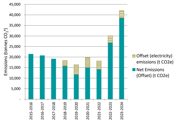
Table 1. 2023/24 Actual and net emissions since 2015/16
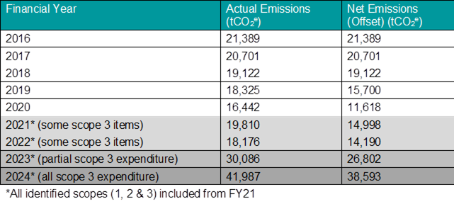
A detailed analysis of each sector is provided in the final 2023/34 Emissions Inventory Report (Attachment 1 - E2025/49804). Table 2 below gives a brief overview of the changes in each sector since the previous year.
Table 2. Summary of Emissions Sectors and Changes
|
Summary of Emissions Sectors |
||
|
|
Highlights |
Emissions Change (tCO2e) |
|
Electricity & Fossil fuels |
|
|
|
Electricity |
· As of 1 January 2022, Council achieved its goal of sourcing 100% of its operational electricity from renewable energy sources (five years ahead of the 2027 target). In FY24, a combination of renewable energy certificates and GreenPower was purchased for Council assets. · 6.5% (313 MWh) increase in electricity use. · Annual cost $1,664,651 |
+110 (net emissions are zero) |
|
Streetlights |
· As above, all electricity was certified renewable energy. · Electricity use was reduced by 37% (229 MWh) due to the bulk replacement program of fluorescent lamps with LED lamps. · Annual cost of street light service is $311,840. |
-163 (net emissions are zero) |
|
Fleet |
· 0.8% decrease in fuel consumption. · The price of petrol and diesel remained high due to current international market volatility. · 40% of fuel used in light (passenger) vehicle fleet and 60% used in heavy plant and equipment. · Significant action is required to reduce fleet sector emissions. · Annual cost $780,750. |
-13.7 |
|
Waste |
|
|
|
Waste |
· Waste contributes 9.6% to overall emissions. · 47% natural decline of emissions in landfill using an updated calculation methodology. · The gas flare continues to convert landfill emissions from predominantly methane to carbon dioxide, reducing the Global Warming Potential of the gases. |
-3,263 |
|
Wastewater |
· 28% increase in wastewater fugitive emissions due to increase in inflow to Council sewage treatment plants. · Wastewater emissions will continue to fluctuate across years as the Shire experiences different conditions (drought and rain) and different operational aspects (like reduced or increased biosolids inventories and land application)
|
+197 |
|
Scope 3 |
|
|
|
Construction, Repairs & Maintenance |
· 56.7% of total emissions · 95% increase in emissions from previous year due to a change in methodology and an increase in post-flood construction works. |
+10,653 |
|
Water |
· Water usage increased by 27ML or 38% on the previous year. · Emissions were up 38% to 185 tCO2e |
+50 |
|
Other Scope 3 |
|
|
|
Professional Services, Business Travel, Investments, Employees, Products, Materials & Equipment, Office Supplies & Equipment, Advertising & Marketing Services, ICT Services and Equipment
|
· These scope 3 emissions contribute approximately 10,230 (tCO2e) or 26% to total emissions. · There was an increase of 4,217 tCO2e or 70% due to a change in methodology which meant all general ledger items were included as expenditure (scope 3).
|
+4,217 |
Data Quality:
There are still improvements in data quality and collection that can be made to increase the accuracy of the emissions inventory. Staff will continue to refine this process each year to ensure the best available data is utilised in the calculations.
New net zero pathway and target:
Staff have commenced the process of developing a new pathway to net zero emissions and will continue with planned emissions reduction activities in the meantime. A report to Council will be prepared in the coming months regarding the new net zero pathway and proposed interim and long-term target dates.
|
3: Nurtured Environment |
3.4: Support and empower the community to adapt to, and mitigate the impact on climate change |
3.4.3: Monitoring and reporting - Monitor and report on actions that aim to address climate change |
3.4.3.2 |
Prepare annual operational emissions inventory to inform ongoing emissions reduction actions and planning |
|
3: Nurtured Environment |
3.4: Support and empower the community to adapt to, and mitigate the impact on climate change |
3.4.3: Monitoring and reporting - Monitor and report on actions that aim to address climate change |
3.4.3.1 |
Monitor performance of solar assets and report annually |
· Res 25-108 –
1. Acknowledges that it will not be possible to meet the target date for net zero emissions for Council operations by 2025 (Res. 17-086 item 3);
2. Acknowledges that it will not be possible to certify with Climate Active commencing in the 2025/26 financial year (Res. 19-634 item 2);
3. Notes that best-practice interim and long-term targets, including carbon neutrality, will be proposed after the development of a new pathway to net zero emissions;
4. Continues with planned emissions reduction activities while a new pathway to net zero emissions is being developed
5. Notes the plan to realign the net zero target utilising best practice methodology, being the ISO (International Standard for Organisation) IWA (International Workshop Agreement) 42:2022 Net Zero Guidelines;
6. Receives a further future report from Council staff on the development of the net zero pathway and the proposed interim and long-term target dates; and
7. Amends the Operational Plan for Q4 2024/25 to include the new action, 3.4.4.5 Review the Net Zero Emissions Strategy
None relevant to this report.
Staff Reports - Sustainable Environment and Economy 13.15
Report No. 13.15 Byron Bay Urban Design Housing Density Study
Directorate: Sustainable Environment and Economy
Report Author: Shannon Burt, Director Sustainable Environment and Economy
Sharyn French, Manager Environmental and Economic Planning
Patricia Docherty, Team Leader Planning Services - Commercial Industrial & Tourism
File No: I2025/734
Summary:
Council received funding from the NSW Government’s Regional Housing Strategic Planning Program to look at future housing in Byron Bay.
The Byron Bay Urban Design Housing Density Study applies to the residential areas next to the Byron Bay Town Centre.
The Study Area is the same as that identified in Council’s Residential-Strategy 2041 for further investigation for infill development opportunities.
The study aims to:
· Support infill development that creates attractive places to live.
· Guide future changes to Councils planning controls to facilitate the delivery of diverse and affordable housing.
· Support Council in meeting its housing targets, under the North Coast Regional Plan 2041. This target states that we must deliver 4,522 homes for 8,590 people in the next 20 years.
The purpose of this report is to have Council acknowledge the work completed on the Density Study, noting that the final Stage 3 is to be progressed FY2025/206 with further reports to Council.
That Council:
1. Acknowledges the work completed on the Byron Bay Urban Design Housing Density Study to meet the requirements of the NSW Government’s Regional Housing Strategic Planning Program;
2. Notes that staff will upload relevant documents associated with Stage 1 Housing Density Study (Attachment 1 – E2025/56242) and Stage 2 Housing Needs Assessment (Attachment 2 – E2025/54767) and Stage 2 Affordable Housing Viability Assessment (Attachment 3 – E2025/54752) of the Byron Bay Urban Design Housing Density Study to the project web page;
3. Notes that based on the results of the Affordable Housing Viability Assessment (Attachment 3 – E2025/54752) for the Study area, insufficient surpluses were generated by the housing typologies preferred by Council to support a standard Affordable Housing Contribution Scheme;
4. In response to 3 and the Housing Needs Assessment (Attachment 2 – E2025/54767), requests staff to prepare and report on a nonstandard Affordable Housing Contribution Scheme (for the Study area or a revised Area to support a Scheme) to inform a Planning Proposal to be reported to Council; and
5. Notes that the final Stage 3 Review and Amend Local Environmental Plan and Development Control Plan controls in the Study Area will be progressed during FY2025/26 with further reports to Council.
1 Echelon
& Urbanfold - Byron Bay Housing Density Study, E2025/56242 ![]()
2 Urbanista
- Housing Needs Assessment - Byron Bay Housing Density Study, E2025/54767 ![]()
3 Urbanista
- Viability Assessment Report - Byron Bay Housing Density Study, E2025/54752 ![]()
Background
Council received funding from the NSW Government’s Regional Housing Strategic Planning Program to look at future housing in Byron Bay.
The Byron Bay Urban Design Housing Density Study applies to the residential areas next to the Byron Bay Town Centre, refer to Map 1.
The Study Area is the same as that identified in Council’s Residential-Strategy 2041 (page 83) for further investigation for infill development opportunities.
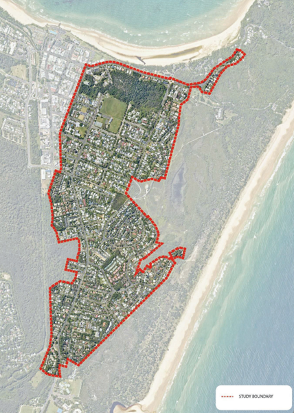
Map 1: Study Area
The Byron Bay Urban Design Housing Density Study is to be delivered in 3 stages.
Stage 1 - Housing Density Study
· A comprehensive technical review of the current planning controls.
· Investigation of viability of low-rise medium density development up to three stories to facilitate increased dwelling choice.
· Identifying how more housing and a variety of housing options can be achieved, including affordable housing stock for community and key workers.
· Considering opportunities for new open space and open space connections.
· Considering opportunities for high level changes to the road network to facilitate better traffic movement and pedestrian connections.
Stage 2 – Affordable Housing Viability Assessment
This stage will determine affordable housing contributions based on any uplift in land values from different housing typologies coming out of Stage 1.
Stage 3 – Amend Local Environmental Plan and Development Control Plan controls
To give effect to Stage 1. This will enable infill development opportunities for diverse and affordable housing and other related uses to support a vibrant town centre economy.
Details about each stage
Stage 1 - Housing Density Study
Echelon Planning and UrbanFold were engaged by Council to prepare a Housing Density Study (Attachment 1) to examine the residential areas next to the Town Centre to determine what opportunities exist to provide more varied and dense housing outcomes.
Part 1 of the Study sets out:
• Mapping of Constraints
• Precinct Analysis
• Summary of the Stakeholder Engagement
• Mapping of the Potential Change Areas:
• Precinct mapping of the change areas and the
• precincts,
• Nominated areas where typology modelling should occur (or not)
Part 2 of the Study sets out:
• Vision and Place-Based Principles
• Methodology outline for the typology modelling and
• the areas where this should occur
• Modelling of various housing typologies and various development and lot assumptions.
• Redevelopment Scenarios
• Observations and Recommendations about opportunities for density.
Overview of the Density Study
Based on the assessment of existing conditions, constraints and opportunities, areas of the Study Area were categorised generally as either ‘Incremental’ or ‘Moderate’ change areas:
· Incremental change areas are defined as slow change over time, primarily secondary dwellings or replacement houses with very limited multi-dwelling proposals.
· Moderate change areas are more likely to see greater change over time, primarily multi-unit dwellings, secondary dwellings and some apartment style development, refer to Map 2.
The Bangalow Road Corridor was identified with the greatest level of opportunity within the Study Area which was nominated for Moderate Change.
There were no substantial change areas identified.
The Study also identified that there were some large sites within the Study Area some of which may have opportunity for redevelopment, but these have significant and varied constraints on their redevelopment (i.e. existing developments or facilities). These “Large Sites” are defined as:
· Parcels over 2,000 sqm
· Held in one contiguous land ownership,
· Having more than one street frontage.
No strategic sites primed for development were identified.
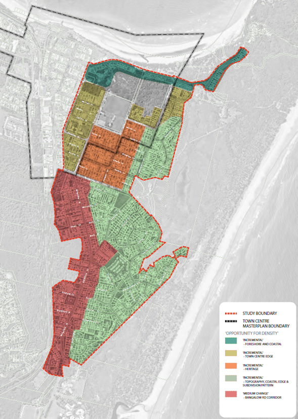
Map 2: Incremental and Medium Change areas
Stage 2 – Affordable Housing Viability Assessment
Urbanista were engaged by Council to prepare a Housing Needs Assessment (Attachment 2); and an Affordable Housing Viability Assessment (Attachment 3) for the Study Area based on the findings and results of Stage 1. The Assessment also needed to meet the requirements of the EP&A Act that contributions are ‘reasonable’.
Viability Assessment Method
• The profitability of each project is examined. Costs and revenue are estimated per apartment.
• The affordable housing contribution is applied, and the viability buffer examined.
• It is assumed that the viability buffer must be 10% for an affordable housing charge to be sustained (this allows for unforeseen risks).
• The Byron Bay Housing Density Study (2025 p 47) found: “the Bangalow Road Corridor presents the greatest level of opportunity within the Study Area”. Hence, it was decided to model some smaller apartment buildings along Bangalow Road.
• The chosen sites were larger corner sites on Bangalow Road.
Modelling Scenarios and Assumptions
• Buildings at different heights were modelled.
• Assumed that 40% of the sites are landscaped, apartment sizes are 85m2, finance is available at 8.5% and 20% of the buildings are common areas.
• Purchase prices for the land are based on recent sales plus a 50% acquisition premium assumed to operate to enable planning changes to be captured.
• Sales prices for the apartments are based on median sales plus 15% bonus as new dwellings.
Findings of the Assessment
• The high price of land means that low rise apartments (up to 3 storeys) will struggle to be feasible and hence an affordable housing contribution is not viable.
• Increasing the heights of apartment buildings above 3 storeys (leading to lower land prices per apartment) will make the developments and affordable housing contributions potentially feasible.
• However, for this to occur, Council’s appetite for increased building heights would need to be further tested and approved via planning control amendments.
Notwithstanding the above and given the acute housing affordability and availability challenge across Byron Shire as evidenced by the Housing Needs Assessment, it is recommended that Council pursue other options for raising funds for affordable housing contributions in the Town Centre Area.
These include:
• Application of the Council’s Draft Affordable Housing Contribution Policy, Affordable Housing Contribution Scheme Procedure, Affordable Housing Planning Agreement Procedure and Affordable Housing Contribution Distribution Plan 2025 Agenda of Ordinary Meeting - Thursday, 22 May 2025 and;
Stage 3 – Review and amend Local Environmental Plan and Development Control Plan controls
The next steps of this Density Study are to recommend and prepare necessary changes to the planning framework to implement the vision of the Study, where the medium density opportunities have been identified.
This is consistent with Council’s Residential Stagey 2041 recommendations for the Study area which provide for:
• Revising development standards (including height, floor space ratio and lot sizes) in the R2 Low Density and R3 Medium Density Residential zones to support greater variety of housing types / design options and number of homes to be developed on each site, and
• Expanding the R3 Medium Density Residential zone in Byron Bay Town Centre
This work will be completed FY2025/2026 with further reports to Council.
|
CSP Objective |
CSP Strategy |
DP Action |
Code |
OP Activity |
|
4: Ethical Growth |
4.1: Manage responsible development through effective place and space planning |
4.1.2: Growth Management Strategies - Implement Local Growth Management Strategies |
4.1.2.6 |
Deliver Byron Bay Town Centre Urban Design Housing Density Study |
|
4: Ethical Growth |
4.2: Enable housing diversity and support people experiencing housing insecurity |
4.2.1: People experiencing housing insecurity - Seek opportunities that provide fair, appropriate, and affordable housing for people experiencing housing insecurity |
4.2.1.1 |
Expand or apply new affordable housing contribution mechanisms over all new residential rezonings |
As discussed in the report where applicable to the study stage.
Council received $239,239 to fund this study from the NSW Government’s Regional Housing Strategic Planning program.
Undertaken as required to meet the Grant milestones. The project team completed targeted consultation with active local developers and local architect/ planners.
Meetings with Council Planners and engineers were also undertaken.
Staff Reports - Sustainable Environment and Economy 13.16
Report No. 13.16 Heritage buildings in Mullumbimby
Directorate: Sustainable Environment and Economy
Report Author: Sarah Nagel, Manager Public and Environmental Services
File No: I2025/743
Summary:
This report responds to Council Resolution 24-504 Minutes of Ordinary (Planning) Meeting - Thursday, 14 November 2024 to retain, control, and restore the old stationmaster’s house and the train station building in the rail corridor in Mullumbimby
RECOMMENDATION:
That Council:
1. Continues to negotiate with TfNSW, the terms and conditions for the transfer of the management responsibility for the old station master’s house to Council, conditional to Council not being responsible the cost and management of remediating the site; and
2. Continues to work with TfNSW to identify a suitable solution for the Mullumbimby train station site, including options such as the adaptive reuse of the site, to support potential funding requests (e.g. grants).
1 Preliminary
Site Investigation old station masters residence prepared ERM dated December
2014, E2025/55936 ![]()
2 Environmental
Site Assessment Old station masters residence prepared by Cavvanba Consulting
dated March 2023, E2025/55938 ![]()
3 Technical
Memo Internal Lead Dust Assessment Old station masters Residence prepared by
Ramboll, E2025/55940 ![]()
4 Human
Health Risk Assessment Old station masters Residence prepared by Ramboll Aust
dated September 2024, E2025/55942
![]()
5 Intermin
Environmental Management Plan Old station masters Residence prepared by Ramboll
Aust dated November 2024, E2025/55943
![]()
Council resolved via 24-504 that Council:
1. Does everything in its power to retain, control, and restore the (old stationmaster’s) house and the train station building in the rail corridor in Mullumbimby.
2. Receives a report on the progress of the licence negotiations with TfNSW and TAHE, that will see a significant section of rail corridor coming into Council hands, including next steps on how to determine the mix of open space and parking as per the Mullumbimby Masterplan.
3. Receives an independent assessment on the contamination of the Station Master’s Cottage and Mullumbimby Station prior to any transfer.
4. Investigates the possibility of TfNSW or Flickerfest remediating the station through their insurance prior to any transfer.
Items 1 and 2
This report responds to Item 2.
Staff have had ongoing meetings with TfNSW and TAHE now (TAM), to progress the future management of the old stationmaster’s house (“SMH”) and the train station building (“TSB”):
Old Station Master’s House
· TAM has now taken over management of the SMH.
· Council has expressed the desire for the SMH to remain and for Council to take over management responsibility for the asset, conditional to Council not being responsible for remediating the site.
· TfNSW confirmed that it would continue to be responsible for managing contamination and it would remediate the site to current zoning only.
· TfNSW and Council will need to explore an appropriate management approach for Council to occupy the SMH (e.g. legal agreement (lease/licence) together with the proposed commercial terms.
· Council to provide TfNSW with a Council Resolution with respect to the SMH so TfNSW can further consider Council’s proposed occupation of the SMH site.
· TfNSW to make the site safe while these processes occur.
Train Station Building
Council and TfNSW agreed to work collaboratively to allow:
· Council has expressed the desire for Council to take over management responsibility for the asset, conditional to Council not being responsible for remediating the site.
· Council acknowledged issues with the TSB due to the hazardous material and contamination.
· Hazardous materials would need to be removed but there is a need to support bus patrons and Council seeks to work with TfNSW on a suitable solution including adaptive reuse of the site.
· TfNSW willing to work with Council on what a suitable solution may look like to support potential funding requests (e.g. grants).
· TfNSW to make the site safe while these processes occur.
Item 3
Council has obtained redacted copies of five reports from TfNSW relating to the Station Master’s Cottage (Attachments 1-5). These reports have been reviewed by Council’s Environmental Health Team. In summary, their review states:
…the site is not suitable for residential land use and short-term remedial and risk management controls are necessary. It is recommended that an Interim Environmental Management Plan (IEMP) be developed and implemented until such time the site is remediated and/or placed under long-term environmental management controls.
…it is considered to be suitable for continued commercial land use..
TfNSW have advised Council that they hold no reports relating to the Mullumbimby Station. To ascertain the status of the Station, TfNSW will be required to fund independent building and contamination assessments.
Item 4
These options are no longer required due to the progression of Items 1 and 2, as outlined above.
|
CSP Objective |
CSP Strategy |
DP Action |
|
|
4: Ethical Growth |
4.1: Manage responsible development through effective place and space planning |
4.1.3: Town / Village Masterplans - Develop, implement, and update Place Plans that promote place-based forward planning strategies and actions
|
|
· 24-504
No new or additional implications.
Relevant and available documents obtained from TfNSW are attached to the report.
Consultation with TfNSW and community, as outlined in this report.
Staff Reports - Sustainable Environment and Economy 13.17
Report No. 13.17 PLANNING - 10.2024.155.1 Alterations and additions to existing multi-dwelling housing development comprising the construction of six (6) x one (1) bedroom dwellings, the construction of two (2) x two (2) bedroom dwellings, and the construction of additional car parking, resulting in a total of twenty (20) dwellings, at 1 Kendall Street, Byron Bay
Directorate: Sustainable Environment and Economy
Report Author: Ben Grant, Senior Planner
File No: I2025/755
Proposal:
|
DA No: |
10.2024.155.1 |
||
|
Planning Portal ref |
PAN-436151 |
||
|
Proposal description: |
Alterations and additions to the existing multi dwelling housing development comprising the construction of six (6) x one (1) bedroom dwellings; the construction of two (2) x two (2) bedroom dwellings, and the construction of additional car parking resulting in a total of twenty (20) dwellings |
||
|
Property description: |
Lots 0 – 13 in SP 96105 |
||
|
1 Kendall Street BYRON BAY |
|||
|
Parcel No/s: |
268846, 268855, 268847, 268848, 268849, 268850, 268851, 268853, 268854, 268856, 268857, 268858, 268859, 268852 |
||
|
Applicant: |
Planners North |
||
|
Owner: |
The Owners of Strata Plan 96105 |
||
|
Zoning: |
C2 Environmental Conservation / PART C3 Environmental Management / PART R2 Low Density. All proposed works are located within R2 zone. |
||
|
Date received: |
30 May 2024 |
||
|
Type of development |
☐ Local |
☐ Integrated |
☒ Designated |
|
Concurrence required |
Yes CNR-69803 |
||
|
Public notification or exhibition: |
- Level 4 Designated Development advertising under Council’s Community Participation Plan and in accordance with EPA Regulation clause 58 - Exhibition period: 18/06/2024 to 15/07/2024 - Submissions received: 2 - Submissions acknowledged: ☒ Yes ☐ No ☐ N/A |
||
|
Planning Review Committee |
Not applicable |
||
|
Variation request to Development Standards under an EPI (e.g., clause 4.6) |
Not applicable
|
||
|
Estimated cost |
$2,476,100.00 |
||
|
Delegation to determine |
Council. The proposal is designated development. |
||
|
Issues |
· Ecological Impacts. · Traffic impacts. · Front setback (DCP Part D1.2.2). · Private open space (DCP Part D1.6.1). |
||
Summary:
This development application seeks consent for alterations and additions to an existing multi dwelling housing development containing 12 attached dwellings at 1 Kendall Street, Byron Bay. The proposal involves constructing 6 new dwellings on the western side of the existing building, and the construction of 2 new dwellings in a smaller building to the south. In total, 8 new dwellings are proposed, resulting in 20 dwellings on the site overall.
The site contains mapped coastal wetlands vegetation which is contiguous with the Cumbebin Swamp Nature Reserve to the south. While this mapping captures areas of genuine wetland vegetation, it also covers developed surfaces such as concrete carparks and managed gardens surrounding the existing buildings. The inclusion of developed features is considered an obvious spatial error in the mapping.
The proposed development does not encroach into the wetland itself but is partially within the boundaries of the mapped area. As a result, the proposal is classified as designated development under s2.7 of State Environmental Planning Policy (Resilience and Hazards) 2021. The application has been referred to the Council for determination as staff do not have delegation to determine an application for designated development.
An Environmental Impact Statement (EIS) and biodiversity assessment report were submitted which included a detailed assessment of the potential environmental effects of the development. The reports concluded that the proposal will not result in any significant deleterious direct or indirect impacts on the biodiversity values of the subject land or the wider locality, noting that the development footprint is located within an existing disturbed part of the site and will not require the removal of native vegetation.
The development application was advertised and notified for a period of 28 days in accordance with the Community Participation Plan. Two submissions were received expressing concerns over the cumulative environmental effects of the development, and the potential for increased traffic congestion at the Kendall Street-Ewingsdale Road intersection. These issues have been considered and are addressed where necessary through appropriate conditions of consent.
In terms of design, the proposed alterations and additions are complimentary to the existing built form and architectural style of the building. The design features pitched roofs, articulated facades, overhanging eaves, and materials that match the existing structure, including painted weatherboard cladding, and Colorbond roofing.
The proposed development has been assessed against the relevant planning controls applying to the site and is generally compliant. The proposal will contribute to the diversity and supply of housing in the Byron Bay area and has been sited and designed to avoid sensitive parts of the site. The development application is recommended for approval subject to conditions of consent.
NOTE TO COUNCILLORS:
In accordance with the provisions of S375A of the Local Government Act 1993, a Division is to be called whenever a motion for a planning decision is put to the meeting, for the purpose of recording voting on planning matters. Pursuant to clause 2(a) under the heading Matters to be Included in Minutes of Council Meetings of Council's adopted Code of Meeting Practice (as amended) a Division will be deemed to have been called by the mover and seconder of all motions relating to this report.
RECOMMENDATION:
That Pursuant to Section 4.16 of the Environmental Planning and Assessment Act 1979, Development Application No. 10.2024.155.1 for alterations and additions to an existing multi dwelling housing development comprising the construction of six (6) x one (1) bedroom dwellings; the construction of two (2) x two (2) bedroom dwellings, and the construction of additional car parking resulting in a total of twenty (20) dwellings, be granted consent subject to the Conditions in Attachment 1 (E2025/56004).
1 10.2024.155.1
Recommended Conditions of Consent, E2025/56004
![]()
2 10.2024.155.1
Architectural Plans, E2025/56006 ![]()
3 10.2024.155.1
Submissions received, E2025/57151
![]()
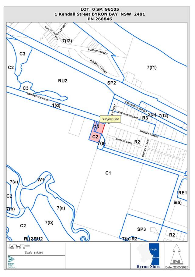
The site contains a multi-dwelling housing complex comprising 12 attached dwellings approved via development application 10.2015.398.1 on 19 October 2015. The complex contains two affordable housing units that are required to be managed by a registered community housing provider.
Previous determinations for the site are listed below.
· 10.2011.338.1 – Double storey dwelling house, approved 15 Feb 2012.
· 10.2012.273.1 – Use of temporary structures approved 11 Sep 2012.
· 10.2014.632.1 – Four attached dwellings, 21 Jan 2015.
· 10.2015.398.1 – Multi-dwelling housing (12 dwellings) approved 19 Oct 2015.
· 10.2015.398.2 – Modify affordable housing conditions, approved 8 Dec 2015.
· 10.2015.398.3 – Modify bushfire conditions, approved 6 Jan 2016.
· 10.2015.398.4 – Modification to building design, approved 1 April 2016.
· 10.2015.398.5 – Modification to add second driveway, approved 31 Aug 2016.
· 10.2015.398.6 – Modification for development in two stages, approved 2 Feb 2017.
· 10.2015.398.7 – Inclusion of service driveway in Stage 2, approved 16 May 2017.
· 10.2015.398.8 – Modification to add toilet and storage area, approved 1 Feb 2018.
· 10.2017.208.1 – Home industry approved 25 August 2017.
· 10.2017.208.2 – Modify location of home industry, approved 8 November 2018.
· 16.2017.44.1 – CDC for strata subdivision, issued 23 June 2017.
This application seeks development consent for substantial alterations and additions to an existing multi-dwelling housing development at 1 Kendall Street, Byron Bay.
The proposed scope of works consists of the following:
1. Extension to existing building (Units 13-18)
An extension to the western side of the existing building is proposed comprising six new attached dwellings (Units 13-18). Each dwelling will have carparking and laundry on the ground floor, one bedroom, bathroom, and kitchen on the first floor, and a loft-style living space on the second floor. The unit layout, courtyard design, and architecture will match the existing building.
2. Construction of new building (Units 19-20)
A new two-storey building will be constructed to south containing two attached dwellings (Units 19-20). Each dwelling will have carparking on the ground floor, two bedrooms, bathroom, open plan kitchen, and lounge on the first floor. Both units have a private open space deck on the first floor of 12m2 and 14m2 respectively.
3. Ancillary works
Ancillary works are proposed including the construction of a stormwater system with on-site detention and bioretention swales, and new carparking and manoeuvring areas.
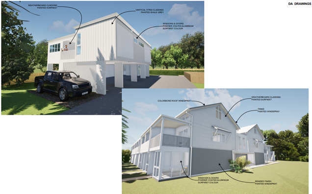
Figure 1: Visualisation of the proposed development.
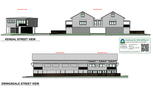
Figure 2: Street view of the development from Kendall St. and Ewingsdale Road.
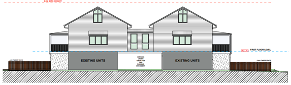
Figure 3: Units 13-18 – west elevation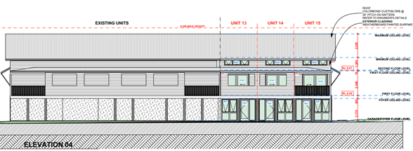
Figure 4: Units 13-18 – north elevation
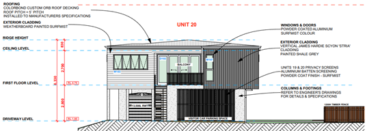
Figure 5: Units 19-20 – east elevation
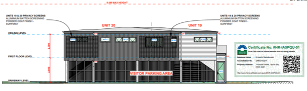
Figure 6: Units 19-20 – north elevation
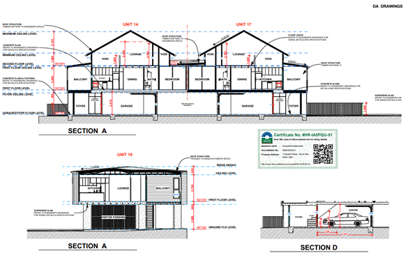
Figure 7: Sections
The subject site is legally described as SP96105 and is located on the corner of Ewingsdale Road and Kendall Street, Byron Bay. The site is rectangular in shape with a frontage of approximately 57m to Ewingsdale Road and a depth of approximately 107m. The total area of the allotment is approximately 6088m².
The site contains a two storey multi-dwelling housing development comprising 12 attached dwellings with ground floor carparking. Two of the existing dwellings were approved as affordable housing under the former SEPP (Affordable Rental Housing) 2009.
The site lies on the periphery of the Shirley Street urban area, approximately 800m from the Byron Bay town centre. A service station adjoins the site on the opposite side of Kendall Street to the east.
Vegetation consists of coastal wetlands in the south-western portion of the site with clusters of trees scattered around the existing building. The site adjoins the Cumbebin Swamp Nature Reserve on the southern and western boundaries.
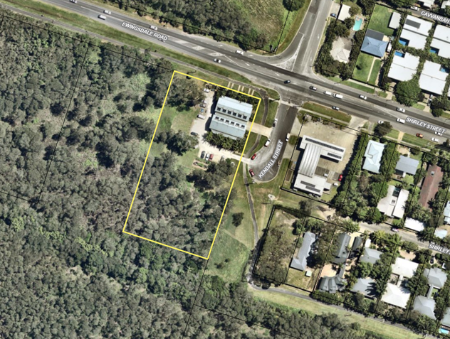
Figure 8: Aerial image of site.
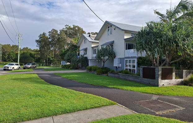
Figure 9: View of site from the corner of Ewingsdale Rd. and Kendall St.
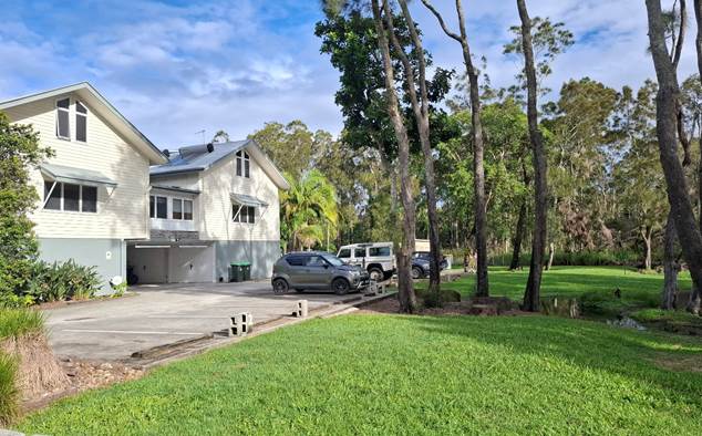
Figure 10: Location of proposed extension to existing building (Units 13-18).
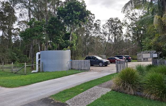
Figure 11: Second driveway access for new building (Units 19-20).
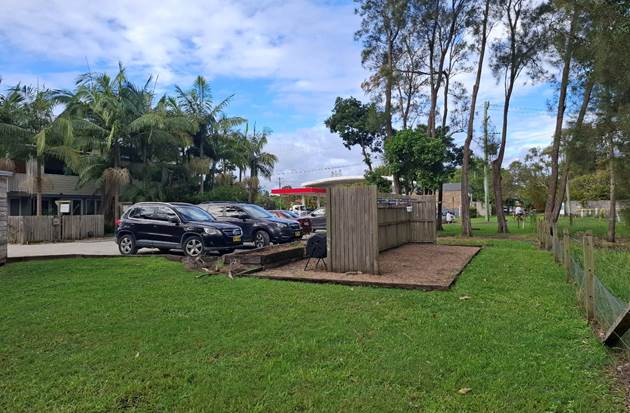
Figure 12: Proposed location of Dwellings 19 and 20.
|
Officer |
Comment |
|
Environmental Health Officer |
Council’s Environmental Health Officer raised no objection subject to conditions of consent. |
|
Development Engineer |
Council’s Development Engineer recommended the construction of a low angle slip bypass lane to ensure traffic coming out of Kendall Street can turn left and merge without compromising the safety and function of Ewingsdale Road. |
|
Building Surveyor |
Council’s Building Surveyor noted that the proposed development could comply with the NCC requirements for Class 1(a) dwellings. |
|
Systems Planning Officer |
Development Servicing Levies are payable. |
|
Development Contributions Officer |
Development contributions are payable. |
|
Ecologist |
Council’s Ecologist supported the proposal subject to the imposition of conditions to protect trees in proximity to new development. |
|
Resource Recovery |
Resource Recovery did not object to the proposed development subject to appropriate conditions for waste storage and collection. |
|
Rural Fire Service (4.14) |
The RFS provided recommended conditions of consent to Council on 20 June 2024. |
|
Department of Climate Change, Energy the Environment and Water – Biodiversity, Conservation and Science |
DCCEEW commented that any removal or pruning of native vegetation within the Biodiversity Values Map area will trigger the Biodiversity Offsets Scheme, including provision of a BDAR. It is noted that amended plans have been submitted which increase separation distances from adjacent Melaleuca trees, and therefore no pruning or tree removal will be required. |
|
Arakwal |
Referral was sent 07/08/24. No comments received. |
|
Tweed Byron Local Aboriginal Land Council |
TBLALC recommended that Aboriginal cultural monitors be engaged during any significant ground disturbing phase of the proposed development. |
Under section 4.14 of the Act, Council must be satisfied prior to making a determination for development on bush fire prone land, that the development complies with the document ‘Planning for Bush Fire Protection 2019’. The site is bushfire prone land.
The RFS provided a set of bushfire conditions which have been incorporated into the recommended conditions of consent in Attachment 1.
Having regard to the matters for consideration detailed in Section 4.15(1) of the Environmental Planning & Assessment Act 1979 (EP&A Act), the following is a summary of the evaluation of the issues.
Biodiversity and Conservation SEPP 2021
Chapter 4 Koala Habitat Protection is not applicable to this assessment as the total site area is less than 1ha. The development is unlikely to have a significant impact on koalas or koala habitat given that development is contained within existing residential zoned land and does not result in the removal of native vegetation.
Resilience and Hazards SEPP 2021
Clause 2.7 Development on certain land within coastal wetlands and littoral rainforests area
Section 2.7 of the Resilience and Hazards SEPP provides that development consent is required for any development within a mapped coastal wetland area. Development for such purposes, other than environmental protection works, is declared to be designated development.
As shown in Figure 13, the southern and western portions of the site fall within the mapped Coastal Wetlands Area. While this mapping captures areas of genuine wetland vegetation, it also includes developed surfaces such as concrete carparks and managed gardens surrounding the existing buildings. The inclusion of developed features is considered an obvious spatial error in the mapping.
The development has been carefully sited within the existing disturbed part of the site and does not encroach into any actual coast wetland vegetation. No native trees within the periphery of the site need to be cleared to establish the development or to create an asset protection zone.
In terms of ecological impacts, the applicant’s EIS and biodiversity assessment report conclude that the proposed development will not adversely affect the biophysical, hydrological and ecological integrity of the coastal wetland, or any threatened species or ecological communities.
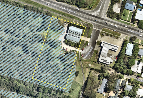
Figure 13: Site image with an overlay of the Coastal Wetlands Map (Blue Hash).
Conditions of consent are recommended that require an updated vegetation management plan to be approved post-consent, outlining measures to protect existing vegetation near new development and detail strategies for preserving and restoring where necessary existing coast wetland communities on the site.
Clause 2.8 Development on land in proximity to coastal wetlands or littoral rainforest
The proposed development is located in the north-east corner of the site, within land zoned for residential use and the mapped “proximity area for coastal wetlands.”
The development is considered acceptable as it is confined to the curtilage of existing residential development and does not require the removal of native vegetation. Stormwater will be managed via detention tanks and bioretention swales before discharging into Council’s drainage system on Kendall Street. As a result, the volume and quality of water entering the adjacent wetlands will remain largely unchanged.
Clause 2.10 Development on land within the coastal environment area & Clause 2.11 Development on land within the coastal use area
The site is located within the coastal environment area and coastal use area. As previously noted, the proposed development is located on residential zoned land and has been designed to avoid existing areas of native vegetation. The proposal will not adversely affect coastal environmental values and is satisfactory having regard to the matters for consideration under ss 2.10 – 2.12 of SEPP (Resilience and Hazards) 2021.
Chapter 4 Remediation of Land
The subject site was investigated for soil and groundwater contamination as part of previous development applications and was found to be suitable for residential use. The probability of land contamination is low, and the site is considered suitable for ongoing residential use in its current state.
Transport and Infrastructure SEPP 2021
Clause 2.119 Development with frontage to classified road
Vehicular access will be via existing driveways on Kendall Street, avoiding direct access to Ewingsdale Road, a regional classified road.
The proposed eight dwellings are expected to generate approximately 37 additional vehicle trips per day, including around 4 per hour. Council’s Development Engineer found that this increase would adversely affect the Kendall Street–Ewingsdale Road intersection. To mitigate this impact, conditions of consent require the construction of a new left-turn low-angle slip lane to maintain traffic safety and flow on Ewingsdale Road.
State Environmental Planning Policy (Housing) 2021
The proposed alterations and additions do not have an affordable housing component and any Housing SEPP provisions relating to affordable housing are not relevant to this assessment.
State Environmental Planning Policy (Sustainable Buildings) 2022
A valid multi-dwelling BASIX certificate has been provided with the application. Commitments for energy, water and thermal comfort have been shown on the DA plans.
In accordance with LEP 2014 clauses 1.4 and 2.1 – 2.3:
(a) The proposed development is defined in the LEP 2014 Dictionary as multi dwelling;
(b) The land is within the C2 Environmental Conservation, C3 Environmental Management, and R2 Low Density Residential zone according to the Land Zoning Map. All proposed works are within the R2 zone,
(c) The proposed development is permitted with consent; and
(d) Regard is had for the Zone Objectives as follows:
|
Zone Objective R2 Low Density Residential |
Consideration |
|
To provide for the housing needs of the community within a low-density residential environment. |
The proposed development is compatible with the R2 Zone objectives. |
|
To enable other land uses that provide facilities or services to meet the day to day needs of residents. |
The remaining checked clauses have been taken into consideration in the assessment of the subject development application in accordance with Section 4.15 of the EP&A Act. The proposed development complies with all clauses of LEP 2014 (in some cases subject to conditions and/or to the satisfaction of other assessing officers).
|
LEP Requirement |
Complies? |
Comment |
||||||||||
|
Clause 4.1E Minimum lot sizes for certain residential accommodation |
Yes |
A minimum lot size of 1,000m2 is required for multi-dwelling housing in the R2 Low Density Residential zone. The subject site has an area of 6,085m2 and complies with the lot size standard. |
||||||||||
|
Clause 4.3 Height |
Yes |
A maximum building height standard of 9m applies to the subject site. The proposed development has a maximum height of 8.5m above existing ground level. |
||||||||||
|
Clause 4.4 Floor space ratio |
Yes |
A maximum floor space ratio of 0.5:1 applies to the subject site. The proposed development result in a total GFA of 982m2 and a floor space ratio of 0.49:1 as detailed below:
|
Part 5 Miscellaneous provisions
|
LEP Requirement |
Complies? |
Comment |
|
Clause 5.21 Flood planning
|
Yes |
The site is subject to flooding from Belongil Creek, with a 2050 Flood Planning Level (FPL) of 3.11m AHD based on Council’s modelling. All habitable rooms are located on the first floor at 4.4m AHD, above the FPL. Non-habitable areas, including garages and laundries, are on the ground floor below the FPL. Conditions of consent require the use of flood-compatible materials for all building elements below the FPL. |
Part 6 Additional local provisions
Division 1 Miscellaneous
|
LEP Requirement |
Complies? |
Comment |
|
Clause 6.1 Acid sulfate soils
|
Yes |
The site contains Class 3 potential Acid Sulfate Soils. An assessment submitted with the application recommends management measures to address this risk. A condition of consent requires these recommendations to be implemented during construction. |
|
Clause 6.2 Earthworks
|
Yes |
The proposal will involve minor earthworks which are unlikely to affect drainage patterns of soil stability in the locality and are satisfactory having regard to the matters for consideration under Clause 6.2. |
|
Clause 6.6 Essential services
|
Yes |
The proposed development is located on residential zoned land with access to reticulated water, sewer, electricity, and telecommunications services. Vehicular access off Kendall Street is adequate. |
Division 2 Affordable housing
|
LEP Requirement |
Complies? |
Comment |
|
Clause 6.17 Affordable housing in employment, mixed use and residential zones
|
Yes |
The existing development was approved pursuant to the former SEPP (Affordable Rental Housing) 2009. Two of the dwellings within the complex are required to be maintained as affordable housing and managed by a community housing provider for a period of 10-years from the date of the issue of the occupation certificate. The proposed development does not propose any change to the current status of the existing affordable housing units and will not alter the management or use of these dwellings. The new units are not intended to be affordable housing in their own right but will nonetheless add to the diversity and supply of dwelling stock in the Byron Bay area. |
There are no proposed environmental planning instruments with relevance to the development application.
Chapter B1 Biodiversity
|
DCP Requirement |
Complies? |
Comment |
|
B1.2.1 Development Envelope Controls |
Meets performance criteria |
The proposed development envelope does not strictly comply with the Prescriptive Measures of Part B1.2.1 as it will result in development within 50m of mapped coastal wetlands. The proposed development is considered to achieve the Objectives and Performance Criteria for ecological setbacks, which is discussed further in the DCP 2014 Issues Section. Conditions of consent to apply in relation to restriction on cats and dogs noting the property adjoins areas of native vegetation and wetland. |
Chapter B3 Services
|
DCP Requirement |
Complies? |
Comment |
|
B3.2.3 Stormwater Management |
Yes |
Stormwater is to be handled and treated to any appropriate standard using a combination of detention tanks and bioretention swales. Stormwater flows will ultimately be directed to the Council drainage system in Kendall Street and will not impact the adjoining wetland. |
Chapter B4 Traffic Planning, Vehicle Parking, Circulation and Access
|
DCP Requirement |
Complies? |
Comment |
|
B4.2.1 Traffic Impact |
Yes, subject to conditions. |
The applicant’s traffic assessment report estimates that the final 20-unit development will generate 92 vehicles trips per day and 12 trips per peak hour when fully occupied. This represents a 33% increase in traffic generation compared to the current 12-unit development. Council’s Development Engineer concluded that the increase in traffic will adversely affect the safety and efficiency of the intersection between Ewingsdale Road and Kendall Street, which is already heavily congested. To mitigate traffic issues, a condition is recommended that requires a low angle slip lane to be constructed in Ewingsdale Road to allow left turning vehicles to safely merge with westbound traffic. |
Chapter B5 Providing for Cycling
|
DCP Requirement |
Complies? |
Comment |
|
Chapter B5 Providing for Cycling |
Yes |
The site adjoins a shared path on southern side of Shirley Street which provides pedestrian and bicycle access into the town centre. Each dwelling has adequate room for internal bicycle storage on the ground floor. |
Chapter B7 Mosquitoes and Biting Midges
|
DCP Requirement |
Complies? |
Comment |
|
Chapter B7 Mosquitoes and Biting Midges |
Yes, subject to conditions |
Conditions are recommended for all windows and sliding doors to be screened with mosquito proof mesh prior to the occupation of the building. |
Chapter B8 Waste Minimisation and Management
|
DCP Requirement |
Complies? |
Comment |
|
B8.3.3 Bin Sizes and Collection Measures |
Yes, subject to conditions |
Council’s Resource Recovery officer recommended that an amended waste minimisation and management plan be provided for approval post-consent, detailing measures for recycling and bin storage. |
Chapter B9 Landscaping
|
DCP Requirement |
Complies? |
Comment |
|
B9.4 Multi Dwelling Housing, Attached Dwellings and Residential Flat Buildings |
Yes, subject to conditions |
A condition is recommended for a detailed landscaping plan to be approved post-consent. The plan is to detail appropriate landscape areas incorporating endemic native species to provide a pleasant environment for residents and guests. |
Chapter B13 Access and Mobility
|
DCP Requirement |
Complies? |
Comment |
|
B13.2.2 Multi Dwelling Housing, Attached Dwellings, Residential Flat Buildings, Shop Top Housing and Serviced Apartments |
Yes, subject to conditions |
This development control requires a minimum of 10% of multi-dwelling units to be adaptable housing. Conditions are recommended requiring one the proposed dwellings to be designed as adaptable housing in accordance with AS1428.1. |
Chapter C2 Areas Affected by Flood
|
DCP Requirement |
Complies? |
Comment |
|
C2.3.2 Minimum Floor Levels |
|
All habitable floor levels are above the estimated 2050 FPL of 3.11m AHD. Conditions are recommended for the use of flood compatible materials below the FPL. |
Chapter D1 Residential Accommodation in Urban, Village and Special Purpose Zones
|
DCP Requirement |
Complies? |
Comment |
|
D1.2.2 Setbacks from Boundaries |
Meets performance criteria |
The proposed development provides a 6.5 metre setback to Ewingsdale Road which is 2.5 metres less than the 9.0 metres specified for a two-storey development adjacent to a Classified Road. Refer to DCP 2014 Issues Section. |
|
D1.2.3 Privacy D1.2.4 Solar Access |
Yes |
The proposed development will not result in a significant loss of privacy or solar access for any new or existing dwellings. |
|
D1.2.5 Screening the Underfloor Space of Buildings |
Yes |
Conditions are recommended for the subfloor space of Units 19 and 20 to be screened. |
|
D1.2.7 Fences |
Yes |
Conditions are recommended for any new fencing to be limited to a maximum of 1.2m, consistent with the existing fencing for the site. |
|
D1.6.1 Private Open Space Courtyards |
Meets performance criteria |
The proposed private open space courtyards are smaller than the 30m2 requirement under D1.6.1. Refer to DCP 2014 Issues Section. |
|
D1.6.4 On-Site Car Parking |
Yes |
Adequate carparking is provided for each dwelling unit in accordance with Chapter D1. |
|
D1.6.5 Sound Proofing |
Yes |
Conditions are recommended for adequate soundproofing between units. |
|
D1.6.6 Clothes Drying Facilities |
Yes, subject to conditions |
Conditions for clothes drying areas to be specified on plans. |
|
D1.6.9 TV Antennae |
Yes |
Conditions are recommended for a maximum of 1 TV antennae per building as per D1.6.9. |
|
D1.6.10 Character |
Yes |
The proposed alterations and additions are appropriately sited and designed to complement the existing built form. The design features pitched roofs, articulated facades, overhanging eaves, and materials that match the existing structure, including painted weatherboard cladding, and Colorbond roofing. |
|
D1.6.11 Density |
Yes |
The R2 Low Density Residential zone limits multi-dwelling housing to 3 dwellings per 1,000m², unless affordable housing is included. The R2-zoned portion of the site is 2,003m², permitting up to 18 dwellings under Part D1.6.11. While the total number of dwellings exceeds the standard density control, two of the existing dwellings are affordable housing units and are therefore exempt from the control. The proposal is considered compliant with the density control for non-affordable housing dwellings. |
|
D1.7 Affordable Housing in R2, R3, B2 and B4 Zones Housing |
Yes |
No change to the existing affordable housing component of the development is proposed. |
Development Control Plan 2014 - Issues
1. Proximity to coastal wetlands
B1.2.1 Development Envelope Controls
Units 19 and 20 are located within 50 metres of mapped coastal wetland vegetation in the southern part of the site, falling short of the prescribed ecological setback under Part B1.2.1. However, the proposal is considered to meet the Objectives and Performance Criteria for the following reasons:
· The development footprint avoids native vegetation, aligning with the principle of avoiding and minimising biodiversity impacts. A detailed ecological assessment supports this, finding any impacts to be manageable.
· Trees within the existing and proposed Asset Protection Zones can be retained, with the arborist report confirming no adverse effects on tree health.
· Stormwater will be adequately managed and treated to ensure that the hydrological function of the adjoining wetland will not be altered or compromised.
· Conditions of consent will require a Vegetation Management Plan to protect and enhance on-site coastal wetland vegetation.
2. Front setback to Ewingsdale Road (Classified Road)
D1.2.2 Setbacks from Boundaries
The proposed development provides a 6.5 metre setback to Ewingsdale Road which is 2.5 metres less than the 9.0 metres specified for a two-storey development adjacent to a Classified Road. The proposed non-compliance is considered to satisfy the Objectives and Performance Criteria for setbacks in this instance in view of the following:
· The existing multi-dwelling housing complex currently has a 6.5m setback to Ewingsdale Road. Maintaining this alignment will allow the building to be naturally extended further west, ensuring a simpler and more sympathetic design that matches the existing architecture.
· The setback controls normally allow for a to 6.5 metres for single storey dwellings fronting a classified road. In this case, the site is flood liable land and the dwellings have been designed as two storey structures to meet flood planning requirements. Given the site constraints, allowing for a slightly reduced setback of the second storey component is considered acceptable.
· The proposed front setback is considered to satisfy the objective of harmonising with existing streetscape and development in the locality. The subject site is highly constrained, and the reduced front setback assists the effective use of the allotment to create useable and liveable private open space and courtyards.
3. Private open space courtyards
D1.6.1 Private Open Space Courtyards
Units 13-18 and 19-20 do not strictly meet the 30m² private open space requirement under DCP Part D1.6.1. However, the proposal satisfies the relevant objectives through alternative design solutions.
Units 13-18 each have approximately 28m² of private open space comprising a 20m² ground-level courtyard (matching existing dwellings) and an 8m² first-floor balcony. This configuration delivers useable, landscaped private space which is consistent with the layout and design of the existing housing complex.
Units 19-20 feature first-floor balconies of 12m² and 14m² respectively, offering elevated outlooks over adjoining wetlands. The covered first-floor decks effectively extend the living areas and provide appropriate private amenity for 2-bedroom dwellings.
The private open space provision adequately serves the dwellings' needs, particularly given the proximity to town centre open space and coastal reserves. The design achieves the DCP objective of providing "private, useable, landscaped open space" through practical alternatives suited to site constraints.
4.5 Environmental Planning and Assessment Regulation 2021 considerations
Section 61 - Additional matters that consent authority must consider
A condition is recommended for any demolition works to be carried out in accordance with AS2601 The demolition of structures.
Section 64 - Consent authority may require upgrade of buildings
The existing building does not require upgrading to meet the requirements of the BCA. The adequacy of new building work will be assessed at the construction certificate stage.
|
Impact on: |
Likely significant impact/s? |
|
Natural environment |
The proposal will not have a significantly adverse impact on the natural environment of the locality. The development footprint avoids areas of native vegetation and will not impact on the adjacent coastal wetland vegetation. Conditions are recommended for the preparation and implementation of a vegetation management plan to enhance and maintain the existing wetland communities on the subject site. |
|
Built environment |
The proposed alterations and additions are compatible with the existing built form on the site and will not detract from the setting of the adjacent Shirley Street Conservation Area. Concerns over traffic congestion at the Kendall Street-Ewingsdale Road intersection are addressed through conditions requiring the provision of a left-turn slip lane. |
|
Social Environment |
The proposed development will increase the diversity and supply of dwellings in the Byron Bay area. Existing affordable housing units within the complex will not be affected. |
|
Economic impact |
The proposal will not have a significant economic impact on the locality. |
|
Construction Impacts |
No. The development will generate minor impacts during its construction. Conditions of consent recommended to control hours of work, builders waste, construction noise, installation of sedimentation and erosion control measures and the like to ameliorate such impacts. |
The site is a serviced, unconstrained property and is suitable for the proposed development.
The development application was publicly exhibited for a period of 28-days in accordance with the Community Participation Plan.
There were 3 submissions made on the application which are addressed below:
|
Issue |
Discussion |
|
Cumulative impacts A submission was received from NSW National Parks and Wildlife regarding the potential cumulative impacts of the development. It was suggested that a concept/masterplan could be prepared for the site so that all existing and future environmental impacts can be understood. |
The potential cumulative impacts of the development have been considered in this assessment, particularly in relation to stormwater flows, traffic, vegetation removal and impacts on adjoining plant and animal communities. |
|
Confirm error in zoning/site location NPWS also noted there was an anomaly in the EIS whereby Units 19 and 20 seemed to be partially located within the C2 Environmental Conservation zoned part of the site. |
Noted. The footprint of Units 19 and 20 is entirely within the R2 Low Density Residential Zoned part of the site. |
|
Intersection upgrades One public submission was received commenting that the intersection with Kendall St. and Ewingsdale Rd. was dangerous and required road upgrades or a roundabout. |
Concerns regarding intersection congestion are noted. Council’s Development Engineer has recommended that a low angle slip lane be provided in Ewingsdale Road to improve traffic safety. |
The proposed development is unlikely to prejudice or compromise the public interest or create an undesirable precedent.
4.10 Requirements for designated development
Section 4.16 (9) of the Act provides that a consent authority must not determine an application for designated development until after the submission period has expired, or, if a submission is made within the submission period, until after 21 days following the date on which a copy of the submission is forwarded to the Planning Secretary.
Submissions were forwarded to the Planning Secretary in accordance with Section 60 of the Regulation on 21 May 2025.
The proposed development will increase the load on Council’s water and sewer infrastructure. Section 64 levies will be payable.
The proposed development will increase the Shire’s population base. Section 7.11 Contributions will be payable.
|
Disclosure details |
Response |
|
Has a Disclosure Statement been received in relation to this application? If Yes, Provide Disclosure Statement register reference: 91. |
Yes ☐ No ☒ |
|
Have staff received a ‘gift’ from anyone involved in this application that needs to be disclosed. |
Yes ☐ No ☒ |
This development application seeks consent for substantial alterations and additions to an existing multi dwelling housing development containing 12 attached dwellings at 1 Kendall Street, Byron Bay.
The proposed development has been assessed against the relevant planning controls applying to the site and is considered to be generally compliant. The proposal will contribute the diversity and supply of housing in the Byron Bay area and has been sited and designed to avoid sensitive parts of the site. The development application is recommended for approval subject to conditions of consent.
Staff Reports - Sustainable Environment and Economy 13.18
Report No. 13.18 PLANNING - Determination of certain s4.55 Applications during the Council recess
Directorate: Sustainable Environment and Economy
Report Author: Chris Larkin, Manager Sustainable Development
Shannon Burt, Director Sustainable Environment and Economy
File No: I2025/762
Summary:
RECOMMENDATION:
That Council:
1. Delegates to the General Manager the determination of s4.55 modification applications that are to address errors, anomalies, redundancies, or minor changes to Development Applications that were approved by Council, and result in minimal change to design or impact to that originally approved; and
2. Receives a report back at the first available meeting with details of any DA approvals made under this delegation.
Background
Council at the Ordinary Meeting 12 December 2024 resolved 24-613 as follows:
1. Delegates to the General Manager the determination of s4.55 modification applications that are to address errors, anomalies, redundancies, or minor changes to Development Applications that were approved by Council, and result in minimal change to design or impact to that originally approved.
2. Receives a report back at the first available meeting with details of any DA approvals made under this delegation.
The use of delegation was Report 13.6 PLANNING - Determination of certain s4.55 Applications during the Council recess Agenda of Ordinary (Planning) Meeting - Thursday, 13 February 2025
With a similar Council meeting recess scheduled for June–July, this report seeks approval from Council to extend the same delegation for this period.
Reason for delegation
Council continues to face ongoing pressure from the State Government to enhance efficiency in the assessment and determination of all development applications.
S4.55 applications relate to modifications of previously approved Development Applications. These modifications typically arise when refining Development Application plans into Construction plans, as compliance with building and engineering standards may necessitate adjustments to certain aspects of the approved development.
The delegation being sought applies only to a limited range of s4.55 applications.
|
CSP Objective |
CSP Strategy |
DP Action |
Code |
OP Activity |
|
4: Ethical Growth |
4.1: Manage responsible development through effective place and space planning |
4.1.1: Development assessment - Manage development through a transparent and efficient assessment process |
4.1.1.1 |
Assess and determine development assessments in accordance with the relevant legislation |
· 24-613
· 25-007
Staff acting in accordance with delegations.
Not applicable.
Not applicable.
Staff Reports - Sustainable Environment and Economy 13.19
Report No. 13.19 NSW Housing Delivery Authority - State Signficant Development Declarations
Directorate: Sustainable Environment and Economy
Report Author: Shannon Burt, Director Sustainable Environment and Economy
File No: I2025/839
Summary:
The NSW Housing Delivery Authority HDA is a body established to streamline the assessment of large residential and mixed-use developments to be assessed as State Significant Development SSD or SSD with a concurrent rezoning to facilitate development.
It has been established by the Minister for Planning and Open Spaces under the Environmental Planning and Assessment Amendment (Housing Delivery Authority) Order 2024.
The purpose of this report is to inform Council of SSD declarations made by the Minister for Planning and Open Spaces in response to the HDA recommendation.
RECOMMENDATION:
That Council:
1. Notes the status report on State Significant Development declarations made by the Minister for Planning and Open Spaces in response to the Housing Delivery Authority recommendation; and
2. Notes that further updates on 1 will be provided as required.
The NSW Housing Delivery Authority HDA is a body established to streamline the assessment of large residential and mixed-use developments to be assessed as State Significant Development SSD or SSD with a concurrent rezoning to facilitate development.
The new State Significant Development (SSD) approval pathway is available for new housing developments above an estimated development cost (EDC) of $60 million in Greater Sydney and EDC of approximately $30 million in regional NSW.
It has been established by the Minister for Planning and Open Spaces under the Environmental Planning and Assessment Amendment (Housing Delivery Authority) Order 2024.
The HDA's role is to evaluate proposals submitted through an Expression of Interest (EOI) process and recommend to the Minister whether they should be declared as SSD.
The HDA reviews EOI applications monthly. After reviewing an EOI for a major residential or mixed-use development, a record of decision is made publicly available on the Department of Planning, Housing and Infrastructure's website within 14 days of the HDA's decision.
If the HDA recommends a project be declared as SSD, the Minister, or their delegate, will make the final determination.
The HDA must be satisfied that an expression of interest meets the criteria before it can recommend the proposal as SSD or SSD with a concurrent rezoning pathway.
Since its establishment there have been 3 (known) EOIs for Byron Shire.
Two (2) have not met the HDA SSD criteria and One (1) has. Details are summarised in the table below:
|
|
|
||||||||||||||||||||||
|
|
|
||||||||||||||||||||||
|
|
|
|
||||||||||||||||||||||
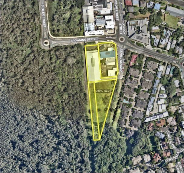
|
CSP Objective |
CSP Strategy |
DP Action |
Code |
OP Activity |
|
|
4: Ethical Growth |
4.1: Manage responsible development through effective place and space planning |
4.1.1: Development assessment - Manage development through a transparent and efficient assessment process |
4.1.1.1 |
Assess and determine development assessments in accordance with the relevant legislation |
|
The Ministerial Order that created the HDA sets out its governance arrangements. How it conducts its business is set out in the:
· HDA Terms of Reference (PDF, 93 KB)
· HDA Operating Procedures (PDF, 230 KB)
· HDA Code of Conduct (PDF, 198 KB)
None relevant to this report.
None required for this report.
Staff Reports - Infrastructure Services 13.20
Staff Reports - Infrastructure Services
Report No. 13.20 Mullumbimby Pool Heating Tender
Directorate: Infrastructure Services
Report Author: Anthony Hobbs, Open Space Facilities Coordinator
Pattie Ruck, Open Space Facilities Coordinator
File No: I2025/703
Summary:
On 20 March 2025, the General Manager, under delegated authority, approved the use of the open tender method to call for tenders for Contract 2025-1593 Mullumbimby Pool Heating Project.
The Request for Tender was advertised from 25 March to 16 April 2025. Tenders were received from the following organisations:
· Goldman Energy
· Image Air Conditioning
· Norcoast Electric
· QIS Solar
· Sydney Solar Solutions
Tenders have been assessed in accordance with the provisions of the Local Government (General) Regulations 2021. This report summarises the background and assessment of the tenders and provides a recommendation to award the tender for Contract 2025-1593.
RECOMMENDATION:
That Council:
1. Awards Tender Mullumbimby Pool Heating to the preferred supplier identified in the tender evaluation report #E2025/47679.
2. Makes public its decision, including the name and amount of the successful tenderer, in accordance with Clause 179(b) of the Local Government (General) Regulation 2021.
3. Includes $250,000 from developer contributions Open Space - Mullumbimby to the Draft 2025/26 Budget Estimates to be adopted at the 30 June 2025 Extraordinary Council Meeting to complete these works.
1 Confidential - 2025-1593 - RFT - Evaluation Report - Mullumbimby Pool Heating Project, E2025/47679
On 20 March 2025, the General Manager, under delegated authority, approved the use of the open tendering method to call for tenders for Contract 2025-1593 Mullumbimby Pool Heating Project.
A contractor is required to install suitable heating infrastructure at the Petria Thomas Mullumbimby Swimming Pool. This will increase operations to deliver a year-round pool facility for Byron Shire Council, the first in the shire.
The purpose of this tender is to enable Byron Council to select a suitably qualified contractor to install heating capability at the Mullumbimby pool. The solution is to reach a water temperature of 27 degrees and be as sustainable as possible within the limitations of the site.
The contract is expected to commence in July 2025 and be completed by March 2026, to align with remaining open for next winter.
The Contract will be managed by Facilities Coordinator.
Tenders were advertised as follows:
VendorPanel Online: 25 March to 16 April 2025
Site inspection was held at 9.30am on 2nd April 2025 at the Mullumbimby Pool and was attended by 8 suppliers, while 3 suppliers attended site meetings on alternate dates.
An Evaluation Panel comprising of three Council staff members was formed.
Tenders closed on 16 April 2025 and tenders were received from the following proponents:
· Goldman Energy
· Image Air Conditioning
· Norcoast Electric
· QIS Solar
· Sydney Solar Solutions
Tenders were evaluated by the Evaluation Panel in accordance with the following evaluation criteria:
Mandatory criteria:
a) Tender lodged on time, in accordance with the Conditions of Tender.
b) Tenderer must have a valid Australian Business Number.
c) Substantial conformance to Conditions of Contract and Statement of Requirements.
d) Workers compensation insurance for all employees.
e) Holds, or is willing to obtain, the insurances as specified in the Statement of Requirements.
f) Satisfactory Work Health and Safety practices.
g) Financial capacity to undertake the contract.
h) Commitment to ethical business practice principles.
i) Tenderer confirms no ties to Bravus Mining previously Adani Mining, no ties with Carmichael mine and no involvement with offshore detention centres.
j) Respondent can confirm steps to comply with the elimination of Modern Slavery from their supply chain.
Qualitative criteria:
|
Criteria |
Elements |
|
Profile and relevant experience |
Tenderer profile |
|
Previous relevant experience |
|
|
Environmental practices |
|
|
Opportunities for disadvantaged people |
|
|
Local employment opportunities |
|
|
Quality and availability of resources |
Proposed key personnel |
|
Proposed staff |
|
|
Use of subcontractors |
|
|
Vehicles, plant and equipment |
|
|
Delivery Plan |
Goods/services standards and methodology |
|
Implementation plan |
|
|
Product sustainability |
|
|
Supporting local business, social enterprise and Indigenous business |
|
|
Price |
Total contract price |
Following the evaluation, the Evaluation Panel conducted referee and financial checks on the preferred tenderer. The results of these checks were deemed by the Evaluation Panel to be satisfactory as detailed in the attached Evaluation Report.
Significant upgrades to the street electrical infrastructure need to be completed to enable these works. Estimated times for these upgrades have been determined, and advice from Essential Energy indicates that the works will be compatible within the contractual program and budget.
The price basis for the contract is a lump sum.
Comment from Manager Finance
Council has currently allocated in the 2024/25 budget funding of $200,000 for this project sourced from developer contributions through available funds held in Open Space – Mullumbimby. If it is Council’s view to support the awarding of the tender, then a further $250,000 could be allocated from the same funding source as the original $200,000. There are funds available. Given the timing of the report with work unlikely to be of scale outside the original budget of $200,000 by 30 June 2025, it is recommended that Council add the additional funding required to the Draft 2025/26 Budget, to be adopted at the Extraordinary Meeting on 30 June 2025. This allocation will then be supplemented by any unspent funds from the 2024/25 financial year that will be carried over to the 2025/26 financial year when Council considers budget carryovers in August 2025.
Council should note under the current Developer Contributions Plan (currently being reviewed), the additional funding will be more than what is in the Plan for the Mullumbimby Pool. By substitution, other projects funded from developer contributions in Open Space Mullumbimby will not be able to proceed or will need to be reduced, however this will all be reviewed with the new Contributions Plan currently being developed for future Council consideration.
The tendering process has been undertaken in accordance with Council’s Purchasing and Procurement Policy, and the provisions of the Local Government (General) Regulation 2021.
The Local Government (General) Regulations 2021 define the options available to Council. An extract is provided below.
178 Acceptance of tenders
(1) After considering the tender submissions for a proposed contract, the council must either—
(a) accept the tender submission that, having regard to all the circumstances, appears to it to be the most advantageous, or
(b) decline to accept any of the tender submissions.
(1A) Without limiting subsection (1), in considering the tender submissions for a proposed contract for the performance of domestic or other waste management services, the council must take into account whether or not existing workers (within the meaning of section 170) will be offered employment or engagement on terms and conditions comparable to those applicable to the workers immediately before the tender submissions.
(2) A council must ensure that every contract it enters into as a result of a tender submission accepted by the council is with the successful tenderer and in accordance with the tender (modified by any variation under section 176). However, if the successful tender submission was made by the council (as provided for in section 55(2A) of the Act), the council is not required to enter into any contract in order to carry out the requirements of the proposed contract.
(3) A council that decides not to accept any of the tender submissions for a proposed contract or receives no tender submissions for the proposed contract must do one of the following—
(a) postpone or cancel the proposal for the contract,
(b) invite, in accordance with section 167, 168 or 169, fresh tender submissions based on the same or different details,
(c) invite, in accordance with section 168, fresh applications from persons interested in making a tender submission for the proposed contract,
(d) invite, in accordance with section 169, fresh applications from persons interested in making a tender submission for contracts of the same kind as the proposed contract,
(e) by resolution of the council, enter into negotiations with any person (whether or not the person was a tenderer) with a view to entering into a contract in relation to the subject matter of the tender,
(f) carry out the requirements of the proposed contract itself.
(4) If a council resolves to enter into negotiations as referred to in subsection (3)(e), the resolution must state the following—
(a) the council’s reasons for declining to invite fresh tender submissions or applications as referred to in subsection (3)(b)–(d),
(b) the council’s reasons for determining to enter into negotiations with the person or persons referred to in subsection (3)(e).
Council’s endorsement of the recommendation to award the tender as recommended in the attached Evaluation Report is sought.
Staff Reports - Infrastructure Services 13.21
Report No. 13.21 Potential renaming of Gilmore Crescent to Tennyson Street, Byron Bay
Directorate: Infrastructure Services
Report Author: Tracy Armstrong, Roads & Property Officer
Shannon McKelvey, Executive Officer
Daniel Strzina, Project Engineer
File No: I2025/728
Summary:
To seek Council support for public exhibition of the renaming of Gilmore Crescent to Tennyson Street, in Byron Bay, as the most efficient way to eliminate the confusion that having two names for one road could cause once the road extension is open, particularly for emergency services and wayfinding.
RECOMMENDATION:
That Council:
1. Supports the proposed renaming of Gilmore Crescent to Tennyson Street for the purposes of public consultation.
2. Requests staff to commence the usual public exhibition process, with invitations to make submissions to also be provided to Bundjalung of Byron Bay Aboriginal Corporation (Arakwal) and Tweed Byron Local Aboriginal Land Council.
3. If no objections are received during the public exhibition, adopts the renaming of Gilmore Crescent to Tennyson Street and it be notified to the Geographical Names Board (GNB) accordingly.
Report
On 27 February 2025 the outcomes achieved by the finalisation of the future management arrangements for Sandhills Estate Crown Land in Byron Bay were reported to Council and community.
One of those outcomes was the extension of Tennyson Street, to connect with Gilmore Crescent, to create the road needed for the new Byron Bay Police and Fire and Rescue Facilities. The road is currently under construction and Crown Lands have recently confirmed that the road dedication will be finalised in the coming weeks. With the road dedication nearly complete, Council can now consider finalising the road name for the extension.
Below shows the extended section of Tennyson Street (yellow), the existing Tennyson Street (orange) and the existing Gilmore Crescent (blue):
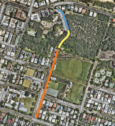
(NB the above image does not attempt to show the location of the actual roads, rather it depicts the three sections of road relative to each other while leaving the road names visible.)
The number of properties with current formal street addresses on these roads are:
- Tennyson Street: 25 residential addresses
- Gilmore Crescent: 2 public facility addresses (Sandhills Early Childhood Education Centre and Youth Activity Centre)
Until now each road has been a no-through road. With the construction of the Tennyson Street extension, it will shortly overlap with Gilmore. While it does occur, it is not recommended to have a single road that changes names partway along its length, as it can cause confusion particularly for emergency services, navigation systems and general wayfinding. Also, because the new Byron Police Station will be located on the Tennyson Street extension, it is important that it has a street address that is clear and easy to find.
So, staff recommend that following the physical road extension, the Tennyson Street name is also extended to replace Gilmore Crescent.
A review of the records of these roads indicates:
· Tennyson Street has had that name since built, based on the 1912 parish maps.
· Tennyson Street has not been gazetted and is currently classified as a ‘Name in Use’ by the NSW Geographical Names Board (GNB)
· Gilmore Crescent was declared a public road in 1977 and it too is classified as a ‘Name in Use’ by the GNB.
Renaming Gilmore Crescent to Tennyson Street would:
a) create a consistent and continuous street name for its entire length
b) create a clear and easily locatable address for the new Byron Police Station
c) reduce confusion for emergency services getting called to attend houses on this road as well as for contractors, residents and the public
d) streamline property addressing and wayfinding for the precinct and its users.
This case is different to usual requests to Council to name new or unnamed roads, as there are already existing road names. For this road there are three potential options:
1. Keep the Gilmore Crescent name and replace Tennyson:
- keeps the status quo for 2 public building addresses
- causes disruption to 25 existing residential addresses
2. Keep the Tennyson Street name and replace Gilmore – recommended:
- keeps the status quo for 25 residential addresses
- causes disruption to only 2 public building addresses
3. Replace both Gilmore and Tennyson with a new name for the whole road:
- causes disruption to the 27 existing addresses.
Option 2 is recommended as it creates the least disruption to existing addresses, requires the least time and resources to implement, does not require a budget allocation and has a good chance of being supported by the GNB.
Following Council’s recent resolution Res 25-155 (relating to the naming of an unnamed lane at Suffolk Park), staff have considered whether it is possible to take the same approach of engaging with traditional owners about a potential new name in this case. However, to create a new name where there are two existing names, would require considerable consultation and, in addition to Arakwal, Council would need engage with the existing 25 residential property owners and occupiers, neighbouring owner Tweed Byron Local Aboriginal Land Council, Byron Youth Service, Police, Fire & Rescue and Crown Lands. If more than one proposed name was put forward by stakeholders, then a further process to try to reach agreement on one of the submitted options and/or a community consultation process on the options would be needed, before Council would have to choose one.
There is no budget for that process and there is limited time available between the Crown Lands’ finalising dedication of the road (expected to be completed soon) and the opening of the road extension. So, for now, replacing both existing names with a new one is not recommended as a viable option. If in future, Council wanted to consider a program of reviewing existing road names it would need to be scoped, and if supported by representative Aboriginal organisations, funded and resourced and included as a new OP activity.
Council is committed to working with Native Title Corporations and Local Aboriginal Land Councils on recognising Aboriginal community leaders and incorporating Aboriginal culture and history in the naming but also the design and operation of facilities and places. There is a great example next door at Jarjumirr Park, a name generously given by Arakwal and adopted by Council. Jarjumirr goes beyond a name, with Aboriginal culture and language embedded into the design and the fabric of the skatepark. That will also occur at the nearby wetlands project, designed with Arakwal, and is intended for the pathways connecting those areas and continuing on to the Arakwal Cultural Centre site. Other recent place naming examples include Bob Bellear Sports fields and Linda Vidler Park. Council will continue to work with Native Title Corporations and Local Aboriginal Land Councils on identifying and acting on opportunities to incorporate Aboriginal language, culture and history into community spaces and names.
The next steps for the recommended option would be:
1. Council to commence public exhibition in accordance with the requirements of the GNB procedures and Council’s policy.
2. If no objections are received during the submission period, proceed with finalising the renaming of Gilmore Crescent to Tennyson Street, otherwise the matter will be reported back to Council for further consideration.
|
CSP Strategy |
DP Action |
Code |
OP Activity |
|
|
1: Effective Leadership |
1.3: Ethical and efficient management of resources |
1.3.3: Asset Management - Maximise asset service delivery potential and take a proactive approach to lifetime asset maintenance |
1.3.3.8 |
Provide ongoing detailed road assessment and valuation for the purposes of purchase, closure and land sale as required |
|
5: Connected Infrastructure |
5.4: Provide accessible community facilities and open spaces |
5.4.2: Parks and open spaces - Provide and maintain active and passive recreational community space that is accessible and inclusive for all |
5.4.2.10 |
Progress Sandhills Reserve management transition under Crown Lands Management Act |
Res 25-155 from Report 13.9 of 28 April 2025, relating to the naming of a lane at Suffolk Park is not directly related but has been considered in the preparation of this report to see if the principles of it can be applied here, but the circumstances in this matter are different.
Res 25-043 from Report 13.1 of 27 February 2025, relating to the finalisation of management arrangements for Sandhills Estate Crown Land in Byron Bay, where Council resolved to note the report and the length and complexity of the project and to recognise the stakeholders involved and the amazing outcomes achieved.
Council is able to name roads in accordance with the authority provided in Part 10, Division 4, Section 162 of the Roads Act 1993.
The procedure of naming roads, is dictated by Sections 7 to 10 within Part 2, Division 7 of the Roads Regulation 2018, which is available in detail at:
https://www.legislation.nsw.gov.au/view/whole/html/inforce/current/sl-2018-0512
Council is the authority to name this road and the recommendation is in line with the below regulations:
· Road Regulations 2018 - Part 2 - Division 1 - Section 7 – Procedure for naming roads
· Roads Act 1993 - Division 4 - Section 162 - Naming of public roads
· New South Wales Address Policy – March 2015
· New South Wales Addressing User Manual – September 2016
· New South Wales Online Naming System – Geographical Names Board of New South Wales – June 2015
The recommended Option 2 would have no financial implications.
The cost of supply and erection of street sign/s is part of the existing Tennyson Street Extension project budget– approximately $500.
Sandhills Childhood Centre and Youth Activity Centre managed by Byron Youth Service will need to formally change their address, which could come at a small administrative cost to those organisations.
If renaming Tennyson Street to a new name was considered as a one-off project, a budget would be needed and staff resources re-allocated from existing OP activities, to undertake the following steps:
- targeted consultation with Arakwal, as traditional owners, and Tweed Byron Local Aboriginal Land Council who generously made creation of the public road to service the Emergency Services Precinct possible, as to the naming of the street (est $4,000)
- targeted consultation with 27 Gilmore Crescent and Tennyson Street address owners and occupiers and with the state agencies involved, Crown Lands, Police and Fire & Rescue, as well as NSW Ambulance (est $4,000)
- broader community consultation on new name options and then formal exhibition and other ancillary costs (est $2,000).
During engagement on the construction of the Tennyson Street Road extension, Byron Youth Service and Sandhills Childcare staff indicated they would have no objection to replacing Gilmore Crescent with Tennyson Street and that it would cause minimal disruptions to their operations.
Should Council support the proposal to replace the name of Gilmore with Tennyson, formal public exhibition will occur in accordance with Council’s Policy and statutory requirements, inviting members of the public to make submissions. In addition, invitations to make submissions will be sent to:
1. Arakwal, as traditional owners, and Tweed Byron Local Aboriginal Land Council, who generously made creation of the road to service the Emergency Services Precinct possible; and
Reports of Committees - Corporate and Community Services 14.1
Reports of Committees - Corporate and Community Services
Report No. 14.1 Report of the Finance Advisory Committee Meeting held on 15 May 2025
Directorate: Corporate and Community Services
File No: I2025/723
Summary:
The Finance Advisory Committee met on 15 May 2025. The Minutes are attached for noting by Council.
RECOMMENDATION:
1. That Council notes the minutes of the Finance Advisory Committee Meeting held on 15 May 2025.
1 Minutes
15/05/2025 Finance Advisory Committee, I2025/715
![]()
The attachment to this report provides the minutes of the Finance Advisory Committee Meeting of 15 May 2025 for determination by Council. The agenda for this meeting can be located on Council’s website at:
Minutes of Finance Advisory Committee Meeting - Thursday, 15 May 2025
Report No. 4.1 Budget Review - 1 January to 31 March 2025
The report was prepared to comply with Section 203 of the Local Government (General) Regulation 2021 and to inform Council and the community of Council’s estimated financial position for the 2024/2025 financial year, reviewed as at 31 March 2025.
Report No. 6.1 2025-2035 Long-Term Financial Plan
The Report was a briefing on the Long-Term Financial Plan for the period 2023-2035 (currently being compiled) which will be presented to Council for adoption at the Extraordinary Meeting to be held on 30 June 2025. This was for information only and no determination by Council is required.
As per the Reports listed within the Finance Advisory Committee Meeting of 15 May 2025.
As per the Reports listed within the Finance Advisory Committee Meeting of 15 May 2025.
Reports of Committees - Corporate and Community Services 14.2
Report No. 14.2 Report of the Audit, Risk and Improvement Committee Meeting held on 13 May 2025
Directorate: Corporate and Community Services
File No: I2025/828
Summary:
This report provides the minutes of the Audit, Risk and Improvement Committee Meeting of 13 May 2025 for determination by Council.
RECOMMENDATION:
1. That Council notes the minutes of the Audit, Risk and Improvement Committee Meeting held on 13 May 2025.
The attachment to this report provides the minutes of the Audit, Risk and Improvement Committee Meeting of 13 May 2025 for determination by Council. The agenda for this meeting can be located on Council’s website at:
Report No. 4.1 Fraud control update
This report updated the Committee on Council’s fraud control. There was no recommendation to Council.
Report No. 5.1 2024-2025 External Audit Engagement Plan
This report presents the 2024-2025 External Audit Engagement Plan for Council to the Audit, Risk and Improvement Committee for noting.
Report No. 5.2 Internal Audit Report Q3 2024-2025 & Draft Section 10.7 Certificate Internal Audit Report
This report presented the Committee with the Internal Audit Status Report – May 2025, the Internal Audit Recommendations Status Report for Quarter 3 2024-2025 and the Draft Section 10.7 Certificate Audit Report with Agreed Management Actions.
Report No. 5.3 Internal Audit Plans
This report requested the Committee endorse the Revised Internal Audit Plan for 2024/25, Revised Internal Audit Plan for 2025/26 and Revised Internal Audit Plan for 2024 – 2028.
Report No. 7.1 Cyber Security & System Outages Quarterly Update
This report provides a summary of cyber security activities and online service outages for the reporting period 1 January 2025 to 31 March 2025. This was an Information Report with no recommendation to Council.
Report No. 7.2 Q3 2024/25 Risk Initiatives and Updates
This Report provided an outline of recent risk initiatives and an update on actions updated or completed in Q3 2024/25, to aid in mitigating Council’s strategic and operational risks. This was an Information Report with no recommendation to Council.
Report No. 7.3 Audit Office’s 30 June 2024 financial audits of New South Wales (NSW) councils’ financial statements
This report presented the audit results and key themes from the Audit Office’s 30 June 2024 financial audits of New South Wales (NSW) councils’ financial statements. This was an Information Report with no recommendation to Council.
Report No. 7.4 Draft Delivery Program 2025 - 2029 and 2025/26 Operational Plan, Budget, and Revenue Policy
This report presented the Draft Delivery Program 2025 - 2029 and 2025/26 Operational Plan, Budget, and Revenue Policy. This was an Information Report with no recommendation to Council.
Report No. 7.5 Operational Plan 2024/25 Quarter 3 Report - to 1 January to 31 March 2025
The Committee recommendations are supported by management and are provided in the attachment to this report.
As per the Reports listed within the Audit, Risk and Improvement Committee Meeting of 13 May 2025.
As per the Reports listed within the Audit, Risk and Improvement Committee Meeting of 13 May 2025.
Reports of Committees - Sustainable Environment and Economy 14.3
Reports of Committees - Sustainable Environment and Economy
Report No. 14.3 Report of the Biodiversity and Agriculture Advisory Committee Meeting held on 13 May 2025
Directorate: Sustainable Environment and Economy
File No: I2025/798
Summary:
This report provides the minutes of the Biodiversity and Agriculture Advisory Committee Meeting held on 13 May 2025.
RECOMMENDATION:
1. That Council notes the minutes of the Biodiversity and Agriculture Advisory Committee Meeting held on 13 May 2025.
|
3. That Council adopts the following Committee Recommendations:
Report No. 4.2 Biodiversity and Agriculture Projects and Operations Update File No: I2025/239
Committee Recommendation 4.2.1 That the Biodiversity and Agricultural Advisory Committee: 1. Notes the update on current projects and programmes being undertaken by Council staff. 2. Requests staff to arrange a discussion with key stakeholders about fire ant management at a future Committee meeting. |
1 Minutes
13/05/2025 Biodiversity and Agriculture Advisory Committee, I2025/654 ![]()
The attachment to this report provides the minutes of the Biodiversity and Agriculture Advisory Committee Meeting of 13 May 2025 for determination by Council. The agenda for this meeting can be located on Council’s website at:
Report No. 3.1 Confirmation of the Minutes of the Biodiversity and Agriculture Advisory Committee Meeting held on 9 May 2024
The Committee confirmed the minutes.
Report No. 4.1 Koala Activity Monitoring
Presents the results of Council’s 2023 koala activity monitoring program.
Report No. 4.2 Biodiversity and Agriculture Projects and Operations Update
Update on current key projects and programs being undertaken by the Biodiversity and Agriculture team
Report No. 4.3 Brunswick Valley Landcare Support Officer quarterly reports, October-December 2024 and January-March 2025
Tables the activities of the Landcare Support Officer via two quarterly reports
Report No. 4.4 Wallum Heath on Pleistocene Threatened Ecological Community listing Working Group
The purpose of this report is to promulgate the working group.
The committee recommendations are supported by management and are provided in the attachment to this report.
As per the Reports listed within the Biodiversity and Agriculture Advisory Committee Meeting of 13 May 2025.
As per the Reports listed within the Biodiversity and Agriculture Advisory Committee Meeting of 13 May 2025.
Reports of Committees - Infrastructure Services 14.4
Reports of Committees - Infrastructure Services
Report No. 14.4 Report of the Local Traffic Committee Meeting held on 3 June 2025
Directorate: Infrastructure Services
File No: I2025/836
Summary:
The attachment to this report provides the minutes of the Local Traffic Committee Meeting held on 3 June 2025 for determination by Council.
Council’s action on the LTC advice will be:
a) If Council is in agreement with the LTC unanimous support then the proposal may be approved. In these cases there is no conflict between Council and the advice of the LTC, consequently there is no need for Council to inform TfNSW or the NSW Police representatives of the decision.
b) If Council is in agreement with the LTC unanimous support, but no longer wants to proceed, the proposal may still be rejected.
c) If Council is in agreement with the LTC unanimous decline then the proposal may be rejected. Again there is no conflict between Council and the advice of the LTC. Consequently there is no need for Council to inform TfNSW or the NSW Police representatives of the decision.
d) If Council decides to proceed with a proposal where the advice of the LTC is not unanimous support, then the Council must first advise the TfNSW and the NSW Police representatives in writing of their intention to approve the proposal. TfNSW or the NSW Police may then lodge an appeal to the Regional Traffic Committee (RTC).
e) If Council decides to proceed with a proposal where the advice of the LTC is a unanimous decline, then the Council must first advise the TfNSW and NSW Police representatives in writing of their intention to approve the proposal. TfNSW or the NSW Police may then lodge an appeal to the RTC.
Due to the fact that the TfNSW and the NSW Police have the power to appeal certain decisions of the Council, the LTC cannot provide its advice to Council until both TfNSW and the NSW Police have provided their vote on the issue.
RECOMMENDATION:
1. That Council notes the minutes of the Local Traffic Committee Meeting held on 3 June 2025.
|
5. That Council adopts the following Committee Recommendations:
Report No. 6.4 Parking changes in Fawcett Street, Brunswick Heads File No: I2025/807 RECOMMENDATION: That the Local Traffic Committee supports the following: 1. The expansion of Brunswick Heads Pay Parking scheme to include the southern side of Fawcett Street (Park Street to Tweed Street), Brunswick Heads; and 2. Changes the parking time limit on the southern side of Fawcett Street (Park Street to Tweed Street) to 4PP, including. a) 4PP 9am-5pm with permit holders excepted. b) No Parking 1-6am with permit holders excepted. |
1 Minutes
03/06/2025 Local Traffic Committee, I2025/823
![]()
The attachment to this report provides the minutes of the Local Traffic Committee Meeting of 3 June 2025 for determination by Council. The agenda for this meeting can be located on Council’s website at:
Agenda of Local Traffic Committee Meeting - Tuesday, 3 June 2025
This report contains the recommendations of the Local Traffic Committee (LTC) meeting held on 3 June 2025.
As per the Reports listed within the Local Traffic Committee Meeting of 3 June 2025.
Statutory and Policy Compliance Implications
As per the Reports listed within the Local Traffic Committee Meeting of 3 June 2025.
Confidential Reports - Infrastructure Services 16.1
Confidential Reports - Infrastructure Services
Report No. 16.1 Confidential - Negotiations to dispose of and acquire land interests for EPAR Works for AGRN1012 2022 NSW Severe Weather and Flooding Event
Directorate: Infrastructure Services
Report Author: Tracy Armstrong, Roads & Property Officer
Shannon McKelvey, Executive Officer
Jeeva Selina Ali, Infrastructure Recovery Coordinator
File No: I2025/339
Summary:
This report seeks Council resolutions to authorise the acquisition and disposal of some land interests, and the opening and closing of some small sections of road, to facilitate road realignments required under the Emergency Public Asset Repair (EPAR) program following the 2022 flood event.
Council resolutions are required to authorise staff to negotiate and enter into agreements relating to road reserve adjustments, land and easement acquisitions, and related road realignments. While the negotiations are still underway, it is necessary to protect Council’s commercial interests by maintaining confidentiality until all required acquisitions have been finalised.
RECOMMENDATION:
1. That pursuant to Section 10A(2)(c) of the Local Government Act, 1993, Council resolves to move into Confidential Session to discuss the report Negotiations to dispose of and acquire land interests for EPAR Works for AGRN1012 2022 NSW Severe Weather and Flooding Event.
2. That the reasons for closing the meeting to the public to consider this item be that the report contains:
a) information that would, if disclosed, confer a commercial advantage on a person with whom the council is conducting (or proposes to conduct) business
3. That on balance it is considered that receipt and discussion of the matter in open Council would be contrary to the public interest, as:
the report discloses information that could prejudice the financial position of Council in ongoing negotiations to facilitate realignment of road reserves necessary to support Essential Public Assest Repair (EPAR) works at multiple sites.
Confidential Reports - Infrastructure Services 16.2
Report No. 16.2 Confidential - Tender Report - Byron Drainage Upgrade Town Centre Construction
Directorate: Infrastructure Services
Report Author: Daniel Strzina, Project Engineer
Christopher Soulsby, Manager Assets & Major Projects
File No: I2025/817
Summary:
On 16 April 2025, the General Manager, under delegated authority, approved the use of the selective tendering method to call for tenders for Contract 2024-2448 Byron Drainage Upgrade Town Centre Construction.
The Request for Tender was advertised from Thursday 17 April and closed Monday 19 May 2025 at 5pm. Tenders were received from the following organisations:
· Diona
· Durack Civil
· Hazell Bros
· Symal Infrastructure
· Winslow Infrastructure
Tenders have been assessed in accordance with the provisions of the Local Government (General) Regulations 2021. This report summarises the background and assessment of the tenders and provides a recommendation to not accept any of the tender submissions and enter into negotiations with the tenderers identified in the report.
RECOMMENDATION:
1. That pursuant to Section 10A(2)(c), (d)i and (d)ii of the Local Government Act, 1993, Council resolves to move into Confidential Session to discuss the report Tender Report - Byron Drainage Upgrade Town Centre Construction.
2. That the reasons for closing the meeting to the public to consider this item be that the report contains:
a) information that would, if disclosed, confer a commercial advantage on a person with whom the council is conducting (or proposes to conduct) business
b) commercial information of a confidential nature that would, if disclosed prejudice the commercial position of the person who supplied it
c) information that would, if disclosed, confer a commercial advantage on a competitor of the council
3. That on balance it is considered that receipt and discussion of the matter in open Council would be contrary to the public interest, as:
Tender report detailing commercially sensitive information supplied by Tenderers
OR, ALTERNATIVELY WHERE THE MEETING IS NOT PROPOSED TO BE CLOSED:
RECOMMENDATION:
1. That pursuant to Section 11(3) of the Local Government Act, 1993, resolves that the Annexures to the report, Tender Report - Byron Drainage Upgrade Town Centre Construction are to be treated as confidential as they relate to matters specified in s10A(2)(c), s10A(2)(d)i and s10A(2)(d)ii of the Local Government Act 1993.
2. That Council adopts the recommendation set out on the final page of the Report.
1 Confidential - Evaluation Panel Recommendation Report - Town Centre RFT Byron Drainage, E2025/55711