Agenda
Ordinary
Meeting
Thursday,
18 October 2018
held
at Council Chambers, Station Street, Mullumbimby
commencing
at 9.00am
 Public Access relating to items
on this Agenda can be made between 9.00am and 10.30am on the day of the
Meeting. Requests for public access should be made to the General Manager
or Mayor no later than 12.00 midday on the day prior to the Meeting.
Public Access relating to items
on this Agenda can be made between 9.00am and 10.30am on the day of the
Meeting. Requests for public access should be made to the General Manager
or Mayor no later than 12.00 midday on the day prior to the Meeting.
Mark
Arnold
General
Manager
What is a “Conflict of Interests” - A conflict of
interests can be of two types:
Pecuniary - an interest that a person has in a matter because of a reasonable
likelihood or expectation of appreciable financial gain or loss to the person
or another person with whom the person is associated.
Non-pecuniary – a private or personal interest that a Council
official has that does not amount to a pecuniary interest as defined in the
Local Government Act (eg. A friendship, membership of an association, society
or trade union or involvement or interest in an activity and may include an
interest of a financial nature).
Remoteness – a person does not have a pecuniary interest in a matter
if the interest is so remote or insignificant that it could not reasonably be
regarded as likely to influence any decision the person might make in relation
to a matter or if the interest is of a kind specified in Section 448 of the
Local Government Act.
Who has a Pecuniary Interest? - a person has a pecuniary interest in a
matter if the pecuniary interest is the interest of the person, or another
person with whom the person is associated (see below).
Relatives, Partners - a person is taken to have a pecuniary interest in a
matter if:
§ The person’s
spouse or de facto partner or a relative of the person has a pecuniary interest
in the matter, or
§ The person, or a
nominee, partners or employer of the person, is a member of a company or other
body that has a pecuniary interest in the matter.
N.B. “Relative”, in relation to a person means any of the
following:
(a) the
parent, grandparent, brother, sister, uncle, aunt, nephew, niece, lineal
descends or adopted child of the person or of the person’s spouse;
(b) the
spouse or de facto partners of the person or of a person referred to in
paragraph (a)
No Interest in the Matter - however, a person is not taken to have a
pecuniary interest in a matter:
§ If the person is
unaware of the relevant pecuniary interest of the spouse, de facto partner,
relative or company or other body, or
§ Just because the
person is a member of, or is employed by, the Council.
§ Just because the
person is a member of, or a delegate of the Council to, a company or other body
that has a pecuniary interest in the matter provided that the person has no
beneficial interest in any shares of the company or body.
Disclosure and participation in meetings
§ A Councillor or a
member of a Council Committee who has a pecuniary interest in any matter with
which the Council is concerned and who is present at a meeting of the Council
or Committee at which the matter is being considered must disclose the nature
of the interest to the meeting as soon as practicable.
§ The Councillor or
member must not be present at, or in sight of, the meeting of the Council or
Committee:
(a) at any
time during which the matter is being considered or discussed by the Council or
Committee, or
(b) at any
time during which the Council or Committee is voting on any question in
relation to the matter.
No Knowledge - a person does not breach this Clause if the person did
not know and could not reasonably be expected to have known that the matter
under consideration at the meeting was a matter in which he or she had a
pecuniary interest.
Participation in Meetings Despite Pecuniary Interest (S 452 Act)
A Councillor is not prevented from taking part in the consideration or
discussion of, or from voting on, any of the matters/questions detailed in
Section 452 of the Local Government Act.
Non-pecuniary Interests - Must be disclosed in meetings.
There are a broad range of options available for managing conflicts &
the option chosen will depend on an assessment of the circumstances of the
matter, the nature of the interest and the significance of the issue being
dealt with. Non-pecuniary conflicts of interests must be dealt with in at
least one of the following ways:
§ It may be appropriate
that no action be taken where the potential for conflict is minimal.
However, Councillors should consider providing an explanation of why they
consider a conflict does not exist.
§ Limit involvement if
practical (eg. Participate in discussion but not in decision making or
vice-versa). Care needs to be taken when exercising this option.
§ Remove the source of
the conflict (eg. Relinquishing or divesting the personal interest that creates
the conflict)
§ Have no involvement by
absenting yourself from and not taking part in any debate or voting on the
issue as if the provisions in S451 of the Local Government Act apply
(particularly if you have a significant non-pecuniary interest)
RECORDING OF VOTING ON PLANNING MATTERS
Clause 375A of the Local Government Act 1993
– Recording of voting on planning matters
(1) In this section, planning
decision means a decision made in the exercise of a function of a council
under the Environmental Planning and Assessment Act 1979:
(a) including a decision
relating to a development application, an environmental planning instrument, a
development control plan or a development contribution plan under that Act, but
(b) not including the making of
an order under Division 2A of Part 6 of that Act.
(2) The general manager is
required to keep a register containing, for each planning decision made at a
meeting of the council or a council committee, the names of the councillors who
supported the decision and the names of any councillors who opposed (or are
taken to have opposed) the decision.
(3) For the purpose of
maintaining the register, a division is required to be called whenever a motion
for a planning decision is put at a meeting of the council or a council
committee.
(4) Each decision recorded in
the register is to be described in the register or identified in a manner that
enables the description to be obtained from another publicly available
document, and is to include the information required by the regulations.
(5) This section extends to a
meeting that is closed to the public.
Ordinary Meeting
BUSINESS OF Ordinary Meeting
1. Public Access
2. Apologies
3. Requests for Leave of
Absence
4. Declarations of Interest
– Pecuniary and Non-Pecuniary
5. Tabling of Pecuniary
Interest Returns (s450A Local Government Act 1993)
6. Adoption of Minutes from
Previous Meetings
6.1 Byron
Shire Reserve Trust Committee held on 20 September 2018
6.2 Ordinary
Meeting held on 20 September 2018
7. Reservation of Items for
Debate and Order of Business
8. Mayoral Minute
9. Notices of Motion
9.1 Climate
Emergency Declaration....................................................................................... 6
9.2 Disaster
Dashboard for Byron Shire................................................................................. 9
10. Petitions
11. Submissions and Grants
11.1 Byron
Shire Council Submissions and Grants as at 1 October 2018............................. 10
12. Delegates' Reports
13. Staff Reports
General Manager
13.1 Variation
of North Byron Farmers Market licence for temporary change to market days 12
13.2 Proposed
lease to Lilly Pilly Community Pre-School Inc, 96 Kingsford Drive Brunswick
Heads 14
13.3 Byron
Masterplan Guidance Group membership........................................................... 18
13.4 LGNSW
request for financial assistance in legal proceedings....................................... 20
13.5 The
giving notice to the Minister of persons employed as Native Title Managers......... 27
Corporate and Community Services
13.6 Investments
September 2018......................................................................................... 29
13.7 Update
to hall fees and charges - Marvell Hall and Suffolk Park Hall........................... 37
13.8 Section
355 Management Committees - resignations and appointments...................... 40
13.9 Election
of Deputy Mayor 2018-2019............................................................................. 43
13.10 Draft
2017/2018 Financial Statements ........................................................................... 47
Sustainable Environment and Economy
13.11 Draft
Bangalow Village Plan for public exhibition........................................................... 49
13.12 PLANNING
- Car Share Pilot Project, Byron Bay & Mullumbimby............................... 55
13.13 PLANNING
- Development Application 10.2018.342.1 Secondary dwelling at 5 Luan Court
Byron Bay.................................................................................................................................. 61
13.14 PLANNING
- Railway Park Draft Plan of Management - Submissions Report............. 74
13.15 PLANNING
- Exceptions to Development Standards - 1 July 2018 to 30 September 2018 84
13.16 Report
of the Planning Review Committee Meeting held on 13 September 2018......... 87
Infrastructure Services
13.17 South
Golden Beach Flood Pump Update...................................................................... 89
13.18 Hinterland
Way and Brunswick Valley Way/Tweed Valley Way Maintenance Funding 96
13.19 Tyagarah
Clothes Optional Declaration - Results of the enhanced stakeholder safety
initiatives of Res 17-499 and Res 17715............................................................................................. 98
13.20 Enactment
of Council Policy 4.17 for Mafeking Road - Resident Contributions......... 112
13.21 Naming
unnamed Track off Brunswick Street Billinudgel for addressing purposes.... 115
13.22 BRRC
Masterplan Stage 2 Works - funding allocation................................................. 118
13.23 Belongil
Catchment Drainage Investigation - Update................................................... 120
14. Reports of Committees
Corporate and Community Services
14.1 Report
of the Arakwal Memorandum of Understanding Advisory Committee Meeting held on 13
September 2018............................................................................................................ 136
Sustainable Environment and Economy
14.2 Report
of the Sustainability and Emissions Reduction Advisory Committee Meeting held
on 30 August 2018................................................................................................................... 139
14.3 Report
of the Heritage Panel Meeting held on 30 August 2018.................................... 141
Infrastructure Services
14.4 Report
of the Water, Waste and Sewer Advisory Committee Meeting held on 13 September
2018....................................................................................................................................... 143
14.5 Report
of the Local Traffic Committee Meeting held on 18 September 2018............. 146
14.6 Report
of the Byron Shire Floodplain Risk Management Committee Meeting held on 13
September 2018............................................................................................................................... 153
14.7 Report
of the Local Traffic Committee Meeting held on 21 September 2018............. 155
15. Questions
With Notice
Responses
to Questions on Notice are now available on www.byron.nsw.gov.au/Council/
Council-meetings/Questions-on-Notice
16. Confidential Reports
Infrastructure Services
16.1 Confidential - Tender 2018-0008 Eureka
Bridge Embankment Rectification...... 160
Councillors are
encouraged to ask questions regarding any item on the business paper to the
appropriate Director prior to the meeting. Any suggested amendments to the
recommendations should be provided to Councillor Support prior to the meeting
to allow the changes to be typed and presented on the overhead projector at the
meeting.
Notices of Motion 9.1
Notices of Motion
Notice of Motion No. 9.1 Climate
Emergency Declaration
File No: I2018/1907
|
I move:
1. That
Council
a) recognises
that we are in a state of climate emergency that requires urgent action by
all levels of government, including by local councils, and
b) acknowledges
that Byron Shire is likely to be substantially affected by climate impacts,
particularly sea level rise;
2. Expands
existing climate change mitigation strategies and develops a Climate
Emergency Plan to further enhance resilience and reduce climate impacts in a
timeframe that is as fast as practicably possible
3.
Creates a special committee/panel of Council to develop the Climate
Emergency Plan, and
4.
calls upon the State and Federal Governments to:
a) declare
a climate emergency
b) and
to back this up with legislated programs to drive emergency action to reduce
greenhouse gas emissions and meet the Paris Agreements.
5. Writes
to the Member for Ballina, Tamara Smith, the Member for Northern NSW, Ben
Franklin and the Member for Richmond, Justine Elliot advising them of
Council’s resolution and urging them to acknowledge a climate emergency
and act to address the crisis.
|
Signed: Cr
Catherine Coorey
Councillor’s
supporting information:
Professor Hans Joachim Schellnhuber, head of the Potsdam
Institute for Climate Impact Research, and a senior advisor to the European
Union, Pope Francis and German Chancellor Angela Merkel recently argued that “Climate
change is now reaching the end-game, where very soon humanity must choose
between taking unprecedented action, or accepting that it has been left too
late and bear the consequences.”
Forest fires in the Arctic, more intense and more frequent
severe storms, shrinking polar icecaps, increasing food and water shortages and
the death of large areas of the Reef, show us that the earth is already too
hot. Each year that passes is another year that is the hottest on record. We
are in a serious crisis and it may already be too late to avert it. What is
needed is a society-wide mobilisation of a scale and speed never before seen in
peace time. We must reach zero emissions as fast as humanly possible and
rapidly scale up efforts to draw down the excess greenhouse gases already in
the atmosphere.
Declaring a climate emergency is the first step in
mobilising government and community resources and funds that are not normally
available. Declaring an emergency inspires the public to act for the common
good. In the Queensland floods of 2011, three-quarters of the council areas
were declared disaster zones. Government funds were made available and a large
workforce was mobilised to deal with the emergency. More than 55,000 volunteers
registered to help clean up the streets of Brisbane. All over Australia
kind-hearted individuals and community groups sent supplies and raised
emergency funds. It is this kind of mobilisation that we need.
This brings me to Darebin in Melbourne. Their council looked
rationally at what the science told them – that we face a crisis and the
only logical response is to declare a climate emergency. So they did – in
consultation with their community and then they developed the Darebin
Climate Emergency Plan.
Councils in Banyule, Moreland, Yarra and Port Melbourne, as
well as in New South Wales and Western Australia are currently taking steps to
follow Darebin City Council’s lead.
Byron is already doing some of the things that are in the
Darebin plan; we need a plan that is relevant to this location, which brings
everything we are doing together and that sets timelines that reflect the
emergency scenario.
As an example of why we need to
act, the NSW Office of Environment and Heritage Scientific Division published a
paper earlier this year that suggests that sea level rises are likely to be
higher than previously predicted in areas built on estuaries. “
…our results show the
potential future growth of exposure to inundation within estuaries to be a far
greater problem in NSW than that of exposure to open coast erosion, which while
nevertheless significant, is an order of magnitude less than the results
presented here. Overall this exposure assessment finds estuarine tidal
inundation to be a major coastal management issue, highlighting the need for
coastal and floodplain management and planning to manage risk to current
development and to avoid the unnecessary growth of risk into the future.”
We are likely to feel the significant impacts of
global warming. Whilst we cannot effect a turnaround of global emissions, we
can work to mitigate impacts and build resilience and we have to start now.
Whilst I acknowledge that the notion of mobilising
governments and people to act seems an insurmountable task, we as a community
must acknowledge that if we do nothing we are doomed.
If we join other Councils and start taking action and
advocating from our communities to government, then we have done something.
Attached:
Darebin Council Climate Emergency Plan Links:
http://climateemergencydeclaration.org/
http://climatesafety.info/guterres/
https://www.climatecouncil.org.au/2018/09/24/australias-report-card-on-emissions-delayed-yet-again/
Staff comments by Shannon
Burt, Director, Sustainable Environment and Economy:
(Management Comments must not include formatted
recommendations – resolution 11-979)
In relation to item 2 and 3 of the recommendations, an
initial view of the Darebin Climate Emergency Plan is that it closely aligns
with Council’s Zero Emissions Strategy, a key action in the 2018/19
Operational Plan and well advanced in its preparation. A preliminary
draft of Council’s Zero Emissions Strategy is scheduled for workshopping
at the 25 October Sustainability Emissions Advisory Committee with a draft
Strategy to be reported to the December Council meeting for public exhibition.
Council’s Zero Emissions Strategy:
· Sets
the context at the Global, National, State and Reginal level
· Establishes
Bryon Council’s Emission Profile and the Byron Community‘s
Emissions Profile
· Uses
the National Greenhouse and Energy Reporting (NGER) methodology as
Council’s carbon accounting approach i.e. Scope 1, 2 and 3 emissions
· Sets
goals, targets and timeframes
· Identifies
actions to deliver our goals and targets
· Provides
a monitoring and reporting framework on our emissions and implementation of
emissions reduction measures
The above content of Council’s Zero Emissions Strategy
accords with the Darebin Climate Emergency Plan.
Financial/Resource/Legal Implications:
Staff are fully committed to the development of
Council’s Zero Emissions Strategy. There is no spare staff capacity
or a budget for the delivery of this resolution in the 2018/2019 Financial
Year.
Is the proposal consistent with any Delivery Program
tasks?
No. Expanding the existing climate change mitigation
strategies and developing a Climate Emergency Plan is not included in the
2018/19 Delivery Program.
Notices of Motion 9.2
Notice of Motion No. 9.2 Disaster
Dashboard for Byron Shire
File No: I2018/1931
|
I move:
That Council receive a report on options and associated
costs for the implementation
of a disaster dashboard website.
|
Signed: Cr
Michael Lyon
Councillor’s
supporting information:
Townsville Council has
implemented a warning system at the following address
http://disaster.townsville.qld.gov.au,
while more recently Lismore City Council has also
implemented one: https://disaster.lismore.nsw.gov.au
It is an all-in-one-stop-shop
for roads, weather and emergency information and can also include live feeds
from cameras set up for one of these purposes. It is important to recognise
this is not about duplication. It is about replication of information, pulled
from various sites that are relevant in an emergency, that updates when those
sites update.
Staff comments by Anna
Vinfield, Manager Corporate Services, Corporate and Community Services
(Management Comments must not include formatted
recommendations – resolution 11-979)
Council is progressing the development of its Business
Continuity Plan and community preparedness for disaster recovery.
As a result of the impact of Ex-Tropical Cyclone Debbie in
April 2017, the Office of Emergency Management (OEM) funded a pilot project
which aims to support local Councils to improve community resilience and
disaster recovery processes.
Councillors will be briefed on the status of this work at
their Strategic Planning Workshop in November 2018. As part of this workshop,
officers will also include discussion on the implementation of a disaster
dashboard website.
On the basis that the Notice of Motion is adopted, a future
report will be presented to Council on the options and the associated costs of
a disaster dashboard website.
Financial/Resource/Legal Implications:
Implications will be considered as part of the future report
to Council.
Is the proposal consistent with any Delivery Program
tasks?
Council’s Delivery Program (2017-2022 revised)
includes reference to disaster preparedness as per below.
|
2.4 Enhance community safety and amenity while respecting
our shared values
|
a) Provide and facilitate local emergency
management
|
Deploy technology to improve disaster response and recovery by
preparing field devices and staff trained in readiness to respond to a natural
disaster
|
Submissions and Grants 11.1
Submissions and Grants
Report No. 11.1 Byron
Shire Council Submissions and Grants as at 1 October 2018
Directorate: Corporate
and Community Services
Report
Author: Anna
Vinfield, Manager Corporate Services
File No: I2018/1922
Theme: Corporate Management
Corporate Services
Summary:
Council have submitted applications
for a number of grant programs which, if successful, would provide significant
funding to enable the delivery of identified projects. This report provides an
update on these grant submissions
|
RECOMMENDATION:
That Council note the report
and attachment (#E2018/80842) for the Byron Shire Council Submissions and
Grants as at 1 October 2018.
|
Attachments:
1 Byron
Shire Council Submissions and Grants as at 1 October 2018, E2018/80842 ⇨

Report
This report provides an update on
grant submissions since last report.
Successful Applications
· Statements of Heritage Significance for the Rail Precinct
Byron Bay, Heritage Transport Grants, Royal Australian Historical Society
· Safer streets through improved lighting, NSW Crime
Prevention Fund, NSW Dept of Justice
Submitted Applications
· Advancing Digital Co-creation for Brunswick Heads Library,
Regional Cultural Fund, NSW Government Regional Growth Fund
· NE Hinterland Regional Koala Project, Saving our Species
Iconic Koala, Office of Environment and Heritage
Unsuccessful Applications
· Coolamon Scenic Drive – Road Safety Evaluation
(Project 3), Safer Roads, NSW Roads and Maritime Services
Additional information on the
grant submissions is provided in Attachment 1 – Submissions and Grants
report as at 1 October 2018.
Financial Implications
If Council is successful in
obtaining the identified grants more than $13 million would be achieved which
would provide significant funding for Council projects. Some of the
grants require a contribution from Council (either cash or in-kind) and others
do not. Council’s contribution is funded. The potential funding and
allocation is noted below:
|
Requested funds from funding bodies
|
13,869,743
|
|
Council cash contribution
|
4,814,356
|
|
Council in-kind Contribution
|
121,857
|
|
Other contributions
|
8,730,545
|
|
Funding applications submitted and awaiting
notification (total project value)
|
27,536,501
|
Statutory and Policy Compliance
Implications
Council is required under Section
409 3(c) of the Local Government Act 1993 to ensure that
‘money that has been received from the Government or from a public
authority by way of a specific purpose advance or grant, may not, except with
the consent of the Government or public authority, be used otherwise than for
that specific purpose’. This legislative requirement governs
Council’s administration of grants.
Staff Reports - General Manager 13.1
Staff Reports - General Manager
Report No. 13.1 Variation
of North Byron Farmers Market licence for temporary change to market days
Directorate: General
Manager
Report
Author: Paula
Telford, Leasing and Licensing Coordinator
File No: I2018/1705
Theme: Corporate Management
Corporate Services
Summary:
The North Byron Farmers Market holds a current licence to
operate weekly farmers market at the New Brighton Oval, part lot 335 DP 755687,
every Tuesday during the hours of 8:00am and 11:00am. The licence expires
on 31 October 2021. The market licence does not permit a change of licensed
market days.
As two regular farmers market
days fall on Tuesday 25 December 2018 and 1 January 2019, North Byron Farmers
Market seeks Council permission to move these two farmers market days to 24 and
31 December 2018.
|
RECOMMENDATION:
That Council delegate the General Manager, the
authority to vary the current Farmers Market Licence to the North Byron
Farmers Markets to permit two regular Tuesday Farmers Markets to be moved to
Mondays 24 and 31 December 2018 in lieu of Tuesdays 25 December 2018
and 1 January 2019 and to execute any documents necessary to give
effect to the variation.
|
Report
The North Byron Farmers Market (‘the Licensee’),
holds a current licence to operate weekly farmers market at the New Brighton
Oval, part lot 335 DP 755687, every Tuesday during the hours of 8:00am and
11:00am. The licence expires on 31 October 2021.
Regular farmer’s market days are licensed to occur on:
· Tuesday
25 December 2018; and
· Tuesday
1 January 2019
The Licensee seeks Council approval to change the following
regular weekly farmer’s market days as follows:
· Monday
24 December 2018 in lieu of Tuesday 25 December 2018 and 1 January 2019; and
· Monday
31 December 2018 in lieu of Tuesday 1 January 2019
Whilst Council’s Policy 15/007 Sustainable Community
Markets does not prevent the proposed change to farmer markets days the terms
of the licence do not permit the Licensee to change or vary regular market
days.
The Licensee has complied with all licence terms and
conditions including the payment of rent, provision of insurances and other
reporting requirements during the term of the licence.
Council staff recommend that Council resolve to permit the
Licensee to operate the weekly Farmers Markets at New Brighton Oval on 24 and
31 December 2018.
Financial Implications
No financial implications arise from the proposed change of
two days to conduct Farmers Markets at New Brighton
Statutory and Policy Compliance Implications
There are no statutory or policy compliance implications
from the change of two days to conduct Farmers Markets at New Brighton.
Staff Reports - General Manager 13.2
Report No. 13.2 Proposed
lease to Lilly Pilly Community Pre-School Inc, 96 Kingsford Drive Brunswick
Heads
Directorate: General
Manager
Report
Author: Paula
Telford, Leasing and Licensing Coordinator
File No: I2018/1706
Theme: Corporate Management
Corporate Services
Summary:
Lot 70 DP 851902, 96
Kingsford Drive Brunswick Heads is Council owned community land currently
leased to the Lilly Pilly Community Pre-School (‘the Pre-School’)
to provide early childhood education
and care services to the Brunswick Heads community. The Pre-School has
requested that Council considers a new twenty (20) year lease when the current
lease expires on 30 November 2018.
The Plan of Management
over Lot 70 DP 851902 categories the
land for general community use and allows Council to grant a lease up to 21
years over the land. Section 46A(3) of the Local Government Act permits
Council to directly negotiate a lease for a term greater than five years with
the Pre-School, being a non-profit organisation.
Councils Children’s Services Policy expressly
authorises Council to provide community land at nominal cost to the Pre-School.
The proposed lease should provide subsidised rent, with the Pre-School paying
annual rent to the value of minimum Crown rent. Further, in accordance with
Council’s Section 356 Donations, Rates, Water and Sewerage Charges
Policy, the proposed lease should provide for a 100% subsidy for the value of
annual general rates payable on the unimproved capital value of the land.
To ensure asset
maintenance of all buildings and land over the term of the lease, Council staff
recommend that the lease places an obligation on the Pre-School to
replace or repair all non-structural building defects identified in building
audits obtained prior to commencement of the lease and again prior to
commencement of each five year options of the lease.
|
RECOMMENDATION:
That Council authorises the General Manager to
negotiate a new lease with the Lilly Pilly Community Pre-School for:
a) an
initial term of five (5) years with three additional options of five (5)
years to renew;
b) the
lessor provide subsidised rent to the value of $40,190 (Calculated
on the basis of 6% of the lands Unimproved Capital Value $40,680
less $490 being the value of minimum Crown rent) and adjusted each year;
c) the
lessee pay annual rent of $490 (excluding GST) being minimum Crown
rent, adjusted for each year of the lease;
d) the
lessor provide full (100%) subsidies general land rates value for each year
of the lease;
e) the
Lessee pay all other outgoings;
f) the
Lessee repair or replace all non-structural defects identified in a building
audits obtained prior to commencement of the lease, and subsequent obtained
prior to commencement of each additional option of the lease.
|
Report
Community Land and Plan of Management:
Lot 70 DP 851902, 96 Kingsford Drive Brunswick Heads is
Council owned land classified as community land for general community
use.
The adopted Generic Plan of Management for Community Land
Categorised as General Community Use – Community Facilities (‘POM’)
guides the management and development of the land. The POM expressly permits
Council to lease the land for a term not greater than 21 years for purposes
consistent with the core objectives of land categorised as general community
use. The provision of facilities on the land to meet current and future needs
of the local community and wider community for individual development or the
physical, cultural, social and intellectual welfare of individuals is core
objective for which a lease may be granted.
Council has acknowledged in its Policy 3.44 Children’s
Services Policy the significant social and economic benefits to individuals,
families and the community that flow from inclusive access to quality early
childhood education and care services.
A lease to the Lilly Pilly Community Pre-School Inc
(‘the Pre-School’) over Lot 70 DP 851902 for the purpose of early
childhood education and care is consistent with both the POM over the land and
Council’s Children’s Services Policy.
The Proposed Lease:
The Pre-School holds a current lease to 30 November
2018. To ensure the ongoing equitable access to pre-school services in
Brunswick Heads, the Pre-School Inc, a registered charity (93 549 848 039) and
approved children’s care provider (PR-00005056), has requested that
Council considers a new twenty (20) year lease. A long-term lease would provide
the pre-school with the security to apply for applicable grant funding.
A twenty (20) year lease is expressly authorised by the POM.
Council staff would recommend that the lease be offered as a five (5) year
lease with three additional options of five (5) years to commence 1 December
2018 for the purpose of early childhood education and care.
Direct negotiation:
In accordance with s46A(3) of the Local Government Act
1993 (NSW), Council is exempted from running a tender process to let a
proposed lease for greater than five years to the Pre-School because the
Pre-school is a registered non-profit organisation.
Subsidies:
Council’s Policy 3.44 Children’s Services Policy
provides that Council will continue to support community pre-schools in the
Shire by providing land and/or buildings for delivery of services to children
aged 3 – 5 years. That Policy states that Council will provide community
land at nominal cost to the organisations including the Pre-School.
As a result, it is proposed that Council provides subsidies
rent to the Pre-School. Market rent is calculated at 6% of the lands Unimproved
Capital Value (UCV) being $40,680. A Council subsidy of $40,190 with the
Pre-school paying $490 (exclusive of GST) is required for year one of the
lease. The proposed lease would require a full rent review to occur on the
commencement of each additional five year option.
Further, Council’s Policy 12/008 Section 356 Donations,
Rates, Water and Sewerage Charges provided eligibility for not for profit
organisations to receive a section 356 donation for general rates, fixed water
and sewerage charges. Under the existing five year lease, the Pre-School
pays all outgoings except for general rates charges
To enable the Pre-School to continue to provide pre-school
services to the Brunswick Heads community, it is proposed that Council continue
to support the Pre-School and fully subsidise 100% of the annual general rate
amount payable on the unimproved capital value of the land.
Asset maintenance:
To ensure ongoing asset maintenance during the term of the
proposed twenty (20) year lease, Council staff recommends that a building audit
is obtained prior to commencement of the lease and again before the
commencement of each additional five year lease option. Terms of the
proposed lease will then place an obligation on the Lessee to repair or replace
all non-structural building defects identified in each subsequent building audit
report. A regime of scheduled building audits through the term of the
lease will ensure ongoing maintenance to the Council asset.
Financial Implications
This report is proposing that
Council provides subsidised rent under the lease to the value of $40,680 for
year one of the lease with the Pre-School to pay the value of minimum Crown
rent currently $490 (exclusive of GST). A full rent review will occur on
the commencement of each additional five year option.
The proposed lease will
require the Pre-School to pay all outgoings except the value of annual general
rent payable on the unimproved capital value (‘UCV’) of the
community land. The annual general rent for the 2018-19 financial year
based on a UCV of $678,000.
Statutory and Policy Compliance Implications
446A Means
of granting leases, licences and other estates
(1) A plan of
management is to specify, in relation to the community land to which it
applies, any purposes for which a lease, licence or other estate may be granted
only by tender in accordance with Division 1 of Part 3.
(2) Nothing in
this section precludes a council from applying a tender process in respect of
the grant of any particular lease, licence or estate.
(3) A lease
or licence for a term exceeding 5 years may be granted only by tender in
accordance with Division 1 of Part 3, unless it is granted to a non-profit
organisation.
47 Leases,
licences and other estates in respect of community land—terms greater
than 5 years
(1) If a
council proposes to grant a lease, licence or other estate in respect of
community land for a period (including any period for which the lease, licence
or other estate could be renewed by the exercise of an option) exceeding 5
years, it must:
(a) give public notice of the
proposal (including on the council’s website), and
(b) exhibit notice of the proposal
on the land to which the proposal relates, and
(c) give
notice of the proposal to such persons as appear to it to own or occupy the
land adjoining the community land, and
(d) give
notice of the proposal to any other person, appearing to the council to be the
owner or occupier of land in the vicinity of the community land, if in the
opinion of the council the land the subject of the proposal is likely to form
the primary focus of the person’s enjoyment of community land.
(2) A notice of the proposal must
include:
• information sufficient to identify the
community land concerned
• the purpose for which the land will be used
under the proposed lease, licence or other estate
• the term of the
proposed lease, licence or other estate (including particulars of any options
for renewal)
• the name of the person to whom it is proposed
to grant the lease, licence or other estate (if known)
• a statement that
submissions in writing may be made to the council concerning the proposal
within a period, not less than 28 days, specified in the notice.
(3) Any person
may make a submission in writing to the council during the period specified for
the purpose in the notice.
(4) Before granting
the lease, licence or other estate, the council must consider all submissions
duly made to it.
(5) The council must not grant the lease,
licence or other estate except with the Minister’s consent, if:
(a) a person makes a submission by
way of objection to the proposal, or
(b) in the
case of a lease or licence, the period (including any period for which the
lease or licence could be renewed by the exercise of an option) of the lease or
licence exceeds 21 years.
(6) If the council applies for the Minister’s
consent, it must forward with its application:
• a copy of the plan of management for the land
• details of all
objections received and a statement setting out, for each objection, the
council’s decision and the reasons for its decision
• a statement setting out
all the facts concerning the proposal to grant the lease, licence or other
estate
• a copy of the public notice of the proposal
• a statement setting out
the terms, conditions, restrictions and covenants proposed to be included in the
lease, licence or other estate
• if the application
relates to a lease or licence for a period (including any period for which the
lease or licence could be renewed by the exercise of an option) exceeding 21
years, a statement outlining the special circumstances that justify the period
of the lease or licence exceeding 21 years
• a statement setting out
the manner in which and the extent to which the public interest would, in the
council’s opinion, be affected by the granting of the proposed lease, licence
or other estate, including the manner in which and the extent to which the
needs of the area with respect to community land would, in the council’s
opinion, be adversely affected by the granting of the proposed lease, licence
or other estate.
(7) On receipt of
the application, the Minister must request the Director of Planning to furnish
a report concerning the application within such period as the Minister
specifies.
(8) After
considering the application and any report of the Director of Planning, the
Minister, if satisfied that:
(a) subsections (1), (2) and (6)
have been complied with, and
(b) such consent would not
contravene section 46, and
(c) in all the circumstances, it is
desirable to grant consent,
may consent to the granting of a lease,
licence or other estate in respect of the whole or part of the land to which
the application relates, subject to such terms and conditions as the Minister
specifies.
(8AA) The Minister may consent to a
lease or licence referred to in subsection (5) (b) only if the Minister is
satisfied that there are special circumstances that justify the period of the
lease or licence exceeding 21 years.
(8A) On request by any
person, the Minister must provide that person, within 14 days of that request,
with a written statement of reasons for consenting to, or refusing to consent
to, the granting of a lease, licence or other estate in accordance with
subsection (8).
(9) The
Minister’s consent is conclusive evidence that the council has complied
with subsections (1), (2) and (6).
(10) For the purposes of
this section, any provision made by a lease or licence, or by an instrument
granting any other estate, in respect of community land, according to which the
council:
(a) would
suffer a disadvantage or penalty if the same or a similar lease, licence or
estate were not to be granted, for a further term, after the expiry of the
current lease, licence or other estate, or
(b) would
enjoy an advantage or benefit if the same or a similar lease, licence or estate
were to be so granted, is taken to confer an option for renewal for a term
equal to the further term.
Staff Reports - General Manager 13.3
Report No. 13.3 Byron
Masterplan Guidance Group membership
Directorate: General
Manager
Report
Author: Claire
McGarry, Place Manager - Byron Bay
File No: I2018/1769
Theme: General Manager
General Manager
Summary:
The Byron Masterplan Guidance Group has been established to
influence and provide advice to Council on policies and strategies relating to
the implementation of the Byron Bay Town Centre Masterplan.
Recent vacancies on the group resulted in Council running an
Expression of Interest process for up to 6 additional members.
This report details the applications received and the
analysis of the applications by the Byron Masterplan Guidance Group.
|
RECOMMENDATION:
That Council appoint and invite up to 6 applicants
to join the Byron Masterplan Guidance Group, being ____________,
____________, ____________, ____________, ____________, ____________ .
.
|
Attachments:
1 Charter -
Byron Masterplan Guidance Group, E2018/19664
⇨

2 Confidential
- Expressions of Interest - Byron Masterplan Guidance Group September 2018.pdf,
E2018/76205
3 Confidential
- Byron Masterplan Guidance Group - Expressions of Interest Analysis September
2018, E2018/76202
Report
The Byron Masterplan Guidance Group has been established to
influence and provide advice to Council on policies and strategies relating to
the implementation of the Byron Bay Town Centre Masterplan (BBTCMP).
The key objectives of the group are to:
· Develop
and maintain communication and understanding between the community and Council
regarding the implementation of the BBTCMP
· Provide
comment and feedback to Council on projects relating to the implementation of
the BBTCMP
· Ensure
open communication between the group and Council
· Actively
engage with the community and provide feedback to Council on local aspirations,
visions, needs and concerns
· Identify
and assist in facilitating partnerships between the community and Council for
relevant projects.
The group is made up of up to 22 members, plus 3 Councillors
and the Mayor.
Recently, a change of circumstance for 6 members has seen
vacancies arise – there are currently 16 members in the group.
As per the group Charter, Council ran an Expression of
Interest process for new members from 16 August to 7 September. The group
identified that they wanted to specifically target members representing the
categories of ‘Youth’ and ‘Environmental Groups’.
Candidates for membership were required to demonstrate
suitability on the basis of:
· An
understanding of and interest in Byron Bay
· Demonstrated
leadership skills
· The
ability to effectively listen to, and cooperate with community members holding
similar or different points of view
· An
ability to develop and sustain contacts with key individuals and groupings in
the local community.
Applications were received from 11 community members. The
Byron Masterplan Guidance Group met on 12 September to assess the applications
received and provide feedback to Council. The analysis of the applications
received is contained in Confidential Attachment 3. The analysis was undertaken
by a confidential vote, to individually nominate the preferred applicants.
All applications have been provided in Confidential
Attachment 2 to this report.
Financial Implications
There are no financial implications of this report.
Statutory and Policy Compliance Implications
The above process has been run in line with the
group’s adopted Charter (attached).
Staff Reports - General Manager 13.4
Report No. 13.4 LGNSW
request for financial assistance in legal proceedings
Directorate: General
Manager
Report
Author: Ralph James,
Legal Counsel
File No: I2018/1872
Theme: General Manager
General Manager
Summary:
The Council has received a
request from Local Government NSW (LGNSW) for assistance with legal costs
incurred by the Council of the City of Sydney; Bayside City Council and North
Sydney Council in respect of an appeal of the Land and Environment Court's
decision in Karimbla Properties v Council of the City of Sydney; Bayside
City Council and North Sydney Council [2017] NSWLEC 75.
The requested assistance is in
the sum of $3,216.52 incl GST.
LGNSW
guidelines provide that a council may apply for the support of the Association
in seeking contributions from all councils to assist with its legal costs where
that council is involved in litigation.
A
prerequisite is that the principle in question in the matter involves a major
local government principle which may be eroded but for pursuing the matter, and
is one which should not be eroded merely because the council involved is not
itself, so seriously affected by the outcome of the case that the legal costs
associated with pursuing the principle outweigh any other consequences.
Council is under no obligation to provide assistance.
There have been 7 requests for assistance since 2008.
Council has approved 5 and has not approved 2.
|
RECOMMENDATION:
That Council:
1. Acknowledge
that the principle involved in the proceedings is one which is a major local
government principle.
2. Authorise
the provision of assistance requested by LGNSW in the sum of $3216.52
including GST, to be drawn from the Legal Services Budget.
|
Attachments:
1 Letter
received from Local Government NSW regarding Request for Financial Assistance
for Legal Costs - Karimbala Properties v Council of the City of Sydney, S2018/12199 ⇨
Report
The Council has received a
request from Local Government NSW (LGNSW) for assistance with legal costs
incurred by the Council of the City of Sydney; Bayside City Council and North
Sydney Council in respect of an appeal of the Land and Environment Court's
decision in Karimbla Properties v Council of the City of Sydney; Bayside
City Council and North Sydney Council [2017] NSWLEC 75 (‘the Karimbla Case’),
attachment 1 (#S2018/12199).
The requested assistance is in
the sum of $3,216.52 incl GST.
From time to time, LGNSW requests that Councils support
other NSW Councils by providing financial assistance to help off-set costs
incurred in relation to legal proceedings in which they have been involved.
The purpose is to assist Councils faced with substantial
legal costs to defend their reasonable decisions, where the issues arising from
and/or outcomes of such legal proceedings directly benefit the NSW local
government sector.
LGNSW
guidelines provide that a council may apply for the support of the Association
in seeking contributions from all councils to assist with its legal costs where
that council is involved in litigation and the principle in question in the
matter;
· involves a major local government principle which may be
eroded but for pursuing the matter; and
· is
one which should not be eroded merely because the council involved is not
itself, so seriously affected by the outcome of the case that the legal costs
associated with pursuing the principle outweigh any other consequences. That
is, just because the council involved itself, has decided in all the
circumstances not to further pursue the matter, legal assistance can be
provided where the matter is of such significance and broader concern to the
whole of local government to warrant pursuing the principle.
This
may include a ‘test case’ where the matter will affect all
councils.
Assistance
under the guidelines is usually only be granted in respect of appeal matters to
the New South Wales Court of Appeal or the High Court of Australia. Assistance
is generally not available to fund litigation in a court of initial
jurisdiction (including the Land and Environment Court) unless the Association
is satisfied that there exists special and exceptional reasons for doing so.
On 6 October 2017, the Board of
LGNSW resolved to approve applications for legal assistance made by the City of
Sydney Council and Bayside Council. On 9 February 2018, the Board resolved to
approve an application for legal assistance made by North Sydney Council.
Approvals were in accordance with the LGNSW Legal Assistance Policy and
Guidelines (November 2015). See https://www.lgnsw.org.au/files/imce-uploads/127/legal-assistance-policy-guidelines-november-2015.pdf
The Karimbla case
In the
Land and Environment Court proceedings Karimbla Properties
(‘Karimbla’) contended that once earthworks commence on land which
has approval for a residential project, the land should be classified as
‘residential’ for rating purposes.
Two of
the respondent councils contended that such land should be classified as
‘commercial land development’ until at least the residential
construction was complete (i.e. an occupation certificate issued).
The third
respondent council contended that such land should only be classified
‘residential’ when a substantial portion of the residential units
were actually occupied.
The
dispute centred on the interpretation of s 516 of the Local Government Act(‘LGA’).
Essence of the Decision
Basically,
the Court followed the decision in Meriton Apartments Pty Ltd v
Parramatta City Council [2003] NSWLEC 309 (Parramatta), as
urged by Karimbla, over the opposition of all the respondent councils.
Categorisation
of land as ‘residential’ (under the first limb of s 516) depended
on the physical use of the land and that use was sufficiently manifested by
commencement of construction of buildings that would be used for the purpose of
residential accommodation. Where land is vacant (i.e. not any construction
activity), the second limb of s 516 required consideration of its zoning and it
was sufficient that the zoning includes the ability to develop land for
residential purposes.
The
fiscal implications of the case for councils are exacerbated by Sheahan
J’s decision that:
· As decided in Parramatta, the Court was not
constrained in determining its categorisation decision could take effect from
the time the ratepayer had applied to the Council for review of the
categorisation of the land as ‘residential’. However, as per the Parramatta decision,
the Court should normally exercise its discretion to determine the time from
which the new categorisation took effect by holding it took effect from the
time that the ratepayer applied to the Council for the re-categorisation.
· Certain NSW legislative impediments to seeking a refund of
tax rates where 12 months had elapsed since payment had been made did not
preclude recovery of overpayment of rates due to land being re-categorised from
‘business’ to ‘residential’.
· The Court should not decline to order a refund of overpaid
rates in the exercise of its discretion on the basis that the Karimbla had not
notified the relevant Council of the change in categorisation within 30 days of
the change occurring in accordance with s 524 LGA.
Whether to categorise land for rating purposes as
‘residential’ from commencement of earthworks
Legislative
Context
Section
516 of the LGA provides (underlining added):
‘Land
is to be categorised as residential if it is a parcel of rateable land valued
as one assessment and:
(a) its dominant use is for
residential accommodation (otherwise than as a hotel, motel,
guest-house, backpacker hostel or nursing home or any other form of residential
accommodation (not being a boarding house or a lodging house) prescribed by the
regulations), or
(b) in the case of vacant
land, it is zoned or otherwise designated for use under an
environmental planning instrument (with or without development consent) for
residential purposes, or
(c)
it is rural residential land.’
Before
rating land, Councils are obliged to declare the category of the land for
rating purposes. The categorisation takes effect from the date specified in the
declaration. Where a ratepayer’s land changes in category, the ratepayer
must notify the Council of the change within 30 days – s 524 LGA.
Ratepayers
can apply to Council at any time for review of the rating classification
– s 525 LGA. The Council can declare a particular classification shall
apply and is deemed to declare the existing classification applies where the
Council fails to make a decision within 40 days of application for re-classification.
A
ratepayer can appeal (s 526 LGA) to the Court in relation to either/both of:
· the Council’s actual/deemed classification decision,
and
· the date on which the declaration is specified to take
effect
Any
appeal from the Council decision must be instituted by the ratepayer within 30
days after the declaration is made.
Section
527 LGA requires the Council to ‘make an appropriate adjustment of rates
paid or payable’ by a ratepayer following re-categorisation of the
ratepayer’s land.
By s
574(2) LGA) that ratepayers can appeal to the Court within 30 days of service
of a rates notice on the ground that the rateable land has been wrongly
categorised.
Whether
land is ‘residential’
The Karimbla
case considered each of the limbs in s 516(a) and (b).
Sheahan J
held that the Parramatta case was directly relevant and that
he was obliged to interpret the limbs in accordance with that decision. He went
further, and endorsed the case as being ‘correctly decided, and should
and would be decided in the same way now’. He adopted its construction of
s 516 and also adopted:
‘its
finding that activities implementing a development consent, which will lead to
a residential development of a type not excluded by the section, dictate that
the land in such circumstances be categorised for rating purposes as for
“residential accommodation”.’
In Parramatta,
the Court rejected the Parramatta City Council’s contention that the
dominant use of land (s 516(a)) was determined by the ratepayer’s purpose
(of building development), which would have required the land to be categorised
as used for business activity rather than residential activity.
In Parramatta,
the Court was referring to ‘physical use’ in the extended sense
discussed in Council of the City of Newcastle v Royal Newcastle
Hospital [1957] HCA 15 and Council of the City of Parramatta v
Brickworks Limited [1972] HCA 21. Those cases recognised that is
possible for land to be used for (i.e. ‘devoted to’) a physical
purpose without any physical activity occurring on the land.
The key
point made in the Parramatta decision is that a
ratepayer’s intention that in the future the land will be
used for residential purposes is not sufficient, the land must be physically
used for that purpose at the time of re-categorisation to
‘residential’ is sought. Commencement of development works (e.g.
excavation of the land as part of the process of constructing foundations) in
relation to a residential building will constitute a sufficient physical use of
the land for residential purposes.
In
relation to s 516(b), the Court in Parramatta considered that
the zoning requirement. It held that it was sufficient that the zoning of the
relevant land allowed ‘development of any kind, including residential,
subject to obtaining development consent’. The point being made is that
the ability to develop the land for non-residential purposes, in addition to
the ability to develop the land for residential purposes, does not preclude the
land meeting the s 516(b) test of being zoned for residential purposes.
In
relation to the term ‘vacant land’ to which s 516(b) refers,
Sheahan J adopted the Macquarie Dictionary definition applied
in Ulan Coal Mines Pty Ltd v Mid-Western Regional Council [2013]
NSWLEC 1167:
‘Vacant
1. having no contents;
empty; void.
2. devoid or destitute
(of).
3. having no occupant:
vacant chairs.
4. untenanted, as a
house, etc.
5. not in use, as a
room.
6. free from work,
business, etc., as time.
7. characterised by or proceeding
from absence of occupation: a vacant life.
8. unoccupied with
thought or reflection, as the mind.
9. characterised by,
showing, or proceeding from lack of thought or intelligence.
10. not occupied by an incumbent,
official, or the like, as a benefice, office, etc.
11. Law
(a) idle or
unutilised; open to any claimant, as land.
(b) without
an incumbent; abandoned: a vacant estate (one having no heir or
claimant).’
Refund of rates overpaid due re-categorisation of land as
‘residential’
Of great
importance for councils is whether their annual budgets can be disrupted
retrospectively, and possibly after the elapse of several years, by
re-categorisation decisions being made by the Court.
In
the Parramatta case, the Court said:
‘The
fact that an application [for re-categorisation] can be made at any time and
that there is a 30 day limit for an appeal to be lodged under s 526(2) should
not be interpreted as limiting the period of a declaration made by the Court to
the date of the application for review made to the Council. Nothing in the
legislation suggests such a limitation should be applied. How the Court’s
discretion is exercised in making any declaration sought will depend on the
circumstances of each case. If the circumstances warrant a change in the rating
category I consider it would generally be appropriate to make such a change
from the time sought in the absence of “disentitling” conduct by
the applicant.’
In
the Karimbla Case, Sheahan J accepted that this was correct. In
short, in the absence of ‘disentitling circumstances’, a Court
should exercise its discretion to declare that re-categorisation took effect
from the time application for change in categorization had been sought.
He had to
consider a potential disentitling circumstance, as identified under the next
heading.
It would
appear that failure to notify a Council of the circumstance that development of
land has commenced within 30 days of that commencement (and where a later
request for re-categorisation to ‘residential’ is made) will not
affect the Court’s discretion to apply the re-categorisation from the
time of the actual request for re-categorisation. The appeal to the Court from
the Council’s decision to refuse re-categorisation is a different issue
and the appeal must be commenced (s 526 LGA) within 30 days after the Council
makes the declaration (or semble the deemed declaration under
s 525 LGA where the Council has not made an actual declaration within 40 days
of the re-categorisation application).
One of
the councils contended that the Court lacked jurisdiction to order a refund of
rates. Sheahan J held that he had the power to order refund of the overpaid
rates. The power arose as ancillary to the express jurisdiction conferred on
the Court.
Summary - why is the Karimbla
case important?
Justice Sheahan
confirmed the approach to determining when to categorise
land as “residential” under s516 LGA. It is not necessary
to have a building ready for occupation in order to classify
it as “residential”. The Court can order the Council
to repay rates paid under an incorrect classification.
While the councils
in the proceedings adopted slightly different
approaches to their arguments, one of the central issues was
whether Parramatta was correctly decided.
Sheehan J considered there was no reason to depart
from the ratio decidendi in Parramatta, and confirmed
that “activities implementing a development
consent, which will lead to a residential development
of a type not excluded by the section, dictate that the
land in such circumstances be categorised for rating
purposes as for “residential accommodation.”
Sheahan J also considered whether the Court could order
a repayment of rates paid previously under the incorrect
categorisation. North Sydney argued that if
a refund was sought, different proceedings for restitution
would be required. Sheahan J was satisfied that having
regard to the objective of finality in proceedings and
the broad jurisdiction of the Land and Environment Court,
that it was possible to make an order for repayment, and that it
was appropriate to do so. The Applicants were therefore
entitled to a repayment of rates paid previously
under different categorisations.
Comments by Revenue Co-ordinator
I am aware of this case and there is no doubt that the
judgement (currently reserved) will affect all NSW Councils to some degree.
It may result in adopting an alternative trigger to consider
a rating categorisation change for a property where development has commenced
rather than completed. There are a few other issues that may be affected by
this case too.
I can’t imagine the appeal outcome having a
significant financial effect on Byron (it may change procedure etc) – it
seems to have a significant effect on metro councils due to high rise
developments on valuable parcels of land.
Ignoring perceived equity issues that may result from the
judgement, I believe that a councils future notional permissible income
shouldn’t be affected, however, any adjustments for prior years would
likely result in one-off lost income.
How Council has dealt with previous requests for
assistance
1) 19
March 2008 Gosford City Council. Assistance of $3346.30 approved. The
issue was legal principles associated with a Tree Preservation Order.
2) 21
July 2009 Berrigan Shire Council. Assistance of $419.69 not approved.
The issue was the consolidation of smaller parcels of land adjacent to a river
to create dwelling entitlements.
3) 20
January 2010 Murray Shire Council. Assistance of $217.59 not approved.
The issues concerned a tourist development and external agency concurrence and
the interpretation of the LEP.
4) 27
April 2012 Blacktown City Council. Assistance of $118.28 approved. The
issue was the interpretation of the GIPA Act.
5) 14
May 2013 Mid-Western Regional Council. Assistance of $3479.48 approved.
The issue was categorisation of land as mining for ratings purposes.
6) 23
February 2016-Cowra Shire Council. Assistance of $569.76 approved. The
issue was LGA prohibition orders in relation to animal welfare.
7) 6 May
2016-Bathurst Regional Council. Assistance of $1044.96 approved. The
issue was a Council’s jurisdiction to fix fees for services under
long-term contracts.
Financial Implications
The requested assistance is in
the sum of $3,216.52 incl GST.
If Council resolved to provide assistance funding would be
drawn from the Legal Services Budget allocation.
Statutory and Policy
Compliance Implications
Council is under no obligation to provide assistance.
Rating categorisation and the application of s 516 LGA are
dealt with in the body of the report. So too have ss 524, 525, 526, 527 and 574
LGA.
Staff Reports - General Manager 13.5
Report No. 13.5 The
giving notice to the Minister of persons employed as Native Title Managers
Directorate: General
Manager
Report
Author: Paula
Telford, Leasing and Licensing Coordinator
File No: I2018/1909
Theme: Corporate Management
Corporate Services
Summary:
The Crown Lands Management Act 2016 (NSW) requires
Council to give written notice to the Minister of details of persons that
Council has employed as Native Title Managers by 31 October each year.
The giving of a notice to the Minister is a function of
Council that must not be delegated in accordance with s377(1)(s) of the Local
Government Act 1993 (NSW). This report seeks that Council resolve to give
notice to the Minister of details of persons that it has employed as native
title managers.
|
RECOMMENDATION:
That Council give notice to the Minister
responsible for the Crown Lands Management Act of the following
employees of Council certified as native title managers:
a) Ralph
James (Legal Counsel)
b) Matt
Meir (Solicitor)
c) Jessica
Orr (Strategic Risk and Improvement Coordinator)
d) Tracey
Dousling (Records Management Coordinator)
e) Paula
Telford (Leasing Coordinator)
|
Report
Legislative requirement:
In accordance with section 8.8 of the Crown Lands
Management Act 2016 (NSW), (‘CLMA’) Council as a
‘responsible person’ must give notice to the Minister detailing
persons it has employed as Native Title Managers by 31 October each year.
Section 377(1)(s) of the Local Government Act 1993
(NSW) further requires that the giving of a notice to the Minister in
accordance s8.8 of the CLMA is a function of Council that cannot be
delegated to the General Manager. This report recommends that Council
resolve to give notice to the Minister of persons it has employed as native
title managers.
Native Title Managers:
Council is required to employ or engage a least one native
title manager to ensure that Council’s dealings with land comply with any
applicable provision of the Native Title legislation. A native title manager
must have undertaken approved training.
The following five employees of Byron Shire Council have
undertaken approved training provided by the NSW Crown Solicitor’s Office
for the NSW Department of Industry Crown Lands and Water:
· Ralph
James (Legal Counsel)
· Matt
Meir (Solicitor)
· Jessica
Orr (Strategic Risk and Improvement Coordinator)
· Tracey
Dousling (Records Management Coordinator)
· Paula
Telford (Leasing Coordinator)
The role of these employees is to provide Council with
written advice that certain acts Council proposes to undertake on Crown land
complies with any applicable provision of the Native Title legislation.
Council must resolve to give notice to the Minister of
details of the persons it has employed as native title managers.
Financial Implications
Nil.
Statutory and Policy Compliance Implications
Crown Lands Managers Act
2016 (NSW)
s8.8 Notice
of native title managers to be given to Minister
(1) A responsible person for
relevant land must give written notice to the Minister about:
(a) whether
any person is engaged or employed as a native title manager for the responsible
person, and
(b) the name
and contact details of that person.
(2) The notice must be given as soon
as practicable after 30 June (but not later than 31 October) of each year.
Local Government Act 1993 (NSW)
377 General power of the
council to delegate
(1) A council may, by resolution, delegate to the general
manager or any other person or body (not including another employee of the
council) any of the functions of the council under this or any other Act, other
than the following..
(s) the
making of an application, or the giving of a notice, to the Governor or
Minister,
Staff Reports - Corporate and Community Services 13.6
Staff Reports - Corporate and Community
Services
Report No. 13.6 Investments
September 2018
Directorate: Corporate
and Community Services
Report
Author: James
Brickley, Acting Director Corporate and Community Services
File No: I2018/1702
Theme: Corporate Management
Financial Services
Summary:
This report includes a list of investments and identifies
Council’s overall cash position for the month of September 2018 for
Council’s information.
This report is prepared to comply with Regulation 212 of the
Local Government (General) Regulation 2005.
|
RECOMMENDATION:
That the report listing Council’s
investments and overall cash position as at 30 September 2018 be noted.
|
Report
In relation to the investment portfolio for the month of
September 2018, Council has continued to maintain a diversified portfolio of
investments. At 30 September 2018, the average 90 day bank bill rate (BBSW) for
the month of September was 1.93%. Council’s performance to 30 September
2018 is 2.73% Council’s performance is again higher than the benchmark.
This is largely due to the active ongoing management of the investment
portfolio, maximising investment returns through secure term deposits and purchasing
floating rate notes with attractive interest rates.
The table below identifies the investments held by Council
as at 30 September 2018:
Schedule of
Investments held as at 30 September 2018
|
Purch Date
|
Principal ($)
|
Description
|
CP*
|
Rating
|
Maturity Date
|
No Fossil
Fuel ADI
|
Type
|
Interest Rate Per
Annum
|
Current Value
|
|
28/10/16
|
650,000
|
Teachers Mutual Bank
|
Y
|
BBB+
|
28/10/19
|
Y
|
FRN
|
3.17%
|
655,144.56
|
|
24/03/17
|
1,000,000
|
NAB Social Bond (Gender Equality)
|
Y
|
AA-
|
24/03/22
|
N
|
B
|
3.25%
|
1,017,387.17
|
|
31/03/17
|
1,000,000
|
CBA Climate Bond
|
Y
|
AA-
|
31/03/22
|
N
|
FRN
|
3.25%
|
1,000,000.00
|
|
16/11/17
|
750,000
|
Bank of Queensland
|
Y
|
BBB+
|
16/11/21
|
N
|
FRN
|
2.63%
|
750,000.00
|
|
30/08/18
|
500,000
|
Bank Australia Ltd (Sustainability Bond)
|
Y
|
BBB+
|
30/08/21
|
N
|
FRN
|
3.20%
|
500,000.00
|
|
04/04/18
|
2,000,000
|
Police Credit Union Limited (SA)
|
Y
|
NR
|
03/10/18
|
Y
|
TD
|
2.86%
|
2,000,000.00
|
|
04/04/18
|
1,000,000
|
NAB
|
N
|
AA-
|
04/10/18
|
N
|
TD
|
2.60%
|
1,000,000.00
|
|
05/04/18
|
1,000,000
|
AMP Bank
|
Y
|
A
|
02/10/18
|
N
|
TD
|
2.60%
|
1,000,000.00
|
|
05/04/18
|
1,000,000
|
Police Credit Union Limited (SA)
|
N
|
NR
|
02/10/18
|
Y
|
TD
|
2.85%
|
1,000,000.00
|
|
17/04/18
|
1,000,000
|
Police Credit Union Limited (SA)
|
N
|
NR
|
17/10/18
|
Y
|
TD
|
2.94%
|
1,000,000.00
|
|
02/05/18
|
2,000,000
|
Police Credit Union Limited (SA)
|
N
|
NR
|
30/10/18
|
Y
|
TD
|
2.83%
|
2,000,000.00
|
|
02/05/18
|
1,000,000
|
Maitland Mutual Building Society
|
Y
|
NR
|
29/10/18
|
Y
|
TD
|
2.83%
|
1,000,000.00
|
|
15/05/18
|
1,000,000
|
Maitland Mutual Building Society
|
N
|
NR
|
15/10/18
|
Y
|
TD
|
2.85%
|
1,000,000.00
|
|
23/05/18
|
1,000,000
|
The Capricornian Credit Union
|
Y
|
NR
|
23/11/18
|
U
|
TD
|
2.85%
|
1,000,000.00
|
|
28/05/18
|
1,000,000
|
B & E Ltd (Bank of Us)
|
Y
|
NR
|
28/11/18
|
U
|
TD
|
2.85%
|
1,000,000.00
|
|
30/05/18
|
1,000,000
|
AMP Bank
|
N
|
A
|
25/02/19
|
N
|
TD
|
2.80%
|
1,000,000.00
|
|
05/06/18
|
1,000,000
|
NAB
|
N
|
AA-
|
03/10/18
|
N
|
TD
|
2.70%
|
1,000,000.00
|
|
08/06/18
|
2,000,000
|
ME Bank
|
Y
|
BBB
|
07/12/18
|
Y
|
TD
|
2.84%
|
2,000,000.00
|
|
08/06/18
|
1,000,000
|
Suncorp
|
Y
|
A
|
09/10/18
|
Y
|
TD
|
2.82%
|
1,000,000.00
|
|
15/06/18
|
1,000,000
|
Suncorp
|
N
|
A
|
15/10/18
|
Y
|
TD
|
2.80%
|
1,000,000.00
|
|
18/06/18
|
2,000,000
|
Beyond Bank
|
Y
|
BBB
|
18/12/18
|
Y
|
TD
|
2.75%
|
2,000,000.00
|
|
18/06/18
|
1,000,000
|
Gateway Credit Union
|
Y
|
NR
|
18/12/18
|
Y
|
TD
|
2.90%
|
1,000,000.00
|
|
03/07/18
|
1,000,000
|
B & E Ltd (Bank of Us)
|
N
|
NR
|
31/10/18
|
U
|
TD
|
3.00%
|
1,000,000.00
|
|
04/07/18
|
1,000,000
|
NAB
|
N
|
AA-
|
08/10/18
|
N
|
TD
|
2.57%
|
1,000,000.00
|
|
05/07/18
|
1,000,000
|
Hunter United Employees Credit Union
|
Y
|
NR
|
03/10/18
|
U
|
TD
|
2.90%
|
1,000,000.00
|
|
05/07/18
|
1,000,000
|
NAB
|
N
|
AA-
|
03/10/18
|
N
|
TD
|
2.76%
|
1,000,000.00
|
|
09/07/18
|
1,000,000
|
Beyond Bank
|
N
|
BBB
|
10/12/18
|
Y
|
TD
|
2.75%
|
1,000,000.00
|
|
23/07/18
|
1,000,000
|
AMP
|
N
|
A
|
21/01/19
|
N
|
TD
|
2.80%
|
1,000,000.00
|
|
23/07/18
|
1,000,000
|
NAB
|
N
|
AA-
|
22/10/18
|
N
|
TD
|
2.68%
|
1,000,000.00
|
|
23/07/18
|
1,000,000
|
Bankwest
|
Y
|
AA-
|
22/10/18
|
N
|
TD
|
2.65%
|
1,000,000.00
|
|
24/07/18
|
1,000,000
|
ME Bank
|
N
|
BBB
|
22/10/18
|
Y
|
TD
|
2.73%
|
1,000,000.00
|
|
30/07/18
|
2,000,000
|
ME Bank
|
N
|
BBB
|
29/10/18
|
Y
|
TD
|
2.73%
|
2,000,000.00
|
|
01/08/18
|
1,000,000
|
Defence Bank
|
Y
|
BBB
|
30/01/19
|
U
|
TD
|
2.75%
|
1,000,000.00
|
|
01/08/18
|
2,000,000
|
Bankwest
|
N
|
AA-
|
30/10/18
|
N
|
TD
|
2.65%
|
2,000,000.00
|
|
01/08/18
|
1,000,000
|
Bank Vic
|
Y
|
NR
|
30/10/18
|
Y
|
TD
|
2.82%
|
1,000,000.00
|
|
03/08/18
|
2,000,000
|
AMP
|
N
|
A
|
30/01/19
|
N
|
TD
|
2.80%
|
2,000,000.00
|
|
03/08/18
|
1,000,000
|
B & E Ltd (Bank of Us)
|
N
|
NR
|
02/11/18
|
U
|
TD
|
2.80%
|
1,000,000.00
|
|
06/08/18
|
2,000,000
|
NAB
|
N
|
AA-
|
05/11/18
|
N
|
TD
|
2.67%
|
2,000,000.00
|
|
07/08/18
|
1,000,000
|
Gateway Credit Union
|
N
|
NR
|
07/12/18
|
Y
|
TD
|
2.78%
|
1,000,000.00
|
|
07/08/18
|
2,000,000
|
ME Bank
|
N
|
BBB
|
04/02/19
|
Y
|
TD
|
2.70%
|
2,000,000.00
|
|
07/08/18
|
1,000,000
|
Coastline Credit Union
|
Y
|
NR
|
05/11/18
|
U
|
TD
|
2.80%
|
1,000,000.00
|
|
08/08/18
|
1,000,000
|
AMP
|
N
|
A
|
08/02/19
|
N
|
TD
|
2.80%
|
1,000,000.00
|
|
13/08/18
|
1,000,000
|
Bank of Us
|
N
|
NR
|
12/11/18
|
U
|
TD
|
2.75%
|
1,000,000.00
|
|
15/08/18
|
1,000,000
|
Police Credit Union Limited (SA)
|
N
|
NR
|
15/11/18
|
Y
|
TD
|
2.70%
|
1,000,000.00
|
|
20/08/18
|
1,000,000
|
Maitland Mutual Building Society
|
N
|
NR
|
19/11/18
|
Y
|
TD
|
2.70%
|
1,000,000.00
|
|
22/08/18
|
1,000,000
|
Suncorp
|
N
|
A+
|
22/11/18
|
Y
|
TD
|
2.65%
|
1,000,000.00
|
|
30/08/18
|
1,000,000
|
Suncorp
|
N
|
A+
|
28/11/18
|
Y
|
TD
|
2.65%
|
1,000,000.00
|
|
30/08/18
|
2,000,000
|
NAB
|
N
|
AA-
|
14/12/18
|
N
|
TD
|
2.63%
|
2,000,000.00
|
|
31/08/18
|
2,000,000
|
Suncorp
|
N
|
A+
|
29/11/18
|
Y
|
TD
|
2.65%
|
2,000,000.00
|
|
03/09/18
|
1,000,000
|
Bank Vic
|
N
|
NR
|
07/01/19
|
Y
|
TD
|
2.76%
|
1,000,000.00
|
|
04/09/18
|
1,000,000
|
Suncorp
|
N
|
A+
|
01/03/19
|
Y
|
TD
|
2.70%
|
1,000,000.00
|
|
06/09/18
|
1,000,000
|
Bananacoast Credit Union
|
Y
|
NR
|
06/03/19
|
Y
|
TD
|
2.70%
|
1,000,000.00
|
|
06/09/18
|
1,000,000
|
Suncorp
|
N
|
A+
|
05/03/19
|
Y
|
TD
|
2.70%
|
1,000,000.00
|
|
11/09/18
|
1,000,000
|
Bank Vic
|
N
|
NR
|
10/12/18
|
Y
|
TD
|
2.78%
|
1,000,000.00
|
|
12/09/18
|
1,000,000
|
Bankwest
|
N
|
AA-
|
10/01/19
|
N
|
TD
|
2.65%
|
1,000,000.00
|
|
12/09/18
|
2,000,000
|
Suncorp
|
N
|
A
|
08/02/19
|
Y
|
TD
|
2.70%
|
2,000,000.00
|
|
17/09/18
|
1,000,000
|
The Capricornian Credit Union
|
N
|
NR
|
17/01/19
|
U
|
TD
|
2.80%
|
1,000,000.00
|
|
17/09/18
|
1,000,000
|
The Capricornian Credit Union
|
N
|
NR
|
17/12/18
|
U
|
TD
|
2.80%
|
1,000,000.00
|
|
17/09/18
|
1,000,000
|
Hunter United Employees Credit Union
|
N
|
NR
|
17/12/18
|
U
|
TD
|
2.80%
|
1,000,000.00
|
|
19/09/18
|
1,000,000
|
Maitland Mutual Building Society
|
N
|
NR
|
17/01/19
|
Y
|
TD
|
2.80%
|
1,000,000.00
|
|
21/09/18
|
1,000,000
|
ME Bank
|
N
|
BBB
|
05/02/19
|
Y
|
TD
|
2.67%
|
1,000,000.00
|
|
21/09/18
|
1,000,000
|
Police Credit Union Limited (SA)
|
N
|
NR
|
21/01/19
|
Y
|
TD
|
2.80%
|
1,000,000.00
|
|
24/09/18
|
1,000,000
|
Bankwest
|
N
|
AA-
|
22/01/19
|
N
|
TD
|
2.65%
|
1,000,000.00
|
|
27/09/18
|
1,000,000
|
Suncorp
|
N
|
A
|
25/01/19
|
Y
|
TD
|
2.65%
|
1,000,000.00
|
|
28/09/18
|
1,000,000
|
Police Credit Union Limited (SA)
|
N
|
NR
|
02/01/19
|
Y
|
TD
|
2.85%
|
1,000,000.00
|
|
N/A
|
1,084,183
|
CBA Business Online Saver
|
N
|
A
|
N/A
|
N
|
CALL
|
1.40%
|
1,084,182.84
|
|
12/01/18
|
1,014,484
|
NSW Treasury Corp
|
N
|
AAA
|
N/A
|
Y
|
CALL
|
2.16%
|
1,014,483.54
|
|
Total
|
77,998,667
|
|
|
|
|
|
AVG
|
2.73%
|
78,021,198.11
|
|
Note 1.
|
CP = Capital protection on maturity
|
|
|
N = No Capital Protection
|
|
|
Y = Fully covered by Government Guarantee
|
|
|
P = Partial Government Guarantee of $250,000 (Financial
Claims Scheme)
|
|
|
|
|
Note 2.
|
No Fossil Fuel ADI
|
|
|
Y = No investment in Fossil Fuels
|
|
|
N = Investment in Fossil Fuels
|
|
|
U = Unknown Status
|
|
Note 3.
|
Type
|
Description
|
|
|
|
B
|
Bonds
|
Principal can vary based on
valuation, interest payable via a fixed interest, payable usually each
quarter.
|
|
|
FRN
|
Floating Rate Note
|
Principal can vary based on
valuation, interest payable via a floating interest rate that varies each
quarter.
|
|
|
TD
|
Term Deposit
|
Principal does not vary during investment term. Interest
payable is fixed at the rate invested for the investment term.
|
|
|
CALL
|
Call Account
|
Principal varies due to cash flow demands from
deposits/withdrawals, interest is payable on the daily balance.
|
Environmental and Socially
Responsible Investing
An additional column has been
added to the schedule of Investments above, to identify if the financial
institution holding the Council investment, has been assessed as a ‘No
Fossil Fuel’ investing institution. This information has been
sourced through www.marketforces.org.au and identifies financial
institutions that either invest in fossil fuel related industries or do
not. The graph below highlights the percentage of each classification
across Council’s total investment portfolio in respect of fossil fuels
only.
The notion of Environmental and
Socially Responsible Investing is much broader than whether a financial
institution as rated by ‘marketforces.org.au’ invests in fossil
fuels or not. Council’s current Investment Policy defines
Environmental and Socially Responsible Investing at Section 4.1 of the
Policy. Council’s Investment Policy can be found at Council’s
website via the following link:
https://www.byron.nsw.gov.au/Council/Your-right-to-Council-information/Policies?dlv_OC%20CL%20Public%20DocLib%20Relative=(pageindex=6)
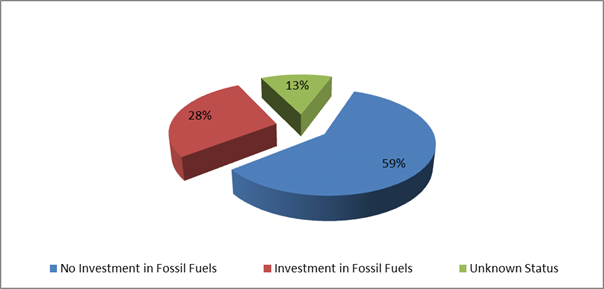
In this regard Council has an
additional two investments that are with financial institutions that invest in
fossil fuels but the purposes of the investments are in accord with the broader
definition of Environmental and Socially Responsible investments as indicated
below:
1. $1,000,000 investment with the National Australia Bank maturing
on 24 March 2022 known as a Social Bond that promotes Gender Equity.
2. $1,000,000 investment with Commonwealth Bank maturing on 31
March 2022 known as a Climate Bond.
For the month of September 2018, as indicated in the table
below, there is a dissection of the investment portfolio by investment type:
Dissection
of Council Investment Portfolio as at 30 September 2018
|
Principal Value ($)
|
Investment Linked to:-
|
Current Market Value ($)
|
Cumulative Unrealised Gain/(Loss) ($)
|
|
72,000,000.00
|
Term
Deposits
|
72,000,000.00
|
0.00
|
|
2,900,000.00
|
Floating
Rate Note
|
2,905,144.56
|
5,144.56
|
|
1,084,182.84
|
Business
On-Line Saver (At Call)
|
1,084,182.84
|
0.00
|
|
1,014,483.54
|
NSW Treasury Corp
(T Corp)
|
1,014,483.54
|
0.00
|
|
1,000,000.00
|
Bonds
|
1,017,387.17
|
17,387.17
|
|
77,998,666.38
|
|
78,021,198.11
|
22,531.73
|
The current value of an investment compared to the principal
value (face value or original purchase price) provides an indication of the
performance of the investment without reference to the coupon (interest) rate. The
current value represents the value received if an investment was sold or traded
in the current market, in addition to the interest received.
The table below provides a reconciliation of investment
purchases and maturities for month of September 2018 on a current market value
basis.
Movement
in Investment Portfolio – 30 September 2018
|
Item
|
Current Market Value (at end of month) $
|
|
Opening
Balance at 1 September 2018
|
77,017,471.34
|
|
Add:
New Investments Purchased
|
17,000,000.00
|
|
Add:
Call Account Additions
|
0.00
|
|
Add:
Interest from Call Account
|
2,146.45
|
|
Less:
Investments Matured
|
15,000,000.00
|
|
Add:
T Corp Additions
|
0.00
|
|
Add:
Interest from T Corp
|
1,580.32
|
|
Less:
Call Account Redemption
|
1,000,000.00
|
|
Add:
Fair Value Movement for period
|
0.00
|
|
Closing
Balance at 30 September 2018
|
78,021,198.11
|
Investments
Maturities and Returns – September 2018
|
Principal Value ($)
|
Description
|
Type
|
Maturity Date
|
Number of Days Invested
|
Interest Rate Per Annum
|
Interest Paid on Maturity $
|
|
1,000,000.00
|
Bananacoast Credit
Union
|
TD
|
06/09/18
|
184
|
2.60%
|
13,106.85
|
|
2,000,000.00
|
MyState Bank
Limited
|
TD
|
06/09/18
|
184
|
2.65%
|
26,717.81
|
|
1,000,000.00
|
Maitland Mutual
Building Society
|
TD
|
11/09/18
|
104
|
2.80%
|
7,978.08
|
|
1,000,000.00
|
Bankwest
|
TD
|
12/09/18
|
92
|
2.55%
|
6,427.40
|
|
2,000,000.00
|
Suncorp
|
TD
|
12/09/18
|
90
|
2.75%
|
13,561.64
|
|
1,000,000.00
|
The Capricornian
|
TD
|
17/09/18
|
154
|
2.74%
|
11,560.55
|
|
1,000,000.00
|
The Capricornian
|
TD
|
17/09/18
|
185
|
2.80%
|
14,191.78
|
|
1,000,000.00
|
Hunter United
Credit Union
|
TD
|
17/09/18
|
123
|
2.80%
|
9,435.62
|
|
1,000,000.00
|
ME Bank
|
TD
|
21/09/18
|
120
|
2.60%
|
8,547.95
|
|
1,000,000.00
|
Police Credit Union
Limited (SA)
|
TD
|
21/09/18
|
112
|
2.82%
|
8,653.15
|
|
1,000,000.00
|
Bankwest
|
TD
|
24/09/18
|
90
|
2.80%
|
6,904.11
|
|
2,000,000.00
|
ME Bank
|
TD
|
27/09/18
|
85
|
2.70%
|
12,575.34
|
|
15,000,000.00
|
|
|
|
|
|
139,660.28
|
The overall ‘cash position’ of Council is not
only measured by what funds Council has invested but also by what funds Council
has retained in its consolidated fund or bank account as well for operational
purposes. In this regard, for the month of September 2018 the table below
identifies the overall cash position of Council as follows:
Dissection
of Council Cash Position as at 30 September 2018
|
Item
|
Principal Value ($)
|
Current Market Value ($)
|
Cumulative Unrealised Gain/(Loss) ($)
|
|
Investments
Portfolio
|
|
|
|
|
Term Deposits
|
72,000,000.00
|
72,000,000.00
|
0.00
|
|
Floating Rate Note
|
2,900,000.00
|
2,905,144.56
|
5,144.56
|
|
Business On-Line
Saver (At Call)
|
1,084,182.84
|
1,084,182.84
|
0.00
|
|
NSW Treasury Corp
(T Corp)
|
1,014,483.54
|
1,014,483.54
|
0.00
|
|
Bonds
|
1,000,000.00
|
1,017,387.17
|
17,387.17
|
|
Total Investment
Portfolio
|
77,998,666.38
|
78,021,198.11
|
22,531.73
|
|
|
|
|
|
|
Cash at Bank
|
|
|
|
|
Consolidated Fund
|
1,621,532.64
|
1,621,532.64
|
0.00
|
|
Total Cash at Bank
|
1,621.532.64
|
1,621.532.64
|
0.00
|
|
|
|
|
|
|
Total Cash
Position
|
79,620,199.02
|
79,642,730.75
|
22,531.73
|
Financial Implications
Council uses a diversified mix of investments to achieve
short, medium and long-term results
Statutory and Policy
Compliance Implications
In accordance with Regulation 212 of the Local Government
(General) Regulation 2005, the Responsible Accounting Officer of Council
must provide Council with a monthly report detailing all monies Council has invested
under section 625 of the Local Government Act 1993.
The Report must be presented at the next Ordinary Meeting of
Council after the end of the month being reported. In this regard, the
current Council Meeting cycle does not always allow this to occur, especially
when investment valuations required for the preparation of the report, are
often received after the deadline for the submission of reports for the
meeting. Endeavours will be made to ensure the required report will be
provided to Council and this will for some months require reporting for one or
more months.
Council’s investments are carried out in accordance
with section 625(2) of the Local Government Act 1993 and Council’s
Investment Policy. The Local Government Act 1993 allows Council to
invest money as per the Ministers Order – Forms of Investment, last
published in the Government Gazette on 11 February 2011.
Council’s Investment Policy includes the objective of
maximising earnings from authorised investments and ensuring the security of
Council Funds.
Staff Reports - Corporate and Community Services 13.7
Report No. 13.7 Update
to hall fees and charges - Marvell Hall and Suffolk Park Hall
Directorate: Corporate
and Community Services
Report
Author: Joanne
McMurtry, Community Project Officer
File No: I2018/1793
Theme: Society and Culture
Community Development
Summary:
Marvell Hall Section 355 Management Committee have
re-assessed their fees and charges and purchased new audio-visual equipment for
hire.
Suffolk Park Community Hall has recently had hall
renovations completed which has provided a new small meeting space within the
hall.
|
RECOMMENDATION:
1. That the
new fees for Marvell Hall outlined in the report be placed on public
exhibition for 28
days.
2. That
the new fees for Suffolk Park Community Hall outlined in the report be placed
on public exhibition for 28 days.
3. That
if no submissions are received during the public exhibition period,
the new fees be adopted and incorporated into Council’s fees and
charges.
|
Report
Two Section 355 Management Committees have requested an
update to their adopted 2018/19 fees and charges as outlined below.
Marvell Hall
Marvell Hall Section 355 Management Committee have purchased
new audio-visual equipment for hire, and would like to be able to charge hire
fees for use of the equipment. They have also used the opportunity to update
other fees and charges and would like to propose the following changes.
|
Marvell Hall
|
2018/19 current fee
|
Proposed fee
|
|
Main Hall (Oodgeroo Room), Dining Room (Mackellar Room)
and Meeting Room (Lawson Room)
|
|
Regular hirers, community groups, by donation events (per
room, per hour)
|
$20
|
$20 (note description changes)
|
|
Casual hirers (per room, per hour)
|
$32
|
$32 (note description changes)
|
|
Main Hall (Oodgeroo Room), Dining Room (Mackellar Room)
and Kitchen together (per hour)
|
|
$62
|
|
Kitchen (day or night, per hour, breakages must be paid
for)
|
$20
|
$20
|
|
Bond
|
$400 weddings, parties, special events
$100 all other users
|
Between $100 - $500 at the discretion of the Management
Committee
|
|
Non return of key (after 24 hours)
|
$50 (late key return)
|
$50 (note description changes)
|
|
Extraordinary cleaning (includes removal of
garbage)
|
At cost
|
At cost with a minimum charge of $77
|
|
Cancellation fees
|
|
· For other hirers cancellation with less than 2 weeks notice
50% of the total fee is forfeited
· If the hirer cancels the booking with 2-4 weeks notice 30% of the
deposit is forfeited.
· If the hirer cancels the booking with 4 or more weeks notice 20%
of the deposit is forfeited.
|
|
Equipment fees
|
|
|
|
Option A (audio only with 10 channel stereo mixer, mic and
PA to be attached to computer)
|
|
$25 per day/ event plus $15 per hour for tech rehearsal
|
|
Option B (Projector, with or without audio)
|
|
$50 per day/ event plus $15 per hour for tech rehearsal
|
|
Option C (Projector, with or without audio, plus linked to
NBN connection)
|
|
$60 per day/ event plus standard Optus fee for timed NBN
downloads, vision or mixing or web-screening and $15 per hour for tech
rehearsal
|
Please note the following fees will be deleted:
Key deposit $50
Weddings/ parties, special events (per function) $200
Kitchen hire weddings, parties, special events (per
function) $50
Conference room (full day) $140
Conference room (half day – 4 hours) $80
Suffolk Park Community Hall
Suffolk Park Community Hall has just had hall renovations
completed which has provided a new small meeting space within the hall. The
Section 355 Management Committee has also taken this opportunity to review some
of their existing fees and charges and would like to propose the following
changes.
|
Suffolk Park Community Hall
|
2018/19 fee
|
Proposed fee
|
|
Meeting Room – standard fee, per hour
|
|
$20
|
|
Meeting Room – regulars fee, per hour
|
|
$15
|
|
Meeting Room – community fee, per hour
|
|
$10
|
|
Storage fee
|
|
POA between $10 - $20 per month
|
|
Cancellation fees
|
· Cancellation with less than 2 weeks notice 50% of the total
fee is forfeited
|
· Cancellation with less than 2 weeks notice 50% of the total
fee is forfeited
· If the hirer cancels the booking with 2-4 weeks notice 20% of the
deposit is forfeited.
|
Financial Implications
As outlined in the report, all other fees already adopted by
Council for 2018/19 are proposed to remain unchanged.
The recommended fees above are also inclusive of Goods and
Services Tax (GST) where applicable.
Statutory and Policy Compliance Implications
Under section 610F of the Local
Government Act 1993, if, after the date on which the operational plan
commences the nature or extent of an existing service is changed, Council must
give public notice (in accordance with section 705) for at least 28 days of the
fee proposed for the new or changed service.
Staff Reports - Corporate and Community Services 13.8
Report No. 13.8 Section
355 Management Committees - resignations and appointments
Directorate: Corporate
and Community Services
Report
Author: Joanne
McMurtry, Community Project Officer
File No: I2018/1794
Theme: Society and Culture
Community Development
Summary:
This report updates Council on recent resignations and
proposed appointments to Section 355 committees.
|
RECOMMENDATION:
1. That
Councillors note and confirm that in addition to Cr Lyon replacing Cr
Martin on the Ocean Shores Community Centre Management Committee as per
resolution 18-488, that Cr Martin will replace Cr Lyon on the Durrumbul
Community Hall Management Committee.
2. That
the resignation of Helen Hamilton from the Brunswick Valley Community Centre
Management Committee be accepted and a letter of thanks be provided.
|
Resignations and Committee appointments
This report details resignations and proposed new
appointments for Section 355 committees where nominations have been received.
Durrumbul Community Hall Management Committee
Following a report to the 2 August 2018 Ordinary Meeting
regarding Section 355 Management Committee resignations and appointments, the
following point 5 was added to the resolution 18-488.
5. That
Cr Lyon replace Cr Martin on the Ocean Shores Community Centre Management
Committee.
Cr Lyon has provided clarification that it was understood
between Cr Martin and Cr Lyon that they would swap committees, with Cr Martin
replacing Cr Lyon on the Durrumbul Community Hall committee in addition to the
statement in point 5 of resolution 18-488.
Brunswick Valley Community Centre
A resignation has also been received from Helen Hamilton.
Current members of this Management Committee are:
Councillors
· Cr
Jeannette Martin
Community Representatives
· Fran
Leske
· Colin
Monroe
· Jennifer
Moore
· Carmel
Lancaster
Management Recommendation
That the resignation from Helen Hamilton is accepted and a
letter of thanks provided.
A number of committees have
expressed desire to advertise for new members, including:
· Brunswick
Heads Memorial Hall
· Brunswick
Valley Community Centre
· Mullumbimby
Civic Hall
· Ocean
Shores Community Centre
· Suffolk
Park Community Hall
Staff will utilise the new
Love Byron Halls marketing materials via social media to augment the standard
Council Notices advertising to encourage fresh membership.
Financial Implications
Community Members of Section 355 Management Committees are
volunteer positions unless otherwise resolved by Council.
Statutory and Policy
Compliance Implications
Management Committees and Boards of Management operate under
Guidelines which states:
3.2
Committee Membership
Committee membership will
number not less than four and not more than nine and each committee will state
the actual number in their Terms of Reference unless otherwise decided by
Council. The exception will be the Bangalow Parks (Showground) committee which
numbers twelve. Council reserves the right to appoint up to two Councillors to
each Committee. The total number of members includes office bearer committee
members and Councillor members which are appointed by Council.
Whilst no particular
qualifications are necessary (not withstanding 3.1.a), a commitment to the
activities of the Committee and a willingness to be actively involved in
Committee issues is essential. Committees work best when the workload is shared
amongst committee members and there is evident goodwill and cooperation amongst
members.
Further information on the operations and meeting minutes
for these Committees and Boards can be found on Council’s web site at https://www.byron.nsw.gov.au/Council/Committees-and-groups/Section-355-Committees-and-Boards-of-Management.
Staff Reports - Corporate and Community Services 13.9
Report No. 13.9 Election
of Deputy Mayor 2018-2019
Directorate: Corporate
and Community Services
Report
Author: Heather
Sills, Corporate Governance Officer
File No: I2018/1859
Theme: Corporate Management
Councillor Services
Summary:
In accordance with Section 231 of the Local Government
Act 1993 Councillors can elect a Deputy Mayor. Normal practice for Byron
Shire is to elect their Deputy Mayor for a period of 12 months at the first
meeting in September each year.
At the Ordinary Meeting of Council on 20 September 2018,
Council resolved (18-619) that Council extend the period of Deputy
Mayor to the October 2018 meeting and defer the election of a new Deputy Mayor
to the next meeting of Council.
|
RECOMMENDATION:
1. That
Council elect a Deputy Mayor for the period from 18 October 2018 until the
first meeting of Council in September 2019.
2. That
the method of election of the Deputy Mayor be by way of ordinary ballot.
|
Attachments:
1 Byron
Shire Council Nomination Form Deputy Mayor 2018, E2018/60931 ⇨

Report
In
accordance with Section 231 of the Local Government Act 1993, a council may
elect a Deputy Mayor to assist the Mayor in the performance of their duties.
(1) The
councillors may elect a person from among their number to be the deputy mayor.
(2) The
person may be elected for the mayoral term or a shorter term.
(3) The
deputy mayor may exercise any function of the mayor at the request of the mayor
or if the mayor is prevented by illness, absence or otherwise from exercising
the function or if there is a casual vacancy in the office of mayor.
(4) The
councillors may elect a person from among their number to act as deputy mayor
if the deputy mayor is prevented by illness, absence or otherwise from
exercising a function under this section, or if no deputy mayor has been
elected.
Term
of the Deputy Mayor
Section
231 (2) of the Local Government Act states: “The person may be
elected for the mayoral term or a shorter term” such as:
1. For
a period of 12 months
2. For
the period of the Mayoral Term
3. For
another period determined by Council
Returning
Officer
Schedule
7(1) of the Local Government (General) Regulation 2005 states that the “General
Manager (or a person appointed by the General Manager) is the Returning
Officer.”
Nomination
Schedule 7(2) of the Local Government (General) Regulation
2005 states that:
(1) A
councillor may be nominated without notice for election as mayor or deputy
mayor.
(2) The
nomination is to be made in writing by 2 or more councillors (one of whom may
be the nominee). The nomination is not valid unless the nominee has
indicated consent to the nomination in writing.
(3) The
nomination is to be delivered or sent to the returning officer.
(4) The
returning officer is to announce the names of the nominees at the council
meeting at which the election is to be held.
Nomination
forms have been provided as an attachment to this business paper. Any
completed nomination forms should be handed to the General Manager prior to the
commencement of the Council meeting.
Election
Schedule
7(3) of the Local Government (General) Regulation 2005 states:
(1) If only one
councillor is nominated, that councillor is elected.
(2) If more than one
councillor is nominated, the council is to resolve whether the election is to
proceed by preferential ballot, by ordinary ballot; or by open voting.
(3) The election is
to be held at the Council meeting at which the Council resolves the method of
voting.
(4) In this clause:
“ballot” has its normal
meaning of secret ballot;
“open voting” means
voting by a show of hands or similar means.
Traditionally
this Council has determined that the election for Deputy Mayor should be by
ordinary ballot. The following additional information is provided in
respect to an election by preferential ballot and by ordinary ballot.
Preferential
ballot – as per its normal interpretation, the ballot papers are to
contain the names of all candidates and Councillors mark their votes 1, 2, 3
and so on against the various names, so as to indicate their order of
preference for all of the candidates.
Ordinary
ballot – this is the usual method adopted in New South Wales.
Ballots are secret with only one candidate’s name written on a ballot
paper.
Where
there are two candidates, the person with the most votes is elected. If
the ballots for the two candidates are tied, the one to be elected is to be
chosen by lots, with the first name out being declared elected.
Where
there are three or more candidates, the person with the lowest number of votes
is eliminated and the process started again until there are only two
candidates. The determination of the election would then proceed as if
the two were the only candidates. In the case of three or more candidates
where a tie occurs, the one to be excluded will be chosen by lot.
Choosing
by Lot – to choose a candidate by lot, the names of the candidates who
have equal numbers of votes are written on similar slips of paper by the
returning officer, the slips are folded by the returning officer so as to prevent
the names being seen, the slips are mixed and one is drawn at random by the
returning officer and the candidate whose name is on the drawn slip is chosen,
on the basis detailed above.
Financial Implications
On 21 June 2018, Council resolved (18-420) in part 3:
"That Council in accordance with its current practice not
determine a fee payable to the Deputy Mayor."
Section 249(5) of the Local Government Act 1993
states:
(5) A council may pay the deputy mayor
(if there is one) a fee determined by the council for such time as the deputy
mayor acts in the office of the mayor. The amount of the fee so paid must
be deducted from the mayor’s annual fee.
Therefore the
Deputy Mayor when acting in the role of Mayor, in instances where the Mayor has
leave of absence endorsed by Council, would be paid a fee calculated on a pro-rata
basis of the annual Mayoral allowance, which would be deducted from the amount
of the monthly Mayoral allowance paid to the Mayor, in accordance with Section
249 of the Local Government Act 1993.
Statutory and Policy Compliance Implications
The
Deputy Mayor will undertake the Mayor’s role at the request of the Mayor
and in situations where the Mayor is prevented by illness, absence or other
reasons from exercising the functions of the position. The role of the
Mayor is defined by Section 226 of the Local Government Act 1993.
Section
226 states that:
The role of the mayor is as
follows:
(a) to be the leader of the council and
a leader in the local community,
(b) to advance community cohesion and
promote civic awareness,
(c) to be the principal member and
spokesperson of the governing body, including representing the views of the
council as to its local priorities,
(d) to exercise, in cases of necessity,
the policy-making functions of the governing body of the council between
meetings of the council,
(e) to preside at meetings of the
council,
(f) to ensure that meetings of the
council are conducted efficiently, effectively and in accordance with this Act,
(g) to ensure the timely development and
adoption of the strategic plans, programs and policies of the council,
(h) to promote the effective and
consistent implementation of the strategic plans, programs and policies of the
council,
(i) to
promote partnerships between the council and key stakeholders,
(j) to advise, consult with and
provide strategic direction to the general manager in relation to the
implementation of the strategic plans and policies of the council,
(k) in conjunction with the general
manager, to ensure adequate opportunities and mechanisms for engagement between
the council and the local community,
(l) to carry out the civic and
ceremonial functions of the mayoral office,
(m) to represent the council on regional
organisations and at inter-governmental forums at regional, State and
Commonwealth level,
(n) in consultation with the
councillors, to lead performance appraisals of the general manager,
(o) to exercise any other functions of
the council that the council determines.
Staff Reports - Corporate and Community Services 13.10
Report No. 13.10 Draft
2017/2018 Financial Statements
Directorate: Corporate
and Community Services
Report
Author: James
Brickley, Acting Director Corporate and Community Services
File No: I2018/1929
Theme: Corporate Management
Financial Services
Summary:
The Draft 2017/2018 Financial Statements have been prepared
and submitted for external audit.
At the time of preparing this report, the external audit
process is still being finalised but is expected to be finalised no later then
12 October 2018.
The External Auditor, being the NSW Auditor General and
represented by Thomas Noble and Russell, have been invited to this Ordinary
Council Meeting to present on the Draft 2017/2018 Financial Statements, and
answer any questions from Councillors on the Financial Statements.
Further information including an amended Report and a copy
of the Draft 2017/2018 Financial Statements, will be distribution to
Councillors prior to the meeting, following the completion of the External
Audit process.
|
RECOMMENDATION:
That Council suspend standing orders to allow for a
presentation from Council’s External Auditor.
|
Report
The Draft 2017/2018 Financial Statements have been prepared
and submitted to external audit.
At the time of preparing this report, the external audit
process is still being finalised but is expected to be finalised no later than
12 October 2018. Following that finalisation, a more detailed report and
associated attachments with updated recommendations containing the Financial
Statements and draft Audit Reports will be circulated to Councillors.
The External Auditor, being the NSW Auditor General to be
represented by Thomas Noble and Russell, have been invited to this Ordinary
Council Meeting, to present on the Draft 2017/2018 Financial Statements and
answer any questions from Councillors on the Financial Statements.
The presentation is proposed to take place after the
conclusion of the Reserve Trust Meeting when the Ordinary Meeting recommences.
Further information including an amended Report and a copy
of the Draft 2017/2018 Financial Statements, will be distribution to
Councillors prior to the meeting, following the completion of the External
Audit process.
Staff Reports - Sustainable Environment and Economy 13.11
Staff Reports - Sustainable Environment and
Economy
Report No. 13.11 Draft
Bangalow Village Plan for public exhibition
Directorate: Sustainable
Environment and Economy
Report
Author: Rob Van
Iersel, Major Projects Planner
File No: I2018/918
Theme: Ecology
Planning Policy and Natural Environment
Summary:
Council resolved (16-623) to prepare a
masterplan for the village of Bangalow through a participative planning process
with the Bangalow Guidance Group.
This report presents the Draft Bangalow Village
Plan – Vision and Initiatives for Council’s consideration
for public exhibition (Attachment 1), and outlines the next step community
engagement initiatives. This report also highlights some changes to the
original communication and engagement plan that was endorsed by the
Communications Panel earlier in the year.
The draft Plan is the outcome of a two year participative
planning process with the Bangalow Guidance Group. The process has sought
to define the things people value about Bangalow and want to conserve; identify
what’s not working and needs improvement; develop strategies to guide
future change and sustainable development of the village over the next 15
years; and ensure it’s unique heritage character and rural amenity are
conserved and enhanced into the future.
The draft Plan presents the synthesis of visions and
initiatives that have come from the process, outlining a recommended framework
to guide the future of Bangalow.
The Plan’s key visions are outlined in the Executive
Summary within Attachment 1, and cover areas of public realm; built form;
access and movement; natural environment and sustainability; and culture and
sociability.
The intent of the draft Plan at this time is to present
these visions and initiatives to the broader Bangalow (and Shire) community to
test a wider view and gain an understanding of desired priorities.
The results of this wider public engagement process will
allow for the finalisation of the Plan and development of a detailed
Implementation Plan/Program.
At the same time, staff from Infrastructure Services (IS)
propose to run a separate community consultation process to determine user
needs in regard to Council-owned land at the Bangalow Sportsfields. A
budget allocation is sought by IS to undertake this parallel consultation and a
subsequent review of the Plan of Management for the Bangalow Sportsfields
(otherwise unrelated to the subject plan and exhibition). This allocation is
addressed in a separate report to this Council meeting, associated with budget
carryovers.
|
RECOMMENDATION:
1. That
Council place the Draft Bangalow Village Plan – Vision and
Initiatives, Attachment 1 (#E2018/79056) on public exhibition for a
period of 6 weeks.
2. That
Council delegate authority to the Director of Sustainable Environment and
Economy to amend the Plan prior to public exhibition, if need be, for the
purposes of proof reading and formatting edits.
3. That
Council endorse the updated Communications and Engagement Plan, Attachment 2
(#E2018/75449), to guide the public engagement activities to be undertaken.
|
Attachments:
1 draft
Bangalow Village Plan - Vision and Initiatives, E2018/79056 ⇨

2 Communications
Action Plan Bangalow Village Plan Public Exhibition, E2018/75449 ⇨
3 Special
Disclosure of Pecuniary Interest Annexure, E2012/2815
⇨
Report:
This report presents the Draft Bangalow Village
Plan – Vision and Initiatives (Attachment 1) and summarises the
community engagement activities planned to occur over a period of 6 weeks.
Background
Council resolved (16-623) to prepare a
masterplan for the village of Bangalow, through a participative planning
process with selected representatives of the Bangalow community.
Key outcomes that Council and the community are seeking from
the plan and the process include:
· greater
involvement of Bangalow residents in Council decision-making about their town;
· a shared
vision for the future – to get everyone rowing in the same direction
(including Council, community groups and private developers);
· better
integration, coordination and sequencing of activities in Bangalow, including
the delivery of infrastructure by Council;
· to inspire
and drive change by trialling some new ideas, temporary events and creative
initiatives in the public domain; and
· to ensure
that the things people love about Bangalow – such as its small town feel,
heritage character, rural setting and natural environment – are conserved.
The process commenced in late 2015 with a community survey, which
received 300 responses. Results of the survey are included in the appendix to
the draft Village Plan (Attachment 1).
A two-day Place Creation Workshop followed in March 2016, attended
by 31 representatives from Bangalow community groups, the Mayor, Councillors
and Council staff. Workshop participants were invited to continue their
involvement by becoming members of a community Guidance Group.
The Bangalow Guidance Group was formed in June 2016,
comprising 19 community members and 3 Councillors. It has met regularly
since then and, through a series of participative workshops, assisted Council
staff in developing the draft Village Plan.
Intent and scope of the draft
plan
The ‘Bangalow Village Plan’ will be a “place
plan” (or town-scale masterplan) to set out the community’s visions
and ideas for their town. When finalised, it will guide future change and
sustainable development of the Bangalow Village over the next 15 years (from
2018 to 2033).
The draft Bangalow Village Plan – Vision and Initiatives
is an important step in the process, to articulate the value of this place;
define the important aspects that make up its character; and put forward
initiatives that will ensure Bangalow’s unique heritage character and
rural amenity are recognised, valued, conserved and enhanced.
It is appropriate, at this time, to engage with the broader
Bangalow (and Shire) community to present these visions and initiatives, to
test a wider view and gain an understanding of desired priorities.
The results of this wider public engagement process will
allow for the finalisation of the draft Plan and development of a detailed
Implementation Plan/ program and future governance structure to assist in
project delivery, consistent with Council’s Community Strategic Plan,
Operational and Delivery Plans.
The draft Plan presents the
community’s vision for Bangalow Village as:
a healthy environment to live,
work and raise a family
a village rich in history and
heritage
a socially resilient community
an economically viable centre,
providing a range of services to the people of the community and the surrounding
area
nestled in the hills, surrounded
by natural beauty
The Plan’s key aspirations and initiatives are
collated across the following themes:
1. Public
realm (streets, parks, public reserves)
2. Built
form and village structure
3. Access
and movement
4. Natural
environment and sustainability
5. Culture
and sociability
6. Shopping
and business
In addition to the initiatives across these themes, the
draft Plan provides conceptual visions for the future of four main precincts
within the Village:
· Byron
Street, from Station Street to the Granuaille/Lismore Road roundabout;
· Station
Street, including “the Triangle”, rail corridor and Memorial Park;
· Showgrounds,
sportsfields, eastern end of rail corridor and Bowling Club; and
· Bangalow
Parklands and Heritage House.
Community
Engagement
Members of the Group had
previously discussed an Implementation Schedule and were keen for this to form
Part B of the draft Village Plan for public exhibition. Staff remain of
the view that further work is required to test and scope the range of
initiatives, to develop projects, resources and funding mechanisms that would
allow the development of an appropriate Implementation Plan.
In
finalising the draft Village Plan, a workshop was held with the Guidance Group
to work through the draft initiatives, to identify where there was consensus
among the Group. For the purposes of public exhibition, the current draft
contains a list of all the initiatives as Appendix 3 (see Attachment 1).
At the workshop, the Group provided a number of specific
comments that will be considered, together with further submissions resulting
from the public exhibition of the draft Plan. These included:
· the document
should clearly prioritise residential amenity over tourism;
· the highest
priority action item in the Draft Plan should be the creation of a walk/cycle
way between Rifle Range Road and the A&I Hall in the rail corridor with a
priority to extend to the sportsfield as soon as practicable suitable [Note:
not all of the members of the Group supported this specific action as the
highest priority];
· The wording
on page 9 ‘purpose and scope’ should be amended to align with the
language from the purpose and scope of the Bangalow Settlement Strategy 2003;
· that
Bangalow as a service centre to the 2479 postcode area be included in the
Purpose and Scope;
· that the NSW
Government’s Office of Environment & Heritage’s map of its
gazetted Bangalow Conservation Area be inserted into the document and properly
introduced in the Introduction to the Draft Plan and be referenced at
appropriate and relevant places throughout the document;
· that the
height limit for the total area gazetted as the Bangalow Conservation Area be
limited to no more than two storeys or 9 metres [Note: not all of the members
of the Group supported this comment];
· that Section
02 Built Form and Structure includes reference to, and aligns with the design
principles for places of cultural significance and heritage areas described in
The Burra Charter (2013) and the NSW Govt’sDesign Guide for Heritage
(2018);
· that all
presumptive and premature references to ‘density’ and ‘medium
density’ in Bangalow be moderated with reference to the need to establish
the actual capacity for what is possible and realistic after an audit
· that all
presumptive and premature descriptions throughout the document of developments
in Station Street be moderated with reference to the amended process described
in point 7 on page 91 ‘though a collaborative design process with
developers and their consultants and the Bangalow Guidance Group.’
· that all
references to a lookout or path at the top of Rankin Drive (water tower area)
be removed
The Guidance Group was invited to provide feedback on the
place planning process to the Sustainable Planning Workshop on the 6 September
2018. Councillors were able to hear directly from the Guidance Group
members about their learnings and experiences from the Bangalow Village Plan
making process.
The group were also asked to identify their top priorities
from within the Draft Bangalow Village Plan. The general themes that
arose were:
· Better
pedestrian and cycle connections through Bangalow
· Protection
of the important heritage character of Bangalow and heritage buildings,
including amending the DCP; and
· Protecting
the village and rural feel of Bangalow.
There was a general consensus that the plan making process
had taken too long. However, this had also created a highly cohesive
group which has worked well together to produce a valuable draft Plan.
In addition to collaboration with the Bangalow Village Plan
Guidance Group, initial consultations with Arakwal, Jali LALC, Tweed/Byron LALC
and Ngulingah LALC have commenced. Further details on this are
highlighted in the updated communication and engagement plan (Attachment 2).
From initial conversations, the ‘Culture and
Sociability’ and the ‘About Bangalow’ sections of the Plan
have been updated with information on the importance of cultural heritage in
the area. It is expected that further amendments and inputs relating to
cultural heritage will be necessary once each board have completed their
review, which will take place during the public exhibition period.
As outlined above, it is now appropriate that wider
community input is obtained.
Purpose of Public Exhibition:
· Feedback on the
initiatives – agreement/disagreement, omissions etc.,
· Prioritisation of
the initiatives,
· General feedback
on the draft.
The communication and engagement plan for this project was
written earlier this year, prior to the draft Plan being completed. It
was, to some extent, unknown at that stage what the exact purpose of the public
exhibition would be. The purpose, as above, has now been clarified and as
such, the methods of engagement listed in the communication and engagement plan
have been amended (see Attachment 2). The changes that have been made to
the communication and engagement plan are tabled below.
|
Removed
|
Reasoning
|
|
Scheduled walking tours
|
Staff time, health and safety issues and resources do not
justify the purpose of these meetings. These types of meetings will be better
suited to the second stage when initiatives are being scoped.
|
|
Presence outside school at pick up time
|
Time not justified – parents and children are busy
and pre-occupied at this time and not likely to stop. Ad in the school
newsletter + parklet likely to be more effective
|
|
Postcard letterbox drop
|
Postcard too expensive - will do a letterbox drop of a
fact sheet or flyer (developed in-house).
|
|
Amended
|
Reasoning
|
|
Half day workshops with Arakwal
|
Staff have been liaising with Arakwal representatives, who
are currently reviewing the Plan.
|
|
Half day workshops with Ngulingah
|
A meeting was held with CEO to get their input.
|
|
Tweed/Byron LALC consultation
|
Staff have met with Tweed/Byron CEO and Chairman.
|
As outlined in the updated communication and engagement
plan, it is recommended that a number of community engagement initiatives be
undertaken over a 6 week period. In addition to the conventional public
exhibition measures, examples of the engagement initiatives include:
· Wide
distribution of project summary information throughout Bangalow;
· Parklets in
the main street where staff will be available to talk with the community;
· Presence at
Farmers Markets;
· Online
survey; and
· Modern use
of social media.
It is intended that members of the Guidance Group will be
asked to take an active role is some of the engagement activities, to assist in
disseminating their local knowledge and input.
Financial Implications
Funds
have been allocated in the 2018/19 budget to finalise the development of the Bangalow
Village Plan.
Funds
are required to review the Plan of Management for the Bangalow Sportsfields.
An allocation of $50,000 is addressed in a separate report to this Council
meeting, associated with budget carryovers.
Statutory and Policy Compliance Implications
The Draft Bangalow
Village Plan – Vision and Initiatives is a
non-statutory document, which has been initiated by Council in response to
requests from community leaders.
It will provide impetus for
the subsequent development of statutory documents and guidelines for future
development in Bangalow.
Staff Reports - Sustainable Environment and Economy 13.12
Report No. 13.12 PLANNING
- Car Share Pilot Project, Byron Bay & Mullumbimby
Directorate: Sustainable
Environment and Economy
Report
Author: Jamie
Van Iersel, Planner - Place Planner
File No: I2018/1377
Theme: Sustainable Environment and Economy
Planning Policy and Natural Environment
Summary:
At the Ordinary Meeting of 22 February
2018, Council considered a draft Car Share Policy and resolved to
exhibit the draft Policy and support an expression of interest (EOI) from car
share companies for a pilot project.
This report provides a status update on the projects public exhibition
and EOI as well as an update on the selection of car share bay locations in
Byron Bay.
The draft Car Share Policy was publicly exhibited until
Monday, 17 September. As no submissions of objection were received the
Policy is now adopted.
Five car share operators expressed an interest in operating
a car share scheme.
Community engagement was carried out with neighbours nearby
to the potential car share bays, and the Local Traffic Committee considered a
report on the potential sites. From this engagement twelve car parking spaces
are recommended for the trial.
Additionally, two landholders, with three sites, have
indicated a willingness to take part in the 12 month pilot by allowing a number
of their car parking spaces to be used by the selected car sharing operator.
Once the location of the car share bays has been endorsed,
Council staff will move forward with the process and invite the car sharing
operators to formally apply to lease the spaces. Once applications close,
the details will be reported back to Council for a car share operator to be
selected.
NOTE TO COUNCILLORS:
In accordance with the
provisions of S375A of the Local Government Act 1993, a Division is to be
called whenever a motion for a planning decision is put to the meeting, for the
purpose of recording voting on planning matters. Pursuant to clause 2(a)
under the heading Matters to be Included in Minutes of Council Meetings of
Council's adopted Code of Meeting Practice (as amended) a Division will be
deemed to have been called by the mover and seconder of all motions relating to
this report.
|
RECOMMENDATION:
That Council endorse the following parking
bay locations for the car share pilot:
a) Mullumbimby:
four (4) spaces in the Station Street car park; and
b) Byron
Bay: four (4) in Lawson Street, two (2) in Marvell Street east (subject to
further consultation with nearby neighbours) and one (1) each in Browning and
Shirley Streets.
|
Attachments:
1 Car Share
Policy, E2018/76862 ⇨

2 Car Share
Implementation Procedure, E2018/77388
⇨
3 Car Share
Bay Location Feedback as of Sept 18 2018, E2018/76870
⇨

4 Car Share
Bay Locations - Recommendations 18 Oct, E2018/77384
⇨
5 Confidential
- Car Share EOI – Responses pdf, E2018/68767
6 Car Share
Potential Bay Locations - LTC, E2018/68877
⇨
Report
Background
At the
Ordinary Meeting of 22 February 2018, Council Resolved (18-115):
1. Endorse
the principles of the report to develop a pilot project for car share;
2. Request
staff to exhibit the draft Policy and the suggested DCP 2014 amendments
together for a period of 28 days;
3. Note
that, if no submissions are received, the amendments are to be adopted as at
the date of the close of exhibition and notified accordingly;
4. Support
progression of an expression of interest from car share companies for a pilot
project in Byron and Mullumbimby, and that a further workshop and report to
Council to occur following the EOI process.
Car Share Policy and
Procedure
The draft Car Share Policy was exhibited until Monday, 17
September. During the exhibition the car sharing concept was introduced during
recent community engagement activities relating to the Byron Bay Town Centre.
There was overwhelming support among attendees at two community workshops, and
from students at workshops undertaken at Byron Bay High School for the
establishment of a car share pilot scheme.
No submissions of objection were received and therefore, in
accordance with the resolution above, the Policy is now adopted, Attachment 1.
One submission of support was received that read “I wish to register my
support for the proposed Car Share scheme in Byron Bay”.
An internal Procedure (Attachment 2) has been developed to
guide the delivery of the car share trial.
Expression of Interest
– Car Share Operators (CSOs)
A presentation on the outcomes of the EOI was provided to
the 9 August 2018 Strategic Planning Workshop.
Five CSOs responded to the EOI, refer to confidential
Attachment 5:
· GoGet
· PopCar
· Green
Share Car
· Flexi
Car
· Car
Next Door
All five CSOs expressed interest, to varying degrees, in
potentially operating in Byron Shire. Green Share Car was only interested
in a Strata Fleet Model, rather than the traditional scheme. The
remaining four could all potentially be suitable for operation in Byron Shire.
Expression of Interest
– Commercial Landowners
The purpose of this expression of interest was to learn from
local commercial landowners of any potential interest they may have in allowing
bays for car sharing within their development. By utilising commercial
landowners to be involved in the pilot, a further reach and potentially more
tactical and strategic placement of car share bays could be achieved.
Council would not be involved in the agreements of these
bays; the landowner would lease their space directly to the CSO. Council
would be available to introduce and support the relationship between the
landowners and the CSO.
So far, two landholders, with three development sites (Koho
Mullumbimby (future development), Koho Sunrise, and Habitat Sunrise), have
identified willingness for one or more car share bays within their car parks.
Car Share Bay Locations
A number of potentially suitable car parking spaces were
initially identified by Council staff to become exclusive car share bays.
The locations were selected based on research regarding existing car sharing
schemes around Australia.
Residents near the identified potential car share bays were
contacted and a fact sheet and letter was sent out to residents in the
immediate vicinity of a parking space that was identified as potentially
suitable.
Staff subsequently discussed the proposal with 12 residents,
receiving feedback on the location of the bays. All 12 respondents saw
the pilot to be a positive contribution for the Shire, although most
recommended minor changes to the locations suggested. Refer to Table 1
below which shows a summary of the residents’ feedback, see Attachment 3
for further detail.
The preferred locations, as well as additional alternatives,
were reported to the Local Traffic Committee (LTC) at the 18 September 2018
meeting, seeking support for at least 10 bays (see Attachment 6).
The LTC Recommended:
That Council support the
following locations for car share spaces: four (4) spaces in Station St, four
(4) in Lawson St and one (1) space each in Massinger, Browning, Marvell and
Shirley Streets, generally located where shown in red in the report.
Table 1: Summary of consultation with residents near
proposed car share bays
|
Location
|
Summary
|
|
Shirley Street
|
|
Neighbour 1
|
Intersection too congested. Further
east on Shirley Street would be better.
|
|
Neighbour 2
|
Great idea and location
|
|
Neighbour 3
|
Intersection too congested
|
|
Neighbour 4
|
Intersection too congested
|
|
Marvell Street
|
|
Neighbour 1
|
Commercial area of Marvell
Street would be better. This is residential area.
|
|
Massinger Street
|
|
Neighbour 1
|
Intersection too busy, closer to
beach or rec grounds better
|
|
Neighbour 2
|
Detrimental here: more illegal
parking, more parking/congestion in short street
|
|
Neighbour 3
|
Location is fine.
|
|
Neighbour 4
|
Area is too busy, driveways
often blocked as cars double park
|
|
Browning Street
|
|
Neighbour 1
|
People already park over
driveway, will impact home occupation.
|
|
Lawson Street South
|
|
Neighbour 1
|
Not in South car park. North
car park would be better. Two bays here would be detrimental to business.
|
|
Neighbour 1
|
Okay, but no more than 2. North
would be better.
|
Based on this feedback, and the recommendations of the LTC,
there are 12 car share bays recommended for endorsement , refer to Table 2 and
Attachment 4 for mapping.
Table 2: Location of car share bays recommended for
endorsement
|
Location
|
Number
|
Comments/ Justification
|
|
Lawson Street South Car Park, in the North-Western corner
of the car park
|
Four (4)
|
· Supported by LTC.
· Neighbour feedback
split, some concerns over the impact on business
· This location is
easily accessible on foot to both town centre and Butler Street
Reserve. The South carpark provides more direct and safer access to
Butler Street Reserve and the Skennars Shoot area where people may be
travelling to/ from.
|
|
Marvell Street (east)*
* this site has been
identified as a result of the consultation process and will require further
consultation with the surrounding neighbours of this location
|
Two (2)
|
· Not sent to LTC,
however LTC supported one bay in Massinger Street and one bay in Marvell
Street (west).
· It is
recommended that these be combined
· Feedback from
neighbours highlighted the location originally identified in Massinger Street
(i.e. near the Top Shop) is a very busy and congested area.
· Provides
pedestrian access to the cars from the surrounding residents/ tourism
accommodation.
· Provides
pedestrian access to the town centre through the recreation grounds.
|
|
Browning Street
|
One (1)
|
· Supported by LTC
· Information to
neighbours included plans for two cars here, the amendment to only include
one should ease the concerns heard from one resident
· Provides
pedestrian access to surrounding residents
· Provides
pedestrian access to the town centre
|
|
Shirley Street
|
One (1)
|
· Supported by LTC
· Information to
neighbours included plans for two cars here close to the corner of Kendall
Street, the amendment to only include one car share bay, and for it to be
located further from the corner should ease the safety concerns heard by the
residents
· Provides
pedestrian access to residents/ tourism accommodation in Belongil, and
surrounding areas
· Provides
pedestrian access to town centre.
|
|
Mullumbimby Car Park – Station Street
|
Four (4)
|
· Supported by LTC
· Provides
pedestrian access to surrounding residents
· Provides
pedestrian access to the town centre
|
Where to From Here
Once the location of the car share bays has been endorsed,
Council staff will move forward with the process and invite the car sharing
operators to formally apply to lease the spaces. Once applications close,
the details will be reported back to Council for a car share operator to be
selected.
In the future, if Council determines it suitable, a similar
application process could be used to designate additional car share bays to the
same or additional car share operators.
Definitions
The traditional scheme of car sharing is where a private CSO
owns and manages the fleet of cars and leases public car parking spaces from
Council and/or private spaces from a land owner. This is the model being
pursued for the pilot project in Byron Bay.
Other car share models include:
· “Strata-fleet”,
where share cars are situated within and designated to specific developments,
such as a university. The use of those car shares are specifically for
the tenants of the ascribed development and not for the public. This
gives the operator a security on the use of the vehicles as the developer will
have to provide a guarantee and financially security; and
· “Peer
to peer”, where cars are ‘leased’ from one community member
directly to another. As this model does not need Council approval or
support it is, most likely, already occurring informally and likely to occur on
a larger and more organised scale without need for any Council action.
The major peer to peer online platform, carnextdoor.com.au has already advised
of their intention to begin marketing to Byron residents by the end of the
year.
Financial Implications
The allocation of car parking spaces to become car sharing
bays will result in some loss of revenue from the paid parking scheme.
Not all car share spaces would be within paid parking areas. It is
estimated that the designation of car share bays will result in a loss of 2 to
4 spaces from paid parking.
The fees and charges accrued from the CSO have been set to
make up some of this revenue. As outlined in the Procedure, the fees and
charges have been set after consideration of:
· Current
business rates for car parking permit;
· Community
benefit;
· Loss
of paid parking revenue; and
· Value
of car spaces
The recently adopted 2018/19 fees and charges provide for:
· An
administration fee of $440 per application; and
· A
permit fee of $110 per car share vehicle/bay
The $110 permit fee is equivalent to the cost of a permit
for a worker/volunteer whose fixed place of employment or volunteer work is
within the Pay Parking area but are not eligible for the Resident/Ratepayer
Permit exemption.
Statutory and Policy Compliance Implications
Nil.
Staff Reports - Sustainable Environment and Economy 13.13
Report No. 13.13 PLANNING
- Development Application 10.2018.342.1 Secondary dwelling at 5 Luan Court
Byron Bay
Directorate: Sustainable
Environment and Economy
Report
Author: Heidi
Hutchinson, Planner
File No: I2018/1687
Theme: Sustainable Environment and Economy
Development and Certification
Proposal:
|
Proposal description:
|
Secondary Dwelling
|
|
Property description:
|
LOT: 56 DP: 863772
|
|
5 Luan Court BYRON BAY
|
|
Parcel No/s:
|
211740
|
|
Applicant:
|
Mr K Gillespie
|
|
Owner:
|
Gillespie Bricks and Mortar Pty Ltd
|
|
Zoning:
|
2A – Residential Zone (deferred matter)
|
|
Date received:
|
10 July 2018
|
|
Integrated Development:
|
No
|
|
Public notification or exhibition:
|
- Level
1 advertising under DCP 2014 Part A14 – Public Notification and
Exhibition of Development Applications
- Exhibition
period: 20/7/18 to 2/8/18
- Submissions received: 6
|
|
Planning Review Committee:
|
9 August 2018
|
|
Other approvals (S68/138):
|
Not applicable
|
|
Delegation to determination:
|
Council meeting
|
|
Issues:
|
· Tree removal
– Moreton Bay Fig
· Floor area
|
Summary:
The proposed development originally sought a consent for
a secondary dwelling with a floor area in excess of the permitted 60m2
and removal of two trees, one being a Moreton Bay Fig tree within the road
reserve of Luan Court. This raised a number of objections during the
exhibition period and the plans were amended with the fig tree no longer being
proposed for removal.
In this regard the tree is an attractive element of the
streetscape and it retention provides for visual screening of both the new
dwelling and existing residence on the property. The design of the dwelling was
also amended and the floor area brought into compliance with the 60m2
maximum. The secondary dwelling comprises a ground floor living, dining,
bathroom and laundry with an upper level mezzanine bedroom. The building is to
be clad in fibro cement sheeting with a colorbond roof.
The proposed development
is consistent with the relevant environmental planning instruments and planning
controls applicable to the site. The proposal raises no significant issues in
terms of environmental impacts which cannot be managed and the site is
considered suitable for the development. The application is recommended for
approval subject to conditions of consent
NOTE TO COUNCILLORS:
In accordance with the
provisions of S375A of the Local Government Act 1993, a Division is to be
called whenever a motion for a planning decision is put to the meeting, for the
purpose of recording voting on planning matters. Pursuant to clause 2(a)
under the heading Matters to be Included in Minutes of Council Meetings of
Council's adopted Code of Meeting Practice (as amended) a Division will be
deemed to have been called by the mover and seconder of all motions relating to
this report.
|
RECOMMENDATION:
Pursuant to Section 4.16
of the Environmental Planning & Assessment Act 1979, Development Application
no. 10.2018.342.1 for secondary dwelling, be granted consent subject to the
conditions of approval attached with this report.
|
|
|
Attachments:
1 Final
Plans for Approval DA342/2018, E2018/78830
⇨

2 Conditions
of consent DA342.2018.pdf, E2018/78831
⇨
3 submission
received, E2018/79803 ⇨
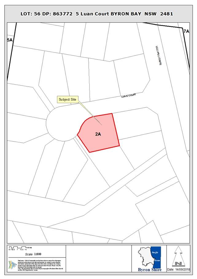
Assessment:
1.1. History/Background
The site was approved for a dwelling on 5th March
1998 under DA6.1998.2043.1. Alterations and additions to the dwelling were
approved 24th February 2006 under DA10.2006.21. Use of unauthorised
dwelling alterations was approved 10th November 2009 under
DA10.2009.506.1.
A secondary dwelling and tree removal was approved on the
site on the 9th January 2013 under DA10.2013.10.1 that included
removal of the existing garage and construction of a 2 storey building
including garage at the ground level and secondary dwelling above. Council
records do not show that this approval was ever acted upon.
A secondary dwelling under DA10.2017.755.1 was refused on
the 6th June 2018 due to the requested variation to the 6.5m setback
(down to 4.5m). The current application complies with councils setback
requirements.
1.2. Description
of the proposed development
This application seeks approval for a two (2) storey
secondary dwelling on land currently zoned as 2(a) Residential zone under the
Byron Local Environmental Plan 1988. The proposed secondary dwelling meets the
requirements of the State Environmental Planning Policy (Affordable Rental
Housing) (ARHSEPP) 2009.
The secondary dwelling is proposed to be constructed from rendered
RFC sheeting with colorbond roofing to match the existing dwelling. The
secondary dwelling will consist of:
Ground floor:
· Combined
Kitchen/living and meals room;
· Combined
bathroom and laundry
First floor:
· One
(1) bedroom
The secondary dwelling would have a total height of 7.06m
and a total GFA of 59.6m2.
The applicant originally sought a secondary dwelling and
tree removal however discussion with the applicant has determined no tree
removal is proposed within this application. It is recommended that a condition
of consent be included for an arborists report to be carried out and root
barriers to be provided for tree protection for the fig (see proposed
conditions 5, 6 & 8).
The areas of the site mapped as High Environmental Value are
to the south of the site whilst the areas mapped as Koala Habitat are to the
north east as shown below:
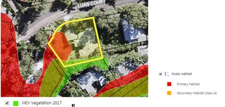
Ongoing discussion with the applicant regarding the bulk and
scale of the design have occurred including amendments to the gross floor area
of the proposed secondary dwelling to ensure it meets the 60 m2 requirements
for secondary dwellings.
1.3. Description
of the site
|
Land is legally described as
|
LOT: 56 DP: 863772
|
|
Property address is
|
5 Luan Court BYRON BAY
|
|
Land is zoned:
|
2A – Residential Zone
|
|
Land area is:
|
831.1 m2
|
|
Property is constrained by:
|
Bushfire prone land Acid Sulfate Soils, High Environmental
Value Vegetation
|
|
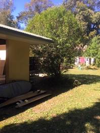
|
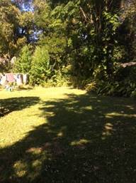
|
|
Figure 1: Looking south east towards existing dwelling
|
Figure 2: Looking south towards back yard
|
|
|
|
|
Figure 3: Looking south towards entrance to principal
dwelling
|
Figure 4: Looking north from the site to existing
vegetation
|
The subject allotment is described as Lot 56 DP 863772 and
is located at No. 5 Luan Court, Byron Bay. The allotment is located on land
zoned 2(a) Residential Zone and has an area of approximately 831.1m2.
Adjoining the subject allotment to the east, south and west are similar residential
allotments. To the north the subject allotment fronts Luan Court.
The site is generally flat. The allotment contains an
existing single storey dwelling house and an attached carport.
There are no easements located on the subject allotment.
1. SUMMARY OF
REFERRALS
|
Referral
|
Issue
|
|
S64 / Systems Planning Officer
|
No objections subject to conditions. Refer to Doc #A2018/22366
|
|
S94 / Contributions Officer
|
No objections. No contributions. Refer to Doc #A2018/22368
|
|
Essential Energy
|
No objections subject to conditions. Refer to Doc
#E2018/76190
|
* Conditions provided in the above referral are included
in the Recommendation of this Report below
2. SECTION 4.14
– BUSH FIRE PRONE LAND
Under section 4.14 of the Act, Council must be satisfied
prior to making a determination for development on bush fire prone land, that
the development complies with the document Planning for Bush Fire Protection
2006. The site is on bush fire prone land.
Appropriate conditions of consent are recommended in
relation to construction standards and the like to address the bushfire hazard.
3. SECTION 4.15C
– MATTERS FOR CONSIDERATION – DISCUSSION OF ISSUES
Having regard to the matters for consideration detailed in
Section 4.15(1) of the Environmental Planning & Assessment Act 1979
(EP&A Act), the following is a summary of the evaluation of the issues.
3.1 State Environmental
Planning Instruments
|
|
Satisfactory
|
Unsatisfactory
|
|
State
Environmental Planning Policy (Coastal Management) 2018
|
☒
|
☐
|
|
Consideration: The site is located wholly within the
Coastal wetlands buffer area.
· No public access
to the coastal foreshore will be impeded or diminished as part of the
proposal
· No effluent is
proposed to be disposed other than to Council’s sewerage system.
· Stormwater is to
be discharged to the existing discharge point and will not be directly into
the coastal environment.
|
|
State
Environmental Planning Policy No 44—Koala Habitat Protection
|
☒
|
☐
|
|
Consideration: The site is identified as Primary Koala
Habitat however the SEPP 44 does not apply to the proposed development as the
site does not contain an area of more than 1 ha.
|
|
State Environmental
Planning Policy No 55—Remediation of Land
|
☒
|
☐
|
|
Consideration: The property is considered suitable for
residential development.
|
|
State Environmental
Planning Policy (Building Sustainability Index: BASIX) 2004
|
☒
|
☐
|
|
Consideration: A BASIX certificate has been supplied with
the application. Amended plans have been provided showing the requirements of
the BASIX.
|
|
State
Environmental Planning Policy (Affordable Rental Housing) 2009
|
☒
|
☐
|
|
Consideration:
Clause 5
Interpretation –
references to equivalent land use zones
(1) A reference in this
Policy to a land use zone that is equivalent to a named land use zone is a
reference to a land use zone under an environmental planning instrument that
is not made as provided by section 3.20 (2) of the Act:
a) that
the Director-General has determined under clause 1.6 of State Environmental
Planning Policy (Exempt and Complying Development Codes) 2008 is a land use
zone in which equivalent land uses are permitted to those permitted in that
named land use zone, or
b) if
no such determination has been made in respect of the particular zone, is a
land use zone in which (in the opinion of the relevant authority) equivalent
land uses are permitted to those permitted in that named land use zone.
The site is located within a
deferred matter area currently zoned 2(a) Residential Zone. The objectives of
the zone are in keeping with the objectives of the R2 Low Density Residential
zone within the standard instrument.
Clause 19
secondary dwelling
means a self-contained dwelling that:
a) is established in conjunction with another dwelling (the
principal dwelling), and
b) is on the same lot of land (not being an individual lot
in a strata plan or community title scheme) as the principal dwelling, and
c) is located within, or is attached to, or is separate
from, the principal dwelling.
The proposed development
meets the criteria for definition “secondary dwelling”.
Clause 20
Secondary Dwellings are
permissible in the following zones provided a dwelling house is permissible
on the land:
· Zone
R1 General Residential,
· Zone
R2 Low Density Residential,
· Zone
R3 Medium Density Residential,
· Zone
R4 High Density Residential,
·
Zone R5 Large Lot Residential.
The site is located in a
Deferred Matter area as discussed above, however, the 2a Residential Zone is an
equivalent zone and therefore Clause 20 may apply to the proposal.
Clause 22
Development may be carried
out with consent
(3) Development
is permissible provided:
a) The total floor area of the principal dwelling and the
secondary dwelling is no more than the maximum floor area allowed for a
dwelling house on the land under another environmental planning instrument;
and
b) The total floor area of the secondary dwelling is no
more than 60m2 or, if a greater floor area is permitted in
respect of a secondary dwelling on the land under another environmental
planning instrument, that greater floor area.
(4) Development must not be
refused on the following grounds:
a) Site area if:
i. the secondary dwelling is located within, or is
attached to, the principal dwelling, or
ii. the site area is at least 450 square metres,
b) Parking if no additional parking is to be provided on
the site.
The current zoning of the
site does not provide requirements for floor space ratio The proposed
secondary dwelling has a gross floor area of 59.6m2. The proposed
secondary dwelling is detached from the principal dwelling and the site has
an area of 831.1m2. No additional parking is provided for the
secondary dwelling. Two (2) spaces are existing for the principal dwelling.
|
4.2B Byron Local Environmental Plan 1988 (LEP 1988)
LEP 1988 is an applicable matter for consideration in the
assessment of the subject development application in accordance with subsection
4.15(1) of the EP&A Act because it applies to the subject land and the
proposed development. The LEP 1988 clauses that are checked below are of relevance
to the proposed development:
|
Part 1
|
☒1|
☒2| ☒2A| ☒3| ☒4| ☒5| ☒LEP 1988 Dictionary| ☒7
|
|
Part 2
|
☒8|
☒9
|
|
Part 3
|
☒15|
☒24| ☐25| ☐27| ☐ 29| ☐29AA| ☐29A| ☐30| ☐31| ☐32| ☐33| ☐34| ☐35| ☐36| ☐37| ☐38| ☐38A| ☐38B| ☐39| ☐39A| ☐39B| ☐39C| ☒40| ☐41| ☐42| ☐43| ☐44| ☐45| ☐46| ☐47| ☐47AA| ☐47A| ☐48| ☐49| ☐51| ☐52| ☐53| ☐54| ☐55| ☐56| ☐ 57| ☐58| ☐59| ☐60| ☐61| ☐62| ☒63| ☐64
|
In accordance with LEP 1988 clauses 5, 8 and 9:
(a) The
proposed development is not defined in the LEP 1988 Dictionary, however is
reverted to the ARHSEPP 2009 where it is defined as “Secondary
Dwelling”;
(b) The
land is within the LEP1988 2(a) Residential Zone according to the map under LEP
1988;
(c) The
proposed development is prohibited in the zone but is permissible under the
ARHSEPP 2009; and
(d) The
proposed development is consistent with the relevant objectives of the Zone for
the following reasons:
|
Zone Objective
|
Consideration
|
|
to make provision for certain suitable lands, both in
existing urban areas and new release areas, to be used for the purposes of
housing and associated neighbourhood facilities of high amenity and
accessibility
|
The development will provide additional housing in a
residential zone.
|
|
to encourage a range of housing types in appropriate
locations
|
The development will provide a range of housing options in
the locality.
|
|
to enable development for purposes other than
residential purposes only if it is compatible with the character of the
living area and has a domestic scale and character,
|
Not applicable.
|
|
to control by means of a development control plan the
location, form, character and density of permissible development
|
The siting of the development is such that it meets the
requirements of the Development Control Plan with only minor variation.
|
Clause 63 - Acid Sulfate Soils
The development is proposed on the portion of the site
mapped as potentially supporting Class 5 Acid Sulfate Soils. The proposed Works
are within 500 metres of adjacent mapped Class 2 Acid Sulfate Soils. However,
it is not expected that works below 5 metres AHD will occur that are likely to
lower the watertable below 1 metre AHD on the adjacent Class 2 land. The
proposal is considered acceptable in this instance and an ASS Management Plan
is not required.
4.3 Any proposed Instrument
that has been the subject of public consultation and has been notified to the
consent authority
No draft EPI’s affect the proposal.
4.4A Byron Shire Development Control Plan 2014
(DCP 2014)
DCP 2014 is an applicable matter for consideration in the
assessment of the subject development application in accordance with subsection
4.15(1) of the EP& A Act because it applies to the land to which LEP 2014
applies. The DCP 2014 Parts/Chapters that are checked below are of relevance to
the proposed development:
As there are no specific requirements for secondary
dwellings in the Byron Shire Development Control Plan 2010, assessment against
the requirements of Part D1.4. The proposal is considered acceptable having
regard to those controls relating to open space, access and parking and siting
design and character.
4.4B Byron Shire Development Control Plan 2010 (DCP 2010)
DCP 2010 is an applicable matter for consideration in the
assessment of the subject development application in accordance with subsection
4.15(1) of the EP& A Act because its purpose is to provide planning
strategies and controls for various types of development permissible in
accordance with LEP 1988. The DCP 2010 Chapters/Parts that are checked below
are of relevance to the proposed development:
|
Chapter 1 Parts:
|
☒A|
☒C| ☒F| ☒H| ☒N
|
|
Chapters:
|
☒17|
☒21
|
These checked Chapters/Parts have been taken into
consideration in the assessment of the subject development application in
accordance with subsection 4.15(1) of the EP&A Act. The proposed
development complies with all sections of these Chapters/Parts (in some cases
subject to conditions and/or to the satisfaction of other assessing officers),
except in relation to certain prescriptive measures which are considered further
(having regard to the DCP 2010 Section A4 “How does this DCP work?”
alternative assessment procedure) as follows:
|
What Section and prescriptive measure does the development
not meet?
|
Does the proposed development meet the Element Objectives
of this Section? Address.
|
Does the proposed development meet the Performance
Criteria of this Section? Address.
|
|
C2.5 Element - Building Height Plane.
The proposed secondary dwelling encroaches the building
height plane on the north western elevation by 600mm being the eaves only.
|
The proposed secondary dwelling encroaches the building
height plane on the eaves only. Therefore, is not considered to impact on
solar access and privacy noting that there would be no change to privacy on
adjoining properties, and on views from adjacent existing buildings.
The occupants of existing and proposed buildings will
enjoy the optimum use of winter sunlight and summer shade currently afforded
to them.
|
The proposed secondary dwelling is set back progressively
from the site boundary as height increases so that it does not adversely
affect existing or future development on adjoining properties by way of
overshadowing, impinging on privacy or obstructing views. Further, the second
storey bedroom window is sited to mitigate potential overlooking and privacy
impacts. Only the eaves encroach on the building height plane.
The proposed secondary dwelling will provide no change to
windows of living areas (decks, living rooms, bedrooms, kitchens, etc.) of
development on adjoining properties will, as a minimum, retain full solar
access between the hours of 9.00am to 3.00pm on any day.
|
|
C3.1 Element - Visual Impact
The development proposes a two (2) storey secondary
dwelling while the principle dwelling is single storey.
The DCP states:
There must be a reasonable degree of integration with
the existing built and natural
environment, balanced with the need to provide variety
in streetscapes
|
The element objective is to maximise the aesthetic character
of the built environment, consistent with the subtropical character of Byron
Shire. The surrounding streetscape boasts a mix of single and two (2) storey
dwelling houses surrounded by trees. The proposed secondary dwelling does not
contravene this objective.
|
The proposed secondary dwelling meets the height
requirements, is proposed to be of similar colours to the principal dwelling
and provides a variety in the streetscape that is softened into the
streetscape by the large amount of vegetation provided in the front setback.
|
4.5 Any Planning Agreement or
Draft Planning Agreement?
|
|
Yes
|
No
|
|
Is there any applicable planning agreement or draft
planning agreement?
|
☐
|
☒
|
|
|
4.6 Environmental Planning
& Assessment Regulation 2000 Considerations
The proposal raises no issues under the relevant clauses in
the Regulations.
4.7 Any coastal zone management
plan?
|
|
Satisfactory
|
Unsatisfactory
|
Not applicable
|
|
Is there any applicable coastal zone management plan?
|
☐
|
☐
|
☒
|
|
|
4.8 The likely impacts of that
development, including environmental impacts on both the natural and built
environments, and social and economic impacts in the locality
|
Impact on:
|
Likely significant impact/s?
|
|
Natural environment
|
The proposal does not involve the removal of vegetation
and will not have a significantly adverse impact on the natural environment
of the locality.
|
|
Built environment
|
No. The proposal will not have a significantly adverse
impact on the built environment of the locality. Conditions of consent to
control hours of work, construction noise, builders waste and the like during
the construction of the dwelling.
|
|
Social Environment
|
No. The proposal will not have a significant social impact
on the locality.
|
|
Economic impact
|
No. The proposal will not have a significant economic
impact on the locality.
|
Are there any Council Policies that are applicable to the
proposed development?
4.9 The suitability of the site
for the development
The site is a serviced, unconstrained property and is
suitable for the proposed development.
4.10 Submissions made in accordance with
this Act or the regulations
The development application was publicly exhibited .
There were 6 submissions made against the development
application:
|
Objection
|
Planners comment
|
|
Tree Removal
|
The applicant no longer seeks tree removal with this
application. Conditions are recommended for protection of the Fig tree (conditions
5, 6 & 8) No further assessment is required regarding this objection.
|
|
Streetscape
|
The development meets the requirements for height, Floor
Space Ratio and setbacks. The applicant has provided advice that five (5)
dwellings within Luan Court provide two (2) storeys. The planner has attended
the site twice with the final site inspection identifying that there are 13
dwellings within Luan Court, three (3) of which are not seen from the
streetscape. Of the 10 visible dwellings from the streetscape it appears that
Luan Court provides five (5) dwellings that are two (2) storeys. As this is
half of the visible development on the street, the inclusion of a secondary
dwelling of two (2) storeys is not considered out of character. Further, the
site provides adequate screening. The request for a two (2) storey
development is to provide affordable housing complying with the relevant
Environmental Planning Instruments. In terms of visual amenity and impacts on
the streetscape, the secondary dwelling will be screened in part by the fig
tree to be retained in the Street.
|
|
Floor Space Ratio
|
Amended plans have been provided by the applicant that has
reduced the floor space to meet the requirements of a maximum 60m2.
The proposal now complies with the Floor Space Ratio.
|
|
Assessment as dual occupancy
|
The Byron Local Environmental Plan 1988 does not include
secondary dwellings. However, assessment of the secondary dwelling is
provided under the State Environmental Planning Policy (Affordable Rental
Housing) (ARHSEPP) 2009. The development meets the requirements of
this part. See Division 2 of the ARHSEPP.
|
|
Car Parking
|
Although the Byron Shire Development Control Plan (BDCP)
2010 does not have specific controls in relation to Secondary dwellings, the
Byron Shire Development Control Plan 2014 does advise that no car parking is
required for secondary dwellings. Further, the ARHSEPP states that an
application cannot be rejected due to no additional parking for the secondary
dwelling (see clause 22 of ARHSEPP). The principal dwelling provides two (2)
spaces. The development complies.
|
|
Environmental Impacts
|
The site is located within an area mapped as potentially
supporting primary koala habitat. The zoning of the site is residential and
the existing area contains low density housing. The proposal no longer
requests removal of vegetation and it is considered the proposal will not
have an adverse impact on the environment.
|
|
Setback of proposed secondary dwelling
|
Proposal complies with Councils setback requirements
|
|
Negative economic impact
|
The proposed secondary dwelling meets the requirements of
the ARHSEPP and is within a residential zone. Residential development is an
expected type of development within this zone and it is unlikely to have an
adverse economic impact
|
|
Use of the secondary dwelling for tourist purposes
|
The owner has provided a signed letter advising that the
development will not be used for tourist purposes. A condition is recommended
(see Condition 25).
|
4.11 Public interest
The proposed development is unlikely to prejudice or
compromise the public interest or create a dangerous precedent.
5. DEVELOPER
CONTRIBUTIONS
The proposed Secondary Dwelling does not generate the need
for water and sewer Headworks charges or S94 Contributions.
6. DISCLOSURE OF
POLITICAL DONATIONS AND GIFTS
|
Has a Disclosure Statement been received in relation
to this application
|
No
|
|
Have staff received a ‘gift’ from anyone
involved in this application that needs to be disclosed. Where the answer is
yes, the application is to be determined by the Director or Manager of the
Planning, Development and Environment Division.
|
No
|
7. CONCLUSION
The proposed development is consistent with the relevant
environmental planning instruments and planning controls applicable to the
site. The proposal raises no significant issues in terms of environmental
impacts which cannot be managed and the site is considered suitable for the
development. The application is recommended for approval subject to conditions
of consent.
Staff Reports - Sustainable Environment and Economy 13.14
Report No. 13.14 PLANNING
- Railway Park Draft Plan of Management - Submissions Report
Directorate: Sustainable
Environment and Economy
Report
Author: Rob Van
Iersel, Major Projects Planner
File No: I2018/1701
Theme: Sustainable Environment and Economy
Planning Policy and Natural Environment
Summary:
Council resolved in November 2017 to prepare a Plan of
Management for Railway Park in Byron Bay (17-575). In June
2018, Council resolved to publically exhibit the draft Plan of Management, and
arrange an independently chaired Public Hearing prior to reporting back to
Council (18-423).
This report provides information on submissions received
during the public exhibition and provides the conclusions and recommendations
from the Public Hearing. The report of the independent Chair of that
Hearing is attached (Attachment 1).
Based on the assessment of submissions, and the conclusions
of the independent report into the Public Hearing, it is recommended that
Council adopt the Plan of Management, with two minor additions, being:
· the inclusion of
information outlining the heritage status of the land and the adjacent railway
corridor and the protections provided for those heritage values in current
local and state legislation; and
· acknowledgement of
the importance of the existing memorial pole, and provisions to ensure that it
is retained and protected within the Park upgrades.
NOTE TO COUNCILLORS:
In accordance with the
provisions of S375A of the Local Government Act 1993, a Division is to be
called whenever a motion for a planning decision is put to the meeting, for the
purpose of recording voting on planning matters. Pursuant to clause 2(a)
under the heading Matters to be Included in Minutes of Council Meetings of
Council's adopted Code of Meeting Practice (as amended) a Division will be
deemed to have been called by the mover and seconder of all motions relating to
this report.
|
RECOMMENDATION:
That Council adopt the Plan of Management for
Railway Park, contained at Attachment 2 (#E2018/78998), categorising the site
as General Community Use, noting the amendments to the Plan following public
engagement associated with acknowledging the heritage value of the land and
the adjoining railway corridor and the retention of the memorial pole.
|
Attachments:
1 Report on
Public Hearing - Railway Park, E2018/78993
⇨
2 Plan of
Management - Railway Park, Byron Bay - Post Exhibition Version, E2018/78998 ⇨
Report
Council considered a report on Railway Park at the meeting
of 23 November 2017.
The report noted that Railway Park was included within the
‘Generic Plan of Management – Parks’, adopted by Council in
1996, but that it was not included in the updated version of that Plan, adopted
in the early 2000’s.
In accordance with the Council resolution at that meeting (15-757),
a preliminary draft Plan of Management was prepared for Railway Park,
consistent with the requirements of the Local Government Act 1993.
Railway Park is classified as Community Land for the
purposes of the Local Government Act 1993. Part 2 of that Act deals with
the use and management of Community Land, requiring Council to adopt a Plan of
Management for Community Land that, amongst other things, identified the category
of the land.
The Act further specifies that land must be categorised as
one or more of the following:
(a) a
natural area;
(b) a
sportsground
(c) a
park;
(d) an
area of cultural significance; or
(e) general
community use.
In relation to Railway Park, the relevant choices are park
or general community use.
The draft Plan of Management (dPOM) proposes to categorise
the land as General Community Use.
Pursuant to Section 36I of the LGA, the core objectives for
land categorised as general community use are:
to promote, encourage and
provide for the use of the land, and to provide facilities on the land, to meet
the current and future needs of the local community and of the wider public:
(a) in
relation to public recreation and the physical, cultural, social and
intellectual welfare or development of individual members of the public, and
(b) in
relation to purposes for which a lease, licence or other estate may be granted
in respect of the land (other than the provision of public utilities and works
associated with or ancillary to public utilities).
The dPOM outlines how Council proposes to achieve these core
objectives in relation to Railway Park.
The dPOM acknowledges and authorises existing leases,
licences, and agreements, particularly in relation to the Artisans
Market. It also provides that a lease/licence can be negotiated for the
continued occupation and use of the rotunda, either in its current location or
in an alternate mutually agreed location within the park, subject to
demonstration of the structural adequacy of the facility.
A status update was provided to Councillors in June 2018,
noting the preliminary consultation undertaken with representatives of the
Byron Environment Centre regarding the rotunda.
At the Council meeting of 26 June 2018, Council resolved (18-243):
1. That
a Strategic Planning Workshop be arranged to allow staff to brief
Councillors on the recommended Plan of Management and the process for its
adoption.
2. That,
unless otherwise agreed at that Strategic Planning Workshop, staff arrange for
the public exhibition of the draft Plan of Management, in accordance with the
requirements of the Local Government Act 1993; including arrangements for an
independently chaired Public Hearing at the completion of the exhibition
period.
3. That
a post-exhibition report be brought to Council, including conclusions and
recommendations from the Public Hearing, to allow the adoption of a Plan of
Management for Railway Park by the end of the calendar year.
The SPW required by this resolution was undertaken in June
2018, and Councillors supported the public exhibition of the dPOM.
Exhibition Process:
The dPOM was publically exhibited from 19 July to 17 August
2018, with the closing date for submissions being 31 August 2018. A
Public Hearing was also held at the Council Chambers on 21 August 2018.
Kate Singleton, Director and Town Planner from Planners
North was engaged to act as the independent Chair for that meeting.
Submissions:
Seven written submissions were received in response to the
public exhibition of the dPOM. The issues raised in these submissions are
addressed below:
Proposed Categorisation
Issues Raised in
Submissions:
Categorisation of General
Community Use not supported. Railway Park should be categorised as Park
– to be retained as ‘green space’ in centre of town.
General
Community Use will allow a higher density of permanent commercial use and the
construction of buildings and more concrete;
Various land uses are
permissible under the Park’s RE1 zoning, and the General Community Use
would allow them to be pursued.
The new draft plan does not
provide clear reasons for a change in land categorisation from 'park’ to
‘general community use’.
Commercial leases should not be
allowed. Any leases should be for non-profit groups only.
Strongly object to commercial
use of the park.
The area containing the Memorial
Pole should be categorised as Area of Cultural Significance.
Byron is currently facing that
vexed question of whether to allow commercial pressures to overwhelm any sense
of community and local traditions, or fight to keep the town's heritage
ambience, of which a grassed and heavily treed Railway Park, together with its
quirky Byron Environment Centre is an essential component, or sink beneath a
sea of monocultural tourism.
Comment:
The core objectives for the park and general
community use categories are set out in the Act and are:
Park:
(a) to encourage, promote and facilitate
recreational, cultural, social and educational pastimes and activities, and
(b) to provide for passive recreational
activities or pastimes and for the casual playing of games, and
(c) to improve the land in such a way as to
promote and facilitate its use to achieve the other core objectives for its
management.
General Community Use:
to promote, encourage and provide for the use of the land,
and to provide facilities on the land, to meet the current and future needs of
the local community and of the wider public:
(a) in relation to public recreation and the
physical, cultural, social and intellectual welfare or development of
individual members of the public, and
(b) in relation to purposes for which a lease,
licence or other estate may be granted in respect of the land (other than the
provision of public utilities and works associated with or ancillary to public
utilities).
The key difference between the
two categories is the emphasis in the core objectives of park on passive
recreation. This is reinforced in the Local Government (General)
Regulation 2005, which, at clause 104, provides the following guidelines
for categorisation of land as park:
Land should be categorised as a park under section 36 (4) of
the Act if the land is, or is proposed to be, improved by landscaping, gardens
or the provision of non-sporting equipment and facilities, for use mainly for
passive or active recreational, social, educational and cultural pursuits that
do not unduly intrude on the peaceful enjoyment of the land by others.
(my emphasis added).
This guideline provides a restriction on the types of uses
and activities that could be authorised within a Plan of Management that
categorises land as park.
Conversely, clause 106 sets out
guidelines for categorisation of land as general community use:
Land should be categorised as general community use under
section 36 (4) of the Act if the land:
(a) may be made available for
use for any purpose for which community land may be used, whether by the public
at large or by specific sections of the public, and
(b) is not required to be
categorised as a natural area under section 36A, 36B or 36C of the Act and does
not satisfy the guidelines under clauses 102–105 for categorisation as a
natural area, a sportsground, a park or an area of cultural significance.
This guideline is more flexible in the types of use that
could be authorised on such land.
The submissions referred to above react to this flexibility
with concern and a level of mistrust, suggesting that the categorisation itself
opens the door to significant commercial development of Railway Park.
The dPOM, as exhibited,
provides for a level of flexibility in how the core objectives of general
community use might be achieved, although it clearly stipulates that use of the
land for community of commercial purposes must deliver enhanced social,
environmental, economic & civic leadership outcomes.
The dPOM further describes that
the means of achieving the aims and performance targets relate to:
· maintaining the existing licence for Artisans markets;
and
· providing for the use of the rotunda, in an
appropriate location, through a lease/ licence with a preferred Community
Group, to be determined through an expression of interest process.
In addition, the draft Plan specifically references
Council’s adopted Railway Square Landscape Concept for the upgrade and
improvement of the space.
It is important to note that there are no other uses or
activities currently proposed by Council for Railway Park. Through the
Byron Bay Town Centre Masterplan, Council has recognised the value of the park
as the central meeting place and green space for the town. The work
outlined in the Landscape Concept has been prepared to enhance those qualities
and there are no plans, proposals or ideas to erect any buildings, commercial
or otherwise, in the Park.
Based on the core objectives and guidelines outlined above,
the key issue is that activities such as the Artisans Market, and activities
that might be associated with a community group occupying and using the rotunda
for community purposes are more than ‘passive recreation’ and could
be seen to unduly intrude
on the peaceful enjoyment of the land by others.
Accordingly, the categorisation of park would not recognise
the important values and existing uses of the space as a central meeting place
for community activities.
One submission suggests that the memorial pole within the
park should be categorised as an Area of Cultural Significance.
The pole was erected in memory of a local Arakwal man and is
certainly a very important item celebrating recent history of the Arakwal
people in Byron Bay. The importance of the pole is recognised in the
upgrade concepts, which specifically retain it as a feature. The
interface between the central plaza and outer grassed area has, in part, been
designed with the pole in mind, so that it remains a strong feature of the
park.
It is appropriate that the cultural importance of the pole
be recognised in the Plan of Management. It is recommended that the dPOM,
as exhibited, be amended to recognise the Memorial Pole as an existing
structure in the park (in section 3.2) and specifically provide for its ongoing
protection, maintenance and celebration, by including specific strategies and
performance targets to this effect in Section 4 of the Plan.
Further protection by way of a specific category of Area of
Cultural Significance is not considered to be warranted, particularly as the
pole occupies a very small space within the park.
The Rotunda
Issues Raised in
Submissions:
The rotunda
should be noted as an existing park structure in the PoM.
A licence/
lease or other instrument or arrangement for the Byron Environment Centre to
occupy the rotunda should be noted in the PoM.
Comment:
The rotunda is noted in section
3.2 of the dPOM as an existing structure within the park, noting that it is used
by Byron Environment Centre (BEC) for community information, education and as a
community access point for various environmental programs, activities and
protests.
In relation to its future use, the draft Plan specifies:
Undertake
an Expression of Interest process for the use of the rotunda by community
groups.
Negotiate
licence/ lease arrangement with the preferred Community Group (Byron
Environment Centre or similar) for continued occupation and use of the rotunda,
including:
· establishing the structural adequacy of the existing
facility;
· working with the preferred Community Group to
determine an appropriate location within the Park;
· coordinating relocation (if required) and structural
improvements (if required) to ensure the rotunda remains useable for the
future.
Council has previously resolved that future use of the
rotunda be determined by way of an Expression of Interest process.
Accordingly, it is not appropriate for the Plan of Management to specify
exclusive use of the structure by one particular community organisation.
At the meeting of 23 August 2018, Council resolved (18-540):
Seek approval from Crown Lands
to relocate the Rotunda to Apex Park until agreement is reached as to the
ownership, location and management of the facility until the redevelopment work
of Railway Park is completed
Given that the resolution does not rule out the possibility
of the rotunda returning to Railway Park, it is appropriate at this time to
retain the provisions referred to above within the Plan.
Miscellaneous
Issue:
The areas of private land under Rail Track Corp
management should be included in the PoM with regard to the Local Government
Act requirements for a Council PoM over private lands.
Comment:
It is assumed that this refers to the adjoining rail
corridor land and associated car park area, both of which are owned by
Transport for NSW.
The provisions of the Local Government Act 1993 requiring
the preparation of a Plan of Management relate to public land, which is land
‘vested in or under the control of the council’.
Council has a license over the land, providing exclusive possession, but this
is not the same as ‘under the control of’. The rail corridor
land is therefore not public land, and the Local Government Act does not
provide for Council developing a Plan of Management for land that is not
public.
Issue:
That proposals for the Landscape Concept's concrete areas
of the park, and proposal for the concrete park extension over present adjacent
car parking/Station building forecourt, be reviewed to consider all proposed
concrete areas, apart from paths, be developed with a grass surface instead of
concrete.
Comment:
The Landscape Concept Plan was adopted by Council at its
meeting of 14 December 2017. Detailed design of the project is continuing.
The dPoM facilitates the implementation of the adopted
Concept Plan, but it is not an appropriate mechanism for Council to consider
modifications to the landscape concepts.
Issue:
The Artisans market licence is invalid, and fresh
expressions of interest should be called, should a licence for a park market be
supported to be placed in the PoM.
Comment:
The suggestion is that the licence for the Market is not
consistent with a Plan of Management. In regard to this, Council has
previously provided written advice to the effect that:
The 'Byron
Shire Council Plan of Management - Parks and Gardens' covers Railway Park. lt
permits leases and licences which comply with the Local Government Act 1993
(NSW). lf the PoM is changed in future, then new leases or licences issued
after the change would have to comply with the provision of the PoM that
applies at that time.
Issue:
A request
that Council receive a report from Council’s park maintenance staff on
the capacity to maintain a park grass surface with a weekly market.
And that if ground staff identify that a grass surface
cannot be maintained, then requests Council consider moving the market to a
hard surface (either the Jonson St roadway in front of the park, as per New
Years Eve market, or to the top end of Jonson St, as per previous Council
consideration of blocking off this section of Jonson St for a regular temporary
plaza for a market and street performance space).
Comment:
This issue is not directly relevant to the dPoM. An
existing license is in place for the Artisans Market and the draft Plan
provides for the continuation of that arrangement. If the Plan of
Management is adopted, an updated license arrangement will be considered.
Issue:
That the proposed loss of vegetated grass cover, and the
embedded emissions in the production of proposed concrete areas, be assessed,
publicly identified, and the actual impact on emissions considered and
eliminated by retention of grass cover, and the adoption of grass cover for the
construction of proposed park extension.
Comment:
The Landscape Concept Plan referred to in the dPoM has been
adopted by Council and detailed design of the project is continuing.
Issue:
That Council identifies required maintenance of proposed
redevelopment prior to construction, and identifies the increased maintenance
budget required, for consideration of capacity of adopted park maintenance
budgets to fulfil required maintenance.
Comment:
The Landscape Concept Plan referred to in the dPoM has been
adopted by Council and detailed design of the project is continuing.
Issue:
The plan should identify that Railway Park is situated
within a NSW State heritage listed precinct which includes the railway station,
railway buildings and surrounding area.
Comment:
Railway Park is located adjacent to, but not within, the
State heritage-listed precinct, which is shown in the figure below. It
is, however, mapped within the Byron LEP 2104 as being within a local Heritage
Conservation Area.
It is relevant to update the dPoM to reflect these heritage
values, noting the heritage status of the Park and the adjacent corridor.
It does not need to specify any actions in this regard, as existing legislation
provides adequate levels protection for the heritage values, and there is nothing
in the Plan that would ‘overwrite’ those provisions.
Issue:
A Plan of Management for community land under the LGA
should be community driven. Why has the draft plan been prepared without
community input? It is not sufficient to say that the draft will be placed on
public exhibition with submissions invited. The community should be part of its
construction irrespective of what was provided for in the over arching
Masterplan.
Comment:
The dPoM has been prepared because Railway Park was
previously omitted from Council’s generic Plan of Management.
Issue:
The Draft Plan is too generic. If Council considers that the
park is important enough to warrant an individual plan at least give it the
attention it deserves. Otherwise just list it in the generic plan which covers
all of the other parks within the Shire.
Comment:
See above.
Issue:
I believe the best location
for the toilets to be on the railway land adjacent to the railway station.
This location puts it in accessible location close to
railway hotel, on the edge of park for street traffic... near the proposed pop
up water spouts within the paved area.
Comment:
The Landscape Concept Plan, including proposals for the
location of toilet facilities, has been adopted by Council and detailed design
of the project is continuing.
Issue:
It would seem important to consider the impact of the
railway corridor and make provisions to link railway park with this area by way
of a path. Rather than take up valuable open space (RE1) with a
boardwalk.....perhaps the old railway platform could be utilized to link up
with the SP2 area (along side railway tracks and linking up with the car park
and solar train railway station )
Comment:
The boardwalk referred to is shown in the Landscape Concept
Plans and is located outside of Railway Park, within the rail corridor land
owned by Transport for NSW. It therefore does not impact on RE1 land.
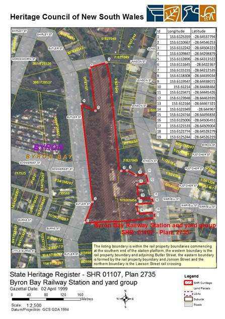
Public hearing
The Plan of Management proposes to change the category
applied to the land, therefore, a formal Public Hearing was required pursuant
to clause 40A of the Local Government Act 1993.
The Hearing was held on 21 August 2018. The hearing
was presided over by an independent chair, Ms Kate Singleton of Planners
North. A number of people provided verbal submissions to the hearing, as
summarised in the report of the Hearing (Attachment 1).
As required by the Act, a report on the hearing, prepared by
the independent chair, was provided to Council on 24 September, and published
on Council’s website within 4 days of receipt. Those who made
verbal submissions were notified on receipt of the report by email when it was
published.
The report contains the chair’s consideration of all
submission, and concludes by recommending that Council proceed with the dPOM,
as exhibited, to categorise Railway Park as General Community Use.
Financial Implications
Finalisation of the Plan of Management will not incur costs
in addition to staff time. Adoption of the Plan will provide the
mechanism through which Council can negotiate leases or licences, within the
requirements of the Act, for future uses authorised by the Plan.
Statutory and Policy Compliance Implications
Adoption of the Plan of Management provides the guidance for
the future use and management of Railway Park, in accordance with the
requirements of the Local Government Act 1993.
Nothing in this plan alters or modifies the provisions of
the Byron LEP 2014 regarding the site’s zoning or the permissible land
uses associated with that zone.
Staff Reports - Sustainable Environment and Economy 13.15
Report No. 13.15 PLANNING
- Exceptions to Development Standards - 1 July 2018 to 30 September 2018
Directorate: Sustainable
Environment and Economy
Report
Author: Noreen
Scott, EA Sustainable Environment and Economy
Chris Larkin, Manager Sustainable
Development
File No: I2018/1764
Theme: Ecology
Development and Approvals
Summary:
This report is provided as a requirement of the NSW
Department of Planning Circular PS17-006, for reporting on exceptions to
development standards for applications made under clause 4.6 of the Standard
Instrument LEP and clause 6 of SEPP 1.
NOTE TO COUNCILLORS:
In accordance with the provisions of S375A of the Local
Government Act 1993, a Division is to be called whenever a motion for a
planning decision is put to the meeting, for the purpose of recording voting on
planning matters. Pursuant to clause 2(a) under the heading Matters to be
Included in Minutes of Council Meetings of Council's adopted Code of Meeting
Practice (as amended) a Division will be deemed to have been called by the mover
and seconder of all motions relating to this report.
Report
This report is provided as a requirement of the NSW
Department of Planning Circular PS17-006, for reporting on exceptions to
development standards for applications made under clause 4.6 of the Standard
Instrument LEP and clause 6 of SEPP 1.
SEPP 1 applies to development applications submitted under
Byron Local Environmental Plan 1988. Clause 4.6 applies to development
applications submitted under Byron LEP 2014.
The period of reporting is for the 1 July 2018 to 30
September 2018 for the following DA’s:
|
DA No
|
10.2018.25.1
|
|
Development
|
Subdivision: Two (2) lots into three (3) lots
|
|
Property:
|
31 Blackwood Crescent Bangalow
|
|
Lot and DP:
|
Lot 1 DP 1233509
|
|
Zoning:
|
Part R2 Low Density Residential/Part R3 Medium Density
Residential/Part DM Deferred Matter – 1(a) (General Rural) Zone
|
|
Development Standard being varied
|
Clause 11 - Subdivision in rural areas for agriculture
(40 Ha min lot size)
|
|
Justification
|
Development consent granted for three lot subdivision at Bangalow with two residential
lots of 801 m2 each in the R2 Low Density Residential Zones and a
larger residual lot of 4.376 ha partly zoned R3 Medium Density and 1(a)
General Rural Zone under Byron LEP 1988. The residual lot containing the area
zoned 1(a) General Rural is not affected by the subdivision to create the two
residential lots and remains the same in shape and area of approximately 1.16
ha. A variation to the 40 Ha development standard was supported in this
instance with the Department of Planning granting concurrence to the SEPP 1
Objection to vary the minimum lot size.
|
|
Extend of variation
|
97% (Approx.)
|
|
Concurrence
|
Council
|
|
Determination Date
|
21/06/2018
|
|
|
|
DA No.
|
10.2017.628.1
|
|
Development
|
60 x 1 & 2 bedroom apartments, plus subdivision to
create 1 additional community lot
|
|
Property:
|
29 Parkes Avenue Byron Bay
|
|
Lot and DP:
|
Lot 1 & 7 DP 271119
|
|
Zoning:
|
B4 Mixed Use
|
|
Development Standard being varied:
|
BLEP 2014 Cl.4.3 9.0m building height limit
|
|
Justification
|
The units are proposed within four (4) buildings, each of
which contains a "monitor roof" along part of the ridge of the main
roof line. The monitor roof feature provides for natural ventilation
and light to the mezzanine bedrooms of the upper floor. The roof form
and building scale responds to the character of built form in the
locality. The buildings will not overshadow or overlook any other
development, as the land immediately to the west is retained for
environmental purposes.
|
|
Extent of variation
|
Between 5% & 10%
|
|
Concurrence
|
Assumed concurrence
|
|
Determined Date
|
24/06/2018 (approved by JRPP)
|
|
|
|
DA No.
|
10.2017.160.1
|
|
Development
|
Residential flat building
|
|
Property:
|
21 Fawcett Street Brunswick Heads
|
|
Lot and DP:
|
Lot 1 DP 309925
|
|
Zoning:
|
R2 Low Density Residential
|
|
Development Standard being varied:
|
Clause 4.4 Floor space ratio
|
|
Justification
|
Proposed variation consistent with objectives of standard
and zone.
|
|
Extent of variation
|
6%
|
|
Concurrence
|
Assumed concurrence
|
|
Determined Date
|
13/07/2018
|
Financial Implications
Not applicable.
Statutory and Policy Compliance Implications
The report is provided as a requirement of NSW Department of
Planning circular PS 17-006. This circular can be viewed at http://www.planning.nsw.gov.au/~/media/Files/DPE/Circulars/planning-circular-variations-to-development-standards-2017-12-19.ashx
Staff Reports - Sustainable Environment and Economy 13.16
Report No. 13.16 Report
of the Planning Review Committee Meeting held on 13 September 2018
Directorate: Sustainable
Environment and Economy
Report
Author: Chris
Larkin, Manager Sustainable Development
Noreen Scott, EA Sustainable
Environment and Economy
File No: I2018/1775
Theme: Ecology
Development and Approvals
Summary:
This report provides the outcome of the Planning Review
Committee meeting held on 13 September 2018.
|
RECOMMENDATION:
That Council note the report of the Planning Review
Committee meeting held on 13 September 2018.
|
Report:
The meeting commenced at
4:15pm and concluded at 4:45pm.
Present: Crs Martin,
Hackett, Cameron, Hunter
Staff: Chris Larkin
(Manager Sustainable Development)
Apologies: Nil
The following development
applications were reviewed with the outcome shown in the final column.
|
DA No.
|
Applicant
|
Property Address
|
Proposal
|
Exhibition
Submission/s
|
Reason/s
Outcome
|
|
10.2018.88.1
|
Mr DR Cope
|
8 Robinson Street
BANGALOW
|
New Dwelling to create
Duall Occupancy (Detached)
|
Level 1
22/3/18 to 4/4/18
|
To
be determined under Delegated Authority
|
|
10.2018.138.1
|
Ardill Payne & Parnters
|
19 Hollingworth Lane
MULLUMBIMBY
|
Dwelling house and shed
|
Level 1
26/4/18 to 9/5/18
|
To be determined under
delegated Authority
|
Staff Reports - Infrastructure Services 13.17
Staff Reports - Infrastructure Services
Report No. 13.17 South
Golden Beach Flood Pump Update
Directorate: Infrastructure
Services
Report
Author: James
Flockton, Drain and Flood Engineer
File No: I2018/963
Theme: Community Infrastructure
Emergency Services and Floods
Summary:
Council has previously considered issues at the South Golden
Beach Flood Pump and are aware of the pump failure which occurred during the
March 2017 flood event.
This report provides a detailed investigation and peer
review of the flood pump design and includes recommended ways forward.
|
RECOMMENDATION:
1. That in relation
to the South Golden Beach Flood Pump, Council endorse the report and
proceed to implement the following report actions:
a) That
the existing station inlet screen be extended to the full width of the
existing channel headwall (approx. 4 metres wide) to minimise intake
velocities and reduce the risk of the screen blinding.
b) That
a programed maintenance regime be implemented for the inlet area and upstream
drains.
c) That
option 6 (within attachment 1, #E2018/77441) be implemented as a short term
solution as soon as practical, before the coming rainy season, if feasible.
d) That
option 8 (within attachment 1, #E2018/77441) be implemented to further support
option 6 as a short term solution.
e) That
option 1 (within attachment 1, #E2018/77441) is used as a long term solution
when the pump becomes aged and is in need of replacement.
2. That
funding for items 2, 4 and 5 from the report be considered at the next
Financial Quarterly Review.
|
Attachments:
1 South
Golden Beach Flood Pump Investigation Report V5 - Jacobs - FINAL for reporting
to Council, E2018/77441 ⇨
Council has previously considered issues at the South Golden
Beach (SGB) Flood Pump and are aware of the pump failure which occurred during
the March 2017 flood event.
This report further updates Council on the failure and
offers a proposed way forward to minimise these risk in the future.
Pump Operations March 2017
A review of the SCADA operating data for the flood pump
operations during March 2017 was carried out after the event. This data shows
the following occurred.
At 11am Wednesday, 29 March, water levels began
to rise in SGB and the main flood pump automatically ran for a short period and
stopped automatically. This automatic on/off continued until 12pm.
Between 12:00pm – 2:45pm nothing operated and the well
level remained OK.
Between 2:45pm – 3:45pm a mixture of sump and main
pump operation occurred on auto.
Between 3.45pm on 29 March – 10.30am on Thursday 30
March the well levels remained OK and no pumping occurred.
Between 10:30am – 1:30pm a mixture of sump and main
pump operation occurred on auto as the rain started to build.
Between 1:30pm – 10:00pm the sump pump appeared to
handle all inflows on auto. Well levels can be seen to be acceptable during
sump pump operations, despite the continued rain.
At 10:00pm the main pump runs for short time and then the
sump pump takes over again until 11:00pm when the main pump runs for a longer
period on auto.
Around midnight the pump operated for a longer period, this
appears to be the manual intervention by Council staff via the telemetry
system. The pump runs continuously for 2 hours. After 2 hours the pump stops.
The pump stopped because it tripped out on thermal overload. The thermal
overload occurred because the pump had been switched from auto to manual and
this doesn’t allow the pump to turn off automatically when well levels
lower, the pump then cavitates, overheats and trips. The main pump
stopped operating between 2:00am and 6:00am. However, the sump pump continued
to run, but couldn’t reduce well levels as it’s not big enough.
Well levels were high throughout this time.
Operational staff advised that the community were pressuring
them to run the pump on manual because it wasn’t running constantly and
staff had previously done this in other floods. Staff eventually agreed to
change the pump to manual via the telemetry system. It is understood that
previous manual runs had occurred when staff were on site. This is the first
time the pump has been run on manual during a flood using the telemetry system.
At 6:00am on Friday, 31 March, the pump trip was reset and
the pump ran for 8-9 hours almost constantly, with a few short stops. It is
unknown if this was on manual or auto, but it is likely to have been auto as
the area was flooded and the pump had plenty of water being supplied to it. Management
made the decision not to send staff out in the dark to reset the pump trip due
to safety concerns, therefore, the trip was reset once it was safe to access
the pump.
At 10:00pm on 31 March the well level drops to a level where
the main pump is no longer required and the sump pump can handle the flows.
This continues running on and off until the majority of the water is gone.
The data shown in the image below shows the pump operations
from 8.00am 30 March to 1 April via Councils SCADA system. The red line is the
sump pump running. The black line is the well water level. The blue line is the
main pump running.
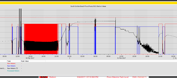
At all times the well levels seem to correspond with pumping
operations, suggesting that the systems are reporting correctly.
Following the event community members advised that the pump
was not running when Council’s telemetry shows it as running. Therefore
the site was attended at 2:35pm on Tuesday, 4 April, to test the system. A call
was made to operational staff at the works depot. Staff turned the pump on
remotely via telemetry, it came on and switched off remotely. This run can be
seen in the image below. This suggests the pumps telemetry systems and data
reporting is working correctly and that the data which provided the above
information is sound.
The following image is another report from Councils SCADA
system. The red line shows the sump pump cycling on and off. The black line is
the water level. The blue line is the main pump operating when the telemetry
was tested at 2:35pm on Tuesday, 4 April.
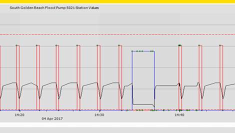
The picture below is the pump inlet, taken 3 days after the
flood. Clearly showing that blockage is an issue with the current inlet set-up,
despite it being constructed as per the design from the consultant designing
the system.
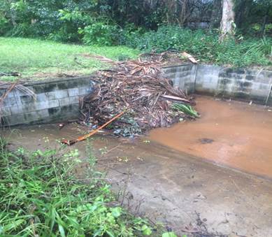
Previous investigations
Following construction of the flood pump in 2007 a number of
years have been spent completing all the drainage works that the 2005 design
report recommended in order to feed the pump with sufficient water flow. This
included culvert upgrades and minor drain widening.
During the above years, the flood pump had operational
problems. Mainly being too powerful and pumping the well dry too quickly.
Various discussions were held with the designer and in late 2009 Council the
flood pump designer provided two possible solutions:-
1. A
variable speed drive for the main pump; and
2. A
larger sump pump.
Option 2 was a cheaper solution and was proceeded
with. This change made an improvement to the pump operations and no
further changes were made. It is also noted that due to the pump design option
1 only had the ability to lower pumping volumes from 1100 L/s second to 750
L/s. This was not considered enough to make a significant improvement to the
pumps operations.
The above modifications helped, but never fully resolved the
problems. The pump continued to be used as best as possible once the
alterations had been made.
The design consultant then further investigated what was
built vs what was designed and confirmed it had been built and set up to
design. The response letter recommended a 5 minute delay to pump restarts to
resolve thermal overload issues when set to auto operation. It also approved
removal of a weir in pump well.
Circa 2010 additional trash grates were installed by staff
without the designers involvement, in an attempt to reduce trash blocking the
pump inlet and impacting inlet flows. These achieved their function but
didn’t improve pump run times.
This work was completed and made further improvements to the
pump operations.
In 2013 Council constructed a box culvert at the inlet to
the pump station to resolve community concerns around water ponding at the
inlet. This installation resolved these community concerns, but did not make
any difference to the pump operation. The box culvert was designed and
constructed as per the original pump designs.
These are the last works that Council completed on the flood
pump. Between 2013 and 2017 the pump received occasional use in minor flood
events and worked with some degree of success, but it did not receive a real
test until 2017 when the pump failed on thermal overload at the most critical
time during the March 2017 flood event.
Original Flood Pump Concept Design 2003
The report for the original Flood Pump Concept Design proposed
the construction of a 1,000L/s inside batter, vertically mounted, submersible
axial flow pump station and stated:-
1. In
a 100 year flood event four properties will receive above floor flooding.
These properties have floor levels ranging between 1.99 and 2.24m AHD, the 5th
highest floor is 2.31m AHD, therefore, it can be deduced that in a 100 year
event water levels should not go beyond 2.3m AHD with the flood pump installed.
2. In
a 10 year event two properties will receive above floor flooding. These
properties have floors levels ranging between 1.99 and 2.05m AHD, the 3rd
highest floor is 2.22m AHD, therefore, it can deduced that in a 10 year event
water levels will not go beyond 2.22m AHD.
3. A
3,000L/s pump is required to prevent all houses from flooding in a 100 year
event. A pump of this size would not satisfy the constraints of cost,
available space, noise and visual amenity. Therefore a 1,000L/sec pump
station was recommended and installed.
Current investigations
Following this more recent failure staff discussed options
to improve the flood pump operation and agreed the best option would be to
obtain a 3rd party peer review of the pump design instead of
continuing discussions with the original pump design consultant. The peer
review was contracted to Brisbane consultants Jacobs and the report is provided
at attachment 1.
The key finding of this report is that the pump is operating
at 20% over the design capacity and the inlet structure cannot keep up with the
pumps water demand unless water levels are around RL2.20m. The following is
text directly from the report.
Hydraulic analysis of the pumping station inlet drainage system was conducted for a number of cases, including the 1000L/sec design basis and the 1220L/sec actual flow to verify the assumed hydraulic constraints mentioned previously.
The analyses found that the change in head over the internal weir section at pump stop level is up to
approximately 0.44m and the loss in the remaining upstream structures is approximately 0.76m. At a total system loss
of 1.2m, the
upstream channel
water level would
need to be RL 2.0m at
the pump stop
condition to achieve the pumped flow rate, i.e. once below RL 2.0m water is unable to enter the pumping station at the pumping flow rate.
At the pump start condition the upstream channel
water level required to achieve the pumped flow rate would be
approximately RL 2.26m; this being an unacceptable upstream flood level. The existing pumping station inlet hydraulic structures are incapable of delivering water to the pump at the required rate whilst the inlet channel is at the existing pump start level.
A number of issues have been found to contribute to the existing situation of the pump starting and stopping rapidly:
1. The
pump is running beyond the
design
basis flow rate (up to approximately 1220L/sec)
2. The
pump start and
stop levels are only 700mm apart
3. There is no volume of still water available at the
pump suction
4. Total intake system losses are approximately 1.2m at 1220L/sec
5. Upsurge from water flowing
into the
pumping
station
structure after pump stop
is very likely to
reach the pump start level; however, this is currently mitigated by a 5-minute pump start delay
6. The pumping
station level
transmitter is located in
a high velocity, turbulent, vertical drop section with
potential air entrainment. It is currently unknown if the transmitter is housed in a stilling tube, but inaccurate
pump starts and stops are
likely
7. Anecdotal
evidence that the inlet screen
blocks rapidly with
debris during large storm events
A total of ten alteration options were considered by Jacobs
as part of their review. The cost range of these alterations is $146,000
to $1,219,000 excl GST. Options 1, 2, 3 and 6 were considered for further
investigation. See section 6.0 of Attachment 1 for more details.
Option 1 and 6 were then considered to be the best options
for Council to move forward and provide an improved solution to the local
community.
Option 1 essentially involves total reconstruction of the
pump station well and installation of 3 staged pumps, plus an auxiliary
pump. This design has built in redundancy should one pump fail and allows
for pumping at numerous different rainfall event sizes. Therefore the
community would likely see it constantly operating during heavy rain
events. However, option 1 has the highest capital cost of $1,219,000 excl
GST making it a long term option for Council.
Option 6 involves limiting the existing pumps maximum flow
to 1,000L/sec via an outlet restrictor and adds a variable speed drive that
allows the pump to be ramped down to 700L/sec for smaller events. Option
6 doesn’t have the built in redundancy or the lower flow pumping rates of
option 1, however, it comes at a much lower capital cost of $146,000 and
continues to make use of the existing infrastructure. Alteration to the
inlet screen should also occur as part of option 6 to help reduce the blockage
risks, as recommended by Jacobs - making option 6 at good short term option for
Council.
Recommendation
The report states;
Regardless
of the final solution implemented, there will always be a risk of blockage or
restriction of the pumping station inlet due to large solids, and a maintenance
regime is recommended to ensure the main channel leading to the pumping station
is reasonably clear of debris.
Power failure is also an
inherent risk of all pump stations without a back up generator; however this
risk was known when Council committed to building the pump station originally.
Additionally option 8 within the report at attachment 1
involves a remote reset function to the flood pump. If this function was
available in March 2017 the pump failure is unlikely to have occurred because
it could have been reset remotely, therefore, it is recommended this option be
implemented and used with caution as per the report.
The following is recommended:
1. Extend the
existing station inlet screen to the full width of the existing channel headwall
(approx. 4 metres
wide) to minimise intake velocities and reduce the risk of the screen blinding.
2. Implement a programed
maintenance regime for the inlet area.
3. Implement option 6 as a short
term solution as soon as practical, before the coming rainy season, if
feasible.
4. Implement option 8 to further
support option 6.
5. Option 1 is used as a long term
solution when the pump becomes aged and is in need of replacement.
Financial Implications
The proposed works are currently unfunded. Council may
either fund these works immediately or in the future.
Immediate funding would be through resolution or the
quarterly budget review process and see completion of the work in the current
financial year. This option would require other works to not go ahead in the
current financial year.
Future funding would be through the standard budget process
and with a plan to complete the works next financial year.
Budget estimates in the report are stated to be +/- 30%
accuracy. Taking this into account, plus the addition of option 8 and the
inlet screen works, a budget of $200,000 is recommended for this work to
proceed.
Statutory and Policy
Compliance Implications
Provision of stormwater infrastructure is a legitimate
function of local government under the Local Government Act 1993.
To the extent that the provision of stormwater infrastructure protects public
roads, other infrastructure, Council land, Crown land, private land and the
community. Council is also responsible for drainage under the Roads
Act 1993.
Resolving as recommended demonstrates that Council is
carrying out stormwater works to the extent that Council resources, capacities
and competing priorities permit.
Staff Reports - Infrastructure Services 13.18
Report No. 13.18 Hinterland
Way and Brunswick Valley Way/Tweed Valley Way Maintenance Funding
Directorate: Infrastructure
Services
Report
Author: Joshua
Provis, Road and Bridge Engineer
File No: I2018/1603
Theme: Infrastructure Services
Asset Management Planning
Summary:
The purpose of this report is to access funds which were
handed over to Byron Shire Council by the RMS for the maintenance of Hinterland
Way, between the Bangalow Interchange and the Byron / Ballina shire boundary,
and the former Pacific Highway, between Brunswick and Yelgun (Brunswick Valley
Way/Tweed Valley Way).
These sections of road were handed over to Council by the
RMS following completion of the new Pacific Motorway.
|
RECOMMENDATION:
1. That
$140,000 be allocated from the Old Pacific Highway Maintenance Reserve for
asphalt heavy patching repairs and line marking to Hinterland Way.
2. That
$45,400 be allocated from the Old Pacific Highway Maintenance Reserve for
asphalt heavy patching repairs and line marking to Brunswick Valley Way/Tweed
Valley Way.
|
Attachments:
1 Signed
Byron Handover letter (Ballina Bypass) - Skinners Creek to Bangalow Interchange
11444RG 09112016 (A15059313) PDF, E2018/81384
⇨
Report
After the opening of the new Pacific Motorway in 2016, a
bypassed section of the Old Pacific Highway from Skinners Creek to the Bangalow
Interchange, known as Hinterland Way, was handed over to Council by the
RMS. This section of road is approximately 3.5km long.
The RMS worked with Council to formalise handover
arrangements and agreed on funding based on Council’s maintenance
diary. Council received a lump sum payment of $530,576 from the RMS for
the ongoing maintenance actions.
Similarly for a bypassed section of the Old Pacific Highway
from Brunswick to Yelgun, known as Brunswick Valley Way/Tweed Valley Way,
maintenance funding was provided with the handover of the asset. These
funds are in the same account, the total available being $45,400.
Recent inspections of these two roads have found significant
defects in the surface requiring repairs.
Financial Implications
The existing balance of the Old Pacific Highway Maintenance
Reserve is $575,937 as at 30 June 2018. None of these funds have been allocated
in the 2018/2019 Budget at this point but should Council approve the
recommendation to this report, this will provide the required funds to
undertake the surface repairs.
After these funds are drawn the remaining balance of the Old
Pacific Highway Maintenance Reserve will be $390,537.
Statutory and Policy Compliance Implications
Regulation 211 of the Local
Government (General) Regulation 2005 states that a Council or a person
purporting to act on behalf of a Council must not incur a liability for the
expenditure of money unless the Council has voted the money necessary to meet
the expenditure.
Staff Reports - Infrastructure Services 13.19
Report No. 13.19 Tyagarah
Clothes Optional Declaration - Results of the enhanced stakeholder safety
initiatives of Res 17-499 and Res 17715.
Directorate: Infrastructure
Services
Report
Author: Michael
Matthews, Manager Open Space and Resource Recovery
Andrew Erskine, Open Space
Technical Services Officer
Darren McAllister, Acting Open
Space and Facilities Coordinator
Ralph James, Legal Counsel
File No: I2018/1707
Theme: Infrastructure Services
Open Space and Recreation
Summary:
This report is the result of
actions prescribed by Council in resolutions 17-715 and 17-499
and discusses analysis of submissions from the Towards Safe Beaches Stakeholder
group, NSW Police, and written submissions from the community.
|
RECOMMENDATIONS:
1. That
Council revoke its “Clothes Optional Declaration” within the
Tyagarah Reserve.
2. That
staff remove all signage that relates to the trialled clothes optional area.
3. That
staff further meet with the NSW Police, NPWS, and other stakeholders to
discuss and implement additional measures that target reduction of lewd and
offensive crime from this area.
4. That
staff pursue the enabling of short-term licences specifically for clothing
optional recreational events.
5. That
Council also acknowledge and thank the efforts and commitment made from the
Towards Safe Beaches in Byron stakeholder representatives in efforts to
achieve safer beaches.
|
Attachments:
1 Res 17-715
Clothes Optional Signage at Tyagarah Beach Council December 2017, E2018/74266 ⇨
2 Res 18-165
Clothes Optional Signage at Tyagarah Beach Council March 2018, E2018/74268 ⇨
3 Confidential
- Safe Beaches Stakeholder Group Minutes January 2018 - August 2018, E2018/78940
4 Confidential
- Tyagarah Clothes Option Beach - 51 Submissions - Report to Council 18
October 2018, E2018/80189
5 Confidential
- Safe Beaches Group summary of options for Byron Shire Council, E2018/80694
6 NSW Police
Submission Tyagarah Clothes Option Beach, E2018/80693
⇨
Report
The Safe Beaches Stakeholder
group commenced discussions 9 August 2016 with the primary focus on achieving
safe beaches.
A range of initiatives have
been implemented in efforts to target lewd and offensive behaviour along and
adjacent to the Council declared Clothes Optional area of Tyagarah Beach.
This declaration was made by
Council 27 October 1998.
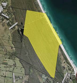
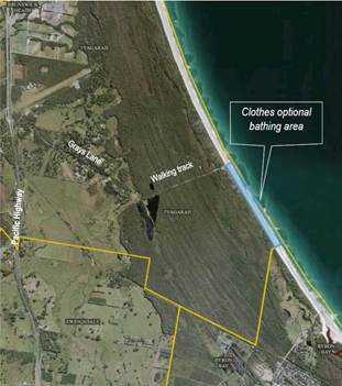
The Safe Beaches Stakeholder
group has included and invited the following organisational representatives:
· NSW
Police
· Council
staff and Elected Councillors
· National
Parks and Wildlife Staff
· Representatives
from the Naturist Community
· Representative
from The Gay Community
· Representatives
and Staff from the North Byron Beach Resort and Elements of Byron
· A
licenced commercial operator operating within the area
· Tyagarah
Residents and
· Invited
Guests
Some key points of
discussions from initial meetings included;
1. Perceived under-reporting to
authorities of lewd sexual behaviour incidents within and adjacent to the
declared clothes optional area
2. Potential culture within the
community not to report such behaviours in fear of losing the clothes optional
area
3. Public confusion as to the
defined area and a significant amount of misinformation as to the exact
location of the clothes optional area (e.g. various websites containing
conflicting, misleading and incorrect information)
4. The necessity of regulatory
signage in enabling the empowerment of the Police to enforce the law primarily
due to the historical notion that nudity is okay anywhere from Belongil to
Tyagarah beach
5. The importance of reporting of
inappropriate activities to enable the NSW Police to respond, gain an
understanding of the extent of issues and to allocate the necessary resources
and implement intelligence led policing strategies in the interest of public
safety
Subsequent meetings
identified the following perceived contributors to lewd sexual behaviour
incidents at this location:
· The
vast presence of inappropriate lewd social media sites promoting lewd sexual
behaviour to this area
· The
remote location of this area and its proximity to South East Queensland, noting
that there are no legal clothes optional beaches in Queensland
· The
absence of controlled use of the land (as apposed to a privately operated clothes
optional facility)
· Remoteness
and public nature of the area lending itself to poor passive surveillance
The following lists the key
initiatives from enhanced stakeholder safety initiatives and Council and National
Parks and Wildlife actions:
· Additional
Police presence as a result of increased information from the community and
committee resulting in a number of police actions. Actions in response to
lewd and offensive behaviours ranging from move on directions to prosecutions
· Resolution
17-499 that redefined the clothes optional area 200m south of Grays Lane
carpark for a distance of 800m
· Installation
of regulatory signage at the Grays Lane carpark and at the start and finish of
the current designated clothes optional area
· Installation
of regulatory and advisory signage at Tea Tree Lakes and Grays Lane carpark
· Installation
of additional advisory signage at Elements of Byron resort providing additional
clarity of the area to bathers and beach users
· Gathering
of data by the Police and members of the committee assisting in defining the
problem
The following are advisory
and regulatory signs that Council installed:
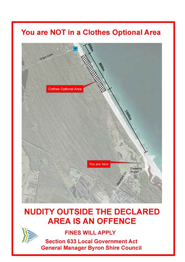
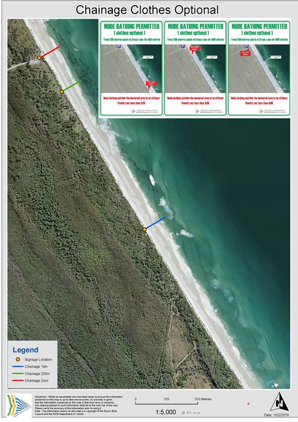
The following additional
safety initiatives have been debated and supported within the stakeholder
group:
· Consideration
of personal protective devices such as the use of whistles
· Use
of a code of conduct amongst the legitimate users on the Clothes Optional Area
In addition to above, the
stakeholder group has debated consideration of alternative locations. These
alternative locations have been rejected by the majority of stakeholder
representatives on the basis of either:
· Lack
of necessary supporting infrastructure and resources needed to support its safe
use
· Actual
or perceived existing use conflicts
The perception across the
group is that the enhanced stakeholder safety initiatives implemented to date
have reduced the frequency of lewd sexual behaviour and criminal
offences.
At the Safe Beaches
Stakeholder Group Meeting held Friday 31 August 2018, it was agreed that the
NSW Police will provide two (2) years of data.
Police Data Sexual Assault
& Street Offences 2016 to 2018 (12 September).
The below tables provided by
the NSW Police provides as a comparison, lewd / offensive detected crime rates
for the area from Ti Tree lakes to Belongil areas and First Sun through to
Wategos Beach.
|
Tyagarah - Sexual Assault
& Street Offences 2016 to 2018 (12 September)
|
|
|
|
|
Location
|
Incident Category
|
Incident Further
Classification
|
2016
|
2017
|
2018
- 12/09
|
Total
|
|
Ti Tree Lake
|
Sexual Offence - Sexual
Assault
|
Adult Victim (16+ Years
Old)
|
0
|
1
|
0
|
|
|
Ti Tree Lake
|
Sexual Offence - Indecent
Assault
|
Adult Victim (16+ Years
Old)
|
0
|
1
|
0
|
|
|
Ti Tree Lake
|
Sexual Offence - Other
|
Act Of Indecency
|
0
|
2
|
0
|
|
|
Ti Tree Lake
|
Street Offence
|
Offensive Behaviour
|
1
|
12
|
11
|
|
|
Ti Tree Lake
|
Street Offence
|
Wilful And Obscene Exposure
|
1
|
2
|
1
|
|
|
Tyagarah Beach
|
Sexual Offence - Sexual
Assault
|
Adult Victim (16+ Years
Old)
|
0
|
1
|
0
|
|
|
Tyagarah Beach
|
Sexual Offence - Other
|
Act Of Indecency
|
0
|
0
|
1
|
|
|
Tyagarah Beach
|
Street Offence
|
Offensive Behaviour
|
0
|
13
|
28
|
|
|
Tyagarah Beach
|
Street Offence
|
Wilful And Obscene Exposure
|
0
|
4
|
2
|
|
|
Tyagarah Nature Reserve
|
Street Offence
|
Offensive Behaviour
|
6
|
6
|
4
|
|
|
|
Total
|
8
|
42
|
47
|
97
|
Staff estimates these
categorised areas to transverse approximately 1,800m linearly.
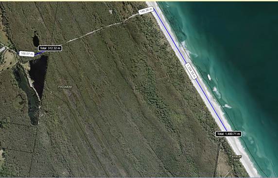
|
Byron Bay Beaches* - Sexual
Assault & Street Offences 2016 to 2018 (25 September)
|
|
|
|
*Excluding Tyagarah & Belongil
beaches
|
|
|
|
|
|
|
Location
|
Incident Category
|
Incident Further
Classification
|
2016
|
2017
|
2018
- 25/09
|
Total
|
|
Main Beach
|
Sexual Offence - Sexual
Assault
|
Adult Victim (16+ Years
Old)
|
0
|
2
|
0
|
|
|
Clarkes Beach
|
Sexual Offence - Indecent
Assault
|
Adult Victim (16+ Years
Old)
|
1
|
0
|
0
|
|
|
Main Beach
|
Sexual Offence - Indecent
Assault
|
Adult Victim (16+ Years
Old)
|
1
|
0
|
0
|
|
|
The Pass
|
Sexual Offence - Indecent
Assault
|
Adult Victim (16+ Years
Old)
|
1
|
0
|
0
|
|
|
Clarkes Beach
|
Sexual Offence - Other
|
Act Of Indecency
|
0
|
1
|
0
|
|
|
Main Beach
|
Street Offence
|
Wilful And Obscene Exposure
|
0
|
1
|
0
|
|
|
Main Beach
|
Street Offence
|
Offensive Behaviour
|
6
|
2
|
3
|
|
|
Wategos
|
Street Offence
|
Offensive Behaviour
|
1
|
0
|
0
|
|
|
Sunrise Beach
|
Street Offence
|
Offensive Behaviour
|
0
|
0
|
1
|
|
|
|
Total
|
10
|
6
|
4
|
20
|
Caveat: Data is correct as 12 September 2018. Some incidents
and locations may not be captured due to incorrect location or event category.
Staff estimates these
categorised areas to transverse approximately 3100m linearly.
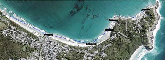
Interpretation of data
The lower 2016 figures within
the Tyagarah table is perceived to be due to under reporting from the community
resulting in less Police resource allocation to these areas.
One submission received
provided life guard service data for a location immediately adjacent to Tyagarah
Beach reserve. Usage data for this area was compared to that of beaches
that Council maintain contracted life guard services. This
comparison provides an indication of usage scale between ‘remote’
and ‘non remote’ beaches within the Shire.
Council considers this beach
as a ‘remote’ beach in which Council does not provide Life Guard
services.
Data
received from this private service.
|
Month
|
Visitation
|
Unit
|
|
December
2017
|
140
|
Per
average day
|
|
January
2018
|
159
|
Per
average day
|
The below tables provides
beach attendance for beaches over the same period for beaches with a Council
contracted life guard service.
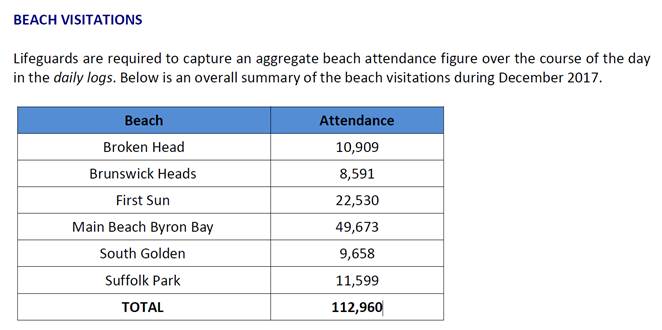
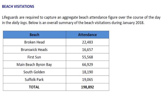
The below graph provides a
comparison of attendance over December 2017 and January 2018.
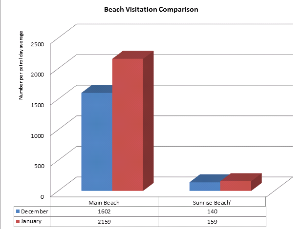
Considering the attendance
difference between ‘remote’ and non ‘remote’ beaches,
this highlights the significance of crime rate differences between Tyagarah and
township beaches.
The following variables and
or causal factors are perceived by staff as contributing to the higher crime
rates for Tyagarah beach and its surrounding areas.
· Relative
remoteness of the site
· Lewd
promotion of the area by a vast number of lewd social media sites
· Lack
of the areas ability to provide for passive surveillance
· The
relative remoteness of the location from Police response
· The
attractive nature to individuals predisposed to offending as the only lawful
clothes optional beach within the region and within 200km of a capital city
· Historical
perceived under reporting resulting in historical low Police presence
Additional Observations:
A number of submissions
perceive the area to be predominately used by non locals. The below graphs
provides sampled vehicle registration observations. It should be noted
the percentage of QLD to that of NSW plates is not dissimilar to random
sampling of Byron township foreshore parking.
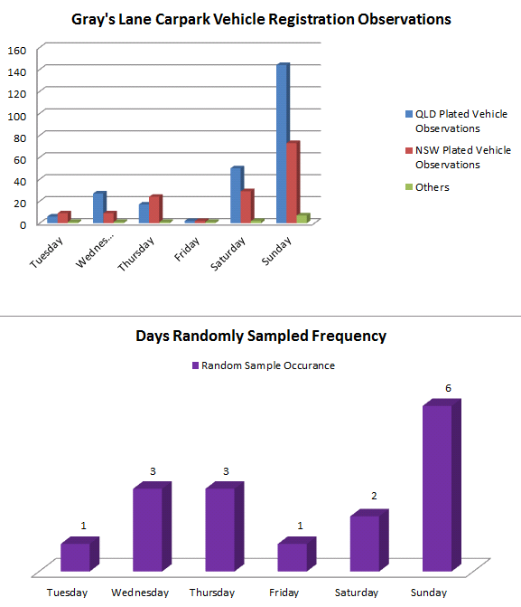
Submissions
Submissions were provided by Safe Beaches Stakeholder Group
on presented options, and by individual and groups/organisations.
The below summarises comments for closure and comments
against.
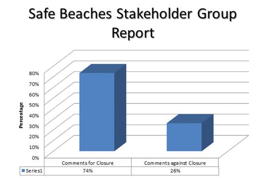
A total of 51 individual written submissions were
received.
The below graphs summarises all submissions against options
considered by the stakeholder group.
All submissions are included as a confidential attachment to
this report due to personal details disclosed within these submissions.
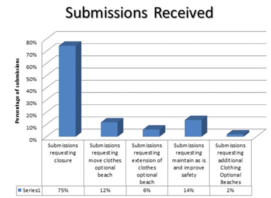
Controlled versus Uncontrolled Environments
Many submissions perceive that the lewd and offensive
behaviour is exacerbated due to the remoteness and isolation of the Clothes
Optional declared area resulting in activities being largely uncontrolled and
difficult to control.
Council as a Crown Land Manager has authority to issue
short-term licences under s2.20 Crown Land Management Act 2016 for
a class of activities listed in clause 31 of the Crown Land Management
Regulations 2018 that includes ‘sporting and organised recreational
activities’.
The authority provided in clause 31 of the Regulations
is valid until either a Plan of Management is adopted for the managed Crown
Lands or 31 June 2021 whichever comes first.
An adopted POM will need to expressly allow for short-term
licenses and a type of licence specifically for clothing optional recreational
events. Mandatory 28 days public consultation would apply.
Financial Implications
N/A
Statutory and Policy
Compliance Implications
LOCAL GOVERNMENT ACT
633 BATHING
(INCLUDING NUDE BATHING)
AND OTHER WATER-BASED RECREATIONAL ACTIVITIES
(2) A person who is in public
view in the nude in any place (other than a designated beach) referred to in subsection (1) is guilty
of an offence unless a notice erected by the council at the place allows the use of
the place (or part of the place)
for the purposes
of nude bathing.
A "designated beach" means any of the following beaches, or any part of the following
beaches (including the sea adjacent
to any such beach):
Lady
Bay (Lady Jane) Beach Cobblers Beach
Obelisk Beach
Werrong
Beach
Samurai
Beach
In the present
context this section
permits a person to be nude, without committing an offence,
provided that the nudity takes place on a designated beach or one which has a notice
erected by the Council
allowing the use of the place for the purpose
of nude bathing.
As Tyagarah is not a designated beach in order to permit
nude bathing it must be the subject
of a notice erected
by Council allowing
the use of the beach for the purpose of nude bathing.
(3) A council may erect a notice:
(a) on land vested
in or under the control
of a council, or
(b) on any other land, with the consent
of the person who owns or controls
the land.
(4) The terms of a notice referred to in this section may relate to one or more of the following:
(a) the conduct and costume of the bathers in the place,
(b) the use of the place (or any part of the place open to public
view) for the purposes of nude
bathing,
(c) the use of water-based recreational equipment in the place.
In order for Council to erect a notice it must be on land vested in or under the control of Council or on
other land with the consent
of the person who owns or controls
the land.
SUMMARY OFFENCES ACT
4 OFFENSIVE CONDUCT
(1) A person must not conduct himself
or herself in an offensive
manner in or near, or within view or
hearing from, a public place or a school.
(2) A person does not conduct
himself or herself
in an offensive manner as referred to in subsection
(1) merely by using offensive language.
(3) It is a sufficient defence
to a prosecution for an offence under
this section if the defendant satisfies the court that the defendant
had a reasonable excuse for conducting "himself or herself in the
manner alleged in the information for the offence.
In this context a person who is nude on a designated beach or on one which is the subject of a notice erected by Council
would have the benefit of the
defence in (3). This would be to the nudity only
and would not extend to any other
form of offensive conduct committed
whilst nude.
Part of one of the submissions to Council is in the
following terms:
Litigation
It’s only a matter of time before a
father/husband/son/daughter looks to the creators of the clothing optional
beach to be accountable for the rape/attack of their loved one. Any approval
will no longer be historical it will be current. It will be yours. The
litigation may be from a property owner whose property value diminishes.
LGA
section 731 provides that a matter or thing done by a council, a councillor, or
an employee of the council or any person acting under the direction of the
council does not, if the matter or thing was done in good faith for the purpose
of executing this or any other Act, and for and on behalf of the council,
subject a councillor, an employee or a person so acting personally to any
action, liability, claim or demand.
Staff Reports - Infrastructure Services 13.20
Report No. 13.20 Enactment
of Council Policy 4.17 for Mafeking Road - Resident Contributions
Directorate: Infrastructure
Services
Report
Author: Joshua
Provis, Road and Bridge Engineer
File No: I2018/1762
Theme: Infrastructure Services
Local Roads and Drainage
Summary:
Residents adjacent to the
unsealed segment of Mafeking Road are enacting Council Policy 4.17 Contribution
to the cost of Sealing of unsealed Roads adjacent to properties at request of
owners.
The matter has been reported
to two previous Council meetings, however, new developments and a request from
the residents regarding funding have been presented to Council Staff.
This report presents those
developments to Council for consideration.
|
RECOMMENDATION:
1. That
the letter received from Mafeking Road residents be noted.
2. That
Council agree to fund the shortfall in resident contributions of
$23,000.
3. That
the provision of the additional $23,000 funding be considered as part of the
next Financial Quarterly Review.
|
Attachments:
1 Letters
from residents 4/9/18 re. sealing of Mafeking Road PDF, E2018/81389 ⇨
Report
At the Council meeting, 1 February 2018, a Notice of Motion
was considered regarding the construction and sealing of Mafeking Road with
Council resolving as follows:
Res 18-026
Resolved
that Council:
1. Note the submissions and proposals to
contribute funds provided by residents regarding the sealing of Mafeking Road.
2. Provide in principle support for the
application of Council Policy 4.17 Contribution to the cost of sealing of
unsealed roads adjacent to properties at request of owners, for the remaining
1.4 km of Mafeking Road.
3. Receive a report at the 22 February meeting:
a) detailing cost estimates for works involved in
sealing 1.4 km of Mafeking Road up to a 5 meter seal with essential only
reformation to achieve this width; and
b) identifying
funding options.
The resolutions from this Council meeting were followed up
by Council staff and further information provided at the following Council
meeting on 22 February where Council resolved as follows:.
Res
18-102
Resolved:
1. That
Council endorse application of policy 4.17 for residents affected by dust
pollution on Mafeking Road and Cedar Road.
2. That
the works to seal the roads be incorporated into the 2018/19 capital works
program with the funding source to be determined as part of the budget process
for 2018/2019.
3. That
a review of policy 4.17 be undertaken with Councillors in a Strategic Planning
Workshop.
4. That
affected residents be thanked for their initiative and good faith proposals.
Following this resolution the project was added to the
2018/19 works program, which identified a funding source for the Council
component. This was presented to and approved by Council at the June
extraordinary Council meeting as part of the budget process.
The residents were advised via email the process which would
apply in enacting the policy, and the total cost to be contributed by the
residents for the seal, which came to $78,275 including GST.
This cost is for the full 1.25km segment by 5m width.
Residents have since been attempting to raise the money.
On Thursday, 13 September 2018, a letter was
received from the residents leading the process, Patrick Morrissey and Niseema
Tayler (E2018/79544)
The letter states that about 70% of the adjacent land owners
are willing to contribute to the seal component, and that they have been able
to raise $55,664 including GST, which is a shortfall of $22,611 including GST.
The letter also discusses that the Byrangery Grass Nature
Reserve, which fronts 410m of the unsealed section is owned by NSW Crown Lands
and the Crown is not willing to contribute any funds.
The Residents presented 2 options to move the project
forward as follows:-
1. That
Council make the contribution for the shortfall of $22,611 on behalf of the
Reserve; or
2. That
Council leave the last section unsealed which is approximately 340m.
They have also provided a letter (E2018/79544) from the
Byrangery Grass Reserve Land Manager which is supportive of sealing the road
and suggests Council make the contribution for the shortfall of $22,611 on
behalf of the Reserve.
Financial Implications
If Council chooses to fund the shortfall, the funds would
need to be sourced. This means another project in the 2018/19 works program
would need to have its budget reduced or additional unallocated funds
identified.
Statutory and Policy Compliance Implications
It should be noted that Council Policy 4.17 was suspended at
the Council meeting on 23 August 2018, after the resolution was passed
endorsing the enactment of the policy for Cedar Road, Mafeking Road and
Settlement Road.
Res 18-550
Resolved:
That Council
suspend the application of ‘Policy 4.17 – Contribution to the Cost
of Sealing of Unsealed Roads adjacent to properties at request of
owners,’ with the exception of the matter of Settlement Road considered
and resolved in item 13.23 until a full review of the policy is complete
and a new and/or revised policy is adopted by Council.
Staff Reports - Infrastructure Services 13.21
Report No. 13.21 Naming
unnamed Track off Brunswick Street Billinudgel for addressing purposes
Directorate: Infrastructure
Services
Report
Author: Deanna
Savage, Roads and Property Officer
File No: I2018/1724
Theme: Infrastructure Services
Local Roads and Drainage
Summary:
That Council endorse the name
“O’Donnells Lane” for a private track extending South West
off Brunswick Street near the intersection of Wilfred and Brunswick Street
(Image 1) and submit the name to the NSW Geographical Names Board for Gazettal.
|
RECOMMENDATION:
1.
That Council endorse the name
“O’Donnells Lane” for a private track extending South West
off Brunswick Street near the intersection of Wilfred and Brunswick Street
(Image 1) and advertise the name in the Byron Shire Echo and notify
Authorities of the name.
2. That
O’Donnells Lane be submitted to the NSW Geographical Names Board for
Gazettal in accordance with regulation requirements.
3. That
new street name signs be erected and funded from the General Fund for
Sign Maintenance.
|
Attachments:
1 Email
Trail MMoore and Tracey O'Donnell re road naming track Billinudgel, E2018/78925 ⇨
2 Advertising
with Byron Shire News for the Notification of Road Name Proposal of O'Donnells
Lane after Charlie O'Donnell who passed away 1989 16 August 2018 PDF, E2018/81393 ⇨
Report
The owners of Lot 12 DP
612989 contacted Council concerned about numbering and addressing issues (Attachment
1 E2018/78925) and emergency services
struggling to identify their properties as they have elderly family members
with medical conditions. The proposal is to name the gravel and concrete track
as depicted below in orange Image 1 and
allocate numbers accordingly.
O’Donnells Lane has
been proposed as the name for the road and has been passed through the
Geographical names board and has been advertised (Attachment 2
E2018/78921) with no submissions of
objection received.
Brief History of the O’Donnell family.
Charlie O'Donnell (1902 -
1989) was an early pioneer of Billinudgel. He was the butcher and the baker in
the village for over 50 years from 1927. He was the president of the
Billinudgel Football Club and the Cricket Club. These sports are now
played on his land known locally as Dung Oval. Charlie and his wife Mary had a
big table at the back of their house in Billinudgel where they often fed
drifters in search of work during the depression/war years. Having lost
his wife in the 1954 floods, Charlie wrote to the then Mullumbimby Municipal
Council several times, offering to donate gravel to raise the road into
Billinudgel from the Pacific Highway so that access in and out of the village
was not lost during floods. Byron Shire Council accepted his offer in
1992 after Charlie had passed away and the road was raised. He was a well
liked and respected member of the Billinudgel community.
Image 1
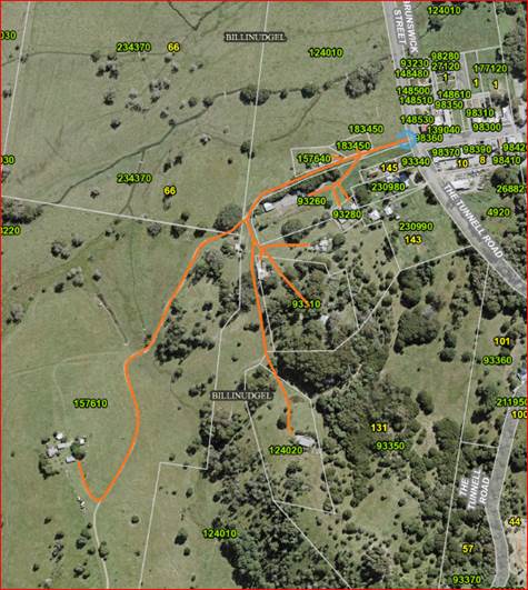
Financial Implications
The installation of the signs will be undertaken next month
and the expenses are to come out of the General Fund for Sign Maintenance.
Statutory and Policy Compliance Implications
Roads Regulation 2008 – Division 2 Naming of
roads
Roads Act 1993 – Sect 162 Naming of public
roads
New South Wales Address policy – March 2015
New South Wales Addressing User manual – September
2016
New South Wales Online Road Naming System –
Geographical Names Board of New South Wales – June 2015
Staff Reports - Infrastructure Services 13.22
Report No. 13.22 BRRC
Masterplan Stage 2 Works - funding allocation
Directorate: Infrastructure
Services
Report Author: Lloyd
Isaacson, Team Leader Resource Recovery and Quarry
File No: I2018/1770
Theme: Infrastructure Services
Waste and Recycling Services
Summary:
Due to a revised and expanded project scope an additional
budget allocation of $428K is required to complete Byron Resource Recovery
Centre (BRRC) Masterplan Stage 2 public drop-off area upgrade works.
l
|
RECOMMENDATION:
That $428,000 is allocated to the Byron Resource
Recovery Centre Masterplan Stage 2 Upgrade Works funded from the following sources:
· $107,600
Secured EPA Grant ;
· $100,000 s94
Developer Contributions – Community Facilities Shire Wide; and
· $221,000
Non-domestic Waste Reserve
|
Attachments:
1 BRRC
Masterplan Stage 2 Works_Pavement Plan, E2018/80139
⇨
Report
The 1st phase of works for Stage 2 of the adopted
BRRC Masterplan (Res 18-053) has commenced involving the upgrade
of the public drop-off area.
The original budget allocated to this specific Masterplan
Stage 2 was $350,000 for the 2017/18 Financial Year, based on a simplified
conceptual masterplan design, and prior to the receipt of a grant to assist in
funding the project. Due to the below identified complexities associated
with EPA approval and design constraints, commencement of the project has been delayed
and initial budget allocation rolled over to the 2018/19 Financial Year:
· EPA
approval and additional requirements to repair compromised landfill cap -
The landfill cap on which the drop-off area is being constructed has been
compromised by historic operations (garden waste management) over the past 10
years. As such the scope and design has been expanded to include a
capping layer as a sublayer to the pavement (see attached design). This
has added a significant amount of project cost associated with design,
material, labour and QA/QC requirements, estimated at approximately
$200,000. It is important to point out that this work would have been
required regardless of this project to maintain compliance with environmental
legislation for the site.
· Engineering
requirements due to site constraints – as a flow on from the above
and due the proposed development being located on redundant landfill the design
consultants have had challenges with the design models for the project to
achieve appropriated surface grades for surface water runoff and access ramp
grades. These will require additional earthworks and access pavement
requirements resulting in additional estimated costs of $228,000.
During the design phase of the project, the scope has had to
be expanded to encompass the abovementioned additional requirements enforced by
the NSW EPA and also to address engineering constraints associated with
constructing pavement on old redundant landfill. The final specification,
designs and projected costings for the revised scope of works have been
prepared (the overall layout and pavement design is attached).
Financial Implications
In order to complete the expanded scope of works, a further
$428,000 budget allocation is required and funding is available from the
following sources:-
· $107,600
Secured EPA Grant;
· $100,000
s94 Developer Contributions – Community Facilities Shire Wide; and
· $221,000
Non-domestic Waste Reserve (current balance of the Non-domestic Waste Reserve
is $4.7 Million)
Statutory and Policy
Compliance Implications
The Myocum landfill and BRRC is heavily regulated by the NSW
EPA via 2 Environmental Protection Licenses issued under the Protection of
the Environment Operations Act 1997. All upgrade works and on-going
operations are required to be conducted in accordance with this
legislation. The upgrade works associated with Stage 2 Masterplan will
increase the efficiency and effectiveness of Council to meet its regulatory
requirements.
Staff Reports - Infrastructure Services 13.23
Report No. 13.23 Belongil
Catchment Drainage Investigation - Update
Directorate: Infrastructure
Services
Report
Author: James
Flockton, Drain and Flood Engineer
File No: I2018/1795
Theme: Infrastructure Services
Emergency Services and Flood Management
Summary:
At Council meeting of 20
September 2018, Council resolved to receive a report on current and possible
drainage paths for catchments leading to land at Melaleuca Drive and the
Bayshore Drive intersection and investigate options for alleviating or removing
impacts.
This issue has been investigated and further information is provided
within the report.
.
|
RECOMMENDATION:
1. That
Council note the report and acknowledge that drainage in this area is
complicated, flat and inefficient.
2. That
the Bayshore Drive roundabout and the drainage maintenance works on Melaleuca
Drive are unlikely to be the cause of the drainage issues being experienced
by local residents.
3. That
Council further investigate drainage easements from Ewingsdale Road to
the Union Drain or an alternative lawful point of discharge including
consideration of the impacts of the Ewingsdale Road duplication project
by investigating appropriate drainage flow paths and create / negotiate
easements as required to ensure lawful long term drainage for Ewingsdale
Road.
4. That
the Belongil Creek Entrance Opening Strategy considers the issues raised
within this report (I2018/1795), to ensure any solutions do not further
impact the long term viability of existing habitable low lying land in the
Belongil Catchment as suitable and healthy land to live.
5. That
staff continue to prepare a "Belongil Catchment Issues
Study” with the goal of then preparing a Belongil Catchment Management
Plan as per resolution 18-617.
6. That
Council recommend the owner of the subject site further investigate potential
blockages and flow paths downstream of their residence to improve drainage
across their land, within current environmental planning legislation.
7. That
Council obtain legal advice with regard to lawful points of discharge and
whether a wetland or water must be a reached.
|
Attachments:
1 Capacity
Assessment of the Belongil Creek Drainage System Report No
16722b_ByronSTP_AlternativeFlowPath_BSC_opt, E2017/13761
⇨
Report
At Council meeting of 20
September 2018, Council resolved as follows:
Resolved
18-617 that, in relation to drainage concerns raised
by Belongil residents south of Ewingsdale Road, Council:
a) undertake
an immediate review of current and possible drainage paths for catchments leading
to land at Melaleuca Drive and the Bayshore Drive intersection and
investigate options for alleviating or removing impacts and report to the
October 2018 Council meeting;
b) prepare
a "Belongil Catchment Issues Study” with the goal of then preparing
a Belongil Catchment Management Plan that addresses, amongst other issues, that
of drainage south of Ewingsdale Road and whether fill over large areas will not
cause waterlogging downstream;
c) allocate
$30,000 to prepare Belongil Catchment Issues Study for presentation to Council
in February 2019.
This report aims to provide the
information requested in item a) above along with recommended actions.
Over the last 4 weeks staff have completed various site
visits and investigations, including two meetings with local land owners and a
site inspection of the Bayshore Drive roundabout. The following are an overview
of the findings.
The pictures below show
recent flooding of the mown areas around the residence of the subject
site. It has been advised that flooding similar to this also occurred in
March 2018, yet previously flooding of this nature only occurred when receiving
rainfall similar to the June 2005 flood event.
The pictures below show
flooding of land on the other side of Melaleuca Drive to the above
pictures. The land is currently fairly dry and not experiencing any
issues, but it can experience flooding during flood events. The ground
levels of this land are marginally higher than the above land.
Upstream Drainage
The following image shows the subject site and the network
of current and historic drains in this area which is considered to be upstream
of the subject site.
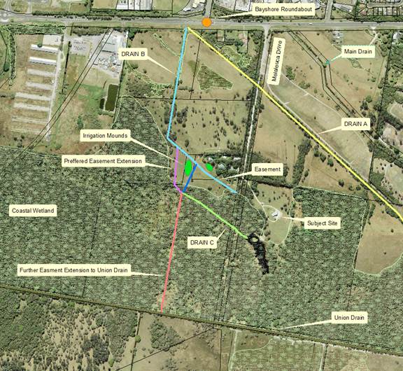
Drain A is considered to be the original flow path for water
leaving the Ewinsgdale Road / Bayshore Drive intersection. Stormwater
water is not piped from the industrial estate to this location.
The image below is a historic aerial photo from 1965 showing
a drain once existed. At that time the drain may have been considered a lawful
point of discharge because is appears to have a water course.
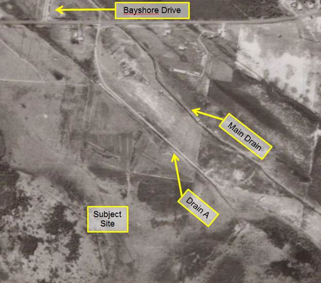
|
The image on the right
shows drain A. On the eastern side of Melaluaca Drive the drain is
mostly non existent today, it is overgrown and filled with sediment.
The images below show the
drain either side of Melaluca Drive. The brown ponded water is to the
east, this has nowhere to flow and appears to be brown from sediment run off
from Melaluca Drive.
The lower right hand image
is the western side, this has a marginal drain through to the Bayshore Drive
roundabout site and recent drainage works.
|
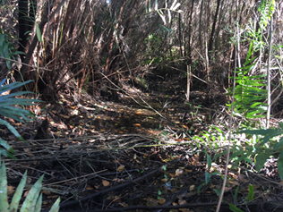
|
|
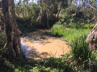
|
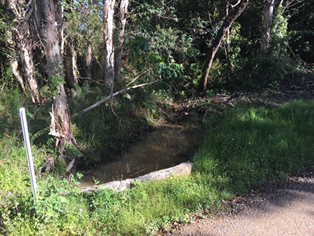
|
The picture and information
above show that drain A has slowly filled in overtime and for this and the legal
reasons it is unlikely to be considered a water course or a lawful point of
discharge today. Legal advice would be needed confirm this position.
|
The image to the right
shows a bund at the outlet from the Bayshore Drive roundabout site.
This shows that water only
leaves the site and into drain A when the bund is flooded and
overtopped. This bund has been in existence since the start of the
project.
|
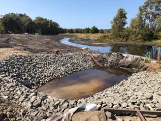
|
Drain B is within a Council
easement for drainage. The drain is partially blocked with sediment at
the start near Ewingsdale Road. Water would only enter this drain when
the area is slightly flooded. Additionally as can be seen by the pictures
below, the drain has limited ability to drain water from Ewingsdale Road
efficiently in its current state. The drain is overgrown and in need of
maintenance, it currently forms more of an uneven depression.
|
|
|
The southern end of drain B
is more obvious at the southern end, however, the end of the drain was
redirected away from the easement around 8 years ago. The closure of this
section was at the request of Council’s Environmental Health staff to
allow the property owner to create a sub-surface irrigation mound for their
waste water treatment system. The redirection is shown in dark blue on
drainage network image above. The connection of this redirection is poor
and an inefficient drain. The more efficient location would be to the
west of the larger waste water irrigation mound, shown in green.
The easement wasn’t
changed at the time of redirection and remains in its original location today
on deposited plans. It is believed the original aim of this easement was to
take drainage flows from Ewingsdale Road to the Melaleuca Drive road
reserve. Council could then build a drain down the road reserve to a
natural flow path or the Union Drain. Unfortunately Crown Lands have
since sold this road reserve to private owners; therefore, the Council easement
no longer reaches a lawful point of discharge and would need a further easement
to drain water beyond the end of the existing easement. This is no longer
the preferred flow path due the issues explained above, particularly the
irrigation mounds.
Council’s consultant
report for the development area north west of this land which Drain B flows
though concluded that this area did not have a lawful point of discharge.
Additionally whilst Council has an easement over Drain B, this easement does
not reach a lawful point of discharge; therefore, Council is unlikely to have a
legal right to send water down this easement. Legal advice will need to
confirm this.
The preferred flow path (noted above in purple) would
require the creation of an easement to take flows to lawful point of discharge
or all the way to the Union Drain (this is considered a lawful point of
discharge, shown in red). The Union Drain link has ecological issues
because it would require a drain to be built through a Coastal Wetland,
therefore an EIS would be required, which may not result in an approval because
draining a Coastal Wetland is a key threatening process to a state protected
wetland.
Drain B can cause issues for
the property owners north of Drain C, therefore, this needs consideration as
part further investigations.
Drain C is minor drain which
links the land to the west of Melaleuca Drive with the east and links the
Coastal Wetland together. The drain is mapped in Council’s system
and in the states SixMaps, however, as can be seen from the images below it has
limited ability to act as an efficient drain and is more of a depression with a
Coastal Wetland.
Council’s design officer has built a 3D model of the
area using Light Detection and Ranging (LiDAR) data from 2015. The model
has been interrogated using a process called ‘water drop’. This
assessment showed that it is unlikely there are any clear flow paths to link
water flow from Melaleuca Drive or Ewingsdale Road to the Subject site
property. Site inspections also concluded there are no clear flow paths.
Water is more likely to flow when the area receives partial flooding or through
ground water. This is mainly due to the condition of the drains in the
area.
It is noted that LiDAR is fairly accurate and excellent for
broad scale assessment, more detailed survey of the area would be required to
build a higher resolution model that may pick up drainage paths more
accurately.
Considering the results of the water drop analysis and the
state of both Drains A and B it is difficult to see how stormwater flows away
from Melaleuca Drive or the Bayshore Drive roundabout site. It is more likely
that this water enters the water table until the area is flooded and then
starts to flow. But these would be very slow flows and the water is more likely
to slowly seep into the ground.
The image below is a coloured terrain model with an aerial
photo behind to help show locations. Blue is very low land, typically water
bodies and swamp. Yellow is low lying land and drains. Red is higher land,
relative to the low land. As can be seen the subject site is surrounded by low
lying land and the majority of the land parcel is either low lying, swamp or
water body. The area around the residence is the higher land, which is
mostly dry.

Downstream Drainage
Staff have inspected some of the receiving land area as well
as the upstream environment in order to understand how the receiving
environment effects drainage away from the subject land. Further
investigation in a Kayak and on foot is being considered.
The following text is taken from section 4.2.2 of the
Capacity Assessment of the Belongil Creek Drainage System December 2016. Full document provided at attachment 1.
Water levels, groundwater and rainfall
Across all monitoring sites, water levels increase as a result of rainfall. The frequency, magnitude
and duration of elevated surface/ground waters as a result of rainfall varies considerably both temporally and spatially. Generally, 50-100mm of rainfall over 2 days will result in
elevated ground
and surface waters to the extent where extensive flooding occurs across land west of the BBIWMR. This relationship is best illustrated
in Figure 4-4, with a series of 50mm + rainfall events in late 2015 which lead to surface flooding. On three occasions between Early November and Late
December flooding of the adjoining paddock occurred; preceding the initial two events ~60mm of rainfall was recorded, with 106mm recorded preceding the third event. Interestingly, 60mm of rain falling on the 9/11/2015 resulted in an increase in drain water levels from 1.47 – 1.7mAHD but did not result in flooding of the
paddocks. This appears to be the influence of the water level within the drains/groundwater prior to
rainfall events. For example, when the
drain water
level is
<~1.4mAHD at Logger 3,
50mm of rainfall will not result in flooding. However, when the water level
is >1.7mAHD 50mm of rainfall will result in flooding.
Figure 4-5 illustrates how the water level at Logger 4 increases to a level greater than the drain invert for a period of 4 days following 311mm over two days. The photograph adjoining this graph shows the extent of flooding on the same rainfall event across the land west of the BBIWMR (refer
to Figure 4-1 for location
and direction of photograph).
While the drainage system of the upper union drain network demonstrably transports effluent efficiently, it is highly likely that since the increased discharge from BB STP in 2006, the regional
water table has increased. While this is difficult to demonstrate quantitatively without
‘pre 2006’
data, the geological cross section presented earlier in Figure 3-3 indicates little pathways for effluent loss outside of the flow under Ewingsdale Road culverts in the Upper Union Drainage system. Furthermore, anecdotal observations by landowners over the past 10 years suggest the
water table has
increased. This increase in the water table would likely result in an increase in the
frequency, duration
and depth of inundation resulting from rainfall events owing to the reduced soil
store available (in comparison to pre 2006).
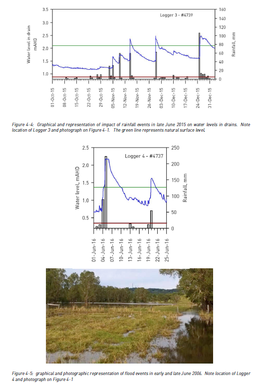
Influence of ‘closed estuary’ on drain system.
Owing to the extremely flat catchment,
water levels within
the Belongil Estuary substantially
influence water levels within the Union and Upper Union drainage system. When the estuary mouth is open, tidal fluctuations in water levels have been recorded north of Ewingsdale Road, at Logger sites 4, 5 and 6. Conversely, when the mouth of the estuary is closed, the level of water within entire Union Drain system rises, as illustrated in Figure 4-6 showing the water level at the
Ewingsdale Bridge and the Upper Union Drain over a period with estuary open and closed events. The static water level within
the estuary and drainage system appears to be set by the opening status of the estuary mouth and tidal fluctuations.
With an estuary
closed event, the water
level within
the estuary and drainage system incrementally increases 3-5cm per day under non rainfall conditions, reaching
a level whereby it overtops the
natural sand bar at the estuary mouth OR Council artificially open the mouth of the estuary –as discussed earlier in Section
3.2.1. Under a ‘closed’ estuary, water levels within the upper union drainage system can be >0.5m when compared to water level under an ‘open’
estuary regime – however estuary closed events occur only 2-3 times per year and generally for periods <7-10 days.
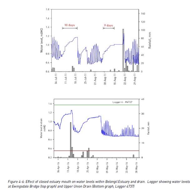
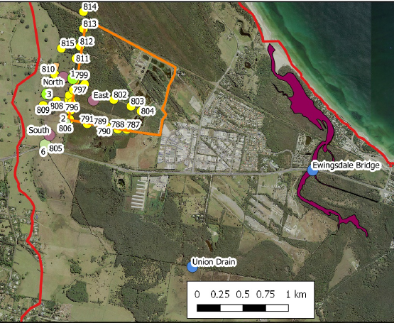
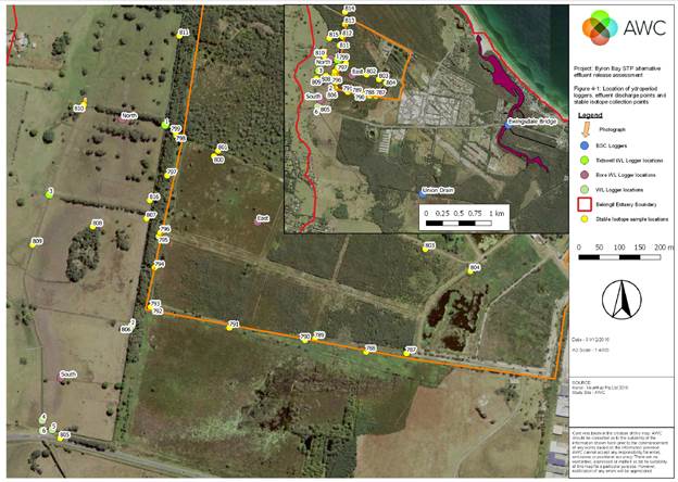
This report clearly shows that water levels in the Union
Drain directly south of Subject site can often range between 0.7-1.2m AHD and
0.6-1.2 at the Ewingsdale Road bridge. This represents a near flat
hydraulic grade line between the two locations. It is also noted that
water levels within the Union Drain further upstream of this location can often
be higher at around 1.3-1.4m AHD and higher during flooding.
Additionally since 1 January 2017 water levels at the
Ewingsdale Road bridge have not lowered below 0.19m AHD. The mouth of
Belongil is opened when water levels at this location reach 1.0m AHD,
therefore, generally water levels do not go much higher than this, except
during heavy and prolonged rain or flooding; although this does happen a number
of times per year. This water level is the downstream boundary for water
draining out of the Union Drain. Therefore it could be said that it is
not unusual for the downstream boundary water levels to be between 0.2 to 1.0m
AHD at the road bridge.
The grass areas around subject site range between 1.4 to 3m
AHD. The majority of the flooded land is below 2m AHD. The swamp
between the Union Drain and subject sites residence has ground levels between
0.8-1.4m AHD, while the banks on the Union Drain have ground levels up to 1.8m
AHD in places, with gaps which would allow water to drain into the drain.
The image below shows 0.2m contours of this area.
0.00m AHD is mean sea level. Mean sea level is an
average level of the surface of an ocean from which heights such as elevation
may be measured. A common and relatively straightforward mean sea-level
standard is the midpoint between a mean low and mean high tide at a particular
location. In Australia mean sea level for 1966-1968 was assigned a value
of 0.000m on the Australian Height Datum (AHD) at 30 tide gauges around the
coast of the Australian continent.
Typicaly drainage design aims for a hydraulic grade of 1% or
higher to achieve efficient flow rates. The lower Belongil area is very flat
and the drains have little if any grade as they are usually flooded.
Therefore the drainage in this area relies more upon displacement or
hydrostatic head to drive the water flow, rather than drain grade.
The distance water has to flow from the Union Drain south of
subject site and the Ewingsdale Road bridge is approximately 2,700m. If
you assumed a near flat (not efficient) hydraulic grade of 0.1% from the
Ewingsdale Road bridge and followed the water flow back up the Union Drain to
this same point the following water levels would result.
|
Water Level at
Ewingsdale Road
|
Resulting water
level at Union Drain
|
|
0.2m AHD
|
2.9m
|
|
0.6m AHD
|
3.3m
|
|
1.0m AHD
|
3.7m
|
This shows that water draining from the swamp surrounding
subject site has very little hydrostatic head to drive flow. The land would
need to be flooded before you achieve an inefficient hydraulic grade line of
0.1%, even when water levels in the creek are 0.2m AHD. A more efficient
hydraulic grade line of 1% is not possible without considerable flooding.
The land shown as flooded in the pictures provided is
approximately 1.4m AHD, if this is flooded and the Belongil Creek water levels
are 1m AHD, this water has a hydraulic grade line of 0.015%, this is basically
flat.
Water flowing from the subject site generally has nowhere to
flow to because the downstream water levels are similar, resulting in no
hydraulic grade or head to drive flow.
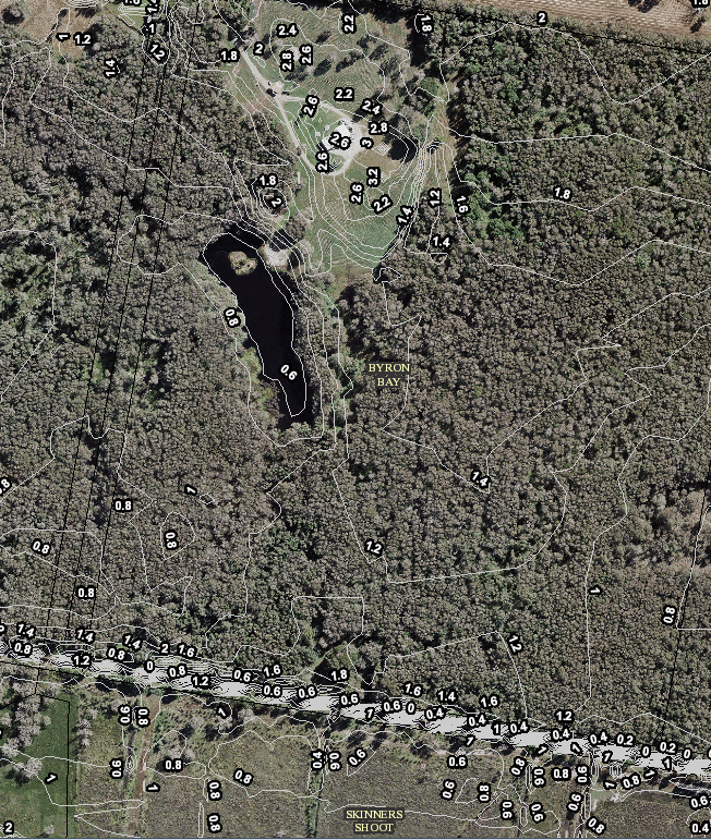
Conclusions
1. Staff
have concluded that the Bayshore Drive roundabout and the drainage maintenance
works on Melaleuca Drive are unlikely to be the cause of the drainage issues
that the subject site is experiencing. The cause of the drainage issues are
more likely to be the downstream environment not allowing water to flow away
from the land.
2. The
recommended alternative flow path from the Byron Bay STP could reduce water
levels in the Union Drain to the south of the subject site, but it may not
lower water levels in the main Belongil Creek, therefore, it is unlikely to
have a profound impact or provide a solution to the subject site.
3. Council
is unlikely to have a legal right to send water down Drain A or B, because it
does not end at a lawful point of discharge, legal advice could be sought to
confirm.
4. If
Council doesn’t have a legal to discharge nor does the proposed
sub-division of the land which Drain B runs through. Additionally the
opportunities for infiltration from this site should be considered very carefully
because the water table is already very high which makes successful
infiltration very unlikely.
5. Initial
investigations suggest the preferred drainage flow path for this area is an
extension of Drain B, within an easement, until it reaches a lawful point of
discharge, however, further investigation into this is recommended and
confirmation on where the nearest lawful point of discharge exists.
6. Alternate
flow paths also need further survey and investigation as part of the above
investigation. There may be an alternative option to Drain B, but this needs
detailed survey to prove.
7. This
report shows that water can only drain from the swamp surrounding the subject
site if water levels provide the head to drive flow. 2.7m above water levels in
the Belongil Creek achieves a 0.1% hydraulic grade. 0.27m provides a 0.01%
hydraulic grade. Both of which result in very slow inefficient drainage
flows. Further modelling would help better understand these effects and the
system’s capacity to drain.
8. If
the catchment is becoming more water logged and drainage paths through the
swamp become blocked this drainage efficiency becomes further restricted. It is
a natural process for swamp land to naturally fill and change over time and
this likely to be occurring in the area subject to this investigation.
9. This
review has confirmed that Council needs to further investigate drainage
easements from Ewingsdale Road to the Union Drain or lawful point of
discharge. The best locations for drainage easements needs to be
confirmed and the easements created to a lawful point of discharge to ensure
long term drainage. These easements should not proceed if they are likely
to impact local residents.
10. It
is recommended that the Ewingsdale Road duplication project investigate
appropriate drainage flow paths and create / negotiate easements as required.
11. It
is noted that long term change in the wetlands surrounding the subject site and
water levels within the receiving environment (Belongil Creek) may impact the long
term viability of the subject land as suitable and healthy land to live.
Financial Implications
Resolution 18-617 (c) has committed $30,000 to
further investigate the above and a whole of catchment investigation to provide
recommendation for a Belongil Catchment Management Plan.
Statutory and Policy
Compliance Implications
Provision of stormwater infrastructure is a legitimate
function of local government under the Local Government Act 1993.
To the extent that the provision of stormwater infrastructure protects public
roads, other infrastructure, Council land, Crown land, private land and the
community. Council is also responsible for drainage under the Roads
Act 1993.
Resolving as recommended demonstrates that Council is
carrying out stormwater works to the extent that Council resources, capacities
and competing priorities permit.
Reports of Committees - Corporate and Community Services 14.1
Reports of Committees - Corporate and Community
Services
Report No. 14.1 Report of the Arakwal Memorandum of Understanding Advisory Committee
Meeting held on 13 September 2018
Directorate: Corporate and Community Services
Report
Author: Lisa
Brennan, EA Corporate and Community Services
File No: I2018/1871
Theme: Corporate Management
Community Development
Summary:
This report provides the minutes and recommendations of the
Arakwal (Memorandum of Understanding) Advisory Committee Meeting held on 13
September 2018 for determination by Council.
|
RECOMMENDATION:
1. That
Council note the minutes of the Arakwal Memorandum of Understanding Advisory
Committee Meeting held on 13 September 2018.
|
|
2. That Council
adopt the following Committee Recommendation:
Report No. 4.1 Environmental Protection and
Improvement Works at the Sandhills Estate
File No:
I2018/1665
Committee Recommendation 4.1.1
1. That
the Arakwal Memorandum of Understanding Advisory Committee:
a) Note
the progress of this project and provide any feedback to Council.
b) Provide
feedback on the Sandhills Estate Environmental Protection and Improvement
Plan.
2. That
Council establish a partnership protocol with the Arakwal Corporation for
works within the Sandhills Estate and facilitate a stakeholder engagement
process for the broader Sandhills project.
3. That
the Environmental Protection and Improvement Project Plan (E2018/76687) be
presented to the Arakwal Corporation Board by Council staff.
|
|
3. That Council
adopt the following Committee Recommendation:
Report No. 4.2 Australia Day 2019
File No:
I2018/1570
Committee Recommendation 4.2.1
1. That
input provided by the Arakwal MoU Committee informs the planning and delivery
of Council’s Australia Day 2019 activities.
2. That,
in the event the date of the official Council celebrations change, that it be
recognised that it is a Council decision, not one by the Arakwal Corporation.
3. That
Council continue to support the Byron Reconciliation Group Survival Day
events.
|
|
4. That Council
adopt the following Committee Recommendation:
Report No. 4.3 Byron Shire Council and
Bundjalung of Byron Bay Aboriginal Corporation (Arakwal) Memorandum of
Understanding intended Review
File No:
I2018/1668
Committee Recommendation 4.3.1
That the Arakwal MoU Advisory
Committee note the intended review and evaluation of the Arakwal MoU and
provide preliminary feedback for the process.
|
|
5. That Council
adopt the following Committee Recommendation:
Report No. 4.6 Ironbark Avenue - Drainage
Investigation
File No:
I2018/1663
Committee Recommendation 4.6.1
1. That
the Arakwal Corporation proceed to obtain relevant approvals for the proposed
drainage solution and engage a suitable contractor to complete the works, and
acknowledge their commitment as stated in 5.2.1 of the Arakwal Memorandum of
Understanding.
2. That
a funding source be identified within Council’s 30 September Quarterly
Budget Review for Council’s consideration.
3. That
a review of parking design be included as part of this process.
|
Attachments:
1 Minutes of
the Arakwal (MoU) Advisory Committee meeting held on 13 September 2018, I2018/1729 ⇨
Report
The attachment to this report provides the minutes of the
Arakwal Memorandum of Understanding Advisory Committee Meeting of 13 September
2018 for determination by Council. The agenda for this meeting can be
located on Council’s website at:
https://byron.infocouncil.biz/Open/2018/09/AMUAC_13092018_AGN_786_AT.PDF
The committee recommendations are supported by management
and are provided in the attachment to this report.
Financial Implications
As per the Reports listed within the Arakwal Memorandum of
Understanding Advisory Committee Meeting of 13 September 2018.
Statutory and Policy
Compliance Implications
As per the Reports listed within the Arakwal Memorandum of
Understanding Advisory Committee Meeting of 13 September 2018.
Reports of Committees - Sustainable Environment and Economy 14.2
Reports of Committees - Sustainable Environment
and Economy
Report No. 14.2 Report of the Sustainability and Emissions Reduction Advisory
Committee Meeting held on 30 August 2018
Directorate: Sustainable Environment and Economy
Report
Author: Michelle
Chapman, Project Support Officer
File No: I2018/1778
Theme: Sustainable Environment and Economy
Planning Policy and Natural Environment
Summary:
The attachment to this report provides the minutes of the Sustainability
and Emissions Reduction Advisory Committee Meeting of 30 August 2018 for
determination by Council.
|
RECOMMENDATION:
That Council note the minutes of the Sustainability and
Emissions Reduction Advisory Committee Meeting held on 30 August 2018.
|
Attachments:
1 Minutes
30/08/2018 Sustainability and Emissions Reduction Advisory Committee, I2018/1658 ⇨
Report
The attachment to this report provides the minutes of the
Sustainability and Emissions Reduction Advisory Committee Meeting of 30 August
2018 for determination by Council. The agenda for this meeting can be
located on Council’s website at:
https://byron.infocouncil.biz/RedirectToDoc.aspx?URL=Open/2018/08/SERAC_30082018_AGN_877_AT.PDF
The Committee recommendations are supported by management
and are provided in the attachment to this report.
Financial Implications
As per the Reports listed within the Sustainability and
Emissions Reduction Advisory Committee Meeting of 30 August 2018.
Statutory and Policy
Compliance Implications
As per the Reports listed within the Sustainability and
Emissions Reduction Advisory Committee Meeting of 30 August 2018.
Reports of Committees - Sustainable Environment and Economy 14.3
Report No. 14.3 Report of the Heritage Panel Meeting held on 30 August 2018
Directorate: Sustainable Environment and Economy
Report
Author: Noreen
Scott, EA Sustainable Environment and Economy
File No: I2018/1798
Theme: Sustainable Environment and Economy
Development and Certification
Summary:
The attachment to this report provides the minutes of the
Heritage Panel meeting held on 30 August 2018 for determination by Council.
|
RECOMMENDATION:
That
Council note the minutes of the Heritage Panel Meeting held on 30 August
2018.
|
Attachments:
1 Minutes
Heritage Panel 30 August 2018, I2018/1575
⇨
Report
The attachment to this report provides the minutes of the
Heritage Panel Meeting of 30 August 2018 for determination by Council.
The agenda for this meeting can be located on Council’s website at:
https://byron.infocouncil.biz/Open/2018/08/HER_30082018_AGN_820_AT.PDF
The Panel recommendations are
supported by management and are provided in the attachment to this report.
Financial Implications
As per the Reports listed within the Heritage Panel Meeting
of 30 August 2018.
Statutory and Policy
Compliance Implications
As per the Reports listed within the Heritage Panel Meeting
of 30 August 2018.
Reports of Committees - Infrastructure Services 14.4
Reports of Committees - Infrastructure Services
Report No. 14.4 Report of the Water, Waste and Sewer Advisory Committee Meeting held
on 13 September 2018
Directorate: Infrastructure Services
Report
Author: Dominika
Tomanek, Executive Assistant Infrastructure Services
File No: I2018/1779
Theme: Infrastructure Services
Waste and Recycling Services
Summary:
The attachment to this report provides the minutes of the
Water, Waste and Sewer Advisory Meeting held on 13 September 2018 for
determination by Council.
|
RECOMMENDATION:
1. That
Council note the minutes of the Water, Waste and Sewer Advisory Committee
Meeting held on 13 September 2018.
|
|
2. That Council
adopt the following Committee Recommendation(s):
Report No. 4.1 Water Sensitive Urban Design
Strategy
File No: I2018/956
Committee Recommendation 4.1.1
1. That
the committee note the report and commend Council for undertaking this
initiative.
2. Staff
circulate questions from the presentation and Committee provide feedback
within 2 weeks.
3. That
committee will have workshop to discuss questions in the end of October 2018.
|
|
3. That Council
adopt the following Committee Recommendation(s):
Report No. 4.2 Telecommunications
Installations on Reservoirs
File No:
I2018/1159
Committee Recommendation 4.2.1
That Council welcome the study
to our shire.
|
|
4. That Council
adopt the following Recommendation(s):
Report No. 4.3 Rous Regional Water Supply
Agreement Liaison Committee Meeting 28 August 2018 Agenda and Business papers
File No:
I2018/1298
Committee Recommendation 4.3.1
That Council circulate the
business papers for the Rous Regional Water Supply Agreement Liaison
Committee to members of the WWSC when received.
|
|
5. That Council
adopt the following Committee Recommendation(s):
Report No. 4.4 Mullumbimby Inflow and
Infiltration update
File No:
I2018/1660
Committee Recommendation 4.4.1
That Council move ahead with the
Inflow and Infiltration project as originally conceived for a small cluster
of properties in Mullumbimby to quantify the benefit of a pressure sewer
system and ensure that the results of the trial are not confounded by other
activities.
|
|
6. That Council
adopt the following Committee Recommendation(s):
Report No. 4.5 Nutrient Loading in the
Belongil
File No:
I2018/1704
Committee Recommendation 4.5.1
1. That
Council note that consent conditions in clause 11 of the approval under
Council res 02-1329 have been exceeded for short periods during the past 15
months
2. That
Council determine a new methodology to calculate nutrient discharge into the
Belongil to satisfy both Council Resolution 02-1329 and the Recycled Water
Management Strategy 2017-27
3. That
Council consider measures for overcoming these exceedances.
|
|
7. That Council
adopt the following Committee Recommendation(s):
Report No. 4.6 Items for the Committee
Requested by Mark Tidswell
File No:
I2018/1715
Committee Recommendation 4.6.1
That Council note the Committee
discussed the item on 13 September 2018 in relation to flooding at Melaleuca
Drive and a Notice of Motion is on the Agenda for the next scheduled Council
Meeting on 20 September 2018.
|
Attachments:
1 Minutes
13/09/2018 Water, Waste and Sewer Advisory Committee, I2018/1719 ⇨
Report
The attachment to this report provides the minutes of the
Water, Waste and Sewer Advisory Committee Meeting of 13 September 2018 for
determination by Council. The agenda for this meeting can be located on
Council’s website at:
https://byron.infocouncil.biz/Open/2018/09/WWSAC_13092018_AGN_802_AT.PDF
Committee Recommendation
The committee recommendations are supported by management
and are provided in the attachment to this report.
Financial Implications
As per the Reports listed within the Water, Waste and Sewer
Advisory Committee Meeting of 13 September 2018.
Statutory and Policy
Compliance Implications
As per the Reports listed within the Water, Waste and Sewer
Advisory Committee Meeting of 13 September 2018.
Reports of Committees - Infrastructure Services 14.5
Report No. 14.5 Report of the Local Traffic Committee Meeting held on 18 September 2018
Directorate: Infrastructure Services
Report
Author: Evan
Elford, Team Leader Infrastructure Planning
Stephanie Tucker, Traffic and
Transport Assistant
File No: I2018/1870
Theme: Infrastructure Services
Local Roads and Drainage
Summary:
This report contains the recommendations of the Local
Traffic Committee meeting held 18 September 2018. There was no Police
representative at the 18 September meeting, however the Police have advised
their support for the recommendations via email, see attachment E2018/79491.
Council’s action on the LTC advice will be:
a) If
Council is in agreement with the LTC unanimous support then the proposal may be
approved. In these cases there is no conflict between Council and the advice of
the LTC, consequently there is no need for Council to inform the RMS or the NSW
Police representatives of the decision.
b) If
Council is in agreement with the LTC unanimous support, but no longer wants to
proceed, the proposal may still be rejected.
c) If
Council is in agreement with the LTC unanimous decline then the proposal may be
rejected. Again there is no conflict between Council and the advice of the LTC.
Consequently there is no need for Council to inform the RMS or the NSW Police
representatives of the decision.
d) If
Council decides to proceed with a proposal where the advice of the LTC is not
unanimous support, then the Council must first advise the RMS and the NSW
Police representatives in writing of their intention to approve the
proposal. The RMS or the NSW Police may then lodge an appeal to the
Regional Traffic Committee (RTC).
e) If
Council decides to proceed with a proposal where the advice of the LTC is a
unanimous decline, then the Council must first advise the RMS and NSW Police
representatives in writing of their intention to approve the proposal.
The RMS or the NSW Police may then lodge an appeal to the RTC.
Due to the fact that the RMS and the NSW Police have the
power to appeal certain decisions of the Council, the LTC cannot provide its
advice to Council until both the RMS and the NSW Police have provided their
vote on the issue.
|
RECOMMENDATION:
1. That
Council note the minutes of the Local Traffic Committee Meeting held on 18
September 2018.
|
|
2. That Council
adopt the following Committee Recommendation(s):
Report No. 6.1 Parking for volunteers
vehicles at RFS Mullumbimby Brigade
File No:
I2018/1151
Committee Recommendation 6.1.1
1. That Council not provide
dedicated parking for volunteers’ private vehicles in Gordon Street at
the Mullumbimby RFS brigade.
2. That council have further
discussions with the RFS regarding alternative parking arrangements.
Flanagan,
Cameron and Stevens voted in favour of the motion.
Nil voted against the motion
|
|
3. That Council
adopt the following Committee Recommendation(s):
Report No. 6.2 Events - Mullumbimby Music
Festival 2018 - Road Closure
File No:
I2018/1571
Committee Recommendation 6.2.1
1. That
the Traffic Management Plan and Traffic Control Plan/s as relates to the
Mullumbimby Music Festival 2018, to be held between Thursday 15 November 2018
and Monday 19 November 2018, which includes the temporary road closures
below, be endorsed between these times:
a) Dalley
Street, between Tincogan Street and Burringbar Street, between 11:00am and
12:00noon on Sunday 18 November 2018 - Street Parade;
b) Burringbar
Street, between Station Street and Dalley Street, effective between 10:45am
and 11:15am on Sunday 18 November 2018 - Street Parade;
c) Cenotaph
Lane, between Dalley Street and east of the fire station driveway and Murphys
Lane, effective from 4:00pm Thursday 15 November 2018 through to 8am Monday
19 November 2018; and
d) Murphys
Lane, between Cenotaph Lane and Tincogan Street, effective from 4:00pm
Thursday 15 November 2018 through to 8am Monday 19 November 2018.
2. That
the approval provided in Part 1 is subject to:
a) implementation
of the approved Traffic Management Plan and Traffic Control Plan/s by those
with appropriate RMS accreditation and the holding of current and appropriate
levels of insurance and liability cover;
b) that
each temporary bus stop, as required by the event, be established in
accordance with the accredited Traffic Control Plan/s;
c) the
event organiser:
i) advertising
the impact of the event via a notice in the local weekly paper a minimum of
one week prior to the operational impacts taking effect, noting it must include
the event name, specifics of any traffic impacts or road closures and times,
alternative route arrangements, event organiser, a personal contact name and
a telephone number for all event related enquiries or complaints;
ii) providing
a copy of the advert for Council's web page;
iii) the
written concurrence of the Fire Stations on both Gordon Street and Dalley
Street, be obtained and copies provided to Council;
iv) informing
community and businesses that are directly impacted (eg adjacent to the
event) via written information which is delivered to the property in a timely
manner so as to document, consider and respond to any concerns raised;
v) arranging
for private property access and egress affected by the event;
vi)
liaising with bus and taxi operators and ensuring arrangements
are made for provision of services during conduct of the event;
vii) consulting
with emergency services and any identified issues be addressed;
viii) holding
$20m public liability insurance cover which is valid for the event;
ix) paying
of Council’s Road Event Application Fee prior to the event.
Flanagan, Cameron and
Stevens voted in favour of the motion.
Nil voted against the
motion.
|
|
4. That Council
adopt the following Committee Recommendation(s):
Report No. 6.3 Request for No Stopping - 12
Browning Street, Byron Bay
File No:
I2018/1586
Committee Recommendation 6.3.1
That “No
Stopping” apply at the frontage of 12 Browning Street, Byron Bay for
the times and day of waste services only, as per existing adjoining signage.
Flanagan, Cameron and Stevens
voted in favour of the motion.
Nil voted against the motion.
|
|
5. That Council
adopt the following Committee Recommendation(s):
Report No. 6.4 Event Road Closures -
Brunswick Woodchop Twilight Markets 2018
File No:
I2018/1683
Committee Recommendation 6.4.1
1. That
the Twilight Markets to be held on Wednesday 19 December 2018, which includes
the temporary road closure/s below, be endorsed between these times:
a) Mullumbimbi
Street Brunswick Heads, between The Terrace and Park Street on Wednesday 19
December 2018, as per the following:
i) Closure
of the area bounded by the nose-in parking and centre parking bay from 7:00am
until 11:00pm. This is the u-shaped provision for parking that is adjacent
Banner Park in the vicinity of the children's play area;
ii) Two
(2) temporary designated ‘Disability Parking’ spaces be created outside
of the hotel during the morning, with signage to be installed by
appropriately accredited persons in conjunction with the implementation of
the TCP. The existing 2 spots will have been closed off;
iii) Closure
of the remaining section of ‘through road’ between The Terrace
and Park Street from 12:00noon until 11:00pm.
b) Opening
of Memorial Park for parking on Wednesday, 19 December 2018 from 12:00 noon
to allow stallholders to get their vehicles off the street before the markets
start at 3:00pm.
2. That
the Fireworks Night to be held on Saturday 19 January 2019, which includes
the opening of Memorial Park for parking from 6:00pm be endorsed.
3. That
the approval provided in Part 1 and Part 2 is subject to:
a) the
event organiser provide council with an updated Traffic Management Plan and
Traffic Control Plan for the 2018 event;
b) implementation
of the approved Traffic Management Plan and Traffic Control Plan by those
with appropriate RMS accreditation and the holding of current and appropriate
levels of insurance and liability cover;
c) the
impact of the event be advertised, and charged at cost to the organisers, via
a notice in the local weekly paper a minimum of one week prior to the
operational impacts taking effect, noting it must include the event name,
specifics of any traffic impacts or road closures and times, alternative
route arrangements, event organiser, a personal contact name and a telephone
number for all event related enquiries or complaints;
d) the
event be notified on Council’s web page;
e) the
event organiser:
i)
informing community and businesses that are directly impacted (eg adjacent to
the event) via written information which is delivered to the property in a
timely manner so as to document, consider and respond to any concerns raised;
ii) arranging
for private property access and egress affected by the event;
iii) liaising
with bus and taxi operators and ensuring arrangements are made for provision
of services during conduct of the event;
iv) consulting
with emergency services and any identified issues be addressed;
v) holding
$20m public liability insurance cover which is valid for the event;
vi) paying
of Council’s Road Event Application Fee prior to the event.
Flanagan, Cameron and
Stevens voted in favour of the motion.
Nil voted against the
motion.
|
|
6. That Council
adopt the following Committee Recommendation(s):
Report No. 7.1 Events - Byron Bay Triathlon
2019 - Traffic Management
File No:
I2018/1338
RECOMMENDATION:
Item deferred. No
recommendation made.
|
|
7. That Council
adopt the following Committee Recommendation(s):
(s)
as follows:
Report No. 7.2 Car Share Scheme, Byron and
Mullumbimby - 12 Month Pilot
File No:
I2018/1441
Committee Recommendation 7.2.1
That Council support
the following locations for car share spaces: four (4) spaces in Station St,
four (4) in Lawson St and one (1) space each in Massinger, Browning, Marvell
and Shirley Streets, generally located where shown in red in the report.
Flanagan, Cameron and Stevens
voted in favour of the motion.
Nil voted against the motion.
|
|
8. That Council
adopt the following Committee Recommendation(s):
Report No. 7.3 Brunswick Heads Boat Harbour
Master Plan - Traffic, Access and Parking Options
File No: I2018/1084
Committee Recommendation 7.3.1
1. That
the committee’s comments and recommendations be provided to
Crown Lands to assist in developing the Brunswick Heads Boat Harbour Master
Plan.
2. That LTC support the
intersection locations and layout, both internal and
external as presented in Council’s plan
2640-SK 2 Issue B.
Flanagan, Cameron and Stevens
voted in favour of the motion.
Nil voted against the motion.
|
|
9. That Council
adopt the following Committee Recommendation(s):
Report No. 7.4 Bangalow Primary School -
Parking and Traffic Management
File No:
I2018/1709
RECOMMENDATION:
Item
deferred. No recommendation made.
|
|
10. That Council adopt the
following Committee Recommendation(s):
Report No. 7.5 Adoption of Constitution for
Local Traffic Committee
File No:
I2018/1684
RECOMMENDATION:
Item deferred. No recommendation made.
|
Attachments:
1 LOCAL
TRAFFIC COMMITTEE E-mail from Police advising support for LTC recommendations
September 18 LTC - PDF VERSION, E2018/79491
⇨
Report
The attachment to this report provides the minutes of the
Local Traffic Committee Meeting of 18 September 2018 for determination by
Council. The agenda for this meeting can be located on Council’s
website at:
https://www.byron.nsw.gov.au/Council/Council-meetings/Agendas-Minutes
An e-mail from the Police Representative’s delegate,
Sgt Michael Stewart, advising Police support for the recommendations is also
attached.
Financial Implications
As per the Reports listed within the Local Traffic Committee
Meeting of 18 September 2018.
Statutory and Policy
Compliance Implications
As per the Reports listed within the Local Traffic Committee
Meeting of 18 September 2018.
Reports of Committees - Infrastructure Services 14.6
Report No. 14.6 Report of the Byron Shire Floodplain Risk Management Committee
Meeting held on 13 September 2018
Directorate: Infrastructure Services
Report
Author: Dominika
Tomanek, Executive Assistant Infrastructure Services
File No: I2018/1873
Theme: Infrastructure Services
Emergency Services and Flood Management
Summary:
The attachment to this report provides the minutes of the
Byron Shire Floodplain Risk Management Committee Meeting held on 13 September
2018 for determination by Council.
|
RECOMMENDATION:
1. That
Council note the minutes of the Byron Shire Floodplain Risk Management
Committee Meeting held on 13 September 2018.
|
|
2. That Council
adopt the following Committee Recommendation(s):
Report No. 4.1 North Byron Floodplain Risk
Management Study and Plan
File No:
I2018/1443
Committee Recommendation 4.1.1
1. That
Council accept the calibration results for the March 2017 flood event and
that the North Byron Flood Model, as adopted in 2016, is fit for the Draft
Floodplain Risk Management Study tasks.
2. That
Council note the results of the community survey and look forward to seeing
these results guide the various parts of the Draft Floodplain Risk Management
Study document.
|
Attachments:
1 Minutes
13/09/2018 Byron Shire Floodplain Risk Management Committee, I2018/1720 ⇨
Report
The attachment to this report provides the minutes of the
Byron Shire Floodplain Risk Management Committee Meeting of 13 September 2018
for determination by Council. The agenda for this meeting can be located
on Council’s website at:
https://byron.infocouncil.biz/Open/2018/09/BSFRM_13092018_AGN_806_AT.PDF
Committee Recommendation
The committee recommendations are supported by management
and are provided in the attachment to this report.
Financial Implications
As per the Reports listed within the Byron Shire Floodplain
Risk Management Committee Meeting of 13 September 2018.
Statutory and Policy
Compliance Implications
As per the Reports listed within the Byron Shire Floodplain
Risk Management Committee Meeting of 13 September 2018.
Reports of Committees - Infrastructure Services 14.7
Report No. 14.7 Report of the Local Traffic Committee Meeting held on 21 September 2018
Directorate: Infrastructure Services
Report
Author: Stephanie
Tucker, Traffic and Transport Assistant
File No: I2018/1894
Theme: Infrastructure Services
Local Roads and Drainage
Summary:
This report contains the recommendations of the Local
Traffic Committee meeting held electronically from 21-28 September 2018.
Council’s action on the LTC advice will be:
a) If
Council is in agreement with the LTC unanimous support then the proposal may be
approved. In these cases there is no conflict between Council and the advice of
the LTC, consequently there is no need for Council to inform the RMS or the NSW
Police representatives of the decision.
b) If
Council is in agreement with the LTC unanimous support, but no longer wants to
proceed, the proposal may still be rejected.
c) If
Council is in agreement with the LTC unanimous decline then the proposal may be
rejected. Again there is no conflict between Council and the advice of the LTC.
Consequently there is no need for Council to inform the RMS or the NSW Police
representatives of the decision.
d) If
Council decides to proceed with a proposal where the advice of the LTC is not
unanimous support, then the Council must first advise the RMS and the NSW
Police representatives in writing of their intention to approve the proposal. The
RMS or the NSW Police may then lodge an appeal to the Regional Traffic
Committee (RTC).
e) If
Council decides to proceed with a proposal where the advice of the LTC is a
unanimous decline, then the Council must first advise the RMS and NSW Police representatives
in writing of their intention to approve the proposal. The RMS or the NSW
Police may then lodge an appeal to the RTC.
Due to the fact that the RMS and the NSW Police have the
power to appeal certain decisions of the Council, the LTC cannot provide its
advice to Council until both the RMS and the NSW Police have provided their
vote on the issue.
|
RECOMMENDATION:
1. That
Council note the minutes of the Local Traffic Committee Meeting held on 21
September 2018.
|
|
2. That Council
adopt the following Committee Recommendation(s):
Report No. 6.1 Events - Falls Festival
2018/19 - Road Closures
File No:
I2018/1788
Committee Recommendation 6.1.1
That Council approve the
Traffic Management Plan, which includes Traffic Control Plans, for the Falls
Festival 2018/19 to be held at the North Byron Parklands site, Yelgun 31
December 2018 to 2 January 2019 inclusive, subject to the following
conditions: -
a) Separate
approvals by NSW Police and RMS being obtained;
b) Implementation
of the approved Traffic Management Plan and Traffic Control Plan by those
with appropriate RMS accreditation and the holding of current and appropriate
levels of insurance and liability cover;
c) The
approved event size being sufficient (20,000 patrons) to trigger use of the
south car park as per the DA Condition for its use;
d) The
temporary ‘No Stopping’ where applied, including on Brunswick
Valley Way (between Shara Boulevard and Tweed Valley Way) and on Tweed Valley
Way (between Brunswick Valley Way and the Shire boundary), is implemented
prior to the event and in accordance with relevant state requirements and
Australian Standards;
e) A
communications protocol be developed and maintained by those involved in the
implementation of traffic management including monitoring and ability to
implement contingency plans as and when directed;
f) Monitoring
of vehicle volumes that arrive and depart the festival site and on the local
road network;
g) The
holding of an event debrief within the month following the festival which
includes but not limited to Council, RMS and Police;
h) The
event organiser:
i) advertising
the impact of the event via a notice in the local weekly paper a minimum of
one week prior to the operational impacts taking effect, noting it must
include the event name, specifics of any traffic impacts or road closures and
times, alternative route arrangements, event organiser, a personal contact
name and a telephone number for all event related enquiries or complaints;
ii) providing
a copy of the advert for Council's web page;
iii) give
consideration of any submissions received;
iv) informing
community and businesses that are directly impacted (e.g. adjacent to the
event) via written information which is delivered to the property in a timely
manner so as to document, consider and respond to any concerns raised;
v) arranging
for private property access and egress affected by the event;
vi) liaising
with bus and taxi operators and ensuring arrangements are made for provision
of services during conduct of the event;
vii) consulting
with emergency services and any identified issues be addressed;
viii) holding
$20m public liability insurance cover which is valid for the event.
ix) paying
of Council’s Road Event Application Fee prior to the event.
Smith, Cameron, Stewart
and Boulton voted in favour of the motion.
Nil voted against the
motion.
|
|
3. That Council
adopt the following Committee Recommendation(s):
Report No. 6.2 Events - Byron Bay Triathlon
2019 - Traffic Management
File No:
I2018/1787
Committee Recommendation 6.2.1
1) That
the Byron Bay Triathlon to be held on Saturday 11 May 2019, which includes
the temporary road closures below and Denning Park access, be endorsed
between these times:
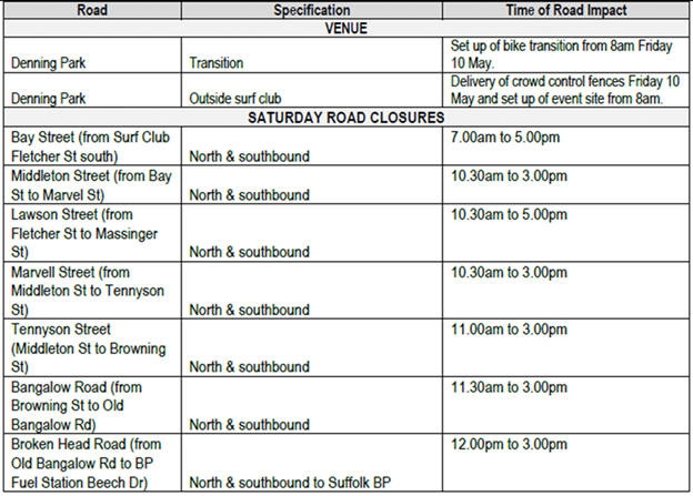
2)
Endorse the Traffic Management Plans for the 2019 Byron Bay Triathlon to be
held on Saturday 11 May 2019
3) That
the approval provided in Part 1 and Part 2 is subject to:
a) separate
approvals by NSW Police and RMS being obtained;
b) the
event organiser provide council with an updated Traffic Management Plan
and Traffic Control Plan for the 2019 event, if required by the Police and
RMS;
c) implementation
of the approved Traffic Management Plan and Traffic Control Plan by those
with appropriate RMS accreditation and the holding of current and appropriate
levels of insurance and liability cover;
d) the
impact of the event be advertised, and charged at cost to the organisers, via
a notice in the local weekly paper a minimum of one week prior to the
operational impacts taking effect, noting it must include the event name,
specifics of any traffic impacts or road closures and times, alternative
route arrangements, event organiser, a personal contact name and a telephone
number for all event related enquiries or complaints;
e) the
event be notified on Council’s web page;
f) the
event organiser:
· informing community
and businesses that are directly impacted (eg within road closure zones) via
written information which is delivered to the property in a timely manner so
as to document, consider and respond to any concerns raised;
· arranging for private
property access and egress affected by the event;
· liaising with bus,
taxi and waste operators and ensuring arrangements are made for provision of
services during conduct of the event;
· consulting with
emergency services and any identified issues be addressed;
· holding $20m public
liability insurance cover which is valid for the event;
· paying of
Council’s Road Event Application Fee prior to the event.
· Provide the committee comments to the Events Team
and Event Organisers
Smith, Cameron, Stewart
and Boulton voted in favour of the motion.
Nil voted against the
motion.
|
Report
The attachment to this report provides the minutes of the
Local Traffic Committee Meeting of 21 September 2018 for determination by
Council. The agenda for this meeting can be located on Council’s
website at:
https://www.byron.nsw.gov.au/Council/Council-meetings/Agendas-Minutes
Financial Implications
As per the Reports listed within the Local Traffic Committee
Meeting of 21 September 2018.
Statutory and Policy Compliance Implications
As per the Reports listed within the Local Traffic Committee
Meeting of 21 September 2018.
Confidential Reports - Infrastructure Services 16.1
Confidential Reports - Infrastructure Services
Report No. 16.1 Confidential - Tender 2018-0008 Eureka
Bridge Embankment Rectification
Directorate: Infrastructure
Services
Report
Author: Joshua
Provis, Road and Bridge Engineer
File No: I2018/1763
Theme: Infrastructure Services
Local Roads and Drainage
Summary:
On Tuesday, 10 July 2018, a Request For Tender was called
for the Eureka Bridge Embankment Rectification.
The Request for Tender was advertised from 10 July 2018 to
10 August 2018. Tenders were received from the following organisations:-
· Civil
Contracting Solutions Pty Ltd
· Elite
Retaining Systems Pty Ltd
· Valley
Earthworks Pty Ltd
Tenders have been assessed in accordance with the provisions
of the Local Government (General) Regulations 2005. This report summarises the
background and assessment of the tenders and provides a recommendation to award
the tender for Contract 2
RECOMMENDATION:
1. That
pursuant to Section 10A(2)(d)i and (d)ii of the Local Government Act, 1993,
Council resolve into Confidential Session to discuss the report Tender
2018-0008 Eureka Bridge Embankment Rectification.
2. That
the reasons for closing the meeting to the public to consider this item be that
the report contains:
a) commercial
information of a confidential nature that would, if disclosed prejudice the
commercial position of the person who supplied it
b) information
that would, if disclosed, confer a commercial advantage on a competitor of the council
3. That
on balance it is considered that receipt and discussion of the matter in open
Council would be contrary to the public interest, as:
The report contains commercial
in-confidence information that should not be disclosed publicly.
OR, ALTERNATIVELY WHERE
THE MEETING IS NOT PROPOSED TO BE CLOSED:
RECOMMENDATION:
1. That
pursuant to Section 11(3) of the Local Government Act, 1993, resolve that the
Annexures to the report, Tender 2018-0008 Eureka Bridge Embankment
Rectification are to be treated as confidential as they relate to matters
specified in s10A(2)(d)i and s10A(2)(d)ii of the Local Government Act 1993.
2. That
Council adopt the recommendation set out on the final page of the Report.
Attachments:
1 2018-0008
Eureka Bridge Embankment - Tender Evaluation Plan, E2018/69439
2 2018-0008
Eureka Bridge Embankment - Tender Evaluation Scoresheet, E2018/69437
3 2018-0008
Eureka Bridge Embankment - Tender Evaluation Report, E2018/80056