Agenda
Ordinary
Meeting
Thursday,
12 December 2019
held
at Council Chambers, Station Street, Mullumbimby
commencing
at 9.00am
 Public Access relating to items
on this Agenda can be made between 9.00am and 10.30am on the day of the
Meeting. Requests for public access should be made to the General Manager
or Mayor no later than 12.00 midday on the day prior to the Meeting.
Public Access relating to items
on this Agenda can be made between 9.00am and 10.30am on the day of the
Meeting. Requests for public access should be made to the General Manager
or Mayor no later than 12.00 midday on the day prior to the Meeting.
Mark
Arnold
General
Manager
What is a “Conflict of Interests” - A conflict of
interests can be of two types:
Pecuniary - an interest that a person has in a matter because of a reasonable
likelihood or expectation of appreciable financial gain or loss to the person
or another person with whom the person is associated.
Non-pecuniary – a private or personal interest that a Council
official has that does not amount to a pecuniary interest as defined in the Code
of Conduct for Councillors (eg. A friendship, membership of an association,
society or trade union or involvement or interest in an activity and may
include an interest of a financial nature).
Remoteness – a person does not have a pecuniary interest in a matter
if the interest is so remote or insignificant that it could not reasonably be
regarded as likely to influence any decision the person might make in relation
to a matter or if the interest is of a kind specified in the Code of Conduct
for Councillors.
Who has a Pecuniary Interest? - a person has a pecuniary interest in a
matter if the pecuniary interest is the interest of the person, or another
person with whom the person is associated (see below).
Relatives, Partners - a person is taken to have a pecuniary interest in a
matter if:
§ The person’s
spouse or de facto partner or a relative of the person has a pecuniary interest
in the matter, or
§ The person, or a
nominee, partners or employer of the person, is a member of a company or other
body that has a pecuniary interest in the matter.
N.B. “Relative”, in relation to a person means any of the
following:
(a) the
parent, grandparent, brother, sister, uncle, aunt, nephew, niece, lineal
descends or adopted child of the person or of the person’s spouse;
(b) the
spouse or de facto partners of the person or of a person referred to in
paragraph (a)
No Interest in the Matter - however, a person is not taken to have a
pecuniary interest in a matter:
§ If the person is
unaware of the relevant pecuniary interest of the spouse, de facto partner,
relative or company or other body, or
§ Just because the
person is a member of, or is employed by, the Council.
§ Just because the
person is a member of, or a delegate of the Council to, a company or other body
that has a pecuniary interest in the matter provided that the person has no
beneficial interest in any shares of the company or body.
Disclosure and participation in meetings
§ A Councillor or a
member of a Council Committee who has a pecuniary interest in any matter with
which the Council is concerned and who is present at a meeting of the Council
or Committee at which the matter is being considered must disclose the nature
of the interest to the meeting as soon as practicable.
§ The Councillor or
member must not be present at, or in sight of, the meeting of the Council or
Committee:
(a) at any
time during which the matter is being considered or discussed by the Council or
Committee, or
(b) at any
time during which the Council or Committee is voting on any question in
relation to the matter.
No Knowledge - a person does not breach this Clause if the person did
not know and could not reasonably be expected to have known that the matter
under consideration at the meeting was a matter in which he or she had a
pecuniary interest.
Non-pecuniary Interests - Must be disclosed in meetings.
There are a broad range of options available for managing conflicts &
the option chosen will depend on an assessment of the circumstances of the
matter, the nature of the interest and the significance of the issue being
dealt with. Non-pecuniary conflicts of interests must be dealt with in at
least one of the following ways:
§ It may be appropriate
that no action be taken where the potential for conflict is minimal.
However, Councillors should consider providing an explanation of why they
consider a conflict does not exist.
§ Limit involvement if
practical (eg. Participate in discussion but not in decision making or vice-versa).
Care needs to be taken when exercising this option.
§ Remove the source of
the conflict (eg. Relinquishing or divesting the personal interest that creates
the conflict)
§ Have no involvement by
absenting yourself from and not taking part in any debate or voting on the
issue as of the provisions in the Code of Conduct (particularly if you have a significant
non-pecuniary interest)
RECORDING OF VOTING ON PLANNING MATTERS
Clause 375A of the Local Government Act 1993
– Recording of voting on planning matters
(1) In this section, planning
decision means a decision made in the exercise of a function of a council
under the Environmental Planning and Assessment Act 1979:
(a) including a decision
relating to a development application, an environmental planning instrument, a
development control plan or a development contribution plan under that Act, but
(b) not including the making of
an order under that Act.
(2) The general manager is
required to keep a register containing, for each planning decision made at a meeting
of the council or a council committee, the names of the councillors who
supported the decision and the names of any councillors who opposed (or are
taken to have opposed) the decision.
(3) For the purpose of
maintaining the register, a division is required to be called whenever a motion
for a planning decision is put at a meeting of the council or a council
committee.
(4) Each decision recorded in
the register is to be described in the register or identified in a manner that
enables the description to be obtained from another publicly available
document, and is to include the information required by the regulations.
(5) This section extends to a
meeting that is closed to the public.
Ordinary Meeting
BUSINESS OF Ordinary Meeting
1. Public Access
2. Apologies
3. Requests for Leave of
Absence
4. Declarations of Interest
– Pecuniary and Non-Pecuniary
5. Tabling of Pecuniary
Interest Returns (Cl 4.9
Code of Conduct for Councillors)
6. Adoption of Minutes from
Previous Meetings
6.1 Ordinary
Meeting held on 28 November 2019
7. Reservation of Items for
Debate and Order of Business
8. Mayoral Minute
9. Notices of Motion
9.1 Front
and Centre Customer Service at The Counter........................................................ 6
9.2 Byron
Shire Youth Challenge............................................................................................ 8
10. Petitions
11. Submissions and Grants
12. Delegates' Reports
12.1 Presentation
to Virtual Power Plants, New Energy Storage, and Renewable Energy 2019
Conference, 15 November 2019 in Melbourne.............................................................. 11
13. Staff Reports
General Manager
13.1 TAFE
NSW and Lot 12 Bayshore Drive Byron Bay....................................................... 12
13.2 Byron
Rail Corridor Restoration...................................................................................... 16
13.3 Acquisition
and surrender of land - Byron pool complex................................................ 22
Corporate and Community Services
13.4 Policy
Review 2019 - Policies for repeal (part 2)............................................................ 25
13.5 Report
of the Public Art Panel meeting held on 14 November 2019.............................. 29
13.6 Review
of Northern Beaches Council Gambling and Poker Machine Harm Management Strategy......................................................................................................................................... 31
13.7 Submission
to Office of Local Government - Discussion Paper - A New Risk Management and
Internal Audit Framework for Local Councils in NSW.................................................... 34
13.8 Investments
- 1 November 2019 to 30 November 2019................................................ 40
Sustainable Environment and Economy
13.9 Sustainable
Visitation Strategy - Project update............................................................. 48
13.10 Climate
Emergency Response - update on Resolution 19-341...................................... 53
13.11 Review
of Affordable Rental Housing (Res 19-233)...................................................... 57
13.12 PLANNING
- Development Application 10.2018.307.1 - Alterations and additions to
dwelling, new artists studio and boundary adjustment........................................................................... 65
13.13 PLANNING
- Development Application 10.2019.458.1 Multi Dwelling Housing Comprising Eight
(8) Dwellings at 6 Julian Rocks Drive Byron Bay................................................................ 87
13.14 Final
Business and Industrial Lands Strategy for adoption........................................... 108
13.15 Our
Mullumbimby Masterplan - Submissions Report................................................... 119
13.16 Integrated
Pest Management Strategy (Resolution 19-519 )....................................... 123
13.17 Annual
Emissions Inventory and Achieving Net Zero Emissions Target...................... 127
13.18 PLANNING
- Report Exceptions to Development Standards 1 July to 30 September 2019 133
13.19 Expressions
of Interest for the Place Planning Collective (Res 19-451)...................... 136
13.20 Residential
Strategy and affiliated projects update....................................................... 139
13.21 PLANNING
- 24.2019.53.1 Habitat DCP Amendment; Chapter E5 Certain Locations in Byron Bay
and Ewingsdale............................................................................................................. 146
13.22 Report
of Planning Review Committee held on 14 November 2019........................... 151
13.23 PLANNING
- Update on Environmental Zone review and Planning Proposal implementation
process....................................................................................................................................... 153
13.24 PLANNING
- 26.2019.1.1 - Planning Proposal for an amendment to Byron LEP 2014 to permit
Community Title subdivision and dwellings at Lot 38 DP 1059938, Alidenes Road,
Wilsons Creek....................................................................................................................................... 158
13.25 PLANNING
- DA10.2018.466.2 - 61 Kingsley Street Byron Bay - S4.55 modification to
change the Condition of Consent (approved by Council Meeting) in relation to
the Height and FFL of the proposed building, change to pool dimensions and tree
removal................................. 166
13.26 Byron
Shire Council Agricultural Action Plan Update................................................... 179
13.27 PLANNING
- Draft Planning Controls for Short Term Rental Accommodation in response to
Ministerial Direction 3.7 Reduction in non-hosted rental accommodation period......... 184
13.28 PLANNING
- S4.55 for Modification of development consent DA 10.2017.402.3 to dedicate
Lot 130 to Council as a Public Reserve, and amend stormwater design, bushfire
asset protection zones and provide habitat connectivity between Management
Zones 7b and 9........................... 193
Infrastructure Services
13.29 Building
Asset Management Plan................................................................................. 202
13.30 Reducing
Streetlight Use - Update................................................................................ 206
13.31 Part
Road Reserve Closure and Sale to adjoining Lot 5 DP 714077 255 Repentance Creek
Goonengerry................................................................................................................. 209
13.32 Part
Road Closure and purchase Robert Street Bangalow adjoining 5 Deacon Street Lot
7 Section 10 DP 4974 and Lot 1 DP 122670..................................................................................... 214
13.33 Road
Reserve Closure and Purchase 149 Federal Drive Eureka Lot 22 DP 1014053 219
13.34 1
Broken Head Road Project........................................................................................ 224
13.35 Bangalow
Christmas Eve Carnival............................................................................... 231
13.36 Minor
changes to car parking signage in vicinity of Byron Youth Activity Centre
Sandhills Reserve....................................................................................................................................... 234
14. Reports of Committees
Corporate and Community Services
14.1 Report
of the Audit, Risk and Improvement Committee Meeting held on 14 November 2019 238
14.2 Report
of the Finance Advisory Committee Meeting held on 14 November 2019...... 243
Infrastructure Services
14.3 Report
of the Local Traffic Committee Meeting held on 19 November 2019.............. 247
6.1 Event Road Closure - New Year's Eve
and New Year's Day, Byron Bay 2019/2020. 247
6.2 Byron Bay Paid Parking Time Changes
- Jonson St 248
6.3 Restricted Parking Area - Broken
Head Reserve Rd & Seven Mile Beach Road. 249
6.4 Bay Lane - Traffic Managemen. 249
6.5 No Parking Area - Seven Mile Beach
Road. 249
6.6 Byron Bay CBD - Loading Zones. 250
6.7 Event - Summer Holiday Traffic
Management in Byron Bay. 250
7.1 Engineering Advice - Intersection of
Rajah Rd & Yengarie Way (Petition) 250
8.1 Events - Byron Bay Bluesfest 2020. 251
14.4 Report
of the Byron Shire Floodplain Risk Management Committee Meeting held on 26
November 2019............................................................................................................................... 254
15. Questions
With Notice
Questions with Notice: A response to Questions with
Notice will be provided at the meeting if possible, that response will be
included in the meeting minutes. If a response is unable to be provided
the question will be taken on notice, with an answer to be provided to the
person/organisation prior to the next Ordinary Meeting and placed on Councils
website www.byron.nsw.gov.au/Council/Council-meetings/Questions-on-Notice
Councillors are encouraged
to ask questions regarding any item on the business paper to the appropriate Director
prior to the meeting. Any suggested amendments to the recommendations should be
provided to Councillor Support prior to the meeting to allow the changes to be
typed and presented on the overhead projector at the meeting.
Notices of Motion 9.1
Notices of Motion
Notice of Motion No. 9.1 Front and
Centre Customer Service at The Counter
File No: I2019/1939
|
I move that Council take the opportunity to assist the
community with a postal service to receive mail over the counter from the
public for posting standard sized, fully stamped, with a return address into
the Australia Post network.
|
Attachments:
1 Australia
Post Group Mail Delivery Poll Policy, E2019/86006

Signed: Cr
Alan Hunter
Councillor’s supporting information:
The post office in Mullumbimby
is at the western end of Burringbar Street, 4 blocks away from the Council
offices at the eastern end. There are no other postal receivable points in the
CBD. As a service to our customers and residents such a service will be of
convenience and incur no noticeable expense for Council.
In a time when all levels of
government are addressing customer satisfaction and comparing the results
through the communities like ours this is an opportunity to assist bridge the
gaps.
Staff comments by Esmeralda Davis, Acting Manager Corporate
Services, Corporate and Community Services:
Management recognises the importance of community
satisfaction and strongly supports continuous improvement in customer service
to our community. In this instance however, the provision of a second
postal collection service in such close proximity to an Australia Post branch
may not be the best solution or most efficient use of Council resources.
If Council wishes to review its operations and service
delivery to become an agent for Australia Post, further investigation and the
preparation of a cost/benefit analysis would be required prior to a decision.
Preliminary investigations indicate that there are two
formal options for Council to provide this service:
1.
Become a Licensed Post Office (LPO)
Council would
need to apply through a tender process at a time when Australia Post invites
submissions for this type of service. LPOs must offer a range of
Australia Post products and services, including mail acceptance and processing,
postage stamps, money orders, bill payment and banking. Council would
also be responsible for the training of staff in accordance with legislative
requirements.
OR
2. Become a Community Postal Agent
(CPA)
Council would need to wait for a CPA opportunity to become available. At
a minimum, Council would need to offer basic postage assessment, stamp sales
and over-the-counter mail acceptance and delivery, however bill payment and
banking would not be required.
Alternatively, or in the absence of such opportunities being
forthcoming, staff could write to Australia Post inviting them to install a
post box outside the Mullumbimby Administration building.
Financial/Resource/Legal Implications:
In the performance of its functions, Australia Post is
governed by The Australian Postal Corporation Act 1989 and associated
Regulations. It is unclear, without further investigation, how Council
would be impacted by this legislation as an agent for Australia Post.
If Council wishes to consider becoming a Licenced Post
Office or Community Postal Agent it should note that the roles and workload of
the Customer Service and Records Management (and potentially Finance and IT)
teams would undoubtedly be significantly impacted; however further
investigation would be required to understand the specific financial and
resource implications for Council.
There are also considerable potential liability issues
involved in handling public mail which could result in customer
dissatisfaction, insurance claims and reputational damage should mail be misplaced,
damaged or incorrectly handled.
Is the proposal consistent with any Delivery Program
tasks?
|
CSP Objective
|
L2
|
CSP Strategy
|
L3
|
DP Action
|
|
Community
Objective 5: We have community led decision making which is open and
inclusive
|
5.3
|
Deliver a high
level of customer service
|
5.3.1
|
Enhance
external and internal customer service effectiveness
|
|
|
|
|
|
|
|
|
|
This could be considered an improvement to customer service,
but the viability of such an initiative would require further investigation and
assessment.
Notices of Motion 9.2
Notice of Motion No. 9.2 Byron
Shire Youth Challenge
File No: I2019/1976
|
I move:
1. That
Council thanks the young people from Mullumbimby High School involved
in the Byron Shire Youth Challenge, through formal recognition at their
school presentation day on 17 December 2019.
2. That
Council continues to support the ‘food waste expo’
initiative developed by young people in the Byron Youth Challenge through:
a) the
allocation of staff resources
b) utilising
up to $5,000 from the ‘Youth Council’ budget for the
coordination and delivery of the event
c) development
of collateral and promotion in the lead up to the event
3. That,
should the Mullumbimby High School wish to implement a green bin service,
Council provides internal green bins, such as kitchen cadies to assist them
with their food waste initiative
|
Signed: Cr
Michael Lyon
Councillor’s supporting information:
The ‘Byron Shire Youth
Challenge’ (Youth Challenge) program was developed to provide an
innovative and effective engagement program specifically targeting young
people.
Five students from Mullumbimby High School participated
in the program over five weeks, commencing in October 2019 and concluding with
their presentation during Public Access at the 28 November 2019 Ordinary
Meeting of Council.
The young people developed an initiative to
achieve their goal “That businesses in the Byron Shire have zero food
waste to landfill by the time we finish school in 2021”. Their
presentation to Public Access at the 28 November Ordinary Meeting proposed that
they would like to continue to work with Council to coordinate a ‘food
waste expo’ on 29 April 2019.
Staff comments by Heather Sills, Corporate Planning and
Improvement Coordinator, Corporate and Community Services:
(Management Comments must not include formatted
recommendations – resolution 11-979)
The ‘Byron Shire Youth
Challenge’ (Youth Challenge) program was developed to provide an
innovative and effective engagement program specifically targeting young
people. The program targeted young people aged 15-16 (Years 9-10) and aimed to
provide an effective mechanism for youth leadership development and future
social engagement of young people in our Shire.
Five students from Mullumbimby High School participated
in the program over five weeks, commencing in October 2019 and concluding with
their presentation during Public Access at the 28 November 2019 Ordinary
Meeting of Council. The program was designed to develop
civic leadership skills through a series of participatory activities and
challenges related to the functions of Local Government as outlined below:
|
Co-Design Workshop
|
A number of activities designed to engage
and discover:
- What are the most pressing issues for young people
in the Shire?
- What can Council do in this space?
- How can youth get involved in democracy?
|
|
Introduction to Local Government
|
This session focused on LG101 for young
citizens, in the context of the challenges and issues identified in the
co-design phase. Young people received a condensed Local Government induction
with guest speakers from across Council in their identified areas of
interest.
|
|
Byron Youth Challenge (one day)
|
Young people picked their ‘wicked
problem’ from the co-design workshop and were guided by staff through a
series of challenges related to how to respond from a Local Government
perspective.
|
|
Celebration
|
Young presented and discussed their “wicked
problem” and solutions to Councillors and received feedback from
Councillors on the solutions and how to present their ideas at the Council
Meeting.
|
|
Formal Meeting of Council
|
Young people witnessed democracy in action including
public access, debate and decision making. The young people presented at
public access and joined Councillors for morning tea, before observing an
hour of debate in the Chambers.
|
Outcome
Through the program the young
people identified a ‘wicked problem’ that they wanted to
investigate “How can we reduce food waste in the Byron
Shire?”. They worked with a number of staff from across the
organisation, Councillors, and a representative from North East Waste to
consider the issue and research possible solutions.
They developed an admirable goal
“That businesses in the Byron Shire have zero food waste to
landfill by the time we finish school in 2021” and presented
their proposed solution to the Ordinary Council Meeting on 28 November 2019.
Their proposed solution is to
work with Council and other relevant organisations to coordinate a food waste
expo on 29 April 2020 (being ‘Stop Food Waste Day’) at the Cavanbah
Centre in Byron Bay. They intend to invite all businesses in the Byron Shire to
come and learn about food waste and ways to reduce and prevent it, through
guest speakers, demonstrations, and case studies. They particularly want to
promote the existing organisations and services that provide leftover food to
people experiencing homelessness (for example, Liberation Larder).
The students have also proposed
that they would like to develop a program to influence change at their school,
Mullumbimby High School, and use this as a case study to show businesses that
if they can make these changes then so can businesses. They would like to
purchase green bins to distribute throughout the school and educate and promote
their use to encourage fellow students to dispose of food waste appropriately.
During their presentation to
Council the young people indicated that they are seeking support from Council
for a number of elements of their proposal:
· Continued support from Council officers to assist with
development and implementation of their initiative
· Seed funding for the purchase and implementation of
internal green bins at the Mullumbimby High School
· Financial support to deliver the food waste expo on 29
April 2019, including funding of displays and waiving the hire fee of the
Cavanbah Centre
· Allocation of staff resources to work with the young
people to promote the initiative, commencing in Youth Week 2020 in the lead up
to the event
Consultation and Engagement
The Byron Shire Youth Challenge program was promoted to each
of the high schools in the Byron Shire. Mullumbimby High School was the only
school that indicated an interest in participating in the program.
This year was run as a pilot program and, given its success,
it is anticipated that it will be delivered again in 2020 where all schools
will again have an opportunity to participate.
Financial/Resource/Legal Implications:
It is anticipated that this year’s
outcomes from the Youth Challenge will continue to be led by Corporate Services
with support from the Resource Recovery team, given the nature of the
‘wicked problem’ and proposed solution.
$5,000 is available from the ‘Youth
Council’ budget that can be used to support the young people to develop
and deliver their proposed food waste expo, and this will include marketing and
promotion, graphic design, and collateral for use at the expo.
The Resource Recovery team has identified that there is
potentially some seed funding available to assist the young people to purchase
internal green bins for use at Mullumbimby High School, should the school wish
to implement a green bin service.
Is the proposal consistent with any Delivery Program
tasks?
|
CSP Objective
|
L2
|
CSP Strategy
|
L3
|
DP Action
|
L4
|
OP Activity
|
|
Community
Objective 5: We have community led decision making which is open and
inclusive
|
5.1
|
Engage and
involve community in decision making
|
5.1.1
|
Facilitate
inclusive community consultation and stakeholder engagement to inform Council
decision making (SP)
|
5.1.1.7
|
Develop and
implement youth advisory/ leadership program
|
|
|
|
|
|
|
|
|
|
|
|
|
|
|
|
|
Delegates' Reports 12.1
Delegates' Reports
Delegate's Report No. 12.1 Presentation
to Virtual Power Plants, New Energy Storage, and Renewable Energy 2019
Conference, 15 November 2019 in Melbourne
File
No: I2019/1935
|
Delegate notes provided by Mayor Cr Simon Richardson,
Keynote Speaker at Virtual Power Plants, New Energy Storage, and Renewable
Energy 2019 Conference in Melbourne on 15 November 2019, “Case Study
– The Zero Emissions Byron project”, are attached to this Report.
Signed: Cr
Simon Richardson
|
Attachments:
1 Delegates
Report - Mayor Cr Simon Richardson Presentation Case Study - The Zero Emissions
Byron project Nov 2019 Melbourne, E2019/85221

Staff Reports - General Manager 13.1
Staff Reports - General Manager
Report No. 13.1 TAFE
NSW and Lot 12 Bayshore Drive Byron Bay
Directorate: General
Manager
Report
Author: Claire
McGarry, Place Manager - Byron Bay
Shannon Burt, Director Sustainable
Environment and Economy
File No: I2019/1837
Summary:
The purpose of this report is to
update Council on the latest discussions with TAFE NSW in relation to a
Connected Learning Centre (CLC) being located in Byron Shire in the near
future.
In February 2019, the State
Government made an election commitment to establish a TAFE campus in Byron Bay.
A number of new regional campuses have been flagged by the Minister to
Parliament, including one at Batemans Bay, Nambucca Heads, Nelson Bay, Byron
Bay, Cobar, Hay, Jindabyne and West Wyalong.
A formal announcement from the
Minister for Skills and Tertiary Education (The Hon Dr Geoffrey Lee MP) to
confirm the above CLCs is anticipated early 2020. This announcement will
determine whether a project will progress to the next stage of planning or not.
Prior to this announcement, TAFE
is seeking a formal commitment from Council in support of establishing a TAFE
campus on Council land in the Byron Shire.
|
RECOMMENDATION:
That Council:
1.
Note the separate report included in this agenda titled ‘Residential
Strategy and affiliated projects update’ and the section of the
Report relating to Lot 12 Bayshore Drive, Byron Bay.
2.
Confirm its in principle support for TAFE NSW to progress plans for a
Connected Learning Centre, subject to appropriate probity and planning
considerations, through the urban design investigation for Lot 12 Bayshore
Drive, Byron Bay.
3.
Authorise the General Manager to negotiate and enter into a non-binding Heads
of Agreement with TAFE NSW for a Connected Learning Centre on Lot 12 Bayshore
Drive, Byron Bay.
|
Attachments:
1 Confidential
- Draft non-Binding Heads of Agreement TAFE NSW, E2019/88003
2 Letter of
support - TAFE NSW for Byron Shire, E2019/88106
REPORT
Background
Through 2017 and 2018, the Byron
community and Council worked together to purchase the former Byron Hospital
site to retain it for community use. During this period, the community steering
committee collected ‘expressions of interest’ from organisations wanting
to be tenants of the site in future.
NSW TAFE were one of these
organisations (refer Attachment 2 - letter of support).
In February 2019 the NSW Coalition
made an election commitment to establish a TAFE campus in Byron Shire Local
Government area.
Since the March State Election,
NSW TAFE representatives have met with Council regularly to discuss their
proposal for a campus in Byron Bay – being a ‘Connected Learning
Centre’ (CLC). These Centres operate regionally around the state.
Supported by mobile training units, simulations and virtual reality
experiences, the CLCs enhance TAFE’s ability to deliver interactive,
flexible, accessible training across a wider range of locations.
Since purchasing the Byron
Hospital site from the State Government, Council and the community have further
developed and refined their plans for the future use of site. Through this
process, the consistent message has been that the community wishes to
adaptively reuse this site, rather than demolish it and build a purpose-built
facility for community use.
In order to accommodate a TAFE CLC
on the former Byron hospital site, part of the building would need to be
demolished. This outcome would not meet the expectations of Council or the
community for this site. As a result Staff in consultation with representatives
from TAFE NSW has identified other potential sites for a TAFE campus in the
Shire. These potential sites include Lot 12 Bayshore Drive in the Byron Arts
and Industrial Estate (BAIE) being the now preferred site.
The consideration of a TAFE CLC on
Lot 12 Bayshore Drive is included in the urban design investigations for the
site. Note the separate report included in this agenda titled ‘Residential
Strategy and affiliated projects update’ and the section of the Report
relating to Lot 12 Bayshore Drive, Byron Bay.
The landing of a TAFE CLC in Byron
Shire is considered a highly desirable from a community education perspective.
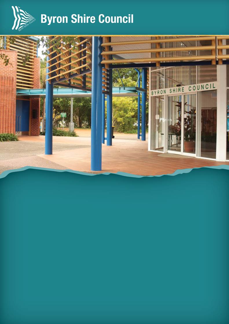
Lot 12 Bayshore Drive, Byron Bay
Lot 12 on DP 1189646,
highlighted in yellow on the figure below, is
situated off Bayshore Drive in northern part of the BAIE. It is a key
Council-owned land parcel, likely to become available for development in the
next couple of years.
Leading on from a recent Enquiry
by Design workshop for BAIE, Council staff working with a group of
representative stakeholders from within the BAIE have prepared a draft Arts and
Industry Estate Precinct Plan. The
Enquiry by Design and draft Precinct Plan identified Lot 12 as an opportunity
for the development of a sustainability
and innovation hub.
Web link here:
https://www.yoursaybyronshire.com.au/byron-arts-and-industry-estate
By resolution (Res.
19-452) staff have now sought to progress a structure plan for
Lot 12. To this aim a request for quotation has been issued for a consultant to
prepare a design blueprint for the site.
The design blueprint will enable
Council to undertake a feasibility assessment of a preferred delivery option
for its future development.
The brief issued requested that
3 options be explored in the context of the land functioning as a
sustainability and innovation hub by either:
1. Urbanised - a plan that develops
the conceptual plan contained in the Draft Byron
Arts and
Industry Estate Precinct Plan shown in Appendix A of the ‘Residential
Strategy and affiliated projects update’ report in this agenda.
2. Anchor based - a Plan testing
the suitability of including a TAFE site (development
footprint
approx. 5,000m2) and/or a social
enterprise commercial laundry site
(development
footprint approx. 2,500m2) on the site, in
conjunction with other uses.
3. Reimagined - an explorative
plan; with all other possibilities on the table, looking to
maximise the
potential of the site as a sustainability and innovation hub.
The three options seek to
optimise the potential design and use outcomes for the site.
The timetable for completion of
this urban design work is set to coalesce with the exhibition of the draft
precinct Plan in early 2020. Both the draft precinct plan and the 3 option
plans will be exhibited concurrently. A further report will follow for final
endorsement of a preferred option plan for Lot 12 by Council.
With the above in mind, it is
understood that the TAFE NSW campus requirements are as follows:
· a
ground lease of between 4700 sq m and 5000 sq m with a 10 year lease and two
five-year options);
· frontage
to Bayshore Drive;
· a
campus style building to serve as a ‘Connected Learning Centre’.
These requirements are more than
likely able to be accommodated on Lot 12, subject to a satisfactory design
being agreed to by both parties. Discussions have commenced and will ensue in
this regard should Council resolve for staff to do so.
For the TAFE NSW CLC to
progress, a development application satisfying all of the relevant planning
controls will be necessary. The cost of development and applicant will
determine the approval pathway for any development application which is likely
to be the Regional Planning Panel.
STRATEGIC CONSIDERATIONS
Community Strategic Plan and
Operational Plan
|
CSP Objective
|
L2
|
CSP Strategy
|
L3
|
DP Action
|
L4
|
OP Activity
|
|
Community
Objective 4: We manage growth and change responsibly
|
4.1
|
Support the
visions and aspirations of local communities through place-based planning and
management
|
4.1.1
|
Develop,
implement and update Place Plans that promote place-based forward planning
strategies and actions
|
4.1.1.6
|
Develop the
Byron Arts and Industry Estate Precinct Plan
|
|
|
|
|
|
|
|
|
|
|
|
|
|
|
|
|
Legal/Statutory/Policy
Considerations
The recommendations in this
report are not intended to bind Council to any agreement for lease. Instead,
they are intended to allow discussions between Council and TAFE to continue and
signal Council’s in-principle support for a TAFE campus in Byron Bay. The
details of which, should this be Lot 12 Bayshore Drive, Byron Bay, to be
confirmed in a Heads of Agreement.
This Report seeks the Council to authorise the General
Manager to negotiate and then enter into a non-binding Heads of Agreement with
TAFE NSW for a Connected Learning Centre on Lot 12 Bayshore Drive, Byron Bay.
TAFE NSW have provided Council with a draft non-binding
Heads of Agreement document as the basis for the negotiation process (refer
Confidential Attachment 1).
It is understood that an executed Heads of Agreement
document is a prerequisite to the Minister determining to progress the project.
Financial Considerations
Project currently funded in 19/20 OP.
In September 2019, Council commissioned a Valuation Report
for Lot 12 Bayshore Drive to provide a broad indicative value range for rental
on this site, based on Council retaining ownership of the land. The rental
amount discussed with TAFE NSW is in accordance with the Valuation Report
commissioned by Council.
Consultation and Engagement
As discussed in the report.
Staff Reports - General Manager 13.2
Report No. 13.2 Byron
Rail Corridor Restoration
Directorate: General
Manager
Report
Author: Claire
McGarry, Place Manager - Byron Bay
File No: I2019/1862
Summary:
This report seeks endorsement of concept plans for
restoration of the rail corridor in Byron Bay for community use.
|
RECOMMENDATION:
1. That
Council endorse the concept plans for the Byron Rail Corridor
(Attachment 1 E2019/86660).
2. That
Council allocate $493,400 from the Byron Town Centre Masterplan
Reserve towards this project.
|
Attachments:
1 Byron rail
corridor concept plans November 2019, E2019/86660

REPORT
Background
In 2016, Council adopted the Byron
Bay Town Centre Masterplan – a vision and strategy to guide the future of
the town centre, and to set out realistic actions and projects that achieve
that vision.
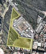
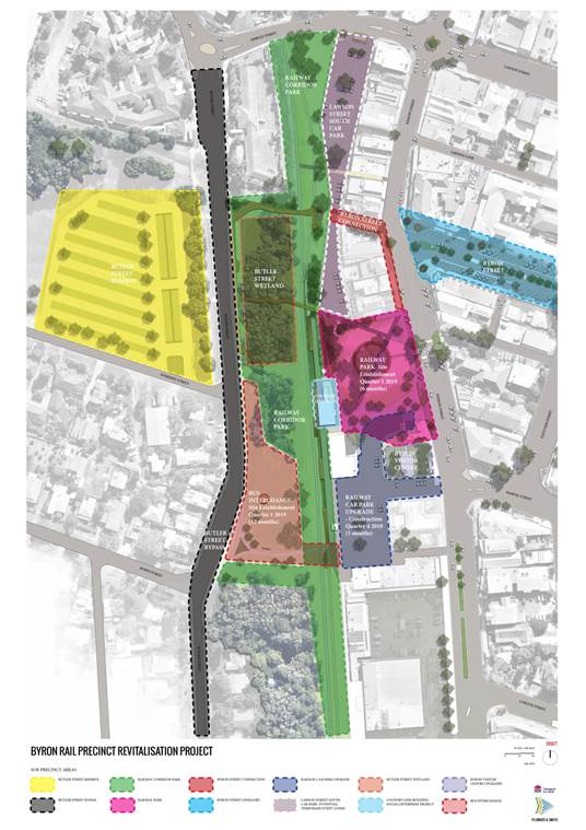
The Masterplan identifies the
Byron ‘rail precinct’ (map below) as a local community focal point
and critical piece of land to improve pedestrian connectivity through the town
centre.
In 2019, Council has:
- Completed the
Railway Park upgrade;
- Progressed
investigations on Butler Street Reserve to inform its future uses; and
- Commenced
construction of the Byron Bay bypass.
Additionally, Council has worked
closely with Transport for NSW to advocate for delivery of the Byron Bay Bus
Interchange and the upgrade of the car parks either side of Railway Park (Rails
car park and Lawson St South car park).
It is evident that as these
projects progress towards completion, the Byron rail corridor will be the final
‘piece of the puzzle’ in this precinct to achieve the vision set
out in the Masterplan – a rail precinct that supports passive recreation;
redirects vehicular traffic away from the town centre; activates public spaces;
improves connectivity; enhances heritage features; and connects key
‘green spaces’ across the town centre.
This report seeks endorsement of
concept plans for the Byron Rail Corridor so that staff can progress with:
- detailed design
- identification
of internal and external funding sources
- planning
approval pathways
- further
community consultation
Concepts
As outlined above, the Rail
Corridor occupies a critical space within the town centre and in particular in
relation to a number of adjacent town centre project areas including Railway
Park, Butler Street Reserve, potential transport interchange and car parks. The
Byron Bay Town Centre Master Plan also nominated the improvement of cross town
circulation routes (particularly east/west) as a critical component of
improving town wide connectivity. The Rail Corridor occupies a critical space
that has previously acted as a barrier to this connectivity. This project has
the potential to improve circulation across town and to improve the viability
and health of a number of public spaces and town centre spaces.
The key component of the Concept
for the Rail Corridor area is to provide safe and equitable circulation paths
connecting the town centre to the western side of the corridor. The Concept
also forms an important part of improving links into and through the recently
completed Railway Park upgrade. By doing so these works would considerably
increase the footprint and integrity of town centre public spaces. This project
can also play an important role in complimenting and safeguarding the heritage
value of the Rail precinct by enabling passive use and appreciation for the
space.
The connectivity improvements that this project enables are
important day to day (for general circulation and access to car parking areas
and the like), but they become vitally important on days of high frequency use
such as market days. As use of this space as an informal circulation route
increases, so do associated safety and accessibility concerns. This project
acknowledges the requirement of linkages through the corridor and provides them
in a way that promotes safe and equitable use of this space.
To improve the viability of the circulation links and the
associated open spaces, small gathering spaces and moments of outlook and
repose have been included in the design. This will increase use of the space
and improve the passive surveillance of this and adjacent spaces. A simple
design approach has been taken to the open areas of the site - improving grass
areas and increasing natural shade will allow for improved passive recreational
uses such as picnicking.
The Concept proposes materials and designs that are simple
and robust. The intention is to use tough and low maintenance solutions that are complimentary to the industrial heritage of the rail
corridor. Existing rail infrastructure will be retained and celebrated as an
integral part of the site experience. Existing trees along the corridor fringes
will be retained and in some cases provide shade and amenity for small seating
areas associated with the circulation paths. The detailing of surface finishes
such as turf and gravel will ensure that safety concerns such as trip hazards
and the like are managed in required areas.
The concepts also include Memento
Aestates – the Giovanni Veronesi artwork originally commissioned for
Railway Park. Council resolved to remove this artwork from the scope of works
for Railway Park and instead include it in concept plans for other town centre
projects. The Public Art Panel endorse the relocation of the artwork to the
rail corridor as the form and material of the piece complements the rail
heritage of the site.
In the context of Council’s
feasibility for multi-use of the rail corridor, this project constructs
infrastructure that is temporary in nature and can easily be adapted or removed
if the rail corridor were to be reactivated for multi-use transport options.
Next steps
This report seeks endorsement of
concept plans for the Byron Rail Corridor so that staff can progress with:
- detailed design
- confirmation of internal
and external funding sources
- planning approval pathways
- further community
consultation
STRATEGIC CONSIDERATIONS
Community Strategic Plan and
Operational Plan
|
CSP Objective
|
L2
|
CSP Strategy
|
L3
|
DP Action
|
L4
|
OP Activity
|
|
Community
Objective 1: We have infrastructure, transport and services which meet
our expectations
|
1.2
|
Provide
essential services and reliable infrastructure which meet an acceptable
community standard
|
1.2.7
|
Implement
identified projects of the Byron Bay Town Centre Master Plan
|
1.2.7.3
|
Undertake
landscaping works in Byron rail corridor (action from Byron Bay Town Centre
Masterplan)
|
|
|
|
|
|
|
|
|
|
|
|
|
Legal/Statutory/Policy
Considerations
In September 2019, Byron LEP 2014 was
amended to allow the following land uses to be permitted with consent in the
rail corridor:
· Community facilities;
· Information and education facilities; and
· Existing markets.
The amendments also clarified that
landscaping works and recreation areas (i.e. playgrounds) can occur without
development consent.
As the section of rail corridor
within the Town Centre is a State-listed heritage area, Council has been
working with Sydney Trains to prepare a Conservation Management Plan (CMP) for
the corridor. The CMP addresses Council’s concepts for the
activation/ community use of the corridor; Sydney Trains proposals to construct
the bus interchange; and concepts for the adaptive reuse of the former ticket
office.
The CMP has been submitted to the
State Government for endorsement. At the time of writing this report, it
has not yet been sign-off.
Adoption of the CMP will allow
Council to apply for approval under Section 60 of the NSW Heritage Act 1977
and planning approval (DA) under the Environmental Planning & Assessment
Act 1979.
Additionally, Council has a
licence over the rail corridor from Transport for NSW which will enable this
work to occur. Under this licence, Council must inform Transport for NSW of the
concept plans and must not make any changes to infrastructure, or install new
infrastructure without the prior written approval of Transport for NSW. Council
has sought approval from Transport for NSW on the concept plans and is awaiting
a response.
Financial Considerations
Preliminary cost estimates for
this project are $1,005,963.
Two sources of funding will be
used to deliver this project:
1. Byron Bay Bypass money
2. Byron Bay Town Centre Masterplan Reserve
Bypass
The Byron Bay Bypass project team
allocated $600,000 as a provisional sum within the bypass contract for the
construction of a walkway between Butler Street and Lawson South car park. The
construction of the walkway joining the new bypass road into town is in
accordance with the overall grant outcomes for the bypass project.
It is important to note that
project delays associated with protest action and referral to the Department of
Environment and Energy referral are likely to result in additional project
costs for the Bypass. The above allocation for the walkway may be reviewed as
the Bypass project progresses.
Masterplan Reserve
Council may recall that it has resolved to allocate revenue
from pay parking based on the existing scheme after accounting for scheme costs
and revenue derived on the Crown Reserve as follows:
· 50% to projects
outside of Byron Bay
· 50% to projects
within Byron Bay and of this amount 50% is allocated to Byron Bay Town Centre
Master Plan projects.
As at 30 June 2020, there is estimated to be $151,200
available that is unallocated assuming the projects being funded from the Byron
Bay Town Centre Masterplan reserve are completed. This also includes
$342,200 in Masterplan projects that are yet to be determined. If this
amount is designated to the subject of this report, there is potentially a
total of $493,400 available. Coupled with the Bypass funding, this should
provide sufficient funding to cover the preliminary cost estimate for this
project.
External funding applications
Finally, Council has applied for
$200,000 of funding for this project under the NSW Government’s Stronger
Country Communities Fund Round 3, and is anticipating notification of the
outcome in January 2020.
Council has also successfully
partnered with the Byron Bay Historical Society to secure heritage funding to
complete a Statement of Heritage Impact for this project. This will be
undertaken as part of the approvals process.
Staff intend to submit an application to the Building Better
Regions Fund (Infrastructure) for this project in mid-December 2019 and
anticipate notification of the outcome in June 2020.
Consultation and Engagement
The Byron Bay Town Centre Masterplan was developed over 18
months of in-depth community consultation and identified the rail corridor as a
critical component of improving town-wide connectivity in Byron Bay.
Since the adoption of the masterplan, the community has
formed the Byron Masterplan Guidance Group to guide Council’s
development, and oversee implementation of key projects from the Masterplan.
The Byron Masterplan Guidance Group identified the rail
corridor as the next key project for delivery following the construction of
Railway Park. They have been involved in development of the concept plans for
the corridor and will continue to be involved as the project team moves towards
detailed design.
Additionally, once concept plans have been adopted by
Council they will be made available on Council’s website and promoted
through local media to encourage community feedback on concepts, which can then
be incorporated into finalising detailed design.
Staff Reports - General Manager 13.3
Report No. 13.3 Acquisition
and surrender of land - Byron pool complex
Directorate: General
Manager
Report
Author: Matt
Meir, Solicitor
File No: I2019/1942
Summary:
This report asks Council to accept the vesting of some Crown
land and to surrender certain Council land to the Crown (‘land
swap’) comprising part of the Byron Bay pool complex.
The land swap’s purpose is to allow the pool complex
to belong solely to Council, and for the building currently comprising the restaurant
to sit entirely within Crown reserve.
The land swap will allow the long term lease of both the
pool and the restaurant building. This has not previously been possible.
|
RECOMMENDATION:
1. That
Council acquire proposed lot 17 in the attached plan of
subdivision (E2019/86293), with lot 17 to be vested in Council under the Crown
Lands Management Act 2016.
2. That
Council agree to dispose of proposed lot 15 in the attached plan of
subdivision (E2019/86293) by surrendering it to the Crown under the Crown
Lands Management Act 2016.
3. That
Council note the Department of Planning Industry and Environment –
Crown Land’s support (S2019/8983) for acquisition and disposal at no
cost for the land.
4. That
Council authorise the affixing of Council’s seal to the plan of
subdivision and any associated section 88B instrument necessary to register
resolutions 1 and 2 with NSW Land Registry Services.
|
Attachments:
1 Proposed
Plan of Subdivision - Byron Bay Memorial Pool and Crown Reserve 82000, E2019/86293 
2 Letter
from NSW Government - Planning Industry & Environment - Proposed exchange
of lands regarding Byron Bay Memorial Pool Complex, S2019/8983 
REPORT
This report is about the Byron Bay pool complex and the
ownership of the land which comprises it.
For many years, the Byron Bay pool complex has suffered from
a mismatch between the land use and its owners. There are two principal
problems:
· The Crown currently
owns part of the land comprising the Byron Bay pool. This is the land known as
lot 17 in the attached plan of subdivision.
· Council
currently owns part of the land comprising Fishheads restaurant. This is the
land known as lot 15 in the attached plan of subdivision.
The current land misalignment of boundaries and ownership
has prevented Council and the Crown from entering into long term lease
arrangements for both the Byron pool and the building currently housing
Fishheads restaurant. This has led to a series of short term agreements
regarding the land’s occupation. These short term arrangements have
created uncertainty for Council, the Crown and the occupants.
To end the uncertainty and allow long term arrangements
through competitive processes that are in the public interest, the Crown has
given its support for the following land swap to take place:
· Proposed lot
17 to be acquired by Council via vesting under the Crown Lands Management
Act 2016 (CLM Act); and
· Proposed lot
15 to be surrendered to Crown by Council under the CLM Act (‘land
swap’) for it to be added to Reserve 82000.
Council should note that under the CLM Act, proposed lot 17
will be taken to be classified as community land for the purpose of the Local
Government Act 1993 when it vests in Council. However, the CLM Act also
allows for the Minister to declare the land as operational land in the Gazette
notice which vests the land in Council.
If Council resolves in accordance with the above
resolutions, staff will ask the Crown to have the Minister declare proposed lot
17 as operational land at the time of vesting. This is because the rest of the
Byron pool (lot 14 in the attached plan of subdivision) is classified as
operational land. The intention is for proposed lot 17 and lot 14 to eventually
be consolidated into one lot.
There is little utility in a small part of this future,
consolidated lot being classified as community land, while the rest is
operational land. Split classifications would make management of the Byron pool
site needlessly complex. This runs counter to this project’s principal
objective.
The above land swap will achieve the following:
· Ensure that
the ownership of the relevant land reflects the actual current use of the land;
and
· Allow
Council (as the outright owner of the Byron pool and/or as the Crown Land
Manager for the restaurant building, with Crown Lands approval) to call
competitive processes for long-term leases for the pool and building.
Crown’s recent letter to Council (refer attachment 2)
regarding the proposed land swap noted that ‘the exchange is in the
public interest as it will substantially improve the on-going administration
and management of this important local public and community complex’.
For the land swap to proceed, Council needs to resolve for
it occur. It then needs to notify Crown of its resolutions.
STRATEGIC CONSIDERATIONS
Community Strategic Plan and
Operational Plan
|
CSP Objective
|
L2
|
CSP Strategy
|
L3
|
DP Action
|
L4
|
OP Activity
|
|
|
Community
Objective 1: We have infrastructure, transport and services which meet our
expectations
|
1.2
|
Provide
essential services and reliable infrastructure which meet an acceptable
community standard
|
1.2.5
|
Ensure ongoing
maintenance and upgrade of inclusive community buildings and swimming pools
|
1.2.5.3
|
Finalise public
land tenure matter for Byron Bay pool
|
|
|
|
|
|
|
|
|
|
|
|
|
|
|
Legal/Statutory/Policy
Considerations
The CLM Act provides a mechanism for the vesting of
‘transferable Crown land’ to Council under certain circumstances.
The proposed vesting of lot 17 in Council meets the criteria for vesting under
the CLM Act.
The CLM Act also provides a mechanism for the surrender of
non-Crown land to the Crown. This allows the surrender of lot 15.
Under the Local Government Act 1993, Council cannot
acquire or dispose of land except by Council resolution and land acquired by
Council needs to be classified, and if appropriate categorised, by Council
resolution.
Financial Considerations
Crown’s letter to Council on the proposed land swap
notes that ‘the application of the above provisions of the CLM Act will
result in a nil financial impact on either party’. Council is
contributing to the costs of preparation of applications and plans to finalise
the land tenure matters and these are being accommodated within existing crown
land budget allocation.
Consultation and Engagement
The development application seeking approval for the
boundary adjustment will have to go through the normal development assessment
process that can be started once Council has confirmed its agreement to the
proposal by resolution.
Staff Reports - Corporate and Community Services 13.4
Staff Reports - Corporate and Community
Services
Report No. 13.4 Policy
Review 2019 - Policies for repeal (part 2)
Directorate: Corporate
and Community Services
Report
Author: Mila
Jones, Corporate Governance Coordinator
File No: I2019/1905
Summary:
As per previous reports to Council on 18 April and 22 August
2019, 139 Council policies are currently being reviewed by staff as a result of
internal audit recommendation made by OCM in November 2017.
At the Ordinary Meeting on 22 August 2019 Council received a
report recommending that 21 public policies be repealed. During the
public access session, there were three submissions made regarding six
policies. It was resolved at the meeting that this matter be presented to a
Strategic Planning Workshop for further discussion. Following the
Strategic Planning Workshop on 7 November 2019, it was agreed that a further
report will be provided to Council in February 2020 discussing the next steps
for those six policies.
This report covers the remaining 15 policies that were
listed as redundant in the Ordinary Meeting Agenda of 22 August 2019, and
recommends that these policies be removed from Council’s register for the
same reasons stated in the earlier report.
|
RECOMMENDATION:
That the
following redundant policies be removed from Council’s Policy Register:
a) Community Halls and Sporting
Facilities - Management by Community Groups 1994
b) Excess of Power and
Procedural Fairness 1996
c) Footpath Dining 2001
d) Freedom of Information
1996
e) Inspection,
Evaluation and Maintenance of Public Infrastructure 2003
f) Interactions
between Councillors and Council Staff 2002
g) Interactive Management
and Supervisory Training 1994
h) Maintenance and Improvement
of Council Owned Community Buildings 1994
i) Procedures for
Cases of Financial Hardship to undertake repair works to prevent adverse
Environmental or Public Health Impacts 2002
j) Review of the
Stormwater Management Service Charge 2007
k) Sewerage Charges -
Charitable Nursing/Aged Care Homes 1994
l) Smoke Free
Environment 1994
m) Water and Sewer Charges
– Religious Properties 1994
n) Water Meters and Charges
on Strata Units 1994
o) Work Health Safety 2015
|
REPORT
This report covers the 15 policies that were not the subject
of the Strategic Planning Workshop on 7 November 2019. These policies are
presented below with reasons for repeal reproduced. It is recommended that
these policies be removed from Council’s Policy Register for the reasons
outlined in the table below.
Next steps
The six reports that were the subject
of public access submissions at the meeting on 22 August and discussed at the
Strategic Planning Workshop on 7 November 2019, will be the subject of a
further report to Council in February 2020. The policies are:
· Affordable Housing on Council Owned Land 2009
· Camphor laurel management in Byron Shire 2011
· Commercial and other activities on public land and roads
1994
· Interim policy on genetically modified agriculture in Byron
Shire 2001
· Positive Ageing Policy 2010
· Youth Policy 2010
The final phase of the policy
review for 2019 will be covered by separate reports to Council, as and when
major updates become necessary, either due to statutory or legislative
requirements or to update Council’s policy position where changes occur.
STRATEGIC CONSIDERATIONS
Community Strategic Plan and
Operational Plan
|
CSP Objective
|
L2
|
CSP Strategy
|
L3
|
DP Action
|
L4
|
OP Activity
|
|
Community
Objective 5: We have community led decision making which is open and
inclusive
|
5.2
|
Create a
culture of trust with the community by being open, genuine and transparent
|
5.2.3
|
Provide access
to publicly available corporate registers
|
5.2.3.4
|
Update and
publish Council's policies online
|
|
|
|
|
|
|
|
|
|
|
|
|
|
|
|
|
Legal/Statutory/Policy Considerations
Council is required to comply
with a varying suite of corporate compliance obligations originating from
sources such as:
· Federal and
State Based legislation, such as the Local Government Act 1993;
· Council’s
own internal policies and procedures; and
· Obligations
which Council has elected to comply with (e.g. contracts).
Financial Considerations
There are no financial implications raised by this project.
Consultation and Engagement
Consultation has been held with the Councillors, Executive
Team, Managers and relevant Document Development Officers.
Staff Reports - Corporate and Community Services 13.5
Report No. 13.5 Report
of the Public Art Panel meeting held on 14 November 2019
Directorate: Corporate
and Community Services
Report
Author: Joanne
McMurtry, Community Project Officer
File No: I2019/1908
Theme: Corporate Management
Community Development
Summary:
A Public Art Panel meeting was held on 14 November 2019 to
consider a new location for Memento Aestates, strategic priorities and
planning, and the final draft of the revised Public Art Guidelines. Panel
recommendations are provided for Council’s consideration.
|
RECOMMENDATION:
1. That
in relation to Memento Aestates artwork, Council:
a) Supports
the location of the Byron rail corridor for the artwork.
b) Supports
corten steel as the preferred material for the artwork.
c) Supports
the most recent design of the artwork and acknowledges the artist will
continue to refine it.
2. That
in relation to the revised Public Art Guidelines, Council:
a) Notes
that the Panel have reviewed the draft and provided any further
feedback for incorporation into the final draft; and
b) Adopts the final
draft as attached (E2019/83965).
3. That
in relation to implementing a proactive approach to encouraging and enabling
public art across the Shire, the following strategic priorities be
noted:
a) Staff
initiate discussions with the project team for the Suffolk Park Recreational
Area about public art opportunities in the area.
b) Staff
commence scoping a plan for public artwork in the Ocean Shores area.
c) A
draft of an annual competitive grant process for public art be provided for
consideration to the next Panel meeting.
d) That
budget for public art projects on water and sewer infrastructure be
investigated.
|
Attachments:
1 Minutes
14/11/2019 Public Art Panel, I2019/1871
2 Public Art
Guidelines - draft presented to Council for adoption December 2019, E2019/83965
REPORT
A Public Art Panel meeting was held on 14 November 2019 to
consider a new location for Memento Aestates, strategic priorities and
planning, and the final draft of the revised Public Art Guidelines.
The Panel made recommendations to Council as noted in the
attached minutes of the meeting and as described in this report.
Please note that the Public Art Panel recommends that
Council adopts the final version of the revised Public Art Guidelines as
attached to this report.
STRATEGIC CONSIDERATIONS
Community Strategic Plan and Operational Plan
|
CSP Objective
|
L2
|
CSP Strategy
|
L3
|
DP Action
|
L4
|
OP Activity
|
|
Community
Objective 2: We cultivate and celebrate our diverse cultures, lifestyle and
sense of community
|
2.1
|
Support and
encourage our vibrant culture and creativity
|
2.1.3
|
Enhance
opportunities for interaction with art in public spaces
|
2.1.3.1
|
Implement
Public Art Strategy
|
|
|
|
|
|
|
|
|
|
|
|
|
Legal / Statutory / Policy Considerations
Public Art Policy
Public Art Strategy
Public Art Guidelines and Criteria
Financial
Considerations
Nil in relation to this report.
Consultation
and Engagement
This report provides the minutes of the Public Art Panel,
made up of 6 community representatives, 2 invited members and 2 councillors.
Staff Reports - Corporate and Community Services 13.6
Report No. 13.6 Review
of Northern Beaches Council Gambling and Poker Machine Harm Management Strategy
Directorate: Corporate
and Community Services
Report
Author: Emily
Fajerman, Project Officer (Generalist)
File No: I2019/1910
Summary:
This report provides a review of the Northern Beaches
Gambling and Poker Machine Harm Management Strategy.
Resolution 18-335 required Council staff to review
the Northern Beaches Council Gambling and Poker Machine Harm Management
Strategy that was due to be finalised in August 2018, and provide a report back
to Council.
Gambling has not been highlighted by the community as a
particular priority need thus far, however if Council were minded to give it a
greater priority, the review of the Northern Beaches Council’s Strategy
would inform work in the space.
|
RECOMMENDATION:
1. That
Council notes the review.
2. That,
if Council wishes to highlight Gambling Harm Management as a key local
priority, an activity be included in the 2020 - 2021 Operational Plan
under the Delivery Program Action Support Community Driven Safety
Initiatives as follows: Support Gambling Harm Minimisation Initiatives.
|
Attachments:
1 Northern
Beaches Gambling and Poker Machine Harm Management Council Policy, E2019/85154
2 Northern
Beaches Council Gambling and Poker Machine Management Plan 2018-2023, E2019/85153
3 Analysis
of Northern Beaches Councils Gambling Harm Management Policy, E2019/85156
REPORT
A Notice of Motion (18-161) was adopted at the
Ordinary Meeting of 22 March 2018:
Prepare a report for the May 2018 Ordinary Meeting
outlining options to develop a comprehensive gambling policy to reduce the harm
in the Byron Shire from the use of poker machines
The report went to the Ordinary Meeting of 24 May 2018 where
Council resolved (18-335) that:
1. Council note the report on policy options in
relation to Poker Machines
2. Review
and receive a report on the development of the Northern Beaches Council
Gambling and Poker Machine Harm Management Strategy that is due to be finalised
in August 2018.
Northern Beaches Council adopted its Gambling and Poker
Machine (EGMs) Harm Management Strategy 2018 – 2023 on 25 September 2018.
This followed an extensive 8 week community consultation process.
Northern Beaches Council is the second council in NSW to
adopt such a strategy. This is in contrast to nearly 50% of Victorian councils
that have a policy or plan in place.
The Strategy is focused on Electronic Gambling Machines
(EGMs, Poker Machines, ‘Pokies’), as current research suggests they
cause the greatest harm in our communities. It acknowledges that the control of
EGMs is the responsibility of the NSW Government, Department of Liquor and
Gaming and recognises that councils have limited capacity to directly impact the
increase of poker machine numbers in their area.
In light of this, the Strategy suggests that the most
effective way for councils to create positive long-term impact is to lobby
State and Federal Government to put further restrictions and controls in place.
The attached Northern Beaches Policy Statement focusses on
the harm caused by EGM gambling; the benefits of harm minimisation strategies
and evidence-based approaches; the role of local councils in lobbying,
education and advocacy and the need for effective collaboration. This is
supported by extensive research summarised in the policy documents.
The actions in the Northern Beaches Strategy include:
· Advocacy
and Lobbying to State and Federal Ministers
· Seeking
to engage Local Government NSW in research and lobbying efforts
· Carrying
out local impact assessment for each request for an increase in EGMs
· Community
Education on the harms of gambling and services available to support those
affected
· Working
with clubs to ensure fair and equitable distribution of Club Grant funding to a
range of community organisations
· Provide
Community Leadership by exploring the option of banning future advertising of
gambling on its buildings and properties and in any form of sponsorship.
· Providing
Community Leadership by assessing the potential harms from gambling when
applying or renewing leases on Council property, and where suitable, implement
appropriate clauses in a lease to restrict EGMs
The Alliance of Gambling Reform (AGR) assessed the Strategy
and supporting documentation .
Key issues
Ongoing
community consultation has identified a range of priority community issues in
Byron Shire, primarily:
· homelessness,
· affordable housing, and
· mental health.
Consultation to date has not
identified gambling as a high priority area for Council’s operational
work.
While acknowledging that EGMs
generate significant harm for a proportion of the community, development of a dedicated
Strategy or gambling harm minimisation initiatives should be considered within a
broader context of local priorities.
STRATEGIC CONSIDERATIONS
Community Strategic Plan and
Operational Plan
There is currently no Operation
Plan activity related to gambling harm minimization initiatives.
If identified as a priority, a new
activity can be considered as part of the development of the 2020/2021
Operational Plan.
Legal/Statutory/Policy Considerations
Nil
Financial Considerations
Nil
Consultation and Engagement
Nil
Staff Reports - Corporate and Community Services 13.7
Report No. 13.7 Submission
to Office of Local Government - Discussion Paper - A New Risk Management and
Internal Audit Framework for Local Councils in NSW
Directorate: Corporate
and Community Services
Report
Author: Heather
Sills, Corporate Planning and Improvement Coordinator
Emma Fountain, Strategic Risk
& Business Continuity Coordinator
File No: I2019/1924
Summary:
The Local Government Act 1993 was amended in August
2016 to require each council and joint organisation in NSW to appoint an audit,
risk and improvement committee (ARIC).
The Office of Local Government (OLG) has developed a draft
internal audit and risk management framework to support and inform the
operations of ARICs. The proposed framework is based on international standards
and the experience of Australian and NSW Government public sector agencies who
have already implemented risk management and internal audit, and has been
adapted to reflect the unique needs and structure of NSW councils and joint
organisations.
OLG has issued a discussion paper, “A New Risk Management and Internal
Audit Framework for Local Councils in NSW” which sets out the
proposed framework in detail and a “snapshot” guide that summarises
its key elements. The OLG is seeking submissions on the framework by 31
December 2019.
Following an internal review and consultation with the
Audit, Risk and Improvement Committee, a submission to OLG has been prepared
and is attached to this report (E2019/83762).
|
RECOMMENDATION:
1. That
Council considers the discussion paper, “A New Risk Management and
Internal Audit Framework for Local Councils in NSW”
2. That
Council makes a submission to the Office of Local Government during the
submission period covering the considerations outlined in this report.
|
Attachments:
1 A new risk
management and internal audit framework for local councils in NSW - snapshot
guide, E2019/76197
2 A new risk
management and internal audit framework for local councils in NSW - discussion
paper, E2019/76198
3 Submission
to Office of Local Government (OLG) - A New Risk Management and Internal Audit
Framework - Discussion Paper, E2019/83762

REPORT
The Local Government Regulation
will provide for a Model Internal Audit Charter and Model Terms of Reference
for Audit, Risk and Improvement Committees which all councils must adopt and
comply with. The discussion paper describes the key requirements that will
ultimately be prescribed by the Local Government (General) Regulation
2005.
The NSW Government’s
objective is to ensure that councils have:
· an independent ARIC that adds value to the council
· a robust risk management framework
· an effective internal audit function
Councils will have until March
2021 to establish their Audit, Risk and Improvement Committees in line with the
regulatory requirements proposed in the discussion paper. It is proposed that
councils will then have a further 18 months, until December 2022, to establish
and resource their internal audit function and risk management framework
(guided by the Audit, Risk and Improvement Committee).
It is expected that over time, as
resources allow, the role of each Council’s Audit, Risk & Improvement
Committee will be expanded to include compliance, fraud control, financial
management, governance, integrated planning and reporting, service reviews and
performance management, with full compliance achieved by 2026.
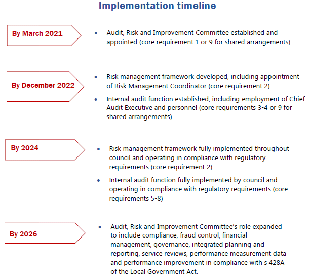
Core Requirements
The discussion paper outlines nine core requirements that
councils will be required to comply with when establishing their Audit, Risk
and Improvement Committee, risk management framework and internal audit
function.
Core requirement 1: Appoint an
independent Audit, Risk and Improvement Committee (must be independent members
from prequalified panel (i.e. no Councillors))
Core requirement 2: Establish a risk
management framework consistent with current Australian risk management
standards
Core requirement 3: Establish an internal
audit function mandated by an Internal Audit Charter
Core requirement 4: Appoint internal
audit personnel and establish reporting lines
Core requirement 5: Develop an agreed
internal audit work program
Core requirement 6: How to perform and
report internal audits
Core requirement 7: Undertake ongoing
monitoring and reporting
Core requirement 8: Establish a quality
assurance and improvement program
Core requirement 9: Councils can
establish shared internal audit arrangements
Key considerations from the
discussion paper
Implications for Joint
Organisation
The framework will apply to
councils, county councils, and joint organisations, meaning that the Northern
Rivers Joint Organisation will be required to have an ARIC. There are potential
opportunities to establish a shared ARIC with the joint organisation and its
member councils.
Implications for Membership
The ARIC is to comprise of three to five independent members who
are prequalified via the NSW Government’s Prequalification Scheme:
Audit and Risk Committee Independent Chairs and Members.
ARIC members and the Chair are to serve a three to five-year term.
A member’s term cannot exceed eight years and the Chair’s term
cannot exceed five years.
All ARIC members must be
independent. To be classified as ‘independent’, a member must be:
1. Free of any relationships that could
be perceived to result in bias or a conflict of interest or interfere with
their ability to act independently.
2. Selected from the panel of
prequalified audit and risk committee independent chairs and members
administered by the NSW Government.
Further details on specific
exclusions and requirements are provided on page 36-37 of Attachment 1, but notably,
under the new regulations Councillors would not be members of the Audit, Risk,
and Improvement Committee.
The discussion paper outlines
recommended fees to be paid to Audit, Risk, and Improvement Committee members,
while noting that members will be able to serve on Audit, Risk, and Improvement
Committees on a voluntary basis. The suggested member fee for a council the
size of Byron Shire is $1,621 per meeting date including preparation time and
$16,213 per annum for the Chair.
The proposed submission response
below includes comment on the membership and fee proposals.
Reporting Lines
ARIC is to have direct and
unrestricted access to the General Manager, senior management and staff and
contractors of the council in order to perform its role. ARIC is also to have
direct and unrestricted access to the council resources and information it needs
to perform its role.
The General Manager is to appoint
a Chief Audit Executive (CAE) to oversee internal audit activities. The CAE is
to report functionally to ARIC and administratively to the GM. In Byron Shire
it is likely that this role would be undertaken by the Director Corporate &
Community Services.
An Annual Assurance Report to the
governing body of the council is to be prepared and be assessed by an external
party at least once each council term.
Implications for Risk Management
Council is required to establish a risk management framework
that is consistent with current Australian standards for risk management which
includes the implementation of a risk management policy, risk management plan
and risk management process.
Council is to fully integrate risk management into its
decision making, operational and integrated planning and reporting processes
and formally assign risk management responsibilities to the GM, senior managers
and other council staff and ensure accountability.
The General Manager is to appoint a Risk Management
Coordinator who will be responsible for the operational activities required to
implement the risk management framework and provide specialist risk management
skills and knowledge. The Risk Management Coordinator will report directly to
the GM or other member of senior management of Council in relation to
Council’s risk management function.
Byron Shire is already well advanced on the path of
establishing an appropriate risk management framework as outlined above and
already has a Risk Management Coordinator.
The risk management framework is to be regularly monitored
and reviewed, with ARIC providing independent assurance of risk management
activities.
The GM is to attest to Council’s compliance with the
risk management requirements in the Annual Report.
Next steps
Submissions to the Office of Local
Government (OLG) are to be made in writing by 31 December 2019. OLG has
suggested consideration of the following questions to inform submissions:
· Will the proposed framework achieve the outcomes sought?
· What challenges do you see for your council when
implementing the proposed framework?
· Does the proposed framework include all important elements
of an effective internal audit and risk framework?
· Is there anything you don’t like about the proposed
framework?
· Can you suggest improvements to the proposed framework?
A submission has been prepared
(Attachment 3 - E2019/83762) in accordance
with the key points of feedback, outlined below:
|
Will the proposed framework
achieve the outcomes sought?
|
· The proposed framework will assist Council to improve its
internal audit and risk management framework, noting that Byron already has a
number of the measures in place
|
|
What challenges do you see
for your council when implementing the proposed framework?
|
· Councillors have a valuable role on ARIC which provides
them with opportunities to understand the audit and risk process and monitor
outcomes. Council believes that to lose this opportunity would be
detrimental
· Sourcing ARIC members that meet the independence and
prequalification requirements may also be a challenge
· Rotating ARIC members when the pool is potentially small
· As proposed the framework creates ambiguity between the
roles, responsibilities, and authority between the administration, elected
body and ARIC. For example: What is the process if Council rejects
recommendations from its ARIC?
|
|
Does the proposed framework
include all important elements of an effective internal audit and risk
framework?
|
· Council considers the proposed framework covers all
important elements of an effective internal audit and risk management
framework
|
|
Is there anything you
don’t like about the proposed framework?
|
· Overall Council is supportive of the proposed framework
and is on track to meet the requirements within the proposed timeframes.
· Council has concerns with the lack of flexibility for
councils to establish membership guidelines that are suitable to individual
locations, organisations and operations.
· Council also has concerns with the proposed extension of
functions of Audit Risk & Improvement Committees, noting that the full
scope is very broad and may prove unmanageable in terms of the amount of work
the ARIC is realistically able to cover. Council already has established
mechanisms to monitor financial management.
|
|
Can you suggest improvements
to the proposed framework?
|
· Council submits that consideration should be given to
creating a sliding scale for payment of fees to ARIC members during the
transition phase, commensurate with the actual functions performed. There is
an expectation that the role of the ARIC will expand over time to cover a
range of functions with full compliance achieved by 2026 but there is no
differentiation in the fees between an established ARIC that is or will be
fully compliant ahead of the proposed timelines and an ARIC that has a
limited focus whilst that council is developing its internal functions in
line with its resources and capabilities.
|
STRATEGIC CONSIDERATIONS
Community Strategic Plan and Operational Plan
|
CSP Objective
|
L2
|
CSP Strategy
|
L3
|
DP Action
|
L4
|
OP Activity
|
|
Community Objective 5: We have community led
decision making which is open and inclusive
|
5.6
|
Manage Council’s resources sustainably
|
5.6.7
|
Develop and embed a proactive risk management
culture
|
5.6.7.4
|
Manage Audit, Risk and Improvement program including
coordinating committee recommendations
|
|
|
|
|
|
|
|
|
|
|
|
|
|
Legal/Statutory/Policy Considerations
The operation of sections 428A and 428B of the Local
Government Act will be supported by new regulations in the Local Government
(General) Regulation 2005.
Financial Considerations
Not applicable at this stage.
Consultation and Engagement
Internal feedback from relevant officers and from the
Executive Team was has informed the proposed submission. Further, the Audit,
Risk and Improvement Committee considered the discussion paper at its 14
November meeting and provided feedback to the draft submission prior to the
report being prepared for Council.
Staff Reports - Corporate and Community Services 13.8
Report No. 13.8 Investments
- 1 November 2019 to 30 November 2019
Directorate: Corporate
and Community Services
Report
Author: James
Brickley, Manager Finance
File No: I2019/1979
Summary:
This report includes a list of investments and identifies
Council’s overall cash position for the period 1 November 2019 to 30
November 2019 for Council’s information.
This report is prepared to comply with Regulation 212 of the
Local Government (General) Regulation 2005.
|
RECOMMENDATION:
That the report listing Council’s
investments and overall cash position as at 30 November 2019 be noted.
|
REPORT
Council has continued to maintain a diversified portfolio of
investments. At 30 November, the average 90 day bank bill rate (BBSW) for the
month of November 2019 was 0.91%.
Council’s performance to 30 November was 1.95%. This is largely due to
the active ongoing management of the investment portfolio, maximising
investment returns through secure term deposits, bonds and purchasing floating
rate notes with attractive interest rates. It should be noted that as
investments mature, Council’s % return will start to decrease due to the
lower rates available in the current market.
The table below identifies the investments held by Council
as at 30 November 2019
Schedule of
Investments held as at 30 November 2019
|
Purch Date
|
Principal ($)
|
Description
|
CP*
|
Rating
|
Maturity Date
|
No Fossil
Fuel
|
Type
|
Interest Rate Per
Annum
|
Current Value
|
|
24/03/17
|
1,000,000
|
NAB Social Bond (Gender Equality)
|
Y
|
AA-
|
24/03/22
|
Y
|
B
|
3.25%
|
1,044,263.16
|
|
15/11/18
|
980,060
|
NSW Treasury Corp (Green Bond)
|
N
|
AAA
|
15/11/28
|
Y
|
B
|
3.00%
|
1,108,880.00
|
|
20/11/18
|
1,018,290
|
QLD Treasury Corp (Green Bond)
|
N
|
AA+
|
22/11/24
|
Y
|
B
|
3.00%
|
1,077,720.00
|
|
28/03/19
|
1,000,000
|
National Housing Finance & Investment
Corporation
|
Y
|
AAA
|
28/03/29
|
Y
|
B
|
2.38%
|
1,062,980.00
|
|
21/11/19
|
1,000,250
|
NSW Treasury Corp (Sustainability Bond)
|
N
|
AAA
|
20/03/25
|
Y
|
B
|
1.25%
|
1,000,250.00
|
|
27/11/19
|
500,000
|
National Housing Finance & Investment
Social Bond
|
N
|
AAA
|
27/05/30
|
Y
|
B
|
1.57%
|
500,000.00
|
|
31/03/17
|
1,000,000
|
CBA Climate Bond
|
Y
|
AA-
|
31/03/22
|
Y
|
FRN
|
3.01%
|
1,008,850.00
|
|
16/11/17
|
750,000
|
Bank of Queensland
|
Y
|
BBB+
|
16/11/21
|
N
|
FRN
|
2.97%
|
753,667.50
|
|
30/08/18
|
500,000
|
Bank Australia Ltd (Sustainability Bond)
|
Y
|
BBB+
|
30/08/21
|
Y
|
FRN
|
3.17%
|
502,795.00
|
|
07/12/18
|
2,000,000
|
Credit Union Australia
|
Y
|
BBB
|
07/12/20
|
Y
|
TD
|
3.02%
|
2,000,000.00
|
|
13/12/18
|
1,000,000
|
Summerland Credit Union
|
Y
|
NR
|
13/12/19
|
Y
|
TD
|
3.01%
|
1,000,000.00
|
|
05/01/19
|
2,000,000
|
NAB
|
N
|
AA-
|
06/01/20
|
N
|
TD
|
2.75%
|
2,000,000.00
|
|
18/01/19
|
1,000,000
|
Westpac
|
Y
|
AA-
|
16/01/20
|
N
|
TD
|
2.73%
|
1,000,000.00
|
|
30/01/19
|
1,000,000
|
Defence Bank
|
Y
|
BBB
|
30/01/20
|
Y
|
TD
|
2.85%
|
1,000,000.00
|
|
04/02/19
|
1,000,000
|
Summerland Credit Union
|
N
|
NR
|
04/02/20
|
Y
|
TD
|
2.95%
|
1,000,000.00
|
|
06/03/19
|
1,000,000
|
Bananacoast Credit Union
|
Y
|
NR
|
04/03/20
|
Y
|
TD
|
2.90%
|
1,000,000.00
|
|
04/06/19
|
2,000,000
|
Beyond Bank Australia
|
Y
|
NR
|
06/12/19
|
Y
|
TD
|
2.40%
|
2,000,000.00
|
|
04/06/19
|
1,000,000
|
AMP Bank
|
Y
|
BBB
|
03/12/19
|
N
|
TD
|
2.45%
|
1,000,000.00
|
|
24/06/19
|
2,000,000
|
NAB
|
N
|
AA-
|
20/01/20
|
N
|
TD
|
1.90%
|
2,000,000.00
|
|
28/06/19
|
2,000,000
|
Bankwest
|
Y
|
AA-
|
27/12/19
|
N
|
TD
|
1.90%
|
2,000,000.00
|
|
28/06/19
|
2,000,000
|
Bank of Queensland
|
N
|
BBB+
|
24/01/20
|
N
|
TD
|
2.10%
|
2,000,000.00
|
|
01/07/19
|
1,000,000
|
Police Credit Union Limited (SA)
|
Y
|
NR
|
03/01/20
|
Y
|
TD
|
2.23%
|
1,000,000.00
|
|
03/07/19
|
1,000,000
|
Australian Military Bank
|
Y
|
NR
|
02/07/20
|
Y
|
TD
|
2.12%
|
1,000,000.00
|
|
04/07/19
|
1,000,000
|
NAB
|
N
|
AA-
|
30/03/20
|
N
|
TD
|
1.95%
|
1,000,000.00
|
|
24/07/19
|
1,000,000
|
Bankwest
|
N
|
AA-
|
24/01/20
|
N
|
TD
|
1.85%
|
1,000,000.00
|
|
30/07/19
|
2,000,000
|
AMP Bank
|
N
|
BBB
|
28/01/20
|
N
|
TD
|
2.20%
|
2,000,000.00
|
|
01/08/19
|
2,000,000
|
NAB
|
N
|
AA-
|
02/12/19
|
N
|
TD
|
1.80%
|
2,000,000.00
|
|
06/08/19
|
2,000,000
|
Bankwest
|
N
|
AA-
|
06/12/19
|
N
|
TD
|
1.70%
|
2,000,000.00
|
|
15/08/19
|
1,000,000
|
Maitland Mutual Building Society
|
Y
|
NR
|
12/02/20
|
Y
|
TD
|
1.78%
|
1,000,000.00
|
|
16/08/19
|
1,000,000
|
ME Bank
|
Y
|
BBB
|
12/02/20
|
Y
|
TD
|
1.73%
|
1,000,000.00
|
|
26/08/19
|
1,000,000
|
Suncorp
|
Y
|
A+
|
21/02/20
|
Y
|
TD
|
1.62%
|
1,000,000.00
|
|
27/08/19
|
2,000,000
|
Bank of Queensland
|
N
|
BBB+
|
27/02/20
|
N
|
TD
|
1.75%
|
2,000,000.00
|
|
27/08/19
|
1,000,000
|
AMP Bank
|
N
|
BBB
|
26/08/20
|
N
|
TD
|
1.80%
|
1,000,000.00
|
|
29/08/19
|
1,000,000
|
Macquarie Bank
|
Y
|
A
|
25/02/20
|
N
|
TD
|
1.80%
|
1,000,000.00
|
|
02/09/19
|
1,000,000
|
Maitland Mutual Building Society
|
N
|
NR
|
02/12/19
|
Y
|
TD
|
1.75%
|
1,000,000.00
|
|
03/09/19
|
2,000,000
|
Macquarie Bank Ltd
|
N
|
A
|
02/03/20
|
N
|
TD
|
1.75%
|
2,000,000.00
|
|
04/09/19
|
1,000,000
|
Australian Military Bank
|
N
|
NR
|
02/03/20
|
Y
|
TD
|
1.70%
|
1,000,000.00
|
|
10/09/19
|
2,000,000
|
NAB
|
N
|
AA-
|
09/12/19
|
N
|
TD
|
1.72%
|
2,000,000.00
|
|
25/09/19
|
1,000,000
|
TCorp Green Deposit
|
N
|
AAA
|
25/03/20
|
N
|
TD
|
1.00%
|
1,000,000.00
|
|
25/09/19
|
2,000,000
|
NAB
|
N
|
AA-
|
24/09/20
|
N
|
TD
|
1.60%
|
2,000,000.00
|
|
30/09/19
|
1,000,000
|
NAB
|
N
|
AA-
|
28/01/20
|
N
|
TD
|
1.68%
|
1,000,000.00
|
|
08/10/19
|
1,000,000
|
NAB
|
N
|
AA-
|
06/04/20
|
N
|
TD
|
1.93%
|
1,000,000.00
|
|
08/10/19
|
1,000,000
|
My State Bank
|
Y
|
NR
|
06/02/20
|
Y
|
TD
|
1.70%
|
1,000,000.00
|
|
21/10/19
|
2,000,000
|
NAB
|
N
|
AA-
|
21/04/20
|
N
|
TD
|
1.57%
|
2,000,000.00
|
|
25/10/19
|
2,000,000
|
NAB
|
N
|
AA-
|
25/02/20
|
N
|
TD
|
1.60%
|
2,000,000.00
|
|
29/10/19
|
1,000,000
|
ME Bank
|
N
|
BBB
|
28/07/20
|
Y
|
TD
|
1.58%
|
1,000,000.00
|
|
30/10/19
|
1,000,000
|
My State Bank
|
N
|
NR
|
29/01/20
|
Y
|
TD
|
1.70%
|
1,000,000.00
|
|
30/10/19
|
2,000,000
|
Macquarie Bank Ltd
|
N
|
A
|
29/04/20
|
N
|
TD
|
1.60%
|
2,000,000.00
|
|
04/11/19
|
1,000,000
|
NAB
|
N
|
AA-
|
03/02/20
|
N
|
TD
|
1.58%
|
1,000,000.00
|
|
06/11/19
|
1,000,001
|
AMP Bank
|
N
|
BBB
|
06/05/20
|
N
|
TD
|
1.75%
|
1,000,001.00
|
|
07/11/19
|
2,000,000
|
NAB
|
N
|
AA-
|
06/04/20
|
N
|
TD
|
1.58%
|
2,000,000.00
|
|
08/11/19
|
2,000,000
|
Suncorp
|
N
|
A
|
04/08/20
|
Y
|
TD
|
1.60%
|
2,000,000.00
|
|
25/11/19
|
1,000,000
|
AMP Bank
|
N
|
BBB
|
25/05/20
|
N
|
TD
|
1.90%
|
1,000,000.00
|
|
27/11/19
|
1,000,000
|
Coastline Credit Union
|
Y
|
NR
|
26/11/20
|
Y
|
TD
|
1.80%
|
1,000,000.00
|
|
28/11/19
|
2,000,000
|
Macquarie Bank Ltd
|
N
|
A
|
12/03/20
|
N
|
TD
|
1.60%
|
2,000,000.00
|
|
N/A
|
706,211.67
|
CBA Business Saver
|
N
|
AA-
|
N/A
|
N
|
CALL
|
1.20%
|
706,211.67
|
|
N/A
|
3,563,370.52
|
NSW Treasury Corp
|
N
|
AAA
|
N/A
|
Y
|
CALL
|
1.30%
|
3,563,370.52
|
|
Total
|
77,018,183.19
|
|
|
|
|
|
AVG
|
1.95%
|
77,328,988.85
|
|
Note 1.
|
CP = Capital protection on maturity
|
|
|
N = No Capital Protection
|
|
|
Y = Fully covered by Government Guarantee
|
|
|
P = Partial Government Guarantee of $250,000 (Financial
Claims Scheme)
|
|
|
|
|
Note 2.
|
No Fossil Fuel ADI
|
|
|
Y = No investment in Fossil Fuels
|
|
|
N = Investment in Fossil Fuels
|
|
|
U = Unknown Status
|
|
Note 3.
|
Type
|
Description
|
|
|
|
B
|
Bonds
|
Principal can vary based on
valuation, interest payable via a fixed interest, payable usually each
quarter.
|
|
|
FRN
|
Floating Rate Note
|
Principal can vary based on
valuation, interest payable via a floating interest rate that varies each
quarter.
|
|
|
TD
|
Term Deposit
|
Principal does not vary during investment term. Interest
payable is fixed at the rate invested for the investment term.
|
|
|
CALL
|
Call Account
|
Principal varies due to cash flow demands from
deposits/withdrawals, interest is payable on the daily balance.
|
Environmental and Socially
Responsible Investing (ESRI)
An additional column has been
added to the schedule of Investments to identify if the financial institution
holding the Council investment has been assessed as a ‘No Fossil
Fuel’ investing institution. This information has been sourced through www.marketforces.org.au
and identifies financial institutions that either invest in fossil fuel related
industries or do not. The graph below highlights the percentage of each
classification across Council’s total investment portfolio in respect of
fossil fuels only.
The notion of Environmental and
Socially Responsible Investing is much broader than whether a financial
institution as rated by ‘marketforces.org.au’ invests in fossil
fuels or not. Council’s current Investment Policy defines Environmental
and Socially Responsible Investing at Section 4.1 of the Policy which can be
found on Council’s website.
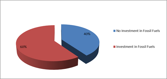
Council has two investments with
financial institutions that invest in fossil fuels but are nevertheless aligned
with the broader definition of Environmental and Socially Responsible
investments i.e.:
1. $1,000,000 investment with the National Australia Bank maturing
on 24 March 2022 known as a Social Bond that promotes Gender Equity.
2. $1,000,000 investment with Commonwealth Bank maturing on 31
March 2022 known as a Climate Bond.
New Environmental and
Socially Responsible Investments (ESRI) November 2019
During November 2019, Council
was able to secure two new ESRI Investments as follows:
1. NSW Treasury Corporation Sustainability Bond. Investment
proceeds for the Sustainability Bond are to be invested into sustainable water
and wastewater projects, a transport access program and the construction of
nine new schools and upgrades to a further 19 schools. Council was able
to secure a $1,000,000 investment in this Bond. The Bond issuance was looking
to raise $1.8billion and firm offers in excess of $2.25billion were received.
2. The National Housing Finance and Investment CorporationSocial
Bond. Investment proceeds are to finance or refinace a protfolio of
assets and projects associated with affordable housing. Council was looking to
secure a $1,000,000 investment in this Bond but was only able to secure
$500,000. The Bond issuance was looking to raise $315million and firm offers of
in excess of $1.235billiob were received.
Investment Policy
Compliance
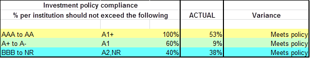
The
above table identifies compliance with Council’s Investment Policy by the
proportion of the investment portfolio invested with financial institutions,
along with their associated credit ratings compared to parameters in the
Investment Policy. The parameters are designed to support prudent short and
long-term management of credit risk and ensure diversification of the
investment portfolio. Note that the financial institutions currently offering
investments in the ‘ethical’ area are still mainly those with lower
credit ratings (being either BBB or not rated at all i.e. credit unions).
Associated Risk
Moving more of the investment portfolio into the
‘ethical’ space will lower the credit quality of the investment
portfolio overall and continue to increase the organisation’s credit risk
(i.e. exposure to potential default). To monitor this issue the
‘Investment Policy Compliance’ table is now produced for each
monthly Investment Report to Council.
The investment portfolio is outlined in the table below by
investment type for the period 1
November 2019 to 30 November 2019:
Dissection
of Council Investment Portfolio as at 30 November 2019
|
Principal Value ($)
|
Investment Linked to:
|
Current Market Value ($)
|
Cumulative Unrealised Gain/(Loss) ($)
|
|
65,000,001.00
|
Term
Deposits
|
65,000,001.00
|
0.00
|
|
2,250,000.00
|
Floating
Rate Note
|
2,265,312.50
|
15,312.50
|
|
706,211.67
|
Business
On-Line Saver (At Call)
|
706,211.67
|
0.00
|
|
3,563,370.52
|
NSW Treasury Corp
(T Corp)
|
3,563,370.52
|
0.00
|
|
5,498,600.00
|
Bonds
|
5,794,093.16
|
295,493.16
|
|
77,018,183.19
|
|
77,328,988.85
|
310,805.66
|
The current value of an investment compared to the principal
value (face value or original purchase price) provides an indication of the
performance of the investment without reference to the coupon (interest) rate. The
current value represents the value received if an investment was sold or traded
in the current market, in addition to the interest received.
The table below provides a reconciliation of investment
purchases and maturities for the period of 1 November 2019 to 30 November 2019
on a current market value basis.
Movement
in Investment Portfolio – 30 November 2019
|
Item
|
Current Market Value (at end of month) $
|
|
Opening
Balance at 1 November 2019
|
77,328,738.85
|
|
Add:
New Investments Purchased
|
11,500,251.00
|
|
Add:
Call Account Additions
|
1,000,000.00
|
|
Add:
Interest from Call Account
|
0.00
|
|
Less:
Investments Matured
|
11,000,001.00
|
|
Add:
T Corp Additions
|
0.00
|
|
Add:
Interest from T Corp
|
0.00
|
|
Less:
Call Account Redemption
|
1,500,000.00
|
|
Less:
T Corp Redemption
|
0.00
|
|
Less:
Fair Value Movement for period
|
0.00
|
|
Closing
Balance at 30 November 2019
|
77,328,988.85
|
Term
Deposit Investments Maturities and Returns – 1 November 2019 to 30
November 2019
|
Principal
Value ($)
|
Description
|
Maturity
Date
|
Number
of Days Invested
|
Interest
Rate Per Annum
|
Interest
Paid on Maturity $
|
|
1,000,001
|
AMP Bank
|
06/11/2019
|
91
|
1.90%
|
4,736.99
|
|
2,000,000
|
Suncorp
|
08/11/2019
|
273
|
2.75%
|
41,136.99
|
|
1,000,000
|
NAB
|
04/11/2019
|
90
|
1.83%
|
4,512.33
|
|
1,000,000
|
AMP Bank
|
25/11/2019
|
182
|
2.45%
|
12,216.44
|
|
2,000,000
|
NAB
|
07/11/2019
|
90
|
1.80%
|
8,876.71
|
|
1,000,000
|
Auswide Bank LTD
|
12/11/2019
|
92
|
2.03%
|
5,116.71
|
|
1,000,000
|
ME Bank
|
13/11/2019
|
91
|
1.78%
|
4,437.81
|
|
2,000,000
|
Macquarie Bank Ltd
|
26/11/2019
|
90
|
1.85%
|
9,123.29
|
|
11,000,001
|
|
|
|
|
90,157.27
|
Council’s overall ‘cash position’ is not
only measured by what funds Council has invested but also by what funds Council
has retained in its consolidated fund or bank account for operational purposes.
In this regard, for the month of November 2019 the table below identifies the
overall cash position of Council as follows:
Dissection
of Council Cash Position as at 30 November 2019
|
Item
|
Principal Value ($)
|
Current Market Value ($)
|
Cumulative Unrealised Gain/(Loss) ($)
|
|
Investments
Portfolio
|
|
|
|
|
Term Deposits
|
65,000,001.00
|
65,000,001.00
|
0.00
|
|
Floating Rate Note
|
2,250,000.00
|
2,265,312.50
|
15,312.50
|
|
Business On-Line
Saver (At Call)
|
706,211.67
|
706,211.67
|
0.00
|
|
NSW Treasury Corp
(T Corp)
|
3,563,370.52
|
3,563,370.52
|
0.00
|
|
Bonds
|
5,498,600.00
|
5,794,093.16
|
295,493.16
|
|
Total Investment
Portfolio
|
77,018,183.19
|
77,328,988.85
|
310,805.66
|
|
|
|
|
|
|
Cash at Bank
|
|
|
|
|
Consolidated Fund
|
4,226,313.82
|
4,226,313.82
|
0.00
|
|
Total Cash at Bank
|
4,226,313.82
|
4,226,313.82
|
0.00
|
|
|
|
|
|
|
Total Cash
Position
|
81,244,497.01
|
81,555,302.67
|
310,805.66
|
STRATEGIC CONSIDERATIONS
|
CSP Objective
|
L2
|
CSP Strategy
|
L3
|
DP Action
|
L4
|
OP Activity
|
|
Community Objective 5: We have community led
decision making which is open and inclusive
|
5.5
|
Manage Council’s finances sustainably
|
5.5.2
|
Ensure the financial integrity and sustainability of
Council through effective planning and reporting systems (SP)
|
5.5.2.5
|
Identification of ethical investment opportunities with
environmental and social inclusion outcomes
|
|
|
|
|
|
|
|
|
|
|
|
|
|
Legal/Statutory/Policy Considerations
In accordance with Regulation 212 of the Local Government
(General) Regulation 2005, the Responsible Accounting Officer of Council
must provide Council with a monthly report detailing all monies Council has
invested under section 625 of the Local Government Act 1993.
The Report must be presented at the next Ordinary Meeting of
Council after the end of the month being reported. The current Council Meeting
cycle does not always allow this to occur, especially as investment valuations
required for the preparation of the report are often received after the
deadline for the submission of reports. Endeavours are being made to achieve a
better alignment and for some months this will require reporting for one or
more months.
Council’s investments are made in accordance with
section 625(2) of the Local Government Act 1993 and Council’s
Investment Policy. The Local Government Act 1993 allows Council to
invest money as per the Minister’s Order – Forms of Investment,
last published in the Government Gazette on 11 February 2011.
Council’s Investment Policy includes the objective of
maximising earnings from authorised investments and ensuring the security of
Council Funds.
Financial
Considerations
Council uses a diversified mix of investments to achieve
short, medium and long-term results.
Staff Reports - Sustainable Environment and Economy 13.9
Staff Reports - Sustainable Environment and
Economy
Report No. 13.9 Sustainable
Visitation Strategy - Project update
Directorate: Sustainable
Environment and Economy
Report
Author: Sarah
Workman, Tourism Officer
Lisa Richards, Tourism Officer
File No: I2019/905
Summary:
Council is currently finalising a draft Byron Shire
Sustainable Visitation Strategy 2020-2030 (SVS) which is based on research and
engagement from the community, visitors, stakeholders and industry and aims to
establish Byron Shire as a leading sustainable tourism destination.
It is written in line with the Global Sustainable Tourism
Council’s destination criteria for sustainable tourism, recognising the
impacts visitation has on our environment and the community whilst also
supporting our tourism economy. This new approach to Strategy development sees
Council looking to the future of tourism in the Shire for the next ten years
and valuing what our community see as priorities.
The following report provides an update on the Sustainable
Visitation Strategy.
|
RECOMMENDATION:
That Council note the staff update on the Byron
Shire 2020 – 2030 Sustainable Visitation Strategy.
|
REPORT
Council is currently finalising a draft Byron Shire
Sustainable Visitation Strategy 2020-2030 (SVS) which is based on research and
engagement from the community, visitors, stakeholders and industry and aims to
establish Byron Shire as a leading sustainable tourism destination.
This report provides an outline of the following work
completed to date:
1. The
research and engagement undertaken to develop the strategy
2. Development
of a SVS framework and vision
3. Revised
project timeline and next steps
Web link:
https://www.byron.nsw.gov.au/Business/Business-in-Byron/Tourism/Talking-Future-Tourism-Sustainable-Visitation-Strategy-2020-2030
Research and Engagement
The following outlines the primary and secondary research
conducted to inform the strategy, which occurred from February to August 2019.
Primary Research and Engagement:
1. Talking
Future Tourism Kitchen Table Handbook and Discussions
a. 11
facilitated community sessions
b. 1200
individual responses received from community members
2. Visitor
Focus Groups
a. 3
focus groups held
b. Topics
reflected content in the kitchen table handbook
3. Stakeholder
Interviews
a. 20
interviews held with Council staff impacted by the visitor economy
4. Byron
Shire Accommodation Audit
a. An
audit of accommodation and capacity was conducted
5. Byron
Shire Tourism Product Audit
a. An
audit of tourism attractions, restaurants, wellness centres and activities were
undertaken.
6. Community
Solutions Panel
a. A
group of 26 randomly selected residents and/or ratepayers met over three
weekends to discuss the following – what actions can Council take to
align visitor behaviour with community values?
Secondary Research:
1. Tourism
Research Australia – National and International Visitor Surveys
2. ID
Profile – Byron Shire Economic Profile
3. Tourism
reports from other Local Government Areas including Waverly, Noosa, Blue
Mountains, Kangaroo Island and Shoalhaven.
4. Future
tourism trends and case studies.
Values and Principles from Engagement
The following values and principles as expressed by our
community through the engagement process will underpin the SVS vision,
strategies and actions.
1. Respect
of community, nature, others and self
2. Appreciation
of culture, nature and social diversity
3. Conservation
of the natural environment and biodiversity
4. Welcoming
all and acceptance of diversity
5. Balance
between economy, society, culture and environment
6. Acceptance
of indigenous, historical and spiritual cultures
7. Live
in harmony and safety
8. Work
life balance that embrace activity and healthy and sustainable lifestyles
9. Embracing
education, innovation and enlightenment
10. Balance between the
laid-back and relaxed lifestyle with the engaged activism.
The research and feedback from the engagement is being
incorporated into the draft SVS to be presented to Council at its meeting in
February 2020.
Sustainable Visitation Strategy Framework – Summary
The SVS is divided into four key areas, which covers
background information, the Byron Shire community profile, tourism facts and
figures, key themes and the action plan. A summary of the SVS contents page is
provided below.
SECTION 1- Sustainable Tourism and the Sustainable
Visitation Strategy
1.1 Introduction
1.2 Our
Vision
1.3 Key
Changes to the Byron Shire Visitor Economy
1.4 Tourism
Management Plan 2008-2018 Achievements
1.5 Preparing
for the Next Ten Years- Sustainable Tourism and Our Byron Shire Sustainable
Visitation Strategy
1.6 What
is the Global Sustainable Tourism Council?
1.7 Engagement
and Research for Informing the Strategy
SECTION 2- Byron Shire Profile
2.1 Our
People and Our Land
2.2 Community
Profile
2.3 Community
Values and Guiding Principles
2.4 Government
Legislation, Regulations and Activities
SECTION 3- Sustainable Tourism in Byron Shire
3.1 Tourism
Facts and Figures
3.2 Accommodation
Summary
3.3 Tourism
Product Inventory
3.4 Emerging
Trends and Drivers of Change
SECTION 4 Sustainable Visitation Strategy Themes:
1. Leadership
and Coordination
2. Funding
3. Marketing
4. Culture
5. Events
6. Environment
7. Transport,
Infrastructure and Open Spaces
8. Planning
Example of how each section will be
laid out:
SECTION 4.1 –
Leadership and Coordination
4.1.1 Background and
Engagement
4.1.2 Case studies
4.1.3 Case study learnings
for Byron Shire
4.1.4 Strategies
4.1.5 Actions
4.1.6 GSTC Compliance
Criteria
4.8.4 Strategies
4.8.5 Actions
4.8.6 GSTC Compliance
Criteria
SECTION 5 - ACTION PLAN
SVS Vision
To ensure the SVS is written in full collaboration with the
community, engagement is underway to develop the vision for the SVS. The
community is providing feedback through Bang the Table and awareness is being
raised through Council’s website and social media channels. Feedback
closes on 20 December 2019 and this feedback will be used to present the SVS
vision to Council in February 2020.
A link to community call-out for feedback on the visions statement
for the SVS is below:
https://www.yoursaybyronshire.com.au/talking-future-tourism
One example vision developed through a recent Councillor
workshop with staff follows:
Byron Shire supports a visitor economy that cares for and
respects our residents, protects our natural environment, celebrates our
cultural diversity and shares our social values.
Next steps
The following table shows the
key timelines for the SVS.
|
Task
|
Delivery
|
|
Community engagement on the SVS vision
|
28 November to 20 December 2019
|
|
SVS draft considered by Council and approval provided to
proceed to public exhibition
|
February 2020
|
|
SVS on public exhibition
|
February/March 2020
|
|
Final draft SVS considered by Council and adopted
|
May 2020
|
STRATEGIC CONSIDERATIONS
Community Strategic Plan and
Operational Plan
|
CSP Objective
|
L2
|
CSP Strategy
|
L3
|
DP Action
|
L4
|
OP Activity
|
|
Community Objective 4: We manage growth and
change responsibly
|
4.4
|
Promote and support local business development, education
and employment opportunities
|
4.4.1
|
Build a tourism industry that delivers local and regional
benefits in line with the community’s values
|
4.4.1.1
|
Develop a new Byron Shire Sustainable Visitation Plan
|
Legal/Statutory/Policy
Considerations
Planning, Environment and Local
Government legislation.
Financial Considerations
Funded within existing operational
budget.
Consultation and Engagement
Consultation and engagement
provided in body of report.
Staff Reports - Sustainable Environment and Economy 13.10
Report No. 13.10 Climate
Emergency Response - update on Resolution 19-341
Directorate: Sustainable
Environment and Economy
Report
Author: Sharyn
French, Manager Environmental and Economic Planning
File No: I2019/1489
Summary:
Council resolved (Res.
19-341) at its Ordinary Meeting 27 June 2019 the following matters in
relation to Council’s Climate Emergency Response. This report
accords with item vii of this resolution to ‘report to Council on
the outcome of actions (i-vi) in December 2019’.
1. That
Council note the report Byron Shire Climate Emergency Response.
2. That
Council endorse the following actions as the result of the report:
i. Include an
action in the Operational Plan FY2019/20 about a ‘Climate Emergency
Plan’;
ii. Hold
a facilitated workshop between Councillors and the Executive Team to better
understand and articulate what ‘climate emergency’ means in the
Byron Shire context, and available mechanisms and resourcing for stronger
action;
iii. Establish
a Climate Emergency Cluster Group as defined in the body of the report;
iv. Undertake
a review of relevant climate policy and literature to establish an
overarching framework for attracting grant funding and developing and
delivering climate adaptation projects;
v. In
concert with item (iv) undertake a review of all Council programs to ensure
alignment with our Climate Emergency commitment;
vi. Request ADAPT NSW to deliver
Council and community workshops on ADAPT NSW/NCERA workshop outcomes; and
vii. Report to Council on
the outcome of actions (i-vi) in December 2019.
3. That
the Climate Emergency Group continues its role as a subgroup of the SERAC and
provides representation to the Climate Emergency Cluster Group.
|
RECOMMENDATION:
1. That
Council note the response to items 2.iv &.v of resolution
19-341 which includes a gap analysis of Council programs in Attachment 2 (E2019/86487),
which will be further developed to inform the proposed Action Tank workshop.
2. That
Council request staff to convene an Action Tank workshop
in the new year to advance the development of the Climate
Change Adaptation Plan to be reported to Council within six months of the
workshop.
3. That
Council fund the Action Tank Workshop and development of the Climate
Change Adaptation Plan by allocating $60,000 from the Land and Natural
Environment Reserve.
|
Attachments:
1 Climate
Emergency Workshop outcomes, 6 September 2019, E2019/67841 
2 Response
to item 2.iv & v of resolution 19-341 for Report to Council Meeting 12 Dec
2019, E2019/86487
REPORT
Council at the 27 June 2019
meeting resolved:
Resolution
19-341:
1. That
Council note the report Byron Shire Climate Emergency Response.
2. That
Council endorse the following actions as the result of the report:
i. Include an
action in the Operational Plan FY2019/20 about a ‘Climate Emergency
Plan’;
ii. Hold
a facilitated workshop between Councillors and the Executive Team to better
understand and articulate what ‘climate emergency’ means in the
Byron Shire context, and available mechanisms and resourcing for stronger
action;
iii. Establish
a Climate Emergency Cluster Group as defined in the body of the report;
iv. Undertake
a review of relevant climate policy and literature to establish an
overarching framework for attracting grant funding and developing and
delivering climate adaptation projects;
v. In
concert with item (iv) undertake a review of all Council programs to ensure
alignment with our Climate Emergency commitment;
vi. Request ADAPT NSW to deliver
Council and community workshops on ADAPT NSW/NCERA workshop outcomes; and
vii. Report to Council on
the outcome of actions (i-vi) in December 2019.
3. That
the Climate Emergency Group continues its role as a subgroup of the SERAC and
provides representation to the Climate Emergency Cluster Group.
This report provides an update on
item 2 parts i-vi.
2(i) Include
an action in the Operational Plan FY2019/20 about a ‘Climate Emergency
Plan’
Complete - action has been
included in the OP.
2 (ii) Hold a facilitated workshop between Councillors
and the Executive Team to better understand and articulate what ‘climate
emergency’ means in the Byron Shire context, and available mechanisms and
resourcing for stronger action
The workshop was held on 6
September 2019 and was proceeded by a presentation open to the public by Dr
Joelle Gergis, Senior Lecturer in Climate Science at Australian National
University.
Dr Gergis is an internationally-recognised
climate scientist in Australian and Southern Hemisphere climate variability and
member of the Climate Council, who spoke about the latest reports, climate
science and what it means to communities like Byron Shire.
The Councillor and staff workshop
considered what other councils’ are doing regarding climate emergency,
the ADAPT NSW North Coast Enabling Regional Adaptation report (NERA), what
climate emergency means and the areas in which council can have the most impact
out of the nine regional systems identified in NERA:
1. Settlements and land-use planning
2. Resilient communities
3. Cultural heritage
4. Biodiversity
5. Emergency management
6. Food and agriculture
7. Infrastructure and water
8. Energy
9. Tourism
Attachment 1 includes the workshop
outcomes which will be used to inform the proposed Action Tank workshop in the
New Year.
2(iii) Establish a Climate Emergency Cluster
Group as defined in the body of the report
The formation of a Cluster Group
was discussed at the above facilitated workshop and it was decided that the
role of the cluster group would be to participate in an Action Tank two to
three day enquiry by design style facilitated workshop to provide recommendations
and feasible actions to Council to inform our Climate Change Adaptation Plan to
be delivered within 6 months.
Potential participants were
identified to be invited to this workshop, Attachment 1.
The role of the Cluster Group and the outcome of the enquiry
by design Action Tank workshop is to:
1. Participate
in an Action Tank to provide recommendations and feasible actions to Council
for our Climate Emergency Response
2. Coordinate actions between Council and
Community
3. Deliver a Climate Change Adaptation
Plan to Council in the next six months
2(iv) Undertake a review of relevant climate policy
and literature to establish an overarching framework for attracting grant
funding and developing and delivering climate adaptation projects
2(v) In concert with item (iv) undertake a review of
all Council programs to ensure alignment with our Climate Emergency commitment
Attachment 2 reviewed
international and national climate emergency frameworks and found that there
are varied approaches depending on their needs.
In NSW the only designated climate
change fund is from ADAPT NSW for projects that are included in or consistent
with the pathways identified in the North Coast Enabling Regional Adaptation
report.
Attachment 2 also provides a gap
analysis of applicable Council programs including strategies, polices and
plans, some of which directly deal with the issue of climate change and others
indirectly. The gap analysis found that approximately 50% of council programs
addressed mitigation while 6% dealt with adaptation directly.
This information will inform
further investigations into our climate plan at the proposed Action Tank
workshop in the New Year.
2(vi) Request ADAPT NSW to
deliver Council and community workshops on ADAPT NSW/NCERA workshop outcomes
NSW Adapt internal staff workshop
was successfully held on 16 October 2019. Council staff and
Councillors were presented with information on the climate change projects for
Byron Shire and the North Coast Enabling Regional Adaptation report.
This was followed by a lively
Q&A session and two interactive activities – Prioritised pathways for
Byron Shire Council (discuss pathways likely to move the system towards 2050
for Byron Shire Council LGA) and Adaptation solutions (formulate transition projects
that occur along the transition pathways).
An evening community information
session was then run by Malcolm and Stephen, updating the community on the same
report, as well as providing useful advice to community members on what they
can do as individuals.
Malcolm Robertson, Senior Project
Officer, Climate Resilience and Net Zero Emissions team, NSW Department of
Planning, Industry and Environment.
Dr Stephen Bygrave, Director
Climate Resilience and Net Zero Emissions, NSW Department of Planning, Industry
and Environment.
STRATEGIC CONSIDERATIONS
Community Strategic Plan and
Operational Plan
|
CSP Objective
|
L2
|
CSP Strategy
|
L3
|
DP Action
|
L4
|
OP Activity
|
|
Community
Objective 3: We protect and enhance our natural environment
|
3.2
|
Strive to
become a sustainable community
|
3.2.1
|
Work towards
Council's zero-emissions target
|
3.2.1.6
|
Develop a
Climate Emergency Plan
|
|
|
|
|
|
|
|
|
|
|
|
|
|
|
|
|
Legal/Statutory/Policy Considerations
Nil
Financial Considerations
The two to three day facilitated Action Tank workshop to provide recommendations and feasible actions to Council,
and the preparation of our Climate Change Adaptation Plan within 6 months of the
workshop is expected to cost $60,000. It is proposed that these funds
come from the Land and Natural Environment reserve.
Staff Reports - Sustainable Environment and Economy 13.11
Report No. 13.11 Review
of Affordable Rental Housing (Res 19-233)
Directorate: Sustainable
Environment and Economy
Report
Author: Kylie
Grainey, Business Improvement Officer
File No: I2019/1120
Summary:
Council resolved on 23 May 2019 (Resolution 19-233)
that staff prepare a report for Council consideration on the following:
a) the
number and type of developments approved under the State Environmental Planning
Policy (Affordable Rental Housing) 2009 since this Policy came into effect; and
b) where
able, the status of compliance these developments have with post approval
requirements for affordable housing imposed by Council on development consents
including current rental costs.
This report outlines the developments issued and where
possible the status of compliance with the SEPP.
|
RECOMMENDATION:
That Council note the staff report on Review of
Affordable Housing in response to Resolution 19-233.
|
REPORT
State Environmental Planning Policy (Affordable Rental
Housing) 2009 commenced 31 July 2009. The
policy’s intent was to facilitate the increase in supply and diversity of
affordable rental and social housing. Numerous amendments to the original SEPP
have occurred since. These can be reviewed in the Historical Notes
section of the NSW Legislation website.
The majority of development
consents issued under the Affordable Rental Housing SEPP have been for Secondary
Dwellings. There have been consents issued other for affordable housing
developments under the legislation for boarding houses, group homes and
residential units. These are discussed below.
Development Applications
issued under SEPP
|
10.2010.603.1
|
Neighbourhood shops and
affordable housing development including central pedestrian plaza, perimeter
vehicle access and car parking, a restaurant, a food shop, four neighbourhood
shops and 15 residential units.
|
|
9-13 Clifford Street Suffolk
Park Approved
25 August 2011
|
|
Approval granted with conditions 2, 31, 42:
2) Affordable
Rental Housing
Units 5, 6 and 7 to be used for
the purposes of affordable housing will be used for the purposes of
affordable housing for a minimum period of 10 years from the date of the
issue of the Occupation Certificate. The three units are to be managed by a
community housing provider with such detail to be submitted to Council prior
to the issue of the Occupation
Certificate.
31) Affordable Rental Housing
A
Section 88E Instrument, benefitting Byron Shire Council, to be registered on
the title of the land prior to the issue of the Occupation Certificate
requiring:
· Units 5, 6 and 7 to be used for
the purposes of affordable rental housing in accordance with SEPP (Affordable
Rental Housing) 2009 for a minimum period of 10 years from the date of the
issue of the Occupation Certificate ; and
· that the three units are to be
managed by a registered community housing provider.
Details demonstrating the S88E
instrument have been registered to be submitted to the PCA.
42) Affordable Rental Housing
Units 5, 6 and 7 to be used for
the purposes of affordable housing In accordance with Clause 17 of SEPP
(Affordable Rental Housing) 2009 for a minimum period of 10 years from the
date of the issue of the Occupation Certificate. The three units are to be
managed by a registered community housing provider.
|
|
Development not commenced.
|
|
16.2013.9.1
|
Group Home
|
|
14 Bangalow Road, Byron Bay Approved
22 January 2013
|
|
This Complying Development
Certificate was issued by a Private Certifier.
Approval was granted as a Permanent
group home means a dwelling:
(a) that is occupied by persons
as a single household with or without paid supervision or care and whether or
not those persons are related or payment for board and lodging is required,
and
(b) that is used to provide
permanent household accommodation for people with a disability or people who
are socially disadvantaged,
|
|
The property is owned by
Community Housing Provider, North Coast Community Housing.
Approval as a permanent group
home has no ongoing requirements for affordable housing.
|
|
16.2013.82.1
|
Group Home
|
|
41 Rajah Road Ocean Shores Approved
29 November 2013
|
|
This Complying Development
Certificate was issued by a Private Certifier.
Approval was granted as a Permanent
group home means a dwelling:
(a) that is occupied by persons
as a single household with or without paid supervision or care and whether or
not those persons are related or payment for board and lodging is required,
and
(b) that is used to provide
permanent household accommodation for people with a disability or people who
are socially disadvantaged,
|
|
The property is owned by
Community Housing Provider, On Track Community Programs.
Approval as a permanent group
home has no ongoing requirements for affordable housing.
|
|
10.2013.584.1
|
Conversion and expansion of
existing dwelling to create a transitional home, under the Affordable Rental
Housing SEPP, including new carpark and disabled access provisions
|
|
60B Kingsvale Road
Myocum Approved
1 May 2014
|
|
Approval was granted as a Transitional
Group home, meaning a dwelling:
(a) that
is occupied by persons as single household with or without paid supervision
or care and whether or not those persons are related or payment for board and
lodging is required, and
(b) that
is used to provide temporary accommodation for the relief or rehabilitation
of people with a disability or for drug or alcohol rehabilitation purposes,
or that is used to provide half-way accommodation for persons formerly living
in institutions or temporary accommodation comprising refuges for men, women
or young people
|
|
Approval as a transitional group
home has no ongoing requirements for affordable housing.
|
|
10.2014.157.1
|
Two boarding houses each
containing nine accommodation units and one managers residence
|
|
18 Sunrise Boulevard Byron
Bay Approved
2 April 2014
|
|
Development granted for a
boarding house comprising a total of 20 x 1 bedroom units. Two of these units
are to be allocated to onsite managers, and a further two units are to single
storey wheelchair accessible. The remaining 16 units are for residents and
designed in a compact two storey “A” frame style with a small ground
floor kitchen, living and storage area and an upper level bedroom and
ensuite. The units have a floor area of 28 m2 and are to be clad in timber
and masonry grooved weatherboards with a colourbond roof. Eight car parking
spaces are proposed including two disabled spaces, four motorbike spaces and
8 spaces for pushbikes.
Consent was conditioned:
36) Use of Boarding House
The boarding house to:
a) Accommodate no more than 2
tenants per room
b) Not to be used for holiday
letting, tourist and visitor accommodation or as a backpackers
c) To have a lease arrangement
with tenants for a minimum period of 6 months or more
d) Have a manager onsite at all
times.
e) Operate in accordance
with the Management Plan prepared by Boston Blyth Flemming – Town Planners
dated March 2014. Any Conditions of this consent which are inconsistent with
the Plan will prevail over the Plan.
f) A sign with an
area no greater than 0.5m2 to be sited at the front of the premises advising
the public and prospective tenants of the managers contact details. This is
to include a 24 hour phone number for emergencies and complaints.
g) Residents within 100
metres for the boarding house in Sunrise Court and Cape Court to be contacted
by way of a letter box drop of the contact details of the managers for
emergency purposes and complaints.
37) State Tax Exemption
Details
to be submitted to Byron Shire Council demonstrating the boarding house is
charging rents below the Office of State Revenues affordable rental
benchmarks for boarding houses. Such details to be provided annually to
Councils Section 94 Officer to ensure the Boarding house is providing
affordable rental housing.
|
|
An occupation certificate 15.2014.157.1 was issued by a
Private Certifier on 7 July 2015.
Compliance with consent conditions 36 and 37:
36. Approval
as a boarding house has no ongoing requirements for affordable housing,
although the land owner has confirmed that items A-G above will continue to
be managed by the appointed manager and real estate.
37. Council
has received copies of Statutory Declarations provided to the Department of
Family & Community confirming rental rates charged over the past three
years.
|
|
10.2015.182.1
|
Change of use from two
boarding houses containing nine rooms and managers residence to eighteen
infill affordable dwellings and two managers dwellings
|
|
18 Sunrise Boulevard Byron
Bay Approved
9 June 2015
|
|
The application was to change the use by definition under
the SEPP Affordable Rental Housing 2009. It did not involve any changes to
the built form nor intensity of development on the site.
The description changed from ‘Boarding House’
to ‘Infill Affordable Housing’ relating to 10.2014.157.1 above.
Contributions were not payable
whilst ever four of the units are used permanently used for the provision of
affordable housing as defined by clause 6 of State Environmental Planning
Policy (Affordable Rental Housing) 2009.
Should the
development cease to be used for affordable housing then all contributions
owing under this condition shall become payable and shall be indexed to the
date of payment.
Condition 8 stated
8) S.88E Restriction to be
placed on title – Affordable Housing for 10 years
A
restriction will be registered, before the date of the issue of the
occupation certificate, against the title of the property on which
development is to be carried out, in accordance with section 88E of the Conveyancing Act 1919 that will ensure that the following requirements are
met.
For 10
years from the date of the issue of the occupation certificate:
(i) the four dwellings proposed
to be used for the purposes of affordable housing will be used for the
purposes of affordable housing, and
(ii) all accommodation that
is used for affordable housing will be managed by a registered community
housing provider.
Please note: Documents
requiring the endorsement of Council associated with the creation or
cancellation of easements, restrictions, covenants are subject to fees listed
within Council’s Fees & Charges.
|
|
No occupation certificate has been issued for this
development, contributions have not been paid, and there is no evidence that
a restriction has been placed on the title as per Condition 8.
The DA will lapse 9 June 2020.
|
|
10.2018.498.1
|
Alterations and additions to
an approved boarding house – two (2) new boarding rooms and conversion
of one (1) manager’s suite to a boarding room (total 22 rooms).
|
|
18 Sunrise Boulevard Byron
Bay Approved
30 May 2019
|
|
This application sought approval for alterations and
additions to an approved boarding house – two (2) new boarding rooms
and conversion of one (1) manager’s suite to a boarding room (total 22
rooms).
This will result in a total increase in boarding rooms
from 18 to 21 and reduce the number of manager’s rooms from 2 to
1.
Conditions 26 and 27 (to be complied with at all times)
were imposed.
26 Use of Boarding House
The boarding house to:
a) Accommodate
no more than 2 tenants per room
b) Not
to be used for holiday letting, tourist and visitor accommodation or as a
backpackers
c) To
have a lease arrangement with tenants for a minimum period of 6 months or
more
d) Have
a manager onsite at all times.
e) Operate
in accordance with the Management Plan prepared by Boston Blyth Flemming
– Town Planners dated March 2014 and as amended in accordance with this
Consent. Any Conditions of this consent which are inconsistent with the Plan
will prevail over the Plan.
f) A
sign with an area no greater than 0.5m2 to be sited at the front
of the premises advising the public and prospective tenants of the managers
contact details. This is to include a 24 hour phone number for emergencies
and complaints.
g) Residents
within 100 metres for the boarding house in Sunrise Court and Cape Court to
be contacted by way of a letter box drop of the contact details of the
managers for emergency purposes and complaints.
27 State Tax Exemption
Details to be submitted to Byron
Shire Council demonstrating the boarding house is charging rents below the
Office of State Revenues affordable rental benchmarks for boarding houses.
Such details to be provided annually to Councils Section 94 Officer to ensure
the Boarding house is providing affordable rental housing.
|
|
A Construction Certificate has not been issued for these
works.
|
|
10.2015.624.1
|
Affordable Rental Housing:
Multi Dwelling Housing
|
|
22 Sunrise Boulevard Byron
Bay Approved
13 January 2016
|
|
SEPP ARH required that Council condition the development
to ensure that an appropriate part of the development is retained for
affordable housing purposes for at least 10 years. The Department of Planning
Circular Supporting infill affordable rental housing
(August 2014) suggests that 20% to 50% of the total floor are is an appropriate
part of the development for this purpose.
Condition 33 required a
restriction be placed on title.
33) S.88E
Restriction to be placed on title – Affordable Housing for 10 years
A
restriction will be registered, before the date of the issue of the
occupation certificate, against the title of the property on which
development is to be carried out, in accordance with section 88E of the
Conveyancing Act 1919, which will ensure that the following requirements are
met.
For
10 years from the date of the issue of the occupation certificate:
(i) the two dwellings proposed
to be used for the purposes of affordable housing will be used for the
purposes of affordable housing, and
(ii) all accommodation that
is used for affordable housing will be managed by a registered community
housing provider.
Please
note: Documents requiring the endorsement of Council associated with the
creation or cancellation of easements, restrictions, covenants are subject to
fees listed within Council’s Fees & Charges.
|
|
Notification of registration of
the Restriction to User was received on 9 March 2017 over units 6 and 7.
|
|
10.2015.398.1 and 2
|
Multi dwelling housing -12
dwellings
|
|
1 Kendall Street, Byron Bay Approved
19 October 2015
|
|
The application sort development consent for the erection
of a two (2) storey multi dwelling housing development containing twelve (12)
attached dwellings.
Conditions were imposed in the determination to require
the provision of all twelve (12) dwellings as affordable housing and for the
housing to be managed by a social/community housing provider (as defined
under Part 1 Clause 6 of SEPP (Affordable Rental Housing) 2009. The applicant
advised in writing that they were willing to accept a condition of consent to
provide affordable rental housing as specified above.
Modification 10.2015.398.2 approved on 8 December 2015
modified the number of dwellings to be used as affordable housing from 12 to
2.
Condition 3 now reads:
3) Provision
of Affordable Housing
For ten (10) years from the date
of the issue of an Occupation Certificate for the subject development two (2)
dwellings are to be used only for the purposes of ‘affordable
housing’ (as defined in the Environmental Planning and Assessment
Act 1979 and State Environmental Planning Policy [Affordable Rental
Housing] 2009), and these dwellings are to be managed by a registered
community housing provider (registered community housing provider has
the same meaning as in the Housing Act 2001).
|
|
An Occupation Certificate was
issued by a Private Certifier on 5 May 2017.
Two units have been allocated
for the purpose of ‘affordable housing’.
|
|
10.2016.189.1
|
Multi Dwelling Housing
Development under the State Environmental Planning Policy (Affordable Rental
Housing) 2009, Comprising Eight (8) Dwellings, Parking for Four (4) Vehicles
and Demolition of Existing Structures
|
|
116 Stuart Street,
Mullumbimby (Court)
Approved 1 February 2017
|
|
Court
approval, condition 3) states:
3) Provision of Affordable
Housing
From the date of the issue of an Occupation Certificate for the subject
development two (2) dwellings are to be used only for the purposes of
‘affordable housing’ (as defined in the Environmental Planning and Assessment Act 1979 and State Environmental Planning Policy
[Affordable Rental Housing] 2009), and these dwellings are to be managed by a registered community housing provider (registered
community housing provider has the same meaning as in the Housing Act 2001).
|
|
An Occupation Certificate was
issued by a Private Certifier on 20 January 2019.
Dwellings 6 and 8 have been
allocated for the purposes as ‘affordable housing’ and are
managed by a Community Housing Provider. Council has been provided with a
copy of the lease agreements.
|
|
10.2017.474.1
|
Multi Dwelling Housing
Consisting of Twenty Five (25) 1 Bedroom Dwellings (Under the Provisions of
the State Environmental Planning Policy (Affordable Rental Housing) 2009):
Infill Affordable Housing
|
|
70 Station Street,
Mullumbimby Approved
22 February 2018
|
|
Council
owned, managed by North Coast Community Housing. Condition 2 requires:
1. Provision
of Affordable Housing
i. From the date
of the issue of an Occupation Certificate for Stage 1 of the subject
development, four (4) dwellings in Stage 1 are to be used only for the
purposes of ‘affordable housing’ (as defined in the Environmental
Planning and Assessment Act 1979 and State Environmental Planning
Policy [Affordable Rental Housing] 2009), and these dwellings are to be
managed by a registered community housing provider (registered community
housing provider has the same meaning as in the Housing Act 2001).
ii. From the date
of the issue of an Occupation Certificate for Stage 2 of the subject
development, two (2) dwellings in Stage 1 are to be used only for the
purposes of ‘affordable housing’ (as defined in the Environmental
Planning and Assessment Act 1979 and State Environmental Planning
Policy [Affordable Rental Housing] 2009), and these dwellings are to be
managed by a registered community housing provider (registered community
housing provider has the same meaning as in the Housing Act 2001).
A
restriction will be registered, before the date of the issue of the
occupation certificate for each stage, against the title of the property, in
accordance with section 88E of the Conveyancing Act 1919,
that will ensure that these requirements of Conditions 4(i) and 4 (ii) are
met.
|
|
A Construction Certificate has
not been issued.
|
STRATEGIC CONSIDERATIONS
Community Strategic Plan and
Operational Plan
|
CSP Objective
|
L2
|
CSP Strategy
|
L3
|
DP Action
|
L4
|
OP Activity
|
|
Community Objective
4: We manage growth and change responsibly
|
4.2
|
Support
housing diversity in appropriate locations across the Shire
|
4.2.1
|
Establish
planning mechanisms to support housing that meets the needs of our community
|
4.2.1.4
|
Investigate and
implement planning controls to encourage an increase in the supply of
affordable and inclusive housing stock (Action in Residential Strategy)
|
Legal/Statutory/Policy
Considerations
Compliance with the requirements of the Affordable Housing
Rental State Environmental Planning Policy 2009 and any associated development
consent required.
Financial Considerations
N/A
Consultation and Engagement
N/A
Staff Reports - Sustainable Environment and Economy 13.13
Report No. 13.12 PLANNING
- Development Application 10.2018.307.1 - Alterations and additions to
dwelling, new artists studio and boundary adjustment
Directorate: Sustainable
Environment and Economy
Report
Author: Ben
Grant, Planner
File No: I2019/1821
|
DA No:
|
10.2018.307.1
|
|
Proposal description:
|
Alterations and Additions to Existing Dwelling House, New
Expanded Dwelling Module, New Artists Studio and Boundary Adjustment
|
|
Property description:
|
LOT: 3 DP: 601327, LOT: 2 DP: 580115
|
|
286 Mafeking Road GOONENGERRY, 300 Mafeking Road
GOONENGERRY
|
|
Parcel No/s:
|
47100, 47090
|
|
Applicant:
|
Matt Walker Town Planning
|
|
Owner:
|
Mr N & Mrs R M Peterson
|
|
Zoning:
|
DM Deferred Matter
|
|
Date received:
|
27 June 2018
|
|
Integrated Development:
|
Yes: Bush Fire Safety Authority under S100B Rural Fires
Act 1997
|
|
Public notification or exhibition:
|
- Level
1 advertising under DCP 2014 Part A14 – Public Notification and
Exhibition of Development Applications
- Exhibition
period: 6/7/18 to 19/7/18
- Submissions received:
Nil
|
|
Planning Review Committee:
|
Not applicable
|
|
Other approvals (S68/138):
|
Not applicable
|
|
Delegation to determination:
|
Council (SEPP 1 objection >10% of development standard)
|
|
Issues:
|
· Bushfire Prone
Land.
· Biodiversity -
development requires entry into the biodiversity offsets scheme.
· Variation to
minimum lot size under clause 11 of LEP 1988 for boundary adjustment.
|
Summary:
This development application seeks consent for alterations
and additions to an existing dwelling house, new expanded dwelling module,
artist’s studio and a boundary adjustment.
The application is being reported to Council due to a SEPP 1
objection to vary the 40 hectare minimum lot size standard under Clause 11 of
LEP 1988. As the variation exceeds 10% of the standard, the application must be
determined by the Council.
The proposed development is relatively modest in scale, but
is located on a sensitive site surrounded by lowland rainforest, an endangered
ecological community. A small amount of clearing is required to site the new
buildings.
As a result of the clearing occurring within the
Biodiversity Values Map, (which covers the whole site), the application is
required to enter into the biodiversity offsets scheme under the Biodiversity
Conservation Act 2016. A Biodiversity Development Assessment Report (BDAR)
has been submitted, providing an assessment of the impacts and a calculation of
the biodiversity credits that are necessary to offset the impact of the
development.
Council’s Natural Resource Planner and the NSW
Biodiversity Conservation Division (formerly OEH) have reviewed the BDAR and
supported its conclusions, noting that the proposal is unlikely to result in
significantly adverse impacts to threatened species or ecological communities.
The only issue raised by BCD is the potential for a clearing
entitlement under Part 5A of the Local Land Services Act 2013. This will
allow for clearing 3m on either side of the new boundary alignment, which
passes through an area of Lowland Rainforest. To account for this potential
impact, one (1) additional biodiversity credit of the same PCT type is
recommended, in accordance with the advice from BCD.
To ensure environmental values of the site are improved, a
condition is recommended for a vegetation management plan to be prepared,
requiring at least 120 local native trees to be planted, along with weed
removal and provisions for monitoring and maintenance.
The design of the new buildings is considered to be an
appropriate response to the characteristics of the site and satisfies the
relevant State and local planning controls. For reasons explained further in
the body of this report, the SEPP 1 objection relating to the boundary
adjustment is considered to be well founded and warrants support in the
circumstances.
The application is recommended for approval subject to
conditions of consent.
NOTE TO COUNCILLORS:
In accordance with the
provisions of S375A of the Local Government Act 1993, a Division is to be
called whenever a motion for a planning decision is put to the meeting, for the
purpose of recording voting on planning matters. Pursuant to clause 2(a)
under the heading Matters to be Included in Minutes of Council Meetings of
Council's adopted Code of Meeting Practice (as amended) a Division will be
deemed to have been called by the mover and seconder of all motions relating to
this report.
|
RECOMMENDATION:
That Development Application No. 10.2018.307.1
for Alterations and Additions to Dwelling, new habitable outbuildings,
artists studio and boundary adjustment, be granted consent, subject to the conditions
listed in Attachment 1 (E2019/85243).
|
Attachments:
1 10.2018.307.1
- Recommended Conditions of Consent, E2019/85243
2 10.2018.307.1
- Development Plans, E2018/112197
3 10.2018.307.1
- Subdivision Plan, E2018/112196
4 10.2018.307.1
- Biodiversity Development Assessment Report (final), E2019/63769
5 10.2018.307.1
- Arboricultural Report Final, E2019/63770
6 10.2018.307.1
- Bush Fire Safety Authority, E2019/85244
7 10.2018.307.1
- SEPP 1 Objection, E2019/85246
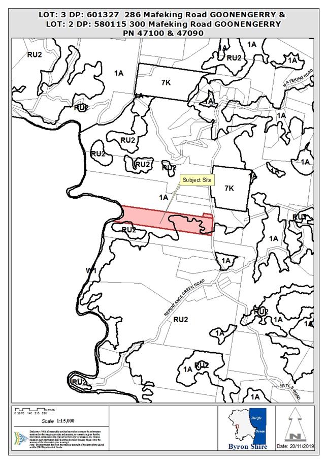
REPORT
1. INTRODUCTION
1.1. Previous
determinations
286 Mafeking Road:
· DA
91/297 for a dwelling house, approved 5 September 1991.
· DA
10.2006.23.1 for use of unauthorised alts/adds, approved 5 September 2006.
· Modification
10.2006.23.2 to change building condition, approved 2 September 2008.
· Modification
10.2006.23.3 to remove conditions, approved 28 September 2010.
· Modification
10.2006.23.4 to modify internal layout, approved 15 June 2011.
300 Mafeking Road:
· DA
90/88 for a multiple occupancy comprising five dwellings, approved 19 December
1990.
1.2. Description
of the proposed development
The applicant is seeking approval for alterations and
additions to a dwelling house, expanded house outbuilding, artist’s
studio, replacement of a dilapidated carport and a boundary adjustment.
The following is proposed:
(a) Alterations
and additions to dwelling
An extension to the main dwelling,
involving partial removal of the rear deck and expansion of the family room,
along with an addition bedroom and outdoor laundry area. A study area is to be
constructed at ground level requiring minor earthworks.
(b) Expanded
house outbuilding and studio
Construction of a two storey
expanded house habitable outbuilding comprising a bedroom and ensuite on the
ground floor and a music studio on the first floor. The two floors are not
internally connected, with the upper floor accessed via an external staircase.
The first floor studio has no internal walls or bathroom facilities. The
building has a gross floor area of 59m2 and will be constructed with
a mixture of timber of fibre cement cladding and a metal roof. Foundations
utilise pier footings supporting a suspended flooring system.
(c) Boundary
adjustment
Realign the boundaries between Lot
2 DP 580115 to Lot 3 DP 601327 to rectify the encroachment of an existing
carport. The boundary adjustment will transfer 250m2 of land from
Lot 2 in to Lot 3.
(d) Replace
carport
Demolish the existing dilapidated
carport and construct a new double carport and attached storage room in the
same location.
(e) Vegetation
clearing and associated works
Clearing of
the following nine (9) canopy trees and understory vegetation:
· Black
Teak (Pentacerus australis )
· Black
Teak (Pentacerus australis )
· Guioa
Guioa semigluaca
· Red
Cedar Toona ciliate
· Lilli
Pilli Syzygium sp.
· Bangalow
Palm Archontophoenix Cunninghamiana
· Bangalow
Palm Archontophoenix Cunninghamiana
· Hard
Quandong Elaeocarpus obovatus
· Queensland
Kauri Agathis robusta
Sections and elevations of the
propose development are shown in figures 1-3 below.
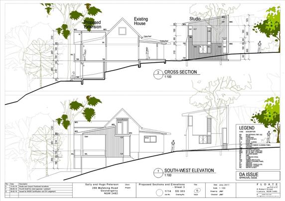
Figure 1: South-west
elevation
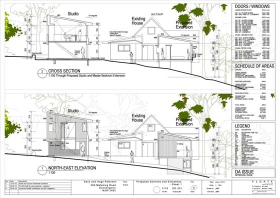
Figure 2: North-east
elevation
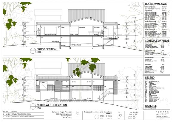
Figure 3: North-west elevation
1.3. Description
of the site
The site comprises two properties legally described as Lot 3
DP 580115 and Lot 2 DP 601327 commonly known as 286 and 300 Mafeking Road,
Goonengerry. 286 Mafeking Road is the smaller of the two properties with an
area of 4000m2 and contains a small residence and a timber carport
(although the survey plan indicates this is located on the adjoining property).
300 Mafeking Road is a 15.46 hectare property containing an approved multiple
occupancy with five dwellings.
Access to both properties is obtained off Mafeking Road. The
land is relatively flat near the road boundary, but drops away steeply in a
westerly direction towards Coopers Creek.
Both properties have a dense coverage of vegetation,
identified as being representative of the endangered ecological community Lowland
Rainforest in the NSW North Coast and Sydney Basin Bioregions (Biodiversity
Conservation Act 2016). One threatened flora species, Red Boppel Nut (Hicksbeachia
pinnatifolia) also occurs within the site.
The bulk of the land is a deferred matter and reverts to the
1(a) (General Rural Zone) zone under LEP 1988. A section of Lot 3 is within the
RU2 Rural Landscape zone under LEP 2014.
Site photos are shown in Figures 4–7 below.
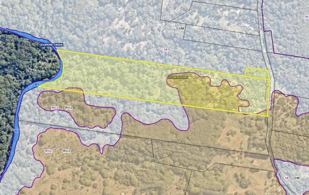
Figure 4: Aerial image of the subject site with
zoning overlay. The site is within the 1(a) (General Rural Zone) under LEP 1988
(light grey) and RU2 Rural Landscape zone under LEP 2014 (light brown).
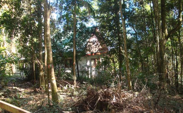
Figure 5: Existing dwelling house, looking
north-west. The proposed studio and bedroom is to be located in the area shown
above (centre frame).
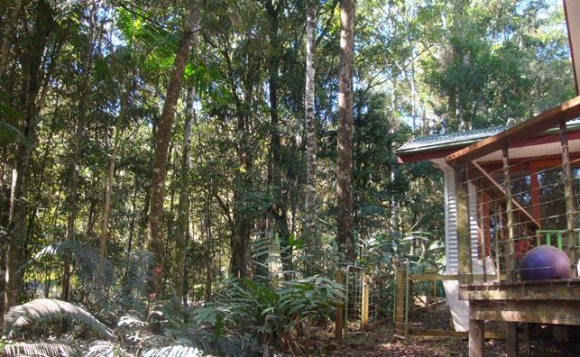
Figure 6: Proposed location of the studio and bedroom
- adjacent to the existing dwelling house.
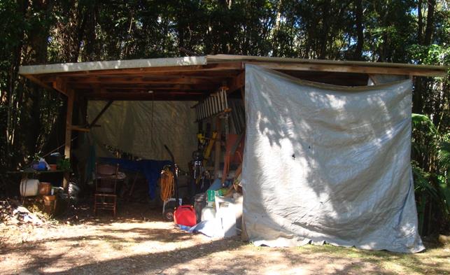
Figure 7: View of an existing carport, looking south.
The structure is located within the boundaries of the neighbouring allotment at
300 Goonengerry Road.
2. SUMMARY
OF REFERRALS
The following referrals were
undertaken as part of the assessment process:
External
|
Authority
|
Comments
|
|
NSW Department of Planning, Environment and Industry
(formerly OEH)
|
The Biodiversity Conservation Division recommends that
an additional biodiversity credit should be included to account for potential
clearing entitlements created by the development. See discussion in the
issues section below.
|
|
Rural Fire Service - s100B
|
A Bush Fire Safety Authority and general terms of
approval have been issued. Refer to Attachment 6. Further discussion
below.
|
Internal
|
Authority
|
Comments
|
|
Environmental Health Officer
|
No objection subject to standard conditions. An
upgraded on-site sewage management system will be required.
|
|
Development Engineer
|
No objection subject to standard conditions.
|
|
Natural Resource planner
|
No objections subject to conditions. Specific measures
for tree protection are required during construction, and a vegetation
management plan is required to ensure maintenance and improvement of the
sites ecological values. Refer to discussion of issues below.
|
Issues:
NSW Biodiversity Conservation Division
The application was referred to the NSW Biodiversity and
Conservation Division (BCD) for comment. BCD was formerly part of the Office of
Environment and Heritage and is now part of the Department of Planning,
Industry and Environment.
BCD noted that the applicant’s amended Biodiversity
Development Assessment Report (BDAR) has addressed the relevant requirements of
the legislation. Support was given for the proposal to restrict the 10/50
Clearing Code of Practice through a condition of consent.
The only point of disagreement relates to the applicants
proposal to ‘switch off’ a fence line clearing entitlement under
Part 5A of the Local Land Services Act 2013 by imposing a condition of consent.
BCD questioned whether such an approach would be legally enforceable. BCD noted
that Council may consider imposing an additional biodiversity credit of the
same PCT to offset the clearing entitlement.
Further discussion of this matter is addressed in section
4.7 – impacts on the natural environment.
Natural Resource Planner
Council’s Natural Resource Planner noted that the
amended BDAR addresses the relevant requirements of the legislation, but agreed
that an additional biodiversity credit should be retired to offset the clearing
entitlements.
Conditions are recommended for a vegetation management plan
to be prepared to for environmental enhancement of the site.
NSW Rural Fire Service
The RFS have issued a Bushfire Safety Authority that
requires the mid and lower storey to be pruned and/or cleared within the asset
protection zone, but allows the upper canopy to be retained. Standard
conditions apply for access, water supply and levels of construction apply.
3. BIODIVERSITY
CONSERVATION ACT 2016
Biodiversity framework
The Biodiversity
Conservation Act 2016, together with the Biodiversity
Conservation Regulation 2017, outlines the framework for addressing impacts on biodiversity from
development. A central feature of the new framework is the introduction
of a biodiversity offsets scheme.
Under the offset
scheme, developers who undertake clearing generate a credit obligation which
must be ‘retired’ to offset their activity. Landholders can also
establish biodiversity stewardship sites on their land to generate credits
which are sold to developers who require those credits to offset their
activities at other sites.
Entry into the offsets scheme is triggered by two main
threshold tests:
· Whether the amount of native vegetation being cleared exceeds
a specified area (i.e. more than a certain number of hectares specified in the
Regulations); or
· Whether the impacts occur on an area mapped on the
Biodiversity Values Map published by the Minister for the Environment.
If either of these two tests is
met, the development application must be accompanied by a biodiversity
development assessment report (BDAR). A BDAR is an ecological impact assessment
report undertaken in accordance with a prescribed biodiversity assessment
methodology (known as the BAM). Depending on the extent and nature of
the impact, the BDAR may include a calculation of biodiversity credits that
need to be purchased to offset the impacts of the development.
Consideration
of biodiversity impacts
This application will require entry into the offsets scheme
due to a small amount of clearing occurring within the Biodiversity Values Map.
The applicant has provided a BDAR which includes an assessment of the impacts
on biodiversity and a calculation of biodiversity credits to be retired.
Impacts on biodiversity are considered in section 4.7 of
this report – impacts on the natural environment.
4. ENVIRONMENTAL
PLANNING AND ASSESSMENT ACT 1979
4.1 Section 4.46 Integrated
Development
The proposed development includes subdivision of bushfire
prone land and requires a Bush Fire Safety Authority (BFSA) under S100B of the Rural
Fires Act 1997. The RFS have issued a Bush Fire Safety Authority for the
proposed development, with conditions for asset protection zones, water supply
and access.
5. SECTION
4.15C – MATTERS FOR CONSIDERATION – DISCUSSION OF ISSUES
Having regard to the matters
for consideration detailed in Section 4.15(1) of the Environmental Planning
& Assessment Act 1979 (EP&A Act), the following is a summary of the
evaluation of the issues.
5.1 State Environmental
Planning Instruments
State Environmental Planning
Policy No 1—Development Standards
The proposed
boundary adjustment results in a contravention of the 40 hectare minimum lot
size standard under clause 11 of LEP 1988. The applicant has provided a written
objection pursuant to clause 6 of SEPP 1 which seeks to justify the variation
(refer to Attachment 7). The written objection is addressed further in section
4.2B of this report.
State Environmental Planning
Policy No 44—Koala Habitat Protection
An ecological survey of the property did not identify any
preferred koala feed trees species or evidence of Koalas or Koalas breeding. On
this basis, the subject land is not considered to be a core Koala habitat and a
Koala plan of management is not required. The applicant’s BDAR notes that
Koalas may utilise the subject land on occasion, however, most canopy species
are intended to be retained and the proposal will not fragment habitat for this
species.
State Environmental Planning
Policy No 55—Remediation of Land
Land contamination was previously considered for this site
as part of the assessment of development application no. 10.2006.23.1. The land
was found to be suitable for residential use. Council’s Environmental
Health Officer did not consider further investigation to be warranted for this
application as there is no increase in the sensitivity of the use.
State Environmental Planning
Policy (Rural Lands) 2008
The proposed dwelling house and boundary adjustment are
compatible with surrounding land uses in the area which are predominantly
characterised by small orchards, grazing and rural living. The proposal is
unlikely to cause any significant conflict with any existing or likely future
land uses in the area.
State
Environmental Planning Policy (Primary Production and Rural Development) 2019
The development application was lodged prior to the
commencement of the primary production SEPP. In accordance with the
transitional arrangements specified in clause 9, the SEPP is not applicable to
the application.
4.2A Byron Local Environmental Plan 2014 (LEP 2014)
LEP 2014 is an applicable matter for consideration in the
assessment of the subject development application in accordance with subsection
4.15(1) of the EP&A Act because it applies to the subject land and the
proposed development. The LEP 2014 clauses that are checked below are of
relevance to the proposed development:
|
Part 1
|
☒1.1|
☒1.1AA| ☒1.2| ☒1.3| ☒1.4| ☒Dictionary| ☒1.6| ☒1.7| ☒1.8| ☒1.8A| ☒1.9| ☒1.9A
|
|
Part 2
|
☒2.1|
☒2.2 | ☒2.3 |☒Land Use Table | ☒2.4 | ☒2.5 | ☒2.6 | ☒2.7 | ☒2.8
|
|
Part 4
|
☒4.1|
☒4.1C| ☒4.3
|
|
Part 5
|
☒5.16
|
|
Part 6
|
☒6.2|
☒6.5| ☒6.6
|
In accordance with LEP 2014 clauses 1.4 and 2.1 – 2.3:
(a) The
proposed development is defined in the LEP 2014 Dictionary as dwelling, clearing
native vegetation, subdivision (boundary adjustment);
(b) The
land is within the RU 2 Rural Landscape zone according to the Land Zoning Map;
(c) The
proposed development is permitted with consent; and
(d) Regard
is had for the Zone Objectives as follows:
Note: The provisions of LEP 2014 only relate to the
boundary adjustment. All building works and vegetation clearing are occurring
within the 1(a) (General Rural Zone).
|
Zone Objective RU 2 Rural Landscape
|
Consideration
|
|
To
encourage sustainable primary industry production by maintaining and
enhancing the natural resource base.
|
The proposed boundary adjustment will have no impact
on the primary production potential of the land or impact on the rural
character of the landscape. The development is considered to be compatible
with the zone objectives.
|
|
To maintain
the rural landscape character of the land.
|
|
To provide
for a range of compatible land uses, including extensive agriculture.
|
|
To enable
the provision of tourist accommodation, facilities and other small-scale
rural tourism uses associated with primary production and environmental
conservation consistent with the rural character of the locality.
|
|
To protect
significant scenic landscapes and to minimise impacts on the scenic quality
of the locality.
|
The remaining checked clauses have been taken into
consideration in the assessment of the subject development application in
accordance with subsection 4.15(1) of the EP&A Act. The proposed
development complies with all clauses of LEP 2014 (in some cases subject to
conditions and/or to the satisfaction of other assessing officers).
Clause 4.1C Minimum subdivision lot
size for boundary adjustments in certain rural and residential zones
Clause 4.1 C permits the minimum lot size to be disregarded
for the purposes of boundary adjustments in zones RU1, RU2 and R5 under certain
circumstances. Council must be satisfied that the subdivision will not create
any additional lots or dwelling opportunities, result in fragmentation of rural
land, create land use conflict or affect the rural character or scenic
qualities of the land.
The proposed boundary adjustment is a minor realignment
intended to rectify a building encroachment and is considered to satisfy the
matters for consideration under clause 4.1C.
Clause 6.5 Drinking water
catchments
The proposed development is unlikely to adversely affect the
quality or quantity of water entering the drinking water catchment. The
upgraded on-site sewage management system will be approximately 850m from
Coopers Creek and erosion and sediment runoff during building works can be
controlled via conditions of consent.
Clause 6.6 Essential services
Rainwater
harvesting and on-site sewage disposal can be provided subject to conditions of
consent. Electricity and telecommunications are available to the site.
Vehicular access is provided off an existing driveway that
connects to Mafeking Road. The driveway will need upgrading and widening to
meet RFS standards, including the provision of a 6m by 8m reversing bay.
Conditions are recommended.
4.2B Byron Local Environmental Plan 1988 (LEP 1988)
LEP 1988 is an applicable matter for consideration in the
assessment of the subject development application in accordance with subsection
4.15(1) of the EP&A Act because it applies to the subject land and the
proposed development. The LEP 1988 clauses that are checked below are of
relevance to the proposed development:
|
Part 1
|
☒1|
☒2| ☒2A| ☒3| ☒4| ☒5| ☒LEP 1988 Dictionary| ☒7
|
|
Part 2
|
☒8|
☒9
|
|
Part 3
|
☒10|
☒11| ☒15| ☒31| ☒40| ☒45| ☒49| ☒52
|
In accordance with LEP 1988 clauses 5, 8 and 9:
(a) The
proposed development is defined in the LEP 1988 Dictionary as Dwelling House,
Subdivision;
(b) The
land is within the 1(a)—(General
Rural Zone) according to the map under LEP 1988;
(c) The
proposed development is permitted with consent; and
(d) The
proposed development is consistent with the relevant objectives of the Zone for
the following reasons:
|
Zone Objective 1(a) (General Rural Zone)
|
Consideration
|
|
to
encourage and permit a range of uses creating a pattern of settlement, at a
scale and character that maintains or enhances the natural, economic,
cultural, social and scenic amenity of the rural environment of the Shire of
Byron,
|
The proposed development is considered to be
consistent with the zone objectives. The proposal is unlikely to result in
conflict with surrounding land uses or result in significantly adverse
impacts on the environment.
|
|
to
encourage and permit a pattern of settlement which does not adversely affect
the quality of life of residents and visitors and maintains the rural
character,
|
|
to ensure
development only occurs on land which is suitable for and economically
capable of that development and so as not to create conflicting uses,
|
|
to allow
the use of land within the zone for agricultural purposes and for a range of
other appropriate purposes whilst avoiding conflict between other uses and
intensive agriculture,
|
|
to identify
lands (shown hatched on the map) which in the opinion of the council possess
a limited capability for more intensive uses or development,
|
|
to restrict
the establishment of inappropriate traffic generating uses along main road
frontages other than in road side service areas,
|
|
to ensure
sound management of land which has an extractive or mining industry potential
and to ensure that development does not adversely affect the potential of any
existing or future extractive industry,
|
|
to enable
the provision of rural tourist accommodation and facilities only where such
facilities are compatible with the form and density of the nature of the
locality, and
|
|
to permit
the development of limited light industries which do not pose any adverse
environmental impact, (eg software manufacture and film processing), and
|
|
to ensure
that the development and use of land shown cross-hatched on the map adjacent
to areas of significant vegetation and wildlife habitat do not result in any
degradation of that significant vegetation and wildlife habitat, and that any
development conserves and protects and enhances the value of the fauna and
flora.
|
The remaining checked clauses have been taken into
consideration in the assessment of the subject development application in
accordance with subsection 4.15(1) of the EP&A Act. The proposed
development complies with all of these clauses (in some cases subject to
conditions and/or to the satisfaction of other assessing officers), except in
relation to which considered further as follows:
Clause 11 Subdivision in rural
areas for agriculture etc
Clause 11 stipulates a 40 hectare minimum lot size in the
1(a) (General Rural Zone). The proposed boundary adjustment will result in two
lots, each with an area of less than 40 hectares. The applicant has submitted a
written objection seeking to vary the 40 hectare standard in accordance with
clause 6 of State Environmental
Planning Policy No 1—Development Standards (SEPP 1), detailed in the LEP issues
section below. The objection is considered to be well founded.
Clause 40 Height
Clause 40 provides that the maximum height of buildings on
the site must not exceed 9m and the topmost floor height must not exceed 4.5m.
The proposed development will have a maximum height of 6.6m and a topmost floor
height of 3.3m.
Clause 45 Provision of services
Rainwater
harvesting and on-site sewage disposal can be provided subject to conditions of
consent. Electricity and telecommunications are available to the site.
Byron
Local Environmental Plan 1988 issues
State Environmental Planning Policy No 1—Development
Standards
State Environmental Planning Policy No 1 (SEPP 1) provides
flexibility in the application of planning controls in circumstances where strict compliance
with those standards would be unreasonable or unnecessary or tend to hinder the
attainment of the objects of the Act.
An applicant may
make a written objection, specifying why strict compliance with the development
standard is unreasonable or unnecessary in the circumstances of the case. Where
the consent authority is satisfied that the objection is well founded and
consistent with the aims of the Policy it may grant consent to the development
application.
The Development Standard to be varied
Clause 11 of Byron LEP 1988 specifies a 40 hectare
minimum subdivision lot size for agriculture,
forestry or a dwelling-house in the 1(a) (General Rural Zone). The numerical
lot sizes stipulated in clause 11 of LEP 1988 are development standards that
are able to be varied by way of SEPP 1.
Extent of Variation to the Development Standard
The proposed
boundary adjustment will transfer 250m2 of land from the larger lot
into the smaller lot for the purposes of correcting a building encroachment.
The resulting layout will be substantially the same as the lots currently in
existence.
As detailed in the table below, the degree of variation
varies from 39.575 hectares for Lot 3 to 24.565 hectares for Lot 2.
|
Property
|
Standard
|
Proposed
|
Difference
|
|
Lot 3 DP 601327
|
40 ha
|
0.425 ha
|
39.575 ha
|
|
Lot 2 DP 580115
|
40 ha
|
15.435 ha
|
24.565 ha
|
Objective of the Development Standard
There are no underlying objectives listed in clause 11. In
addition to the numerical standards listed in the lot size table, Council is
required to be satisfied that each
allotment is of satisfactory shape and has a satisfactory frontage.
Objectives of the Zone
Refer to Section 4.2B of this report.
Is compliance unreasonable or unnecessary in the
circumstances of the case?
The judgment in Wehbe v Pittwater Council [2007] NSW LEC 827
established five different ways in which an objection may be considered well founded
and that approval of the objection may be consistent with the aims of the
policy.
(1) The objectives of the standard are
achieved notwithstanding non-compliance with the standard
Clause 11 does not have any stated aims or objectives. In
terms of planning policy, the maintenance of large lot sizes is a mechanism to
preserve productive rural land or land with special scenic or environmental
characteristics.
In this particular case, the proposed lots are considered to
be of an adequate size, shape and frontage for the proposed use and will not
adversely affect the environmental characteristics of the land.
Strict adherence to the standard would serve no planning
purpose and would likely result in an inferior outcome as the smaller of the
two lots would have less land available for car parking and manoeuvring.
Additional vegetation may need to be cleared to provide an alternative carport
location with sufficient access that meets Council and RFS standards.
(2) The underlying objective or purpose of the
standard is not relevant to the development and therefore compliance is
unnecessary
The underlying purpose of the
standard is relevant, however, as explained above, strict compliance is
unreasonable in the circumstances as it would result in an inferior outcome and
would tend to hinder the attainment of the objects of the Act.
(3) The underlying objective or purpose would
be defeated or thwarted if compliance was required with the consequence that
compliance is unreasonable.
The underlying purpose of the standard would not be thwarted
if strict compliance with the standard was required. Adhering to the standard
is, however, unreasonable in the circumstances because allowing the minor
adjustment of boundaries will result in a superior planning outcome that
achieves the underlying objectives of the standard.
(4) The development standard has been
virtually abandoned or destroyed by the Council’s own actions in granting
consents departing from the standard and hence compliance with the standard is
unreasonable and unnecessary
The 40 hectare standard has been
upheld with relative consistency for subdivisions that result in new lots with
additional dwelling opportunities. Council has regularly allowed variations to
the 40 hectare minimum lot size for minor boundary adjustments.
(5) Compliance with the development standard
is unreasonable or inappropriate due to existing use of land and current
environmental character of the particular parcel of land. That is, the
particular parcel of land should not have been included in the zone
The 1(a) zoned parts of the site are likely to be
transitioned into an environmental zone under LEP 2014 at some point in the
future. The 40 hectare standard will likely apply under the new zoning,
however, strict compliance is considered unreasonable for the reasons listed
above.
Does the non-compliance with the development standard
raise any matters of significance for state or regional environmental planning?
There are no matters of State or
regional planning significance that will be affected by this minor realignment
of boundaries.
Is there a public benefit in maintaining the planning
controls adopted by Byron LEP 1988?
Strict compliance would
hinder the orderly development of the site and would not serve any planning
purpose. There is no public benefit in maintaining the development standard in
this particular case.
4.3 Any proposed Instrument
that has been the subject of public consultation and has been notified to the
consent authority
The subject sites are not included in Phases 1 or 2 or the
E-zones Planning Proposal. It is understood that the properties are likely to
be included in Phase 3 with the bulk of the land identified as potential E2
Environmental Conservation zone and E3 Environmental Management zone.
As Phase 3 has not yet been submitted for gateway
determination, future environmental zoning has not been given significant
weight in this assessment.
4.4A Byron Shire Development Control Plan 2014
(DCP 2014)
DCP 2014 is an applicable matter for consideration in the
assessment of the subject development application in accordance with subsection
4.15(1) of the EP& A Act because it applies to the land to which LEP 2014
applies. The DCP 2014 Parts/Chapters that are checked below are of relevance to
the proposed development:
|
Part A
|
☒
Preliminary
|
|
Part B Chapters:
|
☒B2|
☒B3| ☒B4| ☒B6| ☒B8| ☒B9| ☒B14
|
|
Part C Chapters:
|
☒C2|
☒C4
|
|
Part D Chapters
|
☒D2|
☒D6
|
These checked Parts/Chapters have been taken into
consideration in the assessment of the subject development application in
accordance with subsection 4.15(1) of the EP&A Act. The proposed
development complies with all sections of these Parts/Chapters (in some cases
subject to conditions and/or to the satisfaction of other assessing officers),
except in relation to certain prescriptive measures which are considered
further (having regard to the DCP 2014 Section A1 Dual Path Assessment) as
follows:
|
What Section and prescriptive measure does the
development not comply with?
|
Does the proposed development comply with the
Objectives of this Section? Address.
|
Does the proposed development comply with the
Performance Criteria of this Section? Address.
|
|
B6.3.1 Lot Size, Shape and Configuration
Prescriptive Measure
Lot sizes must not be less than the minimum area
specified in Byron LEP 2014 on the lot size map.
Proposed Development
Each lot is substantially less than the 40 hectare
minimum lot size.
|
Yes. Divergence from the minimum lot size standard is
addressed in section 4.2B of this report. The boundary adjustment satisfies
the relevant planning objectives and has sufficient merit to warrant support.
|
Yes. The proposed boundary adjustment is considered to
satisfy the performance criteria, including the provisions of Chapter B6
Buffers and Minimising Land Use Conflict.
|
4.4B Byron Shire Development Control Plan 2010 (DCP 2010)
DCP 2010 is an applicable matter for consideration in the
assessment of the subject development application in accordance with subsection
4.15(1) of the EP& A Act because its purpose is to provide planning
strategies and controls for various types of development permissible in
accordance with LEP 1988. The DCP 2010 Chapters/Parts that are checked below
are of relevance to the proposed development:
|
Chapter 1 Parts:
|
☒A|
☒B| ☒C| ☒F| ☒G| ☒H| ☒ N
|
These checked Chapters/Parts have been taken into
consideration in the assessment of the subject development application in
accordance with subsection 4.15(1) of the EP&A Act.
|
What Section and prescriptive measure does the
development not meet?
|
Does the proposed development meet the Element
Objectives of this Section? Address.
|
Does the proposed development meet the Performance
Criteria of this Section? Address.
|
|
B4.1 Element – Lot Size and Shape
Prescriptive Measure
All lots are to conform to the minimum area prescribed
in the relevant planning instruments
Proposed Development
Each lot is substantially less than the 40 hectare
minimum lot size.
|
Yes. Divergence from the minimum lot size standard is
addressed in section 4.2B of this report. The boundary adjustment satisfies
the relevant planning objectives and has sufficient merit to warrant support.
|
Yes. Each lot is a satisfactory size and shape for existing
and proposed development. The boundary adjustment will not result in any
additional impacts on the natural or built environments, interfere with
access arrangements or increase the potential for land use conflict.
|
Chapter 1: Part C Residential Development
C14. Studios
The proposed studio complies with the prescriptive measures
of Element C14. The studio is less than 60m2, is located close to
the existing dwelling, and comprises a single room with no facilities or
internal partitions.
The studio is located above an additional bedroom (not
typical for a studio), and is provided with a separate external access to
separate the two uses. The applicant notes this arrangement is intended to
minimise the footprint of the development to minimise the amount of vegetation
removal.
4.5 Any Planning Agreement or
Draft Planning Agreement?
Not applicable.
4.6 Environmental Planning
& Assessment Regulation 2000 Considerations
Clause 92 Additional matters that consent authority
must consider
The carport and minor elements of the dwelling will require
demolition as part of the proposed building works. A condition can be applied
requiring demolition to comply with AS2601–the demolition of
structures.
Clause 94 Consent authority may require buildings
to be upgraded
The NSW Rural Fire Service has included a condition that
requires the existing building to be upgraded to improve ember protection.
4.7 The likely
impacts of that development, including environmental impacts on both the
natural and built environments, and social and economic impacts in the locality
Natural environment
Biodiversity Conservation
Act 2016
The proposal involves
clearing of native vegetation on land included on the Biodiversity Values Map
and is therefore required to enter into the biodiversity offsets scheme. The
application is accompanied by a BDAR, in accordance with sections 7.2 and 7.7
of the BC Act. Refer to Attachment 4.
Consideration of impacts on biodiversity
Section 7.13 of the BC Act
provides that the consent authority is to consider the likely impacts of the
development on biodiversity values,
as assessed in the biodiversity development assessment report. The
consent authority may (but is not required to) further consider the likely
impact of the proposed development on biodiversity values.
Vegetation types
Vegetation within the site has
been identified as representing the Lowland Subtropical Rainforest, listed as Lowland
Rainforest in the NSW North Coast and Sydney Basin Bioregions endangered
ecological community under the BC Act.
Vegetation across the study area
has been subject to various levels of disturbance including previous historical
clearing, APZ management and general disturbance associated with being adjacent
to a residence. Vegetation immediately surrounding the dwelling has been
cleared while regrowth and remanent patches of Lowland Rainforest were present
in various stage of moderate to good condition in areas further from dwelling,
particularly on the eastern an southern extents of the property.
Amount of vegetation to be
cleared
The Arboricultural report
(Attachment 5) identifies the following nine (9) canopy trees to be removed:
· Black
Teak (Pentacerus australis )
· Black
Teak (Pentacerus australis )
· Guioa Guioa
semigluaca
· Red
Cedar Toona ciliate
· Lilli
Pilli Syzygium sp.
· Bangalow
Palm Archontophoenix Cunninghamiana
· Bangalow
Palm Archontophoenix Cunninghamiana
· Hard
Quandong Elaeocarpus obovatus
· Queensland
Kauri Agathis robusta
The location of the trees is
identified in Figure 8 below.
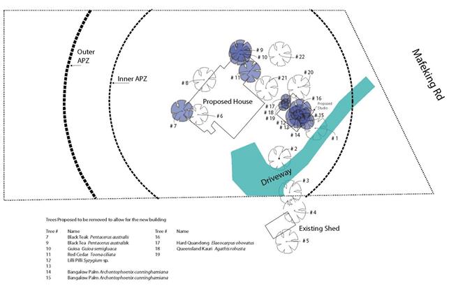
Direct impacts and offset obligation
The BDAR provides that the proposed development will result
in the following direct impacts:
· Removal of 0.016
hectares of Lowland Rainforest, occurring as two condition types.
· Relocation of
fauna habitat components from the subject land to adjacent areas.
The impact of the vegetation removal has been calculated
using the Biodiversity Assessment Method. The biodiversity payment summary
report provided in the BDAR provides that one ecosystem credit for PCT 1302
– White Booyong – Fig subtropical rainforest of the NSW North Coast
Bioregion must be retired to offset the impact of the proposed development.
Increase to offset obligation
The proposed boundary adjustment will create a new
vegetation clearing entitlement under Part 5A of the Local Land Services Act
2013. This will allow for clearing 3m on either side of the new boundary alignment,
which passes through an area of Lowland Rainforest.
To account for this potential impact, one (1) additional
biodiversity credit of the same PCT type is recommended.
The likely hood of the clearing
entitlement being acted on is uncertain, but is considered to be relatively low
in light of a likely future zone change to zone E2 or E3 in phase three (3) of
Council’s E Zone implementation program. Once the site transitions to an
environmental zone, Part 5A will no longer apply and the clearing entitlement
will be lost. In this scenario, any future clearing would require permission
from the Native Vegetation Panel under the Vegetation SEPP.
If Council views the additional biodiversity credit as
unnecessary, the number of credits could be reduced to one (1) without
concurrence from the Environment Agency Head.
Avoid and Minimise
The scale of the new building
work is relatively modest and has been located close to the existing dwelling.
The BDAR notes that proposed development has been designed to minimise native
vegetation removal by locating the house extension within the existing garden
and placing the new habitable outbuilding in a location with no large trees. The proponents have also redesigned the deck to retain the
existing Red Boppel Nut, and have made provision for its continued survival by
seeking advice from a qualified tree expert.
Additional environmental considerations
Byron Development Control Plan 2014, Chapter B2, requires
compensatory plantings at a ratio of 10:1 for local indigenous species.
Council’s Natural Resource Planner has recommended that 120 trees be
planted to account for the loss of vegetation and subsequent impacts on
biodiversity. This account for the nine (9) trees removed, with an additional
requirement to account for trees close the development footprint that may be
impacted over time.
In addition, Madeira vine (Anredera cordifolia), a
Weed of National Significance, is present on the site and should be controlled
and removed. Successful removal of this weed requires control activities to be
repeated over several years.
A condition of consent is recommended that requires a
vegetation management plan to be with provisions for restoration, weeding,
monitoring and maintenance. The plan is to be submitted to Council for approval
prior to the commencement of the development.
Conclusion
The proposed development affects a relatively small area of
vegetation in the context of the site and greater locality and is unlikely to
have a significant impact on the threatened species or ecological communities.
Conditions are recommended for environmental enhancement of the site including
regeneration, weed removal, monitoring and maintenance.
Built Environment
The proposal will not have a significantly adverse impact on
the built environment of the locality.
Social and Economic Impacts
The proposal will not have a significant social or economic
impact on the locality.
4.8 The suitability of the site
for the development
Sites constraints including vegetation and bushfire prone
land have been addressed through appropriate design and conditions of consent.
The site is considered to be suitable for the proposed development subject to
conditions of consent.
4.9 Submissions made in
accordance with this Act or the regulations
The development application was publicly exhibited for a
period of 14 days in accordance with DCP 2014 and DCP 2010. No public
submissions were received.
4.10 Public interest
The proposed development is
unlikely to prejudice or compromise the public interest or create a dangerous
precedent.
5. DEVELOPER
CONTRIBUTIONS
5.1 Water & Sewer Levies
No development servicing levies need to be imposed under the
Water Management Act. Reticulated water and sewer infrastructure is unavailable
to the development.
5.2 Section 7.11 Contributions
No development contributions are
applicable because the boundary adjustment will not create any additional
dwelling opportunities.
6. CONCLUSION
The proposed development is consistent with the relevant
environmental planning instruments and planning controls applicable to the
site. The proposal raises no significant issues in terms of environmental
impacts which cannot be managed and the site is considered suitable for the
development. The application is recommended for approval subject to conditions
of consent.
7. REASONS
FOR DECISION, HOW COMMUNITY VIEWS WERE ADDRESSED
Note:
From July 1 2018, Council’s are required to give and publicly notify
reasons for a range of planning decisions where they are deciding if
development should proceed to help community members to see how their views
have been taken into account and improve accountability to stakeholders. A
statement of reasons for the determination of this application is provided
below.
|
Statement of Reasons
|
|
The proposed development complies with the provisions of
Byron Local Environmental Plan 2014.
|
|
The proposed development complies with the provisions of
Byron Local Environmental Plan 1988.
|
|
The proposed development complies with relevant State
Environmental Planning Policies
|
|
The proposed development complies with relevant provisions
of Development Control Plan 2014
|
|
The proposed development complies with Environmental
Planning & Assessment Regulation 2000 considerations.
|
|
The proposed development will not have significant adverse
impact on the natural, built or social environment or economic impacts on the
locality.
|
|
The proposed development is considered suitable for the
proposed site.
|
|
The development application was notified/advertised in
accordance with Development Control Plan 2014.
|
|
The proposed development is unlikely to prejudice or
compromise the public interest.
|
|
How community views were addressed
|
|
The DA was notified/advertised in accordance with
Development Control Plan 2014. No submissions were received.
|
Report No. 13.13 PLANNING
- Development Application 10.2019.458.1 Multi Dwelling Housing Comprising Eight
(8) Dwellings at 6 Julian Rocks Drive Byron Bay
Directorate: Sustainable
Environment and Economy
Report
Author: Luke
Munro, Planner
Noreen Scott, EA Sustainable
Environment and Economy
File No: I2019/1630
Proposal:
|
DA No:
|
10.2019.458.1
|
|
Proposal description:
|
Multi Dwelling Housing Comprising Eight (8) Dwellings
|
|
Property description:
|
LOT: 41 DP: 714410
|
|
6 Julian Rocks Drive BYRON BAY
|
|
Parcel No/s:
|
36140
|
|
Applicant:
|
Lismore Venture Pty Ltd
|
|
Owner:
|
PD Lismore Pty Ltd & Windmill Property Investments
& others
|
|
Zoning:
|
R2 Low Density Residential
|
|
Date received:
|
30 August 2019
|
|
Integrated / Designated Development:
|
☐
Integrated
|
☐
Designated
|
☐
Not applicable
|
|
Concurrence required
|
No
|
|
Public notification or exhibition:
|
- Level
2 advertising under DCP 2014 Part A14 – Public Notification and
Exhibition of Development Applications
- Exhibition
period: 12/9/19 to 25/9/19
- Submissions received:
21 – including 5 petitions
- https://www.byron.nsw.gov.au/Council/Council-meetings/Additional-Supporting-Information
(#E2019/86404)
|
|
Planning Review Committee:
|
Not applicable / Date of PRC
|
|
Variation request
|
☐
Clause 4.6
|
☐
SEPP 1
|
☒
Not applicable
|
|
Delegation to determine
|
Council
|
|
Issues:
|
· Inconsistent
with character of the locality;
· Non-compliance
with key controls in Byron DCP 2014 – building height plane, setbacks, private
open space;
· Design provides
poor residential amenity; and
· Inconsistent
with SEPP (Affordable Housing) 2008
|
Summary:
The development application is made under the provisions of
State Environmental Planning Policy (SEPP) - Affordable Rental Housing
2009. The proposal consists of eight (8) two storey townhouses; two (2)
being studio dwellings, two (2) containing a single bedroom, and four (4)
containing two bedrooms. The dwellings are arranged in three groups, with the
four two-bedroom townhouses arranged in groups of two, and the third group of
townhouses consisting of the two one-bedroom townhouses and the two studios.
All townhouses are arranged around a central internal car
parking area. Two (2) dwellings are proposed to be set aside for affordable
housing as defined by the SEPP.
The studio dwellings are in fact one bedroom units and have
a floor space of 46m2.
The proposed dwelling size is less than that set by way for
the non-discretionary standard within the SEPP, resulting in units that provide
poor internal amenity for future residents.
Further the development provides 50% of the proposed
dwellings with adequate solar access which is below the non discretionary
standard of 70% under the SEPP further reducing the amenity for future
residents.
The proposal also takes advantage of the reduced car parking
provisions of the SEPP, proposing six (6) spaces, arranged in a central
uncovered parking area.
The proposal is inconsistent with the following requirements
of Byron DCP 2014:
· Building height
plane – encroachments on both residential boundaries;
· Setbacks –
covered external decks intrude within the front setbacks to Julian Rocks Drive;
and
· Private open space
– a number of the units do not comply with the quantum of open space
required. The space provided for Units 1 & 2 is located in the
frontage setback. The low fencing results in these spaces lacking privacy
and being essentially unusable.
The provision of housing diversity addresses an identified
need in Byron Bay. In this case, however, the application proposes a
scale of development that is inappropriate in the context of the site and the
R2 Low density Zoning. It will result in a development that is
significantly out of character with the locality, individual dwellings with
poor residential amenity and no useable private open space, and encroachment
into the building height plane, which will lead to privacy and overlooking
issues for neighbouring properties.
The applicant has commenced a Class 1 appeal in the Land and
Environment Court against the deemed refusal of the application.
Council’s contentions in the Land and
Environment Court proceedings could be addressed by way of a redesign of
the proposal, to reduce floor space and address the issues raised above, which
could provide an outcome that would be acceptable in the context of the site
and its locality.
The development in its current form, however, is not
supported and it is recommended that the application be refused.
NOTE TO COUNCILLORS:
In accordance with the
provisions of S375A of the Local Government Act 1993, a Division is to be
called whenever a motion for a planning decision is put to the meeting, for the
purpose of recording voting on planning matters. Pursuant to clause 2(a)
under the heading Matters to be Included in Minutes of Council Meetings of
Council's adopted Code of Meeting Practice (as amended) a Division will be
deemed to have been called by the mover and seconder of all motions relating to
this report.
|
RECOMMENDATION:
That, pursuant to
Section 4.16 of the Environmental Planning & Assessment Act 1979,
Development Application no. 10.2019.458.1 for construction of multi dwelling housing comprising eight (8)
dwellings under State Environmental Planning Policy (Affordable Rental
Housing) 2009, be refused for the following reasons:
a) Pursuant
to Section 4.15(1)(a) of the Environmental Planning and Assessment Act
1979, the proposal is inconsistent with the provisions of State
Environmental Planning Policy (Affordable Rental Housing) 2009 in that:
i. the
units do not achieve adequate solar access and is inconsistent with the SEPP
(Affordable Housing) 2008;
ii. the
density and scale of the development is inconsistent with the character of
the area; and
iii. the proposed development is
inconsistent with Seniors Living Policy Urban design guidelines for infill
development.
b) Pursuant
to Section 4.15(1)(a) of the Environmental Planning and Assessment Act
1979, the proposal does not comply with the first objective of the R2 Low
Density Residential Zone under Byron LEP 2014, in that:
i. The
proposed 8 dwellings is inconsistent with the character of a low density
environment.
c) Pursuant
to Section 4.15(1)(a) of the Environmental Planning and Assessment Act 1979,
the proposal does not comply with Byron Development Control Plan 2014, in
that:
i. street
boundary setbacks do not comply with the standard contained at Chapter D1.2;
ii. the
proposed development encroaches into the Building Height Plane on southern
boundary, resulting in impacts on neighbouring residential properties;
iii. inadequate
useable private open space is provided to the units, with private spaces
proposed within the front setbacks and overlapping private open spaces
between units; and
iv. the
internal unit design does not provide adequate internal amenity for future
residents.
|
Attachments:
1 Plans -
DA10.2019.458.1, E2019/65116
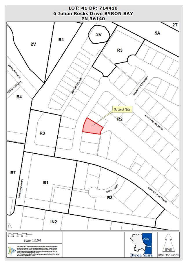
Assessment:
1. INTRODUCTION
1.1. History/Background
The site is subject to the following approvals:
6.1990.2636.1 Patio Approved
13.12.1990
10.2000.93.1 Change
of use – Existing dwelling to Bed & Breakfast establishment Refused
14.03.2000
10.2000.661.1 Bed
& Breakfast establishment Court Approved 06.04.2002
1.02009.54.1 Tree
removal – Three (3) trees Approved 12.02.2009
1.2. Description
of the proposed development
This application seeks approval for Multi Dwelling Housing
Comprising Eight (8) Dwellings. The proposal relies on the provisions for
Infill Affordable Housing under State Environmental Planning Policy
(Affordable Rental Housing) 2009 (SEPP ARH).
The proposal as described by the applicant consists of
eight, two-storey townhouses: two studio dwellings, two single-bedroom
dwellings, and four two-bedroom dwellings. The dwellings are arranged in three
groups, with the four two-bedroom townhouses arranged in groups of two, and the
third group of townhouses consisting of the two one-bedroom townhouses and the
two studios. All townhouses are arranged around a central internal car parking
area.
· The studio
units have a floor space of 46m2, containing a lounge, kitchen,
laundry and storage at ground floor and a bedroom, bathroom and study on the
upper level.
· The
one-bedroom units have a floor space of 51m2, containing a lounge,
kitchen, laundry and storage at ground floor and a bedroom, bathroom and study
on the upper level.
· The
two-bedroom units have a floor space of 70m2, with the same room
configuration at ground floor (i.e., lounge, dining, kitchen, laundry and
storage), and two bedrooms and a bathroom on the upper level.
The units will be constructed as slab on ground construction
with the two-bedroom townhouses having a ground floor level at RL 4.65m
(existing ground level is at approx. RL 3.50m at the front of the site).
External timber decks are proposed off the ground floor, similarly elevated
above existing ground level.
The third group of townhouses (i.e., the two one-bedroom
townhouses and two studios) are located toward the site’s rear and will
be constructed as slab on ground construction with the studio and one-bedroom
townhouses having a ground floor level of RL 4.90m (existing ground level is at
approx. RL 4.70m at the site’s rear). External timber decks are proposed
off the ground floor, similarly elevated above existing ground level.
Vehicle access is proposed off Julian Rocks Drive to a
central, uncovered parking area containing six spaces. A central bin storage
area is proposed on the southern edge of the driveway in an enclosed structure,
between unit 2 and the frontage of the site.
1.3. Description
of the site
The property is known as Lot 41 DP714410 and is located on
Julian Rocks drive, Byron Bay. It is irregular in shape with a 23.25m
slightly curved primary frontage which tapers to 16.72m wide at the rear. The
property is 951.7m2 and is oriented roughly east / west. The western
boundary, which is the Julian Rocks Drive frontage, has a length of 23.25m. The
eastern boundary backs onto a public reserve, with a length of 16.72m.
The property currently contains a single dwelling with
attached garage. Development consent was issued in February 2009 for the
removal of tree (3) trees on the property. Two development applications were
lodged (15 February 2000 and 7 December 2000) to convert the existing dwelling
house into a bed and breakfast establishment, both applications were refused.
There is no substantial vegetation on the land, other than landscape plantings.
The property is gently sloping from the rear down towards
the site frontage with an elevation of approx. RL 3.50-4.73m AHD.
A site inspection was carried out on 11 September 2019
|
Land is legally described as
|
LOT: 41 DP: 714410
|
|
Property address is
|
6 Julian Rocks Drive BYRON BAY
|
|
Land is zoned:
|
R2 Low Density Residential
|
|
Land area is:
|
951.7 m2
|
|
Property is constrained by:
|
Acid Sulfate Soils Class
3
|
|
Is a BDAR required due to the location of the proposed
development?
|
☐ Yes ☒ No
|
|
Are there any easements in favour of Council affecting the
site?
|
☐ Yes ☒ No
|
|
Is there a Vegetation Management Plan which might affect
the proposal?
|
☐ Yes ☒ No
|
|
Is there a Voluntary Planning Agreement which might affect
the proposal?
|
☐ Yes ☒ No
|
Acid Sulfate Soils Class 3
The property is mapped as Class 3 Acid Sulfate Soils there
are no works proposed more than 1 metre below the natural ground surface and no
works by which the water table is likely to be lowered more than one metre
below the natural ground surface. A condition applies that no works are to be
carried out more than 1 metre below the natural ground surface without
submitting an Acid Sulfate Soil Management plan to Council for assessment.
2. SUMMARY OF
REFERRALS
|
Referral
|
Issue
|
|
Environmental Health Officer*
|
No objections subject to conditions. Refer to Doc
#A2019/28041
|
|
Development Engineer
|
Amendments required which can be managed through
conditions, should the application be approved. Refer to Doc #A2019/28043
|
|
S64 / Systems Planning Officer
|
No objections subject to conditions. Refer to Doc
#A2019/28045
|
|
S94 / Contributions Officer
|
No objections subject to conditions. Refer to Doc
#A2019/28044
|
* Conditions provided in the above referral are included
in the Recommendation of this Report below
3. SECTION 4.14
– BUSH FIRE PRONE LAND
Under section 4.14 of the Act, Council must be satisfied
prior to making a determination for development on bush fire prone land, that
the development complies with the document Planning for Bush Fire Protection
2006. The site is not bush fire prone land.
EFFECT OF 10/50 RULE ON
SIGNIFICANT VEGETATION
The site is not identified as
bushfire prone. The site is located in an area where this entitlement is
available. However, there is no significant vegetation on the property.
4. SECTION 4.15C
– MATTERS FOR CONSIDERATION – DISCUSSION OF ISSUES
Having regard to the matters for consideration detailed in
Section 4.15(1) of the Environmental Planning & Assessment Act 1979
(EP&A Act), the following is a summary of the evaluation of the issues.
4.1 State Environmental
Planning Instruments
State
Environmental Planning Policy (Affordable Rental Housing) 2009
|
Policy
requirement/summary
|
Proposed
|
Complies
|
|
8. Relationship with other environmental planning
instruments
If there is an inconsistency between this Policy
and any other environmental planning instrument, whether made before or after
the commencement of this Policy, this Policy prevails to the extent of the
inconsistency.
|
The provisions of this SEPP prevail over any
inconsistencies with Byron LEP 2014.
|
Noted
|
|
Part 2 New affordable rental housing
|
|
|
|
Division 1 In-fill affordable housing
|
|
|
|
10. Development
to which Division applies
|
|
|
|
(1) This Division applies to development for the
purposes of dual occupancies, multi dwelling housing or residential flat
buildings if:
(a) the development concerned is permitted with
consent under another environmental planning instrument, and
(b) the development is on land that does not contain
a heritage item that is identified in an environmental planning instrument,
or an interim heritage order or on the State Heritage Register under the Heritage Act 1977.
|
The site is zoned R2 Low Density Residential.
Multi dwelling housing is
permissible in the R2 zone.
The site does not contain a
heritage item.
|
Yes
|
|
(2) Despite subclause (1), this Division
does not apply to development on land in the Sydney region unless all or part
of the development is within an accessible area.
|
Not applicable.
|
|
|
(3) Despite subclause (1), this Division does not apply to development on land that is not in the Sydney region
unless all or part of the development is within 400 metres walking distance
of land within Zone B2 Local Centre or Zone B4 Mixed Use, or within a land
use zone that is equivalent to any of those zones.
|
The site is located approximately 180m (walking distance)
from the nearest edge of the B4 Mixed Use Zone (Habitat).
|
Yes
|
|
13. Floor
space ratios
|
|
|
|
(1) This clause applies to development to which this
Division applies if the percentage of the gross floor area of the development
that is to be used for the purposes of affordable housing is at least 20 per
cent.
|
|
|
|
(2) The maximum floor space ratio for the development
to which this clause applies is the existing maximum floor space ratio for
any form of residential accommodation permitted on the land on which the
development is to occur, plus:
(a) if the existing maximum floor space ratio is
2.5:1 or less:
(i) 0.5:1 - if the percentage of the gross floor area
of the development that is used for affordable housing is 50 per cent or
higher, or
(ii) Y:1 - if the percentage of the gross floor area
of the development that is used for affordable housing is less than 50 per
cent,
where:
AH is the percentage of the gross floor area of the
development that is used for affordable housing.
Y = AH ÷ 100
|
The application proposes to use a minimum of 20% of the
gross floor area of the development for affordable housing.
The existing FSR applicable in
this location is 0.5:1.
Based on the formula contained in
the clause, the applicable FSR will be 0.5:1 plus 0.2 = 0.7:1.
The proposal complies with this
requirement.
|
Yes
|
|
14. Standards that cannot be
used to refuse consent
|
|
|
|
(1) Site and solar
access requirements
A consent
authority must not refuse consent to development to which this Division
applies on any of the following grounds:
(a) (repealed)
|
|
|
|
(b) site area
if the site
area on which it is proposed to carry out the development is at least 450 square
metres,
|
The site has an area of 951.7m2
|
Yes
|
|
(c) landscaped area
if:
(i) in the case of a
development application made by a social housing provider—at least 35
square metres of landscaped area per dwelling is provided, or
(ii) in any other
case—at least 30 per cent of the site area is to be landscaped,
|
Application not made by a social housing provider.
Plans show a total of 328m2
landscaped space, which is 34% of the site.
|
Yes
|
|
(d) deep soil zones
if, in
relation to that part of the site area (being the site, not only of that
particular development, but also of any other associated development to which
this Policy applies) that is not built on, paved or otherwise sealed:
(i) there is soil of a
sufficient depth to support the growth of trees and shrubs on an area of not
less than 15 per cent of the site area (the deep soil zone), and
(ii) each area forming part
of the deep soil zone has a minimum dimension of 3 metres, and
(iii) if practicable, at least
two-thirds of the deep soil zone is located at the rear of the site area,
|
A total of 135m2 deep
soil zone is provided, being 15% of the site area.
It is provided in 7 areas, each
having a minimum dimension of at least 3m.
The nature of the site, being a
corner lot, makes it impractical to provide all of the deep soil zone to the
rear.
In this case, the design
intention of having the internal car parking located behind the buildings has
taken priority, leaving the deep soil zones throughout the property.
In the circumstances, this is
considered acceptable.
|
Yes
|
|
(e) solar access
if living
rooms and private open spaces for a minimum of 70 per cent of the dwellings
of the development receive a minimum of 3 hours direct sunlight between 9am
and 3pm in mid-winter.
|
In relation to solar access
(14(1)(e)), Council must not refuse development made under Division 1 if
living rooms and private open spaces achieve a minimum of 70 per cent of a
development’s dwellings and receive a minimum of three hours direct
sunlight between 9am and 3pm in mid-winter.
The proposed development does not
provide adequate solar access to the living rooms and private open space
areas to the units as described below:
• unit
4 – there is limited solar access to the living room of unit 4 via a
small high level louvre window adjacent to the entry porch which is setback
under the upper level of the dwelling and will not allow a minimum of 3 hours
direct sunlight into the dwelling.
• unit
8 – there is limited solar access to the living room of unit 8 as the
private open space of unit 7 runs along the full width of the eastern
elevation of unit 8. This interface will require a fence or screening to
separate these two private open space areas which will limit the access to
sunlight for unit 8 to significantly less than 3 hours direct sunlight.
• units
6 and 7 – there is limited solar access to the living rooms of units 6
and 7, demonstrated on plan D-P-04 prepared by The Kollective, and dated 21
August 2019.
Only 50% of the units are
provided with adequate solar access to living rooms. The proposed development
fails to provide a minimum of 70% of the dwellings with adequate solar
access.
4 of the 8 units (50%) received
the required solar access and fail to achieve the minimum solar access
requirements.
|
No
|
|
(2) General
A consent
authority must not refuse consent to development to which this Division
applies on any of the following grounds:
|
|
|
|
(a) parking
if:
(i) in the case of a
development application made by a social housing provider for development on
land in an accessible area—at least 0.4 parking spaces are provided for
each dwelling containing 1 bedroom, at least 0.5 parking spaces are provided
for each dwelling containing 2 bedrooms and at least 1 parking space is
provided for each dwelling containing 3 or more bedrooms, or
(ii) in any other case—at
least 0.5 parking spaces are provided for each dwelling containing 1 bedroom,
at least 1 parking space is provided for each dwelling containing 2 bedrooms
and at least 1.5 parking spaces are provided for each dwelling containing 3
or more bedrooms,
|
Application not made by a social housing provider.
The current dwelling sizes and
classification are addressed in 2)b) below which identifies the studio
dwellings are in fact 1 bedroom dwellings and parking is calculated below:
Application generates the
following:
4 x 1 bedroom (0.4 spaces per
dwelling) = 1.6 spaces required
4 x 2 bedroom = 2 spaces required
TOTAL = 3.6 spaces required
A total of 6 spaces are provided
|
Yes
|
|
(b) dwelling size
if each
dwelling has a gross floor area of at least:
(i) 35 square metres in
the case of a bedsitter or studio, or
(ii) 50 square metres in the
case of a dwelling having 1 bedroom, or
(iii) 70 square metres in the case
of a dwelling having 2 bedrooms, or
(iv) 95 square metres in the case of a
dwelling having 3 or more bedrooms.
|
The 2 x Studio units each have
only 46m2 floor area. (incorrectly classified – addressed
below)
The 2 x 1 bedroom units each have
only 51m2 floor area.
The 4 x 2 bedroom units each have
only 70m2 floor area.
Compliance with SEPP requirement
would result in a total floor space of 494m2. (951.7m2
x 0.52)
Proposal provides a total floor
space of 474m2.
The proposed development has
incorrectly classified the proposed studios, which are one-bedroom dwellings.
The first floor bedrooms and bathrooms are separated from the main living
areas. The proposed ‘studios’ within the development are below
the required 50m2 for a one-bedroom dwelling, at:
· 46m2 for each of
the two ‘studio’ dwellings when considered as one (1) bedroom
dwellings.
Any increase in the size of the
‘Studio’ (one bedroom units would result in the development
exceeding the maximum FSR for the site.
The reduced floor area results in
design of the dwellings that does not provide an acceptable level of amenity,
in that:
· units
do not have adequate internal area to provide a comfortable or reasonable
living environment; and
· laundries
are accessible only from the external decks.
|
No
|
|
(3) A consent authority
may consent to development to which this Division applies whether or not the
development complies with the standards set out in subclause (1) or (2).
|
Noted
|
|
|
15. Design requirements
|
|
|
|
(1) A consent authority must
not consent to development to which this Division applies unless it has taken
into consideration the provisions of the Seniors Living Policy: Urban Design
Guidelines for Infill Development published by the Department of Infrastructure,
Planning and Natural Resources in March 2004, to the extent that those
provisions are consistent with this Policy.
|
Part 1 – Responding to
context
Proposal is inconsistent with
existing character in terms of scale and density. It does not appropriately
respond to the context of the site, given the issues associated with the
internal amenity of the units as proposed and their relationship to
neighbours (encroachment into Building Height Plane).
Part 2 – Site Planning
& Design
In addition to character
concerns, encroachment into the Building Height Plan raises the potential for
privacy, overlooking and overshadowing issues.
Part 4 – Impacts on
neighbours
Encroachment into the Building
Height Plan raises the potential for privacy, overlooking and overshadowing
issues.
Part 5 Internal site amenity
The development does not provide
adequate useable private open space for each of the dwellings. The private
space for units 1-2 is predominantly within the front setback of Julian Rocks
Drive, which severely limits the privacy of the space.
This is also exacerbated by the
raised nature to the private open space areas relative to the road reserve
with bin and bike parking areas being directly adjacent to these open space
areas.
In relation to units 6 and 7, the
area of private open space overlaps the rear elevations and private open
space areas of the adjoining units 5 and 8.
The private open space area of
unit 7 will significantly impact on the private open space area for unit 8,
as it directly overlooks both external and internal areas of unit 8. Any
mitigation measures such as screening or fencing devices would significantly
restrict access to sunlight for unit 8.
|
No
|
|
16A Character of local area
A consent
authority must not consent to development to which this Division applies
unless it has taken into consideration whether the design of the development
is compatible with the character of the local area.
|
Julian Rocks Drive provides a
local access loop for movement through the Sunrise residential estate, which
was developed from the mid 1980s onwards.
In the main, the residential
character is dominated by single one-storey dwellings with a small number of
single storey, dual-occupancy developments throughout the area. The
overriding character of Julian Rocks Drive is single storey brick and tile
(or tin) dwellings with a small number of dual occupancies proximate to the
subject site that are predominantly low density in nature.
Within the residential area north
of Sunrise Boulevard, single one-storey dwellings are the majority land use,
with a small number of dual occupancy dwellings, predominantly single-storey.
More variety exists to the
southern side of Sunrise Boulevard, primarily in the form of multi-dwelling
housing and dual occupancy developments. The areas to the south of Sunrise
Boulevard are appropriately zoned as medium density residential R3 for
multi-dwelling housing. Sunrise Boulevard provides a separation from the
predominantly lower density residential land uses to the north and medium
density residential land uses to the south. The dwellings in this area
remain, however, a mixture of one and two storeys in height.
In this case, there is an
inherent inconsistency in character, given the character described above, and
the proposal for multi-dwelling housing within a low density residential
area.
|
No
|
|
17. Must be used for affordable housing for 10 years
(1) A consent authority must
not consent to development to which this Division applies unless conditions
are imposed by the consent authority to the effect that:
(a) for 10 years from the
date of the issue of the occupation certificate:
(i) the dwellings
proposed to be used for the purposes of affordable housing will be used for
the purposes of affordable housing, and
(ii) all accommodation that is used for affordable housing will be managed
by a registered community housing provider, and
|
A condition can be included in to require that 2 of the
proposed dwellings are to be used for the purposes of affordable housing for
a period of ten years from the date of issue of an occupation certificate.
(Dwellings 7 & 8 are nominated)
This affordable housing is also
required to be managed by a registered community housing provider.
|
*Yes
(Subject to conditions)
|
|
(b) a restriction will be
registered, before the date of the issue of the occupation certificate,
against the title of the property on which development is to be carried out,
in accordance with section 88E of the Conveyancing Act 1919,
that will ensure that the requirements of paragraph (a) are met.
|
An appropriate condition can be
applied.
|
|
|
(2) Subclause (1) does not
apply to development on land owned by the Land and Housing Corporation or to
a development application made by, or on behalf of, a public authority.
|
Noted
|
|
|
18. Subdivision
Land on which
development has been carried out under this Division may be subdivided with
the consent of the consent authority.
|
The subject development
application does not seek consent for subdivision at this time.
|
Noted
|
4.2A Byron Local Environmental Plan 2014 (LEP 2014)
In accordance with LEP 2014 clauses 1.4 and 2.1 – 2.3:
(a) The
proposed development is defined in the LEP 2014 Dictionary as multi dwelling
housing;
(b) The
land is within the R2 Low Density Residential according to the Land Zoning Map;
(c) The
proposed development is permissible with consent; and
(d) Regard
is had for the Zone Objectives as follows:
R2 Low Density Residential Zone
|
Zone Objective
|
Consideration
|
|
To
provide for the housing needs of the community within a low density
residential environment.
To enable other land uses that provide facilities or services
to meet the day to day needs of residents.
|
The proposal will provide additional rental accommodation,
with an affordable component, which is an identified housing need for Byron
Bay.
However the scale of the proposal comprising 8 dwellings
is considered to be inconsistent with a low density environment, and it is
considered to be inconsistent with the first objective of the zone
|
Cl.4.1E Minimum lots sizes for
dual occupancies, multi dwelling housing and residential flat buildings
Development consent must not be granted to development for
multi dwelling housing on land within the R2 zone, unless the property has an
area of 1,000m2. This requirement is inconsistent with clause 14(1)
of SEPP (Affordable Housing) 2008, which sets a minimum site area of
450m2. As indicated above, the provisions of the SEPP prevail
in respect of any inconsistency.
Cl.4.4 Floor space ratio
The FSR specified for the locality is 0.5:1. See comments
above – an FSR ‘bonus’ of 0.2:1 is available under the
provisions of SEPP (Affordable Housing) 2008. Notwithstanding the
proposal has a complaint FSR of 0.49:1.0 with the LEP controls.
The proposed development raises no other issues in terms of
the LEP.
4.3 Any proposed Instrument
that has been the subject of public consultation and has been notified to the
consent authority
None applicable
4.4A Byron Shire
Development Control Plan 2014 (DCP 2014)
DCP 2014 is an applicable
matter for consideration in the assessment of the subject development
application in accordance with subsection 4.15(1) of the EP& A Act because
it applies to the land to which LEP 2014 applies. The DCP 2014 Parts/Chapters
that are checked below are of relevance to the proposed development:
|
Part A
|
☒
|
|
Part B Chapters:
|
☒
B2| ☒ B3| ☒ B4| ☒ B5| ☐B6| ☐B7| ☒ B8| ☐B9| ☐B10| ☐B11| ☐B12| ☒ B13|
☐B14
|
|
Part C Chapters:
|
☐C1|
☐C2| ☐C3| ☐C4
|
|
Part D Chapters
|
☒
D1| ☐D2| ☐D3| ☐D4| ☐D5| ☐D6| ☐D7| ☐D8
|
|
Part E Chapters
|
☐
E1| ☐E2| ☐E3| ☐E4| ☐E5| ☐E6| ☐ E7
|
The proposed development complies with all sections of
DCP2014, except in relation to certain prescriptive measures, which are
considered further (having regard to the DCP 2014 Section A1 Dual Path
Assessment) as follows:
|
Non-compliance
|
Comments
|
|
B4.2.5 Car Parking Requirements
Proposal does not comply with
parking numbers outlined in Table B4.1
|
The provisions of SEPP
(Affordable Housing) 2008 take precedent over the DCP controls. Cl.
14(2) of the SEPP establishes minimum parking requirements. The
proposal meets those requirements.
|
|
D1.2.1 Building Height Plane
|
The proposed development
encroaches into the Building Height Plane:
· upper levels of
Units 5 & 8,
· upper floor of
Units 1, 2 3 & 4, include bedroom windows, overlooking a single-storey
dwelling on the neighbouring property.
The encroachment has the
potential to result in privacy and overlooking issues for neighbouring
properties.
|
|
D1.2.2 Setbacks
|
The majority of existing
dwellings fronting the eastern side of Julian Rocks Drive have a front
setback of between 4.8m and 6.0m and the setback is consistently greater than
the minimum of 4.5m setback required under the Byron DCP 2014.
The proposed development has a
setback to the front walls of units 1 and 2 of 4.9m. However, each unit
includes a deck structure which protrudes into this setback area, set at
between 2.7m and 3.1m from the street frontage.
The existing dwelling on the
subject land maintains a setback of approx. 8.5m from the Julian Rocks Drive
frontage.
On this basis, setbacks of 4.5m
to Julian Rocks Drive would be appropriate. However, the introduction
of the deck elements encroaching into the setbacks is inconsistent with the
streetscape character.
|
|
D1.6.1 Private Open Space
Courtyards
|
The development does not provide
adequate useable private open space for each of the dwellings. The private
space for units 1-2 is predominantly within the front setback of Julian Rocks
Drive, which severely limits the privacy of the space. This is also
exacerbated by the raised nature to the private open space areas relative to
the road reserve with bin and bike parking areas being directly adjacent to
these open space areas. In relation to units 6 and 7, the area of private
open space overlaps the rear elevations and private open space areas of the
adjoining units 5 and 8. The private open space area of unit 7 will
significantly impact on the private open space area for unit 8, as it
directly overlooks both external and internal areas of unit 8. Any mitigation
measures such as screening or fencing devices would significantly restrict
access to sunlight for unit 8.
|
The proposed development does not comply with the relevant
Objectives of DCP 2014.
4.5 Any Planning Agreement or
Draft Planning Agreement?
|
|
Yes
|
No
|
|
Is there any applicable planning agreement or draft
planning agreement?
|
☐
|
☒
|
|
Consideration:
|
4.6 Environmental Planning
& Assessment Regulation 2000 Considerations
|
Clause
|
This control is applicable to the proposal:
|
I have considered this control as it relates to the
proposal:
|
If this control is applicable, does the proposal comply?
|
|
92
|
Yes
|
Yes
|
Yes
|
|
93
|
No
|
N/A
|
N/A
|
|
94
|
No
|
N/A
|
N/A
|
|
94A
|
No
|
N/A
|
N/A
|
* Non-compliances and any other significant issues
discussed below
4.7 Any Coastal Zone Management
Plan?
|
|
Satisfactory
|
Unsatisfactory
|
Not applicable
|
|
Is there any applicable coastal zone management plan?
|
☐
|
☐
|
☒
|
|
Consideration:
|
4.8 The likely impacts of that
development, including environmental impacts on both the natural and built
environments, and social and economic impacts in the locality
|
Impact on:
|
Likely significant impact/s?
|
|
Natural environment
|
No. The proposal will not have a significantly
adverse impact on the natural environment of the locality.
|
|
Built environment
|
Yes. The encroachment into the Building Height Plane
results in a proposal that will have an adverse impact on the built
environment of the locality.
|
|
Social Environment
|
Yes. While the provision of additional rental
accommodation would be a benefit in the area, particularly with an affordable
component ‘locked-in’, the proposal has tried for too many
dwellings which do not provide an acceptable level of amenity for future
residents, resulting in cramped spaces for future residents and no useable
private open space. This will result in an adverse social impact on the
locality.
|
|
Economic impact
|
No. The proposal will not have a significant
economic impact on the locality.
|
Are there any Council Policies that are applicable to the
proposed development? None
4.9 The suitability of the site
for the development
The site is a serviced, unconstrained property and is
suitable for residential development. While the existing character of the
locality relates to very low scale housing, the provisions of Council’s
LEP and DCP and the SEPP ARH are such that it is reasonable to expect an
increase in scale and density in the future.
The proposed development, however, seeks a quantum of
development that is in excess of what would be a reasonable expectation for
this site and context. The combination of poor residential amenity associated
with minimal internal floor space, open spaces for many of the units that is
not private or useable, and the encroachment into the building height plane on
boundaries adjoining existing dwellings demonstrates that the development as
proposed is an overdevelopment of the site.
4.10 Submissions made in accordance with
this Act or the regulations
The development application was publicly exhibited. There
were 21 submissions
objecting to the development. Five (5) of the submissions came in the form of
petitions which received a total of 289 signatures.
The submission can be viewed at https://www.byron.nsw.gov.au/Council/Council-meetings/Additional-Supporting-Information
(E2019/86404)
|
Issue
|
Comment
|
|
Traffic generation and safety on Julian Rocks Drive and
impacts on bus stop; additional traffic would create/ add to safety issues/
conflicts with buses and pedestrians.
|
A traffic impact assessment has not been provided.
The development will generate 40 vehicles per day including 4 peak hour
trips. This volume can be accommodated within the existing capacity of the
road and the road network and the development will create a significant
increase in local traffic.
Overall, it is considered that traffic impacts are
manageable and would not create significant safety or efficiency issues.
|
|
Car parking + bicycle parking
The proposal only provided 6 parking spaces for 8 units
and this is considered totally inadequate.
|
As outlined above, the provisions of SEPP ARH prevent
Council from refusing an application made under that Policy on the basis of
car parking if the minimum standards outlined in the SEPP are met.
The development meets those standards, and Council can
therefore not refuse this application on parking grounds.
The applicant has provided a bike parking area within the
frontage setback which is generally not supported – with bike parking
better provided in individual dwellings.
|
|
Pedestrian safety
|
If approved the proposed development would provide a 1.5m
wide footpath along the full frontage and would improve the current
pedestrian movements along Julian Rocks Drive.
|
|
Excessive Bulk and Scale (two storey development) /
Overdevelopment of the site and intrusion into the BHP.
|
See discussion above – this objection is supported
in relation to the overdevelopment and intrusion of the BHP and setbacks.
|
|
Out of character of area
|
See discussion above – this objection is supported.
|
|
Lack of affordable housing in the development
|
As required by SEPP ARH, 20% of the total floor space
– in this case two of the proposed units would be set aside for
affordable rental for a period of at least 10 years.
The SEPP does not require all of the units to meet this
requirement.
|
|
Overlooking / privacy
|
See discussion above – this objection is supported.
|
|
Noise
|
The proposed development is residential in nature within
an existing residential environment. Future residential use of the site will
be similar to the surrounding environment.
|
|
Lack of appropriate solar access to the individual units
and surrounding properties.
|
See discussion above – this objection is supported.
|
|
The proposed density of the development is inconsistent
with LEP zone objectives for low density zoning
|
The Byron LEP 2014 - Cl.4.1E Minimum lots sizes for
dual occupancies, multi dwelling housing and residential flat buildings
is inconsistent with clause 14(1) of SEPP (Affordable Housing) 2008,
which sets a minimum site area of 450m2.
As discussed above, the provisions of the SEPP prevail in
respect of any inconsistency.
|
|
Impact of similar future development at 7 & 9 Julian
Rocks Drive
|
The current proposal seeks approval for development on 6
Julian Rocks Drive and consideration of additional lots and
‘potential’ development is not relevant to the current
application.
|
|
Environmental impact of demolition
|
The proposed demolition of the existing dwelling would be
undertaken in accordance with the required standards.
|
|
Vegetation removal
|
The site contains no vegetation of significance and
removal of vegetation onsite is considered appropriate.
|
|
Precedence of the development
|
The development is seeking approval under the provisions
of the SEPP (Affordable Housing) 2008. Similar proposals have been
approved in the Shire including developmets at Sunrise Boulevarde and Kendall
St Byron Bay.
|
|
The development does not achieve the requirements of
dwelling design under the Seniors Living Urban Design Guidelines
|
See discussion above – this objection is supported.
|
|
Inadequate infrastructure to service development
|
If the development were approved relevant developer
infrastructure contributions would be applied to the development.
|
|
Impact to Council Reserve
|
Development will not encroach into the Council Reserve at
the rear off the site.
|
|
Insufficient private open space for units.
|
See discussion above – this objection is
supported.
|
|
Safety of children in adjoining preschool
|
The proposed development is for residential purposes
within a residential neighbourhood and there will be no impact on the
operation of the existing pre-school. Council cannot dictate who occupies the
development, similar to all other forms of residential accommodation in the
Shire.
|
|
Safety of neighbourhood – crime etc
|
The proposal seeks approval under the SEPP (Affordable
Housing) 2008 and it would be prejudicial to assume that future
tenants of the development are criminals.
|
|
Occupant limits on dwellings
|
The number of bedrooms will determine the number of
occupants within the development.
|
|
Provisions of bins
|
The proposal proposes shared garbage bins.
|
|
Who Monitors the rental price for affordable housing and
how is it enforced
|
As required by SEPP ARH, 20% of the total floor space
– in this case two of the proposed units would be set aside for
affordable rental for a period of at least 10 years. The market would dictate
rental prices for the other units
Under the SEPP this is to be administered by a community
housing provider.
|
4.11 Public interest
Given the issues raised in
this report, primarily associated with the combination of resident amenity
concerns and inconsistency with character of the locality, approval of the
development in its current form would prejudice or compromise the public
interest.
5. DEVELOPER
CONTRIBUTIONS
5.1 Water & Sewer Levies
Section 64 levies would be payable for this
development. Given the recommendation of this report to refuse,
calculation of the applicable levies has not been completed.
5.2 Section 7.11 Contributions
No Section 7.11 Contributions
would be payable for this development. Given the recommendation of this
report to refuse, calculation of the applicable contributions has not been
completed.
6. DISCLOSURE OF
POLITICAL DONATIONS AND GIFTS
|
Has a Disclosure Statement been received in relation
to this application
|
No
|
|
Have staff received a ‘gift’ from anyone
involved in this application that needs to be disclosed. Where the answer is
yes, the application is to be determined by the Director or Manager of the
Planning, Development and Environment Division.
|
No
|
Provide Disclosure Statement register details here: Not
applicable
7. CONCLUSION
The development in its current form is considered to be an
overdevelopment of the site and is at a scale that is inappropriate in the
context of the neighbourhood. It will result in a development that is
significantly out of character with the locality, individual dwellings with
poor residential amenity, limited solar access and no useable private open
space, and encroachment into the building height plane, creating privacy and
overlooking issues for neighbouring properties. The application is not
supported and it is recommended for refusal.
8. REASONS
FOR DECISION, HOW COMMUNITY VIEWS WERE ADDRESSED
Note:
From July 1 2018, Council’s are required to give and publicly notify
reasons for a range of planning decisions where they are deciding if development
should proceed to help community members to see how their views have been taken
into account and improve accountability to stakeholders. A statement of reasons
for the determination of this application is provided below.
|
Statement of Reasons
|
|
The proposed development is inconsistent with the
character of the locality.
|
|
The proposed development does not comply with significant
provisions of Byron Development Control Plan 2014.
|
|
The proposed development is inconsistent with State
Environmental Planning Policy (Affordable Rental Housing) 2009.
|
|
How community views were addressed
|
|
The DA was notified/advertised in accordance with
Development Control Plan 2014. There were 21 submissions made on the development application
objecting to the development. Five (5) of the submissions came in the form of
petitions which received a total of 289 signatures.
|
|
As summarised in the table at Section 4.10 of this report,
a number of the issues raised in submissions have been identified in this
assessment of the application, resulting in the recommendation for refusal.
|
Staff Reports - Sustainable Environment and Economy 13.14
Report No. 13.14 Final
Business and Industrial Lands Strategy for adoption
Directorate: Sustainable
Environment and Economy
Report
Author: Natalie
Hancock, Senior Planner
Steve Daniels, Project Officer -
Planning Reforms
File No: I2019/1633
Summary:
Council has prepared a Business and Industrial Lands
Strategy (BILS) with a strategic policy framework
and action plan for guiding business and industrial land development over the
next 20 years in Byron Shire. The BILS focuses on land designated for
industrial, retail and commercial office uses under the Byron Local
Environmental Plan 2014 (BLEP). It also provides guidance on knowledge- and
creative-industry precincts, co-operative business and innovation hubs, and
development close to Byron Central Hospital.
At the Planning Meeting, 20
June 2019 Council
resolved (Res 19-281) to update
and reformat the strategy and to consult with the community on an additional
industrial investigation area at Gulgan Road North, Brunswick Heads.
The resolution has been actioned
by Council staff, and this report:
· summaries
government agency and community responses received during consultation on the
additional land
· summaries
key BILS updates and/or amendments
· presents a final BILS and supporting documents for adoption
to enable endorsement by Department of Planning, Industry and Environment.
Overall, the Business and
Industrial Lands Strategy promotes opportunities for Byron Shire Council to
manage business and industrial land development in a way that supports the
community’s desire to leave a better place for future generations of
residents and workers.
|
RECOMMENDATION:
1. That
Council note the Business and Industrial Lands Strategy has
been updated to reflect the outcomes of consultation, as applicable on Area 5
Gulgan North described as part of Lot 2 DP 1159910, 66 The Saddle Road,
Brunswick Heads which has been included as a possible industrial and business
park area.
2. That
Council adopt the Business and Industrial Lands Strategy as contained in
Attachment 4 (E2019/85987) and together with the Background Report contained
in Attachments 3, 5 and 6 (E2019/86202, E2019/83593 and E2019/86203) send to
the NSW Department of Planning, Industry & Environment for final
endorsement.
3. That
Council note that the colour contrasts used on some figures in the Business
and Industrial Lands Strategy will be reviewed and if necessary, changed to
enhance readability under the Web Content Accessibility Guidelines before sending
to NSW Department of Planning, Industry & Environment for final
endorsement.
|
Attachments:
1 Minutes
Resolution 19-281 - 20 June Planning Meeting, E2019/78652
2 Confidential
- Submission from Bundjalung of Byron Bay Aboriginal Corporation (Arakwal)
Business and Industrial Lands Strategy Additional Lands, E2019/83634
3 Additional
lands submission summary report, E2019/86202
4 Business
and Industrial Lands Strategy, E2019/85987
5 Business
and Industrial Lands Strategy Background Report, E2019/83593
6 Business
and Industrial Lands Strategy State consistency check, E2019/86203
7 Combined
submissions additional lands Business and Industrial Lands Strategy, E2019/86296
8 Special
Disclosure of Pecuninary Interest Annexure, E2012/2815
REPORT
The Business and Industrial Lands Strategy (BILS) has been
prepared as part of a staged process that commenced in mid-2017. The BILS
provides a strategic policy framework and action
plan for guiding business and industrial land development over the next 20
years in Byron Shire. Maintaining the Byron Shire as an attractive place
to invest means building on its competitive advantages, making the best use of
existing land, and providing a supply of additional land to meet needs.
The strategy focuses on land designated for industrial,
retail and commercial office uses under the Byron Local Environmental Plan
2014 (BLEP). It also provides guidance on knowledge- and creative-industry
precincts, co-operative business and innovation hubs, and development close to
Byron Central Hospital.
At the Planning Meeting of
20 June 2019
Council considered an Employment Lands Strategy - Submissions Report and
resolved (Res 19-281) to update
and reformat the strategy and to exhibit for community feedback, an additional
industrial investigation area at Gulgan Road North, Brunswick Heads (resolution
attached as Attachment 1).
The resolution has been actioned
by Council staff, and this report:
· summaries
government agency and community responses received during consultation on the
additional land
· summaries
key BILS updates and/or amendments
· presents a final BILS and supporting documents for adoption
to enable endorsement by Department of Planning, Industry and Environment.
Overall, the Business and Industrial Lands Strategy promotes
opportunities for Byron Shire Council to manage business and industrial land
development in a way that supports the community’s desire to leave a
better place for future generations of residents and workers.
Consultation on additional
industrial land
Res 19-281 Item 14
required:
‘That prior to reporting a final strategy back to
Council for adoption before the end of the year:
a) staff
consult with the community and relevant government agencies in regard to the Gulgan
North Precinct ‘A’& ‘B’ (part of Lot 2 DP 1159910,
66 The Saddle Road, Brunswick Heads), as identified in ‘Table 1’ of
this report,; and
b) update
the Employment Lands Strategy to reflect the outcomes of this consultation, as
applicable. ‘
In accordance, a 4 week
consultation was held from 1– 28 August 2019. In addition, Res
19–281 Item 16 supported the inclusion of additional industrial
land, Lot 4 DP 635505, 150 Lismore Road, Bangalow. This land not previously
exhibited, was included in the consultation on the recommendation of the NSW
Department of Planning, Industry and Environment.
Fifty (50) community submissions
(Attachment 7) were received, the majority pertaining to the Gulgan North area.
The following NSW government agencies made a submission:
· Department
of Planning, Industry and Environment:
o Planning
Division
o Biodiversity
and Conservation Division
· Department
of Primary Industry
· Roads
and Maritime Services (RMS)
· Bundjalung
of Byron Bay Aboriginal Corporation (Arakwal) (Attachment 2 - confidential).
Attachment 3 provides an
Additional Land Submissions Summary Report. It makes recommendations for
updating the Business and Industrial Lands Strategy to reflect the outcomes of
consultation on Gulgan North Precinct ‘A’& ‘B’
(part of Lot 2 DP 1159910, 66 The Saddle Road, Brunswick Heads). The updates
are tabled in BILS under Area 5 Gulgan North, an extract is provided below:
Extract of Business and Industrial Lands Strategy –
Area 5: Gulgan North
|
Area Number
|
5.
|
|
Description
|
Part of Lot 2 DP 1159910
66 The Saddle Road, Brunswick Heads
|
|
Image of investigation area
  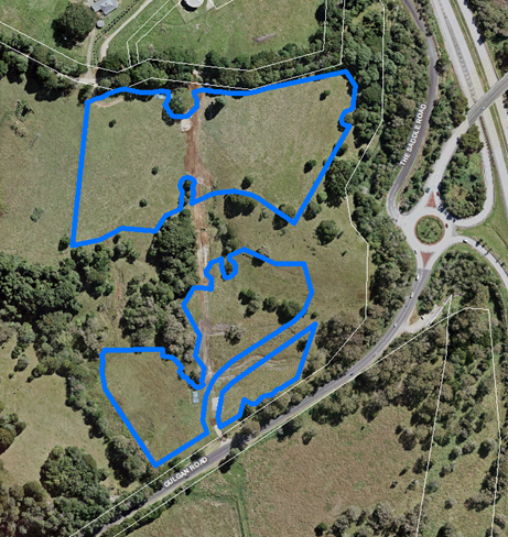
|
|
Potential developable land (ha)
|
6.5 ha
|
|
Preferred role
|
‘A’ proposes business park type development
– buildings housing multiple small businesses
‘B’ a traditional industrial estate, allowing
larger footprints for warehouse style uses requiring truck manoeuvring.
|
|
Strengths/
advantages
|
· under
single ownership
· proximity
to direct north and south-bound ingress and egress to Pacific Highway
· on existing
public transport route
· flood free
and Area B relatively flat
· proximity
to workforce including expanding residential area of Bayshore, Brunswick
Heads with potential for 250 plus homes
· links with
the proposed new on-road cycle lane on Mullumbimby Road and Gulgan Road
between Manns Road and Gulgan North Pacific Highway interchange
|
|
Key issues and further investigations
|
· community views
· Aboriginal cultural
heritage sensitivities - sites and a 100m buffer to a site (requested by
Arakwal) to be excluded from a business or industrial zone
· non-indigenous cultural
sensitivities
· biodiversity and
ecological sensitivities including prime koala habitat (verification by
qualified and experienced ecologist)
· land containing HEV
vegetation to be excluded and designated as Environmental Zone
· distance from existing
water and sewerage infrastructure and connection to existing infrastructure
· bushfire prone
· traffic impacts and
safe access point to Gulgan Road
· linkages to urban areas
(workforce) using pedestrian/cycling pathways
· landscaping to enhance
visual amenity as it pertains to view lines from Gulgan Road and Pacific
Highway
· SEPP 55 assessment of
dip site implications
|
|
Anticipated delivery timeframe
|
Medium term (this means the anticipated progression to a
planning proposal for inclusion in a business and/or industrial zone within
the following 3 to 5 years)
|
Business and Industrial
Lands Strategy updates
As
endorsed by Council under Res 19-281 Item 3, the Employment
Lands Strategy (ELS) has been renamed ‘Business and Industrial Lands
Strategy’.
The final Business and
Industrial Lands Strategy (Attachment 4) is generally consistent with the
content table endorsed by Council under Res
19-281 Item 4 and contains five sections. Table 1 below lists the
sections and provides key points of each section. The right column references
the Res 19-281 item number/s generally facilitating the edit.
Table
1: Summary of key updates to the strategy
|
Section and content overview & key points
|
Res
19-281
Item Ref.
|
|
Section
1 – Overview: contains the introduction, strategy aim, an overview of
what business and industrial lands are and why a strategy is needed.
Key points of note:
· Executive
summary rephrased to provide readers with a quick overview of the
strategy.
· Inclusion
of an ‘aim’ worded as follows:
‘Create
business centres and industrial areas that work for people, commerce and the
environment.’
|
4 & 5
|
|
Section
2 – Background: contains informative details about our people,
workforce, economy and the drivers of change.
Key point of note:
· A
new ‘driver of change’ has been inserted regarding the
Shire’s growing Indigenous workforce and business sector.
The
inclusion of this driver offers respect and acknowledgement to the importance
of local Bundjalung workers and businesses cultural connection to Country as
part of the Byron Shire’s economy.
|
4
|
|
Section
3 – Directions: outlines the directions and actions to deliver the
strategy aim.
Key point of note:
· The
strategic directions as contained in the draft ELS have been revised.
· Each
direction is provided with a context to the direction being taken and a set
of planning actions to achieve the outcome.
|
4
|
|
Direction 1: Enable business centres to retain an individual
identity and fulfil their potential.
|
|
|
Key points of note:
· Figure
10 (draft ELS Figure 15) is presented in a more simplified format and
incorporates information on the future role of a centre. For example, Ocean
Shores business centre, currently a neighbourhood centre, is supported in
taking a more of a ‘town’ centre role, whilst Bangalow and
Brunswick Heads business centres are to retain a ‘village’ centre
role. This delineation is consistent with public exhibition community
feedback and the Bangalow Village Plan.
|
4 &5
|
|
Actions under Direction
1
· Relationship
with place plans actions
The place plans developed
for towns and villages contain a series of actions. To avoid duplication or
potential inconsistencies, where an action under the draft ELS or Res
19-281 endorsement is captured under a place plan, the action has been
removed from the BILS. For example the BILS action that read as follows has
been deleted:
‘That a new
Employment Lands Strategy action be inserted to investigate opportunities for
use of the Mullumbimby surplus rail corridor lands for mixed use
purposes.’
as the draft Mullumbimby
Masterplan states:
‘Liaise with
Transport for NSW to ensure that any future use of the rail corridor lands
are consistent with community needs and values. These uses include medium
density housing for key workers and compatible commercial/live work uses,
along with peripheral parking and open space.’
The BILS encourages the
reader to refer to place plan documents for additional local area actions.
|
1 d) & 9
|
|
Direction 2: Improve the
use of existing industrial areas for industrial and urban services.
|
|
|
Key point of note:
· Parts
of Directions 1 and 5, and subsequent actions as contained in the draft ELS
are combined to provide an integrated direction centred on monitoring of
existing industrial areas under a new Direction 2. This approach recognises
the importance of bringing vacant zoned lands on line. Furthermore, in doing
so, having actions to maintain a healthy balance between lands to meet
every-day urban service needs of residents such as a car maintenance garage
and enabling new ways for business to operate. Such as recent trends for
increased on-line retailing or hosting a local ‘shop front’ as
exampled by Stone and Wood in the Byron Arts and Industry Estate so as to
support established ‘Byron’ brands.
|
1d) & 4
|
|
Direction 3: Secure a
sustainable long-term supply of suitable industrial lands.
|
|
|
Key points of note:
· This
Direction identifies possible new industrial areas.
· Figure
36 (draft ELS Figure 7) has been edited to a more simplified format with
information combining existing and possible new industrial areas.
· Tables
are inserted for each possible new industrial areas detailing:
o description
of the land
o image
of the land, with potential environmental zone areas excluded
o potential
developable area
o strengths/advantages
o key
issues and further investigations such as infrastructure servicing
o anticipated
delivery timeframe – to provide comparison among the possible release
areas in terms of anticipated development timeframes having regard to the
issues for further investigation and to assist with infrastructure planning.
Extract Area
5: Gulgan North from the BILS earlier in this report, is an example of the
new template for possible industrial areas.
|
1,4 & 5
|
|
Actions
under Direction 3
· Three
actions have been inserted providing a reference to the possible investigation
areas and a process for their consideration by Council for development.
|
1 & 5
|
|
Direction 4: Promote an attractive investment environment with
people-friendly industrial areas and business centres.
|
|
|
Key points of note:
· The
‘employment land principles’ and a number of actions contained in
the draft ELS have been reformatted into a set of:
o Business and
industrial suitable land principles to better align with the NSW
government requirement for land release criteria
o Design
principles to better align with the NSW government Better placed design
policy and Urban design guide for Regional NSW:
https://www.governmentarchitect.nsw.gov.au/policies/better-placed
https://www.planning.nsw.gov.au/Plans-for-your-area/Urban-Design-for-Regional-NSW
|
1 c) & d)
|
|
· Criteria
have been inserted providing guidance on:
o development
close to the Byron Central Hospital
o knowledge- and
creative- industry precincts
o co-operative
business and innovation hubs.
|
18
|
|
Actions
under Direction 4
· An
action is inserted to require inclusion of the above criteria in the Byron
Shire Development Control Plan to provide linkage between the
strategy’s criteria and potential development.
|
1d) &18
|
|
Direction 5: Improve
infrastructure in business centres and industrial areas.
|
|
|
Key points of note:
· Inclusion
of a Direction requiring the delivery of industrial and business lands to be
linked to the servicing and infrastructure delivery framework.
· The
context statement promotes innovative sustainable and resilient
infrastructure technologies such as water reuse and renewable energies.
|
1b)
|
|
Actions
under Direction 5
· Actions
inserted to plan for infrastructure delivery to industrial and business land
as part of future infrastructure delivery programs of Council, other agencies
and private providers.
|
1b)
|
|
· As
for Direction 1 actions, to avoid duplication or potential inconsistencies,
where strategy infrastructure and servicing actions are already reasonably
captured in place plans or other Council infrastructure strategies, they are
not duplicated in the strategy. One such example is the proposed new on-road
cycle lane on Mullumbimby Road between Manns Road and Gulgan North Pacific
Highway interchange that is already contained in the Byron Shire Bike Plan.
|
1d)
|
|
Section
4 - Making it happen: specifies actions needed to implement the strategy.
This section contains a table of actions, including measures and
timeframes for implementing the strategy. It also outlines plans for
monitoring and review.
Key points of note:
The timing of actions will
be subject to consideration at as part of the annual budget process and
allocation. The Summary Action Plan (p 91 of the strategy) provides an
indicative timing as follows:
o Short term
means a budget bid will be considered in the Operational Plan within the next
3 years
o Medium term
means a budget bid would be considered within the following 3 to 5 years
o Long term means
a budget bid or landowner initiated development would be considered within
the following 5 - 10 years.
|
1d)
|
|
Section
5 – Key Terminologies: This is a new section inserted to help
explain terms that are used within the BILS such as ‘Trade area’.
|
4
|
|
Appendix
A - Protocol framework for participatory working with the Aboriginal
community.
Key point of note:
· Council
has a statutory obligation for environmental and heritage protection under
the Commonwealth Native Title Act 1993 and NSW state cultural heritage
legislation. The preservation of cultural practices, traditional sites,
significant places and expressions of cultural identity are fundamental to
Indigenous health and social and emotional wellbeing and hence important to the
Closing the Gap, a term arising from the Council of Australian
Government’s pledge to close key gaps in health, education and
employment in response to the Social Justice Report 2005.
The process
of cultural heritage appraisal and mapping requires resources, time and
funds, both Council and the Bundjalung of Byron Bay Aboriginal Corporation
(Arakwal).
A protocol
has been identified as a means for starting this process and enabling
guidance for all parties concerned – Arakwal, Council, community, developers
and government agencies until such time as the mapping has been completed.
|
1a) & c)
|
Background Report
The draft Background Report
floor space/land demands and land scenarios prepared in early 2018 are
considered to remain reasonable. Employment and business numbers have continued
to increase and the earlier NSW Department of Planning, Industry and
Environment Projections projected population for 2036 remains the same. The
data provides a useful base line measure for future monitoring and review.
It is noted however that:
· if the planning
proposal to reduce the current zoned industrial and business land at West
Byron, (Res 19-137) is effected, or
· the North Byron
Flood Risk Management Study investigations identify limitations to the additional
capacity within existing Billinudgel industrial area
it could lead to a heighten requirement in the short term
for the other industrial lands to be brought on line.
List of documentation for
forwarding to the Department of Planning, Industry and Environment
a) Business
and Industrial Lands Strategy (Attachment 4)
b) Background
Report compiled of:
- Submissions
summary report on additional lands (Attachment 3)
- HillPDA
(consultant) background analysis report including exhibition submissions
summary report (Attachment 5)
- Updated
NSW State Policy Consistency Check to include the additional lands and remove
east Bangalow RMS land (Attachment 6).
The NSW State Policy
Consistency Check was requested by the Department of
Planning, Industry and Environment as part of their submission on the draft ELS
in November 2018 and includes:
- Table
1 Appraisal of
Important Farmland Variation Criteria
(North
Coast Regional Plan & Section 117 Direction 5.3)
- Table
2.1 Section 117
Directions Policy - Localities for New Industrial Land
- Table 2.2 Section
117 Directions Policy - Extension of Business Zones
- Table
3 North Coast Regional
Plan 2036
- Table
4 Settlement Planning
Guidelines - Mid and North Coast Regional Strategies*
* It
is noted that the NSW government has recently released North Coast Settlement
Planning Guidelines – the transitional arrangement contained in these
guidelines states that where a land use planning strategy has already been
publicly exhibited compliance with the new Guidelines will not be mandatory.
Conclusion
The Business and Industrial Lands Strategy (Attachment 4) is
consistent or justifiably inconsistent with State policies and directions and
the North Coast Regional Plan. It has sufficient merit to be supported
for forwarding to the NSW Department of Planning,
Industry and Environment for endorsement. This forms the basis of the
report recommendation.
STRATEGIC CONSIDERATIONS
Community Strategic Plan and Operational Plan
|
CSP Objective
|
L2
|
CSP Strategy
|
L3
|
DP Action
|
L4
|
OP Activity
|
|
Community Objective 4: We manage growth and
change responsibly
|
4.5
|
Work to improve community resilience in our changing
environment
|
4.5.1
|
Develop and implement strategies for our
community's needs
|
4.5.1.1
|
Finalise the Employment Lands Strategy
|
Legal/Statutory/Policy
Considerations
The Business and Industrial Lands Strategy is informed by
the relevant state, regional and/or local planning framework and best practice
planning principles.
Disability and Inclusion
Action Plan compliance
It is acknowledged that the ‘predominant floor space
use’ and capacity analysis figures as contained in the strategy may
contain colour contrasts that do not meet best practice for visibility under
the Web Content Accessibility Guidelines. The figures will be reviewed and if
necessary, reformatted prior to sending to the Department of Planning, Industry
and Environment for endorsement. In this review the spelling error for the word
‘additional’ in the legend of the capacity analysis figures will
also be corrected.
Financial Considerations
The cost of preparing the draft BILS has been met by
Council.
Consultation and Engagement
NSW government agencies and the community were consulted on
the inclusion of additional lands at Gulgan Road, Brunswick Heads and Lismore
Road Bangalow. A Submission Summary Report has been prepared for
Council’s consideration (Attachment 3).
The Executive Team and Bundjalung of Byron Bay Aboriginal
Corporation (Arakwal) senior staff were consulted on the proposal for the
inclusion of an action for a protocol to address cultural heritage mapping.
Staff Reports - Sustainable Environment and Economy 13.15
Report No. 13.15 Our
Mullumbimby Masterplan - Submissions Report
Directorate: Sustainable
Environment and Economy
Report
Author: Isabelle
Hawton, Planner
File No: I2019/1712
Summary:
Council resolved in 2015 to prepare a ‘Masterplan for
Mullumbimby’ through a collaborative process involving a community
Guidance Group representing the wider Mullumbimby community.
The Group was established with 16 community members and
worked with Councillors and staff to identify the key values of Mullumbimby,
key issues to be addressed and suggested visions, initiatives and ideas for the
future.
The process was put on hold in 2017 for resourcing reasons,
recommencing in late 2018. As a result, community participation in the
Guidance Group reduced and the final stages of development of the draft
Masterplan was guided by a smaller number of community representatives.
Council resolved in September 2019 (Res 19-453)
to publicly exhibit the draft Our Mullumbimby Masterplan for a period of six
weeks. That exhibition has now concluded.
During the exhibition period, Council staff conducted media
interviews, emailed schools for inclusion in newsletters, posted to social
media, attended a farmers’ market, and set up street stalls to gather
feedback from the wider community. There was also a series of web-based
engagement opportunities and a photography competition was run as a part of the
Masterplan exhibition.
A summary of the submissions received, and the resulting
changes to the Draft Masterplan, attached to this report, along with staff
responses to other issues raised. Key issues have been discussed in the
body of the report.
Based on the feedback and recommended updates, it is
recommended that Council adopt the Masterplan, which will facilitate planning
for the delivery of priority actions.
|
RECOMMENDATION:
1. That
Council adopt Our Mullumbimby Masterplan as contained in Attachment 1
(E2019/85870).
2. That
Council commence work on the priority actions, and consider the required
budget in the 2020/2021 budget process.
|
Attachments:
1 Our
Mullumbimby Masterplan - updated following submissions, E2019/85870
2 Changes to
the Draft Our Mullumbimby Masterplan based on the Public Exhibition, E2019/81604
3 Staff
comments on submissions to draft Our Mullumbimby Masterplan, E2019/81605
4 Combined
submissions Our Mullumbimby Masterplan, E2019/85460
REPORT
Background
Our Mullumbimby Masterplan sets
out the visions and aspirations for our town. It is a long term guiding
document that will sustainably guide change. It also includes future
Council projects and opportunities for community-led initiatives.
The
Public Exhibition
In accordance with a previous
Council resolution (Res 19-453) the draft Masterplan was
publically exhibited from 7 October to 15 November 2019.
Engagement activities included:
· two ‘parklets’, where Council staff established
an on-street stall to talk to the community - on Burringbar Street, on a
Tuesday from 9am to 1pm, and on Station Street, alongside Flock, on a Thursday
afternoon from 2pm to 6pm;
· a stall at the Mullumbimby Farmer’s Market on a
Friday morning
· publication of the draft and associated engagement events
via traditional and social media, and a media release;
· advertisements in school newsletters;
· notification at a Mullumbimby Chamber of Commerce
collective event;
· online engagement through the ‘YourSay’ webpage
(14 map pins, 2 separate discussion forums); and
· several radio interviews (ZZZ FM and ABC North Coast) and
an interview with the Byron Shire News.
During the exhibition period,
Council staff spoke to scores of community members at street stalls and the
market stall and received over 40 written submissions on the plan.
Key
issues
The feedback in general was
largely positive, with many applauding the intended outcomes of the plan.
Some key features that gained support were:
· Burringbar Talking Street;
· Improved pedestrian and cycle accessibility; and
· More trees under a comprehensive street tree plan.
Community members also expressed
concerns that the ‘affordable housing’ talked about as a part of
the plan is genuinely affordable in perpetuity. It is
important to the community that this key part of the plan is delivered in a
meaningful and transparent fashion to ensure ongoing community support.
In addition, community members
expressed concerns about ongoing flooding issues and the impacts of changing
demographics on the town.
During the exhibition period,
submissions were received on many issues, including:
· Flooding;
· Suggestions for new actions to be included in the plan
(including weeding creeks, upgrading road surfaces and upgrading the swimming pool);
and
· Support for improved pedestrian and cycling infrastructure.
· Support for placemaking initiatives.
Crossover
between the Draft Residential Strategy and the Mullumbimby Masterplan
Much
of the feedback received over the course of the exhibition period related to
the suggested new release housing areas contained in the Byron Shire Draft
Residential Strategy, which was exhibited in the weeks prior to Our Mullumbimby
Masterplan.
In conversation with members of
the public, staff were eager to stress that Our Mullumbimby Masterplan is not a
growth management strategy, and does not directly designate land for future
development, but rather aims to ensure that the values and principles of the
town are carried through change over time.
The values and principles of the
Masterplan will guide whatever outcomes are implemented from the Byron Shire
Residential Strategy, but the Masterplan’s primary role is not to
designate specific parcels of land for development or to project population
growth.
Nevertheless, many conversations
at the street stalls were concerned with the delivery of new housing, including
questions around the style of housing, the ability to enable affordable housing
in perpetuity, and unresolved issues relating to flooding.
Many of these questions will be
answered with the delivery of new research, including the holistic flood study
for South Mullumbimby and the current work underway to research models for the
delivery of affordable housing.
Traffic
and Parking
Key issues were raised during the
exhibition around traffic and parking. Though there was general support
for the formalisation of the alternate routes along Fern and Tincogan Streets,
and the introduction of the Burringbar Street Talking Street, some residents
expressed concern about the impacts on traffic and parking in the town
centre. In addition, concerns were also raised about the potential
impacts of an increase in housing on transport and what many community members
considered to be an already burgeoning number of cars in the town centre.
Mullumbimby is and will remain a
local service centre for the Brunswick Valley, meaning that many people who use
its services will need to drive to access the town centre. With this in
mind, it is imperative that alternate parking options are provided where
parking is proposed to be removed, particularly in relation to the longer-term
plan for the Burringbar Street Talking Street.
As such, the proposal to include
some peripheral parking in the rail lands south of Argyle Street should be
pursued as an alternate parking location if car parks are removed from
Burringbar Street. This was a point emphasised throughout the community
consultation.
In addition, some residents of
Tincogan and Fern streets expressed concern over their streets gaining
increased traffic. It is suggested that any detailed designs for the
formalisation of the alternate routes include traffic calming measures to
ensure safety and noise minimisation.
Many submissions were eager for
Brunswick Terrace to become a cul-de-sac. Residents expressed their
concerns over the safety of the intersection and pedestrian crossing near
Federation Bridge and suggested that creating a cul-de-sac at the southern edge
of Brunswick Terrace might alleviate many issues. The support for this
action should be noted as the plan moves forward.
Council staff also considered a
submission that suggested adding a path to Clay’s Road. Though this
is considered a logical connection, the challenging topography and the nature
of the existing narrow road mean that a desktop analysis and rough estimate
places the cost of a pedestrian path at around $800,000. At this stage,
Council staff have decided not to proceed with adding this to the Masterplan
and the Byron Shire Bike Plan, given the anticipated cost and the likelihood
that other projects would take precedence.
Other issues raised during the
submission period have been covered in Attachment 3.
Written
Submissions
Council received 44 written
submissions (Attachment 4) during the public exhibition period. Much of
the focus of the written submissions was not directly relevant or was outside
the scope of the Masterplan. However, some changes were suggested through the
written submissions and have since been incorporated into the Plan (see Attachment
2).
Changes
made to the plan based on the public exhibition period
A number of changes have been made
to the draft plan based on the public exhibition period. An overview of
all changes is included in Attachment 2. Key changes to the
document include:
· Updates to wording for further respectful inclusion of the
Arakwal people (as per their submission);
· Minor wording changes to assist in clarity and legibility;
· Minor mapping corrections to better integrate with other
Council documents and for clarity and legibility;
· An action to upgrade the bus stop near the scout hall;
· An action to upgrade the toilets at the Station Street
Carpark; and
· Additional references to Water Sensitive Urban Design
(WSUD).
Next
steps
Should Council adopt the
Masterplan, the next step will be to begin implementation of priority actions
early in 2020.
STRATEGIC CONSIDERATIONS
Community Strategic Plan and
Operational Plan
|
CSP Objective
|
L2
|
CSP Strategy
|
L3
|
DP Action
|
L4
|
OP Activity
|
|
Community
Objective 4: We manage growth and change responsibly
|
4.1
|
Support the
visions and aspirations of local communities through place-based planning and
management
|
4.1.1
|
Develop,
implement and update Place Plans that promote place-based forward planning
strategies and actions
|
4.1.1.2
|
Continue to
develop Our Mullumbimby Masterplan
|
|
|
|
|
|
|
|
|
|
|
|
|
|
|
Legal/Statutory/Policy
Considerations
Nil
Financial Considerations
Funds have been allocated to finalise the development of Our
Mullumbimby Masterplan.
Council will need to consider the allocation of funds in
order to implement actions within the plan. These should be looked at as
a part of the 2020/2021 budget bid process.
Staff Reports - Sustainable Environment and Economy 13.16
Report No. 13.16 Integrated
Pest Management Strategy (Resolution 19-519 )
Directorate: Sustainable
Environment and Economy
Report
Author: Karen
Love, Research Officer – Integrated Pest Management
File No: I2019/1820
Summary:
As a result of Resolution 19-519 the adoption of the
Draft Integrated Pest Management Strategy 2019-2029 (the Strategy) was
rescinded and a review of six items were to be completed before presenting the
Strategy back to the next available Planning Meeting of Council.
This report outlines the actions taken for each of the six
items reviewed and seeks to confirm each requirement has been met before the
graphics are finalised.
|
RECOMMENDATION:
1. That
Council acknowledge that items 1 to 6 of Resolution 19-519 have
been satisfactorily met.
2. That
Council endorse the changes in Attachment 1
(E2019/84783) for inclusion into the Integrated Pest Management Strategy
2019-2029.
3. That
Council note that item 7 of Resolution 19-519 “on
completion of items 1-6 above, present the revised draft to the next available
Planning Meeting of Council”, will be reported in February 2020.
|
Attachments:
1 Draft
Planting Control Method for inclusion into IPMS, E2019/86506 
REPORT
At the Council Planning
meeting on 17 October 2019, Council considered a rescission motion on the
Integrated Pest Management Strategy 2019-2029 and resolved as follows:
https://byron.infocouncil.biz/Open/2019/10/PLAN_17102019_AGN_1093.PDF
19-519:
Resolved that Council
review the draft Integrated Pest Management Strategy 2019 – 2029 (IPMS)
as follows:
1. Improve
readability by use of more appropriate placement of text, particularly over
graphics, and choice of ink colours and transparency.
2. Redesign
layout to ensure better coherence and relationship of text and adjacent
graphics.
3. Amend
all statements that refer to the cessation of chemical/pesticide/spraying on
rural roadsides and redraft to align with actual practice between 2013 and the
present, ensuring that all such statements are consistent and able to be
clearly understood by readers.
4. Include
full description of weed removal and native vegetation replacement methodology
for weed management on roadsides (Small Steps to Healthier Roadside Vegetation)
in the IPMS.
5. Consult
with Goonengerry Landcare to provide full description of the development and
practice of partnership with Goonengerry Landcare including acknowledgement of
volunteers, pictures and demonstrated understanding of the role of Small Steps
in achieving IPSM objectives.
6. Amend
the first paragraph on page 3 to add the sentence “Whilst maximising our
best practice weed management of our biodiversity rich areas.”
7. On
completion of items 1-6 above, present the revised draft to the next available
Planning Meeting of Council.
With regard to the above resolution the following actions
have been actioned by staff as follows:
Points 1 and 2 completed:
· The document has
been accessibility tested and passed the PDF accessibility test.
· Graphics and text
have had transparency contrast increased.
· The document is
also integrated with assistive technology.
Point 3 for approval:
Within the document there were four instances where the term
‘rural roadsides’ was used in the context of ceasing herbicide use.
The following amendments made:
- Page 4: Replace ‘ceasing’ with
‘substantial reduction’ as follows - ‘This resulted in a
substantial reduction in the use of pesticide across children’s
playgrounds, bus shelters, town centres, garden beds, rural roadsides and
Sports fields‘.
- Page 9: Amend sentence to: ‘Following the 2013
Council resolution (13-621), pest control methodologies changed to achieve a
major reduction in the use of pesticides through the application of alternative
control methods‘.
-Page 9: Delete following infographic and replace with icons
for mechanical control, biological control, steam weeding and manual control.
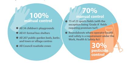
- Page
17: Amend sentence to: ‘After the Resolution in 2013, pesticide use for
the maintenance of roadside vegetation was considerably reduced through the
replacement of broad scale herbicide control with a program of selective
slashing (along rural roadsides) and brush cutting (around fences and guard
rail)‘.
- Page
27: Remove roadsides and Statement: No Council rural roadside crews currently
use pesticide (2018) from infographic.
Point 4 and 5 for approval:
Draft document of planting information with photo’s
Attachment 1 subject to approval.
Point 6 completed:
- Page 3 add: “Whilst maximising best practice
weed management of our biodiversity rich areas.” To the last sentence of
the first paragraph.
Next steps
Once approved, the planting information
and amendments to wording will go to graphics for inclusion into the final
Strategy to be presented to Council at the Council meeting in February 2020.
STRATEGIC CONSIDERATIONS
Community Strategic Plan and
Operational Plan
|
CSP Objective
|
L2
|
CSP Strategy
|
L3
|
DP Action
|
L4
|
OP Activity
|
|
Community Objective 3: We protect and enhance our
natural environment
|
3.1
|
Partner to protect and enhance our biodiversity,
ecosystems and ecology
|
3.1.1
|
Protect and enhance our natural environment and
biodiversity
|
3.1.1.4
|
Prepare a Shire Wide Integrated Pest Management Strategy
|
Legal/Statutory/Policy Considerations
Related Legislation:
Agricultural and Veterinary
Chemicals Administration Act 1992
Agricultural and Veterinary
Chemicals Code Act 1994
Biodiversity Conservation Act 2016
Biosecurity Act 2015 &
Biosecurity Regulations 2017
Companion Animal Act 1998
Crown Land Management Act 2016
Crown Land Legislation Amendment
Act 2017
Environmental Planning and
Assessment Act 1979
Forestry and National Park Estate
Act 1998
Game and Feral Animal Control Act
2002 & Game and Feral Animal Control Regulations 2012
Local Government Act 1993
Local Land Services Act 2013
National Parks & Wildlife Act
1974
NSW Pesticide Act 1999 &
Pesticide Regulation 2017
Prevention of Cruelty to Animals
Act 1979
Protection of the Environment
Operations Act 1997
Roads Act 1993
Work Health and Safety Act (2011)
& Work Health and Safety Regulations (2017)
Related Council Policies
Integrated Pest Management Policy 2018
Personal Protective Equipment Policy 2016
Planting and Landscaping on Footpaths and Nature Strips
within Road Reserves and Drainage Easements Policy 4.16
Procurement and Purchasing Policy 2.6
Work Health & Safety Policy
Related Plans/ Standards and Registers
Byron Shire Pest Animal Management Plan 2018-23
Byron Shire Council Pesticide Use Notification Plan
Byron Shire Roadside Vegetation Management Plan 2012
Byron Shire Tree and Vegetation
Removal Procedure 2017
Byron Shire Chemical Sensitive
Residents and Organic Growers Register
National Standards for the
practice of Ecological Restoration in Australia 2017
North Coast Regional Strategic
Weed Management Plan 2017-2022
North Coast Regional Strategic
Pest Animal Management Plan 2018-2023
Pesticide Use Notification Plan
2018
Strategic Asset Management Plan
2016-2026
AS 4373-2007 Pruning of amenity
trees - SAI Global
Financial Considerations
IPMS project is funded within the current OP budget 19/20.
Consultation and Engagement
Council’s Manager of Works consulted with a
representative of the Goonengerry Landcare group for information relating to
partnership development, and advocacy of Landcare groups wanting to work in
conjunction with Council on rural roadsides.
Staff Reports - Sustainable Environment and Economy 13.17
Report No. 13.17 Annual
Emissions Inventory and Achieving Net Zero Emissions Target
Directorate: Sustainable
Environment and Economy
Report
Author: Kim
Mallee, Sustainability Officer
Julia Curry, Sustainability and
Emissions Reduction Officer
File No: I2019/1823
Summary:
This report outlines the annual emissions inventory for the
2018/19 financial year for Byron Shire Council and provides an update showing
that Council is on track for meeting the Net Zero Emissions Target.
This report also seeks endorsement for Byron Shire Council
to become Carbon Neutral Certified under the National Carbon Offset Standard
(NCOS) and outlines work needing to be progressed regarding carbon offsets.
|
RECOMMENDATION:
1. That
Council note the annual emissions inventory and progress toward meeting the
Net Zero Emissions Target.
2. That
Council become Carbon Neutral Certified under the National Carbon
Offset Standard (NCOS) commencing in the 2025/26 financial year.
3. That
Council note that a Councillor and staff workshop will be organised in the
2020/21 financial year in order to fully understand the scope and
implications associated with offsetting and that the workshop report will
form the foundation for an offsetting policy and procedure as identified in
the Net Zero Emissions Strategy.
|
Attachments:
1 Report on
FY2018-19 Detailed Annual Emissions Inventory, E2019/83875 
REPORT
Byron Shire Council has experienced a 19.7% reduction in
organisational carbon emissions compared to the previous year. This was
predominantly due to the new electricity contract with Powershop that fully
offset electricity use from January to June 2019 and the natural decline of
landfill gas fugitive emissions. This reduction brings Council on track to
meeting the target of net zero emissions so long as this level of electricity
offset is maintained in perpetuity.
Figure 1 and Table 1 below show how Council is tracking
towards the Net Zero Target.
Figure 1 – 2018-19 Emissions tracking towards
2025 target
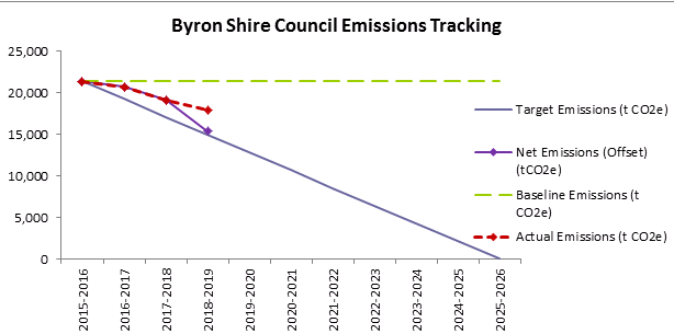
Table 1 – 2018-19 Actual and net emissions over
time
|
Financial Year
|
Actual Emissions (tCO2e)
|
Net Emissions (Offset) (tCO2e)
|
Target (tCO2e)
|
|
2016
|
21,389
|
21,389
|
21,389
|
|
2017
|
20,701
|
20,701
|
19,250
|
|
2018
|
19,122
|
19,122
|
17,111
|
|
2019
|
17,984
|
15,358
|
14,972
|
Table 2 – Summary of Emissions Sectors
|
Summary of Emissions Sectors
|
|
|
Highlights
|
Emissions Change
(tCO2e)
|
|
Electricity
|
· New supplier
Powershop providing 100% carbon offset electricity.
· 1.5 % reduction
in electricity use
· 52% reduction in
emissions
· Annual cost
$1,290,919
|
-2,432
|
|
Streetlight
|
· New supplier
Powershop providing 100% carbon offset electricity.
· LED streetlight
trial of 260 lights at Ocean Shores due Dec 2019
· Cost benefit
analysis of bulk roll out of LED’s being investigated
· Negligible
electricity use change and a 50% reduction in emissions
· Annual cost
$355,420
|
-319
|
|
Fleet
|
· 3% Increase in
fuel consumption created a 21% increase in cost
· 51% of fuel used
in light (passenger) vehicle fleet and 49% used in heavy plant and equipment
· Significant
action required to reduce fleet sector emissions
· Annual cost
$633,308
|
+36
|
|
Bottled Gas
|
· Negligible
emissions footprint
· No action
required
· Annual cost
$14,972
|
+1
|
|
Waste
|
· 9% reduction due
to natural decline of landfill
· Composting
emissions included for first time
· Investigating
not selling carbon credits generated from methane gas flare to enable carbon
reduction to be counted by Council.
|
-982
|
|
Waste Water
|
· 5.8% reduction
in fugitive emissions due to drier than normal year
· Main area of
action required is reducing waste water generation from the community and
inflow and infiltration from storm water to the sewer system.
|
-68
|
|
Total
|
|
-3,763
|
A full and detailed analysis of each sector and suggested
action is provided in Attachment 1.
Carbon Neutrality – to certify or to not certify
It is recommended that Council work towards carbon neutral
certification under the National Carbon Offset Standard (NCOS) for the 2025/26
financial year. Council’s decision now to certify or not certify under
NCOS will directly impact how Council monitors and reports its annual
emissions, and how it will claim to have reached net zero in 2025. It will take
time for Council’s monitoring and reporting processes to adapt to be able
to achieve this which is why commitment to this certification is sought so
early on.
The National Carbon Offset Standard (NCOS) is a voluntary
framework to assist in the management of greenhouse gas emissions and achieve
credible carbon neutral certification under the Australian Government. NCOS
certification is recommended as it displays rigour and will enable
Council’s emissions reduction efforts to count at a national level, and
ultimately contribute towards meeting international climate agreements such as
the Paris accord. Council is currently undertaking the first two, of the
five steps towards achieving certification:
1. Measure
– prepare annual emissions inventory report
2. Reduce
– reduce emissions where possible
3. Offset
– purchase certified offset units and retire any LGC offset units
4. Report
– prepare a public report on Council’s carbon account
5. Audit
– engage consultant to conduct an independent audit on Council’s
account and public report.
The current NCOS annual certification fees, which Council
would incur upon certification in FY2025/26, are approximately $13,000. This
covers the use of the certification and is charged according to the
organisation’s annual emissions (currently around 17,000t CO2-e
each year). Additionally there is also an independent audit fee once
every three years which costs between $10,000 and $15,000, this would first be
incurred in FY2025/26.
The NCOS standard aligns with the scopes of emissions
currently being measured – all scope 1 and 2 and some scope 3. Refer to
Table 3 below for an example of an organisational emissions boundary, according
to scope.
Other local governments certified under NCOS scheme are
Brisbane, Sydney, Melbourne and Randwick.
Emissions Reporting
Boundaries
Table 3. Example of a defined
Emissions Boundary.
|
Measures required to achieve certification
|
|
|
Scope 1
Direct Emissions
|
Scope 2
Indirect Emissions
|
Scope 3
Indirect Emissions
(Currently measuring)
|
Scope 3
Indirect Emissions
(need to measure for certification)
|
Certification Excluded
Indirect Emissions
|
|
· Diesel, petrol, ethanol, biodiesel & liquid gas
used in Council’s fleet.
· Diesel on-site for stationary energy used in Council
owned buildings & managed buildings.
· Natural gas on-site used in Council owned buildings
and managed parks.
· Fugitive emissions from Council’s closed
landfill.
· Fugitive emissions from STPs.
|
· Combustion of fossil fuels off-site to provide mains
electricity for Council owned and managed assets.
|
· Business related flights
· Paper used by Council
· Water usage
· Fuel use associated with collection and transfer of
waste
|
· Disposal of Council waste
· Taxi trips
· Accommodation
· Diesel, petrol, ethanol, biodiesel & liquid gas
used for major outsourced services.
· Extraction, production & transport of fuels used
by fleet & major outsourced activities.
· Employee commute.
|
· Rental vehicles
· Embodied energy of road & building materials.
· Events.
· Freight & couriers.
· Paper that is certified carbon neutral.
· Business flight offset
· Impact of equipment, consumables, repairs,
maintenance & communications.
· Minor outsourced activity
· Scope 3 emissions from ethanol & biodiesel consumption
· Food & catering
|
How will Council offset
emissions?
In accordance with the Net
Zero Emissions Strategy, Council will need to purchase carbon offsets to meet a
net zero target by 2025. Carbon offsets will be required from 2025/26 onwards
regardless of Council’s decision to become NCOS certified just to meet
the target. Carbon offset units are reductions of greenhouse gases or removals
of greenhouse gases from the atmosphere by sinks, are tradeable and can be used
to negate (or offset) all or part of Council’s emissions.
The most common way to invest in an offset program is
through government regulated offsets.
Examples of approved offsets include, but are not limited
to:
· Australian
approved offset schemes include– Australian Carbon Credit Units (ACCUs)
and Large-Generation Certificates (LGCs) which are created per megawatt hour
(MWh) of eligible electricity generated by a power source, such as the Dingo
Lane solar farm.
· International
offsets include Certified Emissions for Clean Development Mechanism projects;
Removal Units in countries around land use, land-use change and forestry
activities; Verified Emissions Reductions and Carbon Units.
In order to understand fully the scope and implications
associated with offsetting, it is planned that a Councillor and staff workshop
will be organised in the 2020/21 financial year, to include:
· Introduction
to offsetting plus case studies and examples of what other Councils are doing
· Certified
versus non-certified offsets
· Specific
modelling for different procurement options eg: tree planning offsets in India
compared to revegetation ACCUs in Grafton.
· Procurement
process and associated risks
· Retirement
of offsets
· Reporting
and accountability.
The workshop report will form the foundation for an
offsetting policy and procedure as identified in the Net Zero Emissions
Strategy. In order to develop the policy an analysis of type, location,
provider and cost of offsets will need to occur. This analysis would also need
to take into account that the most beneficial option likely to be supported by
the local community would be localised offsetting, such as uncertified tree
planting in the Byron Shire as proposed by Zero Emissions Byron. The closest
vegetation ACCUs project is in Grafton (see http://www.cleanenergyregulator.gov.au/ERF/project-and-contracts-registers/interactive-map).
STRATEGIC CONSIDERATIONS
Community Strategic Plan and
Operational Plan
|
CSP Objective
|
L2
|
CSP Strategy
|
L3
|
DP Action
|
L4
|
OP Activity
|
|
Community
Objective 3: We protect and enhance our natural environment
|
3.2
|
Strive to
become a sustainable community
|
3.2.1
|
Work towards Council's
zero-emissions target
|
3.2.1.1
|
Implement Net
Zero Emissions Strategy for Council Operations 2025
|
Legal/Statutory/Policy
Considerations
Nil – Certification in the National Carbon Offset
Standard is voluntary.
Financial Considerations
Cost of Carbon Neutral
Certification will need to be budgeted for in the 2025/26 financial year.
Current best estimate is approximately $28,000.
Consultation and Engagement
This report has been prepared with contribution across all
Council directorates and presented to the executive team and endorsed.
Staff Reports - Sustainable Environment and Economy 13.18
Report No. 13.18 PLANNING
- Report Exceptions to Development Standards 1 July to 30 September 2019
Directorate: Sustainable
Environment and Economy
Report
Author: Chris
Larkin, Manager Sustainable Development
Noreen Scott, EA Sustainable
Environment and Economy
File No: I2019/1846
Summary:
This report is provided as a requirement of the NSW
Department of Planning Circular PS17-006, for reporting on exceptions to
development standards for applications made under clause 4.6 of the Standard
Instrument LEP and Clause 6 of SEPP 1.
NOTE TO COUNCILLORS:
In accordance with the
provisions of S375A of the Local Government Act 1993, a Division is to be
called whenever a motion for a planning decision is put to the meeting, for the
purpose of recording voting on planning matters. Pursuant to clause 2(a)
under the heading Matters to be Included in Minutes of Council Meetings of
Council's adopted Code of Meeting Practice (as amended) a Division will be
deemed to have been called by the mover and seconder of all motions relating to
this report.
|
RECOMMENDATION:
That Council adopt the report on exceptions to
development standards for the period 1 July to 30 September 2019.
|
REPORT
This report is provided as a requirement of the NSW
Department of Planning Circular PS17-006, for reporting on exceptions to
development standards for applications made under Clause 4.6 of the Standard
Instrument LEP and Clause 6 of SEPP 1.
SEPP 1 applies to development applications submitted under
Byron Local Environmental Plan 1988. Clause 4.6 applies to development
applications submitted under Byron LEP 2014.
The period of reporting is for the 1 July 2019 to 30
September 2019 for the following DAs:
|
DA No
|
10.2019.28.1
|
|
Development
|
New Dwelling House to Create Dual Occupancy (Detached) and
Swimming Pool
|
|
Property:
|
119 Lawlers Lane BANGALOW
|
|
Lot and DP:
|
LOT: 2 DP: 629528
|
|
Zoning:
|
RU1 Primary Production
|
|
Development Standard being varied
|
4.2D Erection of dual occupancies
(detached) and secondary dwellings in Zones RU1 and RU2
|
|
Justification Summary
|
That compliance with the development standard is
unreasonable or unnecessary in the circumstances of the case.
That there are sufficient environmental planning grounds
to justify contravening the development standard.
The dwelling site was chosen to minimise earthworks and
also to reduce the potential for land use conflict.
|
|
Extent of variation
|
9% (9 metres above the 100m distance)
|
|
Concurrence
|
Director- delegate of Council under assumed concurrence
|
|
Determination Date
|
9/8/2019
|
|
Determined by
|
Director
|
|
|
|
DA No.
|
10.2018.529.3
|
|
Development
|
S4.55 to Amend Layout, Floor Level, Window Sizes, Plant
Room and Storage Areas
|
|
Property:
|
657B Broken Head Road BROKEN HEAD
|
|
Lot and DP:
|
LOT: 4 DP: 713515
|
|
Zoning:
|
7 (k) Habitat zone
|
|
Development Standard being varied:
|
Height of upper floor
|
|
Justification Summary
|
That compliance with the development standard is
unreasonable or unnecessary in the circumstances of the case.
That there are sufficient environmental planning grounds
to justify contravening the development standard.
The 100 mm modification to the upper floor level is of
minor significance and results in no adverse impact on adjoining land or
development.
|
|
Extent of variation
|
7.77% (0.35 metres over 4.5 metres)
|
|
Concurrence
|
Director- delegate of Council under assumed concurrence
|
|
Determined Date
|
14/8/19
|
|
Determined By
|
Director
|
|
|
|
DA No.
|
10.2019.129.1
|
|
Development
|
Boundary Adjustment Two (2)
Lots Subdivision Two (2) Lots
|
|
Property:
|
480 -544 Coolamon Scenic
Drive COORABELL
|
|
Lot and DP:
|
LOT: 3 and LOT 4 DP: 579176
|
|
Zoning:
|
7(d) - Scenic/Escarpment, RU1 - Primary Production
|
|
Development Standard being varied:
|
Proposed lots less than minimum lot size (c.11 - Byron
LEP 1988, c.4.1 - Byron LEP 2014)
|
|
Justification Summary
|
Objectives of development standard and relevant zones are
met.
|
|
Extent of variation
|
Increase size of Lot 3 by 93.3%, by reducing size of Lot 4
by 1.3%
|
|
Concurrence
|
Secretary of Department of Planning & Environment
issued concurrence.
|
|
Determined Date
|
15/8/19
|
|
Determined By
|
Council
|
|
|
|
DA No.
|
10.2019.245.1
|
|
Development
|
Two (2) Lot Subdivision, of two (2) existing lots, Siting
of Future Building Envelope and Ancillary Works
|
|
Property:
|
1859 Hinterland Way EWINGSDALE
|
|
Lot and DP:
|
LOT: 23 DP: 1239353 and LOT 21 DP 877915
|
|
Zoning:
|
7(d) - Scenic Escarpment, RU1 Primary Production
|
|
Development Standard being varied:
|
Proposed lot less than minimum Lot size (c.4.1 - Byron
LEP 2014)
|
|
Justification Summary
|
That compliance with the development standard is
unreasonable or unnecessary in the circumstances of the case.
That there are sufficient environmental planning grounds
to justify contravening the development standard.
Objectives of development standard and relevant zones met.
|
|
Extent of variation
|
Reduce size of lot 101 by 1.725% of 40ha
|
|
Concurrence
|
Director- delegate of Council under assumed concurrence
|
|
Determined Date
|
30/8/19
|
|
Determined By
|
Director
|
STRATEGIC CONSIDERATIONS
Community Strategic Plan and Operational Plan
|
CSP Objective
|
L2
|
CSP Strategy
|
L3
|
DP Action
|
L4
|
OP Activity
|
|
Community Objective
4: We manage growth and change responsibly
|
4.1
|
Support the
visions and aspirations of local communities through place-based planning and
management
|
4.1.3
|
Manage
development through a transparent and efficient assessment process
|
4.1.3.1
|
Assess and
determine development applications
|
|
|
|
|
|
|
|
|
|
|
|
Legal/Statutory/Policy Considerations
The report is provided as a
requirement of NSW Department of Planning circular PS 17-006.
Staff Reports - Sustainable Environment and Economy 13.19
Report No. 13.19 Expressions
of Interest for the Place Planning Collective (Res 19-451)
Directorate: Sustainable
Environment and Economy
Report
Author: Isabelle
Hawton, Planner
File No: I2019/1860
Summary:
In September 2019 Council resolved to establish a Place
Planning Cluster Group (known from here on as the “Place Planning
Collective”) to manage the implementation of the Mullumbimby, Bangalow,
and Byron Arts and Industry Estate place plans (Res 19-451).
Council also resolved to put out an Expression of Interest
(EOI) process in order to recruit members for that group. This has now
been undertaken. Advertisements were run in local newspapers, a notice
was placed on council’s website, there were social media posts, Council
staff spoke with numerous community members during the public exhibition of the
draft Our Mullumbimby Masterplan and emails went out to the Community round
table and previous guidance groups.
This wide publication has resulted in 19 expressions of
interest to be a part of the place planning collective (Confidential Attachment
1). Council must now nominate six (6) members from the EOIs to sit on the
collective, alongside six (6) randomly selected community members.
|
RECOMMENDATION:
That Council nominate the following six
representatives from the nominations contained in Attachment 1 (E2019/86209)
to be part of the Place Planning Collective: ___________, ____________,
____________, ____________, _____________ and ______________.
|
Attachments:
1 Confidential
- Responses Place Planning Collective Expressions Of Interest Form, E2019/86209
REPORT
In September 2019 Council resolved to establish a Place
Planning Cluster Group (known from here on as the “Place Planning
Collective”) to manage the implementation of the Mullumbimby, Bangalow,
and Byron Arts and Industry Estate place plans (Res 19-451).
Council also resolved to put out an expression of interest
process in order to recruit members for that group. This has now been
undertaken. Advertisements were run in local newspapers, a notice was
placed on council’s website, there were social media posts, Council staff
spoke with numerous community members during the public exhibition of the draft
Our Mullumbimby Masterplan and emails went out to the Community round table and
previous guidance groups.
This wide publication has resulted in 19 nominations to be a
part of the place planning collective (Attachment 1). Council must now
nominate six (6) members to sit on the collective, alongside six (6) randomly
selected community members.
Feedback from the Community Roundtable
During the expression of interest process, some early
feedback was received from a former member of the Bangalow guidance
group. This community member was eager for a sense of continuity to be
upheld through the Place Planning Process, by including some members from
previous guidance groups in the new place planning collective. This
community member argued, it would allow for a natural continuation of the
narrative and for some of the group to have the previous experience and skills
necessary to dive into projects.
This community member suggested that as a minimum, those
selected through the random selection process should also have a basic set of
skills. This feedback has been taken on board.
Next steps
A random selection process will
occur early in 2020. Once the membership of the Place Planning Collective has
been finalised, the first meeting will be scheduled for early in 2020.
STRATEGIC CONSIDERATIONS
Community Strategic Plan and
Operational Plan
|
CSP Objective
|
L2
|
CSP Strategy
|
L3
|
DP Action
|
L4
|
OP Activity
|
|
Community
Objective 4: We manage growth and change responsibly
|
4.1
|
Support the
visions and aspirations of local communities through place-based planning and
management
|
4.1.2
|
Ensure
consistency of place-based projects with community Place Plans through
embedding a governance framework that includes planning, implementation
and ongoing management
|
4.1.2.1
|
Facilitate
Guidance Groups
|
|
|
|
|
|
|
|
|
|
|
|
Legal/Statutory/Policy Considerations
Nil
Financial Considerations
Nil
Consultation and Engagement
Extensive consultation was undertaken in order to seek
members - advertisements were run in local newspapers, a notice was placed on
council’s website, there were social media posts, Council staff spoke
with numerous community members during the public exhibition of the draft Our
Mullumbimby Masterplan and emails went out to the Community round table and
previous guidance groups.
Staff Reports - Sustainable Environment and Economy 13.20
Report No. 13.20 Residential
Strategy and affiliated projects update
Directorate: Sustainable
Environment and Economy
Report
Author: Natalie
Hancock, Senior Planner
File No: I2019/1903
Summary:
The purpose of this report is to provide Council with an
update on the status of the draft Residential Strategy and a number of affiliated
projects, namely:
· Lot 12 Bayshore
Drive
· Old Mullumbimby
Hospital
· Low Rise Medium
Density Code planning proposal
· SEPP 70 Affordable
Housing Contribution Scheme.
The report also report seeks Council support for
consideration of all Residential Strategy new release investigation lands for inclusion
under the SEPP 70 Affordable housing contribution scheme.
|
RECOMMENDATION:
1. That
Council note that the findings of the urban design investigation for Lot 12
Bayshore Drive will be reported to Council in early 2020 with the intent to
exhibit it concurrently with the draft Byron Arts and Industry Estate
Precinct Plan.
2. That
Council note that the old Mullumbimby Hospital Site was considered in the
draft Alternative Housing Models Research Paper (Attachment 1 E2019/87788) with
testing of the concepts against housing governance and delivery models to
occur over the next two months, enabling the findings to be reported to
Council in early 2020.
3. That
Council note that the planning proposal to introduce minimum lot size
standards for ‘manor house’ and ‘multi dwelling
housing’ in readiness for the pending Low Rise Medium Density Code
commencement in July 2020, finalised public exhibition on 22 November and the
submissions will be reported to Council for consideration in early 2020.
4. That
Council support consideration of Residential Strategy new release
investigation lands for inclusion under the SEPP 70 Affordable housing
contribution scheme.
5. That
Council note that staff are reviewing the public submissions received on the
draft Residential Strategy and the submissions will be reported to Council
for consideration in early 2020.
|
Attachments:
1 Byron Bay
Alternative Housing Model, E2019/87788
2 Special
Disclosure of Pecuniary Interest Annexure, E2012/2815
REPORT
The purpose of this report is to update Council on the
following key projects:
· Lot 12 Bayshore
Drive
· Old Mullumbimby
Hospital
· Low Rise Medium
Density Code planning proposal
· Draft Residential
Strategy.
The report is set out in the above order.
Lot 12 Bayshore Drive
Lot 12 on DP 1189646,
highlighted in yellow on the figure below, is
situated off Bayshore Drive in northern part of the Byron Arts and Industry
Estate (BAIE). It is a key Council-owned land parcel, likely to become
available for development in the next couple of years.
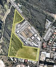
Figure 1: Lot 12
Leading on from an Enquiry by
Design workshop for BAIE Council staff, working with a group of representative
stakeholders from within the BAIE, have prepared a draft Byron Arts and
Industry Estate Precinct Plan (Precinct Plan). The draft Precinct Plan was
considered at the 19 September 2019 Council Planning Meeting where Council resolved
(Res. 19-452) to endorse the Draft Precinct Plan for public exhibition.
The Enquiry by Design and
draft Precinct Plan identified Lot 12 as an opportunity for the development of
a sustainability and innovation
hub. Also at the 19
September meeting Council resolved (19-452) to accelerate the
preparation of a Structure Plan for Lot 12 concurrent with the finalisation of
the Draft Precinct Plan.
A request for quotation has been
issued for a consultant to prepare urban design site options. The brief issued requested
that 3 options be explored in the context of the land functioning as a
sustainability and innovation hub by either:
• refining
the broad concept in the draft Precinct Plan
• adding
into the land use mix a TAFE and a Vanguard laundry (a not-for-profit organisation laundry with a social
outcome purpose such as supporting
people who have a lived experience of mental illness and struggle to secure
employment)
• a
blank canvas - open to ideas.
The findings of the urban design
investigation for Lot 12 Bayshore Dr will be reported to Council in early 2020
with the intent to exhibit it concurrently with the draft Byron Arts and
Industry Estate Precinct Plan.
Also refer to the separate
report in this meetings agenda titled ‘TAFE NSW and Lot 12 Bayshore
Drive Byron Bay’.
Old Mullumbimby Hospital
Facilitating redevelopment
for the old Mullumbimby Hospital has involved two lines of investigation, site
analysis and design and research on housing governance and delivery models as
shown on Figure 2. Site analysis investigations have progressed to a broad structure
plan reflecting the findings of the Mullumbimby Hospital Site Project Reference
Group. The plan, prepared by consultants in association with internal staff,
includes residential opportunities for live work spaces, intentional community
and affordable, accessible and appropriate housing for older people and for
households with a range of income levels.
A draft Alternative Housing Models Research Paper has been
prepared by Echelon Planning and is attached for Council’s information
(Attachment 1).
The next step is to formulate site urban design concepts to
be tested against housing governance and delivery models. This will occur over
the next two months, enabling the findings to be reported to Council in early
2020.
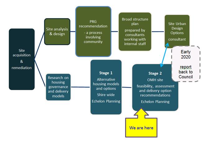
PRG: Mullumbimby Hospital Site Project Reference Group
Figure 2: Outline of process
for old Mullumbimby Hospital (OMH)
Low Rise Medium Density
Code planning proposal
In
actioning Res 19-266 a planning proposal has been prepared to introduce
a minimum lot size standards for ‘manor house’ (a residential flat
building with 3 or 4 dwellings) and ‘multi dwelling housing
(terraces)’. The lot sizes proposed are:
· 1000m2 - R2 Zone Low Density Residential
· 800m2 - R3 Zone Medium Density Residential.
The purpose of the planning proposal
is to set minimum lot size provisions for manor houses and terraces that are
consistent with Council’s current low rise medium density controls for
the R2 and R3 residential zones in readiness for the pending Low Rise Medium
Density Code commencement in July 2020.
The planning proposal was granted
a gateway by the Department of Planning, Industry and Environment and has been
exhibited for comment from 23 October – 22 November 2019. At the
time of preparing this report 4 submissions on the planning proposal had been
received, noting that the exhibition has just closed.
The planning proposal and submission summary will be
reported to Council for consideration in early 2020. This will assist with progression of preparation of Development
Control Plan Character Design Guidelines for Low Rise Medium Density Housing
Code.
SEPP 70 Affordable Housing
In actioning Res 19-152
a planning proposal is under preparation for an
affordable housing contribution scheme under State Environmental Planning
Policy No 70 Affordable Housing (Revised Schemes). Figure 3 following,
outlines the process.
Contribution schemes apply to
developments that are facilitated by up-zoning. As part of the
preparation of the scheme it is necessary to identify areas for future
rezoning. The draft Byron Shire Residential Strategy identifies
new release residential areas with potential for future rezoning. A
single contribution scheme may apply to multiple areas within a local
government area, as long as the feasibility analysis supporting each area
specifically addresses each one.
This report seeks Council support for consideration of all
new release investigation lands identified in the Residential Strategy for
inclusion under SEPP 70.
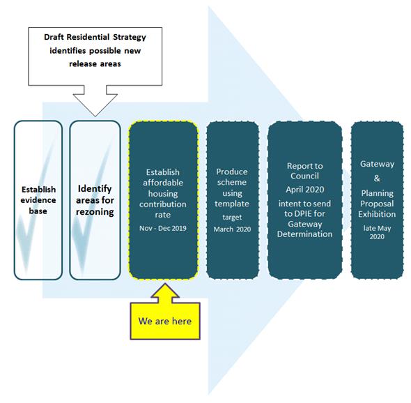
Figure 3: SEPP 70 Process
A set of objectives is required as
part of the contribution scheme. For Council’s information, the following
working draft objectives have been formulated by staff to provide guidance on the
planning proposal’s preparation:
· increase the
amount of affordable housing in the Shire
· provide a
transparent framework for development to make equitable affordable housing
contributions
· give effect to the
‘Action 15’ of the draft Residential Strategy (an action relating
to the SEPP Scheme preparation)
· ensure affordable
housing contribution rates do not impact on development viability
· increase certainty
for landowners and developers seeking to develop land in the Shire
· align, streamline and
simplify exiting affordable housing schemes that operate in the Shire.
At this stage it is planned to present a planning proposal
to Council for consideration in the first half of 2020.
Draft
Residential Strategy
Council at its December 2018 Ordinary
Meeting considered a report on draft Residential Strategy and resolved (Res
18-823) to publicly exhibit the draft strategy and appendices for a
minimum period of 6 weeks.
Consultation on the draft residential strategy has occurred
in 2 stages:
· Shaping our
neighbourhoods, open for discussion in May 2019
· full draft Residential Strategy exhibition, 28 August
– 11 October 2019.
The feedback from Shaping our
Neighbourhoods was encapsulated in the full strategy exhibition document.
The 62 submissions received to the full document exhibition are currently being
reviewed by staff.
Running
parallel to the exhibition is a Mullumbimby Release area flood and stormwater
assessment. This assessment relates to possible new residential areas
identified in the exhibited draft Residential Strategy that are located along
the southern fringe of the Mullumbimby. The findings of this assessment are
important to inform the early implementation affordable housing initiative and
the overall Residential Strategy.
At the
time of preparing this report, the findings flood and stormwater assessment
were not complete. As such, staff considered it prudent to hold off reporting
to Council a final Residential Strategy until such time as this assessment is
completed. It is anticipated that an updated draft flood study will be provided
in mid December 2019, with the Residential Strategy to be reported to
Council for consideration in early 2020.
STRATEGIC CONSIDERATIONS
Community Strategic Plan and
Operational Plan
|
CSP
Objective
|
L2
|
CSP Strategy
|
L3
|
DP Action
|
L4
|
OP Activity
|
|
Community
Objective 4: We manage growth and change responsibly
|
4.1
|
Support the
visions and aspirations of local communities through place-based planning and
management
|
4.1.1
|
Develop,
implement and update Place Plans that promote place-based forward planning
strategies and actions
|
4.1.1.6
|
Develop the
Byron Arts and Industry Estate Precinct Plan
|
|
Community
Objective 4: We manage growth and change responsibly
|
4.1
|
Support the
visions and aspirations of local communities through place-based planning and
management
|
4.1.1
|
Develop,
implement and update Place Plans that promote place-based forward planning
strategies and actions
|
4.1.1.7
|
Amend Local
Environmental Plan and Development Control Plan in accordance with
Mullumbimby Hospital Precinct Plan
|
|
Community
Objective 4: We manage growth and change responsibly
|
4.1
|
Support the
visions and aspirations of local communities through place-based planning and
management
|
4.1.3
|
Manage
development through a transparent and efficient assessment process
|
4.1.3.11
|
Prepare DCP
Character Design Guideline for Low Rise Medium Density Housing Code
|
|
Community
Objective 4: We manage growth and change responsibly
|
4.2
|
Support
housing diversity in appropriate locations across the Shire
|
4.2.1
|
Establish
planning mechanisms to support housing that meets the needs of our community
|
4.2.1.1
|
Finalise the
Residential Strategy
|
Legal/Statutory/Policy Considerations
The projects identified in this report are informed by the
relevant state, regional and/or local planning framework and best practice planning
principles.
Financial Considerations
The cost of undertaking the projects identified in this
report have been met by Council.
Consultation and Engagement
Ongoing consultation and engagement is anticipated to be
required for all of the projects identified in this report encompassing:
· enabling the
community to consider the findings of investigations
· input on
planning proposals
· implementation
of actions under the final Residential Strategy.
Staff Reports - Sustainable Environment and Economy 13.21
Report No. 13.21 PLANNING
- 24.2019.53.1 Habitat DCP Amendment; Chapter E5 Certain Locations in Byron Bay
and Ewingsdale
Directorate: Sustainable
Environment and Economy
Report
Author: Kristie
Hughes, Planner
File No: I2019/1904
Summary:
Council has received an application from Planners North (the
Applicant) on behalf of Bayshore Development Pty Ltd seeking to amend Chapter
E5 of Byron Development Control Plan 2014 (DCP 2014). The application has
been lodged concurrently with Development Application 10.2019.517.1, which
proposes a Mixed Use Development, forming Stage 4 of Habitat.
The key amendments to the current DCP chapter are:
· Amend the
Habitat Precinct Plan (Map E5.3) to split Precinct 1 into two precincts - 1A
and 1B, with the proposed mixed use development being within Precinct 1B.
· Various
wording changes relating to Precinct 1B to reflect the mixed use development
proposed within Development Application 10.2019.517.1.
A ‘marked up’ copy of the draft DCP chapter
showing the proposed changes is appended to this report as Attachment 1. The
received application including the ‘Statement of Environmental Effects
and DCP Modification Request Habitat Stage 4’ is appended as Attachment
2.
Development Application 10.2019.517.1 has recently been
exhibited, with two submissions received. While assessment of that
application is continuing, it is recommended that the draft DCP amendment
proceed to exhibition, with the intention that the DCP amendment and the
Development Application can then be determined concurrently.
NOTE TO COUNCILLORS:
In accordance with the
provisions of S375A of the Local Government Act 1993, a Division is to be
called whenever a motion for a planning decision is put to the meeting, for the
purpose of recording voting on planning matters. Pursuant to clause 2(a)
under the heading Matters to be Included in Minutes of Council Meetings of
Council's adopted Code of Meeting Practice (as amended) a Division will be
deemed to have been called by the mover and seconder of all motions relating to
this report.
|
RECOMMENDATION:
1. That
Council proceed to exhibit the draft DCP 2014 Chapter E5 amendment as shown
in Attachment 1 (E2019/84596) for a period of 28 days.
2. That
following exhibition, Council receive a further report detailing
submissions made. Should there be no submissions as of the close of the
exhibition period, that Council adopt the amended Chapter and give
notice of its decision in accordance with the Environmental Planning and
Assessment Regulation.
|
Attachments:
1 24.2019.53.1
- Draft Byron Shire DCP 2014 Chapter E5 Certain Locations in Byron Bay and
Ewingsdale, E2019/84596
2 Planners
North - 24.2019.53.1 & 10.2019.517.1 - SEE HABITAT STAGE 4, E2019/74577
3 Form of
Special Disclosure of Pecuniary Interest, E2012/2815
REPORT
Council has received an application from Planners North (the
Applicant) on behalf of Bayshore Development Pty Ltd seeking to amend Chapter
E5 of Byron Development Control Plan 2014 (DCP 2014), relating to the
Development Application 10.2019.517.1 – Mixed Use Development (Stage 4
Habitat). Details of this request are presented below.
Subject Site
The subject site is described as Lot 1 & Lot 10 DP
271119 and known as Habitat. It is located immediately northwest of the
Byron Arts and Industry Estate.
Chapter E5 of Byron DCP 2014 contains a range of controls
and guidelines relating to the development of the site. The controls are
precinct-based, with the existing Habitat Precinct Plan shown below in Figure
1.
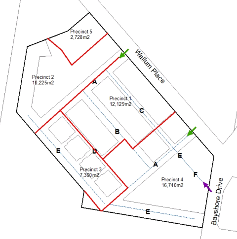
FIGURE 1 Map E5.3 Habitat Precinct Plan
Background
The site originally received
development approval in 2008 (DA 10.2008.360) for a mixed use development
comprising residential dwellings, commercial, retail and creative industrial
units. Chapter E5 was originally drafted at that time to facilitate the
anticipated development.
Development has been approved and
constructed within Precincts 2, 3 and 4 as shown above. A current
development application – 10.2019.517.1 – proposes further mixed
use development within the south-western portion of Precinct 1.
Due to the development being
implemented in stages, changes have been made to the original site plan and
design concept as Habitat has evolved into a successful mixed use development
supporting residential, commercial and industrial purposes. Therefore,
several amendments to the DCP have been made across these stages of
development.
Stage 1: DA 10.2015.353.1 provided for the mixed-use development
comprising residential dwellings, commercial and retails units, recreational
facilities, associated infrastructure and subdivision – located within
Precinct 4.
Stage 2: involved the building of
a residential flat building associated with associated light industry, approved
pursuant to DA 10.2017.4.1. This development application provided for two
additional live /work buildings extending on the two buildings approved at stage
1 – located within Precinct 3.
Stage 3: DA 10.2017.628 60
‘pocket living’ apartments; currently under construction within
Precinct 2.
Summary of Proposed Changes
The proposal relates to the proposed stage 4, as outlined in
Development Application 10.2019.517.1. The application to amend Chapter
E5 of the DCP has been made concurrently with that DA.
Under the proposed amendments, Precinct 1, originally
covering an area of approximately 12,100m2 would be divided into
Precincts 1A (8,419m2) and 1B (3,710m2), as shown in
Figure 2.
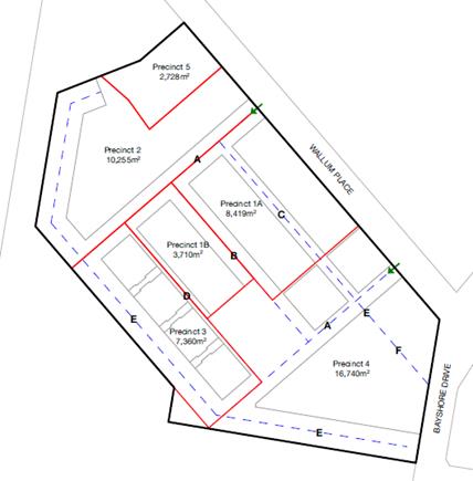
FIGURE 2 Proposed Amendment to Map E5.3 Habitat Precinct
Plan
The development proposed within the current development
application – DA 10.2019.517.1 – will be located within Precinct
1B, with a future application proposed within Precinct 1A.
In addition to the Precinct Map amendment, the proposed
amendments to Section E5.5 reflect the land uses proposed in the current
application and the proposal for buildings within this precinct to be three
storeys in height. The following DCP amendments are proposed:
· Update to
the Council strategy and policy documents outlined in point 2 of the Objectives
(Section E5.5.2);
· Update
references to the Habitat Precinct Map and description of precincts (Section
E5.5.3.4);
· Update land
use descriptions within Table E5.1 to reflect precinct change and current
development proposal;
· Update Table
E5.2 to provide for zero setback to internal roads within Precinct 1B;
· Update to
Table E5.3 to set out the appropriate parking requirements for Precincts 1A
& 1B;
· Changes to
description of the ‘Byron Vernacular’ as outlined in Section
E5.5.4.3, to reflect the contemporary design proposed in the current
development application, together with updates to the Performance Criteria in
this section to provide for three storey buildings;
· Amendment to
the prescriptive measures within Section E5.5.4.3 to allow for masonry and
concrete construction materials; and
· Amendment to
prescriptive measures in Section E5.5.4.6 to allow for three storey buildings.
In accordance with the Environmental Planning and Assessment
Regulation 2000, the proposed DCP amendment should be advertised for public
comment.
Development Application 10.2019.517.1 has recently been
exhibited, with two submissions received. While assessment of that
application is continuing, it is recommended that the draft DCP amendment
proceed to exhibition, with the intention that the DCP amendment and the
Development Application can then be determined concurrently.
STRATEGIC CONSIDERATIONS
Community Strategic Plan and
Operational Plan
|
CSP Objective
|
L2
|
CSP Strategy
|
L3
|
DP Action
|
L4
|
OP Activity
|
|
Community
Objective 4: We manage growth and change responsibly
|
4.1
|
Support the
visions and aspirations of local communities through place-based planning and
management
|
4.1.3
|
Manage
development through a transparent and efficient assessment process
|
4.1.3.10
|
Prepare and
assess Planning Proposals and Development Control Plans, and amend Local
Environmental Plan maps
|
|
|
|
|
|
|
|
|
|
|
|
|
|
|
|
|
Legal/Statutory/Policy
Considerations
This proposal seeks to amend the DCP 2014. All
relevant policy implications have been discussed above. The proposed
amendment will be exhibited as per the statutory requirements.
Financial Considerations
This is an Applicant funded DCP amendment, all costs will be
borne by the applicant.
Consultation and Engagement
It is recommended that the
DCP will be exhibited for a minimum of 28 days as per legislative requirements.
Staff Reports - Sustainable Environment and Economy 13.22
Report No. 13.22 Report
of Planning Review Committee held on 14 November 2019
Directorate: Sustainable
Environment and Economy
Report
Author: Chris
Larkin, Manager Sustainable Development
File No: I2019/1909
Summary:
This report provides the outcome of the Planning Review
Committee meeting held on 14 November 2019.
NOTE TO COUNCILLORS:
In accordance with the
provisions of S375A of the Local Government Act 1993, a Division is to be
called whenever a motion for a planning decision is put to the meeting, for the
purpose of recording voting on planning matters. Pursuant to clause 2(a)
under the heading Matters to be Included in Minutes of Council Meetings of
Council's adopted Code of Meeting Practice (as amended) a Division will be
deemed to have been called by the mover and seconder of all motions relating to
this report.
|
RECOMMENDATION:
That Council adopt the report of the Planning
Review Committee meeting held on 14 November 2019.
|
REPORT
The meeting commenced at 3:30pm and concluded at 4:10pm.
Present: Crs Cameron, Lyon, Hunter, Hackett
Staff: Chris Larkin (Manager Sustainable Development)
Apologies: Crs Coorey, Ndiaye
The following development
applications were reviewed with the outcome shown in the final column.
|
DA No.
|
Applicant
|
Property Address
|
Proposal
|
Exhibition
Submission/s
|
Reason/s
Outcome
|
|
10.2019.437.1
|
Mr C Worling
|
90 Risleys Hill Road
FEDERAL
|
Alterations and Additions
to Existing Dwelling House
|
Level 0
|
Staff Delegation
|
|
10.2019.502.1
|
Town Planning Studio Pty
Ltd
|
20 Newells Road MAIN ARM
|
Relocated Dwelling to
Create Dual Occupancy (Detached)
|
Level 1
5 submissions
|
Staff Delegation
|
Council determined the following
original development applications. The Section 4.55 applications to modify the
development consent is referred to the Planning Review Committee to decide if
the modification application can be determined under delegated authority.
|
DA No.
|
Applicant
|
Property Address
|
Proposal
|
Exhibition
Submission/s
|
Reason/s
Outcome
|
|
10.2015.196.3
|
Frank Stewart Architect
|
40 Mullumbimbi Street
MULLUMBIMBY
|
4.55 to stage development
and modify internal layout
|
Level 1
31/7/19 to 13/8/198
3 submissions
|
Staff Delegation
|
|
10.2018.466.2
|
Byron Bay Planning &
Property Consultants
|
61 Kingsley Street BYRON
BAY
|
S4.55 to Modify Description
of Development, Modify Condition 1 in Relation to Amended Plans and Delete
Condition 6 Regarding Building Height
|
Level 1
24/10/19 to 6/11/19
2 submissions
|
The perceived public significance of the application
Council
|
|
10.2014.753.4
|
Newton Denny Chapelle
|
30 Tanner Lane
TYAGARAH
|
S4.55 Modification to
Increase capacity of Large Events from 25,000 to 30,000 patron capacity
and Increase ability to provide amplified music for Small Events from 10 days
to the prescribed 100 days
|
Level 2
24/10/19 to 13/11/19
13 submissions
|
Staff Delegation
Note: Application amended
removing the proposed increase in amplified music to 100 days for small
events
|
Staff Reports - Sustainable Environment and Economy 13.23
Report No. 13.23 PLANNING
- Update on Environmental Zone review and Planning Proposal implementation
process
Directorate: Sustainable
Environment and Economy
Report
Author: Alex
Caras, Land Use Plannning Coordinator
File No: I2019/1913
Summary:
This report presents an update on
the:
· Status of the
staged E zone implementation program; and
· Additional
2019/20 budget requirements to complete remaining work for Stages 2 & 3.
The E zone planning proposals (PP) are progressing well with Stage 1 awaiting
gazettal and exhibition of the Stage 2 planning proposal recently
completed. Both stages represent agreed
outcomes reached on over 650 properties on the application of both
environmental and non-environmental zones, with over 2,300 ha proposed for
environmental zonings. Stage 3, which will include a similar number of
properties as PP2 (> 600), is substantially advanced and should be finalised
for reporting to Council in early 2020. PP3 is expected to include the
largest area of proposed E zones relative to PP1 and PP2 at 3,500+ha, making it
the most significant stage of the implementation program.
Stage 4 is a new stage in the
implementation program specifically created to address all public land affected
by the E zone review, including land owned by Council, the Crown or other
government agencies
The engagement process undertaken
to date continues to be constructive and well received by those affected, generating
a tremendous amount of goodwill for Council. At the same time the robust
nature of the engagement process remains resource-intensive and at the current
rate of expenditure, the remaining 2019/20 E zone budget will be exhausted by
the end of December 2019. As a result, an additional $17,000 is needed
for the period 1 January to 30 June 2020 to ensure the timely completion of
Council’s E zone implementation program (Stages 2 & 3) as well as to
continue building on the high level of community goodwill already generated.
NOTE TO
COUNCILLORS:
In accordance
with the provisions of S375A of the Local Government Act 1993, a Division is to
be called whenever a motion for a planning decision is put to the meeting, for
the purpose of recording voting on planning matters. Pursuant to clause
2(a) under the heading Matters to be Included in Minutes of Council Meetings of
Council's adopted Code of Meeting Practice (as amended) a Division will be
deemed to have been called by the mover and seconder of all motions relating to
this report.
|
RECOMMENDATION:
1. That Council re-allocate $17,000 in order to finalise Stages 2 and 3 of E
zone implementation program, build on the already high level of community
goodwill generated through the engagement process to date and resolve
outstanding deferred matters in a timely manner.
2. That
the $17,000 be re-allocated from the Community Participation Plan project
(#2605.112) which is now complete.
|
Attachments:
1 Form of
Special Disclosure of Pecuniary Interest, E2012/2815
REPORT
BackgroundCouncil at its 22 March 2018 Ordinary Meeting resolved (Res
18-186) to implement the E zone review outcomes in several stages to
deliver more timely and effective outcomes for affected landowners. An
overview of the latest staged implementation program is shown below.
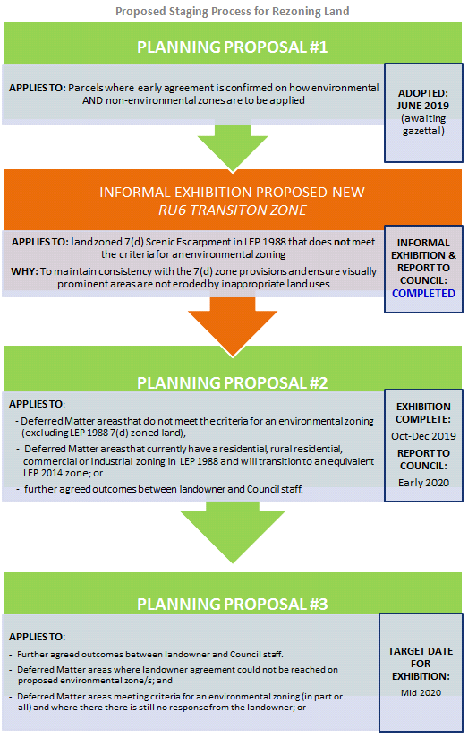
Staging program update
Staff
continue to make good progress with the E zone
implementation program, with the following
outcomes to date:
· Feedback received from nearly 1300 affected landowners in
the Shire.
· Planning Proposal #1
(PP1) – currently with Department of Planning, Industry & Environment
awaiting gazettal.
· Planning Proposal #2
(PP2) – recently finished public exhibition (6 December) and submissions
review currently underway.
· PP1 and PP2 have collectively resulted in
approximately 2,300ha being proposed for an environmental zoning, as follows:
- E2 Environmental Conservation: 1,815 ha
- E3 Environmental Management: 465 ha
For comparison, the total area of
environmental zones in the 1988 LEP (7A, 7B, 7C, 7K and 7J) is approximately
4,100ha.
· Planning Proposal #3
(PP3), which will include a similar number of properties as PP2
(> 600), is substantially advanced and should be finalised for reporting to
Council in early 2020.
As per
the ‘staged implementation’ diagram above, Planning Proposal #3
will include:
(i) further agreements reached
between landowner and Council staff on how environmental zones are to be
applied; or
(ii) Deferred Matter areas that
currently have a residential, rural residential, commercial or industrial
zoning in LEP 1988 that will transition to an equivalent LEP 2014 zone;
and
(iii) Deferred Matter areas that do not meet
the criteria for an environmental zoning and instead will have a suitable rural
zone applied (excluding LEP 1988 7(d) zoned land).
PP3 is
expected to include the largest area (ha) of proposed E zones relative to PP1
& PP2 (3,500+ha), making it the most significant stage of the
implementation program.
· Planning Proposal #4
(PP4) is a new stage in the implementation program specifically created to
address all public land affected by the E zone review, including land owned by
Council, the Crown or other government agencies.
Web link:
https://www.byron.nsw.gov.au/Services/Building-development/Planning-in-progress/Environmental-Zones-E-Zones
Budget requirements to
complete remaining stages
The process of reviewing landowner
feedback and achieving agreed outcomes remains very constructive and well
received by those affected and the wider community. Indeed feedback
received to date confirms that the E zone engagement process has generated a tremendous
amount of goodwill as a result of staff commitment to achieving agreed
landowner outcomes wherever possible. It is important to continue
building on this goodwill by ensuring the timely completion of Council’s
E zone implementation program.
The robust nature of the E zone
engagement process remains essential to the program’s success, but also
continues to be resource-intensive and at the current rate of expenditure, the
remaining 2019/20 E zone budget will be exhausted by the end of December 2019.
As a result, an additional $17,000 is needed for the period 1 January to 30
June 2020 to ensure the timely progression of Stages 2 & 3 of
Council’s E zone implementation program. Work to be undertaken
during this period will include:
Ø PP2 – submissions
review and reporting to Council for adoption; technical (GIS) mapping updates
to enable final submission to State government.
Ø PP3 – select
ground-truthing of vegetation; finalising review of landowner feedback, agreed
outcomes and associated mapping; reporting to Council for Gateway submission
and exhibition.
A review of the E zone
implementation program has also determined that the timetable will extend
beyond the 2019/20 financial year, with further budget allocation of $60,000
required the 2020/21 period to complete following work:
Ø finalising review of feedback, agreed outcomes and
associated mapping (PP4);
Ø planning proposal exhibition and enquiries (PP3 & PP4);
Ø select ground-truthing of vegetation (PP3 & PP4); and
Ø submissions review and reporting to Council
(post-exhibition).
A separate budget bid of $60,000
will be included for consideration in the 2020/21 financial year budget process.
Financial Implications
The 2019/20
budget for the E zone Implementation program will be exhausted by the end of
December 2019. The timeframe for this project
extends beyond the financial 2019-20 financial year and an additional $17,000 budget allocation is required for the period 1 January to
30 June 2020.
It is
proposed that the $17,000 be re-allocated from the Community Participation Plan
project (#2605.112) which is now complete
Funds required to finalise PP3
& PP4 in the 2019/20 financial year will be included in a separate budget
bid.
STRATEGIC CONSIDERATIONS
Community Strategic Plan and
Operational Plan
|
CSP Objective
|
CSP Strategy
|
DP Action
|
OP Activity
|
|
Objective 3:
We Protect And Enhance Our Natural Environment
|
3.1
Partner to protect and enhance our biodiversity, ecosystems and ecology
|
3.1.1
Protect and
enhance our natural environment and biodiversity
|
3.1.1.4
Continue the E
zone review (Action No.9 from Rural Land Use Strategy)
|
Statutory and Policy Compliance
Implications
The
process of applying E zones and mapped overlays in Byron LEP 2014 must satisfy Section 117 Direction 2.5 – Application of E2 and
E3 Zones and Environmental Overlays in Far North Coast LEPs. This
direction specifically requires that a planning
proposal that introduces or alters an E2 Environmental Conservation or E3
Environmental Management Zone, or an overlay and associated clause must be
consistent with the Northern Councils E Zone Review Final Recommendations.
Staff Reports - Sustainable Environment and Economy 13.24
Report No. 13.24 PLANNING
- 26.2019.1.1 - Planning Proposal for an amendment to Byron LEP 2014 to permit
Community Title subdivision and dwellings at Lot 38 DP 1059938, Alidenes Road,
Wilsons Creek
Directorate: Sustainable
Environment and Economy
Report
Author: Alex
Caras, Land Use Plannning Coordinator
File No: I2019/1914
Summary:
Council received a planning proposal
earlier this year to amend Byron LEP 2014. The planning proposal
requested that all of Lot 38 DP 1059938 Alidenes Road (12.27 ha) be
included in an R5 Large Lot Residential zone with a Minimum Lot Size of 0.3 ha
and a prospective lot yield of 30.
However,
nearly 50% of the lot is affected by the 1% AEP flood event (2100 yr) and a 30m
riparian buffer which is more than previously considered in the Byron Rural
Land Use Strategy. Based on Council’s developable land assessment and
allowance for utilities and wastewater disposal the site has a carrying
capacity of 15 dwellings (upper limit). Major traffic upgrades would be
required to public roads if yields exceed 19 dwellings.
Yankee Creek
traverses the site and needs to be managed and rehabilitated as a single
unit. The best way to achieve a sustainable dwelling yield, good
environmental outcomes and an efficient use of infrastructure is to list the
subject land in Schedule 1 of BLEP 2014 to permit the Community Title
subdivision of the land to create up to 15 small lots, with the balance in a
single community lot. Each small lot can be used for a dwelling subject to
development consent. The community lot will include the Yankee Creek waterway
and suitable riparian buffers and be subject to a coordinated management
regime. An amended planning proposal enabling this outcome is contained in
Attachment 1.
The amended
planning proposal is consistent with the Byron Rural land Use Strategy 2017 and
the North Coast Regional Plan.
It is
recommended that Council proceed with the amended planning proposal and forward
it to the Department of Planning and Environment for a Gateway
Determination.
NOTE TO COUNCILLORS:
In accordance with the
provisions of S375A of the Local Government Act 1993, a Division is to be
called whenever a motion for a planning decision is put to the meeting, for the
purpose of recording voting on planning matters. Pursuant to clause 2(a)
under the heading Matters to be Included in Minutes of Council Meetings of
Council's adopted Code of Meeting Practice (as amended) a Division will be
deemed to have been called by the mover and seconder of all motions relating to
this report.
|
RECOMMENDATION:
1. That
Council proceed with the amended planning proposal contained in
Attachment 1 (E2019/85691) and forward it to the NSW Department of Planning,
Industry and Environment for a Gateway determination.
2. That
Council pending a positive Gateway determination, undertake public exhibition
of the planning proposal in accordance with the determination requirements.
3. That
Council consider a submissions report post-exhibition that includes any
recommended changes to the planning proposal for final adoption.
|
Attachments:
1 26.2019.1.1
Planning Proposal Alidenes Rd (amended version for Gateway submission), E2019/85691
2 26.2019.1.1
- Original Planning Proposal lodged Feb2019 - Request to rezone 31 Alidenes
Road - Ardill Payne & Partners (excl appendices), E2019/85641
REPORT
Subject Land
The subject land is described as
Lot 38 DP 1059938, Alidenes Road, Wilsons Creek. It is an area of
12.27 hectares with approximately 550 metres frontage to Alidenes Road and
approximately 170 metres frontage to Wilsons Creek Road. The site is
burdened by a 10-metre wide Right of Carriageway that provides access to
Lot 1 DP 701525 (southwest of subject land) from Alidenes Road.
It is also burdened by two 10-metre wide easements for pipelines that stem from
the old Mullumbimby power station and run along the Wilsons Creek Road
boundary. The land previously contained two dwellings and one of these
was recently demolished.
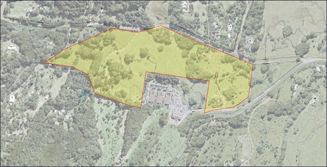
Figure
1 - Subject site showing old Mullumbimby power station at southern boundary
The Planning Proposal
An amended planning proposal has
been prepared (Attachment 1) to permit:
§ A
subdivision using a neighbourhood community title scheme enabling up to 15
neighbourhood lots. Each lot can be privately owned. It will also include
one lot comprising the residue of the land that will be in shared ownership and
will contain the main Yankee Creek waterway that runs through the land.
§ Each
privately owned lot will be limited to only one dwelling.
Planning
Framework and Options
Byron Rural Lands Strategy
In July 2018 the then NSW Department of
Planning and Environment endorsed the Byron Rural Lands Strategy 2017
(RLUS). The RLUS has identified the subject land as
part of an area that is a “priority site for future
rural lifestyle living opportunities”. The subject land, together
with parts of the surrounding lots), is identified for a “Potential
Dwelling Yield of 15 -30”.
Listed among the relevant policy directions on pages 13 and
14 of the RLUS are:
§ Future
rural development will not be supported on sites, or areas within a site [that
is mapped as being affected by the] 1:100 year flood risk and climate
change lands ……;
§ Future
rural lifestyle living opportunities will serve to repair and enhance the
land’s natural values in a manner which more than offsets the full impact
of the site’s population and pressures on the environment; and
§ Future
rural lifestyle living opportunities will preserve scenic amenity, minimise
environmental impacts and better manage natural or man-made hazard risks.
This strategy was endorsed by the NSW
Department of Planning, Industry and Environment (DPIE) in July 2018.
Although the RLUS identified a potential
yield of 15-30 dwellings for this site, this range was indicative only and
subject to more detailed assessment at the planning proposal and DA
stage. In this case the extent of flood prone land determined in the
planning proposal has reduced the developable area considerably. Riparian
buffers, internal roads and onsite waste water disposal will also limit the
yield of this site.
North Coast Regional Plan
As the subject
land is in the RLUS, it is consistent with the North Coast Regional Plan 2036
which states in Action 24.1: “Identify new rural
residential areas in a local growth management strategy or rural residential
land release strategy endorsed by the Department”
Option 1: Include all of the land in the R5 Large
Lot Residential Zone?
The subject land is currently zoned
RU2 Rural Landscape under Byron LEP 2014 (BLEP14). The
original planning proposal submitted to Council (Attachment 2) requested that
all of Lot 38 DP 1059938 Alidenes Road (12.27 ha) be included in an
R5 Large Lot Residential zone, with a Minimum Lot Size of 0.3 ha and a
prospective lot yield of 30. This was based on assumed filling of some flood
prone land and use of levees to protect other areas. The applicant is no longer
proposing such measures as part of this rezoning. Detailed flood
modelling reveals that approximately 45% of the site is affected by flooding in
the 1% ‘2100 yr’ Climate Change flood event (see flood map below).
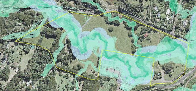
Figure 2 – Map showing 1% ‘2100 yr’
Climate Change flood extent on the subject site (green shaded areas) AND 30m
Riparian Buffer to Yankee Creek (blue shaded areas)
The flood affected land runs through most of the site along
the Yankee Creek waterway. Yankee Creek is also mapped as ‘Key Fish
Habitat’ and a 30m minimum riparian buffer has been applied.
Council generally does not support rezoning of flood prone land for large lot
residential purposes, or filling of flood prone land to enable low density
large lot residential development. Given the extent of riparian and
flood–related constraints, the option of rezoning all of the subject land
to R5 Large Lot Residential is not supported.
Option 2: Include only flood-free and non-riparian
land in the R5 zone?
The option of applying an R5 zone
only on the “flood free” and non-riparian land would leave an RU2
zone residue in one irregular shaped lot (as shown in Figure 2), which in turn
would need to be owned and managed by a single private landowner as it cannot
be further subdivided (ie. under Clause 4.1D of Byron LEP 2014). As
future access to the site must be via Alidenes Road, those parts of the R5 zoned
land that do not have direct access to Alidenes Road would require access
across RU2 land that is separately owned and managed. Any bridges located
on the RU2 residue also would not be owned by those that benefit from them,
creating ambiguity over their long term maintenance. This is not an acceptable
scenario and therefore the option of rezoning the “flood free” part
of the land to R5 with an RU2 zoned residue is not supported.
Option 3: Schedule 1 listing in LEP 2014 enabling
Community Title Subdivision
Council has over many decades
preferred that rural settlement offset its impacts by an environmental repair
framework. This policy position is still reflected in the current RLUS, the cost and responsibility of which should be borne by all of
the residents of this new estate. Given the complex drainage of the subject
land and the biodiversity value of Yankee Creek (as key fish habitat), this
outcome is best achieved by a Community Title development and a Schedule 1
listing in LEP 2014, rather than application of the R5 zone with an arbitrary
minimum lot size. A Community Title development also has the
advantages of shared internal access roads and waterway crossings, the
potential for collective onsite wastewater management systems and disposal areas,
suitable buffers to Yankee Creek and greater flexibility for
‘private’ lot sizes. For these reasons this option is recommended.
Option 4:
Identify land in LEP 2014 Multiple Occupancy and Community Title Map
and make subject to Clause 4.2B of BLEP14?
The subject land could also be identified on the LEP 2014 Multiple
Occupancy and Community Title Map pursuant to Clause 4.2B (Maximum
number of dwelling houses or dual occupancies on multiple occupancy or rural
landsharing community developments) as a future Community Title development
area with a specified number of dwellings. The main drawback with this option
is that this clause also permits dual occupancy. Under this scenario if the
maximum number of lots is created at the subdivision DA stage (say 15 lots
based on developable area) and any subsequent dwelling applications also
include a dual occupancy, these additional dwellings would result in some lots
having no dwelling permissibility and hence becoming sterilised. It is
therefore important that the number of dwellings be limited to the same number
as prospective lots to avoid problems with wastewater disposal in proximity to
Yankee Creek and limit the traffic generation to less than 19 dwellings, as any
more than 19 dwellings would require a complete redesign of the
Alidenes/Wilsons Creek Road intersection via a Voluntary Planning Agreement
(which the applicant does not favour).
In conclusion, a Schedule 1 – Additional Permitted
Uses listing (Option 3) can clearly identify the maximum number of lots
permissible and limit each lot to only one dwelling. It can also require
Community Title subdivision to ensure the coordinated management of Yankee
Creek and other shared infrastructure by future residents of this estate.
Developable land and
dwelling yield
The site has minimal
vegetation of ecological value with most trees being camphor laurel. Two
threatened plants (Red Boppel Nut and Rough-shelled Bush Nut) were found and
they are both located adjacent to Yankee Creek on flood prone land.
The Yankee Creek waterway is potential habitat for native fish and could be
readily rehabilitated to improve water quality, create fish habitat and
encourage native birds and mammals to use the area. It is mapped in the NSW
Biodiversity Values map. If the waterway and its curtilage are community owned
and managed as a community neighbourhood lot by future residents, then the
potential for adverse environmental outcomes can be minimised.
The site contains a greater portion flood prone land than
originally anticipated when it was identified in the RLUS. Approximately
6.5 ha of the 12.27 ha site (53%) is above the 1% ‘2100 yr’ Climate
Change flood event and outside the 30m minimum riparian buffer (Figure
2). This is the area that is potentially suitable for dwellings and
onsite wastewater disposal. The rationale is that these areas will not be used
for large lot residential dwellings or on site waste management systems, and
that filling of flood prone land or constructing levees will not be acceptable
on this site.
Table 10 from the RLUS provides a guide to determining the
dwelling yield of the subject land and can be applied as follows:
· 20% of
unconstrained/assessable land area required for infrastructure (eg. internal
roads);
Comment: In this case
internal roads will be mainly in the form of “shared driveways” so 10%
should be sufficient.
· Only 50% of
assessable land can be developed;
Comment: In this case we
have assessed land that is flood free and outside the 30m riparian buffer at 6.5
ha, approximately 53%.
· Lot sizes on
land suitable for development ranging from 0.5ha (low end) to 1ha (high end),
rounded to nearest multiple of ‘5’ (except where potential dwelling
yield < 5).
Comment: we have used 0.4
ha (slightly below the low end lot size in the RLUS) because the applicant
has expressed a preference for smaller lots and pending more detailed
investigations at the DA stage, it can maximise the yield from the developable
land.
An allowance of 10 % of developable land for infrastructure
and utilities (such as roads and power) reduces the developable area to
approximately 5.85 ha. Assuming an average minimum lot size of 0.4 ha the
site has a carrying capacity of 14.6 dwellings. If this is rounded up to the
nearest multiple of five then the maximum yield of the site is 15 dwellings.
Rounding up is consistent with the RLUS methodology and provides a site yield
that is more likely to justify communal on site wastewater management. However,
this is a maximum number and achieving this with acceptable environmental
impacts would need to be demonstrated at the DA stage. It does provide the
basis for the dwelling yield in the schedule listing.
Other planning issues
Onsite Waste water Disposal
The site is traversed by Yankee
Creek together with a series of intermittent watercourses, dry gullies and
drainage channels. Given the number of intersecting gullies and drainage
channels plus Yankee Creek, the drainage buffers across the subject site are
extensive. Clearly there is a limited area (outside of the typical 40m
buffer) which is suitable at a planning proposal level for the dispersal of
treated effluent. As the Onsite Sewage Capability Assessment supplied by
the applicant has not considered the typical buffer or assessed land that is free
of the buffer,
there is a need to balance dwelling yield and lot size with
the ability of this site to accept wastewater over the long term.
Lots of 0.5 ha are generally at the low end of lot size
capable of dealing with wastewater from modern dwellings and 1 ha would be more
conservative. If lot sizes less than 0.5 ha are proposed for dwellings then a
communal wastewater treatment and disposal system is likely to be required.
Under this scenario a Community Title scheme would be the most appropriate
development approach for the subject site from a wastewater perspective. This
would allow for a certain number of lots to connect into a collectively owned
and managed onsite treatment system (ie. as part of a commonly-owned lot), if
desired.
Traffic and roads
Public roads will be used to access
the site but Council will not be accepting dedication of any internal roads or
bridges needed to access proposed dwelling locations. In a Community
Title development shared internal roads will remain the responsibility of future
residents. The traffic assessment undertaken by the applicant indicates that
some of the proposed dwellings would have access from Wilsons Creek Road, with
the bulk of dwellings gaining access from Alidenes Road. The applicant
has been advised that Council staff do not support any direct access from
Wilsons Creek Road due to safety issues/risk with the access point.
If 20 or more dwellings were proposed in this planning
proposal, with all dwellings requiring access to the site from Alidenes Road,
then the applicant would need to upgrade Alidenes Road from Wilsons Creek Road
through to Robinsons Road as well as redesign the Alidenes/Wilsons Creek Road
intersection. This would be very expensive and require a Voluntary
Planning Agreement to fund, which is not supported by the
applicant. Limiting the maximum dwelling yield to 15 dwellings
overcomes this requirement, noting that signage, line marking and improvements
to sight distances may still be required at the DA stage.
S. 9.1 Directions and SEPPs
The planning proposal is
justifiably inconsistent with some Section 9.1 directions because it:
· has not yet
been referred to RFS for bushfire consideration
· introduces
site specific provisions
· restricts
the potential development of resources on the site
These justifiable inconsistencies are all discussed in more
detail in the planning proposal (Attachment 1).
The planning proposal is consistent with the relevant SEPPs
including SEPP 55 (Remediation of Land). These are discussed in more detail in
the planning proposal (Attachment 1).
Options
to Move Forward
There are
a range of options for Council to consider on this matter, as summarised below:
1. Proceed with the
planning proposal based on a Schedule 1 Additional Permitted Uses
listing in LEP 2014 that would permit a community title subdivision of up to 15
neighbourhood lots/dwellings, with the common ‘residue’ lot to
include the Yankee Creek waterway and suitable riparian buffers. Request DPIE
issue a Gateway determination for the planning proposal as attached to this
report (Recommended option)
2. Proceed with the
planning proposal based applying an R5 zone on the “flood free” and
non-riparian land (only), while retaining the existing RU2 zone on the common
‘residue’ lot incorporating the Yankee Creek waterway and
suitable riparian buffers (as shown in Figure 2). Request DPIE issue a
Gateway determination for a revised planning proposal reflecting this outcome.
(Not Recommended)
3. Proceed with the
planning proposal based on including all of the land in the R5 Large Lot
Residential zone with a Minimum Lot Size of 0.3 ha, as submitted by the
proponent. Request DPIE issue a Gateway determination for a revised planning
proposal reflecting this outcome. (Not recommended).
4. Proceed with the planning
proposal based on including the subject land on the LEP 2014 Multiple
Occupancy and Community Title Map pursuant to Clause 4.2B –
Maximum number of dwelling houses or dual occupancies on multiple occupancy or
rural landsharing community developments. Request DPIE issue a Gateway
determination for a revised planning proposal reflecting this outcome. (Not
recommended).
Conclusion
Council has anticipated this planning proposal as a response
to including the subject land in the Byron Rural Land Use Strategy. There
is sufficient information to support the planning proposal in its amended form
and proceed to a Gateway submission.
In accordance with recommended
option ‘1.’ above, Council should request DPIE issue a Gateway
determination for the planning proposal as attached to this report (Annexure 1).
STRATEGIC CONSIDERATIONS
Community Strategic Plan and
Operational Plan
|
CSP Objective
|
CSP Strategy
|
DP Action
|
OP Activity
|
|
Objective 4:
We manage growth and change responsibly
|
4.1 Support the
visions and aspirations of local communities through place-based planning and
management
|
4.1.3 Manage development through a
transparent and efficient assessment process
|
4.1.3.10 Prepare and assess Planning
Proposals and Development Control Plans, and amend Local Environmental Plan
maps
|
Financial Implications
If Council chooses to proceed with the planning proposal, it
will be at the proponent’s expense as a landowner initiated planning
proposal. Full cost recovery of the remaining stages will be required by Council.
If the applicant chooses not to pay then the planning proposal will not
proceed.
If Council chooses not to proceed then the matter does not
incur any additional costs.
Statutory and Policy
Compliance Implications
The relevant policy considerations are addressed above and
in the planning proposal attached to this report.
Staff Reports - Sustainable Environment and Economy 13.25
Report No. 13.25 PLANNING
- DA10.2018.466.2 - 61 Kingsley Street Byron Bay - S4.55 modification to
change the Condition of Consent (approved by Council Meeting) in relation to
the Height and FFL of the proposed building, change to pool dimensions and tree
removal.
Directorate: Sustainable
Environment and Economy
Report
Author: Nancy
Tarlao, Planner
File No: I2019/1918
Proposal:
|
Section 4.55 Application No:
|
10.2018.466.2
|
|
Proposed modification:
|
S4.55 to Modify Description of Development, Modify
Condition 1 in Relation to Amended Plans and Delete Condition 6 Regarding
Building Height, change to pool dimensions and tree removal.
|
|
Type of modification sought:
|
|
|
|
|
|
Property description:
|
LOT: 11 SEC: 45 DP: 758207
|
|
61 Kingsley Street BYRON BAY
|
|
Parcel No/s:
|
38660
|
|
Applicant:
|
Byron Bay Planning & Property Consultants
|
|
Owner:
|
Mrs N E & Mr C J Cowan
|
|
Zoning:
|
R2 Low Density Residential
|
|
S96 Date received:
|
9 October 2019
|
|
Original DA determination date:
|
20/06/2019
|
|
Public notification or exhibition:
|
- Level
1 advertising under DCP 2014 Part A14 – Public Notification and
Exhibition of Development Applications
- Exhibition
period: 24/10/19 to 6/11/19
- Submissions received:
One
|
|
Delegation to determination:
|
Council
|
|
Issues:
|
· Breach of
Building Height Plane
|
Summary:
The subject site is located within Kingsley Street
Conservation Area in Byron Bay. The approved DA10.2018.466.1 proposed
demolition of the existing dwelling house and construction of a new 2 storey dwelling
with basement storage and a back garden pool.
The modification application as received and exhibited
included the following changes to the consent DA10.2018.466.1:
1. Modification
of the description of development to allow relocation of the existing dwelling
instead of demolition.
2. Change
the backyard pool dimensions from 10 x 3 m to 10 x 4.5m.
3. Tree
removal and relocation.
4. Modification
of condition 1 to reflect new plans and deletion of Condition 6 to alter floor,
ceiling and building heights as approved. The original changes proposed inter
alia created a noticeable 400 mm increase in the wall height of the ground
level resulting in an increased BHP encroachment on the side elevations.
One submission objecting to the modification application was
received.
In response to the issues raised in the submission, the
applicant has amended the plans further - the increase in the wall height from
that originally approved is limited to 200mm only. It is considered the
increased impact on neighbouring properties is negligible in terms of
overshadowing and overlooking.
The applicant is also planning to remove 2 bottle brush
trees, a mango and two bleeding heart trees, and relocate a Lilli-Pilli and 5
Bangalow Palms to facilitate the relocation of the existing dwelling house and
construction works, and an amendment to the approved swimming pools dimensions.
These amendments raise no issues as discussed within the body of the
report.
The objector was advised about the receipt of amended plans,
and given the opportunity to comment on same. The objector advised that
matters relating to overshadowing and privacy remain unresolved and that their
objection stands.
The proposed modification application is recommended for
approval subject to amended conditions of consent.
NOTE TO COUNCILLORS:
In accordance with the
provisions of S375A of the Local Government Act 1993, a Division is to be
called whenever a motion for a planning decision is put to the meeting, for the
purpose of recording voting on planning matters. Pursuant to clause 2(a)
under the heading Matters to be Included in Minutes of Council Meetings of
Council's adopted Code of Meeting Practice (as amended) a Division will be
deemed to have been called by the mover and seconder of all motions relating to
this report.
|
RECOMMENDATION:
That pursuant to Section 4.55 of the Environmental
Planning & Assessment Act 1979, that Application No. 10.2018.466.2, for Relocation of the Existing Dwelling House
and Construction of a New Dwelling House and Swimming Pool, be approved as
follows:
1. Amend the Description of the
development to read:
Removal of Existing
Dwelling (relocation) and Construction of a New Dwelling House and Swimming
Pool.
2.
Amended Condition No.1 to read
1. Development
is to be in accordance with approved plans
The
development is to be in accordance with plans listed below:
|
Plan No.
|
Description
|
Prepared by
|
Dated:
|
|
WD10.
|
Cover Sheet
|
Iphorm
|
Nov 2019
|
|
WD2.0
|
Site Plan
|
Iphorm
|
Nov 2019
|
|
WD3.1
|
Ground Floor Plan
|
Iphorm
|
Nov 2019
|
|
WD3.2
|
Upper Floor Plan
|
Iphorm
|
Nov 2019
|
|
WD3.5
|
Roof Plan
|
Iphorm
|
Nov 2019
|
|
WD4.0
|
Elevations
|
Iphorm
|
Nov 2019
|
|
WD4.2
|
Elevations
|
Iphorm
|
Nov 2019
|
|
WD4.3
|
Elevations
|
Iphorm
|
Nov 2019
|
|
WD5.0
|
Sections
|
Iphorm
|
Nov 2019
|
The
development is also to be in accordance with the changes shown in red ink on
the approved plans or conditions of consent.
The updated
approved plans (as per the Construction Certificate) and related documents
endorsed with the Council stamp and authorised signature must be kept on site
at all times while work is being undertaken.
3.
Delete and replace to Condition No. 6 to read:
6. Plans to be
submitted with the Construction Certificate
The
Plans to be submitted with the Construction Certificate to accurately reflect
the approved plans and as per the following requirements:
· The
floor to ceiling height on the ground floor be set at a maximum of 2.9 m in
height;
· Set
the ground floor of the dwelling at 9.6 m AHD
· Set
the floor to ceiling height in the undercroft basement storage (adjacent to
the pool) at a maximum of 2 m by lowering the basement floor level to 7.3m
AHD
· The
maximum height of the roof to be no greater than 8.5 m above natural ground
level.
· Landscaping
plan showing the location of trees to be replanted and the privacy hedge
comprising as a minimum 10 native plants with a maturity height of 3 metres
along the western boundary with 59 Kingsley Street where the pool and back
verandah are located. The relocated bangalow palms not to be located on this
boundary. The landscape plan to be prepared by a suitably qualified landscape
designer in accordance with Chapter B9 of DCP 2014.
The
plans are to be submitted with the Construction Certificate for approval to
the Principal Certifying Authority.
4.
Delete and replace Condition No. 37 to read
37. Landscaping
All landscaping as
required under this development consent to be completed prior to the
occupation of the dwelling house or issue of Occupation Certificate and in
accordance with the approved landscape plan including the hedge plantings on
the boundary with 59 Kingsley Street.
|
Attachments:
1 Proposed
Plans - DA10.2018.466.2, E2019/87783
2 Submission
received - DA10.2018.466.2, E2019/85374
3 Submission
received on amended plans - DA10.2018.466.2, E2019/88147
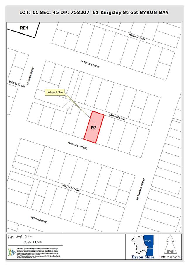
REPORT
1. INTRODUCTION
1.1. History/Background
DA
10.2018.466.1 Demolition of Existing
Dwelling and Construction of a two storey dwelling house and pool - Approved
20/06/2019 (via Council Meeting)
1.2. Description of the
proposed development
This application seeks approval for a S4.55 to Modify
Description of Development, Modify Condition 1 in Relation to Amended Plans and
Delete Condition 6 Regarding Building Height, AHD level and floor to ceiling
heights.
The existing description works under DA 10.2018.466.1 stated
that the existing dwelling was to be demolished, this has been revised to be
‘relocated’ in the description of works for the S4.55 modification
DA.
This modification seeks to delete Condition 6 of
10.2018.466.1 which stipulates the following conditions of consent:
· Reduce the
floor to ceiling height on the ground floor from 3.0 m to be 2.7 m in height;
· Reduce the
floor to ceiling height in the under croft basement storage (adjacent to pool)
from 2 m to 1.8 m in height;
· Set the ground
floor of the dwelling at 9.6 m AHD
· The maximum
height of the roof to be no greater than 8.5 m above natural ground level
The plan below has been prepared as per Condition 6 from the
Development Consent 10.2018.466.1. It is noted the eaves and gutters of the
ground floor are approximately set at the same level as the neighbours to the
west.
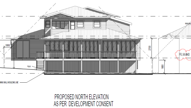
Figure 1: Northern Elevation as per the Condition 6 of
DA10.2018.466.1
The applicant originally proposed to increase the ground
floor to 9.8 metres and raise the floor to ceiling height of the ground floor
from 2.7 to 2.9 metres. This resulted in an increase in height of the side elevations
of approximately 400 mm. The plans have since been amended and the applicant
has now proposed the following:
1. Retain
the Floor level of 9.6 metres and excavate the ground level basement by 200 mm
to provide additional headroom for storage purposes
2. Raise
the floor to ceiling height from 2.7m to 2.9 m for the ground floor
3. Reduce
the floor to ceiling height for the upper level from the 2.7m to 2.6 m; and
4. Set
the maximum roof height at 8.5 m as per the conditions of consent.
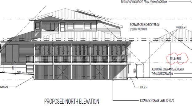
Figure 2. Proposed Northern Elevation as amended It is
noted the eaves and gutters are set just above the neighbours to the west.
The other modifications are as follows:
· Modification of
the description of development to allow relocation of the existing dwelling instead
of demolition.
· Change the
backyard pool dimensions from 10 x 3 m to 10 x 4.5m.
· Tree removal of a
mango, two bottlebrushes and a two bleeding heart trees
· Relocation of a
Lilli-Pilli and 5 Bangalow Palms
The applicant has provided the following reasons for the
changes
As a
summary, our goals in submitting the DA modification were to:
1.
Achieve usability of the basement space;
2.
Raise the ceiling height of the living area by 200mm for aesthetic purposes,
the style of the home and in line with the ceiling heights on
the existing dwelling on our property;
3.
Seek approval to remove the trees at the rear of the property for purposes of
recycling the existing dwelling to a property elsewhere; and
4.
Adjust the size of the pool.
1.3. Description
of the site
The site is known as LOT: 11 SEC: 45
DP: 758207, 61 Kingsley Street Byron Bay and is zoned R2 under Byron LEP 2014.
It contains a single storey timber clad dwelling in an urban subdivision area
of Byron town area. The property has an area of 1012 m2 and falls
away to the rear towards the rear lane on a north-south axis. The subject
property is within the Kingsley Street Heritage Conservation Area under Byron
Shire LEP 2014.
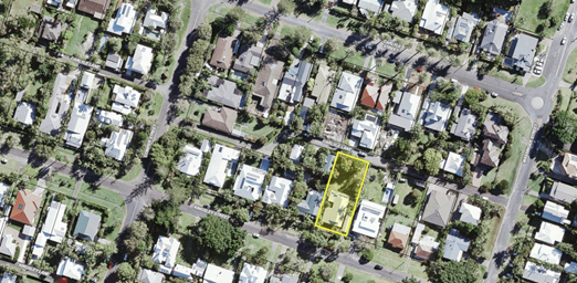
Figure 3: Shows the GIS mapping and the location of the
subject site
2. SECTION 4.15 – MATTERS FOR CONSIDERATION
– DISCUSSION OF ISSUES
Having regard for the matters for consideration detailed in
Section 4.15(1) of the Environmental Planning & Assessment Act 1979, the
following is a summary of the evaluation of the issues.
Section 4.55 of the EPA Act 1979
It is considered the proposed development is considered to
be substantially the same development as approved and satisfies the provisions
as contained within Section 4.55 of the EPA Act 1979.
In terms of the amendments to the description, there is no
planning objection to replacing the wording of demolition to relocation of the
existing dwelling house and this represents a sustainable outcome in
repurposing the existing dwelling. Nor is there any issue with the pool changes
or tree removal relocation matters as proposed.
The changes to the building design in terms of the Building
height plane are the main areas of contention and are discussed below.
2.1. State/Regional Planning
Policies, Instruments, EPA Regulations 2000
Proposed amendments raise no issues under the relevant
SEPPS, Policies or clauses of the EPA Regulations 2000
2.2. Byron Local Environmental
Plan 2014
The Proposed amendments raise no issues under the LEP
2.3. Draft EPI that is or has
been placed on public exhibition and details of which have been notified to the
consent authority - Issues
No draft EPIs affect the proposal.
2.4. Development Control Plans
Chapter D1 Residential Accommodation in Urban, Village
& Special Purpose Zones
D1.2.1 Building Height Plane:
The proposed development breaches the prescribed building
height plane which is defined under Byron DCP 2014 as:
Building Height Plane means the plane projected at an
angle of 450 over the land to be built upon, measured from a vertical distance
of 1.8 metres above ground level (existing) at the site boundary.
The development as approved permitted some encroachment into
the Building height plane with the consent being conditioned to reflect that
level of encroachment as follows:
6.
Amended Plans to be submitted with the Construction Certificate
To lower the
Dwelling by 500 mm amended Plans to be submitted to Council for approval prior
to the issue of the Construction Certificate to accurately reflect the approved
plans as marked in red and as per the following requirements:
· Reduce the
floor to ceiling height on the ground floor from 3.0 m to be 2.7 m in height;
· Reduce the
floor to ceiling height in the undercroft basement storage (adjacent to the
pool) from 2 m to 1.8 m in height.
· Set the ground
floor of the dwelling at 9.6 m AHD
· The maximum
height of the roof to be no greater than 8.5 m above natural ground level.
The amended
plans as approved are to be submitted with the Construction Certificate for
approval to the Principal Certifying Authority.
In arriving at that condition, the report to Council on the
20 June 2019 had regards to privacy, overshadowing, streetscape and
neighbouring dwellings with similar breaches but noted the following:
“To bring the
building into better compliance with the prescriptive measures, conditions of
consent are recommended to lower the dwelling by 500 mm. In this regard the ground
floor of the dwelling to be set 200 mm lower at 9.6 m AHD, whilst the 3 metre
ceilings on this level are also to be lowered by 300 mm to 2.7 m AHD.”
The original amendments as submitted had the effect of
increasing the height overall by 400 mm on the first floor, and in particular
exacerbates the breach on the western boundary that the consent condition was
clearly aimed at addressing. The plans have since been amended and the
additional breach in the building height plane has now been reduced to only 200
mm. The proposal has been considered against the objectives and performance
criteria underpinning this design element in the DCP the following comments are
provided:
Objectives
1. To ensure that residential
development is designed to minimise impacts on solar access and privacy on
adjoining properties, and on the views from adjacent existing buildings.
2. To ensure that the occupants
of the building or buildings will enjoy the optimum use of winter sunlight and
summer shade.
Performance Criteria
1. Developments must be set
back progressively from the site boundaries as height increases so that they do
not adversely affect existing or future development on adjoining properties by
way of overshadowing, impinging on privacy or obstructing views.
2. Developments must be
designed so that they will promote energy efficiency and so that residents may
enjoy optimum use of winter sunlight and summer shade.
3. Development applications must
demonstrate that the windows of living areas (decks, living rooms, bedrooms,
kitchens, etc.) of development on adjoining properties will, as a minimum,
retain full solar access between the hours of 9.00am to 3.00pm on any day.
Comment:
The design of the development gradually steps back from the
side boundaries as it rises in height minimise impacts in relation to solar
access. It is also considered that the increased height of the floor to ceiling
level on the first floor does not exacerbate privacy impacts which have not
been previously considered with the ground floor remaining at the height
already approved and privacy screens proposed on the side elevations to the
verandahs and decks.
The orientation of the lots on a general north south axis
will ensure good solar access through the middle of the day to the subject
dwelling and also to the neighbouring dwellings. The changes to the plans do
not obstruct views with the development located on a residential street
dominated by dwellings aligned on this same north south axis. In terms of
shadow impacts the level of any increase is considered to be negligible, and
any specific shadow cast onto the neighbouring dwelling is gone by 11 am in
midwinter. (For details see the attached plans to this report)
As previously discussed in the earlier Council report of
20/6/19, such shadow impacts fall upon three bedrooms of the neighbours house
to the west, not there main living areas which are located on the northern and
western elevations (see figure 4 for floor plans. It is noted the
dwelling at 59 Kingsley Street also overshadows the subject property and as
indicated in the Building Height Plane controls would be considered non
compliant with the prescriptive controls if proposed now. It is also noted the
dwelling on the opposite side at 63 Kingsley Street also breaches the Building
Height Plane. Hence it could be argued that the subject building height plane
controls have in part been abandoned in this street.
Conclusion
Having regard to the building height plane breaches that are
evident at both the adjoining properties at 59 and 63 Kingsley Street, the
level of encroachment resulting from the modification is considered acceptable.
The applicant has requested Condition 6 be deleted and the
application relies upon the amended plans in terms of construction certificates
and other approvals going forward. However it is considered prudent that
Condition 6 be reworded to reflect the amended plans as follows to ensure the
construction certificate plans reflect the actual approved plans. The condition
also includes further wording in relation to a landscape plan to be approved as
part of the Construction Certificate.
6. Plans to be
submitted with the Construction Certificate
The Plans to
be submitted with the Construction Certificate to accurately reflect the
approved plans and as per the following requirements:
· The floor to
ceiling height on the ground floor be set at a maximum of 2.9 m in height;
· Set the ground
floor of the dwelling at 9.6 m AHD
· Set the floor
to ceiling height in the undercroft basement storage (adjacent to the pool) at
a maximum of 2 m by lowering the basement floor level to 7.3m AHD
· The maximum
height of the roof to be no greater than 8.5 m above natural ground level.
· Landscaping
plan showing the location of trees to be replanted and the privacy hedge
comprising as a minimum 10 native plants with a maturity height of 3 metres
along the western boundary with 59 Kingsley Street where the pool and back
verandah are located. The relocated bangalow palms not to be located on this
boundary. The landscape plan to be prepared by a suitably qualified landscape
designer in accordance with Chapter B9 of DCP 2014.
The plans are
to be submitted with the Construction Certificate for approval to the Principal
Certifying Authority.
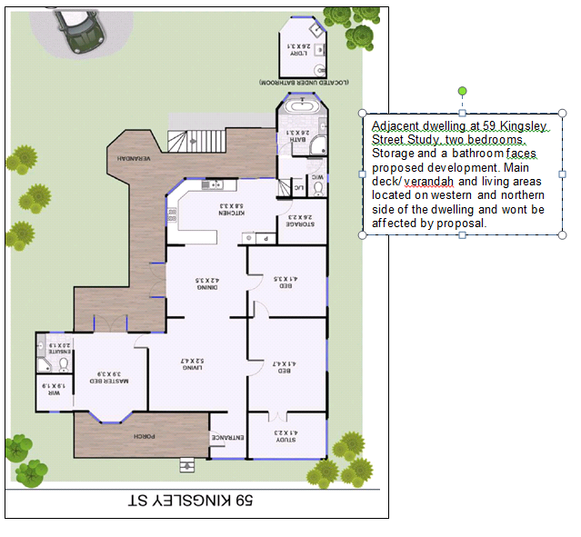
Figure 4 – Floor plans of dwelling at 59 Kingsley
Street
It is considered the proposal raises no other issues against
the DCP chapters within DCP 2014.
2.5. The likely impacts of that
development, including environmental impacts on both the natural and built
environments, and social and economic impacts in the locality
Tree removal
The applicant is proposing to
remove a mango tree, two bleeding heart trees and two bottlebrushes and
relocate a Lilli Pilli and 5 Bangalow Palms. In this regard this is required to
assist with the construction of the dwelling and its relocation. It is
considered the vegetation is lost not significant, however it is recommended as
discussed above a landscape plan be submitted with the construction certificate
showing the location of plants to be relocated and other plants to be planted
increasing the number of trees to be planted on the boundary with 59 Kingsley
Street. It is also recommended that Condition 37 be amend to read:
37. Landscaping
All landscaping as required
under this development consent to be completed prior to the occupation of the
dwelling house or issue of Occupation Certificate and in accordance with the
approved landscape plan including the hedge plantings on the boundary with 59
Kingsley Street.
Relocation of the existing dwelling
The change to the description of the development is
supported and it is considered the relocation of the dwelling as opposed to its
demolition is a more sustainable outcomes for the building and is recommended
for approval.
2.6. The suitability of the
site for the development
The site remains suitable for residential purposes.
2.7 Submissions
made in accordance with this Act or the regulations
One submission objecting to the modification application was
received.
Objection and staff comments to the modification application
as notified are below.
In response to the issues raised in the submission, the
applicant has amended the plans further - the increase in the wall height from
that originally approved is limited to 200mm only. It is considered the
increased impact on neighbouring properties is negligible in terms of
overshadowing and overlooking.
The applicant is also planning to remove 2 bottle brush
trees, a mango and two bleeding heart trees, and relocate a Lilli-Pilli and 5
Bangalow Palms to facilitate the relocation of the existing dwelling house and
construction works, and an amendment to the approved swimming pools dimensions.
These amendments raise no issues as discussed within the body of the
report.
The objector was advised about the receipt of amended plans
and given the opportunity to comment on same. The objector advised that
matters relating to overshadowing and privacy remain unresolved and that their
objection stands
|
Issues
|
Comment
|
|
Council approved the dwelling at a certain height (9.6 AHD
verse 9.8 AHD) and any alterations to this should not be supported due to
non-compliance with the DCP (Building Height Plane) and due to privacy
concerns.
|
Amended plans have been submitted and the increased in
floor to ceiling height is considered acceptable as discussed above. The
ground level remains set at 9.6m whilst the overall height is compliant with
the 8.5 m height conditions.
|
|
Use of bangalow palms as a privacy hedge will exacerbate
overshadowing on neighbours to the east
|
Landscape Hedge to remain and has been increased to 10
trees. Bangalow palms and including the existing Lilli Pill to be sited
elsewhere on the property and a landscape plans required as per conditions of
consent.
|
|
reduction in height of the privacy screens,
|
Privacy screens are set at 1.8 metres
|
|
Heritage – Plans appear to conflict with Condition
No.5 in terms of heritage colours and materials
|
Condition No. 5 is to remain as approved.
|
|
|
|
2.8 Public
interest
The proposed amendments do not prejudice or compromise the
public interest.
3. DEVELOPER
CONTRIBUTIONS/ WATER AND SEWER CHARGES
There is no nexus to levy contributions.
4. DISCLOSURE OF POLITICAL
DONATIONS AND GIFTS
|
Has a Disclosure Statement been received in relation
to this application
|
No
|
|
Have staff received a ‘gift’ from anyone
involved in this application that needs to be disclosed. Where the answer is
yes, the application is to be determined by the Director or Manager of the
Planning, Development and Environment Division.
|
No
|
|
Provide Disclosure Statement register details here:
|
Not applicable
|
5. CONCLUSION
The proposed modification is supported for the reasons
outlined in the above report. The increase in the floor to ceiling height on
the ground floor is considered reasonable and issues of privacy and amenity
impacts acceptable. The application is recommended for approval subject to
amended conditions of consent.
STATEMENT
OF REASONS
Note:
From July 1 2018, Council’s are required to give and publicly notify
reasons for a range of planning decisions where they are deciding if
development should proceed to help community members to see how their views
have been taken into account and improve accountability to stakeholders. A
statement of reasons for the determination of this application is provided
below.
|
Statement of Reasons
|
|
S.4.55
|
The proposed modifications were minor and substantially
the same as the original development approval with no detrimental
environmental impacts.
|
|
How community views were addressed
|
|
1
|
The DA was advertised in accordance with Development
Control Plan 2014. The submissions received were considered on merit and
addressed during assessment of the application.
To view the considerations, please contact Council to view
a copy of the assessment report relating to this DA.
|
Staff Reports - Sustainable Environment and Economy 13.26
Report No. 13.26 Byron
Shire Council Agricultural Action Plan Update
Directorate: Sustainable
Environment and Economy
Report
Author: Andrew
Cameron, Farm Liaison Officer
File No: I2019/1919
Background:
The Investigation into Agriculture in Byron Shire and Action
Plan - Farming Industry Consultation Summary Report (Attachment 1)
identified that in the period from 2010/11 to 2015/16 Byron Shire’s
agricultural industry has:
1. Had
annual turnover reduced from $112.7M to $103.1M
2. Lost
50 jobs in agriculture in that same period.
Agriculture and its sustainability is vital to the local and
regional economy. In order to address the issues of decline, Council employed a
temporary Farm Liaison Officer (FLO) funded to June 2020. The FLO commenced
extensive industry consultation and developed an Agriculture Action Plan aimed
at implementing ways in which Council can assist the industry remain
sustainable and prosper.
Council appointed the FLO with the objectives to elevate our
farming community’s profile, promote sustainable farming in Byron Shire,
be the main point of contact for farming enquiries and to develop plans and
systems to support sustainable farming and our farming community.
To achieve these objectives, the FLO undertook a review of
past and current agricultural reports (relevant to the Shire), and consulted
with key stakeholders and management. Then together with the Agricultural
Cluster Group (representing key primary industries) developed an Agricultural
Action Plan. This plan guides and directs the activities of the FLO in order to
achieve the objectives of the role.
The aim of this report is to gain endorsement of the
Agricultural Action Plan and to provide an update to Council on it’s
progress and achievements to date, current projects and future projects.
|
RECOMMENDATION:
1. That
Council note the update provided in this report on completed, current
and future projects and activities supporting agriculture, agri-business and
farmers in Byron Shire.
2. That
Council acknowledge the significant value the implementation of the
Agricultural Action Plan and its contribution to achieving the objectives,
strategies and actions of Council‘s Community
Strategic Plan and Operational Plan.
3. That
Council endorse the Byron Shire Council Agriculture Action Plan in
Attachment 2 (E2019/84462).
4. That
Council consider funding options for the Farm Liaison Officer position
as a permanent full-time position when preparing the 2020/21 budget..
|
Attachments:
1 Investigation
into Agriculture in Byron Shire and Action Plan - Farming Industry Consultation
Summary Report, E2018/72133
2 Byron
Shire Council Agriculture Action Plan - post ACG meeting 12 June 19, E2019/84462
REPORT
The following provides a summary of completed, current and
future planned projects and activities of the Agriculture Action Plan, in order
to support agriculture, agri-business and farmers in Byron Shire.
Activities Completed
· Establishment
of the FLO position as the primary contact for all farming and rural land
related enquiries within Council.
· Rural Land
Issues database that has been populated with issues related to farming and
rural land holder enquiries.
· A documented
history of agricultural production in Byron Shire from it’s beginnings in
1860 through to present day and projected future production trends.
· Engagement
with over 50 rural land holders, agribusinesses and external agencies to
highlight and promote the objectives of the FLO role to the community.
· Representation
of Council by the FLO in an advisory position on the Leadership Council of
Young Farmers Connect with the objective of supporting and building the
capacity of farmers aged under 40 in the Byron Shire.
· Involvement
by the FLO in advocacy work with the Northern Rivers - Regenerative Agriculture
Investment Network "RAIN". RAIN is made up of land owners, farmers, and people with strong connections to
sustainable/regenerative agriculture - who share a passion for using land as a
source of nourishment for people and planet. To date the discussions have
focussed on incentivising landowners to adopt regenerative land management
practices that increase productivity whilst adapting to climate change and
improving ecosystem services.
· Undertook a
review of the 2004 Sustainable Agricultural Strategy. Relevant issues, outcomes
and activities were incorporated into Council’s Agriculture Action Plan
· Establishment
of the Agricultural Cluster Group (ACG) The ACG acts as a conduit between
Council and the Shire’s agricultural industry. The ACG is made up of a
broad cross-section of primary producers within Byron Shire aimed guiding
decision making processes within Council with regard to agricultural issues. The
ACG also acts as a sounding board for information to be communicated from
Council back into the industry.
· The
ACG’s Terms of Reference (TOR) were developed and endorsed at the
combined Strategic Business Panel/ACG meeting held on 30 May 2019 (Resolution
19-081).
· Since
endorsement of the TOR, the ACG has met on three occasions and achieved the
following outcomes:
o Developed the Byron Shire
Agriculture Action Plan. The Action Plan was developed from a number of
resources and targeted consultation with primary producers. The plan is made up
of objectives, actions and deliverables to be achieved over the short, medium
and long term that aim to deliver the following three outcomes:
1. Ensure agriculture remains a major economic
contributor to Byron Shire‘s Gross Regional Product
2. Continually improve sustainable land-use practices
on all rural land within the Shire
3. Improve communication, engagement and trust with
rural landholders and rural life-stylers
o Information seminar for
farmers on carbon credits under the Federal Government Climate Solution Fund.
Carbon credits can be earned by land managers through registering projects that
utilise innovative farming systems such as those associated with regenerative
agricultural practices.
o A tour of Council’s
composting facility at the Resource Recovery Centre in Myocum. The tour was
extremely well received by the farmers and dispelled many myths about
Council’s composting operations, including the products organic
specifications and it’s competitiveness in price. Recent FLO industry
engagement regarding Council’s composting operations led to a 100m3 sale
to a SoilCare representative who previously would not buy Council compost.
· Successfully
applied for $50,000 grant funding under the National Landcare’s Smart
Farms program, to develop the project “Managing Land in the Micro Climate
of Byron Shire – Capacity Building for New and Lifestyle Land
Managers”. Council will collaborate with a consortium of organisations to
develop a Rural Land Know How Package for our new and existing lifestyle
landholders. The project will be completed by 30 September 2021. Aims include:
o Engage the Shires rural
landowners to build their capacity and capability by increasing their
awareness, knowledge and skills of land management best practice and how to
mitigate risks associated with climate change.
o Deliver agricultural
productivity gains in conjunction with net benefits to soil, water, vegetation
and biodiversity within the region through a best practice land management
guide and mentoring.
· Formalisation
of internal procedures that allow graziers to gain authorization from Council
to apply to North Coast Local Land Services for a permit to conduct roadside
grazing (21/08/2019 Executive Team Meeting).
Activities in progress
· Creation of
version 2 of “Farmers Farm… and Cows DO Moo”. This
publication will be launched in early 2020.
· Supporting
and exploration of options for farmers to value-add or diversify through food
and agritourism on farm, working closely with internal departments to assist
rural landholders navigate LEP and DCP requirements.
· Developing a
business case for delivering a Byron Shire agricultural industry forum.
· Liaising
with, and acting as a conduit to Council for landholders who are seeking to
make amendments to our LEP, to help empower new farming entrants and reduce
their barriers to entry. Such projects would investigate affordable leasing
arrangements for small scale farmers as well as providing on-farm living
arrangements (e.g. Lighthouse Organics/Conscious Grounds and 96 Bangalow).
· Undertaking
mapping of RU1 and RU2 zoned land within Byron Shire with the aim of
identifying what current agricultural production trends are being undertaken in
order to investigate the feasibility of Council supporting an RU4 pilot program
- to support small lot farming initiatives. The “Small Lot Regen Farming
Initiative” pilot project aims to be launched as part of National
Regenerative Agriculture Day February 2020, in order to support and celebrate
the united national movement of raising awareness around Regenerative
Agriculture and the benefits to helping heal the land and our communities.
· Ongoing
management and delivery of the Smart-farms project.
Future projects:
· Expand ACG
membership in order to obtain greater cross-sectoral representation of Byron
Shires agricultural industry
· Engage with
Council Utilities department to assist in optimizing Sewerage Treatment Plant
water re-use projects for the benefit of agriculture and biodiversity
STRATEGIC CONSIDERATIONS
Community Strategic Plan and
Operational Plan
|
CSP Objective
|
L2
|
CSP Strategy
|
L3
|
DP Action
|
L4
|
OP Activity
|
|
Community
Objective 3: We protect and enhance our natural environment
|
3.4
|
Support and
secure our farming future
|
3.4.1
|
Develop and
implement strategies to support agriculture, agri-business and farmers
|
3.4.1.1
|
Finalise and
Implement Agriculture and Agribusiness Action Plan
|
|
|
|
|
|
|
|
|
|
|
|
|
|
|
|
|
Legal/Statutory/Policy
Considerations
Nil
Financial Considerations
Nil
Consultation and Engagement
Byron Shire Agricultural Cluster Group
Byron Shire rural land holders
Project Officer – Environmental and Agriculture
Projects
Manager - Environmental and Economic Planning
Director – Sustainable Environment and Economy
General Manager
Staff Reports - Sustainable Environment and Economy 13.27
Report No. 13.27 PLANNING
- Draft Planning Controls for Short Term Rental Accommodation in response to
Ministerial Direction 3.7 Reduction in non-hosted rental accommodation period
Directorate: Sustainable
Environment and Economy
Report
Author: Ben
Grant, Planner
File No: I2019/1925
Summary:
The
recent rise of online booking platforms has led to significant and sustained
growth in the short term rental accommodation sector in Australia and in
particular the Byron Shire. As tourism has spread into residential areas
there have been increased reports of conflict over noise and anti-social
behaviour, coupled with broader social and economic concerns over housing
supply, worsening affordability and an increasing sense of dislocation from
community.
In 2015,
Council sought to regulate holiday letting through an amendment to Byron Local
Environmental Plan 2014 that would define the use and establish the
circumstances in which development consent would be required. The
planning proposal went through a number of iterations over a two year process
and was eventually submitted to the Department of Planning and Environment for
completion April 2017.
As this process was unfolding, a
Parliamentary Enquiry into the adequacy of the regulation of short-term holiday
letting in NSW was underway. The Enquiries’ final report to Government
concluded that short-term rental accommodation should be defined and enabled
through the planning system as exempt or complying development, supported by a
compliance system and a code of conduct. As a consequence of this
recommendation, the Department chose to defer making a decision on
Council’s planning proposal until the release of an options paper
outlining the intended regulatory approach. The impasse resulted in Council
resolving to withdraw the planning proposal in September 2017.
Since
then, the number of properties offering short term rental accommodation in the
Shire has continued to grow. By September this year approximately 18% of all
dwellings were listed on Airbnb, with numbers in Byron Bay exceeding 40%.
Preliminary research shows that nearly half of these listings are highly
available properties that are most likely offered as de-facto tourist and
visitor accommodation.
This
report explains a set of draft planning controls that seek to define and
regulate short term rental accommodation through an amendment to Byron LEP
2014. The aim is to achieve appropriate balance of regulation that allows for
new tourism opportunities while still preserving the supply of residential
housing and managing adverse impacts on neighbourhood amenity.
It is recommended that a draft
planning proposal be prepared, based on the planning controls in Attachment 1,
which will proceed to an initial round of public exhibition in early 2020.
Following exhibition, the planning proposal will be revised where necessary and
reported back to Council.
NOTE TO COUNCILLORS:
In accordance with the
provisions of S375A of the Local Government Act 1993, a Division is to be called
whenever a motion for a planning decision is put to the meeting, for the
purpose of recording voting on planning matters. Pursuant to clause 2(a)
under the heading Matters to be Included in Minutes of Council Meetings of
Council's adopted Code of Meeting Practice (as amended) a Division will be
deemed to have been called by the mover and seconder of all motions relating to
this report.
|
RECOMMENDATION:
1. That Council request staff to prepare a planning
proposal to amend Byron Local Environmental Plan 2014 in accordance with the
draft planning controls in Attachment 1 (E2019/85833).
2. That Council request staff to undertake an online
community engagement activity of the draft planning proposal controls during
December and January to canvass community opinion on the controls.
3. That Council receive a report on the community engagement activity with a finalised
planning proposal, for endorsement to submit to the Department of Industry
and Environment for Gateway Determination in February 2020.
|
Attachments:
1 Attachment
1 Draft Planning Controls for Short Term Rental Accommodation, E2019/85833
2 Attachment
2 Ministerial Direction 3.7 Reduction in non-hosted rental accommodation
period, E2019/85835
REPORT
Background
The
recent rise of online booking platforms has led to significant and sustained
growth in the short term rental accommodation sector in Australia and in
particular the Byron Shire.
As tourism has spread into
residential areas there have been increased reports of conflict over noise and
anti-social behaviour, coupled with broader social and economic concerns over
housing supply, worsening affordability and an increasing sense of dislocation
from community.
Web links:
https://www.byron.nsw.gov.au/Services/Building-development/Planning-in-progress/Short-term-rental-accommodation
https://www.planning.nsw.gov.au/Policy-and-Legislation/Under-review-and-new-Policy-and-Legislation/Short-term-holiday-letting
Previous attempts to regulate
Council has attempted to regulate
holiday letting in the past with a holiday letting forum in 2005 and a precinct
based approach in 2008. More recent efforts resulted in the preparation of a
Short Term Rental Accommodation Action Plan in 2014. A key recommendation of
the 2014 Action Plan was an amendment to Byron Local Environmental Plan 2014
(LEP 2014) to introduce a set of planning controls to define and regulate
holiday letting. This led to the development of a planning proposal that was
submitted to the Department of Planning and Environment in July 2015.
Following the issue of a gateway
determination on 31 August 2015, the planning proposal went through a number of
iterations over a two year process to address issues raised by the Department
and Parliamentary Counsels Office. It was eventually submitted for completion
following a final round of amendments in April 2017.
As this process was unfolding, a
Parliamentary Enquiry into the adequacy of the regulation of short-term holiday
letting in NSW was underway. The Enquiries’ final report to Government
concluded that short-term rental accommodation should be defined and enabled
through the planning system as exempt or complying development, supported by a
compliance system and a code of conduct. The Government offered qualified
support for most of the recommendations, indicating that an options paper would
be prepared to implement a whole of government framework in the near
future.
As a consequence of this
announcement, the Department chose to defer making a decision on the planning
proposal until after the Governments options paper had been released. The
impasse resulted in Council resolving to withdraw the planning proposal as it
did not make sense to continue until it was known how it would interact with
the Governments finalised approach.
Draft NSW regulatory framework
released
In August
2019, the Department announced a draft regulatory framework for short
term rental accommodation in NSW,
including a state-wide planning framework, fire safety standards and a
mandatory Code of Conduct. None of the new rules have come into force yet.
The draft framework is a package of
legislation comprising the following key elements:
State Environmental
Planning Policy (Short Term Rental Accommodation) 2019
The proposed State
Environmental Planning Policy (Short Term Rental Accommodation) 2019 is a
new SEPP created to provide State-wide land use planning controls for short
term rental accommodation. The SEPP will introduce a standardised definition
for short term rental accommodation, along with definitions for hosted and
non-hosted short-term rental accommodation.
Hosted accommodation is similar to
a bed and breakfast facility and requires a “host”, being the owner
or permanent tenant, to be present during the period of accommodation.
Non-hosted accommodation is similar to a serviced apartment and does not
require the owner or host to be present during the period of accommodation.
Hosted and non-hosted accommodation
will be permissible as either exempt or complying development, subject to a
number of requirements for zoning, dwelling type, occupancy, and fire
safety. Non-hosted accommodation on bushfire prone land or flood prone
land will be permissible only as complying development.
Non-hosted accommodation is limited
to a maximum of 180 days per year in the Greater Sydney Region and for any
other Council that elects to opt-in. Ballina, City of Lake Macquarie, Clarence
Valley and Muswellbrook were identified in the draft SEPP. Other areas will not
be subject to time limitations.
Code
of Conduct
Supporting the new planning rules
will be a mandatory Code of Conduct, given effect through amendments to the Fair
Trading Act 1987 and Fair Trading Regulation 2016 that were passed
by the NSW Parliament on 14 August 2018.
The Code is a complaint based regulatory
system that will be managed by NSW Fair Trading. It applies to booking
platforms, letting agents, hosts, and guests and covers matters such as
reporting, insurance, neighbour notification, anti-social behaviour and damage
to common property.
If the code is breached, Fair
Trading has the option of listing the industry participant or the premises on
an ‘exclusion register’, which prevents the person or premises from
carrying out short-term rental accommodation. Non-compliant behaviour can
result in a ‘strike’ being recorded (two ‘strikes’ in a
two year period may result in exclusion). A breach of the Criminal laws,
planning laws or strata by-laws may also result in an industry participant
being listed on the register.
Fire
Safety Standards
An amendment to the Environmental
Planning and Assessment Regulation 2000 has been proposed that will require a
dwelling being used for short-term rental accommodation to comply with the
requirements of the Short-term Rental Accommodation Fire Safety Standard.
The Fire Safety Standard introduces
new requirements for class 1(a), class 2 and class 4 buildings being used for
short-term rental accommodation. It introduces additional requirements for
smoke and heat alarms, evacuation lighting, fire blankets, fire extinguishers,
egress doors and evacuation diagrams.
Strata by-laws
The
Department has clarified that Strata schemes can adopt a by-law that prohibits
short term rental accommodation where a lot is not a host’s principal
place of residence. Any such by-law will need to be adopted by special
resolution, with 75% of votes supporting the proposal at a general meeting.
Ministerial Directive
On 5
February 2019, a Ministerial Planning Direction was issued to address the high
concentration and unique impacts of short term rental accommodation in the
Byron Shire. The Direction allows Council to reduce non-hosted short-term
rental accommodation to a minimum of 90 days per calendar year, as long as
there is a sound base of evidence to support the proposed changes. A full copy
of the Ministerial Direction is provided in Attachment 2.
The
Ministerial Direction gives Council the opportunity to implement local planning
rules for short term rental accommodation, rather than being subject to the
planning rules in the SEPP.
The
following principles need to be addressed:
o non-hosted
short term rental accommodation periods must not be reduced to be less than 90
days
o the
reasons for changing the non-hosted short-term rental accommodation period
should be clearly articulated
o there
should be a sound evidence base for the proposed change, including evidence of
the availability of short-term rental accommodation in the area (or parts of
the area) in the 12 months preceding the proposal, relative to the amount of housing
in the area, and trend-data on the availability of short-term rental
accommodation over the past 5 years.
o the
impact of reducing the non-hosted short-term rental accommodation period should
be analysed and explained, including social and economic impacts for the
community in general, and impacted property owners specifically.
Preliminary
research
Preliminary
research into Airbnb, the dominant online booking platform, indicates a
significant concentration of online listings in the Byron Shire with evidence
of a strong and sustained growth trend over the past few years.
Using
data from insideairbnb.com (published by activist Murray Cox), the total number
of listings for the Byron Shire was estimated to be 3,305 in September 2019.
Whole houses or apartments comprised 78% of offerings. This compares to Tweed
Shire with 1,232 listings, followed by Ballina with 610. Regionally, Byron
Shire accounts for more Airbnb listings than all other Northern Rivers Local
Government Areas combined.
Approximately
18% of all dwellings in Byron Shire were listed on Airbnb in September 2019,
with most of the activity being concentrated in Byron Bay. This finding
reflects previous research on Airbnb from Australia and overseas that shows
listings tend to concentrate in areas where demand for tourist and visitor
accommodation is high.
Slightly
less than half the listings were identified as ‘frequently
available’, meaning they were available for more than 90 days in the
previous 12 months. Listings of this type are generally considered to be
commercial rentals that are predominantly used for tourist and visitor
accommodation. The majority of frequently available listings were also
concentrated in Byron Bay, comprising up to 25% of the total dwelling supply.
The actual number may be higher, as the preliminary research only looked at
data from Airbnb and did not consider other platforms such as HomeAway (Stayz)
or Booking.com. Research is ongoing.
Council
has also been assisted by researchers from Southern Cross University (SCU) who
recently completed a survey of Byron Shire residents on the impacts of Airbnb.
The majority of survey respondents felt that while Airbnb offers a greater
variety for guests and additional income for hosts, it was having an adverse
impact on neighbourhood amenity and the availability of housing.
A second
SCU research project is currently underway to understand how Airbnb has
impacted approved accommodation providers. We expect the result will form part
of a supporting body of research on the social and economic effects of
short-term rental accommodation to support a future planning proposal.
What is
clear from the preliminary research is that Byron Shire is a hotspot of activity
for short term renal accommodation in NSW and the sector is continuing to
expand. Regulation through the planning system is needed to manage the impacts
on residential amenity and to prevent further erosion of housing supply.
Explanation of the draft
controls
The intended outcomes are to be
achieved by an amendment to LEP 2014 as follows:
(1) Insert
a new definition of short-term rental accommodation into the LEP 2014
dictionary as follows:
short-term rental
accommodation means an existing dwelling—
(a) that
is lawfully used by the owner, tenant or permanent resident of the dwelling
(the host) to provide accommodation on a commercial basis for a temporary or
short-term period, with or without the host residing on the premises during
that period, and
(b) that,
if it were used predominantly as a place of residence, would be one of the
following types of residential accommodation—
(i) an
attached dwelling,
(ii) a
dual occupancy,
(iii) a
dwelling house,
(iv) multi
dwelling housing,
(v) a
residential flat building,
(vi) a
rural workers’ dwelling,
(vii) a
secondary dwelling,
(viii) a
semi-detached dwelling,
(ix) shop
top housing
non-hosted short-term rental
accommodation means short-term rental accommodation provided where
the host does not reside on the premises during the provision of the
accommodation.
hosted short-term rental
accommodation means short-term rental accommodation provided where the
host resides on the premises during the provision of the accommodation.
The definition is adopted from the
draft SEPP for the sake of consistency with the Government’s regulatory
framework. This is intended to ensure compatibility with the Code of Conduct,
Fire Safety Standard and any future Environmental Planning Instruments.
(2) Insert a new mapping overlay, known as the Short Term
Rental Accommodation Map, that will identify the maximum number of days for
short term rental accommodation in different locations.
The map will identify:
o Zero (0) days for Council owned and/or managed lands and
‘urban release area land’ identified in a State Government and or
Council strategy or planning instrument;
o 365 days per year in certain areas identified as suitable
for tourism;
o 90 days per calendar year in the remaining parts of the Shire.
A
precinct map offers the option to identify areas that may be more or less
suitable for short term rental accommodation, and to set clear standards for
the acceptable number of days that a property can be used for short term rental
accommodation in each area. Tourism precincts at Wategos, Belongil and Shirley
Street are currently under consideration; however, the final boundaries adopted
for the planning proposal will be determined after considering feedback from
the initial round of public exhibition and further research.
(3) Insert
an enabling clause into Part 4 of LEP 2014 that will make the Short Term Rental
Accommodation Map a development standard. Maximum occupancy levels will also be
specified.
The purpose of the clause is to
give effect to the Short Term Rental Accommodation Map as a development
standard, and to specify the maximum occupancy levels for a dwelling house
being used for short term rental accommodation. It is intended to limit short
term rental accommodation to a maximum of two persons per bedroom, up to a
maximum of 12 persons, whichever is the lesser. For example, a three bedroom
house would be limited to a maximum of 6 persons, while a 10 bedroom house
would be limited to a maximum of 12 persons. The figure is inclusive if guests,
hosts and any other permanent residents.
(4) A new
local clause under Part 6 of the LEP to set out the aims and objectives and
matters to be considered when assessing a development application for
short-term rental accommodation.
The objectives of this clause are
to provide a set of environmental, social and economic considerations for the
assessment of short term rental accommodation. This will include consideration
of impacts on affordable housing, hosing supply, environmental constraints and
the suitability of the dwelling having regard issues such as neighbourhood
amenity, parking and waste disposal.
(5) Insert
a new clause into Schedule 2 of Byron LEP 2014 that will allow hosted and
non-hosted short term rental accommodation as exempt development in the
following circumstances:
o Hosted
accommodation allowed 365 days per year;
o Non-hosted
accommodation limited to 90 days per year;
o Non-hosted
accommodation not permitted on bush fire prone land or flood prone land;
o The
dwelling must not be (or be part of), a group home, a hostel, seniors housing,
an eco tourist facility, tourist and visitor accommodation, a camping ground,
caravan park or a moveable dwelling.
o The
dwelling must not be approved under the Affordable Rental Housing State Environmental
Planning Policy 2009.
o Occupancy
limited to 2 persons per bedroom, up to a maximum of 12 persons in total,
whichever is the lesser;
o Requires
property to be included on a Council register of short term rental
accommodation
o Requires
compliance with fire safety standards under the BCA and EP&A regulations.
o Requires
an A3 sign to be placed at the front of the property advising the public of the
landowners or property manager’s details to enable complaints to be made
and wording to advise that the property is registered with Byron Shire Council.
o Minimum
requirement for car parking of 1 space for a two bedroom dwelling and two
carparks for a dwelling with three bedrooms or more.
o Dwellings
not connected to reticulated sewer must be serviced by an approved on-site
waste water management system with a current approval to operate.
The exempt provisions will allow
for certain low impact uses to occur without Council approval, subject to
minimum standards. For example, letting a single room to visitors, or renting a
whole house for a few weeks while the occupants are travelling will be covered
by these provisions in most cases. Owners who do not meet the exempt
provisions, or who wish to exceed the 90 day threshold in an approved precinct,
will have the option of lodging a development application.
It is also proposed to create a
Short Term Rental Accommodation Register on Council’s web site. The
register will be interactive and enable landowners to register online and
provide information such as the number of bedrooms, period that the property
will be available for short term rental accommodation and contact phone numbers
of the landowner or manager. Staff are investigating options for this at
present.
The
‘zero (0) day cap’ on Council managed land and new release areas
identified in a strategy is not strictly in accordance with the Ministerial
Direction, but is considered to be necessary for Council to achieve strategic
planning objectives for residential dwelling targets and to meet the needs for
permanent housing stock for our resident community and key workers. The final
planning proposal will argue that this inconsistency is of minor
significance.
Interaction with the State
Government’s Regulatory Framework
Council has asked the Department to
exclude Byron Shire from State Environmental Planning Policy (Short-term
Rental Accommodation) 2019. This is critical for Council to be able to
pursue local planning controls as envisaged by the Ministerial Direction.
Other elements of the
Government’s draft regulatory framework including the Code of Conduct,
Fire Safety Standards and Strata laws will apply in the Byron Shire. The draft
planning controls are not expected to come into conflict with or duplicate
these elements of the framework
Regulation under LEP 1988
The new planning controls will only
apply to parts of the Shire regulated by LEP 2014, which covers the majority of
urban land. In areas regulated by Byron Local Environmental Plan 1988
(i.e. any land identified as a “deferred matter”), short-term
rental accommodation will continue to be regulated under the current planning
controls and will generally either be prohibited or require development
consent, depending on the zoning and definition that applies to the land.
It is anticipated that this
situation will gradually change over time as the remaining deferred matter
lands are transitioned to into LEP 2014.
Recommendation
· It
is recommended that a draft planning proposal be prepared, based on the LEP
amendments listed in Attachment 1.
· That
staff undertake an online public engagement activity during December and
January to canvass the views of the community on the draft controls.
· Following
the online engagement activity, the planning proposal should be revised where
necessary and reported back to Council in February 2020 for endorsement to
submit to the Department of Industry and Environment for Gateway determination.
STRATEGIC CONSIDERATIONS
Community Strategic Plan and
Operational Plan
|
CSP Objective
|
CSP Strategy
|
DP Action
|
OP Activity
|
|
Objective 4:
We manage growth and change responsibly
|
4.1 Support the visions and aspirations
of local communities through place-based planning and management
|
4.1.3 Manage development through a
transparent and efficient assessment process
|
4.1.3.10 Prepare and assess Planning
Proposals and Development Control Plans, and amend Local Environmental Plan
maps
|
Financial Considerations
The development
of a short term rental accommodation register may require additional funding.
If required, this will be reported to Council following further analysis to
determine the register design and how it can be incorporated into
Council’s IT systems.
Council’s
development assessment services may be placed under increasing pressure as
landowners seek to regularise their activities. Council should consider the
implications for staffing resources in the planning services team to
accommodate a rise in the number of development applications.
Given the
high number of holiday let’s currently operating in the Shire, it is
likely that additional compliance resources may be required to implement the
new framework. Council will need to consider resource implication of the new
controls and the compliance team work priorities.
Staff Reports - Sustainable Environment and Economy 13.28
Report No. 13.28 PLANNING
- S4.55 for Modification of development consent DA 10.2017.402.3 to dedicate
Lot 130 to Council as a Public Reserve, and amend stormwater design, bushfire
asset protection zones and provide habitat connectivity between Management
Zones 7b and 9.
Directorate: Sustainable
Environment and Economy
Report
Author: Ivan
Holland, Planner
File No: I2019/1934
Proposal:
|
Section 96 Application No:
|
10.2017.402.4
|
|
Proposed modification:
|
S4.55 for Modification of development consent to dedicate
Lot 130 to Council as a Public reserve, and amend the stormwater design, bush
fire asset protection zones and provide habitat connectivity between
Management Zones 7b and 9.
|
|
Original Development:
|
Subdivision to create
eighteen (18) residential Lots, a public reserve, a drainage reserve,
a residual lot and associated roads, earthworks, landscape and infrastructure
works (Stage 6 of Tallowood Ridge Estate)
|
|
Type of modification sought:
|
|
|
|
|
|
Property description:
|
LOT: 162 DP: 1251169
|
|
77 Tuckeroo Avenue MULLUMBIMBY, Lorrikeet Lane,
MULLUMBIMBY
|
|
Parcel No/s:
|
269619
|
|
Applicant:
|
Bayview Land Development Pty Ltd
|
|
Owner:
|
Gainsplay Pty Ltd
|
|
Zoning:
|
R2 Low Density Residential / Part RU1 Primary Production /
PART RU2 Rural Landscape / PART 1(a) General Rural Zone (LEP 1988)
|
|
S4.55 Date received:
|
21 August 2019
|
|
Original DA determination date:
|
26 July 2017
|
|
Integrated Development:
|
Yes – NSW Rural Fire Service
|
|
Delegation to determination:
|
Council
|
|
Issues:
|
· Dedication of
Lot 130 to Council
|
Summary:
Council has received a S4.55 application to modify
development consent DA 10.2017.402.3 by dedicating Lot 130 to Council as a
Public Reserve and to amend the plans in relation to stormwater drainage, bush
fire asset protection zones and management zones for habitat connectivity.
Council has previously resolved to accept Lot 130 as a
Public Reserve due to the presence of a large tallowwood tree on the site,
having regards to the concerns from the community that the tree maybe lost if
the site was on-sold as a residential lot. The applicant is also seeking to
locate a stormwater main adjacent to an existing approved water main that
extends from Stage 7 into Stage 6, whilst providing a new Environmental
Management Zone 11 providing further habitat connectivity from Management Zones
7b and 9. The applicant has also sought to amend the asset protection
zones for one of the approved lots and the RFS have issued new General Terms of
approval in that regard.
The proposed application raises no issues and the dedication
of Lot 130 to Council will provide an additional pocket park for residents in
the Tallowood Estate. As a consequence any Open Space Contributions from this
development into the future will need to off set the value of Lot
130.
The application addresses relevant planning matters and is
recommended for approval subject to the recommended modified conditions.
NOTE TO COUNCILLORS:
In accordance with the
provisions of S375A of the Local Government Act 1993, a Division is to be
called whenever a motion for a planning decision is put to the meeting, for the
purpose of recording voting on planning matters. Pursuant to clause 2(a)
under the heading Matters to be Included in Minutes of Council Meetings of
Council's adopted Code of Meeting Practice (as amended) a Division will be
deemed to have been called by the mover and seconder of all motions relating to
this report.
|
RECOMMENDATION:
That pursuant to Section 4.16 of the Environmental
Planning & Assessment Act 1979, Application No. 10.2017.402.4, under
S4.55 for Modification of development consent to dedicate Lot 130 to
Council as a Public Reserve, and to amend the stormwater design, bush fire
asset protection zones and provide habitat connectivity between Management
Zones 7b and 9, be approved by modifying Development Consent number
10.2017.402.3 in accordance with the recommended modified conditions in
Attachment 6 (#E2019/86061).
|
Attachments:
1 Subdivision
Layout Plan 10.2017.402.4, E2019/86588
2 Modified
stormwater drainage plans: 1002-MO11 and 1002-MO12 10.2017.402.4, E2019/86592
3 Updated
rehabilitation areas plan 10.2017.402.4, E2019/86593
4 Recommended
modifications to conditions of approval 10.2017.402.4, E2019/86061
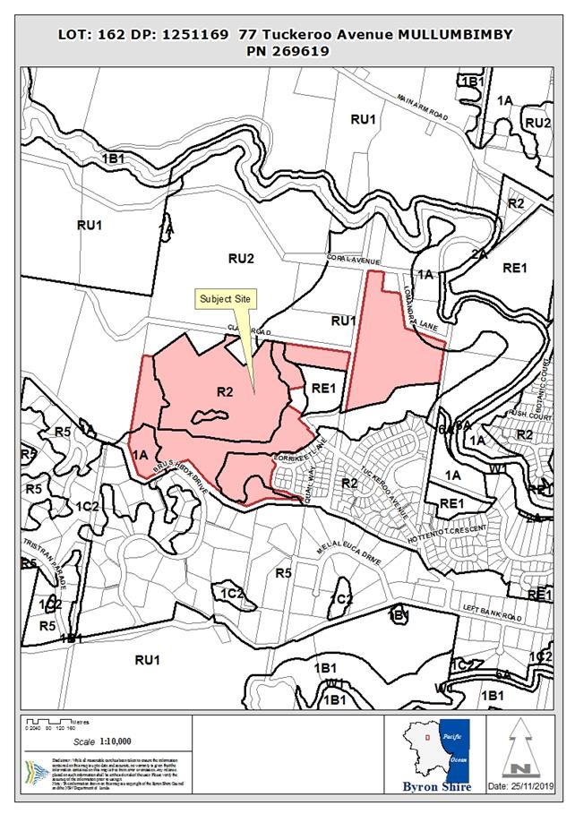
Assessment:
1. INTRODUCTION
1.1. History/Background
DA 10.2017.402.1 for Subdivision to create eighteen (18) residential
Lots, a public reserve, a drainage reserve, a residual lot and associated
roads, earthworks, landscape and infrastructure works (Stage 6 of Tallowood
Ridge Estate) was approved on 22/2/2018 and modified to include a temporary
creek crossing on 21/12/2018.
1.2. Description of the
proposed development
This application seeks approval for a S4.55 for Essential
Services Ancillary to Subdivision. In particular:
1. Dedication
of Lot 130 as a public reserve;
2. Relocation
of a stormwater main to take stormwater from Stage 7 into Stage 6 adjacent to
an approved water main;
3. Amendments
to the Bushfire Asset Protection Zones for proposed Lot 145 from 10 metres to 6
metres; and
4. Provide
additional habitat connectivity between Management Zones 7b and 9 in terms of
the overarching Biodiversity Conservation Management Plan,
1.3. Description of the site
|
Land is legally described as
|
LOT: 105 DP: 1232439
|
|
Property address is
|
77 Tuckeroo Avenue MULLUMBIMBY
|
|
Land is zoned:
|
Part R2 Low Density Residential / Part RU1 Primary
Production / Part RU2 Rural Landscape / Part 1(a) General Rural Zone
|
|
Land area is:
|
44.9 hectares
|
|
Property is constrained by:
|
Flood Liable Land, Bush fire prone land, High
Conservation Value, High Environmental Value Land
|
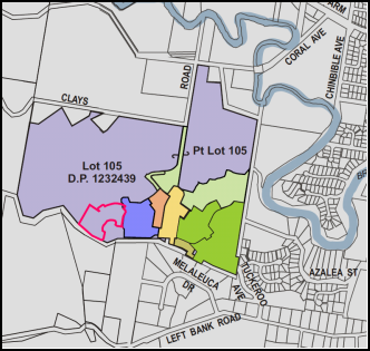
Figure 1 – Location of proposed Stage 6 residential lots
(outlined in pink)
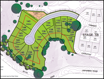
Figure 2 – Diagram of proposed residential lots Stage 6
(red line is extent of bush fire APZ to rear of lots)
|
Photo 1 – Proposed
path of stormwater pipe (water pipe inspection port in left foreground of
photo)
|
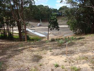
Photo 2 - Proposed path of
stormwater pipe (alignment marked by timber stakes)
|
2. SECTION 4.15 – MATTERS FOR CONSIDERATION
– DISCUSSION OF ISSUES
Having regard for the matters for consideration detailed in
Section 4.15(1) of the Environmental Planning & Assessment Act 1979, the
following is a summary of the evaluation of the issues.
2.1. State/Regional Planning
Policies, Instruments, EPA Regulations 2000
Proposed amendments raise no issues under the relevant
SEPPS, Policies or clauses of the EPA Regulations 2000
Section 100B of the Rural Fires Act 1997
The application was referred to the RFS to review and they
have issued amended general terms of approval in relation to the development
and the APZ’s for Proposed Lot 145.
2.2. Byron Local Environmental
Plan 2014
The proposed modification does not raise any new issues
under the LEP that were not considered under the original DA.
2.3. Draft EPI (Environmental
Planning Instruments) that is or has been placed on public exhibition and
details of which have been notified to the consent authority - Issues
No draft EPIs affect the proposed development.
2.4. Development Control Plans
Chapter B3 Services
The provision of the stormwater main as proposed is
consistent with the relevant provisions contained within Chapter B3. The pipe
will be stepped and include a series of manholes traversing the slope to gain
access to the watercourse in stage 6. Stormwater collected in the main will
come from a contributory channel upslope of the Tallowood Estate residential
footprint and will not contain road or urban stormwater runoff. As such it does
not need to be treated or detained within the stormwater detention pond in
stage 6. The pipe will be laid adjacent to an existing approved water main and
no tree clearing is required for its installation.
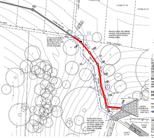
Chapter D6 Subdivision
The location and proposed embellishment of Lot 130 is
generally consistent with the relevant listed criteria (D6.2.1 (9)) under
Chapter D6. Conditions of consent are proposed in relation to its dedication to
Council and embellishment.
2.5. The likely impacts of that
development, including environmental impacts on both the natural and built
environments, and social and economic impacts in the locality
The proposed stormwater main sits within Management Zone 5
(MZ5). The exact area required for the stormwater main and easement through MZ5
is estimated to be 300m2. As an offset and to address issues raised
in a previous application that remain unresolved, the applicant has proposed an
additional rehabilitation area known as Management Zone 11 (MZ11) with an area
of approximately 2500m2. This will provide connectivity between the
larger ecological areas along the southern boundary of the Tallowood Estate
known as Management Zone 7b and Management Zone 9 which is currently an
isolated pocket of bushland. This will take some 2500 m2 of
residential zoned land out of the larger Tallowood
Estate.
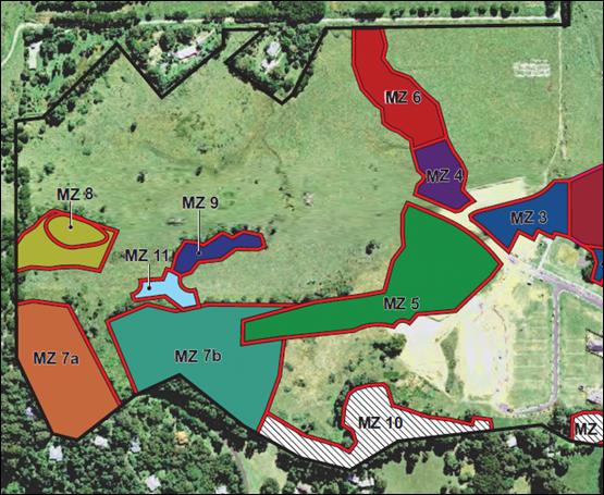
The above is considered a reasonable and positive ecological
outcome. In the circumstances an alternate design could have resulted in the
street network and residential development permanently isolating the Management
Zone 9.
Conditions of consent are proposed requiring the
Biodiversity Management Plan for the Estate be updated to reflect the new
management zone.
2.6. The suitability of the
site for the development
The proposed amendments do not affect the sites suitability
for development. The inclusion of Lot 130 as a public reserve will provide for
additional shady open space under the large Tallowwood tree in the form a
pocket park and will be a good outcome for the residents within the estate and
the broader community.
3.6 Submissions
made in accordance with this Act or the regulations
No submissions were received; however there has been strong
community interest from residents waiting for the dedication of Lot 130 as open
space.
3.7 Public
interest
|
The proposed amendments are unlikely to prejudice or
compromise the public interest.
|
4. DEVELOPER
CONTRIBUTIONS/ WATER AND SEWER CHARGES
Headworks charges have been updated to reflect the reduction
in the number of lots.
It is noted that “Dedication and embellishment of
land used for open space may be offset against the S94 contributions for open
space” (D6.2.1, sub. 9 – DCP).
Council resolved to “…authorise the General
Manager to invite the developer to submit a modification application to
development consent 10.2017.402.3 to dedicate Lot 130 as a public reserve and
offset the value of the land against future development contributions.”
(Resolution 19-278).
The contributions assessment for the development application
will need to be updated following final agreement between Council and the
development on the value of Lot 130 and agreed embellishments. Conditions to
apply in terms of Lot 130 being dedicated to Council.
5. DISCLOSURE OF
POLITICAL DONATIONS AND GIFTS
|
Has a Disclosure Statement been received in relation
to this application
|
No
|
|
Have staff received a ‘gift’ from anyone
involved in this application that needs to be disclosed. Where the answer is
yes, the application is to be determined by the Director or Manager of the
Planning, Development and Environment Division.
|
No
|
6. CONCLUSION
The application satisfies the provisions contained under
S4.55 of the EPA Act 1979 and is considered to be substantially the same
development as approved.
The proposal raises no issues, with two matters of interest
to the community addressed with this modification: the dedication of Lot 130 to
Council; and the provision of the new management zone linking an isolated area
of vegetation with the larger vegetated areas along the southern boundary. The
application otherwise addresses the relevant planning matters and is
recommended for approval subject to conditions.
STATEMENT
OF REASONS
Note:
From July 1 2018, Council’s are required to give and publicly notify
reasons for a range of planning decisions where they are deciding if
development should proceed to help community members to see how their views
have been taken into account and improve accountability to stakeholders. A
statement of reasons for the determination of this application is provided below.
|
Statement of Reasons
|
|
S.96
|
The proposed modifications were minor and substantially
the same as the original development approval with no detrimental
environmental impacts.
|
|
DA
|
The proposed development complies with the provisions of
Byron Local Environmental Plan 2014.
|
|
DA
|
The proposed development complies with relevant State
Environmental Planning Policies
|
|
DA
|
The proposed development complies with relevant provisions
of Development Control Plan 2014
|
|
DA
|
The proposed development will not have significant adverse
impact on the natural, built or social environment or economic impacts on the
locality.
|
|
DA
|
The proposed development is considered suitable for the
proposed site.
|
|
How community views were addressed
|
|
1
|
The DA did not require advertising or notification as per
Development Control Plan 2014.
|
Staff Reports - Infrastructure Services 13.29
Staff Reports - Infrastructure Services
Report No. 13.29 Building
Asset Management Plan
Directorate: Infrastructure
Services
Report
Author: Craig
Purdy, Asset Engineer
File No: I2019/1705
Summary:
Council has completed a full audit and condition assessment
of all council buildings.
From this data a draft Buildings Asset Management Plan
(BAMP) has been created for General Fund buildings.
The draft BAMP was reported
to the Transport and Infrastructure Advisory Committee (TIAC) on the 10 October
2019. There was not a quorum for the meeting, however, the BAMP was
discussed and favourably accepted by those present. There was a
suggestion to review the blank sections on page 26 ‘to be
determined’.
Staff have reviewed this and
the information remains unavailable at this point but the Improvement Plan
includes this action. Edits to page 34 have been complete.
A review of the BAMP
Improvement Plan, Section 13 will be undertaken in 2020/21 and it has been
added to the draft Operational Plan.
|
RECOMMENDATION:
That the draft Buildings Asset Management Plan
be adopted by Council.
|
Attachments:
1 Draft
Buildings Asset Management Plan 2019 to 2029 General Fund (excluding Caravan
Parks), E2019/37319
2 Buildings
Asset Management Plan Community Levels of Service Report 2019, E2019/39855
3 Buildings
Asset Management Plan Customer Levels of Service Infographic, E2019/39854
REPORT
The Buildings Asset Management Plan (E2019/37319) includes 166
buildings from the General Fund assets class (this excludes Caravan Parks where
funds are restricted and 3 State owned toilets at Brunswick Heads [only the
cleaning costs are included in this plan for the 3 state owned Brunswick Heads
toilets). The buildings included are: public toilets, libraries,
community halls, community / recreation leases, swimming pool, recreation,
Bangalow showgrounds, Tyagarah airfield, commercial leases, emergency services
and Council operation buildings.
A condition and defect
audit was conducted in 2018/19 where 1,600 defects were identified to prepare a
Maintenance Plan and over 12,000 components were condition assessed and
modelled to develop an optimised Capital Works Plan.
Our present funding
levels are insufficient to continue to provide existing services at current
levels in the medium term. This conclusion is made from predictive
modelling the current Long Term Financial Plan. Asset modelling has established an
annual capital renewal gap of $185,567 and annual
maintenance target of $1.1M.
There is
a once off defect maintenance gap of $1.9M.
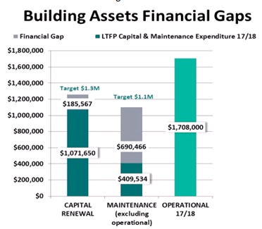
The community were
engaged and rated the ‘quality’ of the public toilets at 3.6 and
community buildings at 2.2 (1 excellent – 5 very poor). The average ‘technical
condition’ of the public toilets is 3.0 and the community buildings
3.3. There are 30% of the buildings in a poor to very poor condition.
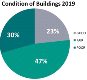
Three funding scenarios were modelled:
Scenario 1 – “Deteriorate” current
Long Term Financial Plan
Scenario 2 – “Holding” budget
Scenario 3 – “Improve” budget
The identified financial gaps indicate building condition
and associated service levels are already falling. This is evident with 30% of
buildings in a poor condition. For example, 1 statutory, 57 safety/
environmental/security defects and 94 structural defects identified. The
funding gaps, whilst challenging, are comparatively small relative to the gap
in roads funding. The funding gaps will be considered in the preparation
of the 2020/2021 Operations Plan and associated budget.
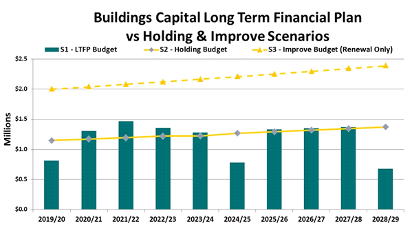
STRATEGIC CONSIDERATIONS
Community Strategic Plan and Operational Plan
|
CSP Objective
|
L2
|
CSP Strategy
|
L3
|
DP Action
|
L4
|
OP Activity
|
|
Community
Objective 1: We have infrastructure, transport and services which meet our
expectations
|
1.2
|
Provide
essential services and reliable infrastructure which meet an acceptable
community standard
|
1.2.2
|
Develop
infrastructure asset renewal and upgrade program in line with Community
Solutions Panel values (SP)
|
1.2.2.1
|
Prepare a
Buildings Asset Management Plan
|
|
|
|
|
|
|
|
|
|
Consultation and Engagement
The community have been engaged to measure the performance
and importance of the public toilets and community buildings via an online
survey from 8 March to 12 April 2019. The Community Buildings Customer
Levels of Service Survey results are annexures to this report (E2019/39855 and
E2019/39854).
Staff Reports - Infrastructure Services 13.30
Report No. 13.30 Reducing
Streetlight Use - Update
Directorate: Infrastructure
Services
Report
Author: Evan
Elford, Manager Works
Kim Mallee, Sustainability Officer
Julia Curry, Sustainability and
Emissions Reduction Officer
File No: I2019/1759
Summary:
At the 22 August 2019 Council meeting, Council resolved (19-406):
That Council receives a report on the implications and
intricacies of turning off residential street lights and that the report
considers:
a) The possible use of some
streets to use as trial sites and engagement with those residing on these
streets
b) The financial and emission
savings
c) The human and
environmental benefits
d) Any safety issues
e) Any regulatory issues.
This report
provides an update on actions to date in respect of the above Council
resolution.
|
RECOMMENDATION:
1. That
Council not move to turn off streetlights as an energy saving measure
at this time as the existing infrastructure does not have the ability to be
isolated and managed for this purpose.
2. That
Council request a cost benefit analysis from Essential Energy
regarding the bulk roll out of LED street lighting to the remaining
applicable street lights in the Byron Shire.
|
REPORT
Council’s Sustainability Team approached Essential
Energy (EE) to gain feedback on the potential feasibility of turning off
streetlights.
Essential Energy advised that the existing infrastructure
does not have the ability to be isolated and managed for this purpose. They
also advised that they were unsure if it would be permissible under current
energy regulations, even if it was technically possible in the future.
Essential Energy also reported that this could cause issues
around fault reporting, community safety and their service level agreement with
Council to provide the street lighting service. The trouble with turning off
streetlights on roads that have been classified to need them (hence why they
are already installed) is that Council would then have made a conscious
decision to not meet the Australian Standard for lighting and may become liable
should any incident occur in the vicinity.
Essential Energy did advise that all new lights (including
the new LED lights) would be “Smart Enabled” and that with
additional controllers could be made to be independently controlled if all
other regulatory and safety issues were overcome. This however would not be
possible until late 2020 at the earliest.
As a consequence of the feedback obtained from Essential
Energy, it is not possible to advance a trial at this time and any
investigation in respect of financial and emissions savings from a trial would
appear to have little relevance to what might actually be achievable from technology
yet to become available and at a currently unknown cost. Accordingly, Council
staff have not progressed these investigations further.
Next steps
Essential Energy are looking to complete a small trial LED
lighting program which involved LED upgrades to 260 streetlights in Ocean
Shores. Council chose to defer any full roll out of LED until the
findings from the trial were known. Unfortunately, this trial is behind
schedule due to problems of procurement and performance of LED lights in
respect to meeting Essential Energy specifications and requirements. The trial
is unlikely to commence until December 2019 at the earliest.
Notwithstanding the delays in running this trial and being
able to confidently analyse and quantify cost benefit outcomes, staff believe
the greatest energy saving action Council could take would be to roll out
LED’s which meet Australian Standard for public lighting across the
shire.
If greater energy saving was an expected outcome from
trialling turning off streetlights, efforts could be made to complete the
entire roll out of LED’s. It is now possible for LED lighting to be
installed across both category P and V roads (previously only available for
category P roads). It is recommended that Council request a cost benefit analysis
from Essential Energy for the bulk roll out of LED streetlights for the
remaining applicable lights in the Byron Shire. This action will assist Council
in meeting targets outlined in the Zero Emissions Strategy for council
Operations 2025.
Mr Wade Elliot, Streetlight and Joint Use Manager for
Essential Energy, made an offer to discuss plans and energy saving
opportunities with the NRJO General Managers at an upcoming
meeting, pending confirmation from NRJO and this may afford an opportunity for
Council to advance a streetlight replacement program shire wide earlier than
possibly anticipated.
STRATEGIC CONSIDERATIONS
Community Strategic Plan and Operational Plan
|
CSP Objective
|
L2
|
CSP Strategy
|
L3
|
DP Action
|
L4
|
OP Activity
|
|
Community Objective 3: We protect and enhance our
natural environment
|
3.2
|
Strive to become a sustainable community
|
3.2.1
|
Work towards Council's zero-emissions target
|
3.2.1.1
|
Implement Net Zero Emissions Strategy for Council
Operations 2025
|
|
|
|
|
|
|
|
|
|
|
|
|
|
|
|
|
Legal/Statutory/Policy Considerations
Nil at this stage
Financial Considerations
Nil at this stage
Consultation and Engagement
Brooke Lyn, Essential Energy
Wade Elliot, Essential Energy
Staff Reports - Infrastructure Services 13.31
Report No. 13.31 Part
Road Reserve Closure and Sale to adjoining Lot 5 DP 714077 255 Repentance Creek
Goonengerry
Directorate: Infrastructure
Services
Report
Author: Deanna
Savage, Roads and Property Officer
File No: I2019/1861
Summary:
This report is being presented to Council to endorse the
closure of Council road reserve surrounded by Lot 5 DP 714077 highlighted in
red Image 1.
As per Crown Land determination (Attachment 1
E2019/84334) the road/land will vest in Council upon closure and it is
proposed to sell the land to the adjoining land owner Lot 5 DP 714077.
Land size is approximately 9,127m2.
|
RECOMMENDATION:
1. That
Council endorse the closure of part road reserve surrounded by Lot 5
DP 714077, as per Image 1 of this report.
2. That
Council ascertain market value by retaining a suitably qualified Valuer and
delegate to the General Manager the authority to enter into a contract for
sale of the closed part of the road with the owner of adjoining Lot 5 DP
714077 at a value no less than the value placed on the part closed road by
the independent Valuer.
3. That
the applicant pay all costs associated with the part road closure, including
but not limited to:
a) Council
application fees
b) Council’s
surveyor's fees and survey, valuation and legal costs
c) All
registration fees
d) Legal
costs
4. The
allotment created by the part road closure to be consolidated into the
existing Parcel No 76290 Lot 5 DP 714077.
5. That
Council authorise the execution of all documents necessary to affect the road
closure, sale, transfer and consolidation of the part closed road.
|
Attachments:
1 All
submissions for part road reserve closure and purchase 255 Repentance Creek
Road Goonengerry Lot 5 DP 714077, E2019/84334
2 Email
requesting road closure application from owners 255 Repentance Creek Road Lot 5
DP 714077, E2019/84340
REPORT
Information/Background:
The closure of Council Road Reserve as per Image 1 highlighted
in red has been instigated by the owner of Lot 5 DP 714077, which surrounds the
road reserve.
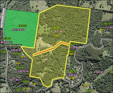
Image 1
The owner contacted Council
requesting information regarding encroachments on Council road reserve which as
can be seen in Image 2, runs through their property. The owner
wants to place their property on the market for sale and in doing so wants to
rectify the encroachments by applying to close and purchase the road
reserve. Image 2 gives an indication of the encroachments the owner
is referring to.
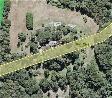
Image
2
As this road reserve does not adjoin any Council
infrastructure and isn’t utilised by the public it would be a financial
gain to Council to have the road reserve closed and sold to the adjoining land
owner.
Road Closure Application
An
application was received from the owner of Lot 5 DP 714077 (Attachment 2 –
E2019/84340), in August 2019, requesting the closure and purchase of
part of Council road reserve, highlighted in red, Image 1 above.
Staff
accepted the application as per the New Process for Road Closures and the Roads
Act 1993 Part 4 Closing of public roads, Division 3 Closing of council
public roads by councils 38A, when council may close council public road.
The
closure was advertised in the Byron Echo on 19 September 2019.
Letters were sent out to all adjoining land owners, Crown Lands and all
Notifiable Authorities as per the Roads Act 1993.
A 28 day submission period was
given with no submissions of objection by authorities, adjoining land owners or
members of the public received. Attachment 1 E2019/84334 shows all
submissions received.
Attachment 2 E2019/84334
also includes Crown Lands response vesting the land to Council upon closure.
STRATEGIC CONSIDERATIONS
Community Strategic Plan and
Operational Plan
|
CSP Objective
|
L2
|
CSP Strategy
|
L3
|
DP Action
|
L4
|
OP Activity
|
|
Community
Objective 1: We have infrastructure, transport and services which meet
our expectations
|
1.1
|
Provide a road
network which is safe, accessible and maintained to an acceptable level of
service
|
1.1.1
|
Deliver road
and drainage maintenance services in line with Community Solutions Panel
values (SP)
|
1.1.1.2
|
Implement
ongoing road planned maintenance programs
|
|
|
|
|
|
|
|
|
|
|
|
|
|
|
|
|
Legal/Statutory/Policy Considerations
Roads Act 1993
Part 4 Closing of public roads
Division 3 Closing of council public roads by councils
38A When council may close council public road
A
council may propose the closure of a council public road for which it is the
roads authority if:
(a) the road is not reasonably required as a road for
public use (whether for present or future needs), and
(b) the road is not required to provide continuity for
an existing road network, and
(c) if the road provides a means of vehicular access
to particular land, another public road provide lawful and reasonably
practicable vehicular access to that land.
38B Notification of proposal to close council public
road
(1) A council that is proposing to close a council
public road must cause notice of the proposal:
(a) to be published in a local newspaper, and
(b) to be given to:
(i) all owners of land adjoining the road, and
(ii) all notifiable authorities, and
(iii) any other person (or class of person) prescribed
by the regulations.
(2) The notice:
(a) must identify the road that is proposed to be
closed, and
(b) must state that any person is entitled to make
submissions to the council with respect to the closing of the road, and
(c) must indicate the manner in which, and the period
(being at least 28 days) within which, any such submission should be made.
38C Public submissions and formal objections
(1) Any person may make submissions to the council
with respect to the closing of the road in the manner and within the period
specified in the notice published under section 38B.
(2) Without limiting subsection (1), a notifiable
authority in relation to the road may include a
statement in the authority’s submission to the
effect that the authority formally objects to the
closing of the road. The authority may withdraw the
objection any time by written notice given
to the council.
Note.
If
a formal objection is made, section 38D (2) provides that the road may not be
closed until the
objection
is withdrawn by the authority or set aside by the Land and Environment Court
under this section.
(3) The council may appeal to the Land and Environment
Court against a formal objection made by a notifiable authority against the
closing of the road.
(4) On any such appeal, the Land and Environment Court
may:
(a) affirm the objection, or
(b) set aside the objection.
(5) In deciding whether to affirm or set aside the
objection, the Land and Environment Court must have regard to the public
interest.
38D Decision of proposal
(1) After considering any submissions that have been
duly made with respect to the proposal, the
council may, by notice published in the Gazette, close
the public road concerned.
(2) However, a council public road may not be closed:
(a) in the case of a classified road—unless RMS
consents to the closure of the road, or
(b) in the case where a notifiable authority has
formally objected under section 38C to the
closing of the road—until the objection is
withdrawn by the authority or set aside by the
Land and Environment Court under that section.
38E Effect of notice of closure
(1) On publication of the notice closing the council
public road concerned:
(a) the road ceases to be a public road, and
(b) the rights of passage and access that previously
existed in relation to the road are
extinguished.
(2) The land comprising a former road:
(a) in the case of a public road that was previously
vested in a council (other than a public road in respect of which no
construction has ever taken place)—remains vested in the council, and
(b) in any other case—becomes (or, if previously
vested in the Crown, remains) vested in the Crown as Crown land.
38F Appeals to Land and Environment Court against closure decision
(1) A person referred to in section 38B (1) (b) may
appeal to the Land and Environment Court against the closure of a council
public road by a council.
(2) On any such appeal, the Land and Environment Court
may:
(a) affirm the closure, or
(b) set aside the closure.
(3) Section 38E is taken never to have applied to a
closure that is set aside.
(4) To avoid doubt, an appeal under section 38C does
not prevent an appeal under this section.
SECT 43 Disposal of land comprising former public road
owned by council
(1) This section applies to land vested in a council
and forming part of a former public road.
(2) Land to which this section applies is operational
land for the purposes of the Local Government Act 1993 unless, before the land
becomes vested in the council, the council resolves that it is to be community
land, in which case the land is community land.
(3) If the land is disposed of by sale, the proceeds
of sale (less the costs of the sale) are to be paid to the council.
(4) Money received by a council from the proceeds of
sale of the land is not to be used by the council except for acquiring land for
public roads or for carrying out road work on public roads.
Financial Considerations
All costs associated with the road closure are borne by the
applicant.
As
per Roads Act 1993 legislation above the money received by council from
the proceeds of sale of this land is not to be used by the council except for
acquiring land for public roads or for carrying out road work on public roads.
Consultation and Engagement
As
per the Roads Act 1993 requirements, the necessary notices and submissions
period was undertaken and no objections were received.
Staff Reports - Infrastructure Services 13.32
Report No. 13.32 Part
Road Closure and purchase Robert Street Bangalow adjoining 5 Deacon Street Lot
7 Section 10 DP 4974 and Lot 1 DP 122670
Directorate: Infrastructure
Services
Report
Author: Deanna
Savage, Roads and Property Officer
File No: I2019/1864
Summary:
This report is being presented to Council to endorse the
closure of Part Council road reserve adjoining 5 Deacon Street (Lot 7 Section
10 DP 4974 and Lot 1 DP 122670) highlighted in blue Image 1.
The road will vest in Council upon closure and it is
proposed to sell the land to the adjoining land owner of Lot 7 Section 10 DP
4974 and Lot 1 DP 122670
|
RECOMMENDATION:
1. That
Council endorse the closure of part road reserve adjoining 5 Deacon
Street (Lot 7 Section 10 DP 4974 and Lot 1 DP 122670) as per Image 1
highlighted in blue.
2. That
Council ascertain market value by retaining a suitably qualified Valuer and
delegate to the General Manager the authority to enter into a contract for
sale of the closed part of the road with the owner of adjoining Lot 7 Section
10 DP 4974 and Lot 1 DP 122670 at a value no less than the value placed on
the part closed road by the independent Valuer.
3. That
the applicant pay all remaining costs associated with the part road closure,
including but not limited to:
a) Council
application fees
b) Council’s
surveyor's fees and survey, valuation and legal costs
c) All
registration fees
d) Legal
costs
4. The
allotment created by the part road closure to be consolidated into the
existing Parcel No’s 19260 Lot 7 Section 10 DP 4974 and 148090 Lot 1 DP
122670.
5. That
Council authorise the execution of all documents necessary to affect the road
closure, sale, transfer and consolidation of the part closed road.
|
Attachments:
1 Submissions
for part road reserve closure and sale 5 Deacon street Bangalow Lot 7 Sec 10 DP
4974 and Lot 1 DP 122670, E2019/84682
REPORT
Following the identification of an encroachment of a carport
a request was by the owner of Lot 7 Section 10 DP 4974 to either lease the road
reserve the encroachment was on or potentially close this part and purchase the
land to deal with an encroachment of a carport .
At the time staff determined that the carport encroachment
needed to be removed, (which has now been fully removed) and an order was
issued by compliance for the demolition of the bathroom encroachment.
Following the above the owner of Lot 7 Section 10 DP 4974
made contact with Councillor Hunter and a Notice of Motion was lodged at the 18
April 2019 Council meeting. The outcome of this meeting was resolution 19-174.
Resolution Number 19-174
Resolved
that Council agree to a
boundary adjustment of 1.5 meters for the southern boundary of Lot 7 section 10
DP 4974 at 5 Deacon Street, Bangalow to regularise a building encroachment in a
heritage area of Bangalow.
The motion was put to the vote and declared carried.
Road closure application
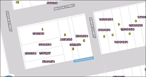
Image 1
In
accordance with Council Resolution 19-174 part road closure (section of closure
highlighted in blue Image 1) was commenced as per the New Process
for Road Closures and the Roads Act 1993 Part 4 Closing of public roads,
Division 3 Closing of council public roads by councils 38A, when council may
close council public road.
The
closure was advertised in the Byron Echo on 19 September 2019.
Letters were sent out to all adjoining land owners, Crown Lands and all
Notifiable Authorities as per the Roads Act 1993.
A 28 day submission period was
given with no submissions of objection by authorities, adjoining land owners or
members of the public received. Attachment 1 E2019/84682 shows all
submissions received.
STRATEGIC CONSIDERATIONS
Community Strategic Plan and Operational Plan
|
CSP Objective
|
L2
|
CSP Strategy
|
L3
|
DP Action
|
L4
|
OP Activity
|
|
Community Objective 1: We have infrastructure,
transport and services which meet our expectations
|
1.1
|
Provide a road network which is safe, accessible and
maintained to an acceptable level of service
|
1.1.1
|
Deliver road and drainage maintenance services in line
with Community Solutions Panel values (SP)
|
1.1.1.2
|
Implement ongoing road planned maintenance programs
|
|
|
|
|
|
|
|
|
|
|
|
|
|
|
|
Legal/Statutory/Policy Considerations
Roads
Act 1993
Part
4 Closing of public roads
Division
3 Closing of council public roads by councils
38A When council may close council public road
A
council may propose the closure of a council public road for which it is the
roads authority if:
(a) the road is not reasonably required as a road for
public use (whether for present or future needs), and
(b) the road is not required to provide continuity for
an existing road network, and
(c) if the road provides a means of vehicular access
to particular land, another public road provide lawful and reasonably
practicable vehicular access to that land.
38B Notification of proposal to close council public
road
(1) A council that is proposing to close a council
public road must cause notice of the proposal:
(a) to be published in a local newspaper, and
(b) to be given to:
(i) all owners of land adjoining the road, and
(ii) all notifiable authorities, and
(iii) any other person (or class of person) prescribed
by the regulations.
(2) The notice:
(a) must identify the road that is proposed to be
closed, and
(b) must state that any person is entitled to make
submissions to the council with respect to the closing of the road, and
(c) must indicate the manner in which, and the period
(being at least 28 days) within which, any such submission should be made.
38C Public submissions and formal objections
(1) Any person may make submissions to the council
with respect to the closing of the road in the manner and within the period
specified in the notice published under section 38B.
(2) Without limiting subsection (1), a notifiable
authority in relation to the road may include a
statement in the authority’s submission to the
effect that the authority formally objects to the
closing of the road. The authority may withdraw the
objection any time by written notice given
to the council.
Note.
If
a formal objection is made, section 38D (2) provides that the road may not be
closed until the
objection
is withdrawn by the authority or set aside by the Land and Environment Court
under this section.
(3) The council may appeal to the Land and Environment
Court against a formal objection made by a notifiable authority against the
closing of the road.
(4) On any such appeal, the Land and Environment Court
may:
(a) affirm the objection, or
(b) set aside the objection.
(5) In deciding whether to affirm or set aside the
objection, the Land and Environment Court must have regard to the public
interest.
38D Decision of proposal
(1) After considering any submissions that have been
duly made with respect to the proposal, the
council may, by notice published in the Gazette, close
the public road concerned.
(2) However, a council public road may not be closed:
(a) in the case of a classified road—unless RMS
consents to the closure of the road, or
(b) in the case where a notifiable authority has
formally objected under section 38C to the
closing of the road—until the objection is
withdrawn by the authority or set aside by the
Land and Environment Court under that section.
38E Effect of notice of closure
(1) On publication of the notice closing the council
public road concerned:
(a) the road ceases to be a public road, and
(b) the rights of passage and access that previously
existed in relation to the road are
extinguished.
(2) The land comprising a former road:
(a) in the case of a public road that was previously
vested in a council (other than a public road in respect of which no
construction has ever taken place)—remains vested in the council, and
(b) in any other case—becomes (or, if previously
vested in the Crown, remains) vested in the Crown as Crown land.
38F Appeals to Land and Environment Court against closure decision
(1) A person referred to in section 38B (1) (b) may
appeal to the Land and Environment Court against the closure of a council
public road by a council.
(2) On any such appeal, the Land and Environment Court
may:
(a) affirm the closure, or
(b) set aside the closure.
(3) Section 38E is taken never to have applied to a
closure that is set aside.
(4) To avoid doubt, an appeal under section 38C does
not prevent an appeal under this section.
SECT 43 Disposal of land comprising former public road
owned by council
(1) This section applies to land vested in a council
and forming part of a former public road.
(2) Land to which this section applies is operational
land for the purposes of the Local Government Act 1993 unless, before the land
becomes vested in the council, the council resolves that it is to be community
land, in which case the land is community land.
(3) If the land is disposed of by sale, the proceeds
of sale (less the costs of the sale) are to be paid to the council.
(4) Money received by a council from the proceeds of
sale of the land is not to be used by the council except for acquiring land for
public roads or for carrying out road work on public roads.
Financial Considerations
The 2019/2020 Budget has provision for $4,000 (GL account
4680.008) for this road closure that was carried over from the 2018/2019
financial year representing the unexpended portion of the budget originally
allocated by Council via a Notice of Motion in April 2019.
All further costs associated with the road closure are borne
by the applicant.
As
per Roads Act 1993 legislation above the money received by council from
the proceeds of sale of this land is not to be used by the council except for
acquiring land for public roads or for carrying out road work on public roads.
Consultation and Engagement
As
per the Roads Act 1993 requirements, the necessary notices and submissions
period was undertaken and no objections were received.
Staff Reports - Infrastructure Services 13.33
Report No. 13.33 Road
Reserve Closure and Purchase 149 Federal Drive Eureka Lot 22 DP 1014053
Directorate: Infrastructure
Services
Report
Author: Deanna
Savage, Roads and Property Officer
File No: I2019/1893
Summary:
This report is being presented to Council to endorse the
closure of Council road reserve, namely Whian Creek Road surrounded by 149
Federal Drive Eureka( Lot 22 DP 1014053) highlighted in red Image 1.
Crown Lands determined the road/land will vest in Council
upon closure. It is proposed to sell the land to the adjoining land owner of
Lot 22 DP 1014053. Land size is approximately 14,570m2.
|
RECOMMENDATION:
1. That
Council endorse the closure of part road reserve surrounded by Lot 22
DP 1014053, as per Image 1 of this report.
2. That
Council ascertain market value by retaining a suitably qualified Valuer and
delegate to the General Manager the authority to enter into a contract for
sale of the closed part of the road with the owner of adjoining Lot 22 DP
1014053 at a value no less than the value placed on the part closed road by
the independent Valuer.
3. That
the applicant pay all costs associated with the part road closure, including
but not limited to:
a) Council
application fees
b) Council’s
surveyor's fees and survey, valuation and legal costs
c) All
registration fees
d) Legal
costs
4. The
allotment created by the part road closure to be consolidated into the
existing Parcel No 231770 Lot 22 DP 1014053.
5. That
Council authorise the execution of all documents necessary to affect the road
closure, sale, transfer and consolidation of the part closed road.
|
Attachments:
1 Emails and
application fee for road closure application 149 Federal Drive Eureka Lot 22 DP
1014053, E2019/84490
2 Submissions
for road closure Whian Creek Road 149 Federal Drive Eureka Lot 22 DP 1014053, E2019/84467
REPORT
This closure has been instigated by Rob Doolan Balanced
Systems Planning Consultants on behalf of his client owners of Lot 22 DP
1014053. As part of DA 10.2018.137.1 approved Consent Conditions,
condition 7 states:
Road
closure application
A permanent
road closure application under the provisions of the Roads Act 1993 for the
existing paper road identified as Whian Creek Road must be submitted to the
relevant road authority.
Section to be
closed viewed on Image 1 highlighted in red.
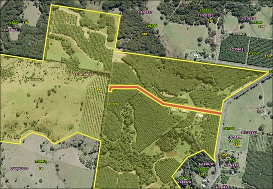
Image 1
Road closure application
An
application was received from Balanced Systems Planning Consultants Rob Doolan
(Attachment 1 – E2019/84490), on behalf of the owner of Lot 22 DP
1014053 in August 2019, requesting the closure and purchase of part of
Council road reserve, highlighted in red, Image 1 above as part of
conditions of consent DA 10.2018.137.1.
Staff
accepted the application as per the New Process for Road Closures and the Roads
Act 1993 Part 4 Closing of public roads, Division 3 Closing of council
public roads by councils 38A, when council may close council public road.
The
closure was advertised in the Byron Echo on 19 September 2019.
Letters were sent out to all adjoining land owners, Crown Lands and all
Notifiable Authorities as per the Roads Act 1993.
A 28 day submission period was
given with no submissions of objection by authorities, adjoining land owners or
members of the public received. Attachment 2 E2019/84467 shows all
submissions received.
STRATEGIC CONSIDERATIONS
Community Strategic Plan and Operational Plan
|
CSP Objective
|
L2
|
CSP Strategy
|
L3
|
DP Action
|
L4
|
OP Activity
|
|
Community Objective 1: We have infrastructure,
transport and services which meet our expectations
|
1.1
|
Provide a road network which is safe, accessible and
maintained to an acceptable level of service
|
1.1.1
|
Deliver road and drainage maintenance services in line
with Community Solutions Panel values (SP)
|
1.1.1.2
|
Implement ongoing road planned maintenance programs
|
|
|
|
|
|
|
|
|
|
|
|
|
|
|
|
|
Legal/Statutory/Policy Considerations
Roads Act 1993
Part 4 Closing of public roads
Division 3 Closing of council public roads by councils
38A When council may close council public road
A
council may propose the closure of a council public road for which it is the
roads authority if:
(a) the road is not reasonably required as a road for
public use (whether for present or future needs), and
(b) the road is not required to provide continuity for
an existing road network, and
(c) if the road provides a means of vehicular access
to particular land, another public road provide lawful and reasonably
practicable vehicular access to that land.
38B Notification of proposal to close council public
road
(1) A council that is proposing to close a council
public road must cause notice of the proposal:
(a) to be published in a local newspaper, and
(b) to be given to:
(i) all owners of land adjoining the road, and
(ii) all notifiable authorities, and
(iii) any other person (or class of person) prescribed
by the regulations.
(2) The notice:
(a) must identify the road that is proposed to be
closed, and
(b) must state that any person is entitled to make
submissions to the council with respect to the closing of the road, and
(c) must indicate the manner in which, and the period
(being at least 28 days) within which, any such submission should be made.
38C Public submissions and formal objections
(1) Any person may make submissions to the council
with respect to the closing of the road in the manner and within the period
specified in the notice published under section 38B.
(2) Without limiting subsection (1), a notifiable
authority in relation to the road may include a
statement in the authority’s submission to the
effect that the authority formally objects to the
closing of the road. The authority may withdraw the
objection any time by written notice given
to the council.
Note.
If
a formal objection is made, section 38D (2) provides that the road may not be
closed until the
objection
is withdrawn by the authority or set aside by the Land and Environment Court
under this section.
(3) The council may appeal to the Land and Environment
Court against a formal objection made by a notifiable authority against the
closing of the road.
(4) On any such appeal, the Land and Environment Court
may:
(a) affirm the objection, or
(b) set aside the objection.
(5) In deciding whether to affirm or set aside the
objection, the Land and Environment Court must have regard to the public
interest.
38D Decision of proposal
(1) After considering any submissions that have been
duly made with respect to the proposal, the
council may, by notice published in the Gazette, close
the public road concerned.
(2) However, a council public road may not be closed:
(a) in the case of a classified road—unless RMS
consents to the closure of the road, or
(b) in the case where a notifiable authority has
formally objected under section 38C to the
closing of the road—until the objection is
withdrawn by the authority or set aside by the
Land and Environment Court under that section.
38E Effect of notice of closure
(1) On publication of the notice closing the council
public road concerned:
(a) the road ceases to be a public road, and
(b) the rights of passage and access that previously
existed in relation to the road are
extinguished.
(2) The land comprising a former road:
(a) in the case of a public road that was previously
vested in a council (other than a public road in respect of which no
construction has ever taken place)—remains vested in the council, and
(b) in any other case—becomes (or, if previously
vested in the Crown, remains) vested in the Crown as Crown land.
38F Appeals to Land and Environment Court against closure decision
(1) A person referred to in section 38B (1) (b) may
appeal to the Land and Environment Court against the closure of a council
public road by a council.
(2) On any such appeal, the Land and Environment Court
may:
(a) affirm the closure, or
(b) set aside the closure.
(3) Section 38E is taken never to have applied to a
closure that is set aside.
(4) To avoid doubt, an appeal under section 38C does
not prevent an appeal under this section.
SECT 43 Disposal of land comprising former public road
owned by council
(1) This section applies to land vested in a council
and forming part of a former public road.
(2) Land to which this section applies is operational
land for the purposes of the Local Government Act 1993 unless, before the land
becomes vested in the council, the council resolves that it is to be community
land, in which case the land is community land.
(3) If the land is disposed of by sale, the proceeds
of sale (less the costs of the sale) are to be paid to the council.
(4) Money received by a council from the proceeds of
sale of the land is not to be used by the council except for acquiring land for
public roads or for carrying out road work on public roads.
Financial Considerations
All costs associated with the road closure are borne by the
applicant.
As
per Roads Act 1993 legislation above the money received by council from
the proceeds of sale of this land is not to be used by the council except for
acquiring land for public roads or for carrying out road work on public roads.
Consultation and Engagement
As
per the Roads Act 1993 requirements, the necessary notices and submissions
period was undertaken and no objections were received.
Staff Reports - Infrastructure Services 13.34
Report No. 13.34 1
Broken Head Road Project
Directorate: Infrastructure
Services
Report
Author: Phil
Warner, Manager Assets and Major Projects
File No: I2019/1923
Summary:
In August 2019 Council considered a report on a Request for
Tender (RFT) for the 1 Broken Head Road Redevelopment. Council resolved:
Resolved 19-417:
1. That Council defer a
decision on whether to accept any of the tenders submitted for RFT 2019-0015
– 1 Broken Head Road Redevelopment.
2. That a Councillor
workshop be convened to consider the tenders submitted for RFT 2019- 0015
– 1 Broken Head Road Redevelopment.
In accordance with point 2, Council considered the matter at
a Strategic Planning Workshop on 18 November 2019.
The purpose of this report is to again present to Council the matter
for decision.
|
RECOMMENDATION:
1. That
Council decline to accept any of the tenders submitted for RFT 2019-0015
– 1 Broken Head Road Redevelopment.
2. That
Council, in accordance with s178 part 3(a) under Local Government Regulation
2005, cancel the proposal for the contract.
|
Attachments:
1 Confidential
- Redevelopment Tender Evaluation Report CONFIDENTIAL FINAL DRAFT, E2019/57134
Report
In August 2019 Council considered a report on a Request for
Tender (RFT) for the 1 Broken Head Road Redevelopment. Council resolved:
Resolved 19-417:
3. That Council defer a decision on whether to
accept any of the tenders submitted for RFT 2019-0015 – 1 Broken Head
Road Redevelopment.
4. That a Councillor workshop be convened to
consider the tenders submitted for RFT 2019- 0015 – 1 Broken Head Road
Redevelopment.
In accordance with point 2, Council considered the matter at
a Strategic Planning Workshop on 18 November 2019.
The purpose of this report is to again present to Council the matter
for decision.
In March 2018, Council undertook
an Expression of Interest (EOI) process inviting submissions from capable and
experienced organisations regarding the future use of the former South Byron
STP site (1 Broken Head Road). The EOI process allowed Council to gauge
the level of preliminary interest in the development of the site and to develop
a short-list of tenderers for a further selective procurement process.
The following organisations were shortlisted:
• The
Village Retirement Group
• Archiblox
and Byron Bay Eco Lodges
• The
Living School
• National
Affordable Housing Consortium.
Byron Shire Council issued a
Request for Tender (RFT) for the 1 Broken Head Road Redevelopment opening 8
March 2019 and closing on 17 May 2019. The RFT was issued to the above
four shortlisted organisations.
An Evaluation Panel comprising of five Council staff members
was formed.
Tenders were received from the following proponents:
· Archiblox
and Byron Bay Eco Lodges
· The
Living School
· National
Affordable Housing Consortium.
The Village Retirement Group officially withdrew from the
procurement process on 15 May 2019.
An initial compliance check was conducted by the Evaluation
Panel to identify submissions that did not comply with the requirements of the
RFT.
The Compliance Criteria are:
• Tender
lodged on time, in accordance with the Conditions of Tender
• Respondent
has a valid Australian Business Number
• Respondent
substantially complies with the stated requirements
• Respondent
substantially complies with the draft lease
• Commitment
to ethical business practice principles
• Tenderer
confirms no ties to Adani.
During the initial compliance check, the evaluation panel
identified that all respondents did not comply with the compliance
criteria. This outcome was checked with the probity advisor
O’Connor Marsden.
The Evaluation Panel chose to continue and the tenders were
evaluated in accordance with the following evaluation criteria:
|
Criteria
|
Description
|
Weighting
|
|
Financial Return
|
Financial viability of the
Tender and financial benefit to Council. Elements which will be considered
include:
· Financial
return to Council; and
· Structure
of financial return.
|
30%
|
|
Vision, concept design,
delivery approach and operation
|
Tender alignment with
Council’s Community Strategic Plan and vision for the Site, including:
· Concept
design;
· Delivery
approach;
· Development
staging and program; and
· Management
and long term operation.
|
25%
|
|
Economic and social
benefits
|
Tender performance in the
delivery of economic and social benefits for the immediate and broader Byron
Shire Community.
Elements which will be
considered include:
· Social
benefits
· Environmental
benefits
· Economic
benefits.
|
20%
|
|
Financial capacity
|
Demonstrated financial
capacity (including financial resources) indicating clear ability to fund, to
manage and deliver a development of the size, character and complexity of the
Project.
Elements which will be
considered include:
· Financial
status of the Tenderer; and
· Structure
of financial arrangements including the source and adequacy of the Tenderer's
funding.
|
10%
|
|
Experience and capability
|
Demonstrated capability to
plan, deliver and operate a development of the size, character and complexity
of the Project.
Elements which will be
considered include:
· Demonstrated
understanding of the applicable planning approval pathway;
· Proposed
community engagement through all phase of the Project:
· Team
composition;
· Experience
in successfully delivering and operating similar projects; and
· Capability
and resources.
|
10%
|
|
Risk Management
|
Degree of demonstration of the
Tenderer’s understanding of the proposed risk allocation and the Tenderer’s
approach to managing and mitigating the risks the Tenderer proposes to
accept.
|
5%
|
Each of the criteria was scored out of ten according to the
following rating scale:
|
Score
|
Rating
|
|
10
|
Outstanding - Requirements are exceeded in
most key areas & addressed to a very high standard in others. All
claims are fully substantiated. The solution is sound and represents
very low risk.
|
|
8
|
Very Good - Requirements have been exceeded in some
key areas. Most claims are fully substantiated. The solution is sound
and represents low risk.
|
|
6
|
Acceptable - Requirements have been met to a
satisfactory standard.
|
|
4
|
Passable - Requirements have been met but to a very
low standard. The solution is passable but some major shortcomings or
deficiencies could make the solution unworkable. The solution is of
high to medium risk.
|
|
2
|
Marginal - Requirements have not been fully
met or have been inadequately dealt with in most or all areas. The
business solution is unclear. Clarification may rectify the
understanding of the solution. The solution is of high risk.
|
|
0
|
Non-Compliant - The offer completely failed
to respond to the criteria
|
The results of the evaluation are detailed in the attached
confidential tender evaluation report.
In summary, all tenders resulted in comparatively low
scores.
As reflected in the low scores, none of the responses
significantly meet Council’s strategic objectives for the redevelopment
of the site. Economic and social benefits are at most marginal and
targeted at small segments of the broader Byron community. Financial
return over 25 year could not be consistently assessed. This was an
important criteria for Council as a financial return to the Sewer Fund could
variously repay loans, lower service pricing or potentially support environmental
outcomes aligned with sewer operations.
Key issues
Site Remediation
A detailed update of the progress of remediation was
provided to Councillors at the 18 November Strategic Planning Workshop.
In summary, a tender will be issued in early 2020 for the
works associated with relocating and capping the remaining contaminated
material on site by creating an L–shaped berm along the western and
southern edges of the property.
The project team has consulted with key stakeholders
extensively throughout the project history. Their feedback in conjunction with
the results of contamination investigations has informed the outcome of the
remediation option. It should be noted that early in the project key stakeholders
Arakwal Corporation, the NPWS and DPI had positive feedback to the remediation
project. More recently, both the Arakwal and NPWS in particular expressed a
desire to:
- Have
the site complement or integrate with the adjacent Arakwal National Park;
- Have
all contaminated material removed from site. They viewed the berm
solution as an interim or incomplete solution. The Arakwal did concede
that the berm solution would be acceptable to them only if Council committed to
revisiting the removal of all contaminated material at the end of the proposed
25 year property lease; and
- Have
more consultation with Council particularly with regards to the redevelopment
of the site as stated in the MOU with Council.
Due to the procurement and probity requirements of the site
redevelopment EOI/Tender process, no stakeholder was able to be consulted with
in detail. However, if redevelopment proceeds it will be a requirement
for Council and the proponent to consult thoroughly with key stakeholders
particularly the Arakwal Corporation.
Existing sewage treatment ponds
The redevelopment tender proponents have all expressed the
desire for Council to maintain control of the two sewage treatment ponds.
At the conclusion of remediation works the ponds will remain in-situ and
unmodified. As the ponds are currently used, and are valued by the
community as an environmental area with no human contact (primary or
secondary), they are currently deemed suitable for that purpose provided they
are not disturbed. The selected remediation option allows both sewage
treatment ponds to remain ‘as is’ for environmental purposes
however this comes with access and sediment contact risks:
- Access:
The ponds are designed as sewage infrastructure and have steep embankments
around the perimeter. Should a member of the public access or fall into the
water exiting the ponds could prove difficult. To mitigate this risk, Council
could fully fence the ponds which will come at a cost to amenity (e.g.
proximity for bird watching), aesthetics and operational finances. Council
could alternatively reshape the ponds which would require disturbance of
sediments and possible remediation;
- Sediment
Contact: Whilst the water contained within the ponds is not contaminated (it is
effectively stormwater), heavy metals and other persistent contaminants
associated with STP operations may be present in the sediments of the
ponds. The sediments do not pose a hazard in their current undisturbed
state within the ponds and the environmental consultant has confirmed that
should sediments remain in-situ contaminants will not migrate. Contact
with such sediments should be avoided by people for both human health and the
need to avoid sediment disturbance. Council could choose to remediate the
ponds and this would require contaminant investigations, a remediation action
plan, validation activities and works on the ponds. Such works would
likely require dewatering and possible removal of sediments (if reshaping the
ponds) or, at minimum, capping of sediments. Secondary contact activities
(kayaking etc) in the ponds in the current state are not advisable due to the
need to monitor and police such activities to prevent primary contact and
access to sediments.
As considered at the 18 November 2019 SPW, the accessibility
and safety of the sewage ponds should be a factor in all deliberations
pertaining to the future use of the site.
Next steps
The recommendation of the Evaluation Panel is to decline to
accept any of the tenders.
It is possible that the elected council, having declined to
accept any of the tenders, may wish to amongst a range of options:
1) continue
to work with one of the tenders in developing their proposal for the
site. In such circumstances the staff recommendation could be changed to
specify a Tenderer to move forward with the next phase of community engagement
to test support for the proposal. This process would shape the details of
the proposal with a view to reaching an agreement with council.
2) commence
a new master planning process. In such circumstances the staff
recommendation could be changed to direct a new planning process and specify
key issues for consideration.
3) pause
action on the future use of the site whilst the remediation of the site is
completed.
Community Strategic Plan and
Operational Plan
|
CSP Objective
|
L2
|
CSP Strategy
|
L3
|
DP Action
|
L4
|
OP Activity
|
|
Community
Objective 1: We have infrastructure, transport and services which meet
our expectations
|
1.5
|
Provide
continuous urban water and sewerage services within the Shire
|
1.5.2
|
Ensure
Wastewater Treatment Plants are maintained in accordance with operating
licences
|
1.5.2.7
|
South Byron
Sewerage Treatment Plant future use options
|
|
|
|
|
|
|
|
|
|
|
|
|
Financial Implications
The 2019/20 Sewer Fund capital program includes funding to
progress the future use of the remediated South Byron STP site.
Statutory and Policy Compliance Implications
The tendering process has been undertaken in accordance with
Council’s Purchasing and Procurement Policy, and the provisions of the Local
Government (General) Regulation 2005.
The Local Government (General) Regulations 2005 define the
options available to Council. An extract is provided below.
Local
Government (General) Regulation 2005 - Reg 178
Acceptance
of tenders
178 Acceptance
of tenders
(1) After
considering the tenders submitted for a proposed contract, the council must
either:
(a) accept the
tender that, having regard to all the circumstances, appears to it to be the
most advantageous, or
(b) decline to
accept any of the tenders.
(2) A council
must ensure that every contract it enters into as a result of a tender accepted
by the council is with the successful tenderer and in accordance with the
tender (modified by any variation under clause 176). However, if the successful
tender was made by the council (as provided for in section
55 (2A) of the Act),
the council is not required to enter into any contract in order to carry out
the requirements of the proposed contract.
(3) A council
that decides not to accept any of the tenders for a proposed contract or
receives no tenders for the proposed contract must, by resolution, do one of
the following:
(a) postpone
or cancel the proposal for the contract,
(b) invite, in
accordance with clause 167, 168 or 169, fresh tenders based on the same or
different details,
(c) invite, in
accordance with clause 168, fresh applications from persons interested in
tendering for the proposed contract,
(d) invite, in
accordance with clause 169, fresh applications from persons interested in
tendering for contracts of the same kind as the proposed contract,
(e) enter
into negotiations with any person (whether or not the person was a tenderer)
with a view to entering into a contract in relation to the subject matter of
the tender,
(f) carry
out the requirements of the proposed contract itself.
(4) If a
council resolves to enter into negotiations as referred to in subclause (3)
(e), the resolution must state the following:
(a) the
council’s reasons for declining to invite fresh tenders or applications
as referred to in subclause (3) (b)–(d),
(b) the
council’s reasons for determining to enter into negotiations with the
person or persons referred to in subclause (3) (e).
Council’s endorsement of the recommendation to not
award the tender, as recommended in the attached Evaluation Report, is sought.
Staff Reports - Infrastructure Services 13.35
Report No. 13.35 Bangalow
Christmas Eve Carnival
Directorate: Infrastructure
Services
Report
Author: Andrew
Pearce, Traffic Engineer
File No: I2019/1968
Summary:
The purpose of this report is to gain Council’s
support for the Bangalow Christmas Eve Carnival, subject to Local Traffic
Committee recommendations.
|
RECOMMENDATION:
1.
That Council support the Bangalow Christmas
Eve Carnival 2019 to be held Tuesday 24 December 2019, that includes the
temporary road closure of Byron Street, Bangalow between Ashton Street and
Granuaille, between 3:30pm and 10:00pm.
2.
That the approval provided in Part 1 is
subject to any Local Traffic Committee recommendations.
|
REPORT
The following information is cut and paste from the relevant
LTC report used to obtain LTC recommendations.
The Bangalow Christmas Eve Carnival is an annual community
event with performers, food vendors and carnival rides. It is anticipated
that there will be approximately 2,000 attendees.
It is proposed that Byron Street will be closed between
3:30pm and 10:00pm on Tuesday 24 December 2019. There will be detours in
place to allow traffic to continue to flow. Traffic will be directed
through Deacon Street, which will facilitate two-way traffic flow. These
measures are identical to traffic control measures adopted in 2018.
Parking will be available at the Bangalow Showgrounds, which
will allow pedestrians to have access to the carnival without the need to cross
a trafficable road.
It is requested that Council endorse the event, subject to
Local Traffic Committee recommendations. It is noted the following
recommendations were stated in the 2018 LTC report and are again recommended
within the 2019 LTC report.
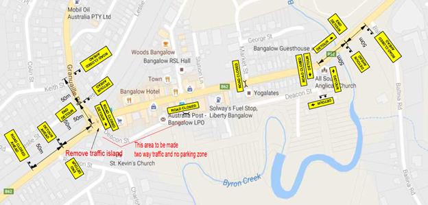
General LTC recommendations:
a) separate
approvals by NSW Police and RMS being obtained, noting that the traffic control
plan is partially located on a state road;
b) implementation
of the approved Traffic Management Plan and Traffic Control Plan, including the
use of signed detours, as designed and implemented by those with appropriate
accreditation;
c) that
the impact of the event be advertised via a notice in the local weekly paper a
minimum of one week prior to the operational impacts taking effect, noting it
must include the event name, specifics of any traffic impacts or road closures
and times, alternative route arrangements, event organiser, a personal contact
name and a telephone number for all event related enquiries or complaints;
d) the
event be notified on Council’s webpage;
e) the
event organiser:
i) undertake
consultation with community and affected businesses including adequate
response/action to any raised concerns;
ii) undertake
consultation with emergency services and address any identified issues;
iii) holding
$20m public liability insurance cover which is valid for the event;
iv) paying
Council’s Road Event Application Fee prior to the event.
Key issues
STRATEGIC CONSIDERATIONS
Community Strategic Plan and
Operational Plan
|
CSP Objective
|
L2
|
CSP Strategy
|
L3
|
DP Action
|
L4
|
OP Activity
|
|
Community
Objective 1: We have infrastructure, transport and services which meet
our expectations
|
1.6
|
Manage traffic
and parking in an efficient manner
|
1.6.4
|
Improve
effectiveness of Local Traffic Committee
|
1.6.4.1
|
Continued
reporting of traffic matters through the Local Traffic Committee
|
|
|
|
|
|
|
|
|
|
|
|
|
|
|
|
|
Consultation and Engagement
A condition of the endorsement of this event is that
appropriate consultation is undertaken, including:
· Advertising
the impact of the event in the local newspaper and on the Council website.
· Informing
community and business that are directly impacted.
· Liaising
with bus and taxi operators.
· Consulting
with emergency services.
Staff Reports - Infrastructure Services 13.36
Report No. 13.36 Minor
changes to car parking signage in vicinity of Byron Youth Activity Centre
Sandhills Reserve
Directorate: Infrastructure
Services
Report
Author: Andrew
Pearce, Traffic Engineer
File No: I2019/1969
Summary:
The purpose of this report is to gain Council’s
support for minor changes to the regulation of car parking in the vicinity of
the Byron Youth Activity Centre at the Sandhills Reserve, subject to Local Traffic
Committee ( LTC) recommendations.
|
RECOMMENDATION:
That Council support minor changes to car parking
signage in the vicinity of Byron Youth Activity Centre, Sandhills Estate, as
per recommendations from the Local Traffic Committee meeting on 6 December 2019,
and the approval from Crown Lands.
|
REPORT
Council has been working with the Byron Youth Activity
Centre (YAC), Department of Planning Industry and Environment – Crown
Lands and local Police in response to a number of public safety concerns
arising from the parking of vehicles inside the Sandhills Reserve.
The area shown below in Figure 1 is now persistently being
used for illegal ‘vanpacking’ and attracting a variety of
anti-social behaviours in close proximity to the YAC and the young people who
use that centre. Recently, the YAC has experienced a number of incidents
of vandalism and damage to their facility.
Visits by Council staff and compliance teams have confirm
the southern part of Gilmore Crescent, in particular, feels unsafe due to the
number cars and people and type of people parked in the vicinity immediately
adjacent to the YAC and is a risk factor for the youth attending the YAC.
As a result, Council staff would like to modify the existing
parking scheme within Gilmore Crescent as a step towards improving the culture
and safety of the area through enabling safer and easier parking management.
Additional works are expected to be required, such as installing bollards in
key locations. However, this is considered a second step and not a regulatory
matter to be included in this report.
Existing Parking Scheme
Figure 2 and 3 below shows the existing parking scheme that
was supported by LTC in 2016 (refer I2016/278) and adopted by Council. A
Restricted Parking Area was adopted over the car park area immediately to the
south of the Child Centre. The RPA incorporates the area covered by the Blue
Line and Green Line.
This Restricted Parking Area is anecdotally working well
with people generally obeying the signage. Sealed, line marked and angled
parking existing along the western side of Gilmore Crescent. No Parking and No
Parking between 1am-6am signs are installed along the eastern edge of Gilmore
Crescent and there is very sandy informal angled parking located at the south
eastern end of Gilmore Crescent.
Proposed Parking Scheme
Figure 4 below shows the proposed modifications to the
parking scheme in the vicinity of the YAC. These modifications will need to be
done with the concurrence of Crown Lands.
In summary, it is proposed to do the following:
· Expand the
Restricted Parking Area to include the car parking area adjacent to the YAC,
· Introduce a
No Parking Area 7pm-7am over the Restricted Parking Area,
· Introduce
Yellow No Stopping lines in key locations to prevent parking along the eastern
side of the road and the dead end,
· Introduce
Bollards at a future stage along the eastern edge to physically prevent parking
subject to funding and detail design. This part of the modifications is not a
regulatory matter and does not need to go through LTC. These works are just
shown to provide the whole project context.
Compliance
It is recognised the above proposed modifications can only
be effective subject to their enforcement. However, these changes are regarded
as a necessary first step towards improving the safety and culture of the area
and enabling Council officers and Police to regulate the area effectively.
It is anticipated that after the above changes are
implemented (excluding the bollards) Council Staff with Police may undertake a
short term blitz of the area for a couple weeks to remove the existing problem
and begin a new safer culture for the area.
Feedback provided to Council is that the parking regulation
that applies in the Sandhills Carpark is sufficient to encourage appropriate
car parking and discourage anti-social behaviours.
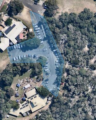
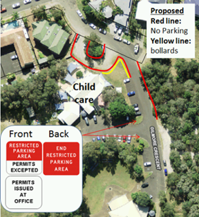
Figure 1 – Parking area
Gilmore Crescent under consideraton
|
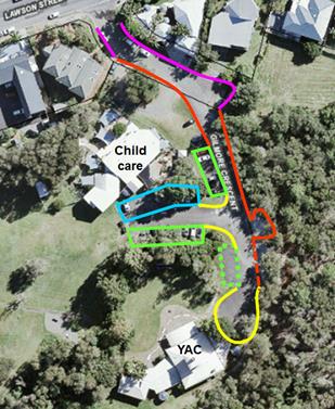
|
Pink line
Pay parking Mon-Sun 9am-6pm, at other times no changes to existing signage/regulation
Red solid line
No Parking (applies at all times)
Red dashed line
No Parking 1am – 6am
Yellow line
No Stopping to apply at all times unless currently signed otherwise,
e.g. permissive parking
Blue line
Existing Loading Zone removed; and
except mobility permit park (which remains unchanged), 15-minute time
limit apply Monday to Friday 8am-10am and 3pm-6pm and no time limit outside
these times except No Parking 1am-6am
Green solid line
No Parking - Mon-Fri 6am-6pm Permit Holders Excepted and No Parking
1am-6am
Green dashed line
No Parking - 6am-6pm Permit Holders Excepted and No Parking 1am-6am
|
Figure
2 – Existing parking scheme approved in 2016 (I2016/278)
|

Figure 3 – Approved
Restricted Parking Area.
|
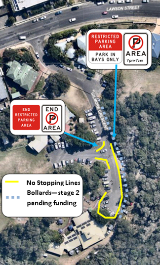
|
STRATEGIC CONSIDERATIONS
Community Strategic Plan and
Operational Plan
|
CSP Objective
|
L2
|
CSP Strategy
|
L3
|
DP Action
|
L4
|
OP Activity
|
|
Community
Objective 1: We have infrastructure, transport and services which meet
our expectations
|
1.6
|
Manage traffic
and parking in an efficient manner
|
1.6.4
|
Improve
effectiveness of Local Traffic Committee
|
1.6.4.1
|
Continued
reporting of traffic matters through the Local Traffic Committee
|
|
|
|
|
|
|
|
|
|
|
|
|
|
|
|
|
Financial Considerations
There will be usual costs associated with installation of
additional signage along the extension to Gilmore Crescent that will be
accommodated within existing budgets.
Consultation and Engagement
So far consultation has occurred with Byron Youth Service
and Crown Lands. Police will be consulted through the LTC process.
Reports of Committees - Corporate and Community Services 14.1
Reports of Committees - Corporate and Community
Services
Report No. 14.1 Report of the Audit, Risk and Improvement Committee Meeting held on 14 November 2019
Directorate: Corporate and Community Services
Report
Author: Heather
Sills, Corporate Governance Officer
File No: I2019/1907
Summary:
This report provides the minutes of the Audit, Risk and
Improvement Committee Meeting held on 14 November 2019 for adoption by
Council.
|
RECOMMENDATION:
1. That
Council notes the minutes of the Audit, Risk and Improvement Committee
Meeting held on 14 November 2019.
|
|
2. That Council
adopts the following Committee Recommendation(s):
Report No. 4.1 A New Risk Management and
Internal Audit Framework - Discussion Paper
File No:
I2019/1636
Committee Recommendation 4.1.1
That the Audit Risk
and Improvement Committee:
1. Considers
the discussion paper, “A New Risk Management and Internal Audit
Framework for Local Councils in NSW”
2. Makes
a submission to the Office of Local Government during the submission period
covering the considerations outlined in this report
3. Receives
a draft submission for comment prior to the submission being made to the
Office of Local Government.
|
|
3. That Council
adopts the following Committee Recommendation(s):
Report No. 4.2 2018/2019 Financial Statements
File No:
I2019/1843
Committee Recommendation 4.2.1
That the Audit, Risk and
Improvement Committee notes the report on the 2018/2019 Financial Statements
and the 2019 Audit Engagement Closing Report received from the NSW Audit
Office.
|
|
4. That Council
adopts the following Committee Recommendation(s):
Report No. 5.1 Update on IT Actions
File No:
I2019/1691
Committee Recommendation 5.1.1
That the Audit, Risk
and Improvement Committee notes the update provided in the report.
|
|
5. That Council
adopts the following Committee Recommendation(s):
Report No. 5.2 Audit Progress Report -
November 2019
File No:
I2019/1841
Committee Recommendation 5.2.1
1. That
the Audit, Risk and Improvement Committee notes the Internal Audit Activity
Report – November 2019 (E2019/81972).
2. That
the Audit, Risk and Improvement Committee endorses the recommendation from
the Executive Team to close off 12 outstanding recommendations in Appendix C
of the attached report (E2019/81972) due to these actions being confirmed as
complete.
|
|
6. That Council
adopts the following Committee Recommendation(s):
Report No. 5.3 Business Continuity and Risk
Management - Update
File No:
I2019/1853
Committee Recommendation 5.3.1
1. That
the Audit, Risk and Improvement Committee notes this Business Continuity
and Risk management update.
2. That
the Audit, Risk and Improvement Committee receives ongoing progress reports
on the status of the Business Continuity and Risk Management blueprint
|
|
7. That Council
adopts the following Committee Recommendation(s):
Report No. 5.4 Pay Parking Audit Review
File No:
I2019/1857
Committee Recommendation 5.4.1
1. That
the Audit, Risk and Improvement Committee notes the Pay Parking internal
audit review report.
2. That
the Audit, Risk and Improvement Committee requests management to implement
the recommendations made in the report identified as Confidential Attachment
1 (E2019/81748).
3. That
the report and Confidential Attachment 1 of the closed part of the meeting
remain confidential.
|
|
8. That Council
adopts the following Committee Recommendation(s):
Report No. 5.5 Grants Management Audit Review
File No:
I2019/1858
Committee Recommendation 5.5.1
1. That
the Audit, Risk and Improvement Committee notes the Grant Management internal
audit review report.
2. That
the Audit, Risk and Improvement Committee requests management to implement
the recommendations made in the report identified as Confidential Attachment
1 (E2019/81617).
3. That
the report and Confidential Attachment 1 of the closed part of the meeting
remain confidential.
|
Attachments:
1 Minutes
14/11/2019 Audit, Risk and Improvement Committee, I2019/1900
Report
The attachment to this report provides the minutes of the
Audit, Risk and Improvement Committee Meeting of 14 November 2019 for
determination by Council. The agenda for this meeting can be located on
Council’s website at:
https://byron.infocouncil.biz/Open/2019/11/ARIC_14112019_AGN_1097_AT.PDF
Report
No. 4.1 A New Risk Management and
Internal Audit Framework - Discussion Paper
The Local Government Act 1993 was amended in August
2016 to require each council and joint organisation in NSW to appoint an audit,
risk and improvement committee (ARIC).
The Office of Local Government (OLG) has now developed a
draft internal audit and risk management framework to support and inform the
operations of ARICs. It has issued a discussion paper, “A New Risk
Management and Internal Audit Framework for Local Councils in NSW”
which sets out the proposed framework in detail and a “snapshot”
guide that summarises its key elements. The OLG is seeking submissions on the
framework by 31 December 2019.
This report recommends that Council makes a submission to
the OLG outlining some of the considerations and implications for Council
should the OLG proceed with the proposed framework. The draft submission to the
OLG following feedback from ARIC is the subject of a separate report in this
agenda for Council’s endorsement.
Report
No. 4.2 2018/2019 Financial Statements
This report is on the external audit for the financial year
ended 30 June 2019. It covers the financial results for Council for the
2018/2019 financial year and the 2019 Audit Engagement Closing Report in
respect of the audit provided by the NSW Audit Office.
Report
No. 5.1 CONFIDENTIAL - Update on IT Actions
This report provides a summary of
all open actions with their current status and expected due dates for IT
Actions.
Report
No. 5.2 CONFIDENTIAL - Audit Progress Report - November 2019
This report presents the Internal Audit Outstanding Actions
Report – November 2019 prepared by Council and the Internal Auditor,
O’Connor Marsden and Associates (OCM).
The activity report contains the remaining outstanding
recommendations from each audit review conducted by Council’s previous
internal audit provider as well as recommendations from recently completed
audit reviews conducted by OCM.
Report
No. 5.3 CONFIDENTIAL - Business Continuity and Risk Management
– Update
The purpose of this report is to provide an update on the
Business Continuity and Risk Management frameworks.
Report
No. 5.4 CONFIDENTIAL - Pay Parking Audit Review
Council’s Internal Auditors, O’Connor Marsden
and Associates (OCM), conducted an internal audit review of Pay Parking during
October 2019. This audit received a review rating of ‘weak’ and it
identified one high and three medium risks. Management has agreed actions and a
timeframe to address these issues.
Report No. 5.5 CONFIDENTIAL - Grants Management Audit
Review
Council’s Internal
Auditors, O’Connor Marsden and Associates (OCM), conducted an internal
audit review of Grant Management during October 2019. This audit received a
review rating of ‘satisfactory’ and it identified two medium risks.
Management has agreed actions and a timeframe to address these issues.
Financial Implications
As per the Reports listed within the Audit, Risk and
Improvement Committee Meeting of 14 November 2019.
Statutory and Policy Compliance Implications
As per the Reports listed within the Audit, Risk and
Improvement Committee Meeting of 14 November 2019.
Reports of Committees - Corporate and Community Services 14.2
Report No. 14.2 Report of the Finance Advisory Committee Meeting held on 14 November 2019
Directorate: Corporate and Community Services
Report
Author: James
Brickley, Manager Finance
File No: I2019/1911
Summary:
This report provides the minutes and recommendations of the
Finance Advisory Committee Meeting held on 14 November 2019 for determination
by Council.
|
RECOMMENDATION:
1. That
Council notes the minutes of the Finance Advisory Committee Meeting held on
14 November 2019.
|
|
2. That Council
adopts the following Committee Recommendation(s):
Report No. 4.1 Unrestricted Cash and Reserves
at 30 June 2019
File No:
I2019/1767
Committee Recommendation 4.1.1
1. That
the Reserve Balances as outlined in Attachment 1 (#E2019/80264) at 30
June 2019 be noted by the Finance Advisory Committee.
2. That
the Unrestricted Cash Balance of $1,000,000 as at 30 June 2019 be noted by
the Finance Advisory Committee.
|
|
3. That Council
adopts the following Committee Recommendation(s):
Report No. 4.2 Quarterly Update -
Implementation of Special Rate Variation
File No:
I2019/1834
Committee Recommendation 4.2.1
That the Finance Advisory Committee
notes the quarterly update on the Special Rate Variation Implementation as at
30 September 2019.
|
|
4. That Council
adopts the following Committee Recommendation(s):
Report No. 4.3 Budget Review - 1 July 2019 to
30 September 2019
File No: I2019/1856
Committee Recommendation 4.3.1
That the Finance Advisory Committee recommends to
Council:
1. That
Council notes that the itemised budget variations as shown in Attachment 2
(#E2019/81261) which includes the following results in the 30 September 2019
Quarterly Review of the 2019/2020 Budget:
a) General
Fund – $132,400 increase to the Estimated Unrestricted Cash Result
b) General
Fund - $2,564,600 decrease in reserves
c) Water
Fund - $222,500 increase in reserves
d) Sewerage
Fund - $638,200 decrease in reserves
were
adopted by Council at its Ordinary Meeting held on 28 November 2019.
2. That
Council adopts the revised General Fund Estimated Unrestricted Cash Result of
$1,000,000 for the 2019/2020 financial year as at 30 September 2019.
|
Attachments:
1 Minutes
14/11/2019 Finance Advisory Committee, I2019/1869
Report
The attachment to this report provides the minutes of the
Finance Advisory Committee Meeting of 14 November 2019 for determination by
Council. The agenda for this meeting can be located on Council’s
website at:
https://byron.infocouncil.biz/Open/2019/11/FAC_14112019_AGN_1013_AT.PDF
The Committee considered the following items:
Report 4.1 – Unrestricted Cash and Reserves at 30
June 2019
The Committee considered a report that outlined the detailed
schedule of all Council reserves held at 30 June 2019. Whilst the
schedule of reserves was adopted by Council as part of completing the 2018/2019
financial statements, the details of these reserves are summarised in Note 6 to
the financial statements. The report also indicated to the Committee the
positive short term financial strength of Council in terms of the Unrestricted
Current Ratio and Cash Expense Cover Ratio. The report also identified that
Council was able to maintain an unrestricted cash balance of $1,000,000 as at
30 June 2019.
Report 4.2 – Quarterly Update –
Implementation of the Special Rate Variation
The Committee considered a report that outlined expenditure
in relation to the 2017/2018 Special Rate Variation. The report included a
schedule of works with total funding of $7,539,200 (this includes the
$3,508,600 derived from the third year of the 4 year Special Rate Variation
that commenced on 1 July 2017 and the residual amount unexpended at 30 June
2019 ($33,300). As at the end of September 2019, Council had expended 15.94% of
the overall program.
Report 4.3 – Budget Review – 1 July 2019 to
30 September 2019
The Committee discussed the 30 September 2019 Quarter Budget
Review, noting the proposed amendments to the 2019-2020 Budget and recommended
their adoption to Council (this occurred at the 28 November 2019 Ordinary
Meeting).
Of note in the report were the following major items:
1. Recovery
of the 2019-2020 budget deficit in the General Fund of $132,400 to a balanced
projected budget result.
2. Expected
maintenance of the unrestricted cash balance of $1,000,000 the Council’s
adopted benchmark.
3. Funding
additional items as a result of additional Financial Assistance Grant revenue
not originally budgeted.
The Committee Recommendations are supported by management
and are provided at Attachment 1 to this report. The recommendation for Report
4.3 has been amended to reflect the consideration and adoption of this report
separately at the 28 November 2019 Ordinary Council Meeting.
Financial Implications
As per the Reports listed within the Finance Advisory
Committee Meeting of 14 November 2019.
Statutory and Policy
Compliance Implications
As per the Reports listed
within the Finance Advisory Committee Meeting of 14 November 2019.
Reports of Committees - Infrastructure Services 14.3
Reports of Committees - Infrastructure Services
Report No. 14.3 Report of the Local Traffic Committee Meeting held on 19 November 2019
Directorate: Infrastructure Services
Report
Author: Dominika
Tomanek, Executive Assistant Infrastructure Services
File No: I2019/1941
Summary:
This report contains the recommendations of the Local
Traffic Committee meeting held on 19 November 2019.
Council’s
action on the LTC advice will be:
a) If
Council is in agreement with the LTC unanimous support then the proposal may be
approved. In these cases there is no conflict between Council and the advice of
the LTC, consequently there is no need for Council to inform the RMS or the NSW
Police representatives of the decision.
b) If
Council is in agreement with the LTC unanimous support, but no longer wants to
proceed, the proposal may still be rejected.
c) If
Council is in agreement with the LTC unanimous decline then the proposal may be
rejected. Again there is no conflict between Council and the advice of the LTC.
Consequently there is no need for Council to inform the RMS or the NSW Police
representatives of the decision.
d) If
Council decides to proceed with a proposal where the advice of the LTC is not
unanimous support, then the Council must first advise the RMS and the NSW
Police representatives in writing of their intention to approve the
proposal. The RMS or the NSW Police may then lodge an appeal to the
Regional Traffic Committee (RTC).
e) If
Council decides to proceed with a proposal where the advice of the LTC is a
unanimous decline, then the Council must first advise the RMS and NSW Police
representatives in writing of their intention to approve the proposal.
The RMS or the NSW Police may then lodge an appeal to the RTC.
Due to the fact that the RMS and the NSW Police have the
power to appeal certain decisions of the Council, the LTC cannot provide its
advice to Council until both the RMS and the NSW Police have provided their
vote on the issue.
|
RECOMMENDATION:
1. That
Council note the minutes of the Local Traffic Committee Meeting held on 19
November 2019.
|
|
2. That Council
adopt the following Committee Recommendation(s):
Report No. 6.1 Event Road Closure - New
Year's Eve and New Year's Day, Byron Bay 2019/2020
File No:
I2019/930
Committee Recommendation 6.1.1
1. That
the Local Traffic Committee supports:
a) Council's
temporary traffic management initiatives for the Soul Street New Year's Eve
event to be held in Byron Bay and approves the temporary road closure of
Jonson Street, between Lawson Street through to the car park entry at Railway
Park (north of Marvell Street), from 6am on Monday 31 December 2019 and its removal
by no later than 7am on the Tuesday 1 January 2020.
b) Council’s
temporary traffic management initiatives for the First Sun New Year’s
Day event to be held in Byron Bay and approves the temporary road closure of
Lighthouse Road from Brooke Road (The Pass), from 3am to 8am on Tuesday 1
January 2020.
2. That
the approval provided in Part 1 remain subject to Council endorsement of the
event prior to implementation and is subject to the following requirements:
a) traffic
control plans are designed and implemented by those with the appropriate NSW
(RMS) accreditation;
b) advertising
is undertaken in accordance with the Roads Act, including the publication of
a map and explanatory notes in a local newspaper and on Council's website;
c) the
letterbox drop of properties adjacent to and prior of the Jonson Street
closure and Bay Street, Marvell Street and Byron Street parking changes; and
d) all
parties involved in Council's NYE events hold, or least covered by,
appropriate and relevant levels of insurance and public liability cover as
required by Council.
|
|
3. That Council
adopt the following Committee Recommendation(s):
Report No. 6.2 Byron Bay Paid Parking Time
Changes - Jonson St
File No:
I2019/1256
Committee Recommendation 6.2.1
That Council support a
minor modification of the Byron Bay Pay Parking scheme, as outlined below:
1. That
12 car spaces, extending from in front of 120 Jonson St and north to the bus
stop in front of Mercato, be modified to 2P time limit.
2. The
associated street signage be updated to reflect the above changes with
additional signs added as required.
3. The
modification is to be communicated to all relevant stakeholders, such as:
a) Council’s
compliance team;
b) Council’s
communication team for advertising on Council’s website and updating
parking maps;
c) Companies
managing Council pay parking scheme in order to update relevant databases.
|
|
4. That Council
adopt the following Committee Recommendation(s):
Report No. 6.3 Restricted Parking Area -
Broken Head Reserve Rd & Seven Mile Beach Road
File No:
I2019/1473
Committee Recommendation 6.3.1
1. That
Council approve the introduction of a Restricted Parking Area (RPA) to
Broken Head Reserve Road and Seven Mile Beach road. The RPA is to be in
accordance with RMS guidelines.
2. That
Council consider upgrading existing car parking facilities and areas in the
Broken Head Reserve Road village precinct and on Seven Mile Beach Road, as
required, to comply with RMS Restricted Parking Area requirements subject to
approved funding.
|
|
5. That Council
adopt the following Committee Recommendation(s):
Report No. 6.4 Bay Lane - Traffic Management
File No:
I2019/1514
Committee Recommendation 6.4.1
That Council supports:
1. The
people focused activation of Bay Lane through regulating access of vehicles
into Bay Lane, subject to the following:
a) Vehicle
access within Bay Lane, between chainages CH 0-75m (approx.), be prohibited
generally between 5pm to 5am;
b) Vehicle
access between chainages CH 0-75m be permitted generally between 5am to 5pm;
c) Detail
design to be generally in accordance with attached drawing E2019/79917 and
must include appropriate regulatory signage and relevant time plates;
2. The
following modifications to traffic flow in Bay Lane:
a) Maintaining
one way traffic flow between chainages 0-75m (approx.);
b) Change
traffic flow to two way between chainages 75-150m;
c) Detail
design to be generally in accordance with attached drawing E2019/79917 and
must include appropriate regulatory signage and relevant time plates
|
|
6. That Council
adopt the following Committee Recommendation(s):
Report No. 6.5 No Parking Area - Seven Mile
Beach Road
File No:
I2019/1515
Committee Recommendation 6.5.1
That Council support the
establishment of a No Parking Area 1am to 5am, with relevant signage in
accordance with RMS requirements, for the full length of Seven Mile Beach
Road.
|
|
7. That Council
adopt the following Committee Recommendation(s):
Report No. 6.6 Byron Bay CBD - Loading Zones
File No:
I2019/1516
Committee Recommendation 6.6.1
That Council supports:
1. The
removal of the Bay Lane Loading Zone.
2. The
establishment of approximately 6 new Loading Zone generally located as
shown in this report and generally operating during the time limits as shown
in this report (I2019/1516).
3. The
undertaking of consultation with local businesses and Chamber of Commerce
prior to the installation of signage to confirm the most appropriate location
and time limits.
|
|
8. That Council
adopt the following Committee Recommendation(s):
Report No. 6.7 Event - Summer Holiday Traffic
Management in Byron Bay
File No:
I2019/1833
Committee Recommendation 6.7.1
That Council endorse
the provision of traffic management facilities and traffic controllers within
Byron Bay, when deemed necessary, between 6 December 2019 to 31 January 2020
to provide increased safety for road users and pedestrians and to manage the
efficient movement of vehicles on the road network during the Christmas
school holiday period, subject to the development and implementation of
Traffic Control Plans by those with relevant RMS accreditation.
|
|
9. That Council
adopt the following Committee Recommendation(s):
Report No. 7.1 Engineering Advice -
Intersection of Rajah Rd & Yengarie Way (Petition)
File No:
I2019/1531
Committee Recommendation 7.1.1
That Council:
1. Notes
the recent works undertaken by staff to improve the visibility of the
intersection and road alignment through improved line markings, cats eyes,
CAMS and the installation of a traffic island.
2. Does
not support the installation of a guardrail due to the potential increased
risk of a driver fatality.
3. Consider
the installation of frangible bollards, with reflectors, along the southern
alignment of the Yengarie Way / Rajah Road intersection. This is to be
subject to detail design to confirm:
a) Extent
and alignment of bollards
b) Suitability
of installing bollards adjacent to recently installed CAMS, and
c) Feasibility
of installing such devices in this part of the road reserve (i.e. check for
underground services etc)
|
|
10. That Council adopt the
following Committee and Recommendation(s):
Report No. 8.1 Events - Byron Bay Bluesfest
2020
File No:
I2019/1729
Committee Recommendation
8.1.1
1. That
Council endorse the Byron Bay Bluesfest 2020 to be held on Thursday 9 April
2020 to Monday 13 April 2020, inclusive, subject to the following conditions:
2. Separate
approvals by NSW Police and RMS being obtained, noting that the event is on a
state road or may impact the state road network;
3. The
development of a Traffic Management Plan and Traffic Control Plan(s) by those
with relevant RMS accreditation. These plans are to be submitted to Byron
Shire Council at least 2 months prior to the event for approval of traffic
regulation on roads under Byron Shire control;
4. The
Traffic Management Plan and the Traffic Control Plan(s) to be implemented by
those with relevant and current RMS accreditation;
5. Traffic
camera data recorders or similar be used to obtain an accurate record of
traffic impacts at KPI queue locations;
6. That
the impact of the event be advertised via a notice in the local weekly paper
a minimum of one week prior to the operational impacts taking effect, noting
it must include the event name, specifics of any traffic impacts or road
closures and times, alternative route arrangements, event organiser, a
personal contact name and a telephone number for all event related enquiries
or complaints;
7. The
event organiser:
i) advertise
the impact of the event via a notice in the local weekly paper a minimum of
one week prior to the operational impacts taking effect, noting it must
include the event name, specifics of any traffic impacts or road closures and
times, alternative route arrangements, event organiser, a personal contact
name and a telephone number for all event related enquiries or complaints;
ii) provide
a copy of the advert for Council's web page;
iii) give
consideration of any submissions received;
iv) inform
community and businesses that are directly impacted (e.g. adjacent to the
event) via written information which is delivered to the property in a timely
manner so as to document, consider and respond to any concerns raised;
v) arrange
for private property access and egress affected by the event;
vi) liaise
with bus and taxi operators and ensuring arrangements are made for provision
of services during conduct of the event;
vii) consult
with emergency services and any identified issues be addressed;
viii) holding
$20m public liability insurance cover which is valid for the event.
ix) paying
of Council’s Road Event Application Fee prior to the event.
8. The
event be notified on Council’s webpage.
9. The
event organiser is to:
i) undertake
consultation with community and affected businesses including adequate response/action
to any raised concerns;
ii) undertake
consultation with emergency services and any identified issues addressed;
iii) hold
$20m public liability insurance cover which is valid for the event;
iv) pay
Council’s Road Event Application Fee prior to the event.
|
Attachments:
1 Minutes
19/11/2019 Local Traffic Committee, I2019/1890
Report
The attachment to this report provides the minutes of the
Local Traffic Committee Meeting of 19 November 2019 for determination by
Council. The agenda for this meeting can be located on Council’s
website at:
https://byron.infocouncil.biz/Open/2019/11/LTC_19112019_AGN_1106_AT.PDF
Committee Recommendation
The committee recommendations are supported by management
and are provided in the attachment to this report.
Financial Implications
As per the Reports listed within the Local Traffic Committee
Meeting of 19 November 2019.
Statutory and Policy
Compliance Implications
As per the Reports listed within the Local Traffic Committee
Meeting of 19 November 2019.
Reports of Committees - Infrastructure Services 14.4
Report No. 14.4 Report of the Byron Shire Floodplain Risk Management Committee
Meeting held on 26 November 2019
Directorate: Infrastructure Services
Report
Author: Dominika
Tomanek, Executive Assistant Infrastructure Services
File No: I2019/1967
Summary:
The attachment to this report provides the minutes of the
Byron Shire Floodplain Risk Management Committee Meeting of 26 November 2019
for determination by Council.
|
RECOMMENDATION:
1. That
Council note the minutes of the Byron Shire Floodplain Risk Management
Committee Meeting held on 26 November 2019.
|
|
2. That Council
adopt the following Committee Recommendation(s):
Report No. 4.1 North Byron Floodplain Risk
Management Study Draft Document
File No:
I2019/1832
RECOMMENDATION:
1. That
Council support the public exhibition of the Draft North Byron
Floodplain Risk Management Study Attachment 1 and 2 (E2019/83311 and
E2019/83313) from 20 January to 21 February 2020.
2. That
Council delegate staff the authority to make minor amendments to the
Draft North Byron Floodplain Risk Management Study documents, in consultation
with support from the Floodplain Management Committee, prior to it going on
public exhibition in January 2020.
|
Attachments:
1 Minutes
26/11/2019 Byron Shire Floodplain Risk Management Committee, I2019/1928
2 North
Byron FRMS&P - Floodplain Risks Management Study - Draft Report, E2019/83311
3 North
Byron FRMS&P - Floodplain Risks Management Study - Figure Pack High
res, E2019/83313
Report
The attachment to this report provides the minutes of the
Byron Shire Floodplain Risk Management Committee Meeting of 26 November 2019
for determination by Council. The agenda for this meeting can be located on
Council’s website at:
https://byron.infocouncil.biz/Open/2019/11/BSFRM_26112019_AGN_1099_AT.PDF
Committee Recommendation
The committee recommendations are supported by management
and are provided in the attachment to this report.
Financial Implications
As per the Reports listed within the Byron Shire Floodplain
Risk Management Committee Meeting of 26 November 2019.
Statutory and Policy Compliance Implications
As per the Reports listed within the Byron Shire Floodplain
Risk Management Committee Meeting of 26 November 2019.