Agenda
Ordinary
(Planning) Meeting
Thursday,
19 November 2020
held
at Council Chambers, Station Street, Mullumbimby
commencing
at 11.00am
 Public Access relating to items
on this Agenda can be made between 11.00am and 11.30am on the day of the
Meeting. Requests for public access should be made to the General Manager
or Mayor no later than 12.00 midday on the day prior to the Meeting.
Public Access relating to items
on this Agenda can be made between 11.00am and 11.30am on the day of the
Meeting. Requests for public access should be made to the General Manager
or Mayor no later than 12.00 midday on the day prior to the Meeting.
Mark
Arnold
General
Manager
What is a “Conflict of Interests” - A conflict of
interests can be of two types:
Pecuniary - an interest that a person has in a matter because of a reasonable
likelihood or expectation of appreciable financial gain or loss to the person
or another person with whom the person is associated.
Non-pecuniary – a private or personal interest that a Council
official has that does not amount to a pecuniary interest as defined in the Code
of Conduct for Councillors (eg. A friendship, membership of an association,
society or trade union or involvement or interest in an activity and may
include an interest of a financial nature).
Remoteness – a person does not have a pecuniary interest in a matter
if the interest is so remote or insignificant that it could not reasonably be
regarded as likely to influence any decision the person might make in relation
to a matter or if the interest is of a kind specified in the Code of Conduct
for Councillors.
Who has a Pecuniary Interest? - a person has a pecuniary interest in a
matter if the pecuniary interest is the interest of the person, or another
person with whom the person is associated (see below).
Relatives, Partners - a person is taken to have a pecuniary interest in a
matter if:
§ The person’s
spouse or de facto partner or a relative of the person has a pecuniary interest
in the matter, or
§ The person, or a
nominee, partners or employer of the person, is a member of a company or other
body that has a pecuniary interest in the matter.
N.B. “Relative”, in relation to a person means any of the
following:
(a) the
parent, grandparent, brother, sister, uncle, aunt, nephew, niece, lineal
descends or adopted child of the person or of the person’s spouse;
(b) the
spouse or de facto partners of the person or of a person referred to in
paragraph (a)
No Interest in the Matter - however, a person is not taken to have a
pecuniary interest in a matter:
§ If the person is
unaware of the relevant pecuniary interest of the spouse, de facto partner,
relative or company or other body, or
§ Just because the
person is a member of, or is employed by, the Council.
§ Just because the
person is a member of, or a delegate of the Council to, a company or other body
that has a pecuniary interest in the matter provided that the person has no
beneficial interest in any shares of the company or body.
Disclosure and participation in meetings
§ A Councillor or a
member of a Council Committee who has a pecuniary interest in any matter with
which the Council is concerned and who is present at a meeting of the Council
or Committee at which the matter is being considered must disclose the nature
of the interest to the meeting as soon as practicable.
§ The Councillor or
member must not be present at, or in sight of, the meeting of the Council or
Committee:
(a) at any
time during which the matter is being considered or discussed by the Council or
Committee, or
(b) at any
time during which the Council or Committee is voting on any question in
relation to the matter.
No Knowledge - a person does not breach this Clause if the person did
not know and could not reasonably be expected to have known that the matter
under consideration at the meeting was a matter in which he or she had a
pecuniary interest.
Non-pecuniary Interests - Must be disclosed in meetings.
There are a broad range of options available for managing conflicts &
the option chosen will depend on an assessment of the circumstances of the
matter, the nature of the interest and the significance of the issue being
dealt with. Non-pecuniary conflicts of interests must be dealt with in at
least one of the following ways:
§ It may be appropriate
that no action be taken where the potential for conflict is minimal.
However, Councillors should consider providing an explanation of why they
consider a conflict does not exist.
§ Limit involvement if
practical (eg. Participate in discussion but not in decision making or vice-versa).
Care needs to be taken when exercising this option.
§ Remove the source of
the conflict (eg. Relinquishing or divesting the personal interest that creates
the conflict)
§ Have no involvement by
absenting yourself from and not taking part in any debate or voting on the
issue as of the provisions in the Code of Conduct (particularly if you have a significant
non-pecuniary interest)
RECORDING OF VOTING ON PLANNING MATTERS
Clause 375A of the Local Government Act 1993
– Recording of voting on planning matters
(1) In this section, planning
decision means a decision made in the exercise of a function of a council
under the Environmental Planning and Assessment Act 1979:
(a) including a decision
relating to a development application, an environmental planning instrument, a
development control plan or a development contribution plan under that Act, but
(b) not including the making of
an order under that Act.
(2) The general manager is
required to keep a register containing, for each planning decision made at a
meeting of the council or a council committee, the names of the councillors who
supported the decision and the names of any councillors who opposed (or are
taken to have opposed) the decision.
(3) For the purpose of
maintaining the register, a division is required to be called whenever a motion
for a planning decision is put at a meeting of the council or a council
committee.
(4) Each decision recorded in
the register is to be described in the register or identified in a manner that
enables the description to be obtained from another publicly available
document, and is to include the information required by the regulations.
(5) This section extends to a
meeting that is closed to the public.
Ordinary (Planning) Meeting
BUSINESS OF Ordinary (Planning) Meeting
1. Public Access
2. Apologies
3. Requests for Leave of
Absence
4. Declarations of Interest
– Pecuniary and Non-Pecuniary
5. Tabling of Pecuniary
Interest Returns (Cl 4.9
Code of Conduct for Councillors)
6. Adoption of Minutes from
Previous Meetings
6.1 Ordinary
(Planning) Meeting held on 15 October 2020
7. Reservation of Items for
Debate and Order of Business
8. Mayoral Minute
8.1 Use
of public spaces for busking and other activities....................................................... 5
9. Notices of Motion
Nil
10. Petitions
10.1 Against
The Kollective's proposal for Bayside Development in Bayside Brunswick Heads 6
11. Submissions and Grants
12. Delegates' Reports
13. Staff Reports
General Manager
13.1 Rent
relief for business and not-for-profit organisations eligible for JobKeeper............... 7
13.2 Amendments
to Code of Meeting Practice..................................................................... 11
Sustainable Environment and Economy
13.3 PLANNING
- Development Application 10.2019.444.1 Dwelling house and swimming pool at 37
Byron Street, New Brighton............................................................................................ 15
13.4 PLANNING
- 26.2017.4.1 Lot 22 - Proposed Amendments to the Exhibited Planning Proposal 29
13.5 PLANNING
- Development Application 10.2020.274.1 New dwelling to create dual occupancy
(detached) at 590 Booyong Road Booyong.................................................................... 46
13.6 PLANNING
- Development Application 10.2020.296.1 New dwelling to create dual occupancy
(detached) in two stages at 665 Coopers Shoot Road Coopers Shoot: Stage 1
– Main dwelling with 2 bedrooms, 2 bathrooms, kitchen, laundry and car
port. Stage 2 – Expanded outbuilding with 1 bedroom, 1 bathroom and
separate living area.............................................................. 58
13.7 PLANNING
- Development Application 10.2020.30.1 Dual Occupancy at 20 Prince Street
Mullumbimby................................................................................................................... 72
13.8 PLANNING
- Development Application 10.2020.145.1 Boundary Adjustment and Demolition of
Garage and Shed at 35A and 35B Argyle Street Mullumbimby..................................... 88
13.9 PLANNING
- Report Exceptions to Development Standards 1 July 2020 to 30 September 2020....................................................................................................................................... 102
13.10 PLANNING
- Report of the 15 October 2020 Planning Review Committee................ 105
13.11 PLANNING
- Development Application - 10.2020.132.1 - Alterations and Additions to
Existing Dwelling House, Swimming Pool, Subdivision of two (2) lots into two
(2) lots - 19 Campbell Street Bangalow....................................................................................................................... 107
13.12 PLANNING
- Development Application 10.2020.306.1 Rural Dual occupancy (detached) at 212
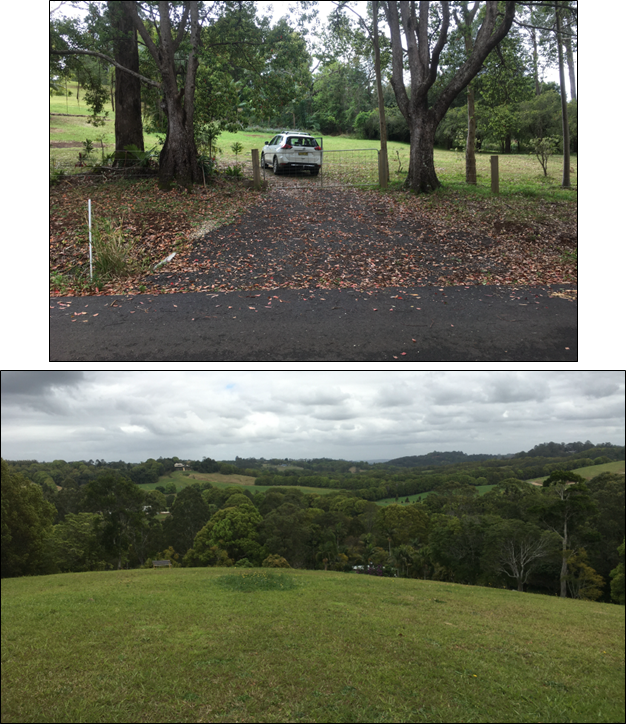
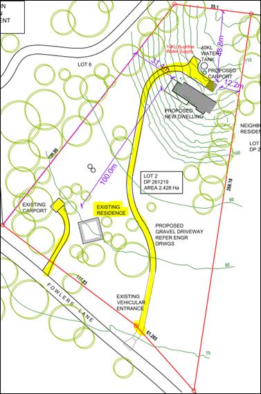
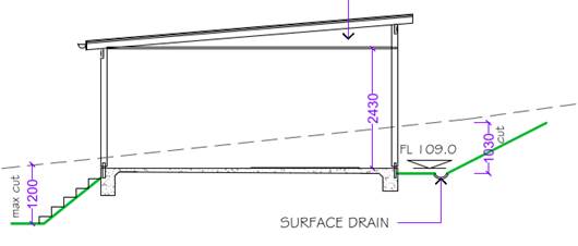
Fowlers Lane, Bangalow............................................................................................... 125
13.13 PLANNING
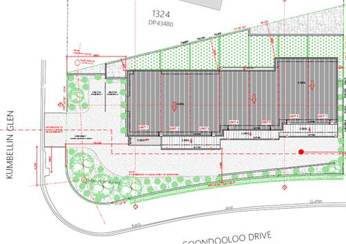
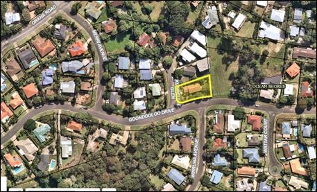
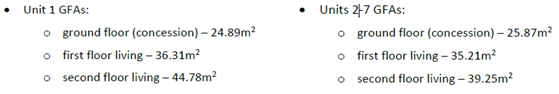
- Development Application 10.2020.138.1 to establish Multi-Dwelling Housing (7
units) at 8 Kumbellin Glen, Ocean Shores.................................................................................. 140
13.14 PLANNING
- Development Application 10.2020.530.1 Swimming Pool and decks at 36 Roses
Road Federal........................................................................................................................... 161
13.15 PLANNING
- 26.2020.5.1 Planning proposal to permit a car park at 158 Jonson
Street, Byron Bay....................................................................................................................................... 169
13.16 Draft
Development Control Plan 2014 Chapter B2 Tree and Vegetation Management 181
13.17 PLANNING
- S4.55 Application to modify Consent 10.2019.616.1 Mixed Use Development, cnr
Jonson & Browning Streets Byron Bay......................................................................... 184
13.18 PLANNING
- 26.2020.6.1 Byron Local Environmental Plan 2014 Housekeeping Amendments 202
13.19 PLANNING
- 26.2020.7.1 E zone Implementation Program - Planning Proposal STAGE 3
BLEP 2014 – Gateway Submission........................................................................................ 208
13.20 Update
Resolution 20-525- Clarkes and Main Beach Reserves Inter Agency Meeting 213
13.21 Update
- Impacts of and management options for short term rental accommodation (STRA)
in Byron Shire.............................................................................................................................. 220
14. Questions
With Notice
Questions with Notice: A response to Questions with
Notice will be provided at the meeting if possible, that response will be
included in the meeting minutes. If a response is unable to be provided the
question will be taken on notice, with an answer to be provided to the
person/organisation prior to the next Ordinary Meeting and placed on Councils
website www.byron.nsw.gov.au/Council/Council-meetings/Questions-on-Notice
Councillors are
encouraged to ask questions regarding any item on the business paper to the
appropriate Director prior to the meeting. Any suggested amendments to the
recommendations should be provided to Councillor Support prior to the meeting
to allow the changes to be typed and presented on the overhead projector at the
meeting.
Mayoral Minute 8.1
Mayoral Minute
Mayoral Minute No. 8.1 Use
of public spaces for busking and other activities
File No: I2020/1759
|
I move that Council end the current suspension on the
use of public spaces for busking or other activity within the definition,
including: tarot cards and palm readers, fortune readers, or the display or
demonstration of items, particularly multiples of items, with an implication
that they are available for sale or otherwise in exchange for money from 14
December 2020.
|
Background Notes:
At the Council Meeting of 26 March 2020, as part of
Council’s response to the COVID pandemic Council resolved 20-124 inter
alia:
…b) Establishes a 3 month ban on the
use of public spaces for busking or other activity within the definition,
including: tarot cards and palm readers, fortune readers, or the display or
demonstration of items, particularly multiples of items, with an implication
that they are available for sale or otherwise in exchange for money.
This suspension was due to expire 30 July 2020.
At the time however, there had been an increase in COVID
cases across NSW, and there were community concerns over the potential spread
of COVID into the Byron Shire by people visiting and congregating in public
places. The public health orders then restricted outdoor
gatherings to no more than 20 in a public place.
At the request of the NSW Police, Council resolved to
further extend the suspension on the use of public spaces for busking until the
public health order restrictions changed. Council resolved at the extra
ordinary meeting 30 July 2020 (20-360):
That Council in relation to the implemented response to
COVID-19, extend the current suspension on the use of public spaces for busking
or other activity within the definition, including: tarot cards and palm
readers, fortune readers, or the display or demonstration of items,
particularly multiples of items, with an implication that they are available
for sale or otherwise in exchange for money until 31 January 2021.
This extended suspension was put in place to assist the
Police in keeping outdoor gathering numbers restricted and social distancing
requirements met in Byron Shire.
Since July: state borders have started to reopen; various
iterations of public health orders have been put in place to relax gatherings;
and COVID case numbers have not been an issue for Byron Shire as a result.
Byron Shire like most other local areas is now moving into a recovery phase for
business and community post COVID. Events and activations of spaces and places
is one way to do this. In recognition of the role that buskers and other
space activators can play in bringing vibrancy to towns and villages, a lifting
of the current suspension is proposed from mid December.
Buskers and associated space activators will need to have a
current permit issued by Council, COVID Safe practices such as maintaining
physical distancing, managing crowds in line with NSW Health restrictions
observed if they seek to resume activity from this date.
Signed: Cr
Simon Richardson
Petitions 10.1
Petitions
Petition No. 10.1 Against The Kollective's proposal for Bayside Development in Bayside
Brunswick Heads
Directorate: Sustainable Environment and Economy
Report
Author: Shannon
Burt, Director Sustainable Environment and Economy
File No: I2020/1734
Council is in receipt of a petition containing 100
signatures which seeks:
We, the residents of Bayside
and Brunswick Heads have serious concerns about the proposed development. A
boarding house seems completely incompatible and out of character with Bayside
without the infrastructure, jobs or public transport to support it.”
Comments from Director Sustainable Environment and Economy:
At the time of writing this response, a development
application had been uploaded into the Planning Portal (PAN-44324) for 94
Kingsford Drive, Brunswick Heads. The development is described as: “a
mixed use development comprising a general store/cafe, cafe, co-working space,
8 shop top houses and a boarding house containing 39 rooms, including a manager's
room and communal laundry and common room”.
The matters raised in the petition will be considered in the
staff assessment report which will be presented to Council at a future meeting
for determination.
|
RECOMMENDATION:
1. That
the petition regarding Against The Kollective's proposal for Bayside
Development in Bayside Brunswick Heads be noted.
2. That
the petition be referred to the Director Sustainable Environment and Economy.
|
Attachments:
1 Confidential
- Petition Letter with 100 Signatures Against Proposed Development in Bayside
Brunswick Heads, S2020/9269
Staff Reports - General Manager 13.1
Staff Reports - General Manager
Report No. 13.1 Rent
relief for business and not-for-profit organisations eligible for JobKeeper
Directorate: General
Manager
Report
Author: Paula
Telford, Leasing and Licensing Coordinator
File No: I2020/1639
Summary:
Ongoing COVID-19 national and
domestic border closures or restrictive movement coupled with other Coronavirus
restrictions continues to have a significant impact on Council’s
commercial and not-for-profit tenants.
Tenants that remain eligible
for the Australian Government’s JobKeeper Scheme have requested extended
rent relief from Council to coincide with the remaining term of JobKeeper.
This report proposes an
extended rent relief programme to tenants of Council that demonstrate
eligibility for JobKeeper at a rate determined by the General Manager for the
remaining term of the JobKeeper Scheme.
|
RECOMMENDATION:
That Council delegate to the General Manager the
authority to negotiate and enter into arrangements with JobKeeper eligible
businesses and not-for-profit organisations identified in this report
relating to rental payments due after 31 October 2020 until 28 March 2021.
|
Attachments:
1 Confidential
- In confidence - eligibility for JobKeeper, E2020/84832
2 Confidential
- In confidence - eligibility for JobKeeper, E2020/85183
3 Confidential
- In confidence - eligibility for JobKeeper, E2020/85576
4 Confidential
- In confidence - eligibility for JobKeeper, E2020/85676
5 Confidential
- In confidence - eligibility for JobKeeper, E2020/85876
6 Confidential
- In confidence - eligibility for JobKeeper, E2020/85887
7 Confidential
- In confidence - eligibility for JobKeeper, E2020/85976
8 Confidential
- In confidence - eligibility for JobKeeper, E2020/85980
9 Confidential
- In confidence - eligibility for JobKeeper, E2020/86130
10 Confidential - In
confidence - eligibility for JobKeeper, E2020/86337
11 Confidential - In
confidence - eligibility for JobKeeper, E2020/86341
12 Confidential - In
confidence - rent payable by JobKeeper eligible organisations, E2020/86394
REPORT
Council resolved (20-258)
at its 28 May 2020 meeting:
1. That Council waive
all rent and licence fees to business affected and identified in the report
from 15 March to 30 June 2020.
2. That the General
Manager is delegated to negotiate and enter into arrangements with affected
businesses on the payments due after 30 June until 31 October 202.
In accordance with the above
resolution the General Manager negotiated and entered into rent relief
arrangements with many of the identified businesses for the period up to 31
October 2020. Rent relief was provided at a rate of a 50% rent waiver
with the remaining 50% of rent deferred for the term of the lease or licence.
Council has received requests from
a number of identified businesses for extended rent relief beyond 31 October
2020. Extended rent relief is requested to support business significantly
impacted by ongoing COVID-19 national and domestic border closures or
restrictive movements.
JobKeeper extended:
The Australian Government extended
its JobKeeper Scheme to eligible businesses and not-for-profit organisations to
28 March 2021 in response to ongoing COVID-19 pandemic closures and
restrictions. The aim of the Scheme is to provide temporary assistance those
businesses and not-for-profit organisations significantly impacted by the
Coronavirus.
Eligibility for extended JobKeeper
requires a business or not-for-profit organisation with an aggregated turnover
of $1 billion or less to demonstrate at least a 30 percent decline in actual
GST turnover during the period 28 September 2020 to 3 January 2021.Eligibility
must be re-tested for the remaining period 4 January to 28 March
2021.
The NSW Government also extended its COVID-19 rental
moratorium measures to 26 March 2021 requiring landlords to negotiate
reductions in rent in good faith with impacted tenants. Tenants not affected by
COVID-19 restrictions are expected to continue to pay all rents and charges in
full. Only tenancies governed by the Retail Leases Act 1994 (NSW)
are subject to the NSW rental moratorium.
Council wrote to identified
businesses and not-for-profit organisations requesting that the tenant put in
writing its request for extended rent relief. Tenants were advised that any
request must include evidence from the Australian Taxation Office that the
business or not-for-profit organisation remains eligible for the JobKeeper Scheme.
Submissions for extended rent
relief:
Council received the following
submissions from identified businesses and not-for-profit organisations for
extended rent relief including:
1. Surfing Byron Bay
Pty Ltd t/as Lets Go Surfing (confidential attachment 1) continues to
experience a 50% decline in turnover and has demonstrated eligibility for
extended JobKeeper.
2. Australia Skydive
Pty Ltd (confidential attachment 2) lessee of a premises at the Tyagarah
Airfield, continues to experience a significant decline in turnover due to
COVID-19 restrictions and border closures and has demonstrated edibility for
extended JobKeeper
3. Golden Breed
Corporation Pty Ltd (confidential attachment 3) lessee of 10 Lawson Street
Byron Bay continues to experience a decline in actual GST turnover of more than
30% due to COVID-19 restrictions and has demonstrated eligibility for extended
JobKeeper.
4. Byron Stand Up
Paddle (confidential attachment 4) continues to experience a greater than 50%
decline in turn due to COVID-19 and has demonstrated eligibility for extended
JobKeeper
5. Fishheads @ Byron
Bay Pty Ltd (confidential attachment 5) lessee of café and Byron Bay
swimming pool complex continues to suffer significant downturn in café
trade due to COVID-19 and has demonstrated eligibility for extended JobKeeper.
6. Byron Bay Style
Surfing School Pty Ltd (confidential attachment 6) continues to experience a
downturn in business as demonstrated by actual sales number. The company
remains on JobKeeper and currently awaits its statement from the Australian
Taxation Office showing extended JobKeeper eligibility.
7. Cape Byron Kayaks
(confidential attachment 7) continues to suffer a downturn in turnover
exceeding 30% and had demonstrated eligibility for extended JobKeeper.
8. Byron Bay Surf
School Pty Ltd (confidential attachment 8) continues to experience a significant
decline in turnover and is eligible for JobKeeper. The company is
awaiting its statement from the Australian Taxation Office showing extended
JobKeeper eligibility.
9. Black Dog Surfing
Pty Ltd (confidential attachment 9) remains eligible for JobKeeper. The company
is awaiting its statement from the Australian Taxation Office showing extended
JobKeeper eligibility.
10. Go Sea Kayak Byron Bay Pty Ltd
(confidential attachment 10) remains eligible for JobKeeper. The company is
awaiting its statement from the Australian Taxation Office showing extended
JobKeeper eligibility.
11. Soul Surf Pty Ltd (confidential
attachment 11) remains eligible for JobKeeper. The company is awaiting its
statement from the Australian Taxation Office showing extended JobKeeper
eligibility.
This report recommends that
Council delegate to the General Manager the authority to enter into
arrangements with JobKeeper eligible businesses and not-for-profit
organisations as detailed in confidential attachment 12, relating to rental
payments due after 31 October 2020 until 28 March 2021.
STRATEGIC CONSIDERATIONS
Community Strategic Plan and
Operational Plan
|
CSP Objective
|
L2
|
CSP Strategy
|
L3
|
DP Action
|
L4
|
OP Activity
|
|
Community
Objective 1: We have infrastructure, transport and services which meet
our expectations
|
1.2
|
Provide
essential services and reliable infrastructure which meet an acceptable
community standard
|
1.2.6
|
Optimise
Council’s property portfolio (SP)
|
1.2.6.8
|
Manage leases
and contracts at Tyagarah Airfield
|
|
Community
Objective 1: We have infrastructure, transport and services which meet
our expectations
|
1.2
|
Provide
essential services and reliable infrastructure which meet an acceptable
community standard
|
1.2.4
|
Provide active
and passive recreational Community space that is accessible and inclusive for
all (SP)
|
1.2.4.3
|
Deliver Stage 1
of a Public Open Space Accessibility Program
|
Legal/Statutory/Policy Considerations
Nil
Financial Considerations
The quantum of rent relief waived to businesses and
not-for-profit tenants of Council is summarised below:
Consultation and Engagement
Nil
Staff Reports - General Manager 13.2
Report No. 13.2 Amendments
to Code of Meeting Practice
Directorate: General
Manager
Report
Author: Ralph
James, Legal Counsel
File No: I2020/1702
Summary:
This report discusses and recommends changes to clauses of
Council Code of Meeting Practice relating to Public Access and the
participation therein by “a person/organisation”.
It also seeks to clarify the number of
speeches/submissions/questions available to “a
person/organisation”.
The report also discusses and recommends the reintroduction
into the Code of Meeting Practice of provisions relating to meetings of the
Planning Review Committee.
|
RECOMMENDATION:
That Council endorse the amendments to the Code of
Meeting Practice and place it, as amended, on public exhibition for a period
of 28 days and that:
a) should
no submissions be received the amended Code of Meeting Practice be adopted,
or
b) should
any submissions be received those submissions be reported to Council at its
first meeting in 2021.
|
Attachments:
1 Draft
Amended Code of Meeting Practice, E2020/86844

REPORT
A draft amended Code Meeting practice, incorporating all of the
amendments referred to in this report (noted in red), is attachment 1.
Public Access
Clauses 4.7, 4.11 and 4.13 of Council’s Code of
Meeting Practice (Code) permit speeches, submissions and questions by “a
person/organisation”.
The interpretation of who is a person, what is an
organisation and the number of speeches, submissions and questions by either or
both “a person/organisation” has become confusing and in some
instances, contentious.
Legal persons can be either
human beings or corporations. “Legal person” includes
corporations, companies, associations, firms, partnerships, societies, and
joint stock companies, as well as individuals.
A natural
person is an individual human being, as opposed to a legal
person.
When allowing speeches, submissions and questions from
an organisation it was Council’s intention that the organisation would be
a community organisation. It is sought to make that abundantly clear.
The interpretation of the
words “a person/organisation is permitted one speech (clause 4.7), one
submission (clause 4.11) and one question (clause 4.13)” is also causing
confusion.
Council’s intention was that “a
person/organisation” meant that the speech, submission or question could
be from either of a person or an organisation - but not both. If Council had
intended otherwise the wording would have been “a person and an
organisation.”
Also requiring clarification is the interpretation of clause
4.7 “A person/organisation is permitted one speech in favour of or
against items on the Agenda.” Council interprets this to mean
any one item within the total of items, i.e, the items are
plural, not the speeches. Otherwise it could be interpreted as one speech
on every item- the speeches being plural.
For the avoidance of doubt it is proposed to amend clause
4.7 to read “A person/organisation is permitted one speech in favour
of or against one item on the Agenda.”
That wording would still permit a person to make one speech
in favour of or against one item on the Agenda, and
that person, if representing a community organisation, would also be
permitted one speech in favour of or against one item on
the Agenda. The wording would allow a natural person to make one speech in
favour of or against one item on the agenda whilst representing a legal person
but it would not allow a natural person to make a speech in favour of or
against one item on the agenda and also make a speech in favour of or against
one item on the agenda on behalf of a legal person.
It is recommended that clause 4.7 be amended to read:
A natural person/community organisation is permitted one
speech in favour of or against one item on the Agenda. For avoidance of doubt a
natural person is permitted to make one speech in favour of or against one item
on the agenda. If that natural person also represents a community organisation
that natural person is permitted to make one speech in favour of or against one
item on the agenda on behalf of the community organisation, in addition to the
speech they make on their own behalf.
It is recommended that clause 4.11 be amended to read:
A natural person/community organisation is permitted to
register one submission per meeting on matters that are not on the Agenda. For
avoidance of doubt, if that natural person also represents a community
organisation that natural person is permitted to register one submission per
meeting in addition to the submission they register on their own behalf.
It is recommended that clause 4.13 be amended to read:
A natural person/community organisation is permitted to
ask one question per meeting. For avoidance of doubt, if that natural person
also represents a community organisation that natural person is permitted to
ask one question in addition to the question they ask on their own behalf.
There would need to be a
consequential amendment to clause 4.6 so that it reads “Natural
persons/community organisations wanting to speak in favour of or against time
on the Agenda will be listed for Public Access in the same order the items
appear on the Agenda.”
Planning Review Panel.
Amendments made to the Local Government
Act 1993 (LGA) in August 2016 by the Local Government Amendment (Governance
and Planning) Act 2016 provided for a model code of meeting practice (Model
Meeting Code) to be prescribed by the Regulation.
The Model Meeting Code was
prescribed under the Local Government (General) Regulation 2005 (the
Regulation) and the then existing meetings provisions of the Regulation were
repealed.
Council adopted its Code of
Meeting Practice which included the provisions of the Model Meeting Code on 13
May 2019 (Resolution 19-103).
The pre Model Meeting Code version of Council’s Code of
Meeting Practice was adopted on 11 June 2014 and was subsequently amended on 27
August 2015 (Amendment to Schedules A (order of business) and B (Special
Purpose Committees) )
and on 23 August 2016 (correction to clause 19.3 and on 21 June 2018
(amendment to clause 22 and Schedule A).
The pre Model Meeting Code version of Council’s Code
of Meeting Practice included provisions relating to meetings of the Planning
Review Committee.
The Model Meeting Code provides that it applies to all
meetings of Council and Committees of Council of which all the members are
Councillors. All Councillors are members of the Planning Review Committee.
Accordingly, when Council’s Code of Meeting Practice was drafted to
incorporate the provisions of the Model Meeting Code the meeting practice of
the Planning Review Committee was omitted as it was considered superfluous.
The Director Sustainable Environment and Economy has
recently advised that, in her view, the Planning Review Committee would be
assisted in the management of its meetings if those meetings could be conducted
in accordance with a meeting practice specifically designed for the Planning
Review Committee.
That would not mean that Council’s Code of Meeting
Practice would not apply. There would still be work for it to do beyond the
ambit of the meeting practice of the Planning Review Committee i.e. rules of
debate, conflicts of interest and keeping order.
The provisions relating to meetings of the Planning Review
Committee would be inserted into the Code of Meeting Practice as clause 20A.
STRATEGIC CONSIDERATIONS
Community Strategic Plan and Operational
Plan
|
CSP Objective
|
L2
|
CSP Strategy
|
L3
|
DP Action
|
L4
|
OP Activity
|
|
Community
Objective 5: We have community led decision making which is open and
inclusive
|
5.2
|
Create a
culture of trust with the community by being open, genuine and transparent
|
5.2.4
|
Support
Councillors to carry out their civic duties
|
5.2.4.2
|
Deliver Council
meeting secretariat – including agenda preparation, minutes and council
resolutions monitoring
|
|
|
|
|
|
|
|
|
|
|
|
|
Legal/Statutory/Policy Considerations
The Model Meeting Code was
prescribed under the Local Government (General) Regulation 2005 (the
Regulation). Council adopted its Code of Meeting Practice which included the
provisions of the Model Meeting Code on 13 May 2019 (Resolution 19-103)
Financial issues
Not
applicable.
Consultation
and Engagement
The Code of Meeting Practice will be placed on public
exhibition for a period of 28 days inviting submissions from members of the
public.
Staff Reports - Sustainable Environment and Economy 13.3
Staff Reports - Sustainable Environment and
Economy
Report No. 13.3 PLANNING
- Development Application 10.2019.444.1 Dwelling house and swimming pool at 37
Byron Street, New Brighton
Directorate: Sustainable
Environment and Economy
Report
Author: Greg
Smith, Team Leader Planning Services
File No: I2020/1233
Proposal:
|
DA No:
|
10.2019.444.1
|
|
Proposal description:
|
Dwelling House and Swimming Pool
|
|
Property description:
|
LOT: 3 DP: 869207
|
|
37 Byron Street NEW BRIGHTON
|
|
Parcel No/s:
|
215660
|
|
Applicant:
|
Ms K Radmacher
|
|
Owner:
|
Ms K Radmacher
|
|
Zoning:
|
RU2 Rural Landscape / 1(d) (Investigation Zone)
|
|
Date received:
|
2 September 2019
|
|
Delegations
|
Council
|
|
Public notification or exhibition:
|
- Level
2 advertising under DCP 2014 Part A14 – Public Notification and
Exhibition of Development Applications
- Exhibition
period: 19/9/2019 – 18/10/2019, 19/12/2019 – 31/1/2020, 23/7/2020
– 5/8/2020
- Submissions received: 6
|
|
Variation request
|
☐
Clause 4.6
|
☐
SEPP 1
|
☒
Not applicable
|
|
Issues:
|
· Bush fire prone
land
· Biodiversity
values (BDAR)
· Coastal
Wetlands,
· Flood liable
land
|
Summary:
This application seeks approval for a large single storey
dwelling house and swimming pool at 37 Byron Street, New Brighton. The dwelling
includes 6 bedrooms with ensuites, living / dining / kitchen space and an
adjacent smaller kitchen, gym, study, utility rooms and garaging for up to 5
vehicles. The dwelling is best described as comprising a number of circles
linked by the main entrance, dining and living rooms. The proposal sits on one
of three large coastal lots north of the New Brighton Soccer fields. The
dwelling is partly elevated to satisfy flood requirements for the area and is
to be predominantly constructed on concrete piers supporting a concrete slab.
Other building materials include concrete blockwork, tiled roof, aluminium
framed windows
The dwelling has been carefully sited within the cleared
areas of the property avoiding areas of coastal wetland and to minimise the
need for any clearing to satisfy bushfire requirements. Access to the site is
provided by way of a sealed road however the property will rely upon onsite
effluent disposal by way of a tertiary aerated waste water treatment system.
The subject dwelling is satisfactory in terms of
Council’s planning controls and the subject site is considered suitable
for the proposed development. The application is recommended for approval
subject to conditions of consent.
NOTE
TO COUNCILLORS:
In
accordance with the provisions of S375A of the Local Government Act 1993, a
Division is to be called whenever a motion for a planning decision is put to
the meeting, for the purpose of recording voting on planning matters.
Pursuant to clause 2(a) under the heading Matters to be Included in Minutes of
Council Meetings of Council's adopted Code of Meeting Practice (as amended) a
Division will be deemed to have been called by the mover and seconder of all
motions relating to this report.
|
RECOMMENDATION:
That pursuant to
Section 4.16 of the Environmental Planning & Assessment Act 1979,
Development Application No. 10.2019.444.1 for Dwelling House and Swimming Pool, be granted consent subject to
the conditions of approval in Attachment 3 (E2020/85548).
|
Attachments:
1 10.2020.444.1
- Plans, E2020/87088 
2 Confidential
- 10.2019.444.1 - Submissions, E2020/87075
3 10.2019.444.1
- Recommended Conditions, E2020/85548

REPORT
1. INTRODUCTION
1.1. History/Background
DA 10.2008.190.1 for a farm shed was refused on
17/6/2008.
DA 10.2017.483.1 for a dwelling house was approved on
8/2/2018. An extract of the approved site plan is shown below:
1.2. Description
of the proposed development
This application seeks approval for a large single storey
dwelling house and an ancillary swimming pool. The dwelling includes 6 bedrooms
with ensuites, living / dining / kitchen space and an adjacent smaller kitchen,
gym, study, utility rooms and garaging for up to 5 vehicles. The dwelling is
best described as comprising a number of circles linked by the central main
entrance, dining and living areas
The development has been positioned so that it avoids
encroachment into the mapped Coastal Wetlands areas of the site. The proposed
plans are included as Attachment 1 to this Report.
1.3. Description
of the site
|
Land is legally described as
|
LOT: 3 DP: 869207
|
|
Property address is
|
37 Byron Street NEW BRIGHTON
|
|
Land is zoned:
|
Part RU2 Rural Landscape under Byron LEP 2014 and part
1(d) (Investigation Zone) under Byron LEP 1988.
Note: The proposed development is located entirely
within the part of the site that is zoned RU2 under Byron Local Environmental
Plan 2014, and on this basis no further consideration of the provisions of
the 1(d) Zone or Byron Local Environmental Plan 1988 is required.
|
|
Land area is:
|
5.204 hectares
|
|
Property is constrained by:
|
· Bush fire prone
land
· Endangered
Ecological Communities
· Biodiversity
values (BDAR)
· Coastal
Wetlands, Coastal Wetlands Buffer, Coastal Environment Area, Coastal Use Area
· Koala
development application mapping
· Flood liable
land
· Coastal erosion
– Precinct 3
· Acid sulfate
soils – Classes 3 and 5
· High
environmental value vegetation
|
|
Is a BDAR required due to the location of the proposed
development?
|
☐ Yes ☒ No
|
|
Are there any easements in favour of Council affecting the
site?
|
☐ Yes ☒ No
|
|
Is there a Vegetation Management Plan which might affect
the proposal? – The conditions of consent require a VMP.
|
☒ Yes ☐ No
|
|
Is there a Voluntary Planning Agreement which might affect
the proposal?
|
☐ Yes ☒ No
|
2. SUMMARY OF
REFERRALS
|
Referral
|
Issue
|
|
Environmental Health Officer
|
No objections subject to conditions.
|
|
Development Engineer
|
No objections subject to conditions.
|
|
S64 / Systems Planning Officer
|
No objections subject to conditions.
|
|
Natural Resource Planner
|
No objections subject to conditions.
|
|
Department of Primary Industries – Office of Water /
NRAR
|
Integrated Development
The applicant originally sought consent as integrated
development DA in terms of the Water Management Act 2000. The
application was referred to DPI - The Natural Resources Access Regulator (NRAR) who advised
that for the purposes of the Water Management Act 2000 (WM Act), General
Terms of Approval and/or a Controlled Activity Approval the development is
exempt. The regulator provided no specific comments or conditions to Council.
On this basis, the development has not been assessed as being for
integrated development.
|
Natural Resource Planner
Council’s Natural Resource Planner originally raised
concerns with the proposed development in terms of its potential impacts on the
wetland. The applicant originally sought consent to fill the site through the
creation of borrow pits on the site, generating issues relating to Acid sulfate
soils, ground water impacts and there proximity to the mapped wetland areas on
the property. The application was amended with the subject borrow pits
removed and the dwelling now to be constructed on piers. Conditions of consent
are recommended to require a vegetation management plan for the site to
ensuring ongoing improvements to the health of the adjacent wetland in the
western half of the site post development.
Development Engineer (on Coastal Erosion)
The site is mapped as Coastal Erosion – Precinct 3,
and it is recommended conditions of development consent to apply in relation
the consent lapsing the dwelling be demolished in the event of coastal erosion
affecting the dwelling.
ET Engineer
Whilst the DA is supported by a proposal for on-site sewage
management system, the applicant expressed a preference to connect to the
sewerage system. The location of the sewerage system is shown in the Council
map extract below.
The site does not have an entitlement to connect to the
sewer. Should Council wish to support a sewer connection, conditions would need
to be imposed for the construction of a private pump station and the payment of
the relevant headworks charges.
The site has an entitlement to connect to the reticulated
water system.
Environmental Health Officer
Council’s
Environmental Health Consultant reviewed the proposal against the relevant legislation and the Best Practice Guidelines and concurs with the finding
that, subject to conditions which have been included in the conditions (including in relation to
groundwater, noise, sewer and on site sewage management), the proposal
will
not
have a significant impact in
relation to environmental health considerations.
Groundwater
Groundwater quality results
provided indicate exceedances in Groundwater Investigation Level (GIL) for
fresh, marine based on the Australian and New Zealand Guidelines for Fresh and
Marine Water Quality (August 2018) in relation to aluminium and arsenic, while
arsenic was in compliance with the National Medical Research Council (NHMRC)
(2011) Drinking Water Guidelines.
Groundwater quality results show a lower pH
(5.28 – 5.54) than the recommended range (for discharge pH 6.5 to
8.5). The pH conditions reflect the acidic natural environment.
The current design has removed all excavations that
were previously below the groundwater table. The only below ground level
excavation proposed is the swimming pool that will now be installed at 1.60m
AHD. This is located at 0.55 m above the maximum groundwater level recorded at
site. Footings for the swimming pool will be installed at 1.30m AHD, 0.25m
above the maximum groundwater level recorded at site.
Given the changes in design to avoid any contact with
groundwater (and resultant dewatering) any risk associated with groundwater as
part of the proposed development is likely to be mitigated.
Conditions of consent are recommended to confirm that
any penetration of the groundwater / level
not is permitted to avoid dewatering.
Construction noise
Given the scale of the development and the considerable
construction period it is recommended that a Noise Management Plan be prepared
as part of an overall Construction Environmental Management Plan for the proposed
development.
Potential connection to reticulated sewer
Greg Alderson & Associates,
on behalf of the applicant, have contacted Council regarding connection to
sewer for the site. An email from Council to the applicant’s consultant
dated 5 March 2019 advised that Council does not permit rural dwellings to connect
to its water and/or sewer systems.
In this regard the neighbouring
allotment has permission to connect to Council sewer under DA 10.2007.813.1 as
stage 2 of that development. Wherever possible it is preferable for development
to be afforded a connection to reticulated sewer rather than onsite sewerage
management. As sewer connection is available next to the subject site,
therefore, it is preferred that Council allow connection to sewer for this
property, seeing that the neighbouring allotment was permitted to connect.
On site Sewage Management
In lieu of a sewer connection, effluent will need to be
disposed of onsite. The applicant proposed a tertiary system with sub surface
irrigation area of some 500 m2. This is partly supported with the
disposal area to be by way of a Wisconsin mound system which will take up an
area of approximately 220m2. Conditions of consent to apply.
3. SECTION 4.14
– BUSH FIRE PRONE LAND
Under section 4.14 of the Act, Council must be satisfied
prior to making a determination for development on bush fire prone land, that
the development complies with the document ‘Planning for Bush Fire
Protection 2006’. The site is bush fire prone land. The development
application is accompanied by a Report by Melanie Jackson (an RFS recognised
qualified bush fire risk assessment consultant) of Bushfire Risk dated 5/7/2020
which does not recommend any alternate solutions. Conditions are included in
the Recommendation of this Report requiring that the development must comply
with the requirements of that Report.
EFFECT OF 10/50 RULE ON SIGNIFICANT VEGETATION
A condition is recommended requiring that all
native vegetation that the 10/50 Vegetation Clearing Code of Practice would otherwise
authorise to be removed, destroyed or pruned must be retained for conservation
purposes.
4. SECTION 4.15C
– MATTERS FOR CONSIDERATION – DISCUSSION OF ISSUES
Having regard to the matters for consideration detailed in
Section 4.15(1) of the Environmental Planning & Assessment Act 1979
(EP&A Act), the following is a summary of the evaluation of the issues.
4.1 State Environmental
Planning Instruments
|
|
Satisfactory
|
Unsatisfactory
|
|
State
Environmental Planning Policy (Koala Habitat Protection) 2019
|
☒
|
☐
|
|
Consideration: The western half of the property was mapped
as a Koala Development Application area on the SEPP (Koala Habitat
Protection) 2019 mapping, until the mapping and the SEPP were recently
amended with approximately 60% of the site is mapped as potential koala
habitat (coastal swamp forests). Council’s Natural Resource Planner
raises no objection to the proposal on the basis of koala habitat protection,
with the development located in the eastern cleared part of the property away
from koala habitat. It is considered the development is likely to have a low
to no impact on Koalas or koala habitat.
|
|
State
Environmental Planning Policy No 55—Remediation of Land
|
☒
|
☐
|
|
Consideration: Whilst the Contaminated Land Assessment was
limited in site history, notably the discovery of the former nursery in the
western half of the site, from the information provided that the surface
soils are in compliance with the Health Investigation Levels (HIL-A) for
residential use with gardens and therefore suitable for the proposed
development.
With respect to
the occurrence of arsenic and aluminium as noted previously arsenic complies
with the NHMRC (2011) drinking water guidelines and falls outsides the GIL
(ANZECC 2018) while aluminium exceeds the GIL (2018) and drinking water
guidelines.
Nevertheless,
given the changes in design to avoid contact with groundwater and resultant
dewatering any risk associated with groundwater as part of the proposed development
ought to be mitigated. Conditions are recommended accordingly.
|
|
State Environmental Planning Policy (Coastal
Management) 2018
|
☒
|
☐
|
|
Consideration: The site includes areas mapped under the
Coastal Management SEPP as Coastal Wetlands, Coastal Wetlands Buffer, Coastal
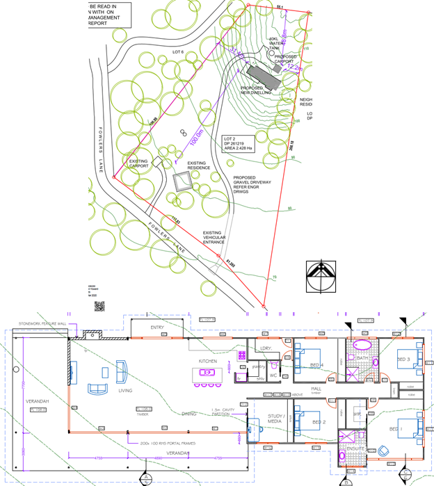
Environment Area and Coastal Use Area.
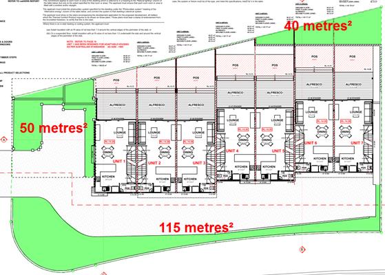
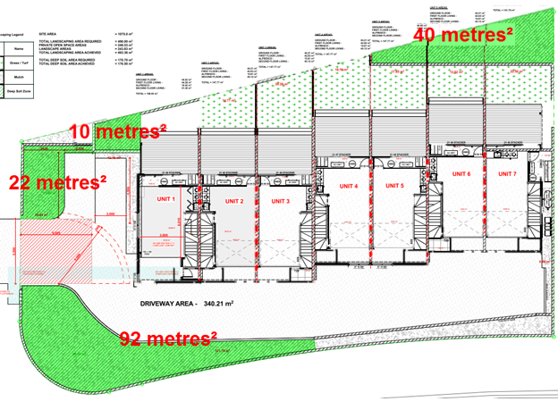
Council’s Natural Resource Planner is satisfied that
the proposed development will not encroach into the Coastal Wetland mapped
parts of the site. Council’s Natural Resource Planner is also satisfied
that the proposal will not cause significant impacts as a result of being
within the Buffer area of the Coastal Wetlands, given the incorporation of a Wisconsin
mound into the design (occupying an approximate area of 220m2)
provided fill is not sourced from the subject site.
In relation to the Coastal Environment Area the proposal
is unlikely to cause a significant impact in relation to:
(a) the integrity and resilience of the biophysical,
hydrological (surface and groundwater) and ecological environment,
(b) coastal environmental values and natural coastal
processes,
(c) the water quality of the marine estate (within the
meaning of the Marine Estate Management Act 2014),
(d) marine vegetation, native vegetation and fauna and
their habitats, undeveloped headlands and rock platforms,
(e) existing public open space and safe access to and along
the foreshore, beach, headland or rock platform for members of the public,
including persons with a disability,
(f) Aboriginal cultural heritage, practices and places, and
(g) the use of the surf zone.
In relation to the Coastal Use Area the proposal is
unlikely to cause a significant impact in relation to:
(i) existing access to and along the foreshore, beach,
headland or rock platform for members of the public,
(ii) overshadowing, wind funnelling and the loss of views
from public places to foreshores,
(iii) the visual amenity and scenic qualities of the coast,
(iv) Aboriginal cultural heritage, practices and places,
and
(v) cultural and built environment heritage.
The development is designed,
sited and will be managed to minimise adverse impacts as referred to above.
The proposal is acceptable having regard to the surrounding coastal and built
environment, and the bulk, scale and size of the proposed development.
|
|
State
Environmental Planning Policy (Infrastructure) 2007
|
☒
|
☐
|
|
Consideration: The development is satisfactory having
regard to the provisions of the Infrastructure SEPP.
|
4.2 Byron Local Environmental Plan
2014 (LEP 2014)
In accordance with LEP 2014 clauses 1.4 and 2.1 – 2.3:
(a) The
proposed development is defined in the LEP 2014 Dictionary as a dwelling house
(with an ancillary swimming pool);
(b) The
proposed development is located within the RU2 Rural Landscape according to the
Land Zoning Map;
(c) The
proposed development is permitted with consent in the RU2 Zone, noting also
that the site has a dwelling entitlement in accordance with clause 4.2A of LEP
2014; and
(d) Regard
is had for the RU2 Zone Objectives as follows:
|
Zone Objective
|
Consideration
|
|
To
encourage sustainable primary industry production by maintaining and
enhancing the natural resource base.
|
The site is not currently used
for sustainable primary industry production purposes, but options could be
explored by the owner at some future stage (noting that the site has already
been approved for a dwelling).
|
|
To maintain the rural
landscape character of the land.
|
The proposal is a positive contribution to the particular
rural landscape character of the land.
|
|
To provide for a range of
compatible land uses, including extensive agriculture.
|
The proposal is a compatible land use in the prevailing
context.
|
|
To enable the provision of tourist
accommodation, facilities and other small-scale rural tourism uses associated
with primary production and environmental conservation consistent with the
rural character of the locality.
|
Tourist accommodation, facilities and other small-scale
rural tourism uses associated with primary production and environmental
conservation consistent with the rural character of the locality are not
proposed or prevented by this DA.
|
|
To protect significant scenic
landscapes and to minimise impacts on the scenic quality of the locality.
|
The proposal will not have a significant impact on any
publicly accessible scenic landscapes and the proposal appropriately
minimises impacts on the scenic quality of the locality.
|
Clause 4.3 Height of Building
The submitted elevations show the 9m maximum building height
development standard. The maximum height of the building does not exceed the
depicted 9m maximum at any point.
Clause 6.1 Acid Sulfate Soils – Classes 3 and 5
The site is
identified by Council’s GIS as containing Class 3 Acid Sulfate
Soils: Works beyond 1 metre below the natural ground surface, works by
which the water table is likely to be lowered beyond 1 metre below the natural
ground surface. The proposal is likely to disturb acid sulfate soils.
A number of reports have been prepared in support of a development application.
The current design has removed all excavations that were
previously below the groundwater table. The only below ground level excavation
proposed is the swimming pool that will now be installed at 1.60m AHD. This is
located at 0.55 m above the maximum groundwater level recorded at site.
Footings for the swimming pool will be installed at 1.30m AHD, 0.25m above the
maximum groundwater level recorded at site.
Under the proposed
development, soil excavations are to take place within a localised part of the
site, for strip footings, service trenches and the swimming pool. Disturbance
is expected to be limited to depths of up to 1m below existing ground level
(BEGL). Since it has been established that acid sulfate soils do not
occur in the soil layers to 1.5m BEGL corresponding acid sulphate soil
management for the subject development as planned is not necessary.
Clause 6.2 Earthworks
As discussed above, earthworks are
proposed in relation to footings and installation of services etc. Conditions
of consent to apply.
Clause 6.3 Flood liable land
The subject dwelling is to be sited
and elevated on piers, Minor filling is proposed on site. Flood studies and
modelling submitted with the application demonstrate that there will be no to
minimal flood impacts offsite as a result due to the size of the property.
Clause 6.6 Essential
services
The site is able to be connected to
the reticulated water and electricity supply systems. Stormwater to be disposed
of onsite as is effluent. It is considered services can be provided to the
property to enable the dwelling to be constructed.
4.3 Any proposed Instrument
that has been the subject of public consultation and has been notified to the
consent authority
Parts of the site are potentially to be within the E2
Environmental Conservation Zone under the E Zone Review. The proposal itself
however is not within the potential E2 Zone part of the site.
4.4 Byron Shire Development
Control Plan 2014 (DCP 2014)
DCP 2014 is an applicable matter for consideration in the
assessment of the subject development application in accordance with subsection
4.15(1) of the EP& A Act because it applies to the land to which LEP 2014
applies.
These checked Parts/Chapters have been taken into
consideration in the assessment of the subject development application in
accordance with Section 4.15 of the EP&A Act. The proposed development is
demonstrated to meet the relevant Objectives of all relevant Parts/Chapters (in
some cases subject to conditions and/or to the satisfaction of other assessing
officers).
Chapter B4 Traffic Planning, vehicle parking, Circulation,
and access
The proposal has access to a sealed road. Car parking is
provided on site for up to 5 vehicles.
Chapter B7 Mosquitos and Biting Midge
The property is highly likely to be affected by mosquitos
and biting midge. Standard conditions to apply in relation to fly screens to
help minimise the impacts of these insects.
Chapter C2 Areas affected by Flood
The proposed dwelling house is to be set at compliant height
above the flood level for the area at RL 3.61m AHD. The applicant has submitted
various flood reports and modelling to demonstrate that minor filling for the
development can be accommodated on the land without adversely impacting upon
surrounding development.
Chapter D2 Residential accommodation and Ancillary
development in Rural Areas
The proposed development satisfies the general setback, car
parking and servicing requirements under the DCP. In terms of visual impacts,
the dwelling although sizeable in area will be difficult to see from the urban
areas of New Brighton due to surrounding vegetation, whilst the structure
itself is well setback behind the dues and is unlikely to be visible from the
beach.
Chapter E9 Ocean Shores, New Brighton and South Golden
Beach
The subject property sits outside of the mapped areas
identified under the DCP.
4.5 Any Planning Agreement or
Draft Planning Agreement?
|
|
Yes
|
No
|
|
Is there any applicable planning agreement or draft
planning agreement?
|
☐
|
☒
|
|
|
4.6 Environmental Planning
& Assessment Regulation 2000 Considerations
The proposed development raises no issues against the
relevant regulations.
4.7 The likely impacts of that
development, including environmental impacts on both the natural and built
environments, and social and economic impacts in the locality
|
Impact on:
|
Likely significant impact/s?
|
|
Natural environment
|
No. The proposal will not have a significantly adverse
impact on the natural environment of the locality.
|
|
Built environment
|
No. The proposal will not have a significantly adverse
impact on the built environment of the locality. Conditions of consent to
apply in relation to hours of work, sedimentation and erosion control
measures, construction noise, builders waste and the like.
|
|
Social Environment
|
No. The proposal will not have a significant social impact
on the locality.
|
|
Economic impact
|
No. The proposal will not have a significant economic
impact on the locality.
|
4.8 The suitability of the site
for the development
The property is serviced with water, power and
telecommunications, and access is available via sealed road and driveway. Sewer
could be extended to the site; however effluent is to be disposed of onsite.
The property is affected by flood, coastal erosion and bushfire and these
hazards can be appropriately managed without having a detrimental impact upon
the built or natural environment. Although the Part J Provisions under DCP 2010
do not apply to the site, standard conditions of consent to apply in relation
to the consent lapsing in the event coastal erosion threatens the property. The
site is considered suitable for the proposed development.
4.9 Submissions made in
accordance with this Act or the regulations
The DA was publicly exhibited on 3 occasions, the first
being associated with the originally submitted plans and the subsequent two
associated with amended plans.
There were a total of 6 submissions made on the development
application, being 1 from Crown Lands and 5 from members of the public. These
are included as confidential Attachment 3 to this Report.
The Crown Lands submission as an adjoining land owner
offers no objections to the proposed development as no impact to Crown land has
been identified. Crown Lands asked Council to ensure that the applicant does
not undertake any activity on the Crown land or use the Crown land for any
purpose associated with the development. The development may not:
· encroach
upon the Crown land,
· remove
any vegetation from the Crown land,
· stockpile
materials, equipment or machinery on the Crown land,
· use
the Crown land for access purposes,
· direct
stormwater discharges to the Crown land, or
· use
the Crown land as an Asset Protection Zone.
A condition is recommended
accordingly.
2 submissions are in support of the proposed
development. One of these advises as follows:
The residence will have minimal negative influence on the
following key considerations:
· The
surrounding Nature Reserve is substantially buffeted by the setbacks and
vegetative screenings – existing and proposed;
· The
selected location is logical, as it provides optimum privacy whilst impacting
on minimal flora and fauna;
· Vision
lines (internal and external) are respectful of privacy for occupants,
neighbours;
· Flooding
impacts will be below measurable parameters on site and to neighbours (based on
specific engineering I had undertaken in 1992);
· Solar
alignment is logical for the local climate;
· Design
and materials are world class;
· Location
of residence will be in balance with the existing services and infrastructure.
The remaining three
submissions raised the following issues
· Protect
access to the neighbouring property (Lot 1 DP 536652) which is via Byron Street
and an unnamed street which is adjacent to the lots.
Comment: The subject neighbouring property is
Lot 1 DP 536652 shown in the extract from the Site Plan for the proposed
development below. There is an existing generally north-south access crossing
the subject site, also shown in the extract. The proposed development is to be
carried out entirely on the eastern side of that access, whereas the
neighbouring Lot 1 is entirely to the west of that access. The proposal will
not change any existing access arrangements in relation to the neighbouring Lot
1.
· Filling and
Flood impacts
Comment: The development was substantially
amended through the assessment process removing proposal to construct borrow
pits and to fill the site. Minor filling is still required in part for access
and for the small effluent disposal area. As discussed above, it is considered
the development will have negligible impacts on the flood plain in terms of
flood heights or the displacement of flood waters.
· The impact of
this development will result in a decrease in the amenity to the neighbouring
property.
Comment: The submission has not nominated the
way/s that the proposal would decrease amenity to the neighbouring property.
There is a separation distance of approximately 90m between the neighbouring
Lot 1 and the proposed dwelling house. There is not expected to be any
significant privacy impacts, and will be no overshadowing or view impacts.
There are no expected significant amenity impacts in relation to the yet to be
developed vegetated neighbouring Lot 1.
· Access to the
neighbouring site through the public roads or in the alternative via No 37
Byron Street to be discussed.
Comment: A meeting is currently being arranged
to discuss access to the neighbouring Lot 1 between the owner of the
neighbouring Lot 1, Council’s Development Engineer and any other required
staff via an existing but unformed road reserve. This is now a matter for the
owner of the subject land to this DA to negotiate.
· Vegetation removal
and associated works involved with the borrow pit
Comment: The DA originally proposed a borrow
pit however this has been deleted. The dwelling is to be sited on cleared land
with minimal vegetation removal required.
· Traffic impacts on
Byron Street, New Brighton
Comment: The subject road network is capable of
accommodating traffic generated by this dwelling house.
4.10 Public interest
The proposed development is unlikely to significantly
prejudice or compromise the public interest or create an undesirable precedent,
and approval is recommended subject to conditions.
5. DEVELOPER
CONTRIBUTIONS
5.1 Water & Sewer Levies
Unless the site is to be connected to the sewer, no
headworks charges apply.
5.2 Section 7.11 Contributions
No Section 7.11 Contributions
will be required.
6. DISCLOSURE OF
POLITICAL DONATIONS AND GIFTS
|
Has a Disclosure Statement been received in relation
to this application
|
No
|
|
Have staff received a ‘gift’ from anyone
involved in this application that needs to be disclosed. Where the answer is
yes, the application is to be determined by the Director or Manager of the
Planning, Development and Environment Division.
|
No
|
Provide Disclosure Statement register details here: Not
applicable
7. CONCLUSION
The application appropriately addresses the relevant
constraints applying to the site including flooding, coastal erosion, bushfire
and native vegetation. The application is recommended for approval subject to
the conditions of consent.
Staff Reports - Sustainable Environment and Economy 13.4
Report No. 13.4 PLANNING
- 26.2017.4.1 Lot 22 - Proposed Amendments to the Exhibited Planning Proposal
Directorate: Sustainable
Environment and Economy
Report
Author: Steve
Daniels, Project Officer - Planning Reforms
File No: I2020/1244
Summary:
The Lot 22 planning proposal relates to Council owned land
located at the southern edge of Mullumbimby, described as (part) Lot 22 DP
1073165, 156 Stuart Street, Mullumbimby. A Gateway Determination was
issued by the Department of Planning, Industry & Environment on 30 May 2018
(Attachment 1).
The planning proposal (Attachment 2) was placed on public
exhibition from 31 October 2018 to 12 December 2018 and an independently
chaired Public Hearing was held on the 6 February 2019. Following the
public exhibition and public hearing, Council received a submissions report on
11 April 2019 and resolved to prepare a further flood study and structure plan
for Lot 22 and the adjoining sites identified in the draft Residential Strategy
as investigation areas for future housing.
This report discusses the draft flood study and
recommendations, draft structure plan for Lot 22, and changes required to the
planning proposal provisions as a result.
If the planning proposal is supported and the site is
ultimately rezoned and reclassified, an amendment to the Lot 22 Plan of
Management and preparation of a site specific DCP chapter will also be
required.
In short:
· The
updated flood study prepared by WMAwater (Attachment 3) explores a range of
options to manage flooding and drainage for Lot 22 and the adjoining
investigation areas. The natural rehabilitation approach to stormwater
management was the highest ranked option in the multi-criteria assessment,
which considers non qualitative benefits such as potential for local drainage
and water quality improvements, ecology/habitat improvement, long term
maintenance cost and the potential for social engagement. As such this option
is recommended.
· The
structure plan (Attachment 4) is a high level document designed to inform the
planning proposal and preparation of a site specific DCP. The
structure plan is for illustrative purposes only and provides an example of
how diverse housing could be delivered on the flood free development
areas. It is not a formal plan for development assessment purposes and
should not be viewed as such. It is subject to change pending detailed
site investigations at the DA stage, detailed feasibility assessments,
consultation with the community and consultation with future housing providers.
· In response to the flood study recommendations, structure
plan and draft Residential Strategy, a number of changes to the exhibited
planning proposal are presented in this report. It is recommended that the
planning proposal be updated and forwarded to the Department of Planning,
Industry & Environment for a Gateway determination.
If a positive Gateway
determination is issued, Council staff will prepare a community engagement
program that is in addition to the Gateway exhibition requirements.
NOTE
TO COUNCILLORS:
In
accordance with the provisions of S375A of the Local Government Act 1993, a
Division is to be called whenever a motion for a planning decision is put to
the meeting, for the purpose of recording voting on planning matters.
Pursuant to clause 2(a) under the heading Matters to be Included in Minutes of
Council Meetings of Council's adopted Code of Meeting Practice (as amended) a
Division will be deemed to have been called by the mover and seconder of all
motions relating to this report.
|
RECOMMENDATION:
That Council:
1. Prepare
an amended planning proposal for (part) Lot 22 DP 1073165, 156 Stuart Street,
Mullumbimby that reflects changes detailed in Table 2 of this report.
2. Forward
the amended planning proposal and supporting studies to the Minister for
Planning requesting a Gateway determination.
3. Place
the amended planning proposal, supporting studies and structure plan on
public exhibition in accordance with the Gateway determination.
4. Carry
out a community engagement program in addition to the Gateway exhibition
requirements.
5. Receive
a further report to consider:
a) The
outcome of the public exhibition and community engagement program.
b) The
preparation of an amended Plan of Management for Lot 22.
c) The
preparation of Development Control Plan provisions for Lot 22.
d) The
preparation of a holistic traffic and transport study for the Saltwater Creek
Precinct.
|
Attachments:
1 26.2017.4.1
Gateway determination - Stuart Street Mullumbimby PP_2018_BYRON_001_00
(30/5/18) - Lot 22, E2018/46655
2 26.2017.4.1
Planning Proposal Lot 22 Mullumbimby (v2 Exhibition version) - pdf of
E2018/76218, E2018/76692 
3 Mullumbimby
Land Release Areas - Flood Impact Assessment and SWMP Final_Aug2020, E2020/43608
4 26.2017.4.1
Lot 22 Illustrative Structure Plan_Updated 26_10_20, E2020/85789
5 26.2017.4.1
Lot 22_Draft Statutory Framework and DCP Discussion_Pdf of E2020/85726, E2020/87627 
REPORT
Background
The Lot 22 planning proposal relates to Council owned land
located at the southern edge of Mullumbimby, described as (part) Lot 22 DP
1073165, 156 Stuart Street, Mullumbimby. Lot 22 is an irregular
shaped lot that is split by a railway line and has part of its boundary to
Saltwater Creek. Lot 22 includes the Mullumbimby community gardens (however
this area is not proposed to be rezoned and reclassified) and has a total area
of approximately 29.2 hectares.
Lot 22 is one of four sites collectively known as the
Saltwater Creek Precinct (see Figure 1). These sites are identified in
the draft Residential Strategy as investigation areas for future housing, and
have been subject to an early implementation initiative that aims to
incorporate affordable housing outcomes as a component of any future
development.
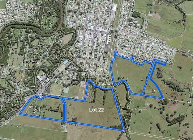
Figure 1: Lot 22 & adjoining sites in the Saltwater
Creek Precinct
On 23 November 2017 Council considered a planning proposal
to rezone and reclassify (part) Lot 22 DP 1073165, 156 Stuart Street,
Mullumbimby, for the purpose of permitting residential development with an
emphasis on affordable and diverse housing.
Following consideration of the 23 November 2017 Council
report, Council resolved (17-597) to forward the planning proposal to the NSW
Department of Planning and Environment (DPIE) for a Gateway determination and
proceed to public exhibition of the planning proposal. A Gateway
Determination was issued by the DPIE on 30 May 2018 (Attachment 1).
The planning proposal (Attachment 2) was placed on public
exhibition from 31 October 2018 to 12 December 2018 and an independently
chaired Public Hearing was held on the 6 February 2019.
The exhibited Lot 22 planning proposal aims to:
· Rezone
part of the land (approximately 22 hectares of 29.2 hectares) from
RE1 Public Recreation zone to R1 General Residential zone to permit residential
development with an emphasis on affordable and diverse housing, and make
further consequential amendments to planning controls for the site.
· Reclassify
par of the land from Community to Operational land.
· Include
local provisions to encourage diverse and affordable housing on this and other
key sites to be identified on a map in Byron LEP 2014.
Following the public exhibition and public hearing, Council
received a submissions report on 11 April 2019 and resolved (19-147)
to:
1. Prepare
a further flood study and a structure plan for Lot 22 DP 1073165 and the three
surrounding properties that make up the Mullumbimby Accessible Housing Area.
2. Receive
a further report to consider the future of the Planning Proposal for Lot 22 DP 1073165
once the additional studies have been completed.
The purpose of this report is to provide:
· Key
recommendations of the draft flood study and concept stormwater management
plan;
· An
overview of the structure plan developed in response to the flood study
recommendations;
· A
detailed overview of proposed changes to the exhibited Planning Proposal
provisions;
· A
timeline for preparing an updated Plan of Management for the residual Lot 22
community land; and
· A
timeline for preparing DCP provisions and a traffic and transport study for Lot
22
Draft Flood Study & Concept Stormwater Management
Plan
In accordance with Res 19-147, WMAwater was
engaged to provide an updated flood study (Attachment 3) to inform the Lot 22
planning proposal and structure plan. Given that Lot 22 is one of four
sites in the Saltwater Creek Precinct, the study area encompasses all 4 sites
in this precinct (Figure 1), providing a more holistic approach to flood
planning and a better understanding of cumulative flood impacts.
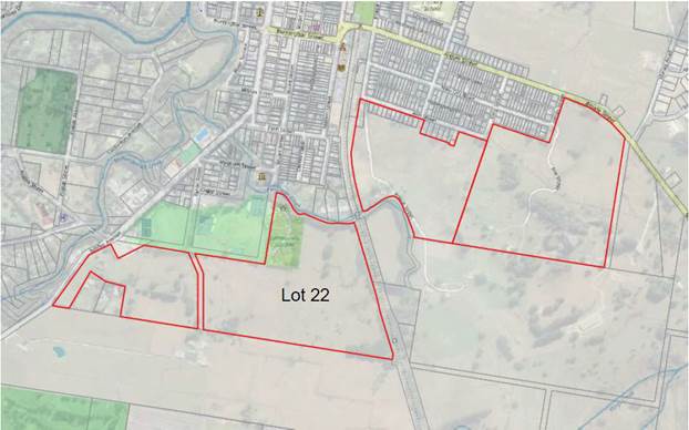
Figure 2: Study Area –
Mullumbimby Saltwater Precinct
Based on the analysis undertaken, the following findings
were obtained with regards to regional
flood impacts:
· The
sites all have a portion of area which is deemed developable when considering
the impact to the regional flood levels and the development controls with
regards to flooding on new land release areas;
· A
cut to fill balance may be achievable however its viability is dependent on the
soil quality onsite, which is currently unknown;
· Some
channel works may be required to achieve the development footprint proposed
– these have not been considered in the costing; and
· Some
local drainage corridors servicing existing areas may be impacted by the
development. Future detailed assessments should ensure that the proposed
development does not cause local drainage issues or regional flooding impacts
‘offsite’. The report notes that augmentation of existing
drainage corridors may be necessary to improve overall local drainage and
overcome any offsite impacts.
With regards to stormwater management, two potential
management options were reviewed:
1. A
traditional engineered option which relies on bio retention and detention basins
to treat runoff; and,
2. An
alternative approach which aims at improving the existing drainage corridor
through a revitalisation process.
Based on the assessment undertaken, the natural channel
rehabilitation option is identified as the preferred outcome for the
development (see Figure 3). While this option is initially more expensive to
establish, it will provide greater environmental benefits to the area, has
potential for improved drainage and water quality for areas external to the
development and also has a greater opportunity for social engagement and
amenity. The rehabilitation option is also likely to have a lower ongoing
maintenance and lifecycle costs when compared to engineered solutions,
especially with regards to water quality. By contrast, traditional engineered
water quality solutions require constant maintenance to ensure function, which
often does not occur, resulting in a poor urban design outcome over time.
The natural rehabilitation approach was also the highest
ranked option in the multi-criteria assessment, which considers non qualitative
benefits such as potential for local drainage and water quality improvements,
ecology/habitat improvement, long term maintenance cost and the potential for
social engagement. As such this option is recommended.
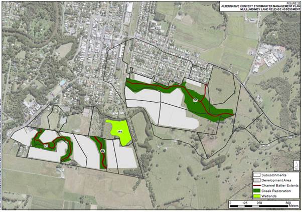
Figure 3: Developable
Area & Alternative Stormwater Management plan (Recommended Option)
It should be noted that each stage of the development
process requires further refinements to flood impact modelling and required
drainage upgrades. Additional assessments undertaken at the development
application stage can draw on a more detailed understanding of the site
constraints and proposed development outcome.
If the planning proposal proceeds to Gateway, the flood
study (Attachment 3) will be appended to the planning proposal. If the
Gateway determination permits Council to proceed to public exhibition, the
flood study will be placed on exhibition with the planning proposal for
community feedback
Proposed Structure Plan
The structure plan (Attachment 4) is a high level document
designed to inform the planning proposal and preparation of a site specific
DCP. The structure plan is for illustrative purposes only (excerpt
provided below in Figure 4) and provides an example of how diverse housing
could be delivered on the flood free development areas. It is not a formal plan
for development assessment purposes and should not be viewed as
such. It is subject to change pending detailed site investigations
at the DA stage, detailed feasibility assessments, consultation with the
community and consultation with future housing providers.
The alternative stormwater management plan (natural channel
rehabilitation approach) provides the foundation from which the structure plan
has been developed. The structure plan is therefore complimentary in its
intention to improve amenity and water quality for areas upstream, restore
creek systems as part of the three natural drainage channels, and rehabilitate
the wetland area on the site.
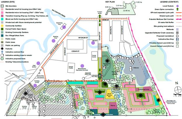
Figure 4: Illustrative
Structure Plan – Excerpt taken from Attachment 4
(NOTE: Privately owned land to the
west of Lot 22 is overlaid with diagonal black lines; this land would be
subject to a separate planning proposal and rezoning process)
Vision for Lot 22
In broad terms, the vision for Lot 22 is to create an
innovative housing precinct that stands apart from traditional approaches to
suburban housing, while also delivering an accessible housing component that
supports the housing needs of the community. This vision aims to provide:
· A
diversity of dwelling typologies and densities;
· Neighbourhood’s
set within the green landscape of the recreation grounds, creek corridors and
the community gardens.
· A
highly connected place with walking and cycle links to the nearby schools, town
centre, parks and services.
The accessible housing component of Lot 22 seeks to promote
opportunities for a mix of people to join (or re-join) the creative and diverse
community of Mullumbimby. This would include:
· Singles
and young people; key workers; low income workers and students; lone parents;
first-home buyers; the elderly; welfare recipients; and people transitioning
out of homelessness.
· Local
Aboriginal people seeking affordable opportunities to live on Country.
A Range of Lot Sizes and Dwelling Types
By comparison to other investigation areas identified in the
Residential Strategy, Lot 22 aims to achieve a higher dwelling density by
incorporating a higher percentage of smaller lot sizes within the overall lot
size mix. This emphasis on more compact housing typologies reflects the
goal of targeting a 30% affordable housing allocation for Lot 22, as opposed to
20% for other sites identified as investigation areas in the Residential
Strategy.
There are 2 options for how affordable housing could be
placed across the site – dispersed throughout the development or
concentrated in small pockets. Both options have their merits and will be
determined in consultation with the housing provider responsible for
construction and ongoing management.
This greater emphasis on micro lot housing and small lot
housing (delivering 1, 2 & 3 bedroom homes) translates to higher dwelling
yields for the site. It is estimated that the development footprint and
proposed lot size mix could yield approximately 250 to 350 dwellings.
Attachment 3 provides an illustrative picture of potential housing outcomes for
the site.
Movement & Access
Two vehicle access points are proposed for Lot 22 (and the
adjoining privately owned site to the west):
1. Via Stuart Street to
the north; and
2. Via
a proposed intersection on Coolamon Scenic Drive to the west (in the vicinity
of Azalea Street). An intersection in this location would seek to improve
existing choke points in this area which currently struggles to manage bus
exchanges, school traffic and vehicles entering and exiting the Mullumbimby
Rural Co-Op.
The close proximity of Lot 22 to the town centre and
essential services in Mullumbimby makes walking and cycling a viable option for
residents making short trips around town. The structure plan aims to
promote alternative, healthy transport options over vehicle dependence where
possible.
The current Gateway determination for the Lot 22 planning
proposal did not require a traffic study, and it is understood that there are a
number of access options available. However it is noted that the
estimated dwelling yield has increased in the time since the current Gateway
was issued.
A traffic study for Lot 22 and the adjoining Residential
Strategy Investigation Area is necessary. It is usual practice to
undertake a traffic study at the planning proposal stage where the planning
proposal is being progressed by a third party, however in this case, Council is
the landowner and has stewardship of the planning proposal. It is
considered premature in this particular case to undertake a traffic assessment
ahead of more detailed work that would establish the subdivision design,
housing yield and concept viability.
Additionally, a separate planning proposal is expected to be
received for rezoning of the adjoining investigation area to the west.
The site to the west will contribute to the overall traffic volume, and the
proposed development outcome needs to be understood when considering access
options noted above and/or any alternative access routes. Given the need
to consider the cumulative impacts of future development in Mullumbimby, it
would therefore be logical to undertake a holistic traffic study for all of the
Saltwater Creek Precinct investigation area, including Lot 22. It is
proposed that a detailed traffic assessment be undertaken prior to the
preparation of a site specific DCP for Lot 22.
Recreation and Environmental Conservation
The northern half of the site (adjoining the Mullumbimby
Community Gardens) sits outside the development footprint and provides an
opportunity for passive recreation in a restored natural environment.
A buffer area to the south of the site would provide
separation from the adjoining farmland as well as opportunities for vegetated
recreational areas and urban farming.
Proposed changes to the
exhibited Planning Proposal
In response to the flood study
recommendations, structure plan and the draft Residential Strategy, a number of
changes to the exhibited planning proposal are required. It should be
noted that an amended Gateway determination, or a new Gateway determination,
will be necessary. The planning proposal will be re-exhibited along with
the supporting studies and structure plan. All proposed changes to the
planning proposal are summarised below in Table 2.
LEP Provisions to Support
Improved Housing Choice, Diversity and Equity
The exhibited planning proposal
featured a minimum lot size of 200m2 and a ‘Diverse
Housing’ clause that sought to deliver a mix of dwellings at one, two or
three plus bedrooms. This approach has since been superseded by
provisions in the draft Residential Strategy, Policy 2 - Improved housing
choice, diversity and equity.
The objectives are complimentary
to The North Coast Regional Plan 2036, Direction 23: Increase housing diversity and
choice. Action 23.1 of the Regional Plan (Page 56) requires Councils
to:
Encourage housing diversity by
delivering 40 per cent of new housing in the form of dual occupancies,
apartments, townhouses, villas or dwellings on lots less than 400 square
metres, by 2036.
To meet the actions in the draft
Residential Strategy and the North Coast Regional Plan, new urban areas zoned
R1, R2 & R3 require supporting provisions in Byron LEP 2014 that deliver a
range of housing typologies and lot sizes.
Proposed Statutory Clauses -
Lot Size Diversity & Housing Diversity
The standard instrument Minimum
Lot Size maps typically used in Byron LEP 2014 have limitations when trying to
deliver a development outcome that features a targeted mix of varying lot
sizes. Specifying the mix of lot sizes on a site via a minimum lot size
map is an overly prescriptive approach and lacks the flexibility needed to
deliver subdivision outcomes at the DA stage that can respond to site
constraints, servicing requirements, market conditions and investment viability
– particularly if land is subject to an affordable housing
contribution.
The proposed statutory framework
introduces local clauses 4.1G, 4.1H and 4.1I to Byron LEP 2014. These
clauses operate in conjunction with a proposed ‘Key Sites Map’ that
identifies land to which the clauses would apply (in this case Lot 22).
The intended effect of these clauses is summarised below in Table 1, and a
detailed overview is provided in Attachment 4.
Table 1: Summary
of Proposed LEP Statutory Clauses (Attachment 4) - Lot Size Diversity &
Housing Diversity
|
Item #
|
Proposed Byron LEP 2014 clause
|
Function of the proposed clause
|
|
(A)
|
Clause
4.1G
|
Provides
a target lot size mix for new urban areas based on draft Residential Strategy
¾ Policy 2 and Table 5. .
The
updated version of Table 5 is provided in Attachment 4. It
outlines a lot size diversity mix for investigation areas zones R2 & R3,
and a separate lot size diversity mix for Council owned land zoned R1 (Lot
22).
|
|
(B)
|
Clause 4.1H
|
Guides the development of
appropriate housing typologies for certain lot sizes.
This clause is designed to
promote greater housing diversity and the efficient use of land.
|
|
(C)
|
Clause 4.1I
|
Provides necessary flexibility
to the proposed LEP provisions to ensure that development concepts can
respond to site constraints and investment/ viability considerations.
Often these considerations can
only be fully determined following detailed site investigations at the DA
stage.
|
|
(D)
|
Key Sites Map
|
Identifies sites that are
required to comply with lot size diversity and housing diversity provisions
summarised above.
Initially, Lot 22 will be the
only site identified on the Key Sites Map, however other sites identified as
investigation areas in the draft Residential Strategy would be included in
the future subject to a planning proposal confirming their suitability for
future housing.
|
Overview of All Proposed
Changes to the exhibited Planning Proposal
In addition to the lot size and
housing diversity framework described above, further changes are necessary in
response to the flood study recommendations, specifically the extent of land
zoned R1, and a building height provision that factors proposed fill
pads. Table 2 below provides a summary of all proposed changes to the
exhibited planning proposal.
Table 2: Summary of all proposed changes
to the exhibited planning proposal
|
Item #
|
Previously Exhibited Planning Proposal Provisions
|
Proposed Changes
|
|
(1)
|
Land Use Zones
Rezone approximately 22 hectares of the existing RE1
Public Recreation zone to R1 General Residential. This will be a
new zone not previously used in Byron LEP 2014.
The balance of Lot 22 DP 1073165 will remain in
its current RE1 Public Recreation zone and partly as a Deferred Matter under
Byron LEP 1988 (see Figure 5 below).
|
The extent of the proposed R1 General Residential
zone will be reduced to the southern portion of the site to encompass the
developable area identified in the flood study.
The balance of the land will remain in its current RE1
Public Recreation zone and partly as a Deferred Matter under Byron LEP
1988 (see Figure 6 below).
|
|
(2)
|
Height of Buildings
Current Height of Building (9 metres) will be
retained.
|
Retain the 9 metre Height of
Building provision and identify the site on a proposed Building Height
Allowance Map.
Draft clause 4.3A is proposed to
ensure that building heights are measured from the flood planning level (this
is relevant given that development pads on Lot 22 will be filled to the FPL
plus 0.5m freeboard).
4.3A Exceptions to height
of buildings
(1) The
objective of this clause is to align building height and flood planning
provisions and provide for a consistent point of reference for the
measurement of building heights in flood prone areas.
(2) This
clause applies to land identified as “Minimum Level Australian Height
Datum (AHD)” on the Building Height Allowance
Map.
The
maximum height of a building on land to which this clause applies is to be
measured from the minimum level AHD permitted for that land on the Building Height Allowance
Map.
|
|
(3)
|
Minimum Lot Size
A Minimum Lot Size of 200m2 is proposed to
encourage affordable housing outcomes on the subject land.
|
Remove the 200m2
minimum lot size control from the planning proposal. The site will not
feature on the minimum lot size map.
This provision is to be replaced
by the Lot Size Diversity & Housing Diversity
clauses described in Attachment 4 and summarised above in Table 1.
|
|
(4)
|
Diverse Housing Clause & Key Sites Map
Introduce a new diverse housing clause applicable to sites
identified on a Key Sites Map.
4.7 Diverse housing
Council wants to increase the diversity of dwelling
types in new residential areas on land identified on the key sites map.
This clause will apply to residential and mixed use
development on land shown on the key sites map as
“clause 4.7”. It will apply to a development
application where four or more dwellings are proposed.
Residential development on this land should comprise at
least 25% one bedroom dwellings and at least 50% two bedroom dwellings with
no more than 25% of new residential development being three or more bedrooms.
|
Remove the current diverse housing clause from the
planning proposal and replace with the proposed Lot
Size Diversity & Housing Diversity clauses described in Attachment 4 and
summarised above in Table 1.
The Key
Sites Map is to be retained; however it will serve to identify land to which
the new Lot Size Diversity & Housing Diversity clauses apply.
|
|
(5)
|
Reclassification – Community to Operational
Reclassify part of Lot 22 DP 1073165 from
Community to Operational to reflect the changes to the zone of the land and
the prospective change of land use. This will be achieved by listing
the subject land in “Part 2 Land classified, or reclassified, as
operational land—interests changed” within “Schedule 4
Classification and reclassification of public land”.
|
The area of land subject to reclassification will be
amended to reflect the proposed R1 General Residential zone shown below in
Figure 6. The remaining land will retain its Community Land
classification.
|
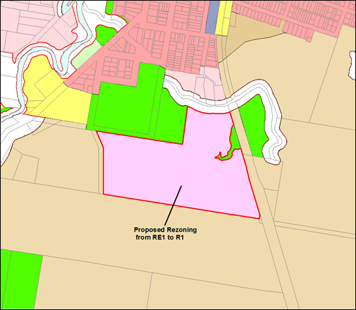
Figure
5 – Previously proposed zone
changes under the exhibited planning proposal
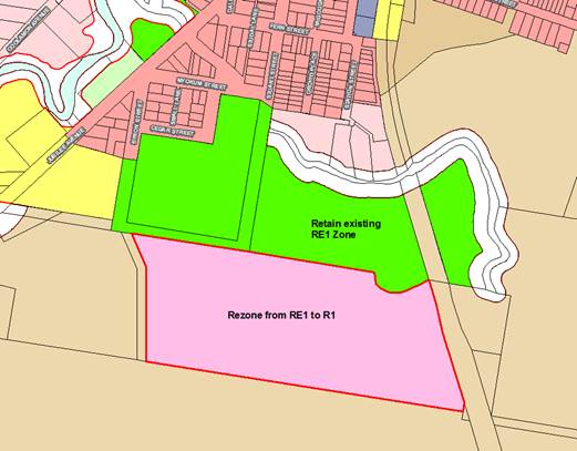
Figure 6 - Proposed zone changes under an amended
planning proposal (indicative only)
Required DCP Provisions
The amended planning proposal
provides a statutory framework that delivers a
mix of lot sizes and housing typologies for the site, this mix includes an allocation
of smaller lot sizes that create unique challenges when considering the design
and location of buildings. More detailed design considerations are best
managed via a DCP in order to provide sufficient flexibility at the DA stage.
It is proposed that a site
specific DCP for Lot 22 be prepared in concert with the finalisation of the
planning proposal. The DCP would be reported to Council and placed on
public exhibition ahead of any future DA for the site. Some of the key
issues that will need to be addressed are discussed below.
Subdivision & Integrated
Development
DCP provisions are required to
manage the development of housing at smaller lot sizes to ensure that buildings
are designed and located in a manner that best aligns with the amenity of
housing on adjoining lots. The potential for poor outcomes is greater when
working with smaller lot sizes due to the close proximity of buildings.
To address this issue, proposed
clause 4.1G requires that subdivisions creating lots smaller than 300m2
be carried out as part of an integrated development application. This means
that the subdivision DA and the building DA are submitted together as an
integrated DA.
This integrated approach removes
the risk of ad-hoc development outcomes in terms of the location of buildings,
building design and interface.
Managing site constraints at
smaller lot sizes
Smaller lot sizes (i.e. less than
600m2) also create challenges when working with site-specific
constraints, such as vegetation, slope etc. Such constraints can further
limit the potential location of buildings, thus compounding the potential for
poor outcomes on small lots.
To manage the impact of site
constraints, DCP provisions will be necessary to ensure that subdivision
applications are accompanied by a Building Envelope Plan to demonstrate that
the lot can accommodate a building platform, appropriate access and servicing
with minimal site, visual and vegetation impacts.
Infrastructure
Considerations
Water & Sewer Services
Lot 22 is one of a number of sites in Mullumbimby identified
as an investigation area for new housing under the Byron Residential
Strategy. New housing supply in Mullumbimby will also be generated
through infill development in existing urban areas, and through the development
of existing (undeveloped) residential zoned land.
Therefore, the provision of water and sewer services for lot
22 is part of a broader water security strategy for Mullumbimby.
Servicing requirements for these development areas (including lot 22) would be
confirmed once the dwelling yield/type is known.
A staged delivery program is necessary to ensure that new
development in Mullumbimby is supported by necessary infrastructure
upgrades. The water supply strategy will investigate supply options to
meet the anticipated demand, but will need to be flexible to respond to the
actual growth realised. It is expected
that required staging of new development will be enforced via corresponding LEP
and DCP provisions.
Traffic & Transport
As noted above, a traffic
study for Lot 22 and the adjoining Residential Strategy Investigation Area is
necessary. It is usual practice to undertake a traffic study at the
planning proposal stage where the planning proposal is being progressed by a
third party, however in this case, Council is the landowner and has stewardship
of the planning proposal.
A separate planning proposal is expected to be received for
rezoning of the adjoining investigation area to the west. The site to the
west will contribute to the overall traffic volume, and the proposed
development outcome needs to be understood when considering access
options. Given the need to consider the cumulative impacts of future
development in Mullumbimby, it would therefore be logical to undertake a
holistic traffic study for all of the Saltwater Creek Precinct investigation
area, including Lot 22. It is proposed that a detailed traffic assessment
be undertaken prior to the preparation of a site specific DCP for Lot 22.
Affordable Housing
A key driver behind part of Lot 22
being rezoned for residential purposes is to deliver affordable housing.
There may be a number of options
available to Council to secure affordable housing on Lot 22. At this
stage the most obvious would appear to be LEP 2014 provisions under a SEPP 70
affordable housing contribution scheme. To do this, a planning proposal
to apply the scheme needs to progress in parallel to the zone change, as a
scheme can only be applied where there is an upzoning.
That said, staff are currently
investigating alternative models for securing affordable housing. This
work may identify alternatives more suited to this site and Council
objectives. It is expected that findings will be available by the early
part of 2021.
Either way, preliminary viability
analysis to date indicates that Lot 22 may be able to deliver a higher
percentage of affordable housing than other investigation areas in the
Shire. This may be further enhanced should Council be able to identify a
delivery model to secure project funding at the state level or in partnership
with the private or not for profit sectors.
At this point in time given
Council has stewardship of this planning proposal process; it is suggested a
decision on whether to progress with a SEPP 70 Affordable Housing Contribution
Scheme planning proposal be held over until the findings of the alternative
model investigations are available.
With all options, the delivery of
affordable housing will be influenced by ensuring the affordable housing is
most suited to our community’s needs, is compatible with
Mullumbimby’s character, construction costs, market trends and investment
funding options.
Required amendment to the Lot 22 Plan of Management
The existing Plan of Management applies to all of the land
identified as Lot 22 DP 1073165. The land is Community Land, owned and
managed by Byron Shire Council. The plan of management categorises the
community land parcel into the following:
· Sportsground
· General Community
use
The plan of management will need to be amended to reflect
and include only that land proposed to remain classified as community
land. Council will also need to consider changes to the categories noted
above for that land.
An updated Plan of Management will be prepared and exhibited
following gazettal of the rezoning and reclassification of the land from
community to operational. Work will commence of this sooner should council
resolve to do so.
Community Engagement and
Consultation Program
Community engagement and consultation moving forward will
build on the extensive consultation that has been undertaken on the planning
proposal and also that as part of the residential strategy in relation to
housing diversity and choice.
A successful Gateway determination
issued by the DPIE will require Council to undertake a public exhibition of the
planning proposal for a prescribed time period. However, the significant
public interest in this proposal, as well the community land classification of
the site, warrant Council going above and beyond the Gateway public exhibition
requirement including focus groups, drop in sessions, listening posts at the
markets and main Street. Zoom webinar/recording will also be developed. Each
will need to comply with COVID safe workplace requirements inn place at the
time.
A community engagement program
will be prepared and implemented once a positive Gateway Determination is
received.
Summary and Conclusions
The objective of the Lot 22
planning proposal is to determine if the land is suitable for residential
development, and to establish the most appropriate zoning and statutory
planning controls for the site.
The structure plan and flood
study attached to this report have been prepared to assist the decision making
process at the rezoning stage. The structure plan and flood study would
be further refined at the DA stage, and would be subject to further
consideration by Council and the community.
Detailed plans at the DA stage
will also need to account for feasibility assessments, market analysis and
infrastructure delivery.
STRATEGIC CONSIDERATIONS
Community Strategic Plan and
Operational Plan
|
CSP Objective
|
L2
|
CSP Strategy
|
L3
|
DP Action
|
L4
|
OP Activity
|
|
Community
Objective 4: We manage growth and change responsibly
|
4.2
|
Support
housing diversity in appropriate locations across the Shire
|
4.2.1
|
Establish
planning mechanisms to support housing that meets the needs of our community
|
4.2.1.3
|
Progress future
use of Lot 22, Mullumbimby Planning Proposal and Plan of Management
|
|
|
|
|
|
|
|
|
|
|
|
|
|
|
|
|
Legal/Statutory/Policy
Considerations
The relevant legal/statutory/policy
considerations have been noted above.
Financial Considerations
As this is a Council initiated planning proposal, the costs
will be borne by Council if it chooses to proceed.
Staff Reports - Sustainable Environment and Economy 13.5
Report No. 13.5 PLANNING
- Development Application 10.2020.274.1 New dwelling to create dual occupancy
(detached) at 590 Booyong Road Booyong
Directorate: Sustainable
Environment and Economy
Report
Author: Patricia
Docherty, Planner
File No: I2020/1420
Proposal:
|
Proposal description:
|
New Dwelling to Create Dual Occupancy (Detached)
|
|
Property description:
|
LOT: 1 DP: 878972
|
|
590 Booyong Road BOOYONG
|
|
Parcel No/s:
|
222120
|
|
Applicant:
|
Dixonbuild Pty Ltd
|
|
Owner:
|
Mr B J Towers
|
|
Zoning:
|
RU2 Rural Landscape
|
|
Date received:
|
10 June 2020
|
|
Integrated / Designated Development:
|
☐
Integrated
|
☐
Designated
|
☒
Not applicable
|
|
Concurrence required
|
No
|
|
Public notification or exhibition:
|
- Level
2 advertising under DCP 2014 Part A14 – Public Notification and
Exhibition of Development Applications
- Exhibition
period: 2/7/20 to 22/7/20
- Submissions received: nil
- Submissions
acknowledged: ☐
Yes ☐ No ☒ N/A
|
|
Planning Review Committee:
|
Not applicable
|
|
Variation request
|
Clause 4.6
|
|
Delegation to determine
|
Council
|
|
Issues:
|
4.6 Variation of Development Standards under Clause 4.2D -
Distance between dwellings (>100m).
|
Summary:
The DA proposes a new single storey dwelling to create a
dual occupancy (detached) on rural land at Booyung. The proposed dwelling will
be approximately 124 metres to the south of the existing dwelling on the site
and will share the existing driveway access off Booyung Road. The
proposed dwelling comprises four bedrooms and is of a brick veneer design with
a colorbond roof.
The proposed dwelling does not comply with the development
standard for a minimum of 100 metres distance between dwellings required under
Clause 4.2D (2) (c) Erection of dual occupancies (detached) and
secondary dwellings in Zones RU1 and RU2, and a request has been made to
vary the development standard under Clause 4.6 of Byron LEP 2014.
Having considered the applicant’s written request to
vary the development standard, Council can be satisfied that the proposed
development is consistent with the relevant objectives of the RU2 zone and development
standard:
(a) to provide alternative accommodation for rural
families and workers,
(b) to ensure that development is of a scale and
nature that is compatible with the primary production potential, rural
character and environmental capabilities of the land,
(c) to set out consent considerations for
development of dual occupancies (detached) and secondary dwellings to address
matters such as access, siting, land suitability and potential impacts.
Upon review of the applicant's written request it is
considered that compliance with the development standards is unreasonable or
unnecessary in the circumstances of the case, having regards to the cleared
nature of the site, the objectives of the RU2 Zone and the level nature of the
site. The additional distance is not likely to impact on surrounding properties
and no submissions were made.
The proposed development will not result in any adverse
impacts on the character, amenity and environment of the locality, and the site
is considered suitable for the proposed development.
The application appropriately addresses the relevant
constraints applying to the site, and is recommended for approval subject to
the conditions listed in the Recommendation of this Report below.
NOTE TO COUNCILLORS:
In accordance with the
provisions of S375A of the Local Government Act 1993, a Division is to be
called whenever a motion for a planning decision is put to the meeting, for the
purpose of recording voting on planning matters. Pursuant to clause 2(a)
under the heading Matters to be Included in Minutes of Council Meetings of
Council's adopted Code of Meeting Practice (as amended) a Division will be
deemed to have been called by the mover and seconder of all motions relating to
this report.
|
RECOMMENDATION:
That pursuant to
Section 4.16 of the Environmental Planning & Assessment Act 1979,
Development Application No. 10.2020.274.1 for New Dwelling to Create Dual Occupancy (Detached), be granted
consent subject to the recommended conditions of approval in Attachment 2
(#E2020/85691).
|
Attachments:
1 10.2020.274.1
- Plans, E2020/85238
2 10.2020.274.1
- Conditions of Consent, E2020/85691
REPORT
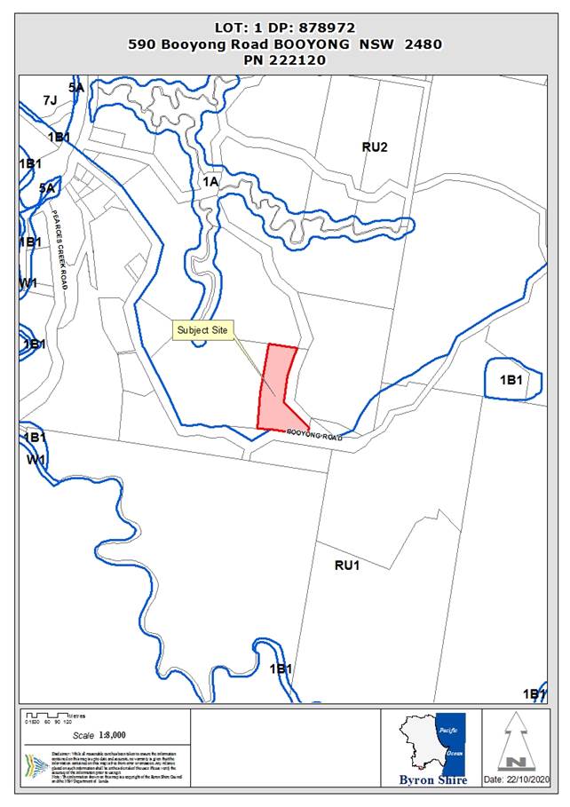
Assessment:
1. INTRODUCTION
1.1. History/Background
1.2. Description
of the proposed development
This application seeks approval for a new single storey
dwelling to create a dual occupancy (detached).
The proposed dwelling will be approximately 124 metres to
the south of the existing dwelling on the site and will share the existing
driveway access off Booyong Road. The dwelling includes 4 bedrooms, media
room, study, 2 bathrooms, a laundry and double garage.
Plans and elevations
The proposal is of a brick veneer design with a colorbond
roof and is single storey in terms of height.
1.3. Description
of the site
A site inspection was carried out on 3 September 2020
|
Land is legally described
|
LOT: 1 DP: 878972, LOT: 8 DP: 41024, LOT: 1 DP: 1187774
|
|
Property address
|
590 Booyong Road BOOYONG
|
|
Land is zoned:
|
RU2 Rural Landscape
|
|
Land area is:
|
2.023 hectares
|
|
Property is constrained by:
|
Bushfire prone land, High Environmental Value, Drinking
Water Catchment
|
|
Is a BDAR required due to the location of the proposed
development?
|
☐ Yes ☒ No
|
|
Are there any easements in favour of Council affecting the
site?
|
☐ Yes ☒ No
|
|
Is there a Vegetation Management Plan which might affect
the proposal?
|
☐ Yes ☒ No
|
|
Is there a Voluntary Planning Agreement which might affect
the proposal?
|
☐ Yes ☒ No
|
GIS Mapping Extract
2. SUMMARY OF
REFERRALS
|
Referral
|
Issue
|
|
Environmental Health Officer
|
No objections subject to conditions.
|
|
Development Engineer
|
No objections subject to conditions. .
|
|
S94 / Contributions Officer
|
No objections subject to conditions.
|
|
Land Information Officer
|
No objections subject to conditions.
|
* Conditions provided in the above referral are included
in the Recommendation of this Report below
3. SECTION 4.14
– BUSH FIRE PRONE LAND
Under section 4.14 of the Act, Council must be satisfied
prior to making a determination for development on bush fire prone land, that
the development complies with the document ‘Planning for Bush Fire
Protection 2019’. The site is bush fire prone land. The development
application is accompanied by a Report by Peter Thornton dated 23 October
2019 which provides conditions. Due to legislative changes to
Planning for Bushfire Protection since the report was prepared, the assessing
officer has undertaken an updated assessment in accordance with Planning for
Bushfire Protection 2019, based on the site details provided in the Bushfire
report.
Using the provisions under Planning for Bushfire Protection
2019’, the asset protection zone and bush fire attack levels for this
proposed development (which is in fire weather area FDI 80) are as follows:
|
Direction
|
Effective Slope
|
Veg Formation
|
Distance to Veg
|
APZ
|
BAL
|
|
N
|
0-5
|
Grassland
|
>20
|
11m
|
19
|
|
NE
|
10-15
|
Rainforest
|
>39
|
20m
|
19
|
|
E
|
5-10
|
Grassland
|
26
|
12m
|
12.5
|
|
S
|
5-10
|
Forest
|
80
|
To the boundary
|
12.5
|
|
W
|
0-5
|
Grassland
|
17
|
11m
|
19
|
Condition number 4 is included in the Recommendation
of this Report requiring that the development must comply at all times with the
recommended bushfire protection measures.
EFFECT OF 10/50 RULE ON SIGNIFICANT VEGETATION
A small portion of land mapped High Environmental Value may
be affected by the APZ required to the south. The trees in this location
are Camphor Laurel on the road reserve and are not considered to be of high
environmental value and the APZ is still achievable to the boundary without
their removal.
4. SECTION 4.15C
– MATTERS FOR CONSIDERATION – DISCUSSION OF ISSUES
Having regard to the matters for consideration detailed in
Section 4.15(1) of the Environmental Planning & Assessment Act 1979
(EP&A Act), the following is a summary of the evaluation of the issues.
4.1 State Environmental
Planning Instruments
|
|
Satisfactory
|
Unsatisfactory
|
|
State
Environmental Planning Policy Koala Habitat Protection 2019
|
☒
|
☐
|
|
Consideration: The proposed development is entirely on existing
cleared land. No further consideration is required.
|
|
State
Environmental Planning Policy No 55—Remediation of Land
|
☒
|
☐
|
|
Consideration: History
Review of Council’s archive shows that PR239691 was
created by way of DA 5.1998.3.1 Subdivision – Boundary Adjustment
– Property Consolidation/Boundary Adjustment (DM1101852). The
preliminary contaminated land assessment states that the larger agricultural
allotment (pre-subdivision) was predominately used for cattle grazing, dairy
farming and other agricultural pursuits.
Observable point sources of contamination were identified
during the site visit on 03 September 2020. Point sources included an abandoned
vehicle at site of proposed dwelling, and waste/rubbish (mainly scrap metal,
tyres and vehicle machinery). No unusual odours or yellowing of vegetation
was identified.
Results
Two composite soil samples were prepared from eight
individual samples taken within the building envelope. Samples taken were
analysed for a range of organochlorines pesticides, organophosphorus and heavy metals relevant for the sites land use
history. The report concluded that the all results were below the relevant
Health Investigation Limits (HILs) from NEPM 1999.
Given the above and the unchanged land use type, the site
is deemed suitable from the proposed development. No further investigation or
action warranted. Conditions are recommended.
|
|
State
Environmental Planning Policy (Building Sustainability Index: BASIX) 2004
|
☒
|
☐
|
|
Consideration: A BASIX certificate was submitted with the
application.
|
|
State Environmental Planning
Policy (Primary Production and Rural Development) 2019
|
☒
|
☐
|
|
Consideration: The proposed development is not contrary to
rural planning principals and land use conflicts have been considered during
assessment.
|
4.2 Byron Local
Environmental Plan 2014 (LEP 2014)
In accordance with LEP 2014
clauses 1.4 and 2.1 – 2.3:
(a) The
proposed development is defined in the LEP 2014 Dictionary as Dual occupancy
(detached);
(b) The
land is within the RU2 Rural Landscape according to the Land Zoning Map;
(c) The
proposed development is permissible with consent; and
(d) Regard
is had for the Zone Objectives as follows:
|
Zone Objective
|
Consideration
|
|
• To encourage sustainable primary
industry production by maintaining and enhancing the natural resource base.
• To maintain the rural landscape
character of the land.
• To provide for a range of compatible
land uses, including extensive agriculture.
• To enable the provision of tourist
accommodation, facilities and other small-scale rural tourism uses associated
with primary production and environmental conservation consistent with the
rural character of the locality.
• To protect significant scenic
landscapes and to minimise impacts on the scenic quality of the locality.
|
The proposed development is not contrary to the objectives
of the zone.
|
The remaining underlined clauses have been taken into
consideration in the assessment of the subject development application in
accordance with Section 4.15 of the EP&A Act. The proposed development
complies with all of these clauses (in some cases subject to conditions and/or
to the satisfaction of other assessing officers), except in relation to Clause 4.2D,
which is considered further as follows:
Clause 4.1 E Minimum lot sizes for dual occupancies,
manor houses, multi dwelling housing and residential flat buildings
The site is 2.023 hectares; therefore the proposed dwelling
meets the minimum site area of 4,000 square metres required for dual occupancy
(detached) in the Zone RU2 Rural Landscape.
Clause 4.2A Erection of dwelling houses and dual
occupancies on land in certain rural zones
Development consent may be granted for the erection of a
dual occupancy on land to which this clause applies because the land is a lot
created before LEP 2014 commenced and on which the erection of a dual occupancy
was permissible immediately before that commencement. No dual occupancy already
exists on the lot and the new dwelling will result in a dual occupancy
(detached), which is permissible with consent.
Clause 4.3 Height of Buildings
The proposed single storey dwelling is 5.43 metres high and
less than the maximum permissible 9 metres.
Clause 5.16 Subdivision of, or dwellings on, land in certain
rural, residential or environment protection zones
The objective of this clause is to minimise potential land
use conflict between existing and proposed development on land in the rural,
residential or environment protection zones concerned (particularly between
residential land uses and other rural land uses).
The land is zoned under the Byron Local Environment Plan
2014 as RU2 Rural Landscape Zone, and is classified as Regionally Significant
Farmland under the Byron Shire Rural Land Use Strategy 2018. Council’s
Geocortex mapping database appears to show that the land surrounding the parcel
is comprised of rural/residential lifestyle lots and farmland. The property
directly south of the subject site includes an orchard. A potential
conflict due to noise and space has been considered. However, as
the sites are separated by a vegetative buffer on both sides of the roads, the
potential for conflict is low.
The proposed dwelling to create a dual occupancy is compatible
with the surrounding land uses and it is not envisaged that approval will
result in significant land use conflicts.
Clause 6.2 Earthworks
Minor earthworks are required to complete driveway access.
Most of the site for the rest of the building is already clear and level.
Clause 6.5 Drinking water catchments
The proposed dwelling is unlikely to have any adverse
impacts on the quality and quantity of water entering drinking water storages.
An intermittent water body is located approximately 60 m north east of the
proposed development site. All buffer distances are met and it appears that
there is space for a land application area (LAA) and reserve LAA.
The site has an approved On Site Sewage Management System
(OSMS) servicing the existing five-bedroom dwelling (70.2001.202.1). This OSMS
appeared to be in proper working condition with no signs of failure during the
inspection on 03 September 2020. Council records also show this system has up
to date quarterly servicing of the AWTS – see most recent maintenance
report dated 09/09/20 (E2020/72301).
Therefore, the site is suitable and has capacity to assimilate
the wastewater from the proposed development. A Section 68 application to
install a new OSMS is required – conditions recommended.
Clause 6.6 Essential Services
Council can be satisfied that the following services that
are essential for the development can be made available:
(a) the supply of water,
(b) the supply of electricity,
(c) the disposal and management of sewage,
(d) stormwater drainage,
(e) suitable vehicular access.
Conditions are recommended.
|
What clause does the development not comply with and what
is the nature of the non-compliance?
|
Further consideration, including whether the development
application is recommended for approval or refusal accordingly
|
|
4.2D Erection of dual occupancies
(detached) and secondary dwellings in Zones RU1 and RU2
(1) The objectives of this clause are as
follows—
(a) to provide alternative accommodation for rural
families and workers,
(b) to ensure that development is of a scale and
nature that is compatible with the primary production potential, rural
character and environmental capabilities of the land,
(c) to set out consent considerations for
development of dual occupancies (detached) and secondary dwellings to address
matters such as access, siting, land suitability and potential impacts.
(2) Development consent must not be granted to
development for the purpose of a dual occupancy (detached) or secondary
dwelling on land in Zone RU1 Primary Production or Zone RU2 Rural Landscape
unless the consent authority is satisfied that—
(a) the development will not impair the use of the
land for agriculture or rural industries, and
(b) each dwelling will use the same vehicular access
to and from a public road, and
(c) any dwellings will be situated within 100
metres of each other, and
(d) the land is physically suitable for the
development, and
(e) the land is capable of accommodating the on-site
disposal and management of sewage for the development, and
(f) the development will not have an adverse impact
on the scenic amenity or character of the rural environment.
|
Each dwelling will be 124 metres apart.
The assessment planner has considered the applicants
written request to vary the development standard. The request is in the form
and content required by the NSW Guide to Varying a development standard
(2011).
Having considered the applicant’s written request to
vary the development standard, Council can be satisfied that the proposed
development is consistent with the relevant objectives of the RU2 zone
and development standard:
(a) to provide alternative accommodation for
rural families and workers,
(b) to ensure that development is of a scale and
nature that is compatible with the primary production potential, rural
character and environmental capabilities of the land,
(c) to set out consent considerations for
development of dual occupancies (detached) and secondary dwellings to address
matters such as access, siting, land suitability and potential impacts.
No public submissions were made.
The proposed development will not result in any adverse
impacts on the character, amenity and environment of the locality.
Upon review of the applicant's written request it is
considered that compliance with the development standards is unreasonable or
unnecessary in the circumstances of the case, with consideration, as follows:
· Locating the
dwelling closer than proposed will result in vegetation clearing which is
deemed to be
· unnecessary
given that there is a previously cleared area where development can occur
which meets the objectives of the zone.
· The proposed
development location has been chosen due to the level nature of the site
requiring minimal earthworks to establish the proposed building pad.
· The proposed
location will retain an existing Teak Tree located on site which is located
at the 100m separation mark and will also provide separation from onsite
power lines.
· The additional
distance is not likely to impact on surrounding properties.
In summary, the requirement to consider the distance
between buildings and an additional access under the current LEP means that
there will be a variation of 24% to the distance a, which means the DA can
only be determined by Council (being a numeric variation greater than 10%).
|
The proposal raises no other issues under the LEP.
4.3 Any proposed Instrument
that has been the subject of public consultation and has been notified to the
consent authority
Not applicable
4.4 Byron Shire Development
Control Plan 2014 (DCP 2014)
DCP 2014 is an applicable matter for consideration in the
assessment of the subject development application in accordance with subsection
4.15(1) of the EP& A Act because it applies to the land to which LEP 2014
applies. The DCP 2014 Parts/Chapters that are checked below are of relevance to
the proposed development:
|
Part A
|
☒
|
|
Part B Chapters:
|
☒B2|
☒ B3| ☒ B4| ☐B5| ☒ B6| ☐B7| ☒ B8| ☐B9| ☐B10| ☐B11| ☐B12| ☐B13|
☒
B14
|
|
Part C Chapters:
|
☐C1|
☐ C2| ☒ C3| ☒ C4
|
|
Part D Chapters
|
☐D1|
☒ D2| ☐D3| ☐D4| ☐D5| ☐D6| ☐D7| ☐D8
|
|
Part E Chapters
|
☐
E1| ☐E2| ☐E3| ☐E4| ☐E5| ☐E6| ☐ E7
|
These checked Parts/Chapters have been taken into
consideration in the assessment of the subject development application in
accordance with Section 4.15 of the EP&A Act. The proposed development is
demonstrated to meet the relevant Objectives of all relevant Parts/Chapters (in
some cases subject to conditions and/or to the satisfaction of other assessing
officers).
Chapter C3 Visually prominent sites, visually prominent
development & view sharing
The single storey dwelling will be located on a level site
which is approximately 81 metres AHD. The 5.43 metres high building is
modest in scale and existing vegetation on site will ensure that development
does not adversely impact on the Shire’s scenic character and visual
quality. A condition is recommended to address materials and colours that must
be muted bushland tones.
Chapter C4 Development in the Drinking Water Catchment
This chapter aims to facilitate and support the provisions
of Byron LEP 2014 relating to development in a drinking water catchment, as
considered in Section 4.2 above. The application has been assessed and
conditions of consent are recommended to ensure that development within the drinking
water catchments does not adversely impact on the quality or quantity of the
public water supply. The proposed development has been adequately designed
and assessed to prevent unacceptable risks to water quality, both individually
and in terms of incremental and cumulative risk.
Chapter D2 Residential Accommodation and Ancillary Development
in Rural Zones
The proposed development is setback 19.876 metres to Booyung
Road Reserve and complies with the setback requirements including the 15 metre
minimum setback to the road.
The development application was accompanied by sufficient
details including existing use of all parts of the site; potential conflicts,
including the distance from the proposed dual occupancy to adjoining land
holdings and access and site details. Parking is provided
The dual occupancy is proposed to be located so that it does
not create potential for conflict with adjoining land uses and is to be located
and retained on the same legal title as the principal dwelling house on the
property. The proposal will result in two dwellings being located more
than 100 metres apart. Both dwellings will be serviced by a common vehicle
access.
The proposed dwelling has its own private open space, car
parking and is sited to retain mature vegetation on the site. It will not
generate additional adverse environmental impacts through excessive vegetation
removal for bushfire protection or detract from the visual amenity of the locality.
Note. Non compliance with the 100 metre is considered
reasonable and justifiable in the circumstances and on its own merit, as
detailed under Section 4.2 of this report.
The proposal raises no other issues under the DCP.
4.5 Environmental Planning
& Assessment Regulation 2000 Considerations
|
Clause
|
This control is applicable to the proposal:
|
I have considered this control as it relates to the
proposal:
|
If this control is applicable, does the proposal comply?
|
|
92
|
No
|
N/A
|
N/A
|
|
93
|
No
|
N/A
|
N/A
|
|
94
|
No
|
N/A
|
N/A
|
|
94A
|
No
|
N/A
|
N/A
|
* Non-compliances and any other significant issues
discussed below
4.6 The likely impacts of that
development, including environmental impacts on both the natural and built
environments, and social and economic impacts in the locality
|
Impact on:
|
Likely significant impact/s?
|
|
Natural environment
|
No. The proposal will not have a significantly adverse
impact on the natural environment of the locality.
|
|
Built environment
|
No. The proposal will not have a significantly adverse impact
on the built environment of the locality.
|
|
Social Environment
|
No. The proposal will not have a significant social impact
on the locality.
|
|
Economic impact
|
No. The proposal will not have a significant economic
impact on the locality.
|
Conditions of consent are proposed to control construction
activities such as hours of work, construction noise, sedimentation and erosion
control measures, builders waste and the like,
4.7 The suitability of the site
for the development
The site is a serviced, unconstrained property and is
suitable for the proposed development subject to recommended conditions of
consent.
4.8 Submissions made in
accordance with this Act or the regulations
The development application was publicly exhibited.
There were no submissions made on the
development application.
4.9 Public interest
The proposed development is unlikely to prejudice or
compromise the public interest or create an undesirable precedent.
5. DEVELOPER
CONTRIBUTIONS
5.1 Water
& Sewer Levies
No Section 64 levies will be
required.
5.2 Section
7.11 Contributions
Section 7.11 Contributions
will be payable.
6. DISCLOSURE OF
POLITICAL DONATIONS AND GIFTS
|
Has a Disclosure Statement been received in relation
to this application
|
No
|
|
Have staff received a ‘gift’ from anyone
involved in this application that needs to be disclosed. Where the answer is
yes, the application is to be determined by the Director or Manager of the
Planning, Development and Environment Division.
|
No
|
Provide Disclosure Statement register details here: Not
applicable
7. CONCLUSION
The DA proposes a new single storey dwelling to create a
dual occupancy (detached).
The proposed development is satisfactory having regard to
the relevant environmental planning instruments and planning controls
applicable to the site.
The proposal raises no significant issues in terms of
environmental impacts which cannot be managed and the site is considered
suitable for the development.
The application appropriately addresses the relevant
constraints applying to the site, and is recommended for approval subject to
the conditions attached to this report.
Staff Reports - Sustainable Environment and Economy 13.6
Report No. 13.6 PLANNING
- Development Application 10.2020.296.1 New dwelling to create dual occupancy
(detached) in two stages at 665 Coopers Shoot Road Coopers Shoot: Stage 1
– Main dwelling with 2 bedrooms, 2 bathrooms, kitchen, laundry and car
port. Stage 2 – Expanded outbuilding with 1 bedroom, 1 bathroom and
separate living area
Directorate: Sustainable
Environment and Economy
Report
Author: Patricia
Docherty, Planner
File No: I2020/1453
Proposal:
|
Proposal description:
|
New dwelling to create dual occupancy (detached) in two
stages:
Stage 1 – Main dwelling with 2 bedrooms, 2
bathrooms, kitchen, laundry and car port.
Stage 2 – Expanded outbuilding with 1 bedroom, 1
bathroom and separate living area.
|
|
Property description:
|
LOT: 5 DP: 747075
|
|
665 Coopers Shoot Road COOPERS SHOOT
|
|
Parcel No/s:
|
113580
|
|
Applicant:
|
Mr B Walker
|
|
Owner:
|
Ms C M Byrnes
|
|
Zoning:
|
RU2 Rural Landscape
|
|
Date received:
|
10 July 2020
|
|
Integrated / Designated Development:
|
☐
Integrated
|
☐
Designated
|
☒
Not applicable
|
|
Concurrence required
|
No
|
|
Public notification or exhibition:
|
- Level
2 advertising under DCP 2014 Part A14 – Public Notification and
Exhibition of Development Applications
- Exhibition
period: 23/7/20 to 5/8/20
- No
Submissions were received
|
|
Variation request
|
Clause 4.6
|
|
Delegation to determine
|
Council
|
|
Issues:
|
Clause 4.6 Variation of Development Standards to Clause
4.2D - Distance between dwellings 113m (>100m) and a second access off
Coopers Shoot Road.
|
Summary:
The DA proposes a new dwelling to create dual occupancy
(detached) to be constructed in two stages as follows:
Stage 1 – Main dwelling with 2 bedrooms, bathrooms,
kitchen, laundry and car port.
Stage 2 – Expanded outbuilding comprising of a
bedroom, ensuite and small living area.
The new dwelling is proposed to be located 113 metres to the
north of the existing dwelling with its own separate driveway access from Byron
Creek Road. Byron Creek Road is an unsealed Council Road which currently
services three properties. The existing dwelling is accessed via an existing
driveway from Coopers Shoot Road which also provides access to an approved farm
shed.
A variation has been sought to the controls under Clause
4.2D Erection of dual occupancies (detached) and secondary dwellings in
Zones RU1 and RU2 in relation to the 100 metre separation distance been
dwellings and the secondary access. Moving the development site closer to the
existing dwelling to comply with the 100 m requirements would locate the
dwelling closer to a watercourse. Other sites within 100m radius would offer
less privacy for all occupants, reduced protection from prevailing weather conditions
and increase the potential for visual; amenity impacts to arise on more
elevated land. The alternative access from Byron Creek Road reduces the general
impact of the driveway as it avoids the need for a creek crossing. The clause
4.6 variation is supported in this instance.
The proposed development will not
result in any adverse impacts on the character, amenity and environment of the
locality. The application appropriately addresses the relevant
constraints applying to the site, and is recommended for approval subject to
the conditions of consent.
NOTE TO COUNCILLORS:
In accordance with the
provisions of S375A of the Local Government Act 1993, a Division is to be
called whenever a motion for a planning decision is put to the meeting, for the
purpose of recording voting on planning matters. Pursuant to clause 2(a)
under the heading Matters to be Included in Minutes of Council Meetings of
Council's adopted Code of Meeting Practice (as amended) a Division will be
deemed to have been called by the mover and seconder of all motions relating to
this report.
|
RECOMMENDATION:
That pursuant to
Section 4.16 of the Environmental Planning & Assessment Act 1979,
Development Application No. 10.2020.296.1 for New dwelling to create dual occupancy (detached) in two stages: Stage
1 – Main dwelling with 2 bedrooms, 2 bathrooms, kitchen, laundry and
car port. Stage 2 – Expanded outbuilding with 1 bedroom, 1 bathroom and
separate living area, be granted consent subject to the conditions of
approval listed in Attachment 2 (#E2020/85108).
|
Attachments:
1 10.2020.296.1
- Plans, E2020/52518
2 10.2020.296.1
- Conditions Of Consent, E2020/85108
REPORT
Assessment:
1. INTRODUCTION
1.1. History/Background

1.2. Description
of the proposed development
This application seeks approval for a new dwelling to create
dual occupancy (detached) in two stages:
Stage 1 – Main dwelling with 2 bedrooms, 2 bathrooms,
kitchen, laundry and car port.
Stage 2 – Expanded outbuilding with 1 bedroom, 1
bathroom and separate living area.
The new dwelling is proposed to be located 113 metres to the
north of the existing dwelling with its own separate driveway
access. The dwelling includes three (3) bedrooms, (3)
bathrooms kitchen and laundry facilities. One of the bedrooms is provided
in an expanded dwelling module with all weather access to the main dwelling.
Car parking for two vehicles is to be accommodated by a car port.
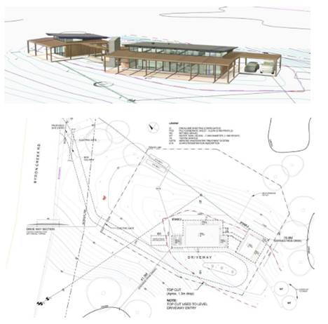
Proposed dwelling 3D and part
site plan
The proposed dwelling is sited approximately 68m from the
west boundary with a total floor area of 512.74 m2. This structure sits below
the highest point of the property.
Additional driveway access is proposed from Byron Creek
Road, which is a public road under Council control. Byron Creek Road is an
unsealed road which currently services three properties. The existing dwelling
is accessed via an existing driveway from Coopers Shoot Road which also
provides access to an approved farm shed and Lot 1 DP 381321.
The proposed dwelling and access is sited to avoid the creek
that runs through the property between the existing dwelling and the proposed
development site.
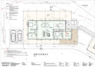
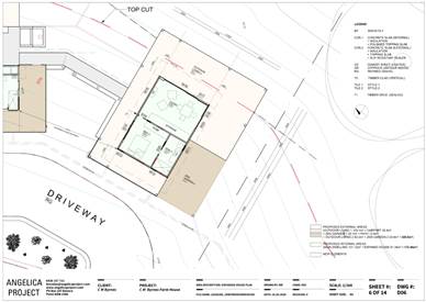
Floor plans of the
dwelling and expanded dwelling module
1.3. Description
of the site
A site inspection was carried out on 4 August 2020
|
Land is legally described
|
LOT: 5 DP: 747075
|
|
Property address
|
665 Coopers Shoot Road COOPERS SHOOT
|
|
Land is zoned:
|
RU2 Rural Landscape
|
|
Land area is:
|
38.41 ha
|
|
Property is constrained by:
|
Flood Liable Land, pockets of Bushfire prone land, pockets
of High Environmental Value, Dip Site Cattle Dip Buffer on part of site,
drinking water catchment.
|
|
Is a BDAR required due to the location of the proposed
development?
|
☐ Yes ☒ No
|
|
Are there any easements in favour of Council affecting the
site?
|
☐ Yes ☒ No
|
|
Is there a Vegetation Management Plan which might affect
the proposal?
|
☐ Yes ☒ No
|
|
Is there a Voluntary Planning Agreement which might affect
the proposal?
|
☐ Yes ☒ No
|
The site is a working cattle farm separated by a Crown owned
paper road which is currently unmade. Survey plan shows the driveway access to
the existing dwelling and adjoining lot is not located with the Crown road
reserve. There is a watercourse and dam on the site between the existing and
proposed dwelling. The proposed dwelling and access have been sited to
minimise impacts on cattle farm operations and to avoid ecological and
hydrological environmental impacts.
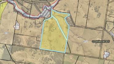
Zoning map
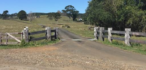
Existing site access
2. SUMMARY OF
REFERRALS
|
Referral
|
Issue
|
|
Environmental Health Officer
|
No objections subject to conditions.
|
|
Development Engineer
|
No objections subject to conditions.
|
|
S94 / Contributions Officer
|
No objections subject to conditions.
|
|
Land Information Officer
|
No objections subject to conditions.
|
3. SECTION
4.14 – BUSH FIRE PRONE LAND
Under section 4.14 of the
Act, Council must be satisfied prior to making a determination for development
on bush fire prone land, that the development complies with the document
‘Planning for Bush Fire Protection 2019’. The site is bush fire
prone land on a small part of the north western corner of the site and the
south western corner of the site. The dwelling and access are located over 200
metres from bushfire vegetation buffer to the north and more than 440 metres to
the bushfire vegetation buffer to the south. No bushfire protection
measures are required.
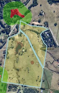
Bushfire mapping
4. SECTION 4.15C
– MATTERS FOR CONSIDERATION – DISCUSSION OF ISSUES
Having regard to the matters for consideration detailed in
Section 4.15(1) of the Environmental Planning & Assessment Act 1979
(EP&A Act), the following is a summary of the evaluation of the issues.
4.1 State Environmental
Planning Instruments
4.2A Byron Local Environmental
Plan 2014 (LEP 2014)
In accordance with LEP 2014
clauses 1.4 and 2.1 – 2.3:
(a) The
proposed development is defined in the LEP 2014 Dictionary as Dual occupancy
(detached);
(b) The
land is within the RU2 Rural Landscape according to the Land Zoning Map;
(c) The
proposed development is permissible with consent; and
(d) Regard
is had for the Zone Objectives as follows:
|
Zone Objective
|
Consideration
|
|
• To encourage sustainable primary
industry production by maintaining and enhancing the natural resource base.
• To maintain the rural landscape
character of the land.
• To provide for a range of compatible
land uses, including extensive agriculture.
• To enable the provision of tourist
accommodation, facilities and other small-scale rural tourism uses associated
with primary production and environmental conservation consistent with the
rural character of the locality.
• To protect significant scenic
landscapes and to minimise impacts on the scenic quality of the locality.
|
The proposed development is not contrary to the objectives
of the zone.
|
The remaining clauses have been taken into consideration in
the assessment of the subject development application in accordance with Section
4.15 of the EP&A Act. The proposed development complies with all of these
clauses (in some cases subject to conditions and/or to the satisfaction of
other assessing officers), except in relation to Clause 4.2D which is
considered further as follows:
Clause 4.1 E Minimum lot sizes for dual occupancies,
manor houses, multi dwelling housing and residential flat buildings
The site is 38.41 hectares; therefore the proposed dwelling
meets the minimum site area of 4,000 square metres required for dual occupancy
(detached) in the Zone RU2 Rural Landscape.
Clause 4.2A Erection of dwelling houses and dual
occupancies on land in certain rural zones
Development consent may be granted for the erection of a
dual occupancy on land to which this clause applies because the land is a lot
created before LEP 2014 commenced and on which the erection of a dual occupancy
was permissible immediately before that commencement. No dual occupancy already
exists on the lot and the new dwelling will result in a dual occupancy
(detached), which is permissible with consent.
Clause 4.3 Height of Buildings
The proposed single storey dwelling is 4.94 metres high and
less than the maximum permissible 9 metres.
Clause 5.16 Subdivision of, or dwellings on, land in
certain rural, residential or environment protection zones
The objective of this clause is to minimise potential land
use conflict between existing and proposed development on land in the rural,
residential or environment protection zones concerned (particularly between
residential land uses and other rural land uses).
The land is zoned under the Byron Local Environment Plan
2014 as RU2 Rural Landscape Zone, and is classified as Regionally Significant
Farmland under the Byron Shire Rural Land Use Strategy 2018. Council’s
Geocortex mapping shows that the land surrounding the parcel is comprised of contiguous
rural lots and farmland.
A land use conflict report prepared in support of the
application dated 18.06.2020 has been considered as satisfactory (Record #
E2020/52529) following referral and assessment by a Council Environmental
Health Officer.
The proposed structure is positioned in the centre of open
field with an enclosing fence line, fitted with an electric gate. This will
allow cattle to easily pass around the development when feeding in the northern
area of the property. Proposed ETA beds, part of the septic system are also
within the fence line are; preventing a potential conflict in feeding area. Two
proposed tanks sit just outside of the fenced area to the south-east, with
planned light fencing around their immediate position to prevent damage to tank
and external pump. Both electric gates from roadside and site entry will be
manually remote controlled to manage accessibility and prevent cattle from
reaching non-feeding areas.
The proposed dwelling to create a dual occupancy is compatible
with the surrounding land uses including existing cattle grazing on the site,
and is not envisaged that approval will result in significant land use
conflicts.
Clause 6.2 Earthworks
Minor earthworks are required to provide driveway access and
a building pad. Most of the site for the building is already cleared. No
geotechnical hazards have been identified using Council’s GIS or from the
site inspection. No retaining walls are proposed or required.
Clause 6.5 Drinking water catchments
The proposed dwelling is unlikely to have any adverse
impacts on the quality and quantity of water entering drinking water storages.
The site is suitable and has capacity to assimilate the wastewater from the
proposed development. A Section 68 application is approved concurrently with
this application to install a new OSMS – Approval No. 70.2020.296., which
is to be constructed in accordance with NSW Environment and Health Protection
Guidelines; and Council specifications.
Clause 6.6 Essential Services
Council can be satisfied that the following services that
are essential for the development can be made available:
(a) the supply of water,
(b) the supply of electricity,
(c) the disposal and management of sewage,
(d) stormwater drainage,
(e) suitable vehicular access.
Conditions are recommended.
|
What clause does the development not comply with and what
is the nature of the non-compliance?
|
Further consideration, including whether the development
application is recommended for approval or refusal accordingly
|
|
4.2D Erection of dual occupancies (detached)
and secondary dwellings in Zones RU1 and RU2
(1) The objectives of this clause are as
follows—
(a) to provide alternative accommodation for rural
families and workers,
(b) to ensure that development is of a scale and
nature that is compatible with the primary production potential, rural
character and environmental capabilities of the land,
(c) to set out consent considerations for
development of dual occupancies (detached) and secondary dwellings to address
matters such as access, siting, land suitability and potential impacts.
(2) Development consent must not be granted to
development for the purpose of a dual occupancy (detached) or secondary
dwelling on land in Zone RU1 Primary Production or Zone RU2 Rural Landscape
unless the consent authority is satisfied that—
(a) the development will not impair the use of the
land for agriculture or rural industries, and
(b) each dwelling will use the same vehicular
access to and from a public road, and
(c) any dwellings will be situated within 100
metres of each other, and
(d) the land is physically suitable for the
development, and
(e) the land is capable of accommodating the on-site
disposal and management of sewage for the development, and
(f) the development will not have an adverse impact
on the scenic amenity or character of the rural environment.
|
Each dwelling will be 113 metres apart and a second
driveway access is proposed to be used.
The assessment planner has considered the applicants
written request to vary these development standards. The request is in the
form and content required by the NSW Guide to Varying a development standard
(2011).
Having considered the applicant’s written request to
vary the development standard Council can be satisfied that the proposed
development is consistent with the relevant objectives of the RU2 zone
and development standard:
(a) to provide alternative accommodation for
rural families and workers,
(b) to ensure that development is of a scale and
nature that is compatible with the primary production potential, rural
character and environmental capabilities of the land,
(c) to set out consent considerations for
development of dual occupancies (detached) and secondary dwellings to address
matters such as access, siting, land suitability and potential impacts.
No public submissions were made.
The proposed development will not result in any adverse
impacts on the character, amenity and environment of the locality.
Upon review of the applicant's written request it is
considered that compliance with the development standards is unreasonable or
unnecessary in the circumstances of the case, with separate consideration for
each matter, as follows
Distance:
Moving the development site closer to the existing
dwelling would impact on the creek, vegetation, and cattle grazing.
Other sites within 100m radius would offer less privacy for all occupants,
reduced protection from prevailing weather conditions and increase the
potential for land use conflicts (disruptive to cattle grazing).
Access:
Alternative access from Byron Creek Road reduces the
general impact of the driveway because it avoids the need for a creek
crossing and will be a shorter driveway than would be possible if the
proposed dwelling used the same access to Coopers Shoot Road.
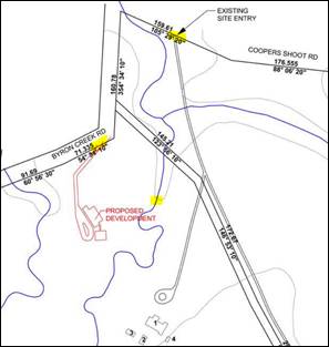
Location of dwellings,
existing access and proposed second access
The potential for any application to subdivide the Land
is highly unlikely to be supported with a minimum lot size requirement of
40ha under BLEP 2014.
In summary, the requirement to consider the distance
between buildings and an additional access under the current LEP means that
there will be a variation of 13% to the distance and 100% for the additional
driveway, which means the DA can only be determined by Council (being a
numeric variation greater than 10%).
|
4.3 Any proposed Instrument
that has been the subject of public consultation and has been notified to the
consent authority
Not applicable
4.4A Byron Shire Development Control Plan 2014
(DCP 2014)
Chapter C3 Visually prominent sites, visually prominent
development & view sharing
The single storey dwelling will be located on a level site
which is approximately 60 metres AHD, 40 metres below the highest point on the
lot. The 4.94 metre high building is modest in scale and existing
vegetation on site will ensure that development does not adversely impact on
the Shire’s scenic character and visual quality. A condition is
recommended to address materials and colours that must be muted bushland tones.
Chapter C4 Development in the Drinking Water Catchment
This chapter aims to facilitate and support the provisions
of Byron LEP 2014 relating to development in a drinking water catchment, as
considered in Section 4.2 above. The application has been assessed and
conditions of consent are recommended to ensure that development within the drinking
water catchments does not adversely impact on the quality or quantity of the
public water supply. The proposed development has been adequately designed
and assessed to prevent unacceptable risks to water quality, both individually
and in terms of incremental and cumulative risk.
Chapter D2 Residential Accommodation and Ancillary Development
in Rural Zones
The proposed development is setback metres over 60 metres to
Byron Creek Road and complies with the setback requirements including the 15
metre minimum setback to the road.
The development application was accompanied by sufficient
details including existing use of all parts of the site; potential conflicts,
including the distance from the proposed dual occupancy to adjoining land
holdings and access and site details.
The dual occupancy is proposed to be located so that it does
not create potential for conflict with adjoining land uses and is to be located
and will be retained on the same legal title as the principal dwelling house on
the property.
The proposal will result in two dwellings being located more
than 100 metres apart. Both dwellings will be serviced by a separate access
which is deemed to be the most orderly means of servicing the development to
minimise environmental impacts in the particular circumstances of this site.
The proposed dwelling has its own private open space, car
parking and is sited to retain mature vegetation on the site and avoid works
that will affect the creek. It will not generate additional adverse
environmental impacts through excessive vegetation removal for bushfire
protection or detract from the visual amenity of the locality.
Non compliance with the 100 metre is considered reasonable
and justifiable in the circumstances and on its own merit, as detailed under
Section 4.2 of this report.
Note. D2.3.3 Expanded House
Objectives
1. To facilitate the provision of a dwelling house
comprising a number of separate building components.
Prescriptive Measures
The design and use of the expanded house conforms to the
following relevant criteria:
a) No expanded house habitable outbuilding is to be
located more than 20m from the wall of the main building, measured from wall to
wall at the closest point;
b) the main building must contain an identifiable living
area including the kitchen;
c) a maximum of three outbuildings may be connected to
the main building by paths with an all-weather surface;
d) outbuildings are to be connected to the main building
by paths with an all weather surface;
e) no separate driveway, car parking area, garage or
carport structure is to be provided to service any outbuilding;
f) the outbuilding must be limited to a maximum floor
area of 45m2 excluding decks, verandahs, patios, balconies and the like;
g) none of the outbuildings is to contain facilities
(e.g. kitchen, sink or the like) that would enable the preparation of food or
beverages;
h) each separate outbuilding may incorporate a maximum of
two bedrooms (including rooms with an ensuite or bathroom).
The proposal raises no other issues under the DCP.
4.5 Environmental
Planning & Assessment Regulation 2000 Considerations
The proposal raises no issues
against the Regulations for consideration
4.6 The likely impacts of that
development, including environmental impacts on both the natural and built
environments, and social and economic impacts in the locality
|
Impact on:
|
Likely significant impact/s?
|
|
Natural environment
|
No. The proposal will not have a significantly adverse
impact on the natural environment of the locality.
|
|
Built environment
|
No. The proposal will not have a significantly adverse
impact on the built environment of the locality.
|
|
Social Environment
|
No. The proposal will not have a significant social impact
on the locality.
|
|
Economic impact
|
No. The proposal will not have a significant economic
impact on the locality.
|
Standard conditions of consent to apply in terms of hours of
construction work, noise, builders waste, sediment and erosion control measures
and the like.
4.7 The suitability of the site
for the development
The site is a serviced, unconstrained property and is
suitable for the proposed development subject to recommended conditions of
consent.
4.8 Submissions made in
accordance with this Act or the regulations
The development application was publicly exhibited. There
were no submissions
made on the development application.
4.9 Public interest
The proposed development is unlikely to prejudice or
compromise the public interest or create an undesirable precedent.
5. DEVELOPER
CONTRIBUTIONS
5.1 Water & Sewer Levies
No Section 64 levies will be required.
5.2 Section 7.11 Contributions
Section 7.11 Contributions will
be payable.
6. DISCLOSURE OF
POLITICAL DONATIONS AND GIFTS
|
Has a Disclosure Statement been received in relation
to this application
|
No
|
|
Have staff received a ‘gift’ from anyone
involved in this application that needs to be disclosed. Where the answer is
yes, the application is to be determined by the Director or Manager of the
Planning, Development and Environment Division.
|
No
|
Provide Disclosure Statement register details here: Not
applicable
7. CONCLUSION
The DA proposes a new dwelling
to create a dual occupancy (detached) in two stages:
Stage 1 – Main dwelling with 2 bedrooms, 2 bathrooms,
kitchen, laundry and car port.
Stage 2 – Expanded outbuilding with 1 bedroom, 1
bathroom and separate living area.
The proposed development is satisfactory having regard to
the relevant environmental planning instruments and planning controls
applicable to the site.
The proposal raises no significant issues in terms of
environmental impacts which cannot be managed and the site is considered
suitable for the development.
The application appropriately addresses the relevant
constraints applying to the site, and is recommended for approval subject to
the conditions of consent.
Staff Reports - Sustainable Environment and Economy 13.7
Report No. 13.7 PLANNING
- Development Application 10.2020.30.1 Dual Occupancy at 20 Prince Street
Mullumbimby
Directorate: Sustainable
Environment and Economy
Report
Author: Luke
Munro, Planner
File No: I2020/1522
Proposal:
|
Proposal description:
|
Dual Occupancy
|
|
Property description:
|
LOT: 12 DP: 527314
|
|
20 Prince Street MULLUMBIMBY
|
|
Parcel No/s:
|
8780
|
|
Applicant:
|
Town Planning Studio Pty Ltd
|
|
Owner:
|
Mr J M Fehlberg & Ms M T Franz
|
|
Zoning:
|
R2 Low Density Residential / PART RU2 Rural Landscape
|
|
Date received:
|
17 January 2020
|
|
Integrated / Designated Development:
|
☐
Integrated
|
☐
Designated
|
X
Not applicable
|
|
Concurrence required
|
No
|
|
Public notification or exhibition:
|
- Level
1 advertising under DCP 2014 Part A14 – Public Notification and
Exhibition of Development Applications
- Exhibition
period: 24/1/20 to 7/2/20
- Submissions received:
None
|
|
Planning Review Committee:
|
Not applicable
|
|
Variation request
|
Clause 4.6
|
|
Delegation to determine
|
Council
|
|
Issues:
|
Clause 4.6 variation to Clause 4.1E Minimum lot sizes for dual
occupancies, manor houses, multi dwelling housing and residential flat
buildings
|
Summary:
The development application seeks approval for a shed
conversion to create a dual occupancy (detached) on split zoned land with
different lot sizes applicable. A variation request to the minimum lot size for
a dual occupancy development is necessary and has been assessed with the zone
split in mind and can be supported.
The proposal is otherwise considered acceptable having
regard to the provisions of the LEP and DCP 2014, and is recommended for
approval subject to conditions.
NOTE TO COUNCILLORS:
In accordance with the
provisions of S375A of the Local Government Act 1993, a Division is to be
called whenever a motion for a planning decision is put to the meeting, for the
purpose of recording voting on planning matters. Pursuant to clause 2(a)
under the heading Matters to be Included in Minutes of Council Meetings of
Council's adopted Code of Meeting Practice (as amended) a Division will be
deemed to have been called by the mover and seconder of all motions relating to
this report.
|
RECOMMENDATION:
That pursuant to Section 4.16 of the Environmental
Planning & Assessment Act 1979, Development Application No. 10.2020.30.1 for Dual Occupancy, be granted consent subject
to the conditions listed in Attachment 2 (#E2020/86238).
|
Attachments:
1 10.2020.30.1
- Plans, E2020/83116
2 10.2020.30.1
- Conditions of consent, E2020/86238
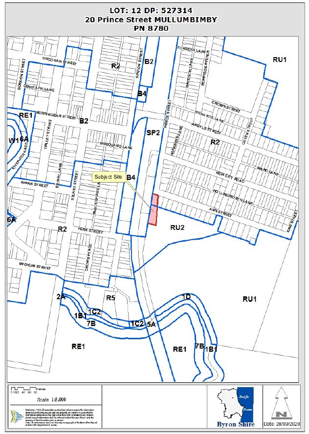
REPORT
Assessment:
1. INTRODUCTION
1.1. History/Background
The site has the following development history:
10.2001.742.1 Two Storey Dwelling
and shed
Approved 06.01.2003
10.2001.742.2 S96 modification
to amend Condition 14 Approved
26.02.2003
10.2001.742.3 Modification to
alter stormwater disposal
Approved 09.02.2004
10.2010.268.1 Use of
unauthorised dwelling additions
Approved 11.08.2010
1.2. Description
of the proposed development
The application seeks to convert an existing shed to a
dwelling. The new dwelling will create a dual occupancy (detached) on the
subject site. The existing shed (new dwelling) is located in the south-western
corner of the property. The existing single storey dwelling is located in the
northern area of the property, and is to remain there.
The shed conversion will create:
· two
bedrooms;
· one
bathroom;
· combined
kitchen and living room leading onto a large deck;
· storage
area and double carport.
The shed conversion will include a new bearer and joist
floor to raise the internal floor level to meet flood requirements. An existing
driveway from Prince Street is proposed to access the rear dwelling.
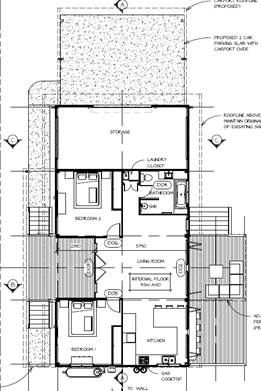
The development application proposes a dual occupancy
(detached) on a lot with an area of 2,384m2 that has a split zoning.
Approximately one third of the northern area of the site is zoned R2
Residential with the southern two thirds of the site zoned RU2 Rural Landscape
Zone under Byron Local Environmental Plan 2014. The existing dwelling is
located in the R2 zone; the proposed dwelling (shed) is located in RU2 zone.
This creates a conflict of development standard. As such, a request for a
variation under clause 4.6 of the LEP has been submitted by the applicant. The
R2 zone requires a minimum lot size of 800m2 and the RU2 Zone
requires a minimum of 4,000m2. The applicant’s variation
request to the RU2 lot size is supported and the development application is
recommended for approval despite the non-compliance.
Further, and of note - the site is subject to further
investigation under the Residential Strategy (Council Resolution 20-276 –
further addressed in Sections 1.3 & 4.2A of this report). This
zone and development standard anomaly is likely to be corrected as a result.
1.3. Description
of the site
A site inspection was carried out on 26 March 2020.
The site contains a single storey dwelling and a detached
shed. The dwelling is positioned near the front property boundary (north). The
shed is located within the south-western corner of the site. The site has lawn
areas, landscaped gardens and is partly fenced.
The site is a large flat flood prone corner lot measuring
approximately 100m x 20m. The site is adjacent to the North Coast Railway to
the west and the site was apparently used for railway purposes as a fuel depot.
Adjoining development to the north and east consists of
similar residential dwellings.
|
Land is legally described as
|
LOT: 12 DP: 527314
|
|
Property address is
|
20 Prince Street MULLUMBIMBY
|
|
Land is zoned:
|
R2 Low Density Residential / PART RU2 Rural Landscape
|
|
Land area is:
|
2384 m2
|
|
Property is constrained by:
|
Flood Liable Land
Acid Sulfate Soils Class
4
|
|
Is a BDAR required due to the location of the proposed
development?
|
☐ Yes X No
|
|
Are there any easements in favour of Council affecting the
site?
|
☐ Yes X No
|
|
Is there a Vegetation Management Plan which might affect
the proposal?
|
☐ Yes X No
|
|
Is there a Voluntary Planning Agreement which might affect
the proposal?
|
☐ Yes X No
|
Council at the Ordinary (Planning) Meeting on the 18 June
2020 resolved (resolution 20-276) to support the Residential Strategy
being updated to include the subject site (as detailed in #E2020/40080 –
map shown below), as an investigation area in the Strategy:
a) part of Lot 12 DP 527314 (20 Prince St Mullumbimby) due to Strategy
investigation areas to the south east potentially contributing to this being a
small pocket of isolated rural land within the Mullumbimby township.
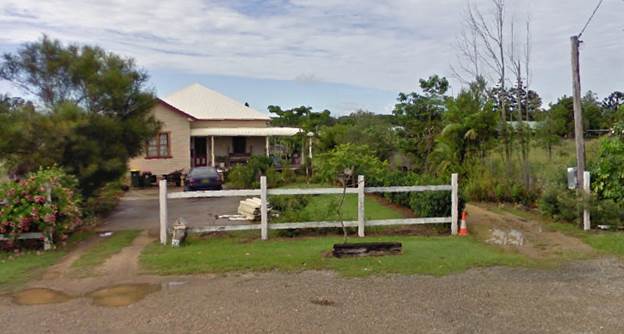
The portion of RU2 Zoned land is to be incorporated into the
Strategy “due to Strategy investigation areas to the south east
potentially contributing to this being a small pocket of isolated rural land
within the Mullumbimby township.”
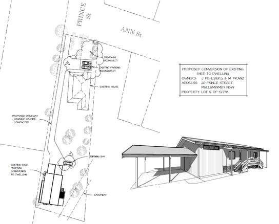
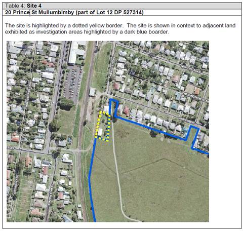
2. SUMMARY OF
REFERRALS
|
Referral
|
Issue
|
|
Environmental Health Officer*
|
No objections subject to conditions.
|
|
Development Engineer
|
No objections subject to conditions.
|
|
Building Surveyor
|
No objections subject to conditions.
|
|
S64 / Systems Planning Officer
|
No objections subject to conditions.
|
|
S94 / Contributions Officer
|
No objections subject to conditions.
|
|
John Holland Rail
|
No objections subject to conditions.
|
* Conditions provided in the above referral are included
in the Recommendation of this Report below
3. SECTION 4.14
– BUSH FIRE PRONE LAND
Under section 4.14 of the Act, Council must be satisfied
prior to making a determination for development on bush fire prone land, that
the development complies with the document ‘Planning for Bush Fire
Protection 2006’. The site is not bush fire prone land.
4. SECTION 4.15C
– MATTERS FOR CONSIDERATION – DISCUSSION OF ISSUES
Having regard to the matters for consideration detailed in
Section 4.15(1) of the Environmental Planning & Assessment Act 1979
(EP&A Act), the following is a summary of the evaluation of the issues.
4.1 State
Environmental Planning Instruments
4.2A Byron Local Environmental Plan 2014 (LEP 2014)
In accordance with LEP 2014 clauses 1.4 and 2.1 – 2.3:
(a) The
proposed development is defined in the LEP 2014 Dictionary as Dual Occupancy;
(b) The
land is within the R2 Low Density Residential / PART RU2 Rural Landscape
according to the Land Zoning Map;
(c) The
proposed development is Permitted with Consent on both the R2 and RU2 Zones;
and
(d) Regard
is had for the Zone Objectives as follows:
|
Zone Objective
|
Consideration
|
|
Zone
RU2 Rural Landscape
1 Objectives
of zone
• To encourage sustainable
primary industry production by maintaining and enhancing the natural resource
base.
• To maintain the rural
landscape character of the land.
• To provide for a range of
compatible land uses, including extensive agriculture.
• To enable the provision
of tourist accommodation, facilities and other small-scale rural tourism uses
associated with primary production and environmental conservation consistent
with the rural character of the locality.
• To protect significant
scenic landscapes and to minimise impacts on the scenic quality of the
locality.
|
The use of the site as a dual occupancy does not conflict
with the objectives of the zone in these circumstances.
The site is currently under investigation for a zone
review as part of Council’s Residential Strategy (Resolution 20-276).
The use of the site as a Dual Occupancy will not conflict
with the existing character of the area as it is a conversion of an existing
shed into a dwelling.
|
|
Zone
R2 Low Density Residential
1 Objectives
of zone
• To provide for the
housing needs of the community within a low density residential environment.
• To enable other land uses
that provide facilities or services to meet the day to day needs of
residents.
|
The proposal will provide additional housing in the area.
|
The remaining underlined clauses have been taken into
consideration in the assessment of the subject development application in
accordance with Section 4.15 of the EP&A Act. The proposed development
complies with all of these clauses (in some cases subject to conditions and/or
to the satisfaction of other assessing officers), except in relation to Clause
4.1E Minimum lot sizes for dual occupancies, manor houses, multi dwelling
housing and residential flat buildings which is considered further as
follows:
|
What clause does the development not comply with and
what is the nature of the non-compliance?
|
Further consideration, including whether the
development application is recommended for approval or refusal accordingly
|
|
4. 4.1E Minimum lot sizes for dual
occupancies, manor houses, multi dwelling housing and residential flat
buildings
(1) The objective of this
clause is to achieve planned residential density in certain zones.
(2) Development consent may be granted
to development on a lot in a zone shown in Column 2 of the table to this
clause for a purpose shown in Column 1 of the table opposite that zone, if
the area of the lot is equal to or greater than the area specified for that
purpose and shown in Column 3 of the table.
(3) In this clause, manor
house has the same meaning as in clause 1.5 of State Environmental Planning
Policy (Exempt and Complying Development Codes) 2008.
Note—
Clause 3B.1A of State
Environmental Planning Policy (Exempt and Complying Development Codes) 2008 provides that development for the
purposes of manor houses is permitted with development consent in Zones R2
and R3.
|
Column 1
|
Column 2
|
Column 3
|
|
Dual occupancy (attached)
|
Zone R2 Low Density Residential, Zone R3 Medium Density
Residential
|
800 square metres
|
|
Dual occupancy (attached)
|
Zone RU1 Primary Production, Zone RU2 Rural Landscape,
Zone RU5 Village, Zone R5 Large Lot Residential
|
4,000 square metres
|
|
Dual occupancy (detached)
|
Zone RU1 Primary Production, Zone RU2 Rural Landscape
|
4,000 square metres
|
|
Dual occupancy (detached)
|
Zone R2 Low Density Residential, Zone R3 Medium
Density Residential
|
800 square metres
|
|
Manor house
|
Zone R2 Low Density Residential
|
1,000 square metres
|
|
Manor house
|
Zone R3 Medium Density Residential
|
800 square metres
|
|
Multi dwelling housing
|
Zone R2 Low Density Residential
|
1,000 square metres
|
|
Multi dwelling housing
|
Zone R3 Medium Density Residential
|
800 square metres
|
|
Residential flat building
|
Zone R3 Medium Density Residential
|
800 square metres
|
|
See assessment below.
|
The Applicant has submitted a clause 4.6 variation request.
The clause 4.6 variation request is considered with reference to relevant
matters as follows:
a) Introduction
– Summary of proposed development
The proposal is for a shed
conversion to create a dual occupancy dwelling (detached) on a lot with an area
of 2,384m2. This lot has a split zoning with a minimum lot size for
a RU2 Zone being 4000m2, and 800m2 for the R2 Zone. The proposed
dwelling is sited on the RU2 zoned area of the land and as such does not meet
the development standard requirement for RU2 lot size.
b) Clause
4.6 Exceptions to Development Standards
Clause 4.6 of Byron LEP 2014 is
accessible via: https://legislation.nsw.gov.au/view/html/inforce/current/epi-2014-0297#sec.4.6
c) The
Development Standard to be varied
The development standard to be
varied is Clause 4.1E (2).
d) Extent
of Variation to the Development Standard
This lot has a split zoning with a
minimum lot size for the RU2 Zone being 4000m2, and 800m2
for the R2 Zone. The proposed dwelling is sited on the RU2 zoned area of the
land and as such does not meet the development standard requirement for RU2 lot
size.
The southern portion of the site
in the RU2 Zone is 1,616m2 (or 40.4%) below the minimum lot size for
a dual occupancy in the RU2 Zone.
Note: If the new dwelling was
located on the R2 land it would comply.
e) Objective
of the Development Standard
The objectives of the development
standard are stated in LEP 2014 subclause 4.1E (1) which states: The objective of this clause is to achieve planned residential density
in certain zones.
f) Objectives
of the Zone
The objectives of the R2 Low
Density Residential Zone which applies to the location of the proposed Dual
Occupancy (detached) are stated in the Land Use Table to LEP clause 2.8, which
states:
• To provide for the housing needs of
the community within a low density residential environment.
• To enable other land uses that
provide facilities or services to meet the day to day needs of residents.
The objectives of the RU2 Rural
Landscape Zone which applies to the location of the proposed Dual Occupancy
(detached) are stated in the Land Use Table to LEP clause 2.8, which states:
• To encourage sustainable primary industry
production by maintaining and enhancing the natural resource base.
• To maintain the rural landscape character
of the land.
• To provide for a range of compatible land
uses, including extensive agriculture.
• To enable the provision of tourist
accommodation, facilities and other small-scale rural tourism uses associated
with primary production and environmental conservation consistent with the
rural character of the locality.
• To protect significant scenic landscapes
and to minimise impacts on the scenic quality of the locality.
g) Assessment
– the specific questions to be addressed:
(a) Clause
4.6(3)(a) – Is compliance with the development standard unreasonable or
unnecessary in the circumstances of the case?
This lot has a split zoning with a
minimum lot size for the RU2 Zone being 4000m2, and 800m2
for the R2 Zone. The proposed dwelling is sited on the RU2 zoned area of the
land and as such does not meet the development standard requirement for RU2 lot
size.
If the new dwelling was located on
the R2 land it would comply. As the new dwelling is the conversion of an
existing shed, it is unreasonable and unnecessary to require compliance with
the RU2 lot size.
The provisions of Byron Local
Environmental Plan 2014 allow dual occupancy development in both zones.
That is all the proposal is seeking to do on the site.
Further given the inclusion of the
site in the Residential Strategy (see Section 4.3 of this report), the
development of the site for a dual occupancy (detached) will achieve the
objective of Clause 4.1E by achieving the planned residential density within the
zone.
(b) Clause
4.6(3)(b) – Are there sufficient environmental planning grounds to
justify contravening the development standard?
There are sufficient grounds to
justify the proposal on environmental planning grounds as follows:
· Council has resolved
to include the site within the Residential Strategy as an investigation area
(Resolution 20-276)
· The site is
located within an existing urban area and partially zoned as R2 Low Density
Residential Zone and is in close proximity to the Mullumbimby business district
and with a level topography, pedestrian and cycling is a common form of
transport;
· Retaining the
existing dwelling house within the streetscape – no significant change to
streetscape or character of Prince Street and locality.
· The development
will enable the efficient use of resources through the retention and adaptive
reuse of the shed into a dwelling;
· Given the site is
located within a Flood Prone Area there will be no increase in intensity of
development as a result of this proposal;
· The site has an
area of 2,384m2 which already limits any agricultural or rural
industry potential given the split zoning and adjoining land uses. The
development will not change this.
· Pedestrian
accessibility and service provision (reticulated water and sewer, garbage
collection and postal services) are available to the site;
(c) Clause
4.6(4)(a)(ii) – Is the proposed development in the public interest? Is it
consistent with the objectives of the standard and the zone as set out above?
The circumstances
of the case warrant a more flexible approach to application of the minimum lot
size required for a dual occupancy (detached) given the split zoning of the
site and the development is further supported by the inclusion of the site as
an investigation area in the Residential Strategy due to Strategy investigation
areas to the south east potentially contributing to this being a small pocket
of isolated rural land within the Mullumbimby township. There is no conflict
with the public interest the result of the proposal.
The
Applicant’s variation request is supported and the development
application is recommended for approval despite the non-compliance.
4.2D Erection of dual occupancies
(detached) and secondary dwellings in Zones RU1 and RU2
Council must not grant consent for development under Clause
4.2D, unless the consent authority is satisfied of the following.
|
Clause
|
Comment
|
|
(a) the development will not impair the use of the land for
agriculture or rural industries, and
|
The site has an area of 2,384m2 which already
limits any agricultural or rural industry potential given the split zoning
and adjoining land uses. The development will not change this.
|
|
(b) each dwelling will use the same vehicular access to and
from a public road, and
|
The new dwelling will use a common vehicular access point
adjacent to the western boundary of the site.
|
|
(c) any dwellings will be situated within 100 metres of each
other, and
|
The new dwelling will be located within 40m of the
existing dwelling.
|
|
(d) the land is physically suitable for the development, and
|
The site is serviced and is currently under consideration
in the Residential Strategy, as an investigation area. The land is suitable
for the proposed development
|
|
(e) the land is capable of accommodating the on-site
disposal and management of sewage for the development, and
|
Not Applicable – the site has access to reticulated
sewerage and onsite effluent disposal is not required.
|
|
(f) the development will not have an adverse impact on the
scenic amenity or character of the rural environment.
|
The development results in no change to the scenic amenity
of the area as the new dwelling is the result of an existing shed conversion.
|
The proposed dual occupancy (detached) complies with the
requirements of Clause 4.2D as described above.
4.3 Height of buildings
There will be no change to the height of either the existing
dwelling house or to the shed which will be converted into a dual occupancy
(detached).The existing height of the shed will be retained at 5.6m, below the
9m maximum building height.
4.4 Floor Space Ratio
The site has a split zoning with the front portion of the
lot containing the existing dwelling house being in the R2 Zone with a FSR of
0.5:1 the remainder of the site is in the RU2 Zone where there are no FSR
controls. There is no change to the existing FSR in the R2 Zone and overall the
site has a FSR of 0.09:1 – well below the FSR of the surrounding R2 residential
area of 0.5:1.
6.1 Acid Sulfate Soils
Soil disturbance is proposed
and where excavations are greater than 1m in depth a condition has been
recommended requiring the preparation of an Acid Sulfate Soils Management Plan
where excavations of over 1m occur.
6.3 Flood Planning
The existing dwelling house will remain onsite and the
proposed shed conversion will include a raised flooring system to comply with
the applicable Flood Planning Level of 4.33m AHD.
6.6 Essential Services
The site is connected to sewer, water, electricity, access
to a formed road via a single crossover/driveway and stormwater dispersal as
addressed in this report and as assessed by Council engineers.
The proposal raise no other issues under the LEP.
4.3 Any proposed Instrument
that has been the subject of public consultation and has been notified to the
consent authority
No instrument. The site is subject to further investigation
under the Residential Strategy (Council Resolution 20-276 – further
addressed in Sections 1.3 & 4.2A of this report). The zone and
development standard anomaly that currently exists is likely to be corrected as
a result.
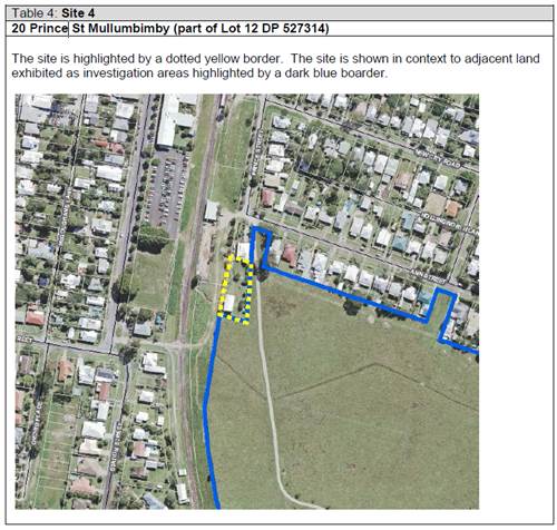
4.4A Byron Shire
Development Control Plan 2014 (DCP 2014)
Chapter B4 Traffic
planning, vehicle parking, circulation and access
The proposal provides
adequate car parking for both dwellings as per the DCP.
Chapter C2 Areas affected by flood
The finished floor level of the proposed dual occupancy
dwelling is 4.5m AHD which is above the 2050 flood planning level of 4.33m AHD.
The dwelling is to be raised on piers to allow the flow of
flood waters through the building. The storage area is slab on ground which
will exclude flood waters from the area however this small volume of flood
water to be displaced is unlikely to create any significant increase in flood
levels to adjoining properties.
Chapter D1 Residential Accommodation in Urban, village
and Special Purpose Zones
Given the development is a conversion of an existing shed
there will be no significant change in the layout of the site or to the
character of the area.
Chapter D2 Residential Accommodation and Ancillary
development in Rural Zones
Given the development is a conversion of an existing shed
there will be no significant change in the layout of the site or to the character
of the area.
Chapter E3 Mullumbimby
The site is identified in Figure E3.1 – Mullumbimby
Residential Character Areas in the Sensitive Character Area. The proposal does
not conflict with these controls.
Further the development complies with the objectives for
Precinct 3 by providing urban consolidation of underdeveloped lots in close
proximity to Precinct 1 (town centre).
4.5 Any Planning Agreement or
Draft Planning Agreement?
|
|
Yes
|
No
|
|
Is there any applicable planning agreement or draft
planning agreement?
|
☐
|
X
|
|
|
4.6 Environmental Planning
& Assessment Regulation 2000 Considerations
|
Clause
|
This control is applicable to the proposal:
|
I have considered this control as it relates to the
proposal:
|
If this control is applicable, does the proposal
comply?
|
|
92
|
No
|
N/A
|
N/A
|
|
93
|
Yes
|
Yes
|
Yes – The proposed dwelling will need to comply with
the Building code requirements for fire safety
|
|
94
|
No
|
N/A
|
N/A
|
|
94A
|
No
|
N/A
|
N/A
|
* Non-compliances and any other significant issues
discussed below
4.7 Any
Coastal Zone Management Plan?
|
|
Satisfactory
|
Unsatisfactory
|
Not applicable
|
|
Is there any applicable
coastal zone management plan?
|
☐
|
☐
|
X
|
|
|
4.8 The likely impacts of that
development, including environmental impacts on both the natural and built
environments, and social and economic impacts in the locality
|
Impact on:
|
Likely significant impact/s?
|
|
Natural environment
|
No. The proposal will not have a significantly adverse
impact on the natural environment of the locality.
|
|
Built environment
|
No. The proposal will not have a significantly adverse
impact on the built environment of the locality.
|
|
Social Environment
|
No. The proposal will not have a significant social impact
on the locality. The development will provide additional housing within
Mullumbimby.
|
|
Economic impact
|
No. The proposal will not have a significant economic
impact on the locality.
|
Conditions of consent to apply in relation controlling
construction activities such ass hours of work, construction noise, builders
waste and the like.
4.9 The suitability of the site
for the development
The site is a serviced, unconstrained property and is
suitable for the proposed development.
4.10 Submissions made in accordance with
this Act or the regulations
The development application was publicly exhibited from
24/1/20 to 7/2/20. No submissions were received.
4.11 Public interest
The proposed development is unlikely to prejudice or
compromise the public interest or create an undesirable precedent.
5. DEVELOPER
CONTRIBUTIONS
5.1 Water & Sewer Levies
Section 64 levies will be payable.
5.2 Section 7.11 Contributions
Section 7.11 Contributions will
be payable.
6. DISCLOSURE OF
POLITICAL DONATIONS AND GIFTS
|
Has a Disclosure Statement been received in relation
to this application
|
No
|
|
Have staff received a ‘gift’ from anyone
involved in this application that needs to be disclosed. Where the answer is
yes, the application is to be determined by the Director or Manager of the
Planning, Development and Environment Division.
|
No
|
Provide Disclosure Statement register details here: Not
applicable
7. CONCLUSION
The application is recommended for approval subject to the conditions
of consent
Staff Reports - Sustainable Environment and Economy 13.8
Report No. 13.8 PLANNING
- Development Application 10.2020.145.1 Boundary Adjustment and Demolition of
Garage and Shed at 35A and 35B Argyle Street Mullumbimby
Directorate: Sustainable
Environment and Economy
Report
Author: Luke Munro,
Planner
File No: I2020/1523
Proposal:
|
DA No:
|
10.2020.145.1
|
|
Proposal description:
|
Boundary Adjustment and Demolition of Garage and Shed
|
|
Property description:
|
LOT: 7 SEC: 2 DP: 4721, LOT: 8 SEC: 2 DP: 4721
|
|
35A Argyle Street MULLUMBIMBY, 35B Argyle Street
MULLUMBIMBY
|
|
Parcel No/s:
|
15470, 125930
|
|
Applicant:
|
Mrs S A McGarry
|
|
Owner:
|
Mr D Harper & Ms E Ricks
|
|
Zoning:
|
R2 Low Density Residential
|
|
Date received:
|
25 March 2020
|
|
Integrated / Designated Development:
|
☐
Integrated
|
☐
Designated
|
☒
Not applicable
|
|
Concurrence required
|
No
|
|
Public notification or exhibition:
|
- Level
1 advertising under DCP 2014 Part A14 – Public Notification and
Exhibition of Development Applications
- Exhibition
period: 7/4/2020 - 28/4/2020
- Submissions received: 0
|
|
Planning Review Committee:
|
Not applicable
|
|
Variation request
|
Clause 4.6
|
|
Delegation to determine
|
Council
|
|
Issues:
|
· Clause 4.6
variation to Minimum Lot Size
|
Summary:
Approval is sought for the re-subdivision of two lots into two
lots by way of a boundary adjustment and Demolition of a Garage and Shed over 35A
Argyle Street and 35B Argyle Street, Mullumbimby. The existing lots are both
currently undersized at 474.6m2.
The resultant subdivision will create the following:
· Proposed
Lot 77 – 453m2 - vacant land with access via an existing
crossover to Argyle Street.
· Proposed
Lot 78 – 497m2 - contain the existing dwelling house with
access from Ward Lane via an existing approved crossover.
The application is supported by a request for a variation
pursuant to clause 4.6 of the LEP as both lots created are less then the
required minimum of 600m2. Given the existing lot size and
arrangement, a more flexible approach to lot size is warranted and the
variation to the minimum lot size provisions is supported in this
instance.
The proposed development is considered to be an appropriate
response to the characteristics of the site and the neighbourhood having regard
to the provisions of the LEP and Byron DCP 2014, and is recommended for
approval subject to conditions.
NOTE TO COUNCILLORS:
In accordance with the
provisions of S375A of the Local Government Act 1993, a Division is to be
called whenever a motion for a planning decision is put to the meeting, for the
purpose of recording voting on planning matters. Pursuant to clause 2(a)
under the heading Matters to be Included in Minutes of Council Meetings of
Council's adopted Code of Meeting Practice (as amended) a Division will be
deemed to have been called by the mover and seconder of all motions relating to
this report.
|
RECOMMENDATION:
That pursuant to
Section 4.16 of the Environmental Planning & Assessment Act 1979,
Development Application No. 10.2020.145.1 for Boundary Adjustment and Demolition of Garage and Shed, be granted
consent subject to conditions listed in Attachment 2 (#E2020/86240).
|
Attachments:
1 10.2020.145.1
- Plans, E2020/86331
2 10.2020.145
- Conditions of consent, E2020/86240
REPORT
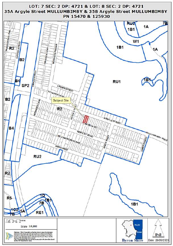
Assessment:
1. INTRODUCTION
1.1. History/Background
Previous development history of the site: 6.1975.2045.1
Building Application for Double Garage
1.2. Description
of the proposed development
This application seeks approval for Boundary Adjustment and
Demolition of Garage and Shed.
The existing dwelling house straddles the two lots, each
with an area of 474.6m2 (Lot 7 Sec.2 DP4721 and Lot 8 Sec.2 DP4721). The
proposal will adjust the boundaries of the existing 2 lots to enable the siting
of the existing timber dwelling to be fully contained within proposed Lot 78.
The resultant lots will be as follows:
· Lot
77 – 453m2 and vacant land with access gained via an existing
crossover to Argyle Street.
· Lot
78 – 497.3m2 and will contain the existing dwelling house.
Access will be gained from Ward Lane via an existing approved crossover.
There is adequate area for parking of two vehicles on both
lots.
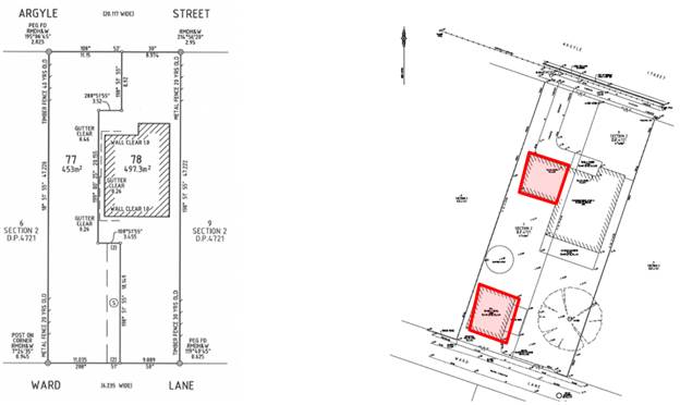
Plan of subdivision Garage
and Shed - previously demolished
The garage that was previously attached to the existing
dwelling has been demolished and enables the existing dwelling to be contained
within a single allotment where subject to the proposed boundary
reconfiguration/subdivision as part of the current proposal. It should be noted
that the garage and shed have already been demolished, boundaries surveyed and
an adjoining fence constructed.
There are no issues arising from the removal of the garage
or shed as both proposed lots have adequate vehicular access to enable parking
onsite in accordance with the Byron DCP 2014.
1.3. Description
of the site
A site inspection was carried out on 22 May 2020
|
Land is legally described
|
LOT: 7 SEC: 2 DP: 4721, LOT: 8 SEC: 2 DP: 4721
|
|
Property address
|
35A Argyle Street MULLUMBIMBY, 35B Argyle Street
MULLUMBIMBY
|
|
Land is zoned:
|
R2 Low Density Residential
|
|
Land area is:
|
474.2 m2+ 474.2 m2
|
|
Property is constrained by:
|
Flood Liable Land
Acid Sulfate Soils Class
3
|
|
Is a BDAR required due to the location of the proposed
development?
|
☐ Yes ☒ No
|
|
Are there any easements in favour of Council affecting the
site?
|
☐ Yes ☒ No
|
|
Is there a Vegetation Management Plan which might affect
the proposal?
|
☐ Yes ☒ No
|
|
Is there a Voluntary Planning Agreement which might affect
the proposal?
|
☐ Yes ☒ No
|
|
|
|
Photo 1: Argyle Street frontage
|
|
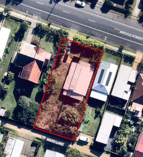
|
|
Photo 2: Aerial photo of subject site showing
(garage and shed demolished)
|
2. SUMMARY OF
REFERRALS
|
Referral
|
Issue
|
|
Development Engineer
|
No objections subject to conditions.
|
|
S64 / Systems Planning Officer
|
No objections subject to conditions.
|
|
S94 / Contributions Officer
|
No objections subject to conditions.
|
3. SECTION 4.14
– BUSH FIRE PRONE LAND
Under section 4.14 of the Act, Council must be satisfied
prior to making a determination for development on bush fire prone land, that
the development complies with the document ‘Planning for Bush Fire
Protection 2006’. The site is not bush fire prone land.
EFFECT OF 10/50 RULE ON SIGNIFICANT VEGETATION
The site is not bushfire prone land.
4. SECTION 4.15C
– MATTERS FOR CONSIDERATION – DISCUSSION OF ISSUES
Having regard to the matters for consideration detailed in
Section 4.15(1) of the Environmental Planning & Assessment Act 1979
(EP&A Act), the following is a summary of the evaluation of the issues.
4.1 State Environmental
Planning Instruments
|
|
Satisfactory
|
Unsatisfactory
|
|
State
Environmental Planning Policy No 55—Remediation of Land
|
☒
|
☐
|
|
Consideration: Site has been subdivided for residential
use since 8 October 1905. Proposal raises no issues in terms of
contamination. The site has an existing residential dwelling onsite with
records showing sewer was connected to the site in 1966 (Tested 22/7/1966)
with a sewerage drainage diagram dated the 20 June 1968. The site has been
developed for residential purposes for over 50 years. No issues are raised in
regards to potential contamination.
|
|
State Environmental Planning Policy (Coastal Management)
2018
|
☒
|
☐
|
|
Consideration:
The site is partially mapped
within the Coastal Environment Area.
The boundary realignment will
not result in any works that would impact on the coastal processes or
integrity of waterways. No substantive issues are raised in regard to this.
|
4.2A Byron Local Environmental Plan 2014 (LEP 2014)
In accordance with LEP 2014 clauses 1.4 and 2.1 – 2.3:
(a) The
proposed development is defined in the LEP 2014 Dictionary as Subdivision;
(b) The
land is within the R2 Low Density Residential according to the Land Zoning Map;
(c) The
proposed development is Permitted with Consent; and
(d) Regard
is had for the Zone Objectives as follows:
|
Zone Objective
|
Consideration
|
|
To provide for the
housing needs of the community within a low density residential environment.
|
The proposed subdivision/boundary realignment will enable
the use of an existing lot for additional housing in the locality and
maintains the existing character of the residential area.
|
|
To enable other land
uses that provide facilities or services to meet the day to day needs of
residents.
|
Not Applicable
|
4.1
Minimum subdivision lot size
Clause 4.1 of LEP 2014 states
(1) The objectives of this clause are
as follows—
(a) to ensure that lot sizes are
compatible with local environmental values and constraints,
(b) to facilitate efficient use
of land resources for residential and other human purposes.
(2) This clause applies to a
subdivision of any land shown on the Lot Size Map that requires development consent and that is carried
out after the commencement of this Plan.
(3) The size of any lot resulting
from a subdivision of land to which this clause applies is not to be less than
the minimum size shown on the Lot Size Map in relation to that land.
(4) This clause does not apply in
relation to the subdivision of any land—
(a) by the registration of a
strata plan or strata plan of subdivision under the Strata Schemes Development Act 2015, or
(b) by any kind of subdivision
under the Community Land Development Act 1989.
Comment
The existing dwelling house
straddles two equal sized lots, each with an area of 474.6m2 (Lot 7 and Lot 8
Sec. 2 DP4721). The proposal will adjust the boundaries of the existing 2 lots
to enable the siting of the existing dwelling house to be retained on a single allotment.
The proposed lots sizes are less than the required 600m2 under
clause 4.1. The applicant has submitted a clause 4.6 variation request with
reference to relevant matters as follows:
a) Introduction
– Summary of proposed development
The development application
proposes a boundary adjustment of two (2) equal sized lots of 474.6m2
into two (2) lots, with an area of 453m2 (Lot 77) and 497.3m2
(Lot 78 – which will retain the existing dwelling house).
b) Clause
4.6 Exceptions to Development Standards
Clause 4.6 of Byron LEP 2014
enables development standards to be varied.
c) The
Development Standard to be varied
The development standard to be
varied is contained in LEP 2014 under Clause 4.1(3). The lot size
requirements are 600m2.
d) Extent
of Variation to the Development Standard
The Statement of Environmental
Effects indicates that the current lots have an area of 474.6m2 each.
The proposal seeks a boundary realignment to reconfigure the existing lots into
two (2) lots with a lot size of 453m2 (Lot 77) and 497.3m2 (Lot 78).
Currently each of the existing lots are 474.6m2 (20.9%) below the Minimum Lot
Size of 600m2. The development will result in Lot 77 being 24.5% and
Lot 78 being 17.1% below the minimum lot size identified on the Minimum Lot
Size Map.
The extent of the variation to the
minimum lot size development standard is therefore 27.5%.
e) Objective
of the Development Standard
The objectives of the development
standard are stated in LEP 2014 subclause 4.1(1) which states:
(a) to ensure that lot sizes are compatible
with local environmental values and constraints,
(b) to facilitate efficient use of land
resources for residential and other human purposes
f) Objectives
of the Zone
The objectives of the R2 Low
Density Residential Zone which applies to the location of the proposed boundary
realignment are stated in the Land Use Table to LEP clause 2.8, which states:
• To provide for the housing needs of
the community within a low density residential environment.
• To enable other land uses that
provide facilities or services to meet the day to day needs of residents.
g) Assessment
– the specific questions to be addressed:
(a) Clause
4.6(3)(a) – Is compliance with the development standard unreasonable or
unnecessary in the circumstances of the case?
The site consists of two existing
non-compliant lots. Requiring compliance with the development standard is
unnecessary in this instance as there will be no further intensification of the
development potential of the site and will ensure the existing dwelling is
retained on a single lot of 497.3m2.
a. The
boundary adjustment is to ensure the existing dwelling house is retained on a
single lot.
b. There
currently exists the ability to develop a single dwelling house on each of the
existing lots, the current proposal will not increase this development
potential and will enable the retention of the existing dwelling while
demonstrating a dwelling can be contained on the vacant Lot 77.
c. The
lots sizes are generally consistent within the existing lot sizes in the
locality of the site.
d. The
proposed boundary adjustment will retain lot widths that are generally
compliant with the existing lot widths within Argyle Street and will not impact
on the existing streetscape and character of the surrounding low density
residential area. There will be no impact on the streetscape as a result of
this development application.
(b) Clause
4.6(3)(b) – Are there sufficient environmental planning grounds to
justify contravening the development standard?
The proposed adjustment of
property boundaries will result in lots which provide wider lots over parts of
the sites to enable easier development of each site.
Currently each of the existing
lots are 20.9% below the Minimum Lot Size of 600m2
The development will result in Lot
77 being 24.5% and Lot 78 being 17.1% below the minimum lot size while
retaining the existing dwelling. The applicant has provided indicative building
envelope diagrams showing that a dwelling house could be constructed on
proposed Lot 77.
There are sufficient grounds to
justify the proposal on environmental planning grounds as follows:
· Retaining the
existing dwelling house within the streetscape – no change to streetscape
or character of Argyle Street.
· The development
will enable the retention of the exiting dwelling house (on a single lot with
no change to the streetscape);
· Given the site is
located within a Flood Prone Area there will be no increase in intensity of
development as a result of this proposal;
· The Lot sizes
remain generally consistent with the surrounding neighbourhood, and width of
lots.
· The proposed lots
retain frontage to both Argyle Street and Ward Lane;
· Pedestrian
accessibility and service provision (garbage collection, postal services) are
able to be provided from the main street frontage on Argyle Street;
· The site is
located within an existing urban area with close proximity to the Mullumbimby
business district and with a level topography, pedestrian and cycling is a
common form of transport;
· the existing
dwelling on the proposed Lot 78 will comply with the floor space ratio of
0.5:1.
There are
sufficient environmental planning grounds to justify contravening the
development standard.
(c) Clause
4.6(4)(a)(ii) – Is the proposed development in the public interest? Is it
consistent with the objectives of the standard and the zone as set out above?
The proposal
will provide a more suitable lot layout with adequate areas on each to contain
a dwelling.
Numerically no
additional lots or dwelling entitlements are created as a result of this
development.
Further the
proposal is consistent with the objectives of the development standard and the
zone. The proposal will not create an undesirable precedent in the
circumstances given there are a number of similar developments proximate to the
site which have resulted in development on the existing smaller allotments
within the ‘New City’ area of Mullumbimby to the east of the
railway line. .
The proposed
development is not significantly contrary to the public interest because it
will not adversely affect the welfare and wellbeing of the broader public.
The applicant’s variation request is supported and the
development application can be recommended for approval in this instance.
4.3 Height of buildings
Complies with the control.
4.4 Floor space ratio
Complies with the control.
6.1 Acid Sulfate Soils
Where excavations are greater than 1m in depth a condition
requiring the preparation of an Acid Sulfate Soils Management Plan will apply.
6.3 Flood Planning
The existing dwelling house will remain onsite and future
dwellings will be subject to requirements to comply with the applicable Flood
Planning Level of 3.73m AHD.
6.6 Essential services
All urban services will be available to the site with
connections to services to be provided to the vacant lot and service
connections to the existing dwelling over Lot 78 to be modified where required.
4.3 Any proposed Instrument
that has been the subject of public consultation and has been notified to the
consent authority
Not Applicable.
4.4A Byron Shire Development Control Plan 2014
(DCP 2014)
DCP 2014 is an applicable matter for consideration in the
assessment of the subject development application in accordance with subsection
4.15(1) of the EP& A Act because it applies to the land to which LEP 2014
applies. The DCP 2014 Parts/Chapters that are checked below are of relevance to
the proposed development:
|
Part A
|
|
|
Part B Chapters:
|
☐B2|
☒B3| ☒B4| ☐B5| ☐B6| ☐B7| ☒B8| ☐B9| ☐B10| ☐B11| ☐B12| ☐B13|
☐B14
|
|
Part C Chapters:
|
☐C1|
☒C2| ☐C3| ☐C4
|
|
Part D Chapters
|
☒D1|
☐D2| ☐D3| ☐D4| ☐D5| ☒D6| ☐D7| ☐D8
|
|
Part E Chapters
|
☐
E1| ☐E2| ☒E3| ☐E4| ☐E5| ☐E6| ☐ E7
|
These checked Parts/Chapters have been taken into
consideration in the assessment of the subject development application in
accordance with Section 4.15 of the EP&A Act. The proposed development
complies with all sections of these Parts/Chapters (in some cases subject to
conditions and/or to the satisfaction of other assessing officers), except in
relation to certain prescriptive measures which are considered further (having
regard to the DCP 2014 Section A1 Dual Path Assessment) as follows:
|
What Section and prescriptive measure does the
development not comply with?
|
Does the proposed development comply with the
Objectives of this Section? Address.
|
Does the proposed development comply with the
Performance Criteria of this Section? Address.
|
|
B4.2.5 Car Parking Requirements
|
Yes
The existing dwelling will have adequate area at the rear
of proposed Lot 78 for 2 car parking spaces – both of which will be
uncovered and accessed from Ward Lane.
|
Yes
The existing dwelling will have adequate area at the rear
of the site (Lot 78) for 2 car parking spaces – both of which will be
uncovered.
Proposed Lot 77 will retain the existing access onto
Argyle Street and has adequate area onsite for the parking of 2 vehicles for
any future dwelling proposed over this site.
|
|
D6.4.1 Lot Size and shape
|
Yes
The proposed boundary realignment/subdivision will allow
portions of both lots to provide lots of sufficient size to satisfy the needs
of future residents, and which will accommodate well designed development
while retaining the existing dwelling over Proposed Lot 78.
Existing lots are 10m wide and are unable to provide
a building envelope of 12 x 15m. The current proposal will enable closer
compliance with the building envelope requirements with wider sections of
each lot better able to site dwellings.
The applicant has provided indicative plans demonstrating
that a dwelling can be sited on proposed Lot 77.
|
Yes
Lots must provide an appropriate shape and area to
accommodate an unconstrained building envelope with minimum dimensions of 12
metres by 15 metres.
The two existing lots are 10.06m wide and are currently
unable to comply with the provision of a building envelope of 12 x 15m. The
proposed boundary realignment/subdivision will allow both lots to retain
portions capable of providing areas of the site better capable of containing
a dwelling.
The existing dwelling and boundary encroachment will be
rectified as part of this proposal with a future dwelling on Lot 77 being
able to locate towards the Ward Lane frontage of the site where the lot is
11.035m wide (an increase of approximately 1m over the current lot
width).
|
The proposed development is demonstrated to meet the
relevant Objectives of DCP 2014.
Chapter B3 Services
All urban services will be available to the site with
connections to services to be provided to the vacant lot and service
connections to the existing dwelling over Lot 78 to be modified where required.
Chapter C2: Areas affected by flood
The existing dwelling house will remain onsite and future
dwellings will be subject to requirements to comply with the applicable Flood Planning
Level of 3.73m AHD.
Chapter D1 Residential Accommodation in Urban,
Village and Special Purpose Zones
The site is formed by two (2) existing lots which will be
adjusted to remove the existing boundary encroachment of the existing dwelling.
The dwelling house will be retained on Lot 78 and will not change the
streetscape character of the area.
The dwelling on lot 77 will be subject to a future
development application.
Chapter E3 Mullumbimby
E3.6 Infill Development in Precincts 2 and 3
The site is formed by two (2) existing lots with a boundary
adjustment proposed between the lots to allow the existing dwelling to be
retained on a single allotment and to provide a vacant residential lot for the
development of housing into the future. The proposal provides frontage to both
Argyle Street and Ward Lane for both lots. The development will ensure the
existing lot frontages are largely retained to retain the consistence of form
within the streetscape and is not inconsistent with the character narrative for
Mullumbimby.
The proposal raises no other issues under the
DCP.
4.5 Any Planning Agreement or
Draft Planning Agreement?
|
|
Yes
|
No
|
|
Is there any applicable planning agreement or draft
planning agreement?
|
☐
|
☒
|
|
|
4.6 Environmental Planning &
Assessment Regulation 2000 Considerations
|
Clause
|
This control is applicable to the proposal:
|
I have considered this control as it relates to the
proposal:
|
If this control is applicable, does the proposal
comply?
|
|
92
|
Yes
|
Yes
|
Yes
|
|
93
|
No
|
N/A
|
N/A
|
|
94
|
No
|
N/A
|
N/A
|
|
94A
|
No
|
N/A
|
N/A
|
* Non-compliances and any other significant issues
discussed below
4.7 Any Coastal Zone Management
Plan?
|
|
Satisfactory
|
Unsatisfactory
|
Not applicable
|
|
Is there any applicable coastal zone management plan?
|
☐
|
☐
|
☒
|
|
|
4.8 The likely impacts of that
development, including environmental impacts on both the natural and built
environments, and social and economic impacts in the locality
|
Impact on:
|
Likely significant impact/s?
|
|
Natural environment
|
No. The proposal will not have a significantly adverse
impact on the natural environment of the locality.
|
|
Built environment
|
No. The proposal will not have a significantly adverse
impact on the built environment of the locality.
|
|
Social Environment
|
No. The proposal will not have a significant social impact
on the locality.
|
|
Economic impact
|
No. The proposal will not have a significant economic
impact on the locality.
|
4.9 The suitability of the site
for the development
The site is a serviced, unconstrained property and is
suitable for the proposed development.
4.10 Submissions made in accordance with
this Act or the regulations
The development application was publicly exhibited from
7/4/2020 - 28/4/2020. No submissions were
received.
4.11 Public interest
The proposed development is unlikely to prejudice or
compromise the public interest or create an undesirable precedent.
5. DEVELOPER
CONTRIBUTIONS
5.1 Water & Sewer Levies
No Section 64 levies will be required.
The proposed development does not generate additional
loading onto Council’s Water, Bulk Water and or Sewer systems beyond the
existing ET entitlements.
5.2 Section 7.11 Contributions
No Section 7.11 Contributions
will be required.
6. DISCLOSURE OF
POLITICAL DONATIONS AND GIFTS
|
Has a Disclosure Statement been received in relation
to this application
|
No
|
|
Have staff received a ‘gift’ from anyone
involved in this application that needs to be disclosed. Where the answer is
yes, the application is to be determined by the Director or Manager of the
Planning, Development and Environment Division.
|
No
|
Provide Disclosure Statement register details here: Not
applicable
7. CONCLUSION
The proposed subdivision is
satisfactory having regard to the relevant environmental planning instruments
and planning controls applicable to the site, and is recommended for approval
subject to the conditions.
REASONS FOR DECISION, HOW COMMUNITY VIEWS WERE
ADDRESSED
Note:
From July 1 2018, Council’s are required to give and publicly notify
reasons for a range of planning decisions where they are deciding if
development should proceed to help community members to see how their views
have been taken into account and improve accountability to stakeholders. A
statement of reasons for the determination of this application is provided
below.
|
Statement of Reasons
|
|
|
|
The proposed development complies with the provisions of
Byron Local Environmental Plan 2014.
|
|
The proposed development complies with relevant State
Environmental Planning Policies
|
|
The proposed development complies with relevant provisions
of Development Control Plan 2014
|
|
The proposed development complies with Environmental
Planning & Assessment Regulation 2000 considerations.
|
|
The proposed development will not have significant adverse
impact on the natural, built or social environment or economic impacts on the
locality.
|
|
The proposed development is considered suitable for the
proposed site.
|
|
The development application was notified/advertised in
accordance with Development Control Plan 2014. Issues raised in the
submissions have been addressed during assessment of the application.
|
|
The proposed development is unlikely to prejudice or
compromise the public interest.
|
|
How community views were addressed
|
|
The DA was notified/advertised in accordance with
Development Control Plan 2014. No submissions were received.
|
Staff Reports - Sustainable Environment and Economy 13.9
Report No. 13.9 PLANNING
- Report Exceptions to Development Standards 1 July 2020 to 30 September 2020
Directorate: Sustainable
Environment and Economy
Report
Author: Chris
Larkin, Manager Sustainable Development
Noreen Scott, EA Sustainable
Environment and Economy
File No: I2020/1588
Summary:
This report is provided as a requirement of the NSW
Department of Planning Circular PS17-006, for reporting on exceptions to
development standards for applications made under clause 4.6 of the Standard
Instrument LEP and Clause 64A of Byron LEP 1988.
NOTE TO COUNCILLORS:
In accordance with the
provisions of S375A of the Local Government Act 1993, a Division is to be
called whenever a motion for a planning decision is put to the meeting, for the
purpose of recording voting on planning matters. Pursuant to clause 2(a)
under the heading Matters to be Included in Minutes of Council Meetings of
Council's adopted Code of Meeting Practice (as amended) a Division will be deemed
to have been called by the mover and seconder of all motions relating to this
report.
|
RECOMMENDATION:
That Council adopts the report on exceptions to
development standards for the period 1 July to 30 September 2020.
|
REPORT
This report is provided as a requirement of the NSW
Department of Planning Circular PS17-006, for reporting on exceptions to
development standards. Clause 4.6 applies to development applications submitted
under Byron LEP 2014. SEPP 1 has been repealed and replaced with Clause 64A
(Exceptions to Development Standards) of Byron LEP 1988.
The period of reporting is for the 1 July 2020 to 30
September 2020 for the following DAs:
|
DA No
|
10.2020.189.1
|
|
Development
|
Residential alteration/addition. Demolition and
replacement, that does not involve the creation of additional dwellings.
|
|
Property:
|
9/124 Lighthouse Road BYRON BAY NSW
|
|
Lot and DP:
|
LOT 9: DP 58355
|
|
Zoning:
|
R3 Medium Density Residential
|
|
Development Standard being varied
|
4.4 - Floor Space Ratio
|
|
Justification Summary
|
Compliance with the development standard is unreasonable
or unnecessary, because the FSR exceedance is minor and unnoticeable when
compared to the existing approved built form on site.
|
|
Extent of variation
|
1%
|
|
Concurrence
|
Director- delegate of Council under assumed concurrence
|
|
Determination Date
|
7/07/2020
|
|
Determined by
|
Director
|
|
|
|
DA No.
|
10.2020.179.1
|
|
Development
|
Dual Occupancy (attached)
|
|
Property:
|
10 Elizabeth Avenue SOUTH GOLDEN BEACH
|
|
Lot and DP:
|
LOT: 244 DP: 31166
|
|
Zoning:
|
R2 Low Density residential
|
|
Development Standard being varied:
|
4.1E - Minimum lot size for dual occupancies
|
|
Justification Summary
|
Continued use of the site as a Dual occupancy. Compliance
with the standard is unreasonable and unnecessary as the built form exists
and the lot size variation is minor.
|
|
Extent of variation
|
7.89%
|
|
Concurrence
|
Council under assumed concurrence
|
|
Determined Date
|
7/07/2020
|
|
Determined By
|
Director
|
|
|
|
DA No.
|
10.2020.177.1
|
|
Development
|
Dwelling house &
Secondary dwelling
|
|
Property:
|
39 Browning Street BYRON
BAY
|
|
Lot and DP:
|
LOT: 15 SEC: 50 DP: 758207
|
|
Zoning:
|
R2 Low Density residential
|
|
Development Standard being varied:
|
4.3 Height of Buildings
|
|
Justification Summary
|
Compliance with the development standard is unreasonable
or unnecessary, because it is minor and unnoticeable when compared to the
existing approved building on the site and adjoining development.
|
|
Extent of variation
|
3.42%
|
|
Concurrence
|
Director- delegate of Council under assumed concurrence
|
|
Determined Date
|
8/09/2020
|
|
Determined By
|
Director
|
STRATEGIC CONSIDERATIONS
Community Strategic Plan and Operational Plan
|
CSP Objective
|
L2
|
CSP Strategy
|
L3
|
DP Action
|
L4
|
OP Activity
|
|
Community
Objective 4: We manage growth and change responsibly
|
4.1
|
Support the
visions and aspirations of local communities through place-based planning and
management
|
4.1.3
|
Manage
development through a transparent and efficient assessment process
|
4.1.3.1
|
Assess and
determine development applications
|
|
|
|
|
|
|
|
|
|
|
|
Legal/Statutory/Policy Considerations
The report is provided as a
requirement of NSW Department of Planning circular PS 17-006.
Staff Reports - Sustainable Environment and Economy 13.10
Report No. 13.10 PLANNING
- Report of the 15 October 2020 Planning Review Committee
Directorate: Sustainable
Environment and Economy
Report
Author: Chris
Larkin, Manager Sustainable Development
File No: I2020/1610
Summary:
This report provides the outcome of the Planning Review
Committee (PRC) held on 15 October 2020.
NOTE TO COUNCILLORS:
In accordance with the
provisions of S375A of the Local Government Act 1993, a Division is to be
called whenever a motion for a planning decision is put to the meeting, for the
purpose of recording voting on planning matters. Pursuant to clause 2(a)
under the heading Matters to be Included in Minutes of Council Meetings of
Council's adopted Code of Meeting Practice (as amended) a Division will be deemed
to have been called by the mover and seconder of all motions relating to this
report.
|
RECOMMENDATION:
That Council endorses the outcomes of the
Planning Review Committee meeting held on 15 October 2020.
|
REPORT
The Planning Review Committee meeting was held on 17
September 2020. The Meeting commenced at 2:45pm and concluded at 3.10pm.
Councillors: Crs Richardson, Lyon, Martin, Coorey, Ndiaye
Apologies: Cr Cameron
Staff: Chris Larkin (Manager Sustainable Development)
The following development
applications were reviewed with the outcome shown in the final column.
|
DA No.
|
Applicant
|
Property Address
|
Proposal
|
Exhibition Submissions
|
Reason/s
Outcome
|
|
10.2020.257.1
|
Logan Architecture
|
113A Paterson Street
BYRON BAY
|
Multi Dwelling Housing
Comprising Seven (7) Dwellings, including Demolition of Existing Dwelling
House
|
Level 2
18/6/20 to 8/7/20
17 submissions
|
The number of public
submissions.
Council
|
|
10.2020.358.1
|
Ardill Payne & Partners
|
194 St Helena Rd
McLeods Shoot
|
Primitive Camping Ground
consisting Eight (8) Sites with Ancillary Ensuites and Onsite Sewage
Management Disposal System
|
Level 2
6/8/20 to 19/8/20
7 submissions
|
The number of public
submissions
Council
|
Staff Reports - Sustainable Environment and Economy 13.11
Report No. 13.11 PLANNING
- Development Application - 10.2020.132.1 - Alterations and Additions to
Existing Dwelling House, Swimming Pool, Subdivision of two (2) lots into two
(2) lots - 19 Campbell Street Bangalow
Directorate: Sustainable
Environment and Economy
Report
Author: Lachlan
Wall, Gateway Planner
File No: I2020/1644
Proposal:
|
DA No:
|
10.2020.132.1
|
|
Proposal description:
|
Alterations and Additions to Existing Dwelling and
Swimming Pool, and Subdivision of two (2) lots into two (2) lots
|
|
Property description:
|
LOT: 24 SEC: 1 DP: 4358, LOT: 25 SEC: 1 DP: 4358
|
|
19 Campbell Street BANGALOW
|
|
Parcel No/s:
|
112470, 112480
|
|
Applicant:
|
Sanctuary Design Studio
|
|
Owner:
|
Ms S C Ryan & Mr A T Norton
|
|
Zoning:
|
R2 Low Density Residential
|
|
Date received:
|
13 March 2020
|
|
Integrated / Designated Development:
|
☐
Integrated
|
☐
Designated
|
☒
Not applicable
|
|
Concurrence required
|
No
|
|
Public notification or exhibition:
|
-
Level 1 advertising under DCP 2014 Part A14 – Public
Notification and Exhibition of Development Applications
-
Exhibition period: 25/3/20 to 7/4/20
-
Submissions received: 4 (against)
-
Submissions acknowledged: ☒ Yes
|
|
Variation request
|
Clause 4.6
|
|
Delegation to determine
|
Council
|
|
Issues:
|
Clause 4.6 variation to clause 4.1 Minimum Lot Size
Encroachment to the Building height plane
|
Summary:
The development application is seeking approval for the
re-siting of an existing dwelling, alterations and additions to an existing
dwelling, new swimming pool and re - subdivision of two (2) lots into two (2)
lots.
The subject properties are zoned R2 Low Density Residential
under Byron LEP 2014 and are located within the Bangalow Heritage Conservation
Area. The existing dwelling is nominated as a contributory item to the
heritage conservation area, but is not a listed heritage item.
The subject property contains two Torrens title lots with
the existing dwelling house encroaching over the shared boundary. The
proposal seeks to move the dwelling to partially rectify the encroachment and
to also carry out a boundary adjustment to create a vacant lot. The current
lots are both 460 m2 each in area and the re-subdivision will create
two new lots with the same areas.
The application requests a variation to clause 4.1 of the
Byron LEP 2014 under Clause 4.6 in relation to the minimum lot size which is
supported in this instance.
The application also seeks a number of variations to the
Byron Development Control Plan 2014 in relation to depth of excavation and the
building height plane which are also supported in this instance.
The development is considered to be able to comply with the
objectives of the applicable planning instruments and development controls, and
does not offend the heritage character of the neighbourhood. The
application is recommended for approval subject to conditions of consent.
NOTE TO COUNCILLORS:
In accordance with the
provisions of S375A of the Local Government Act 1993, a Division is to be
called whenever a motion for a planning decision is put to the meeting, for the
purpose of recording voting on planning matters. Pursuant to clause 2(a)
under the heading Matters to be Included in Minutes of Council Meetings of
Council's adopted Code of Meeting Practice (as amended) a Division will be
deemed to have been called by the mover and seconder of all motions relating to
this report.
|
RECOMMENDATION:
That Pursuant to
Section 4.16 of the Environmental Planning & Assessment Act 1979,
Development Application No. 10.2020.132.1 for Alterations and Additions to Existing Dwelling and Swimming
Pool, and Subdivision of two (2) lots into two (2) lots be granted consent
subject to the conditions listed in Attachment 3 (#E2020/86847) to this
report.
|
Attachments:
1 Plans
10.2020.132.1, E2020/86324
2 Confidential
- Submissions 10.2020.132.1, E2020/85909
3 Conditions
of Consent 10.2020.132.1, E2020/86847
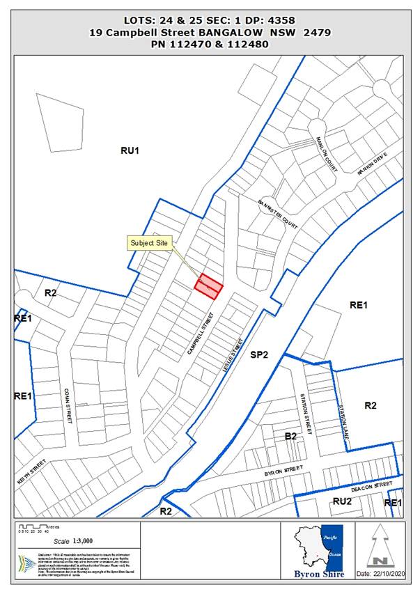
REPORT
1.
INTRODUCTION
1.1.
History/Background
The applicant’s heritage impact statement claims that
the dwelling was likely to have been constructed circa 1920, but has been
altered since then, date unknown.
The site is listed as a contributory item in the Bangalow
Heritage Conservation area as “Dickibusch” 19 Campbell Street.
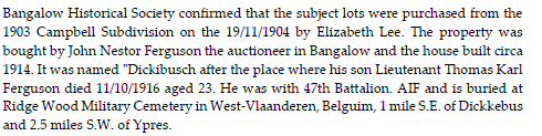
1.2.
Description of the proposed development
This application seeks approval for Alterations and
Additions to Existing Dwelling and Swimming Pool and subdivision of 2 lots into
2 lots.
The proposal seeks to re-site the existing dwelling so that
it is sited within the southern parcel of land, Lot 25 Section 1 DP 4358 by
approximately 1.2 metres to the south. In re-siting the dwelling it is also
proposed to raise the dwelling to provide a usable subfloor area to create a
new living / rumpus room and two (2) car garage.
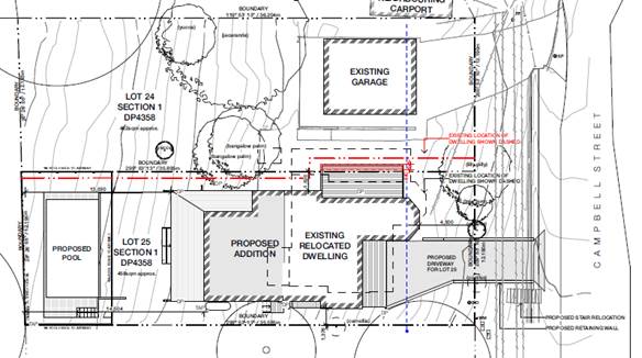
Site plan of proposed works.
Boundary Adjustment plans
A boundary adjustment is also proposed to create a vacant
lot other than a retained garage which has access to Campbell Street.
The proposed driveway will also remove the existing
pedestrian staircase within the retaining wall in the road reserve. The
application also indicates that these stairs will be relocated and rebuilt to
retain pedestrian access from the street.
1.3.
Description of the site
|
Land is legally described
|
LOT: 24 SEC: 1 DP: 4358, LOT: 25 SEC: 1 DP: 4358
|
|
Property address
|
19 Campbell Street BANGALOW
|
|
Land is zoned:
|
R2 Low Density Residential
|
|
Land area is:
|
460 m2 (both lots)
|
|
Property is constrained by:
|
Heritage conservation area
|
|
Is a BDAR required due to the location of the proposed
development?
|
☐Yes
☒ No
|
|
Are there any easements in favour of Council affecting the
site?
|
☐Yes ☒No
|
|
Is there a Vegetation Management Plan which might affect
the proposal?
|
☐Yes ☒No
|
|
Is there a Voluntary Planning Agreement which might affect
the proposal?
|
☐Yes ☒No
|
View of house from Campbell Street.
Existing driveway crossover of northern lot. Existing double
garage structure and vehicular crossover on lot 24.
Front entrance as existing; Front sunroom to be converted
back into verandah/deck.
2.
SUMMARY OF REFERRALS
|
Referral
|
Issue
|
|
Development Engineer
|
No objections subject to conditions.
|
|
ET Engineer
|
No objections subject to conditions.
|
|
Heritage Advisor
|
See comments below under Clause 5.10
|
Issues:
Relocation of and connection to services
The removal of the encroachment will allow for a vacant lot
that does not have essential services directly connected.
Clause 6.6 Essential Services of the BLEP 2014 states that:
Development Consent must not be granted unless the consent authority is satisfied
that the services within this clause are available, or adequate arrangements
have been made to make them available when required. The developer is required
to provide these services when additional lots are created. All services
required to be provided to the site are located within the street frontage and
additional connections to lots can be achieved.
Conditions have been recommended for services to be
relocated and provided.
Works within Road reserve
Council’s Infrastructure Services has reviewed the
application and the driveway design is acceptable. Conditions are included in
the recommendation.
Pedestrian access for adjoining properties
The proposal seeks to demolish the existing stairs within
the retaining wall. An objection was received noting that this is undesirable.
The applicant’s plans show the stairs to be relocated – conditions
have been included in the recommendation for these works to occur.
3.
SECTION 4.14 – BUSH FIRE PRONE LAND
Under section 4.14 of the
Act, Council must be satisfied prior to making a determination for development
on bush fire prone land, that the development complies with the document ‘Planning
for Bush Fire Protection 2019’. The site is not bush fire prone land.
4.
SECTION 4.15C – MATTERS FOR CONSIDERATION – DISCUSSION
OF ISSUES
Having regard to the matters for consideration detailed in
Section 4.15(1) of the Environmental Planning & Assessment Act 1979
(EP&A Act), the following is a summary of the evaluation of the issues.
4.1
State Environmental Planning Instruments
4.2A Byron Local Environmental Plan 2014 (LEP 2014)
In accordance with LEP 2014 clauses 1.4 and 2.1 – 2.3:
(a) The
proposed development is defined in the LEP 2014 Dictionary as dwelling house,
swimming pool, Subdivision;
(b) The
land is within the R2 Low Density Residential according to the Land Zoning Map;
(c) The
proposed development is permissible with consent; and
(d) Regard
is had for the Zone Objectives as follows:
|
Zone Objective
|
Consideration
|
|
To provide for
the housing needs of the community within a low density residential
environment.
|
Objective met.
|
|
To enable other
land uses that provides facilities or services to meet the day to day needs
of residents.
|
No conflict. Propose residential use only.
|
|
What clause does the development not comply with and what
is the nature of the non-compliance?
|
Further consideration, including whether the development
application is recommended for approval or refusal accordingly
|
|
Clause 4.1 Minimum Subdivision Lot Size
1. Introduction
– Summary of Proposed Development
The development application
proposes to re-site a dwelling onto the southern lot at the subject site,
undertake alterations and additions to the existing dwelling, and to
re-subdivide the two (2) existing lots into two (2) lots.
The re-subdivision provides
for a lot size of 460.15 and 460.25m2respectively. This being
139.85m2 and 139.75m2 less than the prescribed 600m2
minimum lot size.
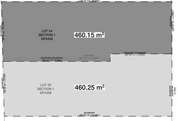
2. Clause
4.6 Exceptions to Development Standards.
LEP 2014 Clause 4.6 allows the granting of development
consent in the instance that a development would contravene a development
standard. However Council must first be satisfied by a written request from
the Applicant, that:
(a) compliance
with the development standard is unreasonable or unnecessary in the
circumstances of the case, and
(b) There are
sufficient environmental planning grounds to justify contravening the
development standard.
(c) The proposed
development will be in the public interest because it is consistent with the
objectives of the particular standard and the objectives for the development
within the zone in which the development is proposed to be carried out.
3. The
Development Standard to be varied
The Development Standard to be
varied is the 600m2 minimum lot size, prescribed by the Minimum
Lot Size Map applicable to the site under Clause 4.1 of LEP 2014.
4. Extent
of Variation to the Development Standard
The extent of the variation is
approximately 23.3% (for each lot).
5. Objective
of the Development Standard
The objectives of the
development standard, as outlined in subclause 4.1(1) are:
(a)
to ensure that lot
sizes are compatible with local environmental values and constraints,
(b)
To facilitate
efficient use of land resources for residential and other human purposes.
6. Objective
of the Zone
The objectives of the Low density residential (R2) zone
have been addressed in the section above.
·
To provide for the housing needs of the community within a low
density residential environment.
·
To enable other land uses that provides facilities or services
to meet the day to day needs of residents.
7.
Assessment – specific questions to be addressed under LEP
Clause 4.6:
(a) Clause
4.6(3) (a) – Is compliance with the development standard unreasonable
or unnecessary in the circumstances of the case?
The Clause 4.6 written request submitted in support of
the DA advises as follows in this regard:
‘The subject site
consists of two titles each approximately 460m2, with a single dwelling that
is listed as ‘an item that contributes to the heritage significance and
character of the precinct’. The client wishes to seek a boundary
adjustment in order to retain the majority of the northern verandah of the
existing dwelling and enable compliance with boundary setbacks, so that the
two titles can be independent’.
‘…so to
achieve strict compliance would involve merging the two titles, which would
detract from the historical pattern of subdivision and devalue the
client’s asset.
Comment:
In this circumstance, strict compliance with the
development standard is impossible to achieve, as both lots are existing
torrents lots, and both are under the minimum lot size prescribed by Clause
4.1 of the BLEP 2014. Strict compliance with the control is unreasonable and
unnecessary. The variation should be supported as it will allow for the
retention of original elements of a contributory item to the heritage
character of Bangalow.
Requiring compliance with the standard would result in a
subdivision plan that would be inconsistent with the pattern of subdivision
within this area of Bangalow, comprising Granuaille Road, Campbell Street and
Leslie Street. The historical pattern of subdivision generally is a number of
narrow lots with dwellings orientated either to the east or west, facing the
street frontage. There are no examples within the area of boundaries running
in a north/south orientation.
The potential to devalue the asset is not a matter of
consideration under s4.15 of the act.
(b) Clause
4.6(3) (b) – Are there sufficient environmental planning grounds to
justify contravening the development standard?
The Clause 4.6 written request submitted in support of
the DA advises as follows in this regard:
‘Although the existing lot size is less than the
current minimum lot size, the variation is to simply to adjust the boundary
while retaining the existing historical lot sizes, in order to better
preserve the historical item located on the site’.
Comment:
Both lots currently are less than the prescribed minimum
lot size. The boundary adjustment allows for the retention of original
elements of the dwelling and retains the general appearance of the dwelling
to the street. The proposed boundary adjustment will not result in a
noticeable change to the street frontage as the existing dwelling will retain
a similar street façade and width. Allowing the variation will also remove
an existing encroachment between the two lots.
The two resultant lots will retain sufficient frontage to
the street so as to comply with the development control plan 2014, and will
retains sufficient space within the northern lot to allow for the future
construction of a dwelling and access on the site.
There are sufficient environmental planning grounds to
justify the contravention of the standard, as the extent of the variation
will result in a better outcome for the heritage character of the streetscape
by retaining the general bulk and shape of the existing contributory heritage
dwelling and will retain the existing pattern of subdivision within the area.
In reducing the size of the lot that will contain the
dwelling as proposed within this application, does not exceed the floor space
ratio of 0.5:1 required on the site.
(c)
Clause 4.6(4) (a) (ii) – Is the proposed development
in the public interest? Is it consistent with the objectives of the standard
and the zone as set out above?
Comment:
The proposal is for development that is permitted with consent in the
zone; the resultant development footprint complies with the floor space ratio
and provides boundary setbacks that comply with the DCP. Approval of the
variation will also allow for the upgrade / replacement of the pedestrian
access from the Campbell Street frontage that will allow for a safer
pedestrian movement within the street.
It is considered that the
proposal achieves the objectives of the development standard and the zone.
The proposal and associated
request to vary a development standard is considered to meet subclause (3) of
Clause 4.6 and therefore the request to vary a development standard is
supported in this case.
|
Clause 4.3 Height of buildings
The proposal complies with the prescribed 9m height limit
wit a building height of 7.2m.
Clause 4.4 floor space ratio
Lot 24 will contain the dwelling after subdivision.
Proposed lot size = 460.25m2
Proposed dwelling Floor area = 150.26m2
Ground floor = 33.8m2
First floor = 116.46m2
FSR = 0.32:1 - Complies
Lot 25 will contain the existing garage.
But will contain no habitable spaces.
Clause 4.6 Exceptions to development standards.
The application has sought a variation to clause 4.1 of the
BLEP 2014 as discussed above.
Clause 5.10 Heritage Conservation
The site is located within the Bangalow Heritage
Conservation Area. The application has been reviewed by Council’s
Heritage Advisor. Initial concern was raised regarding the loss of the kitchen
and the verandah on the northern façade and the height of the building,
but in principal there was no objection to the sympathetic upgrades and
extensions to the dwelling. The applicant submitted amended plans to retain the
verandah and other external elements including the french doors and lowered the
building to reduce the overall height.
The application is considered to be consistent with the
heritage character of the conservation area. Conditions of consent are proposed
in relation to colours and external finishes.
Clause 6.2 Earthworks
The application requires earthworks of up to 1.85m depth to
allow the carpark/ garage to be constructed under the dwelling.
A search of the AHMIS database was undertaken and no
Aboriginal relics or places were identified within a 50m proximity to the site.
A condition is included in the recommendation for works to stop if relics are
encountered in accordance with the National Parks and Wildlife Act 1974.
The earthworks are of a residential scale and will not
impact on the potential or likely future use of the land for residential
purposes. A condition is included in the recommendation for geotechnical
reports to be prepared and submitted with the construction certificate.
Clause 6.6 Essential Services
Connections to water, sewer and stormwater and electricity
are able to be provided as the services exist within the Campbell Street
frontage. Connections to the northern lot, (lot 25) are required to be provided
by the developer, subject to conditions of consent. Suitable vehicular access
can be achieved. The applicant has demonstrated how the new crossover will be
achieved; the design is satisfactory to Council’s Development Engineers
subject to conditions.
4.4A Byron Shire Development Control Plan 2014
(DCP 2014)
Chapter B2 Preservation of trees and other vegetation
The plans show 1Tree to be removed that is likely to be
impacted by the construction of the driveway for Lot 25. The plans identify
this tree as a conifer. A condition is included in the recommendation requiring
a landscape plan sympathetic to the dwelling and to show the replacement of the
tree at a 1:1 ratio.
Chapter B4 Traffic Planning, vehicle Parking, circulation
and access
The proposed design complies with the DCP provision with 2
car parking spaces provided for the dwelling.
Chapter B14 Excavation and fill
Excavation to a depth of 1.85m is proposed. Under B14.2
– excavation and fill for car parking is permitted to a level up to
2m.The proposal complies.
Chapter D6 – Subdivision
Both lots are capable of siting a dwelling and ancillary
buildings. Standard subdivision conditions to apply.
Chapter D1.2.1 – building height plane
Due to the relocation of the existing house towards the
southern boundary a building height plane encroachment results. The
dwelling has varied setbacks to this boundary from 1.3m to 2.0m with the level
of encroachment prevalent when viewed from the street elevation and all but
compliant when viewed from the back boundary due to the topography of the site.
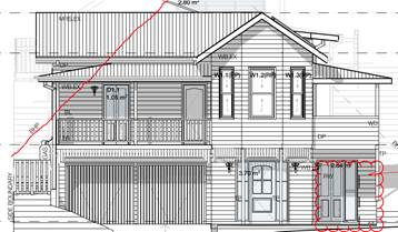
Front / Street elevation of
proposed dwelling
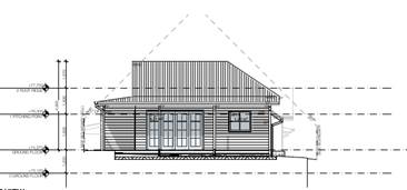
Rear elevation of the
proposed dwelling.
The applicant has submitted shadow plans which indicate that
the dwelling will cast a shadow onto the neighbours property during the winter
months.
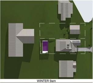
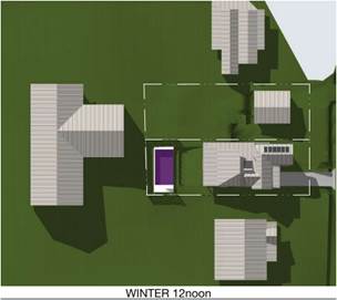
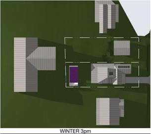
Some shadow is likely to be cast on the southern dwelling at
9am period but by noon there is no impact. It is considered that the proposal
will not restrict the use of the site or unduly impact on the adjoining lots
ability to enjoy winter sunlight or summer shade (performance criteria 2 &
3). The shadow diagrams provided show that a minimal impact to solar access and
views will occur from the development. Privacy is generally maintained with
existing landscaping, and conditions of consent are proposed for the inclusion
of privacy screening to decks and windows. It is considered a variation can be
granted in this instance.
Chapter C1 – Non-indigenous Heritage.
Council’s heritage advisor has reviewed the
application and provided comments. Recommendations of this report; where
possible have been incorporated into the design.
C1.4.1 Roof form and chimneys
Proposal retains the general existing scale and form of the
roof. New works are not readily visible from the street frontage
- Solar
panels are to be relocated onto the new roof part so that they are not readily
visible from the street. – marked in red on plans.
C1.4.2 Verandahs
Existing Verandahs are to be maintained. Where
original verandahs have been enclosed, the design seeks to restore these to the
original form.
C1.4.3 Windows and doors
The proposal generally retains existing windows and doors;
new works at the rear of the site are not inconsistent with the character of
the site and is not readily visible. The current design as proposed presents with
two doors that confuses the placement and character of the existing
dwelling. The new ground floor habitable area is recommended to be
altered so that only 1 door entrance is located within the front façade.
Plans marked in red.
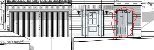
Second, recessed door in the front façade is to be
replaced with a window.
C1.4.4 building materials
New works are proposed as weatherboard, and metal roof
sheeting, and generally is consistent with the existing materials. A condition
requiring a schedule of materials and colours is to be approved by Council
prior to the issue of a Construction Certificate.
C1.4.5 colours
Condition recommended for colour scheme to be approved by
Council prior to issue of Construction Certificate.
C1.4.6 parking, garages and carports
Garages in general should be located behind the dwelling,
however the built form is consistent with other dwellings constructed in the
street with parking located underneath and/or attached to the dwelling and is
consistent with the established character of the area. The garage is also well
setback under the front deck and will not dominate the buildings appearance to
the street. The proposal is considered satisfactory.
C1.4.7 fences
No new fencing proposed forward of the building line.
Proposed pool fencing is located at the rear of the site and
is not visible from the street frontage. No specific heritage style of fencing
is required in this instance.
C1.4.8 Outbuildings and swimming pools
Proposed pool is located at the rear of the property –
complies.
C1.4.9 Subdivision
The proposed boundary adjustment results in a better
heritage outcome as the resultant subdivision allows for the original heritage
elements to be retained i.e. verandah to northern elevation. The resultant lots
are generally the same as existing. And do not compromise the vehicular access
of the existing crossover. New access to the southern lot is not inconsistent
with other dwellings in the street.
The pattern of subdivision within the Campbell Street area
includes a number of narrow lots with high set dwellings. The corner of
Campbell Street and the northern arm of the street is a transition area into
larger lots that have reduced setbacks.
The applicant has provided a clause 4.6 variation that
demonstrates that the non-compliance with the LEP Clause would result in a
better planning outcome by allowing flexibility in this particular
circumstance. The variation to the development standard will result in two lots
that currently do not meet the minimum lot size under the LEP to retain the
existing pattern of subdivision within the area.
C1.6.7 Bangalow Conservation Area
The proposal generally complies with Chapter E2 see below.
Chapter C4 – Development within a drinking water
catchment
The site is located within the Bangalow Township. Any water
runoff is capable of being directed into Council controlled systems, and is
unlikely to impact on water quality.
Chapter E2 – Bangalow
E2.3.1 Character, bulk and scale of development
The re-sited dwelling will be generally consistent with the
existing built form visible from the street frontage. It is noted there
was a preference for the existing kitchen to be retained, however, it is noted
the dwelling is not a heritage item, and the external fabric and appearance of
the dwelling in its residential setting will be conserved. The proposal is
considered to be generally consistent with the existing character of the street
and the requirements of Chapter C1.
4.5
Environmental Planning & Assessment Regulation 2000
Considerations
|
Clause
|
This control is applicable to the proposal:
|
I have considered this control as it relates to the
proposal:
|
If this control is applicable, does the proposal
comply?
|
|
92
(b) demolition
|
Yes
|
Yes
|
Yes
Condition recommended for demolition works to comply with
AS2601–1991
|
|
93
|
No
|
N/a
|
N/a
|
|
94
|
No
|
N/a
|
N/a
|
|
94A
|
No
|
N/a
|
N/a
|
* Non-compliances and any other significant issues
discussed below
4.6
The likely impacts of that development, including environmental
impacts on both the natural and built environments, and social and economic
impacts in the locality
|
Impact on:
|
Likely significant
impact/s?
|
|
Natural environment
|
No likely impacts on the
natural environment of the locality.
|
|
Built environment
|
No likely impacts on the built environment of the
locality.
|
|
Social Environment
|
No likely impacts on the social environment of the
locality.
|
|
Economic impact
|
No likely impacts on the economic environment of the
locality.
|
4.7
The suitability of the site for the development
The site is suitable for the proposed development.
4.8
Submissions made in accordance with this Act or the regulations
The development application was publicly exhibited
There were 4 submissions made on the development application:
Against
|
Submission
|
Comment
|
|
Streetscape amenity
|
The existing dwelling has a reduced front setback. Amended
plans received provide a minimum front setback of 4.5m which is compliant
with the DCP requirements as the proposed new dwelling location will be set
back further from the front boundary.
The Campbell street frontage contains examples of reduced
front setbacks that do not comply with the building height plane as well as
driveways that include retaining walls within the road reserve.
The driveway design will retain the mature magnolia tree
within the street front setback. Council’s Heritage Advisor noted that
this tree was a contributory planting.
The new works are not readily visible from the street
frontage as the dwellings are constructed at a level higher than the road.
|
|
Heritage preservation
|
Council’s Heritage Advisor has reviewed the
application and has provided comments and recommendations.
The proposed alterations will retain generally the same
front façade. In terms of shape and bulk. The proposed dwelling in the
relocated position increases the minimum front setback
The rock retaining wall within the road reserve is not
part of the heritage conservation area or a heritage item itself. It is also
noted that there have been numerous driveways and accesses created through
this retaining wall.
The application had sought to create a secondary door
within the front façade into a downstairs rumpus room. This is not
supported and is recommended to be converted to a window.
|
|
Driveway location and gradient
|
Council’s Infrastructure Services and Development
Engineers have reviewed the driveway design and raise no issues, subject to
conditions.
|
|
Building height plane
|
The building height plane encroachments are considered
acceptable as discussed above.
|
|
Solar access and overshadowing caused by vegetation.
Impacts on solar panels
|
It is noted that the tree referred to in the objection is
not located on the subject lot but situated on the neighbouring property to
the northwest of the subject site. The impact on the tree is not a matter for
consideration of this DA. Shadow diagrams have been provided of the
development. There is minimal overshadowing that will occur to the southern
dwelling at 9am and is no impact by noon and no impact at 3pm. The shadow
diagrams do not show the shadows cast by vegetation or fencing surrounding
the site. It is also noted that the new works located at the rear of
the site, generally comply with the building height plane.
An existing 1.8m high timber fence exists on the southern
boundary, as well as mature landscaping on the adjoining lot, creates additional
privacy for both lots.
The shadow diagrams provided show minimal shadow falls
over the roof form of the adjoining dwellings, except for a small area at 9am
during winter. This is unlikely to significantly impact on Photovoltaic
appliances on the adjoining structures.
|
|
Privacy impacts
|
There are 4 areas of the design that pose a potential
impact to privacy / overlooking impacts.
- The
deck on the front façade of the dwelling and the proximity to the
southern boundary.
- Bedroom
1 (w1.11) (southern elevation)
- Bathroom
(southern elevation (existing window)
- Deck
to the northern boundary
Conditions to apply in terms of privacy screening.
|
|
Setbacks
|
The dwelling currently is 2.6m from the southern boundary.
It is proposed to reduce the side setback to 1.3m, which is compliant with
the minimum 900 mm setback requirements of the BCA and the DCP 2014.
Given the area is a residential area within an established
town; it is unreasonable to require additional setbacks to the adjoining
properties, where it complies with the planning controls. The dwelling will
also be set back more than 7m from the adjoining dwelling to the south. The
area of Bangalow is characteristic of narrow lots and the two lots at the
subject of this application appear to be part of the original town
subdivision.
The proposal seeks to increase the front setback to 4.5m,
which will comply with the DCP 2014 requirements.
|
|
Removal of staircase within road reserve
|
The stairs will be required to be removed to allow for the
driveway to be constructed. The stairs will be required to be reconstructed
by the applicant. Conditions of consent to apply.
|
|
Geotechnical stability
|
Conditions of consent to apply to require plans and
specifications that indicate retaining walls and methods for preventing
movement of the soil, and geotechnical report to be prepared for the
construction certificate.
|
4.9 Public interest
The proposed development is unlikely to prejudice or
compromise the public interest or create an undesirable precedent.
5. DEVELOPER
CONTRIBUTIONS
5.1 Water & Sewer Levies
No Section 64 levies will be required.
5.2 Section 7.11 Contributions
No Section 7.11 Contributions
will be required.
6. DISCLOSURE OF
POLITICAL DONATIONS AND GIFTS
|
Has a Disclosure Statement been received in relation
to this application
|
No
|
|
Have staff received a ‘gift’ from anyone
involved in this application that needs to be disclosed. Where the answer is
yes, the application is to be determined by the Director or Manager of the
Planning, Development and Environment Division.
|
No
|
Provide Disclosure Statement register details here: Not
applicable
7. CONCLUSION
The proposed development is considered acceptable and provides
a satisfactory response to the planning controls applicable to the site and the
constraints affecting the land. The application is recommended for approval
subject to the conditions of consent.
Staff Reports - Sustainable Environment and Economy 13.12
Report No. 13.12 PLANNING
- Development Application 10.2020.306.1 Rural Dual occupancy (detached) at 212
Fowlers Lane, Bangalow
Directorate: Sustainable
Environment and Economy
Report
Author: Jordan
Vickers, Planner
File No: I2020/1650
Proposal:
|
DA No:
|
10.2020.306.1
|
|
Proposal description:
|
Dual Occupancy (Detached)
|
|
Property description:
|
LOT: 2 DP: 261219
|
|
212 Fowlers Lane BANGALOW
|
|
Parcel No/s:
|
25130
|
|
Applicant:
|
Balanced Systems Planning Consultants
|
|
Owner:
|
Drs J D Mortensen & R L Reardon
|
|
Zoning:
|
RU2 Rural Landscape
|
|
Date received:
|
29 June 2020
|
|
Integrated / Designated Development:
|
☐
Integrated
|
☐
Designated
|
☒
Not applicable
|
|
Concurrence required
|
No
|
|
Public notification or exhibition:
|
- Level
1 advertising under DCP 2014 Part A14 – Public Notification and
Exhibition of Development Applications
- Exhibition
period: 9/7/20 to 22/7/20
- No Submissions
received.
|
|
Variation request
|
Clause 4.6 – second driveway access to rural dual
occupancy.
|
|
Delegation to determine
|
Council
|
Summary:
This application seeks approval for a Dual Occupancy
(Detached) at the subject site. The proposed Dual occupancy dwelling is located
100m to the north of the existing dwelling on the allotment and is comprised of
four (4) bedrooms, one (1) study/media room, open-plan dining/kitchen/living
area, covered outdoor deck, and a two (2) car carport.
A Clause 4.6 variation has been lodged to vary the single
shared vehicular access development standard (Clause 4.2D (2)(b)) with a second
driveway to be used to serve the new dwelling. In this regard the driveway
already exists and although an alternative path from the driveway serving the
primary dwelling exists, this will require an existing OSMS to be relocated,
removal of established vegetation, and potentially relocate Essential Energy
overhead infrastructure to achieve the same end. Having regards to the above, strict
compliance with the single vehicle access development standard is considered
unreasonable and unnecessary in the circumstances.
The application raises no other issues in terms of site
suitability or generates any deleterious impacts and is recommended for
approval subject to the conditions listed in the recommendation.
NOTE
TO COUNCILLORS:
In
accordance with the provisions of S375A of the Local Government Act 1993, a
Division is to be called whenever a motion for a planning decision is put to
the meeting, for the purpose of recording voting on planning matters.
Pursuant to clause 2(a) under the heading Matters to be Included in Minutes of
Council Meetings of Council's adopted Code of Meeting Practice (as amended) a
Division will be deemed to have been called by the mover and seconder of all
motions relating to this report.
|
RECOMMENDATION:
That pursuant to
Section 4.16 of the Environmental Planning & Assessment Act 1979,
Development Application No. 10.2020.306.1 for Dual Occupancy (Detached), be granted consent subject to the
following conditions listed in Attachment 2 (#E2020/84751).
|
Attachments:
1 10.2020.306.1
- Plans, E2020/85917
2 10.2020.306.1
- Conditions of consent, E2020/84751
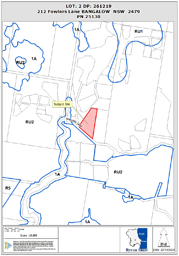
Assessment:
1.1. History/Background
A search of Council records indicates the following relevant
site history:
|
DA No.
|
Description
|
Outcome
|
Date
|
|
6.1988.2609
|
Alterations and Additions to a Dwelling
|
Approved
|
17/10/1988
|
|
10.2016.75.1
|
Use of Existing Swimming Pool & Deck
|
Approved
|
15/02/2016
|
1.2. Description
of the proposed development
This application seeks approval for a Dual Occupancy (Detached) at the subject
site. The proposed Dual occupancy dwelling is located 100m to the north of the
existing dwelling on the allotment and is comprised of four (4) bedrooms, one
(1) study/media room, an open-plan dining/kitchen/living area, covered outdoor
deck, and a two (2) car carport. The dwelling is a single level design but
elevated on piers to account for the sloping topography of the site.
Bothe the dwelling and detached
carport employ skillion roofs. The dwelling is located on a cleared area of the
property and no clearing is required.
1.3. Description
of the site
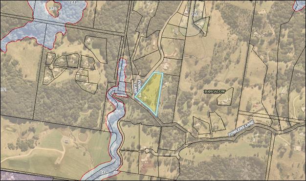
The subject site known as 212 Fowlers Lane, Bangalow and legally described as
Lot 2 on DP261219 has a total site area of 2.428ha and is located within the
Rural Landscape (RU2) zone of the Byron Local Environmental Plan 2014. The
property is currently improved by a single Dwelling house and carport with
access granted via a crossover at Fowlers Lane. The site is identified as Bushfire
prone land and containing High Environmental Value vegetation.
A site inspection was carried out
on 7 September 2020
|
Land is legally described
|
LOT: 2 DP: 261219
|
|
Property address
|
212 Fowlers Lane BANGALOW
|
|
Land is zoned:
|
RU2 Rural Landscape
|
|
Land area is:
|
2.428ha
|
|
Property is constrained by:
|
Bushfire prone land, High Environmental Value vegetation
|
|
Is a BDAR required due to the location of the proposed
development?
|
☐ Yes ☒ No
|
|
Are there any easements in favour of Council affecting the
site?
|
☐ Yes ☒ No
|
|
Is there a Vegetation Management Plan which might affect
the proposal?
|
☐ Yes ☒ No
|
|
Is there a Voluntary Planning Agreement which might affect
the proposal?
|
☐ Yes ☒ No
|
1. SUMMARY OF
REFERRALS
|
Referral
|
Issue
|
|
Environmental Health Officer*
|
No objections subject to conditions.
|
|
Development Engineer*
|
No objections subject to conditions.
|
|
Ecologist*
|
No objections subject to conditions.
|
|
S94 / Contributions Officer*
|
No objections subject to conditions.
|
2. SECTION
4.14 – BUSH FIRE PRONE LAND
Under section 4.14 of the Act,
Council must be satisfied prior to making a determination for development on
bush fire prone land, that the development complies with the document
‘Planning for Bush Fire Protection 2006’. The site is bush fire prone
land. The development application is accompanied by a Report by Helen Robinson
of Sustainable Home Solutions dated 28 May 2019 which provides conditions. A
Condition is included in the Recommendation of this Report requiring that the
development must comply at all times with the requirements of the
aforementioned Report.
EFFECT OF 10/50 RULE ON
SIGNIFICANT VEGETATION
A search for the subject site was conducted on the Rural
Fire Service website to determine the 10/50 status. The search identified the
following:
“The parcel of land you have selected is
located in a designated 10/50 vegetation entitlement clearing area. You must
read the 10/50 Code of Practice carefully to ensure that you are only clearing
in accordance with the 10/50 Code. For more information see our frequently
asked questions.”
Accordingly, the land owner may clear vegetation in
accordance with the 10/50 Vegetation Clearing Code Of Practice For New South
Wales.
3. SECTION 4.15C
– MATTERS FOR CONSIDERATION – DISCUSSION OF ISSUES
Having regard to the matters for consideration detailed in
Section 4.15(1) of the Environmental Planning & Assessment Act 1979
(EP&A Act), the following is a summary of the evaluation of the issues.
3.1 State Environmental
Planning Instruments
4.2A Byron Local Environmental
Plan 2014 (LEP 2014)
In
accordance with LEP 2014 clauses 1.4 and 2.1 – 2.3:
(a) The
proposed development is defined in the LEP 2014 Dictionary as Dual Occupancy
(Detached);
(b) The
land is within the Rural Landscape (RU2) zone according to the Land Zoning Map;
(c) The
proposed development is permitted with consent; and
(d) Regard
is had for the Zone Objectives as follows:
|
Zone Objective
|
Consideration
|
|
· To encourage
sustainable primary industry production by maintaining and enhancing the
natural resource base.
· To maintain the
rural landscape character of the land.
· To provide for a
range of compatible land uses, including extensive agriculture.
· To enable the
provision of tourist accommodation, facilities and other small-scale rural
tourism uses associated with primary production and environmental
conservation consistent with the rural character of the locality.
· To protect
significant scenic landscapes and to minimise impacts on the scenic quality
of the locality.
|
The proposal will maintain the natural resource base and
rural character of the land while protecting the significant scenic landscape
and scenic quality of the locality.
|
|
What clause does the development not comply with and what
is the nature of the non-compliance?
|
Further consideration, including whether the development
application is recommended for approval or refusal accordingly
|
|
Clause 4.2D(2)(b), which
states:
“each dwelling will use the same vehicular access to
and from a public road”
|
In response to the deviation from this development
standard, the applicant has lodged a 4.6 variation request which is
considered in further detail below.
|
4.2D Erection of dual
occupancies (detached) and secondary dwellings in Zones RU1 and RU2
The proposal in the main is satisfactory with the provisions
except the new dwelling will be serviced by a second driveway. A variation has
been sought to this provision and is discussed below under Clause 4.6.
Clause 4.6 Exception to Development Standards.
1. Introduction
– Summary of Proposed Development
The development application proposes to establish a Dual Occupancy (detached)
at the subject site. The building is located 100m from the existing dwelling on
the allotment, and access from the public road is proposed by upgrading an
existing farm entrance, being additional and separate to the crossover for the
existing dwelling as prescribed by the development standard (see image below).
2. Clause
4.6 Exceptions to Development Standards.
LEP 2014 Clause 4.6 allows the granting of
development consent in the instance that a development would contravene a
development standard. However Council must first be satisfied by a written
request from the Applicant, that:
a) compliance with the development
standard is unreasonable or unnecessary in the circumstances of the case, and
b) there are sufficient environmental
planning grounds to justify contravening the development standard.
c) the proposed development will be in
the public interest because it is consistent with the objectives of the
particular standard and the objectives for the development within the zone in
which the development is proposed to be carried out.
3. The Development Standard to be varied
The Development Standard to be
varied is Clause 4.2D(2)(b), which states:
“each [Dual occupancy] dwelling will use the
same vehicular access to and from a public road”
4. Extent
of Variation to the Development Standard
The extent of the variation
relates to the use of an entirely separate driveway and crossover.
Objective of the Development
Standard
The objectives of the development standard, as outlined in
subclause 4.3(1) are:
a) to
provide alternative accommodation for rural families and workers,
b) to
ensure that development is of a scale and nature that is compatible with the
primary production potential, rural character and environmental capabilities of
the land,
c) to
set out consent considerations for development of dual occupancies (detached)
and secondary dwellings to address matters such as access, siting, land
suitability and potential impacts.
5. Objective
of the Zone
The objectives of the Rural Landscape (RU2) zone are as
follows:
a) To
encourage sustainable primary industry production by maintaining and enhancing
the natural resource base.
b) To
maintain the rural landscape character of the land.
c) To
provide for a range of compatible land uses, including extensive agriculture.
d) To
enable the provision of tourist accommodation, facilities and other small-scale
rural tourism uses associated with primary production and environmental
conservation consistent with the rural character of the locality.
e) To
protect significant scenic landscapes and to minimise impacts on the scenic
quality of the locality.
6. Assessment
– specific questions to be addressed under LEP Clause 4.6:
(a) Clause
4.6(3) (a) – Is compliance with the development standard unreasonable or
unnecessary in the circumstances of the case?
The Clause 4.6 written request submitted in support of the
DA advises as follows in this regard:
“the proposed variation…is sought based on
achieving the following positive outcomes for the development:
· reduced
environmental impacts by lessened driveway length;
· improved
vehicular access to the new dwelling;
· reduced costs
of development; and
· lessened
interaction with over-head powerlines”
“In the circumstances of this specific proposal on
this rural site, it [is] considered [that] strict compliance with
the one standard regarding singular access is deemed as unreasonable and
unnecessary, as it does not result in any beneficial planning or environmental
outcomes”
Comment:
Requiring the applicant to comply with the standard would
necessitate additional earthworks that are not otherwise needed, potentially
require the removal of native vegetation to comply with bushfire access
standards, require turning circles in close proximity to power poles (and
potentially relocation of those poles), require a relocation of the existing
OSMS, and require 50m additional driveway than that proposed. Conversely, the
proposed access point is an existing farm entrance to the site that would
require only minor upgrades with no vegetation removal, excessive excavation,
and disturb a smaller portion of the land (50m less driveway length). Use of
the existing farm entrance is unlikely to introduce land use conflicts from
additional vehicle access or fragmentation/alienation of uses, will reduce the
overall footprint of the driveway on the site and introduce fewer environmental
impacts. Nor is the second access likely to lead to any sort of request to
subdivide the land having regard to the minimum lots size requirements of 40
hectares.
In this circumstance, the
proposed development presents a better planning outcome than strict compliance
with the development standard.
(b) Clause
4.6(3)(b) – Are there sufficient environmental planning grounds to
justify contravening the development standard?
The Clause 4.6 written request submitted in support of the
DA advises as follows in this regard:
“The proposed use and upgrade of the existing
second farm vehicular entrance satisfies the objectives of the clause, by
providing a logical and practical vehicular access from Fowlers Lane, resulting
in nil additional adverse environmental effects. The use and upgrade of the
existing second entrance maintains a suitable scale and nature with the rural
character and environmental capabilities of the land. The driveway entrance
does not involve any buildings and will require a s138 application to be made
to Council for the rural crossover.
The attached Driveway Access Plans with mark ups shows
the existing main dwelling driveway centreline, as well as the power line
infrastructure and existing vegetation. Utilising the existing driveway
entrance to the property would require an additional section of driveway of
approximately 50 metres as well as a very tight turning circle between the
existing power pole and the eucalyptus vegetation. Utilising the existing
entrance requires additional length of driveway and may require removal/pruning
of native vegetation for bushfire access requirements”
Comment:
The proposal causes no adverse environmental impacts on the
subject and surrounding properties, and making use of the existing farm access
mitigates additional environmental impacts (vegetation clearing) which would be
required if the development standard were enforced. Despite deviating from the
development standard, the proposal complies with the objectives of both the
Development Standard and Zone, by maintaining the rural landscape character of
the land and protecting the scenic quality of the landscape.
There are sufficient
environmental planning grounds to justify the contravention of the standard.
(c) Clause 4.6(4) (a)
(ii) – Is the proposed development in the public interest? Is it
consistent with the objectives of the standard and the zone as set out above?
Regarding the objectives of the standard and the zone, the
Clause 4.6 written request submitted in support of the DA advises as follows:
“It is in the public interest to support minor
variations to development standards where it results in logical and practical
planning outcomes. Development standards are in place to provide for positive
development outcomes however each specific development application and site has
its own characteristics where it is in the public interest to permit a degree
of flexibility.
The request is in the public
interest as the proposal results in beneficial outcomes for accessibility to
the site and does not result in any adverse environmental impacts on the safety
of traffic movements on Fowlers Lane.”
Comment:
It is contended that use of the
existing farm access for the Dual Occupancy dwelling is in the public interest
as it demonstrates compliance with the provisions of the Byron LEP 2014, DCP
2014, and the Objectives of the Development Standard and zone. Further, it will
reduce the volume of traffic making use of the existing vehicle crossover which
is in close proximity to a sharp, blind corner at Fowlers Lane.
It is considered that the
proposal achieves the Objectives of the development standard and relevant zone
and therefore that the proposal is in the public interest.
The proposal and associated request to vary a development
standard is considered to meet subclause (3) of clause 4.6, and therefore the
request to vary a development standard is supported in this case.
Clause 4.1E Minimum lot sizes for
dual occupancies, manor houses, multi dwelling housing and residential flat
buildings
The proposal complies with the minimum lots size
requirements of 4000 m2.
Clause 4.2A Erection
of dwelling houses and dual occupancies on land in certain rural zones
The proposal seeks to establish a rural Dual occupancy
(detached) at the subject site, which achieves the minimum lot size for rural
dual occupancies, is a lot created under this plan, and the complies with the
objectives of this clause.
Clause 4.3 Height of Buildings
The proposed dwelling house complies with the 9m maximum
height of buildings development standard.
Clause 6.2 Earthworks
Earthworks proposed under the subject application will not
have detrimental impact on environmental functions and processes, neighbouring
uses, cultural nor heritage items or features on surrounding lands.
Clause 6.5 Drinking Water catchments
The proposal is cognisant of and suitably distanced from
nearby waterways; no chemicals are to be used, stored nor disposed of on the
site under the proposal; and Council’s EHO has reviewed the proposed On-Site
Sewage Management System (OSMS) and recommended that the application be
approved subject to conditions.
Clause 6.6 Essential Services
The subject site is connected to telecommunications and
electricity infrastructure; access is granted to the site via a lawful point of
access; the proposed dwelling is afforded a 40,000L water tank, and the
suitability of the site to accommodate an OSMS has been considered by
Council’s EHO.
The proposal raises no other issues under the LEP.
4.3 Any proposed Instrument
that has been the subject of public consultation and has been notified to the
consent authority
There are no proposed Environmental Planning Instruments of
relevance to the proposed development.
4.4A Byron Shire
Development Control Plan 2014 (DCP 2014)
Chapter
B14 – Excavation and Fill
Chapter
B14 allows for excavation and fill/battering up to 1m in order to facilitate a
car parking space. The proposed development seeks a maximum cut up to 1.2m (see
image below). The exceedance of 0.2m is minimal and is not anticipated to
introduce adverse environmental impacts and a variation is supported in this
instance to facilitate the construction of the car port.
Chapter B4 – Traffic Planning, Vehicle Parking,
Circulation and Access
DCP 2014 Chapter B4 requires that two car parking spaces are
required per dwelling. The proposal provides two car parking spaces adjacent to
the dwelling.
Chapters C3 – Visually prominent Sites &
Development
The proposal promotes the
Shire’s natural features, vegetation and topography by way of situating
amongst the natural landscape with minimal excavation/fill, not being located
in front/behind adjacent/adjoining dwellings in a manner that may damage
existing views and vistas, establishes within an existing portion of cleared
land to mitigate vegetation clearing, and does not intrude on the skyline when
viewed from public land.
The proposed development is
demonstrated to meet the relevant Objectives of DCP 2014.
D2 – Residential
Accommodation in Rural zones
Prescriptive Measure 2 of
Chapter D2.5.2 prescribes (in accordance with LEP clause 4.2D(2)(b)) that Dual
Occupancy (detached) buildings are not located greater than 100m apart, and
must be serviced by a common vehicle access point. Variation to this
development control has been considered above under the clause 4.6 variation
discussion.
The proposal complies with the prescribed boundary setbacks,
on-site car parking, and private open space requirements.
The proposal raises no other
issues under the DCP.
4.5 Environmental Planning
& Assessment Regulation 2000 Considerations
The proposal raises no issues under the regulations
4.6 The likely impacts of that
development, including environmental impacts on both the natural and built
environments, and social and economic impacts in the locality
|
Impact on:
|
Likely significant impact/s?
|
|
Natural environment
|
No. The proposal will not have a significantly adverse
impact on the natural environment of the locality.
|
|
Built environment
|
No. The proposal will not have a significantly adverse
impact on the built environment of the locality.
|
|
Social Environment
|
No. The proposal will not have a significant social impact
on the locality.
|
|
Economic impact
|
No. The proposal will not have a significant economic
impact on the locality.
|
Relevant conditions of consent are proposed to control
construction activities such as hours of work, construction noise, builders
waste and the like.
4.7 The suitability of the site
for the development
|
Issue
|
Comment
|
|
Services
- Water/
Sewer/ Stormwater
- Ph/
power
- Access
|
- The
site is connected to telecommunications and electricity infrastructure;
- Access
is granted to the site via a lawful point of access
- The
proposed dwelling is afforded a 40,000L water tank, and an On-Site Sewage
Management System (OSMS) will be required by condition of consent.
|
|
Onsite Effluent Disposal
|
- Council’s
EHO has assessed and confirmed the sites suitability for an On-site Sewage
Management System (OSMS). A condition will be applied requiring the
lodgement of a s68 application for an OSMS.
|
|
Hazards
- Bushfire
|
- The
site is Bushfire prone land and a bushfire assessment report has been lodged
alongside the application.
|
|
Land Use conflicts
|
- The
proposal maintains the rural residential use of the land and is not
inconsistent with the other forms of lifestyle acreage lots in Fowlers Lane.
It is not anticipated to introduce any land use conflicts.
|
4.8 Submissions made in
accordance with this Act or the regulations
The development application was publicly exhibited. Council
received no submissions.
4.9 Public interest
The proposed development is unlikely to prejudice or
compromise the public interest or create an undesirable precedent.
5. DEVELOPER
CONTRIBUTIONS
5.1 Water & Sewer Levies
No Section 64 levies will be required.
5.2 Section
7.11 Contributions
Section
7.11 Contributions will be payable.
6. DISCLOSURE OF
POLITICAL DONATIONS AND GIFTS
|
Has a Disclosure Statement been received in relation
to this application
|
No
|
|
Have staff received a ‘gift’ from anyone
involved in this application that needs to be disclosed. Where the answer is
yes, the application is to be determined by the Director or Manager of the
Planning, Development and Environment Division.
|
No
|
7. CONCLUSION
The proposed development is satisfactory having regard to
the relevant environmental planning instruments and planning controls
applicable to the site. The proposal raises no significant issues in terms of environmental
impacts which cannot be managed and the site is considered suitable for the
development. The application is recommended for approval subject to the
conditions of consent.
Staff Reports - Sustainable Environment and Economy 13.13
Report No. 13.13 PLANNING
- Development Application 10.2020.138.1 to establish Multi-Dwelling Housing (7
units) at 8 Kumbellin Glen, Ocean Shores
Directorate: Sustainable
Environment and Economy
Report
Author: Jordan
Vickers, Planner
File No: I2020/1710
Proposal:
|
DA No:
|
10.2020.138.1
|
|
Proposal description:
|
Demolition of Existing Dwelling House and Construction of
Multi-Dwelling Housing Comprising Seven (7) Dwellings
|
|
Property description:
|
LOT: 1323 DP: 243480
|
|
8 Kumbellin Glen OCEAN SHORES
|
|
Parcel No/s:
|
40380
|
|
Applicant:
|
Ardill Payne & Partners
|
|
Owner:
|
Chincogan Property Developments Pty Ltd
|
|
Zoning:
|
R2 Low Density Residential
|
|
Date received:
|
17 March 2020
|
|
Integrated / Designated Development:
|
☐
Integrated
|
☐
Designated
|
☒
Not applicable
|
|
Concurrence required
|
No
|
|
Public notification or exhibition:
|
- Level
2 advertising under DCP 2014 Part A14 – Public Notification and
Exhibition of Development Applications
- Exhibition
period: 2/4 - 22/4/20
- Submissions received:
20
- Submissions
acknowledged: ☒
Yes ☐ No
|
|
Planning Review Committee:
|
Not applicable
|
|
Variation request
|
Not applicable
|
|
Delegation to determine
|
Council
|
|
Issues:
|
· Building Height
Plane
· DIP Site buffer
area
· Setbacks
· Safe vehicular
manoeuvring
· Density &
integration with zone
|
|
Summary:
|
The DA proposes Demolition of Existing Dwelling House and
Construction of Multi-Dwelling Housing Comprising Seven (7) Dwellings.
|
Summary:
This application seeks approval for the demolition of an
Existing Dwelling House and the construction of Multi-Dwelling Housing
comprising Seven (7) Dwellings. The proposed Multi-Dwelling Housing building is
a single structure of attached units spanning approximately 30m across the
subject site.
Each unit is a three-storey domicile comprised of: ground
floor single-car garage and utilities room; first floor kitchen, dining/living
areas, and outdoor private open space; and a second floor containing two
bedrooms (Master bedroom + one bedroom) and a bathroom.
The building is a slab-on-ground construction, articulated
with a variety of materials (FC sheets, weatherboard and rendered cladding),
colorbond roofing and timber-look garage doors.
Excavation and retaining up to
2m is required to establish the ground floor car parking area. Planted
landscaping is required to be removed to facilitate the development. A
landscaping plan has been provided with the application demonstrating proposed
replacement plantings to be established along the Goondooloo Drive frontage.
The site is located within the
R2 Low Density Residential zone which is predominantly characterised by
Dwelling houses and detached Secondary dwellings and Dual occupancies. The
development does not integrate with, and is not indicative of the expected
built form of the low density residential environment which surrounds the
development site (traditional free standing homes).
Submissions received during
community notification identified density and built form as a primary matter of
concern, identifying that the proposal far exceeds the existing and expected
residential density within the Low density residential zone and that the bulk
of the building is out of character with the streetscape.
The applicant was advised prior
to (DAP meeting) and throughout (information request & a meeting at
Council) assessment of the abovementioned issues, and provided with
alternatives to the proposed development that would alleviate the
deficiencies/non-compliances identified; however, the proposal has remained
unchanged. The proposal also presents encroachments into the Building Height
Plane, is deficient of Communal Landscaping Area with part of it not accessible
to all residents, whilst access/egress to the allocated car parking space for
Unit 7 is extremely tight in terms of manoeuvrability and potentially
unsafe.
Reducing the development by one dwelling unit and separating
those remaining into two (2) detached buildings would more accurately reflect
the desired and existing built form of the low density environment; ensure the
site is capable of accommodating the required Communal Landscaped Areas and
provide better vehicular manoeuvring for car parking.
The application is therefore recommended for approval
subject to a deferred commencement consent requiring the plans to be amended
accordingly.
NOTE TO COUNCILLORS:
In accordance with the
provisions of S375A of the Local Government Act 1993, a Division is to be
called whenever a motion for a planning decision is put to the meeting, for the
purpose of recording voting on planning matters. Pursuant to clause 2(a)
under the heading Matters to be Included in Minutes of Council Meetings of
Council's adopted Code of Meeting Practice (as amended) a Division will be
deemed to have been called by the mover and seconder of all motions relating to
this report.
|
RECOMMENDATION:
That Development
Application No. 10.2020.138.1 for
Demolition of Existing Dwelling House and Construction of Multi-Dwelling
Housing Comprising Seven (7) Dwellings be granted consent subject
to Deferred Commencement Conditions listed in Attachment 2 (E2020/86297).
|
Attachments:
1 10.2020.138.1
- Plans, E2020/84846
2 10.2020.138.1
- Conditions of Consent - Deferred Commencement, E2020/86297
3 Confidential
- 10.2020.138.1 - Submissions, E2020/86349
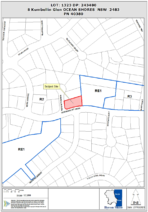
REPORT
Assessment:
1. INTRODUCTION
1.1. History/Background
A search of Council records indicates the following site
history:
|
DA No.
|
Description
|
Outcome
|
Date
|
|
6.1991.2202.1
|
BA - Dwelling
|
Finalised
|
05/06/1991
|
|
10.2017.653.1
|
Multi-Dwelling housing (4 units) & Alts & Adds
|
Withdrawn
|
23/04/2018
|
Development Advisory Panel:
A Development Advisory Panel meeting was held 12
September 2019 regarding the proposed development between Council staff and
the property owner. In summary, the applicant was advised:
- to
break-up the 30m long, three (3)-storey high building into two smaller
buildings with a 3m separation distance;
- that
the proposed building is not reflective of the Low density residential (R2)
zone objectives and contrasts dramatically with the surrounding area which is
dominated by detached dwellings; and
- that one
dwelling unit may need to be deleted from the proposal.
1.2. Description
of the proposed development
This application seeks approval for the demolition of an
Existing Dwelling House and the construction of Multi-Dwelling Housing
comprising Seven (7) Dwellings. The proposed Multi-Dwelling Housing building is
a single structure of attached units spanning approximately 30m across the
subject site. Each unit is a three-storey domicile comprised of: ground floor
single-car garage and utilities room; first floor kitchen, dining and living
areas, and outdoor private open space; and a second floor containing two
bedrooms (Master bedroom + one bedroom) and a bathroom. Each dwelling unit is
afforded private open space area with a minimum area of 30m² and minimum
dimension >4m.
Excavation and retaining is required to establish the ground floor car parking
area and planted landscaping is required to be removed to facilitate the
development. A landscaping plan has been provided with the application
demonstrating plantings that are to take place.
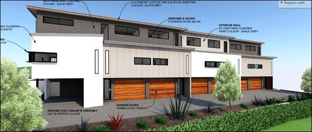
1.3. Description
of the site
The subject site known as 8 Kumbellin Glen, Ocean Shores and
legally described as Lot 1323 on DP243480 has a total site area of 1075m²
and is located within the R2 Low Density Residential zone of the Byron
Local Environmental Plan 2014. The property is a corner lot with dual frontage
to Kumbellin Glen and Goondooloo Drive, and is currently improved by a single
dwelling house and extensive mature planted landscaping. The allotment has an
average gradient of approximately 30% (15 ̊ -18 ̊ ), falling from north to south. No easements encumber the
site, however Council Sewage infrastructure is located at and parallel to the
frontage to Kumbellin Glen and the site is located within a Cattle DIP buffer
area and the Coastal Environment Area of the Coastal Management SEPP 2018.
The greater locality is
predominantly comprised of detached dwelling houses, however the immediate
vicinity of the subject site (particularly Kumbellin Glen) is characterised by
Dwelling houses, detached Dual occupancies and a detached Multi-dwelling
housing development comprised of three (3) dwellings (see image below).
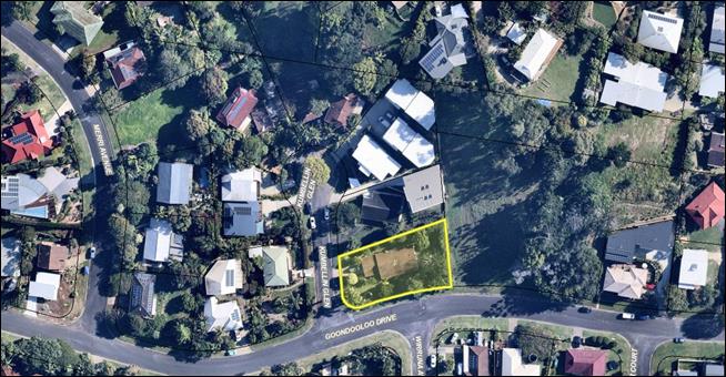
A site inspection was carried out on 1 April 2020
|
Land is legally described
|
LOT: 1323 DP: 243480
|
|
Property address
|
8 Kumbellin Glen OCEAN SHORES
|
|
Land is zoned:
|
R2 Low Density Residential
|
|
Land area is:
|
1075m2
|
|
Property is constrained by:
|
Dip Buffer, Coastal Management SEPP (Coastal Environment
Area)
|
|
Is a BDAR required due to the location of the proposed
development?
|
☐ Yes ☒ No
|
|
Are there any easements in favour of Council affecting the
site?
|
☐ Yes ☒ No
|
|
Is there a Vegetation Management Plan which might affect
the proposal?
|
☐ Yes ☒ No
|
|
Is there a Voluntary Planning Agreement which might affect
the proposal?
|
☐ Yes ☒ No
|
2. SUMMARY OF
REFERRALS
|
Referral
|
Issue
|
|
Environmental Health Officer*
|
No objections subject to conditions.
|
|
Development Engineer*
|
Car Parking issues. See discussion below.
|
|
S64 / Systems Planning Officer*
|
No objections subject to conditions.
|
|
S94 / Contributions Officer*
|
No objections subject to conditions.
|
3. SECTION 4.14
– BUSH FIRE PRONE LAND
Under section 4.14 of the Act, Council must be satisfied prior
to making a determination for development on bush fire prone land, that the
development complies with the document ‘Planning for Bush Fire
Protection 2006’. The site is not bush fire prone land.
4. SECTION 4.15C
– MATTERS FOR CONSIDERATION – DISCUSSION OF ISSUES
Having regard to the matters for consideration detailed in
Section 4.15(1) of the Environmental Planning & Assessment Act 1979
(EP&A Act), the following is a summary of the evaluation of the issues.
4.1 State Environmental
Planning Instruments
|
|
Satisfactory
|
Unsatisfactory
|
|
State
Environmental Planning Policy No 55—Remediation of Land
|
☒
|
☐
|
|
Consideration:
A report
entitled Preliminary Contaminated Land Investigation prepared by Ardill Payne
& Partners dated February 2018 provides that soil sampling results were
below the Health Investigation Levels (HIL) in accordance with NEPM (2013)
Table 1 A (1) Column A – ‘Standard’ Residential with
garden/accessible soil (home grown produce <10% fruit and vegetable intake
(no poultry), also includes childcare centres, preschools and primary
schools. Reporting was conducted in accordance NSW EPA Guidelines
for Consultants Reporting on Contaminated Sites 2000.
There is no
increase in sensitivity as a result of the proposal. The site is
therefore considered suitable for the intended development.
|
|
State
Environmental Planning Policy (Building Sustainability Index: BASIX) 2004
|
☒
|
☐
|
|
Consideration:
The proposal is accompanied by
a valid BASIX and NatHers certificate. The
SEPP has been addressed and the proposal is considered to comply.
|
|
State Environmental Planning
Policy (Coastal Management) 2018
|
☒
|
☐
|
|
Consideration:
Coastal Environment Area:
The property is within the Coastal Environment Area and
the proposed development is unlikely to cause an adverse impact on:
a) the
integrity and resilience of the biophysical, hydrological (surface and
groundwater) and ecological environment,
b) coastal
environmental values and natural coastal processes,
c) the
water quality of the marine estate (within the meaning of the Marine Estate Management Act 2014), in
particular, the cumulative impacts of the proposed development on any of the
sensitive coastal lakes identified in Schedule 1,
d) marine
vegetation, native vegetation and fauna and their habitats, undeveloped
headlands and rock platforms,
e) existing
public open space and safe access to and along the foreshore, beach, headland
or rock platform for members of the public, including persons with a
disability,
f) Aboriginal
cultural heritage, practices and places,
g) the
use of the surf zone.
|
4.2A Byron Local Environmental Plan 2014 (LEP 2014)
In accordance with LEP 2014
clauses 1.4 and 2.1 – 2.3:
(a) The
proposed development is defined in the LEP 2014 Dictionary as Multi-Dwelling
housing;
(b) The
land is within the R2 Low Density Residential according to the Land Zoning Map;
(c) The
proposed development is permitted with consent; and
(d) Regard is had
for the Zone Objectives as follows:
|
Zone Objective
|
Consideration
|
|
· To provide for
the housing needs of the community within a low density residential environment.
· To enable other
land uses that provide facilities or services to meet the day to day needs of
residents.
|
The development provides for the housing needs of the
community, however is not aligned with the low density residential
environment of the locality. The proposed dwelling density of 1
dwelling/153m² far exceeds the expected residential density within a Low
density residential context.
|
The remaining underlined
clauses have been taken into consideration in the assessment of the subject
development application in accordance with Section 4.15 of the EP&A Act.
The proposed development complies with all of these clauses (in some cases
subject to conditions and/or to the satisfaction of other assessing officers),
except in relation to Clause 2.3 which is considered further as follows:
|
What clause does the development not comply with and what
is the nature of the non-compliance?
|
Further consideration, including whether the development
application is recommended for approval or refusal accordingly
|
|
Clause 2.3 - Zone
objectives and Land Use Table
|
See discussion below
|
|
Clause 4.1E Minimum lot
sizes for dual occupancies, multi dwelling housing and residential flat
buildings
|
See discussion below
|
Clause 2.3 - Zone objectives
and Land Use Table
The Objectives of the Low density residential zone (LDRZ)
strive to provide for the housing needs of the community within a low
density environment. Within the LDRZ, the minimum lot size to establish a
dwelling house is 600m², and 800m² for a Dual occupancy. Therefore,
the expected residential density in the LDRZ is between 1 dwelling/600m²
and 1 dwelling/400m² respectively. The proposal seeks to establish a
Multi-dwelling housing development comprised of seven (7) attached dwelling
units at the site with a total area of 1075m², equating to a dwelling
density of one (1) dwelling/153m².
Locality analysis:
An analysis of thirteen (13)
properties in the surrounding Low density residential zone (LDRZ) and eight (8)
properties in the surrounding and nearby Medium density residential zone (MDRZ)
was conducted to identify the predominant density and lot configuration in the
locale. It was found that dwelling density achieves an average of one (1)
dwelling/666m² within the LDRZ, where allotments with multiple dwellings
are most characteristically configured as detached buildings. Comparatively,
dwelling density in the MDRZ achieved an average of one (1) dwelling/287.36m²,
where multiple dwellings often present as attached buildings.
|
Address
(parcel no.)
|
Use
|
Density
|
Area
|
Configuration
|
|
Low density
residential zone
|
|
5 Kumbellin Glen
(268438)
|
Multi-dwelling housing
|
3 x dwellings
1/439m²
|
1318m²
|
Detached
|
|
4 Kumbellin Glen
(40410)
|
Dual Occupancy
|
2 x dwellings
1/588m²
|
1176m²
|
Detached
|
|
3 Kumbellin Glen
(40420)
|
Dwelling house
|
1 x dwelling
1/1397m²
|
1397m²
|
-
|
|
2 Kumbellin Glen
(239591)
|
Dual Occupancy
|
2 x dwellings
1/555m²
|
1110m²
|
Detached
|
|
1 Kumbellin Glen
(29200)
|
Dwelling house
|
1 x dwelling
1/844m²
|
844m²
|
-
|
|
10 Goondooloo Drive
(240213)
|
Dual Occupancy
|
2 x dwellings
1/428.5m²
|
857m²
|
Detached
|
|
9 Goodndooloo Drive
(100330)
|
Dwelling house
|
1 x dwelling
1/866m²
|
866m²
|
-
|
|
26 Wirruna Avenue
(29080)
|
Dwelling house
|
1 x dwelling
1/746m²
|
746m²
|
-
|
|
7 Goondooloo Drive
(29090)
|
Dwelling house
|
1 x dwelling
1/695m²
|
695m²
|
-
|
|
12 Merri Avenue
(51680)
|
Dwelling house
|
1 x dwelling
1/910m²
|
910m²
|
-
|
|
1 Merri Avenue
(29220)
|
Dwelling house & Secondary dwelling
|
2 x dwellings
1/401.5m²
|
803m²
|
Detached
|
|
14 Goondooloo Drive
(29230)
|
Dwelling house & Secondary dwelling
|
2 x dwellings
1/382.55m²
|
765.1m²
|
Attached
|
|
29 Goondooloo Drive
(268281)
|
Multi-dwelling housing
|
3 x dwellings
1/415.3m²
|
1246m²
|
Detached
|
|
Average =
|
1/666.75m²
|
|
Detached
|
|
Medium Density
residential zone
|
|
6 Goondooloo Drive
(268541)
|
Dual Occupancy
|
2 x dwellings
1/483.5m²
|
967m²
|
Detached
|
|
92 Rajah Road
(240195)
|
Multi-dwelling housing
|
5 x dwellings
1/280m²
|
1400m²
|
Attached
|
|
90 Rajah Road
(238705)
|
Multi-dwelling housing
|
4 x dwellings
1/251.25m²
|
1005m²
|
Attached
|
|
88 Rajah Road
(75810)
|
Multi-dwelling housing
|
8 x dwellings
1/121m²
|
973m²
|
Attached
|
|
3 Bindaree Way
(240932)
|
Residential Flat Building
|
4 x dwellings
1/393m²
|
1572m²
|
Attached
|
|
51 Rajah Road
(268623)
|
Multi-dwelling housing
|
14 dwellings
1/127m²
|
1779m²
|
Attached
|
|
3 Jarrah Crescent
(238877)
|
Residential Flat Building (Multi-dwelling housing)
|
4 dwellings
1/297.25m²
|
1189m²
|
Attached
|
|
1 Nunyar Court
(239561)
|
Multi-dwelling housing
|
3 dwellings
1/ 346m²
|
1040m²
|
Attached/Detached
|
|
Average =
|
1/287.36m²
|
|
Attached
|
The above analysis of the LDRZ and
MDRZ surrounding the development site indicates that although Dual occupancies
and (infrequently) Multi-dwelling housing are evident, these often achieve a
dwelling density of ± 1 dwelling/400-500m², present as spatially separated
(detached) structures that contribute to a low-density urban form, and do not
exceed 3 dwellings on the site. Comparatively, dwelling density within the
surrounding and nearby Medium density residential zone (MDRZ) achieves an
average of one (1) dwelling/287.36m², where Multi-dwelling housing
developments are most regularly attached buildings.
It is evident that the proposed
development is reflective of the average density and built-form that is
characteristic of the Medium density residential zone of Ocean Shores as
opposed to the Low density residential zone. This is further demonstrated by
Council’s recent assessment of DA10.2020.170.1 and DA10.2016.423.1
nearby, which resolved as follows:
- DA10.2020.170.1
proposed four (4) dwellings at density of one (1) dwelling/253m²
within the LDRZ at 16 Short Street, Brunswick Heads, and was determined to be
“not consistent with the low density nature and character of this
neighbourhood” and was recommended for refusal.
- DA10.2016.423.1
proposed eight (8) dwellings at a density of one (1) dwelling per 257m²
within the LDRZ at 4 Roundhouse Place, Ocean Shores, was determined by Council
as “not reflecting the expected density in a low density residential
environment” and was recommended for refusal. This
proposal was eventually resolved via mediation with the Land and Environment
Court whereby two dwellings were removed from the design.
- Submissions
received during community notification identified density as a primary matter
of concern, identifying that the proposal far exceeds the existing and expected
residential density within the LDRZ.
The development as proposed does
not integrate with, nor is indicative of the low density residential
environment surrounding the development site (see also discussion under clause
4.1E and DCP part D1.2.4 below). This assessment is consistent with the
preliminary advice provided to the applicant at the Development Advisory Panel
meeting held prior to lodgement and assessment of the application, where the
applicant was advised:
- to
break-up the 30m long, three (3) storey high building into two or more smaller
buildings with a 3m separation distance;
- that
the proposal is not reflective of the Low density residential (R2) zone
objectives and contrasts dramatically with the surrounding area which is
dominated by detached dwellings; and
- that
at least one dwelling unit may need to be deleted from the proposal.
Information Request:
An information request was issued to the applicant
requesting that the proposal is amended such that the density and built form is
reflective of the Low density residential zone and urban character that is
established within the locality.
Response to Information request:
The applicant’s response
to the information request posits that “…there is little to no
difference between the character of the MDRZ and the LDRZ in Byron Shire as the
subject controls including FSR, Landscaped Areas, Private Open Space and
permissibility are very similar in both zones.”
While controls may be “very similar”
between the LDRZ and MDRZ, it is contended that the Objectives of each zone
indicate the intended difference between the two, being the intended
residential density and housing typologies:
|
Low density residential zone Objectives
|
Medium density residential zone Objectives
|
|
· To provide for
the housing needs of the community within a low density residential
environment.
· To enable other
land uses that provide facilities or services to meet the day to day needs of
residents.
|
· To provide for
the housing needs of the community within a medium density residential
environment.
· To provide a variety
of housing types within a medium density residential environment.
· To enable other
land uses that provide facilities or services to meet the day to day needs of
residents.
|
The Objectives of the LDRZ seek to
provide for the housing needs of the community within a low density
residential environment, whereas the Objectives of the MDRZ anticipate a
variety of housing types that are established within a medium density
environment.
As previously noted, the proposal:
- does
not integrate with existing housing typologies of the low density residential
environment which is predominantly characterised by Dwellings, Secondary
dwellings and Dual occupancies which are detached;
- exceeds
the existing density within the LDRZ;
- exceeds
the expected density within the LDRZ (when considering minimum lot size);
- exceeds
the existing density within the surrounding MDRZ; and
- is
more dense (at 1 dwelling/153m²) than recent proposals which Council have
resolved do not align with the expected density of the LDRZ (at 1
dwelling/253m² and 1 dwelling/257m² respectively).
Despite comprising similar
controls, the Objectives of the LDRZ and MDRZ envisage development outcomes
that do not exhibit “little to no difference”. Further, the
similarity between the controls of the LDRZ and MDRZ is not considered suitable
justification for substantial deviation from the Objectives of the zone, nor
the necessity for development to integrate with the surrounding character and
environment.
It is considered that the proposal is inconsistent with what is expected and
existing within the “low density environment” surrounding the
development site.
Clause 4.1E Minimum lot sizes for dual occupancies,
multi dwelling housing and residential flat buildings
Pursuant to clause 4.1E,
Multi-dwelling housing within land zoned Low Density Residential (R2) must be
sited on allotments 1,000m² or greater. This site has an area of
1,075m², thus multi dwelling housing is a permissible use on the subject
site. Notwithstanding, the merits of the proposal need to be considered to
determine if the proposal is appropriate development in context.
The development as proposed is
in conflict with the Objectives of clause 4.1E, notably: “to achieve planned residential density in certain zones”. Given the minimum lot size
map for the locality is 600m², council’s expectation is that the
planned residential density for the locality would be 1 dwelling/600m²;
or, with the inclusion of Secondary dwellings, a maximum of 1 dwelling per 300m².
Similarly, Dual occupancies in the zone are permissible on lots ≥
800m², and the maximum considered density of each allotment in such an
instance would be 1 dwelling/400m².
As the proposal seeks to establish a Multi-dwelling housing
development at a residential density of 1 dwelling /153m², it is not
reflective of the planned residential density of the Low density residential
zone.
It is considered that the proposal
is inconsistent with the intent of the Objectives of Clause 4.1E.
However,
LEP 2014 does not stipulate a density control for Multi dwelling housing
proposed within the LDRZ, and relies on other development standards (LEP, such
as Floor Space Ratio) and development controls (DCP, such as setbacks,
Private Open Space etc.) to guide this density.
Clause 4.4 Floor
Space Ratio
The Statement of Environmental Effects (SEE) notes that the proposed
development is compliant with applicable the Floor Space Ratio (FSR)
development standard (0.5:1). The SEE provides the GFA of the units as:
Table 1 below demonstrates that
the total GFA of the development equates to 527.85m², resulting in a
compliant FSR of 0.49:1.
Note: Ground floor GFA has not
been included in the calculation as it only contains spaces exempt from the GFA
calculation pursuant to the Definitions of the LEP, those being: staircase, car
parking, and storage, garbage and services.
Table 1
Clause 4.3 –
Maximum Height of Buildings
Plans provided with the
Development Application demonstrate that the proposal remains below the 9m
maximum building height limit.
Clause 6.1 –
Acid Sulfate Soils
The site is not
identified as containing Acid Sulfate Soils.
Clause 6.2 –
Earthworks
The proposal requires
earthworks to establish the building pad and car parking areas. An assessment
of the required earthworks has been undertaken by Council’s Development
Engineer and the proposal will not have a detrimental impact on environmental
functions, processes neighbouring uses, cultural or heritage items or features
of the surrounding land.
Clause 6.6 –
Provision of services
The site is a serviced,
unconstrained property and is suitable for the proposed development.
4.3 Any proposed Instrument that
has been the subject of public consultation and has been notified to the
consent authority
There are no proposed Environmental Planning Instruments of
relevance to the proposed development.
4.4A Byron Shire Development Control Plan 2014
(DCP 2014)
The following specific comments are provided on DCP matters
of relevance in terms of non compliance.
B9.4.1 & 9.4.2 –
Common Landscape Area
In accordance with DCP Part B9.4.1
a Common Landscaped Area (CLA) of 490m² is to be provided for the site,
being 70m²/dwelling @ 7 dwellings. For the sake of calculating CLA in
accordance with these controls, CLA is to be calculated less the total of areas
provided for Private Open Space (POS) which has been found to equate to
241m². Therefore, 249m² of CLA is required. The applicant states that
243.83m² of CLA has been provided, however a review of proposal plans
indicates that 205m² of CLA has been provided (50+40+115 = 205m²),
being 44m² deficient:
Prescriptive Measure 2 of DCP Part
B9.4.2, requires that a minimum of 75% of the CLA must consist of deep soil
areas. Therefore, the required deep soil area is 153.75m². The proposal
includes 165m² of deep soil areas, being ≈80% of the CLA. Therefore
the proposal complies with this requirement.
In addition to being 44m² deficient of required Common
Landscaping Area, it is arguable as to how much of the CLA is “available
for common use and enjoyment” as required by the definition of CLA in
the DCP. The 10m² depicted in the image above is located atop a 2m
high retaining structure that is not afforded access other than for private use
by the occupants of Unit 1. Similarly, the 40m² depicted in the north east
corner of the site is not granted common access, and is seemingly an extension
of the private open space of the residents of Units 5 – 7.
Chapter B13 Adaptable
Housing.
The applicant provided amended
plans demonstrating that unit 1 can be used as the adaptable housing unit to
comply with the Prescriptive Measures of this Development Control.
B14 – Excavation and Fill & D1.2.5 - Fences
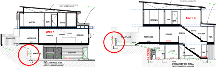
Excavation and retaining up to 2m is required in order to create the ground
floor and visitor car parking spaces and services areas for the proposed
development (see Unit 1 below). DCP Part B14.2 allows for excavation up to 2m
for car parking beneath a building, and while the proposal also locates
services within the excavated area, these located behind enclosed garage spaces
and
will not be visible from the streetscape
Excavation up to 1.2m is also proposed for the rear yard of
Units 5-7 (see Unit 6 above). Rear yard retaining will provide usable private
open space for the units in a scale and character that is compatible with the
surrounds and does not introduce adverse visual impacts.
The proposal seeks to establish a retaining structure along
the front property boundary to create a landscaping bay along the Goondooloo
road frontage, and is thereby considered a Fence in accordance with the DCP
Part D1.2.5. As proposed, the structure is located on the property boundary
line growing in height from approximately 1.2m at the western end of the site
to a maximum height of approximately 2.2m at the east, with hedging to be
located in front of the structure within the Council road reserve. Without the
hedging in front of the wall the structure will adversely effect streetscape
character; however if the hedging is not located on the property the landowner
holds no responsibility for its maintenance. The applicant has been requested
to provide amended plans demonstrating that the structure and hedging are
located entirely within the subject site to accord with DCP Part D1.2.5 for a
fence > 1.2m.
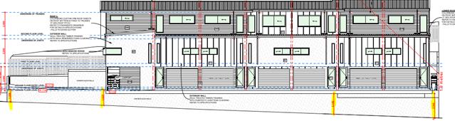
In their response, the applicant did not address this component of the
Information Request. Accordingly, if approved, a Condition of consent will be
applied requiring that amended plans demonstrate compliance with DCP part
D1.2.5 by locating the retaining wall not less than 50cm inside the front
boundary with the area in front to be landscaped, or are articulated with
landscaping recessions.
D1.2.1 Building Height Plane
The proposal presents encroachments into the Building Height
Plane (BHP) at the eastern and north-western (rear) property boundaries. While
the development is not gradually recessed from the eastern side boundary, the
subject site adjoins public park land and the development will therefore not
adversely affect development of the site by way of overshadowing, impinging on
privacy or obstructing views.
D1.6.4 – On-site car parking
Council’s Development
Engineer reviewed the proposal and identified that the vehicle manoeuvring at
Unit 7 is precarious and potentially dangerous as proposed, where any over
manoeuvring will create the potential for a vehicle to fall from the edge of
the driveway along the common boundary approximately 1.9m (see images below).
This is very unsafe, especially
when driving with bad visibly (at night when there is less light and when there
is rain), and conflicts with the Objectives of the development control D1.6.4
“To ensure that vehicle access to and from the development is safe,
effective and enhances visual amenity.”
Council’s Development Engineer ran swept path analyses
and advised that this scenario can be improved by moving Lots 4, 5, 6 & 7,
1m to the rear (north), increasing the manoeuvring area and improving safety
and efficiency.
The applicant was requested to
amend the proposal plans as noted above, however relocated the dwelling only
500mm to the rear (north) as opposed to the 1m requested. Council’s
Development Engineer reviewed the amended plans, and resolved that amended
plans provided did not alleviate the issue of safety and efficiency.
The proposal is not considered to achieve the objective of this development
control.
D1.6.10 – Character
& E9 – Ocean Shores, New Brighton and South Golden Beach Residential
Character Areas
This development control seeks
to ensure that medium density housing development (including attached
dwellings) is compatible in character with the locality, provides adequate
private open space, addresses slope and drainage issues, and is consistent with
the character narrative within Chapter E9 of the DCP. The relevant character
narrative for Ocean Shores notes that residential areas are predominantly
comprised of “low density, low rise single and attached dwellings with
low-impact bulk and scale.”
As noted to the applicant in the
pre-lodgement DAP meeting, through an information request, and at a meeting
with Council officers, the 30m long singular building presents excessive bulk
that is not consistent with the built form of the area which is predominantly
comprised of detached dwellings, Secondary dwellings and Dual occupancies.
Additionally, Chapter E9 accounts for medium density
development, “earmarking an area for change” to incorporate
“pockets of low rise medium density homes that match the amenity of
traditional free standing homes.” The subject site is not located in
the earmarked area, and does not match the amenity of free standing homes.
Discussion of assessment against LEP and DCP:
The proposal is considered to be
inconsistent with the Objectives of Clauses 2.3 (Zone objectives) and 4.1E
(Minimum lot sizes) of the Byron LEP 2014, being development that does not
align with the existing ‘low density residential environment’ and not
reflective of the planned residential density of the Low density residential
zone.
However,
LEP 2014 does not stipulate a density control (dwellings/xm²) for Multi
dwelling housing proposed within the LDRZ, and relies on other development
standards (LEP, such as Floor Space Ratio) and development controls (DCP,
such as setbacks, Private Open Space etc.) to guide this density.
Multi
dwelling housing is permitted with consent on an allotment of this size and the
proposal is demonstrated to comply with the development standards of the Byron
LEP other than the Objectives listed above.
The
building does not comply with the prescribed Building Height Plane, however is
considered to achieve the objectives of the development control as it does not
overshadow adjoining buildings.
The
design is deficient 44m² of Common Landscaped Area (CLA), and of that
provided, it is questionable as to how much of the CLA is “available
for common use and enjoyment”, when 50m² of that provided is
landlocked and inaccessible.
Council’s Development
Engineer posits that access/egress to the allocated car parking space for Unit
7 is unsafe and inefficient, conflicting with the Objectives of the development
control ‘D1.6.4 – On-site car parking’.
In summary the proposal is considered to be an
overdevelopment of the site for the following reasons:
· The built form
does not integrate with existing housing typologies of the low density
residential environment which is predominantly characterised by Dwellings,
Secondary dwellings and Dual occupancies which are predominantly detached;
· The density is inconsistent
with the existing and expected density within the low density residential zone
and surrounding environment; and
· The proposal does
not provide the prescribed area of Common Landscaped Area, and 25% of that
which is provided is not freely accessible for common use and enjoyment;
· the proposal
requires encroachments into the Building Height Plane and
· safe and efficient
vehicular access/egress to car parking within the site cannot be guaranteed by
the proposal.
Notwithstanding, the subject site is within ≈300m
(walking distance) of the Ocean Shores Shopping Village, is proximal to nearby
Medium density residential zones, and Multi dwelling housing is permitted with
consent on an allotment of this size. Additionally, the proposal provides a housing
typology (2-bed housing) that is desirable in the Shire, pursuant to Clause 6.7
of the Byron LEP 2014 which endeavours to:
a) increase
the supply of affordable housing,
b) provide
accommodation to support a diverse residential population inclusive of all
income groups within Byron,
c) to
ensure a housing mix and tenure choice including affordable housing,
d) to
ensure that affordable housing is identified by the Council as in demand and
located close to transport and services appropriate to the intended households.
If the proposal were to be
reduced by one dwelling unit (i.e., Unit 4), and the remaining units present as
two (2) detached buildings, the development would more accurately reflect the
desired and existing built form of the low density environment; the site will
be capable of accommodating the Communal Landscaped Areas that it is currently
deficient of and reconfiguration of the buildings will allow for this space to
be accessible for common use and enjoyment; vehicular manoeuvring about the
property can be reconfigured to ensure the safety and efficiency of it’s
operation; and the proposal will provide accommodation to support a diverse
residential population inclusive of affordable housing in close proximity
(walking distance) to a local commercial centre.
This is consistent with advice provided to the applicant
both prior to (at DAP meeting) and throughout assessment of the development
application (by way of information requests & discussions with the
applicant).
Recommendation:
It is recommended that the proposal be approved, subject to
the imposition of a Deferred Commencement Condition requiring amended plans to
be submitted reducing the total number of units within the development to six
(6) and to separate the building into two (2) structures to reflect the built
form of the locality. Amended plans must demonstrate that vehicular
access/egress to car parking areas is safe and efficient, to Council’s
Development Engineer’s satisfaction.
4.5 Any Planning Agreement or
Draft Planning Agreement?
|
|
Yes
|
No
|
|
Is there any applicable planning agreement or draft
planning agreement?
|
☐
|
☒
|
|
|
4.6 Environmental Planning
& Assessment Regulation 2000 Considerations
The proposal raises no issues against the relevant
Regulations.
4.7 The likely impacts of that
development, including environmental impacts on both the natural and built
environments, and social and economic impacts in the locality
|
Impact on:
|
Likely significant impact/s?
|
|
Natural environment
|
No. The proposal will not have a significantly adverse
impact on the natural environment of the locality.
|
|
Built environment
|
The building as proposed is incapable of providing the
required Communal Landscaped Area, safe vehicular access/egress, and is
considered to be inconsistent with the built form and character of the Low
density residential zone. Approval of the structure in its current format may
introduce an undesired precedent for bulky Multi-dwelling housing that does
not contribute to or conform with the Low density residential zone.
|
|
Social Environment
|
No. The proposal will not have a significant social impact
on the locality.
|
|
Economic impact
|
No. The proposal will not have a significant economic
impact on the locality.
|
4.8 The suitability of the site
for the development
The site is a serviced, unconstrained property and is suitable
for the residential development.
4.9 Submissions made in
accordance with this Act or the regulations
The development application was
publicly exhibited
There were 18 submissions made on the development application:
- 1
For
- 17
Against
Primary concerns from submissions of opposition:
Numerous submissions were received regarding the proposed
development. A summary of these submissions and the assessment officer’s
comment are discussed hereafter.
v Conflicts with existing and
expected density
Submitters posit that the bulk and built form of the
proposal does not reflect the low density residential environment that is
characteristic of the area (dwelling houses, Secondary dwellings and detached
Dual occupancies), nor the expected residential density of the Low density
residential zone.
Comment:
It is the opinion of the
assessment officer that the proposal exceeds the expected residential density
and built form that is characteristic of the low density residential area. The
applicant was requested to revise the proposal with due regard to the expected
built form and residential density within the Low density residential zone and
did not.
v Use as air bnb (short term accom)
and consequential impact on amenity:
Submitters highlight concerns regarding the
‘potential’ use of the development for short term accommodation,
and the consequential degradation of amenity and community within the locality
(as is commonly experienced from such occurrence).
Comment:
The proposal seeks to establish
Multi-Dwelling Housing at the subject site, development that is
‘permitted with consent’ pursuant to the Byron Local Environmental
Plan 2014. Granting development consent to Multi-Dwelling Housing is not
granting development consent for a short-term accommodation and use of the
dwellings as such without appropriate consent is considered a development
offence under the Environmental Planning and Assessment Act 1979. Conditions
will be applied to the development restricting the use of the dwellings to that
approved under the consent. Use of the dwelling inconsistent with the
development consent will be unlawful and a matter for Council’s
Development Compliance team to investigate if enacted.
v Excess traffic, Number of car
parking spaces provided and flow-on on-street parking.
Submitters are concerned that increased density within
Kumbellin Glen is unsustainable, and identify that each dwelling is afforded a
single car parking space and that flow-on on-street parking is likely however
not feasible.
Comment:
While it is acknowledged that
each dwelling is comprised of two bedrooms and it is possible that each
dwelling may therefore require two car parking spaces, the proposal complies
with the measures prescribed by the Byron DCP.
v Degradation to Goondooloo Drive road
surface
Submitters posit that additional vehicles trafficking
Goondooloo Drive will further contribute to the degradation of the road
surface.
Comment:
The applicant will be required to
pay developer contributions in accordance with Council’s Policy whereby a
portion of the contribution paid will be allocated to maintenance of Urban
Roads.
v Noise
Submitters are concerned about the noise of
demolition/construction and habitation of the proposed residences.
Comment:
Demolition and construction of
the existing and proposed buildings respectively is required to be undertaken
in accordance with the Protection of Environment Operations Act 1997. Noise
caused by inhabitants of the dwellings cannot be controlled in Development
Assessment.
v Height - the
development is > 10m)
Submissions purport that the
proposal exceeds the maximum building height development standard.
Comment:
Proposal plans demonstrate that
the proposal is less than 9m overall height. Proposal unlikely to
impact on views or the like
v Noncompliance with the Building
Height Plane
A submitter highlighted that the Building Height Plane
(BHP) is encroached at the eastern side property boundary (adjoining Council
park land).
Comment:
Clause 4.14(6) of the Act
requires malleability in the application of the DCP. Using the Dual Path
assessment process, the BHP encroachment is justifiable as it will not cause
overshadowing, privacy or amenity implications for adjoining property owners,
and provides an acceptable performance outcome.
v Overshadowing
One submitter highlights concerns regarding overshadowing
of the development to adjoining properties.
Comment:
Shadow diagrams provided with the
proposal demonstrate that any shadow caused by the development will be cast
onto public land and road reserve, and not affect adjoining properties or
residences.
v The dangerous intersection of
Goondooloo and Kumbellin – people speed down the hill and it is
dangerous.
Submitters are concerned that increased density within
Kumbellin Glen will intensify the existing dangerous intersection of Kumbellin
Glen and Goondooloo Drive.
Comment:
The assessment of this DA cannot
respond to the dangerous driving within the locality.
v School Bus stop at Goondooloo
Submitters highlight concerns regarding safety for
students using the Goondooloo Drive bus stop with additional traffic using the
(Kumbellin Glen – Goondooloo Drive) intersection, considering increased
density within Kumbellin Glen and assumed on-street parking.
Comment:
The proposal will not inhibit use
of the School Bus stop at Goondooloo Drive; and on-street parking is assumed in
this instance.
v Submission of support:
One submission of support was
received from a local developer who claims to own the adjoining property,
commending the developer of the site for:
· their transparency
in the design process;
· an impressive
proposed design; and
· contributing
to housing options in the area.
The submitter also made comments
noting:
· that they do not
have concerns regarding car parking on site or within Kumbellin Glen;
· that they have no
concerns regarding the density of the development;
· that they consider
it to be an improvement of the use of the site;
· that they have
“no concern about traffic movements as the property is at the bottom of
the street so clearly will not add any further traffic along…[the]…
cul-de-sac”; and
· that the design
and appearance of the building is “very appealing” and
“consistent with the size of other home buildings in the area”
Comment
Noted.
4.10 Public interest
The proposed development does not integrate with the
existing and expected low density residential environment, numerous controls of
the Byron DCP, is not considered suitable for the site and is therefore likely
to compromise the public interest or create an undesirable precedent within the
zone.
5. DEVELOPER
CONTRIBUTIONS
5.1 Water & Sewer Levies
Section 64 levies will be payable.
5.2 Section 7.11 Contributions
Section 7.11 Contributions will
be payable.
6. DISCLOSURE OF
POLITICAL DONATIONS AND GIFTS
|
Has a Disclosure Statement been received in relation
to this application
|
No
|
|
Have staff received a ‘gift’ from anyone
involved in this application that needs to be disclosed. Where the answer is
yes, the application is to be determined by the Director or Manager of the
Planning, Development and Environment Division.
|
No
|
Provide Disclosure Statement register details here: Not
applicable
7. CONCLUSION
Council could refuse the application based on the
development being inconsistent with the objectives of the R2 Low density Zone,
relevant provisions of the Byron DCP 2014 and being an overdevelopment of the
site.
It is recommended though that the proposal be approved
though with deferred commencement conditions to delete one of the units and to
break the building into two. This will ensure the development is at an
acceptable scale having regards to the objectives of the R2 Zone the provisions
under DCP 2014.
Staff Reports - Sustainable Environment and Economy 13.14
Report No. 13.14 PLANNING
- Development Application 10.2020.530.1 Swimming Pool and decks at 36 Roses
Road Federal
Directorate: Sustainable
Environment and Economy
Report
Author: Shannon
Burt, Director Sustainable Environment and Economy
File No: I2020/1600
Proposal:
|
DA No:
|
10.2019.516.1
|
|
Proposal description:
|
Swimming Pool and decks
|
|
Property description:
|
LOT: 4 DP: 1003205
|
|
36 Roses Road FEDERAL
|
|
Parcel No/s:
|
226140
|
|
Applicant:
|
Mr S G Richardson
|
|
Owner:
|
Mr S G Richardson
|
|
Zoning:
|
RU5 Village
|
|
Date received:
|
14 October 2020
|
|
Integrated / Designated Development:
|
☐
Integrated
|
☐
Designated
|
☒
Not applicable
|
|
Concurrence required
|
No
|
|
Public notification or exhibition:
|
Level 0 advertising under DCP 2014 Part A14 –
Public Notification and Exhibition of Development Applications
|
|
Variation request
|
☐
Clause 4.6
|
☐
SEPP 1
|
☒
Not applicable
|
|
Delegation to determine
|
Council
|
|
Issues:
|
No issues identified
|
Summary:
Development consent is sought for a swimming pool and decks
on the subject property at Federal.
The pool and decks are located in a rear yard, which backs
onto a Council reserve.
The pool has a general diameter of 6 metres. A deck
extension with an area of approximately 18 m2 is proposed connecting
the pool with the house, and a smaller circular deck with a nominal height of
300 mm proposed as a landscape feature.
The proposal raises no issues in terms of environmental
impacts or site constraints and is permissible with consent in the RU5 under
Byron LEP 2014.
This development application has been assessed and is
reported to Council in accordance with Council’s Management of Conflicts
of Interest for Development Matters.
The proposed pool and decks are recommended for approval
subject to Conditions of Consent.
NOTE
TO COUNCILLORS:
In
accordance with the provisions of S375A of the Local Government Act 1993, a
Division is to be called whenever a motion for a planning decision is put to
the meeting, for the purpose of recording voting on planning matters.
Pursuant to clause 2(a) under the heading Matters to be Included in Minutes of
Council Meetings of Council's adopted Code of Meeting Practice (as amended) a
Division will be deemed to have been called by the mover and seconder of all
motions relating to this report.
|
RECOMMENDATION:
That pursuant
to Section 4.16 of the Environmental Planning & Assessment Act 1979,
Development Application No. 10.2020.530.1 for Swimming Pool and decks be granted consent
subject to conditions listed in Attachment 2 #E2020/85634.
|
Attachments:
1 10.2020.530.1
- Plans, E2020/86285
2 10.2020.530.1
- Conditions of consent, E2020/85634
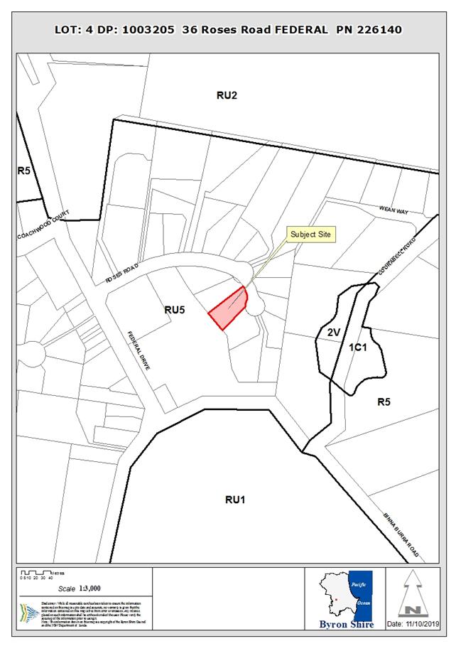
REPORT
1. INTRODUCTION
1.1. History/Background
Council records indicate that
the lot was created by way of a Council approved subdivision registered in
1999. Since that time, the following development approvals have been
granted:
|
10.2001.710.1
|
Dwelling
|
Approved 23/04/2002
|
|
10.2006.467.1
|
Double garage / shed
|
Approved 13/10/2006
|
|
10.2019.516.1
|
Additions to Dwelling
|
Approved 21/11/2019
|
1.2. Description
of the proposed development
Development consent is sought for a swimming pool and decks
on the subject property at Federal.
The pool is located in the rear yard with a general diameter
of 6 metres and a variable depth of 1.2 to 1.6 metres
The larger deck has an area of approximately 18 m2
with general dimensions of 9 x 2 metres. The deck is a timber construction and
will connect the pool with the house.
A small circular deck with a nominal height of 300 mm is
proposed as a landscape feature.
The proposed pool and decks are located in the rear yard of
the property which backs onto a Council Reserve at Federal.
1.3. Description
of the site
|
Land is legally described as
|
LOT: 4 DP: 1003205
|
|
Property address is
|
36 Roses Road FEDERAL
|
|
Land is zoned:
|
RU5 Village
|
|
Land area is:
|
1,491m2
|
|
Property is constrained by:
|
Drinking water catchment
|
2. SUMMARY OF
REFERRALS
There were no referrals for this application.
3. SECTION 4.14
– BUSH FIRE PRONE LAND
The site is not identified as bush fire prone land.
4. SECTION 4.15C
– MATTERS FOR CONSIDERATION – DISCUSSION OF ISSUES
Having regard to the matters for consideration detailed in
Section 4.15(1) of the Environmental Planning & Assessment Act 1979
(EP&A Act), the following is a summary of the evaluation of the issues.
4.1 State
Environmental Planning Instruments
4.2 Byron Local Environmental Plan
2014 (LEP 2014)
LEP 2014 is an applicable matter for consideration in the
assessment of the subject development application in accordance with subsection
4.15(1) of the EP&A Act because it applies to the subject land and the
proposed development. The LEP 2014 clauses that are checked below are of
relevance to the proposed development:
In accordance with LEP 2014 clauses 1.4 and 2.1 – 2.3:
(a) The
proposed development is defined in the LEP 2014 Dictionary as Dwelling House;
(b) The
land is within the RU5 Village according to the Land Zoning Map;
(c) The
proposed development is permissible with consent; and
(d) Regard
is had for the Zone Objectives as follows:
|
Zone Objective
|
Consideration
|
|
To provide for a range of land uses, services and
facilities that are associated with a rural village
|
The proposal raises no issues in
regards to the zone objective.
|
Clause 4.3 Height of Buildings
The proposal complies with the 9 metre height limit.
Clause 4.4 Floor Space ratio
No new floor area is generated by the development.
Clause 6.2 Earthworks
Minor earthworks are proposed to excavate for the pool and
footings and a small retaining wall (approximately 0.8 metre high) to be
erected long the rear boundary. Any spoil from the pool will be spread to level
out parts of the rear yard.
Conditions of consent will apply in relation to the
installation and maintenance of sedimentation and erosion controls and for
plans to be submitted for the retaining walls with the construction certificate.
Clause 6.6 Services
The proposed development
places no demand on Council infrastructure and the pools location does not
conflict with the location of the existing onsite sewage management system
which is positioned in the front yard.
The proposal raises no other issues under the LEP.
4.3 Any proposed Instrument
that has been the subject of public consultation and has been notified to the
consent authority
None applicable.
4.4 Byron Shire Development
Control Plan 2014 (DCP 2014)
C4 – Development in a Drinking Water Catchment
No issues the result of the
proposal.
E6 – Federal Village
The subject site is located within a residential area as
nominated within Chapter E6. The proposed pool and decks raise no issues
with the provisions contained within the DCP.
The proposal raises no other issues under the DCP.
4.5 Any Planning Agreement or
Draft Planning Agreement?
|
|
Yes
|
No
|
|
Is there any applicable planning agreement or draft
planning agreement?
|
☐
|
☒
|
4.6 Environmental
Planning & Assessment Regulation 2000 Considerations
|
Clause
|
This control is
applicable to the proposal:
|
I have considered this
control as it relates to the proposal:
|
If this control is
applicable, does the proposal comply?
|
|
92
|
No
|
N/A
|
N/A
|
|
93
|
No
|
N/A
|
N/A
|
|
94
|
No
|
N/A
|
N/A
|
|
94A
|
No
|
N/A
|
N/A
|
4.7 Any Coastal Zone Management
Plan?
|
|
Satisfactory
|
Unsatisfactory
|
Not applicable
|
|
Is there any applicable coastal zone management plan?
|
☐
|
☐
|
☒
|
4.8 The likely impacts of that
development, including environmental impacts on both the natural and built
environments, and social and economic impacts in the locality
|
Impact on:
|
Likely significant impact/s?
|
|
Natural environment
|
No. The proposal will not have a significantly adverse
impact on the natural environment of the locality. The existing onsite sewage
management system does not require upgrading for the development.
|
|
Built environment
|
No. The proposal will not have a significantly adverse
impact on the built environment of the locality.
|
|
Social Environment
|
No. The proposal will not have a significant social impact
on the locality.
|
|
Economic impact
|
No. The proposal will not have a significant economic
impact on the locality.
|
Standard conditions of consent to apply in terms of hours of
work, builders waste, construction noise and the like.
4.9 The suitability of the site
for the development
The site is suitable for the proposed development.
4.10 Submissions made in accordance with
this Act or the regulations
Not applicable.
4.11 Public interest
The proposed development is unlikely to prejudice or
compromise the public interest or create an undesirable precedent.
5. DEVELOPER
CONTRIBUTIONS
There is no nexus to levy contributions or headworks
charges.
6. .
DISCLOSURE OF POLITICAL DONATIONS AND GIFTS
|
Has a Disclosure Statement
been received in relation to this application
|
No
|
|
Have staff received a ‘gift’ from anyone
involved in this application that needs to be disclosed. Where the answer is
yes, the application is to be determined by the Director or Manager of the
Planning, Development and Environment Division.
|
No
|
7. CONCLUSION
The proposed development is satisfactory having regard to
the relevant environmental planning instruments and planning controls
applicable to the site. The proposal raises no significant issues in
terms of environmental impacts which cannot be managed, and the site is
considered suitable for the development. The application is recommended
for approval.
8. REASONS
FOR DECISION, HOW COMMUNITY VIEWS WERE ADDRESSED
Note:
From July 1 2018, Council’s are required to give and publicly notify
reasons for a range of planning decisions where they are deciding if
development should proceed to help community members to see how their views
have been taken into account and improve accountability to stakeholders. A
statement of reasons for the determination of this application is provided
below.
|
Statement of Reasons
|
|
The proposed development complies with the provisions of
Byron Local Environmental Plan 2014.
|
|
The proposed development complies with relevant State
Environmental Planning Policies
|
|
The proposed development complies with relevant provisions
of Development Control Plan 2014
|
|
The proposed development complies with Environmental
Planning & Assessment Regulation 2000 considerations.
|
|
The proposed development will not have significant adverse
impact on the natural, built or social environment or economic impacts on the
locality.
|
|
The proposed development is considered suitable for the
proposed site.
|
|
The proposed development is unlikely to prejudice or
compromise the public interest.
|
|
How community views were addressed
|
|
The DA did not require advertising or notification as per
Development Control Plan 2014.
|
Staff Reports - Sustainable Environment and Economy 13.15
Report No. 13.15 PLANNING
- 26.2020.5.1 Planning proposal to permit a car park at 158 Jonson
Street, Byron Bay
Directorate: Sustainable
Environment and Economy
Report
Author: Sam
Tarrant, Planning Support Officer
File No: I2020/1603
Summary:
Council received a planning proposal in July 2020
requesting an amendment to Byron LEP 2014 to permit a car park on land described
as Lot 51 DP 844054 and Part Lot 4729 DP 1228104. It is a triangle-shaped
parcel with a combined area of approximately 0.619 hectares. The street address
is 158 Jonson Street, Byron Bay.
Historically, the subject land has been owned by the
relevant NSW rail authority (most recently Transport for NSW) and has only
passed into private hands in the last ten years. The land contains a
Coastal Wetland mapped under SEPP Coastal Management plus some remnant native
vegetation.
The subject land is currently zoned entirely SP2
Infrastructure (Rail corridor) under Byron LEP 2014 (BLEP14). It has a
building height limit of 9 metres, no minimum lot size (MLS) and no floor space
ratio (FSR).
The planning proposal will change the zone of the subject
land from SP2 Infrastructure (Rail corridor) to part SP2 Infrastructure (Car
park). The land mapped as coastal wetlands will be included in an E2
Environmental Conservation zone, and a buffer and vegetation offset area is to
be zoned E3 Environmental Management.
The car park will be restricted to the land zoned SP2. The
current height of buildings (9 metres) will be retained and a minimum lot size
of 40 hectares is proposed for the land to be zoned E2 and E3, which is
consistent with other locations where these zones are used. No minimum lot size
is required for the SP2 car park land.
The current owners of the subject site also own both
parcels directly to the north. The car park is intended to service a proposed
redevelopment of the large vacant shed within the business zone. The applicants
have advised they will submit a development application for this redevelopment once
the car park rezoning receives a positive gateway determination.
The planning proposal is the only way to permit a car park
on the subject land. The current zone for rail infrastructure is no longer
relevant now that the land is privately owned and no longer required for rail
purposes. The car park will be located on the
edge of the CBD and accessed from Jonson Street via the Byron Bay bypass and
Browning Street. This aligns with Council’s goals of promoting parking on
the CBD edges and promoting pedestrian uses in the CBD as identified in the Byron
Bay Town Centre Masterplan.
This report recommends that Council proceed with the
planning proposal and forward to the NSW Department of Planning, Industry and
Environment for a Gateway determination.
Pending a positive Gateway determination, further information
and studies that are required prior to public exhibition and agency
consultation include:
• A study of the site’s Aboriginal heritage.
• A preliminary contaminated land investigation to ensure
that any disturbance will not pose a threat to neighbouring dwellings during
development.
• A Bushfire Hazard Report
NOTE TO COUNCILLORS:
In accordance with the
provisions of S375A of the Local Government Act 1993, a Division is to be
called whenever a motion for a planning decision is put to the meeting, for the
purpose of recording voting on planning matters. Pursuant to clause 2(a)
under the heading Matters to be Included in Minutes of Council Meetings of
Council's adopted Code of Meeting Practice (as amended) a Division will be
deemed to have been called by the mover and seconder of all motions relating to
this report.
|
RECOMMENDATION:
That Council:
1. proceed
with the planning proposal as attached to this report (Attachment 1 –
E2020/83230) to amend LEP 2014 to permit a car park and apply environment
protection zones on the subject land;
2. forward
the planning proposal to the NSW Department of Planning, Industry and
Environment for a Gateway determination;
3. pending
a positive Gateway determination and completion of adequate studies and
further supporting information, undertake public exhibition of the planning
proposal in accordance with the determination requirements; and
4. consider
a submissions report post-exhibition that includes any recommended changes to
the planning proposal for final adoption.
|
Attachments:
1 26.2020.5.1
Planning Proposal Jonson St car park (v1 Gateway), E2020/83230
2 26.2020.5.1
Combined supporting information, E2020/85746
3 Form of
Special Disclosure of Pecuniary Interest, E2012/2815
REPORT
Background
and Subject Land
Council received a planning proposal in July 2020
requesting an amendment to Byron LEP 2014 to permit a car park on land
described as Lot 51 DP 844054 and Part Lot 4729 DP 1228104.
Historically, the subject land has been owned by the
relevant NSW rail authority (most recently, Transport for NSW) and has only
passed into private hands in the last ten years. The current owners purchased
the larger piece (Lot 51 DP 844054) and are currently finalising purchase of
the thin strip close to the rail line (Part Lot 4729 DP 1228104). The land has
a combined total area of 0.619 hectares (Figure 1).
The current owners of the subject site also own both
parcels directly to the north, which are zoned B2 Local Centre. The car park is
intended to service a proposed redevelopment of the large vacant shed within
the B2 zone, and potentially the other existing businesses on both parcels (Figure
2). The applicants have advised they will submit a development application for
this redevelopment as soon as the car park rezoning receives a positive gateway
determination.
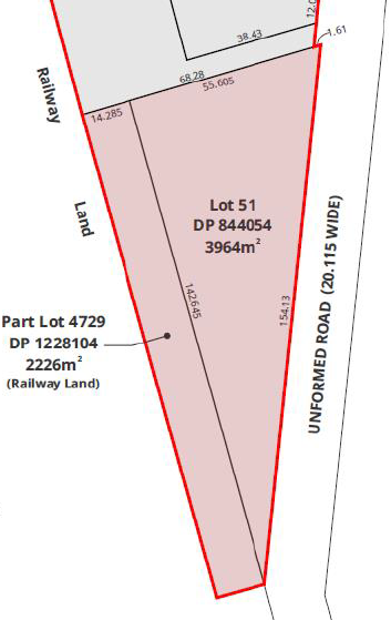
Figure 1 Subject land cadastre
at southern end of Jonson Street
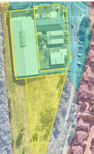
Figure 2 Subject land (SP2) and
adjoining B2 Zone land (shaded blue) in same ownership
The site has been disturbed in the past and has contained
buildings in different locations associated with its rail use. It has
previously been partly cleared and partly filled without Council consent by
previous owners. It contains a small patch of native vegetation that the
applicant’s ecologist identifies as degraded Paper bark Swamp Forest EEC.
The vegetation in the south of the site is mapped as being within a SEPP
Coastal Wetland. The land currently does not contain any buildings (Figure 3).
A small section at the southern end of the site is flood
prone in 1:100-year flood events. The entire site is either bushfire prone or
in a bushfire buffer.
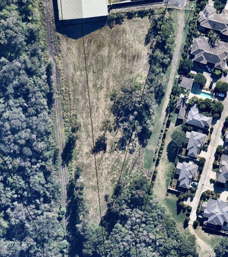
Figure 3 Subject land showing
current vegetation and surrounding land use in 2020
Planning
Proposal
The original
planning proposal lodged by the proponent proposed that the SP2 Rail
Infrastructure zone across the whole site be rezoned to SP2 Car Park.
Byron LEP 2014 states that car park means a building or place primarily used
for the purpose of parking motor vehicles, including any manoeuvring space and
access thereto, whether operated for gain or not.
The structure of
the SP2 land use table is as follows:
Zone SP2
Infrastructure
1 Objectives
of zone
• To provide for infrastructure and
related uses.
• To prevent development that is
not compatible with or that may detract from the provision of infrastructure.
2 Permitted without consent
Environmental
protection works
3 Permitted with consent
Aquaculture;
Environmental facilities; Roads; The purpose shown on the Land Zoning Map,
including any development that is ordinarily incidental or ancillary to
development for that purpose
4 Prohibited
Any
development not specified in item 2 or 3
The proposed
change to SP2 Car Park will permit a car park and other development that
is ancillary to a car park.
The applicant
was advised that the site contained a Coastal Wetland and this area would have
to be included in an E2 Environmental Conservation zone. An additional area
would be required both as a buffer to the Coastal Wetland (not less than 10
metres wide) plus an area to rehabilitate as an offset for the 997m2 of
remnant vegetation to be cleared to construct the car park. An area of
approximately 1180m2 at the southern end of the subject land has
been identified for this purpose and included in an E3 Environmental Management
zone. The applicant has agreed to the application of the environmental zones as
described.
It is not
intended to introduce a floor space ratio (FSR) to the site (no FSR currently
applies) and the current height of buildings (9 metres) will be retained. A
minimum lot size of 40 hectares is proposed for the land to be zoned E2 and E3,
which is consistent with other locations where these zones are used. No minimum
lot size is required for the SP2 Car Park land.
The current
Byron LEP 2014 zone map is at Figure 4 and the proposed Byron LEP zone map is
at Figure 5.
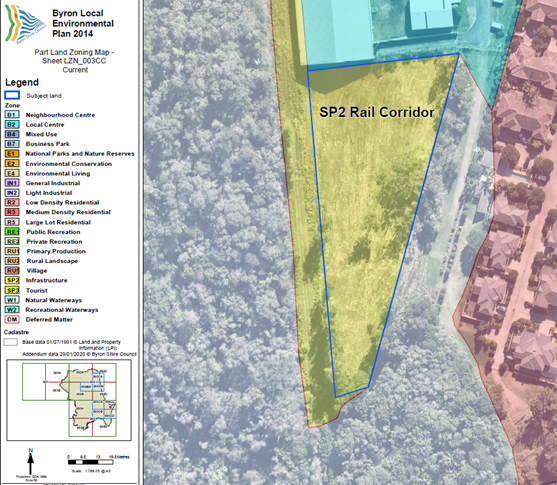
Figure 4 Current LEP zone map for subject land
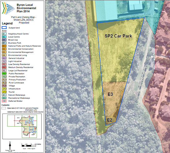
Figure 5 Proposed LEP zone map for subject land
Planning
Framework
North
Coast Regional Plan
The
subject site is not located within the Byron Bay Urban Growth Area boundary
under the North Coast Regional Plan 2036 (NCRP), which is located immediately
adjacent to it on two sides.
The
most relevant NCRP direction is Direction 6: Develop successful centres of
employment, with the relevant action being 6.4 – Focus
retail and commercial activities in existing centres and develop place-making
focused planning strategies for centres. A car park on this land has the
advantage of allowing the adjacent employment land to the north to be developed
consistent with zone objectives. The car park will be located on the edge of
the CBD and accessed from Jonson Street via the Byron Bay bypass and Browning
Street. This aligns with Council’s goals of promoting parking on the CBD
edges and promoting pedestrian uses in the CBD.
Byron
Bay Town Centre Masterplan
The
Byron Bay Town Centre Masterplan was completed in 2016 and includes an
‘access and movement strategy’ that addresses parking. The subject
land is immediately south of the masterplan study area and is not specifically
identified. However, the access and movement strategy states that a key goal is
to “encourage people movement in the town centre and redirect traffic and
parking away from the town centre. Large portions of existing parking need to
be removed to the outer fringes” (pages 25–28). The goal is to
relocate 60% of on-street parking to the edge of the town centre in the long
term.
The
use of the subject land as an ‘edge of town centre car park’ is
consistent with the Byron Bay Town Centre Masterplan.
Site
Specific Issues
Planning
(Car park) merit
The
site is no longer required for rail related uses and is no longer publicly
owned. It is logical that the zone needs to change to reflect the change of use
and ownership. The current owners suggested expansion of the Business zone but
this is not supported by the adopted Byron Shire Business and Industrial Lands
Strategy 2020. The idea to use the site as a car park has merit because it will
allow more efficient use of other land already zoned for business use nearby.
It can be easily accessed by traffic arriving from the southern access to Byron
Bay and easily accessed by traffic coming from the north via the Byron Bay
bypass. The new Jonson Street roundabout will provide safe access to the
proposed car park. The applicant has suggested a ground and first level
car park with a large solar array on the roof of the upper storey. This has
some potential for carbon offsets. The site will allow cars to park and
occupants to shop on foot at businesses at the southern end of the CBD or
access a bus service to travel back into the CBD if walking is not an option.
A
traffic study provided by the applicants supports the proposed car park,
stating that proposed development will increase traffic volume levels; however
the Jonson Street roundabout will provide a safe entry and exit point to
service the site.
Bushfire
The
subject land is partly classified as affected by bushfire hazard vegetation category
1 and a bushfire buffer. A Bushfire Hazard Report has not been provided
relevant to this planning proposal. It is infill development in a largely
developed location. The future car park development will result in more land
clearing on the site, reducing its ability to sustain a fire. A concrete car
park will also be relatively fire resistant. It is not an inappropriate use in
a hazardous area.
It is
reasonable that a Bushfire Hazard Report be undertaken as a condition of the
Gateway determination. The planning proposal (and Bushfire Hazard Report) will
still need to be referred to the Rural Fire Service.
Land
contamination
The
applicant has not supplied a preliminary investigation of the land carried out
in accordance with the contaminated land planning guidelines. The land is known
to have been filled without Council consent and the geotechnical report
undertaken by the applicant shows 0.6 metres to 1.5 metres of fill in two out
of three boreholes located on the site. It is not known if this fill is clean
or contaminated.
The
site was also owned by NSW Rail for an extended period and has evidence of past
sheds and clearing. All sheds have now been demolished or removed. Rail yards
are a potentially contaminating land use and sheds can also generate lead paint
and asbestos upon demolition or removal.
Although
the proposed use of the site as a car park is not a sensitive land use, it will
be a construction site to create the car park and a medium density residential
development is located to the east across a 20-metre road reserve. Dust and
disturbance at this site could affect adjacent property.
Given
the land use history on this site it is reasonable that preliminary
investigation of the land be undertaken as a condition of the Gateway
determination. It should include sufficient soil test information to identify
if there are any potential issues on this site with past rail use or fill
material. Any report will need to demonstrate that the site is suitable for its
proposed use and that, if contaminated it will not pose an issue to
neighbouring dwellings during development
Aboriginal
cultural heritage
The
Tweed Byron LALC has not been invited to inspect the subject land and undertake
a cultural heritage assessment. An AHIMs search was undertaken in October 2020
and shows that there are no registered Aboriginal sites on the subject land or
in proximity to it for 200 metres.
BLEP14
already contains clauses that facilitate the conservation of Aboriginal and
European heritage in Byron Shire. Sites and relics are also protected under
State legislation.
Despite
the disturbance history on this site, it is reasonable that this cultural
heritage assessment be undertaken as a condition of the Gateway determination.
Past
vegetation clearing and land filling
Council
property files show that complaints were made about the subject land in 2017 in
relation to alleged vegetation clearing and land filling without Council
consent (by previous owners).
The
geotechnical report undertaken by the applicant to support a future DA shows
0.6 metres to 1.5 metres of fill in two out of three boreholes located on the
site. It is not known if this fill is clean or contaminated or when it as
placed there. It is not known if the land was also filled or cleared by earlier
rail related landowners or managers prior to the 2017 reports.
The
following series of air photos show that the site has a history of disturbance
and regrowth over the last 25 years.
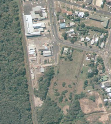
1991 air photo
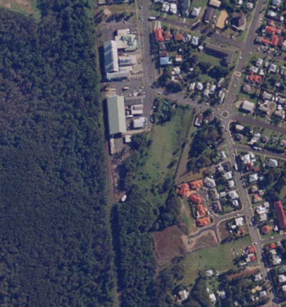
1997 air photo
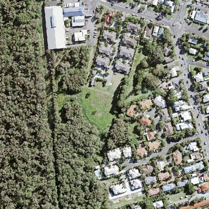
2015 air photo
Preliminary
discussions regarding public car parking
As
stated at the beginning of the report, the purpose of this planning proposal is
to enable a private car parking facility on the subject land to service
existing and future commercial development on adjoining land. Prior to lodging
the planning proposal staff discussed with the applicants the possibility of
formalising the adjacent Jonson Street road reserve with the intent of
providing public car parking spaces, specifically through a voluntary planning
agreement. This was seen as an opportunity to deliver a clear
‘public benefit’ as part of the rezoning process.
At the
time of writing this report the applicants have not provided an offer to enter
into a planning agreement to provide public car parking in the adjacent Jonson
Street road reserve. Further discussions are still underway with
Council’s Infrastructure Services team to determine the appropriateness
of pursuing this option. Pending the outcome of these discussions with
all parties concerned, a planning agreement could be entered into as part of
any subsequent development application/s.
Conclusion
and Options Going Forward
There are three options for Council to consider:
1. Proceed
with the planning proposal at Attachment 1 to this report which will permit a
car park on the subject land with Council consent as well as protecting a
Coastal Wetland and identifying a rehabilitation area to offset native
vegetation lost from the site. This option is subject to the applicant
providing additional information and reports relating land contamination,
Aboriginal heritage and bushfire hazard prior to public exhibition and agency
consultation (Recommended); or
2. Proceed
with the planning proposal in a modified form other than the version attached
to this report; or
3. Not proceed with the
planning proposal and advise the applicant accordingly.
There is sufficient information to support the planning
proposal at Attachment 1 to this report and proceed to a Gateway
submission. Council should request DPIE issue a Gateway determination for
the planning proposal as attached to this report subject to further information
and studies that are required prior to public exhibition and agency consultation
including:
• A
study of the site’s Aboriginal heritage completed by the TBLALC or a
qualified Aboriginal archaeologist.
• A
preliminary contaminated land investigation, which includes sufficient soil
test information to identify if there are any potential issues on this site
with past rail use or fill material. Any report will need to allow Council to
determine that the site is suitable for its proposed use and, if contaminated,
that disturbance will not pose a threat to neighbouring dwellings during development.
• A
Bushfire Hazard Report that addresses the use of the site as a car park and as
it is infill development (that is, development within an already subdivided
area), where an appropriate APZ cannot be achieved, provides for an appropriate
performance standard
STRATEGIC CONSIDERATIONS
Community Strategic Plan and Operational Plan
|
CSP Objective
|
L2
|
CSP Strategy
|
L3
|
DP Action
|
L4
|
OP Activity
|
|
Community Objective 4: We manage growth and
change responsibly
|
4.1
|
Support the visions and aspirations of local communities
through place-based planning and management
|
4.1.3
|
Manage development through a transparent and efficient
assessment process
|
4.1.3.11
|
Prepare and assess Planning Proposals and Development
Control Plans, and amend Local Environmental Plan maps
|
|
|
|
|
|
|
|
|
|
|
Legal/Statutory/Policy Considerations
This planning proposal will amend the Byron Local
Environmental Plan 2014
Financial Considerations
This is an applicant funded planning proposal. All costs
associated with this planning proposal will be borne by the applicants.
If Council chooses not to proceed then the matter does not
incur any additional costs.
Consultation and Engagement
Consultation with the community and government agencies will
occur following a gateway determination.
Staff Reports - Sustainable Environment and Economy 13.16
Report No. 13.16 Draft
Development Control Plan 2014 Chapter B2 Tree and Vegetation Management
Directorate: Sustainable
Environment and Economy
Report
Author: Karen
Love, Research Officer – Climate Change
File No: I2020/1539
Summary:
Clauses 5.9 and 5.9AA within the Byron Local Environmental Plan
2014 and the Native Vegetation Act 2003 have been repealed and replaced
with State Environmental Planning Policy (Vegetation in non-rural areas) 2017 and
the Local Land Services Act 2013. Given the recent gazetting of our
environmental zones (E2 and E3) Council is now required to declare such
vegetation within a Development Control Plan (DCP) and administer its
management through a tree removal permit system. As a result, DCP 2014 Chapter
B2 Tree and Vegetation Management has been updated to include the information
now required under the Vegetation SEPP.
|
RECOMMENDATION:
1. That
Council endorses the draft Development Control Plan Chapter B2 Tree and
Vegetation Management (Attachment 1 #E2020/67970) for public exhibition for
28 days.
2. That
staff provides a post-exhibition report to Council on item 1, including
consideration and recommendations on submissions received during the
exhibition period.
3. That
staff update Development Control Plan 2014 Part A to include the definitions
contained within Development Control Plan Chapter B2 Tree and Vegetation
Management post public exhibition.
|
Attachments:
1 Draft DCP
2014 Chapter B2 Tree and Vegetation Management, E2020/67970 
REPORT
DCP Chapter B2 Tree and Vegetation Management
The State Environmental Planning Policy (Vegetation in
non-rural areas) 2017 (Veg SEPP) was introduced alongside the Local Land
Services Act 2013 as a result of the Native Vegetation Act 2003 and clauses
5.9 and 5.9AA in the Byron Local Environmental Plan being repealed. The Veg SEPP manages vegetation removal in
all non-rural areas including E zones that does not involve or is ancillary to
development.
Outlining the new requirements of
the Veg SEPP, Councils Draft DCP Chapter B2 Tree and Vegetation Management
declares vegetation, provides information on exemptions and increases clarity
to land holders and our community regarding vegetation management. Given the
recently gazetted E2 and E3 zones, declared vegetation on all non-rural land
(land in any zone other than RU1 and RU2) within the Byron Shire local
government area is now administered under the Veg SEPP which authorises Council
to:
ü administer Tree Removal Permits for the removal of
vegetation, and
ü act as the consent authority for compliance.
Delivering Action 1.2 within the
Biodiversity Conservation Strategy 2020-2030, DCP Chapter B2 will only apply to
the removal or pruning of vegetation that is under the Biodiversity Offsets
Scheme (BOS) threshold.
The objectives of DCP Chapter B2
Tree and Vegetation Management are:
Ø To ensure the protection and preservation of local native
vegetation that contributes to the biodiversity, social and amenity value
of Byron Shire.
Ø To recognise and conserve very large trees and hollow
bearing trees of habitat, amenity or heritage value.
Ø To avoid and minimise wherever possible the
unnecessary removal of native vegetation.
Ø To minimise the risks of destabilisation of foreshore,
riparian or agricultural land.
Ø To provide information ensuring land holders are aware when
a permit is required for the removal or pruning of vegetation.
Ø To provide a consistent framework for assessing permits to remove
or prune vegetation.
Ø To recognise the biodiversity values of vegetation that
supports and provides refuge to native fauna.
Ø To recognise the importance and retention of vegetation for
carbon sequestration at a local scale.
Ø To facilitate the removal of undesirable exotic, declared
invasive or otherwise inappropriate plant species, and replace them with
suitable local native species that contribute to ecological, environmental or
habitat value.
Next steps
ü Place DCP Chapter B2 Tree and
Vegetation Management on public exhibition for 28 days, and report to Council
on submissions,
ü Update DCP Chapter A with the
definitions contained within DCP Chapter B2 post exhibition,
ü Amend the Tree Removal Permit
form to align with Chapter B2 Tree and Vegetation Management and the new Veg
SEPP.
STRATEGIC CONSIDERATIONS
Community Strategic Plan and Operational Plan
|
CSP Objective
|
L2
|
CSP Strategy
|
L3
|
DP Action
|
L4
|
OP Activity
|
|
Community Objective 3:
We protect and enhance our natural environment
|
3.1
|
Partner to protect and
enhance our biodiversity, ecosystems and ecology
|
3.1.1
|
Protect and enhance our
natural environment and biodiversity
|
3.1.1.1
|
Implement the
Biodiversity Conservation Strategy
|
Legal/Statutory/Policy Considerations
Commonwealth Environment Protection and Biodiversity
Conservation Act 1999
Environmental Planning and Assessment Act 1979
Environmental Planning and Assessment Regulation 2000
Biodiversity Conservation Act 2016
Biodiversity Conservation Regulations 2017
Coastal Management Act 2016
Fisheries Management Act 1994
Local Land Services Act 2013
Local Land Services Regulation 2014
National Parks and Wildlife Act 1974
Protection of the Environment Administration Act 1991
State Environmental Planning Policy Koala Habitat Protection
2019
State Environmental Planning Policy (Coastal Management)
2018
State Environmental Planning Policy (Vegetation in non-rural
areas) 2017
Financial Considerations
Project is funded in the 2020/21
budget.
Consultation and Engagement
· Peer
review by internal and strategic planners, open space team leaders,
Infrastructure Services managers and staff.
· Internal
review by compliance team.
· Peer
review by local arborist.
Staff Reports - Sustainable Environment and Economy 13.17
Report No. 13.17 PLANNING
- S4.55 Application to modify Consent 10.2019.616.1 Mixed Use Development, cnr
Jonson & Browning Streets Byron Bay
Directorate: Sustainable
Environment and Economy
Report
Author: Rob Van
Iersel, Major Projects Planner
File No: I2020/1567
Proposal:
|
Section 4.55 Application No:
|
10.2019.616.2
|
|
Proposed modification:
|
S4.55 to modify design of basement carpark, some building
components and various conditions of consent
|
|
Original Development:
|
Demolition of Existing Buildings and Construction of Mixed
Use Development
|
|
Type of modification sought:
|
|
|
|
|
|
Property description:
|
LOT: 21 DP: 247289, LOT: 5 SEC: 51 DP: 758207, LOT: 60 DP:
1256365, LOT: 61 DP: 1256365
|
|
137 Jonson Street BYRON BAY, 139 Jonson Street BYRON BAY,
3 Browning Street BYRON BAY
|
|
Parcel No/s:
|
34700, 34710, 269932, 269933
|
|
Applicant:
|
Mr M Scott
|
|
Owner:
|
JGD Developments Pty Ltd
|
|
Zoning:
|
B2 Local Centre
|
|
S96 Date received:
|
13 August 2020
|
|
Original DA determination date:
|
21/05/2020
|
|
Integrated Development:
|
No
|
|
Public notification or exhibition:
|
- Level
2 advertising under DCP 2014 Part A14 – Public Notification and
Exhibition of Development Applications
- Exhibition
period: 27/08/2020 - 09/09/2020
- Submissions received: 2
|
|
Planning Review Committee:
|
Not applicable
|
|
Delegation to determination:
|
Council
|
|
Issues:
|
· Building height
|
Summary:
Development application 10.2019.616.1 was approved at
Council (Planning) Meeting of 21 May 2020, providing consent for the
construction of a mixed use development involving two levels of underground car
parking, retail, commercial and café tenancies at ground level, with 28
shop top residential units in two levels above.
An application has been received to modify aspects of the
approved design:
1. Modify
the layout of the approved basement carpark;
2. Raise
the ground floor level of the building by 300mm to account for the finished
levels of the adjoining bypass roundabout;
3. Make
minor internal modifications to approved building;
4. Modify
the roof; and
5. Make
minor amendments to various conditions of consent.
The amendments to the basement involve internal
reconfiguration to provide a more logical circulation path between the two
levels. The amendments do not alter the approved number of spaces.
The addition of 300mm to the ground floor level is required
to ‘tie in’ to the finished levels of the kerb at the newly
constructed adjoining roundabout. This will result in slight increase in
building height, in order to maintain good internal floor to ceiling heights.
This overall height increase is partially offset by the amended rood design,
which reduces the “thickness” of the roof. As a result, the
area of roof that exceeds the 9.0m height limit is slightly reduced, even
though the actual maximum height is increased by approx. 300mm. The roof of the
south-east lift over-run now exceeds the 9.0m limit by approx. 0.4m, where it
was at the 9.0m limit in the approved version.
The roof is proposed to be further amended by relocation of
the roof-top plant, such as air-conditioning condensers and the like, and by
extending the north-west internal lift to provide access to the roof for
maintenance of building plant (air conditioners etc). The extension of this
lift results in the lift over-run exceeding the 9.0m building height limit by
3.7m. This is confined to the lift itself, with the roof area around the
lift below the maximum height. The lift will not be visible from street
level.
Internal modifications of spaces at the ground level are
proposed, resulting in a reduction in floor area of approx. 58m2.
The proposed land uses are not changed. Minor internal modifications are
also provided to shop-top residential units, not altering the number on units
or bedrooms.
Following discussions with immediate neighbours, the developer
proposes to alter Condition #6, which requires construction of an acoustic
fence along one neighbour’s boundary, to raise the fence height from 1.8m
to 2.4m and extend it along Ruskin Lane for the frontages of 2 adjoining
properties. Those land owners have given their support to that proposal.
The application also requests that the payment of developer
contributions be deferred, with payment required prior to issue of an
Occupation Certificate rather than at Construction Certificate. This is in line
with a State Government Direction which provides for such deferral as part of
the government’s COVID response. The direction applies to
contributions under Section 7.11 of the Environmental Planning and Assessment
Act, but not to water and sewer headworks charges. The application
proposes deferral of both sets of developer contributions, but it is
recommended that it only be approved for the Section 7.11 levies.
Adjoining owners were notified of the proposed amendments
and no concerns were raised in the two submissions received.
Overall, the proposed modifications do not substantially
alter the approved development and do not raise any significant planning issues
that were not addressed in the original approval.
The S4.55 application is recommended for approval.
NOTE TO COUNCILLORS:
In accordance with the
provisions of S375A of the Local Government Act 1993, a Division is to be
called whenever a motion for a planning decision is put to the meeting, for the
purpose of recording voting on planning matters. Pursuant to clause 2(a)
under the heading Matters to be Included in Minutes of Council Meetings of
Council's adopted Code of Meeting Practice (as amended) a Division will be
deemed to have been called by the mover and seconder of all motions relating to
this report.
|
RECOMMENDATION:
That, pursuant to Section 4.55 of the Environmental
Planning and Assessment Act 1979, Application No. 10.2019.616.2 for
modifications to approved mixed use development be approved by modifying
Consent Number 10.2019.61.1 as per the amended conditions in Attachment 4
(#E2020/86006).
|
Attachments:
1 10.2019.616.2
Proposed Modification Plans, E2020/86025
2 10.2019.616.1
Approved Plans, E2019/86364
3 Confidential
- 10.2019.616.1 Submissions received, E2020/86068
4 10.2019.616.2
Recommended Modified Conditions of Consent, E2020/86006
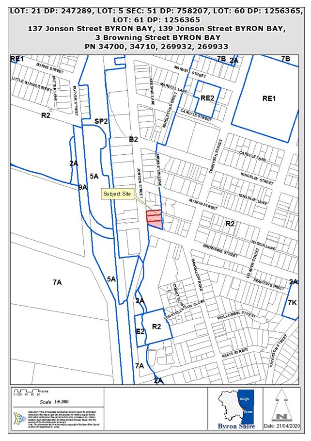
Assessment:
1. INTRODUCTION
1.1. History/Background
DA 10.2019.616.1 was approved at Council (Planning) Meeting
of 21 May 2020. The consent provided for the demolition of all buildings
on the site and the construction of a new mixed use building, with two levels
of basement car parking, a ground floor of commercial and retail tenancies,
with two levels of shop-top residential apartments.
Prior to that approval, the following approvals were
relevant to the site:
|
137 Jonson Street – Lot
21 DP 247289:
|
|
BA 1974/80
|
Dwelling – 4 bedrooms
|
Approved 24/05/1974
|
|
DA 5.1998.398.1
|
Conversion of garage to dual
occupancy
|
Approved 11/10/1988
|
|
BA 1998/2746
|
Alterations to existing flat
|
Approved 01/12/1988
|
|
BA 1991/2038
|
Additions to Dwelling
|
Approved 26/02/1991
|
|
139 Jonson Street – Lot
5 Sec 51 DP 758207:
|
|
DA 10.2011.553.1
|
Car hire business & use of garage as office
|
Approved 06/04/2012
|
|
3 Browning Street – Lots
61 & 61 DP 1256365 (previously Lot 6 Sec 51 DP 758207);
|
|
DA 10.2009.9.1
|
Tree removal – 1 tree
|
Approved 28/01/2009
|
|
Whole site:
|
|
DA 10.2017.510.1
|
Mixed use development comprising
demolition of all existing structures, removal of vegetation and construction
of commercial premises, cafe, child care centre, shop top housing, serviced
apartments and associated basement car parking and landscaping.
|
Refused (JRPP) 14/11/2018
|
1.2. Description of the
proposed development
The approved development provides for two levels of basement
car parking and:
|
Ground Floor
|
Upper Floors
|
|
614m2 retail floor
space
|
2 x 1 bedroom units
|
|
120m2 café/
restaurant
|
20 x 2 bedroom units
|
|
799m2 commercial floor
space
|
2 x 3 bedroom units
|
|
57m2 ancillary space
(storage, amenities, etc.)
|
4 x 4 bedroom units
|
|
Central landscaped courtyard
|
|
The current application seeks to implement a number of
design modifications, involving:
· modify the design
of the approved basement carpark;
· raise the floor
level of the building by 300mm;
· make minor internal
modifications;
· modify the roof
construction; and
· amendment to a
number of conditions of development consent.
1. Basement Car Park:
The amendments to the basement involve internal realignments
to provide a more logical circulation path between the two levels. The
amendments do not alter the approved number of spaces.
The primary change is to relocate the internal ramp between
the two levels from the centre, as approved, to the southern edge. In
addition to providing a more efficient vehicle flow, the change provides
increased storage area.
The total number of spaces is unchanged, although the
proposal has 1 less space in basement level 1, with 1 more in basement level 2,
compared to the approved layout.
The proposed new layout includes a number of tandem spaces,
which would be allocated to the occupiers of residential apartments.
Council’s Development Engineer has review the modified
layout and, following further minor amendments, is satisfied that it is
consistent with the original consent and complies with all relevant standards.
2. Change to Building Levels:
The
applicant advises that, during the design development process, it became
apparent that levels of the now constructed kerb on the corner of Jonson and
Browning Streets (part of the Byron Bay bypass works) are approx. 300mm higher
than previously understood.
This
means that the finished floor levels (FFL’s) of the ground floor also
need to be raised by approx. 300mm. Maintaining the ceiling heights on
the commercial ground floor and residential Levels 1 and 2, means that the
building overall is raised by 300mm.
This results in a 300mm increase in the maximum height of
the building, including a corresponding increase in the 9.0m height limit
exceedance at the building parapets, as shown below:
However, the proposed modification to roof design, as
described below, has minimised the amount of roof area that exceeds the 9.0m
height limit, such that there is actually a slightly smaller area of roof now
exceeding the limit.
The diagrams below show the approved and proposed,
illustrating that the height increase is limited to the roof parapets.
The perspectives illustrate that there is no substantial change in the extent
of roof area that exceeds the limit, and a slight decrease in the area of
exceedance in the roof section located in the south-eastern corner.
The only additional area that exceeds the 9.0m limit as a
result of the 300mm increase is the top of the lift over-run on the
south-eastern building (see grey square located toward the centre of the roof
on diagram below).
The exceedance of the lift over-run is approx. 0.4m.
|
Section – Approved
|
Section – Proposed
|
|
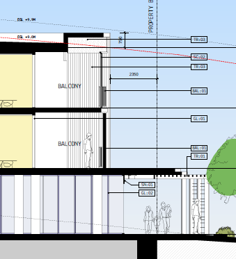
|
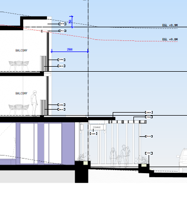
|
Area of Exceedance –
Approved
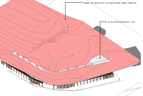
Area of Exceedance – Proposed
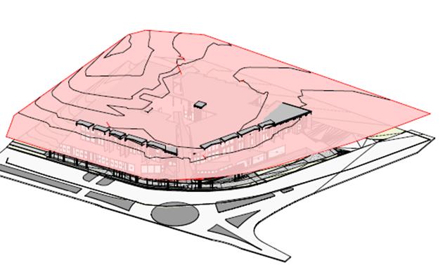
3. Internal Modifications:
Modifications are proposed to the internal ground floor
layout, altering the size of some internal tenancies, resulting in a reduction
in floor space of approx. 58m2. The proposed uses at ground
level have not changed.
Other minor internal modifications are proposed throughout
the building, none of which materially change the approved uses or size/ scale
of the building. The nature of those modifications are what would
routinely be expected between DA approval and construction certificate
application and involve things such as relocation of internal doorways, changes
to internal ‘back of house’ layout, and minor internal
modifications to shop-top apartment layouts.
There are no changes to the number of shop-top apartments or
the total number of bedrooms.
4. Changes to Roof:
The roof construction is proposed to be modified to a
concrete structure, which has the effect of lowering the overall roof profile,
resulting in a slight reduction in the area that exceeds the 9.0m height
limit. In effect, this results in a ‘thinner’ roof structure,
while having insignificant effect on the overall look of the building.
The application also proposed to relocate the main plant
area (air conditioning etc.) to the north eastern corner of the roof.
It is proposed to extend the approved internal lift within
the north-western building to access the roof area, to provide for access for
maintenance of the roof-top plant. Construction contractors have advised
that access to that plant by way of a lift is required, given the nature of the
plant and the frequency of maintenance requirements.
The alternative to lift access would be to use a crane to
access the roof, which would need to access the site via Ruskin Lane for each
maintenance event.
Extending the lift to the roof, however, means that the lift
over-run will exceed the 9.0m building height limit, with a maximum height of
12.7m.
The location of the lift
over-run is shown below in blue, with the approved areas of exceedance also
shown in blue. The lift over-run is the small rectangle located centrally
within the roof area on the north-west building.
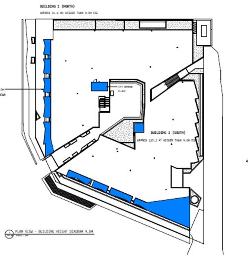
The location of the new lift over-run is such that it will
not be visible from street level.
The application includes updated shadow diagrams
demonstrating that the lift over-run does not result in any shadowing outside
the property.
The shadow diagrams also demonstrate that the proposed
modifications, including the additional 300mm height, do not result in any
noticeable increase in shadowing above the approved development, primarily
because of the reduced roof profile.
Modification of Conditions:
· Condition
6 Acoustic Barrier:
A 1.8m high acoustic barrier
is to be constructed along the western (Ruskin Lane) frontage of adjoining
residential property, No. 5 Browning Street (Lot B DP 363695), in accordance
with the recommendations of the Environmental Noise Impact Report, prepared by
CRG Acoustics, dated 6 November 2019 (Ref. 17083 rev.7).
Details of the barrier are to be
provided to Council’s Environmental Health Officer prior to the issue of
a Construction Certificate.
The proponents have been approached
by the owner of No 5 Browning St to increase the height of the barrier to
2.4m. They have also been approached by the owner of No 1 Ruskin Lane who
has requested a similar acoustic barrier.
As approved, the 1.8m acoustic
barrier would replace the existing timber fence along the first property in
Ruskin Lane (see below):
The increase in height to 2.4m
will have little visual impact given the widening of the lane and the scale of
the new development.
If extended to the adjoining
property, the 2.4m high acoustic barrier will replace a much smaller fence (see
below). While this will have a more substantial visual impact, it is
considered that the impact will be acceptable in the context of the scale of
the overall change to this part of the lane.
The land owners have both
requested the 2.4m acoustic barrier to protect their privacy.
· Condition
15 Excavation depth and dewatering limited
Excavations and dewatering
below the final approved basement level are not permitted without prior approval
from council. Such approval must be obtained after the date of this
consent.
The structural engineer for the
development indicates that it will be necessary to excavate approx. 0.6m below
the basement level of -2.0m (AHD), which is the approved floor level of
Basement 2, in order to accommodate the thickness of the slab and foundations.
The condition is proposed to be changed to:
Excavations and dewatering
below -2.6m (AHD) is not permitted without the prior approval of Council.
Modifying the condition as
requested creates no additional impacts.
· Condition
17 Land to be consolidated
Evidence, satisfactory to the Certifying Authority, is
to be provided demonstrating that arrangements have been made for all separate
parcels to be consolidated into one allotment and registered with NSW Land
Registry Services.
A Section 88B Instrument is to
be incorporated with the consolidation plan, providing for suitable public
access over the south-east corner of the property, associated with the access
to the basement ramp.
Condition No. 17 currently requires the consolidation to be
finalised prior to the issue of a Construction Certificate.
The delay in the consolidation of the 3 titles is due to a
drafting error made in regard Lots 60 & 61 in the subdivision of Lot 60 DP
758207, 3 Browning St. and the road reserve. The applicant proposes that
Condition No. 17 be complied with prior to the issue of the Occupation
Certificate.
Condition 3 of the consent provides that the development
can be carried out in 2 stages, with construction of the basement car parking
levels as Stage1, with the remainder of the building constructed as Stage
2. As currently worded, consolidation would be required before the first
Construction Certificate.
It is reasonable to amend the conditions such that
consolidation is required prior to the issue of a Construction Certificate for
Stage 2 works. This will provide the developer with the time required,
while ensuring that consolidation occurs.
· Condition
21 Certificate of Compliance – Water Management Act 2000
A Certificate of Compliance
will be issued upon payment of developer charges for water and sewer as
calculated in accordance with Byron Shire Council and Rous Water Development
Servicing Plans.
Byron Shire Council acts as
Rous Water’s agent in this matter and will issue a Certificate of
Compliance on behalf of Rous Water upon payment of the Rous Water Development
Servicing Charge to this Council.
Note: Copies of
the application forms for Certificates of Compliance are available on
Council’s website http://www.byron.nsw.gov.au/files/Forms/Section_305_Certificate.pdf
or from Council’s Administration Office. Copies of Byron Shire
Council’s Development Servicing Plans are available at Council’s
Administration Office.
Developer charges will be
calculated in accordance with the Development Servicing Plan applicable at the
date of payment. A check must be made with Council to ascertain the
current rates by contacting Council’s Principal Engineer Systems
Planning, Water on 02 6626 7081. Applicable charges can be found on
Council’s website: http://www.byron.nsw.gov.au/development-contributions-plans-section-94-and-64
The contributions payable will
be adjusted in accordance with relevant plan and the amount payable will be
calculated on the basis of the contribution rates that are applicable at the
time of payment.
Payment by
Personal or Company Cheque will not be Accepted
Condition No. 21 is to be complied with prior to the issue
of a Construction Certificate.
It is requested that Condition No. 21 be complied with
prior to the issue of the Occupation Certificate.
The request is based on the principles outlined in Ministerial
Direction Environmental Planning and Assessment (Local Infrastructure
Contributions – Timing of Payments) Direction 2020, dated 25 June
2020.
This Direction is a COVID response from the State Government,
which provides opportunity for payments of infrastructure contributions to be
deferred for certain types of development. It relates only, however, to
Developer Contributions levied under the Environmental Planning and Assessment
Act and does not apply to the Water Management Act charges.
It is recommended, therefore, that this condition not be
modified.
· Condition
24 – no right turn sign
Intersection
with Browning St in accordance with Planit drawing J170-1300 Rev C dated
9/3/20, except for the following:
- “No Right
Turn” signage is to comply with the relevant standards of Transport for
NSW;
- a “No
Right Turn” sign is to be located on the eastern side of Ruskin Lane
opposite the basement access ramp, so as to be clearly visible to southbound
vehicles within the lane;
- a “No
Right Turn” sign is to be located on the western side of Browning Street
opposite the Ruskin Lane intersection;
- a “Left
Turn Only” sign is to be located either on the central median in Browning
Street, or at junction of Ruskin Lane and Browning Street, to be clearly
visible to vehicles exiting the lane;
- the left arrow
and words “no right turn” proposed to be painted on the Ruskin Lane
pavement are not approved;
The wording in the third dot
point is incorrect and should read “southern side of Browning
Street”.
· Condition
24 – street lighting in Ruskin Lane
Upgrade of the street lighting
in accordance with AS1158 from Browning St and along the full frontage of the
development in of Ruskin Ln
The applicant notes that there is
currently no street lighting in Ruskin Lane and is concerned that providing
lighting will negatively impact neighbouring properties on eastern side of the
lane.
It is suggested that the
condition be modified to require an assessment of the need for lighting upgrade
to be carried out in accordance with AS1158 and that, if any additional
lighting is required as a result of that assessment, it be designed to ensure
that nearby dwellings are not impacted by light spill.
· Condition
27 Car parking
The condition includes the following table:
|
Basement 1
|
Width
|
Length
|
Aisle Width
|
Number
|
|
Car
|
2.6m
|
5.4m
|
6.0m
|
51
|
|
Accessible
|
2 x 2.6m
|
5.4m
|
6.0m
|
2
|
|
Motorcycle
|
1.2m
|
5.4m
|
6.0m
|
8
|
|
|
|
|
|
|
|
Basement 2
|
Width
|
Length
|
Aisle Width
|
Number
|
|
Car
|
2.6m
|
5.4m
|
6.2m
|
62
|
|
Accessible
|
2 x 2.6m
|
5.4m
|
6.2m
|
4
|
|
Motorcycle
|
1.2m
|
5.4m
|
6.2m
|
6
|
The applicant has requested that the table be updated to
reflect the amended basement car parking proposal, including reduction in
required aisle widths to accord with requirements of the relevant Australian
Standard.
Council’s Development Engineer has review the
revised basement plans and provided an updated condition of consent that
ensures that all spaces comply with the applicable Australian Standards.
· Condition
36 Developer Contributions to be paid
The applicant requests that the
timing of payment be modified to prior to the issue of an Occupation
Certificate, in lines with the Ministerial Direction outlined above (Condition
21).
The Ministerial Direction Environmental Planning and
Assessment (Local Infrastructure Contributions – Timing of Payments)
Direction 2020, remains in force and provides an opportunity for the timing
of developer contribution payments to be deferred until the issue of an
Occupation Certificate.
It is recommended that this
condition be modified in accordance with the guidance provided in the
Minister’s Direction.
· Condition
42 Construction times
Construction works must not
unreasonably interfere with the amenity of the neighbourhood. In particular
construction noise, when audible from adjoining residential premises, can only
occur:
a) Monday
to Friday, from 7 am to 6 pm.
b) Saturday,
from 8 am to 3 pm.
No construction work to take
place on Sundays and Public Holidays and the Construction Industry Awarded
Rostered Days Off (RDO) adjacent to Public Holidays.
The applicant has requested
deletion of the component the Construction Industry Awarded Rostered Days
Off (RDO) adjacent to Public Holidays, as a way to reduce the overall
construction timeframe, thereby reducing impacts on neighbours. They
estimate a saving of up to 3 weeks over the construction period.
The condition can be modified as
requested.
· Condition
70 Parking
Parking within the development
shall be provided and maintained as follows:
|
Use
|
Parking
|
Location
|
Allocated
|
Number
|
|
Retail
|
Car
|
Basement 1
|
Tenants & Customer
|
31
|
|
|
Accessible
|
Basement 1
|
Tenants & Customer
|
1
|
|
Cafe
|
Car
|
Basement 1
|
Tenants & Customer
|
6
|
|
Commercial
|
Car
|
Basement 1
|
Tenants & Customer
|
14
|
|
|
Accessible
|
Basement 1
|
Tenants & Customer
|
1
|
|
|
Motorcycle
|
Basement 1
|
Tenants & Customer
|
8
|
|
Commercial
|
Car
|
Basement 2
|
Tenants & Customer
|
25
|
|
Residential
|
Car
|
Basement 2
|
Residents
|
28
|
|
|
Car
|
Basement 2
|
Visitors
|
9
|
|
|
Accessible
|
Basement 2
|
Visitor
|
4
|
|
|
Motorcycle
|
Basement 2
|
Tenants & Customer
|
6
|
Tenants and customers of the
development must have unrestricted access to the car parking spaces on a daily
basis during business hours of the development.
No car parking spaces are to
be reserved (generally or specifically) for any tenant or customer. Only
carparking spaces required for the residential component of the development are
to be reserved and made available for particular residents.
The applicant requests that this
condition be updated in accordance with the modified basement car park design
and Condition 27 (above). Council’s Development Engineer has
reviewed the request and provided an updated consent condition that reflects
the approved basement parking plans.
1.3. Description of the site
The Site:
|
137 Jonson Street
|
Lot 21 DP 247289
|
758.8m2
|
|
|
139 Jonson Street
|
Lot 5 Sec 51 DP 758207
|
1,012.0m2
|
|
|
3 Browning Street
|
Lot 60 DP 1256365
|
1,009.0m2
|
|
|
|
Lot 61 DP 1256365*
|
29.1m2
|
|
|
|
|
2,835.9m2
|
|
|
* Lot 61 is currently owned by Byron Shire Council. It was created as
part of a ‘land swap’ arrangement to facilitate the construction
of the Bypass roundabout at the Jonson/ Browning Street intersection, where
part of the previous lot (Lot 6 Sec 51 DP 758207) was dedicated to Council
for road widening, in exchange for a strip of land approx. 0.6m wide along the
Browning Street frontage. A condition of consent is recommended
requiring the amalgamation of all lots prior to occupation of the building.
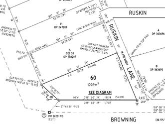
|
|
Land is zoned:
|
B2 Local Centre
|
|
Property is constrained by:
|
Acid Sulfate Soils (Class 5)
|
|
|
Proximity to Heritage Items – Norco Building located
on opposite side of Jonson Street; Jasmin House located on opposite side of
Browning Street.
|
|
|
|
|
|
The dwellings that previously existed on the property have
been demolished since the original approval. There are a number of
existing trees across the properties that will be removed for the proposed
development.
The combined properties have a frontage to Jonson Street of
approx. 49m, with approx. 48m to Browning Street and approx. 58m to Ruskin
Lane.
The property has a high point in its north-east corner, at
approx. RL 8.0m AHD. It slopes to the south west at around 30,
with low points at the Browning Street frontage of approx. RL 3.8m AHD.
The Jonson Street frontage of the property is at approx. RL 4.2m AHD.
The property is oriented towards the Jonson/ Browning
Streets intersection. The approved Byron Town Centre Bypass will exit at
this point, with a new four-way roundabout proposed.
The property is located at the southern fringe of the Byron
Bay Town Centre. It is zoned B2 Local Centre, as is land immediately
north and on the opposite side of Jonson Street. Land on the eastern side
of Ruskin Lane is zoned R2 Low Density Residential.
Land in the vicinity of the property, on the eastern side of
Jonson Street and further to the east, is currently largely residential in
nature, although there are a number of holiday properties among the existing
dwellings.
On the opposite side of Jonson Street, land uses are more
commercial, other than shop-top dwellings immediately opposite. Byron RSL
Club is located in close proximity.
The approved design for the Byron Bypass includes the
construction of a roundabout at the Jonson/ Browning Streets intersection,
directly in front of the site. An acquisition of a small part of the
subject land has previously occurred to allow for a widening of the road
reserve in this location to accommodate the roundabout works. That
adjustment also provided for the creation of Lot 61 DP 1256365, which is a
narrow (approx. 0.6m wide) strip of land along the Browning Street frontage of
the property, which will be transferred to the land owners and consolidated
with the larger property holding.
Construction of the bypass roundabout is planned for
completion in late 2020 and it is likely to be in operation before construction
of the subject development begins.
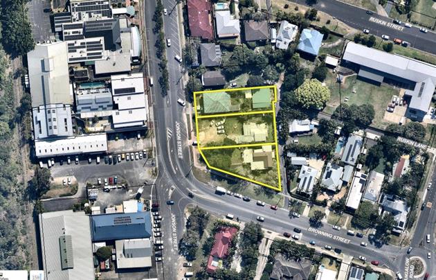
Site Locality
2. SECTION 4.15 – MATTERS FOR CONSIDERATION
– DISCUSSION OF ISSUES
Having regard for the matters for consideration detailed in
Section 4.15(1) of the Environmental Planning & Assessment Act 1979, the
following is a summary of the evaluation of the issues.
2.1. State/Regional Planning
Policies, Instruments, EPA Regulations 2000
The proposed amendments raise no issues under the relevant
SEPPS, Policies or clauses of the EPA Regulations 2000.
2.2. Byron Local Environmental
Plan 2014
Other than height which is discussed below, the proposed
amendments raise no issues under the LEP.
Clause 4.3 Height of
Buildings
As outlined above, the
proposal to raise the building results in a slightly greater exceedance of the
9.0m building height limit, established in clause 4.3 of BLEP 2014.
The addition of 300mm to the maximum building height only
affects the parapet edges and roof section in the south-eastern corner, both of
which exceeded the limit in the approved scheme, and the top of the
south-eastern lift over run, which is not visible from street level.
The minor addition to maximum height is offset somewhat by
the change to roof construction, which will provide a more slender profile
overall for the roof.
The extension of the north-western lift to service the roof
space for maintenance purposes, results in an exceedance of height limit that
was not part of the approved development. Its location, however, central
within the roof, is such that the objectives of the development standard are
maintained.
The minor increase in height generates no deleterious
impacts on the built amenity of the neighbourhood in terms of overshadowing,
loss of views or privacy. In conclusion the arguments put forward in the
original application to vary the height limit remain valid, and it is
considered that the exceedance of the maximum height standard associated with
the proposed modifications is acceptable in the circumstances.
2.3. Draft EPI that is or has
been placed on public exhibition and details of which have been notified to the
consent authority - Issues
No draft EPIs affect the proposal.
2.4. Development Control Plans
The proposed amendments do not generate any additional
issues that have not been previously considered.
2.5. The likely impacts of that
development, including environmental impacts on both the natural and built
environments, and social and economic impacts in the locality
Proposed amendments generally do not generate any impacts
that have not been previously considered. The applicant has requested a minor
modification to condition 42 in terms of referencing no work on industry
awarded RDO’s adjacent to public holidays. In terms of any RDO’s
this is matter between the builder and its employees and Council has no
specific role in workplace flexibility. The modification is
supported.
2.6. The suitability of the
site for the development
Proposed amendments do not affect the Sites Suitability.
3.6 Submissions
made in accordance with this Act or the regulations
The application was publicly exhibited, resulting in 2
submissions. Both submissions were from the owners of adjoining
properties within Ruskin Lane, and both confirmed their support for the
increased height for acoustic fencing along their boundaries.
One submission noted, however, that amendment of the
condition relating to acoustic fencing should not remove the obligation to
comply with all recommendations in the approved acoustic report.
In relation to the conditions regarding lighting within
Ruskin Lane, the submissions request that any lighting upgrade be designed and
implemented to prevent light spill into adjoining properties.
3.7 Public
interest
Proposed amendments are unlikely to prejudice or compromise
the public interest and the minor changes to roof height do not create an
undesirable precedent.
4. DEVELOPER
CONTRIBUTIONS/ WATER AND SEWER CHARGES
There is no nexus to levy additional contributions.
The applicant requests that the timing of payment be
modified to prior to the issue of an Occupation Certificate, in lines with the
Ministerial Direction outlined above (Condition 21).
The Ministerial
Direction Environmental Planning and Assessment (Local Infrastructure
Contributions – Timing of Payments) Direction 2020, remains in force
and provides an opportunity for the timing of developer contribution payments
to be deferred until the issue of an Occupation Certificate.
It is recommended that this condition be modified in
accordance with the guidance provided in the Minister’s Direction.
5. CONCLUSION
The proposed development is considered to be substantially
the same development and satisfies the requirements under S4.55 of the EPA act
1979. The application raises no issues and is recommended for approval subject
to amended conditions of consent.
Staff Reports - Sustainable Environment and Economy 13.18
Report No. 13.18 PLANNING
- 26.2020.6.1 Byron Local Environmental Plan 2014 Housekeeping Amendments
Directorate: Sustainable
Environment and Economy
Report
Author: Sam
Tarrant, Planning Support Officer
File No: I2020/1438
Summary:
Staff periodically batch
amendments to the Byron Local Environmental Plan (LEP) 2014 to keep it current,
correct and consistent with Council policy and the Act. These amendments are
commonly referred to as House Keeping.
This planning proposal is for 12
House Keeping amendments to the LEP: 7 policy related and 5 mapping related.
The policy related amendments aim to address anomalies and correct out of date
information. The 5 mapping amendments proposed are minor in scale and aim to
correct mapping anomalies. None of these amendments will enable any additional
development.
Further detail on each amendment
is presented below and in the attached planning proposal.
NOTE TO COUNCILLORS:
In accordance with the
provisions of S375A of the Local Government Act 1993, a Division is to be
called whenever a motion for a planning decision is put to the meeting, for the
purpose of recording voting on planning matters. Pursuant to clause 2(a)
under the heading Matters to be Included in Minutes of Council Meetings of
Council's adopted Code of Meeting Practice (as amended) a Division will be
deemed to have been called by the mover and seconder of all motions relating to
this report.
|
RECOMMENDATION:
That Council:
1. Submit
the planning proposal contained in Attachment 1 (E2020/69360) to the
NSW Department of Planning, Industry and Environment for Gateway
determination;
2. Subject
to the Gateway determination undertake public exhibition of the
planning proposal and consult with government agencies as required by the
Gateway determination; and
3. Receive
a report outlining the exhibition outcomes.
|
Attachments:
1 26.2020.6.1
Byron Local Environmental Plan 2014 Housekeeping Amendments, E2020/69360
2 Form of
Special Disclosure of Pecuniary Interest, E2012/2815
REPORT
Background
Council maintains a live list of
LEP controls and mapping matters that have been identified as being out of
date, anomalous or in need of attention for other reasons. The items identified
on this list are reviewed and those considered minor policy and minor mapping
changes (meaning they do not warrant an individual planning proposal in their
own right) are bundled into periodic housekeeping planning proposals for time
and staff efficiency reasons.
The intent of a housekeeping
planning proposal is to ensure the LEP stays current, correct and consistent
with Council policy and the Act.
This planning proposal is for 12
House Keeping amendments to the LEP: 7 policy related and 5 mapping related.
The policy related amendments aim to address anomalies and correct out of date
information. The 5 mapping amendments proposed are minor in scale and aim to
correct mapping anomalies.
None of these amendments will
enable any additional development.
Further detail on each amendment
is presented below and in the attached planning proposal.
Draft Policy Amendments
Item 1: Clause 4.2B – Maximum number of dwelling
houses or dual occupancies on multiple occupancy or rural landsharing community
developments
Prohibit Dual Occupancies
and Secondary Dwellings on approved Multiple Occupancies and Community
Titles in the RU1 and RU2 zones
Rationale
Community Title Management
Statements often include restrictions on secondary dwellings and dual
occupancies in the rural zones. The LEP overrides the Community Title Statement
and on the face of it appears to permit these land uses in the RU1 ad RU2
zones, which is inconsistent with the intent of multiple occupancy and
community title approvals.
Clause 4.2B governs dwelling
density on rural multiple occupancies and community title, however the current
application of the clause is only to multiple occupancies. This clause should
also apply to rural community title to give consistency to existing and future
community title approvals to prevent overdevelopment of the rural areas.
Although Development Control Plan
(DCP) 2014 currently does not support dual occupancies or secondary dwellings
on Multiple Occupancy and Community Title development in the rural zones, this
amendment to the LEP will strengthen this position and add consistency across
Council’s planning instruments.
Item 2: Clause 4.1F – Exceptions to minimum lot
sizes for certain rural subdivisions
Remove clause 4.1F from Byron LEP
2014
Rationale
Clause
4.1F was inserted into the LEP when it was first created to enable special
purpose subdivisions in the rural areas, similar to what was permitted under
the LEP 1988.
This clause was flagged for review
as an applicant had interpreted this clause to enable subdivision of tourist
cabins from the parent lot containing the dwelling house. This is not the
intention of this clause.
Further research has found this
clause is not providing for any genuine need in the shire. This clause is also not
present in the neighbouring LEPs of Ballina or Tweed shire. On the other
hand clause 4.1C exists to enable rural boundary adjustments and has been
applied in a number of recent development applications. It is therefore
considered that clause 4.1F is not required in the LEP and to avoid confusion
or applications attempting to utilise this clause for unintended purposes, this
clause should be removed altogether from the LEP.
Item 3: Clause 4.1E – Minimum lot sizes for dual
occupancies, manor houses, multi dwelling housing and residential flat
buildings
Insert a minimum lot size for Attached
Dwellings in R2 and R3 zones and Dual Occupancies (detached) in the
R5 zone - Clause 4.1E
Rationale
Currently there is no minimum lot
size that applies to Attached Dwellings. It is considered appropriate to
have a minimum lot size apply to Attached Dwellings in line with similar types
of medium density housing. Therefore the same minimum lot size that currently
applies to multi dwelling housing is proposed: 1000m2 in R2 Low Density
Residential and 800m2 in R3 Medium Density Residential zones.
Additionally, there is currently
no minimum lot size for Dual Occupancies (detached) in the R5 Large Lot
Residential zone. For consistency with the R5 zone objectives and permissible
uses, a minimum lot size of 4000m2 is proposed.
Item 4: Clause 4.2A - Erection of dwelling houses and dual
occupancies on land in certain rural zones AND Clause 4.1D - Exceptions to
minimum subdivision lot sizes for certain split zones
Include Zone E3 Environmental
Management in the application of Clause 4.2A and
Zones E2 Environmental
Conservation and E3 Environmental Management in Clause 4.1D
Rationale
As a result of Council’s E
zone implementation program a number of properties in Byron Shire now have
environmental zones applying to them. Clause 4.2A governs the replacement of
lawfully erected dwellings in rural zones and should also apply to the E3
Environmental Management zone (which permits dwelling houses).
Multiple zonings also apply to
many properties throughout the shire. Clause 4.1D allows for subdivision of the
residential, business or industrial zone component of a
property from the rural zone component if it meets certain criteria. The rural
section of this clause should now be expanded to include the E2
Environmental Conservation and E3 Environmental Management zones.
Item
5: Roadside stalls in RU1 Primary Production & RU2 Rural Landscape
zones
Permit
roadside stalls as ‘exempt’ development in RU1 and RU2 zones
Rationale
A new clause in schedule 2 will
enable roadside stalls to be exempt development in RU1 and RU2 zones as long as
they meet certain criteria.
Currently a development
application is needed to permit a roadside stall that farmers can use to sell
excess produce to the public. Small scale stalls on private properties that do
not create any traffic issues should be permitted as exempt development, which
benefits local farmers and the community. This amendment will also reduce the
number of development applications received helping to free up time for the
assessment of higher impact applications. The maximum footprint of the stall is
to be no greater than 4m2.
The proposed schedule 2 amendment
has been taken from a recent amendment by Ballina Council to enable roadside
stalls as exempt development.
Item 6: Artisan food and drink industry in RU2 Rural Landscape
zone
Permit Artisan Food and Drink
Industry with consent in RU2 Rural Landscape zone.
Rationale
Artisan food and drink industry is a relatively new definition introduced into the
standard instrument in late 2018. The definition is as follows:
artisan food and drink industry means a building or place the
principal purpose of which is the making or manufacture of boutique, artisan or
craft food or drink products only. It must also include at least one of the
following—
(a) a
retail area for the sale of the products,
(b) a
restaurant or cafe,
(c) facilities
for holding tastings, tours or workshops.
Prior to the introduction of this
definition, uses such as breweries and other agricultural related food
industries in the rural zones were permitted under the rural industry or
agricultural produce industry definitions.
Now that the Department of
Planning, Industry and Environment (DPIE) has introduced this new definition,
which fits more closely to these uses, the previous definitions above can no
longer be used to permit this type of development.
Including this land use definition
as permissible with consent in the RU2 zone is considered appropriate given the
range of uses it encompasses, which were previously permitted in the RU2 zones
(e.g. restaurants and cafes).
This will be supported by
additional controls in LEP (Clause 5.4) to limit the floor area for retail
sales to the lesser of 40% of the gross floor area of
the industry, or 250 square metres.
Council
may choose to alter these numbers if they wish after considering feedback from
exhibition of this planning proposal. Additional controls could also be drafted
in the DCP to further control scale, capacity, operational hours and setbacks.
Item
7: Clause 4.1A - Minimum
subdivision lot size for strata plan schemes in certain rural and residential
zones AND Clause 4.1AA - Minimum subdivision lot size for community title
schemes
Amend clause 4.1A and 4.1AA to ensure the minimum lot size
map applies to Community title and Strata subdivisions in both Special
Purpose and Environmental zones.
Rationale
Clause 4.1A and 4.1AA apply the LEP minimum lot size map to
Community Title and Strata subdivisions for zones listed within these clauses
(namely RU1, RU2 & R5).
Amendment of clause 4.1AA is proposed as a result of the
Linnaeus Estate Planning Proposal (Broken Head) report noting that community title development is
currently permitted in the SP1 zone with no restriction on lot numbers or size.
In considering the Linnaeus planning proposal Council resolved to support this
amendment. It is appropriate to amend this clause in this housekeeping planning
proposal rather than the Linnaeus planning proposal as the amendment is of a
housekeeping nature given it will also apply to other SP1 zoned land in the
Shire and can be completed in a more timely manner.
It is also proposed to include SP3 Tourist, E2
Environmental Conservation and E3 Environmental Management zones in
clause 4.1A and in clause 4.1AA to apply minimimum lot sizes for Communtiy
Title and Strata subdivisions in these zones.
Draft Mapping Amendments
Corresponding maps for the
amendments below are available in the attached planning proposal (Attachment 2;
page 39 – 50).
|
Item number
|
Amendment
|
|
8
|
Remove B1 zoning from a
residential property in Byron Bay (Lot 129 DP 777329). The property already
contains residential housing however business zoning from the neighbouring
property spills over into the residential property.
|
|
9
|
Rezone a small section of RU2
zoning from the back portion of RU5 lots correcting cadastre issues.
|
|
10
|
Remove spill over SP2
Infrastructure zoning adjacent to the Highway as requested by Transport for
NSW
|
|
11
|
Aligning residential zoning with
the properties cadastre at 10 Botanic Court Mullumbimby
|
|
12
|
Remove acid sulfate soil mapping
from 219 The Saddle Road based on a study demonstrating no acid sulfate soils
present on the site. This study is available in the planning proposal (page
51).
|
Next steps
Should council resolve to proceed
with this planning proposal, a request for a Gateway determination will be sent
to the Department of Planning, Industry and Environment.
STRATEGIC CONSIDERATIONS
Community Strategic Plan and Operational Plan
|
CSP Objective
|
L2
|
CSP Strategy
|
L3
|
DP Action
|
L4
|
OP Activity
|
|
Community Objective 4: We manage growth and
change responsibly
|
4.1
|
Support the visions and aspirations of local communities
through place-based planning and management
|
4.1.3
|
Manage development through a transparent and efficient
assessment process
|
4.1.3.11
|
Prepare and assess Planning Proposals and Development
Control Plans, and amend Local Environmental Plan maps
|
|
|
|
|
|
|
|
|
|
|
Legal/Statutory/Policy
Considerations
This planning proposal will amend the Byron Local
Environmental Plan 2014.
Financial Considerations
This is a Council initiated planning proposal funded through
the existing operational budget.
Consultation and Engagement
Should Council resolve to proceed with the planning
proposal, it will be sent to the NSW Department of Planning, Industry and
Environment for Gateway determination to enable formal public exhibition.
Staff Reports - Sustainable Environment and Economy 13.19
Report No. 13.19 PLANNING
- 26.2020.7.1 E zone Implementation Program - Planning Proposal STAGE 3
BLEP 2014 – Gateway Submission
Directorate: Sustainable
Environment and Economy
Report
Author: Alex
Caras, Land Use Plannning Coordinator
File No: I2020/1576
Summary:
The purpose of this report is to present the Stage 3
Planning Proposal (Attachment 1) for Council’s endorsement to enable
submission to the Department of Planning, Industry & Environment for
Gateway determination.
This follows Council’s resolution (Res 18-186)
at its 22 March 2018 Ordinary Meeting to implement the Department’s ‘Northern Councils E Zone Review Final Recommendations Report’ in several stages to deliver more
timely and effective outcomes for affected landowners.
Stage 3 Planning Proposal (PP) applies environmental and
non-environmental zones to 2,206 properties in the Shire, which includes
approximately 5,350 ha of E2 Environmental Conservation zones and 730 ha
of E3 Environmental Management zones. It also amends other LEP
2014 maps such as Minimum Lot Size, Height of Building, Floor Space Ratio,
Drinking Water Catchment, Acid Sulfate Soils and Multiple Occupancy &
Community Title Maps.
NOTE TO COUNCILLORS:
In accordance with the
provisions of S375A of the Local Government Act 1993, a Division is to be
called whenever a motion for a planning decision is put to the meeting, for the
purpose of recording voting on planning matters. Pursuant to clause 2(a)
under the heading Matters to be Included in Minutes of Council Meetings of
Council's adopted Code of Meeting Practice (as amended) a Division will be
deemed to have been called by the mover and seconder of all motions relating to
this report.
|
RECOMMENDATION:
That Council:
1. submit
the planning proposal contained in Attachment 1 (E2020/85949) to the
NSW Department of Planning, Industry and Environment for Gateway
determination;
2. pending
Gateway determination, undertake public exhibition of the planning
proposal and consult with government agencies in accordance with the Gateway
determination; and
3. receive
a report outlining the exhibition outcomes.
|
Attachments:
1 E zone
Implementation Program - Planning Proposal STAGE 3 BLEP 2014 – Gateway
Version, E2020/85949
REPORT
Council at its 22 March 2018 Ordinary Meeting resolved (Res
18-188) to implement the Department’s
‘Northern Councils E Zone Review Final Recommendations Report’ in several stages to deliver more
timely and effective outcomes for affected landowners. An overview of the
latest staged implementation program is shown in Figure 1 below.
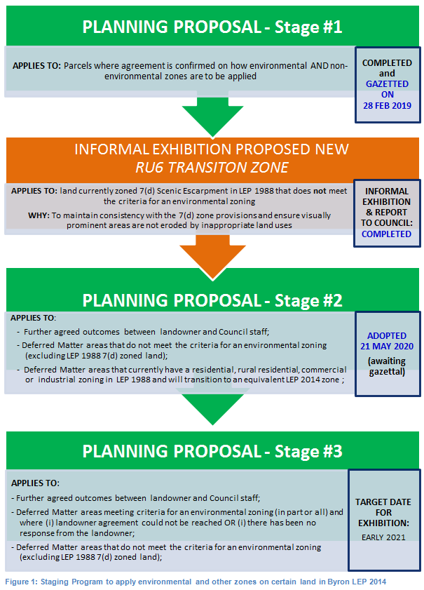
Stage 1 Planning Proposal
(PP1)
PP1 applied environmental
and non-environmental zones to 64 properties in the Shire based on agreed
outcomes. This included approximately 340 ha of E2 Environmental
Conservation zones and 60 ha of E3 Environmental Management zones.
Status: gazetted on 28 February 2020.
Stage 2 Planning Proposal (PP2)
PP2 applies environmental and
non-environmental zones to 619 properties in the Shire based on agreed
outcomes. Approximately 1,485 ha of E2 Environmental Conservation
zones and 400 ha of E3 Environmental Management zones are applied in
PP2. It also amends other LEP 2014 maps such as Minimum Lot Size, Height of
Building, Drinking Water Catchment and Acid Sulfate Soils Maps.
Status: adopted by Council
on 21 May 2020 and currently with the State government for finalisation.
Stage 3 Planning Proposal (PP3)
This report presents the Stage 3
Planning Proposal (Attachment 1) for Council’s endorsement to enable
submission to the Department of Planning, Industry & Environment for
Gateway determination.
In relation to the Stage 3 Planning Proposal, Council
previously resolved [Resolution 18-188]
to:
“(6) Receive a report on draft Planning Proposal #3:
(PP3) for:
(i)
Parcels where there is no agreement reached between the landowner
and Council staff on proposed environmental zone/s; or
(ii)
Deferred Matter areas that meet the criteria for an environmental zoning
(in part or all) and where there has been no response from the landowner; or
(iii) remaining LEP 1988 7(d) zoned land
to be zoned RU6 Transition (subject to Council endorsement).
as soon as practical after Council’s adoption of
Planning Proposal #2.”
PP3 applies environmental and non-environmental zones to
2,206 properties in the Shire, which includes approximately 5,350 ha of E2
Environmental Conservation zones and 730 ha of E3 Environmental
Management zones.
Consultation and Engagement to date
The E zone
engagement process to date has been robust, constructive and well received by
the majority of those affected. Key elements include:
ü notification letters
all potentially affected E zone landowners requesting feedback in early October
2017, with follow-up letters sent in March 2018 and June 2019.
The letters invited landowners to review the mapping with Council staff
in order to understand the planning process and E zone criteria. This enabled
more informed landowner feedback which in turn provided more accurate and
up-to-date information to inform the rezoning of land to an environmental,
rural and/or urban zone.
ü supporting material
on Council’s website
including: an overview of review process; electronic access to interactive
mapping; an online (FAQ) video, FAQs and fact sheets including information on
proposed uses and objectives in the E2 and E3 zones;
ü opportunities for one
on one meetings in Council’s offices (beneficial for all landowners
including those who were not computer savvy or unable to use Council’s
website to see what part of their land may be affected by a potential E2 or E3
zone and/or understand how primary land use was determined);
ü site visits (where
required or requested) to ground truth Council’s vegetation mapping and
inform appropriate environmental conservation and management zones; and
ü responding to
stakeholder phone enquiries and emails, many of which were able to be easily
and quickly resolved by staff emailing more detailed vegetation and E zone
mapping information at a ‘close-up’ property scale.
Since commencing
the E zone review in October 2017, Council’s commitment to the engagement
process is demonstrated by:
ü over 830
face-to-face meetings with affected landowners and/or representative
consultants;
ü over 110 on-site
inspections; and
ü over 970
agreed outcomes arising from submissions received
The engagement
process has been successful in:
ü providing genuine
opportunities for landowner issues/potential fears to be heard and for
them to have a say in the future use of their land (and thus a sense of
ownership in the process);
ü supporting landowner
aspirations regarding biodiversity/habitat/corridor enhancement;
ü enabling Council to
update its mapping of primary land use and updated vegetation information in
collaboration with landholders;
ü using a
‘staged’ process so that landowners did not feel pressured into
making decisions within a ‘fixed’ timeframe and therefore could
take as much time as needed to make informed decisions about their property;
and
ü verifying that a very
high percentage of the shire including primary producers and urban residents
had aspirations of protecting the natural environment for current/future
generations.
RECOMMENDATION
It is recommended that Council
endorse the E zone Stage 3 Planning Proposal (Attachment 1) to enable
submission to the Department of Planning, Industry & Environment for
Gateway determination.
STRATEGIC CONSIDERATIONS
Community Strategic Plan and
Operational Plan
|
CSP Objective
|
LSPS Priority
|
CSP Strategy
|
DP Action
|
OP Activity
|
|
3. We protect and enhance our
natural environment
|
Protect and
enhance our biodiversity, ecosystems and ecology
|
3.1 Partner to protect and enhance our
biodiversity, ecosystems and ecology
|
3.1.1
Protect and enhance our natural environment and biodiversity
|
3.1.1.4
Continue the
E zone review (Action No.9 from Rural Land Use Strategy)
|
Legal/Statutory/Policy Considerations
The process of applying E zones and
mapped overlays in Byron LEP 2014 is being undertaken in accordance with Section
117 Direction 2.5 – Application of E2 and E3 Zones and Environmental
Overlays in Far North Coast LEPs. This direction specifically requires
that a planning proposal that introduces or alters an E2 Environmental
Conservation or E3 Environmental Management Zone, or an overlay and
associated clause must be consistent with the Northern Councils E Zone
Review Final Recommendations
Financial Considerations
The remaining 2020/21 budget for
the E zone Implementation program will most likely be exhausted before 30 June
2021. If so, a separate report will be presented to Council detailing the
additional 2020/21 budget required to finalise Stage 3 planning proposal and
enable commencement of Stage 4. Stage 4 includes Council and public authority
lands and will be the final stage of applying E Zones.
Staff Reports - Sustainable Environment and Economy 13.20
Report No. 13.20 Update
Resolution 20-525- Clarkes and Main Beach Reserves Inter Agency Meeting
Directorate: Sustainable
Environment and Economy
Report
Author: Chloe
Dowsett, Coastal and Biodiversity Coordinator
File No: I2020/1596
Summary:
Council at the 25 September 2020 meeting made a resolution (Res
20-525) regarding the impact of coastal processes on Clarkes Beach and Main
Beach Reserves as outlined below.
20-525
Resolved that
Council:
1. Request
staff to convene an urgent meeting between all Land Managers of Clark’s
Beach (sic) and Main Beach reserves to discuss the current impact of coastal
processes on the beach and adjoining land, and explore potential options for
management.
2. That
the outcome of the meeting be reported to the next available Council meeting.
3. Note
that significant work has occurred on the Lighthouse Road Stormwater Diversion
Project and a briefing on this project is scheduled for councillors at the
December SPW. This briefing will also address previous concerns raised about
contribution of surface runoff and hard drainage systems to beach erosion.
This report addresses items 1and 2 of the above
resolution.
The current erosion trend at The Pass, Clarkes Beach and
Main Beach has been evident since approximately 2016.
Staff have been collaborating with technical staff from
Department of Primary Industry and Environment (DPIE) – Environment,
Energy and Sciences on the issue and it appears that this current erosion trend
(as based on visual assessment) is a result of a distinct lack of sand in the
eastern precinct of Byron Bay. However, the effects of these large swell events
have not yet been correlated against nearshore and beach profiles.
An inter-agency meeting was held at the Council Chambers and
via Zoom on Wednesday 14 October 2020 attended by the following Land Managers
and relevant agencies of Clarkes and Main Beach:
· Department
of Primary Industry and Environment – Crown Lands
· Reflections
Holiday Parks (NSW Crown Holiday Parks Land Manager)
· Department
of Primary Industries (Fisheries) – Cape Byron Marine Park
· National
parks and Wildlife Services
· Byron
Shire Council (Crown Land Manager)
· DPIE
– Environment, Energy and Sciences
Key comments made by each of the relevant parties at the
meeting regarding the issue and the present or proposed management actions is
outlined below in the report.
|
RECOMMENDATION:
That Council notes the report on the outcome of
the Clarkes and Main Beach Reserves Inter-Agency Meeting.
|
REPORT
Background
Council at the 25 September 2020 meeting made a resolution (Res
20-525) regarding the impact of coastal processes on Clarkes Beach and Main
Beach Reserves as outlined below.
20-525
Resolved that
Council:
1. Request
staff to convene an urgent meeting between all Land Managers of Clark’s
Beach (sic) and Main Beach reserves to discuss the current impact of coastal
processes on the beach and adjoining land, and explore potential options for
management.
2. That
the outcome of the meeting be reported to the next available Council meeting.
3. Note
that significant work has occurred on the Lighthouse Road Stormwater Diversion
Project and a briefing on this project is scheduled for councillors at the
December SPW. This briefing will also address previous concerns raised about
contribution of surface runoff and hard drainage systems to beach erosion.
This report addresses items 1& 2 of the above
resolution.
Key issues – erosion
trend
The current erosion trend at The Pass, Clarkes Beach and
Main Beach has been evident since approximately 2016. Over the previous four
years there have been a few significant wave events on the North Coast of NSW
including 2016 ‘Black NE’rly and 2019 Tropical Cyclone Oma. These swell
events result in various erosion impacts to the beaches of Byron Shire through
interference with littoral sand transport and sand by-pass across the Byron Bay
embayment.
Staff have been collaborating with technical staff from DPIE
– Environment, Energy and Sciences on the issue and it appears that this
current erosion trend (as based on visual assessment) is a result of a distinct
lack of sand in the eastern precinct of Byron Bay. However, the effects of
these large swell events have not yet been correlated against nearshore and
beach profiles.
There has been notable erosion and recession primarily at
Clarkes Beach, with The Pass and Main Beach also being affected. This erosion
has:
· substantially
lowered the beach and berm,
· removed
incipient dunes,
· eroded
the frontal dunes,
· removed
coastal vegetation,
· undermined
(resulting in the removal of some) beach access infrastructure,
· exposed
indurated sand layers (coffee rock), beach rock and cobbles on the beach and in
the dune,
· further
exposed Aboriginal middens, and
· undermined
(resulting in the removal of some) commercial assets and infrastructure.
The erosion has occurred over a period of months (not a
single storm event) becoming progressively worse during subsequent events
throughout 2019 that included more easterly waves combined with high tides and
elevated ocean levels (for examples TC Oma in February 2019, and a storm event
in early July 2019). The erosion has also continued throughout 2020 under minor
to moderate wave conditions progressively lowering and reducing sand reserves
allowing waves to directly propagate onto a severely depleted beach profile.
Why is this happening?
It is generally accepted that
the net sediment transport direction across the Ballina, Byron and Tweed
Shires is south to north. Under predominant S/SE wave conditions, sand may be
transported around Cape Byron from the south to the north before being
transported generally westwards through Byron Bay (due to wave refraction
around the Cape). The sand may be deposited onto, or will be transported
along or past (in the subtidal zone) Wategos Beach, The Pass, Clarkes and Main
Beaches and beyond.
During NE or ENE swells regimes
sand transport may be significantly reduced around Cape Byron and into Byron
Bay. However, sediment transport inside Byron Bay (from Wategos to Belongil
Beach and beyond) would still be expected to be in a general westerly direction
under the influence of such swell regime.
In strong northerly or north
westerly wind conditions, sand may be transported by ‘wind waves’
and the associated littoral current in an eastwards direction in Byron Bay.
When considering observations
over the past 2-3 years (or more), it appears that the eastern area of Byron
Bay has suffered from a reduction in the supply of sand into the area (from
around Cape Byron). This apparent reduction in sand supply around the Cape has
likely occurred while sand within the Byron Bay embayment has continued to be transported
out of the eastern area in a (net) westwards direction. That is, more sand
has likely been transported out of the eastern Byron Bay area towards the west,
than is coming in to it around the Cape. This is likely to be one of the key
contributing causes of the dune erosion evident at Clarkes and Main Beach.
When will it stop?
Though difficult to predict the
future state of the beach profile at Clarkes and Main Beach, and in recognition
of the cyclical nature (erosion/accretion) of beach behaviour in NSW, it is
expected that the beach profile will begin to accrete when a significant slug
of sand re-enters the compartment from the east. It is difficult to predict
when this may happen and by how much, as it is subject to many factors.
There is presently a ‘sand
slug’ at The Pass as shown in the photos below.
Figure 1: Near maps imagery showing slug of sand
at The Pass – taken August 2020

Figure 2: Slug of sand at The
Pass – looking west from Lighthouse Rd.
Present and proposed
management actions
On Wednesday 14 October 2020 an inter-agency meeting was
held at the Council Chambers and via Zoom attended by senior staff and
consultants of the following Land Managers and agencies responsible for
management of Clarkes and Main Beach:
· Department
of Planning, Industry and Environment (DPIE) – Crown Lands
· Reflections
Holiday Parks (NSW Crown Holiday Parks Land Manager)
· Department
of Primary Industries (DPI-Fisheries) – Cape Byron Marine Park
· National
Parks and Wildlife Services (NPWS)
· Byron
Shire Council (Crown Land Manager)
· Department
of Planning, Industry and Environment (DPIE) – Environment, Energy and
Sciences Group
Outlined below are key comments made by each of the relevant
parties regarding the issue and the present or proposed management actions.
Department of Planning, Industry and Environment –
Crown Lands
- Confirmed
Minister Melinda Pavey has issued a direction for temporary 90-day geobag works
to be constructed in front of Clarkes Beach Café and Whites Cottage (on
Reflections site) under the emergency works provisions of the coastal
legislation (Coastal SEPP). Crown Lands advised that the geobags are to allow
time for works to be done to reconfigure those buildings and to avoid ‘an
uncontrolled incident’, with confirmation that at the end of the 90 days
both the Reflections and new geobags are intended to be removed at the same
time. Crown Lands are going through the process of finalising the design,
approval documentation (Review of Environmental Factors) and logistics for the
construction works.
- Crown
Lands will licence areas of the adjoining reserve for their contractors to use
for storage of sand bags and equipment and that commencement of set up of the
staging areas could commence as early as 15 October 2020.
- Confirmed
they are actively working with the Café lessee who has been directed to
take steps to separate the beach-side deck from the main building to ready it
for removal if required and to commence preparation for reconfiguration of the
building for future retreat.
- Confirmed
they will lead community consultation and engagement for the construction
project.
DPIE – Environment, Energy and Sciences Group
- Confirmed
that the general understanding of the processes occurring at Clarkes is based
on staff interpretation and not on any recent coastal hazard or technical beach
profile data assessment. The recent persistent erosion trend has and is occurring
due to a general lack of southerly swell regime over the past 4 years and
influences of east and/or north-east swell which results in more sand leaving
the embayment that entering.
- There
is short, medium and long-term shoreline variability where the shoreline
experiences periods of accretion (beach building) followed by periods of
erosion - much like what is occurring now. The net result over time is that the
shoreline is undergoing a long term trend being landward recession (movement of
the shoreline landward over time) which is due to a deficit in the overall
sediment budget (more sand leaving the Bay than coming in). Shoreline recession
will also be influenced by sea-level rise.
- Indicated
an erosion period is occurring at the moment with no way to estimate when it
will end. History tells us that the shoreline will eventually accrete, however
when this occurs there is no way to know.
- Stressed
importance of interagency cooperation during this period with a focus on long
term strategic planning as a priority (i.e. development of a Coastal Management
Program).
Reflections Holiday Park
- Confirmed
they have made infrastructure modifications within the Park.
- Are
reviewing options for reconfiguration within the park in case retreat becomes
necessary, but indicated that due to size and layout, retreat will be
difficult.
- Acknowledged
Crown Lands’ intention to remove the works after 90 days but indicated
they have engaged consultants to provide them with advice on the potential to
prepare a development application for approval for the interim geobags in front
of Reflections to remain pending development of a Coastal Management Program.
- Confirmed
that White’s Cottage, in an area also being impacted, has an asbestos
management plan in place and that they too located historical asbestos when
relocating other assets within the park.
DPI-Fisheries – Cape Byron Marine Park
- Confirmed
that they are not a ‘land manager’ and that the works by
Reflections and proposed by Crown Lands are above the Mean High Water Mark
(MHWM) and hence outside the boundary of the Cape Byron Marine Park. As such
permits are required only to transit through the intertidal area of the Marine
Park for construction access purposes only.
- They
continue to support agencies with application processing and assisting with
cultural heritage values.
National Parks and Wildlife Services
- Have
been working with Reflections and Arakwal on a salvage plan and retrieval works
for the aboriginal midden that has been impacted by the erosion.
- Have
undertaken engineering works on Imeson Cottage at The Pass within the Cape
Byron State Conservation Area that was affected.
Council (Staff)
- Confirmed
ongoing monitoring, public safety and debris and contamination removal actions
(when required).
- Provided
agencies with an update on the Coastal Management Program (CMP) processes,
discussing realistic timelines for all the steps that have to be gone through
and the need for input and cooperation from all agencies and land managers.
Commonalities:
- All
land managers, including Council, are actively monitoring and addressing public
safety risks.
- All
land managers, including Council, acknowledge the significance of the area and
need to work with Arakwal on aboriginal cultural heritage matters.
- All
agencies agree to work together and share information to avoid unnecessary work
for Arakwal, minimise duplication and maximise preservation.
- NPWS,
Reflections and Council have all had issues with the management of affected
coastal trees – the three agencies agreed to work together to share
experiences, learn what has and hasn’t work and formulate methods to be
tried in future.
Outcomes:
- The
agencies thanked Council for calling the Inter-Agency meeting, confirming they
found it valuable and committing to strong communication to keep everyone up to
date on the different land-managers’ actions.
- A
group of staff from the agencies, including Council staff, will catch up to
share experiences on tree management options.
- Staff
to provide a detailed report to Council on the advice from and actions of the
various land managers and agencies (this report).
STRATEGIC CONSIDERATIONS
Community Strategic Plan and
Operational Plan
|
CSP Objective
|
L2
|
CSP Strategy
|
L3
|
DP Action
|
L4
|
OP Activity
|
|
Community
Objective 3: We protect and enhance our natural environment
|
3.3
|
Partner to
protect and enhance the health of the Shire’s coastlines, estuaries,
waterways and catchments
|
3.3.1
|
Implement
Coastal Management Program
|
3.3.1.1
|
Continue
preparing a Coastal Management Program (CMP) in accordance with the staged
process for Cape Byron to Sth Golden Beach
|
|
|
|
|
|
|
|
|
|
|
Legal/Statutory/Policy Considerations
The Coastal Management Act 2016, Coastal SEPP and
associated framework.
Financial Considerations
Not applicable.
Consultation and Engagement
Various agencies and land managers as outlined in this
report.
Staff Reports - Sustainable Environment and Economy 13.21
Report No. 13.21 Update
- Impacts of and management options for short term rental accommodation (STRA)
in Byron Shire
Directorate: Sustainable
Environment and Economy
Report
Author: Shannon
Burt, Director Sustainable Environment and Economy
File No: I2020/1740
Summary:
Council has had many reports on the impacts of and
management options for short term rental accommodation (STRA) in Byron Shire.
The most recent:
Report No. 13.27 PLANNING - Draft Planning Controls for
Short Term Rental Accommodation in response to Ministerial Direction 3.7
Reduction in non-hosted rental accommodation period to the December 2019
Ordinary Meeting of Council.
https://byron.infocouncil.biz/Open/2019/12/OC_12122019_AGN_1002.PDF
Followed by: Report No 13.12 - PLANNING - 26.2020.1.1 -
Planning Proposal for Short Term Rental Accommodation to the 20 February 2020 Planning Meeting.
https://byron.infocouncil.biz/Open/2020/02/PLAN_20022020_AGN_1151.PDF
At the February planning meeting, Council resolved to
prepare and submit a planning proposal to Department of Planning, Industry and
Environment (DPIE) for gateway determination. This occurred in March 2020.
The purpose of this report is to update: Council on the
status of the planning proposal, the recent announcements by State Government
on the STRA code of conduct and the state planning controls for STRA, and to
seek support for amendments to the planning proposal to enable a gateway
determination to be issued by the DPIE.
|
RECOMMENDATION:
That Council:
1. Notes
the update provided on the status of the planning proposal and state
management options for short term rental accommodation in Byron Shire.
2. Agrees to amend the
planning proposal to include precinct areas that permit non hosted STRA for
365 days in those areas that have already been taken up almost exclusively
for STRA, and 90 days for those areas that have not. These precinct areas are
shown in the maps in Attachment 1(#E2020/89860).
3. Authorises staff
to submit an amended planning proposal to the Department of Industry and
Environment for Gateway determination that satisfies item 2.
4. Pending gateway
determination, undertakes public exhibition of the planning proposal and
consult with government agencies in accordance with the gateway
determination; and
5. Receives a report
outlining the public exhibition outcomes.
|
Attachments:
1 STRA maps
- 365 day areas, E2020/89860
REPORT
Current status of the planning proposal
At the February planning meeting, Council resolved to
prepare and submit a planning proposal to DPIE for gateway determination. This
occurred 10 March 2020.
However, in March the real time impacts of the COVID 19
pandemic hit Byron Shire. Various states of community lockdown and state border
closures meant that almost all domestic travel demand went into hibernation,
along with large components of the economy. More than 60% of businesses in
Byron Shire relied on Job Keeper to stay afloat. This is the highest in any local
government area in Australia and double the number in capital cities.
Housing security and affordability continued to be a major
concern for community and key workers trying to maintain an existence without
employment; which was not helped by STRA in Byron Shire being promoted for self
isolation for return travellers prior to hotel quarantine.
In June 2020, Council received a letter from the DPIE,
advising that a preliminary assessment of the planning proposal had indicated
inconsistencies with either the Ministerial Direction 3.7 – Reduction in
non-hosted short-term rental accommodation period or the draft short-term
rental accommodation SEPP.
Council was asked for further clarification on the following
aspects of the Planning Proposal prior to the DPIE finalising its assessment:
· further direction from Council on whether it is
seeking to incorporate a savings provision for properties currently being used
for non-hosted STRA purposes and, if not, the implications for any existing
landowners and whether they would be able continue their existing practices
despite the introduction of the new requirements;
· an economic analysis that evaluates and considers the
impacts on the tourism industry and long-term rental housing market if
landowners are required to limit the use of their non-hosted STRA to 90 days or
less;
· further clarification on the intention for any new
STRA provisions in Byron LEP 2014 to override any STRA SEPP as it applies to
Byron Council.
An economic impact analysis can be a costly consultancy to engage
at the best of times, but more so when the project parameters of it are so
broad, and the environment in which it is sought so volatile. As such
further clarification from the DPIE was requested on a scope of analysis that
would satisfy their request for information. Council had already provided a
sizeable amount of data and commentary when it submitted the planning proposal
to them and was certain that this was sufficient to meet the Ministerial
direction.
Several emails and phone conversations with the DPIE have
since followed. Asking in particular:
· Does
the Department require detailed analysis of each town/village in the Shire, or
is a general analysis of impacts across the whole Shire sufficient?
· Considering
‘impacts on the tourism industry’, should the study focus only on
direct impacts on the STRA sector, or should it have a broader scope covering
impacts on all local industries/businesses that are directly or indirectly
related to tourism.
· Having
regard to ‘impacts on the long term rental housing market’, should
the study focus only on economic impacts for property owners (i.e. changes in
rental returns between short and long term rental markets)? Or, is a more
detailed analysis required looking into the usage of properties and the
potential for increased long term rental supply under a 90 day cap scenario.
· The
draft STRA SEPP includes a 180 day cap on non-hosted STRA for LGA’s in
the Greater Sydney Region and certain other regional LGA’s. Would it be
useful to include a comparison of different scenarios for day caps (i.e. 0
days, 90 days, 180 days, etc.) to demonstrate the difference in economic impact
between Council’s PP and the draft SEPP?
The most recent response from the DPIE when pressed is, that
they are considering commissioning advice from an external consultancy about
the potential economic impact of the state wide STRA framework. That part of
the brief to the consultant will be to provide Council with information about
the detail and scope required for our Byron specific study.
The DPIE would be in contact with Council in the near future
with details.
Other recent advice from the DPIE is that it is not going to
introduce a savings provision into the SEPP. DPIEs view is that STRA is
captured by an existing consent for a dwelling and is not a change of use.
Council’s view is that the use of a dwelling for STRA
would in most cases be characterised as tourist and visitor accommodation.
Tourist and visitor accommodation is prohibited in residential zones under
Byron Local Environmental Plan 2014, which raises implications for the legality
of many dwellings predominantly used for STRA in Byron Shire at the current
time.
At the time of writing this report no further advice had
been received from DPIE on the details of their consultancy.
Code of Conduct and the State planning controls for STRA
An (unexpected) recent announcement by the state government
was that laws via a mandatory code of conduct will impose new obligations
on STRA booking platforms, hosts, letting agents and guests from 18 December
2020.
https://www.fairtrading.nsw.gov.au/about-fair-trading/legislation-and-publications/changes-to-legislation/changes-to-short-term-rental-accommodation
The code however does not change the existing complaint
handling processes for NSW Police or local councils about issues or complaints
relating to fire safety (including overcrowding), planning approvals, parking
or ongoing noise.
There will also be changes to planning laws in mid-2021, including
a new planning policy that applies consistent regulation of the use of premises
for short-term rental accommodation across the whole state of NSW.
Advice issued also was that a STRA premises register is
currently under development for commencement in mid-2021. Hosts will be
required to register their premises once that obligation is mandated by
the Department of Planning, Industry and Environment and the register itself
becomes available online.
In the meantime the public health orders remain, and affect
holiday rentals and holiday homes by imposing limitations on the number of
persons who can be on the premises. STRA providers are required to ensure the
maximum number does not exceed 20 persons.
In short the code without the planning law changing and the
registers in place provides little comfort to our community on the operation of
STRA accommodation in Byron Shire.
Suggested amendments to the our planning proposal to move
it forward
With the above in mind, it is critical that Council progress
its STRA planning proposal prior to any STRA SEPP coming into effect, as unless
the DPIE agree to exclude Byron Shire from the STRA SEPP until our local planning
controls are notified it will be for nought.
This has been a previous request of them.
From a community impact perspective, the numbers of STRA
properties online have now returned to higher than pre COVID times, and most
are booked for the 20/21 holiday season and beyond. There are many stories
circulating about displaced local families, individuals and key workers being
evicted from local housing the result.
As reported to Council in February, after considering
community feedback and the results of further research, Council opted for a
more simplified approach for STRA that seeks to introduce a 90 day limit for
non-hosted STRA in all areas as an initial planning control response. The
reason for this is that a proposed precinct model apart from being difficult to
define in Byron Shire with hard boundaries, if done, has the potential to
create an unequal distribution of benefits and burdens across the community.
We also seek to introduce a ‘zero (0) day
cap’ on Council managed land and new release areas identified in a
strategy. The reason for this was to address our housing deficit (the
result of STRA occupations) necessary to achieve strategic planning objectives
for residential dwelling targets and to meet the needs for permanent housing
stock for our resident community and key workers. This also has not been
accepted by the DPIE.
To be clear the Ministerial Planning Direction was issued to
address the high concentration and unique impacts of STRA in the Byron
Shire.
The Direction allows Council to reduce non-hosted short-term
rental accommodation to a minimum of 90 days per calendar year, as long as
there is a sound base of evidence to support the proposed changes.
The Ministerial Direction gives Council the opportunity to
implement local planning rules for STRA, rather than being subject to the
planning rules in the SEPP.
The following principles needed to be addressed:
· non-hosted
short term rental accommodation periods must not be reduced to be less than 90
days
· the
reasons for changing the non-hosted short-term rental accommodation period
should be clearly articulated
· there
should be a sound evidence base for the proposed change, including evidence of
the availability of short-term rental accommodation in the area (or parts of
the area) in the 12 months preceding the proposal, relative to the amount of
housing in the area, and trend-data on the availability of short-term rental
accommodation over the past 5 years.
· the
impact of reducing the non-hosted short-term rental accommodation period should
be analysed and explained, including social and economic impacts for the
community in general, and impacted property owners specifically.
What is clear from the our research and current observations
is that Byron Shire is a hotspot of activity for STRA in NSW and the sector
continues to stay strong. Regulation through the planning system is needed to
manage the impacts on residential amenity and to prevent further erosion of an
already limited and expensive housing supply.
The DPIE has made it clear that it is not supportive of the
proposed zero day areas applying to council owned and managed land or release
areas, and is unlikely to support a blanket 90 day cap for non-hosted STRA in
all areas of the Shire without further economic impact analysis.
So, where does this leave us?
It is recommended that Council agree to amend the
planning proposal submitted to permit non hosted STRA for 365 days in those
areas that have already been taken up almost exclusively for STRA, and 90 days
for those areas that have not. These are shown as precinct areas in the
attached maps.
Further discussion with the DPIE is still needed on the
merits of a zero day cap for STRA on Council owned and managed land and new
release areas identified in a strategy. This can be progressed separate to this
planning proposal.
Recommendation
· It is recommended that a revised draft planning
proposal be prepared by staff, based on the precinct model described in the
report and maps.
· The planning proposal is submitted to the Department of
Industry and Environment for gateway determination.
STRATEGIC CONSIDERATIONS
Community Strategic Plan and Operational Plan
|
CSP Objective
|
L2
|
CSP Strategy
|
L3
|
DP Action
|
L4
|
OP Activity
|
|
Community Objective 4: We manage growth and
change responsibly
|
4.1
|
Support the visions and aspirations of local communities
through place-based planning and management
|
4.1.3
|
Manage development through a transparent and efficient
assessment process
|
4.1.3.10
|
Prepare a Planning Proposal to enable precinct based
Short Term Rental Accommodation.
|
|
|
|
|
|
|
|
|
|
|
|
|
|
|
|
|
Financial Considerations
Given the
high number of STRA properties operating in the Shire, it is likely that
additional compliance resources may be required to implement the new framework.
Council will need to consider resource implication of the new controls and the
compliance team work priorities.
Consultation and Engagement
Subject
to gateway determination issued by the DPIE.