Agenda
Ordinary
(Planning) Meeting
Thursday,
13 May 2021
held
at Council Chambers, Station Street, Mullumbimby
commencing
at 11.00am
Public Access relating to
items on this Agenda can be made between 11.00am and 11.30am on the day of the
Meeting. Requests for public access should be made to the General Manager
or Mayor no later than 12.00 midday on the day prior to the Meeting.

Mark
Arnold
General
Manager
What is a “Conflict of Interests” - A conflict of
interests can be of two types:
Pecuniary - an interest that a person has in a matter because of a reasonable
likelihood or expectation of appreciable financial gain or loss to the person
or another person with whom the person is associated.
Non-pecuniary – a private or personal interest that a Council
official has that does not amount to a pecuniary interest as defined in the
Code of Conduct for Councillors (eg. A friendship, membership of an
association, society or trade union or involvement or interest in an activity
and may include an interest of a financial nature).
Remoteness – a person does not have a pecuniary interest in a matter
if the interest is so remote or insignificant that it could not reasonably be
regarded as likely to influence any decision the person might make in relation
to a matter or if the interest is of a kind specified in the Code of Conduct
for Councillors.
Who has a Pecuniary Interest? - a person has a pecuniary interest in a
matter if the pecuniary interest is the interest of the person, or another
person with whom the person is associated (see below).
Relatives, Partners - a person is taken to have a pecuniary
interest in a matter if:
·
The
person’s spouse or de facto partner or a relative of the person has a
pecuniary interest in the matter, or
·
The
person, or a nominee, partners or employer of the person, is a member of a
company or other body that has a pecuniary interest in the matter.
N.B. “Relative”, in relation to a person means any of the
following:
(a) the parent,
grandparent, brother, sister, uncle, aunt, nephew, niece, lineal descends or
adopted child of the person or of the person’s spouse;
(b) the spouse
or de facto partners of the person or of a person referred to in paragraph (a)
No Interest in the Matter - however, a person is not taken to have a
pecuniary interest in a matter:
·
If
the person is unaware of the relevant pecuniary interest of the spouse, de
facto partner, relative or company or other body, or
·
Just
because the person is a member of, or is employed by, the Council.
·
Just
because the person is a member of, or a delegate of the Council to, a company
or other body that has a pecuniary interest in the matter provided that the
person has no beneficial interest in any shares of the company or body.
Disclosure and participation in meetings
·
A
Councillor or a member of a Council Committee who has a pecuniary interest in
any matter with which the Council is concerned and who is present at a meeting
of the Council or Committee at which the matter is being considered must
disclose the nature of the interest to the meeting as soon as practicable.
·
The
Councillor or member must not be present at, or in sight of, the meeting of the
Council or Committee:
(a) at
any time during which the matter is being considered or discussed by the
Council or Committee, or
(b) at
any time during which the Council or Committee is voting on any question in
relation to the matter.
No Knowledge - a person does not breach this Clause if the person did
not know and could not reasonably be expected to have known that the matter
under consideration at the meeting was a matter in which he or she had a
pecuniary interest.
Non-pecuniary Interests - Must be disclosed in meetings.
There are a broad range of options available for managing conflicts &
the option chosen will depend on an assessment of the circumstances of the
matter, the nature of the interest and the significance of the issue being
dealt with. Non-pecuniary conflicts of interests must be dealt with in at
least one of the following ways:
·
It
may be appropriate that no action be taken where the potential for conflict is
minimal. However, Councillors should consider providing an explanation of
why they consider a conflict does not exist.
·
Limit
involvement if practical (eg. Participate in discussion but not in decision
making or vice-versa). Care needs to be taken when exercising this
option.
·
Remove
the source of the conflict (eg. Relinquishing or divesting the personal
interest that creates the conflict)
·
Have
no involvement by absenting yourself from and not taking part in any debate or
voting on the issue as of the provisions in the Code of Conduct (particularly
if you have a significant non-pecuniary interest)
RECORDING OF VOTING ON PLANNING MATTERS
Clause 375A of the Local Government Act
1993 – Recording of voting on planning matters
(1) In this section, planning
decision means a decision made in the exercise of a function of a council
under the Environmental Planning and Assessment Act 1979:
(a) including a decision relating to
a development application, an environmental planning instrument, a development
control plan or a development contribution plan under that Act, but
(b) not including the making of an
order under that Act.
(2) The general manager is required
to keep a register containing, for each planning decision made at a meeting of
the council or a council committee, the names of the councillors who supported
the decision and the names of any councillors who opposed (or are taken to have
opposed) the decision.
(3) For the purpose of maintaining
the register, a division is required to be called whenever a motion for a
planning decision is put at a meeting of the council or a council committee.
(4) Each decision recorded in the
register is to be described in the register or identified in a manner that
enables the description to be obtained from another publicly available
document, and is to include the information required by the regulations.
(5) This section extends to a meeting
that is closed to the public.
BUSINESS OF Ordinary (Planning) Meeting
1. Public Access
2. Apologies
3. Requests
for Leave of Absence
4. Declarations
of Interest – Pecuniary and Non-Pecuniary
5. Tabling of Pecuniary
Interest Returns (Cl 4.9
Code of Conduct for Councillors)
6. Adoption
of Minutes from Previous Meetings
6.1 Ordinary
(Planning) Meeting held on 8 April 2021
7. Reservation
of Items for Debate and Order of Business
8. Mayoral Minute
9. Notices of Motion
9.1 Quarterly
reports on residential dwelling figures...................................................... 7
10. Petitions
11. Submissions and Grants
12. Delegates' Reports
13. Staff Reports
General Manager
13.1 BSC
ats Pace Development Group Pty Ltd............................................................. 11
Corporate and Community
Services
13.2 Draft
2021/22 Operational Plan and Budget for Public Exhibition..................... 27
13.3 Budget
Review - 1 January 2021 to March 31 2021.............................................. 37
Sustainable Environment and
Economy
13.4 PLANNING
-26.2017.6.1 - Byron Bay Town Centre Planning Controls - Review of submissions
and next steps...................................................................................... 50
13.5 PLANNING
- s4.55 application to modify conditions related to Artisan Food and Drink
Industry (Brewery & Tasting) - 10.2020.201.2......................................................... 59
13.6 PLANNING
- Subdivision to Create Two (2) Lots and New Dwelling House - DA10.2020.102.1
at 18 Red Bean Close, Suffolk Park........................................ 68
13.7 PLANNING
- 26.2019.11.1 Outcome of Public Exhibition - Planning Proposal to obtain
Dwelling Entitlement at Lot 6 DP 8385 81 Yagers Lane, Skinners Shoot......... 84
13.8 Update
on Resolution 20-664 (Lot 12 Bayshore Drive)........................................ 91
13.9 PLANNING
- Development Application 10.2020.215.1 Multi Dwelling Housing Comprising of
Ten (10) Two Storey Detached Dwellings and Ten (10) Swimming Pools and Strata
Subdivision at 6 Keats Street Byron Bay............................................................... 101
13.10 PLANNING
- State Government Planning Amendments for Agriculture........ 120
13.11 PLANNING
- s4.55 to Modify Conditions 1 and 6 Landscaping Plan, DA 10.2019.650.2 at 103
Kings Road Federal.......................................................................................... 125
13.12 PLANNING
- Report of the 8 April 2021 Planning Review Committee............ 139
13.13 Byron
Music Festival 2021 - Use of Dening Park................................................ 141
13.14 Proposed
Housing Diversity State Environmental Planning Policy (SEPP) Confirmation of
Council's position on Boarding Houses in the R2 Low Density Residential Zone 148
Infrastructure Services
13.15 Byron
Bay Bypass Project Closeout....................................................................... 153
14. Questions With Notice
Questions with Notice: A response to Questions with
Notice will be provided at the meeting if possible, that response will be
included in the meeting minutes. If a response is unable to be provided
the question will be taken on notice, with an answer to be provided to the
person/organisation prior to the next Ordinary Meeting and placed on Councils
website www.byron.nsw.gov.au/Council/Council-meetings/Questions-on-Notice
Councillors are
encouraged to ask questions regarding any item on the business paper to the
appropriate Director prior to the meeting. Any suggested amendments to the
recommendations should be provided to Councillor Support prior to the meeting
to allow the changes to be typed and presented on the overhead projector at the
meeting.
Notices of Motion 9.1
Notices of Motion
Notice of Motion No. 9.1 Quarterly
reports on residential dwelling figures
File No: I2021/706
I move:
1. That
Council notes:
a) the
response to Question on Notice 14.1 ‘Agglomerated data on dwelling supply
in Byron Shire’, and
b) that
approximately 1,200 dwellings were approved between 2018 and 2021 and over 500
new lots created
2. That
Council receives quarterly updates that detail the provision of
dwellings in the Shire, with reference to the targets set in the Byron Shire
Residential Strategy 2020 and the North Coast Regional Strategy 2016.
Signed: Cr
Cate Coorey
Councillor’s supporting
information:
This motion
follows on from a question, which was taken on notice, at Council’s
Ordinary Meeting held on 25 February 2021.
“In
view of the recently adopted Residential Strategy and to assist in considering
future planning decisions, can Councillors and the community be advised of
changes in residential approvals since the operation of the Byron LEP
2014.”
Given
the provision of the data regarding numbers of dwellings approved or provided
through subdivision, it is prudent for these figures to be readily available so
that Council can make informed decisions about planning matters.
Staff comments
by Shannon Burt, Director,
Sustainable Environment and Economy:
(Management Comments must not
include formatted recommendations – resolution 11-979)
While staff
appreciate Councillor Coorey wanting to monitor and review dwelling delivery in
the Shire; staff do not support this motion as drafted.
This NOM has not
been discussed with staff prior. It is staff position that no change be made to
the existing monitoring and reporting regime on the ‘provision of
dwellings in the Shire’ for the reasons discussed in the comments below.
In response, it is
important monitoring occurs within the context of an adopted policy framework
and considers development industry seasonal variations, market volatility and
other policy changes that may result in local development peaks and troughs.
For this reason the
Residential Strategy as adopted in December 2020 - Section 4 Monitoring and
Review sets an annual report framework on approvals for the various
types of residential development – detached housing, secondary dwellings
and low rise medium density in both new release and infill areas. This reporting
also includes an update on the implementation of the Strategy’s actions.
Further, it is
considered prudent that monitoring occurs consistently with other reporting
requirements on same that are in place for all councils from the DPIE/ABS.
These are already appropriately resourced by staff.
DPIE –
Performance Monitoring report – DA types, times, etc.
DPIE – Land
and Housing Monitor – No. of dwellings and lots approved and constructed.
ABS – Monthly
building approvals and commencements (note these figures do not include DA
approvals, only construction approvals and commencement – i.e. A DA has 5
years to be commenced but requires construction approval. These figures cannot
be read together as dwelling numbers would be duplicated.)
Other adhoc reports
as requested by Government departments from time to time.
Quarterly reporting of the ‘provision
of dwellings in the Shire’ as recommended by the NOM, outside the above
considerations holds an inherent risk of misinterpretation, resulting in
possible reactive on-the-hop policy changes by say Council, which would be
potentially devoid of consideration of:
· the longer term
housing delivery framework as set in the residential strategy or state
government policy current and emerging such as regulations for short term
rental accommodation.
· trends in the
construction industry such as, development pipeline approvals which have a five
year commencement time and may not yet under construction or complete.
· external
influences - such as in the last 12 months COVID-19 has had major impact
on the function of Australia’s housing sector. Australia’s
international borders have been essentially closed since March 2020 and we have
seen short term shift in interregional migration trends. The population
estimate for Byron Shire as of the 30th June 2020 was 35,773. Since the
previous year, the population has grown by 1.99% and increase on the average of
1.55% in the preceding two years. Population growth in the same period for in
Regional NSW was 0.83%. (source Id. profile / Australian Bureau of Statistics'
official 2020 population figure for all LG Areas).The full economic and social
consequences of the pandemic for NSW and Byron Shire housing sector is still to
be determined.
· implications to
long term infrastructure planning and delivery with reactive policy pivots.
· relationship to
trends and housing delivery in adjoining local government areas and North Coast
region which as stated above are report annually. These reports are used to
assess council performance on housing targets in NCRP.
To exemplify staff
comments above, the statement below has been analysed in more detail. What it
shows is numbers are not simply numbers but can be read in such a way that
without a context – longitudinal and other can give a false impression to
the reader /user as to what is actually happening.
….1,200
dwellings were approved between 2018 and 2021 and over 500 new lots
created…
Dwellings
· Infill development
through dual occupancies (majority additional dwellings, not new developments)
and Secondary dwellings made up 43% of the total dwelling count.
· Secondary
dwellings made up 25% of the dwelling count. However, the number of these have
gradually reduced over the last couple of years. In 2018 the community became
aware that contributions may be reintroduced on Secondary Dwellings, and that
saw a spike in applications. For example, during the period 1 January 2018 to
30 April 2018 there were 33 applications submitted. In the same period for 2021
there are only 17.
· Medium density
dwelling numbers are variable. In 2018, as can be seen by the data there were a
couple of larger DAs that made up these numbers. (i.e. 60 dwellings approved in
‘Habitat’ and 25 Affordable Housing dwellings approved in
Mullumbimby ‘Station Street NCCH’. The rest related to smaller
developments.
· Studios are not
habitable dwellings.
· In 2018
residential lots from previously approved subdivisions were released in
Mullumbimby (Tallowood) and Bangalow.
· As stated in the
report, there were 129 applications during the reported period that included
demolition. There has been an increase in the number of replacement dwellings.
Numbers quoted are not necessarily additional dwellings.
Subdivisions
· Table 5 (lots
registered/created) indicate there were 450 lots created between 2018-2020. As
noted in the report, these do not distinguish between lots created through
boundary adjustments, consolidations and additional lots created through
torrens title subdivision.
· The
registration/creation of lots is the last step in the subdivision process. The
total does not indicate the development has taken place during that period,
just that they were approved at some stage. The lots may relate to historical
applications.
· Tables 3 and 4
(lots approved) during the period was 504. 61% (305) of these were strata
subdivisions. Actual lots were not created. 33% (173) lots were created through
torrens title subdivision.
Financial/Resource/Legal Implications:
No financial implication if the current reporting and
monitoring regime is maintained. Staff costs if it is not.
Is the proposal consistent with any Delivery Program tasks?
|
Community Objective 4: We manage growth and
change responsibly
|
4.1
|
Support the visions and aspirations of local communities
through place-based planning and management
|
4.1.3
|
Manage development through a transparent and efficient
assessment process
|
Staff Reports - General Manager 13.1
Staff Reports - General Manager
Report No. 13.1 BSC
ats Pace Development Group Pty Ltd
Directorate: General
Manager
Report Author: Ralph
James, Legal Counsel
Chris Larkin, Manager Sustainable
Development
File No: I2021/165
Summary:
This report is about the outcome of a section 34
Conciliation Conference which was held on 20 November 2020 and subsequent
without prejudice discussions. It seeks delegations to authorise the
General Manager to enter into consent orders or a s34 Conciliation Agreement
approving Development Application 10.2019.576 .1 as per the conditions in
Attachment 3.
RECOMMENDATION:
That the General Manager be authorised under delegation to
enter into consent orders or a s34 Conciliation Agreement approving Development
Application 10.2019.576 .1 subject to the Without Prejudice Conditions in
Attachment 3 (E2021/50075).
Attachments:
1 Amended
Hotel Plans as submitted to Land and Environment Court, E2021/61896 
2 Original
Hotel Plans as submitted with Development Application DA10.2019.576.1, E2019/81719 
3 Without
Prejudice Conditions, E2021/50075

4 Copy of
Submissions for 10.2019.576.1, E2021/62106
Report
A Class 1 Application was filed
with the Court on 28 February 2020 appealing Councils deemed refusal.
The appeal is presently fixed for hearing in the Land and
Environment Court on 13 and 14 May 2021.
A section 34 Conciliation Conference was held on 20 November
2020. The Conciliation Conference reached the point where the applicant was
prepared to make significant amendments to the proposal so as to enable a
Conciliation Agreement to be entered into. Although the in principle agreement
reached at the Conciliation Conference did not produce a settled agreement
subsequent without prejudice discussions have brought the parties closer to an
agreed position.
Staff do not hold delegated authority to enter into a
Conciliation Agreement or Consent Orders. This report updates the status of the
application and seeks a resolution empowering the General Manager to enter into
a Conciliation Agreement or Consent Orders.
The Proposal
Development application 10.2019.576
.1 (the DA) was received by Council on 1 November 2019. The DA form
describes the proposed development as:
Demolition of an existing
building and Mixed Use Development comprising hotel accommodation with
ancillary swimming pool, roof top open space, ground floor retail premises and
basement health spa. Three storey building above one level of basement. (Proposed
Development)
The Proposed Development consists of:
a. Demolition
of an existing building (shop);
b. Basement
car park with 16 car parking spaces;
c. Health
Spa with a floor space area of 135m2 in the basement - open to both hotel
guests and general public;
d. Four
(4) ground floor retail tenancies ranging in size from 75m2 to 20m2;
e. Hotel
lobby, common area swimming pool at ground level for use by hotel guests;
f. Twenty-nine
(29) hotel rooms (with a total of 38 beds); and
g. Open
roof top area for recreation activities for hotel guests (identified as a yoga
platform) with toilet;
Vehicle access is proposed
off Fletcher Lane. No onsite loading area is provided.
A central bin storage area is proposed
on the basement level with mechanical 'tug' device to enable the safe transfer
of waste bins up the driveway
ramp and onto Fletcher Lane.
The Site
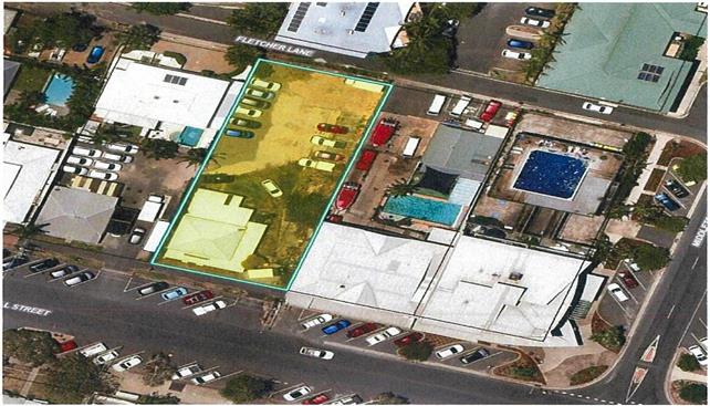
The property is
defined as Lot 9 in DP758207 and known as 7 Marvell Street, Byron Bay (the
Land). It is rectangular in shape with a primary frontage to Marvell Street
(southern boundary) and a secondary northern frontage to Fletcher Lane. The
Marvell Street and Fletcher Lane frontages are 20.117m in length with side
boundaries of equal length of 50.29m. The Land has an area of 1012m2.
The property currently contains an original
timber dwelling which has been converted for use as a shop with rear gravel hardstand and paving areas. The rear parking areas are currently
used as a parking area for rental vehicles associated with the adjoining rental car business
at 5 Marvell Street. There is no substantial
vegetation on the land, other than small
landscape plantings.
The property
is considered flat with a very gradual
slope from the Marvell Street frontage to Fletcher Lane with an elevation of approx. RL 2.45 - 2.28m AHO. The
lowest point of the site is 2.15m AHO in the rear yard area with the highest point of the site being 2.99m AHO and located
midway along the eastern boundary
of the site.
Development consent
10.2016.97.1 was issued
in 8 November 2016 for the
Demolition of existing building, Mixed
Use Development comprising Hotel or Motel Accommodation with ancillary swimming pool, and ground floor Retail Premises (three storey
building above two levels of basement parking)
(the Previous Consent).
The Proposed
Development differs from the Previous
Consent in the following
ways (as described by the applicant):
a. Changes to the facade
of the building to provide a more contemporary building
more in keeping
with the aims of the Byron Bay Town Centre Master Plan;
b. Deletion of the second level of the basement
carpark;
c. A larger hotel
lobby with a corresponding 30m2 reduction in the
floor area of the retail spaces
fronting Marvell Street;
d. Two additional small retail spaces
(20m2 ) each that will front
the rear lane;
e. A health spa (135m2 ) in the basement
car park. The health spa will be open to both guests
and the public;
f. An open roof top platform
for activities for hotel guests;
and
g. A reduction
from 32 to 29 rooms
(but maintaining the same number
of beds) with a minor reconfiguration of the room layout.
CONTENTIONS
In the appeal Council raised
the following contentions as to why the application should be refused:
Reliance on the Planning
Proposal
The proposed
development relies on amendments to the BLEP 2014 proceeding, without consideration of the
submissions received during
the exhibition of Planning Proposal
and the effect that such submissions may have on the Respondent amending the proposed
changes to BLEP 2014 and to BDCP 2014.
Height of building
The
proposed development does not comply
with the 11.5 metre maximum
height of buildings
in Clause 4.3 of BLEP 2014. It is noted
that the development would also exceed the maximum allowable height of buildings
under the current form of the proposed
amended BLEP 2014 which provides a maximum height of 15 AHO (if the amendments
were made). The applicant's clause 4.6 variation request does not provide adequate
justification of why such a variation from the current
BLEP 2014 development standard is appropriate.
Floor Space Ratio
The
proposed development does not comply with the maximum Floor Space Ratio of 1.3:1 in Clause 4.4 of BLEP 2014. The applicant has provided a Clause 4.6 variation request
seeking to allow a maximum
FSR of 1.57:1. The applicant's clause 4.6 variation
request does not provide adequate
justification of why such a variation from the current
BLEP 2014 development standard is appropriate.
Traffic Planning, Vehicle Parking, Circulation and Access
The
proposed development does not comply with BDCP 2014 Chapter B4: Traffic Planning,
Vehicle Parking, Circulation and Access. The proposed development relies on the Planning Proposal, and proposed Chapter E9 to amend car parking provisions. Given the changes proposed
under the Planning
Proposal are neither
likely nor imminent
the departure from the current BDCP 2014 cannot be supported.
Public interest
The application is not in the public
interest having regard
to the contentions raised.
The proposal is not consistent with the proper management or development of land
for the purpose of promoting
the social and economic welfare
of the community, the land and a better environment, having regard
to sections 1.3(a) and (b) of the Environmental Planning
and Assessment Act 1979.
CONCILIATION
Conciliation and without prejudice
discussions have occurred between parties and amended plans have been lodged
with the Land and Environment Court. On 29 April 2021
the Court granted the Applicant's Motion to introduce the amended plans and
ordered for joint expert reporting for town planning and traffic engineering
experts.
The main changes to the development
include the addition of a second basement level of car parking, provision of a
car share for hotel guests to use, and changes to the front and rear facades of
the development incorporating colonnade arches into those elevations. The
applicant has also increased the floor area of two retail shops at the ground
level from a total of 40m2 to 100 m2. Other detail has been prepared justifying
the development including detailed clause 4.6 variations to the height and
floor space ratio controls.
The following comments are provided
on those changes in terms of the contentions raised:
Reliance on the Planning
Proposal
The development has been amended to provide an additional
level of basement car parking which is considered to provide adequate parking
onsite for the proposed uses. Further the applicant has provided an amended
Clause 4.6 request in relation to both the Height of Building and Floor Space
Ratio.
Council has no draft controls which are currently imminent
or otherwise that remove car parking rates, or the Floor space ration
provisions from Byron LEP 2014. As such the proposed amended plans has been
assessed with no regard to future changes to planning controls.
Height of building
The variation to the 11.5m height of buildings standard is
associated with small parts of the overall building that relate to the top of
stairs, lift overrun, storage area and toilet. All other parts of the proposed
building would comply with the height standard.
The variations to the height standard are numerically minor,
particularly when considered as a percentage of the overall roof area. The
exceedance of 1.65m relates to discrete elements near to the centre of the Site
that cumulatively occur on less than 4.2% of the total roof area of the
proposed development.
The small portion of the development that exceeds the 11.5m
height of buildings standard will not be readily viewed from the street, and
will not contribute to the development being dominant in the streetscape or out
of character in the area. It is considered that strict compliance with the
development standard in this instance is unnecessary and a variation to the
height controls can be granted in this instance.
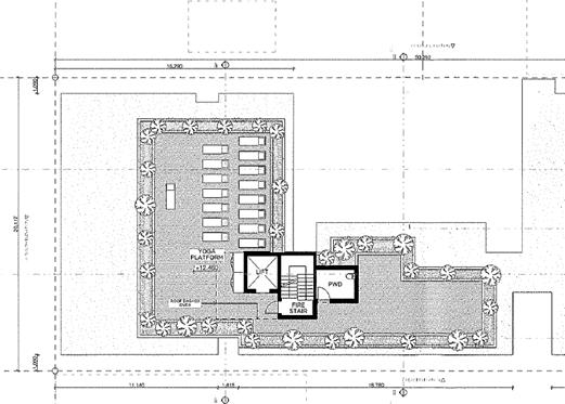
Extract of roof top floor plan
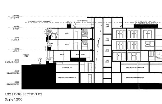
Extract of Section
showing the lift, fire stairs and toilet above the height limit
Floor Space Ratio
The proposed development does
not comply with the maximum Floor Space Ratio of 1.3:1 in Clause 4.4 of BLEP
2014. The applicant has provided a Clause 4.6 variation request seeking to
allow a maximum FSR of 1.57:1.
The site area of 1,012m2 and the applicable 1.3:1
FSR standard provides a compliant GFA of 1,315.6m2. The GFA of the
proposal (including rooftop toilet) is 1,590m2, that is an FSR of
1.57:1 and GFA exceedance of 274.4m2 (20.9%)
In part 127 m2 of the FSR variation sought
relates to the Spa. The spa is located within a basement level and has no
implications for the bulk and scale of the development. Excluding the GFA of
the spa, the FSR of the development would be 1.44:1, that is an exceedance of
approximately 0.147m2 (11.2%).
It is noted that additional retail area is provided from the
Fletcher Street Laneway with the original plans showing two small 20m2
retail tenancies. The subject plans now show two retail shops of 50m2
each.
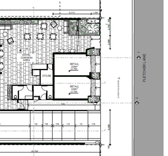
Extract of Original Ground floor plan showing two 20m2
retail shops
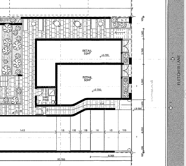
Amended plans showing increased retail floor area of two
50m2 retail shops
In support of the proposal despite the FSR variation being
sought, the development is largely “U” shaped and opened on the
western elevation/ side boundary around the pool courtyard area. The building
is also designed with a degree of articulation at the ground level facing Marvel
Street with the retail shops setback from the boundary.
The applicant has submitted the following to support the
variation to the FSR development standard:
• Both
the front and rear of the Site is bound by public roads, which in this case
provides added separation to adjacent existing development.
• A
substantial component of the additional floorspace (Spa) is contained in a
basement level that has no implications in regard to the size of the building.
• The
balance of the additional floorspace will be substantially contained within the
envelope of an approved building and will not be discernible to an observer in
the street.
• The
proposed modified development reflects Council's contemporary planning controls
for the town centre. Overall the changes would have a positive planning
outcome. In particular, the smaller retail tenancies and health spa will
activate Fletcher Lane, potentially acting as a catalyst for other developments
to follow.
• The refinements to the approved building architecture will
reduce the apparent bulk and scale of the building, albeit marginally.
• The
proposed development is for an anticipated three storey building within the
town centre of an appropriate scale and density of development to support the
Byron Bay town centre, that is effectively contained within an approved
building envelope. Consequently, the proposal would be consistent with the
following objects of the EP&A Act at s.1.3:
(c) to promote
the orderly and economic use and development of land, and
(g) to promote
good design and amenity of the built environment.
• In
addition to the above, there is an absence of material negative impacts
resulting from the proposed variation from the FSR standard.
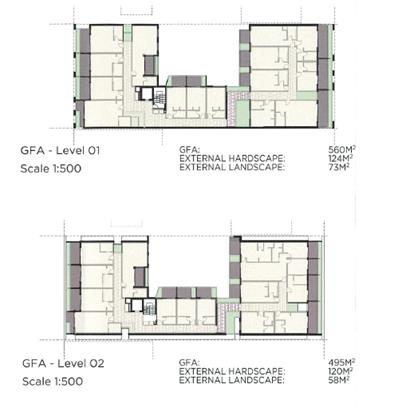
First and Second Floor Plans
Some variation to the FSR development standard is generally
anticipated by applicants seeking to re-develop in the Byron Bay Town Centre.
In raw numbers a 20% variation is excessive. It would also appear there
is little precedence for such a variation. The development on the corner of
Browning and Jonson Street was approved with an FSR of 1.42:1.0, subject to a
thorough Clause 4.6 variation. It is therefore submitted that the development
standard has not been abandoned by Council, and it is considered a variation up
to 1.57:1.0 will send the wrong signal to developers that the standard can be
varied by more than a fifth.
Should Council wish to enter into conciliation with the
applicant, it is recommended that conditions be imposed that require 100m2
of floor area be removed from the development. This can be achieved in a number
of ways by taking floor area out the retail shop areas at the ground level
combined with a reduction in the basement spa area. Additional floor area can
also be found across the first floor level of the development such as
replicating the second floor setback to the side boundaries by 1 metre. In this
regard the floor area for the first floor although similar to the second floor
is some 65 m2 greater. Even the need for a toilet (5 m2)
on the roof top although desirable could be removed, considering the area is to
be utilised only by guests residing at the hotel who have direct access to
their own facilities within the guest
rooms.
With a reduction of 100 m2 the floor area would
be appropriate in terms of the floor space ratio controls.
In the event that Council does not support any variation to
the Floor Space Ratio this will remain an outstanding contention and council
will to defend the contention in the Land and Environment Court.
Traffic Planning, Vehicle Parking, Circulation and Access
The applicant has amended the proposal to include a second
basement level of car parking, similar to a similar approved development on the
subject site. This has also increased car parking from 16 spaces to 36
spaces. The DCP for a development of this size requires a total of 46 spaces.
Engineering assessment has concluded that the additional
parking provision will adequately service the development. The applicant has
also proposed a share car arrangement for guests of the hotel to use, and
conditions of consent are recommended in relation to an appropriate management
plan being prepared for the share car.
Although there is a numerical shortfall, it is noted that
the development is for predominantly tourist and visitor accommodation as
opposed to residential accommodation. It is anticipated that some guests will
arrive at the hotel by way of transfer from airports at Coolangatta or Ballina,
and won’t need a specific car parking space for the duration of their
stay. Further the provision of a share car will provide
opportunities for guests if they wish to visit other parts of the Shire access
to a vehicle subject to booking. Elements of the condition relating to the car
share management plan and the vehicle include that the car is:
· to be owned and
maintained by the Hotel at all times;
· be able to
accommodate a minimum of four adults;
· be for available only
for guest staying at the hotel;
· be no more than 5
years in age from the time of manufacture;
· be an automatic;
· be suitable for
use on sealed and unsealed roads;
· be registered and
appropriately comprehensively insured for guest use including public liability;
and
· parked in the
Basement of Level 1 with the space reserved and signposted at all times for the
car share vehicle.
· Booking
arrangements and measures for guests residing at the Hotel;
· Measures to
promote the car share vehicle to Hotel Guests;
· Monitoring to
enable data to be collected as to the effectiveness of the Car Share
arrangements and sharing of that detail with Council if requested.
It is considered that there is also a degree of cross
utilisation between the proposed spa and the hotel itself. In the event that
car parking demand exceeds capacity from time to time, guests or shoppers will
need to park in the public domain which is dominated by paid parking.
Width of car parking spaces, disabled access and manoeuvring areas are
satisfactory. Appropriate conditions of consent are recommended. This contention
is considered resolved.
Public interest
Should the Floor space ratio and car parking matters be
resolved then it is considered that public interest issues fall away
Other issues
Colonnade Arches
The plans were amended during the conciliation process with
the facades facing both Marvel Street and Fletcher Lane changed to rendered
colonnade arches. Visually this would appear somewhat out of character with the
streetscape and the applicant is agreeable that the development proceed with
the original facades. Conditions of consent to apply.
Public Submissions
The application was notified from 21 November 2019 to 4
December 2019 Council received 23 submissions objecting to the development on
the following grounds
|
Issue
|
Comment
|
|
Lack of Parking
Staff parking
|
Plans have been amended to
increase car parking from 16 to 36 spaces. Conditions of consent are
also recommended in relation to a share car being provided for guest use as
discussed above. A minim of eight spaces are to be allocated for staff purposes
|
|
Height of Building
|
A small portion of the building being the lift, a toilet
and staircase to the roof top area exceeds the height limit. The clause 4.6
variation is supported as discussed in the body of the report.
|
|
Floor space ratio is excessive
|
Noted. It is recommended that the development reduce its
floor area by 100 m2 and conditions of consent recommended.
|
|
Construction Noise
|
With any new development there will be construction noise.
Conditions of consent are recommended in relation to managing hours of work
and noise during this period.
|
|
Operational Noise
|
The development is located within the central business
district of Byron Bay. It is an anticipated the development will generate
some noise consistent with the type of development being proposed. No night
clubs or restaurant is proposed and specific hours of operation are
recommended as follows:
· Retail Shops
and Spa - Monday to Sunday, from 7 am to 7 pm.
· Roof top deck
– Monday to Sunday, from 8 am to 6pm
Roof top deck numbers are limited to a maximum of twenty
patrons.
in relation to the hours of operation of the retail spaces
and the roof top area.
|
|
History of building and heritage
|
Subject building is not heritage listed nor is it in a
heritage conservation area. Notwithstanding conditions imposed regarding
collection of photographic archives for recording purposes prior to works
commencing onsite.
|
|
Services can’t cope
|
Subject propriety is located within the Byron bay Town
Centre and is adequately serviced with necessary infrastructure.
|
|
Does nothing for affordable housing
|
Noted – the development is for tourist and visitor
accommodation not a residential development
|
|
Reliance on Draft Planning controls
|
Noted – Proposal has not been considered in terms of
draft planning controls.
|
|
Rooftop yoga area is a storey
|
The rooftop yoga area is open to the weather and is not a
storey.
|
|
Impacts on other tourist business
|
It is unlikely with the interest from tourists wishing to
stay in Byron Bay that the proposal will impact on the viability of other
tourist accommodation providers or yoga . Notwithstanding this is not a
matter for consideration in terms of any competition that may eventuate
between businesses
|
Options
If Council provide delegated
authority to the General Manager is possible to resolve the proceedings even
though the hearing will have commenced by the time Council considers this
report. If no delegated authority is provided the hearing of the matter will
continue and will be determined by the Commissioner.
Strategic Considerations
Community Strategic Plan
and Operational Plan
|
CSP Objective
|
L2
|
CSP Strategy
|
L3
|
DP Action
|
L4
|
OP Activity
|
|
Community Objective 5: We have community led
decision making which is open and inclusive
|
5.6
|
Manage Council’s resources sustainably
|
5.6.13
|
Manage the delivery of high quality cost effective legal
services
|
5.6.13.2
|
Represent Council’s legal interests
|
Legal/Statutory/Policy Considerations
Conciliation in the Court is
undertaken in accordance with Section 34 of the Court Act (otherwise known as a
Section 34 Conference).
Section 34 Conferences, as articulated by the Chief Judge in
(2008) 19 ADRJ 72, provide: “for a combined or hybrid dispute
resolution process involving first, conciliation and then, if the parties
agree, adjudication. The conciliation involves a Commissioner with technical
expertise on issues relevant to the case acting as a conciliator in a
conference between the parties. The conciliator facilitates negotiation between
the parties with a view to their achieving agreement as to the resolution of
the dispute. If the parties are able to reach agreement, the conciliator, being
a Commissioner of the Court, is able to dispose of the proceedings in
accordance with the parties’ agreement.”
The Court’s practice note encourages parties to
consider using Section 34 Conferences to resolve disputes or narrow the scope
of issues in dispute. The parties should properly prepare for each conference
with this purpose in mind.
In accordance with Section 34(1A) of the Court Act it is the
duty of each party to proceedings where a conciliation conference has been
arranged to participate, in good faith, in the conciliation conference.
Conciliation Agreement/Consent Orders
The differences between finalising the Court proceedings via
a Conciliation Agreement compared to Consent Orders are as follows:
1. A
Conciliation Agreement is between Council and the applicant ie Council stays
the determining authority.
Use of a Conciliation Agreement
would bring the Court cases to an end immediately and without the need for
Council to include any expert witness costs or any legal costs beyond the minor
costs associated with finalising the Conciliation Agreement.
2. Consent
Orders are Orders issued by the Court by agreement ie the Court becomes the
determining authority and has the power to refuse to issue the orders the
parties are asking for and/or to make different orders instead. With a Consent
Orders hearing, everything, including the proposed conditions, is open to the
Court to finally determine and, for example, a Commissioner might disagree with
proposed conditions and issue orders with different conditions.
Because the Court becomes the
determining authority, Consent Orders will not be entered by the Court without
a hearing. That means a hearing would need to be held (usually commencing
on-site then adjourning to a local Court house) and solicitors, expert
witnesses and people who lodged an objection who wished to make a verbal
submission to the hearing would have to attend, and Council would incur the
associated legal and witnesses costs.
Usually, Consent Orders Hearing
are shorter than defended hearings, often only 2 - 4 hours instead of the
minimum full day hearing or more, but the hearing still needs to be prepared
for and attended, just like a defended hearing would be, which means that the
vast majority of the costs are still incurred.
Due to the reduced certainty and
the higher costs, this is usually not the option recommended by staff for
disposal of the court cases where Conciliation Agreement option is still
available, as is the case here.
Statement of
Contentions
The first purpose of the Statement of Contentions is to
inform applicants of the case to be met. The second purpose is to inform the
Commissioner what the case is about.
Conciliation
conferences
As per the body
of this report.
Expert witness
Essentially, expert evidence
is opinion evidence or, the opinion of the expert. The primary function of
the expert witness is to assist the court in reaching its decision by
providing independent expert/technical analysis and opinion on an
issue(s), based on the information provided by those instructing the expert.
An expert witness must comply with
the code of conduct in Schedule 7 to the Uniform Civil
Procedure Rules 2005
The expert witness code of conduct
imposes:
· a
general duty to the Court
· a
duty to comply with orders
· a
duty to work co-operatively with other expert witnesses
· requirements
regarding the content of the expert’s report.
General duty to the Court
An expert witness has an overriding
duty to assist the Court impartially on matters relevant to the expert
witness’s area of expertise. An expert witness’ paramount duty
is to the Court and not to any party in the proceedings (including the person
retaining the expert witness. An expert witness is not an advocate for a
party.
Duty to comply with Court
directions
An expert witness must abide by any
direction of the Court.
The expert, when complying with any
direction of the Court to confer with another expert witness or to prepare a
parties’ expert’s report with another expert witness in relation to
any issue:
(a) must exercise his or her
independent, professional judgment in relation to that issue
(b) must endeavour to reach
agreement with the other expert witness on that issue
(c) must not act on any
instruction or request to withhold or avoid agreement with the other expert
witness.
Financial Considerations
Costs incurred in taking the matter to hearing completion
would only be marginally greater than if the appeal was “settled”
on day 1 of the hearing.
Consultation and
Engagement
Not applicable.
Staff Reports - Corporate and Community Services 13.2
Staff Reports - Corporate and Community
Services
Report No. 13.2 Draft
2021/22 Operational Plan and Budget for Public Exhibition
Directorate: Corporate
and Community Services
Report Author: Heather
Sills, Corporate Planning and Improvement Coordinator
James Brickley, Manager Finance
File No: I2021/641
Summary:
Council’s Operational Plan articulates the key
activities to be delivered in a financial year based on the actions and
strategic goals in ‘Our Byron, Our Future’ – Council’s
10-year Community Strategic Plan and 4-year Delivery Program. Council is in its
final year of the Delivery Program.
Council’s Statement of Revenue Policy includes Budget
Estimates, Rates and Charges, Borrowings, and Fees and Charges.
The preparation of these documents is regulated under the
Integrated Planning and Reporting Framework requirements legislated by the Local
Government Act 1993 (Sections 402 to 406).
This report recommends placing the Draft 2020/21 Operational
Plan and Statement of Revenue Policy, subject to any amendments, on public
exhibition for 28 days.
RECOMMENDATION:
That
Council:
1. Endorses
the draft Operational Plan 2021/22 (Attachment 1, E2021/59631) for public
exhibition for a period of 28 days, from 14 May to 11 June 2021.
2. Endorses
the Draft 2021/22 Statement of Revenue Policy comprising detailed Budget
Estimates (Attachment 2, E2021/62186), Rates, Charges, Borrowings and Fees and
Charges (Attachment 3, E2021/62638) for public exhibition for a period of 28
days, from 14 May to 11 June 2021.
Attachments:
1 Draft
Operational Plan 2021/22, E2021/59631
2 Draft
Detailed 2021/2022 Budget Estimates, E2021/62186
3 Draft
2021/22 Fees and Charges, E2021/62638

Report
The Community Strategic Plan,
the Delivery Program and the Operational Plan form part of the Integrated
Planning and Reporting Framework which is a requirement under the Local
Government Act 1993.
The Delivery Program turns
the strategic goals found in the Community Strategic Plan into actions. The
annual Operational Plan spells out the detail of the Delivery Program,
identifying the individual projects and activities that will be undertaken in a
specific year to achieve the commitments made in the Delivery Program. The
Operational Plan must include the Council’s annual budget, along with
Council’s Statement of Revenue Policy, which sets the proposed rates,
fees and charges for that financial year.
Council undertook a significant review of its Delivery
Program in 2018 following the development of a new Community Strategic Plan and
recommendations from the Infrastructure Community Solutions Panel. It has not
been reviewed this year.
Draft 2021/22 Operational Plan
The Operational Plan actions detail the activities and
projects Council will undertake. It is grouped under our five Community
Strategic Plan themes, which are:
· We
have infrastructure, transport and services which meet our expectations
· We
cultivate and celebrate our diverse cultures, lifestyle and sense of community
· We
protect and enhance our natural environment
· We
manage growth and change responsibly
· We
have community led decision making which is open and inclusive
Within each theme, reading across, the Operational Plan is
structured by Community Strategic Plan objective and strategy, Delivery Plan
action, Operational Plan activity, financial implications, responsibility, measure,
and due date. Links to Community Solutions Panel (infrastructure)
recommendations and Disability Inclusion Action Plan requirements are also
referenced.
The draft Operational Plan is included at Attachment 1.
Draft 2021/22 Budget Estimates (Statement of Revenue Policy)
The Draft 2021/22 Budget Estimates are based on the 2020/21
budget reviewed at 31 March 2021 Quarter Budget Review (subject to a separate
report to this Council Meeting) with various changes to reflect the updated
cost of service delivery across all programs developed from the input received
from each Council Directorate.
The Draft 2021/22 Budget Result on a Consolidated (All
Funds) basis forecasts a balanced budget result as outlined below at Table 1.
Table 1 –
Forecast Budget Result 2020/21 Consolidated (All Funds)
|
Item
|
Amount $
|
|
Operating Result
|
|
|
Operating Revenue
|
93,579,800
|
|
Less: Operating Expenditure
|
(77,453,200)
|
|
Less: Depreciation
|
(15,779,900)
|
|
Operating Result – Surplus/(Deficit)
|
346,700
|
|
|
|
|
Funding Result
|
|
|
Operating Result – Surplus/(Deficit)
|
346,700
|
|
Add: Non cash expenses – Depreciation
|
15,779,900
|
|
Add: Capital Grants and Contributions
|
21,904,900
|
|
Add: Loan Funds Used
|
13,500,000
|
|
Add: Asset Sales
|
0
|
|
Less: Capital Works
|
(61,863,900)
|
|
Less: Loan Principal Repayments
|
(3,868,200)
|
|
Funding Result – Surplus/(Deficit) (Cash
Movement)
|
(14,200,600)
|
|
Reserves Movement – Increase/(Decrease)
|
(14,200,600)
|
|
Overall Budget Result – Surplus/(Deficit)
(Operating + Funding)
|
0
|
The detailed Draft 2021/22 Budget Estimates are included at
Attachment 2. Table 1 indicates a forecasted budgeted balanced result, and this
relates to the General Fund. The forecast General Fund Unrestricted Cash
Balance position based on the draft budget included at Table 1 is outlined in
Table 2 below:
Table 2 –
Forecast General Fund Unrestricted Cash Balance
|
Item
|
$
|
|
Forecast unrestricted cash balance to 30 June 2021 at 31
March 2021 Budget Review (proposed)
|
517,600
|
|
Add: Estimated initial Draft 2021/22 Budget result
|
0
|
|
Forecast unrestricted cash balance at 30 June 2022
|
517,600
|
In addition to Table 1 above, budgeted financial statements
incorporating an Operating Statement and Cash Flow Statement have been
produced. These financial statements, replicating the format of Council’s
Annual Financial Statements, are included in Attachment 1 as part of the
Operational Plan, along with a one-page summary of all Council budget program
outcomes. Reserve balances are outlined in the detailed budget estimates
provided at Attachment 2.
Specific comment about Council’s financial position
To derive the proposed draft budget outcome for 2021/2022
has required Council to take dividends from some of its reserves which is not
sustainable. Council is still feeling the impacts of the COVID-19 Pandemic with
revenue reductions particularly from extreme low interest rates available for
invested funds. Council’s 2021/2022 Budget is impacted by the following
items for 2021/2022 that have compounded the difficulty of balancing the
proposed budget position including:
· Superannuation
guarantee increasing from 9.50% to 10.00% (yet to be confirmed).
· Insurance premiums
· Emergency Services
Levy contribution
· Reduction in
interest revenue
The cumulative impact of the above four items on the budget
is in the vicinity of an extra $1.2million that needs to be absorbed.
Given Council’s current economic circumstances, it
needs to be mindful of the financial impacts of future decisions. Council is
fortunate at the current levels of grant funding being received and the
assistance that brings but grants cannot be relied upon to always be available.
In the lead up to the adoption of the 2021/22 Operational Plan and Revenue
Policy at the June 2022 Ordinary Council Meeting, it is expected Council will
be provided with an updated Long Term Financial Plan which it will need in
order to consider its future financial projections whilst balancing community
demands and expectations.
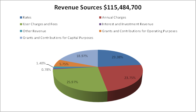
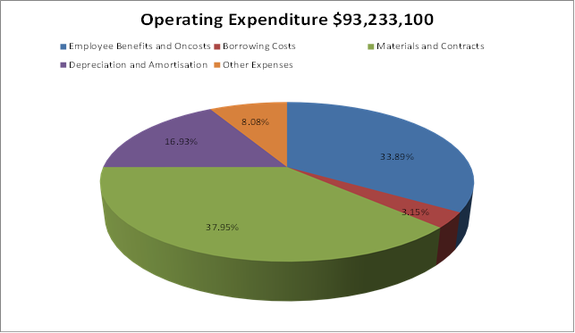
To arrive at the Draft Budget Results outlined in Table 1
for the 2021/22 financial year, Council’s revenue and operational expenses
are expected to be derived from the following sources and allocated
respectively as outlined in the graphs below:
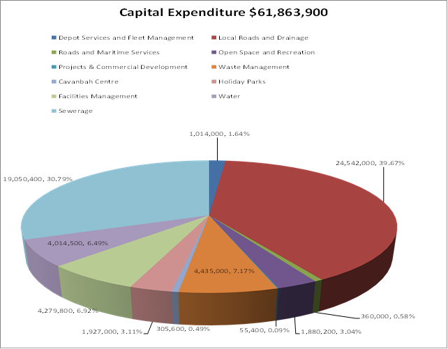
In addition to the operational aspects of the proposed Draft
2021/22 Budget Estimates, Council is proposing a capital works program of
$61.864million. By Fund, the projected capital works are:
· General
Fund $38.799million
· Water
Fund $4.015million
· Sewerage
Fund $19.050million
Specific capital works projects have been detailed in
Attachment 2. As in previous years, the General Fund is presented in a
different format, to improve the disclosure of funding sources for specific
projects including:
· Developer
contribution funding to describe the specific part of the Developer
contribution plan and catchment that is providing the funding for a project.
· Where
reserve funds are funding a project, identification of the reserve being
utilised.
· Separation
of funding provided by the 2017/18 Special Rate Variation (SRV) for which
Council has reporting obligations for 10 years.
Of the $38.799million for capital works related to the
General Fund, $24.902million is allocated to Roads and Drainage projects. The
Sewerage Fund Capital Works Budget includes $12.000million for the proposed
Bio-Energy Facility.
The Draft 2021/22 Budget Estimates also propose new loan
borrowings of $13.500million to fund the following projects:
· First
Sun Holiday Park Land Purchase $1.500million
· Bio-Energy
Facility (Sewerage Fund) $12.000million
The amount of actual loan funds Council will need to borrow
may be reduced pending the following considerations and depending on how both
projects proceed during the coming financial year.
Should Council need to borrow the full $13.500million or
less, this will be subject to lending approval and it will be necessary for
both projects to be financially viable to generate sufficient return to fund
their future loan repayments.
It may be likely that Council will not be able to access the
low-interest initiative loan borrowing facility offered by the NSW Government
through NSW Treasury Corporation as these projects will possibly fall outside
its lending criteria. Nevertheless, given the current interest rate
environment, Council should, depending upon approval processes, be able to
obtain a relatively low interest rate.
Draft General Land Rates and Charges (Statement of Revenue Policy)
The Draft 2021/22 Revenue Policy includes the proposed
rating structure, consistent with the structure revised by Council for the
2017/18 financial year. This is outlined in Attachment 3. The rating structure
incorporates the approved rate peg of 2.00% determined by the Independent
Pricing and Regulatory Tribunal (IPART). Council is now back to normal rate
pegging increases, given the approved 2017/18 Special Rate Variation (SRV)
concluded in the 2020/21 financial year. The cumulative increase in rates revenue
generated by the SRV over the last four financial years is now a permanent
addition to Council’s rating revenue base.
The 2021/22 financial year will also see the continuation of
new land valuations introduced for the 2020/21 financial year for the purposes
of levying general land rates.
In respect of other charges, the Draft 2021/22 Revenue
Policy includes the following:
· Waste
Charges – increase of up to 14%. Charges for 2020/21 were increased by
1.80% but should have been increased further to reflect waste disposal costs so
there is a catch-up proposed for 2021/22.
· Water
access charges increasing around 3.2% and water usage charges increasing by
2.9%. including continuation of water being the same price for usage
irrespective of whether a consumer is residential or non-residential, providing
equity for all consumers and continuation of the single tariff introduced in
the 2019/20 financial year.
· Sewerage
charge increased by 3.0%, including continuation of a fixed access charge for
residential consumers and not charging sewerage usage charges based on water
consumption as introduced in the 2020/21 financial year.
· The
stormwater charge has not increased. It is a regulated charge that has not
changed over the last fifteen years.
For the average residential
ratepayer, the increases proposed for 2021/22 to rates and charges will see an
overall increase of $135.00 or 3.40% for 2021/22 compared to 2020/21.
Draft Fees and Charges (Statement of Revenue Policy)
The Draft 2021/22 Fees and Charges have been reviewed by the
respective program managers and included at Attachment 3. Where possible, fees
have been altered/increased to reflect the following specific changes:
· Increases
in the Consumer Price Index (CPI)/Indexation - assumed at 1.00%.
· Review
of fees and charges including benchmarking/cost of service provision and where
possible, introduction of new fees to assist Council to generate additional/
enhanced revenue.
Strategic Considerations
Community Strategic Plan and Operational Plan
|
CSP Objective
|
|
CSP Strategy
|
|
DP Action
|
|
OP Activity
|
|
Community
Objective 5: We have community led decision making which is open and
inclusive
|
5.2
|
Create
a culture of trust with the community by being open, genuine and transparent
|
5.2.1
|
Provide
timely, accessible and accurate information to the community
|
5.2.1.1
|
Review
Operational Plan annually
|
Legal/Statutory/Policy
Considerations
Section
405 of the Local Government Act outlines the Operational Plan requirements
including public exhibition and timeframes.
The specific statements
required by Council to be disclosed as part of its Revenue Policy are
determined by Clause
201 of the Local Government (General) Regulation 2005.
Financial Considerations
The Operational Plan includes the annual budget required to
fund the projects and services delivered as part of the Plan.
Consultation and
Engagement
The Draft 2021/22 Operational Plan and Budget have been
prepared based on the strategic priorities in the Community Strategic Plan and
insights from the 2018 Infrastructure Community Solutions Panel and the 2018 Community
Satisfaction Survey.
The Draft 2021/22 Operational Plan and Budget will be
subject to 28 days’ public exhibition. Feedback will be sought
primarily through www.yoursaybyronshire.com.au,
Public notices and media releases will also be distributed.
A Community Conversation will be held on 17 May as
part of the exhibition period to offer members of the community an opportunity
to meet with Council to discuss how the budget and operational plan have been
developed, and projects planned for the 2021/22 financial year. Any input
provided by the community as an outcome of the community conversation will be
included as a submission to be considered by Council when adopting the final
plans.
Staff Reports - Corporate and Community Services 13.3
Report
No. 13.3 Budget Review - 1
January 2021 to March 31 2021
Directorate: Corporate
and Community Services
Report Author: James
Brickley, Manager Finance
File No: I2021/645
Summary:
This report is prepared to comply with Regulation 203 of the
Local Government (General) Regulation 2005 and to inform Council and the
Community of Council’s estimated financial position for the 2020/2021
financial year, reviewed as at 31 March 2021.
This report contains an overview of the proposed budget
variations for the General Fund, Water Fund and Sewerage Fund. The
specific details of these proposed variations are included in Attachment 1 and
2 for Council’s consideration and authorisation.
RECOMMENDATION:
1. That
Council authorises the itemised budget variations as shown in Attachment 2
(#E2021/62157) which include the following results in the 31 March 2021
Quarterly Review of the 2020/2021 Budget:
a) General
Fund – $89,400 increase to the Estimated Unrestricted Cash Result and
$4,234,700 increase in reserves
b) Water
Fund – $1,680,300 increase in reserves
c) Sewerage
Fund – $638,500 increase in reserves
2. That
Council adopts the revised General Fund Estimated Unrestricted Cash Result of
$517,600 for the 2020/2021 financial year as at 31 March 2021.
Attachments:
1 Budget
Variations for General, Water and Sewerage Funds, E2021/62155 
2 Itemised
Listing of Budget Variations for General, Water and Sewerage Funds, E2021/62157
3 Integrated
Planning and Reporting Framework (IP&R) required Quarterly Review
Statements, E2021/62158
Report
Council adopted the 2020/2021 budget on 30 July 2020 via
Resolution 20-357. It also considered and adopted the budget
carryovers from the 2019/2020 financial year, to be incorporated into the
2020/2021 budget, at its Ordinary Meeting held on 27 August 2020 via Resolution
20-384. Since that date, Council has reviewed the budget taking
into consideration the 2019/2020 Financial Statement results and progress
through the first three quarters of the 2020/2021 financial year. This
report considers the March 2021 Quarter Budget Review.
The details of the budget review for the Consolidated,
General, Water and Sewer Funds are included in Attachment 1, with an itemised
listing in Attachment 2. This aims to show the consolidated budget
position of Council, as well as a breakdown by Fund and Principal Activity. The
document in Attachment 1 is also effectively a publication outlining a review
of the budget and is intended to provide Councillors with more detailed
information to assist with decision making regarding Council’s finances.
Contained in the document at Attachment 1 is the following
reporting hierarchy:


 Consolidated Budget Cash
Result
Consolidated Budget Cash
Result
General Fund Cash Result Water
Fund Cash Result Sewer Cash Result
Principal
Activity Principal
Activity Principal
Activity
Operating Income Operating
Expenditure Capital income Capital
Expenditure
The pages within Attachment 1 are presented (from left to
right) by showing the original budget as adopted by Council on 30 July 2020
plus the adopted carryover budgets from 2019/2020 followed by and other budget
adjustments approved by resolution or Quarterly Budget Reviews prior to the
Quarterly Budget Review subject of this report summarised as ‘Adjustments
Prior to Revote’ and then the revised position projected for 30 June 2021
as at 31 March 2021 including the proposed ‘Revote’ for this
Quarterly Budget Review.
On the far right of the Principal Activity, there is a
column titled “Note”. If this is populated by a number, it
means that there has been an adjustment in the quarterly review. This
number then corresponds to the notes at the end of the Attachment 1 which
provides an explanation of the variation.
There is also information detailing restricted assets
(reserves) to show Council’s estimated balances as at 30 June 2021 for
all Council’s reserves.
A summary of Capital Works is also included by Fund and
Principal Activity.
Office of Local Government Budget Review Guidelines:
The Office of Local Government on 10 December 2010 issued
the new Quarterly Budget Review Guidelines via Circular 10-32, with the
reporting requirements to apply from 1 July 2011. This report includes a
Quarterly Budget Review Statement (refer Attachment 3) prepared by Council in
accordance with the guidelines.
The Quarterly Budget Review Guidelines set a minimum
standard of disclosure, with these standards being included in the Local
Government Code of Accounting Practice and Financial Reporting as mandatory
requirements for Councils to address.
Since the introduction of the new planning and reporting
framework for NSW Local Government, it is now a requirement for Councils to
provide the following components when submitting a Quarterly Budget Review
Statement (QBRS):-
· A
signed statement by the Responsible Accounting Officer on Council’s
financial position at the end of the year based on the information in the QBRS
· Budget
review income and expenses statement in one of the following formats:
o Consolidated
o By fund (e.g. General,
Water, Sewer)
o By function, activity,
program etc. to align with the management plan/operational plan
· Budget
Review Capital Budget
· Budget
Review Cash and Investments Position
· Budget
Review Key performance indicators
· Budget
Review Contracts and Other Expenses
The above components are included in Attachment 3:-
Income and Expenditure Budget Review Statement by Type
– This shows Council’s income and Expenditure by type. This
has been split by Fund. Adjustments are shown, looking from left to
right. These adjustments are commented on in Attachment 1 under the
section titled ‘Budget Variation Explanations’.
Capital Budget Review Statement – This
statement identifies in summary Council’s capital works program on a
consolidated basis and then split by Fund. It also identifies how the
capital works program is funded. As this is the first quarterly review for the
reporting period, the Statement may not necessarily indicate the total progress
achieved on the delivery of the capital works program.
Cash and Investments Budget Review Statement – This
statement reconciles Council’s restricted funds (reserves) against
available cash and investments. Council has attempted to indicate an
actual position as at 31 March 2021 of each reserve to show a total cash
position of reserves with any difference between that position and total cash
and investments held as available cash and investments. It should be
recognised that the figure is at a point in time and may vary greatly in future
quarterly reviews pending on cash flow movements.
Key Performance Indicators (KPI’s) –
At this stage, the KPI’s within this report are:-
o Debt Service Ratio
- This assesses the impact of loan principal and interest repayments on the
discretionary revenue of Council.
o Rates and Annual
Charges Outstanding Ratio – This assesses the impact of uncollected
rates and annual charges on Council’s liquidity and the adequacy of
recovery efforts
o Asset Renewals Ratio
– This assesses the rate at which assets are being renewed relative
to the rate at which they are depreciating.
These may be expanded in future to accommodate any
additional KPIs that Council may adopt to use in the Long Term Financial Plan
(LTFP.)
Contracts and Other Expenses - This report highlights any
contracts Council entered into during the October to December quarter that are
greater than $50,000.
CONSOLIDATED RESULT
The following table provides
a summary of the overall Council budget on a consolidated basis inclusive of
all Funds’ budget movements for the 2020/2021 financial year projected to
30 June 2021 but revised as at 31 March 2021.
|
2020/2021 Budget Review Statement as at 31 March 2021
|
Original Estimate (Including Carryovers)
1/7/2020
|
Adjustments to 31 Mar 2021 including Resolutions*
|
Proposed 31 Mar 2021 Review Revotes
|
Revised Estimate 30/6/2021 at 31/03/2021
|
|
Operating Revenue
|
84,311,000
|
1,084,700
|
4,480,600
|
89,876,300
|
|
Operating Expenditure
|
91,880,000
|
1,964,300
|
2,212,200
|
96,066,500
|
|
Operating Result –
Surplus/Deficit
|
(7,569,000)
|
(879,600)
|
2,258,400
|
(6,190,200)
|
|
Add: Capital Revenue
|
27,338,600
|
(405,300)
|
(5,207,700)
|
21,725,600
|
|
Change in Net Assets
|
19,769,600
|
(1,284,900)
|
(2,949,300)
|
15,535,400
|
|
Add: Non Cash Expenses
|
14,986,200
|
0
|
0
|
14,986,200
|
|
Add: Non-Operating Funds
Employed
|
27,000,000
|
1,750,000
|
(27,000,000)
|
1,750,000
|
|
Subtract: Funds Deployed for
Non-Operating Purposes
|
(96,029,000)
|
1,629,900
|
36,592,200
|
(57,806,900)
|
|
Cash Surplus/(Deficit)
|
(34,273,200)
|
2,095,000
|
6,642,900
|
(25,535,300)
|
|
Restricted Funds –
Increase / (Decrease)
|
(33,916,400)
|
2,034,300
|
6,553,500
|
(25,328,600)
|
|
Forecast
Result for the Year – Surplus/(Deficit) – Unrestricted Cash
Result
|
(356,800)
|
60,700
|
89,400
|
(206,700)
|
The General Fund financial position overall has improved by
$89,400 as a result of this budget review, leaving the forecast cash result for
the year at a deficit of $206,700. The proposed budget changes are detailed in
Attachment 1 and summarised further in this report below.
Council Resolutions
At the meeting of 24 September 2020, Council resolved
through Resolution 20-518 “That Council considers a budget
allocation at the September quarterly review to undertake further work on the
Rail with Trail on the corridor between Mullumbimby and Byron Bay.” At
this point in time there has not been the capacity to identify sufficient
funding for this resolution given the overall Council budget position is still
projecting a deficit position although a reduced deficit. Further consideration
of this resolution will be given when the 30 June 2021 Quarterly Budget Review
is completed which will provide a better indication of final 2020-2021
financial year outcomes and whether any funds can be reserved.
Council has not passed any resolutions that impact the
unrestricted cash result for the January 2021 to March 2021 quarter.
Budget Adjustments
The budget adjustments identified in Attachments 1 and 2 for
the General Fund have been summarised by Budget Directorate in the following
table:
|
Budget
Directorate
|
Revenue Increase/
(Decrease) $
|
Expenditure Increase/
(Decrease) $
|
Accumulated Surplus (Working Funds) Increase/
(Decrease) $
|
|
General Manager
|
200,000
|
165,000
|
35,000
|
|
Corporate &
Community Services
|
(403,400)
|
(304,400)
|
(99,000)
|
|
Infrastructure
Services
|
(13,125,400)
|
(13,137,500)
|
12,100
|
|
Sustainable
Environment & Economy
|
125,100
|
(16,200)
|
141,300
|
|
Total Budget
Movements
|
(13,203,700)
|
(13,293,100)
|
89,400
|
Budget Adjustment Comments
Within each of the Budget Directorates of the General Fund,
are a series of budget adjustments identified in detail at Attachment 1 and
2. More detailed notes on these are provided in Attachment 1 but in
summary the major additional items included are summarised below by Directorate
and are included in the overall budget adjustments table above:
General Managers Program
· In the General
Manager’s program, it is proposed to transfer $200,000 from the legal
services reserve to cover the actual legal costs Council has incurred to
date. This is in addition to the original $200,000 budget.
· In the People &
Culture program, it is proposed to decrease operating expenditure due to part
of the budgets for training ($20,000), advertising expenses for recruitment
($10,000) and subscriptions ($5,000) not being required for the remainder of
the financial year.
Corporate and Community Services
· In the Councillor
Services program, it is proposed to decrease operating expenditure due to the
whole budget for Guidance Groups ($5,000) not being required for the financial
year. It is also proposed to decrease the budget against Australia Day
($6,900). Council received grant funding for Australia Day which has
allowed savings to be realised against the revenue funded portion of the event(s).
$5,000 expenditure is proposed to provide for a pre-election community
information program.
· In the General Purpose
Revenues program it is proposed to decrease operating income due to the
interest that Council has received for investments being significantly lower
than the budget ($300,000). This is due to the low interest rates that are
currently offered on investments available to Council. As some of this interest
is allocated to externally restricted reserves ($164,300), a decrease in the
transfer to these reserves can be recognised. Some of this decrease can
be offset by an increase in rate income that Council has received. The budget
is under the actual rate income received ($175,800).
· In the Financial
Services program, it is proposed to increase the budget for Section 603
certificates as the actual income received is trending higher than the budget
due to increased activity in the property market.
· In the Information
Services program, it is proposed to increase operating income by $4,400 due to
a reimbursement of iPad purchases received from the SEE directorate. It
is proposed to increase operating expenditure due to a budget required for the
PULSE annual licence fee ($15,100), a decrease to the CCTV budget at main beach
car park as it was completed under budget ($1,200) and a decrease in support
service costs reallocated ($10,700).
· In the Corporate
Services Program, It is proposed to decrease operating income due to the
budgets for DA scanning fees ($15,100) and document preparation fees ($10,500)
not being required. These fees are being taken up elsewhere. It is proposed to
decrease operating expenditure due to the full budgets not required for the
financial year for customer service initiatives ($2,500), sundry expenses
($1,000), overtime for meetings ($2,000) and delegations management ($5,500). A
decrease is also proposed for budgets against the strategic procurement roadmap
($5,000) and risk management programs ($20,000). This $25,000 can be
transferred to the risk management reserve and assist funding of the contract
management framework in the 2022 financial year. A support service cost
decrease of $17,100 is also required.
· In the Community
Development Program, it is proposed to increase operating income and
expenditure by $10,000 due to a grant received for the Arts Restart project. It
is proposed to decrease operating expenditure due to schoolies approvals
($1,400), Youth Week expenses, ($2,200), aboriginal culture steering committee
($6,100) and volunteers’ recognition ($10,000) full budgets not being
required this financial year due to Covid. It is proposed to add a budget for a
ramp at Fletcher Street, to be funded by a reduction to Durrumbul Hall funding
($46,600) and from community building urgent and unplanned maintenance
($10,900). Vacancies within the community development area have enabled the
proposal to create a budget of $40,000 for consultants to assist in completing
projects. The vacancies have provided savings within the salaries budget that
can be used to fund these consultant costs.
· In the Sandhills
program, it is proposed to decrease operating income as the budget is
too high. Sandhills fees had been kept at the 2019/20 level from July to
December 2020 to assist customers who may have been affected by COVID-19. In
addition to this, the facility has been operating at approximately 93%
occupancy when the budget assumed 100%. The impact of this decrease is
significant, but $99,200 can be absorbed through a reduction in the transfer to
and from the Children’s Services Reserve.
· In the Other
Children’s Services program, it is proposed to increase operating
expenditure as salaries for the Brunswick and Mullumbimby OSHC are trending
higher than the budget. The impact of this increase can be absorbed through a
reduction in the transfer to the Children’s Services Reserve.
Infrastructure Services
· In the
Projects and Commercial Development program, it is proposed to decrease capital
expenditure due to Lot 22 Mullumbimby ($40,500), Lot 102 Depot Relocation
($5,000) and Lot 12 Bayshore Drive ($9,900) not being completed this financial
year. These adjustments are funded from the property development reserve
and have been included in the Draft 2021/22 Budget.
· In the
Local Roads and Drainage program, there are a number of adjustments outlined
under Note 17 in the Budget Variations explanations section of Attachment 1.
Further disclosure is included in the third and fourth pages of Attachment 2
under the budget program heading Local Roads and Drainage. Many of these
adjustments are related to works that will not be completed in 2020/21 and will
continue in the 2021/22 financial year. These adjustments have been added
to the Draft 2021/22 Budget.
· In the Roads and
Maritime Services program (RMS) it is proposed to increase operating income and
expenditure by $900,000 due grant funding of estimated natural disaster
expenditure. It is proposed to increase operating expenditure by a further
$166,800 due to this being the amount Council will need to contribute for the
March 2021 event.
· In the Open Space &
Recreation program, there are a number of adjustments outlined under Note 19 in
the Budget Variations explanations section of Attachment 1. Further disclosure
is included in the sixth page of Attachment 2 under the budget program heading
Open Space & Recreation.
· In the Quarries program,
it is proposed to create a budget for operating income as the Quarry has been
generating income during the year. This is the estimated income expected prior
to the end of the financial year. It is expected that $60,000 expenditure will
be incurred by the end of the financial year with the difference between income
and expenditure transferred to the Quarry Reserve.
· In the Waste &
Recycling program, there are a number of adjustments outlined under Note 21 in
the Budget Variations explanations section of Attachment 1. Further disclosure
is included in the seventh page of Attachment 2 under the budget program
heading Waste & Recycling. The capital works adjustments are related to
works that will not be completed 2020/21 and will continue in the 2021/22
financial year. These adjustments have been added to the Draft 2021/22 Budget.
· In the Cavanbah Centre
program, it is proposed to increase operating income due to adjustments
relating to COVID-19. The original income budget for the Cavanbah Centre was
reduced as the effect that COVID 19 would have on the Centre was unknown.
These adjustments reflect the estimated actual income to 30 June 2021.
Operating expenditure increased as the Centre was not closed for as long as
first anticipated as a result of COVID-19, and staff costs have remained the
same. It is proposed to decrease capital expenditure due to the installation of
grandstands being less than the budget ($3,500) and a slight over-spend against
outdoor court lighting ($2,000).
· In the First Sun Holiday
Park program, it is proposed to increase the income and expenditure budgets to
reflect actual income received and expenditure incurred. The original
budgets took into account COVID-19 and the effect closures may have had on the
holiday park. This did not happen for as long as anticipated, therefore
increasing actual income and expenditure.
· In the Suffolk Park
Holiday Park program, it is proposed to increase the income and expenditure
budgets to reflect actual income received and expenditure incurred. The
original budgets took into account COVID-19 and the effect closures may have
had on the holiday park. Subsequently, this did not happen for as long as
anticipated, therefore increasing actual income and expenditure.
· In
the Facilities Management program, it is proposed to increase operating
expenditure by $100,000 to fund the costs associated with over expenditure of
toilet maintenance. The Byron Bay Main Beach toilets maintenance expenditure
can be funded from the Crown pay parking reserve. It is proposed to decrease
capital expenditure due to the construction works at Byron hospital not
occurring this financial year ($650,000), a decrease in community building
renewals ($8,600), and an additional $18,600 required to complete renewal works
at Mullumbimby netball courts. Further, construction of the Dingo Lane
Solar Farm (given Council’s recent decision to proceed to the Development
Application stage) will not occur in the 2020/2021 financial year so it is proposed
to remove the construction budget of $12,000,000 and reduce the proposed
capital income from new loan borrowings by the same amount.
Sustainable Environment and Economy
· In the Development
Certification program, it is proposed to increase operating income as $5,000
was received from the Department of Education for a trainee position.
· In the Planning Policy
and Natural Environment program, operating income and expenditure increased by
$145,000 due to grants received for the Leash-Up Pilot Communication project
($20,000) and Streets as Shared Spaces project ($125,000). It is proposed
to increase operating expenditure by a further $34,500 as additional budgets
are required for the Bangalow village plan ($9,600), Mullumbimby hospital LEP
amendment ($10,500), Lot 22 Masterplan ($10,500), Lot 12 and Lot 107 Bayshore
Drive ($3,500) and the Centennial Circuit one way trial
($5,000).
· In the Environment &
Compliance program, it is proposed to decrease operating expenditure due to
budgets for overtime/consultants ($7,000), Compliance overtime ($45,000),
advertising ($2,000), sundry Expenses ($6,000), Infringement Processing
overtime ($30,000), abandoned vehicle disposal ($4,000), impounding expenses
($3,500), signage ($5,500), vet fees ($1,000), public education ($4,000) and
sundry operating expenses ($8,000) not being required this financial year.
· In the Economic
Development program, it is proposed to decrease operating expenditure by
$57,600 due to savings made from the vacancy in the tourism research officer
position. This can be used to fund additional budgets of $34,100 required in
the Planning Policy and Natural Environment program. Savings can also be made
against the sustainable visitation strategy ($15,300), events communication
($9,900) and sector capacity building ($7,900) as the budgets are not required
this financial year.
WATER
FUND
After
completion of the 2019/2020 Financial Statements, the Water Fund as at 30 June
2020 has a capital works reserve of $9,260,100 and held $1,483,600 in
Section 64 developer contributions.
The estimated Water Fund reserve
balances as at 30 June 2021, and forecast in this Quarter Budget Review, are
derived as follows:
Capital Works Reserve
|
Opening Reserve Balance at 1 July 2020
|
$9,260,100
|
|
Plus original budget reserve movement
|
(1,406,900)
|
|
Resolutions July - September Quarter – increase /
(decrease)
|
0
|
|
September Quarterly Review Adjustments – increase /
(decrease)
|
(720,900)
|
|
Resolutions October - December Quarter – increase /
(decrease)
|
0
|
|
December Quarterly Review Adjustments – increase /
(decrease)
|
(29,200)
|
|
Resolutions January - March Quarter – increase /
(decrease)
|
0
|
|
March Quarterly Review Adjustments – increase /
(decrease)
|
1,411,900
|
|
Forecast Reserve Movement for 2020/2021 – Increase
/ (Decrease)
|
(745,100)
|
|
Estimated Reserve Balance at 30 June 2021
|
$8,515,000
|
Section 64 Developer Contributions
|
Opening Reserve Balance at 1 July 2020
|
$1,483,600
|
|
Plus original budget reserve movement
|
(620,500)
|
|
Resolutions July - September Quarter – increase /
(decrease)
|
0
|
|
September Quarterly Review Adjustments – increase /
(decrease)
|
(80,000)
|
|
Resolutions October - December Quarter – increase /
(decrease)
|
0
|
|
December Quarterly Review Adjustments – increase /
(decrease)
|
0
|
|
Resolutions January - March Quarter – increase / (decrease)
|
0
|
|
March Quarterly Review Adjustments – increase /
(decrease)
|
268,400
|
|
Forecast Reserve Movement for 2020/2021 – Increase
/ (Decrease)
|
(432,100)
|
|
Estimated Reserve Balance at 30 June 2021
|
$1,051,500
|
Movements for Water Fund can be seen in Attachment 1 with a
proposed estimated increase to reserves (including S64 Contributions) overall
of $1,680,300 from the 31 March 2021 Quarter Budget Review.
SEWERAGE FUND
After completion of the 2019/2020
Financial Statements the Sewer Fund as at 30 June 2020 has a capital works
reserve of $6,884,700 and plant reserve of $896,200. It also held
$8,117,300 in Section 64 developer contributions.
Capital Works Reserve
|
Opening Reserve Balance at 1 July 2010
|
$6,884,700
|
|
Plus original budget reserve movement
|
(2,958,400)
|
|
Resolutions July - September Quarter – increase /
(decrease)
|
0
|
|
September Quarterly Review Adjustments – increase /
(decrease)
|
(349,200)
|
|
Resolutions October - December Quarter – increase /
(decrease)
|
0
|
|
December Quarterly Review Adjustments – increase /
(decrease)
|
94,200
|
|
Resolutions January - March Quarter – increase /
(decrease)
|
0
|
|
March Quarterly Review Adjustments – increase /
(decrease)
|
(129,600)
|
|
Forecast Reserve Movement for 2010/2021 – Increase
/ (Decrease)
|
(3,343,000)
|
|
Estimated Reserve Balance at 30 June 2021
|
$3,541,700
|
Plant Reserve
|
Opening Reserve Balance at 1 July 2020
|
$896,200
|
|
Plus original budget reserve movement
|
0
|
|
Resolutions July - September Quarter – increase /
(decrease)
|
0
|
|
September Quarterly Review Adjustments – increase /
(decrease)
|
0
|
|
Resolutions October - December Quarter – increase /
(decrease)
|
0
|
|
December Quarterly Review Adjustments – increase /
(decrease)
|
0
|
|
Resolutions January - March Quarter – increase /
(decrease)
|
0
|
|
March Quarterly Review Adjustments – increase /
(decrease)
|
0
|
|
Forecast Reserve Movement for 2020/2021 – Increase
/ (Decrease)
|
0
|
|
Estimated Reserve Balance at 30 June 2021
|
$896,200
|
Section 64 Developer Contributions
|
Opening Reserve Balance at 1 July 2020
|
$8,117,300
|
|
Plus original budget reserve movement
|
(2,202,600)
|
|
Resolutions July - September Quarter – increase /
(decrease)
|
(451,000)
|
|
September Quarterly Review Adjustments – increase /
(decrease)
|
(82,000)
|
|
Resolutions October - December Quarter – increase /
(decrease)
|
0
|
|
December Quarterly Review Adjustments – increase /
(decrease)
|
0
|
|
Resolutions January - March Quarter – increase /
(decrease)
|
0
|
|
March Quarterly Review Adjustments – increase /
(decrease)
|
768,100
|
|
Forecast Reserve Movement for 2020/2021 – Increase
/ (Decrease)
|
(1,967,500)
|
|
Estimated Reserve Balance at 30 June 2021
|
$6,149,800
|
Movements for the Sewerage Fund can be seen in Attachment 1
with a proposed estimated overall increase to reserves (including Section 64
Contributions) of $638,500 from the 31 March 2021 Quarter Budget Review.
Legal Expenses
One of the major financial concerns for Council over
previous years has been legal expenses. Not only does this item represent a
large expenditure item funded by general revenue, but it can also be
susceptible to large fluctuations.
The table that follows indicates the allocated budget and
actual legal expenditure within Council on a fund basis as at 31 March 2021.
Total Legal Income & Expenditure as at 31 March 2021
|
Program
|
2020/2021
Budget ($)
|
Actual ($)
|
Percentage To Revised Budget
|
|
Income
|
|
|
|
|
Legal Expenses
Recovered
|
0
|
0
|
0%
|
|
Total Income
|
0
|
0
|
0%
|
|
|
|
|
|
|
Expenditure
|
|
|
|
|
General Legal
Expenses
|
400,000
|
574,283
|
143.57%
|
|
Total
Expenditure General Fund
|
400,000
|
574,283
|
143.57%
|
Note: It is proposed to transfer $200,000 from the
Legal Services Reserve within this Quarterly Budget Review to fund the increase
in legal fees incurred.
Strategic Considerations
Community Strategic Plan and Operational Plan
|
CSP
Objective
|
L2
|
CSP
Strategy
|
L3
|
DP
Action
|
L4
|
OP
Activity
|
|
Community Objective 5: We have
community led decision making which is open and inclusive
|
5.5
|
Manage Council’s finances sustainably
|
5.5.1
|
Enhance the financial capability and acumen
of Council
|
5.5.1.1
|
Financial reporting as required provided to
Council and Management
|
|
|
|
|
|
|
|
|
|
|
|
|
|
Legal/Statutory/Policy
Considerations
In accordance with Regulation 203
of the Local Government (General) Regulation 2005 the Responsible Accounting
Officer of a Council must:
(1) Not
later than 2 months after the end of each quarter (except the June quarter),
the responsible accounting officer of a council must prepare and submit to the
council a budget review statement that shows, by reference to the estimate of
income and expenditure set out in the statement of the council’s revenue
policy included in the operational plan for the relevant year, a revised
estimate of the income and expenditure for that year.
(2) A
budget review statement must include or be accompanied by:
(a) a
report as to whether or not the responsible accounting officer believes that
the statement indicates that the financial position of the council is
satisfactory, having regard to the original estimate of income and expenditure,
and
(b) if
that position is unsatisfactory, recommendations for remedial action.
(3) A
budget review statement must also include any information required by the Code
to be included in such a statement.
Financial
Considerations
The 31 March 2021 Quarter Budget Review of the 2020/2021
Budget is proposing to improve the overall budget result by $89,400. This
leaves the movement against the unrestricted cash balance attributable to the
General Fund remaining at deficit of $206,700 for the year. This outcome will
derive an estimated unrestricted cash balance attributable to the General Fund
of $517,600 at 30 June 2021. Going forward Council must be conscious of
decisions that may affect the unrestricted cash balance when considering
matters with financial implications especially where funding sources are not
identified.
It is the view of the Responsible Accounting Officer that
the short-term financial position of the Council is still satisfactory for the
2020/2021 financial year, having consideration of the original estimate of
income and expenditure at the 31 March 2021 Quarter Budget Review.
This opinion is based on the estimated General Fund
Unrestricted Cash Result position and that the current indicative budget
position for 2020/2021 outlined in this Budget Review continues to improve for
the remainder of the 2020/2021 financial year. Council must remember it has a
short-term financial goal of maintaining $1,000,000 in unrestricted cash and if
it is of the view to recover this position by 30 June 2021, the budget position
must continue to improve by $482,400.
Staff Reports - Sustainable Environment and Economy 13.4
Staff Reports - Sustainable Environment and
Economy
Report No. 13.4 PLANNING
-26.2017.6.1 - Byron Bay Town Centre Planning Controls - Review of submissions
and next steps
Directorate: Sustainable
Environment and Economy
Report Author: Isabelle
Hawton, Planner
File No: I2021/391
Summary:
This is the submissions report for the second official round
of exhibition for a planning proposal and accompanying DCP to make changes to
the planning controls for the Byron Bay Town Centre.
Following feedback from the initial formal exhibition (along
with information received over a series of workshops with the public), Council
staff amended the controls, to provide an updated set of changes.
The DCP, Planning Proposal, and Design Excellence documents
were exhibited for a period of 28 days. During this time a media release was
published, the Echo ran an article on the changes, a letter and FAQ were sent
to affected residents, Facebook posts were shared and staff met in person and
spoke over the phone to numerous community members.
25 Submissions were received.
Based on the issues raised in the submissions, the
recommended changes to the exhibited planning proposal are:
· remove the proposed height
increase for the block bordered by Lawson St, Jonson St, Middleton St and Bay
Ln. Retain the current 9m maximum building height for new development in this
area; and
· remove the change of zone from
B2 Local centre to B3 Community Core. Retain the B2 Local Centre zone for
all of the town centre.
The exhibited DCP Chapter is presented with some minor
changes relating to waste management, as recommended by Council’s
Resource Recovery Team, and additional controls to reinforce building
envelopes.
It is recommended that the Design Excellence Panel
Procedures and Policy proceed with some minor amendments to fix
inconsistencies.
NOTE TO COUNCILLORS:
In accordance with the
provisions of S375A of the Local Government Act 1993, a Division is to be
called whenever a motion for a planning decision is put to the meeting, for the
purpose of recording voting on planning matters. Pursuant to clause 2(a)
under the heading Matters to be Included in Minutes of Council Meetings of
Council's adopted Code of Meeting Practice (as amended) a Division will be deemed
to have been called by the mover and seconder of all motions relating to this
report.
RECOMMENDATION
That
Council:
1. Forwards
the planning proposal to amend Byron LEP 2014, as included in Attachment 1
(E2021/58003), to the Department of Planning, Industry & Environment
requesting its finalisation.
2. Adopts
Byron DCP 2014 Chapter E10 as included in Attachment 2 (E2021/56492).
3. Publishes
Byron DCP 2014 Chapter E10 on its website and notifies the public as required
by the Environmental Planning and Assessment Act and Regulation.
4. Adopts
the Design Excellence Procedures as included in Attachment 3 (E2021/56761).
5. Adopts
the Design Excellence Policy as included in Attachment 4 (E2021/56762).
6. Prepares and circulates an Expression of
Interest for appropriately qualified professionals to form the Design
Excellence Panel, as per Attachment 5 (E2020/75377), and report back to Council
with the responses.
Attachments:
1 26.2017.6.1
Byron Bay Town Centre Planning Controls - Planning Proposal V#9, E2021/58003
2 26.2017.6.1
DCP 2014 Chapter E10 Byron Bay Town Centre - April 2021, E2021/56492
3 26.2017.6.1
Byron Town Centre Planning Controls - Design Excellence Panel Procedure
attachment to Council Report 13 May 2021 - For adoption, E2021/56761 
4 26.2017.6.1
Byron Town Centre Planning Controls - Design Excellence Policy (attachment to
council report 13 May 2021), E2021/56762
5 26.2017.6.1
Byron Town Centre Planning Controls - Expressions of Interest to sit on the
Design Excellence Panel, E2020/75377

6 26.2017.6.1
PUBLIC version Submissions Byron Bay Town Centre Planning Controls, E2021/55053
7 Disclosure
of Pecuniary Interest, E2012/2815
Report
Proposed changes to planning
controls relating to the Byron Bay Town Centre have been exhibited a number of
times since 2018, involving previous community workshops and formal public
exhibition of a Planning Proposal.
The most recent proposed changes
to various planning controls were placed on exhibition for 28 days from the 1
March to the 28 March 2021. During this time, letters were sent out to
landowners in the area affected, a media release was published, previous
submitters were contacted, Facebook posts were shared and community groups were
emailed with details. Council also posted information regarding the
proposal to social media.
The Echo ran a story on the
proposed changes during the exhibition period.
Council staff spoke over the phone
with several people, and met in person with others to answer questions about
the proposed changes and help property owners to understand how it might affect
their property.
Key issues
Height Limits and proposed
increase
Proposed changes to building
height limits were the most contentious and commented upon issue in the suite
of changes.
As exhibited, the planning
proposal suggested that the maximum building height be increased from the
current 9.0m to 11.5m for the block bordered by Lawson St, Jonson St, Middleton
St and Bay Lane, to match the 11.5m height applicable to the majority of the
town centre.
Many submissions were concerned
that any height increase would erode the existing character of Byron Town
Centre.
It should also be noted that many
submissions appeared confused about the current height limits in the Byron Town
Centre, and were under the impression that the proposed 11.5m was completely
new and did not apply anywhere else in the town centre. This is
incorrect.
The area suggested for the height
increase is a relatively small part of the overall town centre and many of the
existing two-storey buildings fronting the norther side of Lawson Street are
relatively modern and unlikely to be redeveloped in the short to medium term.
The intent of exploring a height
increase in this block was to increase the capacity of shop-top housing or
upper storey commercial in the town centre. Given the level of community
concern generated by the proposed height increase, and the quite minor
increased capacity it could generate, it is considered that there is no strong
planning or urban design reason to pursue the change in height.
It is therefore recommended that
the existing 9.0m maximum building height limit be retained in this part of the
town centre.
The only other proposed change to
building height relating to the correction of mapping anomaly for a block of
land at the southern end of Jonson Street, near Mitre 10. For that
property, the northern part of the lot, fronting the bypass, has a 9.0m height
limit, with the southern end mapped at 11.5m. There is no apparent
planning reason why this block would have a dual height control, and a review
of historic files suggests that it was originally a mapping error.
The proposal is to correct this
error by applying the existing 11.5m height limit to the whole of the property.
The only other area within the town
centre to have a 9.0m height limit as opposed to the 11.5m limit, is the block
at the southern end of Jonson Street, on the eastern side of the road, between
Kingsley and Browning Streets.
Building height in this area was
reviewed by Council previously, with a resolution to retain the 9.0m maximum.
As exhibited, the planning proposal did not suggest any change to that.
A submission from the owners at
131 Jonson Street requested that Council consider a height increase to 11.5m
for their property (corner Johnson and Ruskin Street), arguing that, given the
topography of this site, a building height of 11.5m would have minimal visual
impact on adjoining residential properties to the east.
While that is the case for this
one property, the topography is not uniform across this area. The
original intention for retaining a 9.0m height limit was to minimise impact on
residential properties to the east, and that objective remains valid for this
stretch of Jonson Street.
It is recommended, therefore, that
the height limit in this location does not change.
Zoning Changes
A number of submissions expressed
concerned that a change in zoning from B2 Local Centre to B3 Commercial Core
might erode the character of Byron Bay – despite the fact that the only
real change would be a prohibition of Bed and Breakfast uses in the B3 (where
they had previously been allowed in B2).
Submissions were concerned that
the zone change might result in different built form outcomes in the town
centre, and would not reflect the coastal town vibe of Byron Bay town centre.
There also appeared to be a great deal of mistrust in Council reflected in
submissions in relation to the zone change. Many submissions could
not understand exactly why Council was proposing a zone change and therefore
concluded that this might be some kind of ‘Trojan Horse’ for
delivering other changes. This is not the case.
The B3 zoning was a legacy from
the initial two exhibitions of this planning proposal. It was initially
intended to distinguish the Byron town centre from other areas in the Shire
also zoned B2, to prohibit backpacker’s accommodation in the town centre,
and allow for certain other changes to be specific only to the Byron town
centre area.
Through previous discussions, the
proposal to prohibit backpacker’s accommodation was withdrawn from the
proposal and other minor adjustments were made such that, as exhibited, there
was virtually no difference between the existing B2 Local Centre zoning and the
proposed B3 Commercial Core zone.
Based on the level of community
concern, and the relatively small differences between the two zones, it is
recommended that the existing B2 Local Centre zoning be retained.
Floor Space Ratio
As exhibited, it is recommended
that the existing Floor Space Ratio (FSR) standard of 1.3:1 be retained.
Recent court cases have tested the efficacy of the FSR as a control and staff
believe that further investigation of alternatives and of the efficacy of FSR
is warranted.
A more in-depth review of FSR will
be undertaken, to examine the pros and cons of its use as an effective control
of building bulk and scale, and staff will report on the outcomes of such
review at a later date.
Car parking/Traffic
A small number of submissions
raised concern over the exhibited changes to carparking – arguing that
reducing the amount of parks owners are required to provide on site might lead
to an increase in cars ‘cruising’ for parks. This feedback is
noted, however these changes will be re-examined for implementation at a later
date and are not proposed as a part of this suite of changes.
The intention is to re-examine
these proposals once peripheral parking areas are brought online.
Design Excellence
There were very few submissions
that directly addressed the proposed Design Excellence Panel. Some verbal
submissions expressed support for the panel agreeing that it might assist in
getting better built form outcomes, and one written submission directly opposed
the panel, saying that it would be an organisation to ‘sideline’
the majority of the community.
However staff believe that if
executed correctly, the panel could have significant benefits to the built form
outcomes in the Byron Bay town centre resulting in design that is more
reflective of the character of the town and produces better urban design
outcomes.
It is recommended that Council
proceed with the adoption of the Design Excellence Policy and Procedures, and
release a call for Expressions of Interest (Attachment 5 E2021/) to sit on the
panel.
Issues outside of the scope of
these changes
Many submissions made comments on
specific recent developments in the Byron town centre – these are outside
the scope of the proposed changes. Other unrelated concerns included the
validity of the Master planning process. Again, this falls outside the
scope of these amendments. The full list of submissions can be found in
Attachment 6 (E2021/55053).
Feedback from Council’s
Waste team
During the public exhibition
period, comment was sought from Council’s waste management team.
This has resulted in some minor updates to the Waste Management section in the
exhibited DCP. These have been included in the final copy for adoption.
Cadastre issues
A minor mapping inconsistency was
picked up in a small area adjacent to Mitre 10 at the Southern end of Jonson
Street where the lots have been partially split in the Height of Buildings Map,
so Council is taking this opportunity to rectify this minor mapping error.
A submission from the Department
of Education raised another mapping inconsistency during the exhibition period
– adjacent to the Byron Public School in Kingsley Street. A small
sliver of the land belonging to the Department of Education has been
incorrectly included in the town centre area on a number of LEP maps.
This issue has been added to the list of Housekeeping amendments and will be
rectified as a part of that planning proposal.
Options
Council has several options with regards
to the proposed changes:
1. Option
1 (recommended)
Amend the planning proposal to
retain the 9.0m building height limit for the block between Jonson, Lawson,
Middleton and Bay Lane.
Submit the amended planning
proposal (Attachment 1) to the Parliamentary Counsel office to
‘make’ the amendment.
Adopt the Byron DCP with some
minor changes
Adopt the Design Excellence
Procedure and Policy
Seek
Expressions of Interest for suitably qualified professionals for the Design
Excellence Panel
2. Option
2 (not recommended)
Progress the planning proposal as it was exhibited.
Adopt the Byron DCP Plan as exhibited.
Adopt the Design Excellence Procedure and Policy.
Consider and Expressions of Interest
Process to seek suitably qualified professionals for the Design Excellence
Panel.
3. Option 3 (not recommended)
Abandon the Planning Proposal and other exhibited changes
Next steps
Council forwards the Planning
Proposal to the Department of Planning, Industry & Environment requesting
its finalisation.
Council adopts and notifies Byron
DCP 2014 Chapter E10 as amended.
Council adopts the Design
Excellence Policy and Procedures, and begins an Expression of Interest process
to seek suitable applicants for the Design Excellence Panel.
Strategic Considerations
Community Strategic Plan and Operational Plan
|
CSP Objective
|
L2
|
CSP Strategy
|
L3
|
DP Action
|
L4
|
OP Activity
|
|
Community Objective 4: We manage growth and
change responsibly
|
4.1
|
Support the visions and aspirations of local communities
through place-based planning and management
|
4.1.1
|
Develop, implement and update Place Plans that promote
place-based forward planning strategies and actions
|
4.1.1.1
|
Progress draft Planning Proposal and DCP chapter to amend
planning controls for Byron Bay town centre (Byron Bay Town Centre Masterplan
action)
|
|
Community Objective 4: We manage growth and
change responsibly
|
4.1
|
Support the visions and aspirations of local communities
through place-based planning and management
|
4.1.1
|
Develop, implement and update Place Plans that promote
place-based forward planning strategies and actions
|
4.1.1.2
|
Investigate establishment of a Design Panel for Byron Bay
Town Centre
|
|
|
|
|
|
|
|
|
|
Recent Resolutions
· 20-681
Legal/Statutory/Policy Considerations
By adopting the Design Excellence Policy, Council is
introducing a new policy. The policy will apply to land marked on the
Design Excellence Map in the Byron LEP 2014.
Financial Considerations
The fees collected under the 2020/2021 fees and charges will
cover any costs incurred as part of the administration of the Design Excellence
Panel.
Consultation and Engagement
Council has undertaken extensive community consultation as a
part of this project as discussed in the report.
Staff Reports - Sustainable Environment and Economy 13.5
Report
No. 13.5 PLANNING - s4.55
application to modify conditions related to Artisan Food and Drink Industry
(Brewery & Tasting) - 10.2020.201.2
Directorate: Sustainable
Environment and Economy
Report Author: Jordan
Vickers, Planner
File No: I2021/303
Proposal:
|
Modification
No:
|
10.2020.201.2
|
|
Proposed
modification:
|
S4.55 to Delete
or Amend Conditions 3, 17, 30, 49, 52, 53 and 55, and stage the development
into two stages
|
|
Original
Development:
|
Artisan Food and
Drink Industry
|
|
Type of
modification sought:
|
|
|
|
|
|
Property
description:
|
LOT: 7 DP: 805144
|
|
9 Dudgeons Lane
BANGALOW
|
|
Parcel No/s:
|
20000
|
|
Applicant:
|
Ardill Payne
& Partners
|
|
Owner:
|
Mr B K Plummer
|
|
Zoning:
|
IN1 General
Industrial
|
|
S96 Date
received:
|
27 November 2020
|
|
Original DA
determination
|
Approved -
07/10/2020
|
|
Public
notification or exhibition:
|
- Level 0 advertising
under DCP 2014 Part A14 – Public Notification and Exhibition of
Development Applications
- Council received no
submissions
|
|
Planning
Review Committee:
|
Council
|
|
Issues:
|
· Car parking
· Patron Numbers
· Noise impacts
|
Summary:
This application seeks approval for a modification of
DA2020/201 under s4.55 to Delete or Amend Conditions 3, 17, 30, 49, 52, 53 and
55, and stage the development into two stages.
Specifically the applicant was initially seeking to increase
patron numbers from 20 to 100 and an extension of hours with a closing time of
6pm extended to 10pm seven days a week. Consent was also sought to amend the
conditions to enable amplified music. There was a general concern that this
development appeared more like a licensed venue such as a hotel rather than an
artisan food and drink premise with a tasting room.
Discussions with the applicant resulted in the patron numbers
being amended to an increase to a maximum of 50 people after 5 pm on Thursday
and Friday evenings and on Saturday and Sunday with the use of a courtesy bus
to ferry patrons to and from the site proposed. Amendments to hours of
operation is supported to enable extended trading to 10.00pm on Thursday,
Friday and Saturday nights and to 8pm on Sundays only. The request to modify
Condition 55 (no amplified music) is partially supported to allow background
music from small indoor speakers. No live bands or DJs indoors and/or outdoors
are permissible at any time.
The applicant has also sought to stage the consent in terms of
production of beer whist there is some general housekeeping of conditions also
proposed in relation to managing building waste and bringing the building into
compliance with the Building Code of Australia.
The application is considered to be substantially the same
development as approved.
It is recommended for approval subject to amended conditions
of consent.
NOTE TO COUNCILLORS:
In accordance with the
provisions of S375A of the Local Government Act 1993, a Division is to be
called whenever a motion for a planning decision is put to the meeting, for the
purpose of recording voting on planning matters. Pursuant to clause 2(a)
under the heading Matters to be Included in Minutes of Council Meetings of
Council's adopted Code of Meeting Practice (as amended) a Division will be
deemed to have been called by the mover and seconder of all motions relating to
this report.
RECOMMENDATION:
That pursuant to Section 4.55 of the Environmental Planning
& Assessment Act 1979, that Application No. 10.2020.201.2, for S4.55 to
delete or amend Conditions 3, 17, 30, 49, 52, 53 and 55, be approved by
modifying Development consent number 10.2020.201.1 as indicated in Attachment 2
(E2021/58206).
Attachments:
1 DA10.2020.201.1
Stamped Approved Plan, E2020/76930
2 DA10.2020.201.2
Modified conditions of consent, E2021/58206
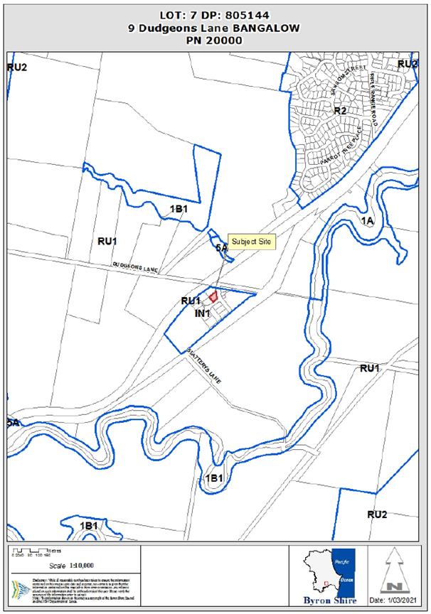
Assessment:
1. INTRODUCTION
1.1. History/Background
A search of Council records indicates the following relevant
site history:
|
DA No.
|
Description
|
Outcome
|
Date
|
|
5.1992.266.1
|
Sign
|
Approved
|
04/08/1992
|
|
6.1992.2058.1
|
Factory/Laboratory
|
Approved
|
03/03/1992
|
|
10.1999.87.1
|
Alteration to
Factory Unit
|
Approved
|
21/07/1999
|
|
10.2005.614.1
|
Use of Existing Industrial
building as Ice production facility
|
Approved
|
15/12/2005
|
|
10.2005.614.2
|
Modification to
reduce developer contributions
|
Approved
|
02/03/2007
|
|
10.2020.201.1
|
Artisan Food and
Drink Industry
|
Approved
|
07/10/2020
|
1.2. Description
of the proposed development
This application seeks approval for a modification of
DA2020/201 under s4.55 to Delete or Amend Conditions 3, 17, 30, 49, 52, 53 and
55, and stage the development into two stages as follows:
Condition 3
|
3.
|
Existing building/s to be bought into compliance
with fire safety provisions
In accordance
with Clause 94 of Environmental Planning & Assessment Regulation 2000,
the existing building is to be bought into compliance with the fire
protection and structural provisions of the Building Code of Australia.
|
Reason: It
is requested to Modify Condition 3 to define fire safety upgrades to the
building.
Condition 17
|
17.
|
Certificate of Compliance – Water Management
Act 2000
A Certificate of Compliance will be issued upon payment of
developer charges for water and sewer as calculated in accordance with Byron
Shire Council’s Development Servicing Plan.
Note: Copies of the application forms for Certificates
of Compliance are available on Council’s website
http://www.byron.nsw.gov.au/files/Forms/Section_305_Certificate.pdf
or from Council’s Administration Office. Copies of Byron Shire
Council’s Development Servicing Plans are available at Council’s
Administration Office.
Developer charges will be calculated in accordance with the Development
Servicing Plan applicable at the date of payment. A check must be made with
Council to ascertain the current rates by contacting Council’s Principal
Engineer Systems Planning, Water on 02 6626 7081. Applicable charges
can be found on Council’s website: http://www.byron.nsw.gov.au/development-contributions-plans-section-94-and-64
The
contributions payable will be adjusted in accordance with relevant plan and
the amount payable will be calculated on the basis of the contribution rates
that are applicable at the time of payment.
Payment by Personal or Company Cheque will not be
Accepted
|
Reason: It
is requested to update condition 17 to reflect the proposed staging of this
development having regards to the payment of water and sewer charges
Condition 30
|
30.
|
Removal of asbestos
All asbestos wastes associated with removal of the existing
dwelling to be disposed of in accordance with the requirements of the
WorkCover Authority. The applicant/owner is to produce documentary
evidence that this condition has been met.
Please note the
Byron Resource Recovery Centre can not accept asbestos. You will need to
arrange disposal at an alternate landfill site.
|
Reason: It
is requested to delete condition 30 as the condition is already covered by
another condition of the consent.
Condition 49
|
49.
|
Restriction on Production Rate
Production of
beer and Kombucha at the premises is to be limited to 1442.31 Litre per
week. Any increase in production rate will require further consent from
Council.
|
Reason It is
requested that condition 49 is amended to reflect the proposed staging under
this modification.
Condition 52
|
52.
|
Restricted Use
Patron use of the
tasting room is restricted to twenty (20) patrons at any time.
|
Reason: It
is requested to modify condition 52 to permit increased patrons.
Condition 53
|
53.
|
Hours of
Operation
The development
must not unreasonably interfere with the amenity of the neighbourhood.
In particular operating noise, when audible on adjoining residential
premises, can only occur:
Brewery
Production
Monday to Sunday,
from 7.00am to 10.00pm
Tasting Room
& Takeaway Sales
Monday to Sunday,
from 10.00am to 6.00pm
|
Reason: It
is requested to modify condition 53 to permit tasting room operation and sales
until 10pm.
Condition 55
|
55.
|
Amplified
music
Amplified music
is not permitted at any time.
|
|
Reason: It
is requested that condition 55 be deleted from the consent to enable
amplified music.
|
1.3. Description
of the site
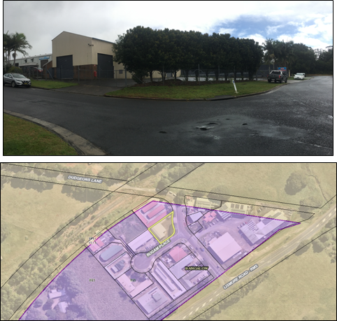
The subject site known as 9 Dudgeons Lane, Bangalow and legally described as
Lot 7 on DP805144 has a total area of 1003m² and is located in the General
Industrial (IN1) zone of the Byron Local Environmental Plan 2014. The property
is currently improved by an established industrial building that has been
historically used for various industrial operations, hardstand for car parking
and planted landscaping at the Dudgeons Lane frontage.
Subject Site
2. SECTION
4.15 – MATTERS FOR CONSIDERATION – DISCUSSION OF ISSUES
Section 4.55 Modification of Consents:
Having regard for
the matters for consideration detailed in Section 4.15(1) of the Environmental
Planning & Assessment Act 1979, the following is a summary of the
evaluation of the issues.
Hours of
Operation and Patron Numbers
The main changes to
the consent relate to an increase in patrons and hours of operation. In this
regard it is noted the development site is some 2 kilometres to the south west
of the Bangalow Town Centre in the industrial estate. Public transport is
limited, and the development is unlikely to attract pedestrian traffic as the
main mode of transport. It is anticipated patrons and staff will predominantly
arrive and leave the site by way of motor vehicle. Council also was concerned
that the development is meant to be an artisan food and drink industry with
ancillary sales and tastings, not a licensed venue such as “pub” or
hotel. The development site only contains ten car parking spaces.
It was initially
requested to modify the consent to permit up to 100 patrons anytime and hours
of operation extended to 10 pm. Further discussions with the applicant reduced
the increase to a maximum of 50 patrons after 5pm to 10pm on Thursday and
Fridays and on Saturday Afternoons and Sundays to closing time. To make up for
any shortfall in parking the applicant has proposed to provide a courtesy bus.
It is noted that the extended patron numbers and hours of operation are
generally outside of normal business hours within the industrial estate and
there should be room within the street network for any overflow parking if
required.
It is recommended
that Council approve the proposed changes to the conditions of consent to
increase patron numbers and hours of operation. Additional conditions of
consent are recommended in relation to a plan of management being prepared and
submitted to Council for approval in relation to the courtesy bus operations,
the need for a register of patrons to be kept in terms of numbers and the bus
to operate as required as per the conditions of consent.
Amplified Music
Condition 55 does
not permit amplified music. This has been reviewed by council and there remains
some concern regarding impacts of amplified music may have on the surrounding
amenity. Although the development site is located within an industrial area,
there are rural residential properties in vicinity to the site on Lismore road
and Dudgeons Lane.
The applicants have submitted a Noise Report for the
development. It is as recommended that the condition be modified to allow
background music from small indoor speakers. Amplified music including live
bands and DJ’s is not permitted on the site (indoors and outdoors) at any
time.
Proposed Staging
The proposed staging of the development is to allow the
operator of the brewery to open at a smaller scale and gradually increase
production as time and income permit. Conditions of consent and the notes are
recommended to be updated and amended to reflect the staging arrangements in
relation to the payment of headworks charges.
Building Code
and Demolition Matters
Council’s
Building Certifier confirmed that it is appropriate to modify the condition to
reflect which sections of the Building Code of Australia apply to fire upgrades
of the building.
Typographical
Error
An error was noticed in relation to
Condition 54, where the word ‘restaurant’ has been used instead of
‘development’. This is to be amended to reflect that the
development is an ‘artisan food and drink industry’ as defined.
The proposed
development remains substantially the same development as approved and
satisfies the provisions under Section 4.55(1A) of the EPA Act 1979.
2.1. State/Regional
Planning Policies, Instruments, EPA Regulations 2000
Application assessed
as having no direct conflict or adverse impact on these provisions.
2.2. Byron Local
Environmental Plan 2014
Application
assessed as having no direct conflict or adverse impact on these provisions.
2.3. Draft EPI
that is or has been placed on public exhibition and details of which have been
notified to the consent authority - Issues
No draft EPIs apply
to the proposal.
2.4. Development
Control Plans
Chapter B4
Traffic Planning, Vehicle Parking, Circulation and Access
Artisan Food and
Drink Industry are a type of Light Industry which only require 1 space per 100m2
of floor area and a parking rate for general retail was utilised for the sales
and tasting area, as follows.
· Factory & Mezzanine Area
– 312m2 x 1 space per 100m2 GFA = 3.12 spaces
· Tasting Room & Deck
– 135.9m2 x 1 space per 20m2 GFA = 6.80 spaces
· Total Parking Spaces
Required = 9.92 spaces round to 10 spaces
However there are
no specific provisions within the DCP to consider in terms of patron numbers.
The applicant’s proposal to facilitate access to the site through the use
of a mini bus after general business hours in the industrial estate provides
for a suitable outcome for increased patronage up to 50 people. Conditions of
consent recommended in relation to the provision and operation of the courtesy
bus, including a plan of management.
2.5. The
likely impacts of that development, including environmental impacts on both the
natural and built environments, and social and economic impacts in the locality
The proposed
amendments to the consent have the potential to impact on the amenity of the
surrounding properties, having regard to overflow parking, hours of operation
and noise impacts. These issues have been carefully considered and amended
conditions recommended to limit patron numbers, limited extended hours outside
of normal business hours and restrictions on amplified music to mitigate
against such impacts.
2.6. The
suitability of the site for the development
The site
suitability was previously assessed and has not changed the result of the
application.
2.7. Submissions
made in accordance with this Act or the regulations
Not relevant.
2.8. 3.7 Public
interest
The proposed
amendments to the consent are unlikely to prejudice or compromise the public
interest.
2.9. DEVELOPER
CONTRIBUTIONS/ WATER AND SEWER CHARGES
There is no nexus
to levy additional contributions. Notwithstanding, conditions prescribing Water
and Sewer charges are modified under this consent to reflect the proposed
staging.
3. CONCLUSION
The proposed amendments to the consent are assessed as
satisfactory having regard to relevant matters for consideration. The
application is recommended for approval subject to conditions listed in the
attachment.
4. DISCLOSURE
OF POLITICAL DONATIONS AND GIFTS
|
Has a Disclosure
Statement been received in relation to this application
|
No
|
|
Have staff received a
‘gift’ from anyone involved in this application that needs to be
disclosed. Where the answer is yes, the application is to be determined by
the Director or Manager of the Planning, Development and Environment
Division.
|
No
|
Provide Disclosure Statement register details here:
Not applicable
Staff Reports - Sustainable Environment and Economy 13.6
Report
No. 13.6 PLANNING - Subdivision
to Create Two (2) Lots and New Dwelling House - DA10.2020.102.1 at 18 Red Bean
Close, Suffolk Park
Directorate: Sustainable
Environment and Economy
Report Author: Jordan
Vickers, Planner
File No: I2021/483
Proposal:
|
DA No:
|
10.2020.102.1
|
|
Proposal
description:
|
Subdivision to
Create Two (2) Lots, New Dwelling House
|
|
Property
description:
|
LOT: 19 DP:
1009620
|
|
18 Red Bean Close
SUFFOLK PARK
|
|
Parcel No/s:
|
229750
|
|
Applicant:
|
Mr J V Main
|
|
Owner:
|
Mr J V & Mrs
B A Main
|
|
Zoning:
|
R2 Low Density
Residential / PART 2A Residential / PART 7(d) Scenic/Escarpment zone
|
|
Date received:
|
27 February 2020
|
|
Integrated /
Designated Development:
|
☒ Integrated
|
☒ Designated
|
☐ Not
applicable
|
|
Public
notification or exhibition:
|
- Level 1 advertising
under DCP 2014 Part A14 – Public Notification and Exhibition of
Development Applications
- Exhibition period:
16/3/20 to 29/3/20
- Submissions received: 0
- Submissions
acknowledged: ☐
Yes ☐
No ☒ N/A
|
|
Variation
request
|
Clause 64A
>10%
|
|
Delegation to
determine
|
Council
|
|
Issues:
|
· Subdivision
less than Minimum lot size
· Bushfire
prone land
· High
Environmental Value Vegetation
· Biodiversity
Values assessment
|
Summary:
This application seeks approval for Subdivision to Create
Two (2) Lots and a New Dwelling House. The intended staging of the
Subdivision/Dwelling house is undefined, and the applicant has requested
conditions allowing either to take place first.
The subject site has a total site area of 1.315ha and
proposes to create two (2) lots, being: proposed Lot 1 of 1.143ha, and proposed
Lot 2 of 1720m². As the lot 1 (residual Lot) contains 7(d) zoned land it
does not comply with the minimum lot size requirements of the Byron LEP 1988
being 40 Ha. A Clause 64A variation accompanies the application. The variation
request is recommended to be supported for the reasons detailed in this report.
In this regard the subdivision does not affect the area in the 7(d) Zone
A new two-storey Dwelling house is planned for proposed Lot
2, which is comprised of four (4) bedrooms, in and outdoor living areas
(including decks), kitchen and a double car garage. The dwelling has a total
height of 9m and complies with prescribed boundary setbacks and building height
plane. Some clearing of native vegetation is required to facilitate the
development in terms of asset protection zones for the dwelling. The vegetation
has elements of littoral rainforest species.
The Biodiversity Development Assessment Report (BDAR)
provided with the application was not finalised by the applicant’s
ecologist to Council’s satisfaction having regards to the Biodiversity
Assessment Method. An offset was offered for the minimal clearing required for
the development equal to one littoral rainforest credit. The proposal is
unlikely to have a detrimental impact on the environment or threatened species,
however to ensure the development satisfies Biodiversity Conservation Act 2016,
it is recommended that the development be approved subject to a deferred
commencement condition requiring that a completed BDAR is provided to the
satisfaction of Council.
NOTE TO COUNCILLORS:
In accordance with the
provisions of S375A of the Local Government Act 1993, a Division is to be called
whenever a motion for a planning decision is put to the meeting, for the
purpose of recording voting on planning matters. Pursuant to clause 2(a)
under the heading Matters to be Included in Minutes of Council Meetings of
Council's adopted Code of Meeting Practice (as amended) a Division will be
deemed to have been called by the mover and seconder of all motions relating to
this report.
RECOMMENDATION:
That pursuant to
Section 4.16 of the Environmental Planning & Assessment Act 1979,
Development Application No. 10.2020.102.1 for subdivision to create two (2) lots and new dwelling house, be
granted Deferred Commencement (deferral period 12 months).
Attachments:
1 DA10.2020.102.1
Conditions of consent 18 Red Bean Close, Suffolk Park, E2021/57881
2 DA10.2020.102.1
Plans for approval (Subdivision and dwelling house), E2021/57849
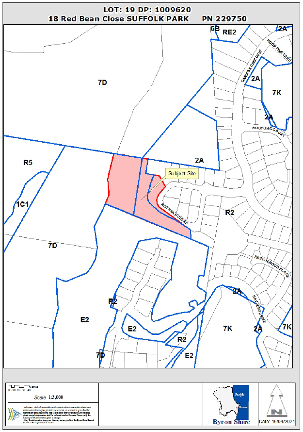
Assessment:
1. INTRODUCTION
1.1. History/Background
A search of Council records indicates the following relevant
history:
|
DA No.
|
Description
|
Outcome
|
Date
|
|
10.2005.312.1
|
Dwelling, Tree
removal & swimming pool
|
Approved
|
17/03/2006
|
|
10.2008.323.1
|
Pruning four
trees
|
Approved
|
06/06/2008
|
|
10.2010.315.1
|
Tree removal two
trees
|
Approved
|
15/07/2010
|
The location of the proposed
dwelling appears to have been recently cleared, with no evidence of approval
for the removal of this mature vegetation.
1.2. Description
of the proposed development
This application seeks approval for Subdivision to Create
Two (2) Lots and New Dwelling House. The subject site has a total site area of
1.315ha and proposes to create two (2) lots, being proposed Lot 1 of 1.143ha
and proposed Lot 2 of 1720m². As the proposed lot sizes do not comply with
the minimum lot size requirements of the Byron LEP, a Clause 4.6 variation
accompanies the application material. 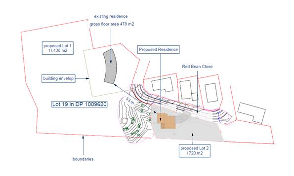
Proposed Site Plan
A new two-storey Dwelling house is planned for proposed Lot
2, which is comprised of four (4) bedrooms, in and outdoor living areas
(including decks), kitchen and a double car garage. The dwelling has a total
height of 9m, and complies with prescribed boundary
setbacks and the building height plane. The house is to be
located on a generally cleared area, however associated asset protection zones
have an impact on surrounding native vegetation comprising rainforest species.
1.3. Description
of the site
The subject
site known as 18 Red Bean Close, Suffolk Park and legally described as Lot 19
on DP1009620 has a total site area of 1.315ha (13,150m²) and is traversed
by three zones: the Low Density Residential (R2) zone of the Byron Local
Environmental Plan (LEP) 2014, and the Residential (2A) zone and 7(d)
Scenic/Escarpment zone of the Byron LEP 1988. The property is currently
improved by a single dwelling house and established mature vegetation, the
majority of which is mapped by Council as High Environmental Value (except for
the proposed dwelling location) and on the Biodiversity Values map of the
Biodiversity Conservation Act. The site is identified as Bushfire prone land
and potentially subject to geotechnical instability. A restriction on use
easement (building envelope) exists on the subject site, being the location of
the existing dwelling house.
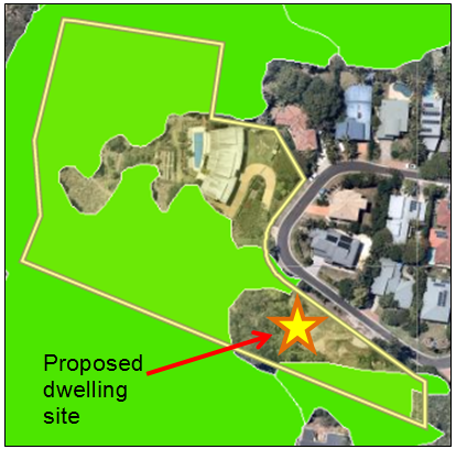
High
Environmental Value Vegetation Mapping
2. SUMMARY
OF REFERRALS
|
Referral
|
Issue
|
|
Development
Engineer
|
No objections
subject to conditions.
|
|
Water & Sewer
Engineer (Local Approvals Officer)
|
No objections
subject to conditions.
|
|
S64 / Systems
Planning Officer
|
No objections
subject to conditions.
|
|
S94 /
Contributions Officer
|
No objections
subject to conditions.
|
|
Ecologist
|
See comments
below
|
|
Rural Fire
Service (100B/4.14/4.14)
|
No objections
subject to conditions. General terms of approval under Section 100B of the
Rural Fires Act 1997. Conditions to apply
|
Ecologist:
The subject development site and
in particular the house site is mapped as containing biodiversity values under
the Biodiversity conservation Act 2016.
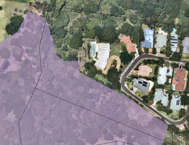
A Biodiversity Development
Assessment Report (BDAR) was supplied and Council sought advice from NSW Government’s
Department of Planning, Environment and Industry (DPIE) regarding this report.
Various issues were identified but predominantly, that the method of data
collection for the BDAR was not fully compliant with the Biodiversity
Assessment Method (BAM). Multiple information requests (RFIs) were provided to
the applicant seeking clarification/amendments to the BDAR to ensure that it
complies with the BAM. The applicant failed to provide sufficient information
in this regard, however the applicant’s ecologist completed field work as
to impacts on the surrounding native vegetation to estimate that one
Biodiversity Credit would need to be retired to offset the impacts associated
with the dwelling house. This is generally associated with the provision of the
asset protection zone around the dwelling for bushfire purposes.
It was requested that the BDAR
be completed and updated to accurately to reflect these offsets are in
accordance with the Biodiversity assessment methodology. Aside from
strict compliance with the BC Act and associated regulations, the
proposal development is not fatally flawed of its own accord. The provided BDAR
and associated information indicates that minimal environmental impact is
anticipated as a result of the development. As such it is recommended that the
matter be finalised by way of deferred commencement consent condition that will
require an amended BDAR which accords with the BAM, to the satisfaction of
Council.
It is noted that Council’s
Ecologist remains concerned that this is not the most appropriate way of
fulfilling the requirements of the Biodiversity Conservation Act 2016 and had
recommended refusal and that this may create a precedent with other developers
seeking to circumvent biodiversity controls as they apply. However, the
environmental impacts of the proposed development are understood in the current
circumstance and the requested corrections to the BDAR subject to deferred
commencement will accurately inform the Biodiversity offset credits required to
be retired.
3. SECTION
4.14 – BUSH FIRE PRONE LAND
Under section 4.14 of the Act, Council must be satisfied
prior to making a determination for development on bush fire prone land, that
the development complies with the document ‘Planning for Bush Fire
Protection 2006’. The site is bush fire prone land. The development
application was referred to the NSW Rural Fire Service, whom provided
conditions which are reflected in the Recommendation of this Report.
4. SECTION
4.15C – MATTERS FOR CONSIDERATION – DISCUSSION OF ISSUES
Having regard to the matters for consideration detailed in
Section 4.15(1) of the Environmental Planning & Assessment Act 1979
(EP&A Act), the following is a summary of the evaluation of the issues.
4.1 State
Environmental Planning Instruments
|
|
Satisfactory
|
Unsatisfactory
|
|
State
Environmental Planning Policy No 55—Remediation of Land
|
☒
|
☐
|
|
The property has a long standing residential history and is not
included on Council’s contaminated lands register. There is no record
of previous land uses on the site, or on surrounding sites, that are likely
to have resulted in land contamination. Based on the available information,
the site is considered to be suitable for the proposed residential use in its
current state and no further investigation is warranted.
|
|
State
Environmental Planning Policy (Building Sustainability Index: BASIX) 2004
|
☒
|
☐
|
|
The
proposal is accompanied by a valid BASIX certificate. The SEPP has been
addressed and the proposal is considered to comply.
|
4.2A Byron Local Environmental Plan 2014 (LEP 2014)
Note: The subject site is traversed by the Low density
residential (R2) zone of the Byron LEP 2014; however, the proposed development
is located within the Residential (2A) zone of the Byron LEP 1988.
Nevertheless, the proposal complies with the Byron LEP 2014.
4.2B Byron Local Environmental Plan 1988 (LEP 1988)
Notes: The subject site is traversed by both the
Residential (2A) zone and 7(d) Scenic/Escarpment zone of the Byron LEP 1988.
The entirety of proposed Lot 2 and the proposed Dwelling house are to be
located within the Residential (2A) zone, with the remainder of the Lot 1
comprising components of the Residential (2A) zone and Scenic/Escarpment (7(d))
zone of the BLEP 1988, and Low density residential (R2) zone of the Byron LEP
2014.
LEP 1988 is an applicable matter for consideration in the
assessment of the subject development application in accordance with subsection
4.15(1) of the EP&A Act because it applies to the subject land and the
proposed development.
The proposal complies with all clauses of the LEP 1988,
except clause 11 – Subdivision in Rural areas for agriculture etc. The
subject dwelling is permitted with consent in the 2(a) residential zone,
complies with height and floor space ratio provisions and the land is serviced
with necessary infrastructure.
A Clause 64A variation request accompanies this application
to vary the 40ha lot size under Clause 11 as discussed below.
Clause
64A – Exceptions to Development Standards:
As per the planning circular
PS20-002 - Variations to development standards, the Secretary’s
concurrence cannot be assumed for development that contravenes a numerical
development standard by more than 10% where the application is decided by a
Council delegate (e.g. Director of SEE or General Manager). But concurrence can
be assumed by the elected Council to vary the development standard and as such
the proposal is reported to Council for determination as per the planning
circular.
1. Introduction
– Summary of Proposed Development
The development application proposes to establish a Dual
Occupancy at the subject site, including Torrens title subdivision to create
two (2) residential allotments. Proposed Lot 1 has a total area of 1.143ha and
is traversed by the Scenic Escarpment (7d) and Residential (2A) zones of the
Byron LEP 1988 and Low density residential (R2) zone of the Byron LEP 2014,
while Proposed Lot 2 has a total site area of 1,720m², and is entirely
within the Residential (2A) zone of the Byron LEP 1988.
2. Clause 64A Exceptions to Development Standards.
LEP 1988
clause 64A allows the granting of
development consent in the instance that a development would contravene a
development standard. However, Council must first be satisfied by a written
request from the Applicant, that:
a) compliance with the
development standard is unreasonable or unnecessary in the circumstances of the
case, and
b) there are sufficient
environmental planning grounds to justify contravening the development
standard.
c) the proposed development will be in the public interest because it is
consistent with the objectives of the particular standard and the objectives
for the development within the zone in which the development is proposed to be
carried out.
3. The
Development Standard to be varied
The Development Standard to be varied is the 40ha Minimum
lot size (Scenic Escarpment (7d) zone) prescribed by clause 11 of LEP 1988.
4. Extent
of Variation to the Development Standard
The extent of the variation relates to the proposed 1.143ha lot size, which requires a
variation of around 97% to the 40ha development standard.
5. Objective
of the Development Standard
The objectives of the development standard, as outlined in
clause 11 are:
a) The council shall not consent to the
subdivision of land for agriculture, forestry or a dwelling-house within the
zones shown in Column 1 of the Table to this clause unless the area of each of
the allotments to be created is not less than that shown opposite that zone in
Column 2 of the Table and, in the opinion of the council, each allotment is of
satisfactory shape and has a satisfactory frontage.
6. Objective
of the Zone
The objectives of the Scenic
Escarpment (7d) zone are as follows:
a) to protect and enhance the scenic
qualities of the Shire of Byron which enhance the visual amenity by controlling
the choice and colour of building materials, position and bulk of buildings,
access roads and landscaping,
b) to prohibit development within the
zone that is likely to have a visually disruptive effect on the scenic quality
and visual amenity of the Shire,
c) to enable development for certain
purposes where such development would not have a detrimental effect on the
scenic quality and visual amenity of the Shire,
d) to minimise soil erosion from
escarpment areas and prevent development in geologically hazardous zones, and
e) to
enable the careful control of noxious plants and weeds by means not likely to
be significantly detrimental to the native ecosystem.
7. Assessment –
specific questions to be addressed under LEP Clause 64A:
(a) Clause
64A(3) (a) – Is compliance with the development standard unreasonable or
unnecessary in the circumstances of the case?
The Clause
64A written request submitted in support of the DA advises as follows in this
regard:
“Compliance with the
development standard is unreasonable in the circumstances as no purpose would
be served in requiring compliance. The apparent aim of not permitting the
fragmentation of scenic lands has been fulfilled in that all the land remains
in one lot…
Therefore,
in terms of the criteria in Clause 64A (3) the compliance with the lot size
control in Clause 11 is unnecessary as the scenic land is to be retained in the
one lot and will not be fragmented”
Officer comment:
The subject site currently has a total area of 1.315ha, and
is traversed by three (3) separate zones from both the LEP 1988 and LEP 2014.
The portion of the site zoned Scenic Escarpment (7d) has an approximate area of
6,600m² and is landlocked behind zones for residential purposes (2A and
R2). The proposal will maintain the entirety of the 6,600m² Scenic
Escarpment zone within proposed Lot 1, which will therefore not be fragmented
or altered from its current state. Neither the existing allotment (1.315ha) nor
the portion of the allotment zoned 7d (6,600m²) achieve the development
standard.
Proposed Lot 1, with an area of 1.143ha is
substantially less than the 40ha development standard; however, compliance with
the development standard in this instance is unreasonable and unnecessary for
the following reasons:
- the portion of proposed
Lot 1 zoned Scenic Escarpment (7d) (≈6,600m²) will not be fragmented
or altered under the proposal, and compliance is therefore unnecessary; and
-
neither the greater allotment, nor the portion of the allotment containing land
zoned Scenic Escarpment (7d) currently achieves the minimum lot size for the
zone, and therefore expecting compliance with this standard is unreasonable.
In this circumstance, the proposed development presents a
better planning outcome than strict compliance with the development standard by
allowing for the creation of suitably sized residential allotments on
residential zoned land. As such, compliance is unreasonable and unnecessary,
and no purpose would be served by compliance with the standard as the portion
of the subject site within the Scenic Escarpment (7d) zone will remain
unaltered.
(b) Clause
64A(3)(b) – Are there sufficient environmental planning grounds to
justify contravening the development standard?
The Clause 64A written request submitted in support
of the DA advises as follows in this regard:
“Further there are sufficient environmental
planning grounds to justify contravening the development standard in that it
allows the extensive area that is residentially zoned to be subdivided into
smaller lots as intended. If this variation was not granted no subdivision of
the residential land would be possible, contrary to the clear intent of other
provisions of the LEP.”
Officer comment:
The proposal will provide two residential allotments on
appropriately zoned land which exceed the prescribed minimum lot sizes for each
zone respectively (prescribed 600m² minimum, proposed 1.143ha and
1720m²). The portion of the subject site zoned Scenic Escarpment (7d) will
remain unaltered in shape and/or size, will remain entirely within proposed Lot
1, and is therefore unaffected by the proposal.
There are sufficient
environmental planning grounds to justify the contravention of the standard as
the proposal will provide suitably sized residential allotments as envisaged by
the LEP while preserving/maintaining the existing Scenic Escarpment (7d) zone
in situ.
(c) Clause 64A(4) (a) (ii)
– Is the proposed development in the public interest? Is it consistent
with the objectives of the standard and the zone as set out above?
Regarding the objectives of the standard and the zone, the
Clause 64A written request submitted in support of the DA advises as follows:
“There are no objectives for lot size
standard in Clause 11 as is the case with standard LEPs. Therefore, I advise
the following regarding consistency with the zone objectives for development
only.
A. Consistency
with the objectives of the zone
Regarding consistency with each of the zone
objectives, I advise as follows:
The use of
the land in the zone will not be changing and no works are proposed. Therefore,
there will be no impact on the scenic qualities of the Shire of Byron.
The use of the land in the
zone will not be changing and no works are proposed. Therefore, there will be
no disruptive effect on the scenic quality and visual amenity.
No new use is proposed. The entire area of the
zone is to be retained in one lot.
No works
are proposed. Therefore, there will no impact on the stability of the land.
Retaining the land in the lot will ensure easier control of
noxious plants and weeds.
…[t]he
development will be in the public interest for the purposes of clauses
64A(a)(ii)…as the scenically protected land will not be fragmented and
the residential lots will be larger than 600m², as intended by the
planning controls. The development will still comply with the respective
objectives of the development standards and the zones.”
Officer comment:
There are no objectives of the development standard;
however the proposal aligns with the Objectives of the Scenic Escarpment zone.
It is considered that the proposal is in the public interest.
The proposal and associated request to vary a development
standard is considered to meet subclause (3) of clause 64A, and therefore the
request to vary a development standard is supported in this case.
4.4A Byron Shire Development Control Plan 2014 (DCP
2014)
DCP 2014 is an applicable matter for consideration in the
assessment of the subject development application in accordance with subsection
4.15(1) of the EP& A Act because it applies to the land to which LEP 2014
applies. As the proposed development takes place entirely within the 2A and 7D
zones of the Byron LEP 1988, assessment under the DCP 2014 is not required.
4.4B Byron Shire Development Control Plan 2010 (DCP 2010)
The proposed development complies with the relevant
provisions of DCP 2010 as they relate to subdivision and dwelling houses other
than Element C2.6 – Setbacks from street’ and ‘Element
C2.7 – Extent of Earthworks’ which are discussed in detail
below:
C2.6 Element – Setback from Street:
Prescriptive Measures for Element
C2.6 require that urban development provides a setback of 6.5m from the primary
front boundary, with a variation permissible to 4.5m where the building is less
than 3.6m in height. The proposed dwelling house presents in part as a single
storey/ two storey dwelling to the street with elements breaching the setback
controls. The controls under DCP 2014 permit a more generous setback of
4.5 metres to dwellings of all heights. Having regards to the split level
design of the dwelling, a variation is warranted in this instance.
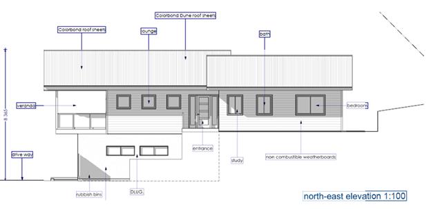
Street Elevation
– part one and two storey presentation
C2.7 Element –
Extent of Earthworks:
Prescriptive Measures for Element C2.7 requires that
excavation/fill does not exceed 1m. The proposal seeks to establish in part a
two-storey dwelling where the ground floor (garage and bedrooms) are cut into
the natural ground with a maximum excavation of up to 2.4m. Despite
non-compliance with the standard, the proposal will blend into the landscape
with a reduced footprint, and provides a design which is in keeping with the
natural landform, with car parking provided at a suitable grade from the
street. It is recommended a variation be supported in this instance.
4.5 Any Planning
Agreement or Draft Planning Agreement?
|
|
Yes
|
No
|
|
Is there any
applicable planning agreement or draft planning agreement?
|
☐
|
☒
|
|
|
4.6 Environmental
Planning & Assessment Regulation 2000 Considerations
|
Clause
|
This control
is applicable to the proposal:
|
I have
considered this control as it relates to the proposal:
|
If this
control is applicable, does the proposal comply?
|
|
92
|
No
|
N/A
|
N/A
|
|
93
|
No
|
N/A
|
N/A
|
|
94
|
No
|
N/A
|
N/A
|
|
94A
|
No
|
N/A
|
N/A
|
4.7 The likely
impacts of that development, including environmental impacts on both the
natural and built environments, and social and economic impacts in the locality
|
Impact on:
|
Likely
significant impact/s?
|
|
Natural
environment
|
No. The proposal
will not have a significantly adverse impact on the natural environment of
the locality.
|
|
Built
environment
|
No. The proposal
will not have a significantly adverse impact on the built environment of the locality.
|
|
Social
Environment
|
No. The proposal
will not have a significant social impact on the locality.
|
|
Economic
impact
|
No. The proposal
will not have a significant economic impact on the locality.
|
Council Policies
applicable to the proposed development have been considered through the
assessment of this application with relevant conditions imposed where
necessary. Appropriate conditions of consent recommended in relation to
construction activities, hours of work, builders waste and the like.
4.8 The
suitability of the site for the development
The site is
serviced, and generally unconstrained property and is suitable for the proposed
development. Bushfire constraints have been considered with appropriate
conditions of consent recommended.
4.9 Submissions
made in accordance with this Act or the regulations
The development application was
publicly exhibited. No submissions were received.
4.10 Public interest
The proposed
development is unlikely to prejudice or compromise the public interest or
create an undesirable precedent.
5. DEVELOPER
CONTRIBUTIONS
5.1 Water &
Sewer Levies
Section 64 levies
will be payable.
5.2 Section 7.11
Contributions
Section
7.11 Contributions will be payable.
6. DISCLOSURE
OF POLITICAL DONATIONS AND GIFTS
|
Has a Disclosure Statement been
received in relation to this application
|
No
|
|
Have staff received a ‘gift’ from anyone
involved in this application that needs to be disclosed. Where the answer is
yes, the application is to be determined by the Director or Manager of the
Planning, Development and Environment Division.
|
No
|
Provide
Disclosure Statement register details here: Not applicable
7. CONCLUSION
The DA proposes
Subdivision to Create Two (2) Lots and New Dwelling House. The proposed
development is satisfactory having regard to the relevant environmental
planning instruments and planning controls applicable to the site. The proposal
raises no significant issues in terms of environmental impacts which cannot be
managed and the site is considered suitable for the development. The application
appropriately addresses the relevant constraints applying to the site, and is
recommended for approval subject to conditions of consent.
Staff Reports - Sustainable Environment and Economy 13.7
Report
No. 13.7 PLANNING - 26.2019.11.1
Outcome of Public Exhibition - Planning Proposal to obtain Dwelling Entitlement
at Lot 6 DP 8385 81 Yagers Lane, Skinners Shoot
Directorate: Sustainable
Environment and Economy
Report Author: Dylan
Johnstone, Development Investigations Lead
File No: I2021/541
Summary:
On 18 June 2020 Council considered a planning proposal
(Attachment 1) to amend Byron Shire LEP 2014 by granting a dwelling entitlement
for the land so that development consent can be sought for the use of an
existing unauthorised dwelling house on the land. The matter is the subject of
current enforcement action in accordance with Council’s Enforcement
Policy.
The land has an area of approximately 4.1 hectares and is
zoned RU2 pursuant to LEP 2014. The planning proposal is consistent with the
Byron Rural Land Use Strategy 2017 and the North Coast Regional Plan 2036.
The Department of Planning, Industry & Environment
issued a Gateway determination on 7 August 2020 and the planning proposal
(Attachment 1) was placed on public exhibition for a period of 4 weeks from 15
February to 15 March 2021.
One (1) public submission was received and two (2) public
authority submissions were received.
If a dwelling is permitted on the site, this will create
additional demands on rural roads, community facilities, open spaces etc. Such
demands are captured by the Byron Shire Developer Contributions Plan 2012 which
requires a monetary contribution in accordance with the Plan and Section 7.11
of the Environmental Planning and Assessment Act 1979.
Such a monetary contribution is required to be formalised
through a planning agreement. A formal agreement was drafted by the
applicant’s legal representative (Attachment 4) and exhibited
concurrently with the planning proposal. No public submissions were received
during the exhibition period that referred specifically to the draft planning
agreement.
This report recommends that the planning proposal be sent to
the Department of Planning, Industry & Environment for finalisation and
that delegation be granted to the General Manager for the Director Sustainable
Environment and Economy to execute the planning agreement associated with the
planning proposal.
NOTE TO COUNCILLORS:
In accordance with the
provisions of S375A of the Local Government Act 1993, a Division is to be
called whenever a motion for a planning decision is put to the meeting, for the
purpose of recording voting on planning matters. Pursuant to clause 2(a)
under the heading Matters to be Included in Minutes of Council Meetings of
Council's adopted Code of Meeting Practice (as amended) a Division will be
deemed to have been called by the mover and seconder of all motions relating to
this report.
RECOMMENDATION:
That Council:
1. Forward
the planning proposal in Attachment 1 (E2020/96982) to the Department of
Planning, Industry & Environment requesting finalisation.
2. Grant delegation to the General Manager
for the Director Sustainable Environment and Economy to execute the planning
agreement associated with the planning proposal in Attachment 4 (E2021/58054).
Attachments:
1 26.2019.11.1
Exhibited Version - Planning Proposal to obtain Dwelling Entitlement 83 Yagers
Lane Skinners Shoot, E2020/96982
2 26.2019.11.1
DPIE Gateway Determination, E2020/86729
3 26.2019.11.1
DPIE Altered of Gateway determination, E2021/57832
4 26.2019.11.1
Draft Planning Agreement 83 Yagers Lane Skinners Shoot, E2021/58054
5 26.2019.11.1
- Combined Submissions, E2021/58026
6 Template -
Form of Special Disclosure of Pecuniary Interest, E2012/2815
Report
Background
On 18 June 2020 Council
considered a planning proposal to amend Byron Shire LEP 2014 by granting a
dwelling entitlement for the land so that development consent can be sought for
the use of an existing unauthorised dwelling house on the land.
Action No. 22 of the Byron
Shire Rural Land Use Strategy 2017 (BSRLS) recommends investigation into a
strategic framework for resolving dwelling entitlement issues. This action
provides the strategic basis for the subject planning proposal. This strategy
was endorsed by the NSW Department of Planning and Environment (DPE) in July
2018.
Following consideration of the 18 June 2020 Council report, 20-283
Resolved that Council:
1. Proceed
with option 1 to request the NSW Department of Planning, Industry and
Environment to issue a Gateway determination for the planning proposal as
contained in Attachment 1 (E2020/40745).
2. Agree
that staff can proceed to obtain further studies from the applicant (if
required by the Gateway determination), then undertake public exhibition of the
planning proposal and government agency consultation based on the Gateway
determination.
3. Request
staff to prepare an Unauthorised Residential Accommodation Policy as a matter
of priority to confirm the planning pathways and consequences for unauthorised
residential accommodation seeking regularisation in Byron Shire, and that this
be reported to the next available Planning meeting for consideration of public
exhibition.
4. That in
the meantime any planning proposal or development application lodged with
Council for existing (as of 18 June 2020) unauthorised residential
accommodation comply with the requirements of the Unauthorised Residential
Accommodation Policy or for those applications lodged prior to the Policy being
adopted the principles as presented in this report.
5. That a
15 month (from 18 June 2020) moratorium on enforcement action be granted to
land owners with existing (as of 18 June 2020) unauthorised residential
accommodation on their land that does not present unacceptable risk to human health
or the environment, to enable them time to lodge a planning proposal and or
development application to Council for assessment under the Unauthorised
Residential Accommodation Policy as drafted / adopted at the time of lodgement.
6. Confirm
that any unauthorised residential accommodation built after 18 June 2020 or
existing unauthorised accommodation altered or added to after 18 June 2020 will
be subject to Council’s Enforcement Policy as adopted.
In response to item 3 above, the draft Unauthorised
Dwellings Policy was reported to the Ordinary Meeting on 27 August 2020 where
it was resolved to place the draft policy on public exhibition from 23
September to 4 November 2020. A number of public submissions were received
during this period and these submissions will be reported to Council in the
near future.
Planning Proposal
The planning proposal (Attachment 1) seeks to amend Byron
Shire LEP 2014 by granting a dwelling entitlement for the land (Lot 6 DP 8385)
so that development consent can be sought for the use of an existing
unauthorised dwelling house on the land. Specifically, the planning proposal
seeks to add the land to Schedule 1 – Additional permitted uses of LEP
2014 to permit a dwelling house with consent.
A “Plain English” version of the proposed Byron
LEP 2014 Schedule 1 clause is as follows:
What Land Does it Apply to?
Lot 6 DP 8385, 81 Yagers Lane, Skinners Shoot.
What Additional Development will be Permitted?
A dwelling house will be permitted with development consent.
Gateway Determination
A Gateway determination (Attachment 2) was issued by the
DPIE on 7 August 2020. The Gateway determination required:
· Minor
amendments to the planning proposal
· Public
exhibition for a minimum of 14 days
· Consultation
with public authorities (see details below)
· The
time frame for completing the LEP is to be 9 months following the date
of the Gateway determination.
At the request of Council staff DPIE issued an alteration of
gateway determination dated 6 April 2020 (Attachment 3), granting an amended
timeframe of 7 August 2021 for completion of the LEP amendment.
Planning Agreement
The planning proposal seeks to amend LEP 2014 so that a
dwelling is permitted with consent on the subject site.
If a dwelling is permitted on the site, this will create
additional demands on rural roads, community facilities, open spaces etc. Such
demands are captured by the Byron Shire Developer Contributions Plan 2012 which
requires a monetary contribution in accordance with the Plan and Section 7.11
of the Environmental Planning and Assessment Act 1979.
Ordinarily contributions would be paid at the time of
subdivision for creating a lot with a dwelling entitlement equivalent to one
Standard Dwelling Unit (SDU) (3 bedroom dwelling or greater). However, for the
purposes of this planning proposal, there is no clear mechanism within the
Contributions Plan for applying developer contributions.
The submitted planning proposal included a letter of offer
to enter into a planning agreement with Council. The offer proposes payment of
a monetary contribution equivalent to one SDU.
Council staff have no justification to require additional
contributions over and above the demand 30 normally generated for a rural
dwelling under the terms of the Contributions Plan 2012.
A formal agreement was drafted by the applicant’s
legal representative and exhibited concurrently with the planning proposal. No
public submissions were received during the exhibition period that referred
specifically to the draft planning agreement.
Council’s Legal Services have reviewed the draft
planning agreement (Attachment 4) and recommend that it be executed by the
Director Sustainable Environment and Economy.
Consultation Undertaken
Consultation with Public
Authorities
In accordance with the
Gateway determination, comment on the planning proposal was sought from the
following public authorities:
· NSW
Rural Fire Service
· Tweed
Byron Local Aboriginal Land Council
· Jali
Local Aboriginal Land Council
· Arakwal
Corporation
Two submissions were received, one from Bundjalung of Byron
Bay Aboriginal Corporation (Arakwal) and one from the NSW Rural Fire Service.
Both authorities had no comments to make.
Despite a number of follow up attempts to obtain comments
from Tweed Byron Local Aboriginal Land Council and Jali Local Aboriginal Land
Council, comments have not been received.
Public Exhibition
In accordance with the Gateway determination, the planning
proposal was placed on public exhibition for a period of 4 weeks from 15
February to 15 March 2021.
One (1) public submission was received during the exhibition
period. This submission is in favour of the proposal on the grounds that there
are minimal constraints on the land and that it would also allow the extended
family members of one of Byron Shire's oldest pioneer families to stay in close
to proximity to family and community.
A copy of all submissions can be found in Attachment 5.
Options
Option 1 (Recommended)
Forward the Planning Proposal
in Attachment 1 to the Department of Planning, Industry & Environment
requesting finalisation.
Option 2
Withdraw
support for the Planning Proposal.
Strategic Considerations
Community Strategic Plan and Operational Plan
|
CSP Objective
|
L2
|
CSP Strategy
|
L3
|
DP Action
|
L4
|
OP Activity
|
|
Community Objective 4: We manage growth and
change responsibly
|
4.2
|
Support housing diversity in appropriate locations
across the Shire
|
4.2.1
|
Establish planning mechanisms to support housing that
meets the needs of our community
|
|
|
|
Community Objective 2: We cultivate and celebrate our
diverse cultures, lifestyle and sense of community
|
2.4
|
Enhance community safety and amenity while respecting our
shared values
|
2.4.3
|
Enhance public safety, health and liveability through the
use of council's regulatory controls and services
|
2.4.3.1
|
Monitor, investigate and resolve complaints in relation
to community safety, land use and the environment
|
|
|
|
|
|
|
|
|
|
|
|
|
|
|
|
Recent Resolutions
· 20-283
dated 18 June 2020.
Legal/Statutory/Policy Considerations
The relevant
legal/statutory/policy considerations have been noted above.
Financial Considerations
If Council chooses to proceed
with the planning proposal, it will be at the proponent’s expense as a
land owner initiated planning proposal. Full cost recovery of the remaining
stages will be required by Council. If the applicant chooses not to pay
then the planning proposal will not proceed.
If Council chooses not to
proceed then the matter does not incur any additional costs.
Consultation and Engagement
Details pertaining to community
consultation and engagement are provided above. Consultation has been
undertaken in accordance with the Gateway determination.
Staff Reports - Sustainable Environment and Economy 13.8
Report
No. 13.8 Update on Resolution
20-664 (Lot 12 Bayshore Drive)
Directorate: Sustainable
Environment and Economy
Report Author: Shannon
Burt, Director Sustainable Environment and Economy
Andrew FitzGibbon, Place Liaison
Officer
File No: I2021/377
Summary:
The purpose of this report is to provide Council with an
update on Resolution
20-664 relating to Lot 12 Bayshore Drive, Byron Bay.
Staff have been in negotiations
with Creative Capital as the preferred EOI proponent to refine the masterplan
as required by Resolution 20-664.
A refined masterplan has been
submitted to Council (refer Attachment 1).
A final decision on the refined
Creative Capital masterplan is now needed in order to progress and realise
development on Lot 12 Bayshore Drive consistent with the Site Strategy and
Urban Design Protocol.
RECOMMENDATION:
That Council:
1. Endorses
the revised masterplan prepared by Creative Capital (Attachment 1) alongside
the Lot 12 Site Strategy and Urban Design Protocol as the basis for the Lot 12
Bayshore Drive future planning proposal and development applications.
2. Authorises
staff to prepare and lodge a development application for a three (3) lot
subdivision over Lot 12 Bayshore Drive, Byron Bay, as per the Lot 12
subdivision concept plan (refer Attachment 3 Concept Plan).
3. Authorises
the sale of that part of Lot 12 in DP 1189646, being the land marked ‘Lot
1’ (Land) in the Concept Plan (refer Attachment 3) to Creative Capital,
subject to reaching agreement on sale price and terms.
4. For
the purposes of resolution part 3, authorises the General Manager to:
(a) obtain
an acceptable valuation (consistent with Council’s land acquisition and
disposal policy) for the Land to determine its sale price;
(b) reach
agreement with Creative Capital on price and terms for the sale;
(c) execute
any document on Council’s behalf necessary to complete the sale; and
(d) do
anything else reasonably necessary to complete the sale.
5. Agrees
to revenue derived from the above sale being quarantined to the Council reserve
titled ‘Property Development Reserve – Lot 12 Bayshore
Drive’.
6. Notes that staff will prepare and forward
a Lot 12 planning proposal as per the Masterplan to the Department of Planning
Industry and Environment (DPIE) for the purpose of obtaining a gateway
determination from DPIE, and that Council then exhibit the Planning Proposal as
required by DPIE.
Attachments:
1 Revised
Masterplan Creative Capital, E2021/59395
2 Update on
Resolution 20-664 Points 1a to 1d, E2021/59416
3 Lot 12
Subdivision Concept Plan, E2021/58790
4 Confidential
- Original Creative Capital EOI Masterplan Response - Confidential, E2021/53108
5 Request
for Expression of Interest Lot 12 Bayshore Drive, E2020/73154
6 Lot 12
Site Strategy & Urban Design Protocol, E2020/68646
Report
As per Council resolution (Res 20-446) Expressions
of Interest (EOI) were sought for the development of Council-owned land at Lot
12 Bayshore Drive, within the Byron Arts and Industry Estate.
As per the resolution, the EOI process sought ideas and
proposals to achieve Council’s vision for the property consistent with
the adopted Lot 12 Site Strategy and Urban Design Protocol (refer Res
20-446).
The EOI process was open from 14 September to 26 October
2020 (a period of more than 6 weeks). Two EOI submissions were received, one
from Citta Property Group and one from The Creative Capital Company (Creative
Capital).
An EOI evaluation report was presented to the Ordinary
Meeting on 26 November 2020, where Council resolved as below (refer Res
20-664).
Resolved:
1. That Council
authorise the General Manager to enter into direct negotiation with The
Creative Capital Company as the preferred EOI proponent and that following
these negotiations the General Manager reports back to Council with a refined
proposal. Key issues to be refined during this negotiation include (but are not
limited to) the following:
a) Mix of land uses to
align more strongly with overall vision – review quantity of retail and
residential
b) Structure and land
uses on proposed Council lots to be defined by Council
c) Site access, frontage
and entry to better prioritise pedestrian and cyclists movements, including a revision of the traffic study to consider
all options, not just a roundabout
d) Proposed subdivision
and masterplan to respond accurately to the extent of existing vegetation
e) Clarify and confirm
governance and title arrangements (i.e. community title with central management
body which can oversee design excellence and tenancy)
f) Timing of main
infrastructure to accommodate delivery of TAFE by 2022
g) Independent review of
quantity surveyor and land valuation reports provided in the proposal
2. That a report be
brought to the December meeting of Council outlining the process
for delivery of the TAFE NSW Connected Learning Centre in the location
proposed within the Creative Capital EOI, including the details of the
proposed lease arrangements for approval.
3. That Council
thank Citta Property Group for their Expression of Interest and advise that
they were not successful in this instance.
4. That Council
develops a project scope for a Lot 12 Planning Proposal to amend provisions of
the Byron Local Environmental Plan 2014 and the Byron Development Control Plan
2014 to deliver on the final agreed masterplan, to be reported back to Council
in early 2021.
Relevant
background documents to Res 20-664 have been attached as follows:
· Attachment 4:
Original Creative Capital EOI response (confidential)
· Attachment 5:
Request for Expression of Interest Lot 12
· Attachment 6: Lot
12 Site Strategy and Urban Design Protocol
Update on
Resolution 20-664
Resolution points are addressed
below.
1. That
Council authorise the General Manager to enter into direct negotiation with The
Creative Capital Company as the preferred EOI proponent and that following
these negotiations the General Manager reports back to Council with a refined
proposal. Key issues to be refined during this negotiation include (but are not
limited to) the following:
a) Mix of land uses to align more strongly
with overall vision – review quantity of retail and residential
b) Structure and land uses on proposed Council
lots to be defined by Council
c) Site access, frontage and entry to better
prioritise pedestrian and cyclists movements, including a revision of the
traffic study to consider all options, not just a roundabout
d) Proposed subdivision and masterplan to
respond accurately to the extent of existing vegetation
Creative Capital and relevant
Council staff have held meetings to discuss and address the aspects of the EOI
that required further refinement.
A revised masterplan has been
provided by Creative Capital at Attachment 1 which addresses the points above.
This builds on the presentation
given to Councillors at the Strategic Planning Workshop on 1 April 2021.
Specific comment regarding the
spatial masterplanning points (1a to 1d) are addressed in detail at Attachment
2.
e) Clarify and confirm governance and title
arrangements (i.e. community title with central management body which can
oversee design excellence and tenancy)
Governance
The initial masterplan proposed
that Creative Capital deliver infrastructure over the whole site upfront and
then receive land to a similar value of the cost of works. This project
methodology would constitute a Public Private Partnership (PPP) under the Local
Government Act 1993.
Advice from the Office of Local
Government (OLG) on other Council projects has indicated that the OLG are
unable to provide an estimated timeframe as to how long an initial assessment
would take or, if it were to be assessed as a PPP, how long that process would
take (refer Report 14.1 Form Byron Hospital, 25 March 2021 Council Meeting).
An alternative approach has
therefore been developed that involves the following key steps:
· Council undertakes an initial high order subdivision that
reflects the overall split of Council and Creative Capital lots;
· Council sells one lot to Creative Capital;
· Council develops their lot with the proceeds from the sale;
and
· Creative Capital develops their lot independently.
The project methodology was
developed following independent legal advice and in consideration of the
initial Probity Management Plan that was prepared for the EOI process. The
independent legal advice has confirmed that the alternative approach outlined
above:
· does not trigger the Public Private Partnership provisions
of the Local Government Act 1993 (Chapter 12 Part 6) as Creative Capital will
not be providing any public infrastructure or facilities; and
· does not trigger the tendering provisions of the Local
Government Act 1993 (Section 55) as Council is not required to invite tenders
before entering into a contract for the purchase and sale of land.
Delivery of Shared
Infrastructure
Any shared infrastructure, such as
the entry road, will need to be delivered equitably with costs shared by both
parties. This could be achieved through a Planning Agreement for example during
the planning proposal or development application stages.
Design Quality
Design quality measures will be embedded throughout the
process at all possible stages. This will include:
· contract conditions relating to design at the execution of
sale;
· LEP and DCP provisions to guide detailed masterplanning,
subdivision and development applications; and
· Design Excellence Panel or similar to consider development
applications.
f) Timing of main infrastructure to
accommodate delivery of TAFE by 2022
The timing and delivery of the
TAFE development is able to occur independent but concurrent to the masterplan
process. Funding for the base infrastructure is through a transferal of funds
from the Sewer Fund to the General Fund as payment for an easement on Lot 12 to
facilitate the Additional Flow Path project.
g) Independent review of quantity surveyor and land
valuation reports provided in the proposal
Land valuation reports will be
required and are dependent on the outcome of this report to Council which will
confirm the governance and title arrangements to support the masterplan
delivery for Lot 12.
An independent land valuation will
be carried out prior to proposed sale of part of Lot 12 to Creative Capital.
An independent quantity surveyor
report is no longer required at this point given the new governance model
proposed.
2. That
a report be brought to the December meeting of Council outlining the process
for delivery of the TAFE NSW Connected Learning Centre in the location proposed
within the Creative Capital EOI, including the details of the proposed lease
arrangements for approval.
Council resolved at 17 December
Council Meeting to authorise the General Manager to continue negotiations and
enter an agreement for lease and lease with TAFE NSW (refer resolution 20-697).
These negotiations are ongoing.
Council has not entered into an agreement yet with TAFE but is proceeding in
good faith towards this.
TAFE has lodged a Development
Application for their Connected Learning Centre on Lot 12.
3. That Council thank Citta Property Group for
their Expression of Interest and advise that they were not successful in this
instance.
This part of the resolution has
been completed. Citta Project Group notified of the result of the EOI process,
and given feedback in an EOI debrief meeting in December 2020.
4. That Council develops a project scope for a
Lot 12 Planning Proposal to amend provisions of the Byron Local Environmental
Plan 2014 and the Byron Development Control Plan 2014 to deliver on the final
agreed masterplan, to be reported back to Council in early 2021.
The revised masterplan (refer
Attachment 1) provides the scope for a Lot 12 Planning Proposal to amend the
Byron Local Environmental Plan 2014 and the Byron Development Control Plan
2014. In principle, the Planning Proposal will need to provide for:
· the land uses described in the revised masterplan;
· 3 storey heights (11.5m);
· any required amendments to floor space ratio and minimum
subdivision lot size requirements;
· design excellence panel provisions (unless other design
review method established); and
· other specific development controls relating to movement,
environment, sustainability, infrastructure, built form, public realm, etc.
Other
Considerations
Sustainability
Targets
The Site Strategy and Urban Design Protocol seeks best
practice sustainability outcomes at precinct and building site levels.
The revised masterplan states that, “Creative Capital
maintains its commitment to deliver a climate resilient precinct, to deliver
zero carbon in operation and to deliver future ready, shared sustainable
infrastructure to support the new community” (refer Attachment 1, page
13).
The revised masterplan includes a request for more time to
confirm sustainability rating tools and targets to be used for Lot 12 (refer
Attachment 1, page 13).
Council is able to work with the proponent on this matter to
confirm sustainability tools and targets that will apply to both Creative
Capital and Council lots. These targets will aim to achieve the aspirations in
the Site Strategy and Urban Design Protocol in a pragmatic way.
These targets will be included in the contract for land
sale.
Next steps
A.
Finalise EOI Process
Advise Creative Capital that they are the successful EOI
proponent and that the revised masterplan can be used as the basis for Lot 12
Bayshore Drive future planning proposal, development applications and land sale
contract conditions.
B. Initial
Subdivision
Prepare and lodge a development application for the initial
3 lot subdivision over Lot 12 Bayshore Drive, Byron Bay generally in accordance
with the subdivision concept plan (as per Attachment 3).
C. Sale of Land to Creative Capital
The General Manager to enter negotiations and subsequent
contract for sale of part of Lot 12 to Creative Capital subject to independent
valuation and contract conditions that ensure development and delivery
consistent with the masterplan vision, principles and design.
D. Planning Proposal
Prepare and forward a Planning Proposal to the Department of
Planning Industry and Environment (DPIE) as per the masterplan to request a
gateway determination. Then exhibit the Planning Proposal as required by DPIE.
E. Lot 12 Bayshore Drive Property Reserve
Quarantine any revenue derived from a future sale of a lot
created as part of the initial 3 lot subdivision of Lot 12 Bayshore Drive,
Byron Bay to the reserve titled “Property Development Reserve – Lot
12 Bayshore Drive’. These funds to be used for any development costs over
Council land on Lot 12.
Strategic Considerations
Community Strategic Plan and Operational Plan
|
CSP Objective
|
L2
|
CSP Strategy
|
L3
|
DP Action
|
L4
|
OP Activity
|
|
Community Objective
1: We have infrastructure, transport and services which meet our
expectations
|
1.2
|
Provide essential services
and reliable infrastructure which meet an acceptable community standard
|
1.2.6
|
Optimise Council’s
property portfolio (SP)
|
1.2.6.1
|
Progress Lot 12 Bayshore
Drive Byron Bay future use
|
|
Community Objective 4: We
manage growth and change responsibly
|
4.1
|
Support the visions and aspirations of
local communities through place-based planning and management
|
4.1.1
|
Develop, implement and update Place
Plans that promote place-based forward planning strategies and actions
|
4.1.1.5
|
Implement Our Mullumbimby Masterplan,
Bangalow Village Plan and Byron Arts and Industry Estate Plan
|
Recent Resolutions
|
Number
|
Meeting Date
|
Primary Subject Matter
|
|
20-161
|
16 April 2020
|
Request to develop Lot
12 development options
|
|
20-285
|
18 June 2020
|
Adoption of Byron Arts
and Industry Estate Precinct Plan and request to refine development options
for Lot 12
|
|
20-304
|
26 June 2020
|
Request to prepare a
Site Strategy and Urban Design Protocol for Lot 12
|
|
20-446
|
31 August 2020
|
Adoption of Lot 12 Site
Strategy and Urban Design Protocol and endorsement to undertake EOI process
|
|
20-664
|
26 November 2020
|
EOI outcomes, TAFE
lease and planning proposal
|
|
20-697
|
17 December 2020
|
Authority to enter an
agreement for lease with TAFE NSW
|
Legal/Statutory/Policy
Considerations
Compliance with the Local Government Act
The project methodology was developed following independent
legal advice and in consideration of the initial Probity Management Plan that
was prepared for the EOI process. The independent legal advice has confirmed
that the proposed project methodology:
· does not
trigger the Public Private Partnership provisions of the Local Government Act
1993 (Chapter 12 Part 6) as Creative Capital will not be providing any public
infrastructure or facilities; and
· does not
trigger the tendering provisions of the Local Government Act 1993 (Section 55)
as Council is not required to invite tenders before entering into a contract
for the purchase and sale of land.
Compliance with the Independent Commission Against
Corruption guidelines
The Independent Commission Against Corruption (ICAC) issued
a publication in September 2007 (still current) titled Corruption risks in NSW
development approval processes – position paper. Recommendation 14 in
this publication makes reference to the sale of land by Council and states that
Councils disposing of their own land should consider using a competitive
process for the sale of valuable land notwithstanding the absence of a
statutory requirement to do so.
Independent legal advice indicated that Council would be in
a position to consider the Lot 12 EOI process as the competitive process
recommended by ICAC in the above publication. However, it is considered that
this would be the case provided there is no material change to the purpose and
objectives of the EOI.
Compliance with the Planning Legislation
Amendments to the Byron Local Environmental Plan 2014 and
Byron Development Control Plan 2014 will be required to deliver the revised
masterplan (as outlined earlier in the report). TAFE use of the Council part of
Lot 12 can proceed under the current zone without LEP and DCP amendments.
Financial Considerations
Funds required for the
initial subdivision of the land to be financed by existing property reserve
plus a transfer from the Sewer Fund to the General Fund for 3m wide Additional
Flow Path easement on the site.
Future development of
infrastructure associated with Council lots to be financed by sale of a lot to
Creative Capital.
The sale of a lot to Creative
Capital to be based on independent valuation.
Comment from Manager Finance
The proposed outcome indicated in this report is supported
given it will potentially provide a positive financial outcome for Council
allowing funding for development of Lot 12 and the opportunity for recurring
revenue.
As the project progresses, budgetary information will be
reported to Council for consideration on the basis this project should not have
any financial impact to the General Fund.
Consultation and
Engagement
The call for Expression of Interest was provided to the open
market from 14 September to 26 October 2020 (a period of more than 6 weeks).
Community consultation and engagement will take place at
multiple future stages in accordance with Councils Community Participation
Plan. This will occur as part of the:
· initial 3
lot subdivision Development Application;
· Planning
Proposal process; and
· any
Development Applications for future subdivisions or development over the lots.
Staff Reports - Sustainable Environment and Economy 13.9
Report
No. 13.9 PLANNING - Development
Application 10.2020.215.1 Multi Dwelling Housing Comprising of Ten (10) Two
Storey Detached Dwellings and Ten (10) Swimming Pools and Strata Subdivision at
6 Keats Street Byron Bay
Directorate: Sustainable
Environment and Economy
Report Author: Ivan
Holland, Planner
File No: I2021/635
Proposal:
Property description: LOT:
2 DP: 1257709
6
Keats Street BYRON BAY
Parcel No/s: 269978
Applicant: Ardill
Payne & Partners
Owner: Stanford
Finance Solutions Pty Ltd & Lilac Capital Pty Ltd & others
Zoning: R2
Low Density Residential
Date
received: 4
May 2020
Integrated / Designated Development:
☒
Integrated
Concurrence required: Yes –
Enter CNR No.7391
Public notification or exhibition:
- Level 2 advertising under
DCP 2014 Part A14 – Public Notification and Exhibition of Development
Applications
- Exhibition period: 14/5/20
to 3/6/20
- Submissions received: 10
- Submissions acknowledged: ☐ Yes ☒ No ☐ N/A
Planning Review Committee: 11 June 2020
Variation request Not
applicable
Delegation to determine: Council
Issues:
• Potential
impacts on adjacent coastal wetland
• Encroachment
into the building height plane
• Encroachment
into the street front setback
• Submissions
in opposition from neighbouring residents
Summary:
This application has been referred by the Planning Review
Committee for determination by the elected Council.
This application seeks approval for multi dwelling housing
comprising of ten (10), two storey detached dwellings and ten (10) swimming
pools and strata subdivision (see Figure 1).
Dwellings have four (4) bedrooms, a guest room, three (3)
bathrooms, a balcony, ground floor outdoor areas, a swimming pool, a garage and
carport.
The strata subdivision will ultimately result in each
dwelling being located on an individual strata lot with the driveway and
southern landscaping being located on common property.
The applicant proposes staging the development as follows:
• Stage
1 – construction of dwellings 5 – 10 including swimming pools,
driveway and landscaping.
• Stage
2 – strata subdivision of dwelling 5 – 10 and creation of a vacant
strata lot.
• Stage
3 – construction of dwellings 1 – 4 including swimming pools and
landscaping on the vacant strata lot.
• Stage
4 – strata subdivision of dwelling 1 – 4.
Earthworks and tree removal will be required to facilitate
the development.
During the assessment, the buffer between the dwellings and
associated driveways were moved north to increase the setback to the mapped
coastal wetland to the south of the property. Council’s Ecologist
is of the view that the application has not adequately demonstrated that
significant impacts on the coastal wetland will be avoided by the development
owing to the limited buffer width and that the buffer is required to be managed
for bush fire protection purposes (rather than for ecological benefit).
However, a condition has been recommended to require a solid, non-combustible
fence to be constructed adjacent along the southern boundary of the development
such that the buffer is separated from the residential land use to minimise urban
edge effects on the wetland.
Some minor plan amendments have been required by recommended
conditions to address issues raised in the assessment. Otherwise the
application appropriately addresses the relevant constraints applying to the
site, and is recommended for approval subject to the conditions listed in the
Recommendation of this Report below.
NOTE TO COUNCILLORS:
In accordance with the
provisions of S375A of the Local Government Act 1993, a Division is to be
called whenever a motion for a planning decision is put to the meeting, for the
purpose of recording voting on planning matters. Pursuant to clause 2(a)
under the heading Matters to be Included in Minutes of Council Meetings of
Council's adopted Code of Meeting Practice (as amended) a Division will be
deemed to have been called by the mover and seconder of all motions relating to
this report.
RECOMMENDATION:
That pursuant to Section 4.16 of the Environmental
Planning & Assessment Act 1979, Development Application No. 10.2020.215.1
for Multi Dwelling Housing Comprising of Ten (10) Two Storey Detached Dwellings
and Ten (10) Swimming Pools and Strata Subdivision, be granted consent subject
to the conditions listed in Attachment 8 (E2021/57487).
Attachments:
1 Overall
site plans - DA 10.2020.215.1 - 6 Keats Street, E2021/58179
2 Dwelling
plans Part 1 - DA 10.2020.215.1 - 6 Keats Street, E2021/58188
3 Dwelling
plans Part 2 - DA 10.2020.215.1 - 6 Keats Street, E2021/58189
4 Stormwater
management plan - DA 10.2020.215.1 - 6 Keats Street, E2021/58168
5 Driveway
plans - DA 10.2020.215.1 - 6 Keats Street, E2021/58169
6 Strata
plans - DA 10.2020.215.1 - 6 Keats Street, E2021/58173
7 Landscaping
plans - DA 10.2020.215.1 - 6 Keats Street, E2021/58174
8 Recommended
conditions - DA 10.2020.215.1 - 6 Keats Street, E2021/57487
9 Submissions
received - DA 10.2020.215.1 - 6 Keats Street, E2021/57828
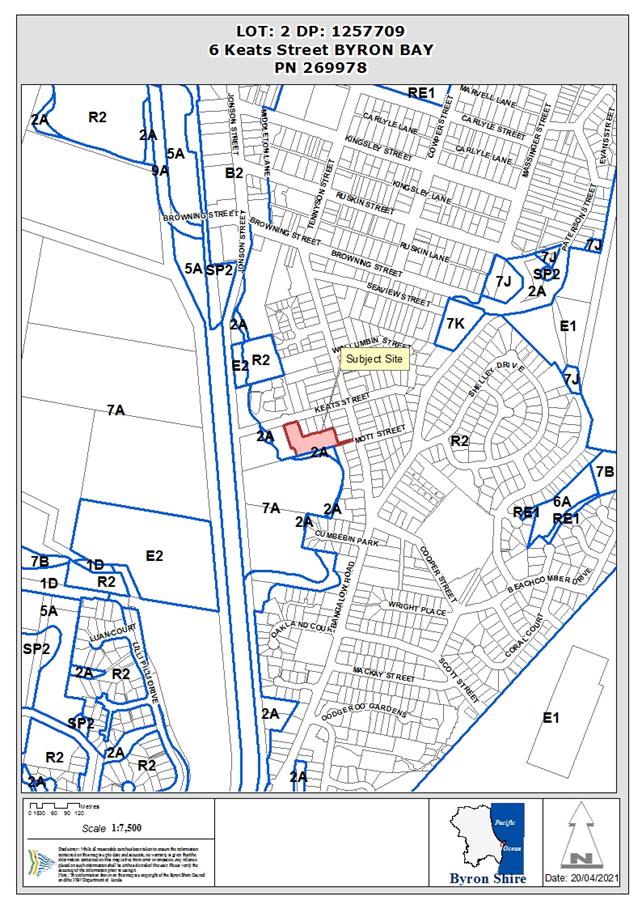
Report
1. INTRODUCTION
1.1. History/Background
The subject property was created by a 2 lot
subdivision (DA 10.2016.794.1) which was approved on 13/6/2017.
1.2. Description
of the proposed development
This application seeks approval for multi dwelling
housing comprising of ten (10), two storey detached dwellings and ten (10)
swimming pools and strata subdivision (see Figure 1).
The Dwellings have four (4) bedrooms, a guest room,
three (3) bathrooms, a balcony, ground floor outdoor areas, a swimming pool, a
garage and carport. The strata subdivision will ultimately result in each
dwelling being located on an individual strata lot with the driveway and
southern landscaping being located on common property.
The applicant proposes staging the development as
follows:
· Stage 1 – construction of dwellings 5 – 10
including swimming pools, driveway and landscaping.
· Stage 2 – strata subdivision of dwelling 5
– 10 and creation of a vacant strata lot.
· Stage 3 – construction of dwellings 1 – 4
including swimming pools and landscaping on the vacant strata lot.
· Stage 4 – strata subdivision of dwelling 1
– 4.
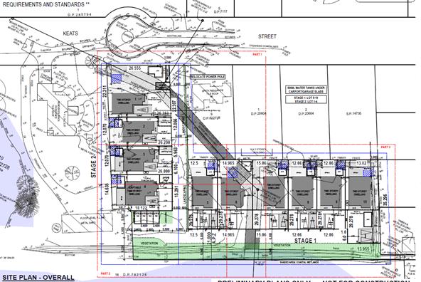
Figure 1. Site plan showing location and layout of
proposed dwellings, swimming pools and associated infrastructure and
landscaping.
1.3. Description
of the site
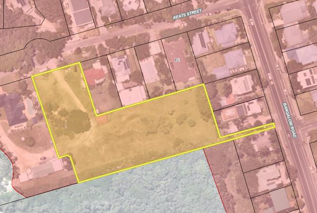
Figure 2. Aerial photo showing property (identified by
yellow polygon) and land zoning showing property zoned as R2.
|
Land is legally described
|
LOT: 2 DP: 1257709
|
|
Property address
|
6 Keats Street BYRON BAY
|
|
Land is zoned:
|
R2 Low Density Residential
|
|
Land area is:
|
6013 m2
|
|
Property is constrained by:
|
· Flood Liable Land
· Bushfire prone land
· Acid Sulfate Soils Class 5
· Underground powerlines
· Stormwater drains
· Sewer pipelines and manhole
· Biodiversity values (beyond the development
footprint)
|
|
Is a BDAR required due to the location of the
proposed development?
|
☐ Yes ☒
No
|
|
Are there any easements in favour of Council
affecting the site?
|
☒ Yes ☐
No
|
|
Is there a Vegetation Management Plan which might
affect the proposal?
|
☐ Yes ☒
No
|
|
Is there a Voluntary Planning Agreement which might
affect the proposal?
|
☐ Yes ☒
No
|
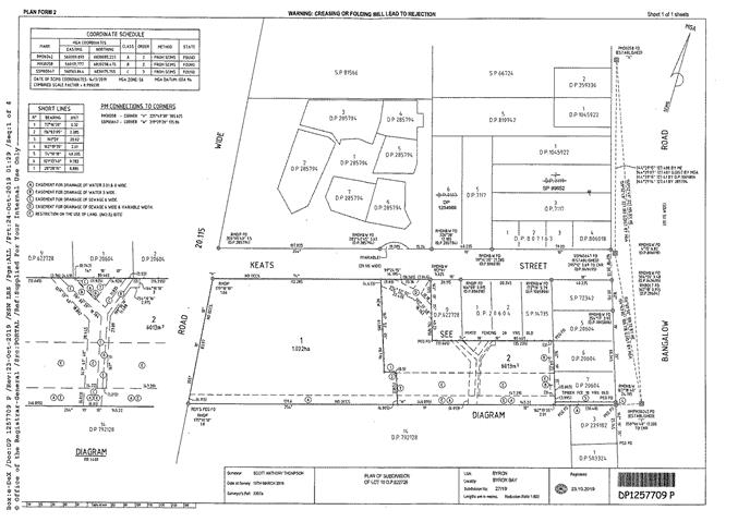
Figure 3. Land title showing 6 Keats Street
(identified as Lot 2) and associated easements and restriction of use of land.
A site inspection was carried out on 26 May 2020
|
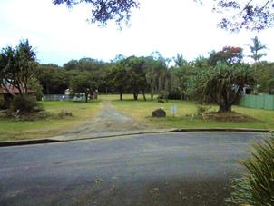
Photo 1 – view south from Keats Street to the
site
|
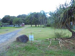
Photo 2 – view south from Keats Street to the
site
|
|
Photo 3 – open stormwater drain adjacent to
southern boundary – view east
|
Photo 4 – open stormwater drain adjacent to
southern boundary – view west
|
|
Photo 5 – open stormwater drain at east of
property – view east
|
Photo 6 – sewer manhole and tree to be removed
|
|
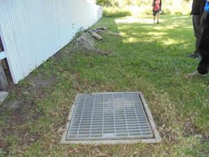
Photo 7 – one of three stormwater grates
within the property
|
|
2. SUMMARY
OF REFERRALS
|
Referral
|
Issue
|
|
Environmental Health Officer
|
No objections subject to conditions.
|
|
Development Engineer
|
No objections subject to conditions.
|
|
Ecologist
|
See Comments below Re: Biodiversity Act 2016 and
SEPP Coastal Management 2018
|
|
Rural Fire Service (100B)
|
No objections subject to conditions.
|
|
Essential Energy
|
No objections, general comments only.
|
3. SECTION
1.7 – APPLICATION OF PART 7 BIODIVERSITY CONSERVATION ACT 2016
The development footprint will not encroach into land
within the property identified on the Biodiversity Values map (see Figure 4
below. In relation to this property, the area mapped as biodiversity
values is the same as the area mapped as coastal wetland).
Council’s Ecologist notes that, should tree
removal be required within the area mapped as biodiversity values (i.e., to
establish an asset protection zone), then the biodiversity offsets scheme and
the requirement for a biodiversity assessment report would be triggered (Biodiversity
Conservation Act 2016, Parts 6 and 7). As noted below, a condition has been
recommended to prevent removal of vegetation within the mapped biodiversity
values/coastal wetland area within the property.
4. State
Environmental Planning Policy (Coastal Management) 2018
A small section at the south of the property is mapped
as a coastal wetland (see Figure 4 below) and the remainder of the property is
mapped as wetland buffer. The built footprint of the proposed development
does not encroach into the mapped coastal wetland. The section of mapped
wetland adjacent to the boundary is part of Council’s stormwater
infrastructure being an open drain taking stormwater from the site, surrounding
properties and Bangalow Road to the west where it eventually discharges into
the Cumbebin Wetland via a culvert under the north coast rail corridor.
Council’s ecologist was concerned if clearing is
required in the mapped wetland area (and the Biodiversity values area) the
application becomes designated development. The development footprint,
including vehicular access and asset protection zones, will not require any
clearing of vegetation in the wetland. Survey detail submitted with the
application indicates the drain is located along the southern boundary of the
lot and wetland vegetation is only on the southern bank and in the neighbouring
property. Notwithstanding this, conditions have been recommended protecting and
preventing clearing of vegetation within the mapped coastal wetland.
A larger vegetated buffer, with meaningful setbacks to
the coastal wetland to the south, would be preferable however, considering the
peri-urban nature of the parcel a condition has been recommended to require a
solid, non-combustible (i.e. sheet metal) fence to be constructed adjacent to
the driveway. This fence will benefit the coastal wetland by minimising urban
edge effects such as noise, light, gross pollution (i.e., rubbish) and exotic
species that are likely to result from the development. The applicant has also
proposed landscaping along the northern edge of the drain to which will also
assist with mitigation of edge effects. Conditions of consent to apply.
Having regard to the above, the impact of the proposed
development on the coastal wetland is considered acceptable under this SEPP.
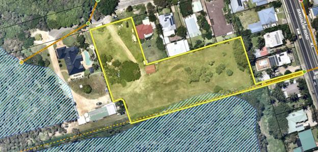
Figure 4. Aerial photo with subject site identified as
yellow polygon, coastal wetlands identified as blue/ diagonal stripes and
stormwater infrastructure yellow dashed line.
5. SECTION
4.14 – BUSH FIRE PRONE LAND
Under section 4.14 of the Act, Council must be
satisfied prior to making a determination for development on bush fire prone
land, that the development complies with the document ‘Planning for Bush
Fire Protection’. The site is bush fire prone land. The development
application is for integrated development and was referred to the NSW Rural
Fire Service, which provided a bush fire safety authority and general terms of
approval which are included in the Recommendation of this Report below.
EFFECT OF 10/50 RULE ON SIGNIFICANT VEGETATION
The subject parcel of land is located in a designated
10/50 vegetation entitlement clearing area. However, the 10/50 exemption to
clear vegetation cannot be used on this parcel of land. This land is excluded
from the operation of the 10/50 Code as it has been identified as being wholly
or partially within coastal wetlands (online tool accessed – 17/2/21).
6. SECTION
4.15C – MATTERS FOR CONSIDERATION – DISCUSSION OF ISSUES
Having regard to the matters for consideration
detailed in Section 4.15(1) of the Environmental Planning & Assessment Act
1979 (EP&A Act), the following is a summary of the evaluation of the
issues.
6.1 State
Environmental Planning Instruments
|
|
Satisfactory
|
Unsatisfactory
|
|
State Environmental Planning Policy No 55—Remediation of Land
|
☒
|
☐
|
|
Consideration: The applicant has submitted details
addressing SEPP 55 which is generally satisfactory, however the contamination
investigation provided does not adequately assess the whole development site
and the subject site is identified on Council’s mapping as containing
radioactive sand fill. Conditions have been recommended that require a
detailed contaminated land assessment to be prepared for the entire site (as
a deferred commencement condition). Following which, preparation of a
remedial action plan (RAP) may be required (if contamination is detected) and
implementation of the RAP to ensure the site is suitable for the proposed
residential development.
|
|
State Environmental Planning Policy (Building Sustainability Index:
BASIX) 2004
|
☒
|
☐
|
|
Consideration: The proposal is for BASIX affected
development and a multi dwelling BASIX Certificate was provided with the
application.
|
|
State Environmental Planning Policy (Infrastructure) 2007
|
☒
|
☐
|
|
Consideration: The proposal involved works in
the proximity of electricity distribution infrastructure. Essential Energy
was notified of the DA and their advice has been taken into consideration
(clause 45). Essential Energy general comments are included in the notes
section of the consent.
|
4.2A Byron Local Environmental Plan 2014 (LEP 2014)
In accordance with LEP 2014 clauses 1.4 and 2.1
– 2.3:
(a) The proposed development
is defined in the LEP 2014 Dictionary as multi dwelling housing;
(b) The land is within the R2
Low Density Residential according to the Land Zoning Map;
(c) The proposed development
is permitted with consent; and
(d) Regard is had for the Zone
Objectives as follows:
Subdivision of land (as defined in clause 6.2 of the
EP&A Act) is permitted with consent pursuant to clause 2.6 of LEP
2014. Proposed demolition of the shed is permitted with consent pursuant
to clause 2.7 of LEP 2014.
|
Zone Objective
|
Consideration
|
|
• To provide for the housing needs of
the community within a low density residential environment.
• To enable other land uses that provide
facilities or services to meet the day to day needs of residents.
|
The proposed multi dwelling housing has the ability
to provide for the housing needs of the community.
In terms of yield the proposal will result in one
house per 600m2 which is not inconsistent with the objectives of
the R2 Zone
|
The subject property with an area in excess of 6000 m2
meets the minimum lot size for multi dwelling housing being 1000m2
(c.4.1E).
The maximum height of the dwellings is ~8.5m which is
compliant with the 9m maximum (c.4.3).
The floor space ratio of the combined development is
~0.35:1 and well below the relevant limit of 0.5:1 for the property (c.4.4).
The site is classified as containing class 5 acid
sulfate soils which are unlikely to be disturbed during construction
works. Council’s Environmental Health Officer has recommended that
conditions be included that require a preliminary acid sulfate soils
investigation be carried out to ensure there is no environmental impact (c.6.1)
from construction activities.
Subject property is partly identified as prone to
flooding with heights across the site varying from 3.82 m AHD at Keats Street
down to 2.02m adjacent to the northern bank of the drain with the land
generally grading to the southern boundary. To avoid filling the site, Conditions
of consent recommended in relation to houses being constructed using a bearer
and joist design other than the adaptable dwelling on Lot 4 which is on an
elevated knoll which meets the minimum floor level of 3.1 m AHD. (c.6.2 and 6.3).
The development site is an urban location which has
access to services or the ability to access services when required
(c.6.6). Council’s Development Engineer determined that the design
and construction of the re-routing of the
inter-allotment drainage system, servicing numbers 10 and 12 Keats Street, needs to be carried out prior to the approval
commencing to ensure the landowner approvals for this work are current (i.e.,
as a deferred commencement condition). Otherwise, issues associated with stormwater and sewer services that
transect the site have been assessed by Council’s Development Engineer
and Systems Planning Officer and found to be acceptable subject to recommended
conditions.
The proposal raises no other issues under the LEP.
4.3 Any proposed
Instrument that has been the subject of public consultation and has been
notified to the consent authority
No proposed instruments were identified that are
relevant to this proposal.
4.4A Byron Shire Development Control Plan 2014 (DCP 2014)
DCP 2014 is an applicable matter for consideration in
the assessment of the subject development application in accordance with
subsection 4.15(1) of the EP& A Act because it applies to the land to which
LEP 2014 applies. The DCP 2014 Parts/Chapters that are checked below are of relevance
to the proposed development:
|
Part A
|
☒
|
|
Part B Chapters:
|
☒ B1| ☒ B2| ☒ B3| ☒ B4| ☒ B5| ☒ B6| ☒ B7| ☒ B8| ☒ B9| ☐B10| ☐B11| ☐B12| ☒ B13| ☒ B14
|
|
Part C Chapters:
|
☐C1| ☒ C2| ☐C3| ☐C4
|
|
Part D Chapters
|
☒ D1| ☐D2| ☐D3| ☐D4| ☐D5| ☒ D6| ☐D7| ☐D8
|
|
Part E Chapters
|
☐ E1| ☐E2| ☐E3| ☐E4| ☒ E5| ☐E6| ☐ E7
|
Chapter A13.4 and Community Participation Plan
The proposal is community significant development
being “residential accommodation resulting in 10 or more dwellings”
and as such community consultation is required to be undertaken prior to
lodgement of a development application (A13.4). The failure to carry out
community consultation prior to development application lodgement is also
contrary to the equivalent requirements in Council’s Community Participation
Plan (October 2019) (see also sections 2.21 and 2.22 of the EP&A Act).
Confirmation that pre-lodgement consultation was not, and will not, be
undertaken was provided by the applicant Ardill Payne and Associates, to
Council, on 8 April 2020 who advised that:
· The land owners immediately to the west of
the subject site disposed of this vacant land following a two Lot subdivision
with the knowledge that a medium density development would be undertaken
onsite.
· The two properties immediately to the east
of the subject site have been consulted about the project during the planning
stage.
· The development is on the lower end of the
community significant development definition threshold being 10 dwellings.
· The proposed medium density development
is:
- well below the
nominated floor space ratio for the subject site,
- complaint
with nominated height limits,
- generally
exceeds all building lines and setbacks
- compliant
with carparking requirements including visitor spaces
- will be
adequately serviced by all reticulated services
- will not
be visible from Bangalow Road, and
- will
provide generous areas of landscaping and private open space for each dwelling
· Accordingly, pre-lodgement consultation is
not deemed necessary nor advantageous in this instance. APP have been
instructed by our client to assess and satisfactorily address any reasonable
submissions received during Council’s public notification process
It is noted that the failure to carry out that
consultation has resulted in delays in finalising the assessment of this DA.
Had they discussed the proposal with the neighbours more broadly in accordance
with the Community Participation Plan, issues such as stormwater management,
easement issues and privacy concerns as raised in the submissions and by
Council could have been more thoroughly addressed in the DA by the applicant
when first submitted.
However, as the development application has since been
publicly exhibited and notified to neighbours and submissions have been
considered (see 4.8 below) it is arguable that the views of the community have
been sought and considered. Should Council be dissatisfied with this, a
condition could be imposed to reduce the number of dwellings to 9 to ensure compliance
with the Community Participation Plan. The effect of such a condition would
potentially result in a separate stand alone DA being submitted for the tenth
dwelling, or the applicant utilising their appeal or review rights under the
EPA Act 1979.
Chapter B1
The proposed development will require the removal of
all trees from the site but for those adjacent to the southern boundary/drain
The SEE identifies these trees as either “landscaping” or
“Pandanus Palm plantation”. As such, this vegetation is not
considered to be “red-flag” vegetation under Chapter B1.
However if the Pandanus are endemic (i.e., Pandanus tectorius) they should be
relocated on site and incorporated into the proposed landscaping. As
noted above, a condition has been recommended preventing clearing of vegetation
within the mapped coastal wetland.
Chapters B3 and B4
Council’s Engineer has assessed the revised
proposal and updated stormwater management plan and is satisfied the
development meets, or is capable of meeting, relevant servicing and parking
requirements subject to recommended conditions.
Chapter B6
The SEE did not address land use conflict in relation
to the location of the residential development adjacent to a coastal
wetland/area of biodiversity value. In this regard:
· “New urban development, rural settlement and
other development should be sited and designed to protect key environmental
assets and, where possible, enhance environmental assets including high
conservation value vegetation and habitats and ecosystems, ecosystem corridors,
waterways, endangered ecological communities and key habitat.
· The potential for land use conflict and development of
mitigation measures should be assessed as part of any proposed intensification
of use…” (B6.2.3).
As discussed above, a narrow (~7m) landscaped buffer
has been proposed between the development and the mapped coastal wetland which
will need to be managed as an asset protection zone. No information was
provided with the application to demonstrate the adequacy of this buffer in protecting
and ideally enhancing the adjacent coastal wetland. As such, a condition
has been recommended to require the southern edge of the development to be
fenced to minimise the impact on the coastal wetland from urban edge effects.
Chapter B7
The standard condition requiring windows to be
screened has been recommended owing to the development being located within a
mapped mosquito risk zone.
Chapter B8
A site waste minimisation and management plan (SWMMP)
was not submitted with the application (B8.2.1). A condition has been
recommended requiring a SWMMP to be submitted prior to the issue of a
construction certificate and to address:
· Demolition (B8.3.1);
· Construction (B8.3.2);
· Ongoing use including ensuring there is sufficient
space for bins to be placed on Keats Street for collection (B8.3.3); and
· Matters specific to multi dwelling housing (B8.4.2.).
Chapter B9
An amended concept landscaping plan (Overview, Rev
003, Kris McFadden Design, 21/12/20) was provided that increased the landscape
area along the southern boundary of the property (Chapter B9). A
condition has been recommended requiring a detailed landscaping plan to be
submitted for approval, prior to the issues of a construction certificate, that
demonstrates:
· Consistency with the general landscape design
principles (B9.3.1);
· Matters specific to multi dwelling housing (B9.4.1)
including but not limited to screen planting to street frontages and driveway
areas, identification of common landscaped area (B9.4.2);
· Landscaping of the drainage line along the southern
boundary of the property (B9.10.2);
· Consideration of a street tree (B9.11.1);
· Existing vegetation (B9.12.4); and
· Planting size, density and species (B9.12.5).
Chapter B13
Dwelling No.4 will be an adaptable dwelling which
meets the minim requirement for 10% of dwelling units to be adaptable
(B13.2.2). Required adaptable car parking has been assessed by
Council’s Development Engineer and found to be acceptable subject to
conditions.
Chapter B14
Council’s Engineer has assessed the earthworks
required for the development and is satisfied that the works and potential
impacts can be adequately managed (i.e., erosion and sediment control) subject
to recommended conditions.
Chapter C2
Council’s Engineer has assessed the revised
proposal and is satisfied the development meets, or is capable of meeting,
relevant flood planning requirements subject to recommended conditions.
Chapter D1
Indicative streetscape renders were provided.
Owing to the shape of the lot the character and visual impact of the
development will be minimal with only Lot1 being clearly visible from Keats
Street (D1.2.4).
Fencing is shown along the Keats Street boundary in
the streetscape renders however no details were provided in the
application. A mailbox structure is proposed at the northeast corner of
Lot 1. Any street front fencing and the mailbox structure should be
limited to 1.2m in height: conditions recommended (D1.2.5).
According to plans provided, each dwelling will have
usable, ground-level, private open space of at least 30m2 and at
least 4m in width and length (D1.6.1).
Chapter D6
The application did not include a consideration of the
subdivision design guidelines (D6.2.1). As a result the subdivision
deviates from some of the design guidelines particularly relating to riparian
buffers and land fronting watercourses. The proposed lots sizes are below
the 600m2 minimum (D6.4.1) however, minimum lot size requirements do
not apply to strata subdivisions (clause 4.1(4)(a) of LEP 2014). Council’s
Development Engineer is satisfied that the subdivision is acceptable subject to
recommended conditions (D6.4).
Chapter E5
6 Keats Street is located within Pocket B which is
characterised by has “an eclectic array of architectural styles, with
diverse coastal architectural themes” and “built form is
largely one or two storeys incorporating various building materials and styles”
(E5.8.4). The proposed development is not at odds with the relevant
character narrative. Further, the property is located in the
“transitional” area “earmarking an area for change
incorporating pockets of low rise medium density homes that match the amenity
of traditional free standing homes, while introducing contemporary dwelling
forms”.
|
What Section and
prescriptive measure does the development not comply with?
|
Does the proposed
development comply with the Objectives of this Section? Address.
|
Does the proposed
development comply with the Performance Criteria of this Section? Address.
|
|
D1.2.1 Building
Height Plane
The western
façade of Lots 1 (both floors) 2, 3 and 4 (ground floor only) encroach
the building height plane. The eastern façade of Lot 10 (first
floor only) encroaches the building height plane.
Note: The northern façade of lots 5, 7, 8, 9 and
10 encroach the building height plane. These encroachments have not been
considered further as they are on the south side of existing development
(i.e., no shading impacts) and are only small sections of the ground floor
alfresco area roof (i.e., minimal privacy and view impacts).
|
The proposed
development complies with the Objectives of the Section because:
Shadow diagrams were
provided for Lots 1, 2 and 10 which show no shading impact on the
neighbouring dwelling to the west (Lots 1 and 2) or east (Lot 10).
There are no dwellings adjacent to and west of Lots 3 and 4.
Privacy and view
impacts from the encroachments will be minor due to the encroachments being
largely of the ground floor roof of alfresco areas.
Privacy impacts of the
first floor encroachments of Lot 1 and Lot 10 can be minimised by screening
windows on the non-compliant facades: conditions recommended. View
impacts from the Lot 10 encroachment can be minimised through alterations to
the building design: condition recommended.
|
The proposed
development complies with the Performance Criteria of this Section because:
The first floors of the
proposed dwellings are largely set back progressively from the boundaries;
All dwellings and lots
have a north facing outdoor area and covered alfresco areas.
The development will
not cause shading impacts on living areas of neighbouring dwellings as
evidenced in the shadow diagrams provided.
|
|
D1.2.2 Setbacks from
Boundaries
The dwellings comply
with relevant setbacks but for the swimming pool associated with Lot 1 which
is located in the street front setback. The provision states “Pools
should not be located within the street frontage setback, except on sites
where private open space can be accommodated only in this location or other
site attributes support this outcome.”
|
The proposed
development complies with the Objectives of the Section because:
Lot 1 is constrained by
a sewer easement and the proposed pool has good solar orientation being
located north of the dwelling.
|
The proposed
development complies with the Performance Criteria of this Section because:
Although setbacks are
to be applied flexibly, the Lot 1 pool is to be 800mm from the street front
boundary. This minimal setback does not allow adequate landscaping to
be provided to avoid impacts on the streetscape. The pool could be
relocated south of the sewer easement where the Alfresco area is currently
proposed. As such, the Lot 1 swimming pool should be relocated south of
the sewer easement or removed from the proposal altogether: conditions
recommended.
|
The proposed development is
demonstrated to meet the relevant Objectives of DCP 2014.
4.5 Environmental
Planning & Assessment Regulation 2000 Considerations
|
Clause
|
This control is
applicable to the proposal:
|
I have considered
this control as it relates to the proposal:
|
If this control
is applicable, does the proposal comply?
|
|
92
|
Yes
|
Yes
|
Condition recommended that demolition of shed be
undertaken in accordance with AS 2601
|
|
93
|
No
|
N/A
|
N/A
|
|
94
|
No
|
N/A
|
N/A
|
|
94A
|
No
|
N/A
|
N/A
|
4.6 The
likely impacts of that development, including environmental impacts on both the
natural and built environments, and social and economic impacts in the locality
|
Impact on:
|
Likely significant impact/s?
|
|
Natural environment
|
No. The proposal will not have a
significantly adverse impact on the natural environment of the locality.
|
|
Built environment
|
No. The proposal will not have a significantly
adverse impact on the built environment of the locality.
|
|
Social Environment
|
No. The proposal will not have a significant social
impact on the locality.
|
|
Economic impact
|
No. The proposal will not have a significant
economic impact on the locality.
|
Standard conditions of consent recommended in relation
to the construction activities including construction noise, hours of work,
builders waste and implementation of sedimentation and erosion control
measures.
4.7 The
suitability of the site for the development
The site can be serviced, has manageable constraints
and is assessed as suitable for the proposed development.
4.8 Submissions
made in accordance with this Act or the regulations
The development application was publicly exhibited
There were ten (10) submissions made on the development application:
- Nil (0) For
- Ten (10) Against
|
Key issues raised in submissions
|
Consideration
|
|
|
The developments density and yield satisfies the
objective of the R2 Zone.
|
|
Stormwater management / drainage
|
Council’s Development Engineer is satisfied
that adequate provision has been made (or will be made through compliance
with recommended conditions) for managing stormwater and drainage from and
for the development.
|
|
Site suitability – property is subject to
flooding
|
Council’s Development Engineer is satisfied
that the flooding impacts can be adequately managed via recommended
conditions.
|
|
Traffic impacts
|
Council’s Development Engineer is satisfied
that the traffic impact is low risk and can be adequately managed via
recommended conditions.
|
|
|
As noted above, the applicant confirmed that
pre-lodgement consultation was not undertaken.
|
|
Waste collection
|
A condition has been recommended that requires a
site waste minimisation and management plan to be provided prior to the issue
of a construction certificate that includes details of waste management
associated with ongoing use of the development including ensuring there is
sufficient space for bins to be placed on Keats Street for collection.
|
|
Encroachment of development on Cumbebin Swamp
|
Impacts on the wetland have been considered as
discussed above
|
|
Residential Impacts (noise, amenity, privacy
|
But for the building height plane and street front
setback encroachments discussed above, the proposed multi dwelling housing is
otherwise compliant with Council planning requirements.
View impacts from the Lot 10 first floor, building
height plane encroachment can be minimised through alterations to the
building design for which a condition recommended.
A fence has been requested by some submitters along
the northern boundary of proposed Lots 5 to 10 to mitigate potential amenity
impacts. Conditions of consent recommended requiring the fence to be
constructed.
|
4.9 Public
interest
The proposed development is unlikely to prejudice or
compromise the public interest or create an undesirable precedent.
5. DEVELOPER
CONTRIBUTIONS
5.1 Water &
Sewer Levies
Section 64 levies will be payable.
5.2 Section 7.11
Contributions
Section 7.11 Contributions will be payable.
6. DISCLOSURE
OF POLITICAL DONATIONS AND GIFTS
|
Has a Disclosure
Statement been received in relation to this application
|
No
|
|
Have staff received a
‘gift’ from anyone involved in this application that needs to be
disclosed. Where the answer is yes, the application is to be determined by
the Director or Manager of the Planning, Development and Environment
Division.
|
No
|
Provide Disclosure Statement register details here:
Not applicable
Conclusion
This application seeks approval for multi dwelling housing
comprising of ten (10), two storey detached dwellings and ten (10) swimming
pools and strata subdivision.
The key issues associated with this proposed development are
stormwater management and potential impacts on the adjacent coastal
wetlands. Conditions have been recommended to address stormwater
management including a deferred commencement condition relating to proposed
modification to inter-allotment drainage affecting numbers 10 and 12 Keats
Street. The buffer between the development and the coastal wetland was
increased in size but remains limited (~7m) in width and is subject to strict
management requirements for bushfire protection (thus limiting the ecological
value of the buffer). However, the buffer will be landscaped and a fence
between the development and the buffer/wetland to mitigate potential impacts on
development has been required by a recommended condition.
Some minor plan amendments have been required by recommended
conditions to address issues raised in the assessment. Otherwise the
application appropriately addresses the relevant constraints applying to the
site, and is recommended for approval subject to the recommended conditions
(Attachment 8).
The proposal is
‘community significant development’ however the applicant failed to
carry out the required community consultation prior to lodging the development
application. However, as the development application has since been
publicly exhibited and notified to neighbours, and submissions have been
considered, it is arguable that the views of the community have been sought and
considered as per the intent of this requirement.
Staff Reports - Sustainable Environment and Economy 13.10
Report
No. 13.10 PLANNING - State Government
Planning Amendments for Agriculture
Directorate: Sustainable
Environment and Economy
Report Author: Rob
van Iersel, Place Activation Coordinator
File No: I2021/636
Summary:
The Department of Planning, Industry and Environment (DPIE)
recently notified an intention to amend planning legislation relating to
agriculture, particularly focussing on tourism uses that might be supplementary
to farming.
The proposed changes will relate to:
· farm
stay accommodation;
· ‘farm
gate activities’; and
· ‘farm
events’;
on the basis that such uses could provide farmers with a
supplementary income.
The changes would make it far easier for farmers to carry
out these activities, in many cases, as exempt development or complying
development.
The exhibition period for these changes closed on 19 April,
and staff lodged a submission expressing concern at the nature and extent of
change. The submission indicates that Council does not want to be included in
the proposed changes until a full review of impacts, intended and unintended,
can be completed.
The main concern is that DPIE’s ‘one size fits
all’ proposals are not suitable to the Byron context, where the
combination of land values and existing rural settlement patterns will result
in the raft of changes incentivising non-farming uses rather than supporting
farmers to increase their productivity.
It is also concerning to note that the DPIE’s
proposals appear to be in conflict with a recent options paper, issued by the
NSW Agricultural Commissioner (Dept. Primary Industries Agriculture) relating
to agricultural land use planning.
That options paper stresses the importance of protecting
farm land and the right to farm, which could easily be undermined by the DPIE
Agritourism proposal, particularly in areas like Byron with
‘tree-changers’ moving into rural areas for lifestyle rather than
farming, who would likely prefer to take up a tourist use of the land than a
farming use of the land.
As currently proposed, the agritourism proposals will remove
/ compromise state and regionally significant farmland by stealth.
Staff have discussed the agritourism proposals with other
Northern Rivers Councils, all of whom share our concerns.
It is recommended that Council continue to work with our
neighbouring Council’s, through the Northern Rivers Joint Organisation,
and make representations to relevant State members, to achieve improved
outcomes for the planned amendments.
NOTE TO COUNCILLORS:
In accordance with the provisions
of S375A of the Local Government Act 1993, a Division is to be called whenever
a motion for a planning decision is put to the meeting, for the purpose of
recording voting on planning matters. Pursuant to clause 2(a) under the
heading Matters to be Included in Minutes of Council Meetings of Council's
adopted Code of Meeting Practice (as amended) a Division will be deemed to have
been called by the mover and seconder of all motions relating to this report.
RECOMMENDATION:
That Council:
1. Notes the
submission lodged with the State Government in relation to proposed planning
amendment for agriculture Attachment 1 (#E2021/57181).
2. Notes that the
proposed changes to planning legislation as drafted, and if imposed on Byron
Shire Council in their current form, will by stealth, significantly impact the
future viability of our farm land being used for use agricultural purposes; and
our long term capacity to grow our local, valued and recognised agricultural
produce sector.
3. Notes that if the
proposed changes to planning legislation are imposed in their current form,
there is likely to be an increase in requirement for compliance/ enforcement on
a range of tourism land use activity, the costs for which cannot be recouped by
additional application fees.
4. Makes formal
representations to the Local Member for Ballina, the Minister for Planning and
Public Spaces and the Minister for Agriculture in relation to Council’s
concerns with the proposed amendments (Attachment 1 #E2021/57181) and those in
2 and 3.
Attachments:
1 Planning
Amendments for Agriculture - Council Submission, E2021/57181
Report
DPIE have released an
“Explanation of Intended Effect” outlining proposed changes to a
variety of planning instruments aimed at “encouraging the growth of
emerging industries that are supplementary to, or based on, agriculture”.
The changes are aimed at
facilitating agritourism, and they involve:
· Farm
stay accommodation – including changes to the existing definition and
provisions to allow certain accommodation to be undertaken as exempt or
complying development;
· Farm
events – a new definition and provisions for certain events to occur
as exempt or complying development; and
· Farm
Gate Activities – a new definition, which includes processing/sales,
restaurants, tasting rooms and the like, and provision for certain activities
to occur as exempt or complying development.
There are a number of significant concerns regarding the
application of these proposed changes to the Byron context. Primarily,
staff are of the view that the changes have the strong potential to incentivise
non-farming activities, rather than resulting in increased productivity.
Existing rural settlement in the Shire does not reflect a
traditional farming pattern. Over 70% of lots within rural zones have an
area less than 10ha; with 61% being less than 5ha.
As rural land values continue to increase, the ability for
farmers to make a viable income from farming continues to be a significant
challenge.
Providing opportunities for farmers to supplement farming
income is a positive. However, the nature and extent of changes proposed
raise a series of significant issues that have a real potential to incentivise
non-farming commercial uses of rural land to the detriment of farming.
Focussing on increasing tourism does not address farm
productivity, and in the Byron context, has the potential for significant
environmental and social impacts.
If the changes proceed as proposed, there would be
significant levels of activity allowed as exempt development, including:
· use of
land for farm stay accommodation by change of use of an existing dwelling or in
tents, caravans or similar;
· use of
land for farm gate activities, which can include farm tours, tastings and
roadside stalls; and
· use of
land for farm events.
In particular, the farm events use has significant potential
for impact, as exempt development can include:
· 52
event days per year for up to 30 guests per event, or 10 event days per year
for up to 50 guests per event; and
· event
times up to 11pm Mondays to Thursdays and midnight on Saturdays.
We have seen in this Shire the history of uncontrolled
events and the social disturbance that can result.
In addition to the exempt provisions, a range of development
would be able to occur as complying development, which can be approved by
private certifiers or Council. This includes:
· change
of use of an existing building or erection of a new building as farm stay
accommodation, allowing a maximum of one dwelling per 15ha, up to a maximum of
6 dwellings;
· erection
of new buildings for farm gate activities (which includes restaurant), with a
maximum building size of 200m2, and a maximum of 50 guests at any
one time; and
· change
of use of an existing building, or erection of a new building for farm events,
with a maximum building size of 200m2, and the same event parameters
as exempt development.
It is clear that, in the Byron context, this ‘one size
fits all’ approach to these uses will result in significant environmental
and social impacts. With the exempt and complying provisions, there is, in
effect, no opportunity for Council to assess the potential for impacts before
they occur.
The resultant activity would significantly increase the
compliance/ enforcement resources required, with no opportunity for fees to
offset these costs.
Importantly, the changes as proposed have no real effect in
increasing farm productivity. Tourism may provide additional income for a
farmer, but it does not promote farming. In our context, where there are very
high tourism demands, the changes will incentivise non-farming activities
rather than incentivising farming.
It is also concerning to note that the DPIE’s
proposals appear to be in conflict with a recent options paper, issued by the
NSW Agricultural Commissioner (Dept Primary Industries Agriculture) relating to
agricultural land use planning.
That options paper stresses the importance of protecting
farm land and the right to farm, which could easily be undermined by the DPIE
Agritourism proposal, particularly in areas like Byron with
‘tree-changers’ moving into rural areas for lifestyle rather than
farming, who would then prefer the high return tourist use.
As currently proposed, the agritourism proposals will remove
/ compromise state and regionally significant farmland by stealth.
Submissions in response to the State’s position
closed 19 April. Council staff lodged a submission (see Attachment 1)
expressing these significant concerns and requesting that Council be exempted
from the new provisions if they are not substantially changed.
Strategic Considerations
Community Strategic Plan and Operational Plan
|
CSP Objective
|
L2
|
CSP Strategy
|
L3
|
DP Action
|
L4
|
OP Activity
|
|
Community Objective 3: We protect and enhance our
natural environment
|
3.4
|
Support and secure our farming future
|
3.4.1
|
Develop and implement strategies to support agriculture,
agri-business and farmers
|
3.4.1.1
|
Finalise and commence implementation of the Agriculture
Action Plan
|
|
Community Objective 4: We manage growth and change
responsibly
|
4.1
|
Support the visions and aspirations of local communities
through place-based planning and management
|
4.1.3
|
Manage development through a transparent and efficient
assessment process
|
4.1.3.11
|
Prepare and assess Planning Proposals and Development
Control Plans, and amend Local Environmental Plan maps
|
Legal/Statutory/Policy Considerations
Staff will monitor the results of consultation regarding the
proposed planning changes.
Financial Considerations
If the proposed changes are imposed in their current form,
there is likely to be an increase in requirement for compliance/ enforcement,
the costs for which cannot be recouped by additional application fees.
Staff Reports - Sustainable Environment and Economy 13.11
Report
No. 13.11 PLANNING - s4.55 to Modify
Conditions 1 and 6 Landscaping Plan, DA 10.2019.650.2 at 103 Kings Road Federal
Directorate: Sustainable
Environment and Economy
Report Author: Chris
Larkin, Manager Sustainable Development
File No: I2021/638
Proposal:
|
Modification No:
|
10.2019.650.2
|
|
Proposed modification:
|
S4.55 to Modify Conditions 1 and 6 Landscaping Plan
|
|
Original Development:
|
New Dwelling to create Dual Occupancy (Detached)
|
|
Type of modification sought:
|
|
|
|
|
|
Property description:
|
LOT: 2 DP: 733182
|
|
103 Kings Road FEDERAL
|
|
Parcel No/s:
|
37780
|
|
Applicant:
|
Newton Denny Chapelle
|
|
Owner:
|
Ranamok Pty Ltd
|
|
Zoning:
|
RU2 Rural Landscape / 1(a) (General Rural Zone)
|
|
Date received:
|
25 February 2021
|
|
Original DA determination date:
|
16/04/2020
|
|
Public notification or exhibition:
|
- Level
1 advertising under DCP 2014 Part A14 – Public Notification and
Exhibition of Development Applications
- Exhibition
period: 5/3/21 to 18/3/21
- Submissions
received: 3
|
|
Issues:
|
· Public submissions
|
Summary:
An application has been received under S4.55 to Modify
Conditions 1 and 6 Landscaping Plan of DA10.2019.650. The dual occupancy was
approved by Council with conditions requiring an earth mound (1.5 m high) and
landscaping to screen the proposed driveway from the neighbouring dwelling to
the west. Due to the length of the driveway and height of the mound some 1100
cubic metres of soil would need to be excavated and imported to the site.
Assuming 10 cubic metres of soil per truck, this would require in excess of 100
truck movements alone to build the mound. The application proposes to delete
the earthmound from the landscape plan and to install instead a fence from the
corner of the property and down the approved sealed driveway for a suitable
length. A condition is to be included requiring the fence to be maintained
permanently. The previously approved area of plantings is also proposed to be
modified with an area of lawn or grass to be maintained adjacent to
neighbouring dwelling.
The proposal is satisfactory having regard to relevant matters
for consideration and is considered to be substantially the same development as
approved. The Section 4.55 application is recommended for approval subject to
modifying conditions 1 and 6 of the consent and inserting relevant conditions
to address issues raised in the submissions.
NOTE TO COUNCILLORS:
In accordance with the
provisions of S375A of the Local Government Act 1993, a Division is to be
called whenever a motion for a planning decision is put to the meeting, for the
purpose of recording voting on planning matters. Pursuant to clause 2(a)
under the heading Matters to be Included in Minutes of Council Meetings of
Council's adopted Code of Meeting Practice (as amended) a Division will be
deemed to have been called by the mover and seconder of all motions relating to
this report.
RECOMMENDATION:
That pursuant to Section 4.55 of the Environmental Planning
& Assessment Act 1979, Application No. 10.2019.650.2, to Modify Conditions
1 and 6 Landscaping Plan, be approved by modifying Development Consent Number
10.2019.650.1 in accordance with the amended conditions in Attachment 2
(E2021/57319).
Attachments:
1 10.2019.650.1
Development Consent and Approved Plans, E2021/57313
2 10.2019.650.2
Modified Conditions of Consent, E2021/57319
3 10.2019.650.2
Proposed Landscape Plan, E2021/57317
4 10.2019.650.2
Submission, E2021/57320
5 10.2019.650.2
1st and 2nd additions to Submission, E2021/57322
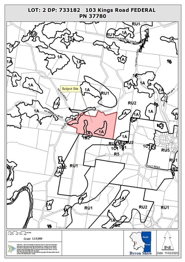
Assessment:
History/Background
The site has the following
application history:
BA 84/2548 Dwelling 5/10/1984
6.1995.2158.1 Rural
Shed 19/05/1995
10.2019.650.1 New
dwelling to create dual occupancy (detached) 16/4/2020
Condition 1 of the consent to DA
10.2019.650.1 (Attachment 1) lists the approved plans, including the approved
Landscaping Plan. Condition 6 of the consent provides more detailed
specifications for the Landscaping Plan.
Description of the
proposal
This application seeks approval under S4.55 to Modify
Conditions 1 and 6 Landscaping Plan. The proposed modifications to conditions 1
and 6 (Attachment 2) would replace the reference to the approved Landscaping
Plan with the modified Landscape Plan (Attachment 3).
The application proposes to delete the earthmound from the
landscape plan and to install instead a 1.8 m timber fence from the corner of
the property and down the approved sealed driveway to the dwelling currently
under construction. The previously approved extensive area of plantings is also
proposed to be modified, and it is noted the area adjacent to the neighbours
dwelling is to be turfed with grass.
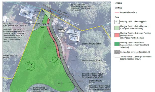
Landscape Plan extract
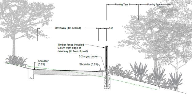
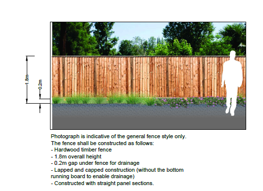
Proposed Fence Detail Extract
Description of the
site
|
Land is legally described as
|
LOT: 2 DP: 733182
|
|
Property address is
|
103 Kings Road FEDERAL
|
|
Land is zoned:
|
RU2 Rural Landscape / 1(a) (General Rural Zone)
|
|
Land area is:
|
26.29 hectares
|
|
Property is constrained by:
|
Bush Fire Prone Land
Drinking Water Catchment
High Environmental Value Vegetation
|
|
Is a BDAR required due to the location of the proposed
development?
|
☐
Yes ☒No
|
|
Are there any easements in favour of Council affecting the
site?
|
☐
Yes ☒No
|
|
Is there a Vegetation Management Plan which might affect
the proposal?
|
☐
Yes ☒No
|
|
Is there a Voluntary Planning Agreement which might affect
the proposal?
|
☐
Yes ☒No
|
The site was inspected on 12 March 2021.
A
meeting was held at the immediate neighbour’s property with the
applicant, the neighbour and staff to discuss the proposed amendments.
SECTION
4.15 – MATTERS FOR CONSIDERATION – DISCUSSION OF ISSUES
Having regard for the matters for consideration detailed in
Section 4.15(1) of the Environmental Planning & Assessment Act 1979, the
following is a summary of the evaluation of the issues.
1. State/Regional
Planning Policies, Instruments, EPA Regulations 2000
The proposed amendments raise no significant issues under
relevant State Environmental Planning Policies or the provisions of the
Environmental Planning and Assessment Regulation 2000.
2. Byron
Local Environmental Plan 2014
The proposed amendments do
not generate any additional significant issues in relation to considerations
under Byron Local Environmental Plan 2014 that have not been previously
addressed in the assessment of the original development application.
3. Draft
EPI that is or has been placed on public exhibition and details of which have
been notified to the consent authority
There are no draft environmental planning instruments which
significantly affect the proposal.
4. Development
Control Plans
The proposed amendments do not generate any additional significant
issues in relation to considerations under Byron Shire Development Control Plan
2014 that have not been previously addressed in the assessment of the original
development application.
5. The
likely impacts of that development, including environmental impacts on both the
natural and built environments, and social and economic impacts in the locality
The proposal as modified will not generate any significant
impacts on the natural and built environments, or significant social or
economic impacts in the locality. It is noted the construction for the proposed
fence instead of importing fill and constructing the earth mound should remove
the need for approximately heavy 100 truck movements up and down Kings Road,
reduce dust and other nuisance issues associated with such a mound (e.g.
machinery moving soil around by heavy machinery, bob cats and the like).
Further the construction of the fence will not see the need for 1100 m3
of soil having to be exported from a quarry or some other fill
source.
In terms of noise from vehicles from the dual occupancy
dwelling once occupied, there are no specific requirements for an Acoustic
Report in terms of mitigating vehicle noise from the dwelling which on average
will generate 9 vehicle trips per day. Notwithstanding, it is noted that the
proposed fence is likely to be equal to or more effective then the earth mound
as originally approved. The 1.8 m fence is to be higher then the 1.5m
earthmound and located adjacent to the driveway to the dwelling. The fence is
to be appropriately embellished with landscape plantings of native vegetation
facing the neighbouring dwelling.
6. The
suitability of the site for the development
The site remains suitable for the approved development
having regard to the modifications sought by the section 4.55 application.
7. Submissions
made in accordance with this Act or the regulations
The development application was publicly exhibited.
There was 1 objection (Attachment 4) dated 8 April
2021objecting to the proposal, with 2 further additions to the objection dated
11 April 2021 and 12 April 2021 (Attachment 5).
The issues raised in the initial objection are commented on as
follows:
Location of access driveway to the approved dual occupancy
dwelling
The sealed driveway to the dwelling approved under DA
10.2019.650.1 is shown on the approved plans under the original development
consent, as modified to the extent shown on the plans approved under the
construction certificate. As the construction of the approved dwelling is not
yet completed, the sealing of the driveway is likewise not yet completed. The
distance between the sealed driveway:
1. according
to the plans approved under the original development application;
2. according
to the plans approved under the construction certificate; and
3. according
to the plans submitted under the current section 4.55 application;
And the common boundary between the site and the
objector’s property is measured to be approximately 15m to 16m. On this
basis, no change is proposed under the current section 4.55 application to the
location of the sealed driveway as per the original development consent
(inclusive of the construction certificate).
Deposited Plan 1121773 shows the objector’s dwelling to
be approximately 8m from the same common boundary. The approximate side setback
from the common boundary to the dwelling is 8m, to the deck is approximately
4.5m and to the spa is approximately 4m. On this basis, the distance between
the sealed driveway and the objector’s dwelling would be an estimated 23m
and 19m to the deck and spa. No change is proposed in this regard under the
section 4.55 application.
The proposal is not for the relocation of the approved
driveway whether to the eastern side of the existing dwelling on the site or
the neighbouring property at 93 Kings Road further to the north east.
Noise & Reverberation
Council’s Environmental Health Officer raised no
concerns with the proposed modifications in relation to noise or reverberation,
and for a development that generated only 9 trips per day there are no specific
requirements for a noise report for this development. Further the construction
of the proposed fence will have a smaller impact compared to the importation of
fill and construction of the earth mound as originally approved.
Dust and Fumes
The driveway is to be sealed and dust from the driveway is not
an issue. No additional traffic will be generated from the change to a fence
from an earthmound once constructed. However, as discussed above there will be
a reduction in trucks and machinery generating dust during construction of the
fence as opposed to the earthmound.
Fumes from the vehicle movements associated with a single
dwelling as approved are not assessed as having a significant impact in terms
of air quality. It is noted the neighbours dwelling is some 23 metres
from the driveway.
Visual nuisance
Proposed plantings adjacent to the fence facing the neighbours
dwelling will reduce any impacts of the subject fence. The following is
proposed:
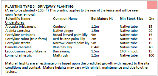
Ways to reduce the earthmound fill – e.g. retaining
walls
The alternatives suggested by the objector to reduce the
amount of fill required are noted; however the application proposes no
earthmound, no fill and no retaining walls. The fence as proposed is considered
a suitable alternative.
New gate and access near our bedroom
The plans submitted in support of the section 4.55 application
show in the vicinity of the objector’s dwelling, an area of grass or turf
between the boundary and the proposed fence and driveway. There is a gate
proposed in the fence to provide access to the area. The application does not
propose the use of the grass area as overflow car parking. The applicant could
potentially plant the area out with trees and shrubs but has left it as a lawn
turf area. It is not unreasonable that a gate be located in the fence to get
access to the land between the fence and the neighbours boundary for
maintenance and mowing purposes.
At the time of inspection there was a pile of timber and tree
trunks adjacent to the boundary. This will need to be removed to enable the
landscaping works including the grass area to be completed.
Additional vehicle movements
The driveway accesses a shed and the remainder of the property
on the farm. The property is utilised for forest plantation purposes with an
approved Plantation Plan in place. It should not be unexpected that the
landowner will seek to access the property by this driveway from time to time
to carry out other activities on the property. It is noted BA6.1995.2158.1 for
a shed on the property shows an a farm track in this general location between
the existing dwelling and the neighbours property to the west linking with
Kings Road. An extract from the approved plans is provided below. The track has
been marked in red for identification purposes.
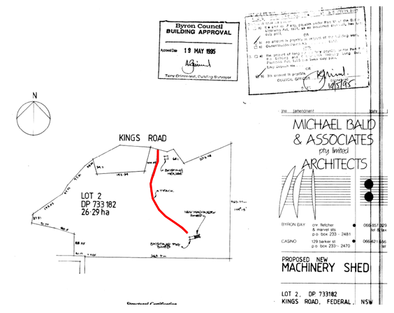
Approved Plan Extract – Internal track to shed
from Kings Road marked up in red
The current consent now requires that driveway to be sealed.
Should the owner of the property carry out additional activities on the land or
in the new dwelling which require development consent which has not been
obtained, then such matters can be raised with Council to investigate and take
action if required.
Farm Track adjacent to boundary
An existing farm track closer to the neighbours dwelling will
be planted out with rainforest vegetation as indicated on the proposed
landscape plan. The schedule below shows the plants to be planted in this
area. The track once planted out will be unusable for vehicle movements.
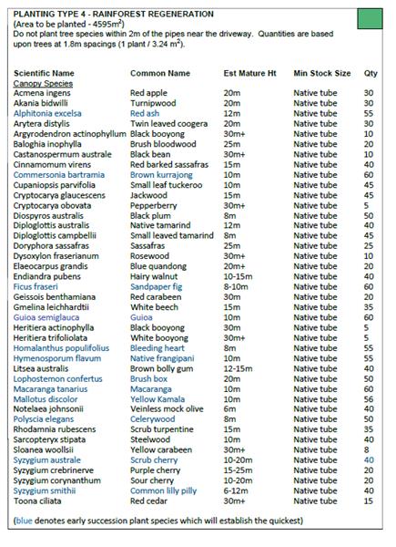
Earthmound versus fence
The applicant has proposed a 1.8 m high timber lap and cap
hardwood paling fence. The fence has a 0.2 m gap at the bottom to enable water
from the driveway to drain away. The proposal was considered by Councils
Environmental Health Officer as acceptable, noting the number of vehicles
generated by the development on average per day (i.e. nine).
Length of fence in adequate
The submitted landscape plan shows that the proposed fence
starts at the north western corner of the site with the neighbours boundary at
the road reserve, extends across to the driveway, then follows the western side
of the driveway for a distance of some 65 metres. The fence is considered an
appropriate length having regard to the number of vehicles per day. Conditions
recommended regarding the fence to be maintained at all times and not removed.
Use of top west corner
The application proposes to change the
landscaping in the north western corner of the site near the objector’s
dwelling from planting throughout to 3 different planting types and a grass
area. The application describes the grass area as an asset protection zone to
the objector’s dwelling. This contrasts with the original approved
landscape plan which does not provide an asset protection zone to the
objector’s dwelling, but potential plantings of Bangalow Palms, Pencil
Cedars, Brown Currajongs, Lilli Pillies and “other native landscape plants”
Compared to the approved landscape plan, the grass area shown
on the proposed plan provides for a more favourable outcome to the
neighbour’s in terms of no trees planted in this location which may
overshadow the dwelling or present as a bushfire risk to the neighbours
dwelling in the future.
Landscaping around approved dwelling and carport
Council’s GIS shows a distance between the
objector’s and the approved dwelling of approximately 110m. The gravel
area referred to in the objection is approximately 8m wide in the front
northern side of the approved dwelling, hence it is likely to be around 100m
from the objector’s dwelling. The approved dwelling is provided with
sufficient space for the parking of vehicles to meet the minimum requirements of
Council’s Development Control Plan. Council raises no objection to the
provision of this gravel area as part of the landscaping of the dwelling house
and for the parking of vehicles on.
Council notes that the landscape plans show a car port, but no
detail has been provided for the structure. The applicant has advised that this
will be carried out under a further approval if not exempt de elopement under
SEPP (exempt and complying development Codes) 2008. The plans to be marked up
showing the car port not approved under this DA.
Removal of timber boundary fence
The approved landscape plan showed a timber fence on the
common boundary near the objector’s dwelling. This fence is not shown on
the submitted landscape plan. No objections have been raised by Council’s
Environmental Health Officer in relation to the deletion of that fence having
regard to noise or reverberation impact reasons, or by Council’s Natural
Resource Planner with respect to weed control reasons.
Over time, the proposed plantings will provide visual
softening.
Department of Primary Industry House Buffers
The subject property has a Plantation Plan approval from NSW
Primary Industries. Condition 5 of the development consent requires the
Plantation Plan to be amended to reflect the proposed dwellings and any
associated house buffers. The Applicant is required to ensure that the proposal
does not conflict with the plantation requirements. In the event there is a
breach of that Plantation Plan then the neighbour can direct those concerns to
the Department of Primary Industries being the appropriate authority in that
regard.
View loss
The proposed plantings as amended will enhance the vegetated
outlook, and the proposed modifications will not have a significantly
detrimental impact on views in this location.
Bush fire safety map
The bush fire safety map provided by the objector, which is
taken from the NSW Planning Portal, has not yet been gazetted by the NSW Rural
Fire Service. Notwithstanding the proposed map and the existing bushfire maps
are near identical and have no bearing on the application.
Compromise alternatives 1 and 2
The objector’s offered compromise 1, being a 30m length
of 1.5m high earthmound at the top of the driveway then a shorter length of
1.8m high lapped and capped timber fence is not the proposal.
The objector’s offered compromise 2, being no earthmound
but instead fence mitigation, no gaps or cracks, from the entry point to access
“C” is not the proposal.
The proposal as submitted by the Applicant in support of their
application causes no significant environmental impact.
Only objector
The application was publicly notified and only 1 submission
plus the two addendum submissions to this were received.
Not substantially the same development and not minimal
environmental impact
The approved development was essentially for a dwelling to be
added to the site. No change is proposed to the approved dwelling. The
amendments to the landscaping and replacement of the earth mound with the
proposed fence are considered to be minor having regards t the totality
of the development. It is considered the proposed development is substantially
the same and generates minimal environmental impacts (in some cases less with
reduced truck movements to construct the earthmound as discussed above)
It is appropriate to utilise the provisions of section
4.55(1A) of the Environmental Planning and Assessment 1979 to approve the
application for the proposed modifications.
Condition 38 and all other conditions of the development
consent remain the same
The application only proposes modifications to conditions 1
and 6 as described in the Attachment 3 to this report. No changes are proposed
to condition 38 of the consent which requires the removal and re-siting of the
existing fence currently sited in the road reserve of Kings Road. The fence
still needs to be resited as per the condition.
Change have been made to the
parking area in front of the existing dwelling
The applicant has advised the
front of the existing dwelling is being landscaped at present. The existing
dwelling has two spaces within a garage/ car port facing Kings Road. Access to
the garage/ car port is from the single driveway as approved by this
development application. An additional condition of consent is recommended
requiring that the garage/ car port be used for parking of resident vehicles
associated with this dwelling house.
8. Public
interest
The proposed amendments are unlikely to significantly
prejudice or compromise the public interest.
9. DEVELOPER
CONTRIBUTIONS/ WATER AND SEWER CHARGES
There is no nexus to levy additional contributions.
10. DISCLOSURE
OF POLITICAL DONATIONS AND GIFTS
|
Has a Disclosure
Statement been received in relation to this application
|
No
|
|
Have staff received a
‘gift’ from anyone involved in this application that needs to be
disclosed. Where the answer is yes, the application is to be determined by
the Director or Manager of the Planning, Development and Environment
Division.
|
No
|
11. CONCLUSION
The proposed amendments to Modify Conditions 1 and 6 relating
to the Landscaping Plan are considered satisfactory having regard to relevant
matters for consideration. Additional conditions have been recommended
addressing neighbours concerns that residents will park next to their house. In
terms of replacing the earthmound with the fence and associated landscaping,
the fence is considered an appropriate alternative and removes the need for
significant earthworks to occur to source the soil, truck movements to bring
the soil to the site (over 100) and then noise and dust associated with
machinery to actually construct, shape and form up the earthmound. The
proposal is considered to be substantially the same development and the Section
4.55 Application is recommended for approval.
Staff Reports - Sustainable Environment and Economy 13.12
Report
No. 13.12 PLANNING - Report of the 8 April
2021 Planning Review Committee
Directorate: Sustainable
Environment and Economy
Report Author: Chris
Larkin, Manager Sustainable Development
Noreen Scott, EA Sustainable
Environment and Economy
File No: I2021/642
Summary:
This report provides the outcome of the Planning Review
Committee (PRC) held on 8 April 2021.
NOTE TO COUNCILLORS:
In accordance with the
provisions of S375A of the Local Government Act 1993, a Division is to be called
whenever a motion for a planning decision is put to the meeting, for the
purpose of recording voting on planning matters. Pursuant to clause 2(a)
under the heading Matters to be Included in Minutes of Council Meetings of
Council's adopted Code of Meeting Practice (as amended) a Division will be
deemed to have been called by the mover and seconder of all motions relating to
this report.
RECOMMENDATION:
That Council endorses the outcomes of the Planning
Review Committee meeting held on 8 April 2021.
Report
The Planning Review Committee
meeting was held on 8 April 2021. The meeting commenced at 1:30pm and
concluded at 2:00pm.
Councillors: Hunter, Lyon,
Hackett, Martin
Apologies: None
Staff: Chris Larkin (Manager
Sustainable Development)
The following development
application was reviewed with the outcome shown in the final column.
|
DA No.
|
Applicant
|
Property Address
|
Proposal
|
Exhibition /submissions
|
Reason/s
Outcome
|
|
10.2021.62.1
|
M Walker
Town Planning
|
44 Benloro Lane
Myocum
|
Dual Occupancy (Detached) including addition of
expanded house habitable outbuilding to the existing dwelling, and New
Dwelling & Studio
|
Level 1
12/2/21 to 25/2/21
No submissions
|
Staff Delegation
|
Staff Reports - Sustainable Environment and Economy 13.13
Report
No. 13.13 Byron Music Festival 2021 - Use of
Dening Park
Directorate: Sustainable
Environment and Economy
Report Author: Rob
van Iersel, Place Activation Coordinator
Alice Heasman, Events Officer
File No: I2021/709
Summary:
Council considered a report at the Ordinary meeting of 25
February 2021 on the proposal to use Dening Park for the 2021 Byron Music
Festival.
Council resolved (Res 21-040):
1. That
Council grants a temporary licence in accordance with section 2.20 of the Crown
Land Management Act for the purpose of Entertainment, Exhibition and Markets to
the Byron Music Festival between Friday 18 June 2021 and Monday 21 June 2021
for occupation of Dening Park.
2. That
the granting of the temporary licence be subject to receipt and favourable
assessment of a full Event Application including:
a) management
of environmental risks on the site with consideration to the dune areas
b) financial
structure and management of the event.
Event organisers have provided further information
addressing the points in Council’s resolution.
The key issue of concern relates to the current beach
erosion in this area and the potential for event activities to impact on dune
stability.
All event infrastructure is located at least 10m from the
timber fencing separating the park area from the vegetated dunes, with access
to that area restricted. A condition is recommended to increase the width
of that restricted area by having market stalls front the existing pathway.
Safety web fencing is proposed to be attached to the
existing timber fencing for the whole length of the event site, preventing
event patrons accessing the dunes (including closing the existing access points
for the day of the event). Security will be employed to monitor the
beach, to prevent people access the event site from the beach itself.
The event use of Dening Park will be for one day only.
Other conditions are recommended to further mitigate any
risk.
It is recommended that the licence to use Dening Park be
granted subject to the conditions limiting impact on the dune edge.
RECOMMENDATION:
That Council grants a temporary licence in
accordance with section 2.20 of the Crown Land Management Act for the purpose
Entertainment, Exhibition and Markets to the Byron Music Festival for Saturday
19 June 2021 for occupation of Dening Park, subject to:
1. All
market stalls on the beachside of the existing pathway to be moved back, a
minimum of 10m from the timber fence, inline with the pathway, with the area
between the back of stalls and the timber fencing to be back of house only,
with no general public access;
2. Market
stalls requiring vehicles integral to stall operation, are to be located on the
south side of the path;
3. The proposed ‘world stage’ is
to be relocated away from the dune edge to the south side of the path.
Attachments:
1 Draft
Event Site Map - Byron Music Festival, E2021/62136
2 Byron
Music Festival -Draft Statement of Environmental Effects and Security Plan, E2021/62135
Report
Byron Music Festival is a
three-day community event held in multiple venues throughout the Byron Bay town
centre, to be held on 18-20 June 2021. The organisers of the festival have
applied for a temporary licence to occupy parts of Dening Park, Byron Bay on
Saturday 19 June 2021, for the festival activities.
The Dening Park activities would
include live music, keynote speakers, market/ food stalls and busking
activities. Organisers are anticipating around 3,000 attendees (subject to
COVID-19 public health orders).
In order for the event to be
COVID-safe, the Dening park event site would need to be fenced and ticketed. To
meet this requirement, event organisers will charge a nominal entry fee ($25)
to cover the administrative and operational costs associated with ticketing the
event.
The area proposed for use and the
fencing proposed for that use is shown in Attachment 1.
Council considered a report on the
festival at the Ordinary Meeting of 25 February 2021 and resolved (Res
21-040):
1. That
Council grants a temporary licence in accordance with section 2.20 of the Crown
Land Management Act for the purpose of Entertainment, Exhibition and Markets to
the Byron Music Festival between Friday 18 June 2021 and Monday 21 June 2021
for occupation of Dening Park.
2. That
the granting of the temporary licence be subject to receipt and favourable
assessment of a full Event Application including:
a) management
of environmental risks on the site with consideration to the dune areas
b) financial
structure and management of the event.
Event organisers have addressed
the points in the resolution and provided a number of supporting documents,
contained in Attachment 2.
Environmental Management:
The main issue relates to the current and
ongoing deterioration of the Byron foreshore. The beach is currently heavily
eroded with a severely depleted beach profile, vulnerable to further erosion of
the back-beach escarpment under small wave conditions and/or high tides.
For the beach in front of Dening Park, there
is no dune buffer to withstand any kind of storm/wave event, with the most
vulnerable area currently located around the surf club. Erosion cell has
recently moved westward in the compartment past the JSPW however, beach levels
are low and the area is susceptible to further erosion of the present very
steep escarpments. The area from the Surf Club to the Children's Playground is
the most vulnerable extent of the Crown Reserve related to the dune width.
The width of the dune in some locations is only 5-7m between
the landward fencing and the steep escarpment. The
dune is currently at risk and we want minimal people on or in close proximity
to it as possible. Significant loading of the area may cause further dune slope
instability or failure.
The erosion escarpment is
currently approx. 7m seaward of the timber fence. An area of around 5-10m
back from this erosion escarpment is the most vulnerable, where activities
creating a potential for further slumping of the dune.
While it is not possible to be
exact, within the event area, the strip of land 5-10m in from the timber fence
is the most vulnerable.
The event organisers propose to
use plastic web fencing attached to the existing timber fencing along the full
length of the event site. This will include fencing to temporarily close
existing beach access points within the event area.
There are five (5) formal beach
access points within the proposed event area. Currently, only two of the
access points are open for use (located closest to the surf club), with the
remainder closed due to erosion.
These two access points would be
closed to the public during the one-day event, by the safety fencing, with
security personnel employed specifically to prevent its use from the beach
side.
The main beach access in front of
the surf club will remain open during the event, with no event infrastructure
in that area.
The fencing and security will
mitigate the risk of people walking through the dune vegetation.
As shown in the Event Map
(Attachment 1), market stalls are proposed to be located along a substantial
length of the dune edge, with stalls proposed to be a minimum of 10m away from
the fence. The area between the fence and the stalls will be restricted
to ‘back of house’ use only, and will not be accessible by the event
patrons.
This limits the infrastructure,
activities and people within the most vulnerable location.
This protection can be increased
by requiring market stalls to be moved further away from the dune edge, to
front the existing pathway, which would double the width ‘back of
house’ protected area for a significant length.
It is also recommended that any
market stalls which require a vehicle in the ‘back of house’ area
(e.g. food vans) to be located on the southern market area, well away from the
dune edge.
A stage area proposed to be
located next to the timber fence to the east of the market stalls will also be
relocated to the south of the existing path, well away from the dune edge.
These measures will minimise
structures, activities and people close to the vulnerable area and successfully
mitigate risk of slumping.
The event will be for one (1) day
only. Given the above, and that the impact on the vulnerable dune area can be
minimised, it is recommended that the event go ahead, subject to the adjustments
described in the report and conditions on the application.
Financial Structure and
Management of the Event
The event is primarily funded
through sponsorship. For the one-day event at Dening Park, site fencing
and ticketing is required in order to comply with COVID-19 public health
orders.
The ticket price ($25) covers to
administration required for the fencing and ticketing.
The event organisers are aware
that corporate advertising is not allowed on the site.
Key issues
As discussed above, the current
vulnerable state of the beachfront is the key issue of concern. The event
organisers have addressed the risks by preventing access across the dunes,
moving infrastructure away from the fenced dune edge and restricting public
access from the ‘back of house; areas between stalls and the fence.
The conditions recommended above
will further mitigate risk.
Strategic Considerations
Community Strategic Plan
and Operational Plan
|
CSP Objective
|
L2
|
CSP Strategy
|
L3
|
DP Action
|
L4
|
OP Activity
|
|
Community Objective 2: We cultivate and
celebrate our diverse cultures, lifestyle and sense of community
|
2.1
|
Support and encourage our vibrant
culture and creativity
|
2.1.1
|
Support a range of inclusive events
that encourage broad community participation and promote social
inclusion
|
2.1.1.1
|
Support innovative and flexible
delivery of community events and initiatives
|
|
Community Objective 2: We cultivate and
celebrate our diverse cultures, lifestyle and sense of community
|
2.1
|
Support and encourage our vibrant
culture and creativity
|
2.1.2
|
Provide meaningful and inclusive
opportunities for volunteering
|
2.1.2.1
|
Partner with community organisations to
develop coordinated spontaneous volunteering processes
|
|
Community Objective 2: We cultivate and
celebrate our diverse cultures, lifestyle and sense of community
|
2.1
|
Support and encourage our vibrant
culture and creativity
|
2.1.7
|
Support range of existing, emerging and
major events
|
2.1.7.1
|
Continue to support event organisers in
the delivery of a range of events
|
|
Community Objective 2: We cultivate and
celebrate our diverse cultures, lifestyle and sense of community
|
2.1
|
Support and encourage our vibrant
culture and creativity
|
2.1.7
|
Support range of existing, emerging and
major events
|
2.1.7.3
|
Administer licences for weddings,
events, activities and filming on council and crown land
|
|
Community Objective 4: We
manage growth and change responsibly
|
4.4
|
Support tourism and events that reflect
our culture and lifestyle
|
4.4.1
|
Build a tourism industry that delivers
local and regional benefits in line with the community’s values
|
4.4.1.2
|
Continue to lead, build and strengthen
strategic tourism partnerships
|
Recent Resolutions
Res 21-040, 25 February 2021:
1. That
Council grants a temporary licence in accordance with section 2.20 of the Crown
Land Management Act for the purpose of Entertainment, Exhibition and Markets to
the Byron Music Festival between Friday 18 June 2021 and Monday 21 June 2021
for occupation of Dening Park.
2. That
the granting of the temporary licence be subject to receipt and favourable
assessment of a full Event Application including:
a) management
of environmental risks on the site with consideration to the dune areas
b) financial
structure and management of the event.
Legal/Statutory/Policy
Considerations
Council is able to approve a licence for the event in
accordance with the Crown Land Management Regulation 2018, and Byron Shire
Council Policy 5.52 Commercial Activities on Coastal and Riparian Crown
Reserves.
Financial Considerations
No cost to Council.
Byron Music Festival would be charged the adopted fee for a
Commercial Temporary Activity, which is currently $244 for the application fee
and $341 per day (for 1 to 7 days) for the licence fee.
Additionally, event
organisers will be charged fees in accordance with Council’s adopted Fees
and Charges for their Traffic Control Plan assessment (if required), waste
management, Occupation Certificate (if required), site inspection/s (if
required), and any relevant building or health inspections.
In the assessment of the event application a bond for any
clean up and/or remediation of Dening Park will be considered and negotiated
with the event organisers.
Consultation and Engagement
Council staff have reviewed
the event application, particularly in relation to the environmental risks.
Staff Reports - Sustainable Environment and Economy 13.14
Report
No. 13.14 Proposed Housing Diversity State
Environmental Planning Policy (SEPP) Confirmation of Council's position on
Boarding Houses in the R2 Low Density Residential Zone
Directorate: Sustainable
Environment and Economy
Report Author: Shannon
Burt, Director Sustainable Environment and Economy
File No: I2021/727
The Department Planning
Industry and Environment (DPIE) recently advised Council that it is working
towards the notification of a new Housing SEPP by the middle of the year.
This new Housing SEPP will
include certain changes to the current planning controls. One of the changes
proposed is to no longer mandate boarding houses as a permissible use in
the R2 Low Density Residential zone (R2 zone).
This change would have the
effect of removing the land use term boarding houses as a permitted use
from the R2 zone for all standard instrument LEPs.
The DPIE is seeking to ensure
that all councils wishing to allow boarding houses in their R2 zone can
continue to do so, without the need for a separate planning proposal after the
new Housing SEPP is made.
The Byron LEP 2014 includes boarding
houses as permissible with consent in the R2 zone.
Confirmation is sought on
whether Council would like to retain boarding houses as a permissible use
in the R2 zone or not.
Council has been given until
13 May 2021 to respond to the DPIE otherwise their default position will apply.
RECOMMENDATION:
That Council retains boarding houses as a
permissible use in the R2 Low Density Residential zone of Byron Local
Environmental Plan 2014, and notify the Department of Planning Industry and
Environment accordingly.
Attachments:
1 Submission:
to Department of Planning, Industry and Environment on the Explanation of
intended effects for a new Housing Diversity SEPP Sept 2020, E2020/71559
Report
Last year the DPIE exhibited an
Explanation of Intended Effect (EIE) for a proposed new Housing Diversity State
Environmental Planning Policy (Housing Diversity SEPP).
https://www.planningportal.nsw.gov.au/proposed-new-housing-diversity-sepp
Staff made a submission to the EIE.
The DPIE has recently advised
Council that it is working towards the notification of a new Housing SEPP by
the middle of the year.
The new Housing SEPP will include
certain changes to current planning controls. One of the changes is to no
longer mandate boarding houses as a permissible use in the R2 Low
Density Residential zone (R2 zone).
If the proposed change is adopted,
it would have the effect of removing the land use term boarding houses
as a permitted use from the R2 zone for all standard instrument LEPs.
The DPIE is seeking to ensure that
all councils wishing to allow boarding houses in their R2 zone can
continue to do so, without the need for a separate planning proposal after the
proposed new Housing SEPP is made.
Confirmation is sought on whether
Council would like to continue permitting boarding houses in the R2 zone
or not.
There have been submissions and
petitions about infill development under the Affordable Rental Housing
(ARH)SEPP presented to Council for consideration; and more recently objections
to a new generation boarding house development at Brunswick Heads which
have highlighted the divergent views in the community on infill housing such as
boarding houses.
Council has until 13 May 2021 to respond
to the DPIE otherwise their default position
will apply.
Key issues
The existing provisions under the ARHSEPP can be viewed
here:
https://www.planning.nsw.gov.au/-/media/Files/DPE/Factsheets-and-faqs/fact-sheet-sepp-affordable-rental-housing-boarding-houses-2019-02-28.pdf?la=en
The EIE as exhibited included proposed updates to some of the
provisions for Boarding houses in the SEPP for discussion:
· The boarding
house definition to be amended to require boarding house development
to be affordable
Boarding houses required to be ‘affordable
housing’ and managed by community housing providers (CHPs). The NSW
Government has also asked for feedback from key stakeholders on whether the
affordable housing restriction for new boarding houses should remain in
place in perpetuity or be limited to a 10-year period only.
· Boarding house
development not be mandated in the R2 Low Density Residential Zone
Boarding houses no longer mandated as a permissible
use in the R2 Low Density Residential zone. Note however that the
permissibility of boarding houses on government owned land will remain
regardless of the LEP provisions.
· Proposed 20%
FSR bonus for boarding house development
The floor space ratio (FSR) bonus for boarding houses
in zones where residential flat buildings (RFBs) are permitted to be set at a
flat rate of 20%.
· Car
parking
No changes to the current rates set under the ARH SEPP.
A non-discretionary parking requirement of 0.5 spaces per boarding
house room or 0.2 spaces per room where the boarding house is
delivered by a social housing provider is to be retained. The car parking rate
is a standard that cannot be used to refuse consent.
Matters for consideration if boarding houses are retained as
permissible in the R2 zone
· No change to
permissibility. The Byron LEP 2014 currently includes boarding houses as
permissible with consent in the R2 zone.
· In February 2019
the ARHSEPP was amended so boarding houses are limited to 12 boarding
rooms per site within the R2 Low Density Residential.
· Allowing a boarding
house with up to 12 bedrooms could be considered out of scale with the
low-density character of the R2 zone (in particular on lots with an area of
less than 1000m2).
· The 20 % flat FSR
bonus will not apply. RFBs not permitted in the R2 zone.
· In June 2018, the
ARHSEPP was amended so car parking standards were increased for boarding
houses.
· Car parking
standards for boarding houses, except where provided by a Social Housing
Provider, are now 0.5 spaces per room in all locations. This standard is
contained at Clause 29(2) (e) of the ARHSEPP, and remains a ‘standard
which cannot be used to refuse consent’. This means councils cannot
refuse a boarding house proposal if it meets this standard, but that
they may consider a lower car parking rate if appropriate.
· The former car
parking rates of 0.2 spaces per room in accessible areas, and 0.4 spaces in
non-accessible areas will continue to apply where boarding houses are
developed by or on behalf of a Social Housing Provider, as defined in the
ARHSEPP. This is based on feedback received during the exhibition that Social
Housing Providers should be supported in providing boarding houses for
lower income earners and other groups.
· No changes
proposed to the car parking rates for boarding houses.
· Lack of on site
car parking, traffic generation and limited public transport continue to be the
main cause of community concern for infill development such as boarding
houses.
Boarding houses/ new generation boarding
houses are now part of the wider housing typology spectrum. They provide a
place to live for those that don’t need a lot of space typically young
professionals, students and older single persons.
Further it is noted that Council has only approved a limited
number of boarding houses in the residential zones over the past decade
(less than 5), and more recently a new age boarding house in the
neighbourhood business zone at Brunswick Heads.
It is submitted they are not a form of residential
accommodation that is being oversupplied in the Shire by social housing providers
or the private sector.
Based on the above, it is
recommended that boarding houses be retained as a permissible use in the
R2 zone in Byron LEP 2014.
Strategic Considerations
Community Strategic Plan
and Operational Plan
|
CSP Objective
|
L2
|
CSP Strategy
|
L3
|
DP Action
|
|
Community Objective 4: We manage growth and change
responsibly
|
4.2
|
Support housing diversity in appropriate locations
across the Shire
|
4.2.1
|
Establish planning mechanisms to support housing that
meets the needs of our community
|
|
|
|
|
|
|
Legal/Statutory/Policy
Considerations
As discussed in the report.
Financial Considerations
Not applicable.
Consultation and
Engagement
This report is presented to Council in response to a request
from the DPIE.
There have been submissions and petitions presented to
Council recently about development under the ARH SEPP.
Staff Reports - Infrastructure Services 13.15
Staff Reports - Infrastructure Services
Report No. 13.15 Byron
Bay Bypass Project Closeout
Directorate: Infrastructure
Services
Report Author: Joshua
Winter, Civil Engineer
File No: I2021/609
Summary:
The Byron Bay Bypass is now open to traffic after many
months of construction and years of planning. The feedback from the community
has been generally positive and has already shown a significant improvement in
traffic flow through town. The construction of the bypass was not without
difficulties, which are discussed in this report along with some potential ways
to mitigate those on future construction projects.
The purpose of this report is to provide a brief history of
the project, summarise the key issues experienced throughout the project
including some key learnings, and advise Council of the final financial
position including the cost overruns that Council resolved to fund via loan
borrowings as part of the 31 December 2020 Quarterly Budget Review.
RECOMMENDATION:
1. That
Council notes the lessons learnt on the Byron Bay Bypass project.
2. That
staff consider these lessons when implementing future projects.
3. That
Council formally authorises the borrowing of $1,750,000 to fund additional
expenditure associated with the Byron Bay Bypass Project.
4. That
Council authorises the General Manager to accept loan borrowing terms offered
to Council that represents the best financial outcome amongst any loan offers received.
5. That
Council authorises the affixing of the Council Seal to any documents to execute
the loan borrowings outlined in this report.
Report
The Byron Bay Bypass has been in
the planning for over 30 years, with Council’s 1988 LEP identifying road
reserve extending south on Butler Street which was ultimately chosen as the
preferred route. Throughout this time, there were a number of concept designs,
routes and environmental reports prepared, with the planning of the final
design and the constructed route commencing in approximately 2014.
The project required an extensive
environmental impact statement (EIS) that guided the design and environmental
approvals required for the project. As part of the project, Council was
required to establish sites under the NSW Biodiversity Banking and Offsets
Scheme (Biobanking) to offset the environmental impact to flora and fauna in
the project footprint. These sites were established at Lilli Pilli to the south
of the site and Wallum Place to the northwest of the site.
The Biobanking agreements at these
locations ensure that 44.8 hectares of land are protected in perpetuity, with
active management currently being undertaken at Lilli Pilli (with all
environmental credits retired) and passive management at Wallum Place, due to
only around 5% of the credits at this site having been retired. The retirement
of credits governed by the Biobanking scheme is managed by NSW Department of
Planning, Industry and Environment.
Further to the requirement for
Biobanking, Council has allocated funding to undertake further bush
regeneration and works in three areas around the proximity of the project
footprint, that were investigated and either had a likelihood of containing
Mitchell’s Rainforest Snail habitat, or at the least were areas of
similar flora that would benefit from regeneration works. These works known as
the “Above and Beyond” will be ongoing for the next four years.
The determination of the Northern
Regional Planning Panel (NRPP) to approve the development application for the
bypass was challenged in the NSW Land and Environment Court by the Butler
Street Community Network. The issues considered by the Court included:
1. Biobanking;
2. flood modelling;
3. noise impacts and at-property mitigations
works to the affected properties;
4. social impacts;
5. traffic modelling assumptions.
The appeal was dismissed and the
Court granted development consent subject to conditions. The original
conditions of the NRPP approval forming the basis of the consent conditions,
with the exception of noting that because the consent only applied to the Part
4 area of the site, all works under an adjacent Part 5 assessment must also be
complete before the project could operate.
Council was then actively
preparing to commence construction of the Bypass, which solidified when a
further $9.5M in funding through the Growing Local Economies grant program was
added to the initial $10.5M in election commitment funding and $4M in developer
contributions. A tender was let to Hazell Bros in May 2019 to construct the
Bypass.
Construction commenced soon after
with a soft start in June 2019, with the road officially opening to traffic on
27 February 2021 after a protracted construction period with a number of
difficulties as explained further in this report.
Issues Experienced During Construction & Additional Funding
Due to several factors, the
project budget encountered challenges throughout that were initially managed
within project contingency but ultimately required additional funding to
complete the works. The cost overrun is $1.75M.
The funding shortfall was due to
specific challenges largely outside the control of Council. These challenges
can be summarised as follows:
1. The unprecedented COVID-19 response involving strict border
closures and social distancing restrictions particularly affected this project
as the principal contractor was based in SE Queensland. Throughout the bulk of
2020 and at a critical time in the project timeline, key staff were stopped
from attending site as well as key subcontractors. This meant sourcing
alternative contractors and increasing third party supervision of the project.
2. A major flooding event in February 2020 that inundated the
town centre caused a significant delay to stage two of the project (the
greenfield area). This delay, being on the critical path, resulted in delay
damages claims from the Contractor.
3. There were substantial design changes made to accommodate
latent conditions, including unknown services, contaminated soil removal, poor
subgrade conditions, and a heritage find.
4. The inclusion of Stage 4 of the project which is the most
northern section including the Shirley St roundabout upgrade. The cost of Stage
4 was $2.5M, which although allowed for initially within the tender contract
value, was never allowed for in the overall project estimates.
5. Protest activity on the project resulted in substantial
additional cost. The protest group established a camp at the start of the
project which resulted in the NSW Police instructing Council to shut the
project down until the required NSW Police resources were able to intervene and
remove the camp from site and enable the project to recommence safely.
6. Allegations of breaches of the Environmental Protection and
Biodiversity Conservation Act (EPBC Act) were made to the Australian Government
regarding the project's impact on threatened species and communities. Council
was required to submit a referral under the EPBC Act to the Commonwealth
Department of Environment and Energy. This substantially delayed the project
and incurred additional cost. It was determined by the Department of
Environment and Energy that the project would not have a significant impact and
no further assessment under the terms of the EPBC Act was required.
Finalisation Works
The civil works are 100% complete,
awaiting only the works as executed documentation for Council’s assets
team to finalise the new assets in our system. The noise abatement works are
also complete, with the exception of the Byron Motor Lodge where the owner
would not sign the Works Deed to allow Council to do the works. An addendum REF
was determined to accept this works as incomplete, on the basis that the noise level
is only 1dB over the limit, which is negligible, and that the property owners
have indicated an appetite to redevelop the site in the short-medium term.
Regarding Council’s
“Above and Beyond” works, the Bypass project will fund the works as
resolved by Council into the future, which allocates a further $81,600 to be
held over for the next four financial years to fund the works. This figure is
included in the required loan borrowing amount detailed in this report.
The project will also pay rent for
use of the Countrylink building, intended to be contributed towards the minor
maintenance/refurbishment works in combination with the $100,000 allocated by
the state government. The rent was calculated at a nominal rate of $250 per
week over two years which amounts to $26,000. This figure is included in the
required loan borrowing amount detailed in this report.
A requirement of the noise
abatement works is for Council’s acoustic consultants to validate their
modelling that was used to design the works, post construction and under
operational traffic conditions. This was undertaken after the writing of this
report but prior to the Council meeting. An estimate of the final cost of this
work is included in the required loan borrowing amount detailed in this report.
The noise validation monitoring is
undertaken in combination with traffic counts to ascertain the number of
vehicles creating the noise. Traffic counters have been on Lawson Street (at
the rail line), Ewingsdale Road (west of Kendall Street) and on Butler Street
(south of Glen Villa entrance). The counts have been fairly consistent and were
also taken over the Easter period.
The counts for a one week period
over Easter (from Thursday 8 April to Wednesday 14 April) were as follows (the
counts are total number of vehicles in both directions);
1. Lawson Street averaged 17,400 vehicles per day.
2. Ewingsdale Road averaged 23,500 vehicles per day.
3. Butler Street averaged 8,000 vehicles per day.
As can be seen above, the averaged
traffic numbers indicate that approximately 34% of vehicles are using the
Bypass road (assuming that all vehicles on the Bypass originated from or ended
up using Ewingsdale road), which is significantly above the original 20%
estimate provided as part of the project approval process.
Key Lessons Learnt
The majority of the challenges on
the project could not be mitigated or planned for, such as the COVID-19
pandemic, flooding and protest activity. In these instances, there is not much
that can be done from a project management or construction perspective to
mitigate the financial risk of these challenges.
There were some key lessons learnt
on the other challenges though and how risk may be mitigated on future
projects. In the case of the design changes required for unknown services, contaminated
soil, poor subgrade and the heritage find, this could have been mitigated by
undertaking a more substantial pre-construction regime including ground
penetrating radar and geotechnical investigations. It is highly likely that the
additional cost of those investigations would have provided a substantial cost
benefit ratio, when compared to the ultimate cost of the variations associated
with those issues.
In the case of the EPBC Act
referral, the determination that Council received from the Department of
Environment and Energy ultimately supported the recommendation from
Council’s consultants however the delay still cost the project a
substantial amount of money to resolve. The lesson in this is that even if
Council is confident in our consultant’s recommendation regarding the
EPBC Act we should refer the matter to the Australian Government. If there is a
potential impact to critically endangered wildlife there should be a voluntary
referral under the act nonetheless. The potential issue with this is that the
process is lengthy and may impact on preferred project time frames, the impact
on the delivery timeframe is far less than the impact from the requirement for
additional funding. For higher profile projects the risk of cost impacts over
delays in approval and assessment times will be evaluated by staff on a case by
case basis.
Regarding the overall Contract
arrangement and the ongoing negotiations as the project progressed, the chosen
conditions of contract and statement of requirements provided a reasonable
level of protection for Council, although Council’s legal advisors from
HWL Ebsworth advised that for a larger project at a smaller Council, it can be
more beneficial to have customised conditions of contract written up by a
professional. However staff are of the opinion that there is still an adequate
level of protection provided by general conditions of contract and custom
clauses in the Statement of Requirements and any applicable special conditions
of contract.
Local Government Act 1993
Section 67 (Private Works)
In accordance with the section 67 and Resolution 20-226,
details of the private works are provided below. Council has or will receive
final work packs for each premises with more exact details that will be kept on
record, unless the registered proprietor chose to undertake the works
themselves and be reimbursed by Council. The requirement for reporting is as
follows;
1. The person for whom the work was carried out: The registered proprietor of each property requiring
noise abatement works.
2. The nature of the work:
The nature of the work was to install noise abatement to protect each property
from the additional noise generated by the Bypass.
3. The type and quantity of materials used: The works varied on each property but generally consisted
of replacing or upgrading windows, doors, air conditioning, front and side
boundary fencing and in some instances wall, roof and underfloor
insulation/protection.
4. The charge made for those materials: There was no charge made to any of the proprietors for
the required works.
5. The total of the number of hours taken by each person who
carried out the work: The exact number of
hours for each property is detailed within each report, however the overall
Contract with Bishton group was undertaken over 8 months.
6. The total amount charged for carrying out the work
(including the charge made for materials):
There was no charge made to any proprietor for the required works.
7. The reason for carrying out the work: To install noise abatement as a condition of consent to
protect each property from the additional noise generated by the Bypass.
Financial Implications
Comment by Manager Finance
Over the course of the 2014/2015 to 2020/2021 financial
years, the funded cost of the Byron Bay Bypass Project has accumulated to
$25,725,600. At the time of preparing this report, Council has incurred
costs of $25,424,200. Currently there is $301,400 remaining for
expenditure which will be used to fund the following items mentioned in this
report:
· Maintenance of the
Bio-banking site.
· Funding the
‘Above and Beyond’ program.
· Payment of rent
for use of the former Countrylink Building as an office during the construction
period.
· Validation of
noise works.
To fund the current and final anticipated expenditure,
Council will need to source an additional $1,750,000 in funding. As it is
unlikely there will be further funding from government towards the project, it
is proposed to borrow via an external loan $1,750,000. Council included
this funding provision in the 2020-2021 Budget when it considered the 31
December 2020 Quarterly Budget Review.
Given the timing in the 2020-2021 financial year, Council
will need to have a loan drawn down by 30 June 2021 to match the funding outlined
in the 2020-2021 Budget. Between now and the 30 June 2021, an expression
of interest for loan borrowings will be conducted to source the best loan
outcome for Council although it will be unlikely there is enough time to
consider a NSW Treasury Corporation loan and their approval process.
Given timing of the borrowings, there will be no loan
repayments in the 2020-2021 financial year. Repayments will commence in
2021-2022 and it is proposed to fund the loan repayments ongoing from the
2017-2018 Special Rate Variation funding.
Section 55 of the Local Government Act 1993 provides an
exemption for Council needing to conduct a tender process for the purposes of
borrowing a loan but Council is required to make a formal resolution to
authorise loan borrowings given it is a decision that cannot be delegated to
the General Manager under Section 377 of the Local Government Act 1993.
To formalise authorisation of the loan borrowing required of
$1,750,000, necessary recommendations are provided with this report for Council
to consider.
Community Strategic Plan
and Operational Plan
This report is intended to advise Councillors that the OP
Activity 1.1.5.1 is now complete.
|
CSP Objective
|
L2
|
CSP Strategy
|
L3
|
DP Action
|
L4
|
OP Activity
|
|
Community Objective 1:
We have infrastructure, transport and services which meet our expectations
|
1.1
|
Provide a road network which is
safe, accessible and maintained to an acceptable level of service
|
1.1.5
|
Deliver road network new works
program
|
1.1.5.1
|
Complete construction of the
Byron Bay Bypass
|