Agenda
Ordinary
Meeting
Thursday,
23 August 2018
held
at Council Chambers, Station Street, Mullumbimby
commencing
at 4.00pm
 Public Access relating to items
on this Agenda can be made between 9.00am and 10.30am on the day of the
Meeting. Requests for public access should be made to the General Manager
or Mayor no later than 12.00 midday on the day prior to the Meeting.
Public Access relating to items
on this Agenda can be made between 9.00am and 10.30am on the day of the
Meeting. Requests for public access should be made to the General Manager
or Mayor no later than 12.00 midday on the day prior to the Meeting.
Mark
Arnold
General
Manager
What is a “Conflict of Interests” - A conflict of
interests can be of two types:
Pecuniary - an interest that a person has in a matter because of a reasonable
likelihood or expectation of appreciable financial gain or loss to the person
or another person with whom the person is associated.
Non-pecuniary – a private or personal interest that a Council
official has that does not amount to a pecuniary interest as defined in the
Local Government Act (eg. A friendship, membership of an association, society
or trade union or involvement or interest in an activity and may include an
interest of a financial nature).
Remoteness – a person does not have a pecuniary interest in a matter
if the interest is so remote or insignificant that it could not reasonably be
regarded as likely to influence any decision the person might make in relation
to a matter or if the interest is of a kind specified in Section 448 of the
Local Government Act.
Who has a Pecuniary Interest? - a person has a pecuniary interest in a
matter if the pecuniary interest is the interest of the person, or another
person with whom the person is associated (see below).
Relatives, Partners - a person is taken to have a pecuniary interest in a
matter if:
§ The person’s
spouse or de facto partner or a relative of the person has a pecuniary interest
in the matter, or
§ The person, or a
nominee, partners or employer of the person, is a member of a company or other
body that has a pecuniary interest in the matter.
N.B. “Relative”, in relation to a person means any of the
following:
(a) the
parent, grandparent, brother, sister, uncle, aunt, nephew, niece, lineal
descends or adopted child of the person or of the person’s spouse;
(b) the
spouse or de facto partners of the person or of a person referred to in
paragraph (a)
No Interest in the Matter - however, a person is not taken to have a
pecuniary interest in a matter:
§ If the person is
unaware of the relevant pecuniary interest of the spouse, de facto partner,
relative or company or other body, or
§ Just because the
person is a member of, or is employed by, the Council.
§ Just because the
person is a member of, or a delegate of the Council to, a company or other body
that has a pecuniary interest in the matter provided that the person has no
beneficial interest in any shares of the company or body.
Disclosure and participation in meetings
§ A Councillor or a
member of a Council Committee who has a pecuniary interest in any matter with
which the Council is concerned and who is present at a meeting of the Council
or Committee at which the matter is being considered must disclose the nature
of the interest to the meeting as soon as practicable.
§ The Councillor or
member must not be present at, or in sight of, the meeting of the Council or
Committee:
(a) at any
time during which the matter is being considered or discussed by the Council or
Committee, or
(b) at any
time during which the Council or Committee is voting on any question in
relation to the matter.
No Knowledge - a person does not breach this Clause if the person did
not know and could not reasonably be expected to have known that the matter
under consideration at the meeting was a matter in which he or she had a
pecuniary interest.
Participation in Meetings Despite Pecuniary Interest (S 452 Act)
A Councillor is not prevented from taking part in the consideration or
discussion of, or from voting on, any of the matters/questions detailed in
Section 452 of the Local Government Act.
Non-pecuniary Interests - Must be disclosed in meetings.
There are a broad range of options available for managing conflicts &
the option chosen will depend on an assessment of the circumstances of the
matter, the nature of the interest and the significance of the issue being
dealt with. Non-pecuniary conflicts of interests must be dealt with in at
least one of the following ways:
§ It may be appropriate
that no action be taken where the potential for conflict is minimal.
However, Councillors should consider providing an explanation of why they
consider a conflict does not exist.
§ Limit involvement if
practical (eg. Participate in discussion but not in decision making or
vice-versa). Care needs to be taken when exercising this option.
§ Remove the source of
the conflict (eg. Relinquishing or divesting the personal interest that creates
the conflict)
§ Have no involvement by
absenting yourself from and not taking part in any debate or voting on the
issue as if the provisions in S451 of the Local Government Act apply
(particularly if you have a significant non-pecuniary interest)
RECORDING OF VOTING ON PLANNING MATTERS
Clause 375A of the Local Government Act 1993
– Recording of voting on planning matters
(1) In this section, planning
decision means a decision made in the exercise of a function of a council
under the Environmental Planning and Assessment Act 1979:
(a) including a decision
relating to a development application, an environmental planning instrument, a
development control plan or a development contribution plan under that Act, but
(b) not including the making of
an order under Division 2A of Part 6 of that Act.
(2) The general manager is
required to keep a register containing, for each planning decision made at a
meeting of the council or a council committee, the names of the councillors who
supported the decision and the names of any councillors who opposed (or are
taken to have opposed) the decision.
(3) For the purpose of
maintaining the register, a division is required to be called whenever a motion
for a planning decision is put at a meeting of the council or a council
committee.
(4) Each decision recorded in
the register is to be described in the register or identified in a manner that
enables the description to be obtained from another publicly available
document, and is to include the information required by the regulations.
(5) This section extends to a
meeting that is closed to the public.
Ordinary Meeting
BUSINESS OF Ordinary Meeting
1. Public Access
2. Apologies
3. Requests for Leave of
Absence
4. Declarations of Interest
– Pecuniary and Non-Pecuniary
5. Tabling of Pecuniary
Interest Returns (s450A Local Government Act 1993)
6. Adoption of Minutes from
Previous Meetings
6.1 Byron
Shire Reserve Trust Committee held on 2 August 2018
6.2 Ordinary
Meeting held on 2 August 2018
7. Reservation of Items for
Debate and Order of Business
8. Mayoral Minute
9. Notices of Motion
9.1 Byron
Shire Voluntary Visitor Fund................................................................................... 6
9.2 2018
Local Government NSW Conference Motion........................................................ 13
9.3 Waiver
of Approval Fees for Chincogan Charge Event................................................. 15
10. Petitions
11. Submissions and Grants
11.1 Byron
Shire Council Submissions and Grants as at 1 August 2018............................... 17
12. Delegates' Reports
13. Staff Reports
General Manager
13.1 Railway
Park rotunda location options............................................................................ 19
13.2 Representation
at Northern Rivers Rail Trail Meetings................................................... 24
13.3 Byron
Skate Park and Recreation Hub.......................................................................... 26
13.4 International
Parking Day - Byron Bay........................................................................... 29
13.5 Open
Space and Recreation Needs Assessment and Action Plan - draft for community
consultation......................................................................................................................................... 32
13.6 Revised
Community Engagement Policy....................................................................... 38
Corporate and Community Services
13.7 Land
and Environment Court Proceedings Gordon Highalands Pty Ltd ....................... 40
13.8 Operational
Plan 2017-2018 and Delivery Program 2017-2021 - 6-month progress report to 30
June 2018................................................................................................................................. 48
13.9 Council
Resolutions Quarterly Review - 1 April 2018 to 30 June 2018.......................... 51
13.10 Carryovers
for inclusion in the 2018/19 Budget.............................................................. 53
13.11 Budget
Review 1 April 2018 to 30th June 2018.............................................................. 58
13.12 Investments
July 2018.................................................................................................... 67
13.13 Bayshore
Drive Roundabout Public Art Project.............................................................. 74
13.14 Water,
Waste and Sewer Advisory Committee - Community Representatives............. 76
13.15 Licence
for community garden at Red Bean Close Suffolk Park.................................. 78
Sustainable Environment and Economy
13.16 Planning
Proposal Update - The Saddle Road (26.2017.3.1) ........................................ 86
13.17 PLANNING
- Exceptions to Development Standards - 1 April 2018 to 30 June 2018 .. 91
13.18 Development
of the new Tourism Management Plan .................................................. 94
13.19 Submissions
Report on the Draft Integrated Pest Management Policy....................... 100
Infrastructure Services
13.20 Grays
Lane Upgrade - Project Status and Community Consultation Outcomes ........ 108
13.21 Waterlily
Park Planned Upgrades................................................................................. 114
13.22 Suffolk
Beachfront Holiday Park Dog Friendly Report................................................ 121
13.23 Settlement
Road Submission Update .......................................................................... 130
13.24 Broken
Head Reserve & Seven Mile Beach Road - ongoing issues............................ 134
13.25 Suffolk
Park Stormwater Drainage Asset Condition.................................................... 142
13.26 Byron
Bay High School - Safety Issues at Arakwal Court........................................... 147
13.27 Parking
Time Changes in Mullumbimby, Bangalow and Brunswick Heads - Status
Report 150
13.28 Recycled
Water Management Strategy 2017-27......................................................... 157
13.29 Coolamon
Scenic Drive - Improving Road Safety....................................................... 160
13.30 Suspension
of Council Policy 4.17................................................................................ 163
14. Reports of Committees
Sustainable Environment and Economy
14.1 Report
of the Heritage Panel Meeting held on 3 July 2018.......................................... 165
Infrastructure Services
14.2 Report
of the Local Traffic Committee Meeting held on 31 July 2018......................... 167
No table of contents entries found.
15. Questions
With Notice
Responses
to Questions on Notice are now available on www.byron.nsw.gov.au/Council/
Council-meetings/Questions-on-Notice
16. Confidential Reports
Corporate and Community Services
16.1 Confidential - Request for Tender for
Minor Civil Works less than $150,000 (2018-0024) 172
16.2 Confidential - Council purchase from
Health Administration Corporation- Mullumbimby War Memorial Hospital site and
Site Remediation .............................................................. 174
Infrastructure Services
16.3 Confidential - CONTRACT 2018-0028 100mm
Water Main Rail Corridor Byron Bay 177
Councillors are
encouraged to ask questions regarding any item on the business paper to the
appropriate Director prior to the meeting. Any suggested amendments to the
recommendations should be provided to Councillor Support prior to the meeting
to allow the changes to be typed and presented on the overhead projector at the
meeting.
Notices of Motion 9.1
Notices of Motion
Notice of Motion No. 9.1 Byron
Shire Voluntary Visitor Fund
File No: I2018/1329
|
I move:
That Council support the development of a Voluntary
Visitor Fund using framework and governance structure option 3 - which shows
Council as the administrator of the fund with an industry led Steering
Committee.
|
Signed: Cr
Simon Richardson
Councillor’s supporting information:
We know the options for receiving money directly
from visitors to Byron Bay have been discussed at length over the years. It is
a common myth that Council receives a sizable financial benefit from the
millions of tourists that visit Byron Bay. In fact, aside from heightened
business rates, it receives nothing and spends millions of dollars to provide
extra sewerage capacity, increased road maintenance and toilet upkeep just to
name a few costs.
The underlying ideology behind this initiative,
and in fact behind the wider volunteer tourism sector, is that it supports a
transition in society from ‘travel to take’ to ‘travel to
assist’ – putting something back while you travel. We are
increasingly interested in ensuring a place we visit is better for us being
there and studies have shown that over 90% of visitors would be supportive of
contributing to the area they visit.
Our local community would also benefit from the
funds, and may improve relations towards visitors if the community could see
the tourist dollar being directed towards enhancing and maintaining our town.
There is increasing evidence that visitors and the tourism industry are
prepared to provide voluntary support for environmental conservation and the
wellbeing of local communities in destinations. A number of studies have
identified that tourists are willing to pay for such outcomes, provided that
local benefits can be clearly identified.
At the Council meeting on 21 November 2013, I
put forward a Notice of Motion regarding a Voluntary Visitor Contribution for
Byron Shire to assist with managing the impacts of tourism. The Council
resolution was as follows (13-622):
1.
That Council commence a trial voluntary visitor
contribution at the First Sun and Suffolk Park caravan parks.
2.
That staff ensure this requirement is outlined
within the scope of future park management contracts.
3.
That the trial period begins from 1 July, 2014,
coinciding with new park management contracts and an evaluation be provided
after the Summer holiday period, 2015.
4.
That staff provide a report addressing the
following aspects:
a)
Creation of a Beautify Byron Fund, in which to receive
funds raised and to provide a prioritised list of projects where the funds raised
could be spent.
b)
The development of a marketing and promotional
strategy to facilitate the voluntary contribution project.
c)
Inviting other businesses within Byron Bay to also take part in the voluntary
contribution scheme, including being part of a governing body to oversee the
Fund.
d)
Financial implications.
Since this resolution, a minimal amount of funds
have been raised through Councils holiday parks.
Over the past 12 months I have been speaking to
industry looking for feedback and support with launching a voluntary visitor
fund. These discussions have involved looking at a model where the business
opts-in and simply adds a small contribution to the visitor’s total bill. In May 2018, an industry
forum was held presenting some of the information below, which shows how a
voluntary visitor fund could be initiated in Byron Shire. This includes the
following:
1. A proposed framework / governance structure
2. Proposed administration
3. Proposed fee structure
4. Transparency and auditing
5. Collection frequency and method
6. Contracts with accommodation providers
7. Project budget, including income estimates
8. Timelines
Proposed Framework and Governance Structure
The following table shows three different
framework and governance options.
|
Option 1
Tourism Organisation Administers
|
Option 2
Independent Accountant with Industry Steering Committee
|
Option 3
Byron Council and Steering Committee Administers
|
|
Tourism
Organisation would:
· Engage Executive Officer or staff to
administer
· Collect data
· Manage trust account or engage
accountancy firm
· Distribute funds to projects
· Administer contracts
· Undertake promotions and marketing
· Secure memberships.
|
The Accountant would:
· Manage trust account
· Collect data
· Distribute funds to projects
The Steering
Committee would:
· Engage and manage Executive officer/staff
· Undertake promotions and marketing
· Secure memberships
· Administer contracts.
|
Byron Shire
Council would:
· Manage trust account
· Collect data
· Distribute funds to projects
The Steering
Committee would:
· Undertake promotions and marketing
· Engage Executive Officer
· Secure memberships
· Administer contracts.
|
|
Pros:
· Arms length from Council
· Industry Association led
· More flexible and responsive to market changes
· Not For Profit with strict auditing
requirements
· GST management would be absorbed into
current structure
|
Pros:
· Arms length from Council
· Whole of industry led – those who
are members or signed up led
· Accountant collects commercial in confidence
data & protects privacy
· Encompasses all accommodation options
· Flexible and responsive to market changes
|
Pros:
· Establish new bank account for
transparency
· Subject to independent audit
· Existing GST and debt recovery processes
· Council collects commercial in confidence
data & protects privacy
· Steering committee would oversea
operation of account and distribution of funds
· Leverage existing administration services
within Council
|
|
Cons:
· Only one portion of the market and would
the rest of the industry be comfortable sharing their commercial in
confidence figures?
· Volunteer run organization without the
experience to administer and promote such a program
· The program could take organisation away
from core business
· Additional costs to the organization
· Costs to administer the program
|
Cons:
· Accountant costs to administer the trust
account would be considerable
· The steering committee would also require
funds to drive membership, marketing and administer the program
· New governance structure and organisation
· Administration costs spread across two
groups could be considerable
· Considerable costs to establish
organization
· Time taken to establish and commence
|
Cons:
· Funds could be ‘perceived’ as
being used as consolidated revenue
· Additional work for Council to administer
· Lack of experience administering and
running a membership scheme
· Is it Council’s core
business? And would industry support this model?
|
Industry has highlighted option 3 as their
preference, which shows Council as the administrator of the fund with an
industry led Steering Committee.
Proposed Administration
This project would require the engagement of an
Executive Officer to undertake the following tasks:
1. Secure industry memberships and grow the number of contributions
(and also work with purchasing to input each business as a supplier)
2. Administer contracts with members
3. Work through the collection methodology and auditing process
4. Undertake all promotions and marketing with the visitor economy and
members (develop the branding, marketing collateral, website and social media
strategy)
5. Oversee project selection and completion
It is anticipated the Executive Officer would be
employed for 3 days a week to drive and administer the program. The officer
would report to the Economic Development and Sustainability team and work
directly with the Industry Steering Committee and Council staff to assist in
communicating the delivery of each project.
Proposed fee structure to guide industry
Below is the proposed pricing classification for
industry.
|
Bookings under $100
|
Bookings $100 - $199
|
Bookings $200 - $299
|
Bookings $300 - $499
|
Bookings $500 and over
|
|
Proposed Fee Options
|
|
$NIL
|
$1
|
$2
|
$3
|
$5
|
Note: at the
industry forum it was suggested that only accommodation providers be targeted.
If tour and activity providers and restaurants etc. added a contribution to the
bill it could be argued that many visitors would pay a contribution twice.
Also, it would be extremely labour intensive to administer this program with
hundreds of tour and activity operators. Note, the structure above does not
capture day visitation.
* Bookings refer for accommodation only (not
transfers, food, activities, beverages etc.)
Here is an example of how funding could be
raised
|
Hotels, Resorts &
Motels
|
Backpacker Hostels
|
Apartments and Houses
|
Festival camping
|
Caravan &
camping/B&B
|
|
Per accommodation booking
|
Per accommodation booking
|
Per accommodation booking
|
Per accommodation booking
|
Per accommodation booking
|
|
|
|
|
|
|
|
Proposed Fee Options (as per the table
above)
|
|
$2
|
$1
|
$5
|
$1
|
$2
|
|
Approximate number of properties
|
|
38
|
13
|
1,000
|
Falls & Splendour
|
65
|
|
Approximate number of voluntary
accommodation units
|
|
2,500
|
1,500
|
1,000
|
40,000
|
6,000
|
|
If we had 25% paying the fee with an annual
average occupancy rate of 75%
|
|
$172,000 potentially
|
$14,500 potentially
|
$48,500
potentially
|
$120,000
potentially
|
$117,000
Potentially
|
Business contributions
The Voluntary Visitor Fund (VVF) can also create
the mechanism for local business to provide a lump sum ‘donation’
to the fund to contribute to local projects. Note: Council cannot achieve
charity status for the VVF, so a business making a donation will not receive
the tax benefits that it would normally receive by donating to a charity.
Transparency
After much consultation with industry more work
needs to be done to work through the mechanics of collection method of the VVF
and in particular how to report the amount of funds raised. This process is not
as straight forward as first thought. It is suggested that Council meet with
small, medium and large accommodation providers and also a property with
Management Rights to understand how a collection method could be adopted, or
whether multiple methods are required for different operators.
Some accommodation outlets report their
occupancy daily (occupancy/vacancy rate) to their channel managers i.e. Wotif,
booking.com etc. So the reporting of the occupancy rate is normal
practice therefore basing the voluntary fee on the occupancy rate could make it
straight forward for some operators to administer.
Collection Frequency and Auditing
After speaking with industry, Council could
issue invoices monthly to participating businesses. Monthly invoices would also
assist in managing cash flow by having funds available regularly to pay for
projects.
Each month businesses would send their bookings
(from their channel manager report or other identified reporting mechanism
– to be decided after more industry consultation) to Economic
Development. Council would then raise invoices monthly based on the reports
from each business.
It is recommended that once a year an
independent auditor conducts an audit to review the accuracy of the channel
manager and/or other reporting mechanisms from operators and pick up any discrepancies.
Contracts with Accommodation providers
Contracts need to be developed between Council
and the participating accommodation houses. Ideally this would be for a minimum
period for example, two years (or the longer the better) would be essential.
For ease of administration, the accommodation property could select which
projects they want their funding to support at the time of signing their
contract.
Part of the contract must address the promotion
of the scheme ensuring positive buy-in from participating businesses. This
Executive Officer will need to assist the visitor economy to promote the
positive aspects to both the visitors and local community. Promotional
material such as logos for accommodation, brochures and project updates would
be vital to assist visitors making a positive choice when selecting their
accommodation.
Project Budget
|
Revenue
|
Estimate
|
|
Potential income in year 1
|
$220,000
|
|
|
|
|
Estimated Costs in year 1
|
Estimate
|
|
· Establish branding, collateral and website
|
$50,000
|
|
· Accountancy fees (applicable with options 1 and 2)
|
$20,000
|
|
· GST, bank fees, insurances (applicable with options 1 and 2)
|
$10,000
|
|
· Executive officer – 3 days per week - annually
|
$45,000
|
|
· Equipment ie: phone, computer
|
$5,000
|
|
· Audit fees
|
$5,000
|
|
· Member events/engagement
|
$5,000
|
|
Total
|
$140,000
|
The estimated costs provided must be paid
upfront to ensure there is no cash flow issue for Council. Also, it’s
important that in its first year the project delivers outcomes for Byron Shire,
rather than contributions solely being used to pay for the ‘administration’
of the program.
I am requesting that $140,000 be initially
sourced from operational funds. Over time money collected will cover all
administrative costs and also provide adequate funding the deliver projects and
can be returned to Council once the VVF has been collected.
Timelines
|
Task
|
Indicative timing - 2018
|
|
Appoint an Executive Assistant (Note: the
tasks of the EO are listed on page 3)
|
September
|
|
Develop the branding collateral, website and
social media strategy
|
September – December
|
|
Develop contracts and secure industry
memberships
|
October – December
|
|
Appoint the Industry Steering Committee
|
October / November
|
|
Industry launch event (and media launch)
|
November
|
|
Projects identified and publicised
|
November
|
|
Commence social media strategy
|
December
|
Proposed Projects
Council and the Industry Steering Committee
would work with industry and the community to identify and prioritise projects.
Staff comments by Shannon Burt, Director Sustainable
Environment and Economy:
Staff have been working with industry in this
space and there is support from the accommodation sector for some form of
visitor contribution.
The potential risk to Council is the unknown
amount of revenue that will be raised and potentially not being able to cover
the administration costs of the program. Also, there is still a lot of work
that needs to be completed around the collection methodology and the auditing
process (and the somewhat lack of transparency). The Economy and Sustainability
team would work through these issues with the appointed Executive Officer.
Financial/Resource/Legal Implications:
The estimated costs for year 1 are $140,000 and
much of these costs are fixed. There is a potential risk to Council that the
revenue goal is not reached and Council is unable to deliver any projects or
cover the running costs of the project. Currently, there are no funds to cover
these costs should that occur.
Is the proposal consistent with any Delivery
Program tasks?
The VVF aligns with the Byron Shire Tourism
Management Plan and Delivery Plan. This is described in detail below.
Council’s Tourism Management Plan (TMP) has a whole strategy dedicated to
improving the provision of funding. Objective two of the TMP asks Council to
identify, pursue and implement appropriate funding for the management,
development and marketing of tourism and for the environmental enhancement of
tourist areas.
Objective 5 of the TMP looks at on-going local
education and communication to ensure visitors, local businesses, local
government and the community understand tourism and community values.
The VVF also aligns with Council’s Delivery Plan. In particular the
following strategies:
· Strategy 3.1 - partner to protect and enhance our biodiversity,
ecosystems and ecology.
· Strategy 4.1 – support the visions and aspirations of local
communities through place-based planning and management
· Strategy 4.4 – support tourism and events that reflect our
culture and lifestyle
· Strategy 5.1 – engage and involve community
in decision making
A VVF initiative is also reflective of the
feedback heard by community during the ‘Big idea Revenue Workshops’ held during the preparation of the Our Byron Our Future Community
Strategy Plan.
Notices of Motion 9.2
Notice of Motion No. 9.2 2018
Local Government NSW Conference Motion
File No: I2018/1514
|
I move:
That Byron Shire Council
resolves to put the following proposal to the 2018 Local Government NSW
Conference:
“That Local Government NSW provide research and resources to support
Councils in NSW developing and implementing Gambling Harm Prevention
policies.”
|
Signed: Cr
Paul Spooner
Councillor’s supporting information:
The proposed motion for this year’s state conference
supports the Notice of Motion resolved at the 22 March meeting of council, in
particular point 4.
18-161 Resolved:
1. That Council
write to the new owners of The Beach Hotel endorsing their deliberate decision
to remove poker machines from their venue to improve the wellbeing of the Byron
Shire community and set a precedent for other venues across Australia to
follow.
2. That Council write
to all remaining poker machine venues in Byron Shire opening a dialogue to
gauge their interests in pursuing a similar strategy to divest their poker
machines and offering Council support if they wish to investigate alternative
business models.
3. That Council
undertake a review of Council’s potential interests and involvements with
poker machines by researching:
i) council
investments with regard to the Ethical Investment Policy;
ii) any council or
crown land leases that may involve poker machine venues; and
iii) planning controls that
may be available (or potentially available) for limiting the use of poker
machines within the shire.
4. That a report be
prepared for the May Ordinary Meeting outlining options to develop a
comprehensive gambling policy to reduce the harm in the Byron Shire from the
use of poker machines.
5. That Council
requests that the State Government refer the proposed amended NSW Legislation
in relation to gambling, announced and introduced to parliament on 5 March
2018, to an inquiry for further investigation and consultation with local
governments as to the potential impacts on gambling harm in our community.
Staff comments by Sarah Ford, Manager Community Development,
Corporate and Community Services:
Staff recognise the social, emotional, and economic impacts
of problem gambling within the community and the proposed motion adheres to the LGNSW policy principles.
Council received a report at the
May 2018 Ordinary Meeting which outlined the limited number of NSW councils who
have developed a gambling harm minimisation Policy. Council resolved to review
and receive a report on the development of the Northern Beaches Council
Gambling and Poker Machine Harm Minimisation Strategy that is due to be
finalised in August 2018. It is anticipated that this body of work will provide
a guide to Council for development of a local harm minimisation policy.
The motion if adopted at the 2018
Local Government NSW Conference, would result in additional resources being
available to all Councils, to assist and support in the preparation of local
harm minimisation policies.
Financial/Resource/Legal Implications:
It is expected the work requirements for developing a
Gambling Harm Minimisation Strategy will be met from existing budgets
unless additional resourcing support can be secured externally.
Is the proposal consistent with any Delivery Program
tasks?
2.2 a) Develop and maintain collaborative relationships with
the government sector and community.
Notices of Motion 9.3
Notice of Motion No. 9.3 Waiver
of Approval Fees for Chincogan Charge Event
File No: I2018/1519
|
I move:
That Council:
1. Waive approval fees
associated with the 2018 Chincogan Charge event
2. Reimburse Mullumbimby
Chamber of Commerce for any approval fees already paid
3. Advertise the amount of the
waiver as a s356 donation
|
Signed: Cr
Basil Cameron
Councillor’s supporting information:
The Chincogan Charge has been a long time
feature of community and social life in Mullumbimby. It is a footrace over a
return course from town to the top of Mt Chingcogan.
Traditionally held as part of the Chincogan Fiesta,
one of Mullumbimby’s most important fund raising events which regularly
saw significant sums donated to various community causes, perhaps most notably
for purchasing equipment and services for the Mullumbimby Hospital.
The Chincogan Fiesta has not been held for many
years, however in 2017, in response to much discussion in the community, the
Chincogan Charge was successfully reprised. The 2018 event is scheduled for 8
September and will incorporate a salute to the spirit of the Chincogan Fiesta with
a food provided by Mullumbimby Public School and a tug of war organised by the
Brunswick Valley Historical Society and local business.
The event involves a street closure that has
already been given approval through the LTC and Council. I propose that
approval fees associated with the street closure be waived.
Staff comments by James Brickley, Manager Finance, Corporate
and Community Services:
(Management Comments must not include formatted
recommendations – resolution 11-979)
Council as part of the 2018/2019 Budget Estimates has
allocated a total budget of $7,000 to assist community organisations with the
costs of any approvals from Council required to conduct community events as a
Section 356 Donation. At the time of preparing these comments, none of this
budget has been expended so far in the 2018/2019 financial year.
Should Council approve this Notice of Motion, funding is
available to assist with approval fees for the Chincogan Charge and as
indicated at part 3 any donation made to offset the approval costs will need to
be advertised.
It is understood from Council events staff, the event for
2018 is different to that held in 2017 and will require only a Roads Act
approval for road closure. The cost of this for the 2018/2019 financial
year is $368.00.
Financial/Resource/Legal Implications:
Waive fees for approvals associated with
approvals for Chingcogan Charge.
Is the proposal consistent with any Delivery Program
tasks?
Section 356 Donations and Activities
2341.16 Contribution - Community Events -
Approval Expenses
Submissions and Grants 11.1
Submissions and Grants
Report No. 11.1 Byron
Shire Council Submissions and Grants as at 1 August 2018
Directorate: Corporate
and Community Services
Report
Author: Jodi
Frawley, Grants Co-ordinator
File No: I2018/1411
Theme: Corporate Management
Corporate Services
3Summary:
Council have submitted applications for a number of grant
programs which, if successful, would provide significant funding to enable the
delivery of identified projects. This report provides an update on these grant
submissions.
|
RECOMMENDATION:
That Council note the report and attachment (#E2018/64272)
for the Byron Shire Council Submissions and Grants as at 1 August 2018.
|
Attachments:
1 BSC
Submissions and Grants as at 1 August 2018, E2018/64272
⇨

This report provides an
update on grant submissions including funding applications submitted and new
potential funding opportunities.
Successful Applications
· Development of Compliant Plans, Implementation of
new Crown Land Management Act 2016, NSW Office of Local Government
Unsuccessful
Applications
· Implementation of projects in the Byron Bay Town
Centre Masterplan, Building Better Regions Fund round 2, Australian Government
· Byron Bay Skate Park, Regional Sports Infrastructure
Fund, NSW Regional Growth Fund
Applications Submitted
· The Redevelopment for the Far-North Coast Fire
Control Centre, Infrastructure Grants – Emergency Preparedness, NSW
Liquor and Gaming
· Statements of Heritage Significance for Rail
Precinct Byron Bay, Royal Australian Historical Society Rail Transport Heritage
Grants
· Main Arm Road Curve Improvements at Chainage 5900,
Safer Roads, NSW Roads and Maritime Services
· Main Arm Road and Settlement Road Intersection, Safer
Roads, NSW Roads and Maritime Services
· Coolamon Scenic Drive - Road Safety Evaluation
(Project 1), Safer Roads, NSW Roads and Maritime Services
· Coolamon Scenic Drive - Road Safety Evaluation
(Project 2), Safer Roads, NSW Roads and Maritime Services
· Coolamon Scenic Drive - Road Safety Evaluation (Project
3), Safer Roads, NSW Roads and Maritime Services
Additional information on
the grant submissions made and/or pending is provided in Attachment 1 –
Submissions and Grants report as at 1 August 2018.
Financial Implications
If Council is successful
in obtaining the identified grants more than $20 million would be achieved
which would provide significant funding for Council projects. Some of the
grants require a contribution from Council (either cash or in-kind) and others
do not. Council’s contribution is funded. The potential funding and allocation
is noted below:
|
Requested funds from
funding bodies
|
8,194,050
|
|
Council cash
contribution
|
4,140,176
|
|
Council in-kind
Contribution
|
56,158
|
|
Other contributions
|
8,540,000
|
|
Funding applications submitted and awaiting notification
(total project value)
|
20,930,384
|
Statutory and Policy Compliance Implications
Council is required under Section 409 3(c) of the Local
Government Act 1993 to ensure that ‘money that has been received from
the Government or from a public authority by way of a specific purpose advance
or grant, may not, except with the consent of the Government or public
authority, be used otherwise than for that specific purpose’. This
legislative requirement governs Council’s administration of grants.
Staff Reports - General Manager 13.1
Staff Reports - General Manager
Report No. 13.1 Railway
Park rotunda location options
Directorate: General
Manager
Report
Author: Claire
McGarry, Place Manager - Byron Bay
File No: I2018/1392
Theme: Infrastructure Services
Open Space and Recreation
Summary:
In 2018-19, Byron Shire Council is upgrading Railway Park
with landscaping, additional seating and lighting, a new playground, and
connecting pathways. This upgrade will bring the area to life so that it can
become a space the community is proud of and a fitting ‘welcome’ to
the centre of Byron Bay.
Staff are progressing with detailed design for the project,
with preliminary works currently underway. A critical decision to be made
before detailed design can progress is the location of the rotunda occupied by
the Byron Environment Centre.
This report details the consultation undertaken with the
Byron Environment Centre, their adopted position regarding rotunda location,
and the consultant designer’s commentary on the suitability of potential
rotunda locations in the context of the overarching park design.
|
RECOMMENDATION:
1. That
Council note the request from the Byron Environment Centre regarding
the location of the rotunda in Railway Park.
2. That
Council identify the preferred location for the rotunda.
3. That
staff progress with detailed design incorporating the identified rotunda
location, and investigate cost estimates if relocation and restoration are
required.
|
Attachments:
1 BEC
request Railway Park, E2018/65942
⇨
Report
Background
In December 2017, Council resolved to endorse the Railway
Park Landscape Concept Plan. Staff are progressing with detailed design for the
project, with preliminary works currently underway.
A critical decision to be made before the detailed design
can progress is the location of the rotunda occupied by the Byron Environment
Centre (BEC).
Consultation
Between July and December 2017, staff notified all
stakeholders (including the BEC) of the project commencement and concept
designs via hard copy letter, email and phone.
Staff have had ongoing discussions with the BEC to gather
feedback on the park upgrade designs and the location of the rotunda.
Specifically, Council and the BEC met:
· 18
December 2017 – General Manager and landscape designer (on-site)
· 27
February 2018 – General Manager and staff (on-site)
· 23
May 2018 – General Manager, Mayor and staff (Council office)
· 29
June 2018 – General Manager, staff and landscape designer (on-site)
· 27
July 2018 – General Manager and staff (Council office)
Stage 1 works were completed in April 2018.
Over the past 12 months, staff have consulted with a wide
range of stakeholders including the BEC, the Byron Masterplan Guidance Group,
surrounding businesses, Councillors, and park users to gather feedback on the
park design and construction timeframes. The project has also attracted regular
media coverage through local outlets.
Rotunda Location
Following a Strategic Planning Workshop with Councillors,
staff met with the BEC on-site in Railway Park on 29 June 2018 to present
Council’s preferred rotunda location – identified as
‘B’ on the map below. The BEC were asked to consider the proposal
and provide a written response to Council. Staff had previously discussed the
option of the rotunda being located outside Railway Park (eg Main Beach) but
this was not seen as a viable option by the BEC.
On 13 July 2018 staff received a formal response from the
BEC (attached), requesting that Council consider alternative locations for the
rotunda within Railway Park.
Staff met with the BEC on 27 July 2018 which included
discussions regarding the possibility of relocation. During these discussions
certainty regarding tenure and future use and management of the rotunda by the
BEC was raised. The attached response from the BEC also addresses this issue.
The below map details potential rotunda locations –
locations A, C and D were identified by the BEC. Location B was identified by
Council.
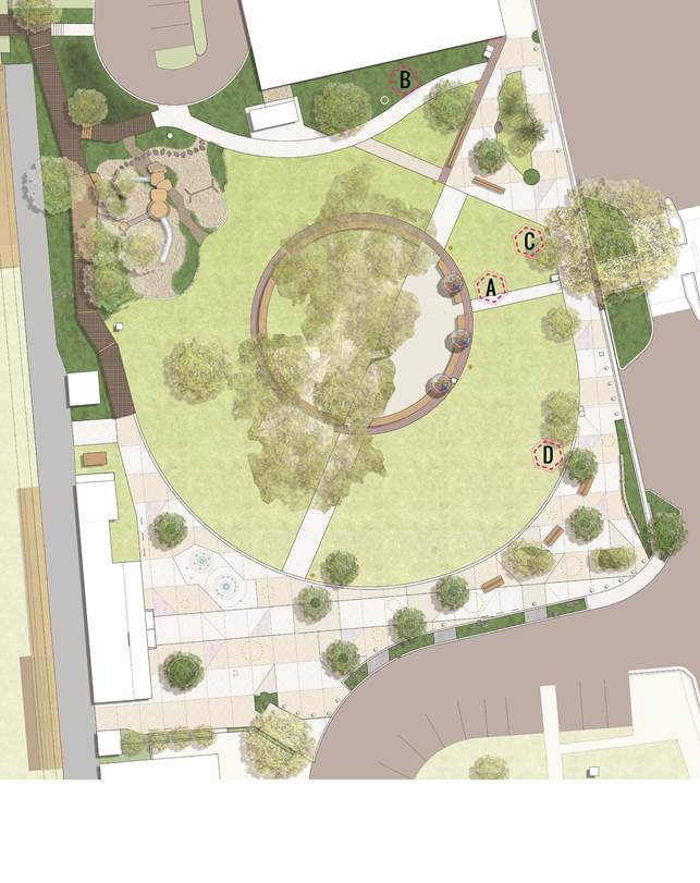
The below table outlines the potential rotunda locations
alongside commentary on the suitability of each location in the context of the overarching
park design. The ‘design implications’ advice has been provided by
Plummer and Smith – landscape architects engaged to design the Railway
Park upgrade.
|
#
|
LOCATION
|
RATIONALE FROM BEC
|
DESIGN IMPLICATIONS
|
|
A
|
Existing location
|
· High visibility
· Close to street and
thoroughfares
· Cultural statement
|
Undesirable because:
· Impedes
view lines into and across the park – safety implications
· Results
in a visual and physical barrier on the front edge of the park
· A
key public gathering and street front location within the park is lost to
locked ‘private’ space
· Covers
prime lawn locations
|
|
B
|
North-Eastern corner between tree stump and Jonson Street
|
Undesirable to BEC because:
· Lack of
visibility
· Close to bank
wall
· Not close to
thoroughfares
|
· Utilises a currently under-utilised part of the park
· Places structure in an area where lawn areas may
struggle due to aspect
· Opens view lines into and across the park
· Retains tree stump in situ
· Allows for tree plantings along bank wall
· Central cottonwood trees remain the focus of the
park for pedestrians crossing Jonson Street
|
|
C
|
A few metres north-east of existing location
|
· High visibility
· Close to street and
thoroughfares
· Central cottonwood
trees remain focus of the park for pedestrians crossing Jonson Street
|
Undesirable because:
· Results in a
visual and physical barrier on the front edge of the park
· A key public
gathering and street front location is lost to locked ‘private’
space
· Covers prime
lawn locations
|
|
D
|
South-Eastern corner close to existing public phones
|
· Allows space for
events
· Close to Jonson Street
· View throughout the
park
· Indigenous art
complements public art space
|
· Impedes view lines into park – safety
implications
· Results in a visual and physical barrier on the
front edge of the park- we are removing the toilet block from this location
in an effort to open the park edge up and create a welcoming space
· A key public gathering and street front location
within the park is lost to locked ‘private’ space
· Depending on the location it may be covering prime
lawn locations
|
In addition, if Council resolves to relocate the rotunda,
the BEC has requested some funds to help to restore the structure and
indigenous paintings after the move.
Financial Implications
If the rotunda is relocated, cost estimates will need to be
sought regarding the relocation and restoration of the rotunda as per the above
request from the BEC.
Statutory and Policy
Compliance Implications
Council is preparing a Plan of Management for Railway Park.
The draft Plan of Management is on exhibition until 31 August 2018, and aims to
support the landscape upgrade works and guide the future use of the Park for
community purposes.
The draft Plan of Management proposes to alter the
categorisation of the land from ‘Community – Park’ to
‘Community – General Community Use’.
The draft Plan of Management allows for the rotunda to be
located on any of the sites identified on the plan.
Staff Reports - General Manager 13.2
Report No. 13.2 Representation
at Northern Rivers Rail Trail Meetings
Directorate: General
Manager
Report
Author: Heather
Sills, Corporate Governance Officer
File No: I2018/1394
Theme: Corporate Management
Councillor Services
Summary:
The Northern Rivers Rail Trail Inc (NRRT Inc) have extended
an invitation to Council to have a representative attend their regular
meetings.
This report is provided to allow Council to consider the
invitation and to nominate Council representative(s) to the NRRT Inc.
|
RECOMMENDATION:
That Council nominate Cr _________________ to
attend the Northern Rivers Rail Trail Inc meetings as a representative of the
Byron Shire Council.
|
Report
Byron Shire Council has been represented by staff and
Councillors in the past through attendance at the meetings of the Northern
Rivers Rail Tail Inc (NRRT Inc.).
Attendance at these meetings would provide Council with an
opportunity to work with the NRRT Inc to ensure future plans are consistent
with Council’s activities and information can be provided to the
committee about projects being undertaken by Council that may impact or involve
NRRT Inc.
The NRRT Inc meets six-weekly, usually in Bangalow, and
occasionally in other locations such as Lismore and Murwillumbah.
Following consideration of
this report and Council’s decision, a letter will be sent to NRRT Inc to
advise Council’s of the outcome.
Financial Implications
There are no financial implications associated with this
report.
Statutory and Policy Compliance Implications
The Council representative will not have voting rights on
the committee and will attend in an advisory capacity, expressing the views of
the Byron Shire Council.
Staff Reports - General Manager 13.3
Report No. 13.3 Byron
Skate Park and Recreation Hub
Directorate: General
Manager
Report
Author: Claire
McGarry, Place Manager - Byron Bay
File No: I2018/1407
Theme: Infrastructure Services
Open Space and Recreation
Summary:
In April 2018, Council resolved to identify the Sandhills
area as its preferred location for a Byron Bay Skate Park and to undertake
community consultation seeking feedback on this location.
This report details the consultation undertaken and feedback
received as well as providing an update on funding applications and potential
funding sources for this project.
|
RECOMMENDATION:
1. That
Council note the report.
2. That
staff continue to investigate funding opportunities for the
development of the Byron Skate Park and Recreation Hub.
|
Attachments:
1 Skatepark
Survey_Responses_Report.pdf, E2018/64357
⇨

Report
Background
In April 2018, Council resolved (18-001) to:
1. Identify
the Sandhills area as its preferred location for a Byron Bay Skate Park.
2. Seek
public and user group feedback and ascertain support for this location.
3. Seek
support from the Department of Industry-Crown Land for use of this site for a
youth focused activity.
4. Provide
a report on the feedback provided by stakeholders, the wider community and the
Department of Industry-Crown Land.
Consultation
Staff developed and implemented a communication and
engagement plan to promote Sandhills as Council’s preferred location for
a new Byron Bay Skatepark.
The plan articulated key messages and challenges, and
identified a wide range of stakeholders including the skating community, nearby
residents and businesses, Arakwal, Police, the Byron Bay Youth Activities
Centre, Sandhills Childcare Centre, the library and the Byron Bay Courthouse.
Communication and engagement activities included meetings
with stakeholders, a survey on yoursaybyronshire, information on
Council’s website, media release, Facebook promotion, E News and video
content for social media.
Stories were printed in the Byron Shire Echo, Northern Star,
and Echonet Daily. Schools in the Byron Bay area were also sent
information advertising the survey with a request that this be included in
their newsletters.
Because of the nature of the project there was a strong
focus on digital engagement with the following results achieved:
· 19,312
people reached on Facebook
· 8,789
video views
· 793
reactions, comments and shares, the majority of which were positive
Of
the social media feedback, approximately 40% of comments were supportive; 50%
were neutral or on unrelated topics; and 10% raised negative issues / concerns.
The survey on yoursaybyronshire resulted in 105 responses, with 89% of comments
supportive of the location of the skatepark and the activation of the Sandhills
area into a family-friendly recreation space.
Staff have written to Crown Lands formally requesting the
vesting of the land across to Council and are awaiting a response. Follow up
enquiries have been made to Crown Lands staff, and Council has made
representation to the Minister’s office through the Parliamentary
Secretary for the North Coast in support of our request.
Feedback
Positive feedback via Facebook and the yoursaybyronshire
survey included:
· the need for this
type of facility in Byron Bay
· the activation of
what is seen by many as an unutilised space
· a positive outcome
for the youth of the town
· whilst Sandhills
is a good location, the best location would be beachfront like Venice Beach,
Bondi, St Kilda etc.
Comments from those not supportive of the skatepark
included:
· location
– it should be on the beachfront
· location
– it is too close to the Sandhills Child Care Centre
· Fixing
the roads should be the Council’s priority, not building a skate park
· Retention
of green space
· Noise
concerns
· Limited
parking
· Attracting
antisocial behaviour
Based on the feedback received and research undertaken
regarding best practice skatepark design, the critical success factor for this
project will be the development of a broader recreation ‘precinct’
within the Sandhills Estate. The development of a precinct will improve passive
surveillance around the skate park and enable noise mitigation measures to be
integrated into the landscape design.
Creation of a recreation ‘hub’ also meets the
objectives of the site in terms of the Byron Bay Town Centre Masterplan,
creating an intergenerational community hub that creates a pedestrian link
between the Byron Rec Grounds and Main Beach. This consultation can be used to
advance developing a skate park in Byron Bay, which is a recommended action in
the Byron Shire Rec Needs Study.
Project Status
Council has engaged Convic, specialist skate park designers,
to develop concept plans for the skate park element of the precinct. It is
anticipated that community design workshops will be hosted by these consultants
during September.
Funding
Council submitted an application to NSW Regional Sports
Infrastructure Fund which was not shortlisted for the second stage development
of a business case.
Additional funding sources are being identified. These will
include:
· Building
Better Regions Fund round 3 expected before the end of 2018
· NSW
Regional Sports Infrastructure Fund Round 2 in 2019-20
· NSW
Regional Growth Fund 2019-20 rounds
With both a Commonwealth and State Election due in the next
12 months, the grant funding landscape is likely to change. Any funds that
match to this project will be flagged for project team consideration.
Financial Implications
Council’s adopted 2018-19 budget allocated $460,000 to
Byron Bay Town Centre Masterplan Projects, specifically the Byron skatepark and
drainage works in Railway Park. From this allocation, Convic have been engaged
to develop concept plans at a cost of $14,620.
Statutory and Policy Compliance Implications
Crown Lands Management Act
Staff Reports - General Manager 13.4
Report No. 13.4 International
Parking Day - Byron Bay
Directorate: General
Manager
Report
Author: Claire
McGarry, Place Manager - Byron Bay
File No: I2018/1431
Theme: General Manager
General Manager
Summary:
This report outlines the proposed participation in
International Parking Day to demonstrate a people-prioritised town centre in
Byron Bay.
|
RECOMMENDATION:
1.
That Council note the report.
2. That
Council endorse the Park(ing) Day concept and support staff working with the
Byron Masterplan Guidance Group to implement the project.
|
Report
Background
The Byron Bay Town Centre Masterplan calls for a
“pedestrian prioritised Byron Bay that supports and integrates alternate
modes of transport”.
The Masterplan’s Access and Movement strategy
identifies that “if people are to be prioritised within the town centre,
large portions of existing parking need to be removed”.
Park(ing) Day is an international event that aims to
revitalise spaces normally reserved for stationary cars. It started in
2005 in San Francisco as a guerrilla type event and it was quickly realised as
a great way to create opportunity for social interaction that wasn’t
there before. It has since taken off around the world and in Australia.
Project
In 2018, Park(ing) Day falls on Friday 21 September.
Staff are working with the Byron Masterplan Guidance Group
to plan the details of the activities for the day and promote the concept
within the local community.
Staff intend to activate space(s) within the Byron Bay town
centre through the temporary closure of the existing parking spaces and the
installation of street furniture and other materials.
In discussions with the Byron Masterplan Guidance Group
regarding Park(ing) Day there was a strong appetite for a bigger, bolder
statement to prioritise pedestrians within the town centre.
The timeframes, budget and resources available for Park(ing)
Day are not sufficient to broaden the scope for 2018, but the below resolution
addresses the aspirations of the Byron Masterplan Guidance Group who will be
kept updated on progress as staff progress with actioning this resolution.
Related Resolution and comment from Infrastructure
Services staff
In 2017, Council resolved:-
Res 17-694
1. That
Council supports, in principle, a trial of ‘Car Free Sundays’ in
Byron Bay;
2. That
the car free day be of similar range and scope to the car free area designated
for Soul Street that occurs on New Year’s Eve;
3. That
the Car Free Sundays occur monthly on days that are not Byron Market days;
4. That
Council and the community work together to plan and progress this trial; and
5. That
a report on this matter be brought to Council for consideration of Car Free
Sundays before the winter recess.
Council has the ability under the Roads Act to close the
road to undertake works, both maintenance and capital, to protect the road
asset and / or public safety associated with the asset condition. Council
does not have the ability to close roads for events without undertaking an
approval process. This occurs for NYE and Soul Street where separate
approval for the event is obtained after the necessary planning, investigation
and consultation has occurred.
Closure of Jonson Street (currently a Regional Road) and associated
streets similar to the area designated for Soul Street that occurs on New
Year’s Eve, needs to be treated as an event, with an intended purpose.
There would then need to be substantial consultation with:
· Emergency Service
agencies, including:
o Police
o Fire & Rescue
o Ambulance
o RFS
· Public transport
operators and relevant organisations
o Bus (local and interstate)
o Department of Transport
o Taxis
o Other public and private
transport operators
o RMS/Local Traffic Committee
· Property owners
· Business operators
· Residents
· General community
Such a closure will have a significant impact on the road
network for motorists, cyclists and pedestrians with the loss of one of the
north- south roads in Byron Bay. This impact will be lessened when the
Byron Bay Bypass has been completed.
There are also issues associated with insurance and risk
management; public safety; and anti terrorism planning and measures.
None of these matters are insurmountable, there just needs
to be funding and resourcing to facilitate achievement of the resolution.
It is intended that a detailed report will be presented to
Council at either the September or October meetings.
Financial Implications
The cost of the project is estimated at $5,000 which can be
funded from existing budgets subject to further confirmation of costs as
planning for the event progresses.
Statutory and Policy
Compliance Implications
Approval would be sought under Section 138 of the Roads Act.
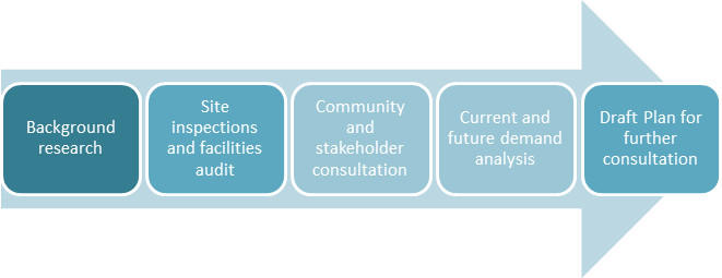
Staff Reports - General Manager 13.5
Report No. 13.5 Open
Space and Recreation Needs Assessment and Action Plan - draft for community
consultation
Directorate: General
Manager
Report
Author: Shannon
McKelvey, Manager Organisation Development
Sharyn French, Manager
Environmental and Economic Planning
Sarah Ford, Manager Community
Development
Michael Matthews, Manager Open
Space and Resource Recovery
File No: I2017/1670
Theme: Community Infrastructure
Open Space and Recreation
Summary:
Council has developed a draft Open Space and
Recreation Needs Assessment and Action Plan. This is the first shire-wide
forward plan for open space and recreation in this Shire.
The Plan has been prepared in collaboration with Ross
Planning, specialists with extensive experience working in this field with
councils around Australia. It was informed by significant community
feedback, ground-truthing, the latest 2016 census data, local and industry
participation information and an analysis of industry trends.
The Plan outlines how open space and recreation areas will
be managed now and into the future, what level of facilities should be located
at them and where funding can be prioritised over the short, medium and long
term.
Council considered the draft Plan at a workshop in December
2017 and deferred it pending further investigation into the feasibility and
cost/benefit of potential options for aquatic facilities (18-039). This
separate work is well underway but in the meantime there a number of Council
projects and grant opportunities that would benefit from having an adopted Open
Space and Recreation Plan in place, so it is recommended that the rest of the
Open Space and Plan proceed to public exhibition. The draft Plan has been
updated to note the additional work that is underway under Res 18-039.
|
RECOMMENDATION:
That Council:
1. Endorse
the revised draft Open Space and Recreation Needs Assessment and Action Plan
for purposes of public exhibition for 28 days.
2. That
in the event:
a) that
any submissions are received, they be reported back to Council prior to
adoption
of the Plan; or
b)
that no submissions are received, the Open Space and Recreation
Needs Assessment and Action Plan be
adopted.
|
Attachments:
1 Draft Open
Space and Recreation Needs Assessment and Action Plan, E2018/66697 ⇨

Report
The draft Open Space and
Recreation Needs Assessment and Action Plan
Attached to this report is
the updated draft Open Space and Recreation Needs Assessment and Action
Plan (the Plan). Council is asked to endorse the draft for the purposes of more
consultation, so that community and stakeholders have a further opportunity to
make suggestions and submissions.
Broadly speaking, the Plan:
· Applies
shire-wide and to all types of open space that is owned or managed by Council.
· Applies
to both active and passive recreation.
· Uses
evidence to identify current and future open space and recreation needs and
trends.
· Identifies
that, generally, the amount of open space and recreation space in the Shire
will be adequate to meet demand, now and into the future, although spaces require
improvements.
· Provides
a framework and classification system that will guide the level of
embellishments in each space in future.
· Identifies
a number of short, medium and long term actions that will inform future
Delivery Programs, Operations Plans, works programs and annual budgets.
The Plan also:
· promotes
the importance to community health and wellbeing of passive recreation in
addition to active sport;
· points
to the changing nature of how we recreate and will do so in future;
· acknowledges
the abundance and role of the NPWS estate and water recreation opportunities in
the Shire.
On page 3-4 there is an explanation of where the Plan fits
into Council’s overall strategic planning.
Where we have come from
This project started in April 2017 and the draft was
completed, but it was put ‘on hold’ in December 2017 pending
Council further investigating feasibility and cost/benefit of potential options
for aquatic facilities 18-039. The work on this Plan up to December 2017
included:
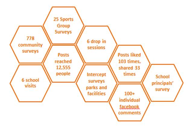
The community and stakeholder consultation was extensive and
the level of involvement from community has been great. Ross Planning
indicated that the number of community members providing input into
Byron’s draft Plan was at the same level as they have experienced in
other shires that have much larger populations.
A snapshot of key consultation outcomes is below and
additional information is at pages 12-13 of the draft Plan:
Why the Open Space and
Recreation Plan is important
Some of our communities have inherited open space legacy
issues from historic decisions of developers or past governments or councils.
In some cases, these have led to reactive decisions about open space, for
example under or over investment in some sites or a focus on some areas in the
Shire over others.
Recently, communities and Council have collaborated to start
writing a new open space and recreation story for this Shire.
Examples include the purchase and development of the Shara Boulevard
Sportsfields, reviews of a number of Plans of Management, the acquisition from
State Government of the Suffolk Park Sportsfields and improvements at Waterlily
Park.
This draft Plan is a key part of this new story. It will
support proactive and equitable management of open space and recreation
opportunities across the Shire and contribute to positive health and wellbeing
outcomes for current and future generations.
For residents and users of open space in the Shire, the
Plan:
· Will
help deliver improved recreation and sporting opportunities through
targeted investment and coordination of Council and community effort.
For ratepayers and external
agencies, the Plan:
· Identifies
the most efficient way for funds to be invested across the open space network
and it provides support for grant applications to help make funding go further.
For Council and staff, the
Plan:
· Provides
the ‘blueprint’ for forward budget and works program development to
proactively manage open space and recreation and it provides a basis for
collaborations with community around future use of particular sites.
It is acknowledged up front,
that the Plan and Council’s management of open space and recreation
cannot meet everyone’s expectations. In a Shire the size of Byron, it is
just not possible for Council to provide space and facilities to meet every
need.
What the Plan does do is
provide strategic direction with the aims of:
· Transparently
and fairly meeting as much of the demand as possible, within the physical,
legislative and funding constraints Council operates under.
· Being
upfront when Council cannot meet a need, providing reasons.
· Promoting
opportunities for private or non-government providers to fill identified gaps.
Where to from here
It is recommended that the Plan be placed on exhibition.
This will provide everyone a further chance to consider the Plan and
recommendations in the context of the entire open space network and provide
feedback. This is important because funding and resources for open space
and recreation are not limitless. Any change to one part of the network will
always result in a need to make a ‘trade off’ in another part of
the network.
The final stage of consultation would run for 28 days.
During this time, Council would promote the consultation through:
· traditional,
digital and web media;
· its
halls and facilities; and
· through
letters to all the stakeholder and user groups who have been involved
date.
After this final round of consultation:
· if
there are no submissions, the Plan would get adopted and could start to be
implemented;
· if
there are submissions, the feedback will be considered, any resulting
adjustments that can be made to the Plan and a consultation report would be
prepared. Then a third Councillor workshop be held, if needed, and the final
Plan be reported to Council for adoption.
Interaction of the draft Plan with other projects and
initiatives
Below are just some examples of how this draft Plan is a
core underpins or interacts with a number of other projects and initiatives:
1. Wellbeing
Framework
Managing and improving
open space and recreation opportunities by acting on this Plan’s
recommendations, will directly contribute to improving outcomes under a number
of the Wellbeing Indicators that Council has recently adopted, including:
- community
facilities - community
connectedness
- health - life
satisfaction
- recreation - open
space
2. Community
Solutions Panel
This Plan is consistent
with the Panel’s key considerations of:
o being proactive, not
reactive;
o recognising there are
different needs in different places;
o supporting investing in
renewal when it is practical and necessary;
o encouraging and
supporting shared ownership of community issues;
o requiring organisational
accountability and transparency.
The Plan also directly
contributes to the first 3 of Panel’s Priority Values of:
o safety– ensuring
spaces and facilities are built and maintained to not harm anyone;
o community wellbeing
– open spaces and facilities are key contributors to positive community
and individual physical, mental, emotional, spiritual and social health.
o connectivity – the
Plan contains recommendations along the lines of the Panel’s third
priority of promoting intra-Shire access for pedestrians and cyclists.
o The Community Solutions
Panel’s recommendations for funding priorities will influence the timing
of when actions in this Plan can be delivered.
3. Feasibility
of aquatic options
This Plan provides
information on evidence-based demand for aquatic facilities and trends in
aquatic recreation. The work currently underway in accordance with Resolution
18 -039, to review the feasibility of different options for aquatics in
the Shire, needs to be completed for further community and Council consideration.
4. Byron
Bay Skatepark Consultation
This Plan provides
evidence of demand and supports development of a new skatepark in Byron Bay.
The recent consultation is consistent with the draft Plan action to investigate
a location for the new Byron Bay skatepark. With this matter being reported to
23 August 2018, one of the actions in the Plan is already well advanced.
5. Planning
Proposal – Rezone & Reclassify (Part) Lot 22 DP 1073165, Stuart
Street, Mullumbimby
The objective of the
Planning Proposal for Lot 22 is to rezone part of the subject land on the
western edge of Mullumbimby to provide for additional residential development
and reclassify it from Community land to Operational land. Of the rest of
the land, a strip of it adjacent to Saltwater Creek will remain a Deferred
Matter zone and the balance be retained in the current RE1 Public Recreation
zone with the current Community land classification.
Whether all of this land
was needed for future use as a recreation area was as part of the Byron Shire
Recreation Needs Assessment. The findings of that assessment were
considered in preparation of the planning proposal and will be publicly
exhibited with the planning proposal.
6. Masterplanning
projects
This Plan, in particular
the Spaces Hierarchy, will be a lens used to help prioritise and guide
initiatives from completed, and nearly completed, town and village masterplans.
For future masterplanning projects, the Plan will provide a basis for
discussions with communities and decisions on Masterplan initiatives.
7. Department
of Education – Share our Space program
Appendix B to the Plan
is the start of a list of public school recreation assets in the Shire. It is a
starting place and can be added to with improved understanding. Councillors
requested this information be included with a view to starting conversations
with local schools about the potential to open up spaces outside of school
hours for community use. Since that time, the State Government has held to
trials during school holidays and they are currently seeking feedback from the
community on the initiative – see https://www.schoolinfrastructure.nsw.gov.au/news/2018/04/share-our-space-these-school-holidays.html.
Financial Implications
The deferral has delayed the project but provided the
remainder of the 2016/2017 funding for this project is carried forward into the
2017/2018 budget, it is still on track to be delivered within the original
budget. The carry forward of the budget will be recommended in the Carryovers
for Inclusion in the 2018/19 Budget Report to this meeting.
Statutory and Policy
Compliance Implications
The Open Space and Recreation
Needs Assessment and Action Plan supports delivery of a number of the Community
Strategic Plan 2028 Strategies.
Development of the Plan was
an action in the 2016/2017 Operational Plan (deferred as requested by Council)
. Its finalisation and adoption is key to delivering a number of 2017/2018
Operational Plan activities, with 2 examples being:
|
Objective 1
|
We have infrastructure, transport
and services which meet our expectations
|
|
Strategy 1.2
|
Provide essential services and
reliable infrastructure which meet an acceptable community standard
|
|
Action 1.2 c)
|
Develop infrastructure new works
program in line with Community Solutions Panel values
|
|
Activity:
|
Prepare a new works 10 year
program that is aligned to an adopted Recreational Needs Assessment and
Solutions Panel values
|
|
Objective 2
|
We cultivate and celebrate our
diverse cultures, lifestyle and sense of community
|
|
Strategy 2.3
|
Provide accessible, local
community spaces and facilities
|
|
Action 2.3 f)
|
Ensure Shire wide assessment of
the current and future needs of the community for active and passive
recreation is integrated into Open Space works programs
|
|
Activity:
|
Update Open Space work programs
in alignment with an adopted Recreational Needs assessment
|
Staff Reports - General Manager 13.6
Report No. 13.6 Revised
Community Engagement Policy
Directorate: General
Manager
Report
Author: Annie
Lewis, Media and Communications Coordinator
File No: I2018/1530
Theme: General Manager
General Manager
Summary:
The purpose of this report is to present the revised
Community Engagement Policy (E2018\10445) to Council with a recommendation it
be put on public exhibition.
|
RECOMMENDATION:
1. That
Council note the report.
2. That
the Revised Community Engagement Policy be put on public exhibition.
|
Attachments:
1 Revised
Draft Community Engagement Poilcy, E2018/67564
⇨
Report
Background
In 2016/17 the Mayor, the former Media and Communications
Officer (Donna Johnston) and the Community Roundtable began working on an
updated Community Engagement Policy to replace the existing policy from 2015.
The resignation of Ms Johnston, and my subsequent
appointment, and the necessity to have input from the Executive Team delayed
the policy, which has since been rewritten to take into account feedback
received as part of the development of the Community Strategic Plan,
The Revised Community Engagement Policy also acknowledges
the outcomes of the Community Solutions Panel project.
The Policy will need to be updated when the
‘Byron’ model of deliberative democracy is finalised and when the
changes to the NSW Environmental Planning and Assessment Act are ready to be
implemented. This is acknowledged in the document.
The Executive Team, Communications Panel and the Community
Roundtable have provided feedback to the Revised Community Engagement Policy.
What are the aims of the Community Engagement Policy?
The Community Engagement Policy is Council’s
commitment to working with the community and providing people with information
that is timely, relevant, easy to understand and encourages people to make a
contribution and work with Council is a variety of different ways.
This policy aims to:
· Improve
understanding of local government responsibilities, structure, functions and
decision-making processes.
· Improve
the quality of decision-making processes.
· Enable
the community and stakeholders to express their views and participate in
Council’s decision-making.
· Enhance
the relationship between Council and the community and support effective
partnerships.
· Keep
elected representatives informed about local concerns and the possible impact
of their decisions on the community.
· Support
Council and community in working together in a mutually supporting relationship
and securing outcomes that ensure the sustainable future of the Byron Shire.
· Achieve
outcomes through consensus rather than adversarial processes.
· Ensure
that community consultation is guided by principles of honesty, accessibility,
equity and transparency.
Financial Implications
Nil.
Statutory and Policy Compliance Implications
Nil.
Staff Reports - Corporate and Community Services 13.7
Staff Reports - Corporate and Community Services
Report No. 13.7 Land
and Environment Court Proceedings Gordon Highalands Pty Ltd
Directorate: Corporate
and Community Services
Report
Author: Ralph
James, Legal Counsel
Chris Larkin, Manager Sustainable
Development
File No: I2018/1132
Theme: Corporate Management
Corporate Services
Summary:
On 26 October 2017 Council received a report in respect of a
development application which sought development consent for erection of a
three (3) storey mixed-use residential and commercial development including six
(6) Shop Top Housing dwellings, three (3) commercial premises and car parking
for fifteen (15) vehicles (inclusive of one (1) disabled parking bay) over 9
Station Street, Bangalow
Council resolved (17-515) to defer consideration of
development application 10.2017.198.1:
1. To
obtain further information;
2. To
request the proponent to lodge amended plans to reduce the bulk and scale that
does not require an excessive cut contrary to the DCP 2014; and
3. An
independent review of heritage assessment regarding the site context and sunken
façade of the commercial components and their interface with the street.
On 28 November 2017 Council was served with a Class 1
application in the Land and Environment Court jurisdiction appealing against Councils
deemed refusal of the development application.
On 1 February 2018 Council resolved as follows:
1. That
no further action be taken in respect of Resolution 17-515.
2. That
after the s34 Conciliation Conference but before a s34 Conciliation Agreement
is entered the matter be reported to Council for consideration of any proposed
s34 Conciliation Agreement and for Council to provide authorisation to the
General Manager to enter a s34 Conciliation Agreement if supported by a
resolution of Council.
Council instructed it external solicitors Marsdens to appear
in the proceedings. Council’s external solicitors engaged heritage expert
David Logan of GML Heritage and planning expert Gerard Turrisi of GAT & Associates.
On about 5 June 2018 the Applicant provided amended plans
and further documents for the purposes of the conciliation conference.
Council’s solicitors forward the amended plans to Council’s
heritage and planning experts for review.
Council’s heritage expert confirmed that the amended
plans were a significant improvement, from a heritage viewpoint, on those of
the application. This was largely due to the reduction in height and deletion
of the second floor together with the distribution and articulation of the
building over the site. Nevertheless, certain design issues that have heritage
impacts still remained and would need to be addressed before he would recommend
approval on heritage grounds. His opinion was that these are all readily
achievable.
Council’s planning expert commented that the plans
provide a great improvement but that there were still some issues that require
resolution.
The conciliation conference took place on 18 June 2018.
On 3 July 2018 the Applicant filed a Notice of Motion
seeking leave to rely on amended plans.
The amended Plans have reduced the number of residential
units from 6 to 5 and removed the third storey from development providing for a
development which is reflective of the heritage characteristics of the Bangalow
area and having regards to the sites commercial zoning as B2 Local Centre. With
the removal of the third storey, the proposal has also reduced the level of
earthworks as previously proposed as it is no longer seeking approval to fit in
a third storey within the 9 metre height limit.
It is considered the proposal as amended is satisfactory and
that the General Manager be granted delegations to enable Consent Orders or a
S34 Agreement to be entered into.
|
RECOMMENDATION:
That the General Manager be authorised to enter
into consent orders or a s34 Conciliation Agreement approving Development
Application 10.2017.198.1, subject to appropriate conditions to be finalised
under delegation.
|
Attachments:
1 Confidential
- REPORT ON THE CONCILIATION PHASE OF THE MATTER, E2018/55451
2 Plans , E2018/67707 ⇨

3 Plans, E2018/67708 ⇨
4 Basix, E2018/67703 ⇨

5 Conditions
of Consent, E2018/67693 ⇨
6 submissions
received, E2018/67702 ⇨
Report
On 26 October 2017 Council received a report in respect of a
development application which sought development consent for erection of a
three (3) storey mixed-use residential and commercial development including six
(6) Shop Top Housing dwellings, three (3) commercial premises and car parking
for fifteen (15) vehicles (inclusive of one (1) disabled parking bay) over 9
Station Street, Bangalow
Staff reported that the proposal was considered to satisfy
the relevant provisions of Byron LEP 2014.
The site falls within the boundaries of the Bangalow
Conservation Area. The applicant had submitted a ‘Statement of Heritage
Impact’ demonstrating the proposal would be contributory to the
surrounding conservation area.
The proposed building was considered by staff to be
compatible with the Bangalow Conservation Area and consistent with
Council’s DCP 2014 Part C Non-Indigenous Heritage. In addition, the
proposed development was considered consistent with all relevant state planning
instruments and with the provisions of the Byron Local Environmental Plan 2014
& Development Control Plan 2014.
Council resolved (17-515) to defer consideration of
development application 10.2017.198.1:
1. To
obtain further information;
2. To
request the proponent to lodge amended plans to reduce the bulk and scale that
does not require an excessive cut contrary to the DCP 2014; and
3. An
independent review of heritage assessment regarding the site context and sunken
façade of the commercial components and their interface with the street.
On 28 November 2017 Council was served with a Class 1
application in the Land and Environment Court jurisdiction appealing against
Councils deemed refusal of the development application.
The application sought that the development be approved.
Council instructed it external solicitors, Marsdens, to
appear in the proceedings. Council also instructed that an external Heritage
expert be retained to assist in the proceedings. Those instructions were also
given in contemplation of the terms of resolution 17-515/3.
Council’s
solicitors were briefed with the full DA file and the staff report to
Council’s Ordinary Meeting on 26 October 2017 and all of its attachments
- including the submissions of the objectors.
Council’s
solicitors were also briefed with the terms of resolution 17-515 and a
transcript of the debate in Council on 26 October 2017.
Council’s external solicitors engaged heritage expert
David Logan of GML Heritage and planning expert Gerard Turrisi of GAT & Associates.
The matter was reported to Council’s Ordinary Meeting
of 1 February 2018. Council resolved as follows:
1. That
no further action be taken in respect of Resolution 17-515.
2. That
after the s34 Conciliation Conference but before a s34 Conciliation Agreement
is entered the matter be reported to Council for consideration of any proposed
s34 Conciliation Agreement and for Council to provide authorisation to the
General Manager to enter a s34 Conciliation Agreement if supported by a
resolution of Council.
On 2 February 2018 the Land and Environment Court made
Orders listing the proceedings for a section 34 conciliation conference on 18
June 2018.
On about 5 June 2018 the Applicant provided amended plans
and further documents for the purposes of the conciliation conference.
A conciliation conference was held in the proceedings on 18
June 2018 presided over by Acting Commissioner Morris. Adam Seton solicitor
(Marsdens) appeared on behalf of Council at the conciliation conference with
Gerard Turrisi (Town Planner), David Logan (Heritage Consultant) and Council
officers Ralph
James and Chris Larkin. The Applicant was represented by Gary Green and Ryan
Bennett (Solicitors), Alison McCabe (Town Planner), Brian McDonald (Heritage
Consultant) and Ben Raymond (Architect).
The conciliation conference commenced at the site with oral
evidence being given by three objectors.
After hearing from the
objectors the conciliation continued at the Cavanbah Centre.
Councillors should refer at
this point to Confidential attachment 1 which reports on the conciliation
conference phase of the proceedings.
The conciliation conference was
terminated. The proceedings were listed for a directions hearing on 26 June
2018. On that day the proceedings were adjourned to 6 July 2018. On that day
the matter was fixed for hearing on 21 and 22 February 2019.
On 3 July 2018 the Applicant
filed a Notice of Motion which sought leave to rely on amended plans.
The applicant has since
provided amended plans which generally accord to the intended outcomes sought
for the Bangalow B2 Local Centre Zone. The amended proposal is considered to
comply with the Byron LEP 2014 and Byron DCP 2014 and addresses Councils
resolution (17-515). The amended design has incorporated the following:
· reduced
the number of storeys from three (3) down to two (2) storeys
· reduced
the number of units from six (6) units down to five (5) units
· the
design has been ‘broken up’ into clearly defined roof elements to
individual units
· the
design has reduced the proposed cut and fill resulting in a better integration
of commercial tenancies with the street
A summary of the
amendments is provided below:
|
|
Previous
Design
|
Amended
Design
|
Change
|
|
No. of Residential Units
|
6
|
5
|
1 unit removed
|
|
Commercial GFA
|
Shop 1 (floor area
78.5m²) Shop 2 (floor area 112m²) Shop 3 (floor area
80.5m²)
Total = 271m2
|
Shop 1 (floor area 82m²)
Shop 2 (floor area 67m²) Shop 3 (floor area 77m²)
Total = 226m2
|
Reduction of 45m2
GFA
|
|
Height
|
9.0m
|
8.5m (approx.)
|
Reduced by 0.5m
|
|
Storeys
|
Three (3)
|
Two (2)
|
Reduced by 1 storey
|
|
Car parking
|
6 spaces for residential
units
14 (13.55) spaces for
commercial area
Required = 20 spaces
Provided = 15
|
6 spaces for residential
units
12 (11.3) spaces for
commercial area
Required = 17.3 spaces
Provided = 12
|
Reduction of 3 parking spaces
|
|
Initial proposal
|
|
|
|
Amended proposal
|
|
|
The changes made to the front
elevation demonstrate the overall reduction in bulk and scale of the
development when viewed from Station Street. The bulk and scale has been
further reduced through the use of individual roof forms for each of the
proposed residential units which provide a consistency of built form within the
streetscape and the surrounding area, whilst the removal of the third storey
ensures the development does not diminish the prominence of the A&I Hall.
The amended plans also provide for a reduction in earthworks on the site
although some cut and fill is proposed to provide for a workable building
platforms for the ground floor commercial premises. Significantly though,
the applicant is no longer seeking to lower the development into the site to
fit in the upper third storey within the 9 m height limit.
.
The proposal provides for an
improved interface with Station Street and is satisfactory having regards to
Councils Resolution 17-515
Public Notification of
Amended Plans
The application was
re-exhibited between the period of 19 July 2018 to 1 August 2018. Five (5)
submissions have been received. All submissions form Confidential attachment 6
hereto.
The following issues have
been raised.
|
Submission
|
Response
|
|
Loss of Greenspace
Our major concern is the loss
of green space resulting from this development. The likely erosion of
open space from ongoing developments in Station St will inevitably lead to
the removal of a unique heritage attribute in Bangalow Village. We therefore
want to work with council to replace such loss with usable public space,
facilitated by the use of a Voluntary Planning Agreement.
|
The site is located with a B2 Local Centre which allows
for development with 0m setbacks.
Landscaping is shown to all site boundaries as part of the
development concept, which will retain a green edge to the site in keeping
with the ‘garden’ character of this streetscape precinct.
Under Chapter E2 Bangalow - E2.3.2 Development within B2
Local Centre Zone There is no requirement to maintain landscaping around
commercial buildings other than to implement a avenue of shady street trees
along Station Street.
|
|
Colours
The use of heritage colours for external surface areas, as
prescribed for the Bangalow Heritage Area, would be preferred so that a
dramatic contrast to A&I Hall is avoided.
|
A condition recommending use of colours contained within
the Byron DCP 2014 is recommended in this instance as the proposed colours
provided by the applicant indicate a predominantly white colour pallet.
|
|
Plan dimensions
Elevation diagrams need to show
building height and window dimensions to enable confirmation that height does
not exceed 9m and that overlooking is acceptable and does not compromise
privacy.
|
The plans provided are to scale to enable accurate
measurement and dimensioning.
The development is well within the 9m height limit.
|
|
Landscaping
Trees chosen for sections along the common boundary with
11 Station St could seriously overshadow this adjoining property over
time.
|
The trees shown in the Landscaping Plan along the southern
boundary should be replaced with lower shrubs to minimise the loss of light
to the southern neighbour.
|
|
Station Lane - Safety
Additional commercial traffic
in Station Lane will create a safety risk for young school children who
regularly use this lane to access the primary school.
The narrow Station Lane cannot
safely serve this proposed development – with a maximum of 31 links
road reserve width for vehicular access for shops and service vehicles. The
laneway cannot safely serve this development. This is not a two-way traffic
option.
|
The use of Station Lane and
the interaction of school children using the lane leaving and entering
Bangalow Public School. The concern was that children may be in danger due to
vehicles using the rear lane.
Children do cross the Laneway
and walk down the Laneway towards Byron Street. The laneways are important in
commercial areas to allow for unloading and back of house functions (such as
access to parking and for servicing) rather than providing for this on main
street frontages. The lane is used by school children however, the
predominant use for the lane should allow for service functions of those
developments fronting onto Station Street including access for vehicles.
The lane is not a high speed
environment and vehicles will be able to enter and leave in a forward
direction.
It is noted that Councils
Development Engineer recommended that Station Lane be upgraded to a full
width sealed pavement construction with kerb & gutter and controlled
drainage along the site’s frontage to the Lane, south of the site
through to the existing fully constructed pavement.
|
|
Parking and overdevelopment
This amended DA seems to STILL
be for Six Units, with the largest unit clearly designed to function as a
distinct pair.
Parking requirements have not
been addressed, for takeaway food shops and for residents.
Insufficient garbage bin
spaces are provided.
|
The amended plans provide a total of five (5) units down
from the previous development proposal of six (6) units.
Parking onsite has been fully provided for each of the
residential units with the shortfall of commercial parking to be provided
under a voluntary planning agreement (shortfall of 5 parking spaces).
Business Premises and Food and Drink Premises have the same
car parking generation within Business and Industrial Zones.
The applicant has stated they are willing to enter into a
voluntary planning agreement with council in regards to car parking short
fall of eight spaces. Appropriate conditions to apply.
|
|
Privacy
The development balconies and
windows on the southern elevation overlook 11 Station Street and require
screening.
|
The proposed development includes upper level windows
which have the potential to overlook the neighbouring dwelling to the south.
The plans indicate the use of double hung windows on this elevation as
opposed to large sliding glass windows. They are also proposed to be glazed
with an opague glass to limit the ability to overlook the adjoining property.
It is considered the need for additional screening in this regards is not
required
In terms of the balconies on this elevation, the rear one
is to be screened as it overlooks the rear yard of 11 Station Street.. In
terms of the front balcony it is considered that a privacy screen is not
required as it overlooks the street and the front yard of number 11 which
already interfaces with the public domain.
|
Financial Implications
The estimated professional legal costs of
defending the appeal is $25,000-$30,000 excluding GST, assuming that the matter
is not settled at a conciliation conference and the ultimate hearing in
the matter only takes 2 days. If the hearing takes longer the legal costs will
be higher.
Because Council staff recommended that development consent
be approved, it was necessary for Council to retain the services of
independent external heritage and planning experts. Estimates as to experts
costs are approximately $15,000 -$20,000.
Costs paid to date are $31,469.56
plus GST
Statutory and Policy
Compliance Implications
Conciliation is a process in
which the parties to a dispute, with the assistance of an impartial
conciliator, identify the issues in dispute, develop options, consider
alternatives and endeavour to reach agreement.
The conciliation conference is conducted by a commissioner
of the Court. Often, the commissioner will have technical knowledge and
expertise on the issues relevant to the dispute.
At the conciliation conference, the conciliator facilitates
negotiation between the parties with a view to their reaching agreement as to
the resolution of the dispute.
If the parties
are able to reach agreement on the terms of the decision in the proceedings
that would be acceptable to the parties, and that decision is one the Court
could have made in the proper exercise of its functions, the conciliation
commissioner must dispose of the proceedings in accordance with the decision
and set out in writing the terms of the decision.
If the parties
are not able to agree either about the substantive outcome the conciliation
commissioner must terminate the conciliation conference and refer the
proceedings back to the Court for the purpose of being fixed for hearing before
a different commissioner.
A Conciliation Agreement is between Council and the
applicant ie Council stays the determining authority.
Use
of a Conciliation Agreement would bring the appeal to an end immediately and
without
the
need for Council to incur any expert witness costs or any legal costs beyond
the relatively
minor costs associated with attending a conciliation conference.
Staff Reports - Corporate and Community Services 13.8
Report No. 13.8 Operational
Plan 2017-2018 and Delivery Program 2017-2021 - 6-month progress report to 30
June 2018
Directorate: Corporate
and Community Services
Report
Author: Heather
Sills, Corporate Governance Officer
File No: I2018/1349
Theme: Corporate Management
Governance Services
Summary:
Council’s Operational Plan
outlines its projects and activities to achieve the commitments in its
four-year Delivery Program.
This report summarises the
Council’s progress towards achieving the annual activities contained in
the 2017-2018 Operational Plan. This report is the six-month
progress report as at 30 June 2018. The report is the final report on the
activities of the 2016/2017 Operational Plan.
|
RECOMMENDATION:
That Council note the six-month progress report to
30 June 2018 (Attachment 1 E2018/60566) on the Operational Plan 2017-2018.
|
Attachments:
1 Delivery
Program 2017-2021 - 6 Monthly Progress Report - 1 January to 30 June 2018, E2018/60566 ⇨
Report
The purpose of this report is to
provide Council with the six month progress report on the annual Activities
contained in the Operational Plan 2017-2018, as at 30 June 2018. The
Operational Plan 2017-2018 is the annual activities component of the 2017-2021
Delivery Program adopted by Council on 22 June 2017.
The Operational Plan progress
report contains üAchieved
lSubstantially
achieved ûNot achieved icons for “at a glance” progress
status. It also includes “exception” reporting explanatory
notes where progress indicators have a red status. A comprehensive
progress report is provided at Attachment 1, and a summary is set out here:
|
52%
completed
|
41%
substantially
completed
|
8%
not achieved
|
It is important to note, that
while some activities may not have been fully achieved over the period of the
Operational Plan, many of the activities reported as ‘substantially
completed’ have been rolled over into the 2018/2019 financial year.
External factors have also impeded Council’s ability to deliver some
projects to 100% completion, based on external funding sources, legislative
requirements, and other factors out of Council’s control.
Achievements
Notable achievements (grouped by Community Strategic Plan
theme) for the six month period include:
· Corporate
management
o Revised Community Strategic
Plan adopted
o New Byron Shire Council
website launched
o 20 year leases to Byron Bay
Surf Life Saving Club and Brunswick Surf Life Saving Club
o Community Solutions Panel
delivers recommendations on infrastructure spending
o Community-led governance
principles adopted
o Partnership Proposal
Guidelines developed
o Big Revenue Ideas workshops
held
· Economy
o Business Retention and
Satisfaction Survey completed
o Launch of Easy to Do Business
program in partnership with Service NSW
o Strategic Business Panel
commenced and held 2 meetings during the reporting period, topics were;
Incubators, Coworking Spaces, and Innovation; and Agriculture in the Byron
Shire
o Launch of the Agricultural
Incubator Program
o Billinudgel is Back in
Business
o Launch of Byron Unfolded
– Trail Map
o Byron Visitors Centre reopened
after renovations
o Completed the Byron Business
Events Sponsorship – taken to Destination North Coast to be run
regionally
· Society
and Culture
o Community Wellbeing indicators
adopted
o Byron Visitors Centre reopened
after renovations
o Support for Byron Writers
Festival and Renew Fest
o 4 recipients for the Events
and Festival Sponsorship Fund
Ø Byron Bay Japan Festival
Ø Brunswick Nature Sculpture Walk
Ø Byron Bay Guitar Festival
Ø Sample Food Festival
· Environment
o Coastal Zone Management Plan
for the eastern precincts of the Byron Bay Embayment submitted to Minister for
certification
o E-zone review completed
o Pest management program in
Shire hotspots
o Byron Flying Fox Management
Plan completed
o Rural Land Use Strategy
endorsed by Department of Planning
o Byron Town Centre Planning
review commenced
· Community
Infrastructure
o 79% of $16.1M Capital Works
Program completed including
Ø Commence the bridges program in
the Nashua – Booyong area
Ø South Golden Beach Playground
Ø Capping the dipsite at Bangalow
Parklands
Ø Stage one of Railway Square Park,
Byron Bay
Ø Causeways at Durrumbal and
Fowlers Lane
Ø New reservoirs at Bangalow and
Coopers Shoot
Ø Upgrade of fire Mains across the
Shire
o Upcycling of Public Bins in
Mullumbimby
o Department of Planning
approval for rezoning and reclassification process for Lot 22 Station Street
subdivision and affordable housing partnership completed
o Suffolk Park Caravan Park land
reclassification completed
o Grant funding applications for
Fixing Country Roads successful
o ‘Bringing Back the
Bruns’ (Brunswick River) causeway improvement program launched
o Durrumbul Road causeway
upgrade complete
o Stage one Waterlily Park
upgrades complete
Future reporting
The revised Delivery Program and
new 2018/19 Operational Plan endorsed by Council in May 2018 provides for more
detailed planning, better scope and resourcing for projects and activities that
can be delivered within the 12 month period.
This will be supported through
further improvements in the reporting process which will be rolled out in the
first period of the new financial year.
Financial Implications
The Council’s financial
performance for the reporting period is addressed in the Quarterly Budget
Review, which is subject to a separate report.
Statutory and Policy Compliance Implications
The General Manager is required under Section 404 (5) of the
Local Government Act 1993 to provide regular progress reports as to the
Council’s progress with respect to the principal activities detailed in
the Delivery Program/Operational Plan. Progress reports must be provided
at least every six months.
Staff Reports - Corporate and Community Services 13.9
Report No. 13.9 Council
Resolutions Quarterly Review - 1 April 2018 to 30 June 2018
Directorate: Corporate
and Community Services
Report
Author: Heather
Sills, Corporate Governance Officer
File No: I2018/1381
Theme: Corporate Management
Governance Services
Summary:
This report provides an update on the status of Council
resolutions.
Council should note that 194 resolutions were completed
during the period 1 April to 30 June 2018. This is an increase of 96
resolutions compared with the same time period in 2017.
There were 92 active resolutions as at 30 June 2018. This is
a decrease of 29 resolutions compared with the previous reporting period as at
31 March 2018, on which date there were 121 active resolutions.
Resolutions could be active or overdue as a result of budget
constraints, staff resourcing, extended negotiations with stakeholders, or
other reasons.
|
RECOMMENDATION:
That Council:
1. Note
the information provided in this report on active Council Resolutions in Attachment
1 (#E2018/62328).
2. Note
the completed Resolutions in Attachment 2 (#E2018/66349).
|
Attachments:
1 Active
Resolutions as at 30 June 2018, E2018/62328
⇨
2 Completed
Resolutions Report - 1 April to 30 June 2018, E2018/66349
⇨

Report
This report provides a quarterly
update on the status of Council Resolutions to 30 June 2018.
As at 30 June 2018:
· 194 resolutions were
completed since 1 April 2018
· 92 resolutions remained
active
The active Council resolutions per Council terms are provided
below:
· 87 active Council
Resolutions from current Council (2016-2020)
· 5 active Council
Resolutions from previous Council (2012-2016)
Details of completed resolutions for the period are provided
at Attachment 2 (E2018/66349).
Financial Implications
A number of resolutions note that resource constraints limit
completion of action required.
Statutory and Policy Compliance Implications
· Council
requires a quarterly report be prepared to allow it to consider the six monthly
Operational Plan and Quarterly Budget reviews along with a review of Council
Resolutions.
· Implementation
of Council Resolutions in accordance with the Local Government Act 1993.
· This report
has been prepared in accordance with Part 3c) of Resolution 14-417.
Staff Reports - Corporate and Community Services 13.10
Report No. 13.10 Carryovers
for inclusion in the 2018/19 Budget
Directorate: Corporate
and Community Services
Report
Author: James
Brickley, Manager Finance
File No: I2018/1401
Theme: Corporate Management
Financial Services
Summary:
This report is prepared
for Council to consider and to adopt the carryover Budget allocations for works
and services, either commenced and not completed, or not commenced in the 2017/2018
financial year for inclusion in the 2018/2019 Budget Estimates.
Each year Council allocates funding for works and services
across all programs. For various reasons, some of these works and services are
incomplete at the end of the financial year. The funding for these works is
restricted at the end of the financial year, and is carried over as a budget
allocation revote to the following year, to fund the completion of the work or
service.
This report identifies all the works and services
recommended to be carried over from the 2017/2018 financial year to the
2018/2019 Budget Estimates. The report also identifies the funding for each
recommended budget allocation carryover.
This report is scheduled to be considered by the Finance
Advisory Committee at its Meeting held on 16 August 2018.
|
RECOMMENDATION:
That the works and services, and the respective funding
shown in Attachment 1 (#E2018/66991) be carried over from the 2017/2018
financial year and that the carryover budget allocations be adopted as budget
allocation revotes for inclusion in the 2018/2019 Budget Estimates.
|
Attachments:
1 Carryovers
for inclusion in 2018-2019 Budget - General, Water and Sewerage Funds, E2018/66991 ⇨
Report
Each year Council allocates funding for works and services
across all programs. For various reasons, some of these works and services are
incomplete at the end of the financial year. The funding for these works and
services is restricted at the end of the financial year to be carried over to
the following year for completion.
This report identifies all the works and services to be
carried over to the 2018/2019 Budget Estimates and the respective funding of
each, relating to works and services not completed during the course of the
2017/2018 financial year. The specific details of all carryover works and
services subject of this report are outlined for General, Water and Sewer Funds
in Attachment 1.
Financial Implications
The works and services included in Attachment 1 are fully
funded and have no impact on the Unrestricted Cash Result of Council or the
2018/2019 Budget Estimates result. As in previous years there is a significant amount
of carryovers to be brought forward to the current financial year. Table 1
below provides a history of the value of carryovers in recent years with the
proposed total carryovers for 2018/2019 $398,500 more then the carryovers
related to the 2017/2018 financial year. Council may recall that there
was also an earlier assessment of carryovers that was conducted before
finalisation of the 2018/2019 Budget Estimates with these being included at
that point and catered for through the 31 March 2018 Quarter Budget Review.
Table 1 - Value of
budget carryovers 2014/15 – 2018/19
|
Fund
|
2014/15 ($)
|
2015/16 ($)
|
2016/17 ($)
|
2017/18 ($)
|
2018/19 ($)
|
|
General
|
12,863,500
|
10,550,300
|
5,022,100
|
7,102,100
|
9,004,500
|
|
Water
|
586,200
|
1,671,900
|
729,900
|
2,770,100
|
879,500
|
|
Sewer
|
877,100
|
1,929,000
|
600,100
|
2,051,800
|
2,473,500
|
|
Total
|
14,326,800
|
14,151,200
|
6,352,100
|
11,924,000
|
12,357,500
|
General Fund
The value of works carried over to 2018/2019 for the General
Fund are more ($1,902,400) than that carried over for the 2017/2018 year.
Of the $9,004,500 of General Fund carryovers, approximately 40% ($3,645,400) is
attributable to Local Roads and Drainage projects not completed in 2017/2018 to
be carried forward to 2018/2019.
Major carryover items in this program are as follows:
|
· Main
Arm Road – Blindmouth Causeway
|
$884,000
|
|
· Bayshore
Drive/Ewingsdale Rd Roundabout
|
$660,300
|
|
· Rifle
Range Road Intersection Upgrade
|
$341,600
|
|
· Traffic
Study Strategic Network Analysis
|
$174,900
|
|
· Smart
Cities and Suburbs 3D modelling solutions
|
$152,400
|
|
· Brunswick
Heads Library Upgrade
|
$150,000
|
|
· Tyagarah
Airfield Development and Subdivision
|
$185,500
|
|
· CPTIGS
- Bus Shelters
|
$150,000
|
|
· Natural
Disaster (June 2016) funding
|
$347,000
|
|
· RMS
Natural Disaster
|
$525,600
|
|
· Civic
Improvements Byron Bay Town Centre
|
$377,100
|
|
· Byron
Bay Town Centre Masterplan
|
$154,100
|
|
· Multiuse
of Rail Corridor
|
$180,000
|
|
· Bangalow
Weir stage 2
|
$196,000
|
|
· Resource
Recovery Centre Upgrade
|
$350,000
|
|
· Community
Buildings Maintenance (SRV)
|
$507,100
|
|
· Suffolk
Park Community Hall s94 upgrade
|
$176,700
|
Water and Sewer Funds
Carryovers for the Water Fund have decreased by $1,890,600
and the Sewer Fund has increased by $421,700 compared to the carryover applicable
for the 2017/2018 financial year.
The following table outlines the project status of Local
Roads & Drainage capital works carryovers for Councillors information where
works are in progress or contracts awarded at the time this report has been prepared:
Table 2 –
Schedule of Carryover works current status
|
Project
|
Carryover $
|
Project Status
|
|
Byron Bay Stormwater Drainage Maintenance
|
8,100
|
Works in progress that will be completed in 18/19.
|
|
Brunswick Heads Parking
|
104,700
|
Design works in progress that will be completed in 18/19.
|
|
Bridge - Parkers
|
58,300
|
Works in progress that will be completed in 18/19.
|
|
Bridge - Booyong
|
105,300
|
Works in progress that will be completed in 18/19.
|
|
Bridge - Eureka
|
43,400
|
Works to be undertaken in 18/19.
|
|
PTIGS - Bus Shelters
|
150,000
|
Public Art process to be undertaken in 18/19 for bus
shelter renewal as per Council resolution.
|
|
Main Arm Road - Blind Mouth Causeway Upgrade
|
884,000
|
Contract awarded and works in progress. Will be completed
in 18/19.
|
|
Blindmouth & Main Arm Rds Intersection
|
142,600
|
Works to be done in conjunction with Main Arm causeway
contract works
|
|
Remove last fish passage barrier on Byron
|
8,500
|
Works in progress that will be completed in 18/19.
|
|
Bayshore Drive/Ewingsdale Rd Roundabout
|
660,300
|
Contract awarded and works in progress. Will be completed
in 18/19.
|
|
Bayshore Drive Roundabout – Artwork
|
60,000
|
Public Art works to be done in conjunction with contract
roundabout works.
|
|
Access ramps and footpaths Works
|
12,000
|
Works to be done in conjunction with Railway Park upgrade
works in 18/19.
|
|
Replacement of damaged Footpaths Shire
|
10,800
|
Works in progress that will be completed in 18/19.
|
|
Massinger St - Lawson to Carlyle
|
4,100
|
Design works in progress that will be completed in 18/19.
|
|
Shire Wide - PAMP (Pedestrian Access Man
|
53,600
|
Planning works in progress that will be completed in
18/19.
|
|
Survey, design and consultation Bay lane
|
12,200
|
Design works in progress that will be completed in 18/19.
|
|
Bridges Capital Renewal Miscellaneous
|
12,800
|
Works in progress that will be completed in 18/19.
|
|
Bridges - Brunswick Road Bridge
|
50,000
|
Works to be undertaken in 18/19.
|
|
Lighthouse Road, Byron Bay
|
9,600
|
Design works in progress that will be completed in 18/19.
|
|
22 Bangalow Road - Resolve Stormwater
|
59,900
|
Works to be undertaken in 18/19.
|
|
Project Investigation & Planning
|
59,400
|
Design works in progress that will be completed in 18/19.
|
|
Settlement Road
|
6,400
|
Design works in progress that will be completed in 18/19.
|
|
Byron St
|
26,000
|
Design works in progress that will be completed in 18/19.
|
|
Ewingsdale Rd/Sunrise Boulevard Roundabout
|
48,900
|
Land acquisition works to be completed in 18/19.
|
|
Shire Wide - Bike Plan
|
53,600
|
Planning works in progress that will be completed in
18/19.
|
|
Lismore Road Off-Road Shared Path Invest
|
19,400
|
Design works in progress that will be completed in 18/19.
|
|
Ewingsdale Road Off-Road Shared Path
|
19,000
|
Design works in progress that will be completed in 18/19.
|
|
SGB Street Drainage Upgrade – Elizabeth
|
10,000
|
Design works in progress that will be completed in 18/19.
|
|
The Pocket Road Segment 568.10 (CH1.79-2
|
17,000
|
Design works in progress that will be completed in 18/19.
|
|
Station Street, Bangalow
|
35,300
|
Design works in progress that will be completed in 18/19.
|
|
Lawson Street, Byron (Middleton to Tenny
|
9,200
|
Design works in progress that will be completed in 18/19.
|
|
Middleton St (Marvel St to Kingsley)
|
7,800
|
Design works in progress that will be completed in 18/19.
|
|
DESIGN ONLY - Kendall RAB
|
2,900
|
Design works in progress that will be completed in 18/19.
|
|
DESIGN ONLY - Ewingsdale Rd (Highway to
|
60,700
|
Design works in progress that will be completed in 18/19.
|
|
Deacon and Station Street Intersection B
|
61,400
|
Design works in progress that will be completed in 18/19.
|
|
Byron Street Byron Bay Jonson to Railway
|
7,900
|
Works in progress that will be completed in 18/19.
|
|
Shirley Street Widening Investigation
|
22,000
|
Design works in progress that will be completed in 18/19.
|
|
Gravel Resheeting
|
82,600
|
Works to be undertaken in 18/19.
|
|
Clifford St intersection with Broken Head
|
19,200
|
Design works in progress that will be completed in 18/19.
|
|
Boardwalk Design - Lawson to Butler Sts
|
30,000
|
Works to be undertaken in 18/19.
|
|
Seven Mile Beach Rd Investigations
|
20,000
|
Design works in progress that will be completed in 18/19.
|
|
Scarabelottis Lookout- Keys Bridge Reserve
|
15,000
|
Design works in progress that will be completed in 18/19.
|
|
Rifle Range Road Intersection Upgrade
|
341,600
|
Design works in progress that will be completed in 18/19.
|
|
Balemo Dr O/S shared path Orana Dr
|
17,400
|
Design works in progress that will be completed in 18/19.
|
|
Traffic Study Strategic Network Analysis
|
174,900
|
Design works in progress that will be completed in 18/19.
|
|
McGettigans / Ewingsdale Road R/about
|
27,600
|
Works to be undertaken in 18/19.
|
|
Total
|
3,645,400
|
|
Whilst Council in accordance with Clause 211 of the Local
Government (General) Regulation 2005 conducted its annual meeting to approve
expenditure and voting of money on 28 June 2018 via Resolution 18-429,
the expenditure items subject of this report were not included in the 2018/2019
Budget Estimates but now need to be. The intent of this report is to seek
Council approval to revote the carryovers from the 2017/2018 financial year and
to adopt the budget allocation carryovers for inclusion in the 2018/2019
adopted Budget Estimates.
The Strategic Planning Committee at its meeting held on 28
March 2013 considered Report 4.3 on the Council’s financial position for
the 2012/2013 financial year. The recommendations from this meeting were
adopted by Council at its Ordinary Meeting held on 18 April 2013 through
resolution 13-164. Committee recommendation SPC 4.3 in part 5 included
the following process to be applied to the consideration of any amount
identified as a carryover to the 2013/14 and future Budgets and funded from
general revenues:
That
Council determines that any general revenue funded allocated expenditure, not
expended in
a current financial year NOT be automatically carried over to the next
financial year before it is
reviewed and priorities established.
Resolution 13-164 has also been incorporated into
Part 7 – ‘Policy and Decision Making’ of the Financial
Sustainability Plan (FSP) 2017/2018 considered by Council at its Ordinary
Meeting held on 14 December 2017 (Resolution 17-647).
This report was also considered by the Finance Advisory Committee
at its Meeting held on 16 August 2018.
Statutory and Policy Compliance Implications
Regulation 211 of the Local Government (General) Regulation
2005 outlines the requirements of Council relating to authorisation of
expenditure. Specifically the Regulation 211 states:
(1) A
council, or a person purporting to act on behalf of a council, must not incur
a liability for the expenditure of money unless the council at the annual
meeting held in accordance with subclause (2) or at a later ordinary meeting:
(a) has approved the
expenditure, and
(b) has voted the money
necessary to meet the expenditure.
(2)
A council must each year hold a meeting for the purpose of approving
expenditure and voting money.
Council resolution 13-164
Part 7 – ‘Policy and Decision Making’ of
the Financial Sustainability Plan (FSP) 2017/2018.
Staff Reports - Corporate and Community Services 13.11
Report No. 13.11 Budget
Review 1 April 2018 to 30th June 2018
Directorate: Corporate
and Community Services
Report Author: James
Brickley, Manager Finance
File No: I2018/1402
Theme: Corporate Management
Financial Services
Summary:
This report is prepared in accordance with the format
required by Clause 203 of the Local Government (General) Regulation 2005
to inform Council and the Community of Council’s estimated financial
position for the 2017/2018 financial year, reviewed as at 30 June 2018.
The Quarterly Budget Review for the June 2018 Quarter has
been prepared by staff even though it is not statutory requirement to assist
Council with its Policy and decision making on matters that could have short,
medium and long term implications on Councils financial sustainability.
This report contains an overview of the proposed budget
variations for the General Fund, Water Fund and Sewerage Fund. The
specific details of these proposed variations are included in Attachments 1 and
2 for Council’s consideration and authorisation.
The report also provides an indication of the financial
position of the Council at 30 June 2018. It should be noted that the
figures provided are subject to completion and audit of the Council’s
Financial Statements for 2017/2018. Any major variances to the estimated
financial position for the 2017/2018 financial year will be included as part of
the report adopting the financial statements during October 2018.
This report is scheduled to be considered by the Finance
Advisory Committee at its meeting held on 16 August 2018.
|
RECOMMENDATION:
1. That
Council authorises the itemised budget variations as shown in Attachment 2
(#E2018/67079) which includes the following results in the 30 June 2018
Quarterly Review of the 2017/2018 Budget:
General
Fund - $0 change in Unrestricted Cash Result
a) General
Fund - $9,795,300 increase in reserves
b) Water
Fund - $1,899,300 increase in
reserves.
c) Sewerage
Fund - $3,461,600 increase in reserves
|
Attachments:
1 Budget
Variation for General, Water and Sewerage Funds, E2018/67080 ⇨
2 Itemised
Listing of Budget Variations for General, Water and Sewerage Funds, E2018/67079 ⇨
Report
Council adopted the 2017/2018 budget on 22 June 2017 via
Resolution 17-268. It also considered and adopted the budget carryovers
from the 2016/2017 financial year, to be incorporated into the 2017/2018 budget
at its Ordinary Meeting held on 24 August 2017 via Resolution 17-322.
Since that date, Council has reviewed the budget taking into consideration the
2016/2017 Financial Statement results and progress through the 2017/2018
financial year. This report considers the June 2018 Quarter Budget Review.
The details of the budget review for the Consolidated,
General, Water and Sewer Funds are included in Attachment 1, with an itemised
listing in Attachment 2. This aims to show the consolidated budget
position of Council, as well as a breakdown by Fund and Principal Activity. The
document in Attachment 1 is also effectively a publication outlining a review
of the budget and is intended to provide Councillors with more detailed
information to assist with decision making regarding Council’s finances.
Contained in the document at Attachment 1 is the following
reporting hierarchy:
Consolidated Budget
Cash Result
General Fund Cash
Result Water Fund Cash Result Sewer
Cash Result
Principal Activity Principal
Activity Principal
Activity
Operating Income Operating
Expenditure Capital income Capital
Expenditure
The pages within Attachment 1 are presented (from left to
right) by showing the original budget as adopted by Council on 22 June 2017
plus the adopted carryover budgets from 2016/2017 followed by the resolutions
between July and September, the September Review, resolutions between October
and December, the December review, resolutions between January and March, the
March review, resolutions between April and June and the revote (or adjustment
for this review) and then the revised position projected for 30 June 2018.
On the far right of the Principal Activity, there is a
column titled “Note”. If this is populated by a number, it
means that there has been an adjustment in the quarterly review. This
number then corresponds to the notes at the end of the Attachment 1 which
provides an explanation of the variation.
There is also information detailing restricted assets
(reserves) to show Council estimated balances as at 30 June 2018 for all
Council’s reserves.
A summary of Capital Works is also included by Fund and Principal
Activity.
Office of Local Government Budget Review Guidelines:
The Office of Local Government on 10 December 2010 issued
the new Quarterly Budget Review Guidelines via Circular 10-32, with the
reporting requirements to apply from 1 July 2011. Reports to Council
concerning Quarterly Budget Reviews normally provide statements in accordance
with these guidelines as a separate attachment. Given that there is no
statutory obligation for Council to produce a Quarterly Budget Review as at 30
June each financial year, the statements required by the guidelines have not
been produced for this specific report only.
CONSOLIDATED RESULT
The following table provides a summary of the overall
Council budget on a consolidated basis inclusive of all Funds budget movements
for the 2017/2018 financial year projected to 30 June 2018.
|
2017/2018 Budget Review Statement as at 30 June 2018
|
Original Estimate (Including Carryovers)
1/7/2017
|
Adjustments to 30 June 2018 including Resolutions*
|
Proposed 30 June 2018 Review Revotes
|
Revised Estimate 30/6/2018
|
|
Operating Revenue
|
77,022,500
|
5,547,700
|
2,997,600
|
85,567,800
|
|
Operating Expenditure
|
79,542,600
|
6,571,300
|
(1,339,900)
|
84,774,000
|
|
Operating Result –
Surplus/Deficit
|
(2,520,100)
|
(1,023,600)
|
4,337,500
|
793,800
|
|
Add: Capital Revenue
|
27,595,500
|
(18,949,300)
|
879,100
|
9,525,300
|
|
Change in Net Assets
|
25,075,400
|
(19,972,900)
|
5,216,600
|
10,319,100
|
|
Add: Non Cash Expenses
|
12,939,400
|
0
|
0
|
12,939,400
|
|
Add: Non-Operating Funds
Employed
|
2,160,000
|
1,239,000
|
(93,800)
|
3,305,200
|
|
Subtract: Funds Deployed for
Non-Operating Purposes
|
(64,587,000)
|
26,544,400
|
10,033,400
|
(28,009,200)
|
|
Cash Surplus/(Deficit)
|
(24,412,200)
|
7,810,500
|
15,156,200
|
(1,445,500)
|
|
Restricted Funds –
Increase / (Decrease)
|
(24,419,500)
|
7,817,800
|
15,156,200
|
(1,445,500)
|
|
Forecast Result for the
Year – Surplus/(Deficit) – Unrestricted Cash Result
|
7,300
|
(7,300)
|
0
|
0
|
GENERAL FUND
In terms of the General Fund projected Unrestricted Cash
Result the following table provides a reconciliation of the estimated position
as at 30 June 2018:
|
Opening Balance – 1
July 2017
|
$1,145,200
|
|
Plus original budget
movement and carryovers
|
$7,300
|
|
Council Resolutions July
– September Quarter
|
($50,000)
|
|
September Review –
increase/(decrease)
|
($161,900)
|
|
Council Resolutions October
– December Quarter
|
($10.000)
|
|
December Review –
increase/(decrease)
|
($42,300)
|
|
Council Resolutions January
– March Quarter
|
0
|
|
March Review –
increase/(decrease)
|
$256,900
|
|
Council Resolutions April
– June Quarter
|
0
|
|
Recommendations within this
Review – increase/(decrease)
|
0
|
|
Forecast Unrestricted
Cash Result – Surplus/(Deficit) – 30 June 2018
|
0
|
|
Estimated Unrestricted
Cash Result Closing Balance – 30 June 2018
|
$1,145,200
|
The General Fund financial position overall has remained at
zero as a result of this budget review. The proposed budget changes are
detailed in Attachment 1.
Council Resolutions impacting the Budget Result
There were no resolutions of Council during the April to
June quarter that affected the budget result.
Budget Adjustments
The budget adjustments identified in Attachments 1 and 2 for
the General Fund have been summarised by Budget Directorate in the following
table:
|
Budget Directorate
|
Revenue
Increase/
(Decrease) $
|
Expenditure
Increase/
(Decrease) $
|
Budget Result Increase/
(Decrease) $
|
|
General Manager
|
57,100
|
57,100
|
0
|
|
Corporate & Community Services
|
1,995,200
|
1,559,500
|
435,700
|
|
Infrastructure Services
|
(5,973,400)
|
(5,789,100)
|
(184,300)
|
|
Sustainable Environment & Economy
|
361,900
|
613,300
|
(251,400)
|
|
Total Budget Movements
|
(3,559,200)
|
(3,559,200)
|
0
|
Budget Adjustment Comments
Within each of the Directorates of the General Fund, are a
series of budget adjustments identified in detail at Attachment 1 and 2.
More detailed notes on these are provided in Attachment 1 with the majority of
budget revotes proposed to reflect actual results achieved.
The major consideration with this budget review is the
reduction in expenditure associated with projects not completed and under
expenditure. Council will also be considering a report to this same
Ordinary Council Meeting regarding carryover items from the 2017/2018 financial
year not completed to be added to the 2018/2019 Budget Estimates. This
report also considers the implications of that report.
Specific Cash Position
Upon reconciling Council’s total cash and investment
position at 30 June 2018 compared to the reserve movements outlined in this
Budget Review, there is an indication that Council will have total unrestricted
cash and investments of $1,145,200 – the same level as 2017.
Council commenced the 2017/2018 financial year with unrestricted cash of
$1,145,200 which was an attainment of one of Council’s short term
financial goals. The actual amounts that will be eventually allocated will be
contingent upon finalisation of the 2017/2018 financial statements yet to be
finalised and subject to external audit and further reporting to Council.
WATER FUND
After completion of the 2016/2017
Financial Statements the Water Fund as at 30 June 2017 has a capital works
reserve of $4,953,000 and held $6,692,100 in section 64 developer
contributions.
The estimated Water Fund reserve
balances as at 30 June 2018, and forecast in this Quarter Budget Review, are
derived as follows:
Capital Works Reserve
|
Opening Reserve Balance at 1
July 2017
|
$4,953,800
|
|
Plus original budget reserve
movement
|
939,000
|
|
Less reserve funded carryovers
from 2016/2017
|
(124,800)
|
|
Resolutions July -
September Quarter – increase / (decrease)
|
0
|
|
September Quarterly Review
Adjustments – increase / (decrease)
|
(40,000)
|
|
Resolutions October - December
Quarter – increase / (decrease)
|
0
|
|
December Quarterly Review
Adjustments – increase / (decrease)
|
(56,500)
|
|
Resolutions January - March
Quarter – increase / (decrease)
|
0
|
|
March Quarterly Review
Adjustments – increase / (decrease)
|
11,000
|
|
Resolutions April - June Quarter
– increase / (decrease)
|
0
|
|
June Quarterly Review
Adjustments – increase / (decrease)
|
1,240,800
|
|
Forecast Reserve Movement for
2017/2018 – Increase / (Decrease)
|
1,969,500
|
|
Estimated Reserve Balance at
30 June 2018
|
$6,923,300
|
Section 64 Developer
Contributions
|
Opening Reserve Balance at 1
July 2017
|
$6,692,100
|
|
Plus original budget reserve
movement
|
(1,874,000)
|
|
Less reserve funded carryovers
from 2016/2017
|
(2,645,300)
|
|
Resolutions July - September
Quarter – increase / (decrease)
|
0
|
|
September Quarterly Review
Adjustments – increase / (decrease)
|
(70,000)
|
|
Resolutions October - December
Quarter – increase / (decrease)
|
0
|
|
December Quarterly Review
Adjustments – increase / (decrease)
|
(50,000)
|
|
Resolutions January - March
Quarter – increase / (decrease)
|
0
|
|
March Quarterly Review
Adjustments – increase / (decrease)
|
1,184,100
|
|
Resolutions April - June Quarter
– increase / (decrease)
|
(37,500)
|
|
June Quarterly Review
Adjustments – increase / (decrease)
|
658,500
|
|
Forecast Reserve Movement for
2017/2018 – Increase / (Decrease)
|
(2,834,200)
|
|
Estimated Reserve Balance at
30 June 2018
|
$3,857,900
|
Movements for Water Fund can be seen in Attachment 1 with a
proposed estimated increase to reserves (including S64 Contributions) overall
of $1,899,300 from this review.
SEWERAGE FUND
After completion of the 2016/2017
Financial Statements the Sewer Fund as at 30 June 2017 has a capital works
reserve of $7,372,800 and plant reserve of $827,800. It also held $9,583,600
in section 64 developer contributions.
Capital Works Reserve
|
Opening Reserve Balance at 1
July 2017
|
$7,372,800
|
|
Plus original budget reserve
movement
|
(2,408,100)
|
|
Less reserve funded carryovers
from 2016/2017
|
(102,200)
|
|
Resolutions July - September
Quarter – increase / (decrease)
|
0
|
|
September Quarterly Review
Adjustments – increase / (decrease)
|
99,000
|
|
Resolutions October - December
Quarter – increase / (decrease)
|
(251,000)
|
|
December Quarterly Review
Adjustments – increase / (decrease)
|
(524,300)
|
|
Resolutions January - March
Quarter – increase / (decrease)
|
0
|
|
March Quarterly Review
Adjustments – increase / (decrease)
|
2,647,100
|
|
Resolutions April - June Quarter
– increase / (decrease)
|
|
|
June Quarterly Review
Adjustments – increase / (decrease)
|
1,853,300
|
|
Forecast Reserve Movement for
2017/2018 – Increase / (Decrease)
|
1,313,800
|
|
Estimated Reserve Balance at
30 June 2018
|
$8,686,600
|
Plant Reserve
|
Opening Reserve Balance at 1
July 2017
|
$827,800
|
|
Plus original budget reserve
movement
|
0
|
|
Less reserve funded carryovers
from 2016/2017
|
0
|
|
Resolutions July -
September Quarter – increase / (decrease)
|
0
|
|
September Quarterly Review
Adjustments – increase / (decrease)
|
(12,300)
|
|
Resolutions October - December
Quarter – increase / (decrease)
|
0
|
|
December Quarterly Review
Adjustments – increase / (decrease)
|
0
|
|
Resolutions January - March
Quarter – increase / (decrease)
|
0
|
|
March Quarterly Review
Adjustments – increase / (decrease)
|
0
|
|
Resolutions April - June Quarter
– increase / (decrease)
|
|
|
June Quarterly Review
Adjustments – increase / (decrease)
|
(91,100)
|
|
Forecast Reserve Movement for
2017/2018 – Increase / (Decrease)
|
(103,400)
|
|
Estimated Reserve Balance at
30 June 2018
|
$724,400
|
Section 64 Developer
Contributions
|
Opening Reserve Balance at 1
July 2017
|
$9,583,600
|
|
Plus original budget reserve
movement
|
(188,800)
|
|
Less reserve funded carryovers
from 2016/2017
|
(1,949,600)
|
|
Resolutions July -
September Quarter – increase / (decrease)
|
0
|
|
September Quarterly Review
Adjustments – increase / (decrease)
|
(101,700)
|
|
Resolutions October - December
Quarter – increase / (decrease)
|
0
|
|
December Quarterly Review
Adjustments – increase / (decrease)
|
(275,000)
|
|
Resolutions January - March
Quarter – increase / (decrease)
|
0
|
|
March Quarterly Review
Adjustments – increase / (decrease)
|
283,500
|
|
Resolutions April - June Quarter
– increase / (decrease)
|
0
|
|
June Quarterly Review
Adjustments – increase / (decrease)
|
1,699,400
|
|
Forecast Reserve Movement for
2017/2018 – Increase / (Decrease)
|
(532,200)
|
|
Estimated Reserve Balance at
30 June 2018
|
$9,051,400
|
Movements for the Sewerage Fund can be seen in Attachment 1
with a proposed estimated overall increase to reserves (including S64
Contributions) of $3,461,600 from this Budget Review.
Legal Expenses
One of the major financial concerns for Council over
previous years has been legal expenses. Not only does this item potentially
represent a large expenditure item funded by general revenue, but can also be
susceptible to large fluctuations.
The table that follows indicates the allocated budget and
actual legal expenditure within Council on
a fund basis as at 30 June 2018.
Total Legal Income & Expenditure as at 30 June 2018
|
Program
|
2017/2018
Budget ($)
|
Actual ($)
|
Percentage To
Revised Budget
|
|
Income
|
|
|
|
|
Legal Expenses Recovered
|
0
|
0
|
0%
|
|
Total Income
|
0
|
0
|
0%
|
|
|
|
|
|
|
Expenditure
|
|
|
|
|
General Legal Expenses
|
301,000
|
353,124
|
117.32%
|
|
Total Expenditure General Fund
|
301,000
|
353,124
|
117.32%
|
Note: The above table does not include costs incurred by
Council in proceedings after 30 June 2017 or billed after this date. An
additional $100,000 was allocated at the December 2017 budget review to the
General Legal Expenses budget, funded from the Legal Services Reserve.
The current status of the Legal Services Reserve is shown
below:
Legal Reserve
|
Opening Reserve Balance at 1
July 2017
|
$514,800
|
|
Less:-
|
|
|
Legal Services Officer
|
(61,400)
|
|
General Legal Expenses (December
2017 QBR)
|
(100,000)
|
|
Byron Rail Corridor Park
(Railway Square Upgrade) (1)
|
(22,000)
|
|
Conservation Management Strategy
(Railway Square Upgrade) (1)
|
(8,800)
|
|
Market/Comm Relocation/Use Das
(Railway Square Upgrade) (1)
|
(500)
|
|
Rail Corridor Contamination
Assessment (Railway Square Upgrade) (1)
|
(4,000)
|
|
Estimated Reserve Balance at
as at 30 June 2018
|
$318,100
|
(1) These items were approved by Council as per resolution
18-111.
Byron Railway Precinct Projects
For information, the adopted 2017/2018 Budget Estimates
currently provides an allocation of $1,457,500 funded from the Infrastructure Renewal
Reserve, TDDI Grant, Visitor Centre contribution and other sources for projects
related to the Byron Bay Master Plan – Railway Precinct.
A summary of the current projects with funded budgets
associated with the Byron Railway Precinct are outlined in the table below with
budgets presented prior to any adjustment that may be proposed in this
Quarterly Budget Review:
|
Job No
|
Project No
|
Project
|
Current Budget 2017/2018 $
|
|
4835.187
|
0
|
Byron Bay Town Centre Masterplan
|
239,300
|
|
44283.013
|
1
|
Byron Street
|
200,000
|
|
44265.001
|
1
|
Byron Street
|
311,400
|
|
4835.188
|
2
|
Byron St Connection Upgrade
|
139,000
|
|
4835.189
|
3
|
Railway Park Upgrade
|
237,500
|
|
4835.190
|
4
|
Visitor Centre Refurbishment
|
130,000
|
|
2306.028
|
5
|
Countrylink Building Project Plan
|
35,000
|
|
4835.191
|
0
|
Visitor Centre Technology Project
|
45,000
|
|
4835.219
|
18
|
Byron Rail Corridor Park
|
57,000
|
|
4835.222
|
9
|
Conservation Mgmt Strategy
|
8,800
|
|
4835.223
|
11
|
Market/Comm Relocation/DAs
|
500
|
|
4835.224
|
12
|
Rail Corridor Contamination Assessment
|
32,100
|
|
4835.225
|
13
|
Farmers Market Relocation
|
21,900
|
|
|
|
Total
|
1,457,500
|
Financial Implications
The 30 June 2018 Quarter Budget Review of the 2017/2018
Budget Estimates forecasts no change to the estimated budget attributable to
the General Fund assuming all revotes of income and expenditure reported for
Council’s consideration are approved. Overall, the short term
financial position of Council still needs to be carefully monitored on an
ongoing basis. Maintaining this result through the financial year given the
challenges is a good outcome.
It is expected also given the level of reserve funds
compared to total cash and investments at 30 June 2018, Council is likely to
have maintained an unrestricted cash balance currently estimated at least
$1,145,200. This is another achievement for Council maintaining this
result throughout the financial year.
Notwithstanding that Council has maintained during the year
its short term funding liquidity goal, Council certainly still has bigger
issues in the longer term regarding its financial sustainability such as the
provision of adequate funding for the maintenance and renewal of infrastructure
assets.
The outcomes associated with this Budget Review need to be
considered in context that they are indicative financial outcomes for the
2017/2018 financial year. Council is yet to finalise its financial
statements for the year ended 30 June 2018 which will be subject to external
independent audit.
It is expected that Council will receive a report to adopt
its financial statements for the year ended 30 June 2018 at its Ordinary
Meeting to be held on 18 October 2018 where the final financial results for the
year will be presented.
This report was also considered by the Finance Advisory
Committee at its meeting held on 16 August 2018.
Statutory and Policy
Compliance Implications
In accordance with Regulation 203
of the Local Government (General) Regulation 2005 the Responsible Accounting
Officer of a Council must:-
(1) Not later than 2 months after the end of each quarter
(except the June quarter), the responsible accounting officer of a council must prepare and submit to the council a budget review statement that shows, by
reference to the estimate of income and expenditure set out in the statement of
the council’s revenue policy included in the operational plan for the
relevant year, a revised estimate of the income and expenditure for that year.
(2) A budget review statement must include or be
accompanied by:
(a) a report as to whether or not the responsible
accounting officer believes that the statement indicates that the financial
position of the council is satisfactory, having regard to the original estimate
of income and expenditure, and
(b) if that position is unsatisfactory, recommendations
for remedial action.
(3) A budget review statement must also include any
information required by the Code to be included in such a statement.
Statement by Responsible Accounting Officer
This report indicates that the short term financial position
of the Council is still satisfactory for the 2017/2018 financial year, having
consideration of the original estimate of income and expenditure at the 30 June
2018 Quarter Budget Review.
This opinion is based on the estimated Unrestricted Cash
Result position and the maintenance overall of a balanced budget result for the
2017/2018 financial year.
Staff Reports - Corporate and Community Services 13.12
Report No. 13.12 Investments
July 2018
Directorate: Corporate
and Community Services
Report
Author: James
Brickley, Manager Finance
File No: I2018/1420
Theme: Corporate Management
Financial Services
Summary:
This report includes a list of investments and identifies
Council’s overall cash position for the month of July 2018 for
Council’s information.
This report is prepared to comply with Regulation 212 of the
Local Government (General) Regulation 2005.
|
RECOMMENDATION:
That the report listing Council’s
investments and overall cash position as at 31 July 2018 be noted.
|
Report
In relation to the investment portfolio for the month of
July 2018, Council has continued to maintain a diversified portfolio of
investments. At 31 July 2018, the average 90 day bank bill rate (BBSW) for the
month of July was 1.96%. Council’s performance to 31 July 2018 is 2.67%
Council’s performance is again higher than the benchmark. This is largely
due to the active ongoing management of the investment portfolio, maximising
investment returns through secure term deposits and purchasing floating rate
notes with attractive interest rates.
The table below identifies the investments held by Council
as at 31 July 2018:
Schedule of
Investments held as at 31 July 2018
|
Purch Date
|
Principal ($)
|
Description
|
CP*
|
Rating
|
Maturity Date
|
No Fossil
Fuel ADI
|
Type
|
Interest Rate Per
Annum
|
Current Value
|
|
28/10/16
|
650,000
|
Teachers Mutual Bank
|
Y
|
BBB+
|
28/10/19
|
Y
|
FRN
|
3.17%
|
655,144.56
|
|
24/03/17
|
1,000,000
|
NAB Social Bond (Gender Equality)
|
Y
|
AA-
|
24/03/22
|
N
|
B
|
3.25%
|
1,017,387.17
|
|
31/03/17
|
1,000,000
|
CBA Climate Bond
|
Y
|
AA-
|
31/03/22
|
N
|
FRN
|
3.25%
|
1,000,000.00
|
|
16/11/17
|
750,000
|
Bank of Queensland
|
Y
|
BBB+
|
16/11/21
|
N
|
FRN
|
2.63%
|
750,000.00
|
|
31/01/18
|
2,000,000
|
AMP Bank
|
Y
|
A
|
03/08/18
|
N
|
TD
|
2.60%
|
2,000,000.00
|
|
02/02/18
|
1,000,000
|
Rural Bank
|
Y
|
BBB+
|
02/08/18
|
Y
|
TD
|
2.62%
|
1,000,000.00
|
|
06/02/18
|
1,000,000
|
Gateway Credit Union
|
Y
|
NR
|
07/08/18
|
Y
|
TD
|
2.55%
|
1,000,000.00
|
|
08/02/18
|
1,000,000
|
AMP
|
N
|
A
|
08/08/18
|
N
|
TD
|
2.60%
|
1,000,000.00
|
|
15/02/18
|
1,000,000
|
Police Credit Union Limited (SA)
|
Y
|
NR
|
15/08/18
|
Y
|
TD
|
2.61%
|
1,000,000.00
|
|
01/03/18
|
1,000,000
|
Defence Bank
|
Y
|
BBB
|
01/08/18
|
U
|
TD
|
2.50%
|
1,000,000.00
|
|
06/03/18
|
2,000,000
|
My State Bank
|
Y
|
BBB
|
06/09/18
|
Y
|
TD
|
2.65%
|
2,000,000.00
|
|
06/03/18
|
1,000,000
|
Bananacoast Credit Union
|
Y
|
NR
|
06/09/18
|
Y
|
TD
|
2.60%
|
1,000,000.00
|
|
07/03/18
|
1,000,000
|
Bananacoast Credit Union
|
N
|
NR
|
07/08/18
|
Y
|
TD
|
2.55%
|
1,000,000.00
|
|
16/03/18
|
1,000,000
|
The Capricornian Credit Union
|
Y
|
NR
|
17/09/18
|
U
|
TD
|
2.80%
|
1,000,000.00
|
|
04/04/18
|
2,000,000
|
Police Credit Union Limited (SA)
|
N
|
NR
|
03/10/18
|
Y
|
TD
|
2.86%
|
2,000,000.00
|
|
04/04/18
|
1,000,000
|
NAB
|
N
|
AA-
|
04/10//18
|
N
|
TD
|
2.60%
|
1,000,000.00
|
|
05/04/18
|
1,000,000
|
AMP Bank
|
N
|
A
|
02/10/18
|
N
|
TD
|
2.60%
|
1,000,000.00
|
|
05/04/18
|
1,000,000
|
Police Credit Union Limited (SA)
|
N
|
NR
|
02/10/18
|
Y
|
TD
|
2.85%
|
1,000,000.00
|
|
16/04/18
|
1,000,000
|
The Capricornian Credit Union
|
Y
|
NR
|
17/09/18
|
U
|
TD
|
2.74%
|
1,000,000.00
|
|
17/04/18
|
1,000,000
|
Police Credit Union Limited (SA)
|
N
|
NR
|
17/10/18
|
Y
|
TD
|
2.94%
|
1,000,000.00
|
|
30/04/18
|
2,000,000
|
NAB
|
N
|
AA-
|
30/08/18
|
N
|
TD
|
2.64%
|
2,000,000.00
|
|
02/05/18
|
2,000,000
|
Police Credit Union Limited (SA)
|
N
|
NR
|
30/10/18
|
Y
|
TD
|
2.83%
|
2,000,000.00
|
|
02/05/18
|
1,000,000
|
Maitland Mutual Building Society
|
Y
|
NR
|
29/10/18
|
Y
|
TD
|
2.83%
|
1,000,000.00
|
|
07/05/18
|
2,000,000
|
NAB
|
N
|
AA-
|
06/08/18
|
N
|
TD
|
2.64%
|
2,000,000.00
|
|
08/05/18
|
2,000,000
|
ME Bank
|
Y
|
BBB
|
07/08/18
|
Y
|
TD
|
2.60%
|
2,000,000.00
|
|
09/05/18
|
1,000,000
|
Coastline Credit Union
|
Y
|
NR
|
07/08/18
|
U
|
TD
|
2.80%
|
1,000,000.00
|
|
15/05/18
|
1,000,000
|
Maitland Mutual Building Society
|
N
|
NR
|
15/08/18
|
Y
|
TD
|
2.85%
|
1,000,000.00
|
|
15/05/18
|
1,000,000
|
Maitland Mutual Building Society
|
N
|
NR
|
15/10/18
|
Y
|
TD
|
2.85%
|
1,000,000.00
|
|
17/05/18
|
1,000,000
|
Hunter United Employees Credit Union
|
Y
|
NR
|
17/09/18
|
U
|
TD
|
2.80%
|
1,000,000.00
|
|
23/05/18
|
1,000,000
|
The Capricornian Credit Union
|
N
|
NR
|
23/11/18
|
U
|
TD
|
2.85%
|
1,000,000.00
|
|
24/05/18
|
1,000,000
|
ME Bank
|
N
|
BBB
|
21/09/18
|
Y
|
TD
|
2.60%
|
1,000,000.00
|
|
28/05/18
|
1,000,000
|
B & E Ltd (Bank of Us)
|
Y
|
NR
|
28/11/18
|
U
|
TD
|
2.85%
|
1,000,000.00
|
|
28/05/18
|
1,000,000
|
ME Bank
|
N
|
BBB
|
27/08/18
|
Y
|
TD
|
2.60%
|
1,000,000.00
|
|
30/05/18
|
1,000,000
|
Maitland Mutual Building Society
|
N
|
NR
|
20/08/18
|
Y
|
TD
|
2.80%
|
1,000,000.00
|
|
30/05/18
|
1,000,000
|
Maitland Mutual Building Society
|
N
|
NR
|
11/09/18
|
Y
|
TD
|
2.80%
|
1,000,000.00
|
|
30/05/18
|
1,000,000
|
AMP Bank
|
N
|
A
|
25/02/19
|
N
|
TD
|
2.80%
|
1,000,000.00
|
|
31/05/18
|
1,000,000
|
Maitland Mutual Building Society
|
N
|
NR
|
20/08/18
|
Y
|
TD
|
2.80%
|
1,000,000.00
|
|
01/06/18
|
1,000,000
|
Suncorp
|
Y
|
A
|
30/08/18
|
Y
|
TD
|
2.65%
|
1,000,000.00
|
|
01/06/18
|
1,000,000
|
Police Credit Union Limited (SA)
|
N
|
NR
|
21/09/18
|
Y
|
TD
|
2.82%
|
1,000,000.00
|
|
05/06/18
|
1,000,000
|
NAB
|
N
|
AA-
|
03/10/18
|
N
|
TD
|
2.70%
|
1,000,000.00
|
|
08/06/18
|
2,000,000
|
ME Bank
|
N
|
BBB
|
07/12/18
|
Y
|
TD
|
2.84%
|
2,000,000.00
|
|
08/06/18
|
1,000,000
|
Suncorp
|
N
|
A
|
09/10/18
|
Y
|
TD
|
2.82%
|
1,000,000.00
|
|
12/06/18
|
1,000,000
|
Bankwest
|
Y
|
AA-
|
12/09/18
|
N
|
TD
|
2.70%
|
1,000,000.00
|
|
14/06/18
|
2,000,000
|
Suncorp
|
N
|
A
|
12/09/18
|
Y
|
TD
|
2.75%
|
2,000,000.00
|
|
15/06/18
|
1,000,000
|
Suncorp
|
N
|
A
|
15/10/18
|
Y
|
TD
|
2.80%
|
1,000,000.00
|
|
18/06/18
|
2,000,000
|
Beyond Bank
|
Y
|
BBB
|
18/12/18
|
Y
|
TD
|
2.75%
|
2,000,000.00
|
|
18/06/18
|
1,000,000
|
Gateway Credit Union
|
N
|
NR
|
18/12/18
|
Y
|
TD
|
2.90%
|
1,000,000.00
|
|
26/06/18
|
1,000,000
|
Bankwest
|
N
|
AA-
|
24/06/18
|
N
|
TD
|
2.80%
|
1,000,000.00
|
|
03/07/18
|
1,000,000
|
B & E Ltd (Bank of Us)
|
N
|
NR
|
31/10/18
|
U
|
TD
|
3.00%
|
1,000,000.00
|
|
04/07/18
|
2,000,000
|
ME Bank
|
N
|
BBB
|
27/09/18
|
Y
|
TD
|
2.70%
|
2,000,000.00
|
|
04/07/18
|
1,000,000
|
NAB
|
N
|
AA-
|
08/10/18
|
N
|
TD
|
2.57%
|
1,000,000.00
|
|
05/07/18
|
1,000,000
|
Hunter United Employees Credit Union
|
N
|
NR
|
03/10/18
|
U
|
TD
|
2.90%
|
1,000,000.00
|
|
05/07/18
|
1,000,000
|
NAB
|
N
|
AA-
|
03/10/18
|
N
|
TD
|
2.76%
|
1,000,000.00
|
|
09/07/18
|
1,000,000
|
Beyond Bank
|
N
|
BBB
|
10/12/18
|
Y
|
TD
|
2.75%
|
1,000,000.00
|
|
23/07/18
|
1,000,000
|
AMP Bank
|
N
|
A
|
21/01/19
|
N
|
TD
|
2.80%
|
1,000,000.00
|
|
23/07/18
|
1,000,000
|
NAB
|
N
|
AA-
|
22/10/18
|
N
|
TD
|
2.68%
|
1,000,000.00
|
|
23/07/18
|
1,000,000
|
Bankwest
|
N
|
AA-
|
22/10/18
|
N
|
TD
|
2.65%
|
1,000,000.00
|
|
24/07/18
|
1,000,000
|
ME Bank
|
N
|
BBB
|
22/10/18
|
Y
|
TD
|
2.73%
|
1,000,000.00
|
|
30/07/18
|
2,000,000
|
ME Bank
|
N
|
BBB
|
29/10/18
|
Y
|
TD
|
2.73%
|
2,000,000.00
|
|
N/A
|
2,080,138
|
CBA Business Online Saver
|
N
|
A
|
N/A
|
N
|
CALL
|
1.40%
|
2,080,138.36
|
|
12/01/18
|
1,011,062
|
NSW Treasury Corp
|
N
|
AAA
|
N/A
|
Y
|
CALL
|
1.60%
|
1,011,061.74
|
|
Total
|
73,491,200
|
|
|
|
|
|
AVG
|
2.67%
|
73,513,731.83
|
|
Note 1.
|
CP = Capital protection on maturity
|
|
|
N = No Capital Protection
|
|
|
Y = Fully covered by Government Guarantee
|
|
|
P = Partial Government Guarantee of $250,000 (Financial
Claims Scheme)
|
|
|
|
|
Note 2.
|
No Fossil Fuel ADI
|
|
|
Y = No investment in Fossil Fuels
|
|
|
N = Investment in Fossil Fuels
|
|
|
U = Unknown Status
|
|
Note 3.
|
Type
|
Description
|
|
|
|
B
|
Bonds
|
Principal can vary based on
valuation, interest payable via a fixed interest, payable usually each
quarter.
|
|
|
FRN
|
Floating Rate Note
|
Principal can vary based on
valuation, interest payable via a floating interest rate that varies each
quarter.
|
|
|
TD
|
Term Deposit
|
Principal does not vary during investment term. Interest
payable is fixed at the rate invested for the investment term.
|
|
|
CALL
|
Call Account
|
Principal varies due to cash flow demands from
deposits/withdrawals, interest is payable on the daily balance.
|
Environmental and Socially
Responsible Investing
An additional column has been
added to the schedule of Investments above, to identify if the financial
institution holding the Council investment, has been assessed as a ‘No
Fossil Fuel’ investing institution. This information has been
sourced through www.marketforces.org.au and identifies financial
institutions that either invest in fossil fuel related industries or do
not. The graph below highlights the percentage of each classification
across Council’s total investment portfolio in respect of fossil fuels
only.
The notion of Environmental and
Socially Responsible Investing is much broader than whether a financial
institution as rated by ‘marketforces.org.au’ invests in fossil
fuels or not. Council’s current Investment Policy defines
Environmental and Socially Responsible Investing at Section 4.1 of the
Policy. Council’s Investment Policy can be found at Council’s
website via the following link:
https://www.byron.nsw.gov.au/Council/Your-right-to-Council-information/Policies?dlv_OC%20CL%20Public%20DocLib%20Relative=(pageindex=6)
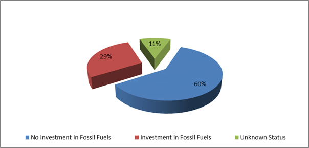
In this regard Council has an
additional two investments that are with financial institutions that invest in
fossil fuels but the purposes of the investments are in accord with the broader
definition of Environmental and Socially Responsible investments as indicated
below:
1. $1,000,000 investment with the National Australia Bank maturing
on 24 March 2022 known as a Social Bond that promotes Gender Equity.
2. $1,000,000 investment with Commonwealth Bank maturing on 31
March 2022 known as a Climate Bond.
For the month of July 2018, as indicated in the table below,
there is a dissection of the investment portfolio by investment type:
Dissection
of Council Investment Portfolio as at 31 July 2018
|
Principal Value ($)
|
Investment Linked to:-
|
Current Market Value ($)
|
Cumulative Unrealised Gain/(Loss) ($)
|
|
67,000,000.00
|
Term
Deposits
|
67,000,000.00
|
0.00
|
|
2,400,000.00
|
Floating
Rate Note
|
2,405,144.56
|
5,144.56
|
|
2,080,138.36
|
Business
On-Line Saver (At Call)
|
2,080,138.36
|
0.00
|
|
1,011,061.74
|
NSW Treasury Corp
(T Corp)
|
1,011,061.74
|
0.00
|
|
1,000,000.00
|
Bonds
|
1,017,387.17
|
17,387.17
|
|
73,491,200.10
|
|
73,513,731.83
|
22,531.73
|
The current value of an investment compared to the principal
value (face value or original purchase price) provides an indication of the
performance of the investment without reference to the coupon (interest) rate. The
current value represents the value received if an investment was sold or traded
in the current market, in addition to the interest received.
The table below provides a reconciliation of investment
purchases and maturities for month of July 2018 on a current market value
basis.
Movement
in Investment Portfolio – 31 July 2018
|
Item
|
Current Market Value (at end of month) $
|
|
Opening
Balance at 30 June 2018
|
76,506,977.26
|
|
Add:
New Investments Purchased
|
13,000,000.00
|
|
Add:
Call Account Additions
|
0.00
|
|
Add:
Interest from Call Account
|
4,513.24
|
|
Less:
Investments Matured
|
15,000,000.00
|
|
Add:
T Corp Additions
|
0.00
|
|
Add:
Interest from T Corp
|
2,241.33
|
|
Less:
Call Account Redemption
|
1,000,000.00
|
|
Add:
Fair Value Movement for period
|
0.00
|
|
Closing
Balance at 31 July 2018
|
73,513,731.83
|
Investments
Maturities and Returns – July 2018
|
Principal Value ($)
|
Description
|
Type
|
Maturity Date
|
Number of Days Invested
|
Interest Rate Per Annum
|
Interest Paid on Maturity $
|
|
1,000,000
|
NAB
|
TD
|
04/07/18
|
91
|
2.57%
|
6,407.40
|
|
2,000,000
|
ME Bank
|
TD
|
04/07/18
|
183
|
2.55%
|
25,569.86
|
|
1,000,000
|
NAB
|
TD
|
05/07/18
|
91
|
2.57%
|
6,407.40
|
|
1,000,000
|
Hunter United
Employees Credit Union
|
TD
|
05/07/18
|
90
|
2.55%
|
6,287.67
|
|
1,000,000
|
Beyond Bank
|
TD
|
09/07/18
|
124
|
2.50%
|
8,493.15
|
|
1,000,000
|
Bankwest
|
TD
|
09/07/18
|
90
|
2.60%
|
6,410.96
|
|
1,000,000
|
Bankwest
|
TD
|
12/07/18
|
91
|
2.60%
|
6,482.19
|
|
1,000,000
|
NAB
|
TD
|
16/07/18
|
124
|
2.58%
|
8,764.94
|
|
1,000,000
|
AMP Bank
|
TD
|
23/07/18
|
181
|
2.60%
|
12,893.15
|
|
1,000,000
|
NAB
|
TD
|
23/07/18
|
91
|
2.60%
|
6,482.20
|
|
1,000,000
|
Bankwest
|
TD
|
23/07/18
|
90
|
2.65%
|
6,534.25
|
|
1,000,000
|
ME Bank
|
TD
|
24/07/18
|
181
|
2.60%
|
12,893.15
|
|
2,000,000
|
Rural Bank
|
TD
|
30/07/18
|
182
|
2.60%
|
25,928.77
|
|
15,000,000
|
|
|
|
|
|
139,555.09
|
The overall ‘cash position’ of Council is not
only measured by what funds Council has invested but also by what funds Council
has retained in its consolidated fund or bank account as well for operational
purposes. In this regard, for the month of July 2018 the table below identifies
the overall cash position of Council as follows:
Dissection
of Council Cash Position as at 31 July 2018
|
Item
|
Principal Value ($)
|
Current Market Value ($)
|
Cumulative Unrealised Gain/(Loss) ($)
|
|
Investments
Portfolio
|
|
|
|
|
Term Deposits
|
67,000,000.00
|
67,000,000.00
|
0.00
|
|
Floating Rate Note
|
2,400,000.00
|
2,405,144.56
|
5,144.56
|
|
Business On-Line
Saver (At Call)
|
2,080,138.36
|
2,080,138.36
|
0.00
|
|
NSW Treasury Corp
(T Corp)
|
1,011,061.74
|
1,011,061.74
|
0.00
|
|
Bonds
|
1,000,000.00
|
1,017,387.17
|
17,387.17
|
|
Total Investment
Portfolio
|
73,491,200.10
|
73,513,731.83
|
22,531.73
|
|
|
|
|
|
|
Cash at Bank
|
|
|
|
|
Consolidated Fund
|
1,753,766.68
|
1,753,766.68
|
0.00
|
|
Total Cash at Bank
|
1,753,766.68
|
1,753,766.68
|
0.00
|
|
|
|
|
|
|
Total Cash
Position
|
75,244,966.78
|
75,267,498.51
|
22,531.73
|
Financial Implications
Council uses a diversified mix of investments to achieve
short, medium and long-term results
Statutory and Policy
Compliance Implications
In accordance with Regulation 212 of the Local Government
(General) Regulation 2005, the Responsible Accounting Officer of Council must
provide Council with a monthly report detailing all monies Council has invested
under section 625 of the Local Government Act 1993.
The Report must be presented at the next Ordinary Meeting of
Council after the end of the month being reported. In this regard, the
current Council Meeting cycle does not always allow this to occur, especially
when investment valuations required for the preparation of the report, are
often received after the deadline for the submission of reports for the
meeting. Endeavours will be made to ensure the required report will be
provided to Council and this will for some months require reporting for one or
more months.
Council’s investments are carried out in accordance
with section 625(2) of the Local Government Act 1993 and Council’s
Investment Policy. The Local Government Act 1993 allows Council to invest money
as per the Ministers Order – Forms of Investment, last published in the
Government Gazette on 11 February 2011.
Council’s Investment Policy includes the objective of
maximising earnings from authorised investments and ensuring the security of
Council Funds.
Staff Reports - Corporate and Community Services 13.13
Report No. 13.13 Bayshore
Drive Roundabout Public Art Project
Directorate: Corporate
and Community Services
Report
Author: Joanne
McMurtry, Community Project Officer
File No: I2018/1433
Theme: Society and Culture
Community Development
Summary:
The Bayshore Drive Roundabout Public Art Project is a key
deliverable in the newly adopted Public Art Strategy. The Public Art Panel met
on Friday 3 August to select the final artist to commission for the project.
Council is requested to endorse the Public Art Panel’s
selection.
|
RECOMMENDATION:
That Council:
1. Grant the preferred
artist, as per attachment 2 (E2018/66023), the commission to deliver
the Bayshore Drive Roundabout Public Art Project, subject to the project
sub-committee being
satisfied that the engineering, fabrication, timeline, and budget
have been well considered and confirmed.
2. Note that the
sub-committee on the project will work with the selected artist to facilitate
the delivery of a successful project.
|
Attachments:
1 Expression
of Interest - Public Art for Bayshore Drive roundabout, E2018/39447 ⇨

2 Confidential
- Preferred Artist's submission (Stage1&2), E2018/66023
Report
The Bayshore Drive Roundabout Public Art Project is a key
deliverable in the newly adopted Public Art Strategy.
A brief was developed with input from the Panel members and
is provided as Attachment 1.
A PAP sub-committee was selected to work with staff to
progress the commissioning of a public artwork – Lisa Hochhauser, Matthew
Baird and Julie Lipsett (Denise Napier alternate for Julie), noting that Crs Ndiaye,
Hackett and Richardson would also be involved where possible.
The Bayshore Drive roundabout is at a major
intersection of Ewingsdale Rd and Bayshore Drive, Bayshore Drive being the main
entrance to the Byron Arts and Industrial Estate, and access to Sunrise Beach
residential area. Council has received grant funding to deliver the new
roundabout by 31 January 2019.
It is Council’s preference that
the public art project is completed and installed prior to any official opening
or launch of the new roundabout.
Expressions of Interest were called via advertising from 14
June, with submissions closing 13 July. An onsite information
session was held on Tuesday 26 June with two artists attending.
The sub-committee of the Panel has met to undertake the
first round of shortlisting. The shortlisted artists signed a Concept Development
contract and were paid $1,000 each to further develop their concept designs.
The Public Art Panel held an ordinary meeting on Friday 3
August to select a final artist to commission for the project. Due to the tight
delivery timelines, this report provides the information about the final artist
selection with a request that Council support the PAP’s recommendation.
The artist’s proposal is provided at Confidential
Attachment 2 for Councillors’ information.
Financial Implications
This project is being funded from Section 94 developer
contributions.
The total available budget is $60,000, however $5,000 has
been set aside to pay for concept design development and as a small
contingency. The total available amount for artists to deliver the project is
$55,000.
There is no cost to the public art budget.
Statutory and Policy Compliance Implications
Public Art Policy
Public Art Strategy
Public Art Guidelines and Criteria
Staff Reports - Corporate and Community Services 13.14
Report No. 13.14 Water,
Waste and Sewer Advisory Committee - Community Representatives
Directorate: Corporate
and Community Services
Report
Author: Heather
Sills, Corporate Governance Officer
File No: I2018/1400
Theme: Corporate Management
Corporate Services
Summary:
Following the resignation of community member, Alan Dickens
from the Water, Waste, and Sewer Advisory Committee, Council has called for
nominations for community members to replace this position on the committee.
The purpose of the Water, Waste and Sewer Advisory Committee
is to:
a) Develop
policies for addressing the water cycle and waste cycle management needs and
aspirations of the Shire’s population in an ecologically sustainable way.
b) Develop
strategies for natural resource management / demand management for water, sewer
and waste management within the Shire.
c) Recommend
on strategies and plans that address water and waste management issues in a
regional/ broader context.
Council advertised for expressions of interest for community
representatives to the Water, Waste and Sewer Advisory Committee, which closed
on Friday, 27 July 2018.
This report has been prepared to allow Council to consider
the nominations received, as contained in Confidential Attachment 1, and advise
the Water, Waste and Sewer Advisory Committee of its community representatives.
The term for the appointed Community Representatives will be
for the remainder of the current term of Council.
|
RECOMMENDATION:
That Council:-
1. Accept
the resignation of Alan Dickens from the Water, Waste, and Sewer Advisory
committee and provide a letter of thanks.
2. Nominate
________________ for appointment to the Water, Waste and Sewer Advisory
Committee.
3. Thank
all nominees for their interest and time in submitting an Expression of
Interest.
|
Attachments:
1 Confidential
- Expression of Interest for Water, Waste and Sewer Committee Membership -
August 2018 - candidate A, E2018/65343
2 Confidential
- Expression of Interest for Water, Waste and Sewer Committee Membership August
2018 - Candidate B, E2018/65331
3 Confidential
- Expression of Interest Water, Waste and Sewer Committee Membership August
2018 - Candidate C, E2018/65345
Report
Committee
meetings are held as required, although generally every quarter for
approximately two hours during business hours.
The Expression of Interest Forms required each nominee to
address the assessment criteria sought from the prospective community
representatives. Completed Expression of Interest forms received are provided
in Confidential Attachment 1, 2 and 3.
Ideally
prospective community representatives should:
• Have an interest in the
water cycle and waste cycle management needs
• Assist
in recommending on strategies and plans that address water and waste management
issues in a regional/broader context
• Assist
develop strategies for natural resource management/demand management for water,
sewer and waste management within the Shire
• Have
an understanding of the role of Local Government
• Demonstrate
a commitment to consultative processes
• Have
the ability to develop and sustain contacts with key individuals and groupings
in the local community
• Have
the ability to effectively listen to, and cooperate with community members
holding similar or different points of view
Financial Implications
The advertisement for the applications for community
representatives were undertaken within existing allocated resources.
Statutory and Policy Compliance Implications
The
nomination of a community representative is in accordance with the Constitution
for the Water, Waste and Sewer Advisory Committee.
Staff Reports - Corporate and Community Services 13.15
Report No. 13.15 Licence
for community garden at Red Bean Close Suffolk Park
Directorate: Corporate
and Community Services
Report
Author: Paula
Telford, Leasing and Licensing Coordinator
File No: I2018/1440
Theme: Corporate Management
Corporate Services
Summary:
The resident of 32 Red Bean
Close Suffolk Park, has progressively turned the majority of open space within
Bunya Place Park into a garden area without Council approval. The area is
planted with over 100 native and fruit trees with raised garden beds, furniture
and an in-ground irrigation system.
Around 70% of the available
open space has now been planted and the area looks, to all intents, like
private property.
The resident’s use of
the land and attempts to exclude the community from the land has led to ongoing
conflict.
Meetings between Council and
the Resident resulted in Council seeking to regularise the activities on the
land by investigating the issue of a one year licence. Council sought public
comment on the proposed licence and received a number of submissions including
a petition opposing the grant of a licence signed by 198 persons.
Given the strong objections
raised by the community regarding the proposed licence, Council staff recommend
that the licence not be granted and that the reserved land be returned to state
whereby the community have full and unrestricted access to the land.
|
RECOMMENDATION:
That Council:
1. Decline
the granting of the Licence for the occupation of and carrying out of works
on Red Bean Close Reserve Suffolk Park (parcel 197060 being Lot 218 DP 846399
and Parcel 229740 being Lot 18 DP 1009620)
2. Request
the resident to return the reserve back into a passive recreational reserve
consistent with its current Plans of Management and that in the event that
the resident does not comply with such request an orders process be
undertaken to achieve the return of the reserve to passive recreation.
3. Take
steps to achieve the removal of inappropriate vegetation and structures,
including European honeybee hives from the land.
4. Request
staff to consult with the local community on level of service maintenance for
this community asset.
5. Request
staff to erect signage on the Reserve that identifies the land as Community
land.
|
Attachments:
1 Confidential
- Submissions and petition, E2018/66865
Report
The resident of 32 Red Bean
Close Suffolk Park (Resident), has progressively turned the majority of open
space within Bunya Place Park into a garden area. The garden is planted
with over 100 plants including both native and fruit trees and has installed
garden furniture, raised garden beds and an in-ground irrigation system. The
Resident mows and maintains the garden area.
Around 70% of the available
open space has now been planted and the area looks, to all intents, like
private property.
Friction between the Resident
and neighbours resulted in formal complaints being lodged with Council.
Neighbours claim that works
by the Resident effectively privatised the reserve for the Resident’s own
use. The Resident in turn claims that neighbours were pulling out or poising
the plantings in the reserve.
Later searches by Council
located a promotional advertisement on Airbnb whereby the Resident described
the area as “a private nature reserve and a fabulous big backyard that
includes… native and fruit bearing trees, 10 award winning vegetable
gardens and both native and European honeybee hives”.
Subsequent meetings between
Council and the Resident resulted in Council seeking to regularise the
activities on the land by the investigation of a license agreement which would
permit the resident to undertake a self managed community garden.
Council, in accordance with
its legislative requirements, sought public comment on the proposed licence and
received a number of submissions.
Council must now consider all
submissions received in determining whether to grant the licence.
The Land:
Bunya Place Park is
categorised as community land accessible from Red Bean Close Suffolk Park.
The land is subject to two
management plans being the:
· Generic
Plan of Management for Community Land Categorises as General Community Use
–Drainage Reserve; and
· Generic
Plan of Management for Community Land Categorises as Natural Area.
Both Plans permit the granting
of a licence over the land only if the purpose of the licence is consistent
with the core objectives of the category of the land.
Background:
In June 2016, the Resident
approached Council seeking authority to plant native trees within the reserve
that adjoined his property. Council, at that time, approved the planning
and permitted the Resident to mow some of the reserve.
Plantings on the reserve
extended beyond the planting of native trees.
In January 2017 Council,
following complaints, requested that the Resident remove all unauthorised
planted fruit trees and to provide Council with a details of any future native
tree planting.
The Resident did not provide
any details.
In February 2017 and again in
October 2017 the Resident was given written notice to remove all unauthorised
planting. Finally in December 2017 Council issued a final notice requesting the
removal of all encroachments and belongings including bee hives, raised garden
beds, exercise equipment, tools and machinery within seven days and that after
seven days council would remove all vegetation assessed as inappropriate given
the location and species.
In January 2018
Council’s Executive Team requested that Council staff attend an onsite
meeting with the Resident with a view of establishing a management plan to
formalise short-term use of the reserve and to permit a review of long-term
options.
At that meeting Council staff
noted that reported stakes and barbed-wire fencing had been removed along with
concrete garden furniture. The Resident maintained that only local native
plants had been used, that the bees were a stingless native variety and that
only edible fruit and vegetables were planted.
The Resident also expressed a
desire to work with Council to establish the garden area as a community
garden.
Following the meeting
Council’s Executive Team requested staff to investigate the prospect of
allowing a self-managed community garden. The Executive Team also requested
staff to review relevant plans of management and to advertise a proposed licence.
Submissions received from
the public exhibition:
Council publicly advertised
from 21 June to 19 July 2018, in accordance with the Local Government Act,
a proposed grant of a one-year licence to the Community Regeneration of Open
Spaces Incorporated for the purpose of general community use of a natural area
for a community garden.
Council received:
· 5 written
submissions in favour of the licence; and
· 10 written
submissions opposing the licence; and
· 198 person
petition objecting to the proposed licence.
Council must consider all submissions received in
determining whether or not to grant the one-year licence. All submissions and
the petition form Confidential attachment 1 hereto.
The table below is a summary of submission given in favour
of granting the licence.
|
Amenity Support
|
|
· Support the use
of the land.
· A great
community project with a long-term vision for creating a space for both the
wild life and human uses.
· Incorporating a
community garden into the space greatly benefits the community.
· Congratulations
on the huge improvement over land that was a mess four years ago due to
Council’s maintenance. Learning about growing fruits and plants in a
suburban area is a great asset to the community and shire and should be
encouraged.
|
The table below is a summary of submissions received
objecting to the granting of the licence.
|
Procedural Concerns
|
Council’s Response
|
|
· Lack of public
consultation regarding the proposed garden and how it is intended to operate.
· The vague and
uncertain undocumented process as proposed for Red Bean Close sets a very bad
precedent for what could be an excellent mechanism for community based
management of the land
· A competitive
process needed before granting the licence.
· Lack of
consultation with immediate neighbours, should have been a letter box drop
because a small A4 sign was ineffective.
|
· Council in
accordance with its legal obligations exhibited the proposed licence in the
local newspaper for a period of 28 days. Council gave notice, via a letter
box drop, to all persons who own or occupy land immediately adjoining the
reserve and placed a notice on the reserve.
· The primary
purpose of the licence is to formalise what has already occurred at the site.
The proposed licence will prohibits any expansion of plantings without
written consent of Council.
· The proposed
licence is provided as an interim means to formalise the garden until Council
has reviewed relevant Plans of Management and its Community Gardens
Policy. Once the review is complete Council is obliged to call for
public expressions of interest to operate the garden.
· Council
conducted a letter box drop of owners and occupiers of land immediately
adjoining the community garden site.
|
Amenity Concerns
|
Council’s Response
|
|
· The encroachment
is made for personal use not community use.
· The Resident has
privatised the space for his own purpose as demonstrated by his Airbnb
advertisement.
· The Resident has
never held an open day to talk with neighbours about his plans and get
community feedback.
· The open space
was previously used by the community walking their dogs, throwing a ball,
kids played on the land, now that use has ceased to almost naught because
residents have been intimidated away.
· The space should
be left for the community, native fauna and water not licensed for personal
use.
· Planting are for
personal consumption, there was no community consultation and has resulted in
a non-community feel.
· The produce is
being sold at nearby shops.
· Prior history of
denying and excluding public access by erecting of fencing including an
electric fence and signage.
· Prior history of
failing to comply with an order to dismantle fencing until threatened with a
fine.
· Prior history of
re-erecting fencing after order to dismantle was issued whereby the community
removed the fencing.
· Community is
concerned Council will sell the land, and that land must be kept for
community uses.
· Loss of privacy,
quietness and unobstructed access that was previous available when the land
was unoccupied
· Council has
moved its maintenance responsibly over the land to the Resident, is it
setting itself up for a big maintenance mess in the future.
· Excessive noise
and toxic fumes caused by inadequate equipment to maintain the land with
mowing and edging takes an extremely long time and the job is never complete.
· The site was
always slashed by Council now due to the Resident’s inability to slash
the site, wetland grasses are spreading towards the drainage culverts and
with drainage problems in heavy rain events, flooding is a concern.
· The ecological
benefits of expanding wetlands must be weight against loss of access by
emergency services; Council must resume its obligations to properly maintain
the land.
· Council needs to
look ahead and determine the long-term costs to the community and council
caused by the remodelling of the community space through aggressive planting,
· The Resident use
of inappropriate language (loud swearing) in a residential area.
· The Resident has
bullied the takeover of community land from the community and people no
longer feel welcome. The formalisation of his takeover should not be allowed.
|
· A proposed
licence would prohibit the Licensee from:
a) enclosing
the licensed area to the general public.
b) advertising
the licensed area for private use;
c) extending
plantings during the term of the licence without the written consent of
Council; and
d) a
breach of any essential term would result in termination of the licence and
require the Licensee to provide vacant possession of the land by removing, at
its own cost, all its structures and plantings within seven days after the
licence ends.
· The Licensed
area covers part of:
a) Lot
218 DP 846399; and
b) Lot
18 DP 1009620
both lands are
classified as Community Land and will not be sold.
· Community land
must be available for community use as determined by the Plan of Management
over the land.
· The Licensee
would be required to maintain all current plantings, gardens and landscaping
at its own cost to a standard as defined by Council.
· Council will
monitor the Licensee use and maintenance of the land to ensure all drainage
areas work effectively.
Noted
Noted
|
|
Safety Concern
|
|
|
· Prior bullying,
abusive and disturbing behaviour by the Resident that required police
intervention has left many close neighbours distressed.
· Misleading and
deceptive behaviour by the Resident in door knocking residence to mislead the
community to go to him and not Council regarding the community space.
· The
Resident’s private garden now allows for easy access for strangers to
access residential back yards and elderly residents are fearful, the land is
not suitable for a garden because it is full of trees and wildlife.
|
Noted
Noted
Noted
|
The objections contained in
the petition are summarised as:
· That
the land is community land not private and the erecting in the past of a wire
fence to prevent access does not indicate community;
· That
the applicant had to be directed to dismantle an electric fence erected to prevent
accesses does not indicate community;
· That
noise caused by the applicants use of inappropriate equipment to maintain is
excessive and the slopes to the creek are extremely neglected; and
· That
against repeated Council instructions, the applicant has turned a one open
green space maintained by Council to an unusable private tree studded maize
that does not meet local needs and grows fruit and vegetables for private
consumption.
Given the strong objections
raised by the community regarding the proposed licence, Council staff recommend
that a licence not be granted and that the reserved land be returned to state
whereby the community have full and unrestricted access to the land.
Financial Implications
Should Council resolve as recommended the Resident will be
required to remove the encroachments on the reserve. The process to achieve
this will involve staff time only.
Should the Resident fail to remove the encroachments it will
be necessary to consider the issue of Local Government Act Orders. This process
will involve staff time only and will see administration fees imposed on the
Resident.
Should the Resident failed to comply with Orders it may
become necessary for Council to remove the encroachments. Council will seek to
recover its costs from the Resident.
Statutory and Policy
Compliance Implications
Local Government Act 1993
(NSW)
Section47 Leases, licences and other estates in
respect of community land—terms greater than 5 years
(1) If a council proposes to grant a
lease, licence or other estate in respect of community land for a period
(including any period for which the lease, licence or other estate could be
renewed by the exercise of an option) exceeding 5 years, it must:
(a) give public notice of the
proposal (including on the council’s website), and
(b) exhibit notice of the proposal
on the land to which the proposal relates, and
(c) give notice of the proposal to
such persons as appear to it to own or occupy the land adjoining the community
land, and
(d) give notice of the proposal to
any other person, appearing to the council to be the owner or occupier of land
in the vicinity of the community land, if in the opinion of the council the
land the subject of the proposal is likely to form the primary focus of the
person’s enjoyment of community land.
(2)
A notice of the proposal must include:
• information sufficient to identify the
community land concerned
• the purpose for which the land will be
used under the proposed lease, licence or other estate
• the term of the proposed lease, licence
or other estate (including particulars of any options for renewal)
• the name of the person to whom it is
proposed to grant the lease, licence or other estate (if known)
• a statement that submissions in writing
may be made to the council concerning the proposal within a period, not less
than 28 days, specified in the notice.
(3) Any person may make a
submission in writing to the council during the period specified for the
purpose in the notice.
(4) Before granting the lease,
licence or other estate, the council must consider all submissions duly made to
it.
(5)
The council must not grant the lease, licence or other estate
except with the Minister’s consent, if:
(a) a person makes a submission by
way of objection to the proposal, or
(b) in the case of a lease or
licence, the period (including any period for which the lease or licence could
be renewed by the exercise of an option) of the lease or licence exceeds 21
years.
(6)
If the council applies for the Minister’s consent, it must forward with
its application:
• a
copy of the plan of management for the land
• details of all objections received and a
statement setting out, for each objection, the council’s decision and the
reasons for its decision
• a statement setting out all the facts
concerning the proposal to grant the lease, licence or other estate
• a copy of the public notice of the
proposal
• a statement setting out the terms,
conditions, restrictions and covenants proposed to be included in the lease, licence
or other estate
• if the application relates to a lease or
licence for a period (including any period for which the lease or licence could
be renewed by the exercise of an option) exceeding 21 years, a statement
outlining the special circumstances that justify the period of the lease or
licence exceeding 21 years
• a statement setting out the manner in
which and the extent to which the public interest would, in the council’s
opinion, be affected by the granting of the proposed lease, licence or other
estate, including the manner in which and the extent to which the needs of the
area with respect to community land would, in the council’s opinion, be
adversely affected by the granting of the proposed lease, licence or other
estate.
(7) On receipt of the application, the
Minister must request the Director of Planning to furnish a report concerning
the application within such period as the Minister specifies.
(8) After considering the application
and any report of the Director of Planning, the Minister, if satisfied that:
(a) subsections (1), (2) and (6)
have been complied with, and
(b) such consent would not
contravene section 46, and
(c) in all the circumstances, it is
desirable to grant consent,
may consent to the granting of a lease, licence or other
estate in respect of the whole or part of the land to which the application
relates, subject to such terms and conditions as the Minister specifies.
(8AA) The
Minister may consent to a lease or licence referred to in subsection (5) (b)
only if the Minister is satisfied that there are special circumstances that
justify the period of the lease or licence exceeding 21 years.
(8A) On request by any person, the Minister
must provide that person, within 14 days of that request, with a written statement
of reasons for consenting to, or refusing to consent to, the granting of a
lease, licence or other estate in accordance with subsection (8).
(9) The Minister’s consent is
conclusive evidence that the council has complied with subsections (1), (2) and
(6).
(10) For the purposes of this section, any provision
made by a lease or licence, or by an instrument granting any other estate, in
respect of community land, according to which the council:
(a) would suffer a disadvantage or
penalty if the same or a similar lease, licence or estate were not to be
granted, for a further term, after the expiry of the current lease, licence or
other estate, or
(b) would enjoy an advantage or
benefit if the same or a similar lease, licence or estate were to be so granted,
is taken to confer an option for renewal for a term equal to the further term.
Section
47A Leases, licences
and other estates in respect of community land—terms of 5 years or less
(1) This section applies to a lease,
licence or other estate in respect of community land granted for a period that
(including any period for which the lease, licence or other estate could be
renewed by the exercise of an option) does not exceed 5 years, other than a
lease, licence or other estate exempted by the regulations.
(2) If a council proposes to grant
a lease, licence or other estate to which this section applies:
(a) the proposal must be notified
and exhibited in the manner prescribed by section 47, and
(b) the provisions of section 47
(3) and (4) apply to the proposal, and
(c) on receipt by the council of a
written request from the Minister, the proposal is to be referred to the
Minister, who is to determine whether or not the provisions of section 47
(5)–(9) are to apply to the proposal.
(3) If the Minister, under subsection
(2) (c), determines that the provisions of section 47 (5)–(9) are to
apply to the proposal:
(a) the council, the Minister and
the Director of Planning are to deal with the proposal in accordance with the
provisions of section 47 (1)–(8), and
(b) section 47 (9) has effect with
respect to the Minister’s consent.
Staff Reports - Sustainable Environment and Economy 13.16
Staff Reports - Sustainable Environment and
Economy
Report No. 13.16 Planning
Proposal Update - The Saddle Road (26.2017.3.1)
Directorate: Sustainable
Environment and Economy
Report
Author: Natalie
Hancock, Senior Planner
File No: I2018/1370
Theme: Sustainable Environment and Economy
Planning Policy and Natural Environment
Summary:
Council,
at its 22 February 2018 meeting, considered a report on a Planning Proposal
relating to land located at Saddle Road and Gulgan Road, inclusive of
Bashforths Lane and Mangrove Lane, between Mullumbimby and Brunswick
Heads.
The impetus for
the Planning Proposal was Council’s resolution of the 22 June 2017
Ordinary Council meeting (Resolution 17-260) which supported
further site investigations and progression of Planning Proposals (where
appropriate) to rezone land for accessible housing. This initiative was
subsequently referred to as the ‘Accessible Housing
Project’ (AHP), which is aimed at providing much needed housing
opportunities for low-medium income households in the Byron Shire.
The Planning Proposal is for a significant and large new urban growth area in Byron Shire. If
developed, this area has potential to supply approximately 475 rural residential and residential lots, of
which 20% of the resulting dwellings would to be
secured for accessible housing.
The February 2018 report outlined a number of issues
requiring further assessment before Council could make an informed and final
decision on the Planning Proposal, including:
· cultural
heritage, farmland protection, infrastructure and precinct design
· a
significant number of landowners objected to being included in the Planning
Proposal
· mechanism(s)
for delivery of the ‘affordable housing’ component of the proposal
which was the pretext for it being submitted to Council.
Council
resolved at the meeting (Res 18-099) to consider a future
report on the Planning Proposal once further assessment information was
available.
Consistent
with Council’s resolution, staff have discussed with the proponents the
matters as identified in the February Council report. This report provides an
update on the current assessment status of the Planning Proposal, including
advice from the Department of Planning and Environment confirming their
position in relation to the draft Residential Strategy. That position
does not support proceeding with this Planning Proposal ahead of the
Residential Strategy.
Notwithstanding
the Department’s advice (Attachment 1), the following options are
presented in the report for Council’s consideration:
1. Advise
the proponent that determination of the Saddle Road Planning Proposal will not
occur until the Residential Strategy is finalised; OR
2. Advise
the proponent that Council notes the Department’s position however it
will continue with the assessment of the Planning Proposal (26.2017.3.1) with
reporting to Council for consideration once further information is available.
NOTE TO COUNCILLORS:
In accordance with the
provisions of S375A of the Local Government Act 1993, a Division is to be
called whenever a motion for a planning decision is put to the meeting, for the
purpose of recording voting on planning matters. Pursuant to clause 2(a)
under the heading Matters to be Included in Minutes of Council Meetings of
Council's adopted Code of Meeting Practice (as amended) a Division will be
deemed to have been called by the mover and seconder of all motions relating to
this report.
|
RECOMMENDATION:
1. Note the Department of
Planning and Environment’s advice clarifying progression of the Saddle
Road Planning Proposal as part of the Accessible Housing Project (Attachment
1.).
2.(a) Advise the proponent that Council will
continue with the assessment of the Saddle Road Planning Proposal
(26.2017.3.1) with a further report to Council for consideration once further
information is available; and
(b). That the Director Sustainable
Environment and Economy arrange an urgent meeting with the
Department of Planning and Environment to request reconsideration of the
Department’s position on early implementation of the Accessible Housing
Project initiative, and that the outcome be
reported back to Council.
OR
2. (a). Advise the proponent
that the determination of the Saddle Road Planning Proposal will not occur
until the Residential Strategy is finalised; and
(b). Notify all other Accessible Housing
Project initiative proponents identified in Resolution 17-601 that a
review of their land will occur as part of finalisation of the draft
Residential Strategy.
|
Attachments:
1 E-mail
from Department of Planning and Environment Saddle Road Planning Proposal
(27.2017.3.1) Early implementation of a Residential Strategy Action to provide
affordable housing, E2018/67368 ⇨
2 Department
of Planning and Environment Response to Byron Council concerning Accessible
Housing Project 2018-06-20, E2018/62839
⇨
3 Special
Disclosure of Pecuninary Interest, E2012/2815
⇨
Report
Background
Council
at its 22 February 2018 meeting considered a report on a Planning Proposal
relating to land located at Saddle Road and Gulgan Road, inclusive of
Bashforths Lane and Mangrove Lane, between Mullumbimby and Brunswick
Heads.
The impetus for
the Planning Proposal was Council’s resolution of the 22 June 2017
Ordinary Council meeting (Resolution 17-260) which supported
further site investigations and progression of Planning Proposals (where
appropriate) to rezone land for accessible housing.” This
initiative was subsequently referred to as the
‘Accessible Housing Project’ (AHP), which is aimed at providing
much needed housing opportunities for low – medium income households in
the Byron Shire.
The Planning Proposal is for a significant and large new urban growth area in Byron Shire. If
developed, this area has potential to supply approximately 475 rural residential and residential lots, of
which 20% of the resulting dwellings would to be
secured for accessible housing.
The February 2018 report outlined a number of issues
requiring further assessment before Council could make an informed and final
decision on the Planning Proposal, including:
· cultural
heritage, farmland protection, infrastructure and precinct design
· a
significant number of landowners objected to being included in the Planning
Proposal
· mechanism(s)
for delivery of the ‘affordable housing’ component of the proposal
which was the pretext for it being submitted to Council.
Council
at the meeting resolved Res 18-099):
That Council note the
report and that the Planning Proposal (26.2017.3.1) will be reported to Council
for consideration once further information is available.
Consistent
with Council’s resolution staff discussed with the proponents, Planners
North and Balanced Advice, the matters as identified in the February Council
report. This report provides an update on the current assessment status of the
Planning Proposal, including the Department of Planning and Environment
confirming their position in relation to the draft Residential Strategy.
Key
Matters
Landowner’s
objection to inclusion in the Planning Proposal.
The
proponent has written to landowners contained in the original Planning Proposal
area (as submitted). This letter outlined the zoning notionally nominated for
their property in the Planning Proposal and asked if they could confirm if they
would like to continue to be included in the Planning Proposal. Following
landowner responses received, the proponent intends to amend the proposal to
exclude those lands where the landowners do not wish to be part of the Planning
Proposal. A formal notification will be provided to Council.
Cultural Heritage
Any development culminating out of a rezoning must protect
and manage Aboriginal cultural heritage. The proponent has undertaken a
confidential Cultural Heritage Assessment. It is Council staff’s
understanding that this assessment is currently being reviewed by the relevant
stakeholders the Bundjalung of Byron Bay Aboriginal Corporation (Arakwal),
Tweed Byron Local Aboriginal Land Council (TBLALC) and Lois Cook. Their input is
considered critical to the credibility of this assessment, as well as ensuring
the Planning Proposal satisfies the requirements of Section 117 (2) of the Environmental
Planning and Assessment Act 1979 Direction 2.3 Heritage Conservation.
It would be premature to progress with a determination of
the Planning Proposal until the findings of this assessment are finalised.
Farmland Protection
The proponent has consulted with the Department of Primary
Industries on the North Coast Regional Plan Important Farmland Interim
Variation Criteria requirements as well as consistency with relevant Section
117 Directions. The proponent has engaged a specialist consultant to advise on
the land’s significant as farmland. The findings of this assessment are
yet to be finalised. This remains critical to the determination of the
appropriateness of this area as a new urban growth area. It would be premature
to progress with a determination of the Planning Proposal until the findings of
this assessment are finalised.
Infrastructure
Under
the Urban Growth Area Variation Principles a development is to provide ‘adequate
and cost effect infrastructure be provided to match the expected
population.’ This includes
the use of committed and planned major transport, water and sewerage
infrastructure, and having no cost to government. The proponent has
verbally advised that preliminary infrastructure capacity and sequencing
investigations do not indicate a basis for the preclusion of this area as a new
urban growth area. Discussions
are ongoing with the proponent to determine requirements, service delivery
approach and potential cost.
Regulatory Framework and
Addressing Council Resolution for Accessible Housing
This Planning
Proposal is part of the AHP. The Saddle Road precinct is outside an
identified urban growth area. The AHP centres on facilitating, prior to the finalization of the Residential Strategy,
planning proposals to rezone land for residential purposes with a certain
portion to be dedication for affordable housing purposes.
Critical to the AHP, is State government support for
assessment of the planning proposals using the North
Coast Regional Plan 2036 Urban Growth Area Variation Principles.
At the 22 June
Council meeting it was reported by staff that the Department of Planning and Environment’s position on other AHP land was that it is ‘committed to a strategic led process in identifying
new residential release areas… and that ‘ad-hoc proposals
for residential land release outside of the strategic planning framework are
generally not supported’. (full advice of 20 June 2018 letter contained in Attachment
2).
Noting this, staff have sought clarification from the
Department as to their position for the Saddle Road Planning Proposal. The
Department response reiterated their position that ‘‘Council’s
draft residential strategy is the most appropriated mechanism for
directing growth to appropriate locations that can sustainably accommodate
residential development and provide necessary services and
infrastructure.’ (Attachment 1)
The proponent has been advised of the
Department’s position in this matter.
Options for moving forward with the
Planning Proposal
The AHP invites
landowners to dedicate land for accessible housing. A pivotal incentive for landowners is, prior to the finalization of the Residential Strategy, facilitating planning proposals to
rezone land for residential purposes. Notwithstanding
the Department’s advice that it does not support this approach of
Council, two options are available to Council:
Option 1
§ Advise the proponent that
the determination of the Saddle Road Planning Proposal will not occur until the
Residential Strategy is finalised (i.e. Concur with the Department’s
position).
The consequence of this option is that there is a high
probability that such landowners are unlikely to remain part of this AHP
initiative. This is because the ‘early implementation’ incentive
for landowners to dedicate a certain portion of land for accessible housing
will be significantly reduced, and may be removed altogether. Under this
scenario the potential loss of the dwellings under the AHP may be in the order
of some 100 dwellings in the Saddle Road precinct. This combined with the
Mullumbimby properties listed in the 21 June Council resolution (Res
18-410) may equate to some 140 dwellings.
Should this be the Council’s preferred option, it will
be necessary to notify all AHP proponents identified in Resolution 17-601
that a review of their land will occur as part of finalisation of the draft
Residential Strategy.
Option 2
§ Advise the proponent that
Council notes the Department’s position however it will continue with the
assessment of the Planning Proposal (26.2017.3.1) with a report to Council for
consideration once further information is available.
Should this be Council’s preferred option, it is
recommended that the Director Sustainable Environment and Economy arrange an
urgent meeting with the Department of Planning and Environment to request
reconsideration of the Department’s position on early implementation of
the AHP initiative.
The aim of these discussions would be to demonstrate the
compelling case for Council’s proactive and innovative approach to
meeting the North Coast Regional Plan ‘Direction 25: Deliver more
opportunities for affordable housing’. It would also be to reiterate
that the AHP initiative essentially offers a one-off opportunity to address the
critical shortage of accessible housing in Byron Shire and that all AHP sites
must satisfy the site suitability requirements of the draft Residential
Strategy.
Financial Implications
If Council chooses to proceed with the Planning Proposal, it
is able to fully recover the processing costs for a proponent-initiated LEP
amendment. Council has already received an amount from the applicant to cover
initial costs associated with preparing this Council report and an assessment
report. If the Planning Proposal is to proceed through the Gateway
determination process then full cost recovery of the remaining stages will be
required by Council. If Council chooses not to proceed then the matter does not
incur any additional costs.
Statutory and Policy
Compliance Implications
The relevant policy considerations are addressed in this
report.
With either option, as noted in the
February 2018 report a rezoning review may be requested by a proponent if
Council has not supported or made a decision within 90 days of receipt of a
planning proposal. Whilst the proponent at this time confirmed in writing that
they have no intention to trigger any “Pre Gateway Review” this
option still remains available to the proponent.
Staff Reports - Sustainable Environment and Economy 13.17
Report No. 13.17 PLANNING
- Exceptions to Development Standards - 1 April 2018 to 30 June 2018
Directorate: Sustainable
Environment and Economy
Report
Author: Chris
Larkin, Manager Sustainable Development
File No: I2018/1374
Theme: Ecology
Development and Approvals
Summary:
This report is provided as a requirement of the NSW
Department of Planning Circular PS17-006, for reporting on exceptions to
development standards for applications made under clause 4.6 of the Standard
Instrument LEP and clause 6 of SEPP 1.
NOTE TO COUNCILLORS:
In accordance with the provisions of S375A of the Local
Government Act 1993, a Division is to be called whenever a motion for a
planning decision is put to the meeting, for the purpose of recording voting on
planning matters. Pursuant to clause 2(a) under the heading Matters to be
Included in Minutes of Council Meetings of Council's adopted Code of Meeting
Practice (as amended) a Division will be deemed to have been called by the
mover and seconder of all motions relating to this report.
Report
This report is provided as a requirement of the NSW
Department of Planning Circular PS17-006, for reporting on exceptions to
development standards for applications made under clause 4.6 of the Standard
Instrument LEP and clause 6 of SEPP 1.
SEPP 1 applies to development applications submitted under
Byron Local Environmental Plan 1988. Clause 4.6 applies to development
applications submitted under Byron LEP 2014.
The period of reporting is for the 1 April 2018 to 30 June
2018 for the following DA’s:
|
DA No
|
10.2017.429.1
|
|
Development
|
Dual Occupancy (Detached)
|
|
Property:
|
31 Charlotte Street Bangalow
|
|
Lot and DP:
|
Lot 42 DP 1232435
|
|
Zoning:
|
Part R2 Low Density Residential/Part RU1 Primary
Production/Part DM Deferred Matter – 1A General Rural Zone
|
|
Development Standard being varied
|
Clause 4.1E Minimum lot sizes for dual occupancies,
multi dwelling housing and residential flat buildings
The provisions establish a minimum lot size of 4000 m2 for
dual occupancy in the RU1 Zone.
|
|
Justification
|
The subject property although residential in nature and
primarily zoned R2, contains an area of RU1. A variation was sought to the
4000m2 provisions under Clause 4.1E to enable the dual occupancy to be
approved.
Due to the residential nature of this property, the size
and scale of the two dwellings (two modest three bedroom residential
cottages), its access to services and its location within a residential
area of Bangalow a variation was supported in this instance.
|
|
Extend of variation
|
30%
|
|
Concurrence
|
Council
|
|
Determination Date
|
19 April 2018
|
|
|
|
DA No.
|
10.2017.460.1
|
|
Development
|
Utility Installation: Telecommunications Tower
|
|
Property:
|
54 Jones Road Wooyung
|
|
Lot and DP:
|
Lot 100 DP 1178907
|
|
Zoning:
|
Part RU1 Primary Production/Part DM Deferred Matter
– 7(k) Habitat Zone
|
|
Development Standard being varied:
|
Clause 40 – Height of buildings
9m maximum height permitted
|
|
Justification
|
A variation was sought to Clause 9 of the LEP in
relation to the proposed Telecommunications Tower with a height of 35m.
The variation was supported due to the site selection
process, and the need for these towers to be elevated to enable the
effective provision of a mobile telecommunication service to the area of
Wooyong, Yelgun and North Ocean Shores which is deficient in this regard.
Visual impacts were considered and minimised with the closest dwelling some
240 metres away. A variation to the height limit was supported in this
instance.
|
|
Extent of variation
|
425%
|
|
Concurrence
|
Council
|
|
Determined Date
|
24 May 2018
|
|
|
|
DA No.
|
10.2018.25
|
|
Development
|
Subdivision: Two (2) Lots into Three (3) Lots
|
|
Property:
|
31 Blackwood Crescent Bangalow
|
|
Lot and DP:
|
Lot 1 DP 1233509
|
|
Zoning:
|
Part R2 Low Density Residential/Part R3 Medium Density
Residential/Part DM Deferred Matter – 1(a) (General Rural) Zone
|
|
Development Standard being varied:
|
Clause 11 - Subdivision in rural areas for agriculture
40 ha minimum
|
|
Justification
|
The proposal created two compliant residential allotments
and one residual allotment with a mix of rural and residential land. The
residual parcel contains all of the 1(a) Zoned Land and does not fragment
this small rural holding. A variation to the 40ha minimum was supported in
this instance.
|
|
Extent of variation
|
915%
|
|
Concurrence
|
Council
|
|
Determined Date
|
21 June 2018
|
|
|
Financial Implications
Not applicable.
Statutory and Policy Compliance Implications
The report is provided as a requirement of NSW Department of
Planning circular PS 17-006. This circular can be viewed at http://www.planning.nsw.gov.au/~/media/Files/DPE/Circulars/planning-circular-variations-to-development-standards-2017-12-19.ashx
Staff Reports - Sustainable Environment and Economy 13.18
Report No. 13.18 Development
of the new Tourism Management Plan
Directorate: Sustainable
Environment and Economy
Report
Author: Sarah
Workman, Tourism Officer
File No: I2018/1395
Theme: Sustainable Environment and Economy
Economic Development
Summary:
Councillors requested that staff develop an engagement
process that incorporates a ‘Citizens Jury’ or ‘Community
Solutions Panel’ for the Tourism Management Plan (TMP) during the
Strategic Planning Workshop on 7 June 2018.
The following report provides an outline of the proposed
engagement strategy and asks Councillors to allocate funds.
|
RECOMMENDATION:
1. That
Council endorse the revised engagement methodology to support the
development of the 2019-2029 Byron Shire Tourism Management Plan.
2. That Council allocate $100,000 from the Election Reserve
to fund the development of the
2019-2029 Tourism Management Plan.
|
Report
The Byron Shire Tourism
Management Plan (TMP) is an integral roadmap that assists with managing the
impacts of tourism. The current TMP is set to conclude in 2018 and it is now
time to rethink how we manage tourism growth and impacts into the future when
developing the 2019 – 2029 TMP.
It’s also important to
note, the visitor economy has dramatically changed since the last TMP was
prepared in 2007. Some of the key changes include:
· In
2017 Byron Shire received 2.1m visitors (compared with in 1,131,569 in 2007)
· Between
2014 and 2017, total visitation to Byron Shire grew by 60%, compared to 8% for
NSW
· Day
visitors have doubled in the last decade, and domestic overnight visitors grew
by 58%
· Domestic
visitor nights are up 49% from 2007, international nights are up 34%
· Byron
Bay is the 4th most visited destination in NSW and the 10th
most visited in Australia amongst international visitors
· The
Tourism industry has an output/sales of $716m recorded in 2017, this has
resulted in:
o 759 resident jobs
o 6,259 local jobs
· Private
rental accommodation is more commonly used by visitors in Byron than elsewhere
in NSW. In the three years to 2017, 17% of domestic overnight visitors used
rental properties, double most benchmarks
· Byron
has more Airbnb listings than all but three Greater Sydney LGAs,
· Properties
used for holiday renting attract higher prices due to their revenue stream. In
2017, the medium dwelling price in Byron was $865,000. This was $225,000 more
than the NSW average
A comprehensive TMP is
critical to ensure Council can assist with managing the following growth
factors, which will impact Byron Shire over the next 10 years:
· Bed
nights are expected to grow from 4.6m to 6.2m
· Every
airport is set to double capacity
· Forecasted
South East Queensland population growth will see an increase in day visitors
Members of the Community
Solutions Panel and the wider community (through the Community Strategic Plan)
also expressed their concern with managing the growth and impacts of tourism.
In addition, the Northern Rivers Joint Organisation lists managing the growth
and impacts of tourism as a key strategic priority.
Background
At the Council meeting on 1 February 2018, staff put forward
a report informing Council of the actions completed to date from the 2008-2018
Tourism Management Plan (TMP) and provided an overview of the scope and
implementation schedule for the new TMP. Council resolved (18-044):
1. That
the report be noted.
2. A
Strategic Planning Workshop (SPW) be held for Councillors to identify key
issues and objectives of a new Tourism Management Plan.
3. That
integrated transport development as defined by Resolution 08-776 be a key
consideration for discussion and inclusion in a new Tourism Management Plan.
Staff then held a Strategic Planning Workshop with
Councillors on 7 June 2018 to talk through the TMP consultation to date and to
obtain feedback. Councillors asked staff to incorporate a more comprehensive
engagement process that incorporates the form of a ‘Citizens Jury’
or a ‘Community Solutions Panel’.
“The Byron Model” of deliberative
democracy
The recently adopted “Our Byron, Our Future”
Community Strategic Plan has a clear objective to “have community-led
decision making which is open and inclusive”. Based on this and
the learnings from the Community Solutions Panel, Council resolved on 2 August
2018 to endorse the development of “The Byron Model” of
deliberative democracy.
This provides the opportunity to create a new democratic
ethos that can draw together Councillors, Council staff, stakeholders and
activists (including existing committees, bodies and groups organised by
Community and the Council), randomly-selected citizen participants and the
wider population.
Guiding principles include:
· Representativeness
· Time
· Information
· Having a clear
remit
· Upfront authority
· Partnership
· Communication and
transparency
· Fit-for-purpose
approaches.
The following provides an outline of the new engagement
methodology for the 2019 – 2029 Tourism Management Plan. Note: the
engagement strategy is aligned with the newDemocracy methodology for community
engagement.
|
Introduction
|
· Apply the newDemocracy’s principles in a 3-step
process that combines surveyed public concerns with considered public
judgement.
· Tourism in Byron Shire is increasing dramatically, and
the community must arrive at a trusted decision on how to resolve this issue,
together.
· The community must assess the difficult trade-off that
reveals the right level of balance between an individual’s freedom to
trade and the collective amenity
|
|
What topic/s?
|
Tourism is important to Byron, but places increased
pressures on the area.
How can we find a fair balance between private
benefit and community values?
|
|
What is the final product?
|
· A report that will include sections for each stage of the
process:
o summary of wide community survey on values they care most
about.
o summary of kitchen-table conversations.
o report from in-person deliberations written entirely by
citizens.
o Report in full is made public.
· Facilitator would apply a common ground threshold of 80%
of the room agreeing to a statement.
· Council would produce formal response to all
recommendations.
· Ongoing media role following a subset of citizens.
|
|
When will it happen and how
long will it take?
|
· To be confirmed once the
consultant is engaged, however it is expected that the final TMP will be
finalised in the third quarter of 2019 due to the changes in the engagement
process.
|
|
How will it work?
|
· Run as three distinct stages
that funnel information into one another.
· Public engagement process
– aimed at gathering public values. Goal is not to gauge community verdict
on the solution but a sense of what is important to them in the taking of
a considered decision. Look for inputs into a trade-off decision not a
venting exercise, i.e. What amenity is most important to you from the
following? What most concerns you regarding tourism in Byron? What benefit
from tourism is of greatest value?
· Public information campaign
centred around a kitchen-conversation kit that presents the issue from
Council’s perspective as well as from key stakeholders. Guide:
12-15-page document, 1-half Council perspective and sharing of the problem,
1-half stakeholder perspectives (1 page each). Kits include links to more
in-depth questioning exercise that informs next stage by asking 3-4
core questions. Kit is widely distributed to reach beyond usual voices. Is
available physically and digitally.
· Four in-person meetings
with randomly selected participants from the community that work to combine
community values, kitchen-table kit feedback and consider trade-offs to come
up with a solution.
o Participants are presented with
4 solutions to the issue as presented by Council. These solutions are built
from the earlier mass engagement and present different trade-offs when
finding a solution.
o Participants ultimately make
decisions around the solutions they’ve been presented with, i.e. We
recommend option A, with x attached qualifier.
o If/when they want to make
adjustments to the options given to them by Council, they provide a rationale
and evidence point(s) for their decision.
o Independent facilitators
operate the room for the in-person meeting.
o Based on small group
discussion with tables repeatedly mixed to avoid factionalising and encourage
the mixing of views.
o Participants will engage in
a critical thinking exercise – equipping them with the skills to
interrogate information, assess the validity of the mass engagement results
and any possible skew inherent to wide scale self-selection.
|
|
Who will participate and
how will they be selected?
|
· Mass engagement in stage 1 –
wide reaching survey-style engagement that reaches a diversity of community.
· Broad engagement in stage 2
– kitchen-table conversation kits are distributed physically and
digitally as widely as possible – again – aim is to reach a
diverse cross-section of the community.
· Randomly selected group of 18-24
members of the community – stratified to demographics of ages, gender,
location and education.
|
|
What will council be asked
to do?
|
· Prepare materials and
liaise with stakeholders for their contribution to resources.
· Publicise heavily to
broaden participation in the mass engagement exercises.
· Seed kitchen-conversation
kits beyond regular community group voices – ie. Sport clubs,
Local markets, beach and inland communities.
· Commit to provide a formal
response to recommendations within 60 days.
|
|
What would participants be
asked to do?
|
· Attend 4 days of deliberation
spread over four weekends (per diem paid at $100 per day).
· Review and read background
information.
· A subset to appear in the media
alongside Council members.
|
|
What information will be
provided to participants?
|
· Diversity of information is a core
principle. Critical thinking exercises are provided to assist citizens.
· Stakeholders to be given equal
opportunity to present written materials in information kit.
· Briefing book (produced by Council
and stakeholders) will contain a baseline of information.
· Participants will have access to
information resulting from wider engagement processes.
|
|
How much will it cost?
|
Total budget = $120,000
Expenses
$60,000 independent panel recruitment, independent panel
coordinator, engagement program, development of kitchen table booklet,
engagement report.
$20,000 Research and Analysis
$15,000 Collateral design and advertising / communications
$5,000 Venue hire and catering
$10,000 Participant per diems
$10,000 Contingency
|
|
Delivery
|
All consultation and the summary reports will be completed
by May 2019.
Please refer to the draft timeline below.
|
Draft Timeline
|
Task
|
Date
|
|
Commence the procurement process
to engage consultant
|
August 2018
|
|
Develop the kitchen table
booklet
|
August / September 2018
|
|
Public engagement process
|
September 2018 - ongoing
|
|
Kitchen table conversations
commence
|
October – December 2018
|
|
Members of the solutions panel
selected
|
November / December 2018
|
|
‘Visitor Economy Solutions
Panel’ commence
|
January to March 2019
|
|
Results analysed and engagement
report prepared
|
April / May 2019
|
|
Engagement report delivered to
Council
|
May 2019
|
|
Draft Tourism Management Plan
prepared by Council staff
|
June / July 2019
|
|
Draft TMP submitted to Council
for consideration
|
August 2019
|
|
Public Exhibition commences
|
September 2019
|
|
Final TMP adopted by Council
|
October 2019
|
Financial Implications
Funds are proposed to be carried
forward to the 2018/2019 financial year that remain unexpended from the budget
available to deliver the Tourism Management Plan in the amount of $20,000. This
will be covered by a separate report to this Ordinary Council Meeting
concerning ‘Carryovers’ from the 2017/2018 financial year.
The required budget necessary to
complete the Tourism Management Plan as proposed in this report is estimated to
cost $120,000. Should Council proceed with the recommendations of this
report it will need to allocate a further $100,000 assuming Council also approves
the $20,000 carryover amount from the 2017/2018 financial year.
In relation to the additional
$100,000 required, a funding option available to Council for consideration is
the Council Election Reserve. Council over the last two financial years, 2016/2017
and 2017/2018 has set aside $60,000 each financial year in reserve to provide
funding for the next Council election in 2020. At 30 June 2018, the
Election Reserve will have a balance of $120,000. Council could utilise
$100,000 from the Election Reserve to part fund the development of the Tourism
Management Plan. Should Council utilise this funding from the Election
Reserve, it will as a result need to by the 2020/2021 financial year replace
the $100,000 to fund the election over the remaining financial years to the
Council election or in the 2020/2021 financial year allocate sufficient funding
amongst other priorities for the Council Election.
Statutory and Policy
Compliance Implications
Councils Procurement Policy
1993 Local Government Act
Staff Reports - Sustainable Environment and Economy 13.19
Report No. 13.19 Submissions
Report on the Draft Integrated Pest Management Policy
Directorate: Sustainable
Environment and Economy
Report
Author: Clare
Manning, Biodiversity Officer
File No: I2018/1430
Theme: Sustainable Environment and Economy
Planning Policy and Natural Environment
Summary:
Council considered this
report at the ordinary meeting 2 August 2018, and resolved as follows:
18-474
Resolved that Council defer item 13.21 until the next Ordinary Meeting of
Council.
The report is submitted again
to Council for consideration as per the resolution.
This report presents the public exhibition outcomes of the
draft Integrated Pest Management Policy (Policy) (Attachment 1
E2018/58361). Specifically, it is proposed to adopt the Policy
with changes to better reflect an integrated pest management approach.
The Policy is consistent with Council Resolution (13-621)
and with the Operational Plan 2018-19.
The Policy will facilitate the development of an Integrated
Pest Management Strategy.
At its most basic, the Policy provides a principle of
action, that if adopted by Council, state what is to be done by Council in
adopting an integrated pest management.
|
RECOMMENDATION:
That Council:
1. Note
the report on the draft Integrated Pest Management Policy.
2. Adopt
the Integrated Pest Management Policy at Attachment 1 (#E2018/58361) that
includes changes following public exhibition as outlined in Table 1 of this
report.
3. Note
an allocation of $50,000 in the 2018-2019 budget to develop an Integrated
Pest Management Strategy is provided from the Infrastructure Services
Carryover Reserve.
|
Attachments:
1 Draft
Integrated Pest Management Policy recommended for adoption (Report to OC
I2018/1333), E2018/58361 ⇨
2 Confidential
- Combined Submissions Integrated Pest Management Policy - for confidential
attachment to 23 August Council report - version with embedded emailed
attachments extracted and included, E2018/65678
Report
Information/Background
Council resolved (Resolution 13-621) to
develop an Integrated Pest Management Policy and Strategy for Council owned and
managed lands.
At the 24 April 2018 Council meeting, Council considered a Report on the progression of Resolution 13-621
and the draft Policy and resolved (Resolution 18-215) to
1. Place
the draft Integrated Pest Management Policy on public exhibition for a period
of six weeks and that the exhibition of the Policy be accompanied by the
Directions Document.
2. Consider
an allocation of $50,000 in 2018-19 budgets to complete the development of the
Integrated Pest Management Strategy.
Consultation
The draft Policy was exhibited for a period of 6-weeks from 26
April to7 June 2018.
Over the exhibition period, 32 submissions were received
including from other Local Government Areas (Attachment 2 E2018/65678)
Submissions
Lismore City Council
Lismore City Council provided general feedback and
recommendations on the draft Policy. There was overall support for the
Policy goals and objectives, they recommended to care when developing a
definition of ‘high use public areas’ to inform the Pesticide
Exclusion Zone mapping. Lismore City Council also recommended that in
developing an Integrated Pest Management Strategy, a full cost analysis is
presented with further consideration given to the environmental costs
associated with increased carbon emissions when using steam as a management
tool.
Public Submissions
Over the exhibition period, Council recorded 410 total
visits in response to the draft Policy via Council’s website. The
majority of visitor traffic to the Council website was direct via Facebook
(67%). A total of 2,726 individuals were reached via Facebook in which 90
Facebook postings of mixed response to the Policy were captured. Postings
ranged from advocating a pesticide free approach to supporting a fully
integrated pest management approach. Two Facebook events (adverts) were
also created, in which a total of 1,172 individual were reached.
Additionally, whilst 27 individuals registered to attend a
community workshop during the public exhibition phase, 36 individuals attended
and participated in the community workshop. In total the draft Policy was
downloaded 134 times while the supporting Directions Document was downloaded 25
times.
This means approximately 18% of the Policy downloads were
downloaded by the accompanying Directions Document, which had informed and
underpinned the draft Policy. Some of the submissions reflected that only
the Policy had been reviewed.
Key matters raised by the submissions have been considered
and a summary of the matters and Council staff response are summarised below (Table
1). Where applicable, Council staff have applied the below changes to
the draft Policy.
Table 1. Summary of all submissions and Council staff
response.
|
No.
|
Issues Raised
|
Staff Recommendation
|
Staff Comment
|
|
|
General
|
|
|
Undertake public consultation
|
Media release, website updates, adverts, newsletters,
emails, factsheets social media, and a World Café were methods used to
engage, consult, involve and collaborate with community. Staff acknowledges
that the World Café style may have been a new experience for many
participates. In developing the IPM Strategy, a Community Engagement Plan
will be developed prior to seeking approval via Council’s Communication
Panel.
|
Noted, no change to draft Policy
|
|
|
The Directions Document is not an IPM Strategy
|
Broadly, a strategy is a plan of action designed to
achieve a long-term aim. The purpose of the Directions Document was to
summarise Council’s progresses, challenges over the last 5-years in
implementing Res 13-621 and offer recommendations in order to facilitate the
development of the Policy, which in turn will facilitate the development of
an IPM Strategy.
|
Noted, no change to draft Policy
|
|
|
Policy Title
|
|
|
Re-name the policy to Pesticide Use Policy
|
Greater detail on the Integrated Pest Management approach
is outlined under Section 1, placing the Policy into improved context.
Maintain the title of Integrated Pest Management Policy.
|
Noted, no change to draft Policy
|
|
|
Section 1 introduction
|
|
|
State the justification and reasoning for Council to
have the Policy
|
Globally, there has been an increased concern about
pesticide use, but particularly highly hazardous pesticides, and its impacts
upon human health and the environment. Local community concern lead, in
part, to Council resolution (13-621) and the request to develop an Integrated
Pest Management Policy and Strategy. A Policy will establish boundaries for
an IMP Strategy to careful consider all available pest control techniques and
subsequent integration of appropriate measures that discourage the development
of pest populations and keep pesticides and other interventions to levels
that are economically justified and reduce or minimize risks to human health
and the environment. The draft Policy offers clear communication to staff and
community as to its position with respect to pest management.
|
Accept recommendation by stating the justification and
reasoning for Council to have the Policy under Section 1
|
|
|
Provide a cost analysis to justify Council’s
position and demonstrate financial responsibility
|
At its most basic, a policy is a course or principle of
action, adopted or proposed by a government, party, business or individual.
Features common to policy are it states matters of principle; it is focused
on action, stating what is to be done and by whom (e.g. Council); it is an
authoritative statement, made by a person or body (e.g. Council) with power
to do so. Above all, policy is a tool which makes administration easier, and
allows people to get on with the organisation’s core business more
efficiently and effectively.
A complete cost analysis is not appropriate within the
policy. Further due to Commercial in Confidence whereby information that, if
disclosed, may result in damage to a party's commercial interests,
intellectual property or trade secrets, Council must not disclose any
information marked 'Commercial in Confidence' without permission from the
party who supplied it. Council currently contract some pest control
activities. A full and transparent cost analysis needs to be cautiously
re-examined and permission sought from Council contractors to help present a
cost analysis of various pest control techniques. This will be investigated
during the development of an IPM Strategy.
|
Noted, no change to draft Policy
|
|
|
Define Integrated Pest Management Principals
|
Defining Integrated Pest Management and its principals has
been strengthen and include how Integrated Pest Management can contribute
importantly to pesticide risk reduction.
|
Accept recommendation by defining Integrated Pest
Management Principals under Section 1
|
|
|
Summaries the principals underpinning the Policy
|
Risk reduction through distinguishing between hazard and
risk has been outlined. Together, defining continuous improvement has been
improved
|
Accept recommendation by the principals underpinning the
Policy under Section 1
|
|
|
Section 2 Goal
|
|
|
Policy goal should seek
outcomes for the integrated management of pest on Council land, and apply to
all pesticide use not just glyphosate
|
The goal has been reviewed to take greater account of an integrated
pest management approach, and will aim to “provide a policy framework
for the effective and efficient control of pests on Council-managed land
through an integrated pest management approach that uses a range of
appropriate prevention and control methods while minimising the use of
pesticides on a continuous improvement basis”
|
Accept recommendation by reviewing goal to seek an
integrated pest management approach under Section 2
|
|
|
Section 3 Objectives
|
|
|
Objective should
reflect the integrated management of pests on Council land
|
Reframe Objective 1 to provide guidance for the
development of an Integrated Pest Management Strategy (IPM Strategy) that
will optimise efficient and effective resolution of pest problems while
minimising adverse impacts upon human heath and the environment
|
Accept recommendation under Section 3
|
|
|
Objective should strengthen
its message about improving council employee and contractors improving their
skill and knowledge of all pest control methods available
|
Reframe Objective 3 to provide impetus for Council to
build, improve and maintain employee and contractor knowledge and skills for
selecting the least hazardous methodologies, including non-pesticide methods,
for attaining the desired pest management outcome on Council-managed land.
|
Accept recommendation under Section 3
|
|
|
Include an objective that
state water quality will be monitored monthly by regularly testing all of
beaches, rivers, creeks, lakes and water conduits for pesticides.
|
An objective describes how a goal will be sought. An
activity/task is an action taken to deliver on the objective, normally
describe in a strategy or action plan.
Several recommendations and suggestions were submitted for
inclusion in the IPM Strategy and all will be carefully considered by staff
in the development of an IPM Strategy.
|
Noted, no change to draft Policy
|
|
|
Section 4 Scope
|
|
|
The Policy scope should improve the boundaries that
define the extent of a Policy. Scope what is and not in scope.
|
The Policy applies to pest management on Council owned or
managed land and seeks to support a transition from a reliance of pesticides
wherever practicable. It does not provide details about when and where an
authorised person undertakes pest management activities or uses a pesticide
as these details will either be provided in Council’s Integrated Pest
Management Strategy or will be determined on a case-by-case basis subject to
the principles outlined in this Policy.
|
Accept recommendation under Section 4
|
|
|
Section 5 Definition
|
|
|
No comment
|
No comment
|
Noted, no change to draft Policy
|
|
|
Section 6 Statement
|
|
|
No comment
|
No comment
|
Noted, no change to draft Policy
|
|
|
Section 7 Legislative and strategic context
|
|
|
Place into Commonwealth and
NSW government context
|
It is noted that many Commonwealth and NSW government
agencies, as well as other organisations including local government agencies,
manage pesticides.
|
Accept recommendation under Section 7
|
|
|
Provide further information
on the Australian Pesticides and Veterinary Medicines Authority (APVMA)
|
Under 7.1 Reference to the Australian Pesticides and
Veterinary Medicines Authority (APVMA) and its role is provided.
|
Accept recommendation under Section 7
|
|
|
Correct and provide further
information on the NSW Pesticides Act 1999 and NSW Pesticide Regulation 2017.
Include Council’s Pesticide Use Notification Plan
|
Under 7.2 The role of the NSW Pesticides Act 1999 and NSW
Pesticide Regulation 2017, and Council’s Pesticide Use Notification
Plan included.
|
Accept recommendation under Section 7
|
|
|
Under Section 8 Sustainability
|
|
|
In section 8.1 Social
include requirements under the NSW Pesticides Act & Regulations as well
as public and health and safety obligations.
|
The NSW Pesticides Act & Regulations as well as public
and health and safety obligations are covered under Section 7 Legislative and
Strategic Context
|
Noted, no change to draft Policy
|
|
|
In section 8.1 Social
discussion needed around state of science with respect to conflicting
pesticide impacts and those challenges to Council
|
A fact is a statement that can be proven true or false. An
opinion is an expression of a person's feelings that cannot be proven. It is
important Council remains up to date on latest research findings and views of
individuals, noting author's purpose and choice of language to guide
decision-making but may not necessarily apply to a Policy position.
|
Noted, no change to draft Policy
|
|
|
Under section 8.1 state how
council intends to be leaders in the transition away from the use and
reliance of pesticides.
|
The Policy supports the adoption of an integrated pest
management approach that seeks to carefully consider all available pest
control techniques and subsequent integration of appropriate measures that
discourage the development of pest populations and keep pesticides and other
interventions to levels that are economically justified and reduce or
minimize risks to human health and the environment on a continuous
improvement basis.
|
Accept recommendation under Section 8
|
|
|
Under 8.1 include details
of Council’s Chemical Sensitive Residents and Organic Growers
|
Under 8.1.1 details of Council’s Chemical Sensitive
Residents and Organic Growers are outlined.
|
Accept recommendation under Section 8
|
Public Consultation – World Café
It is helpful to note that among the public submissions
there was mixed views on the World Café process that Council staff
undertook in line with Council’s Community Engagement Policy.
The broader reasons for using the World Café process,
beyond seeing it as solely to brainstorm and capture ideas was to enabled
people from different parts of a community to meet and get to know each other
and deepen their understanding of other concerns and issues, to establish
relationships and build trust, and provide opportunity for Council to present
its challenges in ceasing or minimising its use of pesticides that might not
have otherwise been considered by community.
Additional comments and feedback
In addition to feedback on the draft Policy, Council also
received constructive feedback which will be considered in developing the IPM
Strategy. Examples include:
· Improve
public consultation and seek more involvement to help inform and advise Council
on alternative non-pesticide methods and how to apply using Council resources
· Outline
how IPM applies to pest management in urban and rural areas
· Present
cost analysis of Council’s pest control techniques
· Promote
the role and importance of bush regeneration best practice and how it supports
the principals of pesticide minimisation
· Identify
the pest problem
· Include a vision
and mission statements and include quantitative objectives, targets, measures
and timetables to reduce risks and impacts of pesticides
· Outline all
available pest control techniques and evaluate their effectiveness
· Consider selected
pest control techniques e.g. steam weeding with development of the Zero
Emissions Strategy
· Seek strategies to
improve, build and maintain respectful views within the community; minimise
highly toxic pesticides; increase transparency around Council’s storage,
use and application of pesticides to public.
· Define thresholds
and action levels for all management actions
Communicate
Legal Services, Governance and Council staff from across the
organisation have been consulted.
Financial Implications
Following the finalisation of the 2018-2019 budget, part 2
of resolution 18-215 required that Council consider an allocation of $50,000 in
the 2018-2019 budget for the development of the Integrated Pest Management
Strategy but this was overlooked.
It is expected that out of the outcome of the 2017-2018
financial year results, there may be the ability to transfer $50,000 to the
Infrastructure Services Carryover Reserve that Council can then call upon in
the 2018-2019 financial year to fund the IPM Strategy should Council wish to
proceed with its development. If this funding scenario cannot be achieved
by the time the 2017-2018 financial year results are finalised then an
alternate funding scenario will be presented back to Council as part of the 30
September 2018 Quarter Budget Review.
Statutory and Policy
Compliance Implications
The Policy is consistent with Council Resolution (13-621)
and with the Operational Plan 2018-19. The Policy will facilitate the
development of an Integrated Pest Management Strategy
All planning documents:
· Byron
Shire’s Community Engagement Policy
· Byron
Shire’s Community Strategic Plan 2022
· NSW
Biosecurity Act
· Local
Land Services Act
The Acts (above) guide how pest (weeds & pest animals)
are managed across NSW. The Acts establish a responsibility for all landholders
to manage pests on their land.
Staff Reports - Infrastructure Services 13.20
Staff Reports - Infrastructure Services
Report No. 13.20 Grays
Lane Upgrade - Project Status and Community Consultation Outcomes
Directorate: Infrastructure
Services
Report
Author: Daniel
Strzina, Project Engineer
File No: I2018/1030
Theme: Community Infrastructure
Local Roads and Drainage
Summary:
To advise on the project status and the outcomes of
community consultation undertaken with respect to the upgrade of an 890m
unsealed, flood-prone section of Grays Lane, Tyagarah.
|
RECOMMENDATION:
1. That
the project status and community consultation outcomes of the Grays
Lane Upgrade project be noted.
2. That
any upgrading of Grays Lane be as per design option 3 including
traffic calming devices to slow traffic to enhance pedestrian and wildlife
safety.
3. That
the timing of any upgrading works for Grays Lane be considered during the infrastructure
planning process undertaken for the 2019/20 Budget process and the 2019/20 to
2028/29 - Ten (10) Year Capital Works Program.
|
Attachments:
1 PDF of
E2017 32558 24.2015.20.1 Grays Lane Upgrade - 2017 Presentation on
options, E2018/11004 ⇨
2 Grays Lane
Upgrade Options Overview Table For Council Report 23 August 2018, E2018/66532 ⇨
3 Confidential
- 24.2015.20.1 - Grays Lane Consultation and Engagement Register - Responses to
letter 23 May 2018 E2018 43985, E2018/64444
4 Confidential
- 24.2015.20.1 Grays Lane Upgrade Correspondence June - July 2018, E2018/66650
Report
At its meeting on 22 May 2014, Council considered a report
and resolved as follows:
14-240 Resolved:
1. That
Council maintain dialogue with the Grays Lane community in developing plans for
an upgrade of the 800m unsealed gravel pavement at the north western end of
Grays Lane by way of holding another meeting when staff have progressed with
some planning for a future upgrade .
2. That
initial planning and design for the upgrade of Grays Lane be undertaken by
Council staff in the first instance and as resources permit.
3. That
as progress of the initial planning and design for the upgrade reaches the
point of needing to engage consultants to undertake ecological assessments and
floodway analysis and design, and in consensus with the community of Grays
Lane, a further report be presented to Council advising of the progress and
recommending a funding source to engage consultants.
4. That
traffic counts be carried out around the Grays Lane precinct with the view to
assessing the traffic volumes of local traffic verses tourist traffic.
5. That
Council write to the Local Government Minister, the Minister for Roads and the
Minister for the Environment seeking a contribution towards the upgrade of
Grays Lane due to the traffic generated by the Tyagarah Nature Reserve and
Beach.
Since this resolution, the following has been completed as
part of preliminary planning and design:-
· Grays
Lane Upgrade Geotechnical Investigation and Pavement Upgrade Options (Coffey)
· Grays
Lane Upgrade Flood Impact Assessment (BMT WBM)
· Grays
Lane Upgrade Preliminary Road Works Plan (Staff)
· Grays
Lane Upgrade Review of Environmental Factors (Geolink)
· Grays
Lane Upgrade Option – Works Project Estimate (Staff)
In accordance with point 4 of Res 14-240, traffic counts
were undertaken and analysed. The average number of traffic movements on
Grays Lane in 2012/13 was 467 movements per day, approximately 270 (58%) of
which were to access Tyagarah Nature Reserve according to the 2013 NPWS State
of the Parks Report. In February 2015 Council Staff recorded a daily
average of 596 traffic movements on Grays Lane, 280 (47%) of which were
recorded as accessing Tyagarah Nature Reserve. It is quite clear that
roughly half of all traffic using Grays Lane do so to access the beach and/or
Tyagarah Nature Reserve. Further traffic counts are scheduled for
September 2018.
Compliant with point five of the Res 14-240, letters were
sent to the Minister for Local Government, the Minister for the Environment and
the Minister for Roads, Maritime and Freight seeking contribution towards the
upgrade of Grays Lane. Responses were received with recommendations to apply
for various state and federal funding programs, however no contributions were
offered.
On 7 September 2017 a presentation was delivered to
Council’s Strategic Planning Workshop. The presentation has been
attached to this report for reference (Attachment 1 - E2018/11004); however, it
should be noted that the information in the SPW presentation is no longer
current and is superseded by the information provided in this report.
Outcomes from the
Strategic Planning Workshop
The presentation to
Council’s Strategic Planning Workshop resulted in actions that have been
completed with outcomes as follows:
1. Investigate the legality of narrowing the road to save
cost and protect the Koala population. This would include a lower speed limit.
The current proposal is for a
total sealed road width of 7.0m, which consists of two (2) 3.0m sealed lanes,
two (2) 0.5m sealed shoulders and two (2) 1.0m unsealed shoulders. This
meets the Northern Rivers Local Government Development Design and Construction
Manual (2013) standard minimum width for a rural road with AADT of 500-1000
vehicles per day.
The most recent traffic counts were undertaken over 12 days
in August 2016. They indicate that there are 563 average daily traffic
movements on Grays Lane, a figure which is only likely to grow with development
and an increase in population of the wider area. For this reason,
narrowing the road design to a lower standard is not recommended.
According to The Northern Rivers Local Government
Development Design and Construction Manual (2013), the minimum acceptable
sealed carriageway width for a rural road with AADT of 150-500 vehicles per day
is 6.0m, which consists of two (2) 3.0m sealed lanes and two (2) 1.0m unsealed
shoulders. If further traffic counts were to be conducted that
demonstrated a significantly lower average number of vehicle movements per day
than those previously recorded, then an argument could be made to reduce the
overall road width to this standard. Potential savings would be in the
order of 10-15%; however, this is not a recommended strategy due to the known
numbers of users during peak times of year.
According to Austroads 2016, the minimum acceptable road
width for a rural single carriageway road with AADT of 150-500 vehicles per day
is 7.2m. This consists of two (2) 3.1m lanes and 0.5m sealed shoulders,
with the requirement for a further 1.0m of unsealed shoulder present on either
side of the road. The current proposal is narrower than this standard.
With respect to protecting the Koala population and local
wildlife, traffic calming and awareness devices will be included in the
detailed design for the road and have been allowed for in the estimates.
While the speed limit on the road is outside of Council jurisdiction, devices
such as speed humps and ‘Koala Zones’ will be implemented to reduce
vehicle speeds.
2. Further review construction estimates, including
the above option.
Construction estimates for
the upgrade options have been updated in the table below. It should be
noted that narrowing the road to the 150-500 AADT standard as mentioned above
would result in cost savings in the order of 10-15%, however this strategy is
not recommended due to the current and future demand on the road.
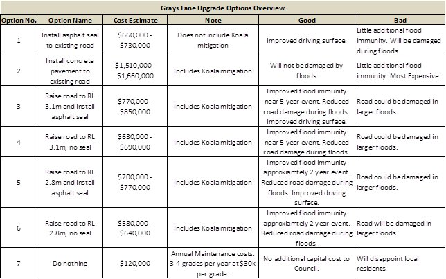
Updated Cost Estimates of Grays Lane Upgrade
Options (this table has also been provided as an attachment 2 -
E2018/66532). Please note that these figures are indicative and based on
assumptions due to the preliminary nature of the design.
3. Write
to NPWS requesting they contribute funds towards upgrading Grays Lane because
the nation park users generate significant amount of traffic on Grays Lane.
Letters is to detail the options Councils in considering, the likely costs and
funds Council has available.
The Hon. Gabrielle Upton MP, who is currently both the
Minister for Local Government and the Minister for the Environment initially
replied only on behalf of the Office of Local Government; not as the Minister
for the Environment. An additional letter was written to her as the
Minister for the Environment seeking contribution to the upgrade of Grays Lane
on the premise that roughly half of the traffic movements on the road are for
access to the NPWS Tyagarah Nature Reserve. A response was received
indicating that NPWS funds cannot be used on Byron Shire Council land, and that
no contributions would be offered.
4. Write
to residents to provide an update on works to date and advise on the options
being investigated. Letter should include a link to a survey asking, how much
property owners would be willing to contribute in order to bring the project
forward, their design standard desires, including flood immunity preferences.
A total of 42 properties were identified that use
Grays Lane for access. On 23 May 2018, letters were (E2018/43985) was
sent to the registered owner of each property that explained the current status
of the Grays Lane upgrade project and requested feedback from them on the
following points:
1. Whether
they would be willing to contribute funds in order to bring the upgrade project
forward in the 10 year capital works plan,
2. How
much they would be willing to contribute in order to bring the project forward,
and
3. Their
desired design standard in terms of road surface and flood immunity
preferences.
A total of 18 responses were received, representing a
total of 21 properties. These responses are summarised in the
attached confidential table (Attachment 3 - E2018/64444), with responses
included as confidential attachments to this report (Attachment 4 -
E2018/66650).
Of the 21 properties represented, 8 were
willing to contribute and 13 were not willing to contribute.
Of the 8 properties that were willing to contribute:-
· 2
nominated a contribution of $2,000,
· 4
nominated a contribution of $1,080,
· 2
did not specify a contribution on the grounds that more information is needed.
· Total
resident contributions proposed at this time amounts to $8,320.
Of the 21 properties represented, 17 specified
the desired design as Option 3 (Raise to 3.1m and asphalt seal) and 2
did not specify a design but indicated their preference for the safest possible
option for pedestrians and wildlife.
In addition to the feedback sought, comments and suggestions
were received that are summarised as follows:
· 10
properties indicated their desire for NPWS or park visitors to contribute to
the upgrade works.
· 9
properties highlighted that additional drainage under Grays lane should be
included in scope to reduce flood impacts.
· 7
properties highlighted the need for traffic calming for pedestrian and wildlife
safety.
· 5
properties indicated their preference for Council to obtain a loan to undertake
Grays Lane upgrade works, and use the maintenance budget from future years to
repay the loan.
· 2
properties highlighted the need for narrow road design to reduce vehicle
speeds.
5. Report
back to Council once the above has been investigated and a preferred way
forward can be recommended.
It is quite clear from the community engagement that the
majority of property owners are not willing to contribute towards the upgrade
of Grays Lane. All, however, are eager for some form of upgrade, with the
vast majority of respondents being in favour of design option 3 for the
benefits of an asphalt seal and 5 year flood immunity.
It is also clear that a significant portion of the residents
are concerned for the safety of pedestrians and local wildlife, as well as for
the need for additional drainage under Grays lane to be included in scope to
reduce the impacts of future floods.
The recommended path forward is to proceed with design
option 3, including traffic calming devices to slow traffic to enhance
pedestrian and wildlife safety. This upgrade is expected to cost between
$770,000 and $850,000, and is currently in the 10 Year Capital Budget Plan for
2022/23 with funding as follows:
· Roads
to Recovery Grant: $500,000
· Section
94: $311,000
· SRV
Allocation: $54,200 (needs to be reviewed as SRV should not be used for the
creation of new assets)
· Special
Rate: $84,800
Bringing the project forward would reduce road maintenance
works; however, none of the above funding is currently available.
The recommended path forward is to proceed with design
option 3 (including traffic calming devices to slow traffic to enhance
pedestrian and wildlife safety), and consider the timing for any upgrade works
as part of the 2019/20 Budget process when the 2019/20 to 2028/29 ten (10)
year Capital Works Program is reviewed.
Financial Implications
No negative financial implications exist in the
recommendations of this report.
Statutory and Policy
Compliance Implications
No negative statutory and policy compliance implications
exist in the recommendations of this report.
Staff Reports - Infrastructure Services 13.21
Report No. 13.21 Waterlily
Park Planned Upgrades
Directorate: Infrastructure
Services
Report
Author: Malcolm
Robertson, Team Leader Open Space
Michael Matthews, Manager Open
Space and Resource Recovery
File No: I2018/1177
Theme: Infrastructure Services
Open Space and Recreation
Summary:
Council staff are working with the Ocean Shores Community to
construct additional play elements, pathways and car park upgrades within
Waterlily Park. The Waterlily Community Playscape committee are a key
stakeholder group in this process and Council officers will continue to consult
with the committee through this process.
The Waterlily Playscape group have created various concept
plans for Waterlily Park. These plans have generated significant resistance
from parkland neighbours and concerns from NSW Police.
NSW “Everyone Can Play” guidelines for
developing inclusive and accessible play spaces recommend that play elements be
co-located with toilets, seating, shade and water bubblers.
|
RECOMMENDATION:
That:
a) Staff
progress with RFQ for supply and installation of the new playground
elements, to be collocated as much as possible with the existing playscape
installation within the detail design professionals;
b) Staff
invite the Waterlily Playscape Community to nominate a representative to
assist in assessment of suppliers within Council’s procurement process;
and
c) Staff
undertake replacement of the outdoor exercise equipment in an alternate
location should the playscape detail design dictate this requirement.
|
Attachments:
1 Waterlily
Playscape Community Survey Results Summary March 20187, E2018/62188 ⇨
2 WATERLILY
PARK SURVEY RESULTS COMPILED, E2018/64473
⇨
3 Confidential
- Community Feedback to proposed Waterlily Park Upgrades, E2018/64697
Background
Waterlily Park is Community
Land owned and managed by Byron Shire Council.
In 2015 members of the
community recognised the need to improve the space for public use and formed a
community group to achieve this. The Group’s stated aim was to design a
playspace based on the ideas of our local kids and the wider community, and
then to use local volunteers to build the playscape during one week, guided by
professionals.
A resolution was passed on 16
July 2015 that Council:
Res 15-322 - That
Council:
1. Supports the endeavours of
Waterlily Community Playspace to establish a play area in Waterlily Park, Ocean
Shores.
2. Develops a formal relationship
with Waterlily Community Playspace, as they are an independent community group
formed to work on and improve a Council asset.
In the 2016/2017 budget, an
allocation of $100,000 was made for the Waterlily Park Playscape.
The initial playscape project
was funded by Council through the Roundhouse sale.
Playscape “Stage
1”
In June 2016, the Committee
engaged consultants to undertake community consultation with local schools to
inform the design and to complete concept plans for the playscape area.
Around 50 local school
children participated and the ideas submitted were used to create concept plans
for the playscape.
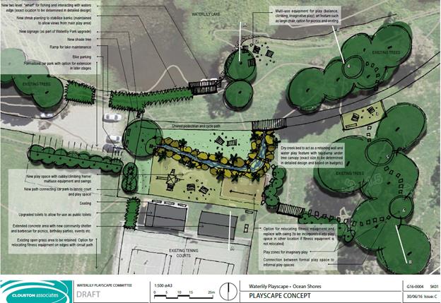
Council worked with the
committee, and facilitated the design and construction of a new playground in
the style preferred by the committee members. The resulting playground
was installed in February 2017.
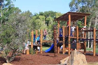
Stronger Country
Communities Grant
Council successfully applied
for $418,000 from the NSW State Government’s Stronger Country Communities
fund to allow for improvements to accessibility through car park upgrades,
pathway linkages, and to add more playground equipment and shade.
Community Consultation
A key requirement for Council
within the grant funding deed was community consultation around the proposed
upgrades. The upgrades have been championed by the Waterlily Playscape group
who have produced and promoted a range of concepts for the future development
of Waterlily Park.
Council prepared an online
survey which was promoted through social media and through the hand delivery of
1,600 flyers to all residences in Ocean Shores. The Waterlily Playscape group
decided to also undertake a separate community survey concurrently. The results
of this are in Attachment 1. 225 people completed the Waterlily Playscape
survey. Results showed 92% of respondents desired more facilities within
Waterlily Park, and there was strong support for all proposed new additions.
The Waterlily Playscape group
also offered to assist Council by distributing and collecting hard copies of
Council’s surveys. Council received a complaint from a resident that
people were being pressured to complete these hard copies in a certain manner,
so the results of those hand collected surveys are differentiated within the
overall results for transparency.
The main item of contention
is the physical location of the new “treehouse” play structure and
flying fox. The concept and developed by the Waterlily Playscape group
had been developed with a focus on activating the park and encouraging
people to utilise less well used parts of the park. Immediate neighbours
to the park were concerned about potential negative impacts to their residences
if these were installed in close proximity.
To get a feel for community
preferences, people were asked to identify a preferred location for the various
items. Community were asked to identify preferred locations for the grant
funded Flying Fox and Tree-house style play structure. The Waterlily Playscape
group have also proposed a number of new additions within their concept
planning, such as a fishing platform, improvement to the Tennis clubhouse to
include toilets and a kiosk, additional tennis and netball courts. It was
determined that to survey across all of these elements would create confusion.
Decision was taken however to take a poll as to the community acceptance of the
Waterlily Playscape group proposed community garden.
Given that the original
option for the playspace suggested relocation of the existing exercise
equipment, the location and style of this was also explored.
Outdoor Exercise Equipment
The current exercise
equipment is aging significantly and is approaching the end of its serviceable
life. The softfall underlay has degraded, is crumbling and needs to be replaced
to maintain required impact attenuation. The exercise equipment is showing significant
wear and corrosion.
The life expectancy for this
equipment was originally 15 years, but the proximity to water and the ocean has
exacerbated corrosion. The equipment is still currently safe and usable, and
visible corrosion can be treated to maintain aesthetics, but internal corrosion
will continue to advance. Current remaining lifespan is anticipated to be no
more than two to three years.


Council has allocated funds
in this financial year for new outdoor exercise equipment in Ocean Shores. If
decision was taken to locate the new tree house play centre in close proximity
to the existing playground the allocated funds will allow for a new exercise
equipment installation in corrosion resistant stainless steel to be constructed
elsewhere in the reserve.
Survey Results
Only 49 surveys were
completed, which was fewer than 4% of residences that received notices.
As can be seen from the survey results, there was preference
for some locations, but no consensus within the results. The greatest
preference for the tree house was “Location B”, however this also
corresponded with the greatest amount of negative comments.
The flying fox saw preference for “Location A”,
but there were concerns raised about impact upon adjoining residences. The exercise
equipment also produced inconclusive results from the survey, with three
locations having very similar preferences.
There was clear preference for planting of additional shade
trees and seats around the playground and car park areas. The Waterlily Playscape
group faced a funding deadline, and made the decision to install the
seating around the lake at locations they deemed most appropriate.
The community garden proposed by the Waterlily Committee
also gave a divided response, with opinions split between the east and west of
the lake.
Parkland Neighbours
The Waterlily Playscape group have progressed concept plans
for the park through several iterations and have promoted these online.
Council has been contacted by neighbours to the park concerned about the
impacts.
Communications from concerned
neighbours are included in Attachment 3. Generally neighbours are
supportive of planned upgrades, but wish to ensure the potential impacts upon
private residences are minimised.
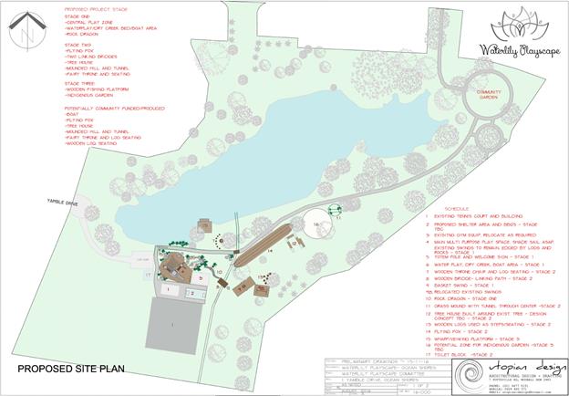
Specific concern was raised
about the bark softfall required for the Tree House if installed at the
location on the concept. This is a lower height above the lake than the
existing playground and is more prone to flooding than some other areas. Mulch
placed in this area previously was carried by floodwaters into houses across
the lake. There are concerns bark softfall would also float away on every flood
event.
NSW Police have expressed
concern with installation of the “Tree House” element at the
location shown in the concept plan. The inability to easily access that
location, poor line of sight from the current vehicle access area and
likelihood that this structure would attract antisocial activities after dark
are seen as reasons to consider a location closer to the existing car park.
Everyone Can Play
NSW Planning & Environment have been working with
key stakeholders including Byron Shire Council to develop new guidelines aimed
at making play spaces more inclusive – “Everyone Can
Play”. The guidelines are now under public exhibition prior to
being finalised and have been referred to Byron Shire Council. The guidelines
contain important considerations for the development of Waterlily Park.
Everyone Can Play is not a new standard, but rather a set of
recommendations designed to encourage more inclusive playspaces, based on three
key principles;
· I
Can Get There
A considered location and layout,
adequate signage and way finding and accessibility will ensure everyone can
find their way to, in and around the playspace.
· I
Can Play
The play experience as a whole,
including the equipment and surfacing, should allow everyone to experience a
variety of challenging play opportunities in a way that suits them.
· I
Can Stay
Sufficient consideration of
safety, amenities and the wider environment and landscape will ensure everyone
can stay at the playspace for as long as they would like.
The Everyone Can Play guidelines have been developed by
representatives from Council and playground designers and managers from across
NSW. The document considers issues that make playspaces less inclusive.
This document assists in providing better understanding to groups like the
Waterlily Playspace Committee as to the reasoning behind design decisions, and
hopefully will encourage more inclusive outcomes.
One of the core requirements of an inclusive playground is
the ability for parents or carers to supervise young children. Concepts created
by the Playscape Committee are focused on activating less used sections of the
park by spreading playground elements over a wide area. If this this
approach is followed there are negative impacts for both playground users and
parkland neighbours.
Placing the new “tree-house” play element 100m
away from the existing playground will create problems for some users.
Supervising children over a large area can be problematic, and the proximity of
the lake adds risk. Elderly or disabled carers may struggle to supervise
children over a widely spread area. If an individual is trying to
supervise multiple children this will be made difficult if the play equipment
is spread widely. Children with disabilities may struggle to travel
between the widespread elements, and therefore be unable to actively engage
with their peers.
It is also recommended that when playspaces are developed
there is a clear distinction between quiet areas and activity spaces to ensure
carers can closely and comfortably supervise children. By spreading the
playground equipment throughout the park there is no distinction between active
play areas and passive areas. This can be problematic for carers with
children who need a quiet space to settle down.
If the Everyone Can Play guidelines were followed with this
development, the separation between the “Tree House” and the
existing playground would not occur. Play elements would be grouped
together in close proximity to toilets, a bubbler and seating for parents or
carers.
Financial Implications
Council has allocated $495,600 towards this project in the current
financial year.
$418,600 of this is from the NSW State Government’s
Stronger Country Communities fund and $77,000 from s94.
Council has allocated $60,000 of s94 funds for outdoor
exercise equipment in Ocean Shores.
Statutory and Policy
Compliance Implications
Plan of Management for Water Lily Park Ocean Shores was adopted by Council 18 December 2008.
Under the PoM the following areas have been
designated:-
· 3
ha designated as Park to allow for passive or active recreational, social,
educational and cultural pursuits that do not unduly intrude on the peaceful
enjoyment of the land by others.
· 1ha
designated as sportsground proposed to be used primarily for
active recreation involving organised sports or the playing of outdoor games.
· 1.2 ha categorised as natural area-wetland (the Lake)
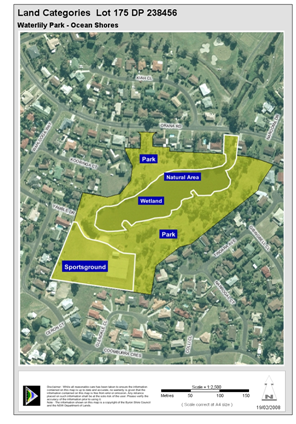
Staff Reports - Infrastructure Services 13.22
Report No. 13.22 Suffolk
Beachfront Holiday Park Dog Friendly Report
Directorate: Infrastructure
Services
Report
Author: Pattie
Ruck, Open Space Facilities Coordinator
File No: I2018/1269
Theme: Infrastructure Services
Suffolk Park Holiday Park
Summary:
To provide a report on Dog Friendly Trial Results at Suffolk
Beachfront Holiday Park and recommend Dog Friendly Status based on these
results.
|
RECOMMENDATION:
That Council adopt Suffolk Beachfront Holiday
Park as a Dog Friendly Park in accordance with the dog friendly site map,
during off peak times.
|
Attachments:
1 Dog
Friendly Park Rules, e2018/57756 ⇨
2 Feedback
on Dog Friendly Trial at Suffolk Beachfront Holiday Park, e2018/59006 ⇨
Report
Dog Friendly Trial
The initial trial period commenced in late 2016 and was
extended until the finalisation of this report.
Consultation prior, during, and post trial period has been
undertaken with the Park Managers, permanent residents, and short term guests.
Written feedback was received from Park Mangers, residents, and short term
guests throughout the dog friendly period. The trial period excluded peak
periods and busy times.
Dog Friendly Park Rules and Associated Procedures
During the trial the Park Managers implemented strict dog
friendly park rules, as attached (E2018/57756). Upon guest check-in these
rules were signed and understood by dog friendly guests and the below map
provided.
Map depicting access point to Off Lead Companion Area from
Suffolk Beachfront Holiday Park
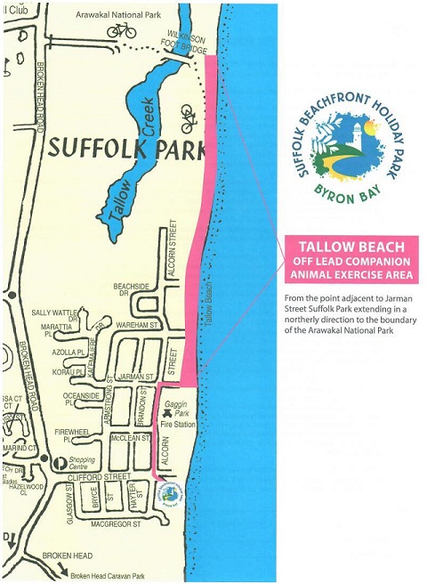
Appropriate signage placed throughout the park and beach
access points.
Beach access points within the park Signs
inside the BBQ Area
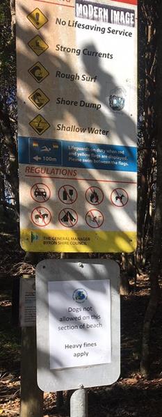
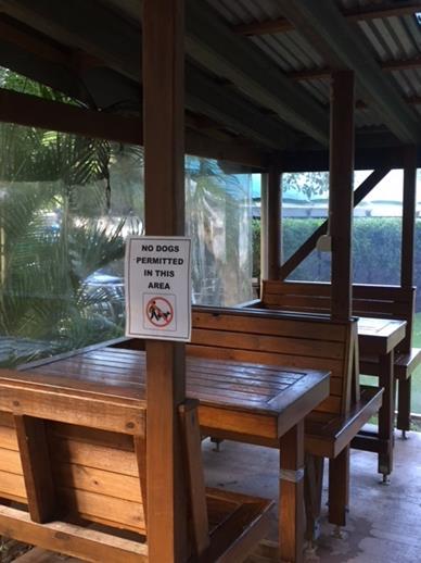
Dogs NOT PERMITTED signs near camp kitchen and
laundry.
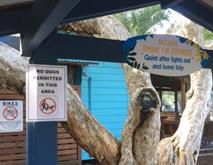
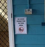
 ,
,
Dog Friendly Sites Available Map
P = Dog friendly sites – Sites 23 to 50 = 32 Sites
OP = Overflow Dog friendly sites – used as overflow
only when P sites are full – Sites 4 to 9 & 17 to 21 = 11 Sites
Dog friendly site locations selected considering
proximity separation from permanent residents.
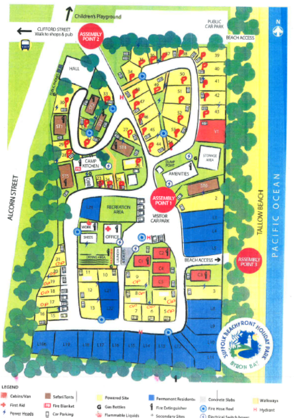
Dog Friendly Feedback
Feedback and Mitigation measures implemented on feedback
items
The table below displays a summary of feedback items
received. Summary of the details of where the feedback was from, how many
submissions were received, and documentation reference details are
attached.
Unsupportive Submissions - One submission signed by
eight of the permanent residents. Two negative submissions received
individually from two permanent residents who also signed the group
submission. One negative submission received from a regular short term
guest.
Supportive Submissions - Two positive submissions
received from permanent residents. Council has received positive feedback
from written letters, facebook comments, and wikiCamp reviews. One
positive feedback received in writing from a short term guest, six positive
comments on Facebook and nine positive comments on wikiCamps.
|
Feedback Item
|
Mitigation Measure
|
|
Dogs off leads
|
— Dog friendly park rules explained to guests
upon check in and signed by guests to acknowledge requirements of the
park.
— Managers communicate with offending guests
ASAP and ensure compliance. If non-compliance is ongoing the guests
will be required to leave.
— Occasionally dogs from outside of the park
wonder through. There has been occasions throughout the trial this has
occurred and after enquiring with guests, these particular dogs were not from
guests staying at the park and did not match the description of their types
of dogs. This issue is ongoing and hard to mitigate with or without a
pet friendly status. Possible fencing could be looked at in the future
if this issue is heightened and cost/benefit is feasible.
|
|
Complaints from other
guests/residents regarding barking and roaming dogs.
|
— Managers act upon the requests ASAP and
ensure compliance where applicable.
— Complaints are looked into ASAP by the
managers and mitigation measure actioned.
|
|
Dog droppings
|
— Guests are briefed and required to sign on
dog friendly park rules.
— Managers inspect the sites daily to ensure
sites and surrounds are free from droppings. There were two occasions
this occurred during the trial.
— Bag dispensers provided if problem
persists.
|
|
Dogs taken onto the
beach through non dog friendly access points
|
— Signs indicate where Dogs are NOT PERMITTED
are in place at access points.
— Upon check in guests are verbally told and
provided a map detailing access points.
|
|
Effect on wildlife
|
— Park rules ensure dogs are tied up,
therefore unable to chase after wildlife. If wildlife was to approach
the dog this is unable to be mitigated.
|
|
Complaints from
permanent residents
|
— Dog Friendly Sites are separated from the
permanent residents and the overflow sites are separated by a minimum road
width. Throughout the trial there were issue when the managers allowed
pets throughout the whole park. However, this was resolved and the
managers are to ensure there is always separation from the residents as per
the map displayed above.
|
Dog Friendly Seasonal Dates
Seasonal dates throughout Suffolk Park for 18/19 was adopted
by Council on 28 June 2018 along with the fees and charges. These
seasonal dates will continue to be included in the annual fees and charges
process.
Peak times will be excluded from
dog friendly status. The adopted peak seasonal dates for Suffolk
Beachfront Holiday Park run from 22 December 2018 to 14 January 2019 (Christmas
holidays) and 17 April 2019 to 27 April 2019 (Easter, ANZAC, NSW and QLD School
holidays). Major festivals fall under this peak category and these festival
dates change annual. Seasonal dates outside of the adopted peak dates
will be available to guests as dog friendly. As peak times
are excluded as dog friendly periods within the park, permanent
residents will not be able to have a pet friendly status. This procedure mitigates
any risk of ongoing permanent dog related issues. Short term guests are
required to leave if their dog is a nuisance.
Financial Implications
The minimum financial increase from dog friendly bookings
from 1 May 2017 to 30 April 2018 was $64,940.78. The Park Managers have
indicated this figure does not include website or internet browsing bookings
that are dog friendly bookings. 9.13% of overall bookings are related to
pet friendly bookings. There was no decline noted in regular bookings
that were not dog friendly guests. Additional infrastructure is not
required by Council. If Suffolk Park is not to continue as a Dog Friendly
Holiday Park Council acknowledges the potential for declined income and
recognises a need to honour pet friendly bookings already taken until 2 October
2018.
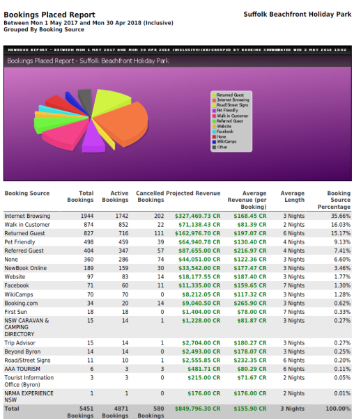
Statutory and Policy Compliance Implications
Current zoning of land – LEP 2014 – Zone RE 1
– Public Recreation
Suffolk Beachfront Holiday Park is currently located on DP
1023737 Lot 100. Zone RE 1 – Public Recreation.
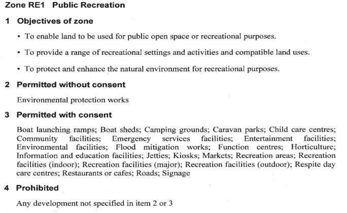
Permanent Sites at the park have been reclassified as
Operational Land recently. These sites are separate from the dog friendly
sites.
Byron Shire Council Companion Animal Exercise Areas
– Policy 5.31
Policy 5.31 adopted by Council in March 1994 and reviewed in
October 2011 outlined off-lead exercise areas within Byron Shire. Tallow
Beach shown in MAP 1 is the closest to Suffolk Beachfront Holiday Park.
Tallow Beach off-lead exercise area is approximately 485 m from Suffolk
Beachfront Holiday Park. This distance requires a short walk from Suffolk
Beachfront Holiday Park.
MAP 1
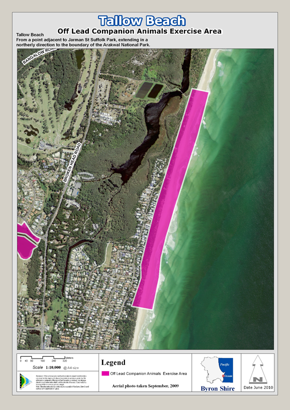
Benefits of Dog Friendly Suffolk Beachfront Holiday Park
— Allows Council’s
holiday park to remain competitive and in line with other holiday parks in and
surrounding Suffolk Park area. Ferry Reserve at Brunswick Heads, Byron
Holiday Park at Suffolk, North Coast Holiday Parks including Shaw’s Bay
in Ballina and Silver Sands at Evans Head have all converted to dog friendly
periods and have reported an increase during off peak periods of approximately
60 to 70 %.
— Dog friendly availability
offers extra service options for guests.
— Increases Council’s
revenue stream for this asset as shown below.
— Park Managers are able to
manage this dog friendly status with no additional resources required from
Council.
— Park location and relaxed
nature support the dynamics of a dog friendly acceptance.
Non-benefits of Dog Friendly Suffolk Beachfront Holiday
Park
— Continued and/or
escalated negative feedback from park users and/or permanent residents and
subsequent increased mitigation measures required by Park Managers in
consultation with Council. Possible increase in costs associated with
mitigation measures relevant to feedback.
— Forecasted revenue not as
predicted.
Conclusion
Overall the dog friendly
trial period was well received by both permanent residents and short term
guests. There were instances where residents were unhappy with the
effects of the dog friendly trial. Once mitigation measures outlined were
strictly enforced many of these complaints were able to be minimised.
The separation of the dog
friendly sites from the permanent resident sites proved to be a major factor in
minimising this negative effect on permanent residents. Unfortunately,
the managers of the park allowed dog friendly sites close to the residents for
an interim period throughout the trial. This created permanent residents
to become unsupportive of the dog friendly status and subsequently submitted
unsupportive feedback.
Since then, Council has
consulted with the park managers to promptly action the site separation
preferences as discussed in the original trial. The mitigation measures
outlined have had a positive impact on feedback received.
It is anticipated that
there will never be 100% support of a Dog Friendly Park, however based on the
feedback received and the success and failure points within the trial it can be
concluded that there is general support from customers for the Park to become
Dog Friendly.
Staff Reports - Infrastructure Services 13.23
Report No. 13.23 Settlement
Road Submission Update
Directorate: Infrastructure
Services
Report
Author: Evan
Elford, Team Leader Infrastructure Planning
File No: I2018/1303
Theme: Infrastructure Services
Roads and Maritime Services
Summary:
Council at its extra ordinary meeting on 28 June 2018
considered the adoption of the 2017-2021 Delivery Program and resolved to
receive a further report regarding the submission on Settlement Road.
|
RECOMMENDATION:
1. That
the road community / council working group, comprised of a
representative from SRAG, Djambul Community, Council’s Infrastructure
Planning staff and Director Infrastructure Services, continue to meet
quarterly to ensure an efficient and mutually satisfactory resolution to the
long-standing road hazard; and
2. That
the outcomes of the road community / council working group be
reported back to Council.
|
Report
Council, at its Extraordinary meeting on 28 June 2018,
considered the adoption of the 2017-2021 Delivery Program and resolved in part
as follows:
Res 18-429
1. Note
the submissions received during the public exhibition period for the
Delivery Program 2017-2021(Revised) and Operational Plan 2018-2019 (including
the Statement of Revenue Policy, 2018-2019 Budget and 2018-2019, Fees and
Charges) (Attachments 2 to 4) and that Council receive a further report to the
2 August 2018 Ordinary Meeting regarding the submission on Settlement Road.
Currently a Development Application is being processed for a
Multiple Occupancy Development on Settlement Road. Conditions on the DA stipulate
that chainage 256 to 1216 of Settlement Road must be improved to
Council’s standards.
This report relates to sections of Settlement Road outside
of the DA, which Council has received a submission from resident, Rod Palmer,
regarding the enactment of Council Policy 4.17 on Settlement Road.
Mr Palmer would like to contribute the cost of the seal for
the following sections of road:-
· Chainage
0-202.10; and
· Chainage
1216.30-1279.76
Policy 4.17 currently is as follows:
POLICY TITLE: CONTRIBUTION TO THE COST OF SEALING OF UNSEALED
ROADS ADJACENT TO PROPERTIES AT REQUEST OF OWNERS
FILE REFERENCE: COR050505
Date Adopted 28 November 1995
Date of Review -
1. OBJECTIVES
1.1. To minimise dust nuisance to residents.
1.2. To improve the amenity of the road reserve adjacent
to properties.
2. POLICY STATEMENT
2.3. Where a property owner requests to have the road
surface adjacent to their property bitumen sealed and the road is not listed on
a current works programme, the owner pays for the cost of sealing and Council
contributes the cost of the pavement upgrading necessary before the sealing
work can be applied.
2.4. This offer is conditional upon:
a) The Council road making plant is working
in the area and the work is carried out as part of normal activities at
Council’s convenience.
b) The sealing of the section of road would
not preclude future works, or be negated by future realignment, etc.
c) The landowner is to contribute the full
cost of a two (2) coat bitumen seal (prime/seal).
d) The full width of the existing payment is
to be sealed.
e) Where more than one landowner fronts the
section of the road to be sealed then arrangements for apportioning the costs
is to be agreed by all landowners fronting that section of road prior to any
work occurring.
Mr Palmer obtained quotations from local contractors in
order to understand the costs required to bring the road up to a standard ready
for sealing however these have not been based on Council’s design or
minimum standard. The costs of these quotations were discussed by Mr
Palmer at the extra ordinary meeting on 28 June 2018.
Council has not been provided with a copy of the quotes
despite making numerous requests to the contractors.
Infrastructure Services have since undertaken a detailed
design of the road, setting out the minimum standards that will be required for
its construction. The design includes consideration of:
· Water
runoff and the need for piped drainage crossings at some locations and
formation of table drains
· Minimum
width of 4m, as required to fire access standards
· Allowance
for a retaining wall at a steep batter interface for safety
· Shaping
and trimming of the road formation to provide a safer surface
· A
design life of 20 years
The design standards for Settlement Road were resolved by
Council at its extra ordinary meeting on 17 November 2017 as follows:
Res 17-579
1. That
the Engineering report recommendation is clarified so that preliminary or first
stage road work - including work required to be completed by Lot 3 as a
Community Title DA consent condition - can commence even if the funds for
latter stage work are not yet confirmed.
2. SRAG
proposes the formalisation of a road community/council working group to meet
quarterly to ensure an efficient and mutually satisfactory resolution to
the long-standing road hazard. This working group would comprise a representative
from SRAG, Djambul Community, Byron Council Engineering, and Byron Council
councillor or director.
3. That
the RFS standard is accepted as the only realistic option to progress road
improvement steps and reduce the hazard faced by road users.
Financial Implications
The design and estimate has been spilt into 3 sections at
the request of Mr Palmer, and does not include any costs for the section of
road associated with the DA, which is being borne by the developer.
The Council component includes all preparation works
required to bring the road up to a standard ready for sealing, as per the
design plans and Councils minimum specifications.
The resident component includes the cost of the two coat bitumen seal (primer
seal followed by final seal).
Both components are marked up by 15% to cover
Council’s site based risks and project management costs.
|
Settlement Road
Estimate Summary
|
|
Description
|
Estimated Cost
(excl GST)
|
|
Sections 1 (CH 0 to 202.10)
|
|
|
Council Component
|
$
127,000
|
|
Resident Component
|
$
21,000
|
|
|
|
|
Section 5 (CH 202.10 to
255.94)
|
|
|
Council Component
|
$
26,000
|
|
|
|
|
Section 6 (CH 1216.30 -
1279.76)
|
|
|
Council Component
|
$
35,000
|
|
Resident Component
|
$
6,000
|
|
|
|
|
Total Cost to Council
|
$
188,000
|
|
Total Cost to Resident
|
$
27,000
|
Section 5 does not have a
Resident component as Mr Palmer is not proposing to contribute to seal this
section, however it would be prudent for Council to fix this section of road
while the plant and labour are established on the road.
The estimates of costs for
the works do not align with the cost information provided by Mr Palmer at the
Extraordinary meeting on 28 June 2018 and more meetings are required of the road
community / council working group to progress and finalise this work.
Statutory and Policy
Compliance Implications
There are no statutory and policy implications.
Staff Reports - Infrastructure Services 13.24
Report No. 13.24 Broken
Head Reserve & Seven Mile Beach Road - ongoing issues
Directorate: Infrastructure
Services
Report Author: Evan
Elford, Team Leader Infrastructure Planning
Tony Nash, Manager Works
Shannon Burt, Director Sustainable
Environment and Economy
File No: I2018/1357
Theme: Infrastructure Services
Local Roads and Drainage
Summary:
This report provides an update to Councillors on recent and
future actions regarding ongoing issues associated with traffic and parking
management at Broken Head Reserve and Seven Mile Beach Road.
|
RECOMMENDATION:
1. That
Council note the work to date on the issues and endorse the future
actions and investigations for Broken Head Reserve, Seven Mile Beach Road and
Broken Head Reserve Road.
|
Attachments:
1 Minutes of
Seven Mile Beach Road Meeting - Monday 26 March 2018, E2018/24348 ⇨
2 Seven Mile
Beach Road - High Level Options Assessment - Including Plans, E2018/38473 ⇨
3 Minutes of
Seven Mile Beach Road Meeting - Monday 2 July 2018, E2018/56081 ⇨
Report
Council considered a report on Broken Head Reserve and Seven
Mile Beach Road Management issues at the ordinary meeting 14 December 2017
https://byron.infocouncil.biz/Open/2017/12/OC_14122017_AGN_613_WEB.htm
and resolved as follows:
Res 17-677
1. That
Council note the report and the Actions that are currently being implemented by
staff, State agencies, Police and residents to address the management issues in
the Broken Head Reserve area and its beaches.
2. That
Council endorse the Action Plan for wider community consultation with the
following adjustments:
Action 2 include
Shire resident permit option and delete consideration of car park closure
Action 6 Immediately
remove the no stopping signs and boulders at the southern end of Seven Mile
Beach Road. Create a proper turning circle and car parking area. Install no
parking from 9.00pm-5.00am signs
Action 9 review
the placement and number of No Stopping signs along the length of the
road.
Action 12 change
‘neighbourhood watch program’ to ‘Broken Head Custodians
Group’
3. That
the provision of a budget of $20,000 for concept infrastructure planning
investigations and surveys for road upgrades and investigation of traffic
calming options be considered as part of the December 2017 Infrastructure
Services Financial Quarterly Review.
4. That
a further report is presented to Council early 2018 on this consultation and
any other management issues that arise over the summer holiday period.
5. That
Council note that responses from both the Police and NPWS requesting support in
these matters, as outlined in Actions 4 and 5 have still not been forthcoming
and that Council write again, requesting an urgent response.
Since the resolution, two community and state agency
meetings have been held 26 March and 2 July 2018. The purpose of these
meetings was to work through the action plan adopted by Council in December to
address anti social behaviour, environmental degradation and traffic and
parking controls as it affects local amenity and environment. Both
meetings were well attended.
The attached document E2018/24348 contains the
minutes and agreed actions from the first meeting in March with the issues and
key actions for Council being:
1. Map
car park jurisdictions.
2. Investigate
future management options for car parks.
3. Request
delegations from National Parks and Wildlife and Police for Council officers to
manage parking, camping, move on directions and the like.
4. Explore
options for the installation of gates as a management option.
5. Review
signage and remove boulders.
6. Investigate
options for traffic calming and introduction of pinch points to regulate
traffic.
7. Present
a further report to Council on consultation outcomes and any other management
issues and
8. Install
surveillance cameras to address vandalism of signs and unauthorised activities.
The issues listed above are discussed below.
Issue – Mapping Jurisdiction
A plan of survey of the location of existing car park areas
and property boundaries has been completed to inform investigation of
management options. The mapping concluded that much of the informal parking
areas are located within the road reserve with part in NPWS controlled lands.
This plan formed the basis of further traffic and parking management
considerations.
Issue – Traffic Management
Traffic management was discussed at both the March and July
meetings.
At the July meeting 5 different traffic and parking
management options were presented to the group for discussion. These
options and the group’s position on each are summarised below:
1. Option
A – Transfer the reserve to landowners. This would be a
difficult option considering the provisions of the Roads Act and it is unlikely
this would be supported by greater community.
Not supported.
2. Option
B – Gate road. Again, would be a difficult option
considering the provisions of the Roads Act and it is unlikely this would be
supported by greater community.
Not supported
3. Option
C - Dedicate the reserve to NPWS. NPWS Act allows restriction of
vehicles on a public road and purpose is likely to be supported by greater
community.
Supported.
4. Option
D – Install traffic calming including upgrade council car parks and
install ‘paystay’. This was not considered an effective
stand alone, but is something that would assist in conjunction with other
options.
Partially supported.
5. Option
E – Close Seven Mile Beach Road and use Blackbutt Lane as alternative
access. This was not considered effective as would still create same
access to the area.
Not supported.
The options are further detailed in the attached document E2018/38473
which was presented to the July 2018 meeting.
These options detailed the relevant costs and associated
issues. The details in respect of the supported option C and partially
supported option D are reproduced below.
Note Option C does not include costs for car park works as
that would be a NPWS area of responsibility.
Option C – Dedicate road
to National Parks
This option maintains current
access rights while the maintenance burden is held by others.
Process:
§ Council cannot transfer a public
road to NPWS, because the latter isn’t a road authority. But it’s
possible for Council to close the road and transfer the land to NPWS. NPWS
would need to want to take responsibility for it. But that would then raise
issues regarding access for the residents, because they would no longer have
the benefit of public road access to their properties.
§ Assuming these issues away,
Council would need to close the road via a Council resolution and application
to the State Government. Then it would Gazette the closure, before transferring
the (then) operational land to the NPWS. That process typically takes a number
of months and requires NPWS support, which we don’t have.
Issues:
§ Resident access through a
National Park maybe problematic. Maybe possible to resolve through right of
way.
§ NPWS have previously advised the
Broken Head residents group that this option is not feasible. (per phone call
with Sue Walker 1.10pm 17/4/18).
§ Not an easy solution to
implement.
Positives:
§ This is good option for Council,
but without NPWS support it can’t happen.
§ Legally feasible.
§ Reduced maintenance burden for
Council.
§ Likely to resolve all concerns
raised by local residents.
Approximate Cost:
Community Consultation $20k
Legal costs $10-40k
Total Cost $30-60k
Ongoing Costs:
Nil
The following information relates to the partially supported
option:
Option D – Install
Traffic Calming devices
This option maintains current
access rights while attempting to reduce traffic speeds and dust levels on the
road. Options to leave road as gravel and seal the road have been considered.
Formalisation of the car parks and installation for toilets is included.
Process:
1. Report
to Council
2. Adopted
as way forward
3. Create
line item in budget
4. Survey
and Design traffic calming solutions and all road works
5. Design
car parks and toilets
6. Prepare
approvals
7. Procure
works and toilets
8. Complete
works
Issues:
§ Small increased maintenance
costs due to calming devices.
§ Speed humps have not been
considered due to the issues raised in the following link. https://www.yarraranges.vic.gov.au/files/assets/public/webdocuments/environment-engineering/infrastructure-services/roads-drains-footpaths-infrastructure-services/unsealed-roads-speed-and-dust-fact-sheet-december-2016.docx
§ Funding of works, most expensive
option for Council. See possible funding solution in positives.
|
Table 4. Curve Road Sign at 35km/hr
for 4 km
|
|

|
§ 7 Mile Beach Road car park is
partly in crown land.
§ Paid parking robots require
mobile reception.
§ No Telstra cable nearby.
Positives:
§ Likely to resolve concerns
raised by local residents. To a degree.
§ Easy to implement.
§ Will make parking compliance
easier to manage.
§ Option could include advisory
speed sign as shown here.
§ Could be completed over 3-4
years.
§ Potential option for paid
parking at car parks in conjunction with NPWS. Revenue could fund a loan for
the works.
§ Resident contribution also
feasible.
§ Traffic calming devices can be
approved by Local Traffic Committee.
§ Likely to receive full support
from NPWS.
§ Potential option to make road
6.8m wide and add yellow lines. This would allow all no parking signs to be
removed and make enforcement easier.
§ Likely parking spaces created by
formalisation; Kings Beach = 17. Whites Beach = 6. Brays Beach = 6. Seven Mile
Beach (+ additional parking areas) = 16. See Plans.
§ Potential option to also
formalise parking at Seven Mile Beach Road and Broken Head Reserve Road
intersection.
§ Parking management assessment
and strategy recommended as first step.
Approximate Cost:
Option 1 - Maintain Gravel
Road
Survey and design $6k
Installation of traffic control
devices as per plans (6 sets of Chicanes) $ $120-180k
Formalisation and seal 4 car
parking areas $82-100k
Paid parking robots for 4 car
parks $132-148k
Provision of stand-alone,
unisex, National Park style toilet at 4 car parks $120-140k
Total Cost $460-574k
Option 2 - Semi Sealed Road
(to Kings car park (760m)
Geotech, Survey and Design $20k
Installation of traffic control
devices (6 sets of Chicanes) $120-180k
Re-work, Overlay and Seal
existing road to Kings $456-684km
Formalise and seal 4 car
parking areas $82-100k
Paid parking robots for 4 car
parks $132-148k
Provision of stand-alone,
unisex, National Park style toilet at 4 car parks $120-140k
Total Cost $930k-1.28m
Option 3 - Fully Sealed Road
Geotech, Survey and Design $20k
Installation of traffic control
devices (6 sets of Chicanes) $120-180k
Re-work, Overlay and Seal
existing road $2.8-4.2m
Formalise and seal 4 car
parking areas $82-100k
Paid parking robots for 4 car
parks $132-148k
Provision of stand-alone,
unisex, National Park style toilet at 4 car parks $120-140k
Total Cost $3.014m-4.4m
Ongoing Costs (excluding road
maintenance):
Annual maintenance of 4 toilets
$28k (one staff and ute 2hr for total 175 days a year, incl products @ $75/hr)
Issue – Parking Management and Enforcement
The community has requested that Council upgrade Council
land into car parks at Brays and Whites Beaches and on Seven Mile Beach
and Broken Head Reserve Road and also install ‘Pay Stay’ on line
paid parking in these car parks as a means to manage parking numbers in the area.
Further, discussion about how to physically restrict parking
outside the car parks along the road carriageway (viz. barrier) instead of
parking signage, given the level of vandalism and non compliance with the
signage has also occurred.
A high level concept investigation for the construction of
the four parking bays on Seven Mile Beach Road has been completed and costs
included in the estimates for the applicable options. Currently these works are
not budgeted for 2018/19 or planned by Council for the future.
Pay stay on line parking is able to be installed to these
parking areas once constructed and approved by the RMS. An estimated
installation cost is between $5,000 - $10,000. Other ongoing annual and
operation support costs would apply following and would vary dependant on
transactions.
The issues relating to parking in Broken Head Reserve Road
were reported to the March 2018 meeting of the Local Traffic Committee (LTC)
and subsequently reported to the 19 April 2018 Council meeting for determination
where Council resolved as follows:-
18-239 Resolved
that Council adopt the following Committee Recommendation(s):
Report No. 6.6 CRM
2343/2018 Broken Head Reserve Road - Regulatory Signage
File No: I2018/421
Committee Recommendation 6.6.1
That Council prepare a plan and
install “No Stopping” signs and line marking to control
inappropriate car parking and to improve pedestrian safety along Broken Head
Reserve Road, Broken Head where considered necessary.
Detailed investigations and cost estimates to determine the
extent of road improvement works, line marking and signage necessary to manage
parking in this location are yet to be completed and reported to Council for
budget consideration..
Issue - Signage
Council has undertaken a range of signage measures to
attempt to control and manage the illegal and anti social behaviours occurring
in this area but largely without any medium to long term positive legacy.
This has included signage for parking, camping, fires,
etc.
The signs have repeatedly and consistently been vandalised
and removed, resulting in staff being onsite often weekly to reinstate them.
All of these signage works to date have been funded by sign
Maintenance budgets.
At one stage large rocks were placed to physically prohibit
parking in the bush off Seven Mile Beach Road. These rocks were later
removed after public objection from the wider Byron community. There
installation and removal were funded from road maintenance budgets.
Issue - Minutes and Actions Arising from July Meeting
The minutes of the meeting are attached as document E2018/56081.
NPWS have now approved delegations for Council Officers
however these are yet to be received; Police are yet to finalise their
consideration of this matter.
Further investigations of signage options are ongoing in
consultation with NPWS.
The following actions were agreed to by consensus at the
meeting held 20 July 2018.
Formal consideration of these actions is required by council
for those which require capital works as they are not within the current
capital work plan or have a budget allocation and will be the subject of a
further report to Council for budget consideration and/or allocation.
|
RESPONSIBILITY
|
ACTION
|
|
Council
|
Council to prepare / send letter and proposal to the
Reserve Acquisitions Department for NPWS to acquire area (Option C)
|
|
Tamara Smith MP
|
Request David Milledge to prepare / send letter to the
Reserve Acquisitions Department outlining ecological concerns and support for
Council’s proposal (Option C)
|
|
Tamara Smith MP
|
Tamara Smith to prepare / send letter to Reserve
Acquisitions Department demonstrating support for Council’s proposal
(Option C)
|
|
Tamara Smith MP
|
Request Tweed-Byron LAC NSW Police to prepare / send
letter to the Reserve Acquisitions Department demonstrating support for
Council’s proposal (Option C)
|
|
Local residents
|
Local residents to prepare / send letter to Reserve
Acquisitions Department demonstrating support for Council’s proposal
(Option C)
|
|
Council
|
Council to investigate and consider other access roads and
likely success of using these
|
|
Council
|
Council to prepare / send letter to NPWS to request a gate
be installed at Kings Beach Car Park which may be locked at night. This
may create a major deterrent to illegal camping in that area
|
|
Council
|
Council to investigate and consider options / costs to
upgrade Council car parks and install ‘Pay Stay’ to manage number
and use of spaces available
|
In addition to the above list, Infrastructure Services will
complete investigation, design and cost assessment of parking and traffic
management on Broken Head Reserve Road.
Council’s community enforcement team will otherwise
continue to patrol the area and respond to the management of issues and or
complaints received that are under their remit as per the Council’s
adopted Enforcement Policy and associated Enforcement Priorities Program.
Financial Implications
Currently there is $20,000 included in the carry over
funding from 2017/18 to progress the infrastructure planning for Seven Mile Beach
Road and Broken Head Reserve Road.
There is no funding indicated for any actual works on these
roads in the 2018/19 to 2027/28 ten (10) year Capital Works Program.
Statutory and Policy Compliance Implications
There are no statutory or policy implications at this stage
Staff Reports - Infrastructure Services 13.25
Report No. 13.25 Suffolk
Park Stormwater Drainage Asset Condition
Directorate: Infrastructure
Services
Report
Author: James
Flockton, Drain and Flood Engineer
File No: I2018/1398
Theme: Infrastructure Services
Local Roads and Drainage
Summary:
Council have experienced a
number of similar catastrophic stormwater pipeline failures in stages 5-7 of
the Suffolk Park subdivision over a period of the last 10 years. This
report informs Council of these failures and seeks funding for further and
ongoing investigations to proactively identify find and repair the pipe network
in order to prevent future catastrophic failures.
|
RECOMMENDATION:
1. That the
information within the report be noted.
2. That
there be consideration as part of the September 2018 Quarterly Budget
Review to allocate $25,000 for an immediate camera inspection of the Baywood
Chase stormwater network and report the results back to Council if concerns
with asset condition are highlighted.
3. That
there be consideration as part of the 2019/20 budget process to
allocate $10,000 annually in future budgets to fund a cyclical stormwater
pipe network camera inspection program.
|
Report
Asset condition and the asset backlog are both issues that
have previously been reported to Council across numerous asset classes. This
report focuses on the stormwater pipe network within the Baywood Chase Estate
in Suffolk Park, in particular stages 5 to 7 of the development.
Stage five and six were built in 1993, while stage 7 was
built in 1998. The stormwater system is a mixture of stormwater pipes,
pits and open drains. Many of the open drains also have low flow pipes below
the drains. The low flow pipes are believed to have been installed due to
the number of springs in the escarpment and hills around Suffolk Park. Many of
the low flow pipes are continuously flowing with water.
Stages five to seven used a pipe made by the company
‘James Hardie’. The pipes are a Fibre Reinforced Cement (FRC)
pipe, rather than the typical concrete pipe most often used in sub divisions.
In 2009 Council replaced a 56m section of FRC pipe which
initially failed during a storm event in July 2008. A further rainfall event in
May 2009 increased the pipeline failure prompting the renewal as the only
option. The pipeline was replaced in June 2009 as urgent works.
Following this failure Council staff made the decision to no longer allow the
use of FRC pipes across the shire.
The failure occurred because the invert of the pipe was
missing. It is believed that the invert had been scoured out due to the
constant running water within the pipeline and the hailstone which can often be
found in the hills around Suffolk Park. The hailstone is round and likely rolls
with the water increasing the scour of the pipe invert. Additionally it appears
FRC pipe does not handle being wet for prolonged periods. From recent
inspection it appears to become saturated and then weakens, increasing the
opportunity for scour. The pictures below were taken in June 2009 prior
to the replacement works.
|
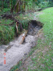
|
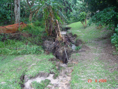
|
|
The picture to the right is a section of the pipe which
failed in 2008/2009. Staff have kept this section as a reminder of
applications where FRC pipes are not recommended.
Since 2008 further failures have occurred. The image below
shows the failures that have occurred. All of these failures are within three
stages of Baywood Chase. Purple shows the failure from 2018 which was
replaced at the end of July 2018. Yellow shows a partial failure from
2017 which is yet to be replaced. Blue shows a failure from 2016 which
has been partially repaired. Green shows the failure from 2009.
|

|
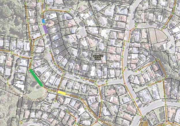
As can be seen in the image, the failures are all occurring
in the same pipeline. However, this is only part of the whole pipeline system
from these sub division stages. It is highly likely that the entire
pipeline is heading towards failure and other stages that use the same FRC pipe
could possibly be in a similar condition.
The 2009 failure made the whole pipeline lift out of the
ground in places during a heavy storm event because water was running all
around the outside of the pipes which pushed the pipeline to the surface.
It was fortunate that this pipeline was within the open drain reserve behind
private property, rather than in the road or nature strip.
The more recent failures have shown in the form of sink
holes because the pipes are deeper (around 3m deep). The pipe invert has
again scoured out compromising the structural integrity of the pipe. The pipe
has then laterally cracked allowing soil to be dragged into the pipe line and
slowly formed a void under the surface. The surface above the void
eventually fails highlighting the sink hole to the community who then contact
Council.
The pictures below were taken from the recent failure.
The cracks in the pipes were not caused by the excavation works to uncover the
pipes, the lateral cracks are the failure point after the pipe invert has been
scoured out and pipe structural integrity is lost.
Currently staff only become aware of these failures when the
sink hole can be seen from the surface. This is not the preferred method of
finding the failures because it carries considerable public risk, but this is
the only option given that Council does not have a program of inspecting
stormwater pipe networks with pipe cameras.
Additionally over the last 12 years Council have experienced
sink holes in the Sunrise Estate, West Byron, Byron Industrial Estate, and
Ocean Shores. These sink holes have formed for different reasons, usually
displaced pipe joints or a failure of the pipes external rubber ring which
seals the joint. These defects could also usually be picked up with pipe
camera surveys prior to the formation of sinkholes.
In order to manage this issue it
is recommended that there be consideration as part of the September 2018
Quarterly Budget Review, to allocate $25,000 for an immediate camera inspection
of the Baywood Chase stormwater network, and report the results back to Council
if concerns with asset condition are highlighted. The budget includes an
allowance for any drain cleaning that would be required to complete the
surveys.
Additionally, in future years there should be an allocation
of budgets of $10,000 per year for a cyclical camera survey of Council’s
stormwater network. Council has approximately 15,000 metres of stormwater
pipelines in the shire. $10,000 per year will allow the entire network to
be condition assessed once every ten years. The budget includes an
allowance for any drain cleaning that would be required to complete the
surveys.
Sunrise Estate, Byron Industrial Estate, and Ocean Shores
would be the next priorities after Suffolk Park.
Financial Implications
There are no negative implications propose in this report.
Statutory and Policy Compliance Implications
Provision of stormwater infrastructure is a legitimate
function of local government under the Local Government Act 1993.
To the extent that the provision of stormwater infrastructure protects public
roads, other infrastructure, Council land, Crown land, Private land and the
community. Council is also responsible for drainage under the Roads
Act 1993.
In all cases, Council must meet its obligation to provide a
satisfactory and safe level of drainage for the Shire’s residents and a
drainage network which is maintained in a condition which is not likely to
endanger the Shire’s residents during or after a rainfall event.
Without pipe camera inspections staff cannot prevent future
failures or know where the next failure may occur. This represents a high
public risk and is a liability which Council needs to manage appropriately.
Staff Reports - Infrastructure Services 13.26
Report No. 13.26 Byron
Bay High School - Safety Issues at Arakwal Court
Directorate: Infrastructure
Services
Report
Author: Evan
Elford, Team Leader Infrastructure Planning
File No: I2018/1432
Theme: Infrastructure Services
Local Roads and Drainage
Summary:
Byron Bay High School requested Council attend a focus
meeting of stakeholders to discuss safety issues relating to traffic
management, parking, cycleways, student drop–off zones and pedestrian
interactions in Arakwal Court.
This report details the outcomes and subsequent actions
resulting from 3 recent meetings held on 20 June, 25 July and 30 July 2018.
|
RECOMMENDATION:
That Council:
1. Note
the work to date in relation to traffic management, parking, cycleways,
student drop–off zones and pedestrian interactions associated with the
Byron Bay High School.
2. Endorse
the future actions as detailed within this report; and
3. Support
Option 5 (Dwg 2644-CP06) to upgrade Arakwal Court to address existing
safety concerns and for the purpose of developing and making grant and other
funding requests.
|
Attachments:
1 2644_CONCEPT
OPTIONS SET - Arakwal Court Upgrade, E2018/67006
⇨
2 Byron High
School - PRG Traffic Safety 1 Minutes - Arakwal Court Upgrade, E2018/66975 ⇨

3 Byron High
School Letter of Support for Option 6 Arakwal Court upgrade, E2018/66967 ⇨
4 Byron Bay
HS Bdry Adjustment in Princ support - Arakwal Court Upgrade, E2018/66980 ⇨
Report
Byron Bay High School requested Council attend a focus
meeting of stakeholders to discuss safety issues relating to traffic
management, parking, cycleways, student drop–off zones and pedestrian
interactions in Arakwal Court.
The first meeting of stakeholders was held on the 20 June
2018 with the following organisations being represented:
· Byron
Bay High School
· St
Finbarr’s Primary School
· School
Parent Bodies
· Department
of Education
· Byron
Shire council
· Police
· RMS
· Parents/community
From that meeting a number of road and pedestrian network
options were developed by Council and presented to the group at a meeting of
the group on 25 July.
The plans submitted to the group for further consideration
where:
· Dwg
2644-CP01 – Overall Concept Plan – Option 1
· Dwg
2644-CP02 – Arakwal Court Layout– Option 1
· Dwg
2644-CP03 – Arakwal Court Layout– Option 2 (Roundabout
Intersection)
· Dwg
2644-CP04 – Arakwal Court Layout– Option 3 (Traffic Lights
Intersection)
· Dwg
2644-CP05 – Arakwal Court Layout– Option 4 (Roundabout
Intersection)
There was general consensus that Option 4, Dwg 2644-CP05 was
the preferred option.
Subsequent refinement of the layout detailed on Dwg2644-CP05
and further comments provided by the Department of education, resulted in 2
more plans being presented to the reference group meeting on 30 July as
follows:
· Dwg
2644-CP06 – Arakwal Court Layout– Option 5 (Roundabout Intersection)
and
· Dwg
2644-CP07 – Arakwal Court Layout– Option 5 – stage 1
Dwg 2644-CP06 proposed works was then adopted by the group
as the option to promote and form the basis of funding investigations.
The group considered staging the works as indicated on Dwg
2644-CP07 however determined that a staged approach would do little to overcome
or address the problems and issues currently before them. A staged approach was
rejected.
The options presented to the stakeholders are provided in
the attached document E2018/67006.
The minutes of the meetings are attached and provide further
detail in relation to the matters discussed and actions of the group, see
document E2018/66975.
Byron Bay High School have provided letters of support and
confirmation that the School would be prepared to dedicate land if required to
develop the preferred option. Those letters are attached as Document E2018/66967
and E2018/66980. Note the letters appear to mix the plan
numbers and options being supported however it was clear from the meetings that
the preferred option is Option 5 on Dwg 2644-CP06.
St Finbarr’s Primary School have verbally given
support to Option 5 Dwg 2644-CP06 and to undertake to dedicate land for the
cycleway relocation if required.
The following actions were envisaged for Council to move the
project forward:
· Prepare
a budget construction cost for Option 5 upgrade of Arakwal Court
· Prepare
a report to Council to seek support for Option 5 to assist with grant and other
funding requests.
· Provide
technical assistance to the group when requested subject to any budget
allocations or constraints.
Financial Implications
A preliminary assessment of
cost to implement the works identified on drawing CP06 is between
$530,000 and $640,000 for Arakwal Court only. This cost should be
considered indicative as no detailed survey or design has been undertaken to
date and excludes work associated with the construction of the roundabout.
Blackspot grant funding was
investigated as a possible source of funds to assist in delivering the project
noting that Council has not identified any funding for works in Arakwal Court
in the 2018/19 to 2027/28 ten (10) year Capital Works Program, that would
facilitate the implementation of the preferred Option 5 Dwg 2644-CP06.
However, there is no accident history that meets the requirements of the
Blackspot Program.
Statutory and Policy Compliance Implications
No Statutory or compliance implications at this stage
Staff Reports - Infrastructure Services 13.27
Report No. 13.27 Parking
Time Changes in Mullumbimby, Bangalow and Brunswick Heads - Status
Report
Directorate: Infrastructure
Services
Report
Author: Evan
Elford, Team Leader Infrastructure Planning
File No: I2018/1437
Theme: Infrastructure Services
Local Roads and Drainage
Summary:
To update Council on the implementation and monitoring of
the time limit changes to parking in Mullumbimby, Bangalow and Brunswick Heads
parking schemes.
The report details the relevant issues relating to the
implementation of the schemes, the methodology of data collection and analysis,
provides commentary on the schemes and outlines the future actions for
continued monitoring and reporting to Council.
|
RECOMMENDATION:
1. That
Council note the status and proposed actions relating to the parking
schemes in Mullumbimby, Bangalow and Brunswick Heads
2. That
Council receive a further report detailing the performance review of
the parking schemes at Mullumbimby, Bangalow and Brunswick Heads at the April
2019 Council meeting.
|
Report - Mullumbimby
Resolutions:
Mullumbimby parking time changes were resolved by Council on
23 November 2017 as follows:
17-572 Resolved:
1. That
Council endorse the implementation of the changes to parking time limits in the
Mullumbimby town centre, in line with Figure 1 in this report, being 1P
throughout Burringbar Street and the addition of 4P zones at the ends of Stuart
and Dalley Streets, with 2P remaining in place for the remainder of Stuart and
Dalley Streets.
2. That
the time limit changes be reported to the Local Traffic Committee (LTC).
3. That
Council approve a budget of $15,000 to implement the revised parking time
limits, from the Infrastructure Renewal Reserve.
4. That Council
receive a report after twelve (12) months, to review:-
a) The
effectiveness of the time limit changes in managing parking turnover;
b) Infringement
levels throughout the town centre; and
c) Based
on the outcomes of a) and b) above, the introduction a pay parking scheme to manage
parking turnover and effectiveness in accordance with the recommendations of
the Traffic and Parking Systems Group (TPS) report titled “Mullumbimby
Town Centre Parking Management Strategy” (#E2016/80919).
The proposed time limit changes were reported to Local
Traffic Committee (LTC) and the minutes reported to Council on 14
December 2017 where Council resolved as follows:-
17-710
Resolved:
Committee Recommendation 6.1.1
1. That
the Local Traffic Committee endorse the changes to the parking time limits in
the Mullumbimby Town Centre, as depicted in the proposed parking times in
Figure 1, being:
a) 1P
throughout Burringbar Street and the addition of 4P zones at the ends of Stuart
and Dalley Streets and
b) 2P
remaining in place for the remainder of Stuart and Dalley Streets.
2. That
the Local Traffic Committee recommend that the proposed 4hr parking limits be
reviewed during the 12 month period on a needs basis.
Implementation:
Infrastructure Services installed new signs and modified
existing parking zone time limits to implement the scheme which became
enforceable on the 15 March 2018.
Approximately 80 new signs were required with the
implementation being of medium complexity due to the requirements to extend
current time zones and the fact that parking durations were not uniform with
that of Byron Bay thereby limiting the option for utilising existing signage
from existing stores.
Parking time zone changes appear to have been accepted by
the community with limited feedback or minimal issues being raised with
Infrastructure Services.
Data Collection:
Monitoring and Licence Plate Recognition (LPR) data
collection of the scheme has been carried out on the following dates:
27 April 28 April 9
May 11 May 12
May 6 June
On those dates, 2 Enforcement Officers carried out LPR data
collection functions in the 3 villages on a rotation basis as follows:
1. Complete
LPR scan of Mullumbimby then Brunswick Heads followed by Bangalow and repeat
this process 3x per day.
2. The
team was also tasked with processing LPR based infringements only for overstays
in these locations as per standard enforcement protocols on the basis that all
other non-LPR compliance would be reviewed outside these dates.
3. The
team operated from 9:00 am to 4pm with a half hour lunch break from 12:30 to1pm
– This represents 6.5 hours data capture per assigned day.
The next series of data collection was scheduled for the
first week of August with dates beyond that subject to consideration of
staffing levels, rosters and staff annual leave interactions by Sustainable
Environment & Economy staff.
Future Actions and Reporting:
Moving forward the identified actions are:-
1. Continue
LPR scanning and infringement actions undertaken to date generally on a monthly
basis.
2. Commence
critical analysis of collected data to review the scheme’s performance
3. Undertake
additional vacancy survey to supplement current data collection and to inform
the review and reporting process.
4. Identify
areas for improvement and any changes or modifications considered worthy of
implementation to improve the parking turnover and effectiveness of the scheme.
5. Prepare
a performance review report noting that a report is due after 12 months in
accordance with resolution 17-572. It is considered appropriate to report
all 3 schemes simultaneously and accordingly Infrastructure Services propose to
report to the April 2019 Council meeting.
Report - Bangalow
Resolutions:
Bangalow parking time changes were resolved to be
implemented by Council on 14 December 2017 as follows:
17-660
Resolved:
1. That
the petition regarding no paid parking in Bangalow be noted.
2. That
Council now resolve on the local traffic committee advice regarding paid parking
in bangalow as follows:
a) In relation to Local
Traffic Committee (LTC) recommendation 6.4 of 31 October 2017 and comments
received from Members at the LTC of 13 December 2017 Council endorse the implementation
of the changes to the parking time limits in the Bangalow town centre, as
depicted in the proposed parking times in Figure 1, being 1P throughout Byron Street and part of Station Street, with 2P in the remainder of
Station Street for a trail period of twelve months and that parking time limits
be reviewed on a needs basis during the trial.
b) Closely monitor parking
demands, durations and infringements in the Bangalow Town Centre area with the
objective to quantify the appropriateness of time limit duration and track
trends in the level of infringement, and
c) Assess compliance with
the revised time limits and associated infringements in the management of
parking turnover in conjunction with any future consideration by Council of the
implementation of a pay parking scheme in bangalow.
d) This resolution rescinds
and replaces Res 17-356
e) That any advice forwarded to RMS and NSW
Police in accordance with the appeal procedures in the Delegation as a result
of this resolution include a notification that the NSW Police Member was not
present at the LTC meeting of 31 October 2017 and consequently raised objection
to the proposal as did the local MP member of the committee at the LTC meeting
of 13 December 2017.
Implementation:
Infrastructure Services installed new signs and modified
existing parking zone time limits to implement the scheme which became
enforceable on the 14 March 2018.
Additional line marking to reinforce parking management
signage was completed on 1 May 2017.
Approximately 50 new signs were required with the
implementation being relatively straight forward due to the requirements to introduce
only 2 time zones and the fact that parking durations were uniform with that of
Byron Bay thereby maximising the option for utilising existing signage from existing
stores.
Parking time zone changes appear to have been accepted by
the community with limited feedback or minimal issues being raised with
Infrastructure Services.
Data Collection:
Monitoring and Licence Plate Recognition (LPR) data
collection of the scheme has been carried out in conjunction with the
collection of data for Mullumbimby and Brunswick Heads as noted earlier in the
report.
Future Actions and Reporting:
Moving forward the identified actions are:
1. Continue
LPR scanning and infringement actions undertaken to date generally on a monthly
basis.
2. Commence
critical analysis of collected data to review the scheme’s performance
3. Undertake
additional vacancy survey to supplement current data collection and to inform
the review and reporting process.
4. Identify
areas for improvement and any changes or modifications considered worthy of
implementation to improve the parking turnover and effectiveness of the scheme.
5. Prepare
a performance review report noting that the scheme is for a trail period
of twelve months and that parking time limits be reviewed on a needs basis
during the trial in accordance with resolution 17-660. It is considered
appropriate to report all 3 schemes simultaneously and accordingly
Infrastructure Services propose to report to the April 2019 Council meeting.
Report - Brunswick Heads
Resolutions:
Brunswick Heads parking time changes were resolved to be
implemented by Council Res 17-587 on 23 November 2017 and Council Res
17-636 at the extraordinary meeting on 28 November 2017 as follows:
17-587
Resolved:
1. That
Council endorse the implementation steps recommended in the Brunswick Heads
Parking Management Strategy as modified to:
a) Implement
revised time limits in the town centre immediately (as per point 2 below);
b) Closely
monitor parking demands, durations and infringements in the Town Centre Area in
particular with the objective to continuously quantify the appropriateness of
duration limits and to ‘track’ trends in the level of infringement;
and
c) Assess
the compliance with the revised time limits and associated infringements in the
management of parking turnover, following the implementation of the revised
time limits, in conjunction with any future consideration by Council of the
implementation of a pay parking scheme in Brunswick Heads.
2. That
Council endorse the implementation of the changes to the parking time limits in
Brunswick Heads, using the layout provided by the Brunswick Heads Chamber of
Commerce shown at Figure 2, incorporating the amendments identified in Table 2.
3. That
Council seek Local Traffic Committee (LTC) endorsement of the parking time
limit changes.
4. That
Council negotiate any necessary agreement with Crown Lands to implement parking
schemes.
5. That
prior to the consideration of any Pay Parking Scheme for Brunswick Heads, staff
undertake further investigations and consultation and report to Council
in mid 2018 on revised parking arrangements and the cost of infrastructure
upgrade requirements in the following areas;
a) Booyun
Street, east of Park Street, in order to implement a Kiss and Ride School drop
off zone in this area;
b) Park
Street, between Fingal Street and Slessor Lane, to formalise parking whilst
maintaining the existing bus zone;
c) Parking
arrangements on South Beach Road, including dedicated parking for up to four
(4) Horse floats at the end of South Beach Road; and
d) Parking
arrangements in South Beach Lane
6. That
Council approve:
a) an
allocation of $115,000 to be funded from Section 94 Car Parking Brunswick Heads
to undertake the investigation works in items 5a) to 5d), inclusive; and
b) the
allocation of $25,000 for the implementation or revised time limits (including
line marking) be funded from the existing signage program.
17-636 Resolved:
That in relation to the implementation of the
Brunswick Heads Parking Management Strategy that Council endorse the following
time limits subject to Local Traffic Committee approval:
1. General
time limits to apply Mon to Sun 9.00am - 5.00pm
2. Time
Limits at South Beach Road and South Beach Lane be retained as all-day parking.
The proposed time limit changes were reported to LTC and the
minutes reported to Council on 14 December 2017 where Council resolved as
follows:
17-711
Resolved
Committee Recommendation 6.2.1
1. That the Local
Traffic Committee endorse Council Resolutions 17-587 and 17-636, providing
concurrence for:
a) Item 2, which is to
implement the changes to the parking time limits in the Brunswick Heads Town
Centre, as depicted in the proposed parking times in Figure 1 of this report,
with the minor amendments identified in Table 1.
2. That the Local
Traffic committee recommend the proposed parking limits be reviewed on a needs
basis.
3. That
the review period be extended from 6 months to 12 months.
Implementation:
Infrastructure Services installed signs and modified
existing parking zone time limits to implement the scheme which became
enforceable on the 21 March 2018. Time changes were implemented by
placing temporary stickers over existing signs and old signs from the depot
store whilst a new sign range was being designed and procured.
Approximately 150 new signs were required with the
implementation being of high complexity due to the requirements to extend
current time zones, change existing time zones and introduce new time zones in
locations that were not time restricted previously. The fact that parking
durations were not uniform with that of Byron Bay limited the option for
utilising existing signage from existing stores and introduced additional
signage procurement issues as this scheme was also inconsistent with those
being simultaneously implemented in Mullumbimby and Bangalow.
Over the course of time a number of signs had stickers
removed which limited enforcement operations to the point where a second round
of sticker placement was undertaken and completed on 4 May 2018.
Procurement of new signs from manufacturers has proved to be
difficult with the filling of orders delayed to late July 2018 due to
manufacturer rescheduling works between it’s Melbourne and Brisbane
plants.
Prior to installing the new signs, a detailed review of
signage was carried out on site which identified that some of the matters that
had been included on the plan prepared by the Chamber of Commerce/Progress
Association (Chamber Plan) had not been fully implemented.
Whilst the vast majority of the scheme had been implemented
on 23 March using old existing signs in accordance with the Chambers plans as
amended by resolutions, a number of issues were identified as not being
implemented which have subsequently been rectified with the installation of the
new signs including:-
· Utilising
existing posts and signs to adjust zones by placing stickers over incorrect
information – essentially due to supply issues for new signs, which were
essentially custom signs from those normally installed across the shire and the
urgency of the implementation program. This has also created inconsistency in
signage throughout the scheme.
· Missed
– 3 dedicated motorcycle spaces adjacent to but outside existing line
marked parking areas.
· Missed
– Change 1 single parking bay to a loading zone at the east end of
Fingal St
· Missed
– 1 loading zone in current no standing zone in driveway of bakery.
– note- all other loading zones were implemented.
· Missed
– 3 single 15 min parking bays– 1 at Laundry and 1 at the bank in
Fingal St and 1 at Bakery in Park St – note all other 15min parking zones
were implemented.
· Anomaly
– Western end of Fingal St 1P and 2P swapped to opposite sides of the St
from that shown on Chamber Plan. No real explanation other than the current
arrangement accords more with the concept of increasing parking time limits as
you move away from the business core however we will change to accord with
Chamber Plan if required.
· Incorrect
extend of 2P parking in western end of Fingal St –as a consequence of a misinterpretation
of the adjustments made under the resolution that was construed as 2P for
Fingal St when only the Chamber proposed 3P was all that was required to
change. This area will be returned to “open”.
As noted above, the misses have now been rectified including
the provision of motorcycle parking pavement markings. The scheme,
complete with replacement new signage was completed 27 July 2018.
Council’s Consultants, TPS Traffic Consultants, have been
contacted and asked to comment on the criticality of the misses in respect to
the review of parking availability and number plate data collections as it
relates to preparation and review reporting of the scheme. The consultant
has been provided with “staging” plans which will identify any
missed or signage errors applicable for each data collection period.
TPS advise “it can
confidently be said that the matters listed have had no identifiable effect on
parking supply, availability or durations. We can confidently state that
none of the things you have listed would be cause to question the validity of
the past or initial data collection processes or results. The best that can be
said of the things you have listed is that they are ‘normal’ fine
tuning which is inevitable (and desirable) in implementing any change in
parking management strategy.”
Operators of the Laundry and other local business owners
spoken to when undertaking the recent inspection work advised that the adjusted
loading zone changes and additional 1/4P parking spaces were welcomed and
provided opportunities for locals to access services where only short access
times were required at all times.
Once again, parking time zone changes appear to have been
accepted by the community with limited feedback or minimal issues being raised
with Infrastructure Services.
Data Collection:
Monitoring and Licence Plate Recognition (LPR) data
collection of the scheme has been carried out in conjunction with the
collection of data for Mullumbimby and Bangalow as noted earlier in the report.
Future Actions and Reporting:
Moving forward the identified actions are:
1. Continue
LPR scanning and infringement actions undertaken to date generally on a monthly
basis.
2. Commence
critical analysis of collected data to review the scheme’s performance
3. Undertake
additional vacancy survey to supplement current data collection and to inform
the review and reporting process.
4. Identify
areas for improvement and any changes or modifications considered worthy of
implementation to improve the parking turnover and effectiveness of the scheme.
5. Complete
current investigation, design works and reporting to Council for the various
areas outlined in item 5 and 6 of resolution 17-587.
6. Investigate
foreshore parking arrangements east of Simpsons Creek (Torakina, South Beach
Road, South Beach Lane area)
7. Based
on a review period of 12 months as required by resolution 17-711 and an initial
implementation date of 23 March 2018, prepare a performance review report for
the April 2019 Council meeting.
Financial Implications
There are no financial implications at this time.
Statutory and Policy Compliance Implications
There are no statutory or policy compliance implications at
this time.
Staff Reports - Infrastructure Services 13.28
Report No. 13.28 Recycled
Water Management Strategy 2017-27
Directorate: Infrastructure
Services
Report
Author: Peter
Rees, Manager Utilities
File No: I2018/1438
Theme: Infrastructure Services
Sewerage Services
Summary:
At the Council meeting on 21 June 2018 Council resolved (18-387)
Committee Recommendation
4.3.1
That Council put the Recycled
Water Strategic Management Strategy (Rev 3. Attachment #E2018/43453) on public
exhibition for 28 days and, if no submissions are received, adopt it or, if
submissions are received, send to Council.
The exhibition period closed on 3
August 2018. Two submissions were received – one from Mr Dey and one from
Mr O’Reilly.
Staff has assessed the submissions
and it is considered that the key elements of each submission have been
considered during the 2 workshops undertaken to develop the strategy. It is
recommended therefore that Council adopt the strategy as exhibited.
|
RECOMMENDATION:
That Council adopt the Recycled Water Management
Strategy 2017-27 as exhibited.
|
Attachments:
1 Email from
Matthew O'Reilly regarding Submission Comments & Concerns - Recycled Water
Strategy 2017-2027 PDF, E2018/67438
⇨
2 Email from
Duncan Dey - Submission for Byron Shire Recycled Water Management Strategy PDF,
E2018/67440 ⇨
Report
The exhibition period for the
Recycled Water Strategic Management Strategy (E2018/43453) closed on 3 August
2018 with two submissions being received – one from Mr Dey and one from
Mr O’Reilly.
Mr Dey’s submission raised
issues that were discussed at length during the 2 workshops. These are
summarised below.
|
Issue
|
Staff Comment
|
|
The use of the term Recycled
Water in the strategy title rather than effluent
|
This was discussed at length
during the workshops. The term Recycled Water is widely used in the
water industry. The strategy is about the beneficial uses of treated
water produced by the Shire’s treatment plants and does not include
water “dumped” into the waterways.
|
|
The Main Arm Rural Recycled
Water Scheme
|
This was discussed at length
during the workshops. The strategy includes the ongoing development of
the Main Arm Recycled Water Scheme
|
|
Key aspirations should be to
release water as far as possible from the ocean; and development tied to
reuse
|
The Vision, Objectives and
Strategic direction were discussed extensively at the workshops. The
strategy as developed will have a beneficial effect on the waterways.
Rehabilitation of degraded waterways is a key focus of the strategy.
|
|
Vision; Guiding Principles,
Objectives – various comments
|
The Vision, Objectives and
Strategic direction were discussed extensively at the workshops with
consensus reached and embodied in the document as exhibited.
|
Mr O’Reilly’s
submission relates to the integration of the Recycled Water Strategy with other
planning documents of Council. The issues raised are summarised below.
|
Issue
|
Staff Comment
|
|
Integration with Council’s
planning documents such as:
Draft Byron Residential Strategy
Byron Residential Strategy
Byron Rural Land Use Strategy
Byron Sustainable Agriculture
Strategy
|
The strategy has been based on
Council’s assessment of water and sewer flows projected into the
future. These are based on Council’s Water and Sewerage Strategic
Business Plan which references all of the relevant Council planning documents.
|
|
Development of an Urban Recycled
Water Scheme throughout the northern part of the Shire
|
This was proposed in the early
2000’s but was rejected by the community at the time. The water
industry today is moving away from such schemes particularly in wet areas due
to the high cost of development and operation. The strategy however
acknowledges the existing assets and includes the ongoing development of
these schemes.
|
|
Delay the strategy until the
Residential Land and Employment Land Strategies have been confirmed by
Council and the Minister
|
Council will always look at
being adaptive to new initiatives as development proceeds and the water and
sewer systems are expanded.
|
|
Unrealistic claims of rural
water use
|
A key element of the strategy is
the development of projects which Council will control – such as a
Bioenergy cropping system; and the re establishment of wetlands which require
water on a continual basis. These schemes will give more certainty to
recycled water usage.
|
Financial Implications
The Water and Sewerage Strategic Business Plan will be
updated to reflect the Recycled Water Management Strategy. This will be taken
to the proposed Water Waste and Sewer Advisory Committee workshop.
Statutory and Policy Compliance Implications
This strategy has relevance
to the following Council policies and strategies
· Corporate
Sustainability Policy
· Emissions
Reduction Strategy
· Zero
Emissions Target
· Sustainable
Agriculture Strategy
Staff Reports - Infrastructure Services 13.29
Report No. 13.29 Coolamon
Scenic Drive - Improving Road Safety
Directorate: Infrastructure
Services
Report
Author: Evan
Elford, Team Leader Infrastructure Planning
File No: I2018/1517
Theme: Infrastructure Services
Roads and Maritime Services
Summary:
This report provides a brief outline of Council actions
relating to improving traffic and road safety conditions on Coolamon Scenic
Drive south of Mullumbimby.
|
RECOMMENDATION:
That Council:
1. Note
the work to date to improve road safety on Coolamon Scenic Drive; and
2. Endorse
the future actions and investigations for Coolamon Scenic Drive and Shire
road network generally.
|
Report
Council continues to receive requests from local residents
to explain how Council is addressing road safety issues on Coolamon Scenic
Drive and this report provides a brief outline of the funding sources and
expenditure on Coolamon Scenic Drive over recent years.
Local residents tend to believe that as a consequence of
Council having prepared a Road Safety Evaluation (RSE) report for Coolamon
Scenic Drive, that this then elevates the issues identified to the highest
priority for Council to action.
Unfortunately, whilst an RSE may have been undertaken, it
does not automatically mean that the matters raised must be the most pressing
issue Council has to deal with in regard to road safety and upgrades across the
shire.
Works can only be carried out when Council has resolved a
budget to do the work or other funding opportunities present.
Table 1 outlines the funding approved to date and the
applicable works being funded.
|
Table 1. Spending on Coolamon Scenic Drive South of
Mullumbimby
|
|
Year
|
Funds
|
Funding Source
|
Works
|
|
2016/17
|
$20,000
|
RMS Grant made May 2017, completed June 2017
|
Road Safety Evaluation ONLY
|
|
2017/18
|
$20,000
|
Safer Roads Program – for design only
|
Coolamon Scenic Dr 953 - Skyfarm – Design
|
|
2017/18
|
$30,000
|
W56.375 Rural – Sealed Roads Maintenance – Line
Marking
44283.011
|
9km of Centre Line Marking with some repainting of
existing edge lines ONLY.
|
|
2018/19
|
$342,000
|
Safer Roads Program – for construction associated
with previous design funding
|
Coolamon Scenic Dr 953 – “Skyfarm”
– construction 2018/19
|
Safer Roads Program
2018/19 – Applications have been developed for a
number of locations across the shire including for more improvement works on
Coolamon Scenic Drive for construction in 2019/2020.
This required investigation of crash data and road safety
audits (where they exist) and an analysis of the benefit / cost ratio prior to
an application being submitted. Submissions are then processed and ranked
and funding is awarded based on rank until the “funding pool” is
empty.
Whilst an application may have merit, there is no guarantee
that it will be funded. Council staff will continue to apply this
analytical approach to ensure we are putting forward the best applications
possible with the highest chance of being successfully funded. That may mean
that not all audit finding results can be addressed initially but should be
addressed over time as applications are made each year.
2018/19 applications for construction in 2019/20 have now
closed and Council has submitted 3 applications for Coolamon Scenic Drive as
detailed below which incorporate additional works to address the
“intolerable” items not captured by the current approved funding
for “Skyfarm”.
· Project-1231:
Coolamon Scenic Drive RSE Nomination 1920 (PROJECT 1) $299,232
o Advanced warning signage
including speed advisory, CAMs, line marking incl. RMP’s at 20 curves
o Advanced warning
signage, line marking incl. RPM’s at 13 intersections
o Guideposts entire RSA
length (16.5km)
o Remaining missing line
marking incl. RPM’s along RSA length (16.5km)
· Project-1163:
Coolamon Scenic Drive RSE Nomination 1920 (PROJECT 2) $302,287
o Remove sight distance
restrictions at 5 concealed driveways , address sight distance at 5 locations ,
Upgrade 6750m2 of seal to seal to high level non-skid surface, Install 135m of
new w-beam barrier including end terminals, improve line marking at
intersection with Coorabel Road
· Project-1307:
Coolamon Scenic Drive RSE Nomination 1920 (PROJECT 3) $300,375
o Replace approx. 930m of
non complying guardrail including end terminals as per Council’s
guardrail condition assessments.
In addition to the safety improvements that will come from
these and the works at “Skyfarm”, Council is also undertaking
landslip remediation works on Coolamon Scenic Drive which may afford an
opportunity to implement further road safety improvements at that location if
warranted.
Moving forward:
· Council
staff will continue to review the shire road network condition including road
safety to ensure maintenance budgets are appropriately prioritised and
allocated.
· Council
staff will continue to seek funds for road safety improvements when funding
opportunities present.
Financial Implications
There are no financial implications
Statutory and Policy
Compliance Implications
There are no Statutory or Policy Compliance implications
Staff Reports - Infrastructure Services 13.30
Report No. 13.30 Suspension
of Council Policy 4.17
Directorate: Infrastructure
Services
Report
Author: Joshua
Provis, Road and Bridge Engineer
File No: I2018/1531
Theme: Infrastructure Services
Local Roads and Drainage
Summary:
Council Policy 4.17 was adopted in 1995 and has lost
relevance in terms of the way Council now plans its works program and drives
value for money. It is also not in accordance with Council’s Fit for the
Future outcomes and Council’s financial sustainability.
|
RECOMMENDATION:
That Council suspend the application of
‘Policy 4.17 – Contribution to the Cost of Sealing of Unsealed
Roads adjacent to properties at request of owners’ until a full review
of the policy is complete and a new and/or revised policy is adopted by Council.
|
Attachments:
1 Policy:
Contribution to the cost of Sealing of Unsealed Roads adjacent to Properties at
Request of Owners (Current_Policies), DM632089
⇨
Report
The policy as it exists, allows a resident to put up the
cost of the bitumen seal, while Council must budget the cost of the pavement
and formation work required to bring the road up to standard ready for sealing.
In many cases it is very costly for Council to bring an
unsealed road up to standard ready for sealing. Often it will be 95% of
the cost, with the bitumen seal or resident component being only 5%.
Projects from the planned works program need to be cut in
order to fund Council’s share of the costs under Policy 4.17.
A review of the policy is currently being undertaken
following enactment of the policy for two roads, and a Strategic Planning
Workshop held on 9 August 2018, as per the Council resolution (18-102)
below:
1. That
Council endorse application of policy 4.17 for residents affected by dust
pollution on Mafeking Road and Cedar Road.
2. That
the works to seal the roads be incorporated into the 2018/19 capital works
program with the funding source to be determined as part of the budget process
for 2018/2019.
3. That
a review of policy 4.17 be undertaken with Councillors in a Strategic Planning
Workshop.
4. That
affected residents be thanked for their initiative and good faith proposals.
Financial Implications
Nil.
Statutory and Policy
Compliance Implications
Council Policy 4.17 will not be able to be enacted by
residents until the new Policy is adopted by Council.
Reports of Committees - Sustainable Environment and Economy 14.1
Reports of Committees - Sustainable Environment
and Economy
Report No. 14.1 Report of the Heritage Panel Meeting held on 3 July 2018
Directorate: Sustainable Environment and Economy
Report
Author: Shannon
Burt, Director Sustainable Environment and Economy
File No: I2018/1426
Theme: Sustainable Environment and Economy
Development and Certification
Summary:
The attachment to this report provides the minutes of the
Heritage Panel meeting held on 3 July 2018.
|
RECOMMENDATION:
1. That
Council note the minutes of the Heritage Panel Meeting held on 3 July
2018.
|
|
2. That Council
adopt the following Committee Recommendation:
Report No. 4.1 State and Local listed
Heritage sites bus tour
File No:
I2018/1105
Committee Recommendation:
That the Heritage Panel note
the report.
(Cameron/Martin)
|
Attachments:
1 Minutes
Heritage Panel held 2 July 2018, I2018/1259
⇨
Report
The attachment to this report provides the minutes of the
Heritage Panel Meeting of 3 July 2018 for determination by Council. The
agenda for this meeting can be located on Council’s website at:
https://byron.infocouncil.biz/Open/2018/07/HER_03072018_AGN_910.PDF
Financial Implications
As per the Reports listed within the Heritage Panel Meeting
of 3 July 2018.
Statutory and Policy
Compliance Implications
As per the Reports listed within the Heritage Panel Meeting
of 3 July 2018.
Reports of Committees - Infrastructure Services 14.2
Reports of Committees - Infrastructure Services
Report No. 14.2 Report of the Local Traffic Committee Meeting held on 31 July 2018
Directorate: Infrastructure Services
Report
Author: Stephanie
Tucker, Traffic and Transport Assistant
File No: I2018/1418
Theme: Infrastructure Services
Local Roads and Drainage
Summary:
This report contains the recommendations of the Local
Traffic Committee from the extraordinary, electronic meeting held between 31
July 2018 and 8 August 2018.
Council’s action on the LTC advice will be:
a) If
Council is in agreement with the LTC unanimous support then the proposal may be
approved. In these cases there is no conflict between Council and the advice of
the LTC, consequently there is no need for Council to inform the RMS or the NSW
Police representatives of the decision.
b) If
Council is in agreement with the LTC unanimous support, but no longer wants to
proceed, the proposal may still be rejected.
c) If
Council is in agreement with the LTC unanimous decline then the proposal may be
rejected. Again there is no conflict between Council and the advice of the LTC.
Consequently there is no need for Council to inform the RMS or the NSW Police
representatives of the decision.
d) If
Council decides to proceed with a proposal where the advice of the LTC is not
unanimous support, then the Council must first advise the RMS and the NSW
Police representatives in writing of their intention to approve the
proposal. The RMS or the NSW Police may then lodge an appeal to the
Regional Traffic Committee (RTC).
e) If
Council decides to proceed with a proposal where the advice of the LTC is a
unanimous decline, then the Council must first advise the RMS and NSW Police
representatives in writing of their intention to approve the proposal.
The RMS or the NSW Police may then lodge an appeal to the RTC.
Due to the fact that the RMS and the NSW Police have the
power to appeal certain decisions of the Council, the LTC cannot provide its
advice to Council until both the RMS and the NSW Police have provided their vote
on the issue
|
RECOMMENDATION:
1. That
Council note the minutes of the Local Traffic Committee Meeting held on 31
July 2018.
|
|
2. That Council
adopt the following Committee Recommendation(s):
Report No. 6.1 Event Road Closures - Byron Lighthouse
Run 2018
File No:
I2018/1322
Committee Recommendation
6.1.1
1. That
the Traffic Management Plan and Traffic Control Plan/s that relate to the
Byron Lighthouse Run 2018, to be held Sunday 14 October 2018, which includes
the temporary road closures below, be endorsed between these times:-
a) Lawson
Street, between Massinger Street and Lighthouse Road, between 6:30am and
10:00am;
b) Tallow
Beach Road, between Lighthouse Road and Tallow Beach Car Park, between 6:30am
and 10:00am;
c) Lighthouse
Road, between Lawson Street and the Cape Byron Lighthouse, between 6:30am and
10:00am; and
d) Brooke
Drive, between Lighthouse Road and the Pass, between 6:30am and 10:00am.
2. That
the approval provided in Part 1 is subject to:-
a) separate
approval by Cape Byron Headland Trust being obtained;
b) implementation
of the approved Traffic Management Plan and Traffic Control Plan/s by those
with appropriate RMS accreditation and the holding of current and appropriate
levels of insurance and liability cover; and
c) The
event organiser:
i) advertising
the impact of the event via a notice in the local weekly paper a minimum of
one week prior to the operational impacts taking effect, noting it must
include the event name, specifics of any traffic impacts or road closures and
times, alternative route arrangements, event organiser, a personal contact
name and a telephone number for all event related enquiries or complaints;
ii) providing
copy of the advert for Council's web page;
iii) informing
community and businesses that are directly impacted (e.g. adjacent to the
event), including the Beach Byron Bay Café and North Coast Holiday
Park Clarkes Beach, via written information which is delivered to the
property in a timely manner so as to document, consider and respond to any
concerns raised;
iv) arranging
for private property access and egress affected by the event;
v) liaising
with bus and taxi operators and ensuring arrangements are made for provision
of services during conduct of the event;
vi) consulting
with emergency services with any identified issues being addressed;
vii) holding
$20m public liability insurance cover which is valid for the event; and
viii) payment
of Council’s Road Event application fee prior to the event.
|
|
3. That Council
adopt the following Committee Recommendation(s):
Report No. 6.2 Request for Stop sign at the
Intersection of Coolamon Scenic Drive and Possum Shoot Road
File No:
I2018/1399
Committee Recommendation 6.2.1
That, subject to funding
availability, improved delineation line marking and appropriate
intersection advisory signage be installed at the intersection of Possum
Shoot Road and Coolamon Scenic Drive.
|
|
4. That Council
adopt the following Committee Recommendation(s):
Report No. 6.3 Event Road Closure - New
Year's Eve and New Year's Day, Byron Bay 2018/2019
File No:
I2018/1406
Committee Recommendation
6.3.1
1. That
the Local Traffic Committee supports:-
a. Council's
temporary traffic management initiatives for the Soul Street New Year's Eve
event to be held in Byron Bay and approves the temporary road closure of
Jonson Street, between Lawson Street through to the car park entry at Railway
Park (north of Marvell Street), from 6am on Monday 31 December 2018 and its
removal by no later than 7am on the Tuesday 1 January 2019.
b. Council’s
temporary traffic management initiatives for the First Sun New Year’s
Day event to be held in Byron Bay and approves the temporary road closure of
Lighthouse Road from Brooke Road (The Pass), from 3am to 8am on Tuesday 1
January 2019.
2. That
the approval provided in Part 1 remain subject to Council endorsement of the
event prior to implementation and is subject to the following requirements:
a. traffic
control plans are designed and implemented by those with the appropriate NSW
(RMS) accreditation;
b. advertising
is undertaken in accordance with the Roads Act, including the publication of
a map and explanatory notes in a local newspaper and on Council's website;
c. the
letterbox drop of properties adjacent to and prior of the Jonson Street
closure and Bay Street, Marvell Street and Byron Street parking changes; and
d. all
parties involved in Council's NYE events hold, or least covered by,
appropriate and relevant levels of insurance and public liability cover as
required by Council.
|
|
5. That Council
adopt the following Committee Recommendation(s):
Report No. 7.1 Middle Pocket Road Petition
File No:
I2018/1299
Committee Recommendation
7.1.1
That the Local Traffic Committee:-
1. Note
the content of the petition in relation to Middle Pocket Road as required by
item 1 of resolution 18-261 and resolution 18-236 of 19 April 2018 which
addresses matters applicable for consideration by the Local Traffic
Committee.
2. Support
the installation of appropriate regulatory and/or advisory signage for the
single lane causeways on Middle Pocket Road.
|
Report
The attachment to this report provides the minutes of the
Local Traffic Committee Meeting of 31 July 2018 for determination by
Council. The agenda for this meeting can be located on Council’s
website at
https://www.byron.nsw.gov.au/Council/Council-meetings/Agendas-Minutes
Management Comments
There are no management comments.
Financial Implications
As per the Reports listed within the Local Traffic Committee
Meeting of 31 July 2018.
Statutory and Policy
Compliance Implications
As per the Reports listed within the Local Traffic Committee
Meeting of 31 July 2018.
Confidential Reports - Corporate and Community Services 16.1
Confidential Reports - Corporate and Community
Services
Report No. 16.1 Confidential - Request for Tender for
Minor Civil Works less than $150,000 (2018-0024)
Directorate: Corporate
and Community Services
Report
Author: Bronwyn
Challis, Strategic Procurement Co-ordinator
Dean Baulch, Principal Engineer,
Systems Planning
File No: I2018/1425
Theme: Infrastructure Services
Water Supplies
Summary:
On 20 March 2018, the Acting General Manager, under
delegated authority, approved the use of the open tender method to call for
tenders for Contract 2018-0024 Minor Civil Works less than $150,000.
The Request for Tender was advertised from 12 June 2018 to
17 July 2018. Tenders were received from the following organisations:
· A&E
Martin trading as Clearflow Australia
· Brown
Contractors
· Civil
Contracting Solutions
· Fewster
Bros Contracting
· Fulton
Hogan
· J&M
Bashforth and Sons
· Mal
Geyer Concreting
· Mr
Martin Tolley
· Powell
and Powell
· Sidewinders
Advertising
· Smith
Plant (Lismore)
· Tallow
Tree Services
Tenders have been assessed in accordance with the provisions
of the Local Government (General) Regulations 2005. This report summarises the
background and assessment of the tenders and provides a recommendation to award
the tender for Contract 2018-0024.
RECOMMENDATION:
1. That
pursuant to Section 10A(2)(c) and (d)i of the Local Government Act, 1993,
Council resolve into Confidential Session to discuss the report Request for
Tender for Minor Civil Works less than $150,000 (2018-0024).
2. That
the reasons for closing the meeting to the public to consider this item be that
the report contains:
a) information
that would, if disclosed, confer a commercial advantage on a person with whom
the Council is conducting (or proposes to conduct) business
b) commercial
information of a confidential nature that would, if disclosed prejudice the
commercial position of the person who supplied it
3. That
on balance it is considered that receipt and discussion of the matter in open
Council would be contrary to the public interest, as:
information, if disclosed,
could prejudice the commercial position of the person who supplied it.
OR, ALTERNATIVELY WHERE
THE MEETING IS NOT PROPOSED TO BE CLOSED:
RECOMMENDATION:
1. That
pursuant to Section 11(3) of the Local Government Act, 1993, resolve that the
Annexures to the report, Request for Tender for Minor Civil Works less than
$150,000 (2018-0024) are to be treated as confidential as they relate to
matters specified in s10A(2)(c) and s10A(2)(d)i of the Local Government Act
1993.
2. That
Council adopt the recommendation set out on the final page of the Report.
Attachments:
1 Confidential
- 2018-0024 Minor Civil Works Tender Evaluation Report Final Signed, E2018/64771
Confidential Reports - Corporate and Community Services 16.2
Report No. 16.2 Confidential - Council purchase from
Health Administration Corporation- Mullumbimby War Memorial Hospital site and
Site Remediation
Directorate: Corporate
and Community Services
Report
Author: Ralph
James, Legal Counsel
Sarah Ford, Manager Community
Development
Michael Crosbie, Project Officer
James Brickley, Manager Finance
Phil Warner, Manager Assets and
Major Projects
File No: I2018/1513
Theme: Corporate Management
Corporate Services
Summary:
This report outlines the status of the
proposed purchase and necessary remediation of the Mullumbimby War Memorial
Hospital site. It also outlines work being undertaken by the Project
Reference Group (PRG).
Proposed Purchase
By letter dated 10 May 2017 the Minister
for Health made an offer to Council to enter into
a contract for sale for $1 and
accepting the property “as is” including any contamination or
hazardous substances on the site and on the basis that NSW Health is fully
indemnified of any future liability for any claim to costs for demolition of
buildings and remediation of the site; and that Council arrange for demolition
of all buildings and remediation of the site at Council’s cost.
The Minister’s offer was considered by Council and an
alternative proposal was put to the Minister.
By letter dated 25 September 2017 the
Minister put a revised offer to Council agreeing
to remove the conditions of sale
requiring demolition of the buildings on certain conditions.
Council considered each of the Minister’s offers and resolved
to receive a further report on the projected costs of contaminated site management,
site holding costs, demolition of all structures and full site remediation for
the site.
On 20 March 2018 Council received a revised
contract.
The terms and implications of that contract
were reported to Council on 24 May 2018.
On 24 May 2018 Council resolved (RES 18-339)
to note the status of contract negotiations and endorse
the position taken by the (then) Acting General Manager.
This report updates developments in contract negotiations
and address budget requirements and associated funding.
Remediation
On the 1 February 2018 Council considered a report on
potential demolition of the Mullumbimby Hospital and resolved (RES
18–048) in part:
2. Under
the provisions of the Local Government Act Section 55(3)(i), enter into direct
negotiations with the demolition contractor previously appointed by NSW
Health to complete the demolition works.
3. Receive
a further report once those negotiations are complete and the project budget
figures are clarified.
The purpose of this report is to present to Council the outcome of
negotiations and to seek
approval to enter into a
contract to complete the demolition and remediation, should Council complete a
contract to purchase the Mullumbimby and District War Memorial Hospital.
Project Reference Group
A Project Reference Group was formed with 21 members
(including 4 councillors) with the purpose of providing advice and
recommendations to Council on the best outcome for the site, considering the
wellbeing of the whole community, the environment and future generations.
Their core value is to create benefit and collective wellbeing for the whole
community.
The group recognise the opportunity to realise the social,
environmental, civic and economic potential of the site and to ensure financial
sustainability and guarantee that future generations are not financially
burdened.
RECOMMENDATION:
1. That
pursuant to Section 10A(2)(c), (d)i and (d)ii of the Local Government Act,
1993, Council resolve into Confidential Session to discuss the report DRAFT
Council purchase from Health Administration Corporation- Mullumbimby War
Memorial Hospital site and Site Remediation .
2. That
the reasons for closing the meeting to the public to consider this item be that
the report contains:
a) information
that would, if disclosed, confer a commercial advantage on a person with whom
the Council is conducting (or proposes to conduct) business
b) commercial
information of a confidential nature that would, if disclosed prejudice the
commercial position of the person who supplied it
c) information
that would, if disclosed, confer a commercial advantage on a competitor of the
council
3. That
on balance it is considered that receipt and discussion of the matter in open
Council would be contrary to the public interest, as:
The reasons for closing the
meeting to the public to consider this item are that the report contains
information on contract negotiation. The report contains information of a
commercial nature.
Attachments:
1 Confidential
- Signed letter - Transfer of the former Mullumbimby Hospital to Byron Shire
Council, E2018/28443
2 Confidential
- Contract for the sale of land - March 2018, E2018/28444
3 Confidential
- Letter - Mark Arnold to Jan Schmidt (Director Asset Management NSW
Health) - BSC Purchase of former Mullumbimby Hospital Site - Amendments to
Contract not previously considered by Council, E2018/35563
4 Confidential
- email from Health setting out outcomes of meeting between Health and Council,
E2018/67303
5 Letter
from Minister for Health 27 July 2018, E2018/66891
6 Confidential
- Letter from Health as to contract terms, E2018/67555
7 Confidential
- Demolition Proposal V6(4), E2018/24638
8 Confidential
- Tender Evaluation, E2018/47047
Confidential Reports - Infrastructure Services 16.3
Confidential Reports - Infrastructure Services
Report No. 16.3 Confidential - CONTRACT 2018-0028 100mm
Water Main Rail Corridor Byron Bay
Directorate: Infrastructure
Services
Report
Author: Dean
Baulch, Principal Engineer, Systems Planning
File No: I2018/1404
Theme: Infrastructure Services
Water Supplies
Summary:
On 25 June 2018, the General Manager, under delegated
authority, approved the use of the open tender method to call for tenders for
Contract 2018-0028 100mm Water Main Rail Corridor Byron Bay.
The Request for Tender was advertised from 4 July 2018 to 26
July 2018. Tenders were received from the following organisations:
· FB
Contracting Pty Ltd
· Ledonne
Constructions Pty Ltd
· Coffs
Harbour City Council
· Civil
Contracting Solutions Pty Ltd
Tenders have been assessed in accordance with the provisions
of the Local Government (General) Regulations 2005. This report
summarises the background and assessment of the tenders and provides a
recommendation to award the tender for Contract 2018-0028.
RECOMMENDATION:
1. That
pursuant to Section 10A(2)(c), (d)i, (d)ii and (d)iii of the Local Government
Act, 1993, Council resolve into Confidential Session to discuss the report
CONTRACT 2018-0028 100mm Water Main Rail Corridor Byron Bay.
2. That
the reasons for closing the meeting to the public to consider this item be that
the report contains:
a) information
that would, if disclosed, confer a commercial advantage on a person with whom
the Council is conducting (or proposes to conduct) business
b) commercial
information of a confidential nature that would, if disclosed prejudice the
commercial position of the person who supplied it
c) information
that would, if disclosed, confer a commercial advantage on a competitor of the
council
d) information
that would, if disclosed, reveal a trade secret
3. That
on balance it is considered that receipt and discussion of the matter in open
Council would be contrary to the public interest, as:
(a) disclosure could adversely
impact Council's position in the upcoming negotiations.
OR, ALTERNATIVELY WHERE
THE MEETING IS NOT PROPOSED TO BE CLOSED:
RECOMMENDATION:
1. That
pursuant to Section 11(3) of the Local Government Act, 1993, resolve that the
Annexures to the report, CONTRACT 2018-0028 100mm Water Main Rail Corridor
Byron Bay are to be treated as confidential as they relate to matters specified
in s10A(2)(c), s10A(2)(d)i, s10A(2)(d)ii and s10A(2)(d)iii of the Local
Government Act 1993.
2. That
Council adopt the recommendation set out on the final page of the Report.
Attachments:
1 Confidential
- 24.2018.19.1 Tender Evaluation Plan Contract 2018-0028, E2018/65673
2 Confidential
- 24.2018.19.1 Tender Evaluation Report Contract 2018-0028, E2018/65711