Agenda
Ordinary
Meeting
Thursday,
2 August 2018
held
at Council Chambers, Station Street, Mullumbimby
commencing
at 9.00am
Public Access relating to items
on this Agenda can be made between 9.00am and 10.30am on the day of the
Meeting. Requests for public access should be made to the General Manager
or Mayor no later than 12.00 midday on the day prior to the Meeting.
Mark
Arnold
General
Manager
What is a “Conflict of Interests” - A conflict of
interests can be of two types:
Pecuniary - an interest that a person has in a matter because of a reasonable
likelihood or expectation of appreciable financial gain or loss to the person
or another person with whom the person is associated.
Non-pecuniary – a private or personal interest that a Council
official has that does not amount to a pecuniary interest as defined in the
Local Government Act (eg. A friendship, membership of an association, society
or trade union or involvement or interest in an activity and may include an
interest of a financial nature).
Remoteness – a person does not have a pecuniary interest in a matter
if the interest is so remote or insignificant that it could not reasonably be
regarded as likely to influence any decision the person might make in relation
to a matter or if the interest is of a kind specified in Section 448 of the
Local Government Act.
Who has a Pecuniary Interest? - a person has a pecuniary interest in a
matter if the pecuniary interest is the interest of the person, or another
person with whom the person is associated (see below).
Relatives, Partners - a person is taken to have a pecuniary interest in a
matter if:
§ The person’s
spouse or de facto partner or a relative of the person has a pecuniary interest
in the matter, or
§ The person, or a
nominee, partners or employer of the person, is a member of a company or other
body that has a pecuniary interest in the matter.
N.B. “Relative”, in relation to a person means any of the
following:
(a) the
parent, grandparent, brother, sister, uncle, aunt, nephew, niece, lineal
descends or adopted child of the person or of the person’s spouse;
(b) the
spouse or de facto partners of the person or of a person referred to in
paragraph (a)
No Interest in the Matter - however, a person is not taken to have a
pecuniary interest in a matter:
§ If the person is
unaware of the relevant pecuniary interest of the spouse, de facto partner,
relative or company or other body, or
§ Just because the
person is a member of, or is employed by, the Council.
§ Just because the
person is a member of, or a delegate of the Council to, a company or other body
that has a pecuniary interest in the matter provided that the person has no
beneficial interest in any shares of the company or body.
Disclosure and participation in meetings
§ A Councillor or a
member of a Council Committee who has a pecuniary interest in any matter with
which the Council is concerned and who is present at a meeting of the Council
or Committee at which the matter is being considered must disclose the nature
of the interest to the meeting as soon as practicable.
§ The Councillor or
member must not be present at, or in sight of, the meeting of the Council or
Committee:
(a) at any
time during which the matter is being considered or discussed by the Council or
Committee, or
(b) at any
time during which the Council or Committee is voting on any question in
relation to the matter.
No Knowledge - a person does not breach this Clause if the person did
not know and could not reasonably be expected to have known that the matter
under consideration at the meeting was a matter in which he or she had a
pecuniary interest.
Participation in Meetings Despite Pecuniary Interest (S 452 Act)
A Councillor is not prevented from taking part in the consideration or
discussion of, or from voting on, any of the matters/questions detailed in
Section 452 of the Local Government Act.
Non-pecuniary Interests - Must be disclosed in meetings.
There are a broad range of options available for managing conflicts &
the option chosen will depend on an assessment of the circumstances of the
matter, the nature of the interest and the significance of the issue being
dealt with. Non-pecuniary conflicts of interests must be dealt with in at
least one of the following ways:
§ It may be appropriate
that no action be taken where the potential for conflict is minimal.
However, Councillors should consider providing an explanation of why they
consider a conflict does not exist.
§ Limit involvement if
practical (eg. Participate in discussion but not in decision making or
vice-versa). Care needs to be taken when exercising this option.
§ Remove the source of
the conflict (eg. Relinquishing or divesting the personal interest that creates
the conflict)
§ Have no involvement by
absenting yourself from and not taking part in any debate or voting on the
issue as if the provisions in S451 of the Local Government Act apply
(particularly if you have a significant non-pecuniary interest)
RECORDING OF VOTING ON PLANNING MATTERS
Clause 375A of the Local Government Act 1993
– Recording of voting on planning matters
(1) In this section, planning
decision means a decision made in the exercise of a function of a council
under the Environmental Planning and Assessment Act 1979:
(a) including a decision
relating to a development application, an environmental planning instrument, a
development control plan or a development contribution plan under that Act, but
(b) not including the making of
an order under Division 2A of Part 6 of that Act.
(2) The general manager is
required to keep a register containing, for each planning decision made at a
meeting of the council or a council committee, the names of the councillors who
supported the decision and the names of any councillors who opposed (or are
taken to have opposed) the decision.
(3) For the purpose of
maintaining the register, a division is required to be called whenever a motion
for a planning decision is put at a meeting of the council or a council
committee.
(4) Each decision recorded in
the register is to be described in the register or identified in a manner that
enables the description to be obtained from another publicly available
document, and is to include the information required by the regulations.
(5) This section extends to a
meeting that is closed to the public.
Ordinary Meeting
BUSINESS OF Ordinary Meeting
1. Public Access
2. Apologies
3. Requests for Leave of
Absence
4. Declarations of Interest
– Pecuniary and Non-Pecuniary
5. Tabling of Pecuniary
Interest Returns (s450A Local Government Act 1993)
6. Adoption of Minutes from
Previous Meetings
6.1 Byron
Shire Reserve Trust Committee held on 21 June 2018
6.2 Ordinary
Meeting held on 21 June 2018
6.3 Extraordinary
Meeting held on 28 June 2018
7. Reservation of Items for
Debate and Order of Business
8. Mayoral Minute
9. Notices of Motion
9.1 Mayor's
Discretionary Allowance...................................................................................... 6
9.2 Native
Animal Awareness Roadside Signage................................................................... 8
9.3 Motion
for change to Councillor remuneration and conditions....................................... 10
9.4 Support
for STEER and Voluntary Breath Testing......................................................... 12
10. Petitions
10.1 Non-Chemical
Means of Weed Control in Byron Shire.................................................. 15
11. Submissions and Grants
11.1 Byron
Shire Council Submissions and Grants as at 11 July 2018................................. 17
12. Delegates' Reports
13. Staff Reports
General Manager
13.1 Northern
Rivers Joint Organisation................................................................................. 19
Corporate and Community Services
13.2 Local
Government NSW Annual Conference 2018....................................................... 23
13.3 Report
of the Public Art Panel Extraordinary Meeting 15 May, adoption of Public
Art Strategy and nominees received for additional members to the Public Art
Panel............................... 26
13.4 Development
of an Arts and Cultural Policy................................................................... 29
13.5 Biodiversity
Advisory Committee and Sustainability & Emissions Reduction Advisory
Committee - Community Representatives........................................................................................... 33
13.6 Section
355 Management Committees - resignations and appointments...................... 35
13.7 BSC
ats Ardill Payne & Partners - 33 Kallaroo Circuit - Land and Environment
Court Proceedings ......................................................................................................................................... 38
13.8 Council
Investments June 2018...................................................................................... 49
13.9 Implementation
of Resolution 18-308 - Tweed Street Masterplan................................. 57
13.10 Amendment
of General Managers Delegation in respect of Legal Proceedings........... 60
13.11 'The
Byron Model' of deliberative democracy - next steps............................................ 66
Sustainable Environment and Economy
13.12 PLANNING
- Development Application 10.2017.742.1 - Alterations and Additions to Existing
Dwelling House, New Dwelling House to Create a Dual Occupancy (detached) and
Two (2) Studios at 219 Saddle Road Brunswick Heads...................................................................................... 70
13.13 Updates
- Audit of secondary dwelling conditions of consent; Short Term Holiday Let
enforcement action and State Government position on Short Term Holiday Let................................ 94
13.14 Northern
Joint Regional Planning Panel (JRPP) - community representatives........... 100
13.15 PLANNING
- Amendment to DCP 2010 - Chapter 1 Part J - Coastal Erosion lands.. 103
13.16 PLANNING
- S96 10.2013.128.3 - Delete Condition 59 and Permit Paid Parking 30
Tanner Lane Tyagarah....................................................................................................................... 107
13.17 PLANNING
- Development Application No. 10.2018.86.1 - Installation of 30m high
telecommunications facility and associated ancillary equipment at Lot 339 DP
755692 Old Pacific Highway Brunswick Heads........................................................................................... 114
13.18 PLANNING
- Development Application 10.2017.516.1 Subdivision to create four (4) lots,
removal of trees, earthworks and associated infrastructure - 8 Coomburra
Crescent, Ocean Shores 130
13.19 Draft
Pest Animal Management Plan .......................................................................... 144
13.20 PLANNING
- Development Application 10.2017.577.1 - Change of Use From Light Industry to
Light Industry Including an Industrial Retail Outlet at 99 Lismore Road,
Bangalow.............. 149
13.21 Submissions
Report on the Draft Integrated Pest Management Policy ...................... 176
Infrastructure Services
13.22 Current
and Future Capacity of Bangalow STP - Response to Resolution 17-502..... 184
13.23 Butler
Street Reserve Lighting...................................................................................... 186
14. Reports of Committees
Sustainable Environment and Economy
14.1 Report
of the Biodiversity Advisory Committee Meeting held on 14 June 2018.......... 190
14.2 Report
of the Sustainability and Emissions Reduction Advisory Committee Meeting held
on 28 June 2018............................................................................................................................... 192
Infrastructure Services
14.3 Report
of the Transport and Infrastructure Advisory Committee Meeting held on 14 June
2018 194
14.4 Report
of the Byron Shire Floodplain Risk Management Committee Meeting held on 14 June
2018....................................................................................................................................... 198
14.5 Report
of the Local Traffic Committee Meeting held on 26 June 2018....................... 201
14.6 Report
of the Transport and Infrastructure Advisory Committee Meeting held on 22 June
2018 209
15. Questions
With Notice
Responses
to Questions on Notice are now available on www.byron.nsw.gov.au/Council/
Council-meetings/Questions-on-Notice
16. Confidential Reports
Infrastructure Services
16.1 Confidential - CONTRACT 2018-0017
Design & Construction of Sewer Rising Main RM3008 Replacement Pipeline -
Bangalow Road Byron Bay.................................................... 211
16.2 Confidential - CONTRACT 2018-0010
Construction of the Azalea Street Sewer Rising Main Mullumbimby................................................................................................................. 213
16.3 Confidential - CONTRACT 2018-0026
SPS4001 New Rising Main and Pump Well Conversion Stuart Street Mullumbimby........................................................................................... 215
16.4 Confidential - CONTRACT 2018-0015
SPS3004 and RM3004 Civil Works Upgrade Milton Street Byron Bay .......................................................................................................... 217
16.5 Confidential - CONTRACT 2017-0060
Lighthouse Road Water Main Replacement Byron Bay....................................................................................................................................... 219
Councillors are
encouraged to ask questions regarding any item on the business paper to the
appropriate Director prior to the meeting. Any suggested amendments to the
recommendations should be provided to Councillor Support prior to the meeting
to allow the changes to be typed and presented on the overhead projector at the
meeting.
Notices of Motion 9.1
Notices of Motion
Notice of Motion No. 9.1 Mayor's
Discretionary Allowance
File No: I2018/1150
|
I move:
1. That
Council confirm the following donation from the Mayor’s
Discretionary Allowance 2017/18:
Lone
Goat Gallery (Byron Bay Library Exhibition Space) - $750
2. That Council
advertise the donations in accordance with Section 356 of the Local Government
Act 1993
|
Councillor’s
Background Notes:
$750.00 Lone Goat Gallery
(Byron Bay Library Exhibition Space)
The support is for local artist, JEREMY HAWKES, to support
his exhibition: CARAPACE, to be held at Lone Goat
Gallery. Jeremy’s story has recently been shown in a short
documentary film, The Ghost in the Machine (currently showing
on ABC iView), produced in collaboration with local film makers
Sophie Hexter & Poppy Walker of HW Collective.
Diagnosed with early-onset Parkinson's Disease, Jeremy
shows great courage by pushing past fears of exposure as he suspends his medication,
allowing the tremors to suffuse his work.
For a local artist of renown, and to promote diversity
and opportunities for all abilities within the shire, I
have allocated this amount to subsidise the leasing costs incurred by
Jeremy.
Recommended priority relative to other Delivery Plan
tasks:
Minimal Impact.
Definition of the project/task:
That Council note and advertise the donations from the
Mayor’s Discretionary Allowance for 2017/18.
Source of Funds (if applicable):
Mayor’s Discretionary Allowance (2153.13)
Signed: Cr
Simon Richardson
Management Comments by Anna
Vinfield, Acting Director Corporate and Community Services:
(Management Comments must not include formatted
recommendations – resolution 11-979)
Clarification of project/task:
Confirm and advertise the making of donation from the
Mayor’s Discretionary Allowance for 2017/18 being:
Lone Goat Gallery (Byron Bay Library Exhibition Space) -
$750.00
Director responsible for task implementation:
Director Corporate and Community Services
Relationship to, priority of, and impact on other
projects/tasks:
This will have minimal impact on other projects/tasks.
Financial and Resource Implications:
The 2017/18 Budget adopted by Council included an allocation
of $2,000.00 for budget item Mayor – Discretionary Allowance.
Sufficient funds are available for making the nominated donation of $750.00.
Legal and Policy Implications:
In relation to the making of Section 356 Donations from the
Mayor – Discretionary Allowance, Council at its Ordinary meeting held on
14 May 2009 resolved as follows: -
“09-349 Resolved that Council confirm that
all s356 donations, to be made from the budget allocation “Mayor –
Discretionary Allowance”, must be the subject of a resolution of the
Council at Ordinary or Extraordinary meeting.”
This Notice of Motion is to confirm the making of the listed
Section 356 Donation.
The Section 356 Donation will be advertised and public
notice of financial assistance provided in accordance with Section 356 of the
Local Government Act 1993.
Notices of Motion 9.2
Notice of Motion No. 9.2 Native
Animal Awareness Roadside Signage
File No: I2018/1342
|
I move:
That Council replace all the “Declared Gas
Free” signs on shire roads with “Native Animal Awareness”
signs alerting drivers for the need to slow down.
|
Attachments:
1 Wildlife
Signage Guidelines, E2018/59907 ⇨

Signed: Cr
Hunter
Councillor’s supporting information:
There is increased community concern for the injury and
death occurring to our native animals on our shire roads and the need to take
more proactive action to do what can be done to increase awareness on our shire
roads. The RMS are currently constructing grids adjacent to the M1 Highway to
address the same issue.
Currently there is a number of Gas Free signs on steel posts
placed on the roadside verge that could be used to minimise the implementation
cost by using the existing posts to mount the new signage.
The signage needs to depict the most affected native animal
at risk at each locality at the sign and the need to slow down. Koalas,
wallabies, turtles and wombats need to be the target species.


Staff comments by Tony Nash, Manager Works, Infrastructure
Services and Sharyn French, Manager Environmental & Economic Planning,
Sustainable Environment & Economy:
(Management Comments must not include formatted
recommendations – resolution 11-979)
The “Gasfield free” signage was provided by the
community at their cost and installed by Council at agreed locations on the
approaches to towns, villages and localities that was in response to a NOM
proposed by Cr Dey on 13 June 2013.
Council resolved as follows:-
13-274 Resolved that
Council:-
1. Support the erection of signs
on each trunk road into the towns of Brunswick Heads, Mullumbimby and Bangalow
2. Liaise with and advise the
Gasfield Free groups of each town on suitable locations, sizing and wording for
the signs using a generic template
3. Assist the groups to order the
signs
4. Erect the signs once provided
by the groups with all costs paid for by the groups
5. Offer the same service to other
Gasfield Free groups in the Shire, if they so wish and once their surveys are
complete. (Dey/Cameron)
Resolution 13-274 did not specify the duration that the
signs would be in place or an indication of maintenance and replacement.
Currently there is no budget for the provision of these new
signs and the necessary site inspections and investigations that would need to
occur prior to their procurement and installation.
The guidelines attached to the NOM are for Queensland and
whilst considered relevant, any signage installed by Council on our road
reserves would need to meet the NSW guidelines.
Generally, the locations of the “Gasfield free”
signage are at the entrances to towns, villages and other localities, which are
not necessarily the locations where wildlife may cross the road. It is
considered best practice that the wildlife warning pictorial signage and road
markings will be most effective when they are located at known locations where
wildlife cross the road.
Council has control over local and regional roads regarding
the installation of signage but would need to refer any requests for the
installation of wildlife signage on State Roads to RMS for consideration,
funding and installation. In our area these roads include the Pacific Motorway,
motorway interchanges, on / off ramps and Lismore Bangalow Road.
Financial/Resource/Legal Implications:
The works proposed in the NOM are for new signs and are not
maintenance of existing signs, therefore, a budget approved by Council will be
required for their procurement and installation in accordance with resolution
18-111.
Is the proposal consistent with any Delivery Program
tasks?
Yes, the provision of wildlife warning signage is in
alignment with the following CSP and Deliver Plan objectives:
CSP 2028: 3.1 Partner to protect and enhance our
biodiversity, ecosystems and ecology
Delivery Program 2017-201-21: a) Protect and enhance our
natural environment and biodiversity
Notices of Motion 9.3
Notice of Motion No. 9.3 Motion
for change to Councillor remuneration and conditions
File No: I2018/1345
|
I move:
1. That
Council submit the following Motion to the LG NSW Annual Conference
That
LG NSW:
1. Continue
to make submissions to the NSW Remuneration Tribunal requesting maximum
permissible remuneration increases, whilst the NSW Public Sector wages policy
applies to Mayor and Councillors remuneration.
2. Lobby
for deletion of s242A from the Local Government Act 1993 (NSW).
3. Lobby
for inclusion in the Local Government Act 1993 (NSW) of provisions (similar
to those in s226 of the Qld Local Government Act 2009) requiring compulsory
superannuation for Mayors and Councillors at the rate equivalent to the rate
set out in the Superannuation Guarantee (Administration) Act 1992
(Cth).
2. That
Council write to relevant Ministers lobbying for changes to the Local
Government Act as set out above.
3. That
a draft submission to NSW Remuneration Tribunal for the Tribunal’s 2019
review be prepared based on the above and reported back to Council for
consideration prior to the submission due date of 30 January 2019.
|
Signed: Cr
Sarah Ndiaye
Councillor’s supporting
information:
Councils individually and local government as an industry
has been lobbying for improved remuneration and superannuation for Mayors and
Councillors. See for example, LG NSW’s submission to the Local
Government Remuneration Tribunal’s 2018 review of Mayors and Councillors
remuneration – available at https://www.lgnsw.org.au/files/imce-uploads/79/LGNSW_submission_to_LGRT_300118.pdf
.
LGNSW have pointed out to the Tribunal in their most recent submission to the Local Government
Remuneration Tribunal’s 2018 review that given the similarities between
the work of MPs and councillors and the competence, skill and experience of
local elected members, councillor and mayoral remuneration, as measured against
that of MP’s, is “woefully inadequate”.
In addition, the LGNSW 2017 Annual Conference moved a motion
to ‘lobby the NSW Local Government Remuneration Tribunal to make it
mandatory that councils make superannuation payments to mayors and councillors
in addition to the stipend paid to elected officials’. The lobbying
occurred but the NSW Local Government Remuneration Tribunal, in their 2017 determination, noted the current statutory
provisions preventing the ‘annual fee’ paid to Mayors and
Councillors being considered as a ‘salary’ that would otherwise be
accompanied by superannuation.
Reasonable remuneration for effort and removal of the
current superannuation disadvantage are significant disincentives that make
elected civic leadership at the local level unaffordable and unattractive.
Staff comments by Shannon
McKelvey, Manager Organisation Development and James Brickley, Manager Finance:
(Management Comments must not include formatted
recommendations – resolution 11-979)
The motion is consistent with previous lobbying efforts of
this Council to improve remuneration for mayors and councillors, including
introducing compulsory superannuation guarantee payments, in recognition of the
significant workload that mayors and councillors have, the invaluable
contribution they make at local, regional and State levels and the benefits
shown to flow from promoting diversity in leadership.
Actioning the motion can be resourced from existing staff
resources.
The proposed changes to Mayor and Councillor remuneration,
as noted in the motion, would require changes to State Government legislation.
Financial/Resource/Legal Implications:
Council’s Budget for remuneration of the Mayor and
Councillors is set each year to the maximum remuneration determined by the
Local Government Remuneration Tribunal. This does not include any
provision for superannuation. The 2018/2019 Budget Estimates provides the
following remuneration amounts for the Mayor and Councillors:
|
Mayor
|
$43,200
|
|
Councillors
|
$178,100
|
|
Total
|
$221,300
|
The current Superannuation Guarantee rate is 9.50%. If
Superannuation was to be paid in addition to the Mayor and Councillor fees,
this would result in an additional cost to Council of approximately $21,000 per
annum at this point in time.
Aside from any potential remuneration increase, the
additional cost for superannuation in the context of the overall Council budget
is not significant. Should there be changes to improve the remuneration
of Mayor and Councillors, then this is a necessary cost of doing
business. Given the ever increasing expectations required of the Mayor
and Councillors along with the complexity of Council business, any attempt to
improve the remuneration levels of the Mayor and Councillors should be
supported. The current remuneration of the Mayor and Councillors in total
equates to 0.18% of Council’s overall 2018/2019 Budget.
Is the proposal consistent with any Delivery Program
tasks?
The motion is consistent with Council’s 4-year
Delivery Program Action to “Support Councillors to carry out their civic
duties” and consistent with this year’s Operational Plan action to
provide support to Councillors including though provision of facilities and
payment of expenses.
Notices of Motion 9.4
Notice of Motion No. 9.4 Support
for STEER and Voluntary Breath Testing
File No: I2018/1363
|
I move that Council:
1. Provide
written support for STEER and their breath testing initiatives
2. Write
to NSW Police, requesting the development and implementation of voluntary
breath testing guidelines
3. Provide
voluntary breath testing in Council owned venues and Council supported events
likely to involve the consumption of alcohol and driving
|
Signed: Cr
Simon Richardson
Councillor’s supporting information:
The reasons behind the disproportionate instances of drink
drinking that occurs in our shire are many. This NoM seeks to have council play
a role in encouraging and supporting initiatives aimed at lowering these
instances and hopefully saving lives.
In 2017 Byron was once again reported as topping the list of
the state’s worst drink driving hotspots. The effects of drink driving go
beyond accidents, injury and at times death. Simply being charged with a drink
driving offence can change the lives of those implicated and their families. I
have written many letters of support to Magistrates seeking a sympathetic
punishment for local offenders due to the affect it would have on their
employment. Without a decent public transport system, losing one’s licence
this shire can be manifestly damaging.
Though personal responsibility is, of course, paramount in a
decision to drive whilst under the influence of alcohol, we should use whatever
methods and processes we have as a society to minimise drink driving, especially
as it impacts on other drivers and voluntary breath testing is an effective way
to respond to drink driving and has demonstrated success in changing drink
driving intentions.
For example, of those who participated in voluntary testing
at Splendour 2014, 100% of those intending to drive and testing over their
limit intended to change their behaviour.
Unfortunately, the utilisation of voluntary breath testing
has been sporadic and wavering and we in Byron can help lead the way to a more
formal and mandatory regime to ensure it becomes a part of any event or venue
which served alcohol.
STEER Project is a youth safe transport project and began as
a series of school road safety presentations in 2010. The Project continues to
evolve and now includes a range of road safety presentations and voluntary
breath testing at major music festivals, community events & presentations
and private functions. STEER are working with support from the Alcohol and Drug
Foundation and NSW Centre for Road Safety to deliver best practice voluntary
breath testing.
It’s commitment to voluntary breath testing has been
impressive; with a Vision to, “positively change drink driving behaviour
at festivals, community events & private functions likely to involve
consumption of alcohol and driving” and with the following Objectives:
1. increase awareness of
standard drinks
2. monitor number of
standard drinks consumed
3. increase awareness of
estimated BAC
4. increase awareness of
alcohol processing by the body
5. increase choice of safe
celebrating options by those intending to drive;
6. provide an accurate
measure of BAC at festivals, community events and private functions;
7. change behaviour of
those intending to drive who test over their legal limit.
Shift has and continues to do great work.
STEER also facilitates the following programs:
• RescuEd -
FRNSW road safety presentation for Year 10 students
• Safer
Drivers Course for Learners - for L platers with 50 hrs experience
• RRISK -
reducing risk increasing student knowledge for Year 11 students
• Keys2Drive
- free driving lesson for learners
• Free2Go -
free roadside assist for 16-20 year olds
• Traffic
Offenders Intervention Program - targeting traffic offenders
STEER are a wonderful and important organisation and one of
which we should be immensely proud. This NoM looks to support their work
and to support their aims.
Staff comments by Deb Stafford, Acting Manager Community
Development, Corporate and Community Services:
The STEER project is known to Council staff, as is the value
of the work they do and services they offer. This voluntary organisation has
provided previous reports to staff on their event-based activities, including
outcomes and statistics that demonstrate positive impacts for local visitors
and residents.
The Safer Community Compact 2016 – 2019 includes the
STEER project as a component for the project ‘Working Together’
(p34): “Working with community groups and individuals to raise
awareness of ‘What’s your limit?’ Mobile breath testing and
other tools can be used at festivals and community events to raise individuals
awareness of their own personal limit.”
Police representatives from the Tweed-Byron Police have
provided advice that breath testing equipment requires careful and frequent
calibration and they did not support the use of any non-police (or official)
breath testing equipment by Council or Council-supported groups.
As an education tool and with the appropriate guidelines and
communication in place, STEER’s reports show that it can be an effective
tool in raising awareness around drink driving.
If resolved, staff would work with relevant agencies to
ascertain the existence of current voluntary breath testing guidelines, or
identify options for guideline development if no current suitable guidelines
exist.
Staff could work with STEER to provide them with the
opportunity to offer their service at Council owned venues and at
Council-supported events. It is staff understanding that the STEER
project team would desire financial support to offer these services in an ongoing
capacity.
Councillors may note that the Community Volunteer Policy and
procedures are currently undergoing a review by staff and this project could be
considered an activity in which volunteers support the work of Council.
Source of Funds (if applicable):
None required at this stage
Is the proposal consistent with any Delivery Program
tasks?
Community Objective 2: We cultivate and celebrate our
diverse cultures, lifestyle and sense of community
2.1 Support and encourage our vibrant culture and creativity
b)
Provide meaningful and inclusive opportunities for volunteering
2.4 Enhance community safety and amenity while respecting
our shared values
b)
Support community driven safety initiatives
Definition of the project/task:
Provide support to the STEER project in the form of:
1. A
written letter of support
2. Identifying
a suitable stakeholder that has, or can inform the development and implementation
of voluntary breath testing guidelines for use by STEER
3. Providing
the opportunity for STEER to offer their voluntary services in Council venues
(including to third party hirers) and at Council supported events likely to
involve the consumption of alcohol and driving.
Petitions 10.1
Petitions
Petition No. 10.1 Non-Chemical Means of Weed Control in Byron Shire
Directorate: Sustainable Environment and Economy
Report
Author: Clare
Manning, Biodiversity Officer
File No: I2018/1263
Theme: Sustainable Environment and Economy
Environment and Compliance Services
At Council’s Ordinary meeting held on 21 June 2018 Mayor
Simon Richardson tabled an anonymous petition containing 202 signatures which
states:
We, the undersigned, request
that Byron Shire Council replace its use of glyphosate
products with non-chemical
weed control. Council has been presented with
scientifically documented
information regarding the negative impact of glyphosate on
human, animal and
environmental health and also supplied with information on
alternative products used by other councils
Comments from Director Sustainable Environment and
Economy and Director Infrastructure Services:
Council resolved (Resolution 13-621) to
develop an Integrated Pest Management Policy and Strategy for Council owned and
managed lands.
In the nearly five years since the passing of Resolution
13-621, pesticide use (including but not limited to the use of glyphosate) by
Council staff has ceased at:
· All 34
children’s playgrounds;
· All 41 formal bus
shelters;
· All kerb side in
main town and village centres
· 70% (or 15 of 23 sports
fields that are permanently open to the public; and,
· All sites across
the Shire in which Council control wild dogs, foxes and feral cat
· Majority of public
buildings (with respect to managing rodents).
Cessation of all pesticide use has been achieved through
adoption of Integrated Pest Management principles, which has allowed
improvements and innovation in various locations. Approaches to
pesticide-free weed control in the Shire now include manual weed removal,
timely treatments, steam cleaning (of kerbs), steam weeding, garden bed edging
and mowing. Approaches to pesticide-free pest animal control in the Shire now
include trapping and shooting.
Following 6-week public exhibition (26 April to 7 June 2018)
and community consultation, a draft Integrated Pest Management Policy (Policy)
is to be tabled at the next Council meeting, scheduled at the 2 August meeting.
The Policy seeks to provide a policy framework for the effective and efficient
control of pests on Council-managed land through an integrated pest management
approach that uses a range of appropriate pest prevention and control methods
while ceasing or minimising the use of all pesticides on a continuous
improvement basis.
It is envisioned that the Policy will aid the development of
an Integrated Pest Management Strategy where Council staff will make the
careful consideration of all available pest control techniques and subsequent
integration of appropriate measures that discourage the development of pest populations
and keep pesticides and other interventions to levels that are economically
justified and ceased or minimize risks to human health and the environment.
Funds to develop an Integrated Pest Management Strategy are
available from the Infrastructure Services Carryover Reserve.
Council’s 2018-19 Operational Plan lists the
preparation of an Integrated Pest Management Policy and Strategy as key
activities (EN 1.1.3).
All planning documents:
·
Byron Shire’s Community Engagement Policy
·
Byron Shire’s Community Strategic Plan 2022
·
NSW Biosecurity Act
·
Local Land Services Act
The Acts (above) guide how pest (weeds & pest animals)
are managed across NSW. The Acts establish a responsibility for all private and
public landholders to manage pests on their land.
|
RECOMMENDATION:
That the
petition regarding Non- Chemical Means of Weed Control in Byron Shire
be noted.
|
Submissions and Grants 11.1
Submissions and Grants
Report No. 11.1 Byron
Shire Council Submissions and Grants as at 11 July 2018
Directorate: Corporate
and Community Services
Report
Author: Jodi
Frawley, Grants Co-ordinator
File No: I2018/1316
Theme: Corporate Management
Corporate Services
Summary:
Council have submitted applications for a number of grant
programs which, if successful, would provide significant funding to enable the
delivery of identified projects. This report provides an update on these grant
submissions.
|
RECOMMENDATION:
That Council note the report and attachment
(#E2018/58520) for the Byron Shire Council Submissions and Grants as at 11
July 2018.
|
Attachments:
1 BSC
Submissions and Grants as at 11 July for 2 August 2018, E2018/58520 ⇨
This report provides an update on grant submissions
including funding applications submitted and new potential funding
opportunities.
Successful Applications
· Balemo
Drive Shared Paths, Active Transport, NSW Roads and Maritime Service
Unsuccessful Applications
· The
fit-out of the Rural Fire Service building, Infrastructure Grants –
Emergency Preparedness, NSW Liquor and Gaming
· Consolidation
of Myocum Landfill, Landfill Consolidation and Environmental Improvement Fund,
NSW Environmental Protection Authority
· Multicultural
Meeting Place, Unity Grants, Multicultural NSW
· Pedestrian
and Management Plan, Active Transport, NSW Roads and Maritime Service
· Bike
Plan, Active Transport, NSW Roads and Maritime Service
· Shared
Paths, Lismore Rd, Bangalow, Active Transport, NSW Roads and Maritime Service
· Shared
Paths, Ewingsdale Rd, Ewingsdale, Active Transport, NSW Roads and Maritime
Service
· Shared
Paths, Broken Head Rd, Suffolk Park, Active Transport, NSW Roads and Maritime
Service
Applications Submitted
· The
construction of the Byron Bay Bypass Business Case, Growing Local Economies,
NSW Regional Growth Fund
Additional information on the grant submissions made and/or
pending is provided in Attachment 1 – Submissions and Grants report as at
11 July 2018.
Financial Implications
If Council is successful in obtaining the identified grants
more than $17 million would be achieved which would provide significant funding
for Council projects. Some of the grants require a contribution from
Council (either cash or in-kind) and others do not. Council’s
contribution is funded. The potential funding and allocation is noted below:
|
Requested funds from funding bodies
|
17,594,050
|
|
Council cash contribution
|
9,495,944
|
|
Council in-kind Contribution
|
306,158
|
|
Other contributions
|
17,040,000
|
|
Funding applications submitted and awaiting
notification (total project value)
|
44,436,152
|
Statutory and Policy Compliance Implications
Council is required under Section 409 3(c) of the Local
Government Act 1993 to ensure that ‘money that has been received from
the Government or from a public authority by way of a specific purpose advance
or grant, may not, except with the consent of the Government or public
authority, be used otherwise than for that specific purpose’. This
legislative requirement governs Council’s administration of grants.
Staff Reports - General Manager 13.1
Staff Reports - General Manager
Report No. 13.1 Northern
Rivers Joint Organisation
Directorate: General
Manager
Report
Author: Mark
Arnold, Acting General Manager
File No: I2018/1300
Theme: General Manager
General Manager
Summary:
This report has been prepared to provide Council with
information relating to the establishment of the Northern Rivers Joint
Organisation (NRJO) and to allow Council to consider and provide comment to the
NRJO on the draft Northern Rivers Joint Organisation Charter (Attachment 1),
the draft Northern Rivers Joint Organisation Code of Meeting Practice
(Attachment 2) and the draft Northern Rivers Joint Organisation Expenses and
Facilities Policy (Attachment 3) for consideration by the NRJO at its next
meeting scheduled for 6 August 2018 at Ballina.
A copy of the Draft minutes of the inaugural meeting
of the NRJO held on 22 June 2018, have been included at Attachment 4 for the
information of Councillors.
|
RECOMMENDATION:
That Council:
1. Receives and notes the
report on the Northern Rivers Joint Organisation.
2. Endorses the;
a) draft Northern Rivers Joint
Organisation Charter (Attachment 1 E2018/57477)
b) draft Northern Rivers Joint
Organisation Code of Meeting Practice (Attachment 2 E2018/57478)
c) draft Northern Rivers Joint
Organisation Expenses and Facilities Policy (Attachment 3 E2018/57479)
3. Appoints
the Deputy Mayor as the alternate voting delegate to the Northern Rivers
Joint Organisation.
|
Attachments:
1 Northern
Rivers Joint Organisation draft Charter from June 2018 Meeting for 02 August
2018 Council Meeting, E2018/57477
⇨
2 Northern
Rivers Joint Organisation draft Code of Meeting Practice from June 2018 Meeting
for 02 August 2018 Council Meeting, E2018/57478
⇨

3 Northern
Rivers Joint Organisation draft Expenses and Facilities Policy from June 2018
Meeting for 02 August 2018 Council Meeting, E2018/57479
⇨

4 Draft NRJO
minutes 2018 06 22 for Council Report 02 August Meeting, E2018/57476 ⇨

Report
Background Information
The Northern Rivers Joint Organisation (NRJO) was proclaimed
on Monday 14 May 2018. The following are 'member councils' of the NRJO:
• Tweed
Shire Council
• Byron
Shire Council
• Ballina
Shire Council
• Lismore
City Council
• Richmond
Valley Council
• Kyogle
Council
The following organisations are proposed as non-voting or
associate members of the NRJO:
• the
NSW Government, as represented by a nominee of the Secretary of the Department
of Premier and Cabinet, currently the Department of Premier and Cabinet,
Director North Coast Region
• Rous
County Council
• Clarence
Valley Council
• Tenterfield
Shire Council
• Gold
Coast City Council
• Scenic
Rim Regional Council
• RDA
Northern Rivers
Previous Council Consideration
Council at its Ordinary Meeting held on 22 March 2018
resolved (via Resolution 18-183) as follows;
“Resolved that, in
accordance with Part 7 of Chapter 12 of the Local Government Act 1993
(Act), Council:
1. lnform the Minister for Local
Government (Minister) of the Council's endorsement of
the
Minister recommending to the Governor the establishment of a Joint Organisation
in
accordance with this resolution.
2. Approve
the inclusion of the Council's area in the Joint Organisation's area
3. Request
that the Joint Organisation be established to cover the Council's area and any
one or more
of the following council areas:
a) Richmond Valley
b) Lismore City
c) Ballina Shire
d) Kyogle
e) Tweed Shire
4. Authorises
the General Manager to provide the Minister with a copy of this resolution
including
the date on which Council made this resolution before 23 March 2018.
5. Authorises the General Manager
to, on the expiry of a period of 28 days from the making of this resolution,
inform the Minister that this resolution has not been rescinded.
6. Write
a letter of support for the
inclusion of Rous County Council as an associate
member (non-voting representative) of the Northern Rivers Joint Organisation be sent
to
the Northern Rivers Joint Organisation on formation.”
Report
The NRJO held its inaugural meeting on June 22, 2018. A copy
of the unconfirmed minutes from this meeting are included in the attachments to
this report (Attachment 4 E2018/57476). At this meeting the NRJO;
1. Elected
Cr Danielle Mulholland as Chair unopposed
2. Adopted
a draft Charter for consultation with the member Councils
3. Appointed
Mr Tim Williamson, Director of Regional Development with RDA Northern Rivers as
their interim Executive Officer and provided the necessary delegations
4. Adopted
a Code of Conduct and procedures for its administration
5. Agreed
to transfer the NOROC Code of Conduct Panel of Conduct Reviewers
6. Adopted
a draft Code of Meeting Practice for consultation with the member Councils
7. Adopted
a draft Expenses and Facilities Policy for consultation with the member
Councils
8. Set
down there meeting dates for the next 18 months
9. Requested
the new Executive Officer to seek proposals for an external consultant to
assist with the development of a Statement of Strategic Regional priorities
based on the 10 Regional Priorities adopted by NOROC.
The next meeting of the NRJO is set down for 6 August 2018
at Ballina.
The last meeting of NOROC was also held the same day where
it was agreed to wind up NOROC and transfer all its assets and commitments
across to the NRJO.
The draft Charter adopted by the NRJO provides for;
• One
voting representative per member council (the Mayors)
• Allows
for an alternate voting delegate in the absence of the Mayor, as determined by
the member Council
• That
decisions are made through a majority (4/6) voting model
• That
the annual membership fees for the NRJO are apportioned to the member Councils
with 50% of costs being split in equal amounts and 50% of costs apportioned by
population, with any financial contributions over and above the annual
membership fees to be referred to the member councils to resolve.
• The
following non-voting or associate members of the NRJO:
o Rous
County Council
o Clarence
Valley Council
o Tenterfield
Shire Council
o Gold
Coast City Council
o Scenic
Rim Regional Council
o RDA
Northern Rivers
Financial Implications
The current proposal is for the financial arrangements that
were used for NOROC to be used initially for the NRJO until such time as a more
detailed assessment of cost sharing options has been developed based on the
NRJO budget.
Council has included an estimate of $15,400 in the 2018/19
Budget for its contribution towards the operation of NRJO. Based on the
preliminary work undertaken to develop a budget for the NRJO for the 2018/19
Financial Year, the contribution to be levied on Council will be within this
budget allocation.
It is anticipated that the contributions for the following
four years will be increased but this increase will be capped at no more then
25% per annum. This would see the contribution increase from $15,067 to
approximately $37,600 for the 2022/2023 Financial Year.
The current year projections for NOROC are that there will
be at least $220,000 remaining in the NOROC bank account at the end of the
2017/18 financial year period. At present, it is proposed that NOROC be wound
up and these funds transferred to the NRJO. The Office of Local Government has
also advised that it will be providing $300,000 to the NRJO in its first year.
Given this, it is unlikely that there would be any budget issues for Council
for the first year of the NRJO, with any funding implications to be reviewed
during future budget processes.
Statutory and Policy Compliance
Implications
The Northern Rivers Joint Organisation (NRJO) was proclaimed
on Monday 14 May 2018.
Council through Resolution 18-183 resolved to form the Joint
Organisation with the following Councils:-
1. Richmond Valley
2. Lismore City
3. Ballina Shire
4. Kyogle
5. Tweed
Shire
Staff Reports - Corporate and Community Services 13.2
Staff Reports - Corporate and Community
Services
Report No. 13.2 Local
Government NSW Annual Conference 2018
Directorate: Corporate
and Community Services
Report
Author: Heather
Sills, Corporate Governance Officer
File No: I2018/832
Theme: Corporate Management
Councillor Services
Summary:
In accordance with Council’s Mayor and Councillors
Payment of Expenses and Provision of Facilities Policy, “A resolution
of Council is required to authorise attendance of Councillors at Local
Government and Shires Association Conference(s) as a voting delegate.”
The Local Government NSW Annual Conference 2018 will be held
from Sunday 21 to Tuesday 23 October 2018 at the Entertainment Centre, Albury.
|
RECOMMENDATION:
That Council:
Authorise the following Councillors to attend the Local
Government NSW Annual Conference 2018 to be held at the Entertainment Centre,
Albury, held from 21 to 23 October 2018:
Cr (A) _______________, Cr (B) _______________ and Cr
(C) _______________ to attend as the voting delegates.
|
Attachments:
1 Official
Notice Local Government NSW Annual Conference 2018, E2018/37338 ⇨
Report
The Local Government NSW Annual Conference 2018 will be held
at the Entertainment Centre in Albury from Sunday 21 to Tuesday 23 October
2018.
In accordance with Council’s Mayor and Councillors
Payment of Expenses and Provision of Facilities Policy, “A resolution
of Council is required to authorise attendance of Councillors at (a) Local
Government and Shires Association Conference(s) as a voting delegate.”
Council is entitled to three voting delegates in the
debating session. This number is determined by population (see attachment
one – E2018/37338).
Additional information and updates can be found on the Local
Government Associations website at the address below.
http://www.lgsa.org.au/events-training/local-government-nsw-annual-conference
Council is to notify LGNSW of its voting delegates by 5pm
Tuesday 2 October 2018. Nominations of voting delegates received after the
closing date/time cannot be accepted.
The purpose of this report is to enable Council to authorise
the attendance of no more than three (3) Councillors as voting delegates to the
Local Government Association of NSW Annual Conference 2018.
Motions
All members can put forward
motions to be considered at the Conference. Members will be
invited to submit motions online
from mid-year using the "LGNSW Conference Business
Sessions Submissions Form"
on the Annual Conference page of the LGNSW website.
Proposed motions should be
strategic, affect members state-wide and introduce new or
emerging policy issues and
actions. Members are encouraged to review the Action Reports
from previous conferences before
submitting motions for the 2018 Conference. Action Reports
from previous conferences are
available on the Annual Conference page of the LGNSW
website.
Deadline for submitting
motions
To allow printing and
distribution of the Business Paper before the Conference, members are
asked to submit their motions by
12 midnight, 26 August 2018 AEST. ln line with the LGNSW
rules, the latest date motions
will be accepted for inclusion in the Conference Business Paper
is 12 midnight, Sunday 23 September 2018 AEST.
Financial Implications
Council has an allocation for conferences of $19,600.00
within the 2018/19 budget.
As at July 2018, the remaining allocated budget for
Councillors to attend Conferences in the 18/19 Financial Year is $16,455.53.
Council is therefore able to fund the cost of three delegates from this budget.
Costs
per person: Registration Fee (early bird due 17
September) $840.00
Flights
(approx) $300.00
Conference
Functions (approx) $300.00
Accommodation (approx) $1,060.00
Total $2,500.00
Statutory and Policy
Compliance Implications
In accordance with Council’s Mayor and Councillors
Payment of Expenses and Provision of Facilities Policy, “A resolution
of Council is required to authorise attendance of Councillors at Local
Government and Shires Association Conference(s) as a voting delegate.”
Staff Reports - Corporate and Community Services 13.3
Report No. 13.3 Report
of the Public Art Panel Extraordinary Meeting 15 May, adoption of Public
Art Strategy and nominees received for additional members to the Public Art
Panel
Directorate: Corporate
and Community Services
Report
Author: Joanne
McMurtry, Community Project Officer
File No: I2018/926
Theme: Society and Culture
Community Development
Summary:
An Extraordinary Public Art Panel meeting was held on 15 May
2018 to consider the responses received from the public exhibition period for
the draft Public Art Strategy. This report provides the minutes of the meeting
and requests Council to adopt the final Public Art Strategy.
In addition, a call for expressions of interest for
additional Public Art Panel members was advertised and a recommendation is made
regarding the nominees.
|
RECOMMENDATION:
That
Council:
1. Support
the Mullumbimby Gateway Sculptures – Repair, Refresh, Renew project in
principle, but note is does not currently have the funds to contribute to the
maintenance of the sculptures.
2. Adopt
the Public Art Strategy as presented noting that changes have been made to
incorporate feedback from the submissions received during the public
exhibition period.
3. Adopt
the revised Public Art Policy as presented noting that it reflects the
strategic approach to managing pubic art in Byron Shire, including the new
Public Art Strategy.
4. Appoint
________________ and _________________ (as many as desired) to the Public Art
Panel following the recent advertising for additional Public Art Panel
community members.
|
Attachments:
1 PUBLIC ART
STRATEGY - version presented to Council for adoption as final, E2018/56731 ⇨
2 Public Art
Policy - revised , E2018/12472 ⇨
3 Confidential
- Confidential attachment to Council report – nominees for Public Art
Panel, E2018/56623
Report
An Extraordinary Public Art Panel meeting was held on 15 May
2018 to consider the responses received from the public exhibition period for
the draft Public Art Strategy.
A copy of the Agenda for the Extra Public Art Panel meeting
of 15 May 2018 can be found at the following link: https://byron.infocouncil.biz/Open/2018/05/PAP_15052018_AGN_901_AT_EXTRA.PDF
The Panel made two recommendations to Council as provided on
the first page of this report and these recommendations are supported by staff.
In addition, a call for expressions of interest for
additional Public Art Panel members was advertised and a recommendation is made
regarding the nominees.
Public Art Strategy and revised Public Art Policy
The Public Art Strategy provide a framework for
Council’s planning and decision making in relation to the commissioning
and acquisition of public art, as well as its ongoing care and maintenance. The
vision articulated in the strategy is to position Byron Shire as a arts and
cultural capital of Northern NSW with vibrant, contemporary public art through
an innovative program that reflects and promotes the unique character and
lifestyle of the region. It provides a framework for:
· Focal
areas for public art
· Integrating
art into public works
· Pooling
funds
· Strong
curatorial direction & project management.
· Build
strength into the DCP
· Partnerships
with community
· Conservation
& maintenance
· Priority
projects and art sites
· Advocacy
& education
· Permanent
art work
· Deferment
on gifts
· The
Public Art Register
· Public
Art Policy & Guidelines
The panel considered the twelve submissions regarding the
Draft Public Art Strategy. Eleven of the submissions outlined their objection
to the reduction in focus of street art and one submission provided 14 pages of
detailed feedback about both the policy and the strategy.
Changes were made to the Public Art Strategy based on the
submission feedback and consideration by the Panel, including:
· Minor
changes to the wording of some sections of the Strategy (too numerous to list)
· Less
restrictive language around street art and gifts of public art to Council
The Panel also discussed how to include the local street
artists in discussion and determination around managing street art across the
Shire.
The Public Art Panel recommend that Council adopt the final
version of the Public Art Strategy as provided in the attachments.
The Public Art Policy was revised by the Public Art Panel
during 2017 and revised further as the Public Art Strategy was finalised,
incorporating the new strategic approach to managing public art in the Shire.
It was placed on public exhibition along with the draft Public Art Strategy and
no submissions were received in direct relation to the revised policy. The
final revised policy is provided in the attachments.
Nominees for Public Art
Panel
Following a request from the
Public Art Panel at the 15 May extraordinary meeting, an advertisement was
placed for additional members to the Public Art Panel. Ten nominations were
received and the details of these are provided in confidential attachment one.
The membership of the Public Art Panel, according to the
adopted constitution is as follows:
Membership
Council must appoint all Panel members. Appointment must
take place prior to a member being conferred the responsibilities and rights as
set out in this document.
Council may release individual members from the Panel at
any time by a resolution of council. Council may also appoint any new
members to a Panel at any time by a resolution of council.
Members will be selected because they have a broad base
of experience and/or expertise in one or more of the following areas of public
art:
· Public
art curation and/or practice
· Landscape
architecture
· Architecture
· Urban
planning/ design
· Interior
design
· Placemaking
activities
· Public
art sector development
· Public
art policy
Membership is to include:
· 2
Councillors - Crs Hackett and Ndaiye
· community
representatives with experience and/or expertise from the above as selected by
Councillors
· A
representative from Arts Northern Rivers
· A
representative from Bundjalung of Byron Bay (Arakwal) Corporation
· General
Manager (or staff member delegate)
Note:Staff members participating on the Panel do not have
any voting entitlements.
Councillors are requested to
appoint appropriate nominees to the Public Art Panel.
Financial Implications
The Public Art Panel did not make any recommendations this
meeting to spend any public art funds.
Statutory and Policy
Compliance Implications
Public Art Policy
Draft Public Art Strategy
Public Art Guidelines and Criteria
Staff Reports - Corporate and Community Services 13.4
Report No. 13.4 Development
of an Arts and Cultural Policy
Directorate: Corporate
and Community Services
Report
Author: Joanne
McMurtry, Community Project Officer
File No: I2018/1066
Theme: Society and Culture
Community Development
Summary:
Council resolved
(Res 18-256) for a report to be presented to Council outlining the
process and associated costs to develop an Arts and Cultural Policy.
This report provides the information requested including:
· Overview
of process – such as literature review, existing policy review and
consultation
· Timeframe
· Resources
and budget
|
RECOMMENDATION:
That Council note that the Cultural Policy will
be reviewed by June 2019 to develop a new ‘Arts and Cultural
Policy’ within existing Council resources utilising best practice
examples and including consultation with key arts and cultural stakeholders
as outlined in the report.
|
Report
Council resolved
(Res 18-256) at the Ordinary Meeting on 19 April 2018 that a report be prepared
“for Council outlining the human resources and costs required to
develop and oversee an Arts and Cultural policy so that we might have an
integrated approach to whole-of-Council planning for the arts and culture in
Byron Shire. This report to be delivered prior to the end of the financial year
(June 2018)”.
This report provides the information requested.
Many councils have Arts and/or Cultural Policies and
increasingly, councils are developing Cultural Plans, although this is no
longer a requirement of the NSW Office of Local Government.
The recently adopted Community Strategic Plan “Our
Byron, Our Future” includes the overarching objective of “We
cultivate and celebrate our diverse cultures, lifestyle and sense of community”
communicating the importance of this pillar of a thriving
community.
Following the outcomes of the recent Community Strategic
Plan consultation and drafting, the community clearly stated that an increased
focus on arts and culture is wanted.
Policy Development
Council has a Cultural Policy that was last reviewed in 2008
and is available online at https://www.byron.nsw.gov.au/files/assets/public/hptrim/corporate-management-policies-current/policy-cultural-res-08-39120408-no-submissions-received-after-advertising-current_policies.pdf
Staff recommend that a revision of the existing Cultural
Policy be undertaken using best practice resources from other local government
areas, Local Government NSW and the Cultural Development Network (https://www.culturaldevelopment.net.au/).
The review would be undertaken to ensure fit with local priorities and context.
The aim of the revised policy would be to provide a
framework for developing future support for arts and culture in the Byron
Shire.
The steps in developing a policy would include: a literature
review, existing policy review, consultation as outlined, and a draft developed
for public exhibition.
The proposed timeline for this development is 12 months and
would include consultation with:
· key
stakeholder groups across the Shire
· Northern
Rivers Councils
· key
regional organisations such as regional galleries, Screenworks, Northern Rivers
Writers Centre and Arts Northern Rivers.
Wider community consultation was recently undertaken as part
of the Community Strategic Planning process and relevant data from the outcomes
report would be used to inform the review. Public exhibition of the draft
policy would also be scheduled.
Work would include understanding the areas of Council which
are cultural development touch-points, for example cultural heritage, economic
development (including tourism and events) and open spaces. Understanding how
arts and culture are integrated throughout Council is important, such as
infrastructure, community and lifestyle and where the growth and opportunities
are.
Assessment of the appropriate role/s for Council would form
part of the assessment of Council’s involvement in arts and cultural
activity. Potential roles may include Council being an enabler, a leader, a
host, a customer, a funder, an advocate, a partner and a provider.
Consultation is key to the development of a Policy, with the
scope requiring agreement including:
· Areas
of performing arts, visual arts, creative industries, literature, cultural
diversity, infrastructure and networks, marketing and promotion, resources and
evaluation of outcomes.
· Council’s
role in relation to services, programs and activities.
· The
option for the Policy to lead to development of a Cultural Plan which will be a
much larger piece of work and will require extensive work and consultation.
· Clarification
about the requirement for mapping of current arts and cultural activities in
the Shire.
Ongoing budget to deliver activities and/ or support arts
and cultural activities across the Shire will also need to be considered.
The Cultural Development Network Incorporated has done
considerable work in partnership with Local Government Associations across
Australia, including the NSW Local Government Association. The Network
published a Guide for developing and maintaining an arts and cultural policy
and has been refining measures for evaluating outcomes of cultural development
activities.
The Network Guidelines for developing a Cultural Policy
include:
· Understanding
the degree of integration and commitment to cultural development across Council
activities;
· Effective
engagement with local communities;
· Identifying
the role of cultural development in improving the quality of life of the
community; (relevant considering Council’s Wellbeing framework)
· Acknowledging
and celebrating diverse cultures and changing forms of creative expression;
· Understanding
the best use of resources; and
· Providing
a policy framework to provide greater certainty in the arts and cultural space.
Cultural Planning
The resolution refers to “an integrated approach to
whole-of-Council planning for the arts and culture in Byron Shire” which
suggests a larger planning task than what is proposed in the development of a
policy above.
If a Cultural Plan is required, preliminary investigations
in relation to Cultural Plans at other councils has identified that significant
staff resourcing and cultural expertise is required.
As an example Tweed Shire Council has recently completed
their new Cultural Plan. The Cultural Officer Tweed Shire Council spent 3 days
per week for 4 months (excluding community consultation), developing their
Cultural Plan. The consultation process prior to this 4-month plan development
period consisted of 5 focus groups plus an ‘ethnic and cultural
activities snapshot’. A booklet was produced for information and
people were encouraged to complete a survey. The project took approximately one
year from start to finish.
At Great Lakes Shire Council, the Manager Cultural Services
wrote the Cultural Plan full time for approximately 4 months. The project
started with cultural mapping and development of a consultative report and
communications strategy. Significant community consultation was undertaken to
inform the Plan. Great Lakes cultural staff were utilised throughout the
planning process.
Resourcing a Cultural Plan
If Council seeks to undertake a full cultural planning
exercise, it is estimated that a consultant or contractor will be required for
12 months to undertake the work, along with additional budget for consultation
and plan development activities.
The Community Development team does not have the capacity to
undertake the development and implementation of a cultural plan without
additional resourcing.
Council has previously had a Cultural Plan (2008-13).
Financial Implications
An arts and cultural policy could be developed as described
in this report within Council’s existing resources over a 12-month
period.
If Council seeks to undertake a full cultural planning
exercise, it is estimated that a consultant or contractor would be required for
12 months to undertake the work, along with additional budget for consultation
and plan development activities. It is estimated that financial resourcing
would be between $60,000 - $100,000 depending on the scope of the project.
Statutory and Policy
Compliance Implications
Community Strategic Plan including Delivery Plan 2018
– 2020 and Operational Plan 2018/19.
Staff Reports - Corporate and Community Services 13.5
Report No. 13.5 Biodiversity
Advisory Committee and Sustainability & Emissions Reduction Advisory
Committee - Community Representatives
Directorate: Corporate
and Community Services
Report
Author: Sharyn
French, Manager Environmental and Economic Planning
David Royston-Jennings, Corporate
Governance Officer
File No: I2018/1042
Theme: Corporate Management
Governance Services
Summary:
At its 19 April 2018 Ordinary Meeting, Council resolved to
seek additional community members to the Biodiversity Advisory Committee and
Sustainability and Emissions Reduction Advisory Committee. Nominations
submitted for Council’s consideration are attached to this report.
|
RECOMMENDATION:
1. That
Council nominate up to Nicholas Hall and Margaret Greenway to the Biodiversity
Advisory Committee.
2. That
Council nominate Anthony Pangallo to the Sustainability and Emissions
Reduction Advisory Committee.
3. That
Council thank all nominees for their interest and time in submitting an
Expression of Interest.
4. That
Council update the Constitutions for the Biodiversity and Sustainability and
Emissions Reduction Advisory Committee’s as required to allow for
additional membership subject to this resolution.
|
Attachments:
1 Confidential
- Nominations for the Biodiversity Advisory Committee and Sustainability and
Emissions Reduction Advisory Committee, E2018/59995
Report
At its 19 April 2018 Ordinary Meeting, Council resolved
(18-224 and 18-229) to seek additional community members to the Biodiversity
Advisory Committee and Sustainability and Emissions Reduction Advisory
Committee.
The purpose of the Biodiversity Advisory Committee is to
assist Council in the development, implementation and review of relevant
biodiversity plans and policies such as: Biodiversity Conservation Strategy,
Integrated Pest Management Plan, Flying Fox Management Plan, Koala Plan of
Management, Feral Animal Management Plan. This Committee also identifies and
reports on opportunities or concerns regarding biodiversity issues to Council
including, but not limited too, funding opportunities, special events,
government policy, practice or guidelines.
Council’s Sustainability and Emissions Reduction
Advisory Committee assists Council in the development, implementation and
review of relevant sustainability and emissions reduction plans, policies and
projects such as: Council’s 100% Emissions Reduction Strategy, renewable
energy projects, local network trading and local network charges, carbon
reporting and associated sustainability initiatives. This Committee also
supports the community’s drive towards zero emissions and informs Council
of opportunities and concerns regarding sustainability and emissions reduction
issues.
Council extended the nomination period and re-advertised for
expressions of interest for community representatives to these Advisory
Committee’s, which closed on 12 July 2018.
This report has been prepared to allow Council to consider
the nominations received, as contained in Confidential Attachment 1
(E2018/59995), and advise the Biodiversity Advisory Committee and the
Sustainability and Emissions Reduction Advisory Committee of its additional
community representatives as required.
The term for the appointed Community Representatives will be
for the duration of the current term of Council.
Three nominations were received. Two for the Biodiversity
Advisory Committee (BAC) and one for the Sustainability and Emissions Reduction
Advisory Committee (SERAC):
· Nicholas
Hall (BAC)
· Margaret
Greenway (BAC)
· Anthony
Pangallo (SERAC)
Financial Implications
The advertisement seeking applications for community
representatives, including Council boosting its associated post on social media
platform Facebook, were undertaken within existing allocated resources.
Statutory and Policy Compliance Implications
The
nomination of additional community representatives requires Council to update
the Constitutions for each Committee as appropriate.
Staff Reports - Corporate and Community Services 13.6
Report No. 13.6 Section
355 Management Committees - resignations and appointments
Directorate: Corporate
and Community Services
Report
Author: Joanne
McMurtry, Community Project Officer
File No: I2018/1161
Theme: Society and Culture
Community Development
Summary:
This report updates Council on recent resignations and
proposed appointments to Section 355 committees.
|
RECOMMENDATION:
1. That
the resignation of Jay Pearse from the Marvell Hall Management Committee be
accepted and a letter of thanks be provided.
2. That
Liz Poynton be appointed to the Marvell Hall Management Committee.
3. That
Michael Dowd be appointed to the Bangalow A&I Hall Board of Management.
4. That
the resignation of Robyn Bolden from the Ocean Shores Community Centre
Management Committee be accepted and a letter of thanks be provided.
|
Attachments:
1 Confidential
attachment to report to Council - additional community members for Section 355
committee members, E2018/57231 ⇨
Resignations and Committee appointments
This report details resignations and proposed new
appointments for Section 355 committees where nominations have been received.
Marvell Hall Byron Bay Management Committee
Following a period of advertising for additional committee
members, a nomination has been received for the Marvell Hall Byron Bay
Management Committee. Details of nominees can be found in Confidential
Attachment 1.
A resignation has also been received from Jay Pearse.
Current members of this Management Committee are:
Councillors
· Cr
Cate Coorey
· Cr
Jan Hackett (alternate)
Community Representatives
· Jim
Beatson (Chair)
· Nancy
English (Secretary)
· Carline
Lloyd (Co–bookings)
· Maureen
Lightfoot (Treasurer)
· Margaret
Robertson (Co- bookings)
· Christine
Willmot
Management Recommendation
That the resignation from Jay Pearse is accepted and a
letter of thanks provided.
That Liz Poynton is appointed to the Marvell Hall Byron Bay
Management Committee.
Bangalow A&I Hall Board of Management
Following a period of advertising for more committee
members, a nomination has been received for the Bangalow A&I Hall Board of
Management. Details of nominees can be found in Confidential Attachment 1.
Current members on this Board of Management are:
Councillors
· Cr
Cate Coorey
Community Representatives:
· Tony
Heeson (Chair)
· Peta
Heeson (Treasurer)
· Roland
Dickson (Vice Chair)
· Don
Osborne (Secretary)
· Damon
Lewis
· John
Hudson
· Adrienne
Lester
Management Recommendation:
That Michael Dowd is appointed to the Bangalow A&I Hall
Board of Management.
Ocean Shores Community Centre Management Committee
A resignation has been received from Robyn Bolden.
Advertising has commenced to find additional members for this committee.
Current members of this Management Committee are:
Councillors
· Cr
Jeannette Martin
· Cr
Cate Coorey (alternate)
Community Representatives
· Gail
Fuller (Chair/ Bookings)
· Wendy
Smith (Treasurer)
· Susan
Cubis (Secretary)
Management Recommendation
That the resignation from Robyn Bolden is accepted and a
letter of thanks be provided.
Financial Implications
Community Members of Section 355 Management Committees are
volunteer positions unless otherwise resolved by Council.
Statutory and Policy
Compliance Implications
Management Committees and Boards of Management operate under
Guidelines which states:
3.2
Committee Membership
Committee membership will
number not less than four and not more than nine and each committee will state
the actual number in their Terms of Reference unless otherwise decided by
Council. The exception will be the Bangalow Parks (Showground) committee which
numbers twelve. Council reserves the right to appoint up to two Councillors to
each Committee. The total number of members includes office bearer committee
members and Councillor members which are appointed by Council.
Whilst no particular
qualifications are necessary (not withstanding 3.1.a), a commitment to the
activities of the Committee and a willingness to be actively involved in
Committee issues is essential. Committees work best when the workload is shared
amongst committee members and there is evident goodwill and cooperation amongst
members.
Further information on the operations and meeting minutes
for these Committees and Boards can be found on Council’s web site at https://www.byron.nsw.gov.au/Council/Committees-and-groups/Section-355-Committees-and-Boards-of-Management.
Staff Reports - Corporate and Community Services 13.7
Report No. 13.7 BSC
ats Ardill Payne & Partners - 33 Kallaroo Circuit - Land and Environment
Court Proceedings
Directorate: Corporate
and Community Services
Report
Author: Ralph
James, Legal Counsel
Patricia Docherty, Planner
File No: I2018/1261
Theme: Corporate Management
Corporate Services
Summary:
On 13 November 2017, Development Application No.10.2017.639.1 (DA) was received by Council
for the construction of a new dwelling house to create a dual occupancy
(detached), alterations and additions to an existing dwelling house and a two
(2) lot Strata subdivision of land at 33 Kallaroo Circuit, Ocean Shores.
On 1 February 2018 the applicant commenced proceedings
(application) in Class 1 of the Land and Environment Court's jurisdiction
against Councils deemed refusal of the DA.
On 22 February 2018 Council refused the DA.
The application
is fixed for s 34AA conciliation and hearing on 6 and 7 August 2018.
The plans for
the dual occupancy have been amended to address the reasons for refusal. Given the circumstances which are set out in full in the body of
this report, delegation is sought for the General Manager to enter into a
section 34 conciliation agreement or to go to a consent orders hearing as
Council staff are of the opinion that Council’s contentions in the
Land and Environment Court proceedings are addressed.
|
RECOMMENDATION:
That the General Manager be authorised to enter
into consent orders or a s34 Conciliation Agreement approving Development
Application 10.2017.639.1, subject to appropriate conditions to be finalised
under delegation.
|
Attachments:
1 Amended
Plans Proposed development 26.06.2018.pdf, E2018/57859
⇨

2 Amended -
Clause 4.6 variation (June 2018).pdf, E2018/57860
⇨
3 Without
Prejudice Conditions of Consent 10.2017.639.1 Ardill ~ 33 Kallaroo Circuit,
Ocean Shores.pdf, E2018/57865 ⇨
Report
On 13 November 2017, Development Application No.10.2017.639.1 (DA) was received by Council
for the construction of a new dwelling house to create a dual occupancy
(detached), alterations and additions to an existing dwelling house and a two
(2) lot Strata subdivision of land at 33 Kallaroo Circuit, Ocean Shores.
The DA was publically notified
to adjoining and nearby residents
between 30 November 2017
and 13 December 2017. Council
received one (1) submission.
The DA proposes
integrated development that requires a Bushfire Safety
Authority under section 1008 of the Rural Fires Act 1997.
On 22 December
2017, Council sent the following correspondence to advise the Applicant that they had the option to withdraw the DA or it
will proceed to be recommended for refusal:
A similar application for development of the
site has previously been refused (Development Application No. 10.2016.844.1). Whilst Development Application No. 10.2017.639.1 partly addresses
some of the reasons for refusal in relation to
landscaping and private open space, it is considered that it does not
address all reasons for refusal.
The application does not adequately justify variation to a development standard
for minimum lot size and the development has not been redesigned to address (or] reduce the overall
layout and footprint of the dwelling resulting in overdevelopment of the site
and
stacked parking and insufficient driveway
access.
It is recommended that Development Application No.10.2017.639.1 be withdrawn
by the Applicant in the next 28 days;
or
Council
will proceed to refuse Development Application No. 10.2017.639 pursuant to Section 80 the Environmental Planning &
Assessment Act 1979.
Please note that the refund amount
for a withdrawal reduces
with time taken to advise Council that you are withdrawing the application.
The Applicant responded
on 9 January 2018 to advise that they would not withdraw the DA.
The DA was
recommended for refusal by Council Officers. The DA was reported
to Council on 22 February 2018 where Council
resolved to refuse the development application.
Resolved
that pursuant to Section 80 of the Environmental Planning &
Assessment Act 1979, development application .10.2017.639.1 for construction of
a new dwelling house to create a dual occupancy (detached), alterations and
additions to existing dwelling house and two (2) lot strata subdivision of
land, be Refused for following reasons:
REASONS
FOR REFUSAL:
a)
Pursuant to Section 79C (1)(a)(i) of the Environmental Planning and
Assessment Act 1979, the proposed development does not comply with clause
4.1E of Byron Local Environmental Plan 2014, which sets an 800m2
minimum lot size for dual occupancies (detached) in the R2 Low Density
Residential Zone.
b)
Pursuant to Section 79C (1)(a)(i) of the Environmental Planning and
Assessment Act 1979, the proposed development does not comply with clause
4.1of Byron Local Environmental Plan 2014, which sets a 600m2
minimum lot size for new lots.
c)
Pursuant to Section 79C (1)(a)(i) of the Environmental Planning and
Assessment Act 1979, the written request accompanying the proposed
development fails to comply with clause 4.6 of Byron Local Environmental
Plan 2014. Insufficient justification has been provided to demonstrate that
compliance with development standards is unreasonable or unnecessary or that there are sufficient environmental
planning grounds to justify contravening the standard’ or that proposed
development is in the public interest.
d)
Pursuant to Section 79C (1)(a)(i) of the Environmental Planning and
Assessment Act 1979, the proposed development does not comply with clause
6.6 of Byron Local Environmental Plan 2014, which requires development
consent must not be granted to a development unless suitable vehicular access
has been provided. The driveway width for the rear dwelling does not meet
obstruction clearance requirements in accordance with Australian Standards
AS2890.1.
e)
Pursuant to Section 79C (1) (a) (iii) of the Environmental Planning and
Assessment Act 1979, the proposed development does not comply with Chapter B9
Landscaping of Byron Development Control Plan 2014. The proposal does not
comply with the objectives of Part B9.5 Dual Occupancies and Semi Detached
Dwellings. Landscape principles to provide a pleasant environment for
enjoyment of occupants of each dwelling – lack of deep soil planting in
rear yard for use by existing property.
f)
Pursuant to Section 79C (1)(a)(iii) of the Environmental Planning and
Assessment Act 1979, the proposed development does not comply with Chapter
D1 Residential Accommodation in Urban, Village and Special Purpose Zones of
Byron Development Control Plan 2014. Private open space for the existing
dwelling comprises a minimal sized fenced area (34 m²) bound by a driveway
on two sides. Insufficient information has been provided to demonstrate how the
proposed development can meet the objectives of Part D1.5.4 Private Open Space,
privacy fence on a front boundary cannot be supported under Part D.1.2.5;
and Part D1.5.2 DCP Character principles – does not provide
adequate private open space – conflicts with proposed rear privacy fence,
driveway width and interface with vehicles.
g)
Pursuant to Section 79C (1)(a)(iii) of the Environmental Planning and
Assessment Act 1979, the proposed development does not comply with Chapter B4 Traffic
Planning, Vehicle Parking, Circulation and Access of Byron Development Control
Plan 2014 in relation to the provision of stacked car parking for both
dwellings. Fails to demonstrate it will not adversely affect the use of
private open space and width of driveway not meeting obstruction clearance
requirements in accordance with Australian Standards AS2890.1.
h)
Pursuant to the provisions of Section 79C (1)(c) of the Environmental
Planning and Assessment Act 1979, the site is not considered suitable for the
development as proposed, as there is insufficient area to accommodate the
proposed three bedroom dwelling and associated vehicle access, resulting in an
overdevelopment of the site.
i)
Pursuant to the provisions of Section 79C (1)(e) of the Environmental
Planning and Assessment Act 1979, approval of a development which
contravenes Council’s adopted development standards and development
controls without sufficient justification may set an undesirable precedent and
is not in the public interest. Options for an alternative design may exist to
achieve better outcomes in relation to private open space, landscaping, fencing
vehicle access, and car parking.
The Notice of Determination was issued on 27 February
2018.
The proposal
The proposal involves the construction of a
new dwelling house and alterations and additions to an existing dwelling house
on the site to create a dual occupancy (detached) and two lot strata
subdivision resulting in two (2) dwelling houses on separate lots.
Specifically, the proposal involves the
following work:
· Alterations and additions to an existing single storey
dwelling house:
o Partial demolition of an attached double garage involving
relocation of the garage wall for the purposes of creating a 3,010 mm wide vehicular
driveway to the rear of the lot;
o A clearance width of not more than 2,500 mm between the
eaves of the dwelling house and the eastern boundary fence; and
o Enclosure of the existing outdoor patio area
approximately 34 m² with 1,800 mm privacy fencing on two (2)
sides east and north, immediately adjoining vehicle access driveway and
maneuvering areas for the proposed single story detached dwelling house.
• Erection of a single
storey detached dwelling house with a gross floor area of 126.66 m²
comprising the following:
o Three (3) bedrooms, two (2) bathrooms, lounge, dining and
kitchen area and a laundry;
o Rear at grade car-port and car space in stacked parking
arrangement behind the existing single storey dwelling house; and
o Vehicular access to the rear of the lot via 3,010 mm wide
vehicular driveway from Kallaroo Circuit with a maximum clearance of 2,500 mm
between the eves of the existing dwelling house and boundary fence.
The site
The subject site is a
760.7 m² residential allotment, legally described as Lot 2083 DP
808462, known as 33 Kallaroo Circuit, Ocean Shores.
The subject site is
rectangular in shape, with a width of 20m and a maximum depth of 38.31 m. The
level of the site generally falls to the street from 4.7 m on the rear boundary
to 4.1 m on the street frontage.
The site has a street
frontage and a driveway cross over to the local road to Kallaroo Circuit. There
is no vehicular access immediately from the rear.
Existing on the site is
a single storey dwelling house with attached two (2) car garage and driveway
access from Kallaroo Circuit.
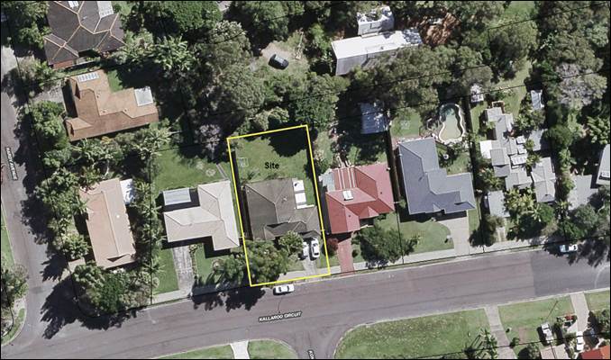
Figure 1:
Aerial image from Council’s GIS (2015)
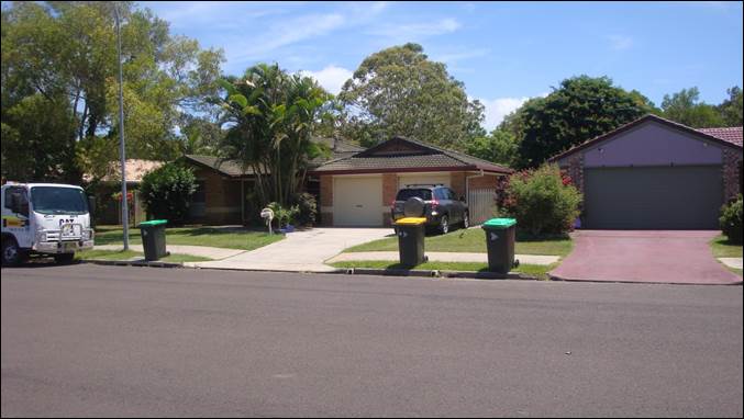
Figure 2:
Existing dwelling looking north from Kallaroo Circuit (centre frame). The
double garage to be reduced to a single garage with a new driveway down the
eastern boundary.
The
locality
Located immediately to
the north of the proposed development is a Council owned reserve, being Lot 19
in DP 872205.
Both adjoining lots to the east and west
contain residential dwellings.
The east of the site adjoins the side
boundary of a residential allotment with a site area of 884.1 m², legally
described as Lot 2082 in DP 808462.
The west of the site adjoins the side
boundary of a residential allotment with a site area of 771.7 m², legally
described as Lot 2084 in DP 808462.
The south of the site has frontage onto the
local road, Kallaroo Circuit, and is directly opposite the intersection with
Kanda Court, a cul-de-sac that provides access to eleven (11) residential
allotments, legally described as Lots 2091-2101 in DP 808462.
In summary, the site is
located in an established low density residential area in the suburb of Ocean
Shores. Surrounding properties comprise of single dwellings with the exception
of the adjoining Council reserve located immediately to the north of the site.
Land and Environment
Court proceedings
On 1 February 2018 the
applicant made application to the court Class 1 of each jurisdiction appealing
against Councils deemed refusal of the DA.
The application
is a residential development appeal as it concerns detached single dwellings
and dual occupancies (including subdivision), or alterations or additions to
such dwellings or dual occupancies.
Residential
development appeals are required to be dealt with by a special, streamlined
conciliation and adjudication process under s 34AA of
the Land and Environment Court Act. This involves the usual conciliation
process (see below) but with two important differences.
First, the
Court must arrange a conciliation conference for residential development
appeals.
Second, if the
parties are not able to agree about the substantive outcome at the conciliation
conference, the conciliation commissioner or registrar must terminate the
conciliation conference and immediately proceed to adjudicate and dispose of
the proceedings, either after a hearing held immediately or, if the parties
consent, on the basis of what has occurred at the conciliation
conference. The parties do not have the option of having the proceedings
return to the Court to be heard by a different commissioner or judge.
The application
is fixed for a s 34AA conciliation and hearing on Monday 6 and Tuesday 7 August
2018.
On 23 March 2018 Council filed its
Contentions in respect of the application. Council contended that the DA should
be refused on the following grounds:
Minimum subdivision lot size
The proposed development does not comply with the minimum
lot size for subdivision in Clause 4.1 of BLEP 2014.
Minimum lot
size for dual occupancy development
The proposed development does not comply with the minimum
lot size for dual occupancy
development in Clause 4.1 E of BLEP 2014.
Essential services
- vehicular access and stacked
parking
The proposed development does not comply with Clause 6.6 Essential
Services of BLEP 2014, which provides that development consent must not be
granted to a development unless suitable vehicular access has been provided.
Stormwater drainage
Insufficient information has been provided to demonstrate that the new
residence can drain to the street.
Landscape principles
The proposed
development does not provide adequate landscaping and does not comply with BDCP 2014 Chapter
89, Landscaping, Part 89.5 Dual Occupancies and Semi Detached
Dwellings.
Character
The proposed development is inconsistent with the character of the
locality.
Private open space
The private
open space to be provided by the proposed development is inadequate and
does not does not comply with BOCP 2014, Chapter 01 Residential Accommodation in Urban, Village
and Special Purpose Zones with regards to private open space principles.
Over development of the site
The site is not
considered suitable for the development as proposed.
Precedent
The proposed
development contravenes Council's adopted development standards and development
controls without sufficient justification and the approval of the proposed
development will set a precedent for similarly inappropriate development on
land zoned low density residential.
Public interest
The proposed
development is not in the public interest having regard to the contentions
raised above and the submission received in relation to the proposed
development.
Joint
conferencing of experts
As part of
its Case Management processes the Court gave directions for conferencing
between Council’s and the applicant’s experts in the town planning,
access engineering and drainage engineering.
The amended proposal
Following
multiple iterations and revisions through mediation between the
applicant’s and Council’s nominated expert witnesses in relation to
engineering and planning matters Council has received the attached revised
plans and Clause 4.6 Variation Request. The applicant has
agreed to the following amendments:
1. The proposed development plans have been amended, as
follows:
a. Removal of strata subdivision boundaries
b. Removal of stacked parking
c. Driveway and manoeuvring areas improved by increasing
the turning areas and ensuring that no vertical obstructions will be
constructed to the side of the realigned garage wall
d. Roof and windows amended to improve solar access to the
dwelling to be constructed at the rear
e. Increased building separation addresses solar access,
privacy and general amenity for both dwellings
f. Front garage door relocated and on-site parking,
driveway arrangements improved with space for landscape screening in the front
set back
g. Landscaping and private open space for both dwellings
improved with suitable courtyard areas accessible from living areas and
improved distribution of deep soil planting
2. The description of the proposal now
seeks consent for 'Alterations and additions to existing dwelling
house and construction of a dwelling house to create dual occupancy (detached)'
meaning that strata subdivision no longer forms part of the
application.
Note.
As a result of withdrawing the strata subdivision, the amended description of
the development will affect the bushfire assessment, originally applied for as
integrated development. 100B special fire purpose approval was granted by
RFS due to the proposed subdivision. Any determination would need to be
granted in accordance with Section 79BA of the Act.
3. The applicant has prepared an amended application
pursuant to Clause 4.6 to vary the Clause 4.1E development standard, which now
satisfactorily addresses the matters Council is required to consider under its
delegations by the Secretary. The applicant has submitted a variation should be
granted for the following reasons:
The particular
environmental planning grounds to justify contravening the minimum lot size
development standard:
· is
not contrary to the objects of the EP & A Act 1979 (per Section 1.3)
· is
not contrary to the aims of the BLEP 2014 (per Clause 1.2)
· is
permitted with consent in and is consistent with the objectives of the R2 zone
· is
not contrary to the objective of Clause 4.1E of the BLEP 2014
· is
such that will attain the principles of affordable housing, in that dual
occupancies are considered to comprise and provide affordable housing stock
· is
not contrary to the best public interest
It is
considered that there are sufficient environmental planning grounds to justify
contravening the minimum lot size development standard for the following
additional reasons, particular to the proposal and the site:
· The
proposal is for a single storey dwelling that will result in 2 x single storey dwellings
being located on the property
· The
proposed Floor Space Ratio is only 0.3:1
· The
proposed dwelling effectively fronts a public reserve to the rear
· The
proposal does not result
in any amenity impacts for
surrounding properties in terms of privacy, overshadowing and bulk and scale.
· The
proposal provides greater deep soil areas then required by the DCP (190m²
required where 280m² is proposed). Additionally, considering that the
minimum lot size for a Dual Occupancy in the R2 zone is 800m², it would
reasonable to require that the minimum amount of deep soil should in fact be
200m² which this proposal is in full compliance with.
· The
proposal provides greater private open space then what is required by the DCP
for both dwellings (30m² required where 44m² proposed for dwelling 1
and 60+m² for proposed dwelling 2).
The proposal
demonstrates the environmental planning grounds to justify a variation to the
Clause 4.1E development standard of 800 m².
Council’s contentions in
the proceedings
It is considered that the documents and amended proposal
satisfactorily address all contentions and reasons for refusal of DA
10.2017.639.1, subject to recommended conditions of consent, attached.
1. Non Compliance with Clause 4.1 of Byron
LEP 2014
As a result of subsequent amendments to
Byron LEP 2014 by the Department of Planning in relation
to Minimum lot sizes for strata subdivision, Councils contentions and reasons
for refusal in the first instance fall away, as follows:
Byron LEP 2014 was amended by the
Department of Planning with a statewide amendment to the Standard instrument on
20 April 2018. The Clause now states:
Byron Local Environmental Plan 2014
4.1 Minimum
subdivision lot size
(1) The objectives of this clause are
as follows:
(a) to ensure that lot sizes are
compatible with local environmental values and constraints,
(b) to facilitate efficient use
of land resources for residential and other human purposes.
(2) This clause applies to a
subdivision of any land shown on the Lot Size Map that requires development consent and that is carried
out after the commencement of this Plan.
(3) The size of any lot resulting
from a subdivision of land to which this clause applies is not to be less than
the minimum size shown on the Lot Size Map in relation to that land.
(4) This clause does not apply in
relation to the subdivision of any land:
(a) by the registration of a
strata plan or strata plan of subdivision under the Strata Schemes Development Act 2015, or
(b) by any kind of subdivision
under the Community Land Development Act 1989.
In this regard sub-clause 4 excludes compliance with the minimum lot
size map provisions of 600 m² in relation to strata subdivision whether sought as part of a
development application or not. . It is the intention of the applicant to pursue
strata subdivision after the building is constructed under exempt development
provisions. This contention therefore no longer
exists.
2. Minimum lot
size for dual occupancy development
The proposed development does not comply with the minimum
lot size for dual occupancy
development in Clause 4.1 E of BLEP 2014.
The applicant has prepared an amended Clause 4.6
Variation request that satisfactorily address the 4.9% variation to the minimum
lot size required for dual occupancies that is justifiable in relation to the
amended plans and documents received and agreed through mediation. It is
considered that there are sufficient environmental planning grounds to justify
contravening the minimum lot size development standard for the additional
reasons, particular to the proposal and the site.
3. Essential services
- vehicular access and stacked
parking
The amended development proposal now
complies with Clause 6.6 Essential Services of BLEP 2014, which provides that
development must provide suitable vehicular access has been provided. All
stacked parking has been removed.
4. Stormwater drainage
Sufficient information has now been
provided to the satisfaction of Councils engineer to demonstrate that the new
residence can drain stormwater to the street.
5. Landscape principles
The amended layout now provides adequate landscaping for
both dwellings in accordance with BDCP 2014 Chapter B9, Landscaping, Part B9.5 Dual Occupancies and Semi Detached
Dwellings.
6. Character
The amended development layout provides for
access, landscaping and open space that is more consistent with the character
of the locality.
7. Private open space
The quality and functionality of private open space to be
provided by the proposed development is significantly improved to comply with
BDCP 2014,
Chapter D1 Residential Accommodation in Urban,
Village and Special Purpose Zones with regards to
private open space principles.
8. Over development of the site
The amendments to the layout are considered to reduce the
impacts of the development through improved building separation, solar access,
privacy and general amenity for both dwellings. The site is considered
suitable for the development as amended.
Financial Implications
The estimated professional legal costs of defending the
appeal is $25,000 excluding GST, assuming that the hearing in the matter only
takes 2 days. If the hearing takes longer the legal costs will be higher.
As Council’s experts in the proceedings are internal
staff there will be no expert witness fees.
Statutory and Policy
Compliance Implications
Conciliation in the Court is undertaken in accordance with
Section 34 of the Court Act (otherwise known as a Section 34 Conference).
Section 34 Conferences, as articulated by the Chief Judge in
(2008) 19 ADRJ 72, provide: “for a combined or hybrid dispute
resolution process involving first, conciliation and then, if the parties
agree, adjudication. The conciliation involves a Commissioner with technical
expertise on issues relevant to the case acting as a conciliator in a
conference between the parties. The conciliator facilitates negotiation between
the parties with a view to their achieving agreement as to the resolution of
the dispute. If the parties are able to reach agreement, the conciliator, being
a Commissioner of the Court, is able to dispose of the proceedings in
accordance with the parties’ agreement.”
The Court’s practice note encourages parties to
consider using Section 34 Conferences to resolve disputes or narrow the scope
of issues in dispute. The parties should properly prepare for each conference
with this purpose in mind.
In accordance with Section 34(1A) of the Court Act it is the
duty of each party to proceedings where a conciliation conference has been
arranged to participate, in good faith, in the conciliation conference.
Conciliation Agreement/Consent Orders
The differences between finalising the Court proceedings via
a Conciliation Agreement compared to Consent Orders are as follows:
1.
A Conciliation Agreement is between Council and the applicant ie Council stays
the determining authority.
Use of a Conciliation Agreement
would bring the Court cases to an end immediately and without the need for
Council to include any expert witness costs or any legal costs beyond the minor
costs associated with finalising the Conciliation Agreement.
2.
Consent Orders are Orders issued by the Court by agreement ie the Court becomes
the determining authority and has the power to refuse to issue the orders the
parties are asking for and/or to make different orders instead. With a Consent
Orders hearing, everything, including the proposed conditions, is open to the Court
to finally determine and, for example, a Commissioner might disagree with
proposed conditions and issue orders with different conditions.
Because the Court becomes the
determining authority, Consent Orders will not be entered by the Court without
a hearing. That means a hearing would need to be held (usually commencing
on-site then adjourning to a local Court house) and solicitors, expert witnesses
and people who lodged an objection who wished to make a verbal submission to
the hearing would have to attend, and Council would incur the associated legal
and witnesses costs.
Usually, Consent Orders Hearing
are shorter than defended hearings, often only 2 - 4 hours instead of the
minimum full day hearing or more, but the hearing still needs to be prepared
for and attended, just like a defended hearing would be, which means that the
vast majority of the costs are still incurred.
Due to the reduced certainty and
the higher costs, this is usually not the option recommended by staff for
disposal of the court cases where Conciliation Agreement option is still
available, as is the case here.
Staff Reports - Corporate and Community Services 13.8
Report No. 13.8 Council
Investments June 2018
Directorate: Corporate
and Community Services
Report
Author: James
Brickley, Manager Finance
File No: I2018/1282
Theme: Corporate Management
Financial Services
Summary:
This report includes a list of investments and identifies
Council’s overall cash position for the month of June 2018 for
Council’s information.
This report is prepared to comply with Regulation 212 of the
Local Government (General) Regulation 2005.
|
RECOMMENDATION:
That the report listing Council’s
investments and overall cash position as at 30 June 2018 be noted.
|
Report:
In relation to the investment portfolio for the month of
June 2018, Council has continued to maintain a diversified portfolio of
investments. At 30 June 2018, the average 90 day bank bill rate (BBSW) for the
month of June was 2.07%. Council’s performance to 30 June 2018 is 2.60%
Council’s performance is again higher than the benchmark. This is largely
due to the active ongoing management of the investment portfolio, maximising
investment returns through secure term deposits and purchasing floating rate
notes with attractive interest rates.
The table below identifies the investments held by Council
as at 30 June 2018:
Schedule of
Investments held as at 30 June 2018
|
Purch Date
|
Principal ($)
|
Description
|
CP*
|
Rating
|
Maturity Date
|
No Fossil
Fuel ADI
|
Type
|
Interest Rate Per
Annum
|
Current Value
|
|
28/10/16
|
650,000
|
Teachers Mutual Bank
|
P
|
BBB+
|
28/10/19
|
Y
|
FRN
|
3.17%
|
655,144.56
|
|
24/03/17
|
1,000,000
|
NAB Social Bond (Gender Equality)
|
P
|
AA-
|
24/03/22
|
N
|
B
|
3.25%
|
1,017,387.17
|
|
31/03/17
|
1,000,000
|
CBA Climate Bond
|
P
|
AA-
|
31/03/22
|
N
|
FRN
|
3.25%
|
1,000,000.00
|
|
16/11/17
|
750,000
|
Bank of Queensland
|
P
|
BBB+
|
16/11/21
|
N
|
FRN
|
2.63%
|
750,000.00
|
|
02/01/18
|
2,000,000
|
ME Bank
|
P
|
BBB
|
04/07/18
|
Y
|
TD
|
2.55%
|
2,000,000.00
|
|
23/01/18
|
1,000,000
|
AMP Bank
|
P
|
A
|
23/07/18
|
N
|
TD
|
2.60%
|
1,000,000.00
|
|
24/01/18
|
1,000,000
|
ME Bank
|
N
|
BBB
|
24/07/18
|
Y
|
TD
|
2.60%
|
1,000,000.00
|
|
29/01/18
|
2,000,000
|
Rural Bank
|
P
|
BBB+
|
30/07/18
|
Y
|
TD
|
2.60%
|
2,000,000.00
|
|
31/01/18
|
2,000,000
|
AMP Bank
|
N
|
A
|
03/08/18
|
N
|
TD
|
2.60%
|
2,000,000.00
|
|
02/02/18
|
1,000,000
|
Rural Bank
|
N
|
BBB+
|
02/08/18
|
Y
|
TD
|
2.62%
|
1,000,000.00
|
|
06/02/18
|
1,000,000
|
Gateway Credit Union
|
P
|
NR
|
07/08/18
|
Y
|
TD
|
2.55%
|
1,000,000.00
|
|
08/02/18
|
1,000,000
|
AMP
|
N
|
A
|
08/08/18
|
N
|
TD
|
2.60%
|
1,000,000.00
|
|
15/02/18
|
1,000,000
|
Police Credit Union Limited (SA)
|
P
|
NR
|
15/08/18
|
Y
|
TD
|
2.61%
|
1,000,000.00
|
|
01/03/18
|
1,000,000
|
Defence Bank
|
P
|
BBB
|
01/08/18
|
U
|
TD
|
2.50%
|
1,000,000.00
|
|
06/03/18
|
2,000,000
|
My State Bank
|
P
|
BBB
|
06/09/18
|
Y
|
TD
|
2.65%
|
2,000,000.00
|
|
06/03/18
|
1,000,000
|
Bananacoast Credit Union
|
P
|
NR
|
06/09/18
|
Y
|
TD
|
2.60%
|
1,000,000.00
|
|
07/03/18
|
1,000,000
|
Beyond Bank
|
P
|
BBB
|
09/07/18
|
Y
|
TD
|
2.50%
|
1,000,000.00
|
|
07/03/18
|
1,000,000
|
Bananacoast Credit Union
|
N
|
NR
|
07/08/18
|
Y
|
TD
|
2.55%
|
1,000,000.00
|
|
14/03/18
|
1,000,000
|
NAB
|
P
|
AA-
|
16/07/18
|
N
|
TD
|
2.58%
|
1,000,000.00
|
|
16/03/18
|
1,000,000
|
The Capricornian Credit Union
|
P
|
NR
|
17/09/18
|
U
|
TD
|
2.80%
|
1,000,000.00
|
|
04/04/18
|
2,000,000
|
Police Credit Union Limited (SA)
|
N
|
NR
|
03/10/18
|
Y
|
TD
|
2.86%
|
2,000,000.00
|
|
04/04/18
|
1,000,000
|
NAB
|
N
|
AA-
|
04/07/18
|
N
|
TD
|
2.57%
|
1,000,000.00
|
|
04/04/18
|
1,000,000
|
NAB
|
N
|
AA-
|
04/10//18
|
N
|
TD
|
2.60%
|
1,000,000.00
|
|
05/04/18
|
1,000,000
|
AMP Bank
|
N
|
A
|
02/10/18
|
N
|
TD
|
2.60%
|
1,000,000.00
|
|
05/04/18
|
1,000,000
|
NAB
|
N
|
AA-
|
05/07/18
|
N
|
TD
|
2.57%
|
1,000,000.00
|
|
05/04/18
|
1,000,000
|
Police Credit Union Limited (SA)
|
N
|
NR
|
02/10/18
|
Y
|
TD
|
2.85%
|
1,000,000.00
|
|
06/04/18
|
1,000,000
|
Hunter United Employees Credit Union
|
P
|
NR
|
05/07/18
|
U
|
TD
|
2.55%
|
1,000,000.00
|
|
10/04/18
|
1,000,000
|
Bankwest
|
P
|
AA-
|
09/07/18
|
N
|
TD
|
2.60%
|
1,000,000.00
|
|
12/04/18
|
1,000,000
|
Bankwest
|
N
|
AA-
|
12/07/18
|
N
|
TD
|
2.60%
|
1,000,000.00
|
|
16/04/18
|
1,000,000
|
The Capricornian Credit Union
|
N
|
NR
|
17/09/18
|
U
|
TD
|
2.74%
|
1,000,000.00
|
|
17/04/18
|
1,000,000
|
Police Credit Union Limited (SA)
|
N
|
NR
|
17/10/18
|
Y
|
TD
|
2.94%
|
1,000,000.00
|
|
23/04/18
|
1,000,000
|
NAB
|
N
|
AA-
|
23/07/18
|
N
|
TD
|
2.57%
|
1,000,000.00
|
|
24/04/18
|
1,000,000
|
Bankwest
|
N
|
AA-
|
23/07/18
|
N
|
TD
|
2.65%
|
1,000,000.00
|
|
30/04/18
|
2,000,000
|
NAB
|
N
|
AA-
|
30/08/18
|
N
|
TD
|
2.64%
|
2,000,000.00
|
|
02/05/18
|
2,000,000
|
Police Credit Union Limited (SA)
|
N
|
NR
|
30/10/18
|
Y
|
TD
|
2.83%
|
2,000,000.00
|
|
02/05/18
|
1,000,000
|
Maitland Mutual Building Society
|
P
|
NR
|
29/10/18
|
Y
|
TD
|
2.83%
|
1,000,000.00
|
|
07/05/18
|
2,000,000
|
NAB
|
N
|
AA-
|
06/08/18
|
N
|
TD
|
2.64%
|
2,000,000.00
|
|
08/05/18
|
2,000,000
|
ME Bank
|
N
|
BBB
|
07/08/18
|
Y
|
TD
|
2.60%
|
2,000,000.00
|
|
09/05/18
|
1,000,000
|
Coastline Credit Union
|
P
|
NR
|
07/08/18
|
U
|
TD
|
2.80%
|
1,000,000.00
|
|
15/05/18
|
1,000,000
|
Maitland Mutual Building Society
|
N
|
NR
|
15/08/18
|
Y
|
TD
|
2.85%
|
1,000,000.00
|
|
15/05/18
|
1,000,000
|
Maitland Mutual Building Society
|
N
|
NR
|
15/10/18
|
Y
|
TD
|
2.85%
|
1,000,000.00
|
|
17/05/18
|
1,000,000
|
Hunter United Employees Credit Union
|
N
|
NR
|
17/09/18
|
U
|
TD
|
2.80%
|
1,000,000.00
|
|
23/05/18
|
1,000,000
|
The Capricornian Credit Union
|
N
|
NR
|
23/11/18
|
U
|
TD
|
2.85%
|
1,000,000.00
|
|
24/05/18
|
1,000,000
|
ME Bank
|
N
|
BBB
|
21/09/18
|
Y
|
TD
|
2.60%
|
1,000,000.00
|
|
28/05/18
|
1,000,000
|
B & E Ltd (Bank of Us)
|
P
|
NR
|
28/11/18
|
U
|
TD
|
2.85%
|
1,000,000.00
|
|
28/05/18
|
1,000,000
|
ME Bank
|
N
|
BBB
|
27/08/18
|
Y
|
TD
|
2.60%
|
1,000,000.00
|
|
30/05/18
|
1,000,000
|
Maitland Mutual Building Society
|
N
|
NR
|
20/08/18
|
Y
|
TD
|
2.80%
|
1,000,000.00
|
|
30/05/18
|
1,000,000
|
Maitland Mutual Building Society
|
N
|
NR
|
11/09/18
|
Y
|
TD
|
2.80%
|
1,000,000.00
|
|
30/05/18
|
1,000,000
|
AMP Bank
|
N
|
A
|
25/02/19
|
N
|
TD
|
2.80%
|
1,000,000.00
|
|
31/05/18
|
1,000,000
|
Maitland Mutual Building Society
|
N
|
NR
|
20/08/18
|
Y
|
TD
|
2.80%
|
1,000,000.00
|
|
01/06/18
|
1,000,000
|
Suncorp
|
Y
|
A
|
30/08/18
|
Y
|
TD
|
2.65%
|
1,000,000.00
|
|
01/06/18
|
1,000,000
|
Police Credit Union Limited (SA)
|
N
|
NR
|
21/09/18
|
Y
|
TD
|
2.82%
|
1,000,000.00
|
|
05/06/18
|
1,000,000
|
NAB
|
N
|
AA-
|
03/10/18
|
N
|
TD
|
2.70%
|
1,000,000.00
|
|
08/06/18
|
2,000,000
|
ME Bank
|
N
|
BBB
|
07/12/18
|
Y
|
TD
|
2.84%
|
2,000,000.00
|
|
08/06/18
|
1,000,000
|
Suncorp
|
N
|
A
|
09/10/18
|
Y
|
TD
|
2.82%
|
1,000,000.00
|
|
12/06/18
|
1,000,000
|
Bankwest
|
N
|
AA-
|
12/09/18
|
N
|
TD
|
2.70%
|
1,000,000.00
|
|
14/06/18
|
2,000,000
|
Suncorp
|
N
|
A
|
12/09/18
|
Y
|
TD
|
2.75%
|
2,000,000.00
|
|
15/06/18
|
1,000,000
|
Suncorp
|
N
|
A
|
15/10/18
|
Y
|
TD
|
2.80%
|
1,000,000.00
|
|
18/06/18
|
2,000,000
|
Beyond Bank
|
N
|
BBB
|
18/12/18
|
Y
|
TD
|
2.75%
|
2,000,000.00
|
|
18/06/18
|
1,000,000
|
Gateway Credit Union
|
N
|
NR
|
18/12/18
|
Y
|
TD
|
2.90%
|
1,000,000.00
|
|
26/06/18
|
1,000,000
|
Bankwest
|
N
|
AA-
|
24/06/18
|
N
|
TD
|
2.80%
|
1,000,000.00
|
|
N/A
|
3,075,625
|
CBA Business Online Saver
|
N
|
A
|
N/A
|
N
|
CALL
|
1.40%
|
3,075,625.12
|
|
12/01/18
|
1,008,820
|
NSW Treasury Corp
|
N
|
AAA
|
N/A
|
Y
|
CALL
|
1.60%
|
1,008,820.41
|
|
Total
|
76,484,445
|
|
|
|
|
|
AVG
|
2.60%
|
76,506,977.26
|
|
Note 1.
|
CP = Capital protection on maturity
|
|
|
N = No Capital Protection
|
|
|
Y = Fully covered by Government Guarantee
|
|
|
P = Partial Government Guarantee of $250,000 (Financial
Claims Scheme)
|
|
|
|
|
Note 2.
|
No Fossil Fuel ADI
|
|
|
Y = No investment in Fossil Fuels
|
|
|
N = Investment in Fossil Fuels
|
|
|
U = Unknown Status
|
|
Note 3.
|
Type
|
Description
|
|
|
|
B
|
Bonds
|
Principal can vary based on
valuation, interest payable via a fixed interest, payable usually each
quarter.
|
|
|
FRN
|
Floating Rate Note
|
Principal can vary based on
valuation, interest payable via a floating interest rate that varies each
quarter.
|
|
|
TD
|
Term Deposit
|
Principal does not vary during investment term. Interest
payable is fixed at the rate invested for the investment term.
|
|
|
CALL
|
Call Account
|
Principal varies due to cash flow demands from deposits/withdrawals,
interest is payable on the daily balance.
|
Environmental and Socially
Responsible Investing
An additional column has been
added to the schedule of Investments above, to identify if the financial
institution holding the Council investment, has been assessed as a ‘No
Fossil Fuel’ investing institution. This information has been
sourced through www.marketforces.org.au and identifies financial
institutions that either invest in fossil fuel related industries or do
not. The graph below highlights the percentage of each classification
across Council’s total investment portfolio in respect of fossil fuels
only.
The notion of Environmental and
Socially Responsible Investing is much broader than whether a financial
institution as rated by ‘marketforces.org.au’ invests in fossil
fuels or not. Council’s current Investment Policy defines
Environmental and Socially Responsible Investing at Section 4.1 of the
Policy. Council’s Investment Policy can be found at Council’s
website via the following link:
https://www.byron.nsw.gov.au/Council/Your-right-to-Council-information/Policies?dlv_OC%20CL%20Public%20DocLib%20Relative=(pageindex=6)
In this regard Council has an
additional two investments that are with financial institutions that invest in
fossil fuels but the purposes of the investments are in accord with the broader
definition of Environmental and Socially Responsible investments as indicated
below:
1. $1,000,000 investment with the National Australia Bank maturing
on 24 March 2022 known as a Social Bond that promotes Gender Equity.
2. $1,000,000 investment with Commonwealth Bank maturing on 31
March 2022 known as a Climate Bond.
For the month of June 2018, as indicated in the table below,
there is a dissection of the investment portfolio by investment type:
Dissection
of Council Investment Portfolio as at 30 June 2018
|
Principal Value ($)
|
Investment Linked to:-
|
Current Market Value ($)
|
Cumulative Unrealised Gain/(Loss) ($)
|
|
69,000,000.00
|
Term
Deposits
|
69,000,000.00
|
0.00
|
|
2,400,000.00
|
Floating
Rate Note
|
2,405,144.56
|
5,144.56
|
|
3,075,625.12
|
Business
On-Line Saver (At Call)
|
3,075,625.12
|
0.00
|
|
1,008,820.41
|
NSW Treasury Corp
(T Corp)
|
1,008,820.41
|
0.00
|
|
1,000,000.00
|
Bonds
|
1,017,387.17
|
17,387.17
|
|
76,484,445.53
|
|
76,506,977.26
|
22,531.73
|
The current value of an investment compared to the principal
value (face value or original purchase price) provides an indication of the
performance of the investment without reference to the coupon (interest) rate. The
current value represents the value received if an investment was sold or traded
in the current market, in addition to the interest received.
The table below provides a reconciliation of investment
purchases and maturities for month of June 2018 on a current market value
basis.
Movement
in Investment Portfolio – 30 June 2018
|
Item
|
Current Market Value (at end of month) $
|
|
Opening
Balance at 1 June 2018
|
75,997,698.45
|
|
Add:
New Investments Purchased
|
14,000,000.00
|
|
Add:
Call Account Additions
|
2,500,000.00
|
|
Add:
Interest from Call Account
|
0.00
|
|
Less:
Investments Matured
|
16,000,000.00
|
|
Add:
T Corp Additions
|
0.00
|
|
Add:
Interest from T Corp
|
1,490.14
|
|
Less:
Call Account Redemption
|
0.00
|
|
Add:
Fair Value Movement for period
|
7,788.67
|
|
Closing
Balance at 30 June 2018
|
76,506,977.26
|
Investments
Maturities and Returns – June 2018
|
Principal Value ($)
|
Description
|
Type
|
Maturity Date
|
Number of Days Invested
|
Interest Rate Per Annum
|
Interest Paid on Maturity $
|
|
1,000,000
|
NAB
|
TD
|
05/06/18
|
92
|
2.54%
|
6,402.20
|
|
2,000,000
|
ME Bank
|
TD
|
08/06/18
|
182
|
2.55%
|
25,430.14
|
|
2,000,000
|
My State Bank
|
TD
|
08/06/18
|
182
|
2.65%
|
26,427.40
|
|
1,000,000
|
Bank of Queensland
|
TD
|
12/06/18
|
151
|
2.55%
|
10,549.32
|
|
1,000,000
|
Bankwest
|
TD
|
12/06/18
|
151
|
2.55%
|
10,549.32
|
|
1,000,000
|
Bankwest
|
TD
|
15/06/18
|
120
|
2.50%
|
8,219.18
|
|
1,000,000
|
Auswide Bank
|
TD
|
15/06/18
|
92
|
2.51%
|
6,326.58
|
|
1,000,000
|
The Capricornian
|
TD
|
15/06/18
|
92
|
2.55%
|
6,427.40
|
|
2,000,000
|
Beyond Bank
Australia
|
TD
|
18/06/18
|
131
|
2.50%
|
18,082.19
|
|
1,000,000
|
Gateway Credit
Union
|
TD
|
18/06/18
|
122
|
2.45%
|
8,189.04
|
|
2,000,000
|
Credit Union
Australia
|
TD
|
19/06/18
|
182
|
2.60%
|
25,928.77
|
|
1,000,000
|
Bankwest
|
TD
|
26/06/18
|
90
|
2.50%
|
6,164.38
|
|
16,000,000
|
|
|
|
|
|
158,695.92
|
The overall ‘cash position’ of Council is not
only measured by what funds Council has invested but also by what funds Council
has retained in its consolidated fund or bank account as well for operational
purposes. In this regard, for the month of June 2018 the table below identifies
the overall cash position of Council as follows:
Dissection
of Council Cash Position as at 30 June 2018
|
Item
|
Principal Value ($)
|
Current Market Value ($)
|
Cumulative Unrealised Gain/(Loss) ($)
|
|
Investments
Portfolio
|
|
|
|
|
Term Deposits
|
69,000,000.00
|
69,000,000.00
|
0.00
|
|
Floating Rate Note
|
2,400,000.00
|
2,405,144.56
|
5,144.56
|
|
Business On-Line
Saver (At Call)
|
3,075,625.12
|
3,075,625.12
|
0.00
|
|
NSW Treasury Corp
(T Corp)
|
1,008,820.41
|
1,008,820.41
|
0.00
|
|
Bonds
|
1,000,000.00
|
1,017,387.17
|
17,387.17
|
|
Total Investment
Portfolio
|
76,484,445.53
|
76,506,977.26
|
22,531.73
|
|
|
|
|
|
|
Cash at Bank
|
|
|
|
|
Consolidated Fund
|
1,781,201.56
|
1,781,201.56
|
0.00
|
|
Total Cash at Bank
|
1,781,201.56
|
1,781,201.56
|
0.00
|
|
|
|
|
|
|
Total Cash
Position
|
78,265,647.09
|
78,288,178.82
|
22,531.73
|
Financial Implications
Council uses a diversified mix of investments to achieve
short, medium and long-term results.
Statutory and Policy
Compliance Implications
In accordance with Regulation 212 of the Local Government
(General) Regulation 2005, the Responsible Accounting Officer of Council must
provide Council with a monthly report detailing all monies Council has invested
under section 625 of the Local Government Act 1993.
The Report must be presented at the next Ordinary Meeting of
Council after the end of the month being reported. In this regard, the
current Council Meeting cycle does not always allow this to occur, especially
when investment valuations required for the preparation of the report, are
often received after the deadline for the submission of reports for the
meeting. Endeavours will be made to ensure the required report will be
provided to Council and this will for some months require reporting for one or
more months.
Council’s investments are carried out in accordance
with section 625(2) of the Local Government Act 1993 and Council’s
Investment Policy. The Local Government Act 1993 allows Council to invest money
as per the Ministers Order – Forms of Investment, last published in the
Government Gazette on 11 February 2011.
Council’s Investment Policy includes the objective of
maximising earnings from authorised investments and ensuring the security of
Council Funds.
Council at its Ordinary Meeting held 8 October 2015 resolved
through resolution 15-515 to insert a new objective into its adopted
Investment Policy, which gives a third tier consideration by Council to
Environmental and Socially Responsible Investments, when making investment
decisions.
Staff Reports - Corporate and Community Services 13.9
Report No. 13.9 Implementation
of Resolution 18-308 - Tweed Street Masterplan
Directorate: Corporate
and Community Services
Report
Author: James
Brickley, Manager Finance
File No: I2018/1284
Theme: Corporate Management
Financial Services
Summary:
Council at its Ordinary
Meeting held on 24 May 2018 resolved (RES 18-308) to proceed with
smaller projects in Tweed Street utilising existing budgets where available and
for possible funding sources to be brought to the Extraordinary Meeting on 28
June 2018.
The funding sources were not
included in the draft and subsequently adopted 2018-2019 Budget Estimates
considered at the 28 June 2018 Meeting. This report is provided to Council to
consider funding for inclusion in the 2018-2019 Budget Estimates.
|
RECOMMENDATION:
That Council allocate $94,700 for Tweed Street Projects
in the 2018-2019 Budget with funding provided from the sources identified in
the financial implications section of this report.
|
Report
Council at its Ordinary
Meeting held on 24 May 2018 resolved (RES 18-308) to be provided with a report
on available and possible funding sources for the progression of smaller
projects in Tweed Street such as pocket parks or landscaping.
This report is provided to
Council to consider and approve available funding for inclusion in the
2018-2019 Budget Estimates should Council wish to proceed as provided in
Resolution 18-308 part 2.
Specifically Resolution 18-308
detailed the following:
1. That
Council note the current status of the Tweed Street Master Plan project.
2. That
Council proceeds with smaller projects in Tweed Street
in the short term, such as pocket parks and landscaping utilising existing
budgets where available and possible funding sources (to be brought to the
Extraordinary meeting on 28 June).
3. That
the Tweed Street Master Plan as a stand-alone project be put on hold until the
Brunswick Heads Master Plan and associated Access and Movement Strategy have
been developed, noting that the works undertaken and plans developed for the
Tweed Street Master Plan will be supplied as supporting information to the
consultant tasked with preparing the Brunswick Heads Master Plan and associated
Access and Movement Strategy.
The 2018-2019 Budget
Estimates were submitted to Council at the Extraordinary Meeting held on 28
June 2018 for adoption in conjunction with the Delivery Program and Operational
Plan documents.
The implications of Council
Resolutions that had impacts on the Draft 2018-2019 Budget during the public
exhibition period (that closed on 15 June 2018) were provided on pages 48 to 50
to Report 4.2 to that Agenda.
It is noted that Report 4.2
did not include any information in respect of Resolution 18-308. This
report now provides for Council to consider funding options.
Financial Implications
The current 2018-2019 Budget does not contain any funding to
progress smaller project works in Tweed Street in the short term.
However, Section 94 funds are available that Council could
include in the 2018-2019 Budget from the following sources:
1. $66,200
– Open Space Contribution Plan (Tweed Street Master Plan)
2. $13,300
– Civic and Urban Improvements Contribution Plan (Tweed Street)
It should be noted that the Open Space Contribution Plans is
growing at the rate of approximately $4,500 annually whilst there is no predicted
growth in the Civic and Urban Improvements Contributions Plan.
Utilising the Tweed Street Section 94 funds now for the
purpose of small landscape zones will remove Council’s ability to provide
funding support in any future grant application for a larger scale project.
In addition, to the identified Section 94 funding, there is
currently $15,200 from the 2017-2018 Budget available to complete the design
and community consultation that remains unspent and will be proposed for
reservation in the Infrastructure Carryover Reserve as part of the 30 June 2018
Quarterly Budget Review to be presented to the Finance Advisory Committee
Meeting to be held on 16 August 2018 and the Ordinary Council Meeting to be
held on 23 August 2018.
Given the consequence of Resolution 18-308 part 3,
Council could also reallocate these funds toward the small pocket park and
landscape works by utilising these funds to determine the appropriate works to
be undertaken and to complete associated design work for implementation.
Should Council wish to proceed on this basis, it would need
to include the provision of $94,700 in the 2018-2019 Budget Estimates by
Resolution with funding sources as identified in this report that represents
the current available funding.
Alternatively if Council does not wish to proceed with
Resolution 18-308 part 2, an alternative recommendation to the staff
recommendation in this report would be required.
Statutory and Policy Compliance Implications
Regulation 211 of the Local Government Regulation (2005)
identifies:
211 Authorisation of expenditure
(1) A council, or a person
purporting to act on behalf of a council, must not incur a liability for the
expenditure of money unless the council at the annual meeting held in
accordance with subclause
(2) or at a later ordinary meeting:
(a) has approved the expenditure,
and
(b) has voted the money necessary
to meet the expenditure.
(3) A council must each year hold a
meeting for the purpose of approving expenditure and voting money.
Council Resolution 18-111 part 5 identified
Council’s position that no expenditure is to be incurred without budget
as follows:
That Council reaffirm that no expenditure is to occur
without an approved budget backed by resolution of Council.
Staff Reports - Corporate and Community Services 13.10
Report No. 13.10 Amendment
of General Managers Delegation in respect of Legal Proceedings
Directorate: Corporate
and Community Services
Report
Author: Ralph
James, Legal Counsel
File No: I2018/1287
Theme: Corporate Management
Corporate Services
Summary:
This report has been prepared to
allow Council to consider and confirm the Instrument of Delegation from Council
to the General Manager.
Following the appointment on 2 July
2018 of the General Manager, it was considered appropriate that there be a form
of restriction or guidance concerning legal proceedings in which Council is a
party.
It is considered that the limit of
authority delegated to the General Manager, concerning legal proceedings, ought
be consistent irrespective of whether Council’s involvement is as the
commencing or defending party.
|
RECOMMENDATION:
That Council revoke its previous delegations to the
General Manager and adopt Instrument of Delegation to the General Manager as
per attachment 1 (E2018/56586)
|
Attachments:
1 Instrument
of Delegation to the General Manager , E2018/56586
⇨

Report
Power to delegate
All Councils delegate a large
number of powers and duties to their General Manager in order
to carry out all the
Council’s functions and powers.
Many of the powers and functions
require responsiveness within statutory time frames as
well as practical expectations.
For this reason, the system of delegations and authorisations
provides for the officers of
Council to execute the powers and functions of Council within a
clearly defined framework of
authority. Conditions may be placed upon any of the powers
being delegated.
Section 377 of the Local Government Act provides that a council may, by resolution, delegate to the general
manager or any other person or body (not including another employee of the
council) any of the functions of the council under this or any other Act, other
than specific matters which are set out in the
section.
Section 378 of the Local Government Act provides that
the general manager may delegate any of the functions of the general manager,
other than this power of delegation and may sub-delegate a function delegated
to the general manager by the council to any person or body (including another
employee of the council).
By an Instrument of
delegation Council authorises the exercise of specific powers, authorities,
duties and functions. These are set out in the Schedule to the Instrument of
delegation.
Where the authority to
exercise powers, authorities, duties and functions is to be amended in any way
the appropriate course is to revoke previous delegations of powers,
authorities, duties and functions and to adopt a fresh Instrument of
delegation.
Council’s
Legal Services Team
Council sources all of its legal
advices and conducts all of its legal proceedings, other than those involving
staff personnel matters, through its internal Legal Services Team.
Council’s
Legal Services Team has been operational since 2 February 2015. The team was
created as part of an organisational restructure, and comprises the Legal
Counsel, the Solicitor (both of whom are admitted to practice in New South
Wales) and the Legal Services Support Officer.
The team sits
within Council’s Corporate and Community Services Directorate.
Between 2
February 2015 and 21 July 2016 the team reported to the General Manager through
the Manager Governance (now Corporate) Services. Since 22 July 2016 the team
has reported to the General Manager directly through the Director Corporate and
Community Services.
The work of the team includes the
provision of professional advice across Council, court appearances and
instructing Council’s external solicitors.
On 22 February 2018 Council
resolved to award Tender 2017-0054 for Provision of Legal Services to the
following tenderers:
· HWL
Ebsworth Lawyers
· Marsdens
Law Group
· McCabes
Lawyers
· Swaab Attorneys
Delegated
authority concerning legal proceedings
Since (at
least) 2008 until November 2017 the authority delegated by Council to the
General Manager in respect of legal proceedings was in the following terms:
(c) to take such actions and do such
acts and things (not inconsistent with the Act or any Act, ordnance, regulation,
or by law conferring powers or imposing duties on the Council or with any
resolution or minute which has been passed or adopted by the Council) as he
deems necessary to generally manage, control and administer the affairs of the
Council including exercise of the powers and discretions of the Council and
performance of its duties.
Without limiting the generality of
the provisions of the aforesaid, to lay Informations and initiate and prosecute
legal actions in relation to any breach of any Act, ordinance, regulation or
by-law administered in whole or in part by Council and to authorise at his/her
discretion specific persons to lay Informations before a court of law and to
obtain legal advice (within the sums voted by Council for that purpose) as and
when the General Manager deems it necessary so to do.
At its Ordinary Meeting on 21 September 2017 Council
received a report concerning delegations.
Council resolved as follows concerning the General
Manager’s delegation in respect of legal proceedings:
Commencement of legal proceedings
Delegation to commence legal
proceedings is limited to those proceedings in which Council’s solicitors
estimate, in writing, that the legal costs for the proceedings will be less
than $50,000.
Settlement of legal proceedings
The delegations do not include:
· Power
to settle legal proceedings for payment of less than 50% of Council’s
original or amended claim.
· Power
to enter into consent orders in the Land and Environment Court in relation to
development for which the General Manager would not otherwise be able to grant
consent under delegation.
Council’s delegated authority was not implemented
until November 2017 when the Instrument of delegation was signed by both the
Mayor and the General Manager.
There is consistency between the pre-and post 21 September
2017 delegations concerning legal proceedings, in that, any limitation on the
General Manager’s delegated authority applies only the commencement of
legal proceedings.
Commencement of action is the formal procedure by
which legal proceedings are initiated.
Legal
proceedings are usually commenced by the filing of a summons, statement of
claim or an application. These are called the originating process.
Parties who commence proceedings
are required to serve a copy of the originating process on all the defendants.
If served with originating process a Defendant must file a
defence.
Commencement of proceedings and
defence of proceedings once commenced, are separate and distinct phases of
legal proceedings.
Reporting of legal proceedings
All legal proceedings, whether
commenced or defended by Council, are reported to both the Executive Team and
the Councillors, on a monthly basis via the Legal Services Status Report.
That report sets out the nature and
status (at the time of the report) of the proceedings together with the costs
expended in respect of the proceedings up to the date of the report.
Some legal proceedings are also
reported to both the Executive Team and the Councillors by Memorandum outside
of the Legal Services Status Report framework.
The following table sets out the
proceedings instituted or defended by Council since November 2017 (the date on
which the 21 September 2017 delegations were implemented), the date on which
they were reported to Councillors, the original cost estimate and the current
costs expenditure.
Proceedings
instituted by Council
|
Local Court
|
|
Matter
|
Reported to Councillors
|
Costs Estimate
|
Actual Costs
|
|
Lewis
|
January 2018, February 2018
|
Internal
|
Nil
|
|
Davies
|
February 2018, March 2018
|
Internal
|
Nil
|
|
Nabors
|
February 2018, March 2018,
April 2018, May 2018, June 2018
|
$3,500 (Counsel instructed
by the Legal Services team)
|
$3,800
|
|
Main Street Burger Bar
|
April 2018, May 2018
|
$500 (Counsel instructed by
the Legal Services team)
|
$500
|
|
Muchada
|
May 2018, June 2018, July
2018
|
Internal
|
Ongoing. Nil costs
anticipated.
|
|
Greenbank Properties Pty
Ltd
|
May 2018, June 2018, July
2018
|
Internal
|
Ongoing. Nil costs
anticipated.
|
|
Land and Environment Court
|
|
Nil
|
|
|
|
|
Supreme Court
|
|
Dansar Pty Ltd
|
May 2018, June 2018
|
Nil. Matter run on behalf
of Council’s insurer.
|
$12,373.50
|
Proceedings
defended by Council
|
Local Court
|
|
23 Court elected Penalty
Notices in respect of parking infringements. All dealt with by the Legal
Services team with nil costs incurred.
|
|
Land and Environment Court
|
|
Matter
|
Reported to Councillors
|
Costs Estimate
|
Actual Costs
|
|
Koresoft Pty Ltd
|
November 2017, December
2017, January 2018, February 2018, March 2018, April 2018
|
$15,000
|
$9,696.53
|
|
Gordon Highlands Pty Ltd
|
December 2017, January
2018, February 2018, March 2018, April 2018, May 2018, June 2018, July 2018
|
$22,000 - $25,000
|
$13,890.40
|
|
Ardill Payne – 541
Friday Hut Road
|
January 2018, February
2018, March 2018, April 2018, May 2018, June 2018, July 2018
|
$22,000 - $25,000
|
$15,494.82
|
|
Ardill Payne – 33
Kallaroo Circuit
|
February 2018, March 2018,
April 2018, May 2018, June 2018, July 2018
|
$22,000 - $25,000
|
$1,367.85
|
|
Meineke
|
February 2018, March 2018,
April 2018
|
|
|
|
Dromore Properties Pty Ltd
|
March 2018, April 2018, May
2018, June 2018, July 2018
|
$10,780
|
$4,151.40
|
|
Ardill Payne – 4
Marvel Street
|
March 2018, April 2018, May
2018, June 2018, July 2018
|
$10,780
|
$1,884.30
|
|
Joe Davidson Town Planning
|
May 2018, June 2018, July
2018
|
$14,000
|
Nil
|
|
Supreme Court
|
|
Nil
|
|
|
|
Amendment to delegated authority
concerning legal proceedings
Following the appointment on 2 July
2018 of the General Manager, it was considered appropriate that there be a form
of restriction or guidance concerning legal proceedings in which Council is a
party and that the limit of authority delegated to the General Manager
concerning legal proceedings ought be consistent irrespective of whether
Council’s involvement is as the commencing or defending party.
An amendment to the General
Managers delegations concerning legal proceedings is therefore proposed
and recommended.
The only amendment in the
Instrument of delegation (attachment 1) recommended for adoption by Council is
to the General Manager’s delegation concerning legal proceedings. The
recommended amendment provides as follows:
Commencing
or defending legal proceedings:
· Delegation to commence
or defend legal proceedings is limited to those proceedings in which Council's external solicitors (if engaged)
estimate, in writing, that the
professional legal costs for the proceedings
will be less than $50,000 unless commencement or defence of legal proceedings
has otherwise been authorised by Council resolution. Where Councils external
solicitors are not engaged delegation to commence or defend legal proceedings
is limited to those proceedings in which Council’s internal solicitors
estimate, in writing, that the disbursements for the proceedings will be less
than $50,000 unless commencement or defence of
legal proceedings has
otherwise been authorised by Council resolution.
· Exercise
of delegation is subject to Councillors being informed by memorandum of its
exercise and the progress of the proceedings, together with current cost
expenditure, being reported to Councillors monthly.
Financial Implications
External legal services are funded out of the General Fund
– Legal expenses 20001.010.
Statutory and Policy
Compliance Implications
Local Government Act
377 General
power of the council to delegate
(1) A
council may, by resolution, delegate to the general manager or any other person
or body (not including another employee of the council) any of the functions of
the council under this or any other Act, other than the following:
(a) the
appointment of a general manager,
(b) the making of a rate,
(c) a determination under section 549 as to the
levying of a rate,
(d) the making of a charge,
(e) the fixing of a fee,
(f) the borrowing of money,
(g) the voting of money for expenditure on its
works, services or operations,
(h) the
compulsory acquisition, purchase, sale, exchange or surrender of any land or
other property (but not including the sale of items of plant or equipment),
(i) the
acceptance of tenders to provide services currently provided by members of
staff of the council,
(j) the adoption of an operational plan
under section 405,
(k) the adoption of a financial statement
included in an annual financial report,
(l) a decision to classify or reclassify
public land under Division 1 of Part 2 of Chapter 6,
(m) the
fixing of an amount or rate for the carrying out by the council of work on
private land,
(n) the
decision to carry out work on private land for an amount that is less than the
amount or rate fixed by the council for the carrying out of any such work,
(o) the
review of a determination made by the council, and not by a delegate of the
council, of an application for approval or an application that may be reviewed
under section 82A of the Environmental Planning and
Assessment Act 1979,
(p) the
power of the council to authorise the use of reasonable force for the purpose
of gaining entry to premises under section 194,
(q) a
decision under section 356 to contribute money or otherwise grant financial
assistance to persons,
(r) a decision under section 234 to grant
leave of absence to the holder of a civic office,
(s) the making of an application, or the giving
of a notice, to the Governor or Minister,
(t) this power of delegation,
(u) any function under this or any other Act
that is expressly required to be exercised by resolution of the council.
378 Delegations
by the general manager
(1) The
general manager may delegate any of the functions of the general manager, other
than this power of delegation.
(2) The
general manager may sub-delegate a function delegated to the general manager by
the council to any person or body (including another employee of the council).
(3) Subsection
(2) extends to a function sub-delegated to the general manager by the council
under section 377 (2).
Staff Reports - Corporate and Community Services 13.11
Report No. 13.11 'The
Byron Model' of deliberative democracy - next steps
Directorate: Corporate
and Community Services
Report
Author: Anna
Vinfield, Manager Corporate Services
File No: I2018/1348
Theme: Corporate Management
Corporate Services
Summary:
Council undertook its
inaugural Community Solutions Panel in early 2018 to directly inform its
delivery program and infrastructure priorities.
Following an evaluation and
reviewing the learnings and successes of the project, Council officers have
liaised with newDemocracy Foundation to look at “what’s
next?”
This report outlines the
proposed process to develop and implement “the Byron model” of
deliberative democracy through a co-design process with community
representatives, councillors and staff.
|
RECOMMENDATION:
That Council endorse the development of “The
Byron Model” of deliberative democracy through the process outlined in
the report and attached outline (E2018/61116)
|
Attachments:
1 The Byron
Model Co-Design Outline - prepared by newDemocracy Foundation, E2018/61116 ⇨
Report
Background –
Community Solutions Panel
The Byron Shire Community Solutions Panel was established in
March 2018 with four workshops being held. 31 randomly-selected local
residents formed to deliberate on infrastructure priorities which would
directly inform Council’s Delivery Program. As a result the revised
program (adopted in July, RES 18-429) was directly informed by their
recommendations and new actions included.
One of the panel’s
concluding recommendations was that “…Council continue to engage
with its community…and undertake more active involvement of everyday
citizens in meaningful and informed problem-solving in partnership with Byron
Shire Council” (p14).
More information on the Community Solutions Panel process is
available at https://www.newdemocracy.com.au/our-work/447-byron-shire-council-trialling-a-community-solutions-panel.
In evaluating the Community Solutions Panel project, it was
recognised that it was beneficial in:
· Directly informing
infrastructure priorities
· Providing clear
set of considerations, values, a decision making framework and infrastructure
categories weighted by values to inform Council’s priorities
· Seeking a diverse
and representative set of views (31 randomly selected citizens)
· Including inputs
from various stakeholders (through the submission process and community
workshops/information sessions held prior)
· Increasing
transparency (all sessions and deliberations open to public)
· Presenting Council
information in a synthesized manner (the Briefing Book)
· Implementing an
online-only (and therefore relatively low-cost) recruitment method
· Improving trust,
transparency and faith in the process (in a post-project exercise, one community
member noted “I think the exercise was very valid. It’s led to a
higher level of cooperation between Council and community. Again, a catalyst.
Seems to have been a bit of a turning point in my area. We are now on the same
side – feels like an absolute partnership.”)
Taking these learnings, newDemocracy Foundation have worked
with officers and Councillors (at a June Strategic Planning Workshop) to
develop “what’s next?”
“The Byron Model” of deliberative
democracy
The recently adopted “Our Byron, Our Future”
Community Strategic Plan has a clear objective to “have community-led
decision making which is open and inclusive”. Based on this and
the learnings from the Community Solutions Panel, Council is interested in going
further to define how democracy can work to achieve more widely supported
decisions in Byron than is found anywhere else in the world today.
There is an opportunity to create a new democratic ethos
that can draw together Councillors, Council staff, stakeholders and activists
(including existing committees, bodies and groups organised by Community and
the Council), randomly-selected citizen participants and the wider population.
A co-design process is recommended to deliberate on the question
““How do we want to make
democratic decisions in Byron Shire that can be widely supported?”
The process is outlined below:
|
Stage 1:
Co-design "the model"
|
• Co-design group brought together to develop "The Byron
Model" for democracy - including approaches (eg deliberative
polls, in-person/online forums, panels, community conversations) & triggers
(e.g. what determines which approach is used)
• Deliberate on the question –
“How do we want to make democratic
decisions in Byron Shire that can be widely supported?”
• 21 member group of randomly-selected everyday people work with
9 councillors, 9 active community group members and 6
council staff members in support.
• Divergent/ helix model where citizens are the constant and
other groups have independent streams scheduled around three in-depth
convergence interactions as an entire group as part of the co-design
exercise:
• Step A – in-depth, all participant interactions to
deliberate/discuss/develop model
• Step B – review and comment process where co-design
participants take working draft back to their communities for discussion
• Run directly by newDemocracy.
• First meeting September. Final completion February 2019.
|
September start
~10 week process
|
|
Stage 2:
Roll out "the model"
|
• Model applied to different projects and issues –
depending on what is developed in stage 1
|
Start March 2019
|
|
Stage 3:
Evaluation
|
• Initial evaluation after 12 months.
• Proposed trial period of 2 years.
|
October 2019
|
Similar to the Community Solutions Panel, the co-design
group will be provided a number of supporting documents and information
points. Guiding principles include:
· Representativeness
· Time
· Information
· Having a clear
remit
· Upfront authority
· Partnership
· Communication and
transparency
· Fit-for-purpose
approaches
The attached model outline prepared by newDemocracy
Foundation provides further information.
Financial Implications
The scope of the co-design project has increased from
originally planned, however it is expected that costs will be approximately
$15,000 and this will be accommodated within existing budgets.
The implementation of the model (once developed) has not
been included in budget estimates.
Statutory and Policy Compliance Implications
Community Strategic
Plan’s fifth objective is “we have community-led decision making
which is open and inclusive”. The 2018/19 operational plan includes
an activity (5.1a) to “Develop a “Byron Model” for
deliberative democracy”.
Staff Reports - Sustainable Environment and Economy 13.12
Staff Reports - Sustainable Environment and
Economy
Report No. 13.12 PLANNING
- Development Application 10.2017.742.1 - Alterations and Additions to Existing
Dwelling House, New Dwelling House to Create a Dual Occupancy (detached) and
Two (2) Studios at 219 Saddle Road Brunswick Heads
Directorate: Sustainable
Environment and Economy
Report
Author: Dylan
Johnstone, Planner
File No: I2018/682
Theme: Ecology
Development and Approvals
Proposal:
|
DA No:
|
10.2017.742.1
|
|
Proposal description:
|
Alterations and Additions to Existing Dwelling House, New
Dwelling House to Create a Dual Occupancy (detached) and Two (2) Studios
|
|
Property description:
|
LOT: 4 DP: 810118
|
|
219 The Saddle Road BRUNSWICK HEADS
|
|
Parcel No/s:
|
137160
|
|
Applicant:
|
Greg Alderson & Associates Pty Ltd
|
|
Owner:
|
Koresoft Pty Ltd
|
|
Zoning:
|
RU2 Rural Landscape
|
|
Date received:
|
27 December 2017
|
|
Integrated Development:
|
No
|
|
Public notification or exhibition:
|
- Level
1 advertising under DCP 2014 Part A14 – Public Notification and
Exhibition of Development Applications
- Exhibition
period: 18/1/18 to 31/1/18
- One submission was
received.
|
|
Delegation to determination:
|
Council
|
|
Issues:
|
· Clause 4.6
request to vary 100m separation distance between Dual Occupancy (detached)
dwellings required by Clause 4.2D of LEP 2014
· Chapter D2.7.1
of DCP 2014 - studios
|
Summary:
This application seeks development consent for alterations
and additions to an existing dwelling house, construction of a new house to
create a dual occupancy (detached), and construction of two (2) studios (one
associated with each dwelling).
The application proposes the new dwelling house to be
located at a distance of 365m from the existing house, which does not comply
with the maximum separation distance of 100m required by the development
standards of Clause 4.2D of LEP 2014.
The application does not provide sufficient grounds to vary
the standard pursuant to Clause 4.6, as it is considered that there are
suitable dwelling sites within 100m of the existing dwelling that would meet
the standard.
Given the circumstances, it is recommended that consent be refused for the reasons provided in the report
and recommendation.
Notwithstanding the
above, the applicant was given the opportunity to remove the Dual Occupancy
component from the Development Application, to enable granting of consent to be
recommended for the alterations and additions to the existing dwelling and one
(1) studio associated with that dwelling. However, the applicant has
requested that Council proceed with determination of the application as a
whole, as submitted.
NOTE TO COUNCILLORS:
In accordance with the
provisions of S375A of the Local Government Act 1993, a Division is to be
called whenever a motion for a planning decision is put to the meeting, for the
purpose of recording voting on planning matters. Pursuant to clause 2(a)
under the heading Matters to be Included in Minutes of Council Meetings of
Council's adopted Code of Meeting Practice (as amended) a Division will be
deemed to have been called by the mover and seconder of all motions relating to
this report.
|
RECOMMENDATION:
That pursuant to
Section 80 of the Environmental Planning & Assessment Act 1979,
development application no. 10.2017.742.1 be refused for the following reasons:
1. Pursuant
to Section 79C(1)(a)(i), the proposed development is inconsistent with
Clause 4.2D of Byron Local Environmental Plan 2014. The
application proposes a dual occupancy (detached) with a new dwelling house to
be located 365m from the existing dwelling house, which does not comply with
Clause 4.2D(2)(c).
2. Pursuant
to Section 79C(1)(a)(i), the proposed development does not satisfy the
provisions of Clause 4.6 of Byron Local Environmental Plan 2014. The
application has not adequately demonstrated that compliance with the
development standard of Clause 4.2D(2)(c) is unreasonable or unnecessary
in the circumstances of the case or that there are sufficient environmental
planning grounds to justify contravening the development standard.
3. Pursuant
to Section 79C(1)(e), the proposed development is not in the public interest.
Approval of the proposed 265% variation would create an undesirable precedent
for rural lands.
4. Pursuant
to Section 79C(1)(a)(i), the proposed development is inconsistent with
Clause 10(3) of State Environmental Planning Policy (Rural lands) 2008,
in that the proposed new dwelling, in the location shown, is likely to have a
significant impact on land uses preferred in the vicinity, given the mapping
of that area as Regionally Significant Farmland.
5. Pursuant
to Section 79C(1)(a)(i), the proposed development is inconsistent with the
objectives of the RU2 Rural Landscape Zone in that it:
· would not
maintain or enhance the natural resource base as the location of the new
dwelling and associated studio has the potential to sterilise a
significant area of Regionally Significant Farmland; and
· would not
maintain the rural landscape character of the land; and
· would not
provide compatible land uses, given the preferred land use of adjoining land.
|
Attachments:
1 Attachment
1 Plans 10.2017.742.1, E2018/59018
⇨
2 Attachment
2 Submission received, E2018/59022
⇨

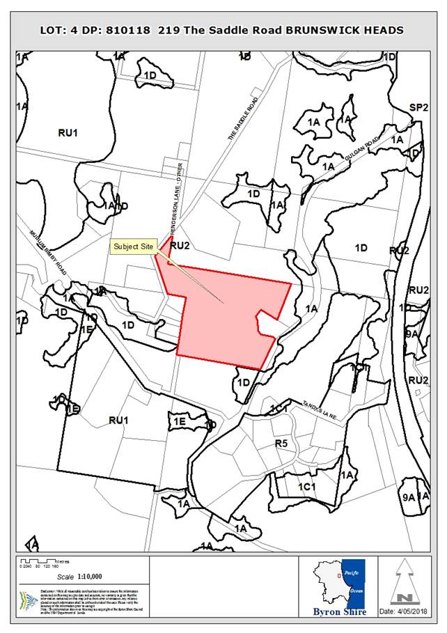
Assessment:
1. INTRODUCTION
1.1. History/Background
5.1991.123.1 – Dwelling House and Carport –
approved 08/05/91
Borrodales basalt quarry was operated by the NSW Department
of Public Works under a series of non-exclusive licence agreements in 1959,
1963 and 1969.
1.2. Description
of the proposed development
This application seeks approval for alterations and
additions to an existing dwelling, construction of a new dwelling, to create a
dual occupancy (detached), and construction of two (2) studios, one associated
with each of the dwellings.
The layout of the proposed development on the site is shown
below.
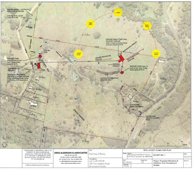
Figure 1 Site Layout & Analysis Plan (Greg
Alderson & Associates)
Existing Dwelling
The proposed alterations and additions to the existing
dwelling house include:
· New covered
balcony
· New enclosed
verandah with indoor swimming pool
· New carport,
undercover driveway and storage
· New deck
with spa
· New bedroom,
study, gym and rumpus room
· Convert
existing garage to underfloor storage and workshop area
Dual Occupancy (detached)
It is proposed to construct a new three-bedroom,
single-storey dwelling, located 365m east of the existing dwelling, as
indicated in Figure 1 above.
Studios
Two non-habitable studios are proposed to be constructed in
conjunction with each of the dwellings. The studio associated with the
existing dwelling is proposed for use as a home occupation, for the production
of naturopathic remedies. The studio associated with the new dwelling is
proposed to be used for the purposes of private exercise (yoga and pilates).
1.3. Description
of the site
|
Land is legally described as
|
LOT: 4 DP: 810118
|
|
Property address is
|
219 The Saddle Road BRUNSWICK HEADS
|
|
Land is zoned:
|
RU2 Rural Landscape
|
|
Land area is:
|
19.32ha
|
|
Property is constrained by:
|
Acid Sulfate Soils Class 3 (very small area in SE corner
– not affected by development)
|
|
|
Bush Fire Prone Land (proposed development outside of
mapped areas)
|
|
|
High Environmental Value Vegetation
|
|
|
Koala Habitat (potential)
|
|
|
Regionally Significant farmland (non-contiguous)
|
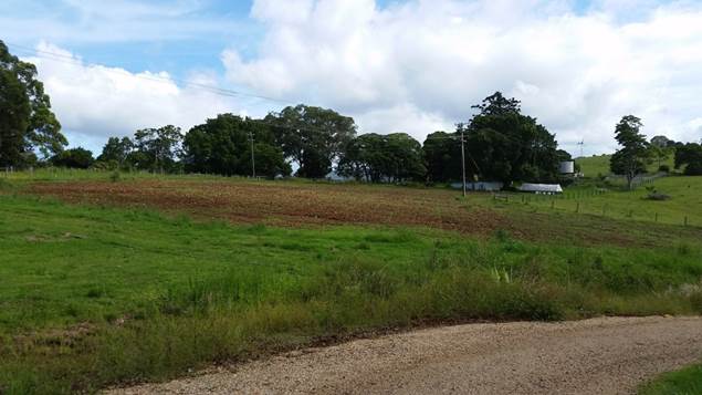
Area identified as
“Horticultural Netting” in Figure 2 (Looking NW)
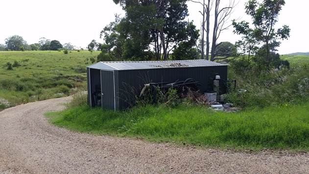
Location of proposed studio
associated with existing Dwelling House (Looking NE)
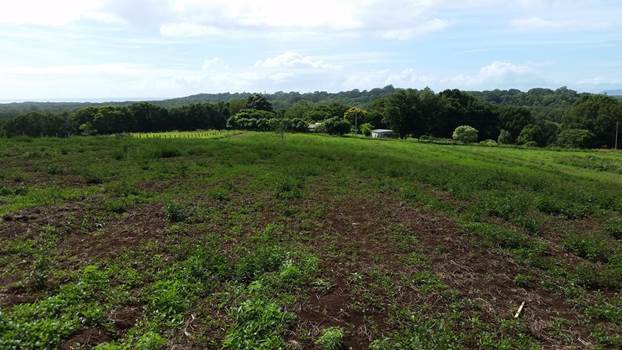
Location of proposed new
Dwelling House (Looking E)

Location of proposed studio
associated with new Dwelling House (existing Dwelling in background –
Looking W)
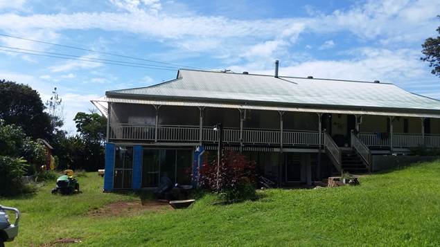
Existing Dwelling House
(Looking E)
The application includes a plan of a “share
farming” arrangement on the land that has been used by the applicant as a
means to justify the location of the proposed development.
Figure 2 Site Layout (Greg Alderson & Associates)
2. SUMMARY OF
REFERRALS
|
Referral
|
Issue
|
|
Environmental Health Officer
|
There is sufficient land area for disposal of wastewater
on the site
|
|
Development Engineer
|
No objections to the proposal subject to conditions.
|
|
S64 / Systems Planning Officer
|
No objections to the proposal subject to conditions.
|
|
S94 / Contributions Officer
|
Section 94 contributions applicable for dual occupancy
development
|
|
Essential Energy
|
No objections to the proposal subject to advisory
comments.
|
|
Department of Primary Industries – Office of Water
|
Comments not received.
|
|
Tweed Byron Land Council
|
The application was referred to TBLALC who recommended
that, if approved, they undertake a site visit and report to further
investigate significant aboriginal cultural heritage thought to be located in
the area.
A site visit was undertaken by TBLALC on 21/06/18.
Subsequently a Cultural Heritage Sites Inspection Report was prepared by
TBLALC dated 21/06/18 and submitted to Council on 23/07/18. The report
concluded that “there is nothing at this stage to halt or delay the
proposed work on this site”. The report recommended that the Due
Diligence Code of Practice for the Protection of Aboriginal Objects in NSW,
published by the DECCW OEH, be applied. Procedures to be applied in the case
of unexpected finds (including even suspected ACH objects) were also
recommended.
|
3. SECTION 79BA
– BUSH FIRE PRONE LAND
Under section 79BA of the Act, Council must be satisfied
prior to making a determination for development on bush fire prone land, that
the development complies with the document ‘Planning for Bush Fire
Protection 2006’. The lot is mapped as containing bushfire
prone land. However, the proposed development site within the lot is not
bush fire prone land.
4. SECTION 79C
– MATTERS FOR CONSIDERATION – DISCUSSION OF ISSUES
Having regard to the matters for consideration detailed in
Section 79C(1) of the Environmental Planning & Assessment Act 1979
(EP&A Act), the following is a summary of the evaluation of the issues.
4.1 State Environmental
Planning Instruments
|
|
Satisfactory
|
Unsatisfactory
|
|
State
Environmental Planning Policy No 44—Koala Habitat Protection
|
☒
|
☐
|
|
Consideration: Part of the land is mapped as containing
Tertiary Habitat. However, the application does not propose development
within this area and no vegetation removal is proposed on the site.
|
|
State
Environmental Planning Policy No 55—Remediation of Land
|
☒
|
☐
|
|
Consideration: A preliminary contaminated land
investigation was undertaken by the applicant in accordance with Section
7. A site history review was conducted for the investigation area
(being the entire site). The history review found that there is no evidence
that the investigation area was subject to cropping or plantations or that
any other contaminating activities had occurred. It is considered that
the land is suitable for residential use.
|
|
State
Environmental Planning Policy (Building Sustainability Index: BASIX) 2004
|
☒
|
☐
|
|
|
|
State
Environmental Planning Policy (Exempt and Complying Development Codes) 2008
|
☒
|
☐
|
|
Consideration: Plans have been submitted with the
application indicating a number of structures to be undertaken as exempt
development including a windmill and wind turbines. Note: The applicant
has acknowledged that some of these structures may not be undertaken as
exempt development and a future Development Application is to be lodged
separate to this application.
|
|
State
Environmental Planning Policy (Infrastructure) 2007
|
☒
|
☐
|
|
Consideration: Clause 101 requires that Council must not grant consent to development on
land that has a frontage to a classified road unless it is satisfied that,
where practicable, vehicular access to the land is provided by a road other
than the classified road (Gulgan Rd).
The
application proposes that vehicular access to each dwelling will be provided
by a single access point to The Saddle Rd.
|
|
State
Environmental Planning Policy (Mining, Petroleum Production and Extractive
Industries) 2007
|
☒
|
☐
|
|
Consideration: Borrodales basalt quarry was operated by
the NSW Department of Public Works under a series of non-exclusive licence
agreements in 1959, 1963 and 1969. Any use rights of previous
extractive activity on the site have since been abandoned.
|
|
State
Environmental Planning Policy (Rural Lands) 2008
|
☐
|
☒
|
|
Consideration: Clause 7 identifies the following Rural
Planning Principles:
(a) the
promotion and protection of opportunities for current and potential
productive and sustainable economic activities in rural areas,
(b) recognition
of the importance of rural lands and agriculture and the changing nature of
agriculture and of trends, demands and issues in agriculture in the area,
region or State,
(c) recognition
of the significance of rural land uses to the State and rural communities,
including the social and economic benefits of rural land use and development,
(d) in
planning for rural lands, to balance the social, economic and environmental
interests of the community,
(e) the
identification and protection of natural resources, having regard to
maintaining biodiversity, the protection of native vegetation, the importance
of water resources and avoiding constrained land,
(f) the
provision of opportunities for rural lifestyle, settlement and housing that
contribute to the social and economic welfare of rural communities,
(g) the
consideration of impacts on services and infrastructure and appropriate
location when providing for rural housing,
(h) ensuring
consistency with any applicable regional strategy of the Department of
Planning or any applicable local strategy endorsed by the Director-General.
Clause 10(3) of the SEPP
establishes the following matters to be considered in determining development
applications for rural dwellings:
(a) the existing
uses and approved uses of land in the vicinity of the development,
(b) whether or not the development is likely to have
a significant impact on land uses that, in the opinion of the consent
authority, are likely to be preferred and the predominant land uses in the
vicinity of the development,
(c) whether or not the development is likely to be
incompatible with a use referred to in paragraph (a) or (b),
(d) if the land is not situated within a rural
residential zone, whether or not the development is likely to be incompatible
with a use on land within an adjoining rural residential zone,
(e) any measures proposed by the applicant to avoid
or minimise any incompatibility referred to in paragraph (c) or (d).
The
proposed new dwelling is located 12m from the northern property
boundary. The adjoining lot to the north is mapped entirely as
Regionally Significant Farmland.
Chapter
B6 of DCP 2014 (Buffers and Minimising Land Use Conflict) recommends a 200m
buffer between rural dwellings and cropping/horticulture, which is a common
use of Regionally Significant Farmland.
While
the adjoining land is not currently used for this purpose, the proposed
dwelling, given its close proximity to the northern boundary, has the
potential to sterilize a significant area of adjoining agricultural land from
being utilised for cropping/horticulture. A dwelling in this location
would also create the potential for a land use conflict with land to the north
in the event that farming activities return to that property.
A
more appropriate location for the proposed dwelling would be closer to the
Saddle Road frontage of the land, to the north of the existing
dwelling. Locating the proposed dwelling in a cluster with the existing
dwelling and surrounding dwellings in the locality would minimise any
potential land use conflict issues with adjoining land and protect Regionally
Significant Farmland.
|
4.2 Byron Local Environmental
Plan 2014 (LEP 2014)
LEP 2014 is an applicable matter for consideration in the
assessment of the subject development application in accordance with subsection
79C(1) of the EP&A Act because it applies to the subject land and the
proposed development. The following LEP 2014 clauses are of relevance to
the proposed development:
Land Use Table:
In accordance with LEP 2014 clauses 1.4 and 2.1 – 2.3:
(a) The
proposed development is defined in the LEP 2014 Dictionary as Dual Occupancy
(detached). Studios are not separately defined in the LEP, and are
considered to be ancillary to the dwellings houses that make up the dual
occupancy.
(b) The
land is within the RU2 Rural Landscape according to the Land Zoning Map.
(c) Dual
occupancies are permitted with consent. As outlined above, the studios
are considered ancillary to the dwellings, and are therefore permissible with
consent.
(d) The
development as proposed is considered to be inconsistent with the Zone
Objectives, for the reasons as outlined below:
|
Zone Objective
|
Consideration
|
|
To encourage
sustainable primary industry production by maintaining and enhancing the
natural resource base
|
The proposed 12m setback of the new dwelling to the
northern boundary has the potential to sterilise a significant area of
Regionally Significant Farmland on the adjoining lot.
The proposed new dwelling and
associated studio are also located within the area mapped as Regionally
Significant Farmland. The proposal would have some impact on the
agricultural potential of the property by alienating the land that would be
occupied by the new dwelling, studio and associated curtilage. The
extent of this alienation is exhibited in the applicant’s plan shown above
as Figure 2, which illustrates a substantial curtilage around the proposed
buildings.
While there would potentially be
some alienation of Regionally Significant Farmland associated with a
compliant location for a detached dual occupancy (i.e. within 100m of the
existing dwelling), the impacts would be significantly less as the area
impacted would include that already within the curtilage of existing
structures and/or within close proximity to site boundaries.
|
|
To maintain the rural
landscape character of the land
|
Existing dwelling houses in the locality are generally
clustered within close proximity to Saddle Rd. The proposal to locate the new
dwelling approximately 400m from Saddle Rd creates potential land use
conflict and does not maintain the rural landscape character of the land.
The establishment of a 100m
maximum separation distance between dwellings in a detached dual occupancy
(cl. 4.2D – see below), is intended as a measure to ensure the
clustering of buildings and therefore the protection and maintenance of an
‘open’ rural landscape character.
Contravention of this development
standard will negatively impact on the existing rural character.
|
|
To provide for a range
of compatible land uses, including extensive agriculture.
|
The proposed 12m setback of the new dwelling to the
northern boundary has the potential to sterilise a significant area of
Regionally Significant Farmland on the adjoining lot.
|
|
To enable the provision
of tourist accommodation, facilities and other small-scale rural tourism uses
associated with primary production and environmental conservation consistent
with the rural character of the locality.
|
The application proposes residential use only.
|
|
To protect significant
scenic landscapes and to minimise impacts on the scenic quality of the
locality.
|
The proposal does not have a significant impact on the
scenic quality of the locality
|
Clause 4.1E Minimum lot sizes for dual occupancies, multi
dwelling housing and residential flat buildings
The property has an area of 19.32 hectares, which satisfies
the requirement for a minimum lot size of 4,000m2 for a Dual
Occupancy (detached) in the RU2 zone.
Clause 4.2A Erection of
dwelling houses and dual occupancies on land in certain rural zones
The land contains an existing dwelling, approved by Council
consent 5.1991.123.1. A dual occupancy is permitted on the land with
Council consent.
Clause 4.2D Erection of dual occupancies (detached) and
secondary dwellings in Zones RU1 and RU2
|
What clause does the development not comply with and
what is the nature of the non-compliance?
|
Further consideration, including whether the
development application is recommended for approval or refusal accordingly
|
|
4.2D Erection of dual occupancies
(detached) and secondary dwellings in Zones RU1 and RU2
(1) The objectives of this clause are as follows:
(a) to provide alternative accommodation for rural families
and workers,
(b) to ensure that development is of a scale and nature that
is compatible with the primary production potential, rural character and
environmental capabilities of the land,
(c) to set out consent considerations for development of dual
occupancies (detached) and secondary dwellings to address matters such as
access, siting, land suitability and potential impacts.
(2) Development consent must not be granted to development
for the purpose of a dual occupancy (detached) or secondary dwelling on land
in Zone RU1 Primary Production or Zone RU2 Rural Landscape unless the consent
authority is satisfied that:
(a) the development will not impair the use of the
land for agriculture or rural industries, and
(b) each dwelling will use the same vehicular access
to and from a public road, and
(c) any dwellings will be situated within 100 metres
of each other, and
(d) the land is physically suitable for the
development, and
(e) the land is capable of accommodating the on-site
disposal and management of sewage for the development, and
(f) the
development will not have an adverse impact on the scenic amenity or
character of the rural environment.
|
The proposal does not comply with the objectives in that
its scale and nature is not compatible with the rural character of the land
(see comments above).
The development also contravenes the development standard
within Clause 4.2D(2)(c), which requires each dwelling to be situated
within 100 metres of each other.
A Clause 4.6 variation has been submitted by the applicant
and is discussed below.
|
Clause 4.3 Height of
Buildings
The maximum height of proposed alterations and additions to
the existing dwelling are approximately 8m. The maximum height of the
proposed new dwelling is approximately 4m and the proposed studios have a
building height of 4.0m. All proposed buildings comply with the permitted
9.0m maximum building height.
Clause 4.6 Exceptions to
Development Standards
The clause 4.6 variation request has been submitted because
the proposed development contravenes the development standard outlined within
Clause 4.2D(2)(c), which requires each dwelling to be situated within 100
metres of each other. The applicant’s variation request has been
considered with reference to relevant matters as follows:
1. Introduction
– Summary of proposed development
The development application seeks
consent for Alterations and Additions to an existing Dwelling House, New
Dwelling House to create a Dual Occupancy (detached) and Two (2) Studios.
2. Clause 4.6
Exceptions to Development Standards
Clause 4.6 of Byron LEP 2014 is
accessible via: http://www.legislation.nsw.gov.au/fragview/inforce/epi+297+2014+pt.4-cl.4.6+0+N?tocnav=y
3. The
Development Standard to be varied
The development standard to be
varied is contained in LEP 2014 subclause 4.2D(2)(c), which is accessible via: http://www.legislation.nsw.gov.au/fragview/inforce/epi+297+2014+pt.4-cl.4.2d+0+N?tocnav=y
The 100m maximum separation
distance is a development standard in accordance with the applicable definition
in section 4 of the Environmental Planning and Assessment Act 1979
because it is a provision of an environmental planning instrument in relation
to the carrying out of development, being a provision by or under which
requirements are specified or standards are fixed in respect of any aspect of
that development.
4. Extent of
Variation to the Development Standard
The application proposes to
locate a new dwelling, to create a dual occupancy (detached), with a separation
distance of 365m from the existing dwelling, which does not comply with the
maximum 100m separation distance permitted.
The extent of the variation is
265%.
5. Objective
of the Development Standard
The objectives of the development
standard are outlined in LEP 2014 subclause 4.2D(1), which states:
(a) to provide alternative
accommodation for rural families and workers,
(b) to ensure that development
is of a scale and nature that is compatible with the primary production
potential, rural character and environmental capabilities of the land,
(c) to set out consent
considerations for development of dual occupancies (detached) and secondary
dwellings to address matters such as access, siting, land suitability and
potential impacts
6. Objectives
of the Zone
The objectives of the RU2 Rural
Landscape Zone which applies to the location of the proposed dual occupancy
(detached) are stated in the Land Use Table to LEP Part 2:
· To encourage sustainable primary industry production by maintaining and
enhancing the natural resource base.
· To maintain the rural landscape character of the land.
· To provide for a range of compatible land uses, including extensive
agriculture.
· To enable the provision of tourist accommodation, facilities and other
small-scale rural tourism uses associated with primary production and
environmental conservation consistent with the rural character of the locality.
· To protect significant scenic landscapes and to minimise impacts on the
scenic quality of the locality.
7. Assessment
– the specific questions to be addressed:
(a) Clause
4.6(3)(a) – Is compliance with the development standard unreasonable or
unnecessary in the circumstances of the case?
The application has not
sufficiently demonstrated that it is unreasonable or unnecessary to comply with
the development standard in the circumstances of the case.
The reasons presented by the
applicant for non compliance with the 100m maximum separation distance standard
are that “all of the land within 100 metres of the existing dwelling is
physically constrained and unsuitable for a new dwelling due to existing
agricultural use, future forestry and horticultural uses, the presence of an
old quarry, steep slopes, drainage lines, overhead power lines and farm
dams”.
The applicant has not
demonstrated that constraints referred to could not be adequately addressed by
appropriate site and building design and that, in that case, the impacts of the
development on farming potential and rural character would not be less than
those associated with the proposal as submitted.
In particular, siting of the new
dwelling much closer to the curtilage of the existing dwelling would minimise
the built footprint and associated alienation/ fragmentation of land mapped as
Regionally Significant Farmland and significantly reduce the potential for
future land use conflict associated with likely future farming uses on
adjoining land.
Siting of the new dwelling and
studio much closer to the existing cluster of structures on Saddle Road would
also minimise the impacts of the development on the rural character of the
land.
It is considered that the
reasons put forward to support the contravention of the development standard
are insufficient and that there are indeed alternative sites for the new
dwelling within 100m of the existing dwelling that have not been adequately
explored by the applicant.
(b) Clause
4.6(3)(b) – Are there sufficient environmental planning grounds to
justify contravening the development standard?
The application has not
adequately demonstrated that there are sufficient environmental planning
grounds to justify the contravention of the development standard.
The applicant has argued that
existing and proposed agricultural use of the land prevents the new dwelling
from being located within 100m of the existing dwelling. However, it is
considered that there are suitable sites within 100m of the existing dwelling.
For example, the area in the northwest of the site, identified as
“horticultural netting” on the submitted plan titled “Site
Layout” and dated 01/12/17, is considered suitable for a dwelling site
and would comply with the development standard. The horticultural use of
this area can reasonably be relocated elsewhere on the site to accommodate a
dwelling house. Further, the applicant has determined that the location
within 20 metres of the existing dwelling house is suitable for the proposed
studio. If this location is suitable for a studio then it is considered
that this location is also suitable for a dwelling house.
Further information supplied by
the applicant included following plan as justification that there are not any
suitable alternative sites on the land for the proposed new dwelling.
Figure 3 Alternative Dwelling Site
Location Map (Greg Alderson & Associates)
Sites A, B, C and H are among
those sites that are identified by the applicant as being unsuitable for the
new dwelling. However, it is considered that these sites are suitable. It
is noted that some of these sites are located greater than 100m from the
existing dwelling, however they would represent a far lesser variation than the
one proposed.
The reasons presented for these
sites being unsuitable are considered insufficient. Areas identified for share
farming and forestry can reasonably be modified to accommodate a new dwelling
rather than requiring a large variation to accommodate a dwelling around such
activities. Other reasons given by the applicant for these sites being
unsuitable include buffers to stormwater drainage lines, buffers to dams,
compliance with the building setback to Saddle Rd, buffers to water bores,
buffers to overhead power lines, buffers to mature vegetation etc.
It is considered that all of
these reasons can be addressed through appropriate design so that sites A, B, C
and H can either achieve compliance with the maximum 100m separation distance
or require a far lesser variation than the one proposed. These locations
are considered to achieve the objectives of both the RU2 zone and Clause 4.2D
by minimising land use conflict and maintaining the rural character of the
locality. These locations will also prevent significant eroding of the
development standard.
(c) Clause
4.6(4)(a)(ii) – Is the proposed development in the public interest? Is it
consistent with the objectives of the standard and the zone as set out above?
The proposed development is not
considered to be in the public interest. The application has not
adequately demonstrated consistency with the objectives of Clause 4.2D and the
objectives of Zone RU2. Approval of the 265% variation would create an
undesirable precedent.
The proposed development is
inconsistent with the objectives of the RU2 zone.
The
proposed dwelling is located 12m from the northern boundary. The
adjoining lot to the north is mapped entirely as Regionally Significant
Farmland. Chapter B6 of DCP 2014 (Buffers and Minimising Land Use
Conflict) recommends a 200m buffer between rural dwellings and
cropping/horticulture, which is a common use of such lands. Given its
close proximity to the northern boundary, the proposed dwelling has the
potential to sterilise a significant area of adjoining agricultural land from
being utilised for cropping/horticulture. Therefore the proposal does not
comply with the objective of Zone RU2 to maintain and enhance the natural
resource base.
Also, existing dwelling houses in the locality are
generally clustered within close proximity to Saddle Rd. The proposal to
locate the new dwelling approximately 400m from Saddle Rd creates potential
land use conflict and does not maintain the rural landscape character of the
land.
For the above reasons, the proposal also does not comply
with the objective of Clause 4.2D, which requires development to be of a
nature that is compatible with the primary production potential and rural
character of the land.
The applicant has referred to
application 10.2016.357.1, which was approved by Council staff under delegated
authority on 11/10/16. That consent permitted a dual occupancy (detached)
with a maximum separation distance of 450 metres between the two dwellings.
There were significant environmental planning grounds to approve that
application. The location of the new dwelling was the only area on the
site cleared of vegetation, thereby avoiding any significant impacts on High
Environmental Value (HEV) vegetation mapped on the site. Also, compliance
with the development standard in that instance would have required large areas
of HEV vegetation to be removed in order to upgrade the existing site access to
comply with Planning for Bushfire Protection 2006.
The applicant also references
six other detached Dual Occupancies (detached) in rural zones that have been approved
with Clause 4.6 variations. Three of these six approvals relate to
variations to the 100m separation distance:
· 10.2016.425.1
– The two structures were already existing on the site and a variation
was granted to permit a Dual Occupancy (detached) with a separation distance of
136m representing a variation of 36%.
· 10.2017.245.1
– The new dwelling was approved to be located 110m from the existing
dwelling representing a variation of 10%. Permitting a slightly greater
separation allowed the new dwelling to be located clear of a gully, resulting
in a better environmental outcome and a more practical use of the land.
· 10.2016.752.1
– The building proposed to be used as a dwelling was approved to be
located 115m from the existing dwelling representing a variation of 15%.
The variation was granted to
formalise the use of an existing structure that could not be readily relocated.
Each of the above referenced
variations to the maximum 100m separation distance had demonstrated that
compliance with the development standard is unreasonable based on environmental
planning grounds.
(d) Clause
4.6(4)(b) – Has the concurrence of the Secretary been obtained?
The NSW Department of Planning and Environment Planning
Circular PS18-003 provides that the Secretary’s concurrence may not be
assumed by a delegate of council if the development contravenes a numerical
standard by greater than 10%.
The application proposes to locate a new dwelling to create
a dual occupancy (detached) with a separation distance of 365m from the
existing dwelling which does not comply with the maximum 100m separation
distance permitted. The extent of the variation is 265%. In
accordance with PS18-003 the application must be determined by the elected
Councillors.
The Applicant’s variation request in the circumstances
is not supported and the development application is recommended for refusal.
Clause 5.10 Heritage
Conservation
The application was referred to the Tweed Byron Local
Aboriginal Land Council (TBLALC) to consider the potential impacts of the
proposed development on Aboriginal objects and/or Aboriginal places of heritage
significance.
A site visit was undertaken by TBLALC on 21/06/18.
Subsequently a Cultural Heritage Sites Inspection Report was prepared by TBLALC
dated 21/06/18 and submitted to Council on 23/07/18. The report concluded that
“there is nothing at this stage to halt or delay the proposed work on
this site”. The report recommended that the Due Diligence Code of
Practice for the Protection of Aboriginal Objects in NSW, published by the
DECCW OEH, be applied. Procedures to be applied in the case of unexpected finds
(including even suspected ACH objects) were also recommended.
Clause 6.1 Acid Sulfate Soils
The south eastern corner of the site is subject to potential
Acid Sulfate Soils Class 3. However, all works are proposed on portions
of the site with an elevation of approximately 40-50m AHD. Therefore no further
assessment is required.
Clause 6.2 Earthworks
The proposal does not require significant earthworks
therefore no further assessment required.
Clause 6.6 Essential Services
Potable water is proposed to supply the development through
rainwater tanks located at each dwelling with backup supplies in the form of an
existing water bore and mains connection to Rous water supply.
Electricity is proposed to be supplied to the new dwelling
and studio by 20KV of solar panels mounted on the new dwelling and farm
buildings along with 2 x 10KV wind turbines and a Lithium battery bank.
It is also proposed to install Three Phase power for back up and to feed
renewable wind and solar energy back into the grid.
There is sufficient land area for disposal of wastewater on
the site and roof water will be collected in rainwater tanks with an overflow
dispersion trench.
Vehicular access is achieved via an existing driveway
crossing to Saddle Rd. Existing access to Gulgan Rd does not appear to have
Council approval.
4.3 Any proposed Instrument
that has been the subject of public consultation and has been notified to the
consent authority
Draft SEPP (Coastal Management) 2016
The Draft Coastal Management
State Environmental Planning Policy (SEPP) proposes to establish a new,
strategic land use planning framework for coastal management. It is intended to
support the implementation of the management objectives set out in the Coastal
Management Act 2016.
Once adopted, the Coastal
Management SEPP will be the single land use planning policy for coastal
development and will bring together and modernise provisions from SEPP 14
(Coastal Wetlands), SEPP 26 (Littoral Rainforests) and SEPP 71 (Coastal
Protection).
The aim of the Draft SEPP is to promote an integrated and
co-ordinated approach to planning in the ‘Coastal Zone’,
identifying four coastal management areas:
· coastal
wetlands and littoral rainforests area
· coastal
environment area;
· coastal use
area; and
· coastal
vulnerability area.
The subject site is mapped within the ‘coastal use
area’. The draft provisions for consideration of development within
this area generally reflect the existing matters for consideration currently
outlined in SEPP 71.
The proposal is considered to be acceptable having regard to
the provisions of the Draft SEPP particularly Divisions No.2, 4 & 5.
The proposed development is not in a wetland, littoral rainforest, or coastal
environment area.
4.4 Byron Shire Development
Control Plan 2014 (DCP 2014)
DCP 2014 is an applicable matter for consideration in the
assessment of the subject development application in accordance with subsection
79C(1) of the EP& A Act because it applies to the land to which LEP 2014
applies. The following DCP 2014 chapters are of relevance to the proposed development:
A14 Public Notification and
Exhibition of Development Applications
The application was advertised in accordance with Level 1
Notification. Adjoining landowners were notified with one submission received
during the notification period. This submission is addressed in section 4.10 of
this report.
B3 Services
The application has demonstrated that the proposed
development will be adequately serviced including the provision of an onsite
sewage management system.
B6 Buffers and Minimising
Land Use Conflict
The proposed new dwelling house is located 12m from the
northern boundary of the site. The adjoining land to the north appears to
be used for grazing cattle. There is no recommended minimum buffer
distance between a rural dwelling and grazing of stock.
However, the adjoining lot
to the north is mapped entirely as Regionally Significant Farmland. Chapter B6
– Buffers and Minimising Land Use Conflict of DCP 2014 recommends a 200m
buffer between rural dwellings and cropping/horticulture which is a common use
of such lands. Given its close proximity to the northern boundary, the
proposed dwelling has the potential to sterilise a significant area of
adjoining agricultural land from being utilised for cropping/horticulture or
other intensive plant agriculture.
An
appropriate location for the proposed dwelling would be along Saddle Rd to the
north of the existing dwelling. Locating the proposed dwelling in a
cluster with the existing dwelling and surrounding dwellings in the locality
would minimise any potential land use conflict issues with adjoining land and
protect Regionally Significant Farm Land.
B14 Excavation and Fill
The proposal does not require significant earthworks
therefore no further assessment required.
D2.5 Dual Occupancies and
Secondary Dwellings
The proposal has the potential to create land use conflict
issues as outlined above.
D2.7.1 Studios
The application proposes two new studios: one for the
existing dwelling and one for the proposed dwelling. Studios are not
permitted to contain internal partitions, other than those necessary for
ablution facilities or demonstrably required for the use of the studio (e.g.
photography darkroom). The studio floor plans indicate a number of partitioned
rooms including an “air conditioned preservation room”, toilet and
bathroom with shower.
The studio plans also contain a kitchen sink, which is not
permitted by the DCP.
Given that the plans also include a carport and 60m2
of verandah area, it would appear that these buildings could be easily
inhabited as separate dwellings. In order to recommend approval of such
studios the bathroom, kitchen and carport would be required to be removed and
the verandah areas significantly reduced.
4.5 Any Planning Agreement or
Draft Planning Agreement?
|
|
Yes
|
No
|
|
Is there any applicable planning agreement or draft
planning agreement?
|
☐
|
☒
|
|
|
4.6 Environmental Planning
& Assessment Regulation 2000 Considerations
|
Clause
|
This
control is applicable to the proposal:
|
I
have considered this control as it relates to the proposal:
|
If
this control is applicable, does the proposal comply?
|
|
92
|
No
|
N/A
|
N/A
|
|
93
|
No
|
N/A
|
N/A
|
|
94
|
No
|
N/A
|
N/A
|
|
94A
|
No
|
N/A
|
N/A
|
* Non-compliances and any other significant issues
discussed below
4.7 Any coastal zone management
plan?
|
|
Satisfactory
|
Unsatisfactory
|
Not applicable
|
|
Is there any applicable coastal zone management plan?
|
☐
|
☐
|
☒
|
|
|
4.8 The likely impacts of that
development, including environmental impacts on both the natural and built
environments, and social and economic impacts in the locality
|
Impact on:
|
Likely significant impact/s?
|
|
Natural environment
|
No. The proposal will not have a significantly adverse
impact on the natural environment of the locality.
|
|
Built environment
|
No. The proposal will not have a significantly adverse
impact on the built environment of the locality.
|
|
Social Environment
|
No. The proposal will not have a significant social impact
on the locality.
|
|
Economic impact
|
No. The proposal will not have a significant economic
impact on the locality.
|
Are there any Council Policies that are applicable to the
proposed development?
|
Council Policy
|
Consideration
|
|
Development Policy
|
In accordance with this policy the application has been
assessed with consideration for the relevant legislation, environmental
plans, development codes and the public interest.
|
|
Management of Contaminated Land Policy
|
A SEPP55 contaminated land assessment submitted by the
applicant has concluded that the land is suitable for residential use.
|
|
Water and Sewer Equivalent Tenement Policy
|
The Subject lot is not serviced by Council reticulated
water or sewer. Rous Water supplies bulk water. Equivalent Tenements
applicable to the development to be determined by Rous Water.
|
4.9 The suitability of the site
for the development
The land is a serviced, unconstrained property.
However, as discussed elsewhere in the report the proposed location of the new
dwelling house has not been adequately justified.
4.10 Submissions made in accordance with
this Act or the regulations
The development application was publicly exhibited.
There was one submission made on the development
application:
|
Issue
|
Comment
|
|
No landowners consent contained in exhibition material
|
Landowners consent has been provided from the directors of
Koresoft Pty Ltd to Greg Alderson & Associates to lodge the application.
|
|
DCP requirements for studios have not been addressed
|
Additional information has been received that addresses
the requirements of Chapter D2.7.1 of DCP2014.
|
|
Concern that studios will be of commercial use and not
ancillary to residential use given reference of wastewater assessment to
staff
|
The wastewater report makes reference to staff in relation
to farm worker’s amenities, not in relation to studios.
|
|
Use of one of the studios for naturopathy is prohibited
development
|
The use of the studio for naturopathy would only be for
the production of naturopathic remedies and not as a medical centre or health
services facility as there will be no patients coming to the site.
|
|
The studio for pilates and exercise is unwarranted given
the amount of space in the associated dwelling.
|
The applicant has argued that the studio for yoga/pilates
use requires a quiet and peaceful environment that will not be available
within the proposed house.
|
|
Proposed studios appear to be small dwellings
|
The studio floor plans indicate a number of partitioned
rooms including an “air conditioned preservation room”, toilet
and bathroom with shower. The studio plans also contain a kitchen sink
which is not permitted by the DCP. Given that the plans also include a
carport and 60m2 of verandah area it would appear that these
buildings could be easily inhabited as separate dwellings. In order to
approve such studios the bathroom, kitchen and carport would be required to
be removed and the verandah areas significantly reduced.
|
|
Windmills shown on plans cannot be undertaken as exempt
development
|
A development application for the windmill and other
proposed agricultural structures which require Council consent is being
prepared, and will be submitted to Council as soon as possible.
|
|
Separation distance between dwellings
|
This issue has been addressed above.
|
|
Impact of the proposal on the agricultural potential of
the land
|
The applicant has argued that “the dwelling has been
strategically located between two of the agricultural areas which are part of
a share farming licence agreement”. Further, “this will
ensure that the residents of the proposed dual occupancy can easily manage
the horticultural activities and provide security to the farming activities
and equipment through passive surveillance”.
The proposal would have some impact on the agricultural
potential of the land by alienating the land that would be occupied by the
new dwelling, studio and associated curtilage.
|
|
Only one wind turbine is permitted as exempt development
|
Plans submitted with the application indicate two wind
turbines to be erected as exempt development. However only one of these is
permitted as exempt development and the other will require development
consent under a separate application.
|
|
Potential impacts on aboriginal heritage
|
TBLALC have recommended a site visit and report to further
investigate significant aboriginal cultural heritage thought to be located in
the area.
A site visit was undertaken by TBLALC on 21/06/18.
Subsequently a Cultural Heritage Sites Inspection Report was prepared by
TBLALC dated 21/06/18 and submitted to Council on 23/07/18. The report
concluded that “there is nothing at this stage to halt or delay the
proposed work on this site”. The report recommended that the Due
Diligence Code of Practice for the Protection of Aboriginal Objects in NSW,
published by the DECCW OEH, be applied. Procedures to be applied in the case
of unexpected finds (including even suspected ACH objects) were also
recommended.
|
4.11 Public interest
The proposed development is not in the public interest and
will create an undesirable precedent.
4.12 Section 5A of the EP&A Act –
Significant effect on threatened species
Having regard to sections 5A, 5C and 5D of the EP&A Act, there is unlikely to be a significant effect on threatened species,
populations or ecological communities, or their habitats as a result of the
proposed development because of its location within cleared agricultural land.
4.13 Section 5B of the EP&A Act –
Have regard to register of critical habitat
The NSW Critical
Habitat Register does not identify any critical habitat on or adjacent to the
site.
5. DEVELOPER
CONTRIBUTIONS
Should the application be approved contributions and water
and sewer charges would apply.
6. DISCLOSURE OF
POLITICAL DONATIONS AND GIFTS
|
Has a Disclosure Statement been received in relation
to this application
|
No
|
|
Have staff received a ‘gift’ from anyone
involved in this application that needs to be disclosed. Where the answer is
yes, the application is to be determined by the Director or Manager of the
Planning, Development and Environment Division.
|
No
|
7. CONCLUSION
This application seeks development consent for alterations
and additions to an existing dwelling house, construction of a new dwelling
house, creating a dual occupancy (detached), and construction of two (2)
studios.
The proposed development does not comply with the
development standards of Clause 4.2D of LEP 2014 in that the dwellings will be
well in excess of 100m distance from each other. The application has does
not provide sufficient environmental planning justification for the contravention
of the standard, pursuant to Clause 4.6 of the LEP.
It is considered that the proposal is inconsistent with the
land use objectives of the RU2 Rural Landscape zone, in that the proposed new
structures would detrimentally impact on the existing rural character of the
property and locality and impact on the potential for sustainable farming on
both the property itself and in relation to land adjoining to the north.
The proposal is also inconsistent with SEPP (Rural Lands)
2008, in that the proposed new dwelling, in the location shown, is likely to
have a significant impact on land uses preferred in the vicinity, given the
mapping of that area as Regionally Significant Farmland.
It is recommended that consent be refused for the reasons provided in the report and the recommendation.
Staff Reports - Sustainable Environment and Economy 13.13
Report No. 13.13 Updates
- Audit of secondary dwelling conditions of consent; Short Term Holiday Let
enforcement action and State Government position on Short Term Holiday Let.
Directorate: Sustainable
Environment and Economy
Report
Author: Shannon
Burt, Director Sustainable Environment and Economy
Sarah Nagel, Community
Enforcement Officer
File No: I2018/974
Theme: Ecology
Development and Approvals
Summary:
The purpose of this report is to update Council on:
· a
recent audit of secondary dwellings conditions of consent;
· the
status of short term holiday let enforcement action commenced/current; and
· the
State Government short term holiday let policy announcement in June.
|
RECOMMENDATION:
That Council note the updates regarding
secondary dwelling conditions of consent and short term holiday letting
provided in the report.
|
Report
Council considered reports in
October and November 2017 on secondary dwellings conditions of consent and
short term holiday let enforcement options.
October https://byron.infocouncil.biz/Open/2017/10/OC_26102017_AGN_611_WEB.htm
Report No. 13.21 Update
Council Resolution 17-191 Secondary Dwelling Conditions
Report No. 13.22 Update
on Resolution 17-263 Short Term Rental Accommodation
Enforcement Options
November
https://byron.infocouncil.biz/Open/2017/11/OC_23112017_AGN_612_WEB.htm
Report
No. 13.25 Further update
on Resolution 17-191 Secondary Dwelling Conditions
A report on Council’s
submission to the Short Term Holiday Let Options Paper prepared by the
Department of Planning was also on the October agenda. https://byron.infocouncil.biz/Open/2017/10/OC_26102017_AGN_611_WEB.htm
Report
No. 13.20 Response to DPE Short
Term Holiday Letting Options Paper
Various resolutions ensued
and have since been actioned by staff.
The purpose of this report is
to update Council on the status of these matters.
1. Secondary
dwellings and conditions of consent
As requested by Council at the
Ordinary Meeting 26 October 2017, a further update on item 2 of Resolution 17-191
was provided at the November Ordinary meeting. Resolution extract for context
below:
… 2. That Council
responds to concerns and compliance issues by:
a) contacting all property owners with a
secondary dwelling (granny flat) approved since the passage of Council
Resolution 11-268 and seek property owners’ confirmation that they are
complying with their approval and/or conditions of consent with the regard to
the Environmental Planning Assessment Act and to Byron Shire Council Resolution
11-268.
b) developing a form that seeks the owners
signature regarding compliance with consent and Resolution 11-268 for inclusion
with the correspondence to be returned to council within 30 days.
Letters and the form were sent to
598 property owners on 13 September 2017. Only 143 had been returned as of 6
November 2017. Copy of letter and form link below:
http://byron.infocouncil.biz/Open/2017/10/OC_26102017_ATT_611_WEB.htm
A second letter was then sent to
those properties (end 2017) that had not responded to provide a further, brief,
opportunity to do so. The aggregated results of both mail outs follow:
|
Complies / Response
|
|
|
Yes
|
311
|
|
No
|
2
|
|
No longer owns property
|
2
|
|
Not signed
|
7
|
|
Previously holiday let
|
1
|
|
Principle dwelling used holiday let
|
1
|
|
Returned to sender
|
6
|
|
Acknowledgement not returned
|
259
|
|
Application surrendered or changed
|
9
|
|
|
598
|
For those properties where no
acknowledgement was received, a memo is to be placed on the property to alert
Council staff of any future non-compliance/complaints re holiday letting.
Evidence via section 9.22 of the
Environmental Planning and Assessment Act is a tool which Council officers may
employ in circumstances where a reasonable suspicion of unauthorised short-term
holiday letting exists. Enforcement proceedings for the offence of development
not in accordance with development consent may result for some properties.
The reasonable suspicion must be
held by the investigating officer who is to commence proceedings. The
investigating officer must be able to form that view in the circumstances of
the particular matter. Each case must be dealt with on its merits.
2. Short Term Rental Accommodation -
Enforcement Options
Council considered Report No.
13.17 Short Term Rental Accommodation - Enforcement Options at the Ordinary
Meeting 22 June 2017 and resolved as follows:
17-263 Resolved that Council:
1. Note the report.
2. Authorise the General Manager, in cases
where a reasonable suspicion of unauthorised short term rental accommodation
and unauthorised tourist and visitor accommodation is taking place, to issue Notices
to the following to provide information and answer questions about property
use:
·Real Estate agents
·Letting Agents
·Website Hosts
·Tenants
3. That Council confirms that:
a) in order to preserve the availability
of long-term letting in the shire for long-term residents that the moratorium
on prosecutions has been lifted.
b) it now intends to prosecute in the
most effective manner where merit exists any and all instances of unauthorised
short term rental accommodation occurring in the shire.
4. That a media release be shared on this
resolution.
5. Compile a confidential list of properties
against which it may commence legal proceedings based on the establishment of a
prima-facie case of unauthorised short term rental accommodation and
unauthorised tourist and visitor accommodation, and that this list is compiled
as soon as possible.
All parts of this resolution have been actioned to date.
1. Report noted.
2. Letters to
‘Real Estate agents, Letting Agents, Website Hosts, Tenants’ have
been sent twice. An initial letter was sent to 19 real estate agencies in
September 2017 as part of our mail out to Secondary Dwelling owners. A second
letter was sent out to 25 Real Estates in May 2018.
3. Council had previously commenced
proceedings against a number of short term holiday let properties/operators.
The details of which are subject to legal proceedings and as such will not be
provided in this report. However, since the announcement of a state government
position and policy on short term holiday let on 5 June 2018, Council has not
commenced any new enforcement proceedings and currently awaits further
clarification from the state government of planning and regulation changes for
short term holiday let to inform what if any action can occur at the local
level.
4. Media releases continue to be
periodically issued.
5. Community enforcement staff now
manages a list of properties against which it may commence enforcement
proceedings based on the establishment of a prima-facie case of unauthorised
short term holiday let and unauthorised tourist and visitor accommodation. This
is relevant to point 2 above.
Further, in April 2018, 114 letters were sent to
the owners of properties that Council has received complaints about to advise
them Council has reason to believe that the abovementioned premises are being
advertised/used as short term holiday let.
The letter also advised of the relevant Council
Resolutions and to the fact that the obtaining of evidence via section 9.22 of
the Environmental Planning and Assessment Act is a tool which Council officers
may employ in circumstances where a reasonable suspicion of unauthorised short
term holiday let activity exists.
Council’s web
page has also been updated to provide various avenues for complaints to be
registered by the community on short term holiday let activity, including
airbnb and other online platform sites:
As stated above, Council has not commenced any new
enforcement proceedings and currently awaits further clarification from the
state government of planning and regulation changes for short term holiday let
to inform what if any action can occur at the local level.
https://www.byron.nsw.gov.au/Services/Building-development/Planning-in-progress/Short-term-rental-accomodation
3. State
Government response to Byron Shire council submission on DPE Short Term Holiday
Letting Options Paper
The NSW Government announced a new regulatory
framework to govern the short-term holiday letting industry on 5 June 2018.
A Notice of Motion was presented to Council at the
Ordinary Meeting 21 June 2018 on same.
https://byron.infocouncil.biz/Open/2018/06/OC_21062018_AGN_776_WEB.htm
The new framework is to include new planning laws,
an industry Code of Conduct and new provisions for strata scheme by-laws.
The announcement is in response to the short term
holiday letting option paper exhibited by the Department of Planning and
Environment last year.
Council made a submission to this paper advocating
strongly for the ability to locally respond to short term holiday let activity
through planning regulation, registration and compliance mechanisms.
The early indication from the consultation being held was
that this would be the case.
There was no further direct engagement with local government
(and in particular Byron Council) subsequent to the consultation close in
October 2017 and the Government announcement.
In reviewing the limited details on the proposed new
state-wide planning controls, it would seem short-term holiday letting is to be
enabled under certain conditions.
If the host is present, a
property owner can use their home for short-term holiday letting all year round
as exempt development. That is, they do not need to submit a development
application to local council.
If the host is not present,
that residence can be used for short-term holiday letting up to 180 days per
year in Greater Sydney, with 365 days allowed in all other areas of New South
Wales. Councils outside Greater Sydney will have the power to decrease the 365
day limit to no less than 180 days per year. There will also be additional
conditions for bushfire prone land to ensure visitor safety.
Council acknowledges the divergent views on the impacts of
short term holiday let in councils across NSW. However, Byron Shire has
experienced rapid growth in the last few years in online holiday rental listing
and activity in the Shire. This has resulted in significant adverse impacts on
the community in terms of amenity and character, and has reduced the available
and affordable rental accommodation for residents and key workers that are
needed to support the local tourist economy.
As such Council does not consider a blanket approach to
planning regulation via a state policy as appropriate. NOTE: As Council has not
seen the details of the state-wide policy a formal position on it has not been
able to be made at this time.
Current situation
The Fair Trading (Short Term Rental Accommodation) Act and
Strata Act amendments have now been enacted without the new-state wide planning
policy. These amendments include the introduction of a mandatory Code of
Conduct that will apply to anyone involved in providing or using short-term
holiday letting including hosts, guests, online platforms, and letting agents.
And amendments to the strata scheme management laws to clarify that by-laws can
prohibit short-term holiday letting, but only for lots that are not a
host’s principal place of residence.
Council has written to the Minister for Planning to seek a
deferral of Byron Shire from the new state-wide planning policy (pause to
implementation) to enable a full consideration of the impact of the changes to short
term holiday let in Byron Shire in terms of environmental, social and economic
impacts; and also to enable Council to tailor a local response to planning and
regulation through either the state-wide policy or Byron local environmental
plan provisions.
The Minister has been advised that Council already permits
one bedroom short term holiday lets with host as exempt development. As
such the requested pause on implementation to the state-wide policy would only
be to short term holiday lets where no host is present.
This Council considers to be a reasonable and equitable
position for the state government to take for Byron Shire given the need to
ensure that what is imposed on the community is both fair and balanced for the
community as a whole not just one part.
An urgent meeting with the Planning Minister has also been
sought. While no response has been received from the Minister, Council staff
received an email 11 July from the Department of Planning staff for a meeting
to discuss the proposed planning framework for short term holiday let.
Dialogue is to occur during July. Further updates will be provided to Council
as available.
Financial Implications
Staff resourcing and any
enforcement proceedings need to be managed within the existing budget allocation.
Costs are dependant on and specific to the enforcement proceedings.
The impacts of the new state-wide
planning framework for short term holiday let on Byron Shire have not been able
to be assessed as yet.
Statutory and Policy Compliance Implications
Environmental Planning and Assessment Act 1979; Local
Government Act and related Acts and regulations.
Staff Reports - Sustainable Environment and Economy 13.14
Report No. 13.14 Northern
Joint Regional Planning Panel (JRPP) - community representatives
Directorate: Sustainable
Environment and Economy
Report
Author: Shannon
Burt, Director Sustainable Environment and Economy
File No: I2018/1350
Theme: Sustainable Environment and Economy
Development and Certification
Summary:
At the 24 May 2018 ordinary meeting, Council resolved to
seek community members for part time appointment to represent Council on the
Northern Joint Regional Planning Panel. Nominations submitted for
Council’ consideration are attached to this report.
|
RECOMMENDATION:
1. That
Council nominate 4 community representatives for part time appointment to
present Council on the Northern Joint Regional Planning Panel as the
alternate Panel members.
2. That
Council thank all nominees for their interest and time in submitting an
Expression of Interest.
3. That
Council notify the Planning Panel Secretariat of the above nominations.
|
Attachments:
1 Confidential
- Nominations EOI Northern Joint Regional Planning Panel, E2018/61095
Report
At the 24 May 2018 ordinary meeting, Council resolved to
seek community members for part time appointment to represent Council on the
Northern Joint Regional Planning Panel (Panel).
Under the Act, a Council is to nominate 2 persons as Council
nominees for the purposes of the
Panel, at least 1 of whom has expertise in planning,
architecture, heritage, the environment, urban design, land economics, traffic
and transport, law, engineering or tourism.
A Panel is comprised of 5 members: 3 appointed by the Minister
and 2 appointed by the relevant local council. Each Panel also includes
alternates to act in place of the permanent members if they are unavailable for
any reason.
Due to recent Panel membership changes, Council currently
only has 2 nominated members both without alternates. Current nominated
Panel members are: Councillor Basil Cameron and David Millage (Community).
Note however, under resolution 18-336 (6), the Mayor has
recently under delegated authority made the temporary appointments of Katie Milne
and Vanessa Ekin to the Panel for the West Byron development applications to
ensure community representation on the Panel for the relevant determination
hearings.
Notwithstanding the above, at least 4 additional members are
needed: 2 alternate members to the permanent Panel members; and a further 2
alternate members for any review of determination applications made to the
Panel.
This report has been prepared to allow Council to consider
the nominations received by EOI, as contained in Confidential Attachment 1
(#E2018/61095).
Any changes made to the Council-nominated members need to be
made and the Planning Panels
Secretariat notified at least two weeks prior to any
scheduled Panel meeting
6 nominations were received to the recent EOI process.
Council is being asked to nominate 4 for part time
appointment to present Council on the Northern Joint Regional Planning Panel as
the alternate Panel members.
Financial Implications
The Department of Planning and Environment does not
remunerate council nominated members, it is a matter for each council to
determine, taking into consideration the previous guidelines from the Minister.
Council Staff Members: No fees should be paid, as
participation in the regional panel would form part of the
employee’s regular duties, consistent the Department Premier and Cabinet
Guidelines for NSW Board and Committee Members: Appointment and Remuneration
(the DPC Guidelines).
Elected Councillors: As Councillors already receive an
annual fee set by the Local Government Remuneration Tribunal each year for
performing their councillor duties, an additional per meeting fee is
reasonable, recognising that membership of the regional panel brings additional
responsibilities.
Community members: Each council may determine an appropriate
level of remuneration for that person, by arrangement with that member, with
your Council’s current rates used as a guide when determining appropriate
remuneration rates.
The EOI was notified with the community position/s being in
a voluntary capacity and panel members not being paid.
Statutory and Policy
Compliance Implications
All regional panel members are expected to follow the
regional panel’s operational procedures and to adhere to the regional
panel’s code of conduct. Both of these documents can be found at www.jrpp.nsw.gov.au
Staff Reports - Sustainable Environment and Economy 13.15
Report No. 13.15 PLANNING
- Amendment to DCP 2010 - Chapter 1 Part J - Coastal Erosion lands
Directorate: Sustainable
Environment and Economy
Report
Author: Steve
Daniels, Project Officer - Planning Reforms
File No: I2018/1276
Theme: Sustainable Environment and Economy
Planning Policy and Natural Environment
Summary:
This report presents the public exhibition outcomes for a
proposed amendment to Byron DCP 2010 - Chapter 1 Part J to clarify that
subdivision of land under the Strata Schemes Development Act 2015 is only
permitted in relation to existing lawfully approved buildings, and not to
create vacant lots.
The proposed DCP amendment (Draft DCP) was placed on public
exhibition from 31 May 2018 to 28 June 2018. No public submissions to the
Draft DCP were received during the exhibition period.
A staff review of the Draft DCP identified a minor
typographical error whereby reference to the 7(f)2 Urban Coastal Lands zone had
been omitted from clause J2.6 Element – Subdivision of Land. It is
proposed that a minor amendment be made to the exhibited Draft DCP to rectify
this.
This report recommends that Council approve the exhibited
Draft DCP 2010 - Chapter 1 Part J with changes in accordance with this report.
NOTE TO COUNCILLORS:
In accordance with the
provisions of S375A of the Local Government Act 1993, a Division is to be
called whenever a motion for a planning decision is put to the meeting, for the
purpose of recording voting on planning matters. Pursuant to clause 2(a)
under the heading Matters to be Included in Minutes of Council Meetings of
Council's adopted Code of Meeting Practice (as amended) a Division will be
deemed to have been called by the mover and seconder of all motions relating to
this report.
|
RECOMMENDATION:
That Council adopt the modification to the Draft
Byron DCP 2010 - Chapter 1 Part J, as outlined in this report, and
give public notice of the decision within 28 days.
|
Report
Council considered a report on 19 April 2018 for a development
application that proposed a strata subdivision of land located in the 7(f2)
Urban Coastal Lands zone under Byron LEP 1988, and located within coastal
erosion Precincts 1 & 2 defined in Byron DCP 2010 – Chapter 1 Part J.
The proposed subdivision would create two lots of 1,030m2 and 975m2.
Proposed Lot 1 (1,030m2) would result in the creation of a vacant
lot.
Creation of new lots for
development in the 7(f2) zone is considered undesirable and outside of the
public interest due to the risk of development adversely affecting, or being
adversely affected by, coastal processes. The initial report to Council
proposed that this matter can be addressed through an amendment to Byron LEP
1988 and an amendment to Byron DCP 2010.
Council resolved to proceed
with preparation and public exhibition of the proposed DCP amendment on 19
April 2018 as follows:
Part 2 of 18-207
Resolved:
2. That
Council:
a) agree to initiate a Planning Proposal to amend clause
32 of Byron Local Environmental Plan 1988, to clarify that subdivision of land
under the Strata Schemes Development Act 2015 is only permitted in relation to
existing lawfully approved buildings, and not to create vacant lots.
b) prepare an amendment to Part J of Byron Development
Control Plan 2010 to clarify that subdivision of land under the Strata Schemes
Development Act 2015 is only permitted in relation to existing lawfully
approved buildings, and not to create vacant lots.
c) forward the planning proposal to the NSW Department of
Planning and Environment for a Gateway determination.
d) agree that staff can proceed to public exhibition of
the planning proposal and the draft DCP amendment and government agency
consultation based on the Gateway determination issued by the NSW Department of
Planning and Environment, and report back to Council as part of post-exhibition
reporting.
It should be noted that Res 18-207 also
resolves that Council initiate the preparation of a planning proposal to amend
Byron LEP 1988. Preparation of a planning proposal is taking place as a
separate process to the DCP amendment addressed in this report. At
present, Council is awaiting further advice from the Department of Planning
& Environment before proceeding with preparation of a planning proposal.
The proposed DCP amendment was placed on public exhibition
from 31 May 2018 to 28 June 2018 in accordance with Res 18-207.
Public Submissions
No public submissions were received during the exhibition
period.
Staff Review
A staff review of the Draft DCP identified a minor
typographical error whereby reference to the 7(f)2 Urban Coastal Lands zone had
been omitted from the draft clause. It is proposed that the draft clause
be amended to specify that Council will not consent to the subdivision of land
in Zone No 7 (f2)—(Urban Coastal Lands (f2) Zone) that is located within
coastal erosion Precincts 1 and 2. This is because the draft clause
(Chapter 1 - Part J2.6) only applies to land in the 7(f2) zone.
An excerpt from the Draft DCP (Chapter 1 - Part J2.6) is
provided below, with the proposed amendment resulting from the staff review
shown in red text:
J2.6 Element
– Subdivision of Land
Element Objective
Restrict the intensity of
development within locations adversely affected by coastal processes.
Performance Criteria
Development will not be
considered where it would result in the creation of vacant land capable of
being developed for residential purposes.
Prescriptive Measures
Council will not consent to the
subdivision of land in
Zone No 7 (f2)—(Urban Coastal Lands (f2)
Zone) that is located within Precincts 1 and 2 other than:
(a) subdivision
of an existing lawfully erected building (or buildings) under the Strata
Schemes Development Act 2015, where no vacant lots result from the subdivision;
or
(b) a
subdivision to excise an allotment that is, or that the Council is satisfied is
intended to be, used for a public purpose; or
(c) a
subdivision that, in the opinion of the Council, is only a boundary adjustment
where no additional lots are created
For additional context, a copy of the existing DCP Chapter
(Chapter 1 - Part J: Coastal Erosion Lands) can be viewed on Council’s
website via the link below. The exhibited amendment (J2.6 Element
– Subdivision of Land) will be included on page J8.
https://www.byron.nsw.gov.au/Services/Building-development/Plans-maps-and-guidelines/Byron-DCP-2014-and-2010/Development-Control-Plan-2010
Financial Implications
As this is a Council initiated DCP amendment, the processing
costs will be borne by Council. If Council chooses not to proceed then the
matter does not incur any additional costs.
Statutory and Policy
Compliance Implications
The amendment of development control plans is governed
by Environmental Planning and Assessment Regulation 2000 (Part 3
– Development Control Plans). The amendment process is summarised below:
Part 3 of the regulation states that a draft development
control plan must be publicly exhibited for at least 28 days and copies of the
draft development control plan are to be made publicly available. After
considering any submissions about the draft development control plan that have
been duly made, the council:
(a) may approve the
plan in the form in which it was publicly exhibited, or
(b) may approve the
plan with such alterations as the council thinks fit, or
(c) may decide not to
proceed with the plan.
The council must give public notice of its decision in a
local newspaper within 28 days after the decision is made. Notice of a
decision not to proceed with a development control plan must include the
council’s reasons for the decision. A development control plan
comes into effect on the date that public notice of its approval is given in a
local newspaper, or on a later date specified in the notice.
The relevant policy considerations are addressed above.
Staff Reports - Sustainable Environment and Economy 13.16
Report No. 13.16 PLANNING
- S96 10.2013.128.3 - Delete Condition 59 and Permit Paid Parking 30
Tanner Lane Tyagarah
Directorate: Sustainable
Environment and Economy
Report
Author: Chris
Larkin, Manager Sustainable Development
File No: I2018/1290
Theme: Sustainable Environment and Economy
Development and Certification
Proposal:
|
Section 96(1A) Application No:
|
10.2013.128.3
|
|
Proposed modification:
|
S96 to amend Condition 59 to Permit Paid Parking
|
|
Original Development:
|
Operate a Place of Assembly (Blues Festival), incorporating
an annual five-day music festival over the Easter Holiday period, with
associated temporary infrastructure (i.e. marquees, camping, food stalls,
restaurants, market stalls, fencing and car park
|
|
Property description:
|
LOT: 103 DP: 1023126, LOT: 105 DP: 1023126, LOT: 104 DP:
1023126
|
|
30 Tanner Lane TYAGARAH, 35 Yarun Road TYAGARAH, 2 Tanner
Lane TYAGARAH
|
|
Parcel No/s:
|
235000, 268701, 235020, 268703, 235010, 268702
|
|
Applicant:
|
Newton Denny Chapelle
|
|
Owner:
|
East Coast Blues & Roots Music Festival Pty Ltd
|
|
Zoning:
|
RU2 Rural Landscape / PART DM Deferred Matter
|
|
Public notification or exhibition:
|
- Level
2 advertising under DCP 2014 Part A14 – Public Notification and
Exhibition of Development Applications
- Exhibition
period: 01/03/2018 - 14/03/2018
- One Submission was
received
|
|
Delegation to determination:
|
Council
|
|
Issues:
|
· Impacts on
traffic on the highway and local road network
|
Summary:
The applicant is seeking approval to amend Condition No.59
of the consent in relation to a prohibition on charging for parking at
Bluesfest Events. The condition states:-
59. No Car Parking Fees
The entry
for the event shall include free car parking within the site to discourage
on-street car parking on roads within the vicinity.
The purpose of the condition is to:-
a) discourage
parking in the surrounding road network by making parking freely available for
patrons within the Bluesfest Car Park; and
b) to
enable traffic to enter the site unencumbered without the need to pay a fee at
the entrance to the site in terms of traffic management. This is of
importance having regards to the means of entrance to the site via the Pacific
Hwy Off ramps with a 110 km speed environment.
The applicant has advised of the
need to charge for parking for financial reasons. They have proposed that
drivers will not be charged until they have parked their vehicles and patrons
will be then approached for payment. A media campaign would advise patrons of
the charges associated with parking at Bluesfest, whilst staff would be
employed to monitor any queuing issues that may arise on the Pacific Hwy, with
traffic management taking priority over any collection of car parking fees. The
applicant has provided details on other events that charge for parking
including Splendour in the Grass and Falls Festival at Yelgun. The matter was originally
reported to the Local Traffic Committee (LTC)
on the 20 March 2018 whereby the request for paid parking was not
supported.
The applicant has provided further
information in relation to the management of traffic and believes that the
provision of paid parking can be appropriately managed through:
· pre purchase of parking tickets
· the use of dedicated staff to collect parking fees after
cars have parked
· The use of smart technology such as tap and go wireless
eftpos machines to enable quick and easy cashless payment on the spot
· Suspension of paid parking in the event that traffic was
starting to queue on the highway
In discussions with the applicant
the point has been made that a price on parking is also desirable to make other
forms of transport more attractive such as local buses and kiss and ride by
family and friends. It is also noted this will provide a “Plan B”
for patrons as they will not be tempted to drink and drive if they have
utilised other forms of transport to access the event.
The matter was reported back to the LTC on the 26 June 2018
whereby the following recommendation was made:
1. That
Paid parking at Bluesfest:
a) Be
supported for Bluesfest 2019 with a review following the event within 2 months
of the event;
b) If
no issues are raised by either the RMS, Police or Council that paid parking be
permitted as a permanent arrangement.
2. The
committee advises the proponent to incorporate these changes into future TMP/
TCP’s and that these be lodged with Council at least 4 months prior to
the event.
It is recommended that the consent be amended to enable paid
parking for the 2019 event and to reflect the recommendations of the Local
Traffic Committee.
NOTE TO COUNCILLORS:
In accordance with the
provisions of S375A of the Local Government Act 1993, a Division is to be
called whenever a motion for a planning decision is put to the meeting, for the
purpose of recording voting on planning matters. Pursuant to clause 2(a)
under the heading Matters to be Included in Minutes of Council Meetings of Council's
adopted Code of Meeting Practice (as amended) a Division will be deemed to have
been called by the mover and seconder of all motions relating to this report.
|
RECOMMENDATION:
1. That
pursuant to Section 96 of the Environmental Planning & Assessment
Act 1979, that Application No. 10.2013.128.3 be approved by modifying
development consent Number 59 to read
59. Car
Parking Fees and Traffic Management Plans
Paid parking
is permitted for the Bluesfest 2019 Event. The applicant to prepare a Traffic
and Parking Report following the event to be submitted to Council within 2
months of the 2019 event for review by the Local Traffic Committee. The
report to address functionality of paid parking, any delays on the Pacific
Highway and surrounding roads, illegal parking and camping and any traffic
incidents.
If no issues
are raised by the RMS, the NSW Police Force or Council in terms of paid
parking at the LTC, paid parking can continue as a permanent arrangement.
Should this
not be supported post the 2019 event, the entry for further Bluesfest Events shall
include free car parking within the site to discourage on-street car parking
on roads within the vicinity. Bluesfest to be advised of the outcome of this
review.
The parking
arrangements to be incorporated into future Traffic Management / Traffic
Control Plans for the even. (Note: These plans to be submitted to Council a
minimum of four months prior to the annual Bluesfest
Event.)
|
Attachments:
1 Attachment
1 - submission received, E2018/58877
⇨
Report
1.1. History/Background
DA10.2013.128.1 – Approved 7/5/14
DA10.2018.128.2 – Approved 11/12/14
1.2. Description of the
proposed development
This application seeks approval to amend Condition 59 to enable
Paid Parking. The condition currently reads:
59. No Car
Parking Fees
The entry for
the event shall include free car parking within the site to discourage
on-street car parking on roads within the vicinity.
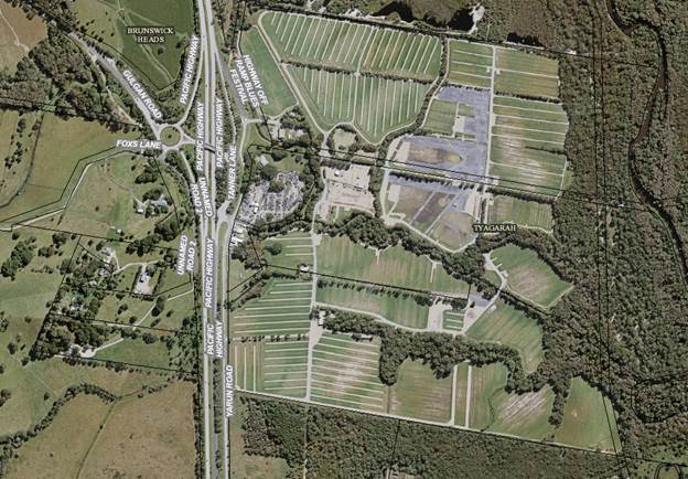
Bluesfest Site
1.3 Is the
modification substantially the same as the development granted?
The proposed section 96 application is considered to result in
a development which is substantially the same development for which consent was
originally granted. The proposal can be considered under S96(1A) as a minor
amendment.
2.0
SECTION 79C – MATTERS FOR CONSIDERATION – DISCUSSION OF
ISSUES
Having regard for the matters for consideration detailed in
Section 79C(1) of the Environmental Planning & Assessment Act 1979, the
following is a summary of the evaluation of the issues.
2.1 State/Regional Planning Policies, Instruments, EPA
Regulations 2000
The proposed amendments raise no issues under the relevant
SEPPS, Policies or clauses of the EPA Regulations 2000
2.2 Byron Local Environmental Plan 2014
The proposed amendments raise no issues under the LEP.
2.3 Draft EPI that is or has been placed on public exhibition
and details of which have been notified to the consent authority - Issues
No draft EPIs affect the proposal.
2.4 Development Control Plans
Proposed amendments do not generate any additional issues
that have not been previously considered.
2.5 The likely impacts of that development, including
environmental impacts on both the natural and built environments, and social
and economic impacts in the locality
The proposal has been referred to the Local Traffic
Committee on the 26 June 2018, whereby it is recommended
that the paid parking be permitted for the Bluesfest 2019 event as follows:
1. That Paid
parking at Bluesfest:
a) Be
supported for Bluesfest 2019 with a review following the event within 2 months
of the event;
b) If
no issues are raised by either the RMS, Police or Council that paid parking be
permitted as a permanent arrangement.
2. The
committee advises the proponent to incorporate these changes into future TMP/
TCP’s and that these be lodged with Council at least 4 months prior to
the event.
It is recommended that the consent be amended to enable paid
parking for the 2019 event and to reflect the recommendations of the Local
Traffic Committee.
Provided that paid parking is successful and there are no
issues or impacts on traffic flow on the highway for the 2019 event, or on the
surrounding road network, paid parking can become a permanent arrangement for
Bluesfest.
2.6 The suitability of the site for the development
The proposed amendments do not raise any issues in relation
to the sites suitability.
2.7 Submissions made in
accordance with this Act or the regulations
One submission was received objecting to the amendment. The
following comments are provided for Councils consideration
|
Issues
|
Staff Comment
|
|
Condition 59 is required to prevent people parking on the
local roads as they would object to paid parking
|
Approval is supported for the 2019 event which will be
reviewed as required by the Local traffic Committee. Should paid parking
cause issues for through traffic on the highway or result in patrons parking
on local roads surrounding the site, then paid parking may not be permitted
in the future following that review
|
|
Local roads need security during events to stop parking in
Fox Lane, Grays Lane etc. Also to prevent camping, illegal rubbish dumping
the like.
|
Condition 29(k) of the consent requires regular security
guard surveillance for Grays and Fox Lane. It is in the interest of Bluesfest
to ensure compliance with that condition.
|
|
Unable to gain access to exhibited documentation
|
Copy of documentation emailed to objector who was invited
to make submission by the Planner
|
|
|
|
2.8 Public interest
The proposed amendments are unlikely to prejudice or
compromise the public interest.
2.9 DEVELOPER CONTRIBUTIONS/
WATER AND SEWER CHARGES
There is no nexus to levy additional contributions.
3.0 CONCLUSION
The proposed development is considered to be substantially
the same development as approved and satisfies the provisions under Section 96
of the EPA Act 1979. Having regards to the amendment to enable paid parking
this is supported for the 2019 Bluesfest Event, which will be reviewed
following the event, as recommended by the Local traffic Committee. Provided no
issues arise, paid parking can become a permanent arrangement provided this is
supported by Council, the RMS and the NSW Police Force. The application is
recommended for approval subject to Condition 59 being amended.
4.0 DISCLOSURE OF POLITICAL DONATIONS AND GIFTS
|
Has a Disclosure Statement been received in relation
to this application
|
No
|
|
Have staff received a ‘gift’ from anyone
involved in this application that needs to be disclosed. Where the answer is
yes, the application is to be determined by the Director or Manager of the
Planning, Development and Environment Division.
|
No
|
5.0 STATEMENT OF REASONS
Note:
From July 1 2018, Council’s are required to give and publicly notify
reasons for a range of planning decisions where they are deciding if
development should proceed to help community members to see how their views
have been taken into account and improve accountability to stakeholders. A
statement of reasons for the determination of this application is provided
below.
|
S.96
|
The proposed modification is minor and substantially the
same as the original development approval with no likely detrimental impacts
on the built or natural environment the result of the change to the relevant
condition.
|
|
How community views were addressed
|
|
1.
|
The DA was advertised in accordance with Development Control
Plan 2014. The submission received was considered on merit and addressed
during assessment of the application as discussed above.
|
Staff Reports - Sustainable Environment and Economy 13.17
Report No. 13.17 PLANNING
- Development Application No. 10.2018.86.1 - Installation of 30m high
telecommunications facility and associated ancillary equipment at Lot 339 DP
755692 Old Pacific Highway Brunswick Heads
Directorate: Sustainable
Environment and Economy
Report
Author: Greg
Smith, Team Leader Planning Services
File No: I2018/1301
Theme: Sustainable Environment and Economy
Development and Certification
Proposal:
|
Proposal description:
|
Installation of 30m High Telecommunications Facility and Associated
Ancillary Equipment
|
|
Property description:
|
LOT: 339 DP: 755692
|
|
Old Pacific Highway BRUNSWICK HEADS
|
|
Parcel No/s:
|
164530
|
|
Applicant:
|
Aurecon
|
|
Owner:
|
Brunswick Heads Bowling Club
|
|
Zoning:
|
RE2 Private Recreation
|
|
Date received:
|
27 February 2018
|
|
Integrated Development:
|
No
|
|
Public notification or exhibition:
|
- Level
2 advertising under DCP 2014 Part A14 – Public Notification and
Exhibition of Development Applications
- Exhibition
period: 22 March 2018 to 4 April 2018
- Submissions received: 1
|
|
Delegation to determination:
|
Council
|
|
Issues:
|
· Building height
under LEP 2014 clause 4.3, with clause 4.6 request for variation (development
standard is 9m, total height is approximately 31.5m)
· Bush fire prone
land
· Acid sulfate
soils - class 4
· Public
submission (1)
|
Summary:
The DA proposes installation of a 30m high
telecommunications facility and associated ancillary equipment. The location is
part of the site of the Brunswick Heads Bowling Club.
The proposed development is generally consistent with the
relevant environmental planning instruments and planning controls applicable to
the site including the LEP and DCP provisions for this type of development,
excluding the height provisions under Clause 4.3 of BLEP 2014. The tower has a
proposed maximum height of approximately 31.5m which exceeds the 9m maximum
development standard.
The DA is supported by a written request for a variation
pursuant to clause 4.6 of LEP 2014. It is considered that strict compliance
with the development standard is not warranted in this instance. In particular
a phone tower would be ineffective at 9 metres in height. It is noted the tower
is located at the southern entrance to Brunswick Heads adjacent to the Bowls
Club and next to an existing shed. The area is in part vegetated with a mixture
of eucalypts and other coastal species helping to screen the tower as it is
approached from Brunswick Heads to the north and from the Pacific Highway to
the south. Further landscaping is also recommended by way of a condition of
consent to soften the visual impact of the tower compound. The proposal is
unlikely to have a significant impact on the visual amenity of the locality.
It is considered the proposal raises no significant issues
in terms of environmental impacts which cannot be managed through reasonable
and relevant conditions of approval, and the site is considered suitable for
the development as discussed in this report. In this regard numerous sites were
considered in the Brunswick Heads area, with the bowling club site selected as
the preferred property for the phone tower.
The proposed tower will provide improved mobile
telecommunication for residents, businesses, tourists and other visitors to the
area. The application is recommended for approval subject to conditions of
consent.
NOTE TO COUNCILLORS:
In accordance with the
provisions of S375A of the Local Government Act 1993, a Division is to be
called whenever a motion for a planning decision is put to the meeting, for the
purpose of recording voting on planning matters. Pursuant to clause 2(a)
under the heading Matters to be Included in Minutes of Council Meetings of
Council's adopted Code of Meeting Practice (as amended) a Division will be
deemed to have been called by the mover and seconder of all motions relating to
this report.
|
RECOMMENDATION:
Pursuant to Section
80 of the Environmental Planning & Assessment Act 1979, Development
Application No. 10.2018.86.1 for
Installation of 30m high telecommunications facility and associated ancillary
equipment, be approved subject to conditions listed in Attachment 2
#E2018/57739.
|
Attachments:
1 Attachment
1 Proposed Plans, E2018/57738 ⇨
2 Attachment
2 Recommended conditions of consent, E2018/58444
⇨
3 Attachment
3 Submission received, E2018/58445
⇨
Report
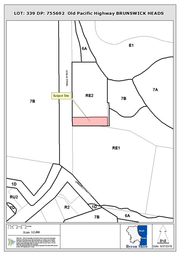
Assessment:
1. INTRODUCTION
1.1. History/Background
The Brunswick Heads Bowling Club is located at the site,
which has been the subject of various development applications over the years.
1.2. Description
of the proposed development
This application seeks approval for Installation of 30m High
Telecommunications Facility and Associated Ancillary Equipment.
1.3. Description
of the site
|
Land is legally described as
|
LOT: 339 DP: 755692
|
|
Property address is
|
Old Pacific Highway BRUNSWICK HEADS
|
|
Land is zoned:
|
RE2 Private Recreation
|
|
Property is constrained by:
|
Bush fire prone land, Acid Sulfate Soils Class
4
|


The above arrows show the approximate location of the
proposed development (looking north and looking south, respectively).
2. SUMMARY OF
REFERRALS
|
Referral
|
Issue
|
|
Environmental Health Officer
|
No objections subject to conditions. Refer to Doc
#A2018/7372.
|
|
Development Engineer
|
No objections subject to conditions. Refer to Doc #A2018/7388.
|
|
S64 / Systems Planning Officer
|
No objections, no conditions. Refer to Doc #A2018/7409.
|
|
S94 / Contributions Officer
|
Conditions recommended in relation to the payment of
section 94A contributions.
|
* Conditions provided in the above referral are included
in the Recommendation of this Report below
3. SECTION 79BA
– BUSH FIRE PRONE LAND
Under section 4.14 of the Act,
Council must be satisfied prior to making a determination for development on
bush fire prone land, which the development complies with the document Planning
for Bush Fire Protection 2006. The site is bush fire prone land.
The Applicant advises that:
“The proposed facility would be unmanned and all equipment constructed of
either steel or aluminium materials. Therefore, a bush fire would not present a
significant danger to the facility. Telecommunications infrastructure is
generally deemed as important infrastructure, during emergency events, such as
a bushfire.”
Planning for Bush Fire
Protection 2006 states that class 10b buildings in bush fire prone areas should
be non-combustible and on the basis of the Applicant’s advice, the
proposal complies with this requirement. It is also noted that the direction of
the bush fire hazard is to the west, on the opposite side of the Old Pacific
Highway, providing a defendable space between the proposal and the hazard.
4. SECTION 79C
– MATTERS FOR CONSIDERATION – DISCUSSION OF ISSUES
Having regard to the matters for consideration detailed in
Section 79C(1) of the Environmental Planning & Assessment Act 1979
(EP&A Act), the following is a summary of the evaluation of the issues.
4.1 State Environmental
Planning Instruments
4.2A Byron Local Environmental Plan 2014 (LEP 2014)
LEP 2014 is an applicable matter for consideration in the
assessment of the subject development application in accordance with subsection
79C(1) of the EP&A Act because it applies to the subject land and the
proposed development.
In accordance with LEP 2014 clauses 1.4 and 2.1 – 2.3:
(a) The
proposed development is defined in the Infrastructure SEPP as a
telecommunications facility;
(b) The
land is within the RE2 Private Recreation according to the Land Zoning Map;
(c) The
proposed development is permitted with consent under the Infrastructure SEPP;
and
(d) Regard
is had for the Zone Objectives as follows:
|
Zone Objective
|
Consideration
|
|
• To enable land to be used for private
open space or recreational purposes.
|
The
proposal does not prevent the use of the land for private open space or
recreational purposes.
|
|
• To provide a range of recreational
settings and activities and compatible land uses.
|
The
proposal does not prevent the provision of a range of recreational settings
and activities and compatible land uses.
|
|
• To protect and enhance the natural
environment for recreational purposes.
|
The
proposal appropriately protects and enhances the natural environment for
recreational purposes.
|
The remaining checked clauses have been taken into
consideration in the assessment of the subject development application in
accordance with subsection 79C(1) of the EP&A Act. The proposed development
complies with all of these clauses (in some cases subject to conditions and/or
to the satisfaction of other assessing officers), except in relation to clause
4.3 which is addressed as follows:
4.3 Height
of buildings
Clause
4.3 is as follows:
(1) The objectives of this clause are as
follows:
(a) to achieve building design that does not
exceed a specified maximum height from its existing ground level to finished
roof or parapet,
(b) to ensure the height of buildings
complements the streetscape and character of the area in which the buildings
are located,
(c) to minimise visual impact, disruption of
views, loss of privacy and loss of solar access to existing development.
(2) The height of a building on any land is
not to exceed the maximum height shown for the land on the Height of Buildings Map.
The Height of Buildings Map shows a 9m maximum height of
building for the location of the proposed development. The proposed height is
approximately 31.5m.
The Applicant has submitted a written request for variation
under clause 4.6 of LEP 2014. The clause 4.6 variation request is considered
with reference to relevant matters as follows:
1. Introduction
– Summary of proposed development
The development application
proposes installation of a 30m high telecommunications facility and associated
ancillary equipment, although the total height is closer to 31.5m.
2. Clause
4.6 Exceptions to Development Standards
LEP 2014 clause 4.6 allows
the granting of a development consent, even though the development would
contravene a development standard. However Council must first consider a
written request from the Applicant that seeks to justify the contravention of
the development standard by demonstrating:
(a) that
compliance with the development standard is unreasonable or unnecessary in the
circumstances of the case, and
(b) that
there are sufficient environmental planning grounds to justify contravening the
development standard.
Council must be
satisfied that the Applicant’s written request has adequately addressed
the matters required to be demonstrated and that the proposed development will
be in the public interest because it is consistent with the objectives of the
particular standard and the objectives for development within the zone in which
the development is proposed to be carried out (noting that the concurrence of
the Secretary is not required to be obtained in this instance).
3. The
Development Standard to be varied
The development standard to be
varied is the maximum height of building planning control of 9m applicable to
this site under LEP 2014 clause 4.3 as described above.
The maximum height of building
planning control is a development standard in accordance with the applicable
definition in section 1.4 of the Environmental Planning and Assessment Act 1979
because it is a provision of an environmental planning instrument in relation
to the carrying out of development, being a provision by or under which requirements
are specified or standards are fixed in respect of any aspect of that
development, being the height of a building.
4. Extent
of Variation to the Development Standard
The extent of the variation is
approximately 250%.
5. Objective
of the Development Standard
The objectives of the development
standard, as outlined in subclause 4.3(1) are:
(a) to
achieve building design that does not exceed a specified maximum height from
its existing ground level to finished roof or parapet,
(b) to
ensure the height of buildings complements the streetscape and character of the
area in which the buildings are located,
(c) to
minimise visual impact, disruption of views, loss of privacy and loss of solar
access to existing development.
6. Objectives
of the Zone
The objectives of the RE2 Private
Recreation Zone are stated and have been addressed in this section above.
7. Assessment
– the specific questions to be addressed:
(a) Clause
4.6(3)(a) – Is compliance with the development standard unreasonable or
unnecessary in the circumstances of the case?
The clause 4.6 written request
submitted in support of the DA advises as follows in this regard:
“Telstra
believes that compliance with the development standard is unreasonable given
the nature of telecommunications facilities”.
Requiring compliance with the
development standard would result in a telecommunications facility of such a
size that would not allow appropriate servicing of the local area in accordance
with it’s intended purpose. Requiring compliance with the development
standard would be unreasonable in the circumstances of the case.
(b) Clause
4.6(3)(b) – Are there sufficient environmental planning grounds to
justify contravening the development standard?
The clause 4.6 written request
submitted in support of the DA advises as follows in this regard:
“The
height of the facility is necessary as the nature of telecommunications
facilities is that they are high enough to protrude above surrounding
vegetation and structures. This is how the network operates, by establishing a
‘line of sight’ for antennas. There is surrounding mature
vegetation that exceeds 9m and as such, the tower is unable to comply with the
maximum height limit prescribed in Council’s LEP. The proposed height of
the facility allows coverage to the Brunswick Heads area, without the facility
needing to be in the middle of a residential locality.
The height
is required to allow adequate provision of mobile voice and data service to the
residential area south of the proposed facility and the main residential,
commercial and tourist areas of Brunswick Heads to the north. Furthermore, if
the 9m height restriction was enforced in all localities as identified in
Council’s LEP, it is unlikely there would be sufficient
telecommunications coverage. Typically, telecommunications base stations exceed
these height limits”.
The
environmental planning grounds are particular to the site and sufficient to
justify contravening the development standard. These include that the building
is located so as to maintain an appropriate distance to nearby residential
properties, minimise environmental and visual impacts, and use of existing
space with minimal environmental constraints. The proposal will be visually
softened to some extent by existing trees and vegetation, particularly from the
southern approach. The photo below is taken from the road, residential
properties are located even further to the south and it is unlikely that the
proposed structure will be excessively visible from the nearest residential
properties (particularly due to intervening vegetation). Refer for example the
photo below which was included in the Applicant’s Statement of
Environmental Effects. The proposed variation does not create any significantly
adverse social, environmental or economic impacts in the locality.
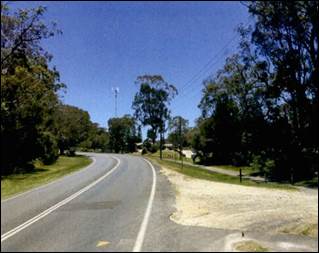
(c) Clause
4.6(4)(a)(ii) – Is the proposed development in the public interest? Is it
consistent with the objectives of the standard and the zone as set out above?
The clause 4.6 written request
submitted in support of the DA advises as follows in this regard:
“With
respect to Clause 4.6(4)(a)(ii), Telstra believes that the proposal is
consistent with the zone objectives of RE2 Private Recreation. The facility
will provide a reliable mobile network service that is essential for
residential, commercial and recreational purposes; meeting the day to day
mobile needs of residents, businesses and visitors to the area”.
The proposal
is consistent with the objectives of the development standard and the zone for
site specific reasons as follows:
(a) Objectives of the Standard
· whilst the proposal exceeds the specified maximum height, the proposed
height is justified in the location and having regard to the minimal
environmental impact of the proposal,
· the proposed height does not significantly detract from the streetscape
and character of the area, and
· the proposal will not have a significant impact in terms of visual,
views, loss of privacy and loss of solar access.
(b) Objectives of the RE2 Zone
· The proposal does not prevent the use of the land for private open
space or recreational purposes.
· The proposal does not prevent the provision of a range of recreational
settings and activities and compatible land uses.
· The proposal appropriately protects and enhances the natural
environment for recreational purposes.
The proposal produces a better
planning outcome than one that strictly complies with the development standard
because requiring strict compliance would result in a mobile phone tower that
is not able to serve the intended purpose. The proposed development is in the
broader public interest. The circumstances of the case warrant a more flexible
approach to application of the building height development standard, the
Applicant’s variation request is supported and the development
application is recommended for approval despite the non-compliance.
6.1 Acid sulfate soils
The location of the proposed development is class 4 acid
sulfate soils, which relates to works exceeding a depth of 2m below the natural
ground surface. However the Applicant confirms that there will be no works
beyond 2m below the natural ground surface. The Applicant acknowledges that
should acid sulfate soils be discovered during excavation, then works would
cease in order to resolve the potential for impacts.
6.2 Earthworks
The development involves earthworks for which development
consent is required. The extent of proposed earthworks is minimal at this
relatively flat topographical location.
6.6 Essential services
The proposed development has access to all necessary
services, including for example stormwater and power.
4.3 Any proposed Instrument
that has been the subject of public consultation and has been notified to the
consent authority
There are no draft environmental planning instruments of
significant influence in relation to the proposal.
4.4A Byron Shire Development Control Plan 2014
(DCP 2014)
DCP 2014 is an applicable matter for consideration in the
assessment of the subject development application in accordance with subsection
79C(1) of the EP& A Act because it applies to the land to which LEP 2014
applies.
Chapter B2 Preservation of trees and other vegetation
The proposed development is located in a grassed position
and does not require the removal of any significant trees.
Chapter B3 Services
The location of the proposed development has access to all
necessary services, including for example stormwater, access and power.
Chapter B4 Traffic Planning, Vehicle Parking, Circulation
and Access
The proposed access is satisfactory having regard to the
assessment provided by Council’s Development Engineer.
Chapter B8 Waste Minimisation and Management
A pre-construction certificate condition is recommended
requiring appropriate waste minimisation and management procedures to be put in
place for all works.
Chapter B9 Landscaping
A landscape plan is required by way of a recommended
condition so as to visually soften the compound of the tower.
Chapter B14 Excavation and Fill
The plans provide an indication that the extent of excavation
and fill does not exceed a depth of 1m.
Chapter C3 Visually Prominent Sites, Visually Prominent
Development and View Sharing
The DA is supported by a visual impact analysis. The nature
of telecommunications base stations is that they need to be tall enough to
protrude above surrounding infrastructure and vegetation, in order to provide a
line of sight to devices and other base stations. It is impractical to
completely screen a new structure.
To the west of the proposed
site, on the other side of Old Pacific Highway, is densely vegetated unused
land. Directly to the north is the Brunswick Bowling Club and beyond the
clubhouse to the north is dense tall vegetation. Considering the tall and dense
nature of these trees, the proposed facility would not be visible to persons
traversing Old Pacific Highway (by either vehicle or pedestrian form) from the
north, towards the south, until approximately 180m from the site. Existing
vegetation provides visual softening from the northerly direction.
To the south east of the site
are sporting ovals and Council's water treatment plant. The closest residential
property is approximately 150m to the south, separated by reasonably tall
vegetation, another sports oval and a skate park. It is predicted the main view
corridor of the proposed facility, would be for pedestrians and vehicular
traffic travelling north along the Old Pacific Highway, Due to the shape of the
road corridor, it would be expected a view of the facility would be obtained
from approximately 160m from the site.
There are surrounding tall trees
that would provide intermittent screening of the facility and the immediate
surrounding vegetation would screen the lower half of the pole. Whilst it is
appreciated there will be an intermittent visual presence of the facility,
particularly when facing northwards and from the Bowling Club and sporting
ovals, this location offers the greatest amount of natural screening and
separation from residential properties, compared to other locations identified
within the Brunswick Heads area. Conditions of consent are recommended in
relation to general landscaping around the compound.
Chapter E4 Brunswick Heads
The DCP shows an existing footpath / cycleway crossing the
site, however there is no existing footpath / cycleway in the exact location of
the proposed development.
4.5 Any Planning Agreement or
Draft Planning Agreement?
|
|
Yes
|
No
|
|
Is there any applicable planning agreement or draft
planning agreement?
|
☐
|
☒
|
4.6 Environmental Planning
& Assessment Regulation 2000 Considerations
The proposal raises no issues relevant clauses for
consideration under the EPA Regulations 2000.
4.7 Any coastal zone management
plan?
|
|
Satisfactory
|
Unsatisfactory
|
Not applicable
|
|
Is there any applicable coastal zone management plan?
|
☐
|
☐
|
☒
|
4.8 The likely impacts of that
development, including environmental impacts on both the natural and built
environments, and social and economic impacts in the locality
|
Impact on:
|
Likely significant impact/s?
|
|
Natural environment
|
No. The proposal will not have a significantly adverse
impact on the natural environment of the locality.
|
|
Built environment
|
No. The proposal will not have a significantly adverse
impact on the built environment of the locality.
|
|
Social Environment
|
No. The proposal will not have a significant social impact
on the locality.
|
|
Economic impact
|
No. The proposal will not have a significant economic
impact on the locality.
|
Standard conditions of consent are recommended in relation
to construction activity, hours of work, builders waste and the like
4.9 The suitability of the site
for the development
The Applicant advises that
Telstra and its consultants have been investigating an appropriate location for
a new Telstra base station facility for over seven years in the Brunswick Heads
area. Brunswick Heads requires a dedicated mobile phone base station to
effectively provide reception to residents, businesses and visitors to the
area.
The Applicant advises that it
has been difficult to find a suitable location, due to the residential and
scenic nature of the area, but that Telstra is of the opinion the Brunswick
Heads Bowling Club offers the most appropriate location for a new facility.
Twelve candidate sites were investigated by Telstra.
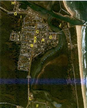
The reasons provided by the Applicant as to why other
candidates were not selected are as follows:
· An
agreement with the landowner could not be reached or property negotiations
failed.
· The
proposal would have resulted in a high degree of visual impact on the
surrounding residential area.
· Proximity
to residential properties or less separation from residential properties.
· An
Aboriginal Land Claim (ALC) was lodged, prohibiting development from occurring.
Upon assessment of all
candidates, Telstra selected the proposed location as ultimately deemed the
most appropriate location as the site offers reasonable distance from the
closest residential properties, existing surrounding tall vegetation, a willing
landowner and the location would meet radio frequency objectives.
It is considered the site is
suitable for the proposed telecommunication tower.
4.10 Submissions made in accordance with
this Act or the regulations
The development application was publicly exhibited. There
was one submission made on the development application which raised the
following issues:
9m height
limit. Maintenance of Brunswick Heads lifestyle and the prevention of Gold
Coast type developments. Views form the breakwater of tree and sky with
hills behind and no building in sight. Every other Telco will want one as their
coverage is no better than Telstra and generally worse. A mobile phone tower is
ugly. A developer could put forward a sound argument that an architecturally
designed 30m block of units would be more attractive. Council must consult
widely with the Community. I only, by chance, picked up the Byron News as
it is not delivered to us.
Comment: The height
of the proposed development has been considered above with reference to the
provisions of clauses 4.3 and 4.6 of Byron LEP 2014 and is considered to be
justified. The Applicant has selected a location that does not adjoin dwellings
and is not topographically elevated or highly visually prominent. The proposed
height is not likely to be a trigger for applications proposing blocks of units
that exceed the height limit. Any subsequent application for a
telecommunications facility would be considered on its merits. The application
was notified in a local newspaper in accordance with Council policy.
The
application indicates a pressing need for the tower based on current call
failure rates and future demand. Even though we live on the edge of the coverage
there has never been a time when a call has failed or dropped out. Delays
in receiving messages during the Splendour or Falls Festivals. These are
massive extra numbers of mobile phone users that should be mandatorily catered
for by mobile towers at the site. There is no Telstra coverage near the Gulgan
Rd / Mullumbimby Rd junctions. Any tower should be on the Mullumbimby
side of the Motorway.
Extra
numbers of people and higher data won’t happen as Brunswick is full at
Xmas and Easter and there is no way of being overfull. With the NBN, many
people who currently use mobiles may switch to VOIP with their internet thus
reducing the demand on mobile services.
Comment: The
Applicant provides the following justification relating to the need for the proposed
development:
“Telstra
regularly undertakes detailed assessments of the performance and coverage of
its digital mobile telephone and broadband internet networks to ensure its
systems are reliable and achieving the required objectives. The customers demand
for mobile broadband, voice and video services is driving existing facilities
towards full capacity.
Since the
introduction of smartphone's and tablet devices, together with wireless
internet and social networking applications, Telstra is experiencing a doubling
every year of wireless demand. Reference to customer demand in the Brunswick
Heads area has identified diminishing radio frequency coverage in the area for
over seven years. This will further deteriorate in the future. In order to
improve coverage in the area, a dedicated site to cover the Brunswick Heads
area is essential; and Telstra has identified the proposed location at
Brunswick Heads Bowling Club as the preferred location for a new mobile phone
base station.
Telstra
considers that the location selected for the new base station best meets the
radio frequency objectives, including:
· the
ability to reduce the work load (referred to as 'traffic') currently being
experienced by the surrounding network sites, specifically the existing site known
as Billinudgei, and
· offering
the opportunity to provide enhanced coverage by locating the new base station
as centrally as possible, whilst avoiding residential properties as much as
possible, within the area of customer demand”.
The Applicant is considered to
have provided sufficient justification for the purposes of DA assessment, for
the proposed development with reference to demand.
No one
wanted their tower, having investigated and had rejected a number of
alternatives. The entry statement to Brunswick Heads from the most popular
South will be the top of the mobile phone tower – not a good look.
The applicant has provided some depictions of the tower from two positions on
Old Pacific Highway, but where else can it be seen from? As the applicant
requires the 30m for line of sight to the relevant mobile phones, so also will
there be line of sight back to the tower. Will it be visible from the
pedestrian bridge over Simpsons Creek or the Breakwater perhaps?
Comment: The
Applicant investigated a number of alternative locations and settled on the
proposed location, which is considered satisfactory having regard to visual
impact for the reasons given above.
The
applicant states “there is no substantial evidence that exposure to low
level radiofrequency EME causes adverse health effects”. This is not the
same as saying there cannot be any effects and in any case of uncertainty
“precautionary principles” should apply. These demand that
any siting of a mobile phone tower should be at a site that minimises exposure.
The Industry Code also has the objective of “avoiding community sensitive
locations”. The skate park and playing fields are community sensitive
locations. One site near the Brunswick Heads Primary School was rejected on
being too close to the school, but they want to put a tower close to where
hundreds of children play regularly on the skate park or at sports on the
adjoining ovals. The playing fields are also used by the Rescue Helicopter.
They also should be advised of this proposal given the height of the tower.
Comment: Council’s Environmental Health Officer advises that
telecommunication facilities which radiate electromagnetic energy (EME) into
the surrounding environment must comply with safety limits imposed by the
Australian Communications and Media Authority (ACMA).
The limits are given in the Radiocommunications
(Electromagnetic Radiation — Human Exposure) Standard 2003. These
limits are based on the ARPANSA Radiation Protection Standard - Maximum
Exposure Levels to Radiofrequency Fields - 3kHz to 300GHz. ACMA also
requires compliance with industry codes of practice including the Australian
Communications Industry Forum (ACIF) C564:2004 Industry Code –
Deployment of Mobile Phone Network Infrastructure.
Appendix B of the Statement
of Environmental Effects provides a summary of estimated RF EME Levels around
the proposed mobile base station in accordance with Australian
Radiation Protection And Nuclear Safety Agency (ARPANSA) Prediction Methodology
and presents a report in an approved ARPANSA Environmental EME Report
format. The maximum predicted EME levels for the proposed systems at this
site is 4.36V/m; equivalent to 48.21 mW/m2 or 0.86% of the ARPANSA public
exposure limits (at 179.22 m from the antenna). Note: The public
exposure limit is 100%, so 0.86% is well within safety limits.
The Telecommunications Code of
Practice requires that telecommunications providers co-locate facilities
with the existing facilities of other carriers or public utilities, or utilise
public easements. Co-location can assist in minimising visibility,
reducing visual impacts and protecting public amenity. Information
contained in the SEE demonstrates that 12 sites (‘candidates A to
L’) were investigated. However, these areas were discounted due to
a variety of issues. Page 8 of the SEE states that: Upon assessment of
all candidates, this location (Location ‘L’) was ultimately deemed
the most appropriate location as the site offers reasonable distance from the
closest residential properties, existing surrounding tall vegetation, a willing
landowner and the location would meet radio frequency objectives.
The proposed development complies with
the mandatory standards required by ARPANSA.
Council’s Environmental
Health Officer stated the following in her assessment of DA 10.2010.404.1:
“Non-support of the
development based on health grounds would be impossible to defend in court due
to the lack of clear scientific evidence that exposure to low level
radiofrequency EME causes adverse health effects. The Land and Environmental Court have upheld an appeal by Hutchison Telecommunication (Australia) against Ku-ring-gai Municipal Council for the refusal a telecommunications tower
located at Kissing Point Road, Turramurra. To view the case in visit http://www.austlii.edu.au”
Koala
habitat
Comment: The
location of the proposed structure is a grassed area with no significant trees.
There is koala habitat in the vicinity, however the specific location of the
proposed development is not koala habitat.
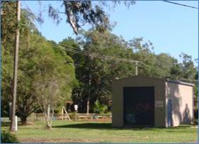
The most
obvious place to put a mobile phone tower would be in the carpark adjacent to
the off ramp of the motorway on the Mullumbimby side or the Council owned land
occupied by the Brunswick Volunteer Rescue in Byron St where there is currently
a radio aerial for VHF communication. If this was replaced by a short
mobile phone tower, then most of the tower would be hidden by the truck shed
and its location backing onto the reserve would limit the visual impact.
Comment: Council is
required to assess the location as proposed by the development application.
4.11 Public interest
The proposed development is unlikely to prejudice or
compromise the public interest or create a dangerous precedent
4.12 Section 5A of the EP&A Act –
Significant effect on threatened species
Having regard to sections 5A, 5C and 5D of the EP&A Act, there is unlikely to be a significant effect on threatened species,
populations or ecological communities, or their habitats as a result of the
proposed development because no significant vegetation is proposed to be
removed.
4.13 Section 5B of the EP&A Act –
Have regard to register of critical habitat
The NSW Critical
Habitat Register does not identify any critical habitat on or adjacent to the
site.
5. DEVELOPER
CONTRIBUTIONS
Section 94 Contributions will be
payable at construction certificate stage.
6. CONCLUSION
The DA proposes Installation of 30m high telecommunications
facility and associated ancillary equipment. The building has a proposed
maximum height of approximately 31.5m which exceeds the 9m maximum development
standard (approximately a 250% variation). The DA is supported by a written
request for a variation pursuant to clause 4.6 of LEP 2014. The circumstances
of the case warrant a more flexible approach to the application of the minimum
lot size development standard, the Applicant’s variation request is
supported and the development application is recommended for approval despite
the non-compliance subject to conditions.
7. REASONS
FOR DECISION, HOW COMMUNITY VIEWS WERE ADDRESSED
|
Note: From July 1 2018, Council’s are required to give and
publicly notify reasons for a range of planning decisions where they are
deciding if development should proceed to help community members to see how
their views have been taken into account and improve accountability to
stakeholders. A statement of reasons for the determination of this
application is provided below.
|
|
The proposed development will not have significant adverse
impact on the natural, built or social environment or economic impacts on the
locality.
|
|
The proposed development is considered suitable for the proposed
site.
|
|
How community views were addressed
|
|
The DA was advertised in accordance with Development
Control Plan 2014. The submissions received were considered on merit and
addressed during assessment of the application.
|
Staff Reports - Sustainable Environment and Economy 13.18
Report No. 13.18 PLANNING
- Development Application 10.2017.516.1 Subdivision to create four (4) lots,
removal of trees, earthworks and associated infrastructure - 8 Coomburra
Crescent, Ocean Shores
Directorate: Sustainable
Environment and Economy
Report
Author: Paul
Mills, Senior Planner
File No: I2018/1304
Theme: Sustainable Environment and Economy
Development and Certification
Proposal:
|
DA No:
|
10.2017.516.1
|
|
Proposal description:
|
Subdivision to create four (4) Lots
|
|
Property description:
|
LOT: 1577 DP: 243995
|
|
8 Coomburra Crescent OCEAN SHORES
|
|
Parcel No/s:
|
14500
|
|
Applicant:
|
Ardill Payne & Partners
|
|
Owner:
|
Mr A L Mangleson
|
|
Zoning:
|
R2 Low Density Residential
|
|
Date received:
|
19 September 2017
|
|
Integrated Development:
|
No
|
|
Public notification or exhibition:
|
- Level
1 advertising under DCP 2014 Part A14 – Public Notification and
Exhibition of Development Applications
- Exhibition
period: 28/09/17 to 11/10/17
- Submissions received:
Ten (10)
|
|
Planning Review Committee:
|
Application was considered at the PRC Meeting held 19
October 2017 where it was decided that the application would be determined at
a Meeting of Council.
|
|
Delegation to determination:
|
Meeting of Council
|
|
Issues:
|
· Traffic noise
and disturbance and vehicle sight distances when accessing Coomburra
Crescent.
· Slope stability
and geotechnical assessment.
· Stormwater
management.
|
Summary:
The application seeks development
consent for the subdivision of a large existing residential lot into four (4)
new lots. Access to proposed Lot’s 1, 2, 3 and 4, is via a 6.0m wide
access handle from Coomburra Crescent. The proposal is considered to satisfy
the provisions of Byron LEP 2014 and other relevant Environmental Planning
Instruments, and is satisfactory form of infill development ranging in size
from 800m2 to 1675 m2 in area.
The proposal is also considered to
satisfy the provisions of Byron DCP 2014 apart from a numeric non-compliance
with the 1.0m maximum depth of excavation control. The proposed retaining wall
associated with the construction of the new driveway reaches a maximum height
of approximately 1.50 metres. The proposed earthworks are considered to achieve
the objective of control to maintain the character of the area subject to
conditions.
A total of ten (10) submissions
were received in response to the community consultation process. The matters
raised in the submissions include concerns regarding the safety of driveway
access to Coomburra Crescent, vehicle noise, earthworks – slope
stability, retaining walls, stormwater management, removal of trees, loss of
privacy, vehicle safety, loss of amenity for the adjoining properties, and future
development potential. The matters raised in the submissions have been
addressed in this report.
Following the exhibition of the
application, the applicant submitted amended plans making minor modifications
to the proposed lot layout to allow more room for the proposed access driveway.
Conditions have been included to require a 2.5 metre high screen fencing
adjacent to the access handle driveway for privacy and to limit vehicle noise
from cars entering and leaving the four proposed lots.
The application is considered to
have sufficient merit to warrant approval subject to conditions.
NOTE TO COUNCILLORS:
In accordance with the
provisions of S375A of the Local Government Act 1993, a Division is to be
called whenever a motion for a planning decision is put to the meeting, for the
purpose of recording voting on planning matters. Pursuant to clause 2(a)
under the heading Matters to be Included in Minutes of Council Meetings of
Council's adopted Code of Meeting Practice (as amended) a Division will be
deemed to have been called by the mover and seconder of all motions relating to
this report.
|
RECOMMENDATION:
That pursuant to
Section 80 of the Environmental Planning & Assessment Act 1979,
development application no. 10.2017.516.1 for subdivision to create four (4) lots, be granted consent subject to
conditions detailed in Attachment 2 #E2018/58889.
|
Attachments:
1 Attachment
1 - Proposed Plans prepared by Ardill Payne , E2018/58888
⇨
2 Attachment
2 - Conditions of consent, E2018/58889
⇨
3 Attachment
3 - Submissions received, E2018/58997
⇨
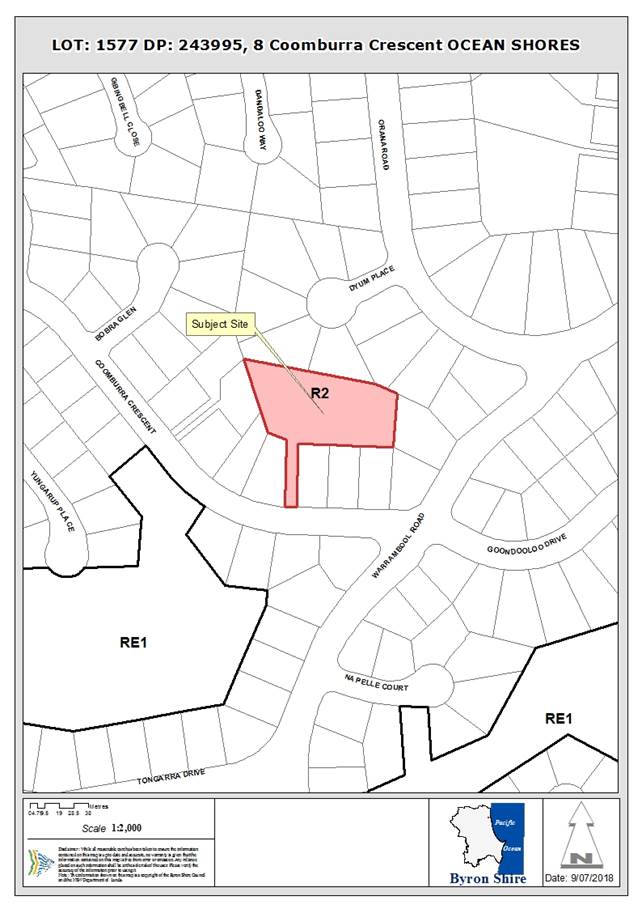
Assessment:
1. INTRODUCTION
1.1. History/Background
Lot 1577 in DP 293995 was registered on 16 October 1973 as
part of a larger residential subdivision for Ocean Shores.
1.2. Description
of the proposed development
This application seeks approval for Subdivision of Lot 1577
DP 243995 to create four (4) Lots. The proposal also includes:
· construction
of a new access driveway connecting each of the proposed lots with Coomburra
Crescent with associated earthworks and retaining walls;
· removal
of fifteen (15) existing trees;
· bulk
earthworks to address slope stability (geotech) issues for a future dwelling
pad on proposed lot three (3), and
· other
associated infrastructure works.
The configuration of the proposed Lots is shown in Figure
1. The proposed lots vary in area as follows:
|
Proposed Lot
|
Area in m2
|
|
Lot 1
|
971
|
|
Lot 2
|
800
|
|
Lot 3
|
800
|
|
Lot 4
|
1675
|
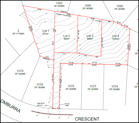
Figure 1 – Proposed Plan of Subdivision
1.3. Description
of the site
|
Land is legally described as
|
Lot: 1577 DP: 243995
|
|
Property address is
|
8 Coomburra Crescent, OCEAN SHORES
|
|
Land is zoned:
|
R2 Low Density Residential
|
|
Land area is:
|
4243 m2
|
|
Property is constrained by:
|
High Environmental Value Vegetation
|
2. SUMMARY OF
REFERRALS
|
Referral
|
Issues
|
|
Environmental Health Officer*
|
SEPP No.55 Contaminated Land assessment provided, site
considered to be suitable for proposed subdivision by Council’s
Environmental Officer. No objection to the proposal subject to
conditions.
|
|
Development Engineer*
|
Stormwater management, vehicular access, slope stability
(geotechnical hazard). No objection to the proposal subject to conditions.
|
|
S64 / Systems Planning Officer*
|
Water and sewer charges are applicable. No objection to
the proposal subject to conditions.
|
|
S94 / Contributions Officer*
|
Section 94 (7.11) contributions are applicable.
|
|
Ecologist*
|
No objection to the proposal subject to conditions.
|
* Conditions provided in the above referral are included
in the Recommendation of this Report below
3. SECTION 79BA
– BUSH FIRE PRONE LAND
Under section 4.14 of the Act, Council must be satisfied
prior to making a determination for development on bush fire prone land, that
the development complies with the document Planning for Bush Fire Protection
2006. The site is not bush fire prone land.
4. SECTION 79C
– MATTERS FOR CONSIDERATION – DISCUSSION OF ISSUES
Having regard to the matters for consideration detailed in
Section 79C(1) of the Environmental Planning & Assessment Act 1979
(EP&A Act), the following is a summary of the evaluation of the issues.
4.1 State Environmental
Planning Instruments
4.2A Byron Local Environmental Plan 2014 (LEP 2014)
Zone: R2 Low Density Residential Zone
Definition: Subdivision
|
LEP Summary of Requirement
|
Proposed
|
|
Zone
R2 Low Density Residential
Objectives of zone
• To provide for
the housing needs of the community within a low density residential
environment.
• To enable other
land uses that provide facilities or services to meet the day to day needs of
residents.
|
The proposed subdivision is considered to be consistent
with the Objectives of the R2 Low Density Residential Zone.
Each of the proposed Lots will have a suitable area to
construct a dwelling house.
|
|
Clause
4.1 Minimum subdivision lot size
(1) The objectives of this
clause are as follows:
(a) to ensure that
lot sizes are compatible with local environmental values and constraints,
(b) to facilitate
efficient use of land resources for residential and other human purposes.
(2) This clause applies to
a subdivision of any land shown on the Lot Size Map that requires development consent
and that is carried out after the commencement of this Plan.
(3) The size of any lot
resulting from a subdivision of land to which this clause applies is not to
be less than the minimum size shown on the Lot Size Map in relation to that land.
|
The subject site is identified as having a minimum lot
size of 600m2. Each of the proposed lots significantly exceeds the
area specified on the minimum Lot Size Map.
|
|
5.5 Development within the coastal zone
The objectives of this clause are as follows:
(a) to provide for the protection of the
coastal environment of the State for the benefit of both present and future
generations through promoting the principles of ecologically sustainable
development,
(b) to implement the principles in the NSW
Coastal Policy,
|
The site is located within the
coastal zone, foreshore access, effluent disposal and stormwater are to be
connected to existing infrastructure.
|
|
5.9: Preservation of trees or vegetation
Summary of standard
Must not remove or otherwise injure any vegetation
prescribed by Chapter B2 of DCP 2014, without development consent.
|
The application seeks
development consent for the removal of trees for the provision of
infrastructure and to establish dwelling sites. An assessment of the
vegetation impacts has been completed in accordance with Council’s DCP
Chapter B2.
|
|
6.1 Acid sulfate soils
Development
consent is required for the carrying out of works described in the table to
this subclause on land shown on the Acid Sulfate
Soils Map as being of the class specified for those works.
|
The subject site is not mapped as containing acid sulfate
soils.
|
|
6.2 Earthworks
(3)
In deciding whether to grant development consent for earthworks (or for
development involving ancillary earthworks), the consent authority must
consider the following matters:
(a) the
likely disruption of, or any detrimental effect on, drainage patterns and
soil stability in the locality of the development,
(b) the
effect of the development on the likely future use or redevelopment of the
land,
(c) the
quality of the fill or the soil to be excavated, or both,
(d) the
effect of the development on the existing and likely amenity of adjoining
properties,
(e) the
source of any fill material and the destination of any excavated material,
(f) the
likelihood of disturbing relics,
(g) the
proximity to, and potential for adverse impacts on, any waterway, drinking
water catchment or environmentally sensitive area,
(h) any
appropriate measures proposed to avoid, minimise or mitigate the impacts of
the development.
|
Earthworks as required for internal road construction and
to address slope stability for proposed Lot 3. These earthworks are
considered to satisfy the provisions of Clause 6.2.
|
|
6.6 Essential services
Development consent must not be granted to development
unless the consent authority is satisfied that any of the following services
that are essential for the development are available or that adequate
arrangements have been made to make them available when required:
(a) the supply of water,
(b) the supply of electricity,
(c) the disposal and management of sewage,
(d) stormwater drainage or on-site conservation,
(e) suitable vehicular access.
|
The subject allotments are
capable of being provided with the essential services required by Clause 6.6.
Reticulated water, sewerage and electricity services available. Adequate
vehicle access is also proposed.
|
4.3 Any proposed Instrument
that has been the subject of public consultation and has been notified to the
consent authority
No relevant Draft Environmental Planning Instruments have
been identified.
4.4A Byron Shire Development Control Plan 2014
(DCP 2014)
DCP 2014 is an applicable matter for consideration in the
assessment of the subject development application in accordance with subsection
79C(1) of the EP& A Act because it applies to the land to which LEP 2014
applies.
The proposed development is demonstrated to meet the
relevant Objectives of all relevant Parts/Chapters (in some cases subject to
conditions and/or to the satisfaction of other assessing officers).
Chapter B2 - Preservation of
Trees and Other Vegetation
The development proposes removal of
(15) trees to facilitate the driveway and stormwater infrastructure. Trees
proposed for removal include:
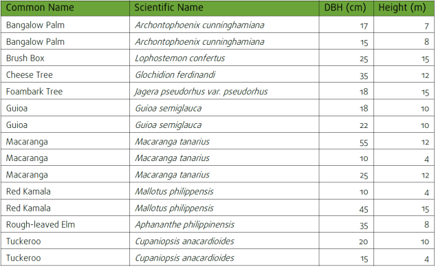
Council’s Ecology Planner
has recommended compensatory planting for the removal of the native trees.
Appropriate conditions of consent have been recommended in this regard
including the preparation of a Vegetation Management Plan.
Chapter B3 – Services
Having regard to Chapter B3
Council’s Development Engineer has assessed the proposed subdivision is
able to be provided with essential urban services subject to conditions of
consent.
Chapter B14 - Excavation and
fill
Section B14.2 Excavation and
Fill in all Zones specifies that filling must be limited to a depth of 1 metre.
The proposed excavation/retaining wall associated with the construction of the
new driveway to Coomburra Crescent reaches a maximum height of approximately
1.5 metres.
The applicant has submitted
engineering drawing of the proposed retaining wall adjacent to the rear of the
property at 4 Coomburra Crescent. The wall at this point is setback
approximately 900mm from the property boundary. In view of the sloping
topography of the site the proposed non-compliance with the prescriptive
measure is acceptable in this instance as the depth of cut satisfies the
objectives of the control which seek to maintain the current and future
character of the area. The applicant has submitted a geotech report for
the site addressing landslip issues. It is considered the site can be developed
for residential purposes.
Chapter D6 - Subdivision
1. Lot Size and
shape
Lot
sizes enable dwellings and driveways to be sited to protect natural or cultural
features, and must respond to site constraints including topography, bushland,
soil erosion, drainage, and bushfire risk.
To provide
adequate useable areas each of the proposed lots have a total area
significantly exceeding the minimum lot size of 600m2. This
additional area provides for more flexible design options for dwellings and
access arrangements that assist to compensate for the steep topography.
Building envelopes consistent with Councils minimum requirements (12x15m) can
be sited on each allotment
2. Vegetation
removal
Subdivision
road layout must be designed around significant stands of trees. These
may be located within reserves or accommodated within the subdivision layout
such that dwelling construction may be achieved without causing any undue
interference with existing trees.
The
proposal involves the removal of scattered exotic and native trees. Appropriate
conditions of consent are recommended for compensatory plantings.
3. Stormwater
Management
Development
applications must demonstrate compliance with Chapter B3 Services, the Northern
Rivers Local Government Development Design and Construction Manuals, Byron
Shire Council Comprehensive Guidelines for Stormwater Management and relevant
Australian Standards.
Council’s
Development Engineer has indicated the proposal complies with DCP 2014 Section
D6.2.1 Subdivision Design Guidelines relating to stormwater management subject
to conditions.
4.5 Any Planning Agreement or
Draft Planning Agreement?
|
|
Yes
|
No
|
|
Is there any applicable planning agreement or draft
planning agreement?
|
☐
|
☒
|
4.6 Environmental Planning
& Assessment Regulation 2000 Considerations
The proposal should not raise any issues regarding
compliance with the matters within the Regulation.
4.7 Any coastal zone management
plan?
|
|
Satisfactory
|
Unsatisfactory
|
Not applicable
|
|
Is there any applicable coastal zone management plan?
|
☐
|
☐
|
☒
|
4.8 The likely impacts of that
development, including environmental impacts on both the natural and built
environments, and social and economic impacts in the locality
|
Impact on:
|
Likely significant impact/s?
|
|
Natural environment
|
No. The proposal will not have a significantly adverse
impact on the natural environment of the locality.
|
|
Built environment
|
No. The proposal will not have a significantly adverse
impact on the built environment of the locality.
|
|
Social Environment
|
No. The proposal will not have a significant social impact
on the locality.
|
|
Economic impact
|
No. The proposal will not have a significant economic
impact on the locality.
|
During Construction
Conditions have been included to minimise the impacts of the
proposed development during construction, including conditions relating to
construction noise and times, sediment and erosion control measures, waste
management and measures to protect trees that are to be retained.
4.9 The suitability of the site
for the development
|
Issue
|
Comment
|
|
Services
- Water/
Sewer/ Stormwater
- Ph/
power
- Access
|
All essential urban services are available for the subject
land including.
|
|
Hazards
- Flooding
- ASS
- Bushfire
- Landslip
|
The applicant has submitted a ‘Geotechnical Stability
Assessment’ prepared by Shaw:Urquart Consulting Geotechnical Services.
To address slope stability issues the applicant submitted on 21 June 2018 a
concept earthworks plan for slope adjustment required for proposed Lot 3.
The
subject site is not mapped as being subject to any of the other hazards noted
in the adjacent column.
|
|
Land Use conflicts and future development potential
|
The
subject land is within the R2 Low Density Residential Zone and located
centrally within the Ocean Shores urban area. In view of the nature of the
proposed subdivision, the low density residential character of the area and
the proposed access arrangements, conditions have been included to limit each
proposed lot to a maximum of one dwelling. In this regard the lots are
suitable for single dwelling house purposes only. It is proposed that a
covenant be placed on the proposed lot that restricts each lot to a maximum
of one dwelling.
|
4.10 Submissions made in accordance with
this Act or the regulations
The development application was publicly exhibited in
accordance with the Level 2 provisions of DCP 2014. During the exhibition
period Council’s records indicate there were ten (10) submissions
received in response to the development application. Following the exhibition
period a further seven (7) letters were received. Following is a summary of the
planning matters raised.
|
Summary of issue
|
Comment
|
|
Concerns regarding the sight distances available for
vehicles entering and exiting the proposed driveway and the safety of
motorists and pedestrians using this steep and busy section of Coomburra
Crescent. Cars are frequently parked on the verge in front of No.10 further
reducing sight distances.
|
The driveway has a line-of-sight of approximately 45
metres to the west. Taking into account the slope leading up to the driveway
45 metres satisfies the minimum requirements under Austroads
Guide to Road Design. Given that Coomburra Crescent is a 50km/ph the 45 metre
line-of-sight is sufficient.
|
|
During times of rain stormwater flows through this block
from all the blocks along Coomburra Crescent, Warrambool Road and the high
side of Orana Road. There is a service (drainage) easement inside the
northern boundary of the site. During the rainy season the site is a complete
bog with evidence of creek flows and water springs. The increased concrete
areas will increase stormwater runoff and the proposal has not considered the
impact on the surrounding properties or the proposed lots.
|
A driveway drainage system is to be incorporated in to the
driveway design. Concept plans are to be submitted to Council showing the
location of driveway grated pits, pipes, and any easements required to
discharge driveway runoff in a controlled manner. The driveway design must
account for the runoff from the properties at 2-6 Coomburra Crescent.
|
|
The proposed removal of trees at this stage is completely
unnecessary at this stage and could contribute to serious erosion in the
event of heavy rain. The large trees to the north (red gums) are significant
and notable landmarks. Removing them affects the privacy of the lots on No.8
plus along Orana Road and Coomburra Crescent.
|
Revised plans and an addendum to the Flora and Fauna
Assessment report were submitted to Council on 17 April 2018.
The number of trees proposed to be removed has been
reduced from 23 to 15 with the most important species and areas now
protected. It is considered that biodiversity offset requirements can be
achieved on the site with a Vegetation Management Plan, building envelopes
and a covenant on Title required as conditions of consent.
|
|
The proposal will result in a loss of privacy for existing
residential properties located adjacent to the site.
|
The proposal does not seek consent for the erection of dwelling/s
on the proposed allotments. The potential for overlooking and privacy impacts
will be a matter for consideration when considering future development of the
proposed lots.
|
|
Concerns regarding the proposed size of the allotments
being 800sqm or greater therefore allowing 2 dwelling per block. Increased
traffic with the potential for 8 dwellings will result in 80 or more car
movements daily along the driveway between No.6 and No.10 Coomburra Crescent.
The gradient of the driveway will result in increased engine revving, noise,
fumes, headlight impacts and loss of privacy for neighbours. The
proposal does not include an acoustic report or any proposal for acoustic
barriers. A minimum 2.5 metre high fence is requested to be erected on the
common boundary with No.10 Coomburra Crescent.
Reduced pedestrian safety, for those walking along the
grass verge with the number of vehicles using the new driveway.
|
Traffic volumes generated by the subsequent development of
the proposed lots are not expected to be beyond the capacity of the local
road network. Condition to require a Title restriction which limits each
proposed lot to a maximum of one dwelling.
Concerns regarding amenity impacts from the use of the
proposed new driveway are acknowledged. Conditions have been included to
require the erection of 2.5 metre high boundary fencing along either side of
the access handle, as requested by an adjoining landholder. The increased
height of the barrier is also to reduce privacy and amenity impacts on
neighbouring residents.
The road reserve of Coomburra Crescent does not contain a
pedestrian footpath.
|
|
No landscape plantings are proposed within the driveway
access handle for the proposed Lots.
|
It is acknowledged that the access handle is not proposed
to include landscape plantings. The access handle has a width of 6.0 metres
and is only to include a concrete surface to provide sufficient width for two
cars to pass.
|
|
Major earthworks and retaining walls need to be built
along the proposed driveway. These retaining walls extend around the back of
the lots fronting Coomburra Crescent but there has been no proper
geotechnical (slope stability) and stormwater assessment of the risk to
stability of those adjacent residential blocks. The lack of geotechnical
report is irresponsible given the gradient, clay soil, the signs of water
springs, the creek flows during wet weather.
No details have been provided of the approximately 2.0
metre high retaining wall on the western side of the driveway adjacent the
property boundary.
|
Following exhibition of the proposal the applicant has
submitted a Geotechnical Stability Assessment, prepared by Shaw:Urquhart,
dated 17 May 2018. Council’s Development Engineer has raised no
objection to the proposal having regard to the driveway design, earthworks
and slope stability subject to conditions of consent.
|
|
Access issues and driveway design. It is not clear from
the proposed plans how large trucks – like building and removalists and
fire engines will be able to access the proposed blocks.
The proposed driveway is narrow, has a gradient of 26% -
30% and includes a 900 turn. The design is not able to meet the
requirements of the ‘Northern Rivers Development and Design
Manual’.
|
The applicant submitted revised driveway design drawings
following the public exhibition of the proposal (including gradient cross
sections details, swept paths, and layout). The proposed driveway design is
considered satisfactory.
|
|
Garbage trucks will not use the proposed steep driveway.
No space is available at the frontage of No.8 for bin storage prior to
collection, meaning bins will sit somewhere along driveways and the verge for
No.6 and No.10.
|
The verge within the Coomburra Crescent road reserve is
capable of accommodating temporary bin storage prior to collection. It is
acknowledged the location of the bins is likely to be on the public road
reserve in front of neighbouring residential lots, However with a proposed
restriction on title limiting the future development of the four lots to one
house only, the use of the road reserve for garbage bin collection purposes
is considered acceptable.
|
|
The proposed replacement plantings to compensate for the
loss of trees and vegetation are considered to be inadequate. There are many
species of wildlife being sustained and living in this area.
The proposal involves the removal of a large forest red
gum which is unnecessary given its location close to the north-east boundary.
Older trees such as this are important for wildlife habitat.
|
Council’s Ecologist noted that proposed Lot 4 has
been made larger in order to accommodate the Tree Protection Zone for the
Forest Red Gum.
|
|
Each of the proposed four (4) lots satisfy the minimum lot
size for a dual occupancy, possibly allowing a total of eight (8) dwellings
on this site, this considered to be contrary to the character of the area and
the objectives of a ‘low density’ residential area.
|
The subject land is located within the R2 Low Density
Residential Zone, the minimum lot size in Byron LEP 2014 for the subject land
is 600sqm. Each of the proposed lots significantly exceed the minimum lot
size. The subject lots are of a size which is similar to that of existing
residential lots in the area. Not withstanding a restriction on title is
proposed limiting each lot to a single dwelling house only.
|
|
|
|
4.11 Public interest
The proposed development is unlikely to prejudice or
compromise the public interest or create an undesirable precedent.
4.12 Section 5A of the EP&A Act –
Significant effect on threatened species
Having regard to sections 5A, 5C and 5D of the EP&A Act, there is unlikely to be a significant effect on threatened species,
populations or ecological communities, or their habitats as a result of the
proposed development because the proposal seeks to retain the majority of
significant trees on the subject site.
4.13 Section 5B of the EP&A Act –
Have regard to register of critical habitat
The NSW Critical
Habitat Register does not identify any critical habitat on or adjacent to the
site.
5. DEVELOPER
CONTRIBUTIONS
5.1 Water & Sewer Levies
Section 64 levies will be payable. A condition of consent is
included to require the payment of water and sewer charges.
5.2 Section 94 Contributions
This development will generate
a demand for additional public facilities. A condition of consent is
included to require the payment of contributions.
6. CONCLUSION
The proposed development is consistent with relevant
environmental planning instruments and planning controls applicable to the
site. The site is considered to be suitable for the proposed subdivision
subject to conditions of consent.
7. DISCLOSURE OF
POLITICAL DONATIONS AND GIFTS
|
Has a Disclosure Statement been received in relation
to this application
|
No
|
|
Have staff received a ‘gift’ from anyone
involved in this application that needs to be disclosed. Where the answer is
yes, the application is to be determined by the Director or Manager of the
Planning, Development and Environment Division.
|
No
|
8. REASONS
FOR DECISION, HOW COMMUNITY VIEWS WERE ADDRESSED
|
Note: From July 1 2018, Council’s are required to give and
publicly notify reasons for a range of planning decisions where they are
deciding if development should proceed to help community members to see how
their views have been taken into account and improve accountability to
stakeholders. A statement of reasons for the determination of this
application is provided below.
|
|
The proposed development will not have significant adverse
impact on the natural, built or social environment or economic impacts on the
locality.
|
|
The proposed development is considered suitable for the
proposed site and represents a viable use of urban land for low density
residential purposes.
|
|
How community views were addressed
|
|
The DA was advertised in accordance with Development
Control Plan 2014. The submissions received were considered on merit and
addressed during assessment of the application.
|
Staff Reports - Sustainable Environment and Economy 13.19
Report No. 13.19 Draft
Pest Animal Management Plan
Directorate: Sustainable
Environment and Economy
Report
Author: Clare
Manning, Biodiversity Officer
File No: I2018/1312
Theme: Sustainable Environment and Economy
Planning Policy and Natural Environment
Summary:
Council has reviewed its Pest
Animal Management Plan to enable Council to meet its statutory requirements
under the NSW Biosecurity Act 2015 and Local Land Services Act 2013.
The draft Byron Shire Pest
Animal Management Plan (Plan) is recommended for public exhibition for a period
of 6-week from 9 August to 21 September 2018.
The draft Plan identifies the
problem of pest animals and desired outcomes, objectives and actions to address
and manage the impacts of pest animals on Council-managed land particularly in
the areas of prevention, eradication, containment, and asset protection.
In recent years, Council has
undertaken pest animal management on private land. Since 2011, Council
commenced a trapping program targeting wild dogs, foxes and feral cats on
private land. Much of that work was part funded by Council, government grants
and in-kind contributions from private landowners. This allowed Council to do
more than it would normally be able to.
Current funds will enable
Council to meet its statutory requirements for managing wild dogs, foxes, feral
cats, European rabbit, Indian myna and cane toads on Council managed land but
will limit Council’s capacity to continue undertaking wild dogs, foxes
and feral cats on private land.
However, through our public
consultation phase we learnt there is some coordination and collaboration among
private land managers to manage pest animals, particularly wild dogs, foxes and
feral cats. Thus there is scope for Council to strengthen these private
initiatives by supporting land managers to fulfill their obligation to manage
pest animals and encourage a collaborative approach by offering technical
advice and support, and acting as a conduit between private and public land
manager such as the Local Land Service.
Additionally, other sources
of external funding and / or support and assistance have been identified to
assist private land managers to manage pest animals, particularly wild dogs,
foxes and feral cats. For example, the Department of Primary Industries Vertebrate
Pest Research Unit is about to launch a landscape scale research and on-ground
management project targeting wild dog, fox and feral cat in the North East of
NSW. Partners include North Coast Local Land Services, National Parks and
Wildlife Service, NSW Forestry Corporation, University of New England and
University of Southern Queensland. There is scope for Byron Shire Council and
private land managers to participate in this program to better understand how
predators interact with the landscape and reduce the impacts of pest animals.
It is understood that the program is well funded and extends over a long time
frame.
Funding commitment is
required annually and long term beyond the five year life of the draft Plan to
ensure the impacts of pest animals on environmental, economic, social and
cultural values in Byron Shire are reduced.
|
RECOMMENDATION:
That Council:
1. Note
the report on the draft Pest Animal Management Plan
2. Endorse
the draft Pest Animal Management Plan at Attachment 1 (E2018/61028)
for public exhibition for a period of 6-weeks from 9 August to 21 September
2018.
3. Note
current funds enable Council to meet its statutory requirements for managing
identified pest animals on Council managed land but will limit
Council’s capacity to continue undertaking wild dogs, foxes and feral
cats on private land.
|
Attachments:
1 Draft Pest
Animal Management Plan for public exhibition (Report to OC 2 Aug 18), E2018/61028 ⇨
Report
Background
Pest animals are recognised as a significant threat to
biodiversity and agricultural productivity and have the ability to interfere
with human health e.g. acute and chronic distress, depression and anxiety, and
lifestyle. Effective management of pests requires a clear and strong commitment
from the State Government, Council and the community. The cost to manage pest
animals is significant and growing annually. The most cost-effective method of
managing pest animals is to prevent further invasions.
The NSW Biosecurity Act 2015 came into effect on 1 July 2017
and replaces all or part of 14 Acts. The Biosecurity Act 2015 together with the
Local Land Services Act 2013 (LLS Act) identifies that all land managers,
regardless of whether on private or public land, have the same responsibilities
to manage pest animals.
Our Plan has been prepared to help Council meet its
statutory requirement under the NSW Biosecurity Act 2015 and the LLS Act.
Consultation
There are a range of stakeholders who are directly or
indirectly affected by pest animals or who are interested in pest animal
management, all of whom were invited to share their thoughts and provide advice
and input in the development of the Plan (Table 1). Extensive
effort was made to engage with the community and other stakeholders in
development of the Plan. Methods included a number of workshops for public land
managers, Traditional Owners, private land managers and the broader Byron Shire
community, as well as an online survey.
Table 1 Stakeholders invited to assist in development
of the Plan
|
Stakeholders
|
|
Bangalow
Koala
|
Northern
Rivers Regional Organisation of Councils
|
|
Byron Bird
Buddies
|
Byron Shire
Council including Councillors and staff
|
|
Landcare
and Dunecare
|
Biodiversity
Advisory Committee
|
|
WIRES
– Northern Rivers
|
Arakwal MOU
Advisory Committee
|
|
Northern
Rivers Wildlife Carers
|
Tweed Shire
Council
|
|
Friends of
Koala
|
Ballina
Shire Council
|
|
Private and
volunteer trappers
|
Lismore
City Council
|
|
NSW Farmers
Association
|
North Coast
Local Land Services
|
|
Australian
Macadamia Society
|
Department
of Primary Industries
|
|
Bundjalung
of Byron Bay Aboriginal Corporation
|
National
Parks & Wildlife Service
|
|
Jali Local
Aboriginal Land Council
|
Office of
Environment & Heritage
|
|
Tweed-Byron
Local Aboriginal Land Council
|
Private
land managers
|
|
Ngulingah
Local Aboriginal Land Council
|
Community
members
|
The types of engagement that have been undertaken include:
· promotion
of contact details of responsible officers (through social media, media
releases, workshops and Council’s website)
· telephone
conversations to record concerns, issues and complaints. Since 2016, a record
of each telephone conversation is kept and followed up until the matter is
resolved
· informal
face-to-face meetings, emails and telephone calls with all land managers
· media
(radio, print, social media)
· website
pages and links (www.byron.nsw.gov.au/Services/Environment )
regularly reviewed and updated accordingly (if required)
· online
survey: an online stakeholder engagement survey was used as a mechanism for
stakeholders to report pest animals and rank how they were affected by pest
animals, identify what control options land managers were undertaking, and who
should be responsible for control programs. The results were then analysed
which allows Council to make informed decisions with consideration of
stakeholder concerns and preferences. This online survey was open from 5 March
until 9 April 2018.
· public
land managers and Traditional Owner workshop: one (1) public land managers and
Traditional Owner workshops were presented by Byron Shire Council staff and
Ecosure ecologist and wildlife biologists on Tuesday 27 March 2018:
· private
land manager workshops: two (2) private land manager workshops were presented
by Byron Shire Council staff and Ecosure ecologist and wildlife biologists on
Wednesday 28 March 2018.
· attend
meetings with Council’s Biodiversity Advisory Committee 12 March 2018 and
14 June 2018 and Arakwal MOU Advisory Committee on 31 May 2018
· attend
Strategic Planning Workshop with Councillors on 7 June 2018
The process used was consultative, with representatives for
key stakeholders involved at all stages of the development of the Plan.
The draft Plan has been prepared and ready for public
exhibition proposed for a period of 6 weeks from 9 August to 21 September
2018 (Attachment 1 E2018/61028).
Prior to public exhibition, a copy of the draft Plan will be
electronically circulated to the Biodiversity Advisory Committee and Arakwal
MOU Advisory Committee members, inviting members to provide feedback, ideas or
thoughts about the proposed management options by 21 September 2018.
This earlier release of the draft Plan is part due to the
scheduling of meetings in 2018 and a high level request for committee feedback
on multiple Council initiatives.
Financial Implications
Financial considerations have been
raised with Manger of Finance.
On 30 October 2017, Council
resolved (Resolution 17-500):
1. That
Council reinstates the Feral Animal Management Program by allocating $10,000 to
assist meeting the costs of a trapper from January to June 2018 and a further
$20,000 be allocated in the 2018-19 and subsequent financial years.
2. That
the program commence after consultation between Council and landholders,
Landcare, Local Land Services, NPWS and other relevant agencies to quantify the
numbers and areas of feral animals and wild dogs to develop a targeted approach
to controls; and that this consultation be completed prior to March 2018.
Infrastructure Services – Utilities
have also agreed to direct $6,000 in the 2018-19FY and subsequent financial
years until 2022-23 for meeting the costs of a trapper targeting wild dogs,
foxes and feral cats on Council managed land at Byron Bay, Bangalow, Brunswick
Valley (Mullumbimby) and Ocean Shores Treatment Plants. These funds were
already allocated for a trapper but will consolidate and streamline the Pest
Animal Program targeting wild dogs, foxes and feral cats on Council managed
land.
Current funds of $26,000 enable
Council to meet its statutory requirements for managing wild dogs, foxes, feral
cats, European rabbit, Indian myna and cane toads on Council managed land but
will limit Council’s capacity to continue undertaking wild dogs, foxes
and feral cats on private land.
Should Council wish to fund the
cost of a trapper targeting wild dogs, foxes and feral cats on private land
then Council will need to consider an additional funding commitment of $20,000
annually and long term beyond the five year life of the Plan.
Alternative, sources of external
funding and / or support and assistance for private land managers are outlined
below.
Environmental Trust
Environmental
Restoration and Rehabilitation Grants of up to $100,000 with a total of
$2,000,000 for community organisations and $2,000,000 for government entities
are available.
Council and/or private land
managers should be interested in making an application to better understand how
predators interact with the landscape and reduce the impacts of pest animals,
especially where there is community-led action by increasing the capacity of
individuals and communities to take collective action for pest animal
management.
DPI Vertebrate Pest Research
Unit
The research unit is undertaking a
major long scale research and management project on wild dog, fox and feral cat
in the North East of NSW. Partners include North Coast Local Land Services,
National Parks and Wildlife Service, NSW Forestry Corporation, University of
New England and University of Southern Queensland.
Council and private land
managers should be interested in participating in this research program to
better understand how predators interact with the landscape and reduce the
impacts of pest animals. It is understood that the program is well funded and extends
over a long time frame It is understood that the program is well funded and
extends over a long time frame.
North Coast Local Land Services
Local Land Services assists land
managers with on-ground detection and control across all land tenures and runs
a number targeted workshops on major pest species on the North Coast. This
service provides skills and resources for private managers to undertake pest
animal control on the land on which they own or occupy.
Statutory and Policy
Compliance Implications
The Plan enables Council to meet its statutory requirements
under the NSW Biosecurity Act 2015 and Local Land Services Act 2013.
Staff Reports - Sustainable Environment and Economy 13.20
Report No. 13.20 PLANNING
- Development Application 10.2017.577.1 - Change of Use From Light Industry to
Light Industry Including an Industrial Retail Outlet at 99 Lismore Road,
Bangalow
Directorate: Sustainable
Environment and Economy
Report
Author: Ben
Grant, Planner
File No: I2018/1330
Theme: Sustainable Environment and Economy
Development and Certification
Proposal:
|
DA No:
|
10.2017.577.1
|
|
Proposal description:
|
Change of use from light industry to light industry
including an industrial retail outlet
|
|
Property description:
|
LOT: 1 DP: 852928
|
|
99 Lismore Road BANGALOW
|
|
Parcel No/s:
|
205130
|
|
Applicant:
|
Mr A Mitchell
|
|
Owner:
|
Ms G M Rosati
|
|
Zoning:
|
RU1 Primary Production / PART DM Deferred Matter
|
|
Date received:
|
16 October 2017
|
|
Integrated Development:
|
No
|
|
Public notification or exhibition:
|
- Level
1 advertising under DCP 2014 Part A14 – Public Notification and
Exhibition of Development Applications
- Exhibition
period: 26/10/2017 to 8/11/2017
- Submissions received:
Nil
|
|
Delegation to determination:
|
Council
|
|
Issues:
|
· Prohibited land
use under Byron LEP 2014;
· Inadequate
on-site sewage management system to cater for the proposed development;
· Unauthorised
development (extensive);
· Extensive
building upgrades required to achieve conformity with the BCA;
· Proximity to
Byron Creek and drinking water catchment;
· Multiple
vehicular access points to a classified road;
· Unauthorised and
non-conforming signage.
|
Summary:
Council is in receipt of a development application for a
change of use from a light industry to a light industry including an industrial
retail outlet.
The site was formerly used for the manufacture and
transportation of wooden palettes. This land use ceased at some point in the
past ten years and the site has since been transformed into a group of
artist’s studios known as the Arts Yard. The site accommodates a range of
different studios where artists and artisans create different products such as
paintings, sculptures, photography, pottery, ceramics, furniture, home wares,
clothing and the like.
As part of the transformation, extensive alterations and
additions to the main industrial shed have been undertaken and numerous studio
outbuildings have been constructed without development consent.
Following an investigation by Council’s enforcement
staff, an Order was issued on 17 July 2017 requiring the land owner to cease
the use of the factory shed and railway carriage and to reinstate the premises
to its former use/condition, amongst other things. This development
application has been lodged in an attempt to regularise the current use and
rectify the unauthorised building works on site.
The proposed change of use includes the following elements:
· Changing
the use of the main industrial shed from its former use for the manufacture of
wooden palettes to a light industry. This will include the approval for the use
of any unauthorised alterations and additions, and use of the new studio
outbuildings.
· Changing
the use of one of the rooms in the main industrial shed to an industrial retail
outlet. The room will be used for the display and sale of various items made
on-site.
· Use
of an existing building that has been constructed at the rear of the site as a
non-habitable garden gazebo.
· Use
of the existing train carriage at the front of the site as an ancillary
communal office.
There are two main issues with the
proposal.
Firstly, the applicant has not
provided adequate information to demonstrate that the primary land use is
permissible in the RU1 Primary Production zone. Permissibility was discussed
with applicant at length during the assessment period, including the
possibility of relying on existing use rights. Insufficient information
has been provided to date to demonstrate how this can be achieved under the
relevant legislation, whilst it is highly likely the initial use approved for
the site under Byron IDO No.1 was defined as a “rural industry” not
light industry.
Secondly, the proposed on-site
sewage management system is not considered to be adequate to cater for the new
uses. The site is highly
constrained due to its proximity to Byron Creek and this limits the area of
land available for wastewater disposal. Council’s Environmental Health
Officer commented that the development as it
is currently proposed cannot be supported unless it connects to reticulated
services, and this would be subject to an approval from Council’s Water
and Sewer Area and Council via a policy change.
Given these circumstances the
development application is recommended for refusal.
Notwithstanding the above, there
are some aspects of the proposal that do have planning merit. In particular,
the proposal seeks to enable the adaptive re-use of
“abandoned” sheds and provide additional studio space for artists
and artisans in the Bangalow area.
As such, Part 2 of the staff recommendation invites the
applicant/landowner to submit a Planning Proposal (for a merit assessment) that
would seek to amend Byron LEP 2014 to facilitate the properties use as the
“Arts Yard” consisting of multiple artisan studios and workspaces
with ancillary retailing activities as proposed in this DA; and also seek
approval to connect to reticulated sewer to minimise environmental impacts to
the adjacent waterway.
Part 2 of the staff recommendation provides for a clear and
legal process for the applicant/landowner to address the planning and
environmental non compliances currently on site as required under the relevant
planning and environmental legislation.
NOTE TO COUNCILLORS:
In accordance with the
provisions of S375A of the Local Government Act 1993, a Division is to be
called whenever a motion for a planning decision is put to the meeting, for the
purpose of recording voting on planning matters. Pursuant to clause 2(a)
under the heading Matters to be Included in Minutes of Council Meetings of
Council's adopted Code of Meeting Practice (as amended) a Division will be
deemed to have been called by the mover and seconder of all motions relating to
this report.
|
RECOMMENDATION:
1. That
pursuant to Section 80 of the Environmental Planning & Assessment Act
1979, development application no. 10.2017.577.1 be refused for the following reasons:
a) Pursuant to the
provisions of Section 4.15 (1)(a)(i) of the Environmental Planning and
Assessment Act 1979, the proposed development is a prohibited land use in the
RU1 Primary Production zone under Byron Local Environmental Plan 2014.
b) Pursuant
to the provisions of Section 4.15 (1)(a)(i) of the Environmental Planning and
Assessment Act 1979, the proposed development is unsatisfactory in relation
to clause 6.6 of Byron Local Environmental Plan 2014 because it fails to demonstrate that essential services can be
adequately provided to the proposed development.
c) Pursuant
to the provisions of Section 4.15 (1)(a)(i) of the Environmental Planning and
Assessment Act 1979, the proposed development is unsatisfactory in relation
to clause 6.5 of Byron Local Environmental Plan 2014 because it fails to demonstrate that the proposed on-site sewage
management system will not have adverse impact on the Wilsons River drinking
water catchment.
d) Pursuant
to the provisions of Section 4.15 (1)(a)(iii) of the Environmental Planning
and Assessment Act 1979, the proposed development fails to meet the
prescriptive measures and objectives of Part B3.2.2 of Byron
Development Control Plan 2014 in relation to on-site sewage management.
f) Pursuant
to the provisions of Section 4.15 (1)(a)(iii) of the Environmental Planning
and Assessment Act 1979, the proposed development fails to meet the
prescriptive measures and objectives of Parts C4.2.1 and C4.2.3
of Byron Development Control Plan 2014 in relation to the suitability of the
proposed on-site sewage management system for the development given its
proximity to the Wilsons River drinking water catchment.
g) Pursuant
to the provisions of Section 4.15 (1)(a)(iii) of the Environmental Planning
and Assessment Act 1979, the proposed development fails to meet the
objectives, standards and guidelines of section 3.4.2 in Chapter 15 of
Byron Development Control Plan 2010 because the site is not connected to
mains sewer.
h) Pursuant
to the provisions of Section 4.15 (1)(c) of the Environmental Planning and
Assessment Act 1979 the subject site is not considered to be suitable because
there is insufficient land area available to provide an on-site sewage
management system which can adequately cater for the proposed development.
2. That
subject to 1 above, the applicant/landowner be invited to submit a Planning
Proposal (for a merit assessment) that would seek to amend Byron LEP 2014 to
facilitate the site/property use as an “Arts Yard” consisting of
multiple artisan studios and workspaces with ancillary retailing activities
as proposed in this DA.
|
Attachments:
1 Attachment
1 - Plans 10.2017.577.1, E2018/59244, E2018/59244
⇨
1
1. INTRODUCTION
1.1. History/Background
Wooden pallet manufacturing
On 28 September 1987, Council granted consent to development
application no. 87/413 for the ‘manufacture of wooden products’ on
the subject site. A pallet manufacturing business operated out of a shed on the
property from the late 1980’s until some point in the past 10
years. The business involved the manufacturing and transportation of
wooden pallets. It is highly likely this was approved as a rural Industry under
the applicable planning controls being Byron IDO No.1
Previous determinations
|
Record no.
|
Description
|
Determination
|
Date
|
|
DA 87/413
|
Manufacture Wooden Products
|
Approved
|
28/09/1987
|
|
6.1988.2451.1
|
Dwelling
|
Finalised
|
25/08/1998
|
|
5.1992.209.1
|
Subdivision – Special Purpose
|
Approved
|
12/11/1992
|
|
5.1995.94.1
|
Commercial Development
|
Approved
|
11/07/1995
|
|
10.2000.245.1
|
Fibreglass Pool
|
Approved
|
25/05/2000
|
|
10.2017.283.1
|
Change of Use of Pallet Factory
to Industrial Retail Outlet and Gazebo
|
Rejected
|
07/06/2017
|
Background to enforcement action
Council received complaints about multiple dwellings, events
and unauthorised construction at the property on 30 September 2016. During a
subsequent investigation by Council officers, numerous unauthorised building
works and uses were identified. The property was seen to be occupied by several
commercial tenants.
An Order was issued on 17 July 2017, ordering the land owner
to cease the use of the factory shed and railway carriage, provide a
certificate of compliance for electrical work, and other such things as are
necessary to reinstate the premises to its former condition. The land owner
subsequently engaged the services of a consultant and lodged this development
application to regularise the existing buildings and uses on 16 October 2017.
1.2. Description
of the site
|
Land is legally described as:
|
LOT: 1 DP: 852928
|
|
Property address is:
|
99 Lismore Road BANGALOW
|
|
Land is zoned:
|
RU1 Primary Production / PART DM Deferred Matter
|
|
Land area is:
|
6792 m2
|
|
Property is constrained by:
|
Flood Liable Land, High Conservation Value Vegetation,
Drinking Water Catchment
|
Site and Surrounds
The subject site is located approximately 1km south-west of
Bangalow on the southern side of Lismore Road. The property has a road frontage
of 88 metres and is bounded by Byron Creek to the south. The site has an
irregular shape and a total area of 6792m2.
The bulk of the site is within the RU1 Primary Production
zone under LEP 2014, however a strip of land along the banks of Byron Creek is
a deferred matter and reverts to the 1(a) (General Rural Zone) under LEP 1988.
The site contains a dwelling house, a large steel frame
shed, railway carriage, and a number of outbuildings. A sealed on-site car park
is available that can accommodate up to 15 vehicles.
Surrounding development is a mix of dwelling houses and low
lying agricultural land that is primarily used for grazing. The site is within
a drinking water catchment and is partially subject to flooding. A 7m wide
right of carriage way runs along the southern boundary which provides legal
access to the adjoining property to the east on the opposite side of Byron
Creek. An aerial image and site photos are shown in figures 1-3 below.
Figure 1:
Aerial image of the subject site (2014).
Figure 2:
Entrance to the site off Lismore Road, looking south east.
Figure 3: View
towards the main shed, looking north east.
1.3. Description
of the proposed development
The statement of environmental effects describes the
proposed development as follows:
“It is proposed to change
the use of the former rural industrial factory that with Council’s
consent was used for manufacturing timber pallets, to be used for an arts and
rural industrial development incorporating an industrial retail outlet”.
Following further discussions with the applicant, a
submission was received on 13 June 2018 requesting the description of the
development be amended as follows:
“Council is now requested
to process the subject DA as a change of use from light industry to light
industry”.
Specifically, the following is proposed:
1) Change
of use to main shed and use of unauthorised buildings
Change the use of the main
industrial shed from its former use for the manufacture of wooden palettes to a
light industry. This will include the use of the unauthorised alterations and
additions, and use of the new studio outbuildings.
2) Industrial
retail outlet
Change the use of one of the rooms
in the main industrial shed to an industrial retail outlet with a total floor
area of 49.5m2. The room will be used for the display and sale of
various items made on-site.
3) Use
of garden gazebo
Use of an existing building that
has been constructed at the rear of the site as a non-habitable garden gazebo.
4) Use
of train carriage as an office
Use of the existing train carriage
at the front of the site as an ancillary communal office.
The table below depicts the buildings which are intended to
be incorporated into the proposed development. The enumerated uses correspond
to numbering used on the site plan.
|
Garden gazebo (use ‘1’)
Single storey building proposed to be used as a garden
gazebo. The building is constructed of recycled timber with a thatched roof.
It is located near the banks of Byron Creek and has been constructed without
development consent.
|
|
|
Existing factory shed
including additions and alterations (uses ‘2’, ‘3’
and ‘8’)
An existing factory shed is
located on the centre of the site that was previously used for the
manufacture of wooden pallets. Extensive unauthorised alterations and
additions have been undertaken to the interior and exterior of the building
using a mixture of recycled timber and corrugated iron.
The shed will contain two art
studios and the proposed industrial retail outlet.
|
|
|
Wooden workshop building with
corrugated iron roof (use ‘4’)
A workshop has been constructed
near the train carriage at the front of the site without development consent.
The building is constructed with recycled timber and has a corrugated iron
roof. The site plan identifies the building as a ceramic production workshop.
|
|
|
Shipping container (use
‘5’)
A yellow shipping container has
been placed on the land without development consent. The site plan identifies
the building as an art and sculpture production studio.
|
|
|
Workshop building with
external cladding and roof in corrugated iron (use ‘6’)
A workshop building is located in
the southern part of the site which has been constructed without development
consent. The external walls and roof of the building are clad in corrugated
iron. The site plan identifies the building as a small scale steel
fabrication studio.
|
|
|
Sheet metal building and
awning attached to existing factory shed (use ‘7’)
A small wood and sheet metal
building is attached to the existing factory shed. The building is identified
as a clothes manufacturing studio and has been constructed without
development consent.
|
|
|
Main communal office (use
‘9’)
A converted train carriage is
located at the front of the site which is intended to be used as the main
communal office for the site. The building has been approved for use as an
office by way development consent 95/094.
|
|
2. Summary of
Referrals
Internal Referrals
The development application was referred to the following
Council officers for comment:
Environmental Health Officer
Council’s Environmental Health Officer raised concerns
in relation to wastewater disposal, and made the following comment in regards
to the suitability of the proposed on-site sewage management system (OSMS):
“the
applicant has not demonstrated that the proposed upgrade on-site sewage
management facility can service the wastewater load from visitors.
Therefore in terms of the provision of services I cannot support the
‘industrial outlet’ (shop) aspect of the proposed
development”.
The possibility of connecting the site to the reticulated
sewer system was investigated, however Council’s System Planning Officer
indicated this was not practical and made the following comment:
“This
lot is designated as Rural and therefore connection to the sewer network is
against Council policy. I would also note that even if the above were not true
- given the lack of Council infrastructure in the area (requirement to cross
Lismore Road) and the likely requirement for pumping (due to topography) this
option would also be prohibitively expensive”.
As such, the proposed development is not supported on
environmental health grounds. It is noted that the existing OSMS is failing and
poses an immediate risk to the environment due to its proximity to Byron Creek
which feeds into the Wilsons River drinking water catchment. An upgrade of the
existing system has been approved separately to this application and is
suitable only for the existing dwelling and approved industrial building.
Development Engineer
Council’s Development Engineer raised concerns in
relation to stormwater, car parking and vehicular access off Lismore Road. The
proposal is able to be supported from an engineering point of view subject to
conditions of consent requiring an amended car parking layout and comprehensive
stormwater management plan. The vehicular access to Lismore Road will need to
be consolidated and upgraded to meet RMS requirements and Austroads Guide to
Road Design Part 4A: Unsignalised and Signalised Intersections.
Building Certifier
Council’s Building Certifier raised concerns in
relation to the extensive amount of unauthorised building works across the
property and noted that numerous non-compliances have not been satisfied or
addressed by the applicant. While it appears that the significant rectification
measures required to achieve conformity with the Building Code of Australia
(BCA) are achievable, the applicant has not demonstrated this on plans or in a
report. Specific concerns were raised in relation to the setback between the
dwelling and adjacent commercial structures, and the unauthorised structures
achieving compliance with sections C, D and E of the BCA.
Should any approval be considered for the current proposal,
it is recommended that a further report with plans and specifications is submitted
to the principal certifying authority prior to the issue of the construction
certificate for new works for approved structures only, such as kitchenettes,
modifications to WC and other non-life safety health and amenity issues.
In addition, all unauthorised works and structures should be
subject to Building Information Certificates prior to activation of the
consent. Upgrade works to make the building structurally adequate and fit for
use must be undertaken.
Systems Planning Officer
Council’s Systems Planning Officer commented that
should the application be approved, section 64 levies for water and sewer
levies are payable. Calculations are shown in section 5.1 of this report.
External referrals
The development application was referred to the following
agencies:
NSW Roads & Maritime Services
The development
application was referred to NSW Roads and Maritime Authority (RMS) which
provided a response on 5 May 2018 with the following advice:
“Roads
and Maritime has reviewed the referred information and provides the following
comments to assist the consent authority in making a determination;
1. A Traffic Impact Assessment
(TIA) has not been provided with the application. Council should be satisfied
that the impact of through and turning traffic has been adequately addressed.
2. Access should be rationalised
and consolidated to a single location where practicable to reduce conflict
points and improve road safety.
3. Access should be designed and
constructed in accordance with Austroads Guidelines, Australian Standards and
Roads and Maritime Supplements. It is recommended that swept path analysis be
undertaken to ensure the largest design vehicle can safely enter and exit the
site in a forward manner.
4. Detailed plans of the access,
including swept path analysis, should be submitted to Council in accordance
with Section 138 of the Roads Act 1993 and Council shall refer the application
to Roads and Maritime for concurrence.
5. Construction
of the access is to be undertaken in accordance with the RTA Traffic Control at
Worksites Manual and a Road Occupancy Licence (ROL) must be obtained from Roads
and Maritime prior to the implementation of any traffic control on this road.
6. It is
the land owner’s responsibility to maintain any access driveways to the
development to improve safety and efficiency of access and to minimise the
generation of dust and/or tracking of material onto the public road.
7. Consideration
should be given to connectivity for public transport facilities and active
transport modes such as walking and cycling”.
3. Section
79BA – Consultation and development consent—certain bush fire prone
land
The site is not designated bush fire prone land.
4. Section 79C
– matters for consideration – discussion of issues
Having regard to the matters for consideration detailed in
Section 79C (1) of the Environmental Planning & Assessment Act 1979
(EP&A Act), the following is a summary of the evaluation of the issues.
4.1 State Environmental
Planning Instruments
State
Environmental Planning Policy No 55—Remediation of Land
Clause 7 of SEPP 55 provides that a consent authority must
not consent to the carrying out of development on any land unless:
(a) it has considered whether the land is contaminated, and
(b) if the land is contaminated, it is satisfied that the land
is suitable in its contaminated state (or will be suitable, after remediation)
for the purpose for which the development is proposed to be carried out, and
(c) if the land requires remediation to be made suitable for
the purpose for which the development is proposed to be carried out, it is
satisfied that the land will be remediated before the land is used for that
purpose.
A desktop search of Council aerial photos revealed no
evidence of past contaminating activities and the land is not included on
Council’s contaminated lands register. Council’s Environmental
Health Officer commented that contamination of site soils from use of the
former pallet factory is unlikely given the subject development footprint is
predominately hard stand cover. Based on all the available information, the
site is unlikely to be contaminated and can be considered suitable for the
proposed light industrial use.
State
Environmental Planning Policy (Infrastructure) 2007
The site has a direct frontage to Lismore Road, which is a
classified State road. Accordingly, Council must consider the following
provisions of State
Environmental Planning Policy (Infrastructure) 2007:
Clause 101 Development with
frontage to classified road
Clause 101 provides that a consent authority must not grant consent to development on
land that has a frontage to a classified road unless it is satisfied of the
following matters:
(a) where
practicable, vehicular access to the land is provided by a road other than the
classified road, and
(b) the safety,
efficiency and ongoing operation of the classified road will not be adversely
affected by the development as a result of:
(i) the design of the
vehicular access to the land, or
(ii) the emission of smoke or dust
from the development, or
(iii) the nature, volume or
frequency of vehicles using the classified road to gain access to the land, and
(c) the
development is of a type that is not sensitive to traffic noise or vehicle
emissions, or is appropriately located and designed, or includes measures, to
ameliorate potential traffic noise or vehicle emissions within the site of the
development arising from the adjacent classified road.
The existing vehicular access to the site involves the
provision of multiple driveways and does not comply with the relevant engineering
standards. Should any approval be considered for the current proposal,
conditions of consent requiring the driveways to be consolidated to provide one
driveway for the dwelling house and one driveway for the rural arts facility
and industrial retail outlet would be required.
4.2A Byron Local Environmental Plan 2014 (LEP 2014)
LEP 2014 is an applicable matter for consideration in the
assessment of the subject development application in accordance with subsection
79C(1) of the EP&A Act because it applies to the subject land and the
proposed development. The LEP 2014 clauses that are checked below are of
relevance to the proposed development:
|
Part 1
|
☒1.1AA|
☒1.2| ☒1.3| ☒1.4| ☒Dictionary| ☒1.5| ☒1.6| ☒1.7| ☒1.8| ☒1.8A| ☒1.9| ☒1.9A
|
|
Part 2
|
☒2.1|
☒2.2 | ☒2.3 |☒Land Use Table | ☒2.4 | ☒2.5 | ☒2.6 | ☒2.7 | ☒2.8
|
|
Part 4
|
☒4.3|☒4.4 |☒4.5
|
|
Part 5
|
☒5.4
|
|
Part 6
|
☒6.2|
☒6.3| ☒6.4| ☒6.5| ☒6.6
|
In accordance with LEP 2014 clauses 1.4 and 2.1 – 2.3:
(a) The
proposed development is defined in the LEP 2014 Dictionary as light industry,
industrial retail outlet;
(b) The
land is within the RU1 Primary Production zone according to the Land Zoning
Map;
(c) The
proposed light industry is prohibited, and the proposed industrial
retail outlet is permitted with consent;
(d) Regard
is had for the Zone Objectives as follows:
RU 1 Primary Production Zone
|
Zone Objective
|
Consideration
|
|
To encourage
sustainable primary industry production by maintaining and enhancing the
natural resource base.
|
The proposal is not incompatible with the zone objectives;
however light industries are prohibited in the RU1 zone.
|
|
To encourage
diversity in primary industry enterprises and systems appropriate for the
area.
|
|
To minimise the
fragmentation and alienation of resource lands.
|
|
To
minimise conflict between land uses within this zone and land uses within
adjoining zones.
|
|
To
encourage consolidation of lots for the purposes of primary industry
production.
|
|
To
enable the provision of tourist accommodation, facilities and other
small-scale rural tourism uses associated with primary production and
environmental conservation consistent with the rural character of the
locality.
|
|
To
protect significant scenic landscapes and to minimise impacts on the scenic
quality of the locality.
|
Clauses 2.1–2.3 and Land Use Table
Characterisation and permissibility
During the assessment period there was on-going discussion
with the applicant as to how the proposal should be characterised and whether
it was a permissible land use. The statement of environmental effects describes
the proposal as an “arts and rural industrial development”, however
a submission was later provided on the 13th June 2018 requesting the
development be processed as a “change of use from light industry to light
industry”.
The main use primarily involves artists and artisans
creating different products such as artworks, sculptures, photography, pottery,
furniture, home wares, clothing and the like. Such a use is properly
characterised as a type of industrial activity, which is defined in
Byron LEP 2014 as follows:
industrial activity means the manufacturing, production, assembling,
altering, formulating, repairing, renovating, ornamenting, finishing, cleaning,
washing, dismantling, transforming, processing, recycling, adapting or
servicing of, or the research and development of, any goods, substances, food,
products or articles for commercial purposes, and includes any storage or
transportation associated with any such activity.
The proposed development is unlikely to significantly
interfere with the amenity of the area and is therefore considered to be a type
of light industry. Light industries are defined in Byron LEP 2014 as:
light industry means a building or place used to carry out an
industrial activity that does not interfere with the amenity of the
neighbourhood by reason of noise, vibration, smell, fumes, smoke, vapour,
steam, soot, ash, dust, waste water, waste products, grit or oil, or otherwise,
and includes any of the following:
(a) high technology industry,
(b) home industry.
The RU1 Primary Production zone is a ‘closed
zone’, which means that any land use that is not explicitly permitted
with or without consent, is prohibited by default. Light industries are not
listed as being permitted with consent and are therefore prohibited.
The industrial retail outlet is permissible with consent
however such a use can only be established in conjunction with a lawfully
operating industry or rural industry on the site. In the absence of such an
industry, this component of the proposed development is also not permitted.
Existing use rights
One potential pathway to overcome the prohibition is by
relying on existing use rights to undertake a change of use from a light
industry to another light industry. This avenue was discussed at length with
the applicant, however insufficient information has been provided to
demonstrate how this can be achieved in accordance with the relevant
legislation.
Specifically, the applicant has failed to demonstrate that
existing use rights can be relied upon for the following reasons:
1) Inadequate
information has been provided to demonstrate that the former palette factory is
in fact an existing use as defined in Section 4.65 of the Environmental
Planning and Assessment Act 1979 (the Act). The applicant’s most
recent submission put forward a view that the approved use was a type of rural
industry and was therefore not an existing use.
2) Insufficient
information has been provided to demonstrate that the former palette factory
was a type of light industrial use.
3) Insufficient
information has been provided to demonstrate that the proposed
development complies with clause 41 of the Environmental Planning and
Assessment Regulations 2000 (the Regulations) which stipulates that a
change of use from a light industry to another light industry can only occur if
it that change:
(a) involves only alterations or
additions that are minor in nature, and
(b) does not involve an increase of
more than 10% in the floor space of the premises associated with the existing
use, and
(c) does not involve the rebuilding
of the premises associated with the existing use, and
(d) does not involve a significant
intensification of that existing use.
The proposed light industrial use includes multiple new
buildings and additions which are not minor in nature and have a floor area
which likely exceeds 10% of the floor space associated with the former palette
factory. In the absence of adequate supporting
information, Council cannot be satisfied that the proposed change from an
existing light industrial use to a new light industrial use complies with the
requirements of the Act or Regulations.
Given these circumstances the
development application is recommended for refusal.
Clause 6.3 Flood planning
Council’s
mapping indicates that the site is affected by flooding. Subclause (3)
provides that development consent must not be granted on land to which this
clause applies unless the consent authority is satisfied that the development:
(a) is compatible with
the flood hazard of the land, and
(b) will not
significantly adversely affect flood behaviour resulting in detrimental
increases in the potential flood affectation of other development or
properties, and
(c) incorporates
appropriate measures to manage risk to life from flood, and
(d) will not
significantly adversely affect the environment or cause avoidable erosion,
siltation, destruction of riparian vegetation or a reduction in the stability
of river banks or watercourses, and
(e) is
not likely to result in unsustainable social and economic costs to the
community as a consequence of flooding.
Council’s
Development Engineer has calculated a 2050 flood planning level (FPL) of 43.41m
AHD for the site. In relation to the existing and future flood risk, the
proposed development is considered to be suitable for the flood hazard of the
land and is satisfactory having regard to the above mentioned matters. Should
any approval be considered for the proposal, existing buildings below the FPL
would need to conditioned to be retro-fitted with flood compatible materials.
Clause 6.5 Drinking water
catchments
The allotment is bounded to the south east by Byron Creek,
which feeds into the Wilsons River drinking water catchment. In deciding whether to grant consent to a
development application for development on land to which this clause applies,
the consent authority must consider the following:
(a) whether or not the development is likely to have any
adverse impact on the quality and quantity of water entering the drinking water
storage, having regard to the following:
(i) the distance between the
development and any waterway that feeds into the drinking water storage,
(ii) the on-site use, storage and
disposal of any chemicals on the land,
(iii) the treatment, storage and
disposal of waste water and solid waste generated or used by the development,
(b) any appropriate measures proposed to avoid, minimise or
mitigate the impacts of the development.
Additionally,
development consent must not be granted unless the consent authority is satisfied
of the following matters:
(a) the development is designed, sited and will be managed to
avoid any significant adverse impact on water quality and flows, or
(b) if that impact cannot be reasonably avoided—the
development is designed, sited and will be managed to minimise that impact, or
(c) if that impact cannot be
minimised—the development will be managed to mitigate that impact.
As explained in clause 6.6 below,
the application has not demonstrated that the proposed on-site sewage
management system has sufficient capacity to cater for the proposed light
industrial use and the industrial retail outlet. Due to the sites close proximity
to Byron Creek, any overloading of the system is likely have an adverse impact
on the quality of water entering the drinking water catchment.
Given these circumstances the
development application is recommended for refusal.
Clause 6.6 Essential services
Clause 6.6
provides that development consent must not be granted to development unless the
consent authority is
satisfied that any of the following services that are essential for the
development are available or that adequate arrangements have been made to make
them available when required:
(a) the supply of water,
(b) the supply of electricity,
(c) the disposal and management of
sewage,
(d) stormwater drainage or on-site
conservation,
(e) suitable vehicular access.
In relation to
the disposal and management of sewage, the proposed on-site sewage management
system is considered to be inadequate to cater for the development. The site is
highly constrained due to its proximity to Byron Creek and this limits the area
of land available for wastewater disposal.
Council’s
Environmental Health Officer commented that the development
as it is currently proposed cannot be supported unless it connects to
reticulated services, and this would be subject to an approval from Councils
Water and Sewer Area and Councillors.
Given these
circumstances the development application is recommended for refusal.
4.2B Byron Local Environmental Plan 1988 (LEP 1988)
LEP 1988 is an applicable matter for consideration in the
assessment of the subject development application in accordance with subsection
79C(1) of the EP&A Act because it applies to the subject land and the
proposed development. The LEP 1988 clauses that are checked below are of
relevance to the proposed development:
Note. Approximately 30% of the site is within the 1 (a)—(General Rural Zone) under
Byron LEP 1988. This area roughly corresponds to a 20m wide strip of land which
follows the banks of Byron Creek.
|
Part 1
|
☒1|
☒2| ☒2A| ☒3| ☒4| ☒5| ☒LEP 1988 Dictionary| ☒7
|
|
Part 2
|
☒8|
☒9
|
|
Part 3
|
☒15|
☒24| ☒25| ☒27| ☒38| ☒40| ☒42| ☒45| ☒49| ☒52| ☒60| ☒64
|
In accordance with LEP 1988 clauses 5, 8 and 9:
(a) The
proposed development is defined in the LEP 1988 Dictionary as light industry;
(b) The
land is within the 1(a) (General Rural Zone) according to the map under LEP
1988;
(c) The
proposed development is permitted with consent, and
(d) Regard
is had for the Zone Objectives as follows:
1(a)
(General Rural Zone)
|
Zone Objective
|
Consideration
|
|
to encourage and permit a
range of uses creating a pattern of settlement, at a scale and character that
maintains or enhances the natural, economic, cultural, social and scenic
amenity of the rural environment of the Shire of Byron,
|
The proposed development is not incompatible with the zone
objectives.
|
|
to encourage and permit a
pattern of settlement which does not adversely affect the quality of life of
residents and visitors and maintains the rural character,
|
|
to ensure development only
occurs on land which is suitable for and economically capable of that
development and so as not to create conflicting uses,
|
|
to
allow the use of land within the zone for agricultural purposes and for a
range of other appropriate purposes whilst avoiding conflict between other
uses and intensive agriculture,
|
|
to
identify lands (shown hatched on the map) which in the opinion of the council
possess a limited capability for more intensive uses or development,
|
|
to
restrict the establishment of inappropriate traffic generating uses along
main road frontages other than in road side service areas,
|
|
to
ensure sound management of land which has an extractive or mining industry
potential and to ensure that development does not adversely affect the
potential of any existing or future extractive industry,
|
|
to
enable the provision of rural tourist accommodation and facilities only where
such facilities are compatible with the form and density of the nature of the
locality, and
|
|
to
permit the development of limited light industries which do not pose any adverse
environmental impact, (eg software manufacture and film processing), and
|
|
to
ensure that the development and use of land shown cross-hatched on the map
adjacent to areas of significant vegetation and wildlife habitat do not
result in any degradation of that significant vegetation and wildlife
habitat, and that any development conserves and protects and enhances the
value of the fauna and flora.
|
The remaining checked clauses have been taken into
consideration in the assessment of the subject development application in
accordance with subsection 79C (1) of the EP&A Act. The proposed
development complies with all clauses of LEP 1988 (in some cases subject to
conditions and/or to the satisfaction of other assessing officers).
Clause 9 Zone objectives and development control table
Light industries
using less than 100 square metres of floor area are permissible with consent in the 1(a) (General
Rural Zone). It is difficult to provide an exact calculation of the floor area
within the 1(a) zone because the zone boundaries were not shown on the
applicant’s site plan. Based on the available information, it is
considered likely that the proposed development has less than 100m2
in the 1(a) zone and is therefore permissible within that portion of the site.
Note: This is contingent on the garden gazebo not
being included in the floor area calculation.
Clause 24 Development of flood
liable land
Council’s
mapping indicates that the site is affected by flooding. Clause 24 of
LEP 1988 provides that the Council
shall not consent to the erection of a building or the carrying out of a work
on flood liable land unless:
(a) the council is satisfied that:
(i) the development would not
restrict the flow characteristics of flood waters,
(ii) the development would not
increase the level of flooding on other land in the vicinity,
(iii) the structural
characteristics of any building or work the subject of the application are
capable of withstanding flooding, and
(iv) the building is adequately flood
proofed, and
(b) satisfactory arrangements are
made for access to the building or work during a flood.
In relation to
the existing and future flood risk, the proposed development is considered to
be suitable for the flood hazard of the land. Council’s Development
Engineer commented that if the application is to be approved, the existing
buildings below the FPL of 43.41m AHD should be retro-fitted with flood
compatible materials.
Clause 27 Building lines along
arterial roads
The site has a
frontage to an arterial road. Clause 27 provides that a person shall not erect
a building for any purpose closer than 55m from the boundary of an arterial
road. Notwithstanding this requirement, a person may, with the consent of the council, erect a
building closer than 55 metres from the boundary of an arterial road as
designated on the map, provided the council is satisfied that:
(a) the allotment of land is
totally contained within 55 metres of the boundary of the road, or
(b) there is no alternative suitable
building site due to levels, steepness, instability, flooding or other physical
barrier, or
(c) the amenity of the immediate
environment would be adversely affected by requiring the 55 metre setback to be
maintained.
The location of
the existing approved and unapproved buildings on the site is considered to be
acceptable, despite not meeting the minimum 55m setback from an arterial road.
This is because the bulk of the site is within 55 metres from the boundary of
the road, and the remaining portion is unsuitable due to flooding and proximity
to the banks of Byron Creek.
Clause 38 Development within Zone
No 1 (a) shown hatched on the map
Clause 38
provides that the Council shall not consent to the carrying out of development
for any purpose on land to which this clause applies unless the council has
made an assessment of the susceptibility of the land and the proposed
development to flooding, landslip, bushfire hazard, soil erosion and the like.
Part of the site
near to the banks of Byron Creek is within the 1(a)-(General Rural)
‘hatched’ zone. The land in this location is susceptible to
flooding, but is otherwise acceptable for the proposed development having
regard to bush fire, erosion, landslip and other environmental constraints.
Clause 45 Provision of services
Clause 45
provides that the Council shall not consent to the carrying out of development
on any land to which this plan applies unless it is satisfied that prior adequate arrangements have been made
for the provision of sewerage, drainage and water services to the land.
For reasons
explained elsewhere in this report, the proposed on-site sewage management system is considered to be
inadequate to cater for the development. Given these circumstances the development application is
recommended for refusal.
4.3 Any proposed Instrument
that has been the subject of public consultation and has been notified to the
consent authority
There are no proposed instruments that are of relevance to
the subject development application.
4.4A Byron Shire Development Control Plan 2014
(DCP 2014)
DCP 2014 is an applicable matter for consideration in the
assessment of the subject development application in accordance with subsection
79C (1) of the EP& A Act because it applies to the land to which LEP 2014
applies. The DCP 2014 Parts/Chapters that are checked below are of relevance to
the proposed development:
|
Part A
|
☒
Preliminary
|
|
Part B Chapters:
|
☒B2|
☒B3| ☒B4| ☒B8| ☒B9| ☒B10|☒B14
|
|
Part C Chapters:
|
☒C2|
☒C3| ☒C4
|
|
Part D Chapters
|
☒D5
|
These checked Parts/Chapters have been taken into
consideration in the assessment of the subject development application in
accordance with subsection 4.15(1) of the EP&A Act. The proposed
development complies with all sections of these Parts/Chapters (in some cases
subject to conditions and/or to the satisfaction of other assessing officers),
except in relation to certain prescriptive measures which are considered
further (having regard to the DCP 2014 Section A1 Dual Path Assessment) as
follows:
|
What Section and prescriptive measure does the development
not comply with?
|
Does the proposed development comply with the Objectives
of this Section? Address.
|
Does the proposed development comply with the Performance
Criteria of this Section? Address.
|
|
B3.2.2 On-site Sewage Management
Prescriptive Measures
(1) Residential,
commercial and industrial development that produces sewage and is not to be
connected to the urban sewage system must comply with the Council’s
Design Guidelines for On-Site Sewage Management for Single Households.
|
No. The proposed on-site waste water system does not
comply with Council’s Design Guidelines for On-Site Sewage Management
for Single Households, and does not meet the following objectives of Part
B3.2.2:
1. To ensure on-site sewage management
systems that service or are required for industrial, commercial and rural
industries are appropriately designed.
2. To ensure that on-site sewage
management systems are designed and operated to ensure protection of ground
and surface water, including drinking water supplies;
|
There are no performance criteria.
|
|
C4.2.1 On-Site Sewage Management and Potentially High
Impact Land Uses
Prescriptive Measures
1) All
Development Applications seeking consent for development that will include an
on-site sewage management system must demonstrate consistency with the
requirements of Chapter B3 Services and B6 Buffers and Minimising Land Use
Conflict.
|
No. The proposal does not comply with Chapter B3 service
and is therefore does not meet the following objectives:
3. To protect the integrity of the
drinking water catchments from risks arising from inadequate sewage
management.
|
There are no performance criteria.
|
|
C4.2.3 Catchment Impact Assessment
Prescriptive Measures
1) A
catchment impact assessment is required for any development that proposes to
locate an on-site sewage management system (OSMS) less than 100 metres from
the top of the bank of any watercourse
|
No. The proposed on-site Sewage management system is
inadequate to cater for the development and is located in close proximity to
Byron Creek. The proposal does not meet the following objectives:
4. To ensure that proposed development
would not compromise the quality and quantity of raw water in drinking water
catchment.
|
There are no performance criteria.
|
|
D5.2.1 Building Lines
Prescriptive Measures
2) All
buildings must be set back to the primary building line. However, buildings
may encroach forward of the primary building line to the secondary building
line to achieve a "stepped" front elevation. This encroachment must
not exceed more than half of the width of the building at the primary
building line.
|
Yes. There is a minor encroachment of the 10m building
line setback, however the visual impact is not significant. Studio building 4
is not clearly visible from Lismore Road.
|
Yes. The train carriage and building 4 does not strictly
comply with the 10m minimum building line. However, there is no adverse
visual impact and they buildings do not affect adjoining development.
|
|
D5.2.3 Water and Sewer Services
Prescriptive Measures
2) All
development must discharge wastewater to mains sewer.
|
No. The proposed light industrial development does not
have access to reticulated sewer services. The proposal does not meet the
following objectives:
5. To ensure adequate provision of water
and sewer services and infrastructure to cater for industrial development.
|
No. The proposal is not consistent with the provisions of
chapter B3 Services.
|
The proposed development appears to meet the relevant
Objectives of DCP 2014.
Chapter B8 Waste Minimisation and Management
B8.4.5 Industrial Development
The proposed use may generate both liquid and solid wastes
as a result of activities on the site. If the application is to be approved, a
detailed site waste management plan should be required as a condition of
consent. Specific attention should be paid to the disposal of paints, solvents
or other chemicals to ensure such wastes to not enter the drinking water
catchment.
Chapter B10 Signage
B10.3.3 Signage in Business and Industrial Zones and on
Commercial or Industrial Development in other Zones
The following three (3) signs have been erected at the
entrance to the site:
1) A
business identification sign comprising a wooden signboard approximately 1.3m x
1m in area, supported by two wooden posts approximately 3m in height. The sign
contains the words ‘Arts Yard’, and is located adjacent to the main
driveway.
2) A
business identification sign comprising two multi-coloured flags of
approximately 2m in height. The flags have been cemented into the ground and
appear to be located in the public road reserve. The flags contain the words
‘Arts Yard’.
3) A
black, V-shaped signboard comprising two sign boards, each with four smaller
white plaques, detailing the business names and phone numbers of the various
artists operating out of the site. The sign appears to have dimensions of
approximately 1.2m by 2.4m for each panel and is supported by three wooden
posts of approximately 2.6m in height.
No approval could be found for the signs, each of which
would have required development consent. The statement of environmental effects
notes that no signage is proposed and these structures have therefore not been
considered in the assessment. Should any approval be considered for the current
proposal, a note should be added clarifying that signage does not form part of
the development consent.
4.4B Byron Shire Development Control Plan 2010 (DCP 2010)
DCP 2010 is an applicable matter for consideration in the
assessment of the subject development application in accordance with subsection
79C (1) of the EP& A Act because its purpose is to provide planning
strategies and controls for various types of development permissible in
accordance with LEP 1988. The DCP 2010 Chapters/Parts that are checked below
are of relevance to the proposed development:
|
Chapter 1 Parts:
|
☒A|
☒F| ☒G| ☒H| ☒K| ☒L| ☒ N
|
These checked Chapters/Parts have been taken into
consideration in the assessment of the subject development application in
accordance with subsection 4.15(1) of the EP&A Act. The proposed
development complies with all sections of these Chapters/Parts (in some cases
subject to conditions and/or to the satisfaction of other assessing officers),
except in relation to certain prescriptive measures which are considered
further (having regard to the DCP 2010 Section A4 “How does this DCP
work?” alternative assessment procedure) as follows:
|
What Section and prescriptive measure does the development
not meet?
|
Does the proposed development meet the Element Objectives
of this Section? Address.
|
Does the proposed development meet the Performance
Criteria of this Section? Address.
|
|
Chapter 15: Industrial Development
3.4.2 Standards & Guidelines
b) Sewer:
Developments are required to connect to mains sewer.
|
No. The proposed light industrial development does not
have access to reticulated sewer services. The proposal does not meet the
following objectives:
6. To ensure adequate provision of services and
infrastructure to cater for industrial development.
|
There are no performance criteria.
|
4.5 Any Planning Agreement or
Draft Planning Agreement?
|
|
Yes
|
No
|
|
Is there any applicable planning agreement or draft
planning agreement?
|
☐
|
☒
|
|
Consideration:
|
4.6 Environmental Planning
& Assessment Regulation 2000 Considerations
Clause 92(1)(b) application for demolition
No demolition of buildings is proposed, although some upgrades
will be required to comply with the BCA. If the development application is to
be approved, a condition should be imposed to require compliance with AS2601-The
demolition of structures.
Clause 93 Fire safety and other considerations
The buildings may require substantial upgrades to achieve
conformity with Parts C, D and E of the BCA. Should any approval be considered
for the current proposal, conditions should be imposed requiring such matters
to be addressed.
Clause 94 Consent authority may require buildings
to be upgraded
Not applicable. The application does not propose the rebuilding, alteration, enlargement or
extension of an existing building.
Clause 94A Fire
safety and other considerations applying to erection of temporary structures
Not applicable. No temporary structures are proposed.
4.7 Any coastal zone management
plan?
Not applicable. There are no Coastal Zone Management Plans
which apply to the site.
4.8 The likely impacts of that
development, including environmental impacts on both the natural and built
environments, and social and economic impacts in the locality
Natural environment
There is a potential risk to the natural environment due to
inadequate on-site sewage management facilities to cater for the development.
If the proposed system were to be overloaded, this may have an adverse impact
on Byron Creek and the drinking water catchment.
Built environment
The current vehicular access and driveway arrangement is
undesirable and requires upgrading to meet the relevant engineering standards.
Should any approval be considered for the current proposal, the driveways and
access to Lismore Road should be consolidated and upgraded in accordance with
the Development Engineers recommendations.
Social environment
The proposal does not raise any significant issues in
relation social impact on the locality.
Economic impact
The proposal does not raise any significant issues in
relation economic impact on the locality.
4.9 The suitability of the site
for the development
The site is constrained due to its proximity to Byron Creek
and the Wilsons River drinking water catchment. The site is not considered to
be suitable, because there is insufficient land available to provide an on-site
sewage management system which can adequately cater for the development as
proposed. Should the site be connected to reticulated sewer this constraint can
be overcome subject to detailed engineering design and payment of appropriate
water and sewer headwork’s charges.
4.10 Submissions made in accordance with
this Act or the regulations
In accordance with Part A14 of Byron DCP 2014, the proposed
development was notified and advertised for a period of 14 days between
26/10/2017 and 8/11/2017. There were no public submissions made on the
application during this time.
4.11 Public interest
The proposal does not raise any significant issues in
relation to the public interest.
4.12 Section 5AA of the EP&A Act
– Application of Part 7 of Biodiversity Conservation Act 2016 and Part 7A
of Fisheries Management Act 1994
Having regard to Part 7 of the and Part 7A of the Fisheries Management
Act 1994, there is unlikely to be a significant effect on threatened species,
populations or ecological communities, or their habitats as a result of the
proposed development.
The
proposed development is not in a declared area of outstanding biodiversity
value and is not captured by the Biodiversity Offsets Scheme.
5. DEVELOPER
CONTRIBUTIONS
5.1 Water & Sewer Levies
Should the development application be approved, levies will
be payable under the Water Management Act 2000 as the site is connected
to reticulated water. Further, if the development is connected to reticulated
sewer this will also incur sewer levies in addition to the developer’s
costs of installing any necessary infrastructure to extend sewer mains and the
like.
5.2 Section 94 Contributions
No Section 94 Contributions will
be required.
6. DISCLOSURE OF
POLITICAL DONATIONS AND GIFTS
|
Has a Disclosure Statement been received in relation
to this application?
|
No
|
|
Have staff received a ‘gift’ from anyone involved
in this application that needs to be disclosed? Where the answer is yes, the
application is to be determined by the Director or Manager of the Planning,
Development and Environment Division.
|
No
|
7. CONCLUSION
Insufficient information has been
provided to demonstrate the proposal is a permitted land use in the RU1 Primary
Production zone, or that a change of use is permissible by relying on existing
use rights. Additionally, the proposed on-site sewage management system is not
considered to be adequate for the development. Given these circumstances the
development application is recommended for refusal.
Notwithstanding the above, some
aspects of the proposal do have planning merit. In particular, the
proposal will enable the adaptive re-use of an abandoned industrial building
and will provide additional studio space for artists and artisans in the
Bangalow area.
As such, Part 2 of the staff recommendation invites the
applicant/landowner to submit a Planning Proposal (for a merit assessment) that
would seek to amend Byron LEP 2014 to facilitate the properties use as the
“Arts Yard” consisting of multiple artisan studios and workspaces
with ancillary retailing activities as proposed in this DA; and also seek
approval to connect to reticulated sewer to minimise environmental impacts to
the adjacent waterway.
Part 2 of the staff recommendation provides for a clear and
legal process for the applicant/landowner to address the planning and
environmental non compliances currently on site as required under the relevant
planning and environmental legislation.
8. STATEMENT OF
REASONS
|
The proposed development does not comply with Clauses 6.5
and 6.6 of Byron Local Environmental Plan 2014 and is a prohibited land use
in the RU1 Primary Production zone.
|
|
The proposed development does not comply with the
prescriptive measures and objectives of parts B3.2.2, C4.2.1 and C4.2.3 of
Byron Development Control Plan 2014.
|
|
The proposed development does not comply with the objectives, standards and guidelines of
section 3.4.2 in Chapter 15 of Byron Development Control Plan 2010.
|
|
The subject
site is not considered to be suitable because there is insufficient
land area available to provide an on-site sewage management system which can
adequately cater for the proposed development.
|
|
How community views were addressed
|
|
The DA was advertised in accordance with Development
Control Plan 2014. No submissions from the public were received.
|
Staff Reports - Sustainable Environment and Economy 13.21
Report No. 13.21 Submissions
Report on the Draft Integrated Pest Management Policy
Directorate: Sustainable
Environment and Economy
Report
Author: Clare
Manning, Biodiversity Officer
File No: I2018/1333
Theme: Sustainable Environment and Economy
Planning Policy and Natural Environment
Summary:
This report presents the public exhibition outcomes of the
draft Integrated Pest Management Policy (Policy) (Attachment 1
E2018/58361). Specifically, it is proposed to adopt the Policy
with changes to better reflect an integrated pest management approach.
The Policy is consistent with Council Resolution (13-621)
and with the Operational Plan 2018-19.
The Policy will facilitate the development of an Integrated
Pest Management Strategy.
At its most basic, the Policy provides a principle of
action, that if adopted by Council, state what is to be done by Council in
adopting an integrated pest management.
|
RECOMMENDATION:
That Council:-
1. Note
the report on the draft Integrated Pest Management Policy.
2. Adopt
the Integrated Pest Management Policy at Attachment 1 (#E2018/58361) that
includes changes following public exhibition as outlined in Table 1 of this
report.
3. Note
an allocation of $50,000 in the 2018-2019 budget to develop an Integrated
Pest Management Strategy is provided from the Infrastructure Services
Carryover Reserve.
|
Attachments:
1 Draft
Integrated Pest Management Policy recommended for adoption, E2018/58361 ⇨
2 Confidential
- Submissions - draft Integrated Pest Management Policy, E2018/60202
Report
Information/Background
Council resolved (Resolution 13-621) to develop
an Integrated Pest Management Policy and Strategy for Council owned and managed
lands.
At the 24 April 2018 Council meeting, Council considered a Report on the progression of Resolution 13-621
and the draft Policy and resolved (Resolution 18-215) to
1. Place
the draft Integrated Pest Management Policy on public exhibition for a period
of six weeks and that the exhibition of the Policy be accompanied by the Directions
Document.
2. Consider
an allocation of $50,000 in 2018-19 budgets to complete the development of the
Integrated Pest Management Strategy.
Consultation
The draft Policy was exhibited for a period of 6-weeks from
26 April to7 June 2018.
Over the exhibition period, 32 submissions were received
including from other Local Government Areas (Attachment 2 E2018/60202)
Submissions
Lismore City Council
Lismore City Council provided general feedback and
recommendations on the draft Policy. There was overall support for the
Policy goals and objectives, they recommended to care when developing a
definition of ‘high use public areas’ to inform the Pesticide
Exclusion Zone mapping. Lismore City Council also recommended that in
developing an Integrated Pest Management Strategy, a full cost analysis is
presented with further consideration given to the environmental costs
associated with increased carbon emissions when using steam as a management
tool.
Public Submissions
Over the exhibition period, Council recorded 410 total
visits in response to the draft Policy via Council’s website. The
majority of visitor traffic to the Council website was direct via Facebook
(67%). A total of 2,726 individuals were reached via Facebook in which 90
Facebook postings of mixed response to the Policy were captured. Postings
ranged from advocating a pesticide free approach to supporting a fully
integrated pest management approach. Two Facebook events (adverts) were
also created, in which a total of 1,172 individual were reached.
Additionally, whilst 27 individuals registered to attend a
community workshop during the public exhibition phase, 36 individuals attended
and participated in the community workshop. In total the draft Policy was
downloaded 134 times while the supporting Directions Document was downloaded 25
times.
This means approximately 18% of the Policy downloads were
downloaded by the accompanying Directions Document, which had informed and
underpinned the draft Policy. Some of the submissions reflected that only
the Policy had been reviewed.
Key matters raised by the submissions have been considered
and a summary of the matters and Council staff response are summarised below (Table
1). Where applicable, Council staff have applied the below changes to
the draft Policy.
Table 1. Summary of all submissions and Council staff
response.
|
No.
|
Issues Raised
|
Staff Recommendation
|
Staff Comment
|
|
|
General
|
|
|
Undertake public consultation
|
Media release, website updates, adverts, newsletters,
emails, factsheets social media, and a World Café were methods used to
engage, consult, involve and collaborate with community. Staff acknowledges
that the World Café style may have been a new experience for many
participates. In developing the IPM Strategy, a Community Engagement Plan
will be developed prior to seeking approval via Council’s Communication
Panel.
|
Noted, no change to draft Policy
|
|
|
The Directions Document is not an IPM Strategy
|
Broadly, a strategy is a plan of action designed to
achieve a long-term aim. The purpose of the Directions Document was to
summarise Council’s progresses, challenges over the last 5-years in
implementing Res 13-621 and offer recommendations in order to facilitate the
development of the Policy, which in turn will facilitate the development of
an IPM Strategy.
|
Noted, no change to draft Policy
|
|
|
Policy Title
|
|
|
Re-name the policy to Pesticide Use Policy
|
Greater detail on the Integrated Pest Management approach
is outlined under Section 1, placing the Policy into improved context.
Maintain the title of Integrated Pest Management Policy.
|
Noted, no change to draft Policy
|
|
|
Section 1 introduction
|
|
|
State the justification and reasoning for Council to
have the Policy
|
Globally, there has been an increased concern about
pesticide use, but particularly highly hazardous pesticides, and its impacts
upon human health and the environment. Local community concern lead, in
part, to Council resolution (13-621) and the request to develop an Integrated
Pest Management Policy and Strategy. A Policy will establish boundaries for
an IMP Strategy to careful consider all available pest control techniques and
subsequent integration of appropriate measures that discourage the development
of pest populations and keep pesticides and other interventions to levels
that are economically justified and reduce or minimize risks to human health
and the environment. The draft Policy offers clear communication to staff and
community as to its position with respect to pest management.
|
Accept recommendation by stating the justification and
reasoning for Council to have the Policy under Section 1
|
|
|
Provide a cost analysis to justify Council’s
position and demonstrate financial responsibility
|
At its most basic, a policy is a course or principle of
action, adopted or proposed by a government, party, business or individual.
Features common to policy are it states matters of principle; it is focused
on action, stating what is to be done and by whom (e.g. Council); it is an
authoritative statement, made by a person or body (e.g. Council) with power
to do so. Above all, policy is a tool which makes administration easier, and
allows people to get on with the organisation’s core business more
efficiently and effectively.
A complete cost analysis is not appropriate within the
policy. Further due to Commercial in Confidence whereby information that, if
disclosed, may result in damage to a party's commercial interests,
intellectual property or trade secrets, Council must not disclose any
information marked 'Commercial in Confidence' without permission from the
party who supplied it. Council currently contract some pest control
activities. A full and transparent cost analysis needs to be cautiously
re-examined and permission sought from Council contractors to help present a
cost analysis of various pest control techniques. This will be investigated
during the development of an IPM Strategy.
|
Noted, no change to draft Policy
|
|
|
Define Integrated Pest Management Principals
|
Defining Integrated Pest Management and its principals has
been strengthen and include how Integrated Pest Management can contribute
importantly to pesticide risk reduction.
|
Accept recommendation by defining Integrated Pest
Management Principals under Section 1
|
|
|
Summaries the principals underpinning the Policy
|
Risk reduction through distinguishing between hazard and
risk has been outlined. Together, defining continuous improvement has been
improved
|
Accept recommendation by the principals underpinning the
Policy under Section 1
|
|
|
Section 2 Goal
|
|
|
Policy goal should seek
outcomes for the integrated management of pest on Council land, and apply to
all pesticide use not just glyphosate
|
The goal has been reviewed to take greater account of an integrated
pest management approach, and will aim to “provide a policy framework
for the effective and efficient control of pests on Council-managed land
through an integrated pest management approach that uses a range of
appropriate prevention and control methods while minimising the use of
pesticides on a continuous improvement basis”
|
Accept recommendation by reviewing goal to seek an
integrated pest management approach under Section 2
|
|
|
Section 3 Objectives
|
|
|
Objective should
reflect the integrated management of pests on Council land
|
Reframe Objective 1 to provide guidance for the
development of an Integrated Pest Management Strategy (IPM Strategy) that
will optimise efficient and effective resolution of pest problems while
minimising adverse impacts upon human heath and the environment
|
Accept recommendation under Section 3
|
|
|
Objective should strengthen
its message about improving council employee and contractors improving their
skill and knowledge of all pest control methods available
|
Reframe Objective 3 to provide impetus for Council to
build, improve and maintain employee and contractor knowledge and skills for
selecting the least hazardous methodologies, including non-pesticide methods,
for attaining the desired pest management outcome on Council-managed land.
|
Accept recommendation under Section 3
|
|
|
Include an objective that
state water quality will be monitored monthly by regularly testing all of
beaches, rivers, creeks, lakes and water conduits for pesticides.
|
An objective describes how a goal will be sought. An
activity/task is an action taken to deliver on the objective, normally
describe in a strategy or action plan.
Several recommendations and suggestions were submitted for
inclusion in the IPM Strategy and all will be carefully considered by staff
in the development of an IPM Strategy.
|
Noted, no change to draft Policy
|
|
|
Section 4 Scope
|
|
|
The Policy scope should improve the boundaries that
define the extent of a Policy. Scope what is and not in scope.
|
The Policy applies to pest management on Council owned or
managed land and seeks to support a transition from a reliance of pesticides
wherever practicable. It does not provide details about when and where an
authorised person undertakes pest management activities or uses a pesticide
as these details will either be provided in Council’s Integrated Pest
Management Strategy or will be determined on a case-by-case basis subject to
the principles outlined in this Policy.
|
Accept recommendation under Section 4
|
|
|
Section 5 Definition
|
|
|
No comment
|
No comment
|
Noted, no change to draft Policy
|
|
|
Section 6 Statement
|
|
|
No comment
|
No comment
|
Noted, no change to draft Policy
|
|
|
Section 7 Legislative and strategic context
|
|
|
Place into Commonwealth and
NSW government context
|
It is noted that many Commonwealth and NSW government
agencies, as well as other organisations including local government agencies,
manage pesticides.
|
Accept recommendation under Section 7
|
|
|
Provide further information on
the Australian Pesticides and Veterinary Medicines Authority (APVMA)
|
Under 7.1 Reference to the Australian Pesticides and
Veterinary Medicines Authority (APVMA) and its role is provided.
|
Accept recommendation under Section 7
|
|
|
Correct and provide further
information on the NSW Pesticides Act 1999 and NSW Pesticide Regulation 2017.
Include Council’s Pesticide Use Notification Plan
|
Under 7.2 The role of the NSW Pesticides Act 1999 and NSW
Pesticide Regulation 2017, and Council’s Pesticide Use Notification
Plan included.
|
|
|
|
Under Section 8 Sustainability
|
|
|
In section 8.1 Social
include requirements under the NSW Pesticides Act & Regulations as well
as public and health and safety obligations.
|
The NSW Pesticides Act & Regulations as well as public
and health and safety obligations are covered under Section 7 Legislative and
Strategic Context
|
Noted, no change to draft Policy
|
|
|
In section 8.1 Social
discussion needed around state of science with respect to conflicting
pesticide impacts and those challenges to Council
|
A fact is a statement that can be proven true or false. An
opinion is an expression of a person's feelings that cannot be proven. It is
important Council remains up to date on latest research findings and views of
individuals, noting author's purpose and choice of language to guide
decision-making but may not necessarily apply to a Policy position.
|
Noted, no change to draft Policy
|
|
|
Under section 8.1 state how
council intends to be leaders in the transition away from the use and
reliance of pesticides.
|
The Policy supports the adoption of an integrated pest
management approach that seeks to carefully consider all available pest
control techniques and subsequent integration of appropriate measures that
discourage the development of pest populations and keep pesticides and other
interventions to levels that are economically justified and reduce or
minimize risks to human health and the environment on a continuous
improvement basis.
|
Accept recommendation under Section 8
|
|
|
Under 8.1 include details
of Council’s Chemical Sensitive Residents and Organic Growers
|
Under 8.1.1 details of Council’s Chemical Sensitive
Residents and Organic Growers are outlined.
|
Accept recommendation under Section 8
|
Public Consultation – World Café
It is helpful to note that among the public submissions
there was mixed views on the World Café process that Council staff
undertook in line with Council’s Community Engagement Policy.
The broader reasons for using the World Café process,
beyond seeing it as solely to brainstorm and capture ideas was to enabled
people from different parts of a community to meet and get to know each other
and deepen their understanding of other concerns and issues, to establish
relationships and build trust, and provide opportunity for Council to present
its challenges in ceasing or minimising its use of pesticides that might not
have considered by community.
Additional comments and feedback
In addition to feedback on the draft Policy, Council also
received constructive feedback which will be considered in developing the IPM
Strategy. Examples include:
· Improve
public consultation and seek more involvement to help inform and advise Council
on alternative non-pesticide methods and how to apply using Council resources
· Outline
how IPM applies to pest management in urban and rural areas
· Present
cost analysis of Council’s pest control techniques
· Promote
the role and importance of bush regeneration best practice and how it supports
the principals of pesticide minimisation
· Identify
the pest problem
· Include a vision
and mission statements and include quantitative objectives, targets, measures
and timetables to reduce risks and impacts of pesticides
· Outline all
available pest control techniques and evaluate their effectiveness
· Consider selected
pest control techniques e.g. steam weeding with development of the Zero
Emissions Strategy
· Seek strategies to
improve, build and maintain respectful views within the community; minimise
highly toxic pesticides; increase transparency around Council’s storage,
use and application of pesticides to public.
· Define thresholds
and action levels for all management actions
Communicate
Legal Services, Governance and Council staff from across the
organisation have been consulted.
Financial Implications
Following the finalisation of the 2018-2019 budget, part 2
of resolution 18-215 required that Council consider an allocation of $50,000 in
the 2018-2019 budget for the development of the Integrated Pest Management
Strategy but this was overlooked.
It is expected that out of the outcome of the 2017-2018
financial year results, there may be the ability to transfer $50,000 to the
Infrastructure Services Carryover Reserve that Council can then call upon in
the 2018-2019 financial year to fund the IPM Strategy should Council wish to
proceed with its development. If this funding scenario cannot be achieved
by the time the 2017-2018 financial year results are finalised then an
alternate funding scenario will be presented back to Council as part of the 30
September 2018 Quarter Budget Review.
Statutory and Policy
Compliance Implications
The Policy is consistent with Council Resolution (13-621)
and with the Operational Plan 2018-19. The Policy will facilitate the
development of an Integrated Pest Management Strategy
All planning documents:
· Byron
Shire’s Community Engagement Policy
· Byron
Shire’s Community Strategic Plan 2022
· NSW
Biosecurity Act
· Local
Land Services Act
The Acts (above) guide how pest (weeds & pest animals)
are managed across NSW. The Acts establish a responsibility for all landholders
to manage pests on their land.
Staff Reports - Infrastructure Services 13.22
Staff Reports - Infrastructure Services
Report No. 13.22 Current
and Future Capacity of Bangalow STP - Response to Resolution 17-502
Directorate: Infrastructure
Services
Report
Author: Dean
Baulch, Principal Engineer, Systems Planning
File No: I2018/1091
Theme: Community Infrastructure
Sewerage Services
Summary:
Council Resolution 18-058 provided comments for
consideration in assessing DA 10.2016.283.1, the Food Hub on Lismore Road
Bangalow. The DA has since been withdrawn.
|
RECOMMENDATION:
That Council note the report and close
Resolution 18-058.
|
Attachments:
1 10.2016.283.1
Update to Councillors - Withdrawal of Food Hub DA, 201 Lismore Road, Bangalow, E2018/61454 ⇨
Report
18-058 Resolved
that Council adopt the following Recommendation(s):
Report No. 4.9 Current and Future Capacity of
Bangalow STP - Response to Resolution 17-502
Committee Recommendation 4.9.1
That in relation to the report prepared under Resolution
17-502, Council should also consider at least the following additional matters:
a) Estimates
of sewer flow made by developers at time of application are inherently low. The
estimates of flow from this development as it may stand in 10 years time should
be made independently.
b) Satisfying
the EPA licence requirements does not equate to protecting the environment.
There are now many more factors to be consider for the impact on receiving
environment. This include: pharmaceuticals, viruses, medical and recreational
drugs, hormone treatment, etc.
c) If
STP upgrades are brought forward for a development then the extra cost of
bringing then forward should be passed on to the developer.
d) A
detailed risk assessment is needed of the pre-treatment system, including the
likely dynamics of its loading and effluent quality, and its potential impacts
on the performance of the Bangalow STP, and suitable mitigations identified.
As per Attachment 1. the developer has withdrawn the
application that the above resolution was pursuing.
Irrespective of the withdrawn development application, staff
response in relation to items a) through to d) in the above resolution follows:
a) Staff
do check the flows independently using other resources, such as similar
industry and manufacturing production rates with their associated water inputs
and sewerage/waste water discharge rates. Council staff also utilise its
own Equivalent Tenement Policy (adopted as per Council Resolution 18-193) and
Water Directorate Guidelines that contain peak use rates for different
categories of business.
b) Protection
of the Environment Operations Act 1997 (POEO Act) is the key piece of
environment protection legislation administered by the EPA. The object of the
Act is to achieve the protection, restoration and enhancement of the quality of
the NSW environment.
c) If
infrastructure works are required the developer does pay as per Council’s
Developer Servicing Plan and associated 30 year Capital Works Plan (adopted as
per Council Resolution 16-325).
d) Risk
Assessments are carried as per DPI Water Liquid Trade Waste Regulations 2009
and Council’s associated Liquid Trade Waste Policy and Guidelines
(adopted as per Council Resolution 14-352).
Staff Reports - Infrastructure Services 13.23
Report No. 13.23 Butler
Street Reserve Lighting
Directorate: Infrastructure
Services
Report
Author: Joshua
Winter, Civil Engineer
File No: I2018/1286
Theme: Infrastructure Services
Roads and Maritime Services
Summary:
Council resolved (Res 17-697) to modify the Butler Street
Reserve to a free parking zone, in line with the Byron Bay Town Centre
Masterplan to promote longer term parking outside of the town centre. The car
park is now being utilised accordingly however requires lighting in order to be
a safe area for people to return at night to their vehicles.
Council have received a number of requests for this lighting
at the Butler Street Reserve and have sought a design and quotes to progress
towards installation. Due to the site constraints, a quote was sought for an
above ground lighting option, which is fixed to the top of a large concrete
block.
This report seeks Council approval to allocate funds to
proceed with installation of lighting in the reserve.
|
RECOMMENDATION:
1. That
Council allocate a budget of $85,000 from the Property Reserve to:-
a) Complete
stage one of the Butler Street Reserve lighting project as per the quotation
for the works;
b) Investigate
the lighting along Butler Street and Lawson Street to ensure it complies
with AS1158;
c) Investigate
whether lighting is permissible on the east-west link through the rail corridor
and complete a lighting design; and
d) If
budget and the SEPP permits, install lighting on the east-west link through
the rail
corridor.
2. That
Council consider allocating budget in future years to complete Stages
Two and Three when Butler Street Reserve is being used sufficiently to
warrant the investment.
|
Attachments:
1 Butler
Street Lighting Design, E2018/60488
⇨
Report
Council resolved (Res 17-697) to modify the Butler Street
Reserve to a free parking zone, in line with the Byron Bay Town Centre
Masterplan to promote longer term parking outside of the town centre. The
car park is now being utilised accordingly however requires lighting in order to
be a safe area for people to return at night to their vehicles.
Council have received a number of requests for this lighting
at the Butler Street Reserve and have sought a design and quotes to progress
towards installation. Due to the site contamination, a quote was sought for an
above ground lighting option, which is fixed to the top of a large concrete
block. The lights are also solar powered, so they do not require power supply
to be provided which means there is no excavation required and therefore does
not disturb the contaminated soil.
Due to the number of requests from the community and the
‘non-permanent’ nature of the solution being considered, it was
deemed consultation was not required, as some level of lighting is clearly
required and the physical location of the lights can be modified as required. With
regards to overflow lighting to neighbouring properties, the design from the
consultant has taken into consideration the Australian Standard AS4282 which
provides a standard for the maximum level of light for the overflow of light
from outdoor lighting affecting adjacent properties.
There is also a need to ensure the path travelled from town
to the Butler Street Reserve is well lit and complies with the Australian
Standard AS1158 which is for the lighting of roads and public spaces. This
requires further investigation with Essential Energy and consultation with John
Holland regarding potentially adding lighting on their land (the rail
corridor).
A model of the style of light is provided below for
reference;

Financial Implications
Council obtained a quote to design and install the lighting
in Butler Street and the Butler Street Reserve in three stages as per the below
diagram.
The pricing for Butler Street Reserve is as follows:-
Stage One -
$65,000
Stage Two -
$50,000
Stage Three -
$25,000
The total cost if completed in three stages would be $140,000.
If all three stages were completed in a single stage, Council would save
approximately $10,000 due to labour and plant efficiencies and would require a
total budget of $130,000.
The additional $20,000 sought to the Stage one costs of
$65,000 should enable Council to complete recommendation items 1b to 1d.
In terms of funding for these works, Council at the end of
the 2016/2017 financial year was able to set aside some funds for the Butler
Street Reserve in the Property Reserve. These funds are still available
and can be used by Council to fund this project should it wish to proceed.
Statutory and Policy Compliance Implications
The lighting has been designed by the consultant to the
following Australian Standards:-
· AS1158 –
Lighting for Roads and Public Spaces. This ensures the level of lighting
requires is adequate for safe use of the parking area at night by pedestrians
and vehicles.; and
· AS4282 –
Control of the Obtrusive Effects of Outdoor Lighting. This sets a standard for
the overflow of lighting to adjacent properties to ensure it does not irritate
the residents on Somerset Street.
Under the State Environmental Planning Policy
(Infrastructure) 2007 – Clause 97 (1)(c), the development for the
purposes of street lighting carried out by a public authority in connection
with road infrastructure facilities is classed as Exempt Development as
does not require any approvals. This is only if the lighting minimises light
spill in accordance with the AS4282 standard detailed above, which it does.
Road infrastructure facilities is defined under this policy to include road
related areas within the meaning of the Road Transport Act 2013, which states
that an area that is not a road and that is open to or used by the public
for driving, riding or parking vehicles is defined as a road related area.
Reports of Committees - Sustainable Environment and Economy 14.1
Reports of Committees - Sustainable Environment
and Economy
Report No. 14.1 Report of the Biodiversity Advisory Committee Meeting held on 14 June 2018
Directorate: Sustainable Environment and Economy
Report
Author: Sharyn
French, Manager Environmental and Economic Planning
File No: I2018/1324
Theme: Sustainable Environment and Economy
Planning Policy and Natural Environment
Summary:
The attachment to this report provides the minutes of the
Biodiversity Advisory Committee Meeting of 14 June 2018.
|
RECOMMENDATION:
That Council note the minutes of the Biodiversity
Advisory Committee Meeting held on 14 June 2018.
|
Attachments:
1 Minutes
14/06/2018 Biodiversity Advisory Committee, I2018/1104
⇨
Report
The attachment to this report provides the minutes of the
Biodiversity Advisory Committee Meeting of 14 June 2018 for determination by
Council. The agenda for this meeting can be located on Council’s
website at:
https://byron.infocouncil.biz/RedirectToDoc.aspx?URL=Open/2018/06/BAC_14062018_AGN_872_AT.PDF
The meeting was held as a bus tour to a 40 acre wetland
project (cabinet timber and rainforest regeneration) at Seapeace, Ewingsdale as
an example of best practice of an agri-environment project.
Financial Implications
As per the Reports listed within the Biodiversity Advisory
Committee Meeting of 14 June 2018.
Statutory and Policy
Compliance Implications
As per the Reports listed within the Biodiversity Advisory
Committee Meeting of 14 June 2018.
Reports of Committees - Sustainable Environment and Economy 14.2
Report No. 14.2 Report of the Sustainability and Emissions Reduction Advisory
Committee Meeting held on 28 June 2018
Directorate: Sustainable Environment and Economy
Report
Author: Sharyn
French, Manager Environmental and Economic Planning
File No: I2018/1327
Theme: Sustainable Environment and Economy
Planning Policy and Natural Environment
Summary:
The attachment to this report provides the minutes of the
Sustainability and Emissions Reduction Advisory Committee Meeting of 28 June
2018 for determination by Council.
|
RECOMMENDATION:
That Council note the minutes of the Sustainability and
Emissions Reduction Advisory Committee Meeting held on 28 June 2018.
|
Attachments:
1 Minutes
28/06/2018 Sustainability and Emissions Reduction Advisory Committee, I2018/1262 ⇨
Report
The attachment to this report provides the minutes of the
Sustainability and Emissions Reduction Advisory Committee Meeting of 28 June
2018 for determination by Council. The agenda for this meeting can be
located on Council’s website at:
https://byron.infocouncil.biz/RedirectToDoc.aspx?URL=Open/2018/06/SERAC_28062018_AGN_876_AT.PDF
The committee recommendations are supported by management
and are provided in the attachment to this report.
Financial Implications
As per the Reports listed within the Sustainability and
Emissions Reduction Advisory Committee Meeting of 28 June 2018.
Statutory and Policy
Compliance Implications
As per the Reports listed within the Sustainability and
Emissions Reduction Advisory Committee Meeting of 28 June 2018.
Reports of Committees - Infrastructure Services 14.3
Reports of Committees - Infrastructure Services
Report No. 14.3 Report of the Transport and Infrastructure Advisory Committee
Meeting held on 14 June 2018
Directorate: Infrastructure Services
Report
Author: Dominika
Tomanek, Executive Assistant Infrastructure Services
File No: I2018/1323
Theme: Infrastructure Services
Roads and Maritime Services
Summary:
The attachment to this report provides the minutes of the
Transport and Infrastructure Advisory Committee Meeting of 14 June 2018 for the
determination by Council.
|
RECOMMENDATION:
1. That
Council note the minutes of the Transport and Infrastructure Advisory
Committee Meeting held on 14 June 2018.
|
|
2. That Council
adopt the following Committee Recommendation(s):
Report No. 4.1 Draft 2018/19 - 2020/21 Local
Roads Operational & Capital Works Programs
File No:
I2018/4
Committee Recommendation 4.1.1
That the
committee note the information in this report.
|
|
3. That Council
adopt the following Committee Recommendation(s):
Report No. 4.2 Massinger Street, Byron Bay -
Shared Path Design Report
File No:
I2018/187
Committee Recommendation 4.2.1
1. That
the Transport and Infrastructure Advisory Committee provide the following
comments to the Project Engineer in relation to the Massinger Street Shared
Path concept design:-
a) Locals
use Cowper Street to access the beach / Tennyson Street.
b) Adjust
the path to stop opposite Kipling Street.
c) It
doesn’t connect to other bike plan projects.
d) Consider
the repainting lines on the road to enable parking and pedestrian
movement.
e) Cowper
Street path will link to proposed sewer tracks/paths in Sandhills area.
2. The
committee consider the Cowper Street access to the
beach (Sandhills area) as the preferred route and urge Council to consider
repainting line marking on Massinger Street to improve pedestrian safety.
3. That Massinger Street shared path and Cowper Street
extension be referred to current Bike Plan review for consideration
|
|
4. That Council
adopt the following Committee Recommendation(s):
Report No. 4.3 Balemo Drive, Ocean Shores -
Shared Path Design Report
File No:
I2018/188
Committee Recommendation 4.3.1
That Council support Concept
Design 1 - Shared Path on the eastern side of Balemo Drive to be designed and
constructed pending the outcome of the grant funding application and
allocation of budget.
|
|
5. That Council
adopt the following Committee Recommendation(s):
Report No. 4.4 Koala Wildlife Signage
File No:
I2018/1117
Committee Recommendation 4.4.1
1. That
the Committee note the report and recommend the signage strategy to include
other native animals.
2. That
the Consultation is undertaken with WIRES and Bangalow Koalas community
initiative is considered.
3. The
Committee receive an update on the consultation during the next Committee
meeting.
|
|
6. That Council
adopt the following Committee Recommendation(s):
Report No. 4.5 Lismore Road, Bangalow -
Off-Road Shared Path Design Report
File No:
I2018/359
Committee Recommendation 4.5.1
That the Transport and
Infrastructure Advisory Committee provide comments to the Project Engineer
that the proposed location of the path along Lismore Road, Bangalow - Shared
Path concept design, is supported.
|
|
7. That Council
adopt the following Committee Recommendation(s):
Report No. 4.6 Tourist, Street Name, Community
Facility and Service Signs - Policy 07/102.
File No:
I2018/924
Committee Recommendation 4.6.1
1. That
further investigation of the issues relating to the Tourist, Street Name,
Community Facility and Service Signs commence including a review of Policy
07/102 with a view to reporting outcomes to the 15 November 2018 meeting of
the Transport and Infrastructure Advisory Committee.
2. That
the investigation within point 1 include consideration of
commercial/event/community signage within road reserve.
3. That
innovation in digital way finding be considered.
|
|
8. That Council
adopt the following Committee Recommendation(s):
Report No. 4.7 Ewingsdale Road Shared Path -
Project Update
File No:
I2018/964
Committee Recommendation 4.7.1
1. That
the Transport and Infrastructure Advisory Committee note the report on the
Ewingsdale Road and Woodford Lane Shared Path concept designs.
2. That
Committee recommends that alternative crossing points are considered to
access The Farm and Woodford Lane.
3. That
future connections to the western site of the Pacific Motorway and Hinterland
communities be considered.
|
|
9. That Council
adopt the following Committee Recommendation(s):
Report No. 4.8 Bike Plan and PAMP
Status Update
File No:
I2018/969
Committee Recommendation 4.8.1
That the Committee note the
progress of the Bike Strategy and Action Plan (Bike Plan) and the Pedestrian
Access and Mobility Plan (PAMP).
|
Attachments:
1 Minutes
14/06/2018 Transport and Infrastructure Advisory Committee, I2018/1095 ⇨
Report
The attachment to this report provides the minutes of the
Transport and Infrastructure Advisory Committee Meeting of 14 June 2018 for
determination by Council. The agenda for this meeting can be located on
Council’s website at:
https://byron.infocouncil.biz/Open/2018/06/TIAC_14062018_AGN_907_AT.PDF
Committee Recommendation
The committee recommendations are supported by management
and are provided in the attachment to this report.
Financial Implications
As per the Reports listed within the Transport and
Infrastructure Advisory Committee Meeting of 14 June 2018.
Statutory and Policy
Compliance Implications
As per the Reports listed within the Transport and
Infrastructure Advisory Committee Meeting of 14 June 2018.
Reports of Committees - Infrastructure Services 14.4
Report No. 14.4 Report of the Byron Shire Floodplain Risk Management Committee
Meeting held on 14 June 2018
Directorate: Infrastructure Services
Report
Author: Dominika
Tomanek, Executive Assistant Infrastructure Services
File No: I2018/1326
Theme: Infrastructure Services
Emergency Services and Flood Management
Summary:
The attachment to this report provides the minutes of the
Byron Shire Floodplain Risk Management Committee Meeting of 14 June 2018 for
determination by Council.
|
RECOMMENDATION:
1. That
Council note the minutes of the Byron Shire Floodplain Risk Management
Committee Meeting held on 14 June 2018.
|
|
2. That Council
adopt the following Committee Recommendation(s):
Report No. 4.1 North Byron Floodplain Risk
Management Study and Plan - Committee Meeting Two
File No:
I2018/896
Committee Recommendation 4.1.1
1.
That Council approve changes to the North Byron flood model as follows:
a) Bend
losses set to 0 for the Brunswick River upstream of Federation Bridge in
Mullumbimby except 5 sectors, where bend losses are set between 0.5 and 1 (as
detailed in the attachment 1 E2018/40963).
b) Initial
Loss set to 40mm for forested area for the design events. (As detailed in the
attachment 2 E2018/40965).
c) Implement
the other changes recommended by Council's consultant WMA Water in their memo
titled Hydrologic and Hydraulic Model Review, dated 28 March 2018 and updated
on 15 May 2018, in attachment 3 (E2018/41015) of this agenda.
2. That
Council investigate the following initial flood mitigations options to
establish their feasibility as part of the phase one flood mitigation
assessment process:
a) Dredging
of key areas of the creek system.
b) Changes
to key parts of the rocks wall at Brunswick Heads (2 options).
c) One
Flood Outlet through the dunes north of South Golden Beach.
d) One
Flood Outlet between New Brighton and South Golden Beach.
e) A
combination of the two Flood Outlets.
f) Channel
enhancement around Mullumbimby.
g) A
Flood Levee for Billinudgel.
|
Attachments:
1 Minutes
14/06/2018 Byron Shire Floodplain Risk Management Committee, I2018/1094 ⇨
Report
The attachment to this report provides the minutes of the
Byron Shire Floodplain Risk Management Committee Meeting of 14 June 2018 for
determination by Council. The agenda for this meeting can be located on
Council’s website at:
https://byron.infocouncil.biz/Open/2018/06/BSFRM_14062018_AGN_805_AT.PDF
Committee Recommendation
The committee recommendations are supported by management
and are provided in the attachment to this report.
Financial Implications
As per the Reports listed within the Byron Shire Floodplain
Risk Management Committee Meeting of 14 June 2018.
Statutory and Policy
Compliance Implications
As per the Reports listed within the Byron Shire Floodplain
Risk Management Committee Meeting of 14 June 2018.
Reports of Committees - Infrastructure Services 14.5
Report No. 14.5 Report of the Local Traffic Committee Meeting held on 26 June 2018
Directorate: Infrastructure Services
Report Author: Evan
Elford, Team Leader Infrastructure Planning
Stephanie Tucker, Traffic and
Transport Assistant
File No: I2018/1339
Theme: Infrastructure Services
Local Roads and Drainage
Summary:
This report contains the recommendations of the Local Traffic
Committee from the meeting held on the 26 June 2018.
Council’s action on the LTC advice will be:
a) If
Council is in agreement with the LTC unanimous support then the proposal may be
approved. In these cases there is no conflict between Council and the advice of
the LTC, consequently there is no need for Council to inform the RMS or the NSW
Police representatives of the decision.
b) If
Council is in agreement with the LTC unanimous support, but no longer wants to
proceed, the proposal may still be rejected.
c) If
Council is in agreement with the LTC unanimous decline then the proposal may be
rejected. Again there is no conflict between Council and the advice of the LTC.
Consequently there is no need for Council to inform the RMS or the NSW Police
representatives of the decision.
d) If
Council decides to proceed with a proposal where the advice of the LTC is not
unanimous support, then the Council must first advise the RMS and the NSW
Police representatives in writing of their intention to approve the
proposal. The RMS or the NSW Police may then lodge an appeal to the
Regional Traffic Committee (RTC).
e) If
Council decides to proceed with a proposal where the advice of the LTC is a
unanimous decline, then the Council must first advise the RMS and NSW Police
representatives in writing of their intention to approve the proposal.
The RMS or the NSW Police may then lodge an appeal to the RTC.
Due to the fact that the RMS and the NSW Police have the
power to appeal certain decisions of the Council, the LTC cannot provide its
advice to Council until both the RMS and the NSW Police have provided their vote
on the issue.
|
RECOMMENDATION:
1. That
Council note the minutes of the Local Traffic Committee Meeting held on 26
June 2018.
|
|
2. That Council
adopt the following Committee Recommendation(s):
Report No. 6.1 Request for one way signage - Ruskin
Lane Byron Bay
File
No: I2018/904
Committee Recommendation 6.1.1
That Council note the comments
provided by the committee in relation to this request and that further advice
be provided to the committee as the DA 10.2017.510.1 process continues.
|
|
3. That Council
adopt the following Committee Recommendation(s):
Report
No. 6.2 Draft Constitution for Local Traffic Committee
File
No: I2018/905
Committee Recommendation 6.2.1
That the draft constitution
attached to this report be reviewed by members and the committee comments be
presented at the next committee meeting for adoption.
|
|
4. That Council
adopt the following Committee Recommendation(s):
Report No. 6.3 Koala interactions and speed
advisory sign options for Granuaille Road Bangalow
File
No: I2018/970
Committee Recommendation 6.3.1
That the committee note the
actions and recommendations from the Transport and Infrastructure Advisory
Committee in relation to wildlife signage and request the RMS undertake a
speed zone review on Granuaille Road.
|
|
5. That Council
adopt the following Committee Recommendation(s):
Report No. 6.4 Bayshore & Sunrise
Roundabouts Linemarking & Signage
File
No: I2018/1097
Committee Recommendation 6.4.1
That the Local Traffic Committee
endorse the Pavement Marking and Signage Plans for the Ewingsdale Road
roundabouts, including the additional changes at Sunrise Roundabout as
detailed below:-
a) Bayshore
Drive Pavement Marking and Signage Plan as amended by RMS as per Attachment 2
(#E2018/49110); and
b) Sunrise
Boulevard Pavement Marking and Signage Plan as amended by RMS and
incorporating additional comments as per Attachment 3 (#E2018/49111).
|
|
6. That Council
note the Committee Comments and adopt the following Committee Recommendation(s):
Report No. 6.5 Interim Actions to Manage
Traffic and Parking at Byron Bay Arts and Industrial Estates
File
No: I2018/1143
Committee
Comments
We note Council’s
intention to undertake Master plan planning process and ongoing transport
corridor studies.
Encourage business owners to
better manage their on-road parking and encourage businesses to have more
on-site parking.
Committee Recommendation 6.5.1
1. That
LTC support Council’s action to implement short term traffic and
parking solutions within the Byron Arts and Industrial Estate through
appropriate signage and line marking.
2. That
Council consider funding and undertaking a movement and access study for the
Arts and Industrial Estate and adjacent industrial precincts.
|
|
7. That Council
note the Committee Comments and adopt the following Committee Recommendation(s):
Report No. 7.1 Events - INGENUITY
Sculpturefest Mullumbimby - Brunswick Terrace Road Closure
File
No: I2018/1131
Committee
Comments
Detour down Gordon Street
preferred. Traffic Control Services to modify the TCP accordingly.
Committee Recommendation 7.1.1
1. That
Council endorse the Creative Mullumbimby Inc. event, “ INGENUITY
Sculpturefest 2018”, to be held between 8:00am Monday 12 November
2018 and 5:30pm Monday 19 November 2018, that requires temporary road
closures and actions to control traffic on Mullumbimby roads, subject to
conditions at Brunswick Terrace from Burringbar Street to Tincogan Street.
2. That
the approval provided in Part 1 is subject to:-
a) submission
to Council and implementation of an appropriate Traffic Management Plan,
incorporating a modified Traffic Control Plan prepared by Traffic Control
Services Pty Ltd to extend the extent of the road closure to the intersection
of Burringbar and Gordon Streets, including the use of signed detours,
designed and implemented by those with appropriate accreditation;
b) that
the impact of the event be advertised via a notice in the local weekly paper
a minimum of one week prior to the operational impacts taking effect, noting
it must include the event name, specifics of any traffic impacts or road
closures and times, alternative route arrangements, event organiser, a
personal contact name and a telephone number for all event related enquiries
or complaints;
c) the
event be notified on Council’s webpage;
d) the
event organiser:-
i. undertake
consultation with community and affected businesses including adequate response/action
to any raised concerns;
ii. undertake
consultation with emergency services and any identified issues addressed;
iii. hold
$20m public liability insurance cover which is valid for the event;
iv. pay
Council’s Road Event Application Fee prior to the event; and
v. provide
a debrief of the event to Council’s Traffic Engineer within two weeks
of the conclusion of the event.
|
|
8. That Council
note the Committee Comments and adopt the following Committee Recommendation(s):
Report No. 7.2 Events - Billinudgel Open For
Business - Wilfred Street Road Closure
File
No: I2018/1142
Committee
Comments
Concerns about emergency vehicle
access, also issue of east/west through traffic access, noting the lack of an
alternate route. Consider closing one side of the street or a temporary
shared zone. Also issue of not using qualified traffic controllers.
Signage
for northbound motorway traffic be incorporated at the Brunswick Heads
exit ramp.
Committee Recommendation 7.2.1
1. That
Council endorse the Billinudgel Open for Business Festival to be held on 22
September 2018, that includes the temporary road closure below of Wilfred
Street Billinudgel from 12pm to 6pm.
2. That
the approval provided in Part 1 is subject to:
a) submission
to Council and implementation of a Traffic Management Plan incorporating
actions required by committee comments and Traffic Control Plans prepared by
Traffic Management Training Pty Ltd, including the use of signed detours, as
designed and implemented by those with appropriate accreditation. To legally
control traffic each RFS volunteer traffic controller will require a RMS
issued ‘Traffic Control’ ticket. The RFS volunteer traffic
controller supervisor must have a RMS issued ‘Implement Traffic Control
Zone’ ticket to set out signage as per the Traffic Control Plan.
b) that the
impact of the event be advertised via a notice in the local weekly paper a
minimum of one week prior to the operational impacts taking effect, noting it
must include the event name, specifics of any traffic impacts or road
closures and times, alternative route arrangements, event organiser, a
personal contact name and a telephone number for all event related enquiries
or complaints.
c) the event
be notified on Council’s webpage.
d) the event
organiser:
i. undertake
consultation with community and affected businesses including adequate
response/action to any raised concerns.
ii. undertake
consultation with emergency services and any identified issues addressed.
iii. holding
$20m public liability insurance cover which is valid for the event.
iv. paying
Council’s Road Event Application Fee prior to the event.
|
|
9. That Council
adopt the following Committee Recommendation(s):
Report No. 7.3 Event - Chincogan Charge,
Mullumbimby - 8 September 2018
File
No: I2018/676
Committee Recommendation 7.3.1
1. That
Council endorse the Chincogan Charge 2018 to be held on Saturday 8 September
2108 that requires temporary road closures and actions to control traffic on
Mullumbimby roads between 8:00am and 5:30pm, subject to conditions at:
a) Dalley Street - Burringbar Street to
Tincogan Street
b) Tincogan Street - Dalley Street to
Brunswick Terrace
c) Murwillumbah Road - Brunswick
Terrace to Coolamon Scenic Drive
d) Coolamon Scenic Drive – House
1913 to Murwillumbah Road
2. That
the approval provided in Part 1 is subject to:
a) submission
to Council and implementation of an appropriate Traffic Management Plan,
incorporating the Traffic Control Plan dated 9 April 2018 prepared by
Spinifex Recruiting, including provision for access for emergency services,
the use of signed detours, designed and implemented
by those with appropriate accreditation. To legally control traffic each RFS
volunteer traffic controller will require a RMS issued ‘Traffic
Control’ ticket. The RFS volunteer traffic controller supervisor
must have a RMS issued ‘Implement Traffic Control Zone’ ticket to
set out signage as per the Traffic Control Plan.
b) that
the impact of the event be advertised via a notice in the local weekly paper
a minimum of one week prior to the operational impacts taking effect, noting
it must include the event name, specifics of any traffic impacts or
road closures and times, alternative route arrangements, event organiser, a
personal contact name and a telephone number for all event related enquiries
or complaints
c) the
event be notified on Council’s webpage
d) the
event organiser:
i. undertake
consultation with community and affected businesses including adequate
response/action to any raised concerns
ii. must
undertake consultation with emergency services and any identified issues
addressed including event notification to emergency services one week prior
to the event.
iii. hold
$20m public liability insurance cover which is valid for the event
iv. pay
Council’s Road Event Application Fee prior to the event
v. provide
a debrief of the event to Council’s Traffic Engineer within two weeks
of the conclusion of the event.
|
|
10. That Council note the
Committee Comments and Management Comments and NOT adopt the following
Committee Recommendation(s):
Report No. 7.4 Traffic Calming on
Broken Head Road
File
No: I2018/1144
Committee
Comments
The committee noted the issues,
no further action to be taken at this time. Investigate which Council
area owns the road section
Council to conduct speed counts
(outside the coffee plantation and along the long straight from the 2nd
coffee plantation).
The Council consider a road
safety audit and explore funding opportunities with RMS to improve road
safety.
Management
Comments
The area in question was
subsequently investigated by staff and found to be located within the Ballina
Shire LGA.
As a consequence RMS have been
notified that Council will not be proceeding with any of the matters
associated with this item.
Accordingly, Management
recommend, Council not adopt the Committee Recommendation.
Committee Recommendation 7.4.1
That Council consider a road
safety audit and explore funding opportunities with RMS to improve road
safety at Broken Head Road, Newrybar.
|
|
11. That Council note the
Committee Comments and adopt the following Committee Recommendation(s):
Report
No. 8.1 Bluesfest 2019 - Paid Parking
File
No: I2018/1082
Committee
Comments
The committee recommends
traffic management plans be submitted 4 months prior to the event.
Concerns about potential traffic
impacts on the motorway for future events and considers that a review of the
TMP and TCP be undertaken. The review to incorporate contingency plans to
rectify motorway congestion in the event such should occur.
Committee Recommendation 8.1.1
1. That
paid parking at Bluesfest:-
a) Be
supported for Bluesfest 2019, with a review following the event within 2
months of the event.
b) If
no issues are raised by either the RMS, Police or Council that paid parking
be permitted as a permanent arrangement.
2. The
committee advises the proponent to incorporate these changes into future
TMP/TCPs and that these be lodged with Council at least 4 months prior to the
event.
|
|
12. That Council adopt the
following Committee Recommendation(s):
Report No. 8.2 Beer and Cider Festival
File
No: I2018/1081
Committee Recommendation 8.2.1
That Council note the committee
comments.
|
Attachments:
1 Minutes
26/06/2018 Local Traffic Committee, I2018/1154
⇨
Report
The attachment to this report provides the minutes of the
Local Traffic Committee Meeting of 26 June 2018 for determination by
Council. The agenda for this meeting can be located on Council’s
website at:
https://byron.infocouncil.biz/Open/2018/06/LTC_26062018_AGN_905_AT.PDF
Committee Recommendation
As per items listed above
Management Comments
Generally In accordance with the Committee Recommendation,
apart from item 10 as noted in Management comments for that item due to
subsequent investigations determining that the location of the matter being
reported was not within Council’s LGA. The RMS have been notified of the
situation.
The remainder of the committee
recommendations are supported by management and are provided in the attachment
to this report.
Financial Implications
As per the Reports listed within the Local Traffic Committee
Meeting of 26 June 2018.
Statutory and Policy
Compliance Implications
As per the Reports listed within the Local Traffic Committee
Meeting of 26 June 2018.
Reports of Committees - Infrastructure Services 14.6
Report No. 14.6 Report of the Transport and Infrastructure Advisory Committee
Meeting held on 22 June 2018
Directorate: Infrastructure Services
Report
Author: Dominika
Tomanek, Executive Assistant Infrastructure Services
File No: I2018/1351
Theme: Infrastructure Services
Roads and Maritime Services
Summary:
Please leave the text format throughout this whole report as
“left justification” 
The attachment to this report provides the minutes of
Extraordinary Transport and Infrastructure Advisory Committee Meeting held on
22 June 2018 for determination by Council.
|
RECOMMENDATION:
1. That
Council note the minutes of the Transport and Infrastructure Advisory Committee
Meeting held on 22 June 2018.
|
|
2. That Council
adopt the following Committee and Management
Recommendation(s):
Report No. 4.1 Development of a Shire-wide
Transport Strategy
File No:
I2018/1107
Committee Recommendation 4.1.1
1. That
the Committee review recommendations to Council for the following sections of
a Shire-wide Transport Strategy:-
· Scope and
context
· Vision
· Principles
· Issues and
challenges
Management Recommendation
4.1.2
2. That
the Committee develop recommendations to Council for the following sections
of a Shire-wide Transport Strategy:-
· Targets and
desired outcomes
|
Attachments:
1 Minutes
22/06/2018 Transport and Infrastructure Advisory Committee Extraordinary, I2018/1168 ⇨
Report
The attachment to this report provides the minutes of the
Transport and Infrastructure Advisory Committee Meeting of 22 June 2018 for
determination by Council. The agenda for this meeting can be located on
Council’s website at:
https://byron.infocouncil.biz/Open/2018/06/TIAC_22062018_AGN_906_AT_EXTRA.PDF
Committee Recommendation
The committee recommendation for 4.1.1 is supported by
management and has been provided in the attachment to this report.
Management Comments
Management do not agree with the Committee recommendations
4.1.2 for the reasons given below and alternatively recommended:
1. That
the Committee develop recommendations to Council for the following sections of
a Shire-wide Transport Strategy:-
·
Targets and desired outcomes
The Reason is that the points ‘Key actions to
achieve objectives’ and ‘Community and stakeholder
engagement’ were not been discussed during the meeting.
The Committee Recommendation for 4.1.2 is reproduced below:
2. That
the Committee develop recommendations to Council for the following sections of
a Shire-wide Transport Strategy:-
· Targets and
desired outcomes
· Key actions
to achieve objectives
· Community
and stakeholder engagement
Financial Implications
As per the Reports listed within the Transport and
Infrastructure Advisory Committee Meeting of 22 June 2018.
Statutory and Policy
Compliance Implications
As per the Reports listed within the Transport and
Infrastructure Advisory Committee Meeting of 22 June 2018.
Confidential Reports - Infrastructure Services 16.1
Confidential Reports - Infrastructure Services
Report No. 16.1 Confidential - CONTRACT 2018-0017
Design & Construction of Sewer Rising Main RM3008 Replacement Pipeline -
Bangalow Road Byron Bay
Directorate: Infrastructure
Services
Report
Author: Dean
Baulch, Principal Engineer, Systems Planning
File No: I2018/1308
Theme: Infrastructure Services
Sewerage Services
Summary:
On 13 March 2018, the General Manager, under delegated
authority, approved the use of the open tender method to call for tenders for
Contract 2018-0017 Design & Construction of Sewer Rising Main RM3008
Replacement Pipeline - Bangalow Road Byron Bay.
The Request for Tender was advertised from 16 May 2018 to 14
June 2018. Tenders were received from the following organisations:
· Comdain
Infrastructure Pty Ltd
· FB
Contracting Pty Ltd
· Ledonne
Constructions Pty Ltd
· Murphy
McCarthy & Associates Pty Ltd
· National
Tapping Services Pty Ltd
· O’Leary
Drainage and Civil Pty Ltd
· Crane
& Rigging Industries Pty Ltd
Tenders have been assessed in accordance with the provisions
of the Local Government (General) Regulations 2005. This report summarises the
background and assessment of the tenders and provides a recommendation to award
the tender for Contract 2018-0017.
RECOMMENDATION:
1. That
pursuant to Section 10A(2)(c), (d)i, (d)ii and (d)iii of the Local Government
Act, 1993, Council resolve into Confidential Session to discuss the report
Contract 2018-0017 Bangalow Road RM3008.
2. That
the reasons for closing the meeting to the public to consider this item be that
the report contains:
a) information
that would, if disclosed, confer a commercial advantage on a person with whom
the Council is conducting (or proposes to conduct) business
b) commercial
information of a confidential nature that would, if disclosed prejudice the
commercial position of the person who supplied it
c) information
that would, if disclosed, confer a commercial advantage on a competitor of the
council
d) information
that would, if disclosed, reveal a trade secret
3. That
on balance it is considered that receipt and discussion of the matter in open
Council would be contrary to the public interest, as:
(a) disclosure could adversley
impact Council's position in the upcoming negotiations
OR, ALTERNATIVELY WHERE
THE MEETING IS NOT PROPOSED TO BE CLOSED:
RECOMMENDATION:
1. That
pursuant to Section 11(3) of the Local Government Act, 1993, resolve that the
Annexures to the report, Contract 2018-0017 Bangalow Road RM3008 are to be
treated as confidential as they relate to matters specified in s10A(2)(c),
s10A(2)(d)i, s10A(2)(d)ii and s10A(2)(d)iii of the Local Government Act 1993.
2. That
Council adopt the recommendation set out on the final page of the Report.
Attachments:
1 Confidential
- 24.2018.16.1 Tender Evaluation Plan Contract 2018-0017, E2018/59095
2 Confidential
- 24.2018.16.1 Tender Evaluation Report Contract 2018-0017, E2018/59112
Confidential Reports - Infrastructure Services 16.2
Report No. 16.2 Confidential - CONTRACT 2018-0010
Construction of the Azalea Street Sewer Rising Main Mullumbimby
Directorate: Infrastructure
Services
Report
Author: Dean
Baulch, Principal Engineer, Systems Planning
File No: I2018/1307
Theme: Infrastructure Services
Sewerage Services
Summary:
On 13 March 2018, the General Manager, under delegated
authority, approved the use of the open tender method to call for tenders for
Contract 2018-0010 Construction of the Azalea Street Sewer Rising Main
Mullumbimby.
The Request for Tender was advertised from 13 May 2018 to 14
June 2018. Tenders were received from the following organisations:-
• BR Durham
& Sons Pty Ltd
• Crane
& Rigging Industries Pty Ltd
• Coffs Harbour
City Council
• FB Contracting
Pty Ltd
• O'Leary Drainage
& Civil Pty Ltd
• Ledonne Constructions
Pty Ltd
• Murphy; McCarthy
& Associates Pty Ltd
• National Tapping
Service Pty Ltd
Tenders have been assessed in accordance with the provisions
of the Local Government (General) Regulations 2005. This report
summarises the background and assessment of the tenders and provides a
recommendation to award the tender for Contract 2018-0010.
RECOMMENDATION:
1. That
pursuant to Section 10A(2)(c), (d)i, (d)ii and (d)iii of the Local Government
Act, 1993, Council resolve into Confidential Session to discuss the report
Contract 2018-0010 Azalea Street Sewer.
2. That
the reasons for closing the meeting to the public to consider this item be that
the report contains:
a) information
that would, if disclosed, confer a commercial advantage on a person with whom
the Council is conducting (or proposes to conduct) business
b) commercial
information of a confidential nature that would, if disclosed prejudice the
commercial position of the person who supplied it
c) information
that would, if disclosed, confer a commercial advantage on a competitor of the
council
d) information
that would, if disclosed, reveal a trade secret
3. That
on balance it is considered that receipt and discussion of the matter in open
Council would be contrary to the public interest, as:
(a) disclosure could adversely
impact Council's position in the upcoming negotiations.
OR, ALTERNATIVELY WHERE
THE MEETING IS NOT PROPOSED TO BE CLOSED:
RECOMMENDATION:
1. That
pursuant to Section 11(3) of the Local Government Act, 1993, resolve that the
Annexures to the report, Contract 2018-0010 Azalea Street Sewer are to be
treated as confidential as they relate to matters specified in s10A(2)(c),
s10A(2)(d)i, s10A(2)(d)ii and s10A(2)(d)iii of the Local Government Act 1993.
2. That
Council adopt the recommendation set out on the final page of the Report.
Attachments:
1 Confidential
- 24.2013.28.1 Tender Evaluation Plan Contract 2018-0010, E2018/58882
2 Confidential
- 24.2013.28.1 Tender Evaluation Report Contract 2018-0010, E2018/58883
Confidential Reports - Infrastructure Services 16.3
Report No. 16.3 Confidential - CONTRACT 2018-0026
SPS4001 New Rising Main and Pump Well Conversion Stuart Street Mullumbimby
Directorate: Infrastructure
Services
Report
Author: Dean
Baulch, Principal Engineer, Systems Planning
File No: I2018/1305
Theme: Infrastructure Services
Sewerage Services
Summary:
On 12 March 2018, the General Manager, under delegated
authority, approved the use of the open tender method to call for tenders for
Contract 2018-0026 SPS4001 New Rising Main and Pump Well Conversion Stuart
Street Mullumbimby.
The Request for Tender was advertised from 18 May 2018 to 21
June 2018. Tenders were received from the following organisations:-
· FB Contracting
· Pensar
Construction Pty Ltd
· Ledonne
Constructions Pty Ltd
· O'Leary Drainage
& Civil
· MMA Civil
· Diona Pty Ltd
Tenders have been assessed in accordance with the provisions
of the Local Government (General) Regulations 2005. This report summarises the
background and assessment of the tenders and provides a recommendation to award
the tender for Contract 2018-0026.
RECOMMENDATION:
1. That
pursuant to Section 10A(2)(c), (d)i, (d)ii and (d)iii of the Local Government
Act, 1993, Council resolve into Confidential Session to discuss the report
CONTRACT 2018-0026 SPS4001 New Rising Main and Pump Well Conversion Stuart
Street Mullumbimby.
2. That
the reasons for closing the meeting to the public to consider this item be that
the report contains:
a) information
that would, if disclosed, confer a commercial advantage on a person with whom
the Council is conducting (or proposes to conduct) business
b) commercial
information of a confidential nature that would, if disclosed prejudice the
commercial position of the person who supplied it
c) information
that would, if disclosed, confer a commercial advantage on a competitor of the
council
d) information
that would, if disclosed, reveal a trade secret
3. That
on balance it is considered that receipt and discussion of the matter in open
Council would be contrary to the public interest, as:
(a) disclosure could adversely
impact Council's position in the upcoming negotiations.
OR, ALTERNATIVELY WHERE
THE MEETING IS NOT PROPOSED TO BE CLOSED:
RECOMMENDATION:
1. That
pursuant to Section 11(3) of the Local Government Act, 1993, resolve that the
Annexures to the report, CONTRACT 2018-0026 SPS4001 New Rising Main and Pump
Well Conversion Stuart Street Mullumbimby are to be treated as confidential as
they relate to matters specified in s10A(2)(c), s10A(2)(d)i, s10A(2)(d)ii and
s10A(2)(d)iii of the Local Government Act 1993.
2. That
Council adopt the recommendation set out on the final page of the Report.
Attachments:
1 Confidential
- 24.2018.14.1 Tender Evaluation Plan Contract 2018-0026, E2018/58452
2 Confidential
- 24.2018.14.1 Tender Evaluation Report Contract 2018-0026, E2018/58510
Confidential Reports - Infrastructure Services 16.4
Report No. 16.4 Confidential - CONTRACT 2018-0015
SPS3004 and RM3004 Civil Works Upgrade Milton Street Byron Bay
Directorate: Infrastructure
Services
Report
Author: Dean
Baulch, Principal Engineer, Systems Planning
File No: I2018/1306
Theme: Infrastructure Services
Sewerage Services
Summary:
On 13 March 2018, the General Manager, under delegated
authority, approved the use of the open tender method to call for tenders for
Contract 2018-0015 SPS3004 and RM3004 Civil Works Upgrade Milton Street Byron
Bay.
The Request for Tender was advertised from 18 May 2018 to 21
June 2018. Tenders were received from the following organisations:
· Coastal Works
· FB Contracting
· Ledonne
Constructions Pty Ltd
· O'Leary Drainage
& Civil
· MMA Civil
· NTS Group Pty Ltd
· Diona Pty Ltd
· Crane &
Rigging Industries
Tenders have been assessed in accordance with the provisions
of the Local Government (General) Regulations 2005. This report summarises the
background and assessment of the tenders and provides a recommendation to award
the tender for Contract 2018-0015.
RECOMMENDATION:
1. That
pursuant to Section 10A(2)(c), (d)i, (d)ii and (d)iii of the Local Government
Act, 1993, Council resolve into Confidential Session to discuss the report
Contract 2018-0015 Milton Street SPS3004 & RM3004.
2. That
the reasons for closing the meeting to the public to consider this item be that
the report contains:
a) information
that would, if disclosed, confer a commercial advantage on a person with whom
the Council is conducting (or proposes to conduct) business
b) commercial
information of a confidential nature that would, if disclosed prejudice the
commercial position of the person who supplied it
c) information
that would, if disclosed, confer a commercial advantage on a competitor of the
council
d) information
that would, if disclosed, reveal a trade secret
3. That
on balance it is considered that receipt and discussion of the matter in open
Council would be contrary to the public interest, as:
(a) disclosure could adversely
impact Council's position in the upcoming negotiations.
OR, ALTERNATIVELY WHERE
THE MEETING IS NOT PROPOSED TO BE CLOSED:
RECOMMENDATION:
1. That
pursuant to Section 11(3) of the Local Government Act, 1993, resolve that the
Annexures to the report, Contract 2018-0015 Milton Street SPS3004 & RM3004
are to be treated as confidential as they relate to matters specified in
s10A(2)(c), s10A(2)(d)i, s10A(2)(d)ii and s10A(2)(d)iii of the Local Government
Act 1993.
2. That
Council adopt the recommendation set out on the final page of the Report.
Attachments:
1 Confidential
- 24.2018.15.1 Tender Evaluation Plan Contract 2018-0015.pdf, E2018/62010
2 Confidential
- 24.2018.15.1 Tender Evaluation Report Contract 2018-0015, E2018/62026
Confidential Reports - Infrastructure Services 16.5
Report No. 16.5 Confidential - CONTRACT 2017-0060
Lighthouse Road Water Main Replacement Byron Bay
Directorate: Infrastructure
Services
Report
Author: Dean
Baulch, Principal Engineer, Systems Planning
File No: I2018/1320
Theme: Infrastructure Services
Water Supplies
Summary:
A new pipeline is required to be constructed from Lighthouse
Road up to the Wategos Reservoir. A previous stage of the project was
completed in early 2015 during which the contractors became insolvent.
Subsequently the open tender method was used to call for tenders for Contract 2017-0060
Lighthouse Road Water Main Replacement Byron Bay.
The Request for Tender was advertised from 21 May 2018 to 12
June 2018. Tenders were received from the following organisations:
· MMA Civil
Contractors
· FB Contracting Pty
Ltd
· Veolia Water
Technologies (Australia) Pty LTD
· O’Leary
Drainage and Civil Pty Ltd
· DIONA PTY LTD
Tenders have been assessed in accordance with the provisions
of the Local Government (General) Regulations 2005. This report summarises the
background and assessment of the tenders and provides a recommendation to award
the tender for Contract 2017-0060.
RECOMMENDATION:
1. That
pursuant to Section 10A(2)(c), (d)i, (d)ii and (d)iii of the Local Government
Act, 1993, Council resolve into Confidential Session to discuss the report
CONTRACT 2017-0060 Lighthouse Road Water Main.
2. That
the reasons for closing the meeting to the public to consider this item be that
the report contains:
a) information
that would, if disclosed, confer a commercial advantage on a person with whom
the Council is conducting (or proposes to conduct) business
b) commercial
information of a confidential nature that would, if disclosed prejudice the
commercial position of the person who supplied it
c) information
that would, if disclosed, confer a commercial advantage on a competitor of the
council
d) information
that would, if disclosed, reveal a trade secret
3. That
on balance it is considered that receipt and discussion of the matter in open
Council would be contrary to the public interest, as:
(a) disclosure could adversely
impact Council's position in the upcoming negotiations.
OR, ALTERNATIVELY WHERE
THE MEETING IS NOT PROPOSED TO BE CLOSED:
RECOMMENDATION:
1. That
pursuant to Section 11(3) of the Local Government Act, 1993, resolve that the
Annexures to the report, CONTRACT 2017-0060 Lighthouse Road Water Main are to
be treated as confidential as they relate to matters specified in s10A(2)(c),
s10A(2)(d)i, s10A(2)(d)ii and s10A(2)(d)iii of the Local Government Act 1993.
2. That
Council adopt the recommendation set out on the final page of the Report.
Attachments:
1 Confidential
- 24.2012.24.2 Tender Evaluation Plan Contract 2017-0060, E2018/59208
2 Confidential
- 24.2012.24.2 Tender Evaluation Report Contract 2017-0060, E2018/59209